19
Planning for the Proposed Peel Food Zone 2017
Planning for the Proposed Peel Food Zone2017
GHD | Report for Department Of Agriculture and Food - Planning for Peel Food Zone, 6135283 | i
Table of contentsExecutive Summary ................................................................................................................................ iii
1. Introduction.....................................................................................................................................1
1.1 Background..........................................................................................................................1
2. The proposed Peel Food Zone ......................................................................................................3
2.1 Proposed location and boundary .........................................................................................3
2.2 Existing Land uses and enterprise types .............................................................................6
2.2 Constrained areas................................................................................................................9
3. Potential development within the proposed Peel Food Zone ......................................................11
3.1 Potential (or Future) land use ............................................................................................11
3.2 INDEGO.............................................................................................................................11
3.3 Site Suitability surfaces......................................................................................................12
3.4 Land use scenarios............................................................................................................13
3.5 Constraints and opportunities ............................................................................................16
3.6 Stakeholder Consultation workshop ..................................................................................21
4. Implementation.............................................................................................................................25
4.1 Ongoing intensification of Australian agriculture ...............................................................25
4.2 The need for planning intensive agricultural production ....................................................25
4.3 Land use conflict ................................................................................................................32
4.4 Required separation distances between intensive agricultural enterprises andsensitive land uses.............................................................................................................34
4.5 Factors determining the success of industry zones, clusters or precincts ........................35
5. Conclusion....................................................................................................................................37
6. References...................................................................................................................................38
Table indexTable 1 Approximate percentage of land uses within the PFZ ...............................................................7
Table 2 Performance ratings and descriptions......................................................................................12
Table 3 Relevant datasets used to developed the INDEGO site suitability surfaces ...........................13
Table 4 Land use Scenarios..................................................................................................................13
Table 5 Land use development opportunities in the Peel Food Zone (Preferred Criteria) ...................19
Table 6 Stakeholder comments for each land use scenario .................................................................23
Table 7 Potential sources of land use conflict.......................................................................................33
Table 8 Separation distances................................................................................................................34

GHD | Report for Department Of Agriculture and Food - Planning for Peel Food Zone, 6135283 | ii
Figure indexFigure 1 Original proposed Peel Food Zone ...........................................................................................4
Figure 2 Proposed location of the Peel Food Zone.................................................................................5
Figure 3 Current land use........................................................................................................................8
Figure 4 Highly unsuitable areas for agricultural development .............................................................10
Figure 5 Conceptual map of the proposed PFZ .....................................................................................18
Figure 6 Australian farmers’ terms of trade and productivity ................................................................25
Figure 7 Determinants of cluster competitiveness ................................................................................35
Figure 8 Reasons for ongoing cluster competitiveness ........................................................................36
AppendicesAppendix A – MCA Workshop
Appendix B - Dryland pasture and grazing.
Appendix C - Soil based irrigated horticulture (annual)
Appendix D – Soil based irrigated horticulture (perennial)
Appendix E - Soil based irrigated horticulture (covered)
Appendix F - Non Soil based irrigated horticulture (closed system) [Glasshouses]
Appendix G – Closed loop intensive livestock
Appendix H – Stakeholder consultation attendees

GHD | Report for Department Of Agriculture and Food - Planning for Peel Food Zone, 6135283 | 25
4. ImplementationThis Chapter describes the pathway to implementation of the PFZ. The Chapter begins with areview of interstate and international examples of similar initiatives. Discussion on the planningframework and development approval process concludes this Chapter.
4.1 Ongoing intensification of Australian agriculture
The terms of trade for Australian agricultural enterprises (i.e. prices received for outputs relativeto prices paid for inputs) has been on a steady decline over the long-term. This trend iscommon across developed countries with globally competitive agricultural sectors, wherefarmers rely on ongoing productivity gains (i.e. increasing volume of outputs relative to inputs) inorder to remain competitive, see Figure 6.
Figure 6 Australian farmers’ terms of trade and productivity
Source: ABARES 2017
In order to lift productivity, Australian farms have increased in scale, either through expandedarea and/or increased intensity of production per unit of land. Intensification has been observedin the increased yields and production from broadacre land, as well as the expansion ofintensive agricultural sectors including feedlots, piggeries, poultry farms and horticulturalproduction. This has resulted in an increase in “total factor productivity” to offset the decliningterms of trade (Figure 6).
4.2 The need for planning intensive agricultural production
Traditionally, agricultural production has been established in particular geographic locationsbased on the available natural resources, e.g. climate, soil and available water resources.However, through technological change, improved infrastructure and access to inputs,agricultural production has intensified and therefore become less reliant on natural resources.Some agricultural enterprises, including greenhouse and intensive animal production, are nowhighly reliant on having ready and reliable access to markets, feed, water, electricity and labour.Land capability and climate often has little or no impact on these enterprises.
GHD | Report for Department Of Agriculture and Food - Planning for Peel Food Zone, 6135283 | 26
Despite being less reliant on natural resources, there appear to be fewer suitable locations forintensive agricultural enterprises due to both their high reliance on external factors(infrastructure, services, markets, inputs) and their increased external impact on amenity.
As agricultural enterprises have intensified, so too has demand for smaller lifestyle propertiesparticularly in semi-rural areas. If allowed to co-exist, these types of land-use often result inconflict due to noise, odour and visual amenity issues. Intensive agricultural enterprises canequally cause land-use conflict with traditional agricultural enterprises as well as other intensivefarms, due to production risks including chemical spray drift, biosecurity threats, nutrient run-off,etc.
Traditionally, most agricultural enterprises have been catered for under broad Rural or FarmingZones. However, the increased potential for land use conflict has forced many councils andplanning authorities around Australia to consider more nuanced policy and planning controls,within rural planning schemes. In some cases, authorities have sought to encourage intensiveagricultural enterprises in particular areas, zones, precincts or clusters. This approach isusually used to achieve two key outcomes:
Make best use of supporting infrastructure and services (e.g. water, energy, transport,processing, markets)
Minimise land use conflict, through the grouping of like businesses.
Discussed below are some examples of intensive agricultural zones, precincts or clusters inAustralia and overseas.
4.2.1 National
Golden Plains Food Production Precinct, Victoria
In 2014, the Golden Plains Shire launched a Food Production Precinct, consisting of 4 000ha ofagricultural land, 30 km north of Geelong, Victoria.3. This precinct, considered the first of itskind in Australia, aims to attract intensive animal production, horticulture, aquaculture, wastemanagement, energy technology and complementary businesses such as food processing.Advantages for investors include the strategic location in relation to markets and transportoptions (road, rail, sea and air export), access to skilled labour, infrastructure and services (inparticular potable water) as well as policy support from local government and other agencies.
Once fully developed, the Shire anticipates the precinct will attract over $160m of agribusinessinvestment, more than 770 jobs and generate an additional $50m per annum of regional output.
The precinct was the culmination of over 10 years planning, including the following steps:
1. Preliminary studies into markets, infrastructure and planning requirements for intensiveanimal and food production (2004-2006)
2. Business Case (2012)
3. Concept Plan (2014)4
4. Investment Strategy and promotional video (2015)
5. Development Applications open (2015)
3 http://www.weeklytimesnow.com.au/news/australias-first-designated-food-production-precinct-has-been-launched-between-geelong-and-ballarat-in-victoria/news-story/dd17baf7e6decb9bd8f40bb9af380c0a4 https://www.goldenplains.vic.gov.au/business/major-projects/golden-plains-food-production-precinct
GHD | Report for Department Of Agriculture and Food - Planning for Peel Food Zone, 6135283 | 27
6. Construction of an 18km potable water pipeline completed (2016).
GHD consulted with Golden Plains Shire to identify some key information and learnings fromthe Precinct development, and these are outlined below.
The establishment of the precinct was a long-term process for the Shire requiring adedicated staff member to secure infrastructure funding and policy support from StateGovernment, the local water authority and other agencies. Development is only nowstarting to occur and it will be a number of years before the vision is realised.
The Shire undertook extensive consultation with landholders and industry to understand thespecific issues and needs. Even so, it was difficult to predict exactly which types ofenterprises would be developed in the precinct. For example, the Shire receivedconsiderably more interest from egg producers than expected, however less interest hasbeen received from horticultural producers.
The Shire made a conscious decision to develop the precinct without introducing anyspecial planning overlays or amendments. This resulted in the precinct not having a clearlydefined boundary (other than the areas serviced by the water pipeline). This decision hasalso avoided placing unnecessary restrictions on development options, as the Shire did notwant to pre-empt the market for land. However, with a broad range of uses currentlypermitted in the precinct, the Shire must ensure it gives careful consideration todevelopment applications, to avoid conflicts with existing or future developments.
Biosecurity has been a key issue and constraint, particularly with intensive animalindustries, which require large separation distances. There has been considerable interestfrom free-range animal producers, however these types of production systems can result inincreased biosecurity risk for neighbouring producers. In some cases, real or perceivedbiosecurity issues emerged which were not addressed in industry planning codes orguidelines. For example, glasshouse horticultural producers were hesitant to develop landadjoining intensive animal enterprises due to a perceived risk of airborne pathogens,contamination etc.
In terms of infrastructure, the potable water pipeline (funded in part by the local waterauthority and state government) has proven to be the key incentive for investors. Road andpower infrastructure was mostly already in place. Initially many producers said they wouldneed natural gas, however to date no developments have requested it. On the other hand,telecommunications infrastructure is becoming increasingly important.
The Northern Adelaide Plains Agribusiness Initiative, South Australia
The Northern Adelaide Plains (NAP) is located to the north of Adelaide and comprises thecouncils of City of Playford, City of Salisbury, District Council of Mallala, Barossa Council, LightRegional Council and Wakefield Regional Council. The region generates over one-third ofSouth Australia’s horticulture production, approximately 170 000 tonnes (t) of fresh produce,valued at over $340m per annum (PIRSA 2016).
Under the Northern Adelaide Plains Agribusiness Initiative, the South Australian Government isimplementing a range of initiatives aimed at lifting production and value adding within this regionas discussed below.
Northern Adelaide Food Park is a 40ha site which is being developed to provide foodmanufacturers and food processing businesses, together with food packaging, storage andlogistics companies, the opportunity to establish in a dedicated food precinct, with access toinfrastructure and services on the one site.
Northern Adelaide Irrigation Scheme (NAIS) is a project with aims to make available 20GL ofrecycled water per annum to industry through the augmentation of the Bolivar Waste Water
GHD | Report for Department Of Agriculture and Food - Planning for Peel Food Zone, 6135283 | 28
Treatment Plant, increased winter water storage capacity, and the development of a newdistribution network.
The Northern Adelaide Plains and Pest Free Area (PFA) is being developed by BiosecuritySouth Australia. This certification will ensure the region meets the international standard forphytosanitary measures, which sets out the requirements for fruit fly pest-free status to bedeclared. Certification will provide international recognition, enabling growers to export highquality horticultural commodities to important trading partners within three days of harvest,without the need for treatments.
Penrith Agribusiness Precinct, New South Wales
In 2013, the Penrith City Council engaged GHD to investigate the potential development of anagribusiness precinct in Western Sydney. Opportunities were identified for the precinct tosupport agricultural production, food processing and distribution, tourism as well as relatedoffice, retail and research facilities.
The key requirements for the precinct included:
Appropriate zoning and streamlined approvals process
Access to utilities, including water, waste management, gas, electricity, sewage andpossibly centralised refrigerated warehousing and logistics services
Transport linkages for sourcing supply and distribution
Access to labour
Financing; the proponent of the venture should be able to provide financial incentives totenants with access to grants, low interest loans, tax minimisation incentives and/orreduced Council rates.
At this stage (2017), while the Penrith City Council has not developed a standaloneagribusiness precinct, there is continuing support for an “Agripark” in this peri-urban region. AnAgripark is seen as an innovation corridor which can straddle agricultural, technological andmanufacturing attributes within designated employment lands. See “Western SydneyInnovation Corridor Discussion Paper” (August 2015)https://www.westernsydney.edu.au/__data/assets/pdf_file/0010/970867/Innovation_Corridor_-_Discussion_Paper.pdf
Western Sydney Parklands Trust, New South Wales
The Western Sydney Parklands Trust established in 2006, is responsible for managing an areaof over 5 280ha of publically owned land and has a vision of ‘a place for people of allbackgrounds to meet, celebrate, learn, play and appreciate the environment. The Parklands willbe a venue for communities to create and manage a new sustainable future on the CumberlandPlain.
The Western Sydney Parklands Plan of Management 2020 lists urban farming as one of its fivekey strategic directions with a commitment of delivering over 500ha of land for urban farming.The largest area devoted to urban farming is the Horsley Park precinct covering an area ofclose to 159ha to be divided into 11 lots ranging in size from five to 31ha. The precinct willinvolve a range of intensive agricultural land uses focused on glasshouses, market gardens andorchards (Planisphere 2012).
Note that in addition to being an example of a production only agribusiness precinct, theprecinct is potentially a competitor with Penrith Agribusiness Precinct in attracting suitabletenants.

GHD | Report for Department Of Agriculture and Food - Planning for Peel Food Zone, 6135283 | 29
Somersby, New South Wales
An agribusiness park was proposed on a 67ha site which was formerly the Department ofPrimary Industry (DPI) research site at Somersby on the Central Coast, NSW. It was proposedthat this site would have a concentration of greenhouse horticulture grown in glasshouses inorder to ensure year round crop production. This site is well located within easy reach of the F3freeway and Somersby Industrial Park. So far this agribusiness park has not proceeded.
South West Food Processing Precinct, Western Australia
A site at Waterloo near Bunbury, WA has been identified as the most preferred location for theproposed South West Food Processing Precinct. This precinct would cater for a range of foodprocessing and value adding activities including meat processing, milk processing andrendering.
This site was selected over five alternate sites in the region, based on an evaluation of landstatus, infrastructure, transport linkages, environment, waste management, workforce, servicesand support business, social amenity impacts and strategic potential.
The 1 511ha site was the largest of the shortlisted sites, which provides potential for retainingbuffers within site boundaries.
The site will now be subject to more detailed investigations and feasibility assessments.
City of Busselton: Viticulture and Tourism Zone, Western Australia
The Viticulture and Tourism Zone was introduced in the City of Busselton in recognition of theinterdependence of the viticultural industry and tourist attractions, facilities and activities.
The zone aims to provide for the development of the viticultural industry while allowing tourismactivities including wine sales, restaurants and cellar door tastings.
Campaspe Shire, City of Greater Shepparton, and Moira Shire, Victoria
Campaspe Shire, City of Greater Shepparton, and Moira Shire undertook a Regional RuralLand Use Strategy with the outcome being a series of planning scheme amendments(Campaspe C69, City of Greater Shepparton C121 and Moira Shire C51). The amendmentsestablished four farming zones to allow for different land (soil) and farming types to bedistinguished with clear guidance to be given on minimum lot sizes for each zone.
In addition, intensive agricultural industry clusters are recognised in the planning schemes ofthe Campaspe Shire (C21.04) and City of Greater Shepparton (C21.06), with these policiesaimed at potential future growth, consolidation and niche areas based on land capability andsubdivision patterns. In particular, the policies identify preferred locations for intensive farmingsuch as piggeries in the Patho Plains, and locations where intensive animal husbandry shouldbe avoided, such as in irrigation or tourism areas.
Strathbogie Special Use Zone, Victoria
In 2006, the Strathbogie Shire in Victoria sought to introduce a Special Use Zone (SUZ) of morethan 40 000ha, aimed primarily at accommodating the expansion of intensive broiler farmingand piggeries. Many existing broadacre producers within the proposed SUZ opposed theproposal due to concerns that separation zones around intensive animal facilities (oftenextending onto neighbouring properties) would remove their development rights. Shireresidents also had general concerns about loss of amenity due to odour, dust, traffic etc.
Because of community opposition, the Shire decided not to pursue the SUZ. Instead, aSustainable Intensive Agriculture Policy (Clause 22.02) was introduced, which outlines theShire’s broad objectives and requirements for intensive agricultural development applications.

GHD | Report for Department Of Agriculture and Food - Planning for Peel Food Zone, 6135283 | 30
4.2.2 International
Mawashi, Qatar
Located at Al Wukair southwest of Doha, this 100ha park is primarily scoped as a slaughteringfacility for both public and commercial use, but also consists of fruit and vegetable markets,hotel, staff housing, mosque, livestock areas, auction areas, restaurants, amenities (banks, postoffice, grocery store etc), coldstores, corporate facilities, and fertiliser production. Although thispark is tailored towards the Middle Eastern market culture, it provides a good example of anintegrated business model. An agibusiness precinct in the Peel Region would benefit fromintegrating commercial and public facilities. By exposing the public to the commercial side offood production, it would promote greater tolerance of agricultural activity within peri-urbanareas.
Park Supermarket, Holland
The Park Supermarket concept model, which made the shortlist in the World ArchitectureAwards 2011 (in the Future Projects–Landscape category) is based on the cultivation andharvesting of food in the metropolitan parks of the Randstad. It allows people to selectvegetables straight from the plots where they are grown. The Park Supermarket is based onsmall flexible plots of one hectare or more.
In all, about 1 600ha of land would be converted in the project to small-scale plots with groceryshopping. However, Park Supermarket is not just a food growing area it is also a recreationalspace and an opportunity for city-dwellers to enjoy both nature and healthy food at theirdoorsteps.
The Park Supermarket is planned to be easily accessible to residents within a 10-minute driveby car or a 15-minute bike ride away.
It will also cater for the 177 cultural groups living in the area, by allowing residents to not justselect produce from the plots, but also have input into what vegetables they would like to havegrown.
To cater for the variety of needs, the Park Supermarket includes the creation of three climatezones — moderate, Mediterranean and tropical — and raised water levels, to allow a diverserange of produce to be grown. The different zones will be powered using sustainable energysources, such as locally-produced solar energy and geothermal heat. Warmth-storing snake-shaped walls, water spray roofs and floor heating will allow everything from risotto rice toavocados to be grown within the Park Supermarket.

GHD | Report for Department Of Agriculture and Food - Planning for Peel Food Zone, 6135283 | 31
Genesee Valley Agri-Business Park, New York State
Genesse Valley Agri-Business Park is an 80ha “shovel ready” park dedicated to agri-businessand renewable energy. The park sits in the heart of West New York (2.1m people) and primarilyprovides dairy and vegetables and combines Agri-business and processing.
Infrastructure for the park was funded by three levels of government (State/County/Town). Lowcost water is supplied to the park, with on-site water treatment shared amongst park tenants.Tax incentives are provided at local and State level with low cost financing deals and grantsoffered through Farm Credit of Western New York who have an equity stake in the park. APublic Private Partnership arrangement was setup to fund the venture.
Being close to the dairy belt, the park has attracted large dairy processors such as Lactalissetting up large yoghurt processing facilities along with other multi-nationals such as Kraft, BirdsEye and Coca Cola. The links to major transport hubs (road and rail) makes the locationattractive to these producers.
A $1m federal grant from the U.S. Economic Development Agency to finish the construction ofan aquifer direct water system for food processors at the Genesee Valley Agri-Business Park,which will benefit producers Muller Quaker Dairy and Alpina Foods, is an example of costsharing within the park.

GHD | Report for Department Of Agriculture and Food - Planning for Peel Food Zone, 6135283 | 32
4.2.3 Other planning approaches for intensive agriculture
A number of Councils, sometimes as part of a wider region, have prepared land capabilitystudies and rural plans and sought to formally identify areas for various agricultural productionmethods, including intensive operations.
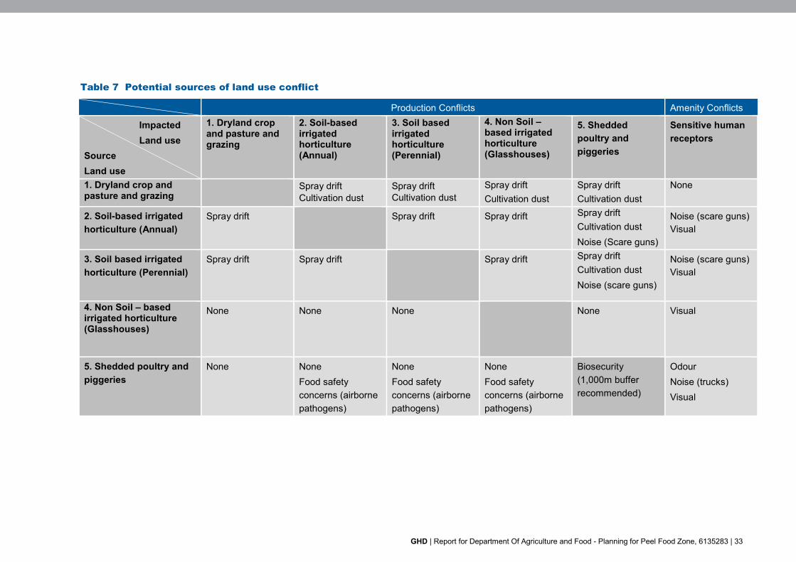
4.3 Land use conflict
Land use conflicts typically arise when intensive agricultural activities negatively affect theamenity of adjoining residents, via excessive odour, noise or visual impact. Land use conflictscan also occur between agricultural enterprises, due to production issues such as biosecurityrisk, spray drift from chemical applications and potential loss of organic or other certifications.Table 7 provides a summary of potential land use conflicts between different intensive landuses.
GHD | Report for Department Of Agriculture and Food - Planning for Peel Food Zone, 6135283 | 33
Table 7 Potential sources of land use conflict
Production Conflicts Amenity Conflicts
ImpactedLand use
SourceLand use
1. Dryland cropand pasture andgrazing
2. Soil-basedirrigatedhorticulture(Annual)
3. Soil basedirrigatedhorticulture(Perennial)
4. Non Soil –based irrigatedhorticulture(Glasshouses)
5. Sheddedpoultry andpiggeries
Sensitive humanreceptors
1. Dryland crop andpasture and grazing
Spray driftCultivation dust
Spray driftCultivation dust
Spray driftCultivation dust
Spray driftCultivation dust
None
2. Soil-based irrigatedhorticulture (Annual)
Spray drift Spray drift Spray drift Spray driftCultivation dustNoise (Scare guns)
Noise (scare guns)Visual
3. Soil based irrigatedhorticulture (Perennial)
Spray drift Spray drift Spray drift Spray driftCultivation dustNoise (scare guns)
Noise (scare guns)Visual
4. Non Soil – basedirrigated horticulture(Glasshouses)
None None None None Visual
5. Shedded poultry andpiggeries
None NoneFood safetyconcerns (airbornepathogens)
NoneFood safetyconcerns (airbornepathogens)
NoneFood safetyconcerns (airbornepathogens)
Biosecurity(1,000m bufferrecommended)
OdourNoise (trucks)Visual
GHD | Report for Department Of Agriculture and Food - Planning for Peel Food Zone, 6135283 | 34
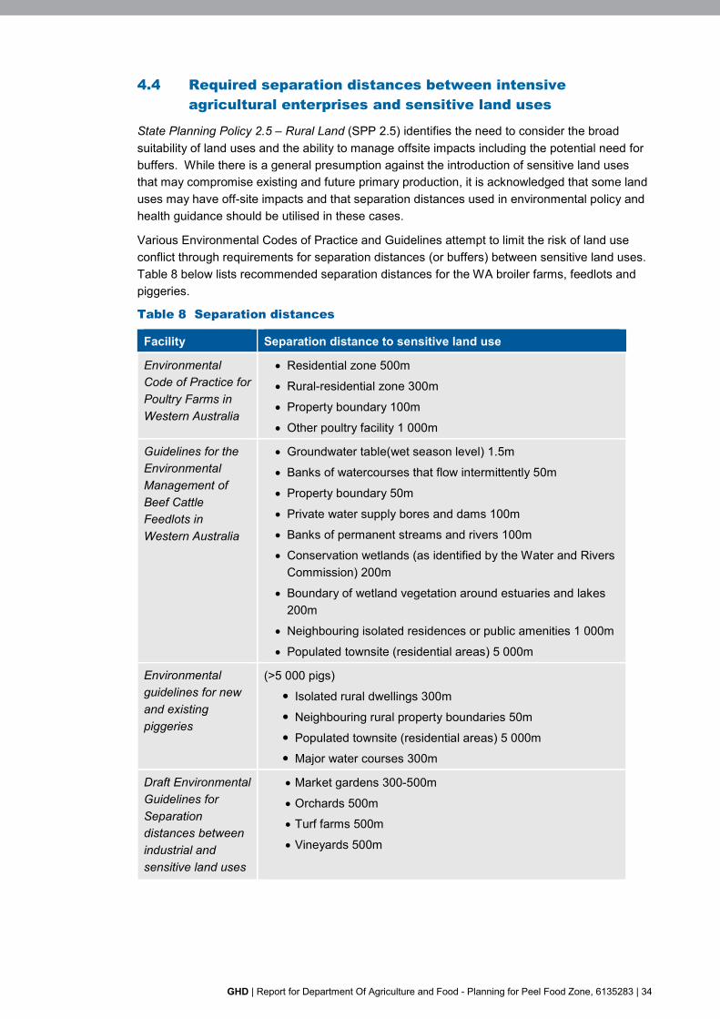
4.4 Required separation distances between intensiveagricultural enterprises and sensitive land uses
State Planning Policy 2.5 – Rural Land (SPP 2.5) identifies the need to consider the broadsuitability of land uses and the ability to manage offsite impacts including the potential need forbuffers. While there is a general presumption against the introduction of sensitive land usesthat may compromise existing and future primary production, it is acknowledged that some landuses may have off-site impacts and that separation distances used in environmental policy andhealth guidance should be utilised in these cases.
Various Environmental Codes of Practice and Guidelines attempt to limit the risk of land useconflict through requirements for separation distances (or buffers) between sensitive land uses.Table 8 below lists recommended separation distances for the WA broiler farms, feedlots andpiggeries.
Table 8 Separation distances
Facility Separation distance to sensitive land use
EnvironmentalCode of Practice forPoultry Farms inWestern Australia
Residential zone 500m
Rural-residential zone 300m
Property boundary 100m
Other poultry facility 1 000m
Guidelines for theEnvironmentalManagement ofBeef CattleFeedlots inWestern Australia
Groundwater table(wet season level) 1.5m
Banks of watercourses that flow intermittently 50m
Property boundary 50m
Private water supply bores and dams 100m
Banks of permanent streams and rivers 100m
Conservation wetlands (as identified by the Water and RiversCommission) 200m
Boundary of wetland vegetation around estuaries and lakes200m
Neighbouring isolated residences or public amenities 1 000m
Populated townsite (residential areas) 5 000m
Environmentalguidelines for newand existingpiggeries
(>5 000 pigs)
Isolated rural dwellings 300m
Neighbouring rural property boundaries 50m
Populated townsite (residential areas) 5 000m
Major water courses 300m
Draft EnvironmentalGuidelines forSeparationdistances betweenindustrial andsensitive land uses
Market gardens 300-500m
Orchards 500m
Turf farms 500m
Vineyards 500m

GHD | Report for Department Of Agriculture and Food - Planning for Peel Food Zone, 6135283 | 35
Where a development generating off-site impacts cannot meet the environmental and healthrequirements, then more detailed consideration of the off-site impacts are required. Indetermining the appropriate buffer the following matters should be taken into account:
Separation distances recommended in Government policy and guidance
Whether the design/operation meets prescribed standards
Whether management plans associated with the proposal can be implemented
Need for environmental licensing and/or works approval
Potential cumulative impacts
Whether modelling is required where impacts are anticipated to exceed the parametersestablish by Government policy and guidance
The need to ensure that modelling is undertaken in accordance with Government policy orguidelines.
Pursuant to SPP 2.5 where a buffer has been determined in accordance with the above, theycan be implemented through the following planning mechanisms:
Identified through a special control area with related provisions
Identified on structure plans.
Notifications on title advising purchasers or either a statutory buffer or a land use that may affectresidential amenity at the time of subdivision.
4.5 Factors determining the success of industry zones, clustersor precincts
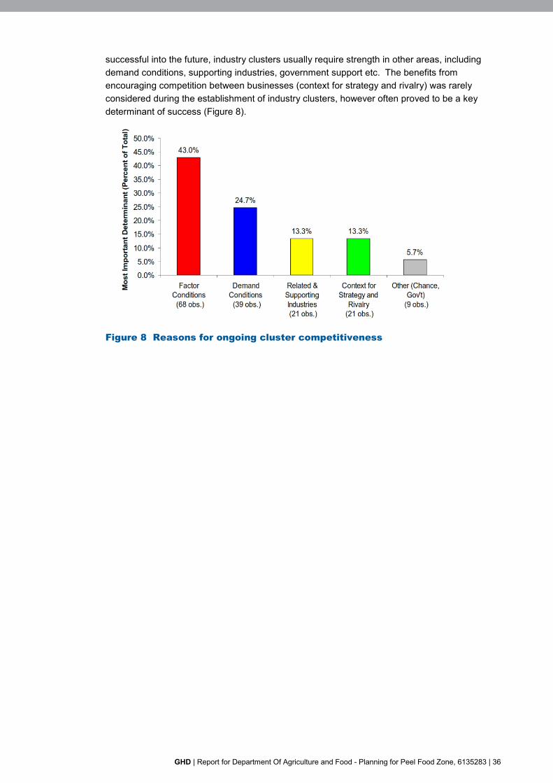
In 2002, the Harvard Business School completed the Cluster Meta Study (Van der Linde, 2003),which compiled information from 833 industry clusters from around the world, including 73involving food or beverage industries. The study identified five key determinants of a clusterscompetitiveness (or success), outlined in Figure 7.
Figure 7 Determinants of cluster competitiveness
The study found that the supply of inputs (factor conditions) was usually the principal reason orjustification for the establishment of industry clusters. However to be competitive and
GHD | Report for Department Of Agriculture and Food - Planning for Peel Food Zone, 6135283 | 36
successful into the future, industry clusters usually require strength in other areas, includingdemand conditions, supporting industries, government support etc. The benefits fromencouraging competition between businesses (context for strategy and rivalry) was rarelyconsidered during the establishment of industry clusters, however often proved to be a keydeterminant of success (Figure 8).
Figure 8 Reasons for ongoing cluster competitiveness
GHD | Report for Department Of Agriculture and Food - Planning for Peel Food Zone, 6135283 | 37
5. ConclusionThe vision to establish a Food Zone in the Peel region, while challenging, promises to bringinvestment, vibrancy and sustainability to the region. Existing planning frameworks andterminology will need to be finalised in order to establish a ‘planning language’ that can beapplied across a zone that encompasses the jurisdictions of two local government authorities.
Attracting investors who are keen to invest in the region and so take advantage of marketconditions is likely to require government decision-makers and regulators to facilitate approvalprocesses in shorter time frames than may ordinarily be the case and operating conditions willneed to be pragmatic in terms of time and money.
While establishing the PFZ facilitates future growth and development of this region, thesensitivities of the natural environment and residences must be protected. For example,environmental conditions that continue to protect and improve the health of waterways andwetlands, native vegetation and water availability in a drying climate must be maintained as thePFZ develops. Similarly, amenity values, particularly visual, noise, spray drift and light, must betaken into account as the Zone develops.
This study found that the key factors determining where future industries were most suited were:
Phosphorous export
Land capability
Access to infrastructure
Groundwater availability; and
Proximity to sensitive human residences.
In broad terms, soil based production industries were most suited to the eastern half of the zonewhere there is improved land capability and a reduced risk of P export. Access to infrastructurewas a key factor for the more intensive industries, such as the covered, above ground industriesand intensive livestock production. Proximity to residences further refined the areas suitable foreach of the studied land use scenarios.
The findings of this work can only be applied in broad terms and do not provide enough detail toinfluence specific investment opportunities. Investors will still be required to investigate specificfeatures of potential investment properties for heritage constraints, water availability, potentialcontamination and other caveats.
The next stages of this work will be to refine the planning framework and environmentalconditions for the PFZ while taking into consideration the views of the existing landholders.

GHD | Report for Department Of Agriculture and Food - Planning for Peel Food Zone, 6135283 | 38
6. ReferencesABARES 2017, Agricultural commodities: March quarter, Australian Bureau of Agricultural andResource Economics and Sciences, Canberra.
Peel Development Commission, 2014. Peel: a region in profile 2014, available from PIRSA
2016, Northern Adelaide Horticulture Production 2020 Growth Scenario, PIRSA Scorecardteam, 2016.


www.ghd.com


