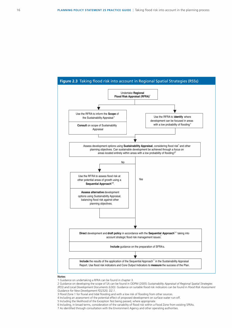
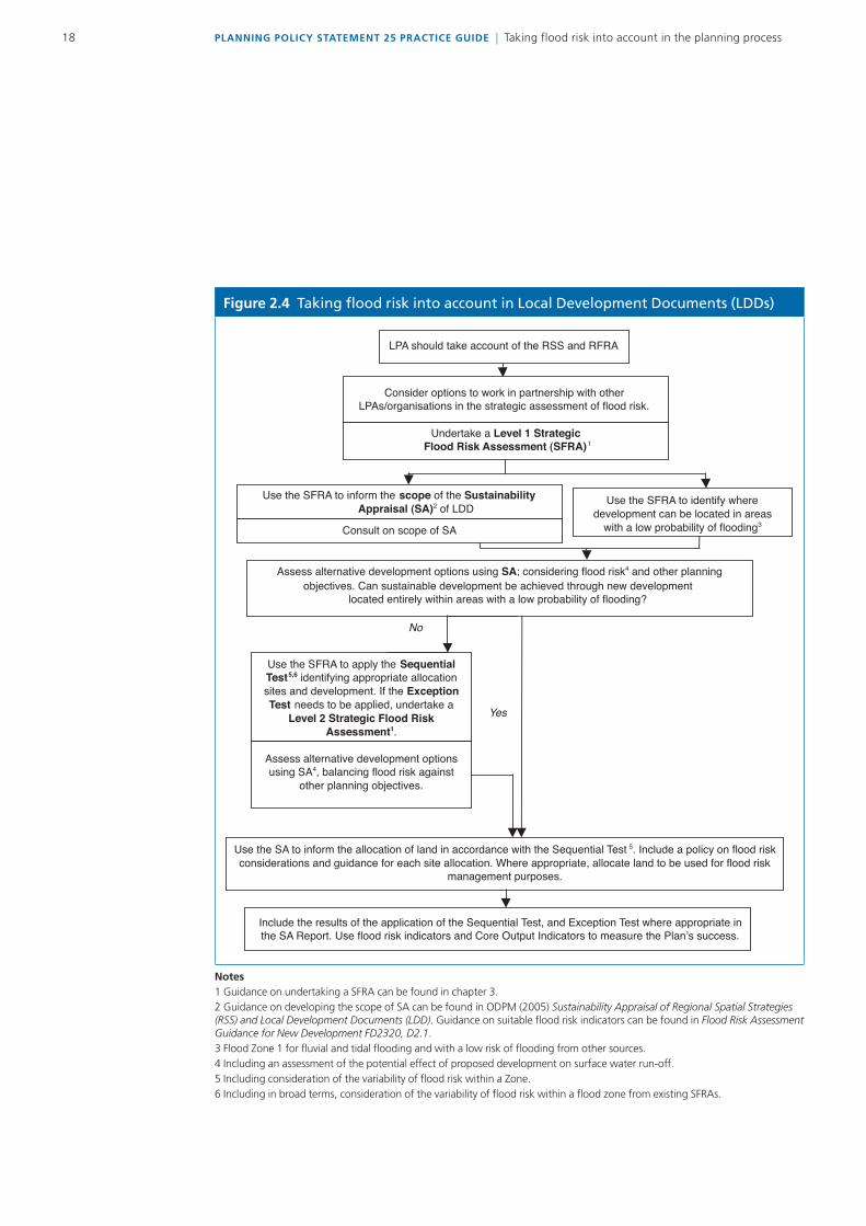
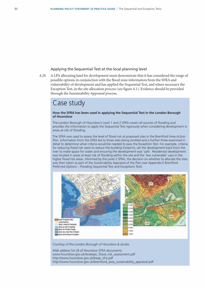
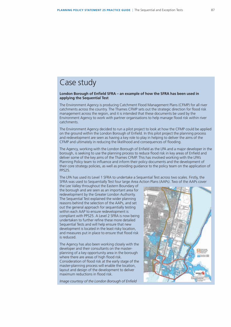
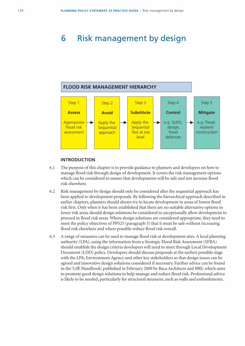
Chapter 4 of the practice guide provides guidance on how the sequential approach can be used to inform the lay-out of new development sites
This should show that the flood risk management hierarchy has been followed and that flood defences are a necessary solution This should include details of any proposed flood defences accessegress arrangements site drainage systems (including what consideration has been given to the use of sustainable drainage systems) and how these will be accessed inspected operated and maintained over the lifetime of the development This may need to include details of any modelling work undertaken in order to derive design flood levels for the development taking into account the presence of any new infrastructure proposed
a This should be over the lifetime of the development taking the relevant climate change allowances into account The assessment may need to include
bull Details of the design basis for any mitigation measures (for example compensatory flood storage works and measures to improve flood conveyance) A description of how the design quality of these measures will be assured and of how the access operation inspection and maintenance issues will be managed over the lifetime of the development
bull Evidence that the mitigation measures will work generally in the form of a hydrological and hydraulic modelling report
bull An assessment of the potential impact of the development on the river estuary or sea environment and fluvialcoastal geomorphology A description of how any impacts will be mitigated and of the likely longer-term sustainability of the proposals
b Evidence should be provided that drainage of the site will not result in an increase in the peak rate or in the volumes of run-off generated by the site prior to the development proceeding
a Designing for event exceedance on site drainage systems is covered in chapter 5 of the practice guide Guidance on other residual risks is provided in chapter 7
b Reference should be made to flood warning and evacuation procedures where appropriate and to likely above ground flow routes should sewers or other conveyance systems become blocked or overloaded This may need to include a description of the potential economic social and environmental consequences of a flood event occurring which exceeds the design standard of the flood risk management infrastructure proposed and of how the design has sought to minimise these ndash including an appraisal of health and safety issues
PLANNING POLICY STATEMENT 25 PRACTICE GUIDE | Relevant policies plans and sources of information174 PLANNING POLICY STATEMENT 25 PRACTICE GUIDE | Relevant policies plans and sources of information
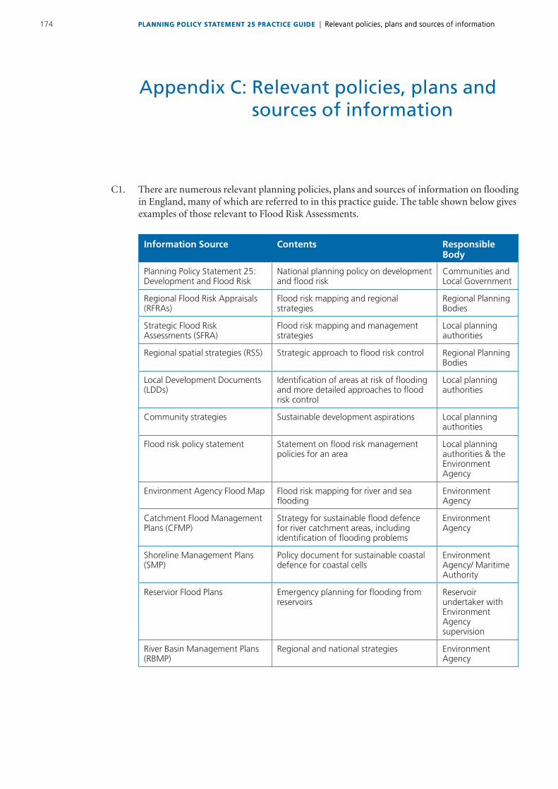
C1 TherearenumerousrelevantplanningpoliciesplansandsourcesofinformationonfloodinginEnglandmanyofwhicharereferredtointhispracticeguideThetableshownbelowgivesexamplesofthoserelevanttoFloodRiskAssessments
Information Source Contents Responsible Body
Planning Policy Statement 25 Development and Flood Risk
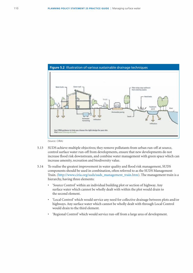
National planning policy on development and flood risk
Communities and Local Government
Regional Flood Risk Appraisals (RFRAs)
Flood risk mapping and regional strategies
Regional Planning Bodies
Strategic Flood Risk Assessments (SFRA)
Flood risk mapping and management strategies
Local planning authorities
Regional spatial strategies (RSS) Strategic approach to flood risk control Regional Planning Bodies
Local Development Documents (LDDs)
Identification of areas at risk of flooding and more detailed approaches to flood risk control
Local planning authorities
Community strategies Sustainable development aspirations Local planning authorities
Flood risk policy statement Statement on flood risk management policies for an area
Local planning authorities amp the Environment Agency
Environment Agency Flood Map Flood risk mapping for river and sea flooding
Environment Agency
Catchment Flood Management Plans (CFMP)
Strategy for sustainable flood defence for river catchment areas including identification of flooding problems
Environment Agency
Shoreline Management Plans (SMP)
Policy document for sustainable coastal defence for coastal cells
Environment Agency Maritime Authority
Reservior Flood Plans Emergency planning for flooding from reservoirs
Reservoir undertaker with Environment Agency supervision
River Basin Management Plans (RBMP)
Regional and national strategies Environment Agency
Appendix C Relevant policies plans and sources of information
175PLANNING POLICY STATEMENT 25 PRACTICE GUIDE | Relevant policies plans and sources of informationPLANNING POLICY STATEMENT 25 PRACTICE GUIDE | Relevant policies plans and sources of information
Information Source (continued)
Contents Responsible Body
Surface Water Management Plans (SWMP)
Management of surface water Local planning authorities
Water Level Management Plans Identification of water level management requirements of protected wetland areas
Environment Agency
Harbour Management Plans Sustainable use of harbours
Sea defence scheme design reports
Design of sea defence schemes including modelling to assess design levels
Environment Agency
Coastal Habitat Management Plans (CHAMP)
Sustainable sea defence strategies for areas that may affect internationally important wildlife sites
Environment AgencyNatural England
Estuary Management Plans Sustainable use of estuaries Natural England
Heritage Coast Management Plans
Management options for Heritage Coast areas
Local planning authorities
Flood risk management scheme design reports or project appraisal reports
Design report for flood alleviation schemes including modelling to set design levels
Environment Agency local planning authorities amp private
AnnualBiennial Reports Identification of recent flooding problemsissues
Local authority
Sewage Planssewer flooding reportsdrainage area studies
Identification of location of sewerage and potential problems
Sewerage undertaker
Biodiversity Action Plans (BAP) Identification of the status and targets for habitats and species
Natural England
AAP AreaActionPlan
AOD AboveOrdnanceDatum
BR BuildingRegulations
CFMP Catchmentfloodmanagementplan
CIRIA ConstructionIndustryResearchInformationAssociation
CIWEM CharteredInstitutionofWaterandEnvironmentalManagement
Defra DepartmentforEnvironmentFoodandRuralAffairs
EA EnvironmentAgency
EiP ExaminationinPublic
FCDPAG Floodandcoastaldefenceprojectappraisalguidance
FRA FloodRiskAssessment(site-specific)
GDPO1995 TownandCountryPlanning(GeneralDevelopmentProcedures)Order1995
GIS GeographicalInformationSystem
ICE InstitutionofCivilEngineers
IDB InternalDrainageBoard
IUD IntegratedUrbanDrainage
LDD Localdevelopmentdocument
LDF Localdevelopmentframework
LPA LocalPlanningAuthority
LRF LocalResilienceForum
MPA MineralPlanningAuthority
NFCDD NationalFloodandCoastalDefenceDatabase
NGO Non-GovernmentalOrganisation
NSWG NationalSUDSWorkingGroup
ODPM (theformer)OfficeoftheDeputyPrimeMinister
PPG PlanningPolicyGuidanceNote
PPS PlanningPolicyStatement
RBMP RiverBasinManagementPlan
RFRA RegionalFloodRiskAppraisal
RDA RegionalDevelopmentAgency
RPB RegionalPlanningBody
RSS RegionalSpatialStrategy
SA SustainabilityAppraisal
AbbreviationsAcronyms
PLANNING POLICY STATEMENT 25 PRACTICE GUIDE | AbbreviationsAcronyms176
SEA StrategicEnvironmentalAssessment
SFRA StrategicFloodRiskAssessment
SHLAA StrategicHousingLandAvailabilityAssessment
SMP ShorelineManagementPlan
SPD SupplementaryPlanningDocument
SUDS SustainableDrainageSystems
SWMP SurfaceWaterManagementPlan
UKCIP UKClimateImpactProgramme
WFD WaterFrameworkDirective
177PLANNING POLICY STATEMENT 25 PRACTICE GUIDE | AbbreviationsAcronyms
Annualexceedanceprobability TheestimatedprobabilityofafloodofgivenmagnitudeoccurringorbeingexceededinanyyearExpressedasforexample1in100chanceor1percent
Adoptionofsewers Thetransferofresponsibilityforthemaintenanceofasystemofsewerstoasewerageundertaker
Attenuation Reductionofpeakflowandincreaseddurationofaflowevent
CatchmentFloodManagement AstrategicplanningtoolthroughwhichtheEnvironmentAgencywillseekPlans toworkwithotherkeydecision-makerswithinarivercatchmenttoidentify
andagreepoliciesforsustainablefloodriskmanagement
Climatechange Long-termvariationsinglobaltemperaturesandweatherpatternsbothnaturalandasaresultofhumanactivity
ConsultationDirection ADirectionmadeundertheTownandCountyPlanning(Consultation)(England)Direction2006wherebyalocalplanningauthoritywhichisproposingtograntplanningpermissioninthefaceofasustainedobjectiononfloodriskgroundsbytheEnvironmentAgencymustrefertheplanningapplicationthroughtheregionalGovernmentOfficetodeterminewhetheritshouldbecalled-inforadecisionbytheSecretaryofState
Designevent Ahistoricornotionalfloodeventofagivenannualfloodprobabilityagainstwhichthesuitabilityofaproposeddevelopmentisassessedandmitigationmeasuresifanyaredesigned
Designeventexceedance Floodingresultingfromaneventwhichexceedsthemagnitudeforwhichthedefencesprotectingadevelopmentweredesignedndashseeresidualrisk
Designfloodlevel Themaximumestimatedwaterlevelduringthedesignevent
Exceedancefloodriskassessment Astudytoassesstheriskofasiteorareabeingaffectedbyexceedanceflowandtoassesstheimpactthatanychangesmadetoasiteorareawillhaveontheexceedancefloodrisk
Exceedanceflow Excessflowthatemergesonthesurfaceoncetheconveyancecapacityofadrainagesystemisexceeded
Floodactiongroup Localcommunitygroupswhoaimtoensurethatallauthoritiesworkcloselytogethertomanagefloodriskandtodeliveranactionplantominimisefloodriskwithintheirarea
Flooddefence Flooddefenceinfrastructuresuchasfloodwallsandembankmentsintendedtoprotectanareaagainstfloodingtoaspecifiedstandardofprotection
FloodandCoastalDefence TheEnvironmentAgencylocalauthoritiesandInternalDrainageBoardsOperatingAuthorities withlegislativepowerstoundertakefloodandcoastaldefenceworks
Glossary
PLANNING POLICY STATEMENT 25 PRACTICE GUIDE | Glossary178
Floodeffectmitigation Allmeasurestoreducetheeffectoffloodingonabuildinganditsoccupantsincludingfloodavoidancefloodresistanceandfloodresilience
FloodMap AmapproducedbytheEnvironmentAgencyprovidinganindicationofthelikelihoodoffloodingwithinallareasofEnglandandWalesassumingtherearenoflooddefencesOnlycoversriverandseaflooding
Floodplain Areaoflandthatbordersawatercourseanestuaryortheseaoverwhichwaterflowsintimeoffloodorwouldflowbutforthepresenceofflooddefenceswheretheyexist
Functionalfloodplain Landwherewaterhastofloworbestoredintimesofflood
Floodriskmanagementstrategy Along-termapproachsettingouttheobjectivesandoptionsformanagingfloodrisktakingintoaccountabroadrangeoftechnicalsocialenvironmentalandeconomicissues
Floodriskassessment(coversall Astudytoassesstherisktoanareaorsitefromfloodingnowandinthescalesofassessment) futureandtoassesstheimpactthatanychangesordevelopmentonthesite
orareawillhaveonfloodrisktothesiteandelsewhereItmayalsoidentifyparticularlyatmorelocallevelshowtomanagethosechangestoensurethatfloodriskisnotincreasedPPS25differentiatesbetweenregionalsub-regionalstrategicandsite-specificfloodriskassessments
Floodriskmanagementmeasure Anymeasurewhichreducesfloodrisksuchasflooddefences
FloodZone AgeographicareawithinwhichthefloodriskisinaparticularrangeasdefinedwithinPPS25
Floods Directive AEuropeanCommunityDirective(200760EC)oftheEuropeanParliamentandCouncildesignedtoestablishaframeworkfortheassessmentandmanagementoffloodrisksaimingatthereductionoftheadverseconsequencesassociatedwithfloodsonhumanhealththeenvironmentculturalheritageeconomicactivityandinfrastructureThethreemainrequirementsoftheDirectivearethedevelopmentofPreliminaryFloodRiskAssessments(byDecember2011)floodhazardandriskmaps(byDecember2013)andfloodriskmanagementplans(byDecember2015)
Fluvial Floodingcausedbyrivers
Freeboard Thedifferencebetweentheflooddefencelevelandthedesignfloodlevel
Greenfieldland Landthathasnotbeenpreviouslydeveloped
Holdtheline Maintainingtheexistingflooddefencesandcontrolstructuresintheirpresentpositionsandstandardofprotection
179PLANNING POLICY STATEMENT 25 PRACTICE GUIDE | Glossary
Localdevelopmentframework Anon-statutorytermusedtodescribeafolderofdocumentswhichincludesallthelocalplanningauthorityrsquosLocalDevelopmentDocumentsThelocaldevelopmentframeworkwillalsocomprisethestatementofcommunityinvolvementthelocaldevelopmentschemeandtheannualmonitoringreport
LocalDevelopmentDocuments Alldevelopmentplandocumentswhichwillformpartofthestatutory developmentplanaswellassupplementaryplanningdocumentswhichdo
notformpartofthestatutorydevelopmentplan
LocalResilienceForum AgrouprequiredundertheCivilContingenciesAct2004whoareresponsiblefortheco-ordinationofemergencyplanningwithinlocalareas
MainRiver AwatercoursedesignatedonastatutorymapofMainRiversmaintainedbyDefraonwhichtheEnvironmentAgencyhaspermissivepowerstoconstructandmaintainflooddefences
Majordevelopment Amajordevelopmentis a)wherethenumberofdwellingstobeprovidedistenormoreorthesiteareais05hectaresormoreor b)non-residentialdevelopmentwherethefloorspacetobeprovidedis1000m2ormoreorthesiteareais1haormore
Ordinarywatercourse Allriversstreamsditchesdrainscutsdykessluicessewers(otherthanpublicsewer)andpassagesthroughwhichwaterflowswhichdonotformpartofaMainRiverLocalauthoritiesandwhererelevantInternalDrainageBoardshavesimilarpermissivepowersonordinarywatercoursesastheEnvironmentAgencyhasonMainRivers
Permitteddevelopmentrights QualifiedrightstocarryoutcertainlimitedformsofdevelopmentwithouttheneedtomakeanapplicationforplanningpermissionasgrantedunderthetermsoftheTownandCountryPlanning(GeneralPermittedDevelopment)Order1995
PlanningPolicyStatement(PPS) AstatementofspatialplanningpolicyissuedbycentralGovernment(generallytoreplaceolderPlanningPolicyGuidancenotes)
Pluvial Surfacefloodingcausedbyrain
Precautionaryprinciple Wheretherearethreatsofseriousorirreversibledamagelackoffullscientificcertaintyshallnotbeusedasareasonforpostponingcost-effectivemeasurestopreventenvironmentaldegradation
PLANNING POLICY STATEMENT 25 PRACTICE GUIDE | Glossary180
Previously-developedland Landwhichisorwasoccupiedbyapermanentstructureincludingthe(oftenreferredtoasbrownfieldland) curtilageofthedevelopedlandandanyassociatedfixedsurfaceinfrastructure
(PPS3annexB)
RegionalSpatialStrategy(RSS) Abroaddevelopmentstrategyforaregionfora15to20yearperiodpreparedbytheRegionalPlanningBody
Reservoir(largeraised) Areservoirthatholdsatleast25000cubicmetresofwaterabovenaturalgroundlevelasdefinedbytheReservoirsAct1975
Resilience Constructingthebuildinginsuchawaythatalthoughfloodwatermayenterthebuildingitsimpactisminimisedstructuralintegrityismaintainedandrepairdryingampcleaningarefacilitated
Resistance ConstructingabuildinginsuchawayastopreventfloodwaterenteringthebuildingordamagingitsfabricThishasthesamemeaningasfloodproof
Returnperiod Thelong-termaverageperiodbetweeneventsofagivenmagnitudewhichhavethesameannualexceedanceprobabilityofoccurring
Residualrisk Theriskwhichremainsafterallriskavoidancereductionandmitigationmeasureshavebeenimplemented
RiverBasinManagementPlan AmanagementplanforallriverbasinsrequiredbytheWaterFrameworkDirectiveThesedocumentswillestablishastrategicplanforthelong-termmanagementoftheRiverBasinDistrictsetoutobjectivesforwaterbodiesandinbroadtermswhatmeasuresareplannedtomeettheseobjectivesandactasthemainreportingmechanismtotheEuropeanCommission
Run-off Theflowofwaterfromanareacausedbyrainfall
Section106Agreement Section106oftheTownandCountryPlanningAct1990(asamended)allowinglocalplanningauthoritiestonegotiatearrangementswherebythedevelopermakessomeundertakingifhesheobtainsplanningpermissionTheseareknowninterchangeablyasplanningagreementsplanningobligationsorplanninggain
Section106(WaterIndustry AkeysectionoftheWaterIndustryAct1991relatingtotherightofAct1991) connectiontoapublicsewer
ShorelineManagementPlan Aplanprovidingalarge-scaleassessmentoftherisktopeopleandtothedevelopedhistoricandnaturalenvironmentassociatedwithcoastalprocessesItpresentsapolicyframeworktomanagetheserisksinasustainablemanner
Standardofprotection Thedesigneventorstandardtowhichabuildingassetorareaisprotectedagainstfloodinggenerallyexpressedasanannualexceedanceprobability
181PLANNING POLICY STATEMENT 25 PRACTICE GUIDE | Glossary
StrategicEnvironmentalAssessment EuropeanCommunityDirective(200142EC)ontheassessmentofthe(SEA)Directive effectsofcertainplansandprogrammesontheenvironment
SustainableDrainageSystems AsequenceofmanagementpracticesandcontrolstructuresoftenreferredtoasSUDSdesignedtodrainwaterinamoresustainablemannerthansomeconventionaltechniquesTypicallytheseareusedtoattenuaterun-offfromdevelopmentsites
SustainabilityAppraisal Anintegralpartoftheplan-makingprocesswhichseekstoappraisetheeconomicsocialandenvironmentaleffectsofaplaninordertoinformdecision-makingthatalignswithsustainabledevelopmentprinciples
VulnerabilityClasses PPS25annexDprovidesavulnerabilityclassificationtoassesswhichusesoflandmaybeappropriateineachfloodriskzone
Washland Anareaofthefloodplainthatisallowedtofloodorisdeliberatelyfloodedbyariverorstreamforfloodmanagementpurposes
WaterFrameworkDirective AEuropeanCommunityDirective(200060EC)oftheEuropeanParliamentandCouncildesignedtointegratethewaywaterbodiesaremanagedacrossEuropeItrequiresallinlandandcoastalwaterstoreachldquogoodstatusrdquoby2015throughacatchment-basedsystemofRiverBasinManagementPlansincorporatingaprogrammeofmeasurestoimprovethestatusofallnaturalwaterbodies
Windfallsites Siteswhichbecomeavailablefordevelopmentunexpectedlyandarethereforenotincludedasallocatedlandinaplanningauthorityrsquoslocaldevelopmentframework
PLANNING POLICY STATEMENT 25 PRACTICE GUIDE | Glossary182
This practice guide is complementary to Planning PolicyStatement 25 Development and Flood Risk and providesguidelines on how to implement development and floodrisk policies by the land use planning system
PL
AN
NIN
GP
OL
ICY
STA
TE
ME
NT
25
PR
AC
TIC
EG
UID
E|
Taking
floo
drisk
into
accou
nt
inth
ep
lann
ing
pro
cess
Price pound2200ISBN 978 1 4098 2055 0
ISBN 978-1409820550
9 781409 820550
- Updating the PPS25 Practice Guide Summary of main changes
- 1 Introduction
-
- How will this guide help you
- Who should use the guide
- How this update of the guide was prepared
- Status of the guide
- Further information and references
-
- 2 Taking flood risk into account in the planning process
-
- Introduction
- Managing flood risk strategically
- The key stages in taking flood risk into account in the planning process
- Regional Spatial Strategies (RSSs)
- Local Development Documents (LDDs)
- Individual Planing Applications
- Key consultees to the planning process
- Monitoring and review of PPS25
- Illustrative case studies
- Further information and references
-
- 3 The assessment of flood risk
-
- Introduction
- Aims of flood risk assessments
- The source-pathway-receptor approach
- Assessing flood risk
- Types of flood risk assessment
- Regional Flod Risk Appraisal (RFRA)
- Strategic Flod Risk Assesment (SFRA)
- Site-specific flod risk asesment (FRA)
- Climate change
- Lifetime of development
- A hypothetical example of how the flood risk assessment process shouldwork
- Further information and references
-
- 4 The Sequential and Exception Tests
-
- Introduction
- The sequential approach
- The sequential test
- The exception test
- Flood risk vulnerability classifications
- Functional floodplain
- Further information and references
-
- 5 Managing surface water
-
- Introduction
- The role of the planning system in surface water management
- Managing surface water at source sustainable drainage systems
- Role and responsibilities of planning bodiesauthorities
- Role and responsibilities of developers
- Environmental improvements amp issues for planning
- Role of the strategic flood risk assessment (SFRA)
- Surface water management plans and how they integrate into the planning system
- Site ndash specific surface water management
- Householder permitted development rights
- Further information and references
-
- 6 Risk management by design
-
- Introduction
- Risk management options for new development sites
- Building design
- Taking climate change into account in the design of flood risk management measures
- Design of flood protection infrastructure taking account of uncertainty and freeboard allowances
- Insurance issues
- Further information and references
-
- 7 Residual risk
-
- Introduction
- Residual risk in strategic flood risk assessments (SFRAs)
- Residual risk in site specific flood risk assessments (FRAs)
- Residual flood risk behind flood defences
- Other infrastructure acting as a flood defence
- Assessingmanaging residual risk from reservoirs and other artificial water retaining structures
- Assessing other residual flood risks
- Flood warning and evacuation plans
- Further information and references
-
- Appendix A PPS25 in context with othernational planning policy
- Appendix B Flood Risk AssessmentChecklist
- Appendix C Relevant policies plans andsources of information
- AbbreviationsAcronyms
- Glossary
-