54
Planning Proposal Background Report To Support Rezoning Moss Vale Road North Urban Release Area AP&S Ref: N25830 10 May 2019

Planning Proposal Background Report To Support Rezoning
Moss Vale Road North Urban Release Area
AP&S Ref: N25830 10 May 2019

Planning Proposal 2 Moss Vale Road North URA Ref N25830
Copyright Statement
© Allen Price & Scarratts Pty Ltd 2019 Other than as permitted by the Copyright Act 1968, no part of this report may be reproduced, transmitted, stored in a retrieval system or adapted in any form or by any means (electronic, mechanical, photocopying, recording or otherwise) without written permissions. Enquiries should be addressed to Allen Price & Scarratts Pty Ltd. The document may only be used for the purposes for which it was commissioned. Unauthorised use of this document in any form whatsoever is prohibited. Allen Price & Scarratts Pty Ltd assumes no responsibility where the document is used for purposes other than those for which it was commissioned. This report has been prepared on behalf of and for the exclusive use of the Client, and is subject to and issued in connection with the provisions of the agreement between Allen Price & Scarratts Pty Ltd and the Client. Allen Price & Scarratts Pty Ltd accepts no liability or responsibility whatsoever for or in respect of any use of or reliance upon this report by any third party.
Nowra Office: 75 Plunkett Street, Nowra NSW 2541 • PO Box 73, Nowra 2541 Kiama Office: 5/125 Terralong Street, Kiama NSW 2533 • PO Box 209, Kiama 2533 tel 02 4421 6544 • email [email protected] ABN 62 609 045 972 Liability limited by a scheme approved under Professional Standards Legislation

Planning Proposal 3 Moss Vale Road North URA Ref N25830
CONTENTS 1. Introduction ........................................................................................................................................ 4 2. Background ........................................................................................................................................ 4 Part 1 – Objectives or intended outcomes ........................................................................................... 8 Part 2 – Objectives or intended outcomes ......................................................................................... 30 Part 3 – Justification ............................................................................................................................ 30
SECTION A – NEED FOR THE PLANNING PROPOSAL .................................................................... 30
SECTION B – RELATIONSHIP TO STRATEGIC PLANNING FRAMEWORK ..................................... 31
SECTION C – ENVIRONMENTAL, SOCIAL AND ECONOMIC IMPACT ............................................. 41
SECTION D – STATE AND COMMONWEALTH INTERESTS ............................................................. 42
Part 4 – Mapping .................................................................................................................................. 42
Part 5 – Community Consultation ....................................................................................................... 44 Part 6 – Project Timeline ..................................................................................................................... 44 Part 7 – Conclusion.............................................................................................................................. 45
APPENDIX A - AERIAL IMAGE WITH LAND REZONING AMENDMENTS ......................................... 46
APPENDIX B – SUGGESTED VEGETATION / EARTH MOUND BUFFER ......................................... 47
APPENDIX C - EXISTING LAND USE ZONE AND AMENDED LAND USE ZONE MAPS .................. 48
APPENDIX D – INDICATIVE LAYOUT PLAN....................................................................................... 50
APPENDIX E – SUMMARY STATE ENVIRONMENTAL PLANNING POLICIES OF CONSISTENCY 51
APPENDIX F – SUMMARY OF THE PP CONSISTENCY AGAINST S9.1 DIRECTIONS .................... 53

Planning Proposal 4 Moss Vale Road North URA Ref N25830
1. Introduction The purpose of this document is to provide background information, in a Planning Proposal (PP) format, to support rezoning of the Moss Vale Road North Urban Release Area (URA) that is proposed to be formally initiated by Shoalhaven City Council. As explained in the PP, adjustments to the URA have been informed by site specific investigations and a supporting indicative layout plan (masterplan) that results in an overall improved outcome from a town planning, urban design and environmental perspective. Should Council support this initiative, and formally initiate the PP process as the proponent, this document is proposed to assist Council by providing the majority of background information. Therefore, the format of this document follows Council’s adopted Planning Proposal Guidelines and reference to all information set out in Section 3.33 of the EP&A Act and the Department’s Guide to Preparing Planning Proposals. Further to the above, the format of this document is to also optimise a timely and easier path for a Council merit-based assessment of the PP and to provide potential recommendations to the elected Council. This format will further assist with agency and landowner consultation prior to formal exhibition. Overall, the aim of the PP is to continue the intent of the URA vision of meeting future residential housing supply and resolve inconsistencies with land zone mapping of the original URA which over time has been investigated in further detail and concluded that some locations are not accurately zoned to reflect the physical state of this land. The justification and quantum of changes are explained in this document and results in an overall net gain in size and quality of environmental conservation land while not necessarily compromising the intended purpose of the URA. Upon making adjustments to land zone mapping subsequent related amendments are required for other SLEP 2014 mapping which are also explained in the PP. Whilst identifying potential zoning inconsistencies, the PP also addresses consistency with strategy and planning directions with justification for the proposed adjustments. 2. Background 2.1 Subject land The URA was first identified in the Nowra Bomaderry Structure Plan (NBSP) and in 2014 was rezoned for residential development in the Shoalhaven Local Environment Plan 2014 (SLEP 2014). The subject land/ URA (site) boundary totals 266.1ha which does not include roads that are zoned within the zone boundary. Outside the URA boundary, a number of the allotments are zoned RU1, SP2 or E3. A reasonable amount of the land within the URA boundary is zoned E2, where there are watercourses that traverse the land. The site is bordered by Moss Vale Rd to the south, Princes Highway to the east, rural lands to the north-east, with Cambewarra Range Nature Reserve to the north west which contains the peak of Cambewarra Mountain only 3.3kms away from the centre of the URA. Abernethy’s Lane crosses the site from east to west with Bells lane crossing the site from north to south.

Planning Proposal 5 Moss Vale Road North URA Ref N25830
The site is traversed by Abernethy’s Creek and a smaller tributary which both run from west to east through the central portion of the URA. The site generally falls to these watercourses with the northern portion of the site falling to the south with the southern portion of the land falling to the north. Numerous dams have been established on the site, ranging from a few hundred square metres, to a dam about 1.8 ha which is largely included in an E2 zone (Environmental Conservation) and will be the focus of a commercial and recreational district. Abernethy’s Creek and a number of other minor watercourses on site are subject to flooding are reviewed in the supporting flood assessment and therefore are largely encapsulated in the E2 zones. The PP site is shown in Figure 1 and the affected Landholdings is shown in Table 1 and comprises of 17 separate landholdings
Table 1 – List of Affected Landholdings
Property Address Lot/DP Approximate
Area Approximate Area
of Urban Land Zone
220 Moss Vale Rd, Cambewarra Lot 4 DP268209 83.3Ha
33.7Ha – R1 2.3Ha – B1 5.5Ha – B7 2.6Ha – RE1
344 Moss Vale Rd, Cambewarra Lot 54 DP1024592 23.8Ha 5.0Ha – R1
91A Bells Lane, Cambewarra Lot 3 DP708356 2.8Ha 0.95Ha – R1
91B Bells Lane, Cambewarra Lot 4 DP708356 17.9Ha 11.05Ha – R1
125 Bells Lane, Cambewarra Lot 2 DP630811 2.3Ha 2.3Ha – R1
66A Bells Lane, Meroo Meadow Lot 3 DP847399 1.0Ha 1.0Ha – R1
66B Bells Lane, Meroo Meadow Lot 21 DP854369 1.0Ha 1.0Ha – R1
66C Bells Lane, Meroo Meadow Lot 22 DP854369 1.0Ha 1.0Ha – R1
66D Bells Lane, Meroo Meadow Lot 1 DP882059 2.6Ha 2.6Ha – R1
91D Bells Lane, Meroo Meadow Lot 2 DP1191186 4.1Ha 3.44Ha – R1
191 Bells Lane, Meroo Meadow Lot 1 DP1191186 63.6Ha 55.92Ha – R1
194 Bells Lane, Meroo Meadow Lot 2 DP582036 2.3Ha 2.3Ha – R1
202 Bells Lane, Meroo Meadow Lot 5 DP618693 6.3Ha 2.5Ha – R1
132 Bells Lane, Meroo Meadow Lot 6 DP618693 2.0Ha 2.0Ha – R1
Bells Lane, Meroo Meadow Lot 7 DP618693 27.32Ha 18.41Ha – R1
50 Abernethy’s Lane, Meroo Meadow Lot 1 DP1134376 3.6Ha 0.61Ha – R1
112 Bells Lane, Meroo Meadow Lot 2 DP1134376 21.2Ha 15.23Ha – R1
Total Land Holdings 266.1Ha
159.0Ha – R1 2.3Ha – B1 5.5Ha – B7 2.6Ha – RE1

Planning Proposal 6 Moss Vale Road North URA Ref N25830
2.2 Current Land Zones Current land zones affecting the site is shown below.
Figure 1 – Current Land Zones - Moss Vale Rd North Urban Release Area
2.3 Status of current investigation work to date Since the URA was first identified in the NBSP and land rezoned for residential development in SLEP 2014, the following studies have been undertaken to support release of the URA and which provide more detailed investigation of the site:
• Preliminary Planning Report & Masterplan– October 2016
• Aboriginal Archaeological Study – May 2018
• Flora & Fauna Assessment – May 2018
• Flood Study & Riparian Lands Concept Design and Assessment – December 2018
• Fauna Survey – February 2019
• Stage 1 Contamination Assessment – February 2019
• Indicative Layout Plan - February 2019
• Traffic & Transport Report – April 2019
• Draft Development Control Plan - April 2019
• Bushfire constraints advice for Masterplan and DCP – March 2019
• Landscape Study– April 2019
• Visual Impact Assessment– April 2019
• Infrastructure Report – April 2019 Key findings of these studies have identified the following inconsistencies with current land zones and shown in Table 2.

Planning Proposal 7 Moss Vale Road North URA Ref N25830
Table 2 – Recent inconsistencies identified with current land zones
Inconsistency with current
zoning
Key matters informing need for zoning adjustment
Watercourse alignment
Preliminary Planning Report & Masterplan
• Site planning is influenced by existing watercourses.
• Riparian areas alongside the significant waterways provide opportunities to enhance and rehabilitate riparian vegetation / water quality / stream health.
Flora & Fauna Assessment
• The network of riparian zones in the study area offers at best a marginal corridor for frogs due to the historical clearing of the landscape.
• The central north-east tributary has the best development of this vegetation, linking a large dam with a small distinct wetland upstream.
• E2 zones, which predominantly include riparian zones from 1st to 3rd order, can be challenging to rehabilitate when remnant ecosystems have limited resilience.
Flood Study & Riparian Lands Concept Design and Assessment
• There is very little vegetation within the banks of (in-bank) or next to the banks of the creeks (riparian) within the URA at present.
• Development of the site affords the opportunity to ensure that the creeks and the areas adjacent to the creeks are rehabilitated and the riparian zone is revegetated with suitable native vegetation.
Spatial difference with mapped E2 areas
Preliminary Planning Report & Masterplan
• Identifies there are a small number of pockets of significant remnant vegetation on the site that need to be protected, enhanced and preserved.
Connectivity & Fragmentation
Flora & Fauna Assessment
• Local corridor value is marginal, due to the dominance of pastoralism on site and in surrounding lands, the patchy nature of remnant vegetation, the barriers posed by Moss Vale Rd and the Princes Highway.
• Consolidation of green space in the E2 zones and revegetation along watercourses, will result in only minor fragmentation, or even an increase in habitat connectivity.
Indicative Layout Plan - February 2019
• Connects significant watercourses and discount/remove non-significant watercourses. Draft Development Control Plan
• A part objective is to ensure that the environmentally sensitive development of the Moss Vale Road North URA occurs in an integrated and efficient manner and hence relevant connectivity is desired.
Landscape Study
• Continuous riparian corridors along Abernethy’s Creek and the tributary to the south will protect the environmental integrity of the waterways, provide valuable natural features within the neighbourhood, and shape an open space network.
Buffers Flora & Fauna Assessment
• E2 zone separated from residences within the R1 zone by roads.
• The road reserve provides a setback that forms part of the APZ, but also discourages impacts such as yard extensions into public reserves, etc.
Visual Impact Assessment
• The potential for replanting and use of the land zoned E3 running parallel with Moss Vale Road is wider than the area required to ensure suitable screen planting and acoustic buffering and results in a sub-optimal experience for residents and travellers alike. The visual assessment recommends a scenic / earth buffer width of 25m.
• There is potential for rezoning part of this E3 corridor to R1 without impacting in any discernible way on the visual quality of the URA as viewed from Moss Vale Road.
Landscape Study
• Identify the opportunity to improve/use the Moss Value Road buffer area

Planning Proposal 8 Moss Vale Road North URA Ref N25830
Inconsistency with current
zoning
Key matters informing need for zoning adjustment
Allowance for increased density
Indicative Layout Plan - February 2019
• Opportunities are identified for increased residential density in close proximity to adjacent open space and proximity to “B” zoned land and main traffic “spine” roads.
2.4 Strategic business centre development and activation A significant start up challenge for the URA is to achieve business centre development and activation in its early stages which results in substantial benefits for establishing local services and employment opportunities for its new community. To overcome this initial development challenge, the PP seeks for the Business Centre only to have the inclusion of an “Additional Local Provision” which allows temporary residential use of ground floor shoptop housing areas (i.e. use of shop area) until surrounding development and viability is achieved to support the shop use. This outcome will avoid the Business centre having vacant land / shops in its initial development period.
2.5 Strategies or plans assessed against proposed land adjustments The following adopted/endorsed Council or State Government strategies or plans that support this zoning adjustment are listed below and reviewed further in this document in Part 3 – Justification.
• Illawarra Shoalhaven Regional Plan
• Shoalhaven City Council’s Community Strategic Plan
• Shoalhaven Growth Management Strategy – Version 1
• Nowra Bomaderry Structure Plan
Part 1 – Objectives or intended outcomes (s.3.33(2)(a) A statement of the objectives or intended outcomes of the proposed instrument) The intended outcome of the PP is to rezone land that either will not achieve its intended land use purpose or land which could achieve a better use outcome which is consistent with indicative layout plan (masterplan) for the site. Amendment to mapping Table 3 below outlines the justification for each proposed land rezone mapping adjustments and the need (where required) for subsequent other SLEP 2014 mapping amendments related to Clauses – Schedule 1.5 Additional Permitted Uses, Minimum Lot Size, Urban Release Are, and Riparian Lands. Where possible, photos are used to demonstrate the need for the rezone mapping adjustment or refer to aerial image in Appendix A. The land zone amendments are shown in Figure 2 & 3 and an aerial image shown in Appendix A. The outcome of not initiating these rezoning adjustments will result in potential inconsistency with land use and an inefficient development outcome.
Table 3 - Rationale behind each proposed rezoning adjustment
Rezoning item
Justification for land zone map adjustment
A Change RU1 to R1
• Existing zone boundary leaves an isolated and narrow strip of RU1 zoned land which will have a dwelling entitlement located upon it and has the potential for land use conflict with the adjoining R1 zoned land.
• There are no physical/topographical constraints that prevent changing the land zone from RU1 to R1.
• This area of potentially additional R1 zoned land has the ability to partly replace the R1 land that is lost

Planning Proposal 9 Moss Vale Road North URA Ref N25830
Rezoning item
Justification for land zone map adjustment
in the creation of riparian corridor as outlined in Rezoning Item B & P.
• The land is suitable for residential development and does not detract from the overall character of the location.
Subsequent other SLEP 2014 mapping amendments resulting from the adjustment are: ➢ Clauses – Schedule 1.5 Additional Permitted Uses ➢ Minimum Lot Size ➢ Urban Release Area
Photo 1 - Looking south along western URA boundary Photo demonstrates existing zone boundary leaves an isolated and narrow strip of RU1 zoned land which will have a dwelling entitlement (inside (to the left) of the fence line shown) and is suitable for residential development and does not detract from the overall character of the location.
B Change R1 to E2
• The existing watercourse (appears to be Category 3) should be recognised and related land zoned E2 and to be contiguous with downstream riparian areas.
• This proposed Category 3 watercourse is flood affected in the 1% AEP event.
• Previous watercourse assessment for the original SLEP 2014 zoning plan did not cover this watercourse as the URA boundary was moved north when Council adopted the zoning change.
• Site specific investigation since Council adoption of the URA has recommended the rezoning to land zoned E2.
Subsequent other SLEP 2014 mapping amendments resulting from the adjustment are: ➢ Minimum Lot Size ➢ Riparian Lands
Approximate
narrow strip of RU1 zoned land

Planning Proposal 10 Moss Vale Road North URA Ref N25830
Rezoning item
Justification for land zone map adjustment
Photo 2 - Looking east along northern URA boundary downslope to watercourse
Photo 3 - Looking north upslope in watercourse towards northern URA boundary
URA boundary

Planning Proposal 11 Moss Vale Road North URA Ref N25830
Rezoning item
Justification for land zone map adjustment
Photo 4 - Further south looking north upslope in watercourse towards northern URA boundary Photos demonstrate existing watercourse (appears to be Category 3) should be recognised and related land zoned E2 and to be contiguous with downstream riparian areas.
C Change E2 to R1
• The riparian/watercourse value of this land is compromised due to the very narrow strip of E2 zoned land over the existing gully.
• Watercourse assessment for the original SLEP 2014 zoning plan did not examine this land in detail or the water quality / riparian values being better protected in larger zoned areas.
• This gully that forms the watercourse appears to be significantly modified by human intervention and has limited biological or riparian significance.
• Due to land form and the very narrow nature of the watercourse it can be appropriately reconfigured as a drainage opportunity for stormwater collection beneath a collector road.
Subsequent other SLEP 2014 mapping amendments resulting from the adjustment are: ➢ Minimum Lot Size ➢ Riparian Lands

Planning Proposal 12 Moss Vale Road North URA Ref N25830
Rezoning item
Justification for land zone map adjustment
Photo 5 - Looking south downslope in watercourse
Photo 6 - Looking north upslope in watercourse towards northern URA boundary Photos demonstrate riparian/watercourse value of this land is compromised due to the very narrow strip of E2 zoned land with almost no native vegetation coverage that can be appropriately reconfigured as a drainage opportunity for stormwater collection beneath a collector road

Planning Proposal 13 Moss Vale Road North URA Ref N25830
Rezoning item
Justification for land zone map adjustment
D Change E2 to R1
• The riparian/watercourse value of this land is compromised due to the very narrow strip of E2 zoned land over the existing gully.
• Watercourse assessment for the original SLEP 2014 zoning plan did not examine this land in detail or the water quality / riparian values being better protected in larger zoned areas.
• Detailed investigation of this gully/land has not identified any great riparian or biological significance.
• This area can be reconfigured with stormwater treatment to connect to the E2 land on the eastern side of Bells Lane.
Subsequent other SLEP 2014 mapping amendments resulting from the adjustment are: ➢ Minimum Lot Size ➢ Riparian Lands ➢ Biodiversity
Photo 7 - Looking west upslope in watercourse from Bells Lane

Planning Proposal 14 Moss Vale Road North URA Ref N25830
Rezoning item
Justification for land zone map adjustment
Photo 8- Further west looking east downslope in watercourse towards Bells Lane Photos demonstrate the riparian/watercourse value of this land is compromised due to the very narrow strip of E2 zoned land with almost no native vegetation coverage that can be appropriately reconfigured with stormwater treatment to connect to the E2 land on the eastern side of Bells Lane.
E Change R1 to E2
• The existing watercourse area in the location of the existing dam should be zoned E2 contiguous with adjacent upstream and downstream riparian areas.
• This change will connect the upstream riparian / E2 zoned land which is currently isolated in a zoning sense from the lower reaches of Abernethy’s Creek that is also zoned E2.
• The recent completed Flood Study & Riparian Lands Concept Design and Assessment recommends that the watercourses be reconfigured to eliminate the dam including removal of the dam wall.
Subsequent other SLEP 2014 mapping amendments resulting from the adjustment are: ➢ Minimum Lot Size ➢ Riparian Lands

Planning Proposal 15 Moss Vale Road North URA Ref N25830
Rezoning item
Justification for land zone map adjustment
Photo 9 - Looking south (downslope) at junction of 2 watercourses (shown in Re-zoning items E & M)
Photo 10 – Further south looking north upslope of watercourses (shown in Re-zoning items E & M)

Planning Proposal 16 Moss Vale Road North URA Ref N25830
Rezoning item
Justification for land zone map adjustment
Photo 11 - Looking south downslope to current vegetation with E2 land zone from Item E Photos demonstrate that the existing watercourse area in the location of the existing dam should be zoned E2 contiguous with adjacent upstream and downstream riparian areas.
F Adjust E2 and R1 zone land boundary to suit land form
• The recent completed studies recommend protection of Abernethy’s Creek by a boundary / perimeter road.
• Revised zone boundary involves adjustment of similar areas of “give and take” between the E2 and R1 zones to provide an improved urban design outcome.
• The adjustment falls within the Department of Primary Industry guidelines for riparian corridors on waterfront land- averaging rule (https://www.industry.nsw.gov.au/__data/assets/pdf_file/0004/156865/NRAR-Guidelines-for-controlled-activities-on-waterfront-land-Riparian-corridors.pdf ).
• From a master planning, traffic planning and subdivisional planning perspective this adjustment results in efficient and safe use of the land.
Subsequent other SLEP 2014 mapping amendments resulting from the adjustment are: ➢ Minimum Lot Size ➢ Riparian Lands

Planning Proposal 17 Moss Vale Road North URA Ref N25830
Rezoning item
Justification for land zone map adjustment
Photo 12 - Looking east along northern edge of watercourse Photo demonstrates the need to protect this area of Abernethy’s Creek by a boundary / perimeter road
G & H Change B1 to appropriate “B” land zone and R1 (minor adjustment of size/shape)
• To refine the zone boundaries of the business zone to reflect subsequent Urban Design outcomes in indicative layout plan and to meet anticipated population needs.
• Revised Business Centre (via road network) to be bordered by dam E2 zoned land frontage to gain better access to the main collector road through this portion of the site.
• Land zone change from B1 to appropriate “B” zone land “(i.e. B2 or B4) to ensure a business centre that provides for the future population and has the potential to provide services such as commercial premises, educational establishments, entertainment facilities, function centres, information and education facilities, recreation facilities (indoor), registered clubs, residential care facilities, and tourist and visitor accommodation to support both economic and residential development of the URA.
• To allow immediate development and activation of the Business Centre the inclusion of an “Additional Local Provision” is proposed which allows temporary residential use of ground floor shoptop housing areas (i.e. use of shop area) until surrounding development and viability is achieved to support the shop use. This outcome will avoid the Business centre having vacant land / shops in its initial development period.
• Business Centre redesigned will provide for increased housing diversity in the form of apartments and townhouses (including temporary ground floor residential use).
• This design will provide residents with opportunities for employment within the URA. Subsequent other SLEP 2014 mapping amendments resulting from the adjustment are:
➢ Minimum Lot Size ➢ Riparian Lands ➢ Clauses (to support local residential use of ground floor of shoptop housing)

Planning Proposal 18 Moss Vale Road North URA Ref N25830
Rezoning item
Justification for land zone map adjustment
Photo 13 - Looking east along northern edge of watercourse
Photo 14 - Looking west along northern edge of watercourse Photos demonstrate the potential interface via a perimeter road that separates the watercourse on the E2 zoned land and adjacent “B” land zone“(i.e. B2 or B4).

Planning Proposal 19 Moss Vale Road North URA Ref N25830
Rezoning item
Justification for land zone map adjustment
I Adjust RE1 boundary
• To refine the land zone boundaries of the RE1 to reflect subsequent Urban Design outcomes.
• Adjustment separates land zoned RE1 and E2 by road reserve.
• The adjustment outcome provides increased land area for public recreation and environmental protection.
Subsequent other SLEP 2014 mapping amendments resulting from the adjustment is: ➢ Minimum Lot Size
Photo 15 - Looking east along future northern boundary of land zoned R1 & “B” Zone. Photo demonstrates the potential interface via a perimeter road that separates of the R1 and “B” zoned land“ (i.e. B2 or B4).
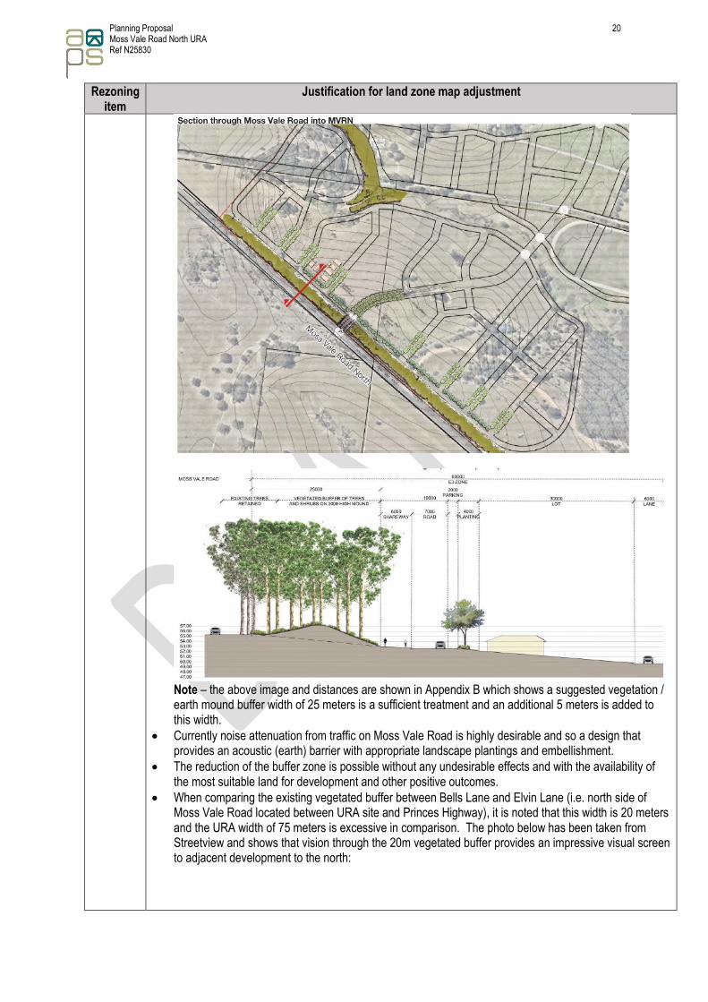
J Adjust E3 width from 75m to 30m and create additional R1 land
• The origin of the dimensions of the E3 “buffer zone” is not entirely certain but its purpose may have been to obscure sighting of URA houses when travelling along Moss Vale Road.
• The proposal is to reduce the width but create a buffer zone that acts as a visual and acoustic barrier for travellers on Moss Vale Road and URA residents respectively – see proposed change extract below from Visual Impact Assessment/Landscape Study.
Planning Proposal 20 Moss Vale Road North URA Ref N25830
Rezoning item
Justification for land zone map adjustment
Note – the above image and distances are shown in Appendix B which shows a suggested vegetation / earth mound buffer width of 25 meters is a sufficient treatment and an additional 5 meters is added to this width.
• Currently noise attenuation from traffic on Moss Vale Road is highly desirable and so a design that provides an acoustic (earth) barrier with appropriate landscape plantings and embellishment.
• The reduction of the buffer zone is possible without any undesirable effects and with the availability of the most suitable land for development and other positive outcomes.
• When comparing the existing vegetated buffer between Bells Lane and Elvin Lane (i.e. north side of Moss Vale Road located between URA site and Princes Highway), it is noted that this width is 20 meters and the URA width of 75 meters is excessive in comparison. The photo below has been taken from Streetview and shows that vision through the 20m vegetated buffer provides an impressive visual screen to adjacent development to the north:

Planning Proposal 21 Moss Vale Road North URA Ref N25830
Rezoning item
Justification for land zone map adjustment
• The increase in R1 land available for development replaces: a) R1 land lost to E2 land zoning at item O & N. b) R1 and B7 land lost to easements for power and gas that runs through the property Lot 4 on DP
268209. c) R1 and B7 land lost to road widening along Bells Lane and Moss Vale Road.
• The increase in R1 land goes part of the way to address the equity issues that remain and arise from the re-location of the RU1 land reserved by Council for road purposes notwithstanding that: a) The location of the zone was revised in controversial circumstances in favour of a neighbouring
property owner and without the knowledge of the land owner. b) The width of the area is substantially in excess of the requirements of the proposed requirements of
a by-pass of Nowra. c) RMS has no published plans to undertake such a project in the future or at all.
Subsequent other SLEP 2014 mapping amendments resulting from the adjustment are: ➢ Minimum Lot Size ➢ Scenic Protection Area ➢ Urban Release Area

Planning Proposal 22 Moss Vale Road North URA Ref N25830
Rezoning item
Justification for land zone map adjustment
Photo 16 - Looking east along northern edge of Moss Vale Road – showing 30 & 75 meter setback to road Photo demonstrates that the width of the scenic protection area and E2 zoned land is excessive for its intended purpose.
K Change E2 to R1 • The riparian/watercourse value of this land is compromised due to the very narrow strip of E2 zoned
land. • Subsequent site investigations have not identified any related biological or riparian significance by this
change. • Due to land form and the very narrow nature of the watercourse it can be appropriately reconfigured as
a drainage opportunity for stormwater collection beneath the road. Subsequent other SLEP 2014 mapping amendments resulting from the adjustment are:
➢ Minimum Lot Size ➢ Riparian Lands
75m setback
to boundary
edge
30m setback
to boundary
edge
Approximate
URA boundary
edge

Planning Proposal 23 Moss Vale Road North URA Ref N25830
Rezoning item
Justification for land zone map adjustment
Photo 17 – (Southern K site) - Looking east downslope in watercourse towards the future town centre Photo demonstrates the riparian/watercourse value of this land is compromised due to the very narrow strip of E2 zoned land and can be appropriately reconfigured as a drainage opportunity for stormwater collection beneath the road.
L Small E2 Lot with dwelling entitlement • The land has an existing significant dwelling (and the proposed lot comprises existing curtilage area)
that pre-existed the SLEP 2014. • It is recommended that the existing dwelling on the E2 zoned land needs to have a 2,000m2 minimum lot
area around it to allow the balance of this land to be provided as public reserve along with other riparian areas in the URA. Alternatively, the zone could be amended to R1 or R5 with larger minimum lot area if desired by Council.
Subsequent other SLEP 2014 mapping amendments resulting from the adjustment is: ➢ Minimum Lot Size

Planning Proposal 24 Moss Vale Road North URA Ref N25830
Rezoning item
Justification for land zone map adjustment
Photo 18 - Looking east along northern edge of watercourse
Photo 19 - Looking west along southern edge of watercourse

Planning Proposal 25 Moss Vale Road North URA Ref N25830
Rezoning item
Justification for land zone map adjustment
Photo 20 - Looking east (downslope) along southern edge of watercourse Photos demonstrate the area to be protected by a perimeter road (shown in indicative layout plan) that separates the land zoned “E” and “R”
M Change E2 to R1
• The riparian/watercourse value of this land is compromised due to the very narrow strip of E2 zoned land over the existing gully.
• Watercourse assessment for the original SLEP 2014 zoning plan did not examine this land in detail or the water quality / riparian values being better protected across the URA in larger zoned areas.
• Detailed investigation of this gully did not identify any great importance from a biological or riparian perspective.
• Due to land form and the very narrow nature of the watercourse it can be appropriately reconfigured as a drainage opportunity for stormwater collection beneath the road.
Subsequent other SLEP 2014 mapping amendments resulting from the adjustment are: ➢ Minimum Lot Size ➢ Riparian Lands

Planning Proposal 26 Moss Vale Road North URA Ref N25830
Rezoning item
Justification for land zone map adjustment
Photo 21 - Looking south downslope in watercourse
Photo 22- Looking north upslope in watercourse Photos demonstrate the riparian/watercourse value of this land is compromised due to the very narrow strip of E2 zoned land with almost no native vegetation coverage that can be appropriately reconfigured with stormwater treatment to connect to the downstream E2 zoned land.

Planning Proposal 27 Moss Vale Road North URA Ref N25830
Rezoning item
Justification for land zone map adjustment
N Change R1 to E2
• Watercourse assessment for the original SLEP 2014 zoning plan did not cover this watercourse and was possibly an oversight.
• Detailed investigation has recommended this land zone change.
• This land proposed to be changed performs a watercourse and is flood affected.
• The change from R1 to E2 is a better outcome overall. Subsequent other SLEP 2014 mapping amendments resulting from the adjustment is:
➢ Minimum Lot Size
O Change R1 to E2
• Watercourse assessment for the original SLEP 2014 zoning plan did not cover this watercourse and was possibly an oversight.
• Detailed investigation has recommended this land zone change.
• This land proposed to be changed performs a watercourse and is flood affected.
• The change from R1 to E2 is a better environmental outcome overall. Subsequent other SLEP 2014 mapping amendments resulting from the adjustment is:
➢ Minimum Lot Size
P Change R1 to E2
• This area is located over a remnant stand of forest and is proposed to be zoned E2 for future protection.
• Site specific investigation since Council adoption of the URA has recommended the rezoning to land zoned E2.
• Assuming other zone changes are supported on the subject landholding, it is felt that there has been sufficient upzoning of the land for this landowner to justify the proposed zone outcome.
Subsequent other SLEP 2014 mapping amendments resulting from the adjustment is: ➢ Minimum Lot Size
Photo 23 - Looking west along northern URA boundary showing tree to be retained in change to land zoned E2 Photo demonstrates that the existing vegetation to be retained along the northern western boundary of the URA.
Q Remove Scenic Protection from B7 zoned land
• In recognition that this area of the site is proposed for business park (land zoned B7) and close proximity to future highway realignment to bypass Nowra/Bomaderry, the original scenic protection purpose is highly compromised.

Planning Proposal 28 Moss Vale Road North URA Ref N25830
Rezoning item
Justification for land zone map adjustment
• The original scenic protection purpose is compromised at the fringe of entering a significant sized urban area with intensified land use.
• The scenic protection purpose is also compromised by high voltage transmission electricity lines which are located between the URA residential area and B7 zoned land.
Subsequent other SLEP 2014 mapping amendments resulting from the adjustment is: ➢ Scenic Protection Area
R Small Lot R1 Zoned Land
• Recognises the opportunities for increased residential density via small lot subdivision in close proximity to adjacent open space and main traffic “spine” roads.
• Increase range of housing opportunity.
• Facilitate the opportunity for increased affordable housing supply. Subsequent other SLEP 2014 mapping amendments resulting from the adjustment is: Minimum Lot Size (i.e. map Clause 4 requirement that allows subdivision below the minimum lot size)
S Medium Density R1 Zoned Land
• Recognises the opportunities for increased residential density in close proximity to adjacent open space and proximity to “B” zoned land.
• Increase range of housing opportunity.
• Facilitate the opportunity for increased affordable housing supply. Subsequent other SLEP 2014 mapping amendments resulting from the adjustment is:
➢ Clauses (to support this density increase)
The following information in Table 4 summaries the overall zone area changes within the URA that result from this PP.
Note – The above areas have been rounded and the minor increase in land zoned SP2 is from minor road widening at the URA entrance which is not discussed in detail in the PP.

Planning Proposal 29 Moss Vale Road North URA Ref N25830
Figure 2 -Proposed Land Zone Boundary Adjustments
Amendment to instrument
Figure 3 -Proposed Final Lane Zones

Planning Proposal 30 Moss Vale Road North URA Ref N25830
Larger images of the existing land use zone and amended land use zone maps are shown in Appendix C. An indicative layout plan (master plan) is shown in Appendix D. Part 2 – Objectives or intended outcomes (s.3.33(2)(b) An explanation of the provisions that are to be included in the proposed instrument) The proposed outcome of the PP will be achieved by amending the Land Zone, Clauses – Schedule 1.5 Additional Permitted Uses, Minimum Lot Size, Urban Release Area and Riparian Lands maps as outlined in in (Section 5) Part 4 – Mapping and the related justification explained above. These amendments/adjustments are required in general to meet the aims of the SLEP2014 are as outlined below:
(a) to encourage the proper management, development and conservation of natural and man-made resources, (b) to facilitate the social and economic wellbeing of the community, (c) to ensure that suitable land for beneficial and appropriate uses is made available as required, (d) to manage appropriate and essential public services, infrastructure and amenities for Shoalhaven, (e) to minimise the risk of harm to the community through the appropriate management of development and land use.
Part 3 – Justification (s.3.33(2)(c) Justification for those objectives, outcomes and provisions and the process for their implementation) Section A – Need for the Planning Proposal
3.A.1 Is the Planning Proposal a result of any strategic study or report? The PP is the result of further detailed site investigations which have further developed the detailed understanding of the site. The PP, along with the proposed DCP and indicative layout plan (masterplan), progresses the intent of the URA and resolves inconsistencies with zone land mapping with the NBSP which Council adopted in 2007. These additional investigations have concluded that some land is not appropriately zoned to reflect the current topography, proposed urban design outcomes, physical characteristics or developability of the land. In the absence of this PP, the delivery of the URA will result in inefficient land use outcomes where zone boundaries are not located in the most appropriate location to service the urban and conservation outcomes proposed in the URA. Part justification for the PP has been informed by the following detailed investigations that have been undertaken since the URA was first identified in the NBSP and land rezoned for residential development in SLEP 2014:
• Preliminary Planning Report & Masterplan– October 2016
• Aboriginal Archaeological Study – May 2018
• Flora & Fauna Assessment – May 2018
• Flood Study & Riparian Lands Concept Design and Assessment – December 2018
• Fauna Survey – February 2019

Planning Proposal 31 Moss Vale Road North URA Ref N25830
• Stage 1 Contamination Assessment – February 2019
• Indicative Layout Plan - February 2019
• Traffic & Transport Report – April 2019
• Draft Development Control Plan - April 2019
• Bushfire constraints advice for Masterplan and DCP – March 2019
• Landscape Study– April 2019
• Visual Impact Assessment– April 2019
• Infrastructure Report – April 2019 3.A.2 Is the Planning Proposal the best means of achieving the objectives or intended outcomes, or is there a better way? The PP is considered to be the best and only means of achieving the intended rezoning and related outcomes. Section B – Relationship to Strategic Planning Framework
3.B.1 Is the Planning Proposal consistent with the objectives and actions contained within the applicable regional or sub-regional strategy (including the Sydney Metropolitan Strategy and exhibited draft strategies)? The PP is broadly consistent with the following regional strategic planning framework. Illawarra Shoalhaven Regional Plan The PP is considered consistent with the Illawarra Shoalhaven Regional Plan which recognises the need for economic development, building of communities, improving housing choice and protection of farmland and natural resources. The proposal is consistent with the following four of the five goals of the Plan.
• A prosperous Illawarra-Shoalhaven. The PP allows consistent use of the URA which in turn provides security for the associated dwellings and businesses that contribute to the prospering opportunities which support the wider Illawarra-Shoalhaven area. The Illawarra Shoalhaven Regional Plan supports coordinating the roll-out of the infrastructure required to support development of this priority growth area.
• A variety of housing choices, with homes that meet needs and lifestyles. The PP continues the URA vision to achieve a variety of housing choices, with homes that meet needs and lifestyles with a variety of residential outcomes that are supported with open space and recreation opportunities in close proximity to a business centre. Outcomes of the URA result in:
• Increased range of housing opportunities close to existing services, jobs and infrastructure.
• Delivering housing in a new release area which provides housing choice and avoids environmental impact.
• Consistency with the Illawarra Shoalhaven Regional Plan which coordinates infrastructure delivery to support the Nowra Bomaderry release area.

Planning Proposal 32 Moss Vale Road North URA Ref N25830
• A region with communities that are strong, healthy and well-connected.
The PP allows for the future community on this URA to be connected to supporting infrastructure and services both locally and regionally. The indicative road layout demonstrates how the URA provides opportunities for investment and activity to support the region whilst building socially inclusive, safe and healthy communities around a business centre.
• A region that makes appropriate use of agricultural and resource lands The PP allows for the better integration and to avoid impacts to the adjacent agriculture lands by implementing the indicative URA layout which provides either a road reserve or E2 land zone interface with the adjacent agricultural land. Hence, impact to the adjacent agricultural land is limited with no dwellings directly adjacent to this land.
• A region that protects and enhances the natural environment. The PP further contributes to protecting and enhancing the natural environment by increasing the net area of land zoned “E” from 46.94ha to 51.41ha (4.47ha increase). This results in protection of the region’s environmental values by focusing development in locations with the capacity to absorb development. Further, the associated land use adjustments contribute to achieving a better water quality outcome for the URA with all significant watercourses now contained within an “E” land zone.
3.B.2 Is the Planning Proposal consistent with the local council’s Community Strategic Plan, or other local strategic plan? The PP is broadly consistent with the following local strategic planning framework. Shoalhaven City Council’s Community Strategic Plan The PP is consistent with Council’s Community Strategic Plan key result areas being people, place and prosperity. The URA with its adjusted land zones is consistent with the following related objectives:
• Providing diverse, united and connected communities.
• Providing opportunity and infrastructure for healthy and active communities that feel safe.
• Providing for population and urban settlement growth that is ecologically sustainable and carefully planned and managed.
• Planning village town centres that are attractive, vibrant and popular destinations.
• Contributing to an economy that supports and is supported by growing, diverse and changing communities.
Shoalhaven Growth Management Strategy – Version 1 The PP is consistent with the following core principles and population projections of this Strategy. In particular, the Strategy identifies the opportunity for 1,754 detached dwellings and 309 medium density dwellings on the URA. Further, the URA is consistent with the following core principles of the strategy:
1.5.1 Ecologically Sustainable Development (ESD) The PP seeks to address an inconsistent land use which results in a better (ESD) outcome than what currently exists with the potential for some land not to achieve its intended land use purpose with current land zones. The rezoning is aimed at achieving a better land use outcome which is consistent with the indicative layout plan (masterplan) for the site.

Planning Proposal 33 Moss Vale Road North URA Ref N25830
1.5.2 Social Justice Principles An outcome of the PP results in better land use, access and connection both internally and external of the site which provide opportunities to support social equity, participation and associated rights. 1.5.3 Council’s Vision and Mission The PP is consistent with Council’s vision of work together in the Shoalhaven to foster a safe and attractive community for people to live, work, stay and play; where sustainable growth, development and environmental protection are managed to provide a unique and relaxed lifestyle. The outcome of the PP results in making current land use consistent with the elements of this vision.
Nowra-Bomaderry Structure Plan The PP is broadly consistent with the NBSP and the following core three goals of this Plan which includes: (1) Sustainable Living - Manage development and change to accommodate economic and population
growth, in a manner which endorses community values, conserves natural resources and safeguards ecological systems. The PP is considered consistent with the goal of sustainable living and the outcome contributes to providing residential growth and appropriate land zones to meet its intended purpose.
(2) Economic Vitality - Facilitate the diversification and expansion of Nowra Bomaderry’s economy by
building on the town’s human resources, skills base and environmental quality of the Shoalhaven whilst strengthening regional linkages, providing efficient support networks, fostering innovation and rewarding enterprise. The PP is not necessarily inconsistent with this goal with the outcome that contributes to appropriate management of the environment with consistent land zone / uses.
(3) Community Wellbeing - Provide living areas in Nowra Bomaderry, which maximise lifestyle quality
and choice by engendering a healthy, caring and harmonious society where both individual and collective rights are respected and there is fair and reasonable access to facilities and services. The PP contributes to maximising lifestyle quality with the rezoning of the site to provide the most efficient use of this land resource.
When analysing the URA, the NBSP outlines some of the key issues affecting development of the URA to be:
• Undulating topography / watercourse
• Abernethy’s Creek and tributaries flowing across the landscape
• Impressive pastoral landscape
• High Scenic Value
• Area is generally cleared
• Some stands of Spotted Gum-Grey Ironbark Forest
• Close proximity to the escarpment
The NBSP responds to these issues and sets a “Desired Future Character” to be as follows:
• The escarpment and pastoral landscape provide an impressive setting for the URA;
• The escarpment and pastoral landscape make a strong contribution to the neighbourhood’s future identity and shape view corridors out of the neighbourhood;
• The area will be primarily residential development with conservation areas and open space networks;

Planning Proposal 34 Moss Vale Road North URA Ref N25830
• Housing will be primarily detached housing with a component of medium density housing;
• Continuous riparian corridors along Abernethy’s Creek and other tributaries will protect the environmental integrity of the waterways, provide valuable natural features within the neighbourhood and will shape an open space network through the neighbourhood, which will include valuable opportunities for a pedestrian and bicycle network;
• The open space network will maximise connections to nearby areas; and,
• The existing road networks of Moss Vale Road and Bells Lane will be retained and incorporated into the street network.
The NBSP applied the following Planning and Design Principles, to achieve the concept “New Living Area” Masterplan shown in Figure 4 to achieve view corridors out of the neighbourhood to the escarpment and pastoral landscape through:
• Exclusion of urban development from areas identified as habitat for threatened species (further studies required to identify these areas) (Note: these studies have now been completed.).
• Protection of riparian corridors including enhanced vegetation along Abernethy’s Creek and associated tributaries.
• A subdivision pattern based on existing topography that maximises the number of north/south facing blocks (promoting energy efficiency).
• Maximising the retention of existing trees, within open space, on road verges or on blocks, where appropriate.
• Plan for and implement current best practice for hazards including bushfire, flood, soil erosion and acid sulphate soil risk.
• Innovative stormwater solutions and reuse of rainwater to minimise detrimental impacts on water flows.

Planning Proposal 35 Moss Vale Road North URA Ref N25830
Figure 4 - Concept “New Living Area” Masterplan
In addition to the discussion on the Future Living Areas, the NBSP also “aims to identify the natural values of the district and the best ways to protect these values in line with principles of ecologically sustainable development”.
Planning Proposal 36 Moss Vale Road North URA Ref N25830
These specific aims are addressed by: 1. Protecting Vegetation Communities 2. Protecting Threatened Species; and 3. Protecting Riparian Corridors; and 4. Protecting Core Conservation Areas
The NBSP seeks to protect the natural values of the district according to the principles of ecologically sustainable development. The primary goal of the strategy is:
“The protection and restoration of biodiversity, ecological integrity and natural capital throughout the Nowra Bomaderry district.”
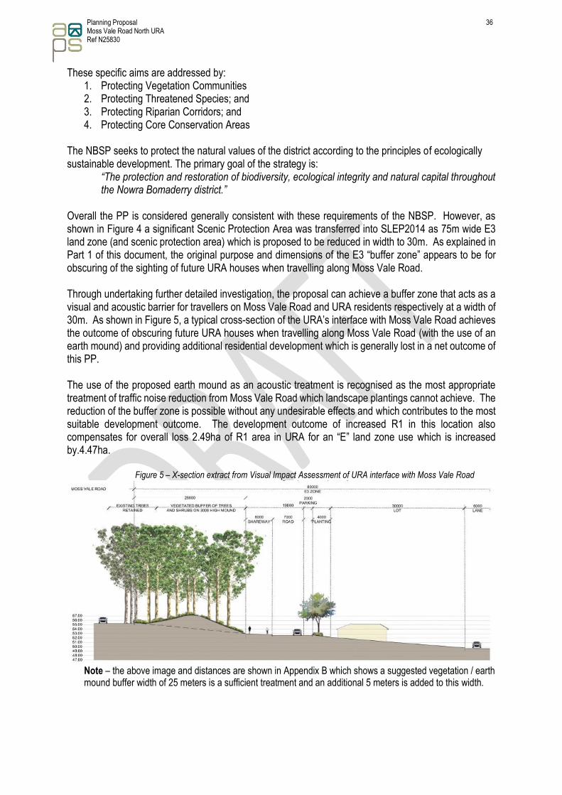
Overall the PP is considered generally consistent with these requirements of the NBSP. However, as shown in Figure 4 a significant Scenic Protection Area was transferred into SLEP2014 as 75m wide E3 land zone (and scenic protection area) which is proposed to be reduced in width to 30m. As explained in Part 1 of this document, the original purpose and dimensions of the E3 “buffer zone” appears to be for obscuring of the sighting of future URA houses when travelling along Moss Vale Road. Through undertaking further detailed investigation, the proposal can achieve a buffer zone that acts as a visual and acoustic barrier for travellers on Moss Vale Road and URA residents respectively at a width of 30m. As shown in Figure 5, a typical cross-section of the URA’s interface with Moss Vale Road achieves the outcome of obscuring future URA houses when travelling along Moss Vale Road (with the use of an earth mound) and providing additional residential development which is generally lost in a net outcome of this PP. The use of the proposed earth mound as an acoustic treatment is recognised as the most appropriate treatment of traffic noise reduction from Moss Vale Road which landscape plantings cannot achieve. The reduction of the buffer zone is possible without any undesirable effects and which contributes to the most suitable development outcome. The development outcome of increased R1 in this location also compensates for overall loss 2.49ha of R1 area in URA for an “E” land zone use which is increased by.4.47ha.
Figure 5 – X-section extract from Visual Impact Assessment of URA interface with Moss Vale Road
Note – the above image and distances are shown in Appendix B which shows a suggested vegetation / earth mound buffer width of 25 meters is a sufficient treatment and an additional 5 meters is added to this width.

Planning Proposal 37 Moss Vale Road North URA Ref N25830
3.B.3 Is the Planning Proposal consistent with applicable state environmental planning policies? The PP is considered generally consistent with applicable State Environmental Planning Policies (SEPP). A summary of the PP’s consistency with applicable SEPP is provided in Appendix E. The following assessment is made specifically against the SEPP Rural Lands 2008 as the URA adjoins is zoned RU1.
SEPP Rural Lands 2008 Section 7 Rural Planning Principles The Rural Planning Principles are as follows: (a) the promotion and protection of opportunities for current and potential productive and
sustainable economic activities in rural areas, (b) recognition of the importance of rural lands and agriculture and the changing nature of
agriculture and of trends, demands and issues in agriculture in the area, region or State, (c) recognition of the significance of rural land uses to the State and rural communities, including
the social and economic benefits of rural land use and development, (d) in planning for rural lands, to balance the social, economic and environmental interests of
the community, (e) the identification and protection of natural resources, having regard to maintaining
biodiversity, the protection of native vegetation, the importance of water resources and avoiding constrained land,
(f) the provision of opportunities for rural lifestyle, settlement and housing that contribute to the social and economic welfare of rural communities,
(g) the consideration of impacts on services and infrastructure and appropriate location when providing for rural housing,
(h) ensuring consistency with any applicable regional strategy of the Department of Planning or any applicable local strategy endorsed by the Director-General.
The PP is consistent with the above objectives for rural land and the remaining land zoned RU1 (not part of the indicative layout plan (masterplan) will continue to be used for agricultural purposes (i.e. grazing). 3.B.4 Is the Planning Proposal consistent with applicable Ministerial Directions (s.9.1 Directions)? A summary of the PP consistency with relevant s.9.1 Ministerial Directions is provided in Appendix F and those that are most relevant are discussed below 1.1 Business and Industrial Zones This direction applies as the PP seeks to change the “B” zoned land “(i.e. B2 or B4) and relocate it marginally south. The proposed land zone adjustment is considered generally administrative and results in:
• Achieving the objectives of this direction,
• Retains the “B” zoned land function (i.e. Business Centre) with a minor area decrease of 0.7ha.
• Does not reduce the total potential floor space area for employment uses and related public services on this “B” zoned land “(i.e. B2 or B4).
The PP is not inconsistent with this direction and the change is considered very minor in comparison to the URA area and changes identified in this PP.

Planning Proposal 38 Moss Vale Road North URA Ref N25830
1.2 Rural Zones The direction applies as the PP proposes to rezone a relevantly small area of RU1 zoned land (as shown in the indicative layout plan (masterplan)) to be consistent with adjacent land zoned as R1. In general, the direction states that a PP must not rezone land from a rural zone to a residential, business, industrial, village or tourist zone. However, a PP may be inconsistent with the terms of this direction only if the relevant planning authority can satisfy the Director-General of the Department of Planning (or an officer of the Department nominated by the Director-General) that the provisions of the planning proposal that are inconsistent are:
(a) justified by a strategy which: (i) gives consideration to the objectives of this direction, (ii) identifies the land which is the subject of the planning proposal (if the planning proposal relates to a particular site or sites), and (iii) is approved by the Director-General of the Department of Planning, or
(b) justified by a study prepared in support of the planning proposal which gives consideration to the objectives of this direction, or (c) in accordance with the relevant Regional Strategy, Regional Plan or Sub-Regional Strategy prepared by the Department of Planning which gives consideration to the objective of this direction, or (d) is of minor significance.
The PP is not inconsistent with this direction and the change is considered very minor in comparison to the URA area and changes identified in this PP. 1.5 Rural Lands This direction requires a PP to be consistent with the Rural Planning Principles listed in State Environmental Planning Policy (Rural Lands) 2008 (as outlined above). The PP is not inconsistent with this direction. 2.1 Environmental Protection Zones The direction applies as the PP proposes to make adjustments to existing land zoned “E” for Environmental Project which results in a net area gain of some 4.47ha which is demonstrated in the above information. Through this process some existing E2 zoned land is proposed to be changed to a relevant residential zone (R1) and a larger amount of land zoned R1 changed to E2. In general, the direction states that a PP must not reduce the environmental protection standards that apply to the land (including by modifying development standards that apply to the land) which in achieved in this PP. However, a PP may be inconsistent with the terms of this direction only if the relevant planning authority can satisfy the Director-General of the Department of Planning (or an officer of the Department nominated by the Director-General) that the provisions of the planning proposal that are inconsistent are:
(a) justified by a strategy which: (i) gives consideration to the objectives of this direction, (ii) identifies the land which is the subject of the planning proposal (if the planning proposal relates to a particular site or sites), and (iii) is approved by the Director-General of the Department of Planning, or
(b) justified by a study prepared in support of the planning proposal which gives consideration to the objectives of this direction, or

Planning Proposal 39 Moss Vale Road North URA Ref N25830
(c) in accordance with the relevant Regional Strategy, Regional Plan or Sub-Regional Strategy prepared by the Department of Planning which gives consideration to the objective of this direction, or (d) is of minor significance.
The PP is not inconsistent with this direction. 3.1 Residential Zones The direction applies as the PP proposes to rezone land to R1 (General Residential). This rezoning is largely to address land that either will not achieve its intended land use purpose or land which could achieve a better use outcome which is consistent with indicative layout plan (masterplan) for the site. The PP also recognises the opportunities for increased residential density and diversity in close proximity to adjacent open space and proximity to “B” zoned land to meet provide for affordable housing supply Further to this, subsequent rezoning changes result in a net area gain of some 4.47ha of “E” zone land. The PP results in broadening the choice of building types and locations in the housing market and makes more efficient use of available land and proposed infrastructure / services. Satisfactory infrastructure and service arrangements are to be in place for all relevant residential lots prior to subdivision release. The land zone adjustment is not foreseen to impact on the residential density of the URA and will generally improve the ability of the land to provide for residential development. The PP is not inconsistent with this direction. 3.4 Integrating Land Use and Transport This direction applies as the PP is located in a URA that is proposed to be serviced by pedestrian infrastructure and public transport which should reduce car dependency and increase the viability of public transport services. However, due to proximity and frequency of public transport services the Shoalhaven in generally is heavily dependent on the private vehicle and the related land zone adjustments on their own are not anticipated to change this public transport service demand or supply.
The PP supports the principles and objectives of Improving Transport Choice — Guidelines for planning and development and The Right Place for Business and Services — Planning Policy. Traffic impacts would be considered as part of the development assessment process.
The PP is not inconsistent with this direction. 4.1 Acid Sulfate Soils
This direction applies as the PP is located on land mapped as having class 5 acid sulfate soils. The PP and subsequent later subdivision will consider the Acid Sulfate Soils Planning Guidelines adopted by the Director-General of the Department of Planning or such other provisions provided by the Director-General of the Department of Planning that are consistent with the Acid Sulfate Soils Planning Guidelines.
The PP is not inconsistent with this direction. 4.3 Flood Prone Land This direction applies as the PP as part of the URA is mapped as being flood prone.
Planning Proposal 40 Moss Vale Road North URA Ref N25830
A planning proposal must not rezone land within the flood planning areas from Special Use, Special Purpose, Recreation, Rural or Environmental Protection Zones to a Residential, Business, Industrial, Special Use or Special Purpose Zone. A planning proposal must not contain provisions that apply to the flood planning areas which:
a) permit development in floodway areas, b) permit development that will result in significant flood impacts to other properties, c) permit a significant increase in the development of that land, d) are likely to result in a substantially increased requirement for government spending on flood
mitigation measures, infrastructure or services, or e) permit development to be carried out without development consent except for the purposes of
agriculture (not including dams, drainage canals, levees, buildings or structures in floodways or high hazard areas), roads or exempt development.
A planning proposal may be inconsistent with this direction only if the relevant planning authority can satisfy the Director-General (or an officer of the Department nominated by the Director-General) that:
a) the planning proposal is in accordance with a floodplain risk management plan prepared in accordance with the principles and guidelines of the Floodplain Development Manual 2005,
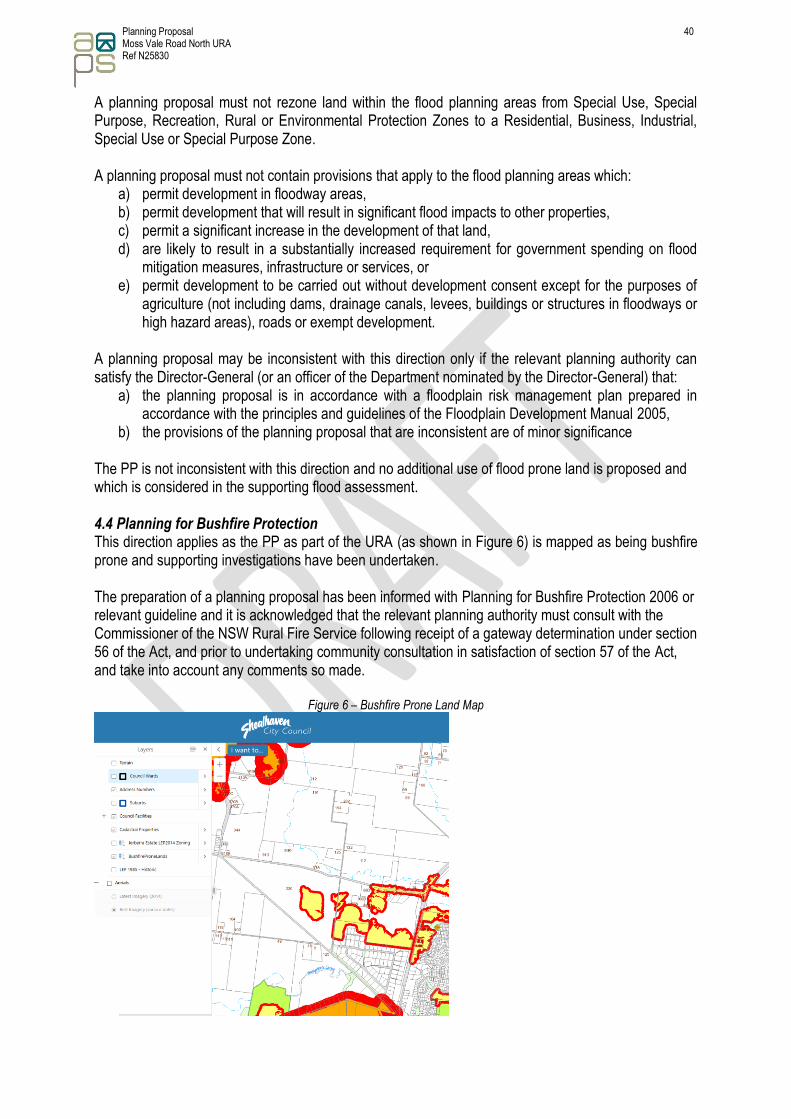
b) the provisions of the planning proposal that are inconsistent are of minor significance The PP is not inconsistent with this direction and no additional use of flood prone land is proposed and which is considered in the supporting flood assessment. 4.4 Planning for Bushfire Protection This direction applies as the PP as part of the URA (as shown in Figure 6) is mapped as being bushfire prone and supporting investigations have been undertaken. The preparation of a planning proposal has been informed with Planning for Bushfire Protection 2006 or relevant guideline and it is acknowledged that the relevant planning authority must consult with the Commissioner of the NSW Rural Fire Service following receipt of a gateway determination under section 56 of the Act, and prior to undertaking community consultation in satisfaction of section 57 of the Act, and take into account any comments so made.
Figure 6 – Bushfire Prone Land Map

Planning Proposal 41 Moss Vale Road North URA Ref N25830
5.10 Implementation of Regional Plans The Illawarra-Shoalhaven Regional Plan addresses the provision of suitable land for housing needs. The PP is considered consistent with the Plan as discussed above. The PP is not inconsistent with this direction.
6.3 Site Specific Provisions
To enable the proposal to proceed, the PP seeks to adjust land zones of the URA to achieve the intended residential use of the site without necessarily compromising or reducing the environmental values of the land. This approach is consistent with Section (4)(b) of this direction. Section C – Environmental, Social and Economic Impact
3.C.1 Is there any likelihood that critical habitat or threatened species, populations or ecological communities, or their habitats, will be adversely affected as a result of the proposal? Detailed flora and fauna assessments have identified the biodiversity value of the landscape in the URA. The PP will not adversely affect any critical habitat or threatened species, populations or ecological communities, or their habitats as it involves a rezoning of land which is already cleared and developed for a residential use. The land for residential / business development has been previously cleared and improved for pasture farming purposes and does not contain any native vegetation communities or significant habitat features. The PP in the main only facilitates use of areas already proposed for access, services and landscaping/recreation purposes for long term residence use and therefore any impact on threatened species, populations or ecological communities is unlikely. Any future use of the land will consider environmental impacts as part of the development assessment process. There is a net gain of land zoned for environmental conservation as a result of the PP and when this is coupled with proposed riparian protection and planting, there will be an improved biodiversity outcome across the URA. 3.C.2 Are there any other likely environmental effects as a result of the Planning Proposal and how are they proposed to be managed? Other environmental impacts are not anticipated as the PP involves land zone adjustments which focus on land that either will not achieve its intended land use purpose or land which could achieve a better use outcome which is consistent with indicative layout plan (masterplan) for the site. Any future use of the land will consider environmental impacts as part of the development assessment process. The PP is not anticipated to generate additional traffic that will already result from the URA nor result in any significant change in demand or use of these services infrastructure. There are no specific environmental effects identified as a result of the PP which require additional management to the current “E” zones already identified on the site.

Planning Proposal 42 Moss Vale Road North URA Ref N25830
3.C.3 Has the Planning Proposal adequately addressed any social and economic effects? The social and economic impacts related to the PP and associated land zone adjustments are considered minimal in the context of the larger URA and its associated objectives which provide significant social and economic benefits to the locality and wider region. The associated land rezoning could also potentially add to the economic viability of the URA. The overall increased residential opportunities of the URA will have positive social impacts for the community with additional housing supply across and associated housing affordability. Section D – State and Commonwealth Interests
3.D.1 Is there adequate public infrastructure for the planning Proposal? The land subject of the PP has existing or in the process of negotiating connection to necessary public infrastructure, including sewer treatment, water, electricity, telecommunications and stormwater drainage. No additional changes to the current URA public infrastructure connections are proposed as part of the PP. The PP would not generate significant additional demand for public infrastructure and services. Clause 6 of the SLEP2014 addresses State Infrastructure Issues. 3.D.2 What are the views of State and Commonwealth public authorities consulted in accordance with the Gateway Determination? Consultation will be subject to the recommendations of the Gateway determination however it is unlikely that the PP has any effects which require the input of State or Commonwealth public authorities. Consistent with the Section 9.1 Direction, consultation with the NSW Rural Fire Service and OEH could occur following a Gateway determination. Part 4 – Mapping (s.3.33(2)(d) Maps to be adopted by the proposed instrument) The PP proposed amendments to the maps are shown in Table 5 which Council will prepare mapping associated with this amendment in accordance with the Standard Technical Requirements for LEP Maps.
Table 5 – Proposed amendments to SLEP 2014 to
Existing SLEP 2014 map (Tile Ref) Modified SLEP 2014 map (Tile Ref)
Terrestrial Biodiversity (BIO_013D)
<image proposed to be prepared by Council>

Planning Proposal 43 Moss Vale Road North URA Ref N25830
Clauses – Schedule 1.5 Additional Permitted Uses (CLS_013D)
<image proposed to be prepared by Council>
Minimum Lot Size (LSZ_013D)
<image proposed to be prepared by Council>
Land Zoning (LZN_013D)
<image proposed to be prepared by Council>
Scenic Protection Area (SCP-013D)
<image proposed to be prepared by Council>
Planning Proposal 44 Moss Vale Road North URA Ref N25830
Urban Release Area (URA_013D)
<image proposed to be prepared by Council>
Riparian Lands (WCL_013D)
<image proposed to be prepared by Council>
Part 5 – Community Consultation (s.3.33(2)(e) Detailed of the community consultation) In accordance with Section 3.34 of the Environmental Planning and Assessment Act 1979, Council would require the PP to be made publicly available for a minimum of 28 days. The exhibition would involve:
• Notices in the local newspaper;
• Exhibition material and all relevant documents will be available at Council’s Administrative and District Offices; and
• Exhibition material and all relevant documents will be available on Council’s website.
Any further consultation required by the Gateway Determination will also be undertaken. Part 6 – Project Timeline In accordance with the Department of Planning and Environment guidelines, the following estimated timeline is provided in Table 6, which includes the tasks deemed necessary for the making of this local environmental plan.
Table 6 – Estimate project timeline Task Responsibility Timeframe Date (approximate)
Council resolution to support the PP
Council 4 weeks June 2019
Lodgement of PP for Gateway determination
Council 2 weeks July 2019
Gateway determination issued
Department of Planning & Environment
6 weeks September 2019

Planning Proposal 45 Moss Vale Road North URA Ref N25830
Task Responsibility Timeframe Date (approximate)
Public exhibition of PP Council Minimum of 28 days October 2019
Report to Council to finalise PP and adopt LEP changes
Council 4 weeks November 2019
Making of Local Environmental Plan amendments
Minister for Planning 6-8 weeks February 2020
Part 7 – Conclusion This PP has been prepared to facilitate the rezoning of land that either will not achieve its intended land use purpose or land which could achieve a better use outcome which is consistent with indicative layout plan (masterplan) for the site. The outcome of the PP results in a number of positive land zone adjustments that result in an overall better town planning, urban design and environmental outcome as demonstrated below in the previous Table 4 extract (Summaries the overall zone area changes within the URA) and also explained in Table 3 and shown in Figures 2 & 3 of document. The PP also recognises the opportunities for increased density in close proximity to adjacent open space and proximity to “B” zoned land to assist in facilitating increased affordable housing supply.
The PP will require amendments to a number of existing maps in SLEP 2014 and the subsequent land use change quantities are summarised in the above Table 4. There are no significant environmental constraints identified for the land subject of the PP which would limit the use of the land (as outlined in this proposal). The PP also results in no additional demand on social infrastructure that supports that use. Therefore, the PP reflects consistency with wider public interest.

Planning Proposal 46 Moss Vale Road North URA Ref N25830
Appendix A - Aerial image with land rezoning amendments

Planning Proposal 47 Moss Vale Road North URA Ref N25830
Appendix B – Suggested vegetation / earth mound Buffer

Planning Proposal 48 Moss Vale Road North URA Ref N25830
Appendix C - Existing land use zone and Amended land use zone maps

Planning Proposal 49 Moss Vale Road North URA Ref N25830

Planning Proposal 50 Moss Vale Road North URA Ref N25830
Appendix D – Indicative Layout Plan

Planning Proposal 51 Moss Vale Road North URA Ref N25830
Appendix E – Summary State Environmental Planning Policies of consistency
SEPP Name Applicable Not inconsistent
1 Development Standards n/a
19 Bushland in Urban Areas n/a
21 Caravan parks n/a
33 Hazardous and offensive development n/a
36 Manufactured home estates n/a
44 Koala habitat protection n/a
47 Moore Park Showground n/a
50 Canal estate development n/a
55 Remediation of land n/a
64 Advertising and signage n/a
65 Design quality of residential apartment development n/a
70 Affordable Housing (Revised Schemes) n/a
Aboriginal Land 2019 n/a
-- Affordable Rental Housing 2009 n/a
-- BASIX 2004 n/a
-- Coastal Management 2018 n/a
Concurrences 2018 ✓ ✓
-- Educational Establishments and Child Care Facilities 2017 n/a
-- Exempt and Complying Development Codes 2008 n/a
-- Housing for Seniors or People with a Disability 2004 n/a
-- Infrastructure 2007 n/a
-- Integration and Repeals 2016 n/a
-- Kosciuszko National Park—Alpine Resorts 2007 n/a
-- Kurnell Peninsula 1989 n/a
-- Mining, Petroleum Production and Extractive Industries 2007 n/a
-- Miscellaneous Consent Provisions 2007 n/a
-- Penrith Lakes Scheme 1989 n/a
-- Rural Lands 2008 ✓ ✓
--
State and Regional Development 2011 n/a
-- State Significant Precincts 2005 n/a
-- Sydney Drinking Water Catchment 2011 n/a
-- Sydney Region Growth Centres 2006 n/a

Planning Proposal 52 Moss Vale Road North URA Ref N25830
SEPP Name Applicable Not inconsistent
-- Three Ports 2013 n/a
-- Urban Renewal 2010 n/a
-- Vegetation in Non-Rural Areas 2017 n/a
-- Western Sydney Employment Area 2009 n/a
-- Western Sydney Parklands 2009 n/a

Planning Proposal 53 Moss Vale Road North URA Ref N25830
Appendix F – Summary of the PP consistency against s9.1 Directions
Direction Applicable Relevant Not inconsistent
1 Employment and Resources
1.1 Business and Industrial Zones ✓ ✓ Refer to Section B
1.2 Rural Zones ✓ ✓ Refer to Section B
1.3 Mining, Petroleum Production and Extractive Industries n/a
1.4 Oyster Aquaculture n/a
1.5 Rural lands ✓ ✓ Refer to Section B
2 Environment and Heritage
2.1 Environmental Protection Zones ✓ ✓ Refer to Section B
2.2 Coastal Protection n/a
2.3 Heritage Conservation n/a
2.4 Recreation Vehicle Area n/a
2.5 Application of E2 and E3 Zones in Environmental Overlays in Far North Coast LEPs
n/a
3 Housing, Infrastructure and Urban Development
3.1 Residential Zones ✓ ✓ Refer to Section B
3.2 Caravan Parks and Manufactured Home Estates n/a
3.3 Home Occupations n/a
3.4 Integrating Land Use and Transport ✓ ✓ Refer to Section B
3.5 Development Near Licensed Aerodromes n/a
3.6 Shooting Ranges n/a
4 Hazard and Risk
4.1 Acid Sulphate Soils ✓ ✓ Refer to Section B
4.2 Mine Subsidence and Unstable Land n/a
4.3 Flood Prone Land ✓ ✓ Refer to Section B
4.4 Planning for Bushfire Protection ✓ ✓ Refer to Section B
5 Regional Planning
5.1 Implementation of Regional Strategies n/a
5.2 Sydney Drinking Water Catchments n/a
5.3 Farmland of State & Regional Significance Far North Coast n/a
5.4 Commercial & Retail Development Far North Coast n/a
5.8 Second Sydney Airport: Badgerys Creek n/a
5.9 North West Rail Link Corridor Strategy n/a
5.10 Implementation of Regional Plans ✓ ✓ Refer to Section B
5.11 Development of Aboriginal Land Council land n/a
6 Local Plan Making
6.1 Approval and Referral Requirements n/a
6.2 Reserving Land for Public Purposes n/a
6.3 Site Specific Provisions ✓ ✓ Refer to Section B

Planning Proposal 54 Moss Vale Road North URA Ref N25830


