36
PLANNING PROPOSAL SPD Site 258-262 PENNANT HILLS ROAD AND 17 & 20 AZILE COURT, CARLINGFORD

PLANNING PROPOSAL SPD Site 258-262 PENNANT HILLS ROAD AND 17 & 20 AZILE COURT, CARLINGFORD

Planning Proposal – 258-262 Pennant Hills Road and 17&20 Azile Court, Carlingford
(RZ/1/2017) 2
Planning Proposal drafts
Proponent versions:
No. Author Version
1. Think Planners Pty Ltd December 2016
Council versions:
No. Author Version
1. City of Parramatta Reported to 20 June IHAP Meeting
2. City of Parramatta Reported to 24 September Council Meeting

Planning Proposal – 258-262 Pennant Hills Road and 17&20 Azile Court, Carlingford
(RZ/1/2017) 3
Contents
INTRODUCTION ..................................................................................................................................... 4
Background and context .................................................................................................................. 4
PART 1 – OBJECTIVES OR INTENDED OUTCOMES ......................................................................... 5
PART 2 – EXPLANATION OF PROVISIONS ........................................................................................ 5
2.1 Other relevant matters .......................................................................................................... 5
PART 3 – JUSTIFICATION .................................................................................................................... 6
3.1 Section A - Need for the planning proposal ....................................................................... 6
3.2 Section B – Relationship to strategic planning framework .............................................. 7
3.3 Section C – Environmental, social and economic impact .............................................. 20
3.4 Section D – State and Commonwealth Interests ............................................................. 26
PART 4 – MAPPING ............................................................................................................................. 27
4.1 Existing controls ................................................................................................................. 27
4.2 Proposed controls .............................................................................................................. 30
PART 5 – COMMUNITY CONSULTATION ......................................................................................... 34
PART 6 – PROJECT TIMELINE .......................................................................................................... 34
Attachment 1 - List of Planning Proposal Attachments .................................................................. 35
Appendix 1 – Urban Design Modification ......................................................................................... 35
Appendix 2 – Traffic and Parking Assessment Report (May 2016)................................................ 35
Appendix 3 – Transport Report Addendum (July 2018) .................................................................. 35
Appendix 4 – Ecological Assessment for Carlingford Block Study Precinct (November 2016) . 35
Appendix 5 – Council Report 9 April 2018 ........................................................................................ 35

Planning Proposal – 258-262 Pennant Hills Road and 17&20 Azile Court, Carlingford
(RZ/1/2017) 4
INTRODUCTION
This Planning Proposal explains the intended effect of, and justification for, the proposed amendment to Parramatta Local Environmental Plan 2011 (PLEP 2011). It has been prepared in accordance with Section 3.33 of the Environmental Planning and Assessment Act 1979 and the Department of Planning and Environment (DP&E) guides, 'A Guide to Preparing Local Environment Plans' (April 2013), 'A Guide to Preparing Planning Proposals' (August 2016) and ‘Guidance for merged councils on planning functions’ (May 2016).
Background and context
On 3 January 2017, Council received an application from Sydney Property Development (SPD) relating to land at 258-262 Pennant Hills Road and 17 & 20 Azile Court, Carlingford. This site comprises four allotments – Lot 1 DP 221491, Lot 1 DP 213263, Lot 3 DP 213263 and Lot 19 DP 221491 and has a total area of 9,274m2. The site currently accommodates low density residential housing and is split by a Council lane way of 292m². The site is shown in Figure 1, below.
Figure 1 – Site at 258-262 Pennant Hills Rd and 17&20 Azile Court, Carlingford subject to the planning proposal
The land is subject to planning controls provided under PLEP 2011. The existing and proposed LEP controls are summarised in Table 1. Table 1 - Summary of current and proposed controls under Parramatta LEP 2011
Control Current Planning Proposal
Zoning Part R2 Low Density Residential
Part SP2 Infrastructure (Classified Road)
Part R4 High Density Residential
Part SP2 Infrastructure (Classified Road)
Height 9 metres* 14m*
FSR 0.5:1* 1:1*
Natural Resources
Biodiversity
N/A To map part of site as Natural Resources-Biodiversity to reflect moderate value vegetation on the site.
* The above refers to “part” of the site because a portion of the site along Pennant Hills Road is zoned SP2 Classified Road. That part of the site does not have an FSR or Height control and is subject a future RMS road widening reservation. The existing SP2 zone is being retained as part of the Planning Proposal and revised FSR and Height controls will not apply to that land.

Planning Proposal – 258-262 Pennant Hills Road and 17&20 Azile Court, Carlingford
(RZ/1/2017) 5
PART 1 – OBJECTIVES OR INTENDED OUTCOMES
The objective of this Planning Proposal is to allow for the redevelopment of the site for higher density residential development in a manner that does not result in adverse impacts on the natural and built environment. The Planning Proposal also seeks to achieve biodiversity protection. In order to achieve this outcome, the provisions of PLEP 2011 as they currently apply will need to be amended. This Planning Proposal seeks to amend the land use zoning, building height and floor space controls in order to achieve the intended outcome. In addition, and as a separate but concurrent process, an amendment to the Parramatta Development Control Plan 2011 (DCP) is also proposed. This amendment will provide more detailed development controls for the site.
PART 2 – EXPLANATION OF PROVISIONS
This Planning Proposal seeks to amend PLEP 2011 in relation to the zoning, height and floor space ratio controls as detailed below Table 2 – Summary of required amendments to Parramatta LEP 2011
Control Current Planning Proposal Required LEP Amendment
Zoning Part R2 Low
Density Residential
Part SP2 Infrastructure (Classified Road)
Part R4 High Density Residential
Part SP2 Infrastructure (Classified Road)
Amend Map Sheet LZN_013
Height 9 metres* 14m* Amend Map Sheet HOB_013
FSR 0.5:1* 1:1* Amend Map Sheet
FSR_013
Natural Resources
Biodiversity
N/A To map part of site as Natural Resources-Biodiversity to reflect existing moderate value vegetation on the site.
Natural Resources -
Biodiversity Map
* See Maps in Section 4 ‘Mapping’
2.1 Other relevant matters
2.1.1 Voluntary Planning Agreement
The site and proposed development potential uplift being sought lends itself to the provision of public benefits, consistent with Council’s draft Voluntary Planning Agreements policy. The proponent has expressed an interest in entering into a Voluntary Planning Agreement (VPA). A formal letter of offer was received from the proponent on 7 June 2017 confirming that they are willing to enter into discussions with Council regarding a VPA under Section 7.4 of the Environmental Planning and Assessment Act 1979 and was revised on 7 August 2018. The Planning Agreement offer includes the following works:
Planning Proposal – 258-262 Pennant Hills Road and 17&20 Azile Court, Carlingford
(RZ/1/2017) 6
Dedication of land as part of the new north-south road link being prepared within the BaptistCare site ($200,000);
Works-in-kind or monetary contribution for public domain improvement works and embellishment along the Lane Way between 258 Pennant Hills Road & 20 Azile Court and 262 Pennant Hills Road & 17 Azile Court.
Dedication of land for the Signalisation of the intersection of Pennant Hills Road and Baker Street, including two signalised pedestrian crossings;
Capital contribution for the upgrading of Homelands Avenue Reserve ($350,000).
A draft VPA will be exhibited in conjunction with the Planning Proposal. 2.1.2 Draft Development Control Plan (DCP)
A draft site-specific DCP, which seeks an amendment to the Parramatta DCP 2011, has been prepared by the proponent for 258-262 Pennant Hills Road, Carlingford. The draft site-specific DCP intends to guide any future development on the site as a result of the Planning Proposal. This has also been assessed separately and will be publically exhibited in conjunction with the Planning Proposal and draft VPA offer.
PART 3 – JUSTIFICATION
This part describes the reasons for the proposed outcomes and development standards in the Planning Proposal.
3.1 Section A - Need for the planning proposal This section establishes the need for a planning proposal in achieving the key outcome and objectives. The set questions address the strategic origins of the Proposal and whether amending the LEP is the best mechanism to achieve the aims on the Proposal.
3.1.1 Is the Planning Proposal a result of any study or report?
The Planning Proposal was informed by the Carlingford Block Study investigation which was undertaken by Urbis in 2017 and commissioned by SPD and BaptistCare. The Study presented an urban design and planning analysis of the subject site and its context as well as potential design options for future redevelopment. On 9 April 2018, Council resolved not to proceed with the Draft Block Study and instead proceed only with the planning proposals for BaptistCare and SPD sites separately at reduced densities. The SPD Planning Proposal has been updated as per the resolution.
3.1.2 Is the Planning Proposal the best means of achieving the objectives or
intended outcomes, or is there a better way?
The Planning Proposal is the best and most appropriate means of achieving the desired future redevelopment of this land. The land use zoning of the site needs to be changed in order to achieve redevelopment of the land for higher density residential development as this form of development is currently not permissible on the site. A planning proposal is the only means available to achieve a rezoning of the site.
Planning Proposal – 258-262 Pennant Hills Road and 17&20 Azile Court, Carlingford
(RZ/1/2017) 7
3.2 Section B – Relationship to strategic planning framework
This section assesses the relevance of the Planning Proposal to the directions outlined in key strategic planning policy documents. Questions in this section consider state and local government plans including the NSW Government’s Plan for Growing Sydney and subregional strategy, State Environmental Planning Policies, local strategic and community plans and applicable Ministerial Directions.
3.2.1 Is the planning proposal consistent with the objectives and actions
contained within the applicable regional or sub-regional strategy?
A Metropolis of Three Cities
In March 2018, the NSW Government released the Greater Sydney Region Plan: A Metropolis of Three Cities (“the GSRP”) a 20-year plan which outlines a three-city vision for metropolitan Sydney for to the year 2036. The GSRP is structured under four themes: Infrastructure and Collaboration, Liveability, Productivity and Sustainability. Within these themes are 10 directions which are each contains Potential Indicator and, generally, a suite of objective/s with each objective supported by a Strategy or Strategies. Those objectives and or strategies relevant to this planning proposal are discussed below. Infrastructure and Collaboration An assessment of the planning proposal’s consistency with the GSRP’s relevant Infrastructure and Collaboration objectives is provided in Table 3a, below.
Table 3a – Consistency of planning proposal with relevant GSRP Actions – Infrastructure and Collaboration
Infrastructure and Collaboration Direction
Relevant Objective Comment
A city supported by infrastructure
O1: Infrastructure supports the
three cities
This Planning Proposal is consistent with the objectives of this direction as the site is less than 800m from Carlingford Rail Station. Bus stops associated with bus services linking Parramatta and Macquarie Park via Epping and Parramatta and Pennant Hills are immediately adjacent to the site.
Redevelopment of the site in accordance with the Planning Proposal will result in an increase in the residential population, however this is not considered to be significant.
As part of the Planning Proposal, SPD has offered to enter into a Planning Agreement with Council to upgrade infrastructure in the vicinity of the site, including dedication of land towards part of a new north-south road link, public domain improvement works, land for signalization of the Pennant Hills Road/Baker Street intersection and $350,000 towards the upgrade and embellishment of the public park at Homelands Avenue Reserve. These details are included in the draft VPA Letter of Offer.
O2: Infrastructure aligns with
forecast growth – growth infrastructure compact
O3: Infrastructure adapts to meet future need
O4: Infrastructure use is
optimised

Planning Proposal – 258-262 Pennant Hills Road and 17&20 Azile Court, Carlingford
(RZ/1/2017) 8
Liveability An assessment of the planning proposal’s consistency with the GSRP’s relevant Liveability objectives is provided in Table 3b, below.
Table 3b – Consistency of planning proposal with relevant GSRP Actions – Liveability
Liveability Direction
Relevant Objective Comment
A city for people
O6: Services and infrastructure
meet communities’ changing needs
As noted above, as part of the Planning Proposal, SPD has offered to enter into a Planning Agreement with Council to upgrade infrastructure in the vicinity of the site as to respond to the changing land uses and associated needs included in this proposal. Therefore, the increased demand for infrastructure will be managed as part of the draft Planning Agreement to be entered into with Council in conjunction with the planning proposal and S94A contributions at the DA stage.
O7: Communities are healthy,
resilient and socially connected The Planning Proposal is supported by a draft site-specific DCP that aims to guide the built form of the proposed development responds appropriately to the unique urban characteristics of Carlingford, particularly those posed by its topography, biodiversity, main roads and low density residential environment.
O8: Greater Sydney’s
communities are culturally rich with diverse neighbourhoods
O10: Greater housing supply The site reference plan which accompanies the Urban Design Analysis prepared for the Planning proposal, identifies that, if development proceeds in accordance with that plan, approximately 68 dwellings will be located on the site. Therefore, it is considered that the Planning proposal is consistent with the objectives of this direction.
Housing the city
O11: Housing is more diverse
and affordable
O12: Great places that bring people together
A city of great places
O13: Environmental heritage is
identified, conserved and enhanced
The site contains trees that are of moderate ecological significance. Landscaping must use predominantly indigenous species that reflect the region’s character of the Sydney Blue Gum High Forest and Sydney Turpentine-Ironbark Forest vegetation communities. Any development on sites containing or immediately adjoining areas of high or moderate ecological significance must confirm the boundaries of the area of ecological significance with detailed analysis to ensure no adverse impacts to those areas occurs as a result of the development. A further assessment of this matter will be considered at the DA stage.
Productivity An assessment of the planning proposal’s consistency with the GSRP’s relevant Productivity objectives is provided in Table 3c, below.
Table 3c – Consistency of planning proposal with relevant GSRP Actions – Productivity
Productivity Direction
Relevant Objective Comment
A well connected city
O14: The plan integrates land
use and transport creates walkable and 30 minute cities
The site is located within the GPOP Corridor of the Central City and locates additional housing in the vicinity of major transport corridors along

Planning Proposal – 258-262 Pennant Hills Road and 17&20 Azile Court, Carlingford
(RZ/1/2017) 9
O15: The Eastern, GPOP and
Western Economic Corridors are better connected and more competitive
Carlingford railway line and Pennant Hills Road. The Planning Proposal satisfies O14 and O15 of the region plan.
Jobs and skills for the city
O19: Greater Parramatta is
stronger and better connected This Planning Proposal is generally consistent with the vision under O19 of the region plan. It provides higher density housing in Carlingford with close proximity to public transport, local schools, amenities and services. The future light rail stop at Carlingford is approximately 800m from the site and will provide direct regular services to the Parramatta CBD and Westmead.
Sustainability An assessment of the planning proposal’s consistency with the GSRP’s relevant Sustainability objectives is provided in Table 3d, below.
Table 3d – Consistency of planning proposal with relevant GSRP Actions – Sustainability
Productivity Direction
Relevant Objective Comment
A city in its landscape
O27: Biodiversity is protected,
urban bushland and remnant vegetation is enhanced
The planning proposal includes an amendment to the Natural Resources - Biodiversity Map to reflect the Endangered Ecological Communities on the site. That assessment found that the site contains intact and modified native vegetation including Sydney Blue Gum High Forest (BGHF) which is a Critically Endangered Ecological Community (CEEC) under the Biodiversity Conservation Act 2016. The vegetation on the site is of moderate ecological significance.
The assessment also notes that the site reference plans provides for retention of much of CEEC on the site and that this could be enhanced through additional planting and management. This demonstrates that the environmental values and urban tree canopy cover on site is protected.
The overall development, particularly through the elements included in the capital works for the public domain and nearby Homelands Reserve contribute to the enhancement of public open space. These circumstances provide an outcome that satisfies O27, O30 and O31.
O30: Urban tree canopy cover is
increased
O31: Public open space is
accessible, protected and enhanced
O32: The Green grid links
Parks, open spaces, bushland and walking and cycling paths
An efficient city O33: A low-carbon city
contributes to net-zero emissions by 2050 and mitigates climate change
The proposal does not include sustainability initiatives such as recycled water, sustainable building materials, photovoltaics. Should the proposal proceed, initiatives towards net-zero emissions by 2050, methods of recycling construction and ongoing waste should be investigated as part of the Development Application stage. Further consideration should be given to Council’s Environmental Sustainability Strategy when delivering the proposal.
O34: Energy and water flows
are captured, used and re-used
O35: More waste is re-used and
recycled to support the development of a circular economy
Implementation An assessment of the planning proposal’s consistency with the GSRP’s relevant Implementation objectives is provided in Table 3d, below.

Planning Proposal – 258-262 Pennant Hills Road and 17&20 Azile Court, Carlingford
(RZ/1/2017) 10
Table 3d – Consistency of planning proposal with relevant GSRP Actions – Implementation
Implementation Direction
Relevant Objective Comment
Implementation O39: A collaborative approach
to city planning
Should the planning proposal be satisfactory following feedback and issues raised from stakeholders during the exhibition period it should proceed in accordance with Section 3.34 and Figure 58 of this plan.
Central City District Plan
In March 2018, the NSW Government released Central City District Plan which outlines a 20 year plan for the Central City District which comprises The Hills, Blacktown, Cumberland and Parramatta local government areas. Taking its lead from the GSRP, the Central City District Plan (“CCDP”) is also structured under four themes relating to Infrastructure and Collaboration, Liveability, Productivity and Sustainability. Within these themes are Planning Priorities which are each supported Action. Those Planning Priorities and Actions relevant to this planning proposal are discussed below.
Infrastructure and Collaboration An assessment of the planning proposal’s consistency with the CCDP’s relevant Infrastructure and Collaboration Priorities and Actions is provided in Table 4a, below.
Table 4a – Consistency of planning proposal with relevant CCDP Actions – Infrastructure and Collaboration
Infrastructure and Collaboration Direction
Planning Priority/Action Comment
A city supported by infrastructure
O1: Infrastructure
supports the three cities
O2: Infrastructure
aligns with forecast growth – growth infrastructure compact
O3: Infrastructure
adapts to meet future need
O4: Infrastructure
use is optimised
PP C1: Planning for a city supported by infrastructure
A1: Prioritise infrastructure
investments to support the vision of A metropolis
A2: Sequence growth across the
three cities to promote north-south and east-west connections
A3: Align forecast growth with
infrastructure
A4: Sequence infrastructure
provision using a place based approach
A5: Consider the adaptability of
infrastructure and its potential shared use when preparing infrastructure strategies and plans
A6: Maximise the utility of existing
infrastructure assets and consider strategies to influence behaviour changes to reduce the demand for new infrastructure, supporting the development of adaptive and flexible regulations to allow decentralised utilities
This proposal seeks to change the existing R2 – Low Density Residential to R4 – high Density Residential to deliver a development of 68 high density apartment dwellings of no more than 4 storeys in height. Further, the site is situated along a classified road and beyond 800m of the Carlingford Station (and proposed light rail stop). Any uplift in residential yield for the site should consider the place-based approach that responds to the built form and site conditions listed in the draft site specific DCP. This is demonstrated with the increased building setback to low density areas and endangered ecological communities.
The VPA Letter of Offer also includes a number of infrastructure provisions to support the development changes for the site and surrounding vicinity. These items will contribute to the provisions of existing infrastructure assets in the area and support the actions of PP C1.

Planning Proposal – 258-262 Pennant Hills Road and 17&20 Azile Court, Carlingford
(RZ/1/2017) 11
O5: Benefits of
growth realized by collaboration of governments, community and business
PP C2: Working through
collaboration
A7: Identify prioritise and delivery
collaboration areas
The proposal is located the identified GPOP corridor that will assist in delivering a vision for housing that is coordinated and optimized for urban renewal. Given the previous work completed, but not adopted by the Draft Carlingford Block Study, Council are satisfied that the planning proposal should proceed to public exhibition following its Gateway Determination on 4 August 2017.
Liveability An assessment of the planning proposal’s consistency with the CCDP’s relevant Liveability Prioirties and Actions is provided in Table 4b, below. Table 4b – Consistency of planning proposal with relevant CCDP Actions – Liveability
Liveability Direction
Planning Priority/Action Comment
A city for people
O6: Services and
infrastructure meet communities’ changing needs
PP C3: Provide services and social infrastructure to meet people’s changing needs
A8: Deliver social
infrastructure that reflects the need of the community now and in the future
A9: Optimise the use of
available public land for social infrastructure
The site is within an urban renewal area known as the Next Generation Living Structure Plan area from Camellia to Carlingford under the interim GPOP plan around the Carlingford-Clyde railway line (and future light rail line route). The planning proposal exhibits a layout that aims to maximize the existing public domain, contribute to construction of a new road adjacent to the site and enhance facilities at the nearby public recreation area at Homelands Avenue reserve.
O7: Communities
are healthy, resilient and socially connected
O8: Greater
Sydney’s communities are culturally rich with diverse neighbourhoods
O9: Greater Sydney
celebrates the arts and supports creative industries and innovation
PP C4: Working through collaboration
A10: Deliver healthy, safe and
inclusive places for people of all ages and abilities that support active, resilient and socially connected communities by (a-d).
A11: Incorporate cultural and
linguistic diversity in strategic planning and engagement.
A12: Consider the local
infrastructure implications of areas that accommodate large migrant and refugee populations.
A13: Strengthen the
economic self-determination of Aboriginal communities by engagement and consultation with Local Aboriginal Land Council’s.
A14: Facilitate opportunities
for creative and artistic expression and participation, wherever feasible with a minimum regulatory burden including (a-c).
The proposal was formally included as part of a collaborative approach under the former Draft Carlingford Block Study. On 9 April 2018, Council resolved not to proceed with the Draft Block Study and instead proceed only with the planning proposals for BaptistCare and SPD sites separately at reduced densities. This report reflects this resolution and relates solely to the SPD Planning Proposal site.
The proposal attempts to facilitate opportunities for connections within and between communities, including that between the adjacent BaptistCare PP site and surrounding low density residential areas.

Planning Proposal – 258-262 Pennant Hills Road and 17&20 Azile Court, Carlingford
(RZ/1/2017) 12
A15: Strengthen social
connections within and between communities through better understanding of the nature of social networks and supporting infrastructure in local places
Housing the city
O10: Greater
housing supply
O11: Housing is
more diverse and affordable
PP C5: Providing housing supply, choice and affordability, with access to jobs, services and public transport
A16: Prepare local or district
housing strategies that address housing targets [abridged version]
A17: Prepare Affordable
Rental housing Target Schemes
The Planning Proposal seeks to increase the yield of residential dwellings on the site with a desired GFA 5,818sqm to accommodate approximately 68 dwellings. The proposal makes a modest contribution to housing targets for the Parramatta LGA and Central City district.
A city of great places
O12: Great places
that bring people together
O13: Environmental
heritage is identified, conserved and enhanced
PP C6: Creating and renewing great places and local centres, and respecting the District’s heritage
A18: Using a place-based and
collaborative approach throughout planning, design, development and management deliver great places by (a-e)
A19: Identify, conserve and
enhance environmental heritage by (a-c)
A20: Use place-based
planning to support the role of centres as a focus for connected neighbourhoods
A21: In Collaboration Areas,
Planned Precincts and planning for centres (a-d)
A22: Use flexible and
innovative approaches to revitalise high streets in decline.
The CCDP encourages a place-based and collaborative approach throughout planning, design and development stages with a focus on centers supported by connected neighborhoods. Council considered this application as part of the former Draft Carlingford Block Study, that was resolved not to proceed by Council on 9 April 2018.
It is considered that the planning proposal still exhibits planning principles that support a place-based approach that connects the site with the vicinity and nearby land uses in Carlingford.
Planning Proposal – 258-262 Pennant Hills Road and 17&20 Azile Court, Carlingford
(RZ/1/2017) 13
Productivity An assessment of the planning proposal’s consistency with the CCDP’s relevant Productivity Prioirties and Actions is provided in Table 4c, below. Table 4c – Consistency of planning proposal with relevant CCDP Actions – Productivity
Productivity Direction
Planning Priority/Action Comment
A well-connected city
O19: Greater
Parramatta is stronger and better connected
PP C7: Growing a stronger and more competitive Greater Parramatta
A23: Strengthen the
economic competitiveness of Greater Parramatta and grow its vibrancy [abridged]
A26: Prioritise infrastructure
investment [abridged]
A27: Manage car parking and
identify smart traffic management strategies
The planning proposal wishes increase the dwelling capacity of the site for high density residential uses in Carlingford. Council officers are satisfied that the planning proposal contributes to the competitiveness and vibrancy of Greater Parramatta, with the 68 dwellings supported by a draft site specific DCP and a draft VPA. Items towards public domain and streetscape improvements are included in the VPA to assist in prioritizing investment and managing traffic and transport in the area. The planning proposal also includes a Traffic and Transport assessment and will be included as part of the exhibition to satisfy A27.
Jobs and skills for the city
O15: The Eastern,
GPOP and Western Economic Corridors are better connected and more competitive
PP C8: Delivering a more connected and competitive GPOP Economic Corridor
A29: Prioritise public transport
investment to deliver the 30-minute city objective for strategic centres along the GPOP Economic Corridor
A30: Prioritise transport
investments that enhance access to the GPOP between centres within GPOP
The planning proposal, draft site specific DCP and draft Planning Agreement include infrastructure arrangements towards the adjacent public domain, proposed roads, traffic signaling and nearby public reserve. These infrastructure works contribute to a more connected and competitive GPOP corridor and satisfy the actions of this section under A29 and A30.
O14: The plan
integrates land use and transport creates walkable and 30 minute cities
PP C9: Delivering integrated land use and transport planning and a 30-minute city
A32: Integrate land use and
transport plans to deliver a 30-muinute city
A33: Investigate, plan and
protect future transport and infrastructure corridors
A34: Support innovative
approaches to the operation of business, educational and institutional establishments to improve the performance of the transport network
The planning proposal is situated on a site in close proximity to the existing Carlingford Railway, future Light Rail and Pennant Hills Road transport corridors. The proposal demonstrates that it is consistent with the objective to integrate land use with transport.

Planning Proposal – 258-262 Pennant Hills Road and 17&20 Azile Court, Carlingford
(RZ/1/2017) 14
Sustainability An assessment of the planning proposal’s consistency with the CCDP’s relevant Productivity Prioirties and Actions is provided in Table 4d, below.
Table 4d – Consistency of planning proposal with relevant CCDP Actions – Sustainability
Sustainability Direction
Planning Priority/Action Comment
A city in its landscape
O25: The coast and
waterways are protected and healthier
O27: Biodiversity is
protected, urban bushland and remnant vegetation is enhanced
O28: Scenic and
cultural landscapes are protected
PP C15: Protecting and enhancing bushland, biodiversity and scenic and cultural landscapes
A65: Protect and enhance
biodiversity by (a-c) [abridged]
A66: Identify and protect
scenic and cultural landscapes
A67: Enhance and protect
views of scenic and cultural landscapes from the public realm
The proposal is not adjacent to any nearby waterways, however it does include an environmentally sensitive vegetation of moderate value. The moderate value vegetation that is found on part of the subject site (20 Azile Court and 258 Pennant Hills Road). It is recommended that the moderate value vegetation as identified in the report by Cumberland Ecology and present on part of the subject site (258 Pennant Hills Rd and 20 Azile Court) be mapped and included in the ‘Natural Resources - Biodiversity’ Map in the Parramatta LEP 2011.
It is also recommended that a minimum setback of 10m be provided from the western boundary near the moderate value vegetation to minimise likely direct impacts (i.e. canopy pruning) and indirect impacts (i.e. conflict between residents and fauna) on these significant trees”. This issue is addressed in the changes to planning controls and draft site-specific DCP for the site. In view of this assessment, it is considered that, subject to the recommendations being implemented, there is no impediment to the Planning Proposal proceeding. It is considered that the planning proposal sufficiently addresses this biodiversity matter.
O30: Urban tree
canopy cover is increased
O32: The Green
grid links Parks, open spaces, bushland and walking and cycling paths
PP C16: PP C16: Increasing urban tree canopy cover and delivering Green grid connections
A68: Expand urban tree
canopy in the public realm
A69: progressively refine the
detailed design and delivery of (a-c) [abridged]
A70: Create Greater Sydney
green Grid connections to the Western Sydney Parklands
The tree canopy on the site includes moderately significant species including the presence of eight trees containing eleven hollows are also present within the site (seven being Eucalyptus saligna) and a 0.22-hectare patch of potential habitat trees. The draft site specific DCP considers the role of these trees in the public domain and areas of ecological value section and their contribution to urban tree canopy cover and delivering the Green grid connections. The controls also provide for sufficient conditions for this planning priority through the provision of deep soil zones which are identified in the DCP.
O31: Public open
space is accessible, protected and enhanced
PP C17: Delivering high quality open space
A71: Maximise the use of
existing open space and protect, enhance and expand public open space by (a-g) [abridged]
The proposal is situated in proximity to the public reserve at Homelands Avenue, with some of the uplift associated with this proposal designated towards the upgrade of facilities at Homelands Avenue Reserve. The draft Planning Agreement includes a capital contribution of $350,000 towards the upgrade of facilities at Homelands Avenue Reserve, thus hoping to maximize the use of this open space.
An efficient city
O33: A low-carbon
city contributes to net-zero emissions by 2050 and
PP C19: Reducing carbon emissions and managing energy, water and waste efficiently
The proposal does not include sustainability initiatives such as recycled water, sustainable building materials, photovoltaics. Should the proposal proceed, initiatives towards net-zero emissions by 2050. These actions were

Planning Proposal – 258-262 Pennant Hills Road and 17&20 Azile Court, Carlingford
(RZ/1/2017) 15
mitigates climate change
O34: Energy and
water flows are captured, used and re-used
O35: More waste is
re-used and recycled to support the development of a circular economy
A75: Support initiatives that
contribute to the aspirational objectives of achieving net-zero emissions by 2050
A76: Support precinct-based
initiatives to increase renewable energy generation and energy and water efficiency
A77: Protect existing and
identify new locations for waste recycling and management
A78: Support innovative
solutions to reduce the volume of waste and reduce waste transport requirements
A79: Encourage the
preparation of low carbon, high efficiency strategies to reduce emissions, optimise the use of water, reduce waste and optimising car parking provisions where an increase in total floor in 100,000sqm
introduced as part of the new district plans, following which the proposal as initiated. Council and the applicant should investigate further opportunities for the development to reflect Council’s Environmental Sustainability Strategy when delivering the proposal at the Development Application stage.
O36: People and
places adapt to climate change and future shocks and stresses
O37: Exposure to
natural and urban hazards is reduced
O38: Heatwaves
and extreme heat are managed
PP C20: Adapting to the impacts of urban and natural hazards and climate change
A81: Support initiatives that
respond to the impacts of climate change
A83: Mitigate the urban heat
island effect and reduce the vulnerability to extreme heat
A85: Consider strategies and
measures to manage flash flooding and safe evacuation when planning for growth in Parramatta CBD
The proposal is not located in a location identified as impacted by natural hazard zones such as flooding or bushfire. Initiatives listed in the above-mentioned sustainability priorities contribute to A83 to mitigate urban heat island effect in the area. The proposal is satisfactory under PP C20.

Planning Proposal – 258-262 Pennant Hills Road and 17&20 Azile Court, Carlingford
(RZ/1/2017) 16
Greater Parramatta and the Olympic Peninsula (GPOP)
In October 2016, the NSW Government through the Greater Sydney Commission released the Greater Parramatta and the Olympic Peninsula (GPOP) Vision. GPOP has been identified as a new priority growth area in A Plan for Growing Sydney. GPOP is an urban renewal area spanning from Strathfield to Westmead and from Carlingford to Lidcombe and Granville, along the planned Parramatta Light Rail corridor. The subject site has been identified in the GPOP Vision as being within the ‘Next Generation Living Camellia to Carlingford’ (see Figure 2 below).
The following directions in the GPOP Vision are relevant to the proposal:
Design Parramatta as our central ‘30-minute city’, with good connectivity within GPOP and beyond to the north, south, east and west;
Deliver a rich mix of housing to create inclusive and diverse ‘inner-city’ liveability across GPOP, to attract and retain talent; and
Shape attractive and effective built environments and public spaces that reflect a focus on great urban design and environmental excellence.
Figure 2 - Subject site identified within the Parramatta CBD
Source: GPOP Vision
Comment: The Planning Proposal is generally consistent with the GPOP Vision. It provides new higher density housing of no more than 4 storeys in Carlingford within close proximity to public transport, local schools, amenities and services. The future light rail stop at Carlingford is approximately 800m from the site (walking distance) and will provide direct regular services to the Parramatta CBD and Westmead.
Parramatta Light Rail
In order to accommodate the rapid growth of the GPOP region, a vision to deliver an integrated light rail service has been proposed within walking distance of the site. The

Planning Proposal – 258-262 Pennant Hills Road and 17&20 Azile Court, Carlingford
(RZ/1/2017) 17
proposed Parramatta Light Rail Corridor will improve the connectivity between Parramatta and Carlingford and create a better connection between Carlingford to other key precincts, such as Telopea, Camellia, Newington, Burwood and Macquarie Park. Comment: The subject site is situated within ten minutes walking distance to 2 x future light rail stops at Telopea and Carlingford Station. An increase in density on the site will provide more housing close to transport and services in a scale consistent with the adjacent BaptistCare site.
3.2.2 Is the planning proposal consistent with the local council’s Community
Strategic Plan or other local strategic plan?
The following strategic planning documents are relevant to the Planning Proposal: Parramatta 2038 Community Strategic Plan
Parramatta 2038 is a long term Community Strategic Plan for the City of Parramatta and it links to the long-term future of Sydney. The Plan formalises several big and transformational ideas for the City and the region. The Planning Proposal is considered to meet the strategies and key objectives identified in the plan by facilitating the redevelopment of this site for the purposes of higher density residential development. In particular:
People and Neighbourhoods: Parramatta will be a world-class city at the centre of Sydney that attracts a diversity of people: a city where people can learn, succeed and find what they need; a city where people live well, get together with others, feel like they belong and can reach their potential.
3.2.3 Is the planning proposal consistent with the applicable State Environmental
Planning Policies?
The following State Environmental Planning Policies (SEPPs) are of relevance to the site (refer to Table 3 below). Table 3 – Comparison of planning proposals with relevant SEPPs
State Environmental Planning Policies (SEPPs)
Consistent:
Yes -
No - or N/A
Comment
SEPP No 1 Development Standards N/A SEPP 1 does not apply to Parramatta LEP 2011
SEPP No 55 Remediation of Land
Yes The site is currently used for residential purposes so the use of the site is fundamentally unchanged. The site is not likely to be contaminated.
SEPP 64 – Advertising and Signage N/A Not relevant to proposed amendments.
SEPP No 65 Design Quality of Residential Flat Development
Yes Compliance with SEPP 65 and the Apartment Design Guide is supported in principle and will be finalized as part of the DA stage.
SEPP No.70 Affordable Housing (Revised Schemes)
N/A Not relevant to proposed amendments.

Planning Proposal – 258-262 Pennant Hills Road and 17&20 Azile Court, Carlingford
(RZ/1/2017) 18
State Environmental Planning Policies (SEPPs)
Consistent:
Yes -
No -
or N/A
Comment
SEPP (Affordable Rental Housing) 2009
N/A Not relevant to proposed amendments.
SEPP (BASIX) 2004
Yes Any future development will need to comply with the provisions of the SEPP.
SEPP (Exempt and Complying Development Codes) 2008
Yes Not relevant to proposed amendments.
SEPP (Housing for Seniors or People with a Disability) 2004
Yes Not relevant to proposed amendments.
SEPP (Infrastructure) 2007 Yes The provisions of the SEPP will apply to any redevelopment of the site.
Sydney Regional Environmental Plan (Sydney Harbour Catchment) 2005
(new a Deemed SEPP)
Yes The provisions of the SEPP will apply to any redevelopment of the site.
3.2.4 Is the planning proposal consistent with applicable Ministerial Directions
(s.117 Directions)?
In accordance with Clause 117(2) of the EP&A Act 1979 the Minister issues directions for the relevant planning authorities to follow when preparing planning proposals for new LEPs. The directions are listed under the following categories:
Employment and resources
Environment and heritage
Housing, infrastructure and urban development
Hazard and risk
Regional planning
Local plan making The following directions are considered relevant to the subject Planning Proposal. Table 4 – Comparison of planning proposals with relevant Section 117 Directions
Section Comment Compliance
2. Environment and Heritage
Direction 2.1 – Environmental Protection Zones
The site is not within an environmental protection zone however some existing vegetation on site is considered to be of moderate value as per the report by Cumberland Ecology (Appendix 4).
The potential impacts of any redevelopment on existing vegetation, including an assessment of whether that vegetation is part of an EEC will be required to be assessed upon receipt of an application for redevelopment. Further discussion regarding vegetation is provided in Section 3.3.1 of this report.
Yes
Direction 2.3 - Heritage Conservation
Neither the site nor any buildings or landscape items on the site are items of environmental heritage. The site is not within a heritage conservation area.
N/A
3. Housing, Infrastructure and Urban Development

Planning Proposal – 258-262 Pennant Hills Road and 17&20 Azile Court, Carlingford
(RZ/1/2017) 19
Section Comment Compliance
Direction 3.1 - Residential Zones
This Direction applies as the planning proposal will affect land within an existing residential zone.
The objectives of the Direction are:
• to encourage a variety and choice of housing types to provide for existing and future housing needs,
• to make efficient use of existing infrastructure and services and ensure that new housing has appropriate access to infrastructure and services, and
• to minimise the impact of residential development on the environment and resource lands.
The planning proposal is considered to be consistent with the objectives because:
• It will allow for the development of a range of housing types on the site including residential flat buildings up to 4 storeys, thus providing more housing choice in a location which has good access to public transport
• The site is adequately serviced by essential infrastructure.
Yes
Direction 3.4 - Integrating Land Use and Transport
The objectives of this Direction are as follows:
• improving access to housing, jobs and services by walking, cycling and public transport, and
• increasing the choice of available transport and reducing dependence on cars, and
• reducing travel demand including the number of trips generated by development and the distances travelled, especially by car, and
• supporting the efficient and viable operation of public transport services, and
• providing for the efficient movement of freight.
This site is well located in terms of access to public transport and other services and therefore there will be opportunities for future residents to use alternative forms of transport and reduce dependence on private cars. The location of the subject site approximately 800m from Carlingford Train Station and future Parramatta Light Rail provides opportunities for future residents to take public transport.
The transport reports at Appendix 2 and 3 discusses the opportunities to utilise alternative forms of transport.
Likely
4. Hazard and Risk
Direction 4.1 - Acid Sulfate Soils
The objective of this direction is to avoid significant adverse environmental impacts from the use of land that has a probability of containing acid sulfate soils.
The subject site is identified as being Class 5 with regards to Acid Sulfate Soils. Nonetheless, clause 6.1 (Acid Sulfate Soil) of Parramatta LEP 2011 will be required to be addressed as part of any future development application for the site, including the potential requirement for the preparation of Acid Sulfate Soils Management Plan where relevant.
Yes
Direction 4.3 – Flood Prone Land
The subject site is not identified as flood prone land. Yes
6. Local Plan Making

Planning Proposal – 258-262 Pennant Hills Road and 17&20 Azile Court, Carlingford
(RZ/1/2017) 20
Section Comment Compliance
Direction 6.2 – Reserving Land for a Public Purpose
The site is affected by an SP2 zone which provides for road widening along part of the Pennant Hills Road frontage.
This planning proposal does not seek to remove or alter the SP2 zone as it affects the site.
The concept scheme provides sufficient flexibility to allow for this road widening to be provided in the future, if required.
Yes
3.3 Section C – Environmental, social and economic impact
This section considers the potential environmental, social and economic impacts which may result from the Planning Proposal.
3.3.1 Is there any likelihood that critical habitat or threatened species, populations or ecological communities, or their habitats, will be adversely affected as a result of the proposal?
An ecological assessment of the area (including the SPD site) was undertaken by Cumberland Ecology in May 2018 and is included at Appendix 4. The assessment identified the following on the subject site:
Areas of ‘Moderate’ constraint are present within 264-268 Pennant Hills Road and lots to the north, west and south of 20 Azile Court.
To minimise impacts on the biodiversity values of the study area as a result of future development, it is recommended that all areas of ‘High’ and ‘Moderate’ constraint be avoided where possible.
Avoiding all areas of ‘High’ and ‘Moderate’ constraint will result in reduced impacts on biodiversity, and costs, as a Species Impact Statement (SIS) and offsetting would unlikely be required.
These can be seen below in Figure 3.
Figure 3 - Ecological constraints on subject site as shown in Ecological Report
Source: Cumberland Ecology

Planning Proposal – 258-262 Pennant Hills Road and 17&20 Azile Court, Carlingford
(RZ/1/2017) 21
Council’s Open Space and Natural Area Officer has reviewed the Planning Proposal and report by Cumberland Ecology and provided the following comment:
“The study confirms the presence of eight trees containing eleven hollows are also present within the site (seven being Eucalyptus saligna) and a 0.22-hectare patch of potential habitat trees as indicated Figure 3.1. These are considered to constitute the only significant ecological constraints within the site and have been categorised as per the following:
• Medium Constraint = Hollow bearing trees / habitat trees I concur with the ecologist that replanting would not be considered as an adequate offset and therefore strongly support the recommendation that ‘all areas of ‘high’ and ‘moderate’ constraint be avoided where possible’ to minimise both costs and impacts on biodiversity. As these high /medium constraint areas comprise only 0.68 hectares (9% of the total site), it is therefore considered reasonable to implement this recommendation. This could be achieved through incorporating these areas into the required minimum 30% deep soil zone / 40% landscaped area (Parramatta DCP 2011).”
Council’s Open Space and Natural Area Officer has also provided the following comments regarding the western part of the subject site:
“I note that adjoining properties to the west of the subject ‘moderate’ habitat vegetation are currently being developed as 2-storey dual-occupancies (DA/222/2014). The Arborist report submitted with DA/222/2014 confirms that this ‘medium value’ vegetation predominantly comprises 17 x Ficus macrocarpa hillii (Hills Weeping Fig) referred to as Trees 45 to 61 (refer attached report). These trees provide habitat for frugivorous species such as threatened Grey-headed Flying Fox and well as hollows for microbats etc,, as identified in the Ecological Constraints Analysis prepared by Cumberland Ecology. The Arborist report also identifies that the canopy spread of these trees ranges 14 – 17m. In consideration of this, and that the adjoining built form is to be 4 storeys, I agree that a deeper setback of a minimum 10m is required to minimise likely direct impacts (i.e. canopy pruning) and indirect impacts (i.e. conflict between residents and fauna) on these significant trees”.
It is recommended that the moderate value vegetation as identified in the report by Cumberland Ecology and present on part of the subject site (258 Pennant Hills Rd and 20 Azile Court) be mapped and included in the ‘Natural Resources - Biodiversity’ Map in the Parramatta LEP 2011. It is also recommended that a setback of 10m be provided from the western boundary near the moderate value vegetation to minimise likely direct impacts (i.e. canopy pruning) and indirect impacts (i.e. conflict between residents and fauna) on these significant trees”. It is further recommended that any associated DCP for the site could also include controls relating to the specific retention of areas of high and moderate ecological value. This is reflected in the draft site specific DCP prepared for the site. In view of this assessment, it is considered that, subject to the recommendations being implemented, there is no impediment to the Planning Proposal proceeding.

Planning Proposal – 258-262 Pennant Hills Road and 17&20 Azile Court, Carlingford
(RZ/1/2017) 22
3.3.2 Are there any other likely environmental effects as a result of the planning proposal and how are they proposed to be managed?
The main potential environmental impacts to be examined in detail with any future development proposal for the site are:
Traffic, Access and Transport
Urban Design
Overshadowing and Privacy Traffic, Access and Transport
The subject site is located approximately 800 metres (10 minutes’ walk) from Carlingford and Telopea train stations. Both stations are on the Carlingford line which offers connectivity to Clyde and on to the wider rail network. The Carlingford train service is proposed to cease when the Parramatta Light Rail replaces heavy rail between Camellia and Carlingford. The light rail will provide more regular services and connect the subject site with the Parramatta CBD and Westmead. The site is also serviced by several bus stops along Pennant Hills Road that provide frequent services. The subject site adjoins Pennant Hills Road and is subject to a road widening reservation, to be acquired by the RMS. Given this affectation, the Planning Proposal has been referred to RMS for comment. The site considers the road widening reservation on the subject site and nearby lots in the area and the proposed built form is adequately setback from Pennant Hills Road as a result. The Planning Proposal is supported by a Traffic and Parking Assessment Report by Varga Traffic Planning (Appendix 2 & 3). It is also takes into consideration comments raised by Council officers and NSW Roads and Maritime Services (RMS). Further analysis was completed by the applicant and received by Council on 10 August 2018 to reflect recommendations by the RMS and be updated to reflect the Council resolution on 9 April 2018. This was received by Council on 10 August 2018. The addendum satisfies Council’s requirements for the application to proceed to public exhibition. Urban Design
Council officers have worked with the applicant to refine the Concept Plan for the subject site and have considered the Block Study area in its entirety in order to address concerns raised in previous reports to Council regarding the adjoining planning proposal. The concept scheme for the subject site is consistent with the findings and recommendations for the site and can be viewed in Appendix 1. This proposed building envelope is shown below (outlined in red) in Figure 4.

Planning Proposal – 258-262 Pennant Hills Road and 17&20 Azile Court, Carlingford
(RZ/1/2017) 23
Figure 4 – Building envelope plan
The Planning Proposal for the subject site will result in a number of residential apartment buildings ranging up to 4 storeys. This will result in a dwelling yield of approximately 68 apartments which has been calculated based on 5,818m² residential GFA and an average of 85m² for each apartment as shown in Table 5 below.
Table 5 - Development yield under the proposed development concept
Site: 258 and 262 Pennant Hills Road, and 17 & 20 Azile Court (SPD site)
Total site area* 5818 sqm**
Site area -262 Pennant Hills Rd & 17 Azile Court
Site area -258 Pennant Hills Rd & 20 Azile Court
2,840 sqm**
2,978 sqm**
GFA (land with FSR of 1:1) - 262 Pennant Hills
Rd and 17 Azile Court
2,840 sqm**
33 dwellings (at 85 sqm each)
GFA (land with FSR of 1:1) - 258 Pennant Hills
Rd & 20 Azile Court
2,978 sqm**
35 dwellings (at 85 sqm each)
TOTAL GFA 5,118 sqm
68 dwellings (at 85 sqm each)
**Excludes land zoned SP2
The built form outcomes for the subject site has been developed in consultation with Council officers following the resolution that the planning proposal should proceed separately to the BaptistCare proposal and not as part of the Draft Block Study. The proposed built form enables the ability to achieve good urban design and design quality outcomes. As shown in Figure 4 above, building heights across the site are proposed to be 14 metres or 4 storeys). This would allow for up to 4 storeys across the site and is consistent with the height limit for the adjacent component of the Planning Proposal at 264-268 Pennant Hills Road, Carlingford (northern part with 14m/4 storeys). The proposed height control
Planning Proposal – 258-262 Pennant Hills Road and 17&20 Azile Court, Carlingford
(RZ/1/2017) 24
has been reviewed by Council’s Urban Design team, who are supportive of the proposed height, subject to the following:
The draft DCP is to specify a maximum of 4 floors at any given point consistent with the Council Resolution with an increased southern setback of 9 metres, and minimum setback to the west of part 9 metres and part 10 metres.
When viewed from adjoining streets and adjacent properties the buildings should appear no higher than 4 floors. The visual interpretation of a “stepped” built form varying 2-4 storeys in bulk would maintain a 4-storey perception of the built form, a larger setback and 4 storeys is considered to result in a superior built form outcome.
The ground floor and the entries to the buildings should follow the topography in order to provide a better interface with the public domain and to maximise the level of passive surveillance.
Compliance with SEPP 65 and Apartment Design Guide To examine the feasibility of layout and building footprint plans, the proposed building envelopes were tested against ADG criteria to ensure that the building envelopes proposed can satisfy the design principles in SEPP 65 and deliver appropriate built form outcomes, SEPP 65 compliance, solar access and cross ventilation. A high-level review of the layout plan in accordance with the ADG is summarised below:
The layout plan for the SPD site has been designed to achieve at least 60% cross ventilation in all buildings.
The layout is capable of achieving 70% solar access.
There are less than 15% apartments not receiving any solar access between 9am and 3pm mid-winter.
Deep soil is easily achieved at 7% of nett site area as all car parking proposed to be basement parking within the building envelope.
Communal open space meets the requirements of the ADG – 25% site area minimum.
There is sufficient separation of buildings in accordance with ADG between the adjoining sites.
2 hours of Solar access to a minimum 50% communal open space is achieved as illustrated in the shadow diagrams (discussed below).
Overshadowing and Privacy
Access to sunlight within apartments and private open spaces is measured at midwinter (21 June) from 9am to 3pm, as this is when the sun is lowest in the sky. This represents the “worst case” scenario for solar access. The impact of shadows and solar access to residential units will be assessed in detail as the design for residential buildings is further developed at DA stage.
3.3.3 How has the planning proposal adequately addressed any social and
economic effects? The Planning Proposal will allow for the site to be developed for higher density residential development of no more than 4 storeys which will add to the supply of housing available in a location accessible to a range of public transport services. Based on the average size of households living in higher density apartments in the Parramatta LGA (2.3 persons per dwelling), the planning proposal will result in a population of 156 persons on the subject site. The subject site is located within walking distance of the following schools:

Planning Proposal – 258-262 Pennant Hills Road and 17&20 Azile Court, Carlingford
(RZ/1/2017) 25
• Carlingford West Primary School, • Cumberland High School, and • James Ruse Agricultural High School. The increase in population resulting from the densities envisaged in the Planning Proposal will place increased demand on local schools. It is considered that this demand can be met by the above existing schools in close proximity to the site. Consultation is recommended to be undertaken with the NSW Department of Education during the public exhibition stage to ensure that the additional demand on local schools can be accommodated as detailed in the Gateway Determination. Draft Voluntary Planning Agreement The signalisation of Baker Street and Pennant Hills Road principally provided by the adjacent BaptistCare Planning Proposal will also provide a new pedestrian crossing, making the abovementioned local schools, open space and recreational facilities north of Pennant Hills Road more accessible and safer to access. The SPD proposal contributes to the delivery of this item by dedicating land within the SPD site for the intersection upgrade. The draft VPA includes a capital allocation of $350,000 for upgrade and embellishment of Homelands Avenue Reserve that will improve the amenity of this nearby public park. The VPA also includes land dedication for part of the north/south road (extension of Baker Street). Further, the Planning Proposal also includes a 2m wide land dedication for the North/South Road with an estimated value of $200,000. The North/South Road will be principally delivered on the adjoining BaptistCare site. This item is required to support a new high quality public domain to support the land use changes posed to the direct vicinity. The planning proposal includes works-in-kind and/or monetary contribution for public domain improvements along the existing laneway bisecting the site. These items respond to the need for upgrading public domain elements as part of the land use changes posed to the area.

Planning Proposal – 258-262 Pennant Hills Road and 17&20 Azile Court, Carlingford
(RZ/1/2017) 26
3.4 Section D – State and Commonwealth Interests
3.1.1. Is there adequate public infrastructure for the planning proposal?
In order to consider the capacity of the site to accommodate higher density residential development, the applicant undertook an assessment of the local and regional road network. The transport reports at Appendix 2 and Appendix 3 also acknowledge that the site has access to public transport, which will minimise traffic generation from the site. Council’s traffic engineer raised no objection to the planning proposal on traffic grounds. Further, Council will liaise with key public infrastructure and utility providers as part of the public consultation period in accordance with the Gateway Determination. The site is currently serviced by essential infrastructure. Should any services require augmentation as a result of redevelopment, this would be the responsibility of future developers.
3.4.2 What are the views of State and Commonwealth public authorities
consulted in accordance with the gateway determination?
As per the Gateway determination from the NSW Department of Planning and Environment dated 12 September 2016, consultation is required with the following public authorities under section 56(2)(d) of the Act, as follows:
Office of Environment and Heritage
Department of Education and Communities
Transport for NSW – Sydney Trains
Transport for NSW - Roads and Maritime Services
Telstra
Sydney Water
Endeavour Energy
The Hills Shire Council
Each public authority will be provided with a copy of the planning proposal and any relevant supporting material, and given at least 21 days to comment on the proposal.

Planning Proposal – 258-262 Pennant Hills Road and 17&20 Azile Court, Carlingford
(RZ/1/2017) 27
PART 4 – MAPPING
This section contains the mapping for this planning proposal in accordance with the DP&E’s guidelines on LEPs and planning proposals.
4.1 Existing controls
This section contains map extracts from PLEP 2011 which illustrate the current controls applying to the site. Existing Zoning
Figure 11 below illustrates the existing part R2 Low Density Residential, and part SP2 Infrastructure zones applying to the site. The subject site is outlined in blue.
Figure 11 – Existing land zoning extracted from PELP 2011 Land Zoning Maps

Planning Proposal – 258-262 Pennant Hills Road and 17&20 Azile Court, Carlingford
(RZ/1/2017) 28
Existing Maximum Height of Buildings
Figure 12 below illustrates the existing 9m height of building control applying to the site. The subject site is outlined in blue.
Figure 12 – Existing height of building extracted from PELP 2011 Height of Building Maps
Planning Proposal – 258-262 Pennant Hills Road and 17&20 Azile Court, Carlingford
(RZ/1/2017) 29
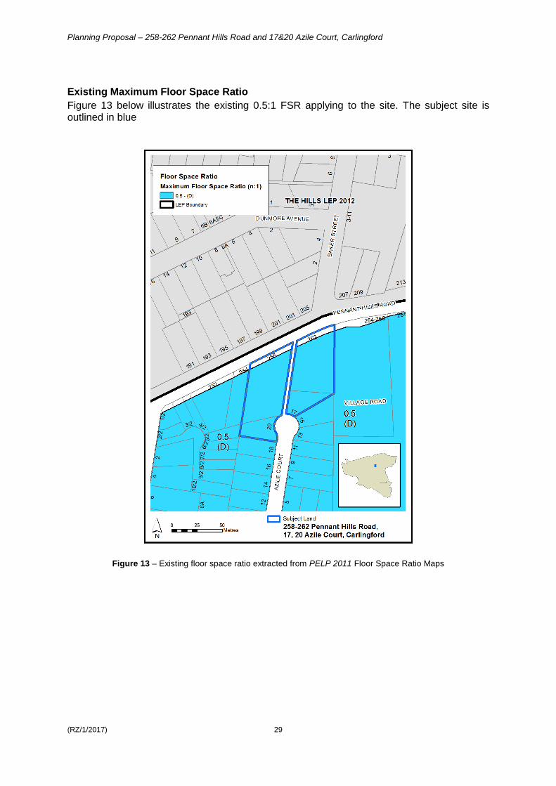
Existing Maximum Floor Space Ratio
Figure 13 below illustrates the existing 0.5:1 FSR applying to the site. The subject site is outlined in blue
Figure 13 – Existing floor space ratio extracted from PELP 2011 Floor Space Ratio Maps

Planning Proposal – 258-262 Pennant Hills Road and 17&20 Azile Court, Carlingford
(RZ/1/2017) 30
4.2 Proposed controls
The figures in this section illustrate the proposed zoning, maximum building height and maximum floor space ratio controls sought by this Planning Proposal. Proposed Zoning
Figure 14 below illustrates the proposed part R4 High Density Residential and part SP2 Infrastructure (Classified Road) across the site. The subject site is outlined in blue.
Figure 14 – Proposed amendment to PLEP 2011 Land Zoning Map

Planning Proposal – 258-262 Pennant Hills Road and 17&20 Azile Court, Carlingford
(RZ/1/2017) 31
Proposed Height of Buildings
Figure 15 below illustrates the proposed maximum height of building controls across the site. As can be seen, the proposed maximum building height on the western part of the site is 14 metres and the proposed maximum building height on the eastern part of the site is 21 metres with the SP2 land along Pennant Hills Road and the Council laneway without a maximum building height control. The subject site is outlined in blue.
Figure 15 – Proposed amendment to PLEP 2011 Height of Building

Planning Proposal – 258-262 Pennant Hills Road and 17&20 Azile Court, Carlingford
(RZ/1/2017) 32
Proposed Floor Space Ratio
Figure 16 below illustrates the proposed maximum floor space ratio (FSR) controls across the site. As can be seen, the proposed maximum FSR on the western part of the subject site is 1.2:1 and the proposed maximum FSR on the eastern part of the site is 1.6:1. The land zoned SP2 (Classified Road) along Pennant Hills Road will continue to be without an FSR control as will the Council laneway in between the two parts of the site.
Figure 16 – Proposed amendment to PLEP 2011 Floor Space Ratio Map
Planning Proposal – 258-262 Pennant Hills Road and 17&20 Azile Court, Carlingford
(RZ/1/2017) 33
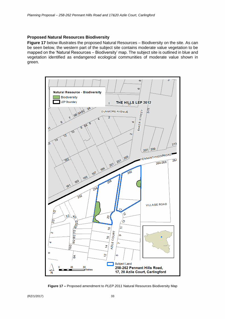
Proposed Natural Resources Biodiversity
Figure 17 below illustrates the proposed Natural Resources – Biodiversity on the site. As can be seen below, the western part of the subject site contains moderate value vegetation to be mapped on the ‘Natural Resources – Biodiversity’ map. The subject site is outlined in blue and vegetation identified as endangered ecological communities of moderate value shown in green.
Figure 17 – Proposed amendment to PLEP 2011 Natural Resources Biodiversity Map
Planning Proposal – 258-262 Pennant Hills Road and 17&20 Azile Court, Carlingford
(RZ/1/2017) 34
PART 5 – COMMUNITY CONSULTATION
In accordance with Section 57(2) of the EP&A Act 1979, the Director-General of Planning must approve the form of the planning proposal, as revised to comply with the gateway determination, before community consultation is undertaken. Public exhibition is likely to include:
newspaper advertisement;
display on the Council’s website; and
written notification to surrounding landowners. The gateway determination will specify the level of public consultation that must be undertaken in relation to the planning proposal including those with government agencies. Consistent with sections 3.34(4) and 3.34(8) of the EP&A Act 1979, where community consultation is required, an instrument cannot be made unless the community has been given an opportunity to make submissions and the submissions have been considered.
PART 6 – PROJECT TIMELINE
The detail around the project timeline is expected to be prepared following the referral to the Minister for a Gateway Determination. The following steps are anticipated:
Referral to Minister for a Gateway determination Commencement and completion dates for public exhibition period and government
agency notification Consideration of submissions Consideration of proposal post exhibition and reporting to Council Submission to the Department to finalise the LEP Notification of instrument

Planning Proposal – 258-262 Pennant Hills Road and 17&20 Azile Court, Carlingford
(RZ/1/2017) 35
Attachment 1 - List of Planning Proposal Attachments
Appendix 1 – Urban Design Modification
Appendix 2 – Traffic and Parking Assessment Report (May 2016)
Appendix 3 – Transport Report Addendum (July 2018)
Appendix 4 – Ecological Assessment for Carlingford Block Study Precinct (November 2016)
Appendix 5 – Council Report 9 April 2018
Please note: The attachments listed above have not been included in Council’s Business Paper due to
their large size. For access to any of these documents, please contact Kieren Lawson, Project Officer,
Land Use Planning at [email protected] .

Planning Proposal – 258-262 Pennant Hills Road and 17&20 Azile Court, Carlingford
(RZ/1/2017) 36
Prepared by City of Parramatta Council


