1 Plate Tectonics • Introduction • Predecessor of plate tectonics: Continental drift hypothesis • What is the theory of plate tectonics? • What is a plate? • How do we find their edges? • How many plates are there? • Why is plate tectonics important? • Types of relative plate movements (and related stresses) • Types of plate boundaries • Plate boundaries and earthquake depths • Measuring plate motions • Why do plates move? 1 News, articles, etc. on Plate Tectonics https://www.diigo.com/outliner/6vks13/Plate-Tectonics?key=hrh02jmyit This Dynamic Earth - USGS Continental Drift In 1912, Alfred Lothar Wegener (1880-1930), a German meteorologist, published the hypothesis of continental drift with multiple lines of evidence to back it up. Wegener proposed that all of the continents were once joined together as one supercontinent that he called Pangea. 2 This Dynamic Earth - USGS Fossil evidence for once joined continents 3 Related puzzle activity: http://volcanoes.usgs.gov/about/edu/dynamicplanet/wegener/ This Dynamic Earth - USGS Later studies have allowed the positions of the continents at different times in Earth history to be determined, and have documented the breakup of Pangea. 4 http://media.pearsoncmg.com/bc/bc_0media_geo/active_art/hdew_2e.html?PlateMoTime Plate Tectonics Today, we know that it isn’t just the continents that have moved. Rather, the Earth’s surface is broken into pieces of continental and/or ocean crust called plates. Plate tectonics deals with the nature of these plates, what happens at their boundaries, how and why they move, etc. Fig 20.3 - Understanding Earth 5 Plate tectonics also explains the locations of earthquake faults, volcanoes, and major mountain ranges. Photos from: This Dynamic Earth (USGS) and Understanding Earth 6
Transcript
1
Plate Tectonics
• Introduction• Predecessor of plate tectonics: Continental drift hypothesis• What is the theory of plate tectonics? • What is a plate? • How do we find their edges? • How many plates are there?• Why is plate tectonics important?
• Types of relative plate movements (and related stresses)
• Types of plate boundaries
• Plate boundaries and earthquake depths
• Measuring plate motions
• Why do plates move?
1
News, articles, etc. on Plate Tectonics https://www.diigo.com/outliner/6vks13/Plate-Tectonics?key=hrh02jmyit This Dynamic Earth - USGS
Continental Drift
In 1912, Alfred Lothar Wegener (1880-1930), a German meteorologist, published the hypothesis of continental drift with multiple lines of evidence to back it up. Wegener proposed that all of the continents were once joined together as one supercontinent that he called Pangea.
2
This Dynamic Earth - USGS
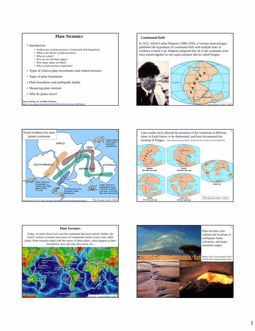
Fossil evidence for once joined continents
3
Related puzzle activity: http://volcanoes.usgs.gov/about/edu/dynamicplanet/wegener/This Dynamic Earth - USGS
Later studies have allowed the positions of the continents at different times in Earth history to be determined, and have documented the breakup of Pangea.
Today, we know that it isn’t just the continents that have moved. Rather, the Earth’s surface is broken into pieces of continental and/or ocean crust called
plates. Plate tectonics deals with the nature of these plates, what happens at their boundaries, how and why they move, etc.
Fig 20.3 - Understanding Earth
5
Plate tectonics also explains the locations of earthquake faults, volcanoes, and major mountain ranges.
Photos from: This Dynamic Earth (USGS) and Understanding Earth
6
2
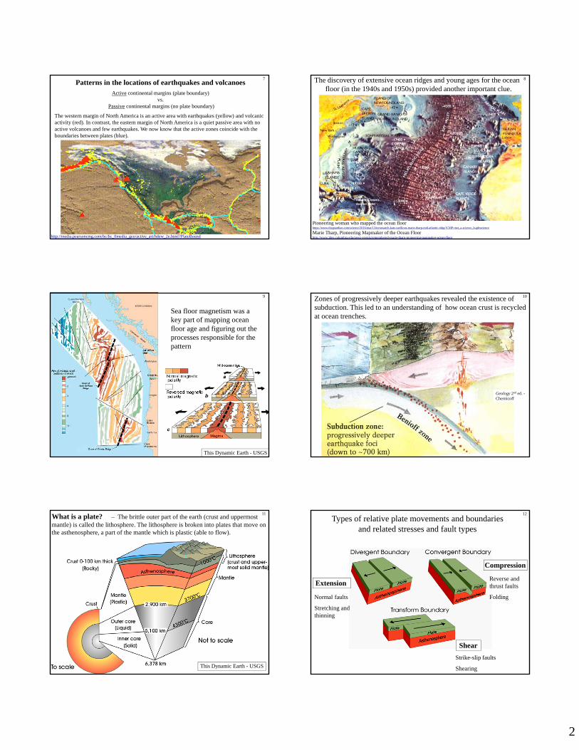
Patterns in the locations of earthquakes and volcanoesActive continental margins (plate boundary)
vs.Passive continental margins (no plate boundary)
The western margin of North America is an active area with earthquakes (yellow) and volcanic activity (red). In contrast, the eastern margin of North America is a quiet passive area with no active volcanoes and few earthquakes. We now know that the active zones coincide with the boundaries between plates (blue).
The discovery of extensive ocean ridges and young ages for the ocean floor (in the 1940s and 1950s) provided another important clue.
8
Pioneering woman who mapped the ocean floorhttps://www.theguardian.com/science/2016/mar/13/terrawatch-kate-ravilious-marie-tharp-mid-atlantic-ridge?CMP=twt_a-science_b-gdnscience
Marie Tharp, Pioneering Mapmaker of the Ocean Floorhttp://www.ldeo.columbia.edu/news-events/remembered-marie-tharp-pioneering-mapmaker-ocean-floor
Sea floor magnetism was a key part of mapping ocean floor age and figuring out the processes responsible for the pattern
9
This Dynamic Earth - USGS
Zones of progressively deeper earthquakes revealed the existence of subduction. This led to an understanding of how ocean crust is recycled at ocean trenches.
Geology 2nd ed. -Chernicoff
10
This Dynamic Earth - USGS
What is a plate? – The brittle outer part of the earth (crust and uppermost mantle) is called the lithosphere. The lithosphere is broken into plates that move on the asthenosphere, a part of the mantle which is plastic (able to flow).
11
Extension
Compression
Shear
Normal faults
Stretching and thinning
Strike-slip faults
Shearing
Reverse and thrust faults
Folding
12
Types of relative plate movements and boundariesand related stresses and fault types
3
This Dynamic Earth - USGS
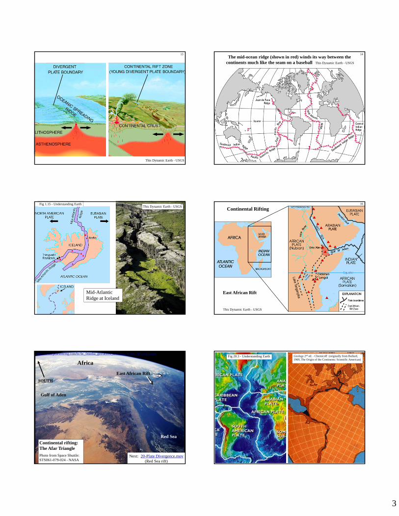
13The mid-ocean ridge (shown in red) winds its way between the
continents much like the seam on a baseball This Dynamic Earth - USGS
14
This Dynamic Earth - USGSFig 1.15 - Understanding Earth
Transform plate boundarySan Andreas fault, California
Fig 1.17 - Understanding Earth
20
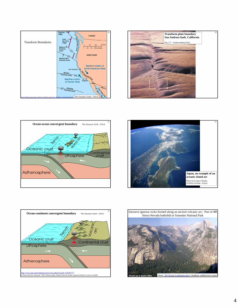
Ocean-ocean convergent boundary This Dynamic Earth - USGS21
Japan, an example of an oceanic island arcPhoto from Space Shuttle: STS059-218-044 - NASA
22
Ocean-continent convergent boundary This Dynamic Earth - USGS23
http://www.npr.org/templates/story/story.php?storyId=124361777(Charles Darwin witnessed 1895 Chilean quake, deduced that the Andes required millions of years to build)
Intrusive igneous rocks formed along an ancient volcanic arc: Part of the Sierra-Nevada batholith in Yosemite National Park
ap based on widely available dataset ETOPO5 http://terra.rice.edu/plateboundary .
Fig. 10-16 Chernicoff - Geology
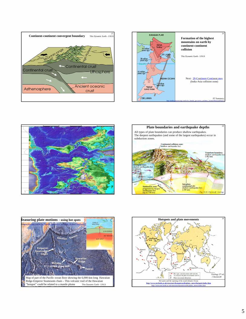
All types of plate boundaries can produce shallow earthquakes. The deepest earthquakes (and some of the largest earthquakes) occur in subduction zones.
Plate boundaries and earthquake depths 28
Map of part of the Pacific ocean floor showing the 6,000-km-long Hawaiian Ridge-Emperor Seamounts chain – This volcanic trail of the Hawaiian “hotspot” could be related to a mantle plume This Dynamic Earth - USGS
A GPS ground receiver at Augustine Volcano (Cook Inlet, Alaska) recording signals sent by GPS satellites. Artist's conception of a Global Positioning System satellite in orbit shown in inset. Source: USGS
32How we know: http://www.see.leeds.ac.uk/structure/dynamicearth/plates_move/index.htmNASA GPS Time Series plate movements: http://sideshow.jpl.nasa.gov/post/series.htmlGPS time series: http://en.wikipedia.org/wiki/File:Global_plate_motion_2008-04-17.jpgMore GPS http://www.dpc.ucar.edu/VoyagerJr/gpsplatebound.html
How do we know plates move today? From Earthquakes, GPS, VLBI, & SLR
Major plate boundaries and their rates of movement33
Since 1994, Australia has moved about 5 feet! http://newatlas.com/australia-gda2020/44674/
Fig 20.12 - Understanding Earth
Projected future positions of the continents - 100 million years from now: If current plate movements continue unchanged, part of California will become an island off the coast of Washington, the Mediterranean Sea may close, and eastern Africa may become an island. Geology 2nd ed. - Chernicoff
34
The general scientific consensus is that plate movements are related to convection.
Convection in the Earth results from the escape of heat from the interior and involves the pull of gravity on rocks of different densities.
Essentially, colder, more dense rocks sink while hotter, less dense rocks rise.
Plate Tectonics:
Why do plates move?
Fig 1.13 - Understanding Earth
35
Fig 20.25 - Understanding Earth
Suggested mechanismsto drive plate motions
36
Best fit to evidence for major force causing
plate movements
Doesn’t match rates
of movement
Partly true, but convection not as organized as this
Deep plumes exist, but are not a major
cause of plate movements
7
Slab pull – probably the most important driver of plate movements
Image source: This Dynamic Earth – USGS http://pubs.usgs.gov/publications/text/dynamic.html
- cold, relatively dense lithosphere is pulled downward at subduction zones and pulls the rest of the plate along behind it