© 2
014 A
irbus D
efe
nce a
nd S
pace –
All r
ights
reserv
ed. T
he r
epro
duction, dis
trib
ution a
nd u
tilization o
f th
is d
ocum
ent as w
ell a
s t
he c
om
munic
ation o
f its c
onte
nts
to o
thers
without expre
ss a
uth
ori
zation is
pro
hib
ited. O
ffenders
will be h
eld
lia
ble
for th
e p
aym
ent of dam
ages. A
ll r
ights
reserv
ed in
the e
vent of th
e g
rant of a p
ate
nt,
utility
model o
r desig
n.
Pléiades 1B and SPOT 6 Image Quality status after commissioning and 1st year in orbit
Brian Cutler, Project Director
Laurent Coeurdevey, Expert Optical Image and Product Quality
Session #3, Spotlight Session, JACIE 2014 (Louisville, March 26 2014)
© 2
014 A
irbus D
efe
nce a
nd S
pace –
All r
ights
reserv
ed. T
he r
epro
duction, dis
trib
ution a
nd u
tilization o
f th
is d
ocum
ent as w
ell a
s t
he c
om
munic
ation o
f its c
onte
nts
to o
thers
without expre
ss a
uth
ori
zation is
pro
hib
ited. O
ffenders
will be h
eld
lia
ble
for th
e p
aym
ent of dam
ages. A
ll r
ights
reserv
ed in
the e
vent of th
e g
rant of a p
ate
nt,
utility
model o
r desig
n.
Acknowledgments
We would like to express our gratitude to all contributors of Pléiades and SPOT 6 Image Quality for the care they
brought in assessing, improving and carrying on monitoring radiometric and geometric performances.
• Pléiades 1B:
– French Space Agency, Centre National d’Etudes Spatiales (CNES)
– Responsible of commissioning phase and monitoring along the life
• SPOT 6:
– AIRBUS Defense & Space
– Responsible of commissioning phase and monitoring along the life
– French Mapping Agency, Institut Géographique National (IGN)
– Commissioning phase: geometric calibration and performance
– French Space Agency, Centre National d’Etudes Spatiales (CNES)
– Commissioning phase and monitoring along the life: radiometric calibration and performance
02 April 2014 2
© 2
014 A
irbus D
efe
nce a
nd S
pace –
All r
ights
reserv
ed. T
he r
epro
duction, dis
trib
ution a
nd u
tilization o
f th
is d
ocum
ent as w
ell a
s t
he c
om
munic
ation o
f its c
onte
nts
to o
thers
without expre
ss a
uth
ori
zation is
pro
hib
ited. O
ffenders
will be h
eld
lia
ble
for th
e p
aym
ent of dam
ages. A
ll r
ights
reserv
ed in
the e
vent of th
e g
rant of a p
ate
nt,
utility
model o
r desig
n.
3
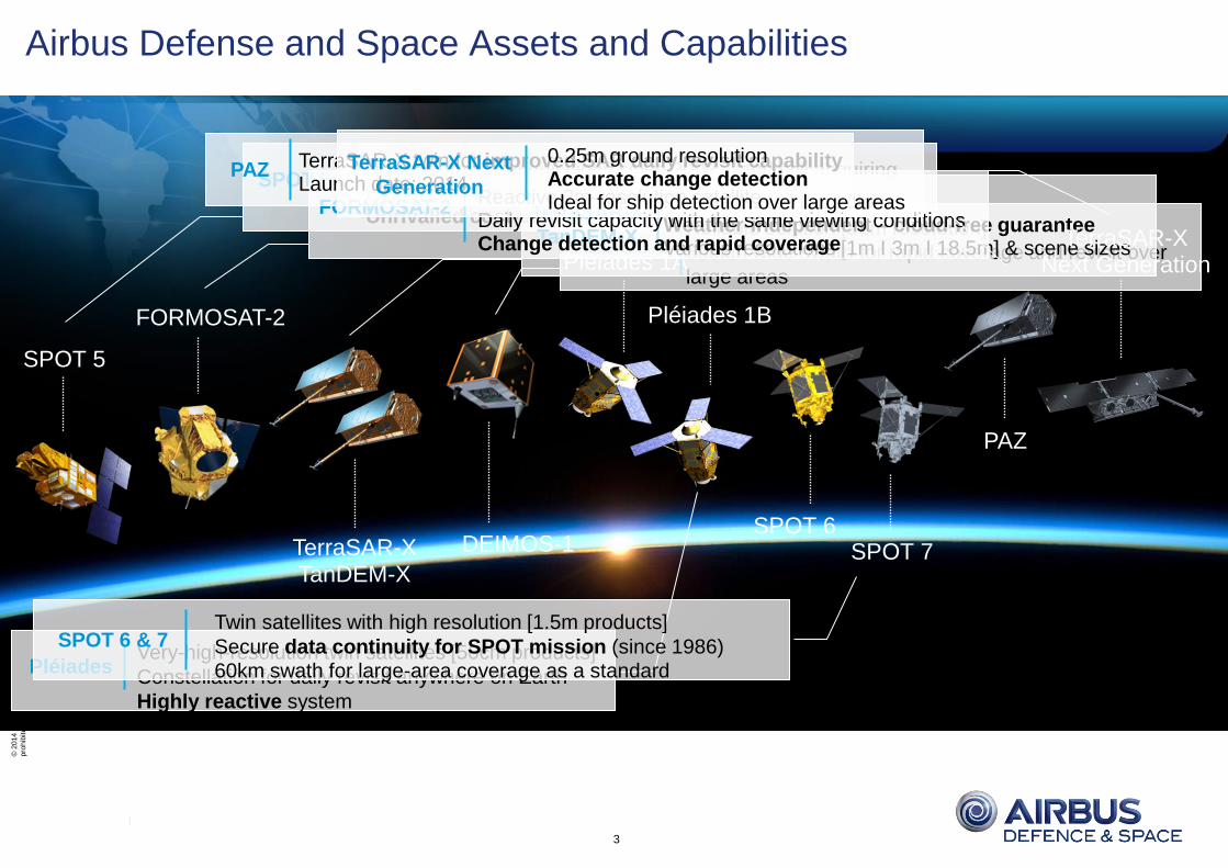
SPOT 5
SPOT 6 SPOT 7
Pléiades 1B
Pléiades 1A
TerraSAR-X TanDEM-X
Reliable image acquisitions since 2002 – and still acquiring High-resolution imagery [2.5m] Unrivalled cost-efficiency
SPOT 5
Very-high-resolution twin satellites [50cm products]
Constellation for daily revisit anywhere on Earth
Highly reactive system
Pléiades
Twin satellites with high resolution [1.5m products]
Secure data continuity for SPOT mission (since 1986) 60km swath for large-area coverage as a standard
SPOT 6 & 7
FORMOSAT-2
DEIMOS-1
Reliable solution [22m resolution]
600km wide swath for rapid coverage and revisit over
large areas
DEIMOS-1
Radar satellite formation Weather-independent – cloud-free guarantee Various resolutions [1m I 3m I 18.5m] & scene sizes
TerraSAR-X
TanDEM-X
Reactive 2m-resolution satellite Daily revisit capacity with the same viewing conditions Change detection and rapid coverage
FORMOSAT-2
TerraSAR-X twin for improved SAR daily revisit capability Launch date: 2014
PAZ 0.25m ground resolution Accurate change detection Ideal for ship detection over large areas
TerraSAR-X Next
Generation
PAZ
TerraSAR-X Next Generation
Airbus Defense and Space Assets and Capabilities
© 2
014 A
irbus D
efe
nce a
nd S
pace –
All r
ights
reserv
ed. T
he r
epro
duction, dis
trib
ution a
nd u
tilization o
f th
is d
ocum
ent as w
ell a
s t
he c
om
munic
ation o
f its c
onte
nts
to o
thers
without expre
ss a
uth
ori
zation is
pro
hib
ited. O
ffenders
will be h
eld
lia
ble
for th
e p
aym
ent of dam
ages. A
ll r
ights
reserv
ed in
the e
vent of th
e g
rant of a p
ate
nt,
utility
model o
r desig
n.
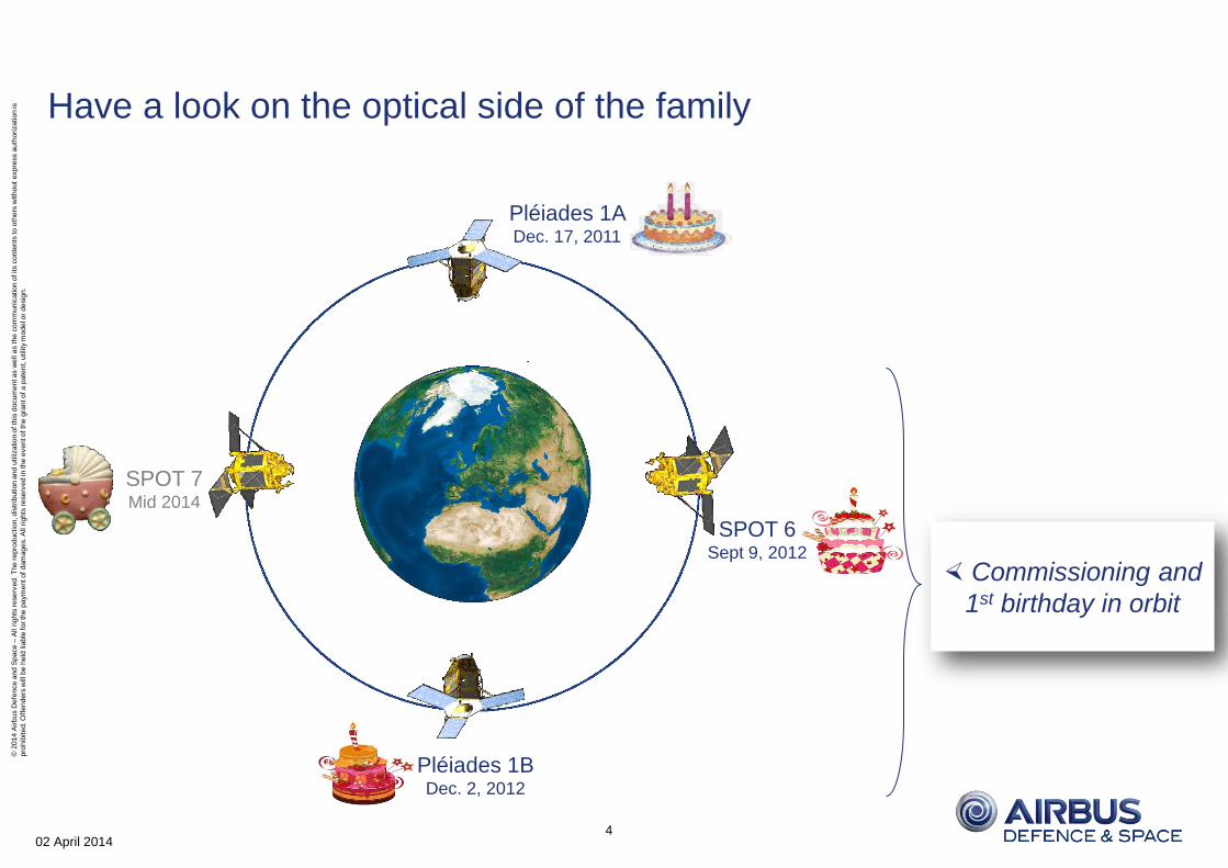
Have a look on the optical side of the family
02 April 2014 4
Pléiades 1A Dec. 17, 2011
SPOT 6 Sept 9, 2012
Pléiades 1B Dec. 2, 2012
SPOT 7 Mid 2014
Commissioning and
1st birthday in orbit
© 2
014 A
irbus D
efe
nce a
nd S
pace –
All r
ights
reserv
ed. T
he r
epro
duction, dis
trib
ution a
nd u
tilization o
f th
is d
ocum
ent as w
ell a
s t
he c
om
munic
ation o
f its c
onte
nts
to o
thers
without expre
ss a
uth
ori
zation is
pro
hib
ited. O
ffenders
will be h
eld
lia
ble
for th
e p
aym
ent of dam
ages. A
ll r
ights
reserv
ed in
the e
vent of th
e g
rant of a p
ate
nt,
utility
model o
r desig
n.
I. Geometry
II. Radiometry
III. Ortho
IV. DEM
02 April 2014 5
© 2
014 A
irbus D
efe
nce a
nd S
pace –
All r
ights
reserv
ed. T
he r
epro
duction, dis
trib
ution a
nd u
tilization o
f th
is d
ocum
ent as w
ell a
s t
he c
om
munic
ation o
f its c
onte
nts
to o
thers
without expre
ss a
uth
ori
zation is
pro
hib
ited. O
ffenders
will be h
eld
lia
ble
for th
e p
aym
ent of dam
ages. A
ll r
ights
reserv
ed in
the e
vent of th
e g
rant of a p
ate
nt,
utility
model o
r desig
n.
Image quality: assessments/measurements/performances
Main objective of image quality assessments is to provide measurements of the performance of image as
acquired by the satellite camera and process by its equipments
• Image quality (IQ) must establish a constant assessment reference frame. Generally provided by:
– Raw images as archived on-ground after data downlink. Possibly including enhancement not achieved at
satellite level.
– A collection of features (sites…) used as reference.
• Final products cannot strictly been included into this frame as:
– Some end-user options may modify image contents: bit-depth radiometric resolution, mapping
projection…
– Requirements agreed with end user may differ from observations assessed on IQ reference features:
acquisition conditions (angle, sunlight…), atmospheric effects, target characteristics…
Evaluation of image quality on final products (Primary, Ortho) must take into account these aspects.
02 April 2014 6
© 2
014 A
irbus D
efe
nce a
nd S
pace –
All r
ights
reserv
ed. T
he r
epro
duction, dis
trib
ution a
nd u
tilization o
f th
is d
ocum
ent as w
ell a
s t
he c
om
munic
ation o
f its c
onte
nts
to o
thers
without expre
ss a
uth
ori
zation is
pro
hib
ited. O
ffenders
will be h
eld
lia
ble
for th
e p
aym
ent of dam
ages. A
ll r
ights
reserv
ed in
the e
vent of th
e g
rant of a p
ate
nt,
utility
model o
r desig
n.
Geometric Performances
Pointing accuracy
Location accuracy
Planimetric accuracy
Vertical accuracy
02 April 2014 7
Geometry Radiometry Ortho DEM
© 2
014 A
irbus D
efe
nce a
nd S
pace –
All r
ights
reserv
ed. T
he r
epro
duction, dis
trib
ution a
nd u
tilization o
f th
is d
ocum
ent as w
ell a
s t
he c
om
munic
ation o
f its c
onte
nts
to o
thers
without expre
ss a
uth
ori
zation is
pro
hib
ited. O
ffenders
will be h
eld
lia
ble
for th
e p
aym
ent of dam
ages. A
ll r
ights
reserv
ed in
the e
vent of th
e g
rant of a p
ate
nt,
utility
model o
r desig
n.
Pointing Accuracy Performance
The capability to target the instrument toward the desired point when tasking the satellite
• Pléiades 1B performance: requirement reached with a comfortable margin
• Performance Across track: 275m LE99.7 vs. Requirement 500m LE99.7
• Performance Along track: 520m LE99.7 vs. Requirement 1000m LE99.7
• SPOT 6 performance: requirement reached with a comfortable margin
• Performance Across track: 70m LE99.7 vs. Requirement 600m LE95
• Performance Along track: 362m LE99.7 vs. Requirement 1000m LE95
02 April 2014 8
Geometry Radiometry
Pléiades 1B single pass tri-stereo
(check time on Macca Clock Royal Tower)
© 2
014 A
irbus D
efe
nce a
nd S
pace –
All r
ights
reserv
ed. T
he r
epro
duction, dis
trib
ution a
nd u
tilization o
f th
is d
ocum
ent as w
ell a
s t
he c
om
munic
ation o
f its c
onte
nts
to o
thers
without expre
ss a
uth
ori
zation is
pro
hib
ited. O
ffenders
will be h
eld
lia
ble
for th
e p
aym
ent of dam
ages. A
ll r
ights
reserv
ed in
the e
vent of th
e g
rant of a p
ate
nt,
utility
model o
r desig
n.
Location Accuracy Assessment: How?
Products location with on-board data only Rigorous Geometric Model accuracy without GCP
• On board ephemeris
• On board raw attitudes and accurate attitudes for Pléiades (orbitography refined twice a day)
Geolocation assessment (both for commissioning and current monitoring) performed with several hundreds of
acquisitions over fully qualified GCPs distributed worldwide in order to reflect the performance all along the orbit
and the nominal acquisition domain (OZA < 30°)
02 April 2014 9
CNES GCP database used for Pléiades assessment AIRBUS GCP database used for SPOT 6 assessment
Geometry Radiometry
© 2
014 A
irbus D
efe
nce a
nd S
pace –
All r
ights
reserv
ed. T
he r
epro
duction, dis
trib
ution a
nd u
tilization o
f th
is d
ocum
ent as w
ell a
s t
he c
om
munic
ation o
f its c
onte
nts
to o
thers
without expre
ss a
uth
ori
zation is
pro
hib
ited. O
ffenders
will be h
eld
lia
ble
for th
e p
aym
ent of dam
ages. A
ll r
ights
reserv
ed in
the e
vent of th
e g
rant of a p
ate
nt,
utility
model o
r desig
n.
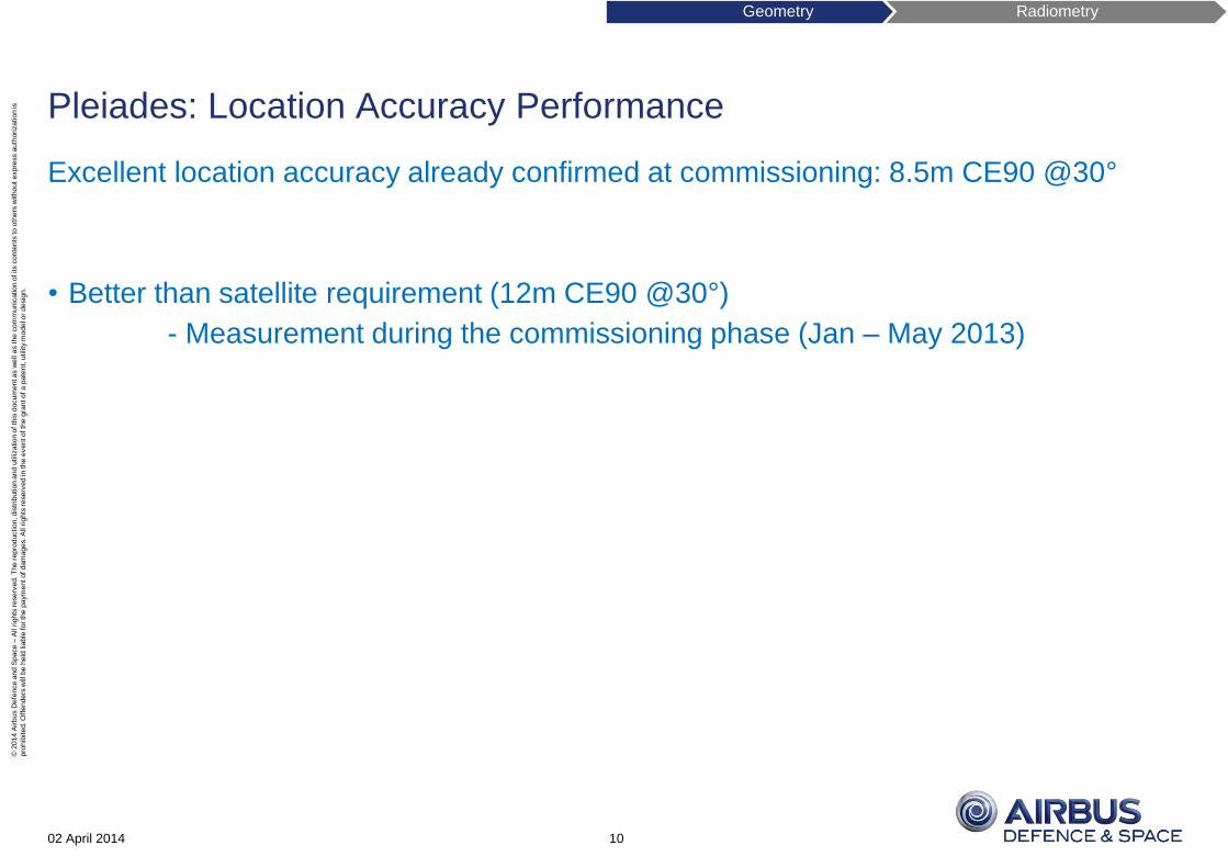
Pleiades: Location Accuracy Performance
Excellent location accuracy already confirmed at commissioning: 8.5m CE90 @30°
• Better than satellite requirement (12m CE90 @30°)
- Measurement during the commissioning phase (Jan – May 2013)
02 April 2014 10
Geometry Radiometry
© 2
014 A
irbus D
efe
nce a
nd S
pace –
All r
ights
reserv
ed. T
he r
epro
duction, dis
trib
ution a
nd u
tilization o
f th
is d
ocum
ent as w
ell a
s t
he c
om
munic
ation o
f its c
onte
nts
to o
thers
without expre
ss a
uth
ori
zation is
pro
hib
ited. O
ffenders
will be h
eld
lia
ble
for th
e p
aym
ent of dam
ages. A
ll r
ights
reserv
ed in
the e
vent of th
e g
rant of a p
ate
nt,
utility
model o
r desig
n.
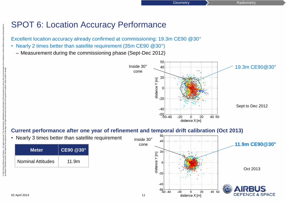
SPOT 6: Location Accuracy Performance
Excellent location accuracy already confirmed at commissioning: 19.3m CE90 @30°
• Nearly 2 times better than satellite requirement (35m CE90 @30°)
– Measurement during the commissioning phase (Sept-Dec 2012)
Current performance after one year of refinement and temporal drift calibration (Oct 2013)
• Nearly 3 times better than satellite requirement
02 April 2014 11
Meter CE90 @30°
Nominal Attitudes 11.9m
Inside 30°
cone
Sept to Dec 2012
19.3m CE90@30°
Inside 30°
cone
Oct 2013
11.9m CE90@30°
Geometry Radiometry
© 2
014 A
irbus D
efe
nce a
nd S
pace –
All r
ights
reserv
ed. T
he r
epro
duction, dis
trib
ution a
nd u
tilization o
f th
is d
ocum
ent as w
ell a
s t
he c
om
munic
ation o
f its c
onte
nts
to o
thers
without expre
ss a
uth
ori
zation is
pro
hib
ited. O
ffenders
will be h
eld
lia
ble
for th
e p
aym
ent of dam
ages. A
ll r
ights
reserv
ed in
the e
vent of th
e g
rant of a p
ate
nt,
utility
model o
r desig
n.
Focal Plane Calibration and Planimetric Accuracy Assessment: How?
Planimetric accuracy: residual error of all Line Of Sight contributors after geometric model reset
on a Ground absolute reference:
• Assessment on reference site, image auto calibration (cross acquisition) …
• Reference sites: correlation on nearly perfect reference sites covering the full swath
• Supersites of Toulouse (France), Bouches du Rhône (France), Napier (New Zealand)
• XY accuracy <0.2m ; Z accuracy<0.3m
• Auto calibration without reference site
• Cross acquisition of 2 images (or more) on a same orbit, viewing the same site
with opposite viewing angles of 90°
• Correlation of image couple gives static and dynamic residues along lines and columns
02 April 2014 12
Pléiades focal plane SPOT 6 focal plane
Geometry Radiometry
© 2
014 A
irbus D
efe
nce a
nd S
pace –
All r
ights
reserv
ed. T
he r
epro
duction, dis
trib
ution a
nd u
tilization o
f th
is d
ocum
ent as w
ell a
s t
he c
om
munic
ation o
f its c
onte
nts
to o
thers
without expre
ss a
uth
ori
zation is
pro
hib
ited. O
ffenders
will be h
eld
lia
ble
for th
e p
aym
ent of dam
ages. A
ll r
ights
reserv
ed in
the e
vent of th
e g
rant of a p
ate
nt,
utility
model o
r desig
n.
Pléiades 1B: Focal Plane and Planimetric Accuracy Performance
Focal plan calibration during commissioning : focal plan residues less than 0.2 pix PAN along track and 0.3 across
Planimetric accuracy performance on almost perfect reference sites: spec comfortably achieved
02 April 2014 13
Planimetric accuracy (in pixel PAN raw size)
Current performance Requirement
On 90% of images 0.45 0.5
Cartography
residues along
columns and
lines at
commissioning
(PAN pixel unit)
Geometry Radiometry
© 2
014 A
irbus D
efe
nce a
nd S
pace –
All r
ights
reserv
ed. T
he r
epro
duction, dis
trib
ution a
nd u
tilization o
f th
is d
ocum
ent as w
ell a
s t
he c
om
munic
ation o
f its c
onte
nts
to o
thers
without expre
ss a
uth
ori
zation is
pro
hib
ited. O
ffenders
will be h
eld
lia
ble
for th
e p
aym
ent of dam
ages. A
ll r
ights
reserv
ed in
the e
vent of th
e g
rant of a p
ate
nt,
utility
model o
r desig
n.
SPOT 6: Focal Plane and Planimetric Accuracy Performance
Focal plan calibration during commissioning: focal plan residues less than 0.1 pix PAN along track and 0.2 across
Planimetric accuracy performance on nearly perfect reference sites: spec comfortably achieved
02 April 2014 14
Planimetric accuracy (in pixel PAN raw size)
Current performance Requirement
On 90% of images 0.75 1
Geometry Radiometry
Cartography
residues along
columns and
lines at
commissioning
(PAN pixel unit)
© 2
014 A
irbus D
efe
nce a
nd S
pace –
All r
ights
reserv
ed. T
he r
epro
duction, dis
trib
ution a
nd u
tilization o
f th
is d
ocum
ent as w
ell a
s t
he c
om
munic
ation o
f its c
onte
nts
to o
thers
without expre
ss a
uth
ori
zation is
pro
hib
ited. O
ffenders
will be h
eld
lia
ble
for th
e p
aym
ent of dam
ages. A
ll r
ights
reserv
ed in
the e
vent of th
e g
rant of a p
ate
nt,
utility
model o
r desig
n.
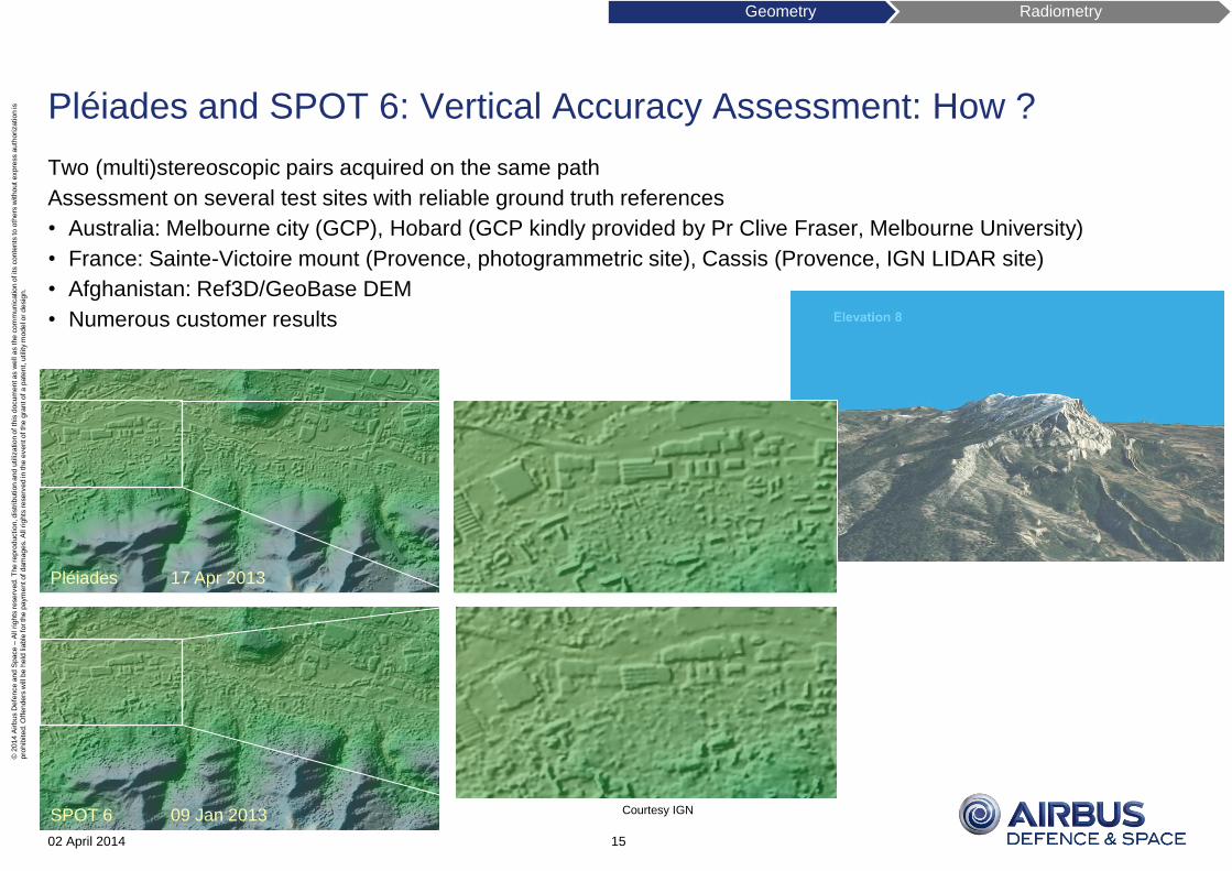
Pléiades and SPOT 6: Vertical Accuracy Assessment: How ?
Two (multi)stereoscopic pairs acquired on the same path
Assessment on several test sites with reliable ground truth references
• Australia: Melbourne city (GCP), Hobard (GCP kindly provided by Pr Clive Fraser, Melbourne University)
• France: Sainte-Victoire mount (Provence, photogrammetric site), Cassis (Provence, IGN LIDAR site)
• Afghanistan: Ref3D/GeoBase DEM
• Numerous customer results
02 April 2014 15
Geometry Radiometry
Courtesy IGN
Pléiades 17 Apr 2013
SPOT 6 09 Jan 2013
© 2
014 A
irbus D
efe
nce a
nd S
pace –
All r
ights
reserv
ed. T
he r
epro
duction, dis
trib
ution a
nd u
tilization o
f th
is d
ocum
ent as w
ell a
s t
he c
om
munic
ation o
f its c
onte
nts
to o
thers
without expre
ss a
uth
ori
zation is
pro
hib
ited. O
ffenders
will be h
eld
lia
ble
for th
e p
aym
ent of dam
ages. A
ll r
ights
reserv
ed in
the e
vent of th
e g
rant of a p
ate
nt,
utility
model o
r desig
n.
Pléiades: Vertical Accuracy Performance
Pléiades (slopes < 20%)
16
Meter LE90
B/H 0.22 1.2m
Tri-stereoscopic 1m
B/H 0.5 0.8m
Australia – Melbourne
Pléiades DEM
AWACS
airplanes
Pléiades 3D
rendering
Excellent performance into shadows,
thanks to 12 bit-depth dynamic range
DEM Product Equivalence *
Elevation 1 HRE10 *
Elevation 4 HRE40 *
Geometry Radiometry
(*) DEM Product with accurate GCPs
© 2
014 A
irbus D
efe
nce a
nd S
pace –
All r
ights
reserv
ed. T
he r
epro
duction, dis
trib
ution a
nd u
tilization o
f th
is d
ocum
ent as w
ell a
s t
he c
om
munic
ation o
f its c
onte
nts
to o
thers
without expre
ss a
uth
ori
zation is
pro
hib
ited. O
ffenders
will be h
eld
lia
ble
for th
e p
aym
ent of dam
ages. A
ll r
ights
reserv
ed in
the e
vent of th
e g
rant of a p
ate
nt,
utility
model o
r desig
n.
SPOT 6: Vertical Accuracy Performance
SPOT 6 (slopes < 20%)
02 April 2014 17
Meter LE90
B/H 0.3 4m
Tri-stereoscopic 2.5m
B/H 0.5 2.5m
Australia – Melbourne
SPOT 6 DEM (Elevation 8)
Excellent performance into shadows,
thanks to 12 bit-depth dynamic range
DEM Product Equivalence (*)
Elevation 8 HRE80 (*)
Geometry Radiometry
(*) DEM Product with accurate GCPs
© 2
014 A
irbus D
efe
nce a
nd S
pace –
All r
ights
reserv
ed. T
he r
epro
duction, dis
trib
ution a
nd u
tilization o
f th
is d
ocum
ent as w
ell a
s t
he c
om
munic
ation o
f its c
onte
nts
to o
thers
without expre
ss a
uth
ori
zation is
pro
hib
ited. O
ffenders
will be h
eld
lia
ble
for th
e p
aym
ent of dam
ages. A
ll r
ights
reserv
ed in
the e
vent of th
e g
rant of a p
ate
nt,
utility
model o
r desig
n.
Pléiades 1B and SPOT 6: Inter-Band Registration Assessment
Inter-band registration between each multispectral channel (MS-MS) and with the Pan band (PAN-MS) at product
level
• Bands registration on ground at production level (see slide focal plan)
• Direct result of focal plan calibration (static effects) and line of sight stability (dynamics effects)
• Assessment by inter-band correlation
• At least 0.25 Pixel MS necessary performance of PAN-MS registration for Pan-sharpening
02 April 2014 18
SPOT 6 inter-band registration measurements (commissioning phase)
Geometry Radiometry
© 2
014 A
irbus D
efe
nce a
nd S
pace –
All r
ights
reserv
ed. T
he r
epro
duction, dis
trib
ution a
nd u
tilization o
f th
is d
ocum
ent as w
ell a
s t
he c
om
munic
ation o
f its c
onte
nts
to o
thers
without expre
ss a
uth
ori
zation is
pro
hib
ited. O
ffenders
will be h
eld
lia
ble
for th
e p
aym
ent of dam
ages. A
ll r
ights
reserv
ed in
the e
vent of th
e g
rant of a p
ate
nt,
utility
model o
r desig
n.
Pléiades 1B: Inter-Band Registration Performance
Requirement reached with a comfortable margin
Excellent registration even in very roughly conditions,
thanks to new Pan-sharpening process within
• Significant viewing angles
• Parallax effects caused by relief
02 April 2014 19
In MS pixel native size Current
performance Requirement
MS-MS registration 0.18@90% 0.25 @99.7%
PAN-MS registration 0.2@90% 0.5 @99.7%
Geometry Radiometry
K2 Mount elevation of 8,611m
(Karakoram)
45° off-nadir acquisition
0.5m pan-sharpened Product
© 2
014 A
irbus D
efe
nce a
nd S
pace –
All r
ights
reserv
ed. T
he r
epro
duction, dis
trib
ution a
nd u
tilization o
f th
is d
ocum
ent as w
ell a
s t
he c
om
munic
ation o
f its c
onte
nts
to o
thers
without expre
ss a
uth
ori
zation is
pro
hib
ited. O
ffenders
will be h
eld
lia
ble
for th
e p
aym
ent of dam
ages. A
ll r
ights
reserv
ed in
the e
vent of th
e g
rant of a p
ate
nt,
utility
model o
r desig
n.
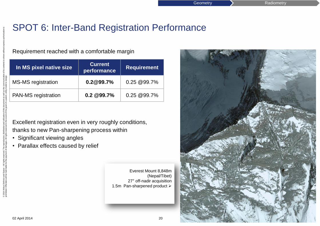
SPOT 6: Inter-Band Registration Performance
Requirement reached with a comfortable margin
Excellent registration even in very roughly conditions,
thanks to new Pan-sharpening process within
• Significant viewing angles
• Parallax effects caused by relief
02 April 2014 20
In MS pixel native size Current
performance Requirement
MS-MS registration [email protected]% 0.25 @99.7%
PAN-MS registration 0.2 @99.7% 0.25 @99.7%
Geometry Radiometry
Everest Mount 8,848m
(Nepal/Tibet)
27° off-nadir acquisition
1.5m Pan-sharpened product
© 2
014 A
irbus D
efe
nce a
nd S
pace –
All r
ights
reserv
ed. T
he r
epro
duction, dis
trib
ution a
nd u
tilization o
f th
is d
ocum
ent as w
ell a
s t
he c
om
munic
ation o
f its c
onte
nts
to o
thers
without expre
ss a
uth
ori
zation is
pro
hib
ited. O
ffenders
will be h
eld
lia
ble
for th
e p
aym
ent of dam
ages. A
ll r
ights
reserv
ed in
the e
vent of th
e g
rant of a p
ate
nt,
utility
model o
r desig
n.
Radiometric performances
Radiance range
Signal to Noise Ratio (SNR)
Modulation Transfer Function (MTF)
Absolute Calibration
02 April 2014 21
Geometry Radiometry
© 2
014 A
irbus D
efe
nce a
nd S
pace –
All r
ights
reserv
ed. T
he r
epro
duction, dis
trib
ution a
nd u
tilization o
f th
is d
ocum
ent as w
ell a
s t
he c
om
munic
ation o
f its c
onte
nts
to o
thers
without expre
ss a
uth
ori
zation is
pro
hib
ited. O
ffenders
will be h
eld
lia
ble
for th
e p
aym
ent of dam
ages. A
ll r
ights
reserv
ed in
the e
vent of th
e g
rant of a p
ate
nt,
utility
model o
r desig
n.
Pléiades 1B: Radiance Range Performance
Radiance encoded over 12 bits-depth (LSB 1 to 4095). 2013 performance:
PAN: nominal Time Delay Integration (TDI) gain configuration: 13 stages (7/10/13/+2 additional configurations)
Saturation controlled by anti-blooming device
• No degradation along lines and columns
02 April 2014 22
Nominal gains configuration in
W.m-2.sr-1.µm-1
Linearity minimum
Level (L1)
Linearity maximum
level (L4)
Detection saturation
Level (Lsat)
Panchromatic (PAN) 13.5 321.4 391.1
Blue Band (B0) 30.8 382.7 513.6
Green Band (B1) 21 370.8 473.5
Red Band (B2) 12 332.3 398.5
NIR Band (B3) 4.9 223.5 251.7
Geometry Radiometry
© 2
014 A
irbus D
efe
nce a
nd S
pace –
All r
ights
reserv
ed. T
he r
epro
duction, dis
trib
ution a
nd u
tilization o
f th
is d
ocum
ent as w
ell a
s t
he c
om
munic
ation o
f its c
onte
nts
to o
thers
without expre
ss a
uth
ori
zation is
pro
hib
ited. O
ffenders
will be h
eld
lia
ble
for th
e p
aym
ent of dam
ages. A
ll r
ights
reserv
ed in
the e
vent of th
e g
rant of a p
ate
nt,
utility
model o
r desig
n.
Pléiades 1B: Radiance Range Performance
Excellent radiance range: Acquisitions tested in nearly nightly conditions
Sun elevation < 1° ; mean radiance at ~1.1 W.m-2.sr-1.µm-1
02 April 2014 23
Sun
Elevation (°) Band
Histo
Min
Histo
Max
Histo
Mean
Histo
STDV
0.614° PAN
(TDI=20) 1 976 20.09 55.54
Usable Comment
Yes
“Moderate” instrument noise and non-uniformity
detector equalization (considering a sun
elevation < 1° and a mean radiance at ~1.1
W.m-2.sr-1.µm-1)
Geometry Radiometry
Kola Peninsula, 2013/11/22
Lat_center=69.20°
Long_center=33.36°
PHR-1B
UTC: 2013-11-22T09:07:29
Sun Elevation 0.614°
© 2
014 A
irbus D
efe
nce a
nd S
pace –
All r
ights
reserv
ed. T
he r
epro
duction, dis
trib
ution a
nd u
tilization o
f th
is d
ocum
ent as w
ell a
s t
he c
om
munic
ation o
f its c
onte
nts
to o
thers
without expre
ss a
uth
ori
zation is
pro
hib
ited. O
ffenders
will be h
eld
lia
ble
for th
e p
aym
ent of dam
ages. A
ll r
ights
reserv
ed in
the e
vent of th
e g
rant of a p
ate
nt,
utility
model o
r desig
n.
SPOT 6: Radiance Range Performance
Radiance encoded over 12 bits-depth (LSB 1 to 4095). 2013 performance:
PAN: nominal TDI gain configuration: 5 stages (3/5/+5 additional configurations)
Saturation controlled by anti-blooming device
• No degradation along lines and columns
02 April 2014 24
Nominal gains configuration in
W.m-2.sr-1.µm-1
Linearity minimum
Level (L1)
Linearity maximum
level (L4)
Detection saturation
Level (Lsat)
Panchromatic (PAN) 17.8 348 364
Blue Band (B0) 33.3 389 424
Green Band (B1) 20.6 376 387
Red Band (B2) 11.9 336 367
NIR Band (B3) 5.6 276 301
Geometry Radiometry
© 2
014 A
irbus D
efe
nce a
nd S
pace –
All r
ights
reserv
ed. T
he r
epro
duction, dis
trib
ution a
nd u
tilization o
f th
is d
ocum
ent as w
ell a
s t
he c
om
munic
ation o
f its c
onte
nts
to o
thers
without expre
ss a
uth
ori
zation is
pro
hib
ited. O
ffenders
will be h
eld
lia
ble
for th
e p
aym
ent of dam
ages. A
ll r
ights
reserv
ed in
the e
vent of th
e g
rant of a p
ate
nt,
utility
model o
r desig
n.
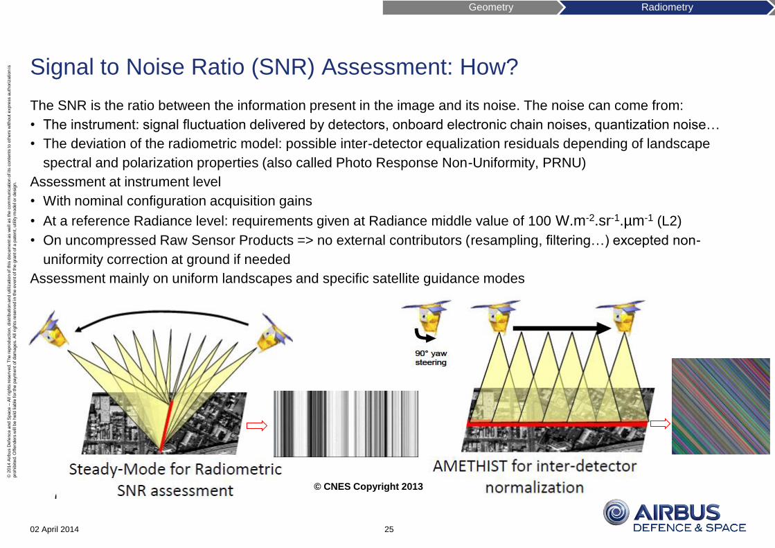
Signal to Noise Ratio (SNR) Assessment: How?
The SNR is the ratio between the information present in the image and its noise. The noise can come from:
• The instrument: signal fluctuation delivered by detectors, onboard electronic chain noises, quantization noise…
• The deviation of the radiometric model: possible inter-detector equalization residuals depending of landscape
spectral and polarization properties (also called Photo Response Non-Uniformity, PRNU)
Assessment at instrument level
• With nominal configuration acquisition gains
• At a reference Radiance level: requirements given at Radiance middle value of 100 W.m-2.sr-1.µm-1 (L2)
• On uncompressed Raw Sensor Products => no external contributors (resampling, filtering…) excepted non-
uniformity correction at ground if needed
Assessment mainly on uniform landscapes and specific satellite guidance modes
02 April 2014 25
© CNES Copyright 2013
Geometry Radiometry
© 2
014 A
irbus D
efe
nce a
nd S
pace –
All r
ights
reserv
ed. T
he r
epro
duction, dis
trib
ution a
nd u
tilization o
f th
is d
ocum
ent as w
ell a
s t
he c
om
munic
ation o
f its c
onte
nts
to o
thers
without expre
ss a
uth
ori
zation is
pro
hib
ited. O
ffenders
will be h
eld
lia
ble
for th
e p
aym
ent of dam
ages. A
ll r
ights
reserv
ed in
the e
vent of th
e g
rant of a p
ate
nt,
utility
model o
r desig
n.
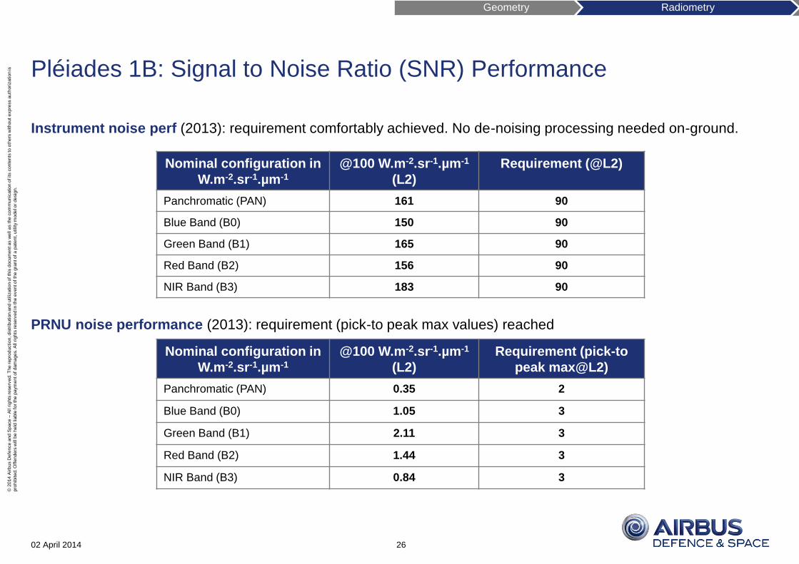
Pléiades 1B: Signal to Noise Ratio (SNR) Performance
Instrument noise perf (2013): requirement comfortably achieved. No de-noising processing needed on-ground.
PRNU noise performance (2013): requirement (pick-to peak max values) reached
02 April 2014 26
Nominal configuration in
W.m-2.sr-1.µm-1
@100 W.m-2.sr-1.µm-1
(L2)
Requirement (@L2)
Panchromatic (PAN) 161 90
Blue Band (B0) 150 90
Green Band (B1) 165 90
Red Band (B2) 156 90
NIR Band (B3) 183 90
Nominal configuration in
W.m-2.sr-1.µm-1
@100 W.m-2.sr-1.µm-1
(L2)
Requirement (pick-to
peak max@L2)
Panchromatic (PAN) 0.35 2
Blue Band (B0) 1.05 3
Green Band (B1) 2.11 3
Red Band (B2) 1.44 3
NIR Band (B3) 0.84 3
Geometry Radiometry
© 2
014 A
irbus D
efe
nce a
nd S
pace –
All r
ights
reserv
ed. T
he r
epro
duction, dis
trib
ution a
nd u
tilization o
f th
is d
ocum
ent as w
ell a
s t
he c
om
munic
ation o
f its c
onte
nts
to o
thers
without expre
ss a
uth
ori
zation is
pro
hib
ited. O
ffenders
will be h
eld
lia
ble
for th
e p
aym
ent of dam
ages. A
ll r
ights
reserv
ed in
the e
vent of th
e g
rant of a p
ate
nt,
utility
model o
r desig
n.
SPOT 6: Signal to Noise Ratio (SNR) Performance
Instrument noise perf (2013): requirement comfortably achieved. No de-noising processing needed on-ground.
PRNU noise performance (2013):
• Intra-camera:
• Inter-camera: according to bi-camera focal plane PRNU performance at inter-camera is performed on-ground at
production processing step with a performance less than 0.3 W.
02 April 2014 27
Nominal configuration in
W.m-2.sr-1.µm-1
@100 W.m-2.sr-1.µm-1
(L2)
Requirement (@L2)
Panchromatic (PAN) 139 100
Blue Band (B0) 258 150
Green Band (B1) 253 150
Red Band (B2) 266 150
NIR Band (B3) 293 150
Geometry Radiometry
Nominal configuration in
W.m-2.sr-1.µm-1
@100 W.m-2.sr-1.µm-1
(L2)
Requirement (99%@L2)
Panchromatic (PAN) 3 3
Blue Band (B0) 3 3
Green Band (B1) 3 3
Red Band (B2) 3 3
NIR Band (B3) 3 3
Considering a same
FOV aperture value,
same performance as
Pléiades 1B
© 2
014 A
irbus D
efe
nce a
nd S
pace –
All r
ights
reserv
ed. T
he r
epro
duction, dis
trib
ution a
nd u
tilization o
f th
is d
ocum
ent as w
ell a
s t
he c
om
munic
ation o
f its c
onte
nts
to o
thers
without expre
ss a
uth
ori
zation is
pro
hib
ited. O
ffenders
will be h
eld
lia
ble
for th
e p
aym
ent of dam
ages. A
ll r
ights
reserv
ed in
the e
vent of th
e g
rant of a p
ate
nt,
utility
model o
r desig
n.
Measures the sharpness of the image (the spatial resolution of the instrument i.e landscape spatial contrasts)
• At sensor level, through the instrument (“Satellite” MTF)
• At ground processing level after specific image restoration (“System” MTF)
A convenient way for end user’s needs is to use the Image Quality Factor defined by CNES – an indicator measuring
the sharp (=MTF) and the noise (=SNR) by multiplying SNR and MTF
Assessments on Raw Sensor Products (no external contributors as resampling, filtering…) over targets like:
• Edge-patterns (e.g Salon de Provence, Fr…)
• Point-like source (lights, stars…)
Modulation Transfer Function (MTF) Assessment: How?
02 April 2014 28
Las Vegas, SPOT 6 night
acquisition and Pint Spread
Function (PSF) measurement
Pléiades star
acquisition for PSF
measurement
© CNES
Geometry Radiometry
© 2
014 A
irbus D
efe
nce a
nd S
pace –
All r
ights
reserv
ed. T
he r
epro
duction, dis
trib
ution a
nd u
tilization o
f th
is d
ocum
ent as w
ell a
s t
he c
om
munic
ation o
f its c
onte
nts
to o
thers
without expre
ss a
uth
ori
zation is
pro
hib
ited. O
ffenders
will be h
eld
lia
ble
for th
e p
aym
ent of dam
ages. A
ll r
ights
reserv
ed in
the e
vent of th
e g
rant of a p
ate
nt,
utility
model o
r desig
n.
Pléiades 1B: Modulation Transfer Function (MTF) Performance
Satellite MTF (2013)
• Requirement comfortably achieved: ~2 times better than satellite requirement
System MTF (ground image restoration)
Allow to enhance on-ground the native sharpness of image (satellite MTF) by a deconvolution process on raw
images at early production step. As sharp enhancement will increase level of noise (SNR), MTF target is always
a compromise between a good sharp and a moderate noise.
• Panchromatic : on-ground restoration process with a MTF target of 0.39 at fe/2
• Multispectral: no restoration on-ground (same as satellite level)
02 April 2014 29
Satellite MTF at Nyquist
frequency (fe/2) Mean MTF
across track (X) / along track (Y)
MTF requirement across track (X) / along track (Y)
Image Quality Factor
MTF x SNR(@L2) across track (X) / along track (Y)
Panchromatic (PAN) 0.14/0.14 0.08/0.08 22/22
Blue Band (B0) 0.3/0.26 0.2/0.2 45/39
Green Band (B1) 0.31/0.26 0.2/0.2 51/43
Red Band (B2) 0.31/0.25 0.2/0.2 48/39
NIR Band (B3) 0.31/0.26 0.2/0.2 57/48
Geometry Radiometry
© 2
014 A
irbus D
efe
nce a
nd S
pace –
All r
ights
reserv
ed. T
he r
epro
duction, dis
trib
ution a
nd u
tilization o
f th
is d
ocum
ent as w
ell a
s t
he c
om
munic
ation o
f its c
onte
nts
to o
thers
without expre
ss a
uth
ori
zation is
pro
hib
ited. O
ffenders
will be h
eld
lia
ble
for th
e p
aym
ent of dam
ages. A
ll r
ights
reserv
ed in
the e
vent of th
e g
rant of a p
ate
nt,
utility
model o
r desig
n.
SPOT 6: Modulation Transfer Function (MTF) Performance
Satellite MTF (2013)
• Requirement comfortably achieved: ~2 times better than satellite requirement
System MTF (ground image restoration)
Allow to enhance on-ground the native sharpness of image (satellite MTF) by a deconvolution process on raw
images at early production step. As sharp enhancement will increase level of noise (SNR), MTF target is always
a compromise between a good sharp and a moderate noise.
• Panchromatic : on-ground restoration process with a MTF target of 0.39 at fe/2
• Multispectral: no restoration on-ground (same as satellite level)
02 April 2014 30
Satellite MTF at Nyquist
frequency (fe/2) Mean MTF
across track (X)/along track (Y)
MTF requirement across track (X)/along track (Y)
Image Quality Factor
MTF x SNR(@L2) across track (X)/along track (Y)
Panchromatic (PAN) 0.2/0.15 0.1/0.1 28/22
Blue Band (B0) 0.4/0.26 0.2/0.2 103/67
Green Band (B1) 0.4/0.26 0.2/0.2 101/66
Red Band (B2) 0.4/0.26 0.2/0.2 106/69
NIR Band (B3) 0.4/0.26 0.2/0.2 117/76
Geometry Radiometry
© 2
014 A
irbus D
efe
nce a
nd S
pace –
All r
ights
reserv
ed. T
he r
epro
duction, dis
trib
ution a
nd u
tilization o
f th
is d
ocum
ent as w
ell a
s t
he c
om
munic
ation o
f its c
onte
nts
to o
thers
without expre
ss a
uth
ori
zation is
pro
hib
ited. O
ffenders
will be h
eld
lia
ble
for th
e p
aym
ent of dam
ages. A
ll r
ights
reserv
ed in
the e
vent of th
e g
rant of a p
ate
nt,
utility
model o
r desig
n.
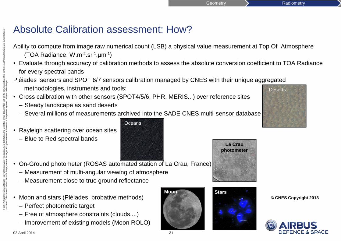
Absolute Calibration assessment: How?
Ability to compute from image raw numerical count (LSB) a physical value measurement at Top Of Atmosphere
(TOA Radiance, W.m-2.sr-1.µm-1)
• Evaluate through accuracy of calibration methods to assess the absolute conversion coefficient to TOA Radiance
for every spectral bands
Pléiades sensors and SPOT 6/7 sensors calibration managed by CNES with their unique aggregated
methodologies, instruments and tools:
• Cross calibration with other sensors (SPOT4/5/6, PHR, MERIS...) over reference sites
– Steady landscape as sand deserts
– Several millions of measurements archived into the SADE CNES multi-sensor database
• Rayleigh scattering over ocean sites
– Blue to Red spectral bands
• On-Ground photometer (ROSAS automated station of La Crau, France)
– Measurement of multi-angular viewing of atmosphere
– Measurement close to true ground reflectance
• Moon and stars (Pléiades, probative methods)
– Perfect photometric target
– Free of atmosphere constraints (clouds....)
– Improvement of existing models (Moon ROLO)
02 April 2014 31
Deserts
La Crau
photometer
Oceans
Stars Moon
Geometry Radiometry
© CNES Copyright 2013
© 2
014 A
irbus D
efe
nce a
nd S
pace –
All r
ights
reserv
ed. T
he r
epro
duction, dis
trib
ution a
nd u
tilization o
f th
is d
ocum
ent as w
ell a
s t
he c
om
munic
ation o
f its c
onte
nts
to o
thers
without expre
ss a
uth
ori
zation is
pro
hib
ited. O
ffenders
will be h
eld
lia
ble
for th
e p
aym
ent of dam
ages. A
ll r
ights
reserv
ed in
the e
vent of th
e g
rant of a p
ate
nt,
utility
model o
r desig
n.
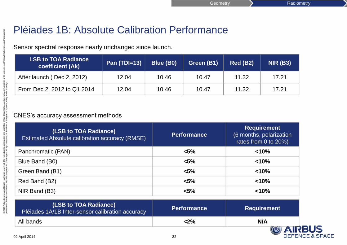
Pléiades 1B: Absolute Calibration Performance
Sensor spectral response nearly unchanged since launch.
CNES’s accuracy assessment methods
02 April 2014 32
(LSB to TOA Radiance)
Estimated Absolute calibration accuracy (RMSE) Performance
Requirement
(6 months, polarization
rates from 0 to 20%)
Panchromatic (PAN) <5% <10%
Blue Band (B0) <5% <10%
Green Band (B1) <5% <10%
Red Band (B2) <5% <10%
NIR Band (B3) <5% <10%
(LSB to TOA Radiance)
Pléiades 1A/1B Inter-sensor calibration accuracy Performance Requirement
All bands <2% N/A
LSB to TOA Radiance
coefficient (Ak) Pan (TDI=13) Blue (B0) Green (B1) Red (B2) NIR (B3)
After launch ( Dec 2, 2012) 12.04 10.46 10.47 11.32 17.21
From Dec 2, 2012 to Q1 2014 12.04 10.46 10.47 11.32 17.21
Geometry Radiometry
© 2
014 A
irbus D
efe
nce a
nd S
pace –
All r
ights
reserv
ed. T
he r
epro
duction, dis
trib
ution a
nd u
tilization o
f th
is d
ocum
ent as w
ell a
s t
he c
om
munic
ation o
f its c
onte
nts
to o
thers
without expre
ss a
uth
ori
zation is
pro
hib
ited. O
ffenders
will be h
eld
lia
ble
for th
e p
aym
ent of dam
ages. A
ll r
ights
reserv
ed in
the e
vent of th
e g
rant of a p
ate
nt,
utility
model o
r desig
n.
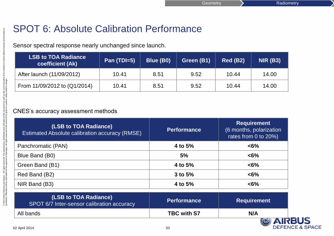
SPOT 6: Absolute Calibration Performance
Sensor spectral response nearly unchanged since launch.
CNES’s accuracy assessment methods
02 April 2014 33
(LSB to TOA Radiance)
Estimated Absolute calibration accuracy (RMSE) Performance
Requirement
(6 months, polarization
rates from 0 to 20%)
Panchromatic (PAN) 4 to 5% <6%
Blue Band (B0) 5% <6%
Green Band (B1) 4 to 5% <6%
Red Band (B2) 3 to 5% <6%
NIR Band (B3) 4 to 5% <6%
(LSB to TOA Radiance)
SPOT 6/7 Inter-sensor calibration accuracy Performance Requirement
All bands TBC with S7 N/A
LSB to TOA Radiance
coefficient (Ak) Pan (TDI=5) Blue (B0) Green (B1) Red (B2) NIR (B3)
After launch (11/09/2012) 10.41 8.51 9.52 10.44 14.00
From 11/09/2012 to (Q1/2014) 10.41 8.51 9.52 10.44 14.00
Geometry Radiometry
© 2
014 A
irbus D
efe
nce a
nd S
pace –
All r
ights
reserv
ed. T
he r
epro
duction, dis
trib
ution a
nd u
tilization o
f th
is d
ocum
ent as w
ell a
s t
he c
om
munic
ation o
f its c
onte
nts
to o
thers
without expre
ss a
uth
ori
zation is
pro
hib
ited. O
ffenders
will be h
eld
lia
ble
for th
e p
aym
ent of dam
ages. A
ll r
ights
reserv
ed in
the e
vent of th
e g
rant of a p
ate
nt,
utility
model o
r desig
n.
Focus on Ortho and DEM/DTM derived products
Ortho products
DEM/DTM derived products
02 April 2014 34
Geometry Radiometry Ortho DEM
Courtesy IGN
SPOT 6 single pass tri-stereo
2012/11/11 Karakoram mountain
© 2
014 A
irbus D
efe
nce a
nd S
pace –
All r
ights
reserv
ed. T
he r
epro
duction, dis
trib
ution a
nd u
tilization o
f th
is d
ocum
ent as w
ell a
s t
he c
om
munic
ation o
f its c
onte
nts
to o
thers
without expre
ss a
uth
ori
zation is
pro
hib
ited. O
ffenders
will be h
eld
lia
ble
for th
e p
aym
ent of dam
ages. A
ll r
ights
reserv
ed in
the e
vent of th
e g
rant of a p
ate
nt,
utility
model o
r desig
n.
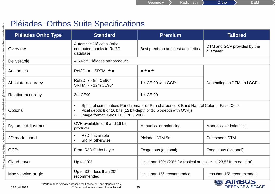
Pléiades: Orthos Suite Specifications
02 April 2014
Pléiades Ortho Type Standard Premium Tailored
Overview Automatic Pléiades Ortho
computed thanks to Ref3D
database
Best precision and best aesthetics DTM and GCP provided by the
customer
Deliverable A 50-cm Pléiades orthoproduct.
Aesthetics Ref3D: - SRTM:
Depending on DTM and GCPs Absolute accuracy Ref3D: 7 - 8m CE90*
SRTM: 7 - 12m CE90* 1m CE 90 with GCPs
Relative accuracy 3m CE90 1m CE 90
Options • Spectral combination: Panchromatic or Pan-sharpened 3-Band Natural Color or False Color
• Pixel depth: 8 or 16 bits (12 bit-depth or 16 bit-depth with OVR))
• Image format: GeoTIFF, JPEG 2000
Dynamic Adjustment OVR available for 8 and 16 bit
products Manual color balancing Manual color balancing
3D model used • R3D if available
• SRTM otherwise Pléiades DTM 5m Customer’s DTM
GCPs From R3D Ortho Layer Exogenous (optional) Exogenous (optional)
Cloud cover Up to 10% Less than 10% (20% for tropical areas i.e. +/-23,5° from equator)
Max viewing angle Up to 30° - less than 20°
recommended Less than 15° recommended Less than 15° recommended
35 * Performance typically assessed for 1 scene AOI and slopes ≤ 20%
** Better performances are often achieved
Geometry Radiometry Ortho DEM
© 2
014 A
irbus D
efe
nce a
nd S
pace –
All r
ights
reserv
ed. T
he r
epro
duction, dis
trib
ution a
nd u
tilization o
f th
is d
ocum
ent as w
ell a
s t
he c
om
munic
ation o
f its c
onte
nts
to o
thers
without expre
ss a
uth
ori
zation is
pro
hib
ited. O
ffenders
will be h
eld
lia
ble
for th
e p
aym
ent of dam
ages. A
ll r
ights
reserv
ed in
the e
vent of th
e g
rant of a p
ate
nt,
utility
model o
r desig
n.
A precision ortho produced with a Pléiades DTM 5m; with optional GCPs.
• Accuracy: 1m CE90 (with GCPs)
Pléiades: Ortho Premium
02 April 2014 36
Geometry Radiometry Ortho DEM
© 2
014 A
irbus D
efe
nce a
nd S
pace –
All r
ights
reserv
ed. T
he r
epro
duction, dis
trib
ution a
nd u
tilization o
f th
is d
ocum
ent as w
ell a
s t
he c
om
munic
ation o
f its c
onte
nts
to o
thers
without expre
ss a
uth
ori
zation is
pro
hib
ited. O
ffenders
will be h
eld
lia
ble
for th
e p
aym
ent of dam
ages. A
ll r
ights
reserv
ed in
the e
vent of th
e g
rant of a p
ate
nt,
utility
model o
r desig
n.
Ortho Time Series: Stack of orthos with different acquisition dates
• No time constraint
• No Viewing angle constraint
• Perfect registration (better than the pixel) between orthos
• Useful to monitor changes for given area (incl automatic change detection)
First element of the series is a “Pleiades ortho premium” product :
• Stereo acquisition
• Computation of an accurate digital terrain model @ 5m posting
Automatic computation for all other elements of the series
Pléiades: Ortho Time Series
02 April 2014 37
Geometry Radiometry Ortho DEM
Sub-pixel
co-registration series
© 2
014 A
irbus D
efe
nce a
nd S
pace –
All r
ights
reserv
ed. T
he r
epro
duction, dis
trib
ution a
nd u
tilization o
f th
is d
ocum
ent as w
ell a
s t
he c
om
munic
ation o
f its c
onte
nts
to o
thers
without expre
ss a
uth
ori
zation is
pro
hib
ited. O
ffenders
will be h
eld
lia
ble
for th
e p
aym
ent of dam
ages. A
ll r
ights
reserv
ed in
the e
vent of th
e g
rant of a p
ate
nt,
utility
model o
r desig
n.
SPOT 6 & SPOT 7: Orthos Suite Specifications
02 April 2014
SPOT 6 / [7] Ortho Type Standard Tailored
Overview Automatic Ortho based on Ref3D database DTM and GCP provided by the customer
Deliverable A 1.5-m SPOT 6 / 7 orthoproduct.
Aesthetics Ref3D: - SRTM:
Depending on DTM and GCPs Absolute accuracy Ref3D: 9 - 12m CE90*
SRTM: 9 - 15m CE90*
Relative accuracy 5m CE90
Options • Spectral combination: Panchromatic or Pan-sharpened 4-Band
• Pixel depth: 8 or 16 bits (12 bit-depth or 16 bit-depth with OVR (Q2/2014))
• Image format: GeoTIFF, JPEG 2000
Dynamic Adjustment OVR available for 8 and 16 bit products
(Q2/2014) Manual color balancing (optional)
3D model used • R3D if available
• SRTM otherwise Customer’s DTM
GCPs From R3D Ortho Layer Exogenous (optional)
Cloud cover Up to 10% Less than 10% (20% for tropical areas i.e. +/-
23,5° from equator)
Max viewing angle Up to 30° - less than 20° recommended Less than 15° recommended
38
* Performance typically assessed for 1 scene AOI and slopes ≤ 20%
** Better performances are often achieved
Geometry Radiometry Ortho DEM
© 2
014 A
irbus D
efe
nce a
nd S
pace –
All r
ights
reserv
ed. T
he r
epro
duction, dis
trib
ution a
nd u
tilization o
f th
is d
ocum
ent as w
ell a
s t
he c
om
munic
ation o
f its c
onte
nts
to o
thers
without expre
ss a
uth
ori
zation is
pro
hib
ited. O
ffenders
will be h
eld
lia
ble
for th
e p
aym
ent of dam
ages. A
ll r
ights
reserv
ed in
the e
vent of th
e g
rant of a p
ate
nt,
utility
model o
r desig
n.
Products 4m posting DEM + Stereo or Tristereo pair
Method Automatic stereo matching including a global auto-filtering of artifacts followed by manual editions. After editing
tasks, all remaining voids are interpolated. Large voids over an area not flat are completed in stereo. Final
visual Quality Check.
Manual edition
level
• Detection of water bodies (sea, lake, large river) and DEM flattening.
• Removal of main artifacts (spike, hole).
• Manual edition.
• Main roads in downtown will be cleaned to remove artificial obstructions.
Source data • Pléiades Stereo or Tristereo pair(s), Panchro, Primary, JPEG 2000 Regular.
Available option • 50cm Pléiades orthoimage
Grid Spacing • 4m.
Accura
cy
Absolute
XY*
• With accurate GCPs: 1.5m CE90
• With Ref3D GCPs: 6m to 10m CE90**
• Without GCPs: 8.5m to 10.5m CE90
Absolute
Z*
• With accurate GCPs: 2m LE90
• With Ref3D GCPs: 6m to 10m LE90**
• Without GCPs: up to 10m LE90**
Relative • XY: 1.5m CE90
• Z: 2m LE90
Format • AsciiGrid or GeoTIFF.
Projection • Geo WGS84 or UTM / WGS84 (custom projection upon request).
02 April 2014
* Performance assessed on individual Stereopair, for slopes ≤ 20%
** Better performances are often achieved
Pléiades: Elevation4 Specifications
39
Geometry Radiometry Ortho DEM
In line with HRE40
requirements by use
of accurate GCPs
© 2
014 A
irbus D
efe
nce a
nd S
pace –
All r
ights
reserv
ed. T
he r
epro
duction, dis
trib
ution a
nd u
tilization o
f th
is d
ocum
ent as w
ell a
s t
he c
om
munic
ation o
f its c
onte
nts
to o
thers
without expre
ss a
uth
ori
zation is
pro
hib
ited. O
ffenders
will be h
eld
lia
ble
for th
e p
aym
ent of dam
ages. A
ll r
ights
reserv
ed in
the e
vent of th
e g
rant of a p
ate
nt,
utility
model o
r desig
n.
Products 1m posting DEM Orthomosaic (8 bits)
Method
Automatic stereo matching including a global auto-
filtering of artifacts followed by an enhanced level of
edition. After editing tasks, all remaining voids are
interpolated. Large voids over an area not flat are
completed in stereo. Final visual quality check.
A Pan-sharpened orthomosaic is also generated
(geometrically seamless, but not radiometrically). The
cutline between each image is automatic. No global
radiometric optimization. Final visual Quality Check.
Manual edition
level
• Detection of water bodies (sea, lake, large river) and
DEM flattening.
• Removal of main artifacts (spike, hole).
• 3D edition
Source data • Pléiades Stereo or Tristereo pair(s), Bundle P & XS 4 bands, Primary, JPEG 2000 Regular.
Grid Spacing • 1m. • 50cm.
Accu
racy
Absolute
XY*
• With GCPs: 1.5m CE90.
• With Ref3D GCPs: 6 to 10m CE90**.
• Without GCPs: 8.5m to 10.5m CE90.
• With GCPs: 1.5m CE90.
• With Ref3D GCPs: 6 to 10m CE90**.
• Without GCPs: 8.5m to 10.5m CE90.
Absolute
Z*
• With GCPs: 1.5m LE90.
• With Ref3D GCPs: 6 to 10m LE90**.
• Without GCPs: up to 10m LE90**.
Relative • XY 1.5m CE90 ; Z 1.5m LE90. • 1,5m CE90
Format • AsciiGrid or GeoTIFF. • GeoTIFF.
Projection • Geo WGS84 or UTM / WGS84 (custom projection on request).
02 April 2014
* Performance assessed on individual Stereopair, for slopes ≤ 20%
** Better performances are often achieved
Pléiades: Elevation1 Specifications
40
Geometry Radiometry Ortho DEM
In line with HRE10
requirements by use
of accurate GCPs
© 2
014 A
irbus D
efe
nce a
nd S
pace –
All r
ights
reserv
ed. T
he r
epro
duction, dis
trib
ution a
nd u
tilization o
f th
is d
ocum
ent as w
ell a
s t
he c
om
munic
ation o
f its c
onte
nts
to o
thers
without expre
ss a
uth
ori
zation is
pro
hib
ited. O
ffenders
will be h
eld
lia
ble
for th
e p
aym
ent of dam
ages. A
ll r
ights
reserv
ed in
the e
vent of th
e g
rant of a p
ate
nt,
utility
model o
r desig
n.
Ortho Premium, DEM and DTM: Chicago
02 April 2014 41
DEM (or DSM)
DTM
Geometry Radiometry Ortho DEM
© 2
014 A
irbus D
efe
nce a
nd S
pace –
All r
ights
reserv
ed. T
he r
epro
duction, dis
trib
ution a
nd u
tilization o
f th
is d
ocum
ent as w
ell a
s t
he c
om
munic
ation o
f its c
onte
nts
to o
thers
without expre
ss a
uth
ori
zation is
pro
hib
ited. O
ffenders
will be h
eld
lia
ble
for th
e p
aym
ent of dam
ages. A
ll r
ights
reserv
ed in
the e
vent of th
e g
rant of a p
ate
nt,
utility
model o
r desig
n.
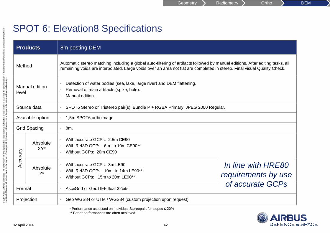
02 April 2014
SPOT 6: Elevation8 Specifications
Products 8m posting DEM
Method Automatic stereo matching including a global auto-filtering of artifacts followed by manual editions. After editing tasks, all
remaining voids are interpolated. Large voids over an area not flat are completed in stereo. Final visual Quality Check.
Manual edition
level
• Detection of water bodies (sea, lake, large river) and DEM flattening.
• Removal of main artifacts (spike, hole).
• Manual edition.
Source data • SPOT6 Stereo or Tristereo pair(s), Bundle P + RGBA Primary, JPEG 2000 Regular.
Available option • 1,5m SPOT6 orthoimage
Grid Spacing • 8m.
Accu
racy
Absolute
XY*
• With accurate GCPs: 2.5m CE90
• With Ref3D GCPs: 6m to 10m CE90**
• Without GCPs: 20m CE90
Absolute
Z*
• With accurate GCPs: 3m LE90
• With Ref3D GCPs: 10m to 14m LE90**
• Without GCPs: 15m to 20m LE90**
Format • AsciiGrid or GeoTIFF float 32bits.
Projection • Geo WGS84 or UTM / WGS84 (custom projection upon request).
* Performance assessed on individual Stereopair, for slopes ≤ 20%
** Better performances are often achieved
42
Geometry Radiometry Ortho DEM
In line with HRE80
requirements by use
of accurate GCPs
© 2
014 A
irbus D
efe
nce a
nd S
pace –
All r
ights
reserv
ed. T
he r
epro
duction, dis
trib
ution a
nd u
tilization o
f th
is d
ocum
ent as w
ell a
s t
he c
om
munic
ation o
f its c
onte
nts
to o
thers
without expre
ss a
uth
ori
zation is
pro
hib
ited. O
ffenders
will be h
eld
lia
ble
for th
e p
aym
ent of dam
ages. A
ll r
ights
reserv
ed in
the e
vent of th
e g
rant of a p
ate
nt,
utility
model o
r desig
n.
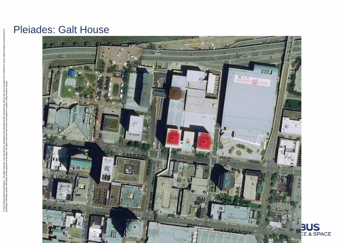
Pleiades: Galt House
© 2
014 A
irbus D
efe
nce a
nd S
pace –
All r
ights
reserv
ed. T
he r
epro
duction, dis
trib
ution a
nd u
tilization o
f th
is d
ocum
ent as w
ell a
s t
he c
om
munic
ation o
f its c
onte
nts
to o
thers
without expre
ss a
uth
ori
zation is
pro
hib
ited. O
ffenders
will be h
eld
lia
ble
for th
e p
aym
ent of dam
ages. A
ll r
ights
reserv
ed in
the e
vent of th
e g
rant of a p
ate
nt,
utility
model o
r desig
n.
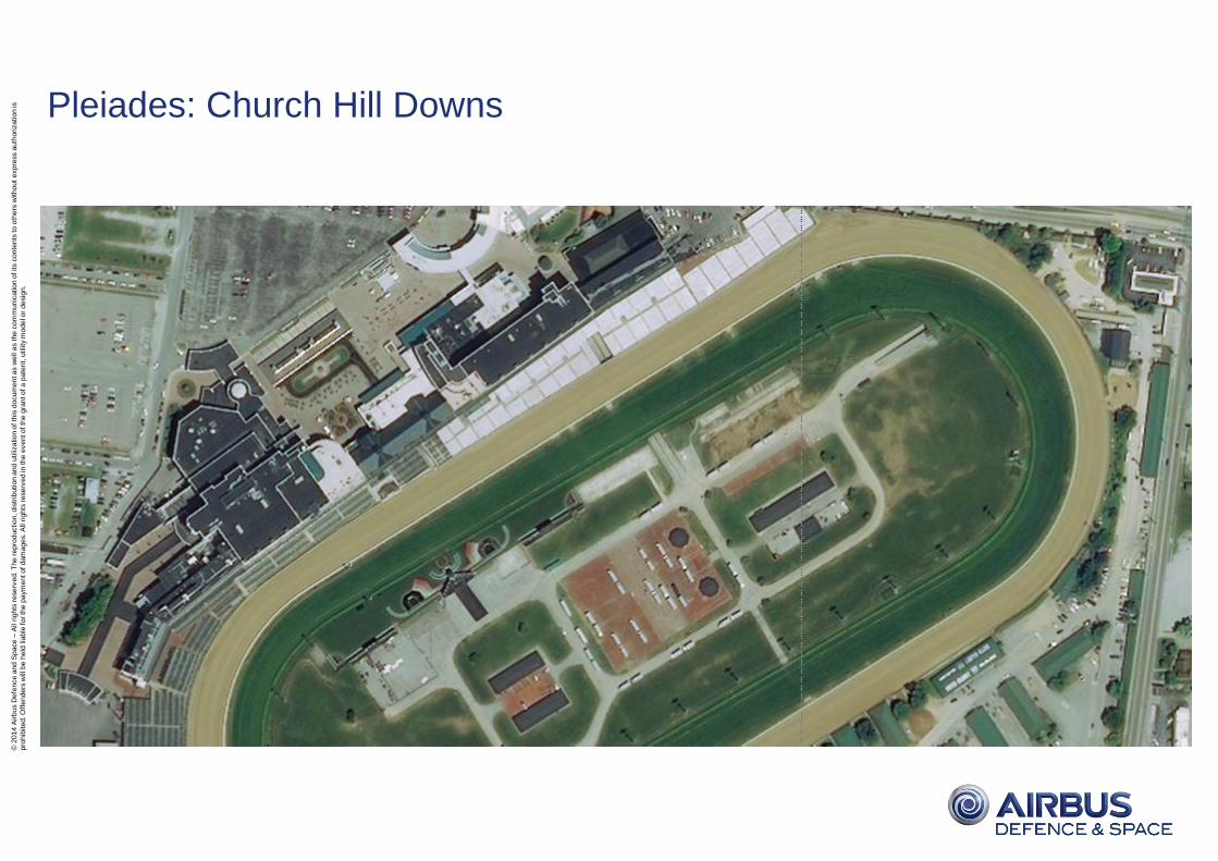
Pleiades: Church Hill Downs
© 2
014 A
irbus D
efe
nce a
nd S
pace –
All r
ights
reserv
ed. T
he r
epro
duction, dis
trib
ution a
nd u
tilization o
f th
is d
ocum
ent as w
ell a
s t
he c
om
munic
ation o
f its c
onte
nts
to o
thers
without expre
ss a
uth
ori
zation is
pro
hib
ited. O
ffenders
will be h
eld
lia
ble
for th
e p
aym
ent of dam
ages. A
ll r
ights
reserv
ed in
the e
vent of th
e g
rant of a p
ate
nt,
utility
model o
r desig
n.
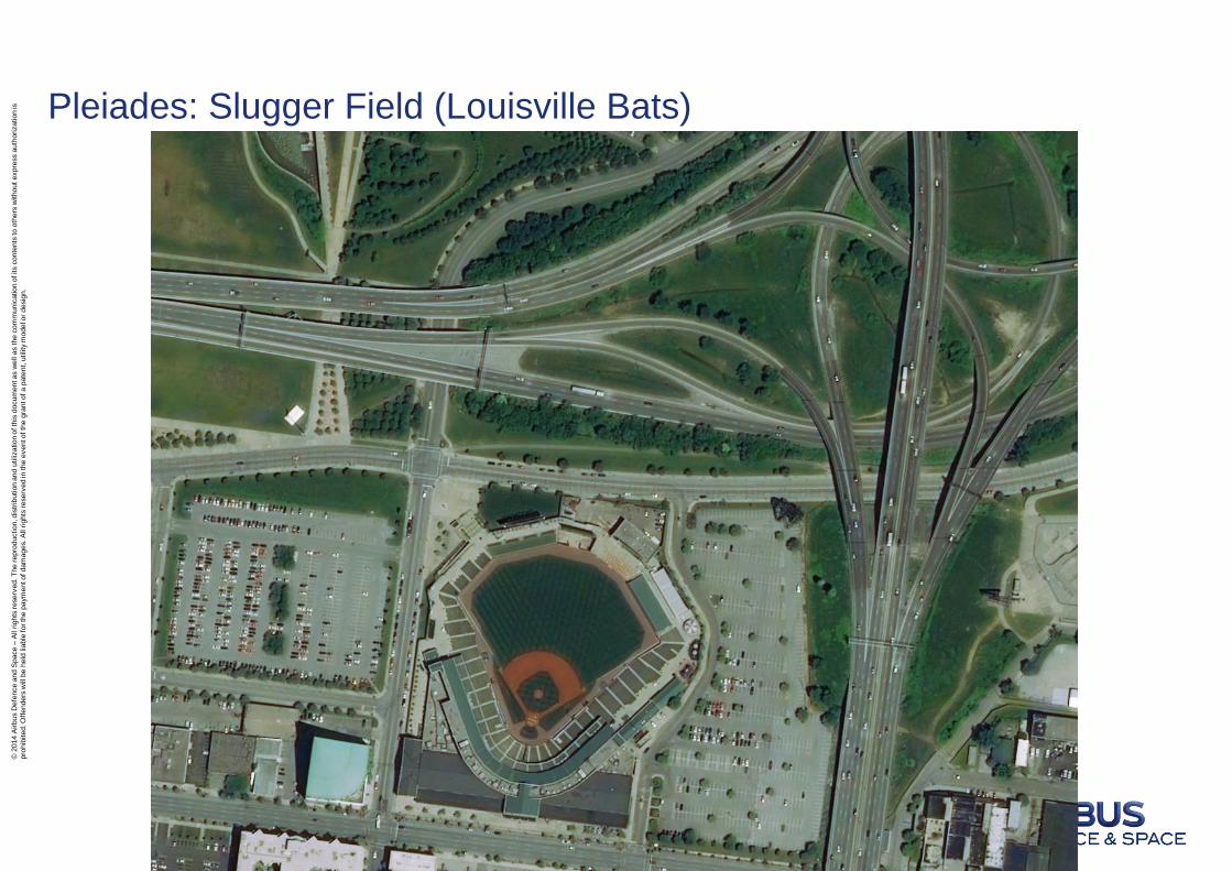
Pleiades: Slugger Field (Louisville Bats)
© 2
014 A
irbus D
efe
nce a
nd S
pace –
All r
ights
reserv
ed. T
he r
epro
duction, dis
trib
ution a
nd u
tilization o
f th
is d
ocum
ent as w
ell a
s t
he c
om
munic
ation o
f its c
onte
nts
to o
thers
without expre
ss a
uth
ori
zation is
pro
hib
ited. O
ffenders
will be h
eld
lia
ble
for th
e p
aym
ent of dam
ages. A
ll r
ights
reserv
ed in
the e
vent of th
e g
rant of a p
ate
nt,
utility
model o
r desig
n.
Latest news about SPOT 7
Integration is complete.
Launch is planned for Mid-2014 (by
Indian PSLV launcher).
In orbit test period will follow for a 2 to
3-month duration.
SPOT 7: Integration of solar panels.
© 2
014 A
irbus D
efe
nce a
nd S
pace –
All r
ights
reserv
ed. T
he r
epro
duction, dis
trib
ution a
nd u
tilization o
f th
is d
ocum
ent as w
ell a
s t
he c
om
munic
ation o
f its c
onte
nts
to o
thers
without expre
ss a
uth
ori
zation is
pro
hib
ited. O
ffenders
will be h
eld
lia
ble
for th
e p
aym
ent of dam
ages. A
ll r
ights
reserv
ed in
the e
vent of th
e g
rant of a p
ate
nt,
utility
model o
r desig
n.
02 April 2014 47
Brian Cutler: [email protected]
See also our User Guides
•SPOT 6: http://www.astrium-geo.com/spot6userguide
•Pléiades: http://www.astrium-geo.com/en/4572-pleiades-technical-documents/
Thank You!