Public Land Orders Access Law and Issues Affecting Public and Private Lands In Alaska February 26, 2016 PLO Case Study #1 S.O. 2665 and Small Tract Lots February 26, 2016 “A Patchwork Quilt of Interests” - An Existing Right-of-Way Based on Multiple Authorities.
Transcript
Public Land Orders
Access Law and Issues Affecting Public and Private Lands In AlaskaFebruary 26, 2016
PLO Case Study #1
S.O. 2665 and Small Tract Lots
February 26, 2016
“A Patchwork Quilt of Interests” - An Existing Right-of-Way Based on Multiple Authorities.
Davis Road – Fairbanks
S.O. 2665 and BLM Small Tracts
“Subject to Valid Existing
Rights…”~
Date of Small Tracts Lease Application?
February 26, 2016
BLM Small Tracts Subdivision of Section 17
Survey Approved April 13, 1953
BLM Master Title Plat ~ S17, T.1S. R.1W., FM
Govt. Lot 25 ~ Patent No. 1154350
G.L. 25 ~ BLM Patent
Patent No. 1154350 ~ September 16, 1955
G.L. 25 ~ Abstract
Rights Vested as of Date Application Received
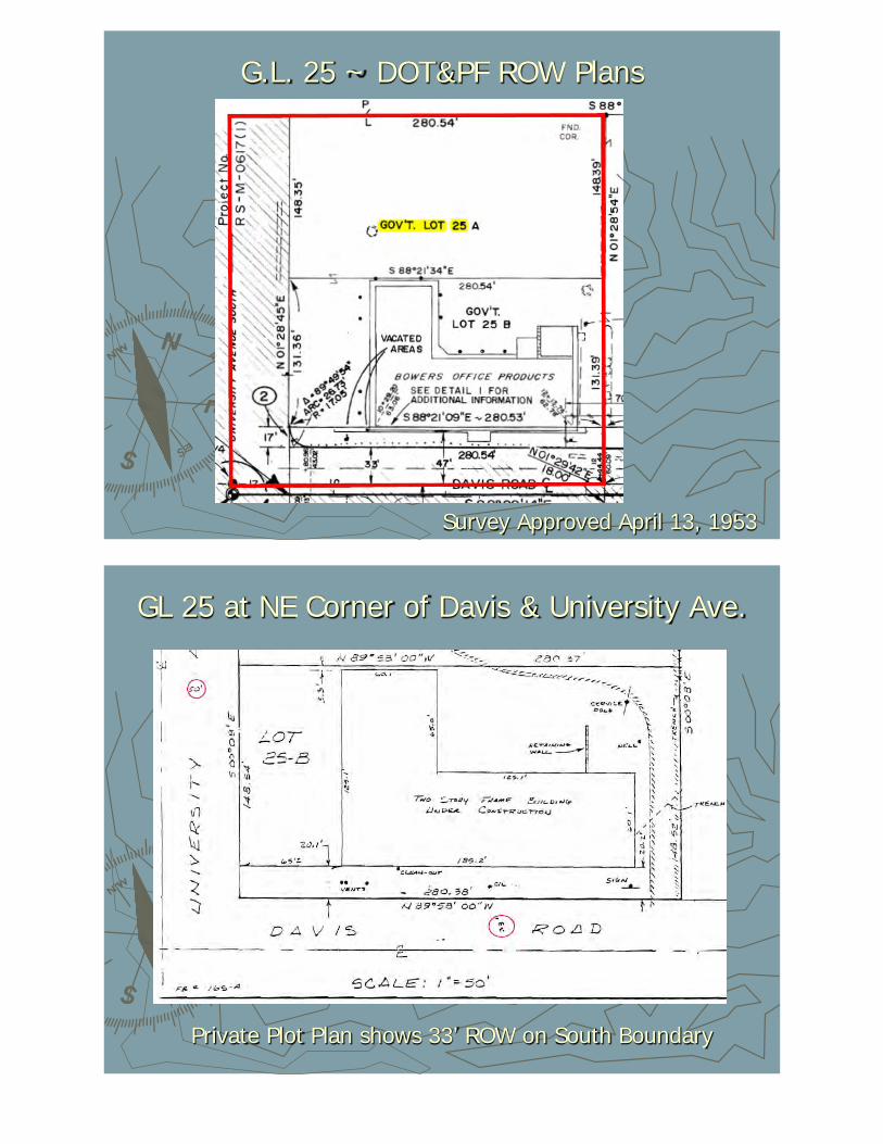
G.L. 25 ~ DOT&PF ROW Plans
Survey Approved April 13, 1953
GL 25 at NE Corner of Davis & University Ave.
Private Plot Plan shows 33’ ROW on South Boundary
Alaska Road Commission Map ~ August, 1951
Schematic Map indicates 50-foot wide ROW Along Davis Road
ARC System Map ~ Fairbanks ~ 12/10/51
February 26, 2016
Davis & Alston Roads Identified As Part of ARC
System
ARC Order No. 40 ~ August 11, 1952
ARC System Inventory Lists Davis Road as a Part of Route
No. 132.1
What Was the Date of Staking or Posting For
New Road Construction?
February 26, 2016
Staking Field Notes ~ August 17, 1951
“Farm Road” Section 17, T.1S.,
R.1W., F.M.
SOA v. Keener Excerpt ~ May 23, 1990
Keener owned a lot on the South side of Davis Road opposite subject lot. Superior Court decision noted a variety of cross-
referenced ARC documents concluding that S.O. 2665 “Staking” occurred prior to lease application.
Priority 6 Petition ~ May 3, 1950
Road Petition Associates “Priority 6” with Section
17, T.1S, R.1W.
Omnibus Quitclaim Deed ~ Route 661
Title Conveyed to State of Alaska on June 30, 1959
Above: Route 661 runs south from the University Ave./Airport Road Intersection, then along University Ave. to the Davis Intersection, then east along Davis Road for 1 mile to Peger Road. Below: Route 5621
“Davis Road is in Wasilla, not Fairbanks!!! Omnibus QCD Descriptions are obscure…make sure you have referenced the correct route!
PLO Case Study #2
PLO 1613Highway Lots
February 26, 2016
Why it is good to know what you own and where your boundaries are before you build!
Glenn Highway MP 143
February 26, 2016
USS No. 4824 ~ Bounds on Glenn ROW
February 26, 2016
USS No. 3336 ~ Bounds on Glenn ROW
February 26, 2016
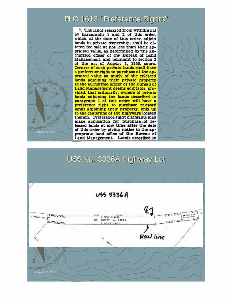
PLO 1613 “Preference Rights”
February 26, 2016
USS No. 3336A Highway Lot
February 26, 2016
USS No. 5637 Bounds on Glenn Centerline
February 26, 2016
Agreement to Vacate Old Glenn – USS 5637
February 26, 2016
ROW Plans – Glenn Highway Realignment
February 26, 2016
MTP ~ Land Under DNR Ownership
February 26, 2016
DOT&PF Vacates Old Glenn Highway ROW to DNR to Allow Preference Rights Disposals
ASLS Defines Preference Rights Parcel
February 26, 2016
PLO Case Study #3
Glenn HighwayPLO & BLM Survey Conflict
February 26, 2016
Highway Right-of-Way Widths That Change Over Time…
Section 19, T.4N., R.1W., C.R.M.
February 26, 2016
In 1993, owner of G.L. 43 questioned status of the ROW adjoining his property. Is the ROW 100’ or 150’ from the
highway centerline?
1951 Army Map Service – Gulkana Quad
February 26, 2016
Executive Order No.
9145Palmer-
Richardson Highway (Glenn)
200-Foot ROW~
April 23, 1942
February 26, 2016
PLO 46Public Land Withdrawal
~IncludingSection 19
~10/23/42
February 26, 2016
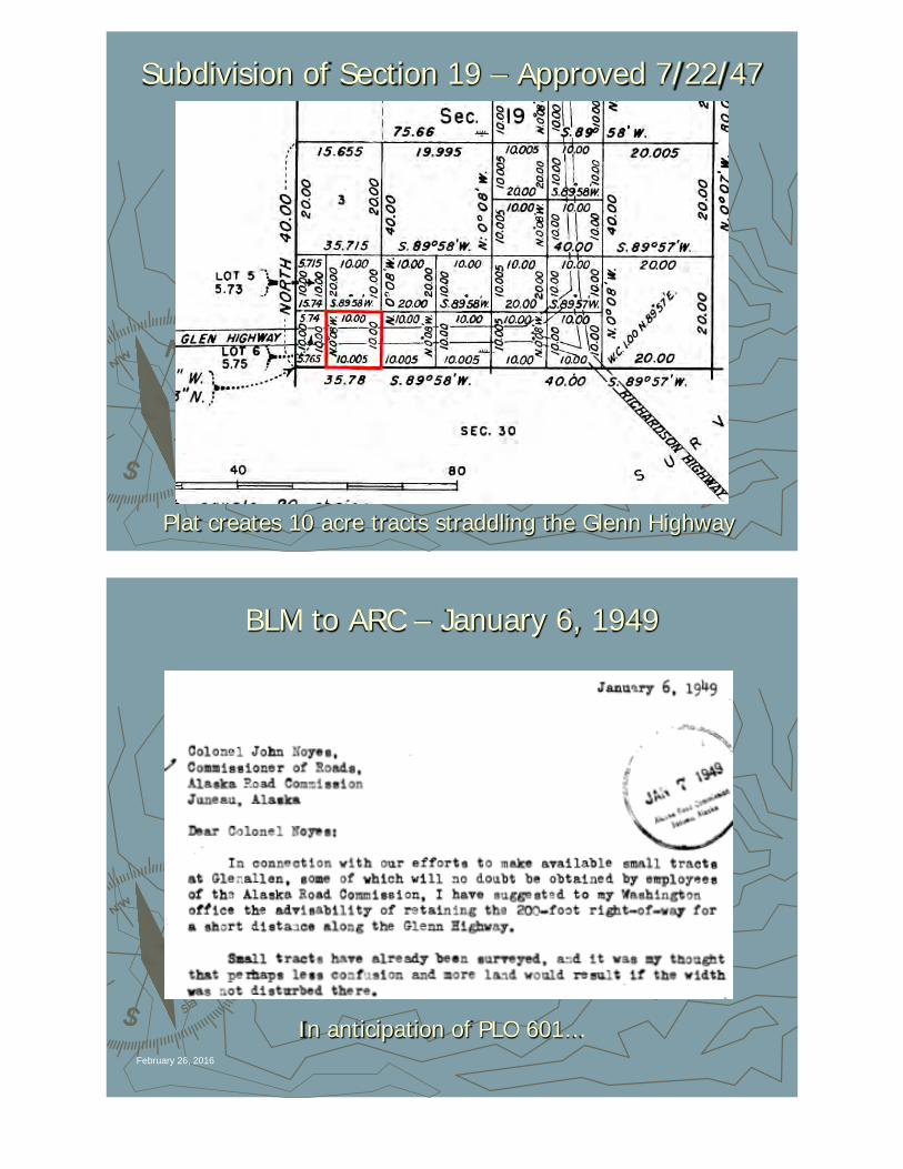
Subdivision of Section 19 – Approved 7/22/47
Plat creates 10 acre tracts straddling the Glenn Highway
BLM to ARC – January 6, 1949
February 26, 2016
In anticipation of PLO 601…
ARC to BLM – January 14, 1949
February 26, 2016
PLO 601 ~ August 10, 1949
February 26, 2016
PLO 616Partial
Revocation of PLO 46
~IncludingWest 1/2Section 19
~11/15/49
February 26, 2016
ROW Segregation Plat ~ October 1, 1953
February 26, 2016Gov’t Lots replatted to include highway lots…
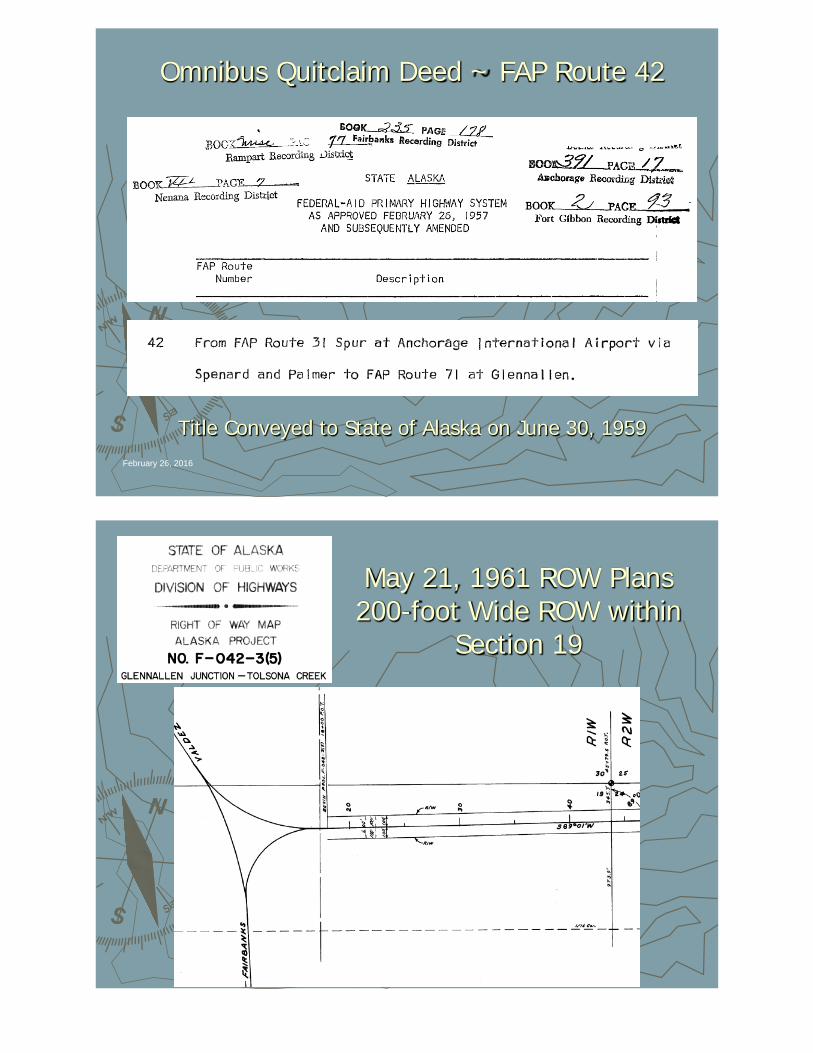
Omnibus Quitclaim Deed ~ FAP Route 42
February 26, 2016
Title Conveyed to State of Alaska on June 30, 1959
May 21, 1961 ROW Plans 200-foot Wide ROW within
Section 19
BLM Patent 50-65-0127 ~ August 20, 1964
February 26, 2016
BLM Conveys G.L. 43, Section 19, T.4N., R.1W., C.R.M. to State of Alaska
___________________________________
Subject to PLO 1613 Highway Easement
State Patent No. 2182 ~ G.L. 43November 15, 1974
February 26, 2016
“Subject to the Glenn Highway Right-of-Way, 150 Feet south of and Parallel to the Centerline, and Such Additional Easements as Provided
by Public Land Order 1613.”
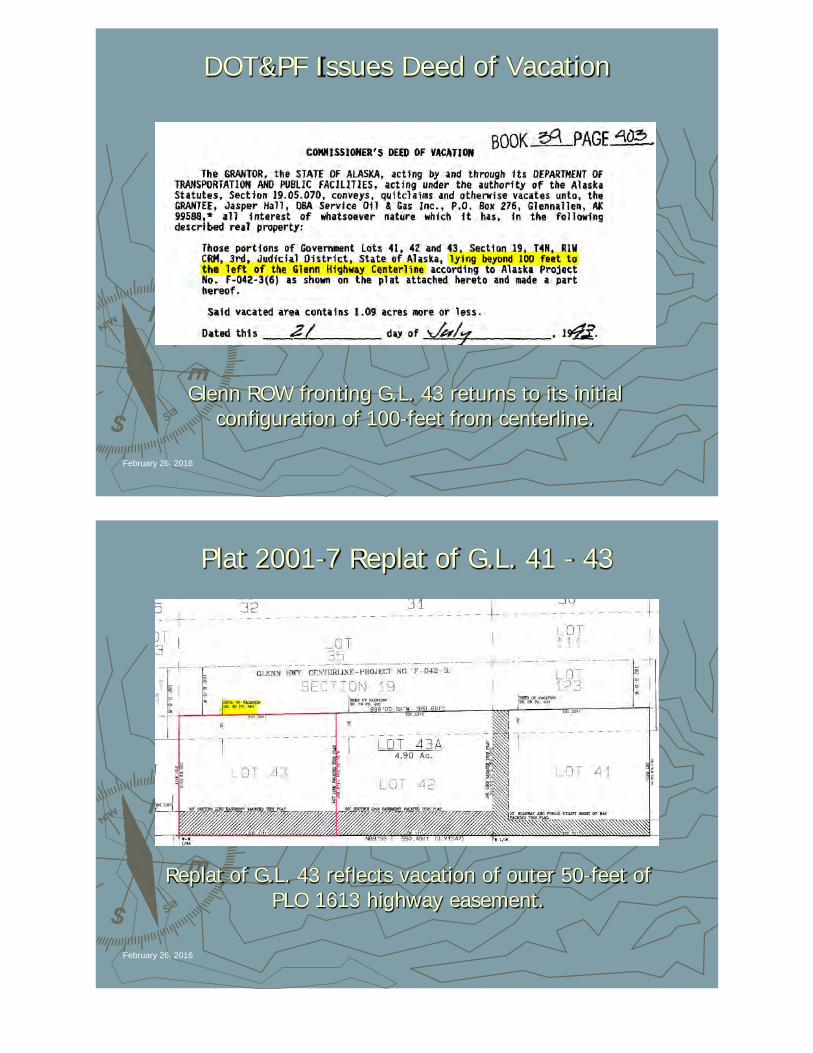
DOT&PF Issues Deed of Vacation
February 26, 2016
Glenn ROW fronting G.L. 43 returns to its initial configuration of 100-feet from centerline.
Plat 2001-7 Replat of G.L. 41 - 43
February 26, 2016
Replat of G.L. 43 reflects vacation of outer 50-feet of PLO 1613 highway easement.
Small Tract Patent G.L. 41
February 26, 2016
G.L. 41 & Lots to East Patented under Small Tract ActWith 33-foot ROW Reservations
Small Tract Parcels Subject to PLO 601?
February 26, 2016
Q: If Small Tract Applications had been filed before PLO 616 revoked the PLO 46 Classification
Withdrawal, would they have been subject to the PLO 601 widening of the Glenn Highway right-of-way?
A: Yes - first, the Small Tract entry would not have been available until revocation of the PLO 46
withdrawal upon which time PLO 601 would have taken effect. Second, the 1978 “Green” Supreme
Court case said: “We already have concluded that the Small Tract Act and Small Tract Classification…did not segregate all small tracts from the operation of other
discretionary right-of-way reservations.”
PLO Case Study #4
S.O. 2665 and Small Tract Lots
February 26, 2016
“A Patchwork Quilt of Interests” - An Existing Right-of-Way Based on Multiple Authorities.
Cartwright Road - Fairbanks
February 26, 2016
“Subject to Valid Existing
Rights…”~
Do they exist, and if so…when were
they established?
February 26, 2016
Gov’t Lot 44 – Section 20
February 26, 2016
MTP - T.1 S., R. 1 W, F.M.
February 26, 2016
Federal Patent
~Small TractGovt. Lot 44 Section 2012/16/58
33’ ROW onsouth & east boundaries
~Does
S.O. 2665 ROW Exist?February 26, 2016
BLM “ACRES” Abstract
February 26, 2016
What Is The Effective Date
Of The Relevant Public
Land Order?
February 26, 2016
Secretarial Order No. 2665
February 26, 2016
What Was the Date of Staking or Posting For
New Road Construction?
February 26, 2016
Dependent Resurvey of Section 20
February 26, 2016
Moore-Cartwright Road ~ Route 6651
February 26, 2016
Omnibus Quitclaim Deed ~ Route 6651
February 26, 2016
January 4, 1955 As-Built
February 26, 2016
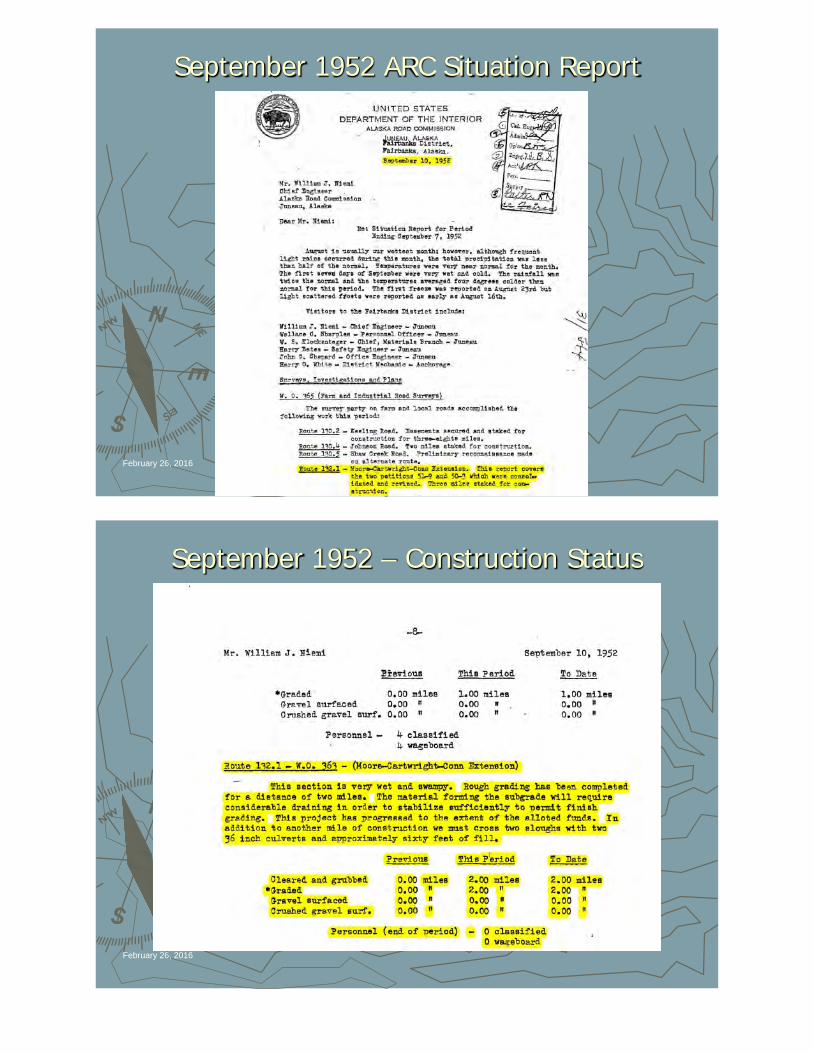
September 1952 ARC Situation Report
February 26, 2016
September 1952 – Construction Status
February 26, 2016
Conclusion
10/20/51 Effective Date of S.O. 26659/10/52 Evidence of Construction
11/2/54 Small Tract Application Received
G.L. 44 is Subject to a PLO Easement 50-feet each side of Cartwright Road Centerline


![2013-2014 ANNUAL ASSESSMENT REPORT TEMPLATE...Chart 3 a. PLO 1: j Y b. PLO 1: v Y c. PLO 1: n Y d. PLO 1: te P Y g. LO 3: j Y h. LO 3: l]Y i. PLO 4: al Y) 1 0 0.51 0.51 0 0.51 0.51](https://static.documents.pub/doc/80x56/5f2cb7f173abf20ea42d8e53/2013-2014-annual-assessment-report-template-chart-3-a-plo-1-j-y-b-plo-1.jpg)


