\\merry\data\projects\AMEC‐KC‐ENR\TASK 2 Meetings\2015‐01‐22 Work Shop 1\Package for EPA\Plot Selection Memo_020315_final.docx taf 02/03/15 Page 1 of 5 Memorandum To: Allison Hiltner, USEPA and Ron Timm, Ecology From: Lower Duwamish Waterway Group Date: February 3, 2015 Subject: Final Plot Selections for Lower Duwamish Waterway Enhanced Natural Recovery‐Activated Carbon Pilot Study This memorandum summarizes the rationale for the proposed Lower Duwamish Waterway (LDW) Pilot Study Plots discussed during our meeting with you on January 21, 2015. The initial screening for the proposed plots can also be found in the “Candidate Plot Locations for Enhanced Natural Recovery‐Activated Carbon Pilot Study (July 24, 2014)” and in the “Quality Assurance Project Plan: Enhanced Natural Recovery‐Activated Carbon Candidate Plot Surface and Subsurface Sediment Sampling (October 24, 2014).” The plot designations used in the Quality Assurance Project Plan (QAPP) have been retained for this memo. The table below cross‐ references plot numbers as they appeared in the July 2014 memo vs. the October 2014 QAPP. Plot Number in 2014 QAPP and this Memo Former Plot/Area Number in July 2014 Memo Area Type 1 1 Scour Mitigation 2 2 Scour Mitigation 3 3 Intertidal 4 4 Subtidal 5 6 Scour Mitigation 6 8 Subtidal 7 10 Subtidal 8 12 Intertidal 9 13 Intertidal There are three proposed plots, one for each of the following conditions: Plot 1 ‐ Subtidal sediments in a scour area Plot 6 ‐ Subtidal sediments Plot 9 ‐ Intertidal sediments and subtidal sediments in a scour area. Each plot consists of two side by side areas, one where an Enhanced Natural Recovery (ENR) layer will be placed and one where ENR with Activated Carbon (ENR‐AC) layer will be placed. We have
Transcript
\\merry\data\projects\AMEC‐KC‐ENR\TASK 2 Meetings\2015‐01‐22 Work Shop 1\Package for EPA\Plot Selection Memo_020315_final.docx
taf 02/03/15
Page 1 of 5
Memorandum To: Allison Hiltner, USEPA and Ron Timm, Ecology
From: Lower Duwamish Waterway Group
Date: February 3, 2015
Subject: Final Plot Selections for Lower Duwamish Waterway Enhanced Natural Recovery‐Activated Carbon Pilot Study
This memorandum summarizes the rationale for the proposed Lower Duwamish Waterway (LDW) Pilot Study Plots discussed during our meeting with you on January 21, 2015. The initial screening for the proposed plots can also be found in the “Candidate Plot Locations for Enhanced Natural Recovery‐Activated Carbon Pilot Study (July 24, 2014)” and in the “Quality Assurance Project Plan: Enhanced Natural Recovery‐Activated Carbon Candidate Plot Surface and Subsurface Sediment Sampling (October 24, 2014).” The plot designations used in the Quality Assurance Project Plan (QAPP) have been retained for this memo. The table below cross‐references plot numbers as they appeared in the July 2014 memo vs. the October 2014 QAPP.
Plot Number in 2014 QAPP and this Memo
Former Plot/Area Number in July 2014 Memo
Area Type
1 1 Scour Mitigation
2 2 Scour Mitigation
3 3 Intertidal
4 4 Subtidal
5 6 Scour Mitigation
6 8 Subtidal
7 10 Subtidal
8 12 Intertidal
9 13 Intertidal
There are three proposed plots, one for each of the following conditions:
Plot 1 ‐ Subtidal sediments in a scour area
Plot 6 ‐ Subtidal sediments
Plot 9 ‐ Intertidal sediments and subtidal sediments in a scour area.
Each plot consists of two side by side areas, one where an Enhanced Natural Recovery (ENR) layer will be placed and one where ENR with Activated Carbon (ENR‐AC) layer will be placed. We have
LDW ENR‐AC Pilot Study – Final Plot Selection February 3, 2015
\\merry\data\projects\AMEC‐KC‐ENR\TASK 2 Meetings\2015‐01‐22 Work Shop 1\Package for EPA\Plot Selection Memo_020315_final.docx
Page 2 of 5
provided key tables and figures to aid in our explanation. Our analysis included data collected in Fall 2014 that is presented in the “Validated LDW Sediment Data for ENR‐AC Pilot (January 15, 2015)”. Plot 9 also included new data from investigations at two adjacent uplands sites, as discussed below in the Plot 9 discussion.
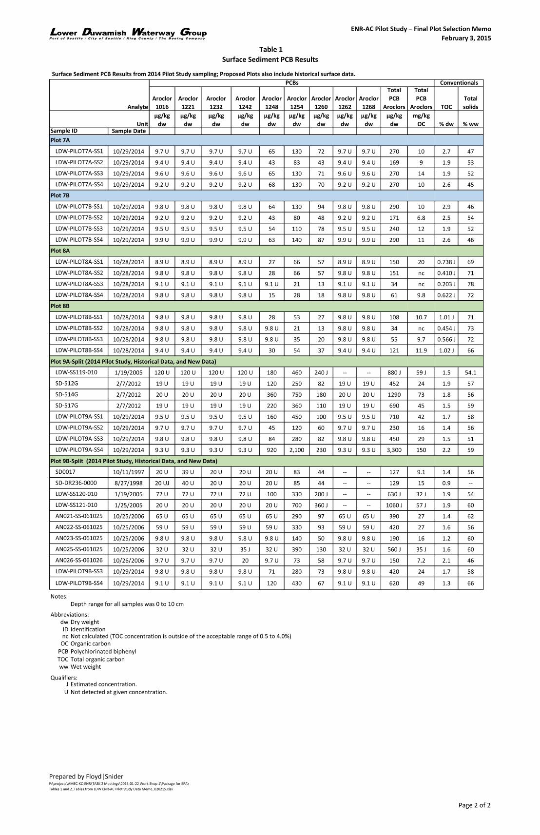
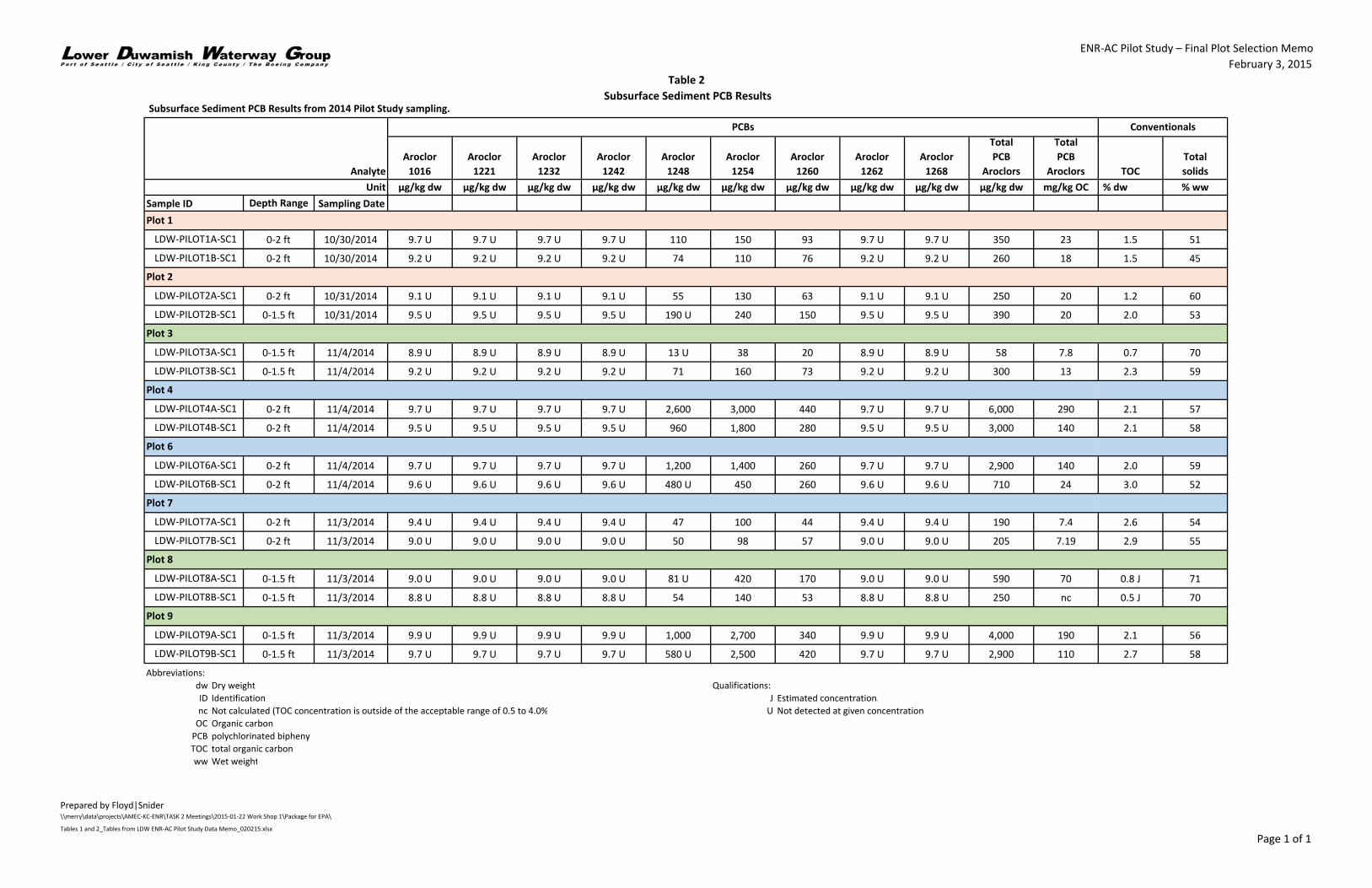
Tables 1 and 2 contain analytical results for surface and subsurface sediment PCB analyses, respectively. For all plots, 2014 sediment data are presented; for the proposed plots, additional historical data are included. Table 3 contains tabulated summary statistics of PCB concentrations based on the 2014 surface sediment data; for Plot 9, historical data and sediment data from the adjacent sites were included to evaluate the proposed split option, which extends beyond the plots used for 2014 data characterization. Table 4 contains the remedial action levels (RALs) and ENR‐upper limits (ULs) for the surface and subsurface sediments and Table 5 contains information on any surface and subsurface RAL and ENR‐UL exceedances. For Plot 1, the Recovery Category 1 RALs have been used, but the Recovery Category 2/3 ENR‐ULs have been used. For Plot 6, the Subtidal Recovery Category 2/3 RALs and ENR‐ULs have been used. For Plot 9, the Intertidal Recovery Category 2/3 RALs and ENR‐ULs have been used.
SCOUR PLOTS: Plot 1 proposed (Plots 1 and 2 considered)
Plots 1 and 2 are located near river mile 0.1. The chemistry in both Plots 1 and 2 are similar in PCB concentration ranges; the mudline elevations of the two plots are also similar. The primary differences are in the grainsize of the sediments and the facility operations in the berths. The grainsize of the sediments in Plot 1 were more uniform and contained little or no gravel, and resulted in better core recoveries than Plot 2 during sampling. This is expected to translate into more reliable deployment and recovery of the solid‐phase micro‐extraction (SPME) fibers. There is less potential of disruption of the ENR layer due to over‐water activities at Plot 1 than Plot 2, including less potential for materials falling onto the layer during off‐loading from upland operations. Finally, Plot 2 is expected to have more access restrictions due to the type and amount of operations at the pier. For these reasons, Plot 1 is recommended for the Pilot Study. Figure 1 shows the location of Plot 1, its subplots, PCB and other Sediment Management Standard (SMS) chemical exceedances in surface sediments, and bathymetry.
Ownership and access are still being assessed. Access is needed during the wintertime fish window for placement of materials. Direct access for sampling is needed to avoid diver‐sampling in confined spaces (for example, under barges).
PCB concentrations in Plot 7 are too low to meet study objectives; they are less than or equal to the RAL in all but one of the 2014 locations. The low concentrations make it more difficult to detect differences in PCB behavior between the subplots (the normal field and laboratory variability combined with concentrations near or below the reporting limits results in poor signal‐
LDW ENR‐AC Pilot Study – Final Plot Selection February 3, 2015
\\merry\data\projects\AMEC‐KC‐ENR\TASK 2 Meetings\2015‐01‐22 Work Shop 1\Package for EPA\Plot Selection Memo_020315_final.docx
Page 3 of 5
to‐noise ratios). Additionally, Plot 7 is near but not in an area of shoaling (This is easiest to see in Map 3‐1d of the QAPP).
Plots 4 and 6 have similar PCB surface chemistry and PCB variability between subplots. The 2014 subsurface core in Plot 4A exceeds the subsurface RAL (290 > 195 mg/kg‐OC), which is not exceeded in Plot 6. Plots 4 and 6 contain exceedances of the ENR‐UL in some of the surface samples; however, the ability to distinguish differences between ENR and ENR‐AC subplots is enhanced by the higher concentration levels. This ability can be further enhanced by lowering the variability between the subplots. The ability to distinguish the subplots is further improved by reconfiguring Plot 6 to be two long subplots; this change is recommended and decreases the variability by half. With this improvement, Plot 6 is recommended as the Subtidal Plot.
Figure 2 shows the location and revised layout of Plot 6, its subplots, PCB and other SMS chemical exceedances in surface sediments, and bathymetry.
The PCB concentrations in Plot 3 are too low (below or very near the RAL in all locations) resulting in decreased ability to discern differences between the subplots. Additionally, the location of Plot 3 behind Kellogg Island makes it representative of that area of the waterway, but less predictive of other intertidal areas (for example, groundwater discharge and exposure to wave/wake action behind Kellogg Island are expected to differ from conditions along the main waterway channel).
Similar to Plot 3, the PCBs concentrations in Plot 8 are too low (all but one location is below the RAL). The bathymetry difference at Plot 8 raises concerns. The intertidal bench, defined as that area between ‐4 MLLW and the toe of the bank, is more narrow at Plot 8 than Plot 9; this results in approximately 1/3 of the plot being representative of one set of conditions and the upper 2/3 another set of conditions (This is easiest to see in Map 3‐1e of the QAPP and is summarized in the table below). The presence of multiple conditions within the test plot, decreases the ability to distinguish between the treatment options. In addition, the design of both placement of the ENR and monitoring are more complex. The following table outlines the differences in portions of Plot 8.
Example Characteristic Nearshore 2/3 (elevation ‐5 ft MLLW or greater)
Nearchannel 1/3 (elevations lower than ‐5 ft MLLW
Groundwater discharge Seeps and seep face likely Little discharge expected
Porewater salinity Brackish and variable Saline
Potential scour process Wave/wake Wave/wake decreased in energy
Slope Relatively flat, good place to check stability
Relatively steep, will likely require coarser material for stability.
LDW ENR‐AC Pilot Study – Final Plot Selection February 3, 2015
\\merry\data\projects\AMEC‐KC‐ENR\TASK 2 Meetings\2015‐01‐22 Work Shop 1\Package for EPA\Plot Selection Memo_020315_final.docx
Page 4 of 5
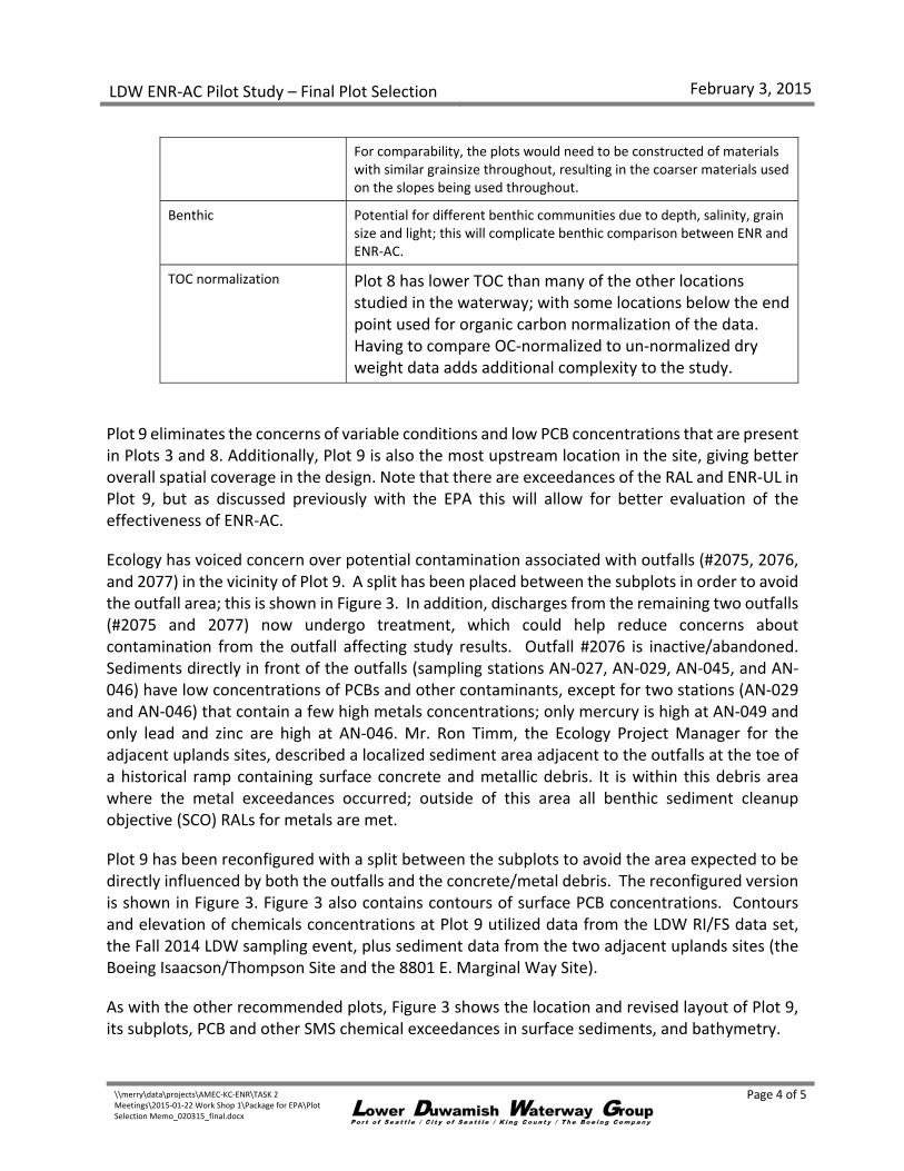
For comparability, the plots would need to be constructed of materials with similar grainsize throughout, resulting in the coarser materials used on the slopes being used throughout.
Benthic Potential for different benthic communities due to depth, salinity, grain size and light; this will complicate benthic comparison between ENR and ENR‐AC.
TOC normalization Plot 8 has lower TOC than many of the other locations studied in the waterway; with some locations below the end point used for organic carbon normalization of the data. Having to compare OC‐normalized to un‐normalized dry weight data adds additional complexity to the study.
Plot 9 eliminates the concerns of variable conditions and low PCB concentrations that are present in Plots 3 and 8. Additionally, Plot 9 is also the most upstream location in the site, giving better overall spatial coverage in the design. Note that there are exceedances of the RAL and ENR‐UL in Plot 9, but as discussed previously with the EPA this will allow for better evaluation of the effectiveness of ENR‐AC.
Ecology has voiced concern over potential contamination associated with outfalls (#2075, 2076, and 2077) in the vicinity of Plot 9. A split has been placed between the subplots in order to avoid the outfall area; this is shown in Figure 3. In addition, discharges from the remaining two outfalls (#2075 and 2077) now undergo treatment, which could help reduce concerns about contamination from the outfall affecting study results. Outfall #2076 is inactive/abandoned. Sediments directly in front of the outfalls (sampling stations AN‐027, AN‐029, AN‐045, and AN‐046) have low concentrations of PCBs and other contaminants, except for two stations (AN‐029 and AN‐046) that contain a few high metals concentrations; only mercury is high at AN‐049 and only lead and zinc are high at AN‐046. Mr. Ron Timm, the Ecology Project Manager for the adjacent uplands sites, described a localized sediment area adjacent to the outfalls at the toe of a historical ramp containing surface concrete and metallic debris. It is within this debris area where the metal exceedances occurred; outside of this area all benthic sediment cleanup objective (SCO) RALs for metals are met.
Plot 9 has been reconfigured with a split between the subplots to avoid the area expected to be directly influenced by both the outfalls and the concrete/metal debris. The reconfigured version is shown in Figure 3. Figure 3 also contains contours of surface PCB concentrations. Contours and elevation of chemicals concentrations at Plot 9 utilized data from the LDW RI/FS data set, the Fall 2014 LDW sampling event, plus sediment data from the two adjacent uplands sites (the Boeing Isaacson/Thompson Site and the 8801 E. Marginal Way Site).
As with the other recommended plots, Figure 3 shows the location and revised layout of Plot 9, its subplots, PCB and other SMS chemical exceedances in surface sediments, and bathymetry.
LDW ENR‐AC Pilot Study – Final Plot Selection February 3, 2015
\\merry\data\projects\AMEC‐KC‐ENR\TASK 2 Meetings\2015‐01‐22 Work Shop 1\Package for EPA\Plot Selection Memo_020315_final.docx
Page 5 of 5
The two adjacent uplands sites have both already conducted sediment sampling; however, we understand Ecology may request that the 8801 Site collect additional data. It is requested that any data needed for the 8801 site from within the area of the reconfigured Plot 9 subplots be collected before the ENR layer is placed in 2016.
Attachments
Table 1 – Surface Sediment PCB Results
Table 2 –Subsurface Sediment PCB Results
Table 3 –Surface Sediment PCB Data Summary for all Plots Considered
Table 4 – RALs and ENR‐ULs Used for Table 5
Table 5 ‐ Chemical Exceedances of RAL and ENR‐UL in Surface and Subsurface Sediments for Proposed Plots
Figure 1 – Plot 1 Layout, Chemical Exceedances, and Bathymetry
Figure 2 – Plot 6 Revised Layout, Chemical Exceedances, and Bathymetry
Figure 3 – Plot 9 Revised Layout, Chemical Exceedances, and Bathymetry
Table 1Surface Sediment PCB Results
ENR-AC Pilot Study – Final Plot Selection MemoFebruary 3, 2015
Prepared by Floyd|SniderF:\projects\AMEC-KC-ENR\TASK 2 Meetings\2015-01-22 Work Shop 1\Package for EPA\Tables 1 and 2_Tables from LDW ENR-AC Pilot Study Data Memo_020215.xlsx
Page 1 of 2
Surface Sediment PCB Results from 2014 Pilot Study sampling; Proposed Plots also include historical surface data.
AnalyteAroclor
1016Aroclor
1221Aroclor
1232Aroclor
1242Aroclor
1248Aroclor
1254Aroclor
1260Aroclor
1262Aroclor
1268
TotalPCB
Aroclors
TotalPCB
Aroclors TOCTotalsolids
Unitµg/kg
dwµg/kg
dwµg/kg
dwµg/kg
dwµg/kg
dwµg/kg
dwµg/kg
dwµg/kg
dwµg/kg
dwµg/kg
dwmg/kg
OC % dw % wwSample Date
8/31/1998 20 U 40 U 20 U 20 U 20 U 46 53 -- -- 99 3.3 3.0 --
3/10/2005 20 U 20 U 20 U 20 U 740 910 270 -- -- 1920 183 1.1 62
10/27/2014 9.4 U 9.4 U 9.4 U 9.4 U 65 78 65 9.4 U 9.4 U 208 15 1.4 59
10/27/2014 9.8 U 9.8 U 9.8 U 9.8 U 160 160 120 9.8 U 9.8 U 440 26 1.7 50
10/29/2014 9.2 U 9.2 U 9.2 U 9.2 U 64 98 77 9.2 U 9.2 U 239 6.8 3.5 46
10/27/2014 9.4 U 9.4 U 9.4 U 9.4 U 48 70 54 9.4 U 9.4 U 172 6.8 2.5 48
3/9/2005 19 U 19 U 19 U 19 U 62 92 86 -- -- 240 8.8 2.7 47
10/3/2006 40 U 40 U 40 U 40 U 95 J 250 J 240 J -- -- 590 J 20 J 3.0 51
10/27/2014 9.7 U 9.7 U 9.7 U 9.7 U 62 84 79 9.7 U 9.7 U 225 23 1.0 46
10/29/2014 9.4 U 9.4 U 9.4 U 9.4 U 63 110 84 9.4 U 9.4 U 260 7.6 3.4 45
10/29/2014 9.7 U 9.7 U 9.7 U 9.7 U 70 110 76 9.7 U 9.7 U 260 9.2 2.8 43
10/27/2014 9.9 U 9.9 U 9.9 U 9.9 U 58 84 71 9.9 U 9.9 U 213 9.4 2.3 45
10/27/2014 9.7 U 9.7 U 9.7 U 9.7 U 37 54 41 9.7 U 9.7 U 132 14 0.9 64
10/28/2014 9.1 U 9.1 U 9.1 U 9.1 U 29 43 29 9.1 U 9.1 U 101 7.1 1.42 J 68
10/28/2014 9.9 U 9.9 U 9.9 U 9.9 U 52 85 220 9.9 U 9.9 U 360 31 1.18 J 55
10/27/2014 9.0 U 9.0 U 9.0 U 9.0 U 58 86 56 9.0 U 9.0 U 200 7.6 2.6 59
10/27/2014 9.7 U 9.7 U 9.7 U 9.7 U 55 69 53 9.7 U 9.7 U 177 7.1 2.5 52
10/28/2014 9.2 U 9.2 U 9.2 U 9.2 U 46 54 40 9.2 U 9.2 U 140 7.0 2.01 J 59
10/28/2014 9.6 U 9.6 U 9.6 U 9.6 U 92 110 70 9.6 U 9.6 U 270 24 1.14 J 53
10/28/2014 9.5 U 9.5 U 9.5 U 9.5 U 98 150 100 9.5 U 9.5 U 350 14 2.44 J 49
Plot 3A
10/27/2014 9.4 U 9.4 U 9.4 U 9.4 U 54 85 62 9.4 U 9.4 U 201 13 1.6 41
10/27/2014 9.1 U 9.1 U 9.1 U 9.1 U 25 38 26 9.1 U 9.1 U 89 4.9 1.8 61
10/27/2014 9.8 U 9.8 U 9.8 U 9.8 U 33 65 46 9.8 U 9.8 U 144 7.0 2.06 J 52
10/27/2014 9.4 U 9.4 U 9.4 U 9.4 U 45 72 55 9.4 U 9.4 U 172 5.4 3.19 J 44
10/27/2014 9.5 U 9.5 U 9.5 U 9.5 U 140 U 120 96 9.5 U 9.5 U 220 13 1.65 J 39
10/27/2014 9.6 U 9.6 U 9.6 U 9.6 U 12 U 14 12 9.6 U 9.6 U 26 4.7 0.6 58
10/27/2014 9.9 U 9.9 U 9.9 U 9.9 U 9.9 U 9.9 U 9.9 U 9.9 U 9.9 U 9.9 U 1.5 U 0.7 63
10/27/2014 10 U 10 U 10 U 10 U 43 65 41 10 U 10 U 149 4.1 3.61 J 39
10/27/2014 9.6 U 9.6 U 9.6 U 9.6 U 92 100 70 9.6 U 9.6 U 260 24 1.09 J 66
10/27/2014 9.6 U 9.6 U 9.6 U 9.6 U 17 25 12 9.6 U 9.6 U 54 nc 0.261 J 76
10/27/2014 9.9 U 9.9 U 9.9 U 9.9 U 110 140 80 9.9 U 9.9 U 330 26 1.28 J 63
10/27/2014 8.9 U 8.9 U 8.9 U 8.9 U 57 90 50 8.9 U 8.9 U 197 11 1.81 J 63
10/27/2014 9.1 U 9.1 U 9.1 U 9.1 U 430 330 180 9.1 U 9.1 U 940 45 2.08 J 61
10/27/2014 10 U 10 U 10 U 10 U 74 100 37 10 U 10 U 210 17 1.26 J 62
10/28/2014 9.6 U 9.6 U 9.6 U 9.6 U 20 21 10 9.6 U 9.6 U 51 6.0 0.846 J 58
10/28/2014 9.8 U 9.8 U 9.8 U 9.8 U 720 660 260 9.8 U 9.8 U 1,640 109 1.51 J 63
8/12/1998 20 UJ 40 U 20 U 33 20 U 142 96 -- -- 271 14 1.9 --
10/28/2014 9.3 U 9.3 U 9.3 U 9.3 U 160 200 100 9.3 U 9.3 U 460 28 1.64 J 49
10/28/2014 9.2 U 9.2 U 9.2 U 9.2 U 640 670 220 9.2 U 9.2 U 1,530 81 1.90 J 55
10/29/2014 9.3 U 9.3 U 9.3 U 9.3 U 1,100 1,400 420 9.3 U 9.3 U 2,900 180 1.6 59
10/29/2014 9.4 U 9.4 U 9.4 U 9.4 U 180 180 J 90 9.4 U 9.4 U 450 J 68 J 0.7 78
10/28/2014 9.0 U 9.0 U 9.0 U 9.0 U 75 83 44 9.0 U 9.0 U 202 10 1.94 J 61
10/28/2014 9.3 U 9.3 U 9.3 U 9.3 U 100 130 57 9.3 U 9.3 U 290 13 2.18 J 67
10/29/2014 9.4 U 9.4 U 9.4 U 9.4 U 700 570 200 9.4 U 9.4 U 1,470 116 1.3 60
10/29/2014 9.1 U 9.1 U 9.1 U 9.1 U 390 610 250 9.1 U 9.1 U 1,250 77 1.6 61
Plot 6 - Lane B (2014 Pilot Study and Historical Data)
LDW-PILOT6A-SS1
LDW-PILOT6A-SS4
LDW-PILOT6A-SS2
LDW-PILOT6A-SS3
LDW-PILOT6B-SS2
LDW-PILOT6B-SS3
LDW-PILOT6B-SS4
Plot 6 - Lane A (2014 Pilot Studay and Historical Data)
SD-DR089-0000
Sample IDPlot 1A (2014 Pilot Study and Historical Data)
Plot 1B (2014 Pilot Study and Historical Data)
Plot 2A
Plot 2B
Plot 3B
Plot 4A
Plot 4B
LDW-PILOT6B-SS1
LDW-SS40-010
LDW-PILOT4B-SS1
LDW-PILOT4B-SS2
LDW-PILOT4B-SS3
LDW-PILOT4B-SS4
LDW-PILOT4A-SS1
LDW-PILOT4A-SS2
LDW-PILOT4A-SS3
LDW-PILOT4A-SS4
LDW-PILOT3B-SS1
LDW-PILOT3B-SS2
LDW-PILOT3B-SS3
LDW-PILOT3B-SS4
LDW-PILOT3A-SS1
LDW-PILOT3A-SS2
LDW-PILOT3A-SS3
LDW-PILOT3A-SS4
PCBs Conventionals
LDW-PILOT1B-SS1
LDW-PILOT2B-SS1
LDW-PILOT2B-SS2
LDW-PILOT2B-SS3
LDW-PILOT2B-SS4
LDW-PILOT2A-SS1
LDW-PILOT2A-SS2
LDW-PILOT2A-SS3
LDW-PILOT2A-SS4
LDW-PILOT1B-SS4
LDW-PILOT1B-SS2
LDW-PILOT1B-SS3
SD-DR001-0000
LDW-SS6-010
LDW-PILOT1A-SS1
LDW-PILOT1A-SS2
LDW-PILOT1A-SS3
LDW-PILOT1A-SS4
LDW-SS7-010
LDW-SS305-010
Table 1Surface Sediment PCB Results
ENR-AC Pilot Study – Final Plot Selection MemoFebruary 3, 2015
Prepared by Floyd|SniderF:\projects\AMEC-KC-ENR\TASK 2 Meetings\2015-01-22 Work Shop 1\Package for EPA\Tables 1 and 2_Tables from LDW ENR-AC Pilot Study Data Memo_020215.xlsx
Page 2 of 2
Surface Sediment PCB Results from 2014 Pilot Study sampling; Proposed Plots also include historical surface data.
AnalyteAroclor
1016Aroclor
1221Aroclor
1232Aroclor
1242Aroclor
1248Aroclor
1254Aroclor
1260Aroclor
1262Aroclor
1268
TotalPCB
Aroclors
TotalPCB
Aroclors TOCTotalsolids
Unitµg/kg
dwµg/kg
dwµg/kg
dwµg/kg
dwµg/kg
dwµg/kg
dwµg/kg
dwµg/kg
dwµg/kg
dwµg/kg
dwmg/kg
OC % dw % wwSample DateSample ID
PCBs Conventionals
10/29/2014 9.7 U 9.7 U 9.7 U 9.7 U 65 130 72 9.7 U 9.7 U 270 10 2.7 47
10/29/2014 9.4 U 9.4 U 9.4 U 9.4 U 43 83 43 9.4 U 9.4 U 169 9 1.9 53
10/29/2014 9.6 U 9.6 U 9.6 U 9.6 U 65 130 71 9.6 U 9.6 U 270 14 1.9 52
10/29/2014 9.2 U 9.2 U 9.2 U 9.2 U 68 130 70 9.2 U 9.2 U 270 10 2.6 45
10/29/2014 9.8 U 9.8 U 9.8 U 9.8 U 64 130 94 9.8 U 9.8 U 290 10 2.9 46
10/29/2014 9.2 U 9.2 U 9.2 U 9.2 U 43 80 48 9.2 U 9.2 U 171 6.8 2.5 54
10/29/2014 9.5 U 9.5 U 9.5 U 9.5 U 54 110 78 9.5 U 9.5 U 240 12 1.9 52
10/29/2014 9.9 U 9.9 U 9.9 U 9.9 U 63 140 87 9.9 U 9.9 U 290 11 2.6 46
10/28/2014 8.9 U 8.9 U 8.9 U 8.9 U 27 66 57 8.9 U 8.9 U 150 20 0.738 J 69
10/28/2014 9.8 U 9.8 U 9.8 U 9.8 U 28 66 57 9.8 U 9.8 U 151 nc 0.410 J 71
10/28/2014 9.1 U 9.1 U 9.1 U 9.1 U 9.1 U 21 13 9.1 U 9.1 U 34 nc 0.203 J 78
10/28/2014 9.8 U 9.8 U 9.8 U 9.8 U 15 28 18 9.8 U 9.8 U 61 9.8 0.622 J 72
10/28/2014 9.8 U 9.8 U 9.8 U 9.8 U 28 53 27 9.8 U 9.8 U 108 10.7 1.01 J 71
10/28/2014 9.8 U 9.8 U 9.8 U 9.8 U 9.8 U 21 13 9.8 U 9.8 U 34 nc 0.454 J 73
10/28/2014 9.8 U 9.8 U 9.8 U 9.8 U 9.8 U 35 20 9.8 U 9.8 U 55 9.7 0.566 J 72
10/28/2014 9.4 U 9.4 U 9.4 U 9.4 U 30 54 37 9.4 U 9.4 U 121 11.9 1.02 J 66
Plot 9A-Split (2014 Pilot Study, Historical Data, and New Data)
1/19/2005 120 U 120 U 120 U 120 U 180 460 240 J -- -- 880 J 59 J 1.5 54.1
2/7/2012 19 U 19 U 19 U 19 U 120 250 82 19 U 19 U 452 24 1.9 57
2/7/2012 20 U 20 U 20 U 20 U 360 750 180 20 U 20 U 1290 73 1.8 56
2/7/2012 19 U 19 U 19 U 19 U 220 360 110 19 U 19 U 690 45 1.5 59
10/29/2014 9.5 U 9.5 U 9.5 U 9.5 U 160 450 100 9.5 U 9.5 U 710 42 1.7 58
10/29/2014 9.7 U 9.7 U 9.7 U 9.7 U 45 120 60 9.7 U 9.7 U 230 16 1.4 56
10/29/2014 9.8 U 9.8 U 9.8 U 9.8 U 84 280 82 9.8 U 9.8 U 450 29 1.5 51
10/29/2014 9.3 U 9.3 U 9.3 U 9.3 U 920 2,100 230 9.3 U 9.3 U 3,300 150 2.2 59
Plot 9B-Split (2014 Pilot Study, Historical Data, and New Data)
10/11/1997 20 U 39 U 20 U 20 U 20 U 83 44 -- -- 127 9.1 1.4 56
8/27/1998 20 UJ 40 U 20 U 20 U 20 U 85 44 -- -- 129 15 0.9 --
1/19/2005 72 U 72 U 72 U 72 U 100 330 200 J -- -- 630 J 32 J 1.9 54
1/25/2005 20 U 20 U 20 U 20 U 20 U 700 360 J -- -- 1060 J 57 J 1.9 60
10/25/2006 65 U 65 U 65 U 65 U 65 U 290 97 65 U 65 U 390 27 1.4 62
10/25/2006 59 U 59 U 59 U 59 U 59 U 330 93 59 U 59 U 420 27 1.6 56
10/25/2006 9.8 U 9.8 U 9.8 U 9.8 U 9.8 U 140 50 9.8 U 9.8 U 190 16 1.2 60
10/25/2006 32 U 32 U 32 U 35 J 32 U 390 130 32 U 32 U 560 J 35 J 1.6 60
10/26/2006 9.7 U 9.7 U 9.7 U 20 9.7 U 73 58 9.7 U 9.7 U 150 7.2 2.1 46
10/29/2014 9.8 U 9.8 U 9.8 U 9.8 U 71 280 73 9.8 U 9.8 U 420 24 1.7 58
10/29/2014 9.1 U 9.1 U 9.1 U 9.1 U 120 430 67 9.1 U 9.1 U 620 49 1.3 66
Depth range for all samples was 0 to 10 cm
Abbreviations:dw Dry weightID Identificationnc Not calculated (TOC concentration is outside of the acceptable range of 0.5 to 4.0%)
OC Organic carbonPCB Polychlorinated biphenylTOC Total organic carbonww Wet weight
Qualifiers:J Estimated concentration.
U Not detected at given concentration.
LDW-SS119-010
SD-512G
SD-514G
Plot 7B
LDW-PILOT7B-SS1
LDW-PILOT7B-SS2
LDW-PILOT7B-SS3
LDW-PILOT7B-SS4
Plot 7A
LDW-PILOT7A-SS1
LDW-PILOT7A-SS2
LDW-PILOT7A-SS3
LDW-PILOT7A-SS4
Notes:
LDW-PILOT9B-SS3
LDW-PILOT9B-SS4
LDW-PILOT9A-SS1
LDW-PILOT9A-SS2
LDW-PILOT9A-SS3
LDW-PILOT9A-SS4
SD-517G
SD0017
SD-DR236-0000
LDW-SS120-010
LDW-SS121-010
AN021-SS-061025
AN022-SS-061025
AN023-SS-061025
AN025-SS-061025
AN026-SS-061026
Plot 8B
LDW-PILOT8B-SS1
LDW-PILOT8B-SS2
LDW-PILOT8B-SS3
LDW-PILOT8B-SS4
Plot 8A
LDW-PILOT8A-SS1
LDW-PILOT8A-SS2
LDW-PILOT8A-SS3
LDW-PILOT8A-SS4
Table 2 Subsurface Sediment PCB Results
ENR‐AC Pilot Study – Final Plot Selection MemoFebruary 3, 2015
Subsurface Sediment PCB Results from 2014 Pilot Study sampling.
AnalyteAroclor1016
Aroclor1221
Aroclor1232
Aroclor1242
Aroclor1248
Aroclor1254
Aroclor1260
Aroclor1262
Aroclor1268
TotalPCB
Aroclors
TotalPCB
Aroclors TOCTotalsolids
Unit µg/kg dw µg/kg dw µg/kg dw µg/kg dw µg/kg dw µg/kg dw µg/kg dw µg/kg dw µg/kg dw µg/kg dw mg/kg OC % dw % wwDepth Range Sampling Date
0‐2 ft 10/30/2014 9.7 U 9.7 U 9.7 U 9.7 U 110 150 93 9.7 U 9.7 U 350 23 1.5 51
0‐2 ft 10/30/2014 9.2 U 9.2 U 9.2 U 9.2 U 74 110 76 9.2 U 9.2 U 260 18 1.5 45
0‐2 ft 10/31/2014 9.1 U 9.1 U 9.1 U 9.1 U 55 130 63 9.1 U 9.1 U 250 20 1.2 60
0‐1.5 ft 10/31/2014 9.5 U 9.5 U 9.5 U 9.5 U 190 U 240 150 9.5 U 9.5 U 390 20 2.0 53
0‐1.5 ft 11/4/2014 8.9 U 8.9 U 8.9 U 8.9 U 13 U 38 20 8.9 U 8.9 U 58 7.8 0.7 70
0‐1.5 ft 11/4/2014 9.2 U 9.2 U 9.2 U 9.2 U 71 160 73 9.2 U 9.2 U 300 13 2.3 59
0‐2 ft 11/4/2014 9.7 U 9.7 U 9.7 U 9.7 U 2,600 3,000 440 9.7 U 9.7 U 6,000 290 2.1 57
0‐2 ft 11/4/2014 9.5 U 9.5 U 9.5 U 9.5 U 960 1,800 280 9.5 U 9.5 U 3,000 140 2.1 58
0‐2 ft 11/4/2014 9.7 U 9.7 U 9.7 U 9.7 U 1,200 1,400 260 9.7 U 9.7 U 2,900 140 2.0 59
0‐2 ft 11/4/2014 9.6 U 9.6 U 9.6 U 9.6 U 480 U 450 260 9.6 U 9.6 U 710 24 3.0 52
0‐2 ft 11/3/2014 9.4 U 9.4 U 9.4 U 9.4 U 47 100 44 9.4 U 9.4 U 190 7.4 2.6 54
0‐2 ft 11/3/2014 9.0 U 9.0 U 9.0 U 9.0 U 50 98 57 9.0 U 9.0 U 205 7.19 2.9 55
0‐1.5 ft 11/3/2014 9.0 U 9.0 U 9.0 U 9.0 U 81 U 420 170 9.0 U 9.0 U 590 70 0.8 J 71
0‐1.5 ft 11/3/2014 8.8 U 8.8 U 8.8 U 8.8 U 54 140 53 8.8 U 8.8 U 250 nc 0.5 J 70
0‐1.5 ft 11/3/2014 9.9 U 9.9 U 9.9 U 9.9 U 1,000 2,700 340 9.9 U 9.9 U 4,000 190 2.1 56
0‐1.5 ft 11/3/2014 9.7 U 9.7 U 9.7 U 9.7 U 580 U 2,500 420 9.7 U 9.7 U 2,900 110 2.7 58
dw Dry weightID Identification J Estimated concentration.nc Not calculated (TOC concentration is outside of the acceptable range of 0.5 to 4.0% U Not detected at given concentrationOC Organic carbonPCB polychlorinated biphenylTOC total organic carbonww Wet weight
LDW‐PILOT9B‐SC1
Abbreviations:
LDW‐PILOT8A‐SC1
LDW‐PILOT8B‐SC1
Plot 9
LDW‐PILOT9A‐SC1
LDW‐PILOT6B‐SC1
Plot 7
LDW‐PILOT7A‐SC1
LDW‐PILOT7B‐SC1
Plot 8
Plot 4
LDW‐PILOT4A‐SC1
LDW‐PILOT4B‐SC1
Plot 6
LDW‐PILOT6A‐SC1
Qualifications:
PCBs Conventionals
Sample IDPlot 1
LDW‐PILOT1A‐SC1
LDW‐PILOT1B‐SC1
Plot 2
LDW‐PILOT2A‐SC1
LDW‐PILOT2B‐SC1
Plot 3
LDW‐PILOT3A‐SC1
LDW‐PILOT3B‐SC1
Prepared by Floyd|Snider\\merry\data\projects\AMEC‐KC‐ENR\TASK 2 Meetings\2015‐01‐22 Work Shop 1\Package for EPA\
Tables 1 and 2_Tables from LDW ENR‐AC Pilot Study Data Memo_020215.xlsx
Page 1 of 1
Table 3Surface Sediment PCB Data Summary for all Plots Considered
ENR-AC Pilot Study – Final Plot Selection MemoFebruary 3, 2015
Prepared by Floyd|SniderF:\projects\AMEC-KC-ENR\TASK 2 Meetings\2015-01-22 Work Shop 1\Package for EPA\Table 3_Plot Data Summary_020215.xlsx Page 1 of 1
Surface Sediment PCB Results from 2014 Pilot Study sampling; Plot 9 also includes historical data and data from adjacent sites.Scour Plot Comparison
Analyte Minimum Maximum Mean Stan Dev Minimum Maximum Mean Stan Dev % Difference
Prepared by Floyd|Snider\\merry\data\projects\AMEC‐KC‐ENR\TASK 2 Meetings\2015‐01‐22 Work Shop 1\Package for EPA\Table 4_RALs and ENR UL_020215.xlsx Page 1 of 2
Table 4RALs and ENR‐ULs Used for Table 5
ENR‐AC Pilot Study – Final Plot Selection MemoFebruary 3, 2015
Notes:‐ No limit given.1 Tables referenced from Record of Decision: Lower Duwamish Waterway Superfund Site, United States Environmental Protection Agency Region 10, November 2014.
CentimeterContaminants of concernCarcinogenic polycyclic aromatic hydrocarbon
Enhanced natural recoveryFeetKilogramMilligrams per kilogramNanogram
Prepared by Floyd|Snider\\merry\data\projects\AMEC‐KC‐ENR\TASK 2 Meetings\2015‐01‐22 Work Shop 1\Package for EPA\Table 4_RALs and ENR UL_020215.xlsx Page 2 of 2
Table 5Chemical Exceedances of RAL and ENR-UL in Surface and Subsurface Sediments for Proposed Plots
ENR-AC Pilot Study – Final Plot Selection MemoFebruary 3, 2015
Prepared by Floyd|SniderF:\projects\AMEC-KC-ENR\TASK 2 Meetings\2015-01-22 Work Shop 1\Package for EPA\Table 5 Exceedances_020215.xlsx
Dry weightEnhanced natural recoveryKilogramMicrogramMilligrams per kilogramOrganic carbonPolychlorinated biphenyl
SD-512
!
!
!
!
!
!
!
!
!
!
!
!
DR001b Total PCB-OCN 3.3b Arsenic 77.2
LDW-PILOT1A-SS1b Total PCB-OCN 14.6
LDW-PILOT1A-SS2b Total PCB-OCN 26
LDW-PILOT1A-SS3b Total PCB-OCN 6.81
LDW-PILOT1A-SS4b Total PCB-OCN 6.83
LDW-PILOT1B-SS1b Total PCB-OCN 23.3
LDW-PILOT1B-SS2b Total PCB-OCN 7.6
LDW-PILOT1B-SS3b Total PCB-OCN 9.2
LDW-PILOT1B-SS4b Total PCB-OCN 9.42
LDW-SS305b Total PCB-OCN 20 Jb Arsenic 123
LDW-SS6b Total PCB-OCN 183b Arsenic 82.9b Lead 573b Zinc 553b bis(2-ethylhexyl)phthalate 81
LDW-SS7b Total PCB-OCN 8.82
-20
-20
0
0
-10
-20
-30-10
-20
0
-30
-10-20
-20
-30
I:\GIS\Projects\AMEC-KC-ENR\MXD\Figure 1 Plot 1 and Results.mxd2/3/2015
Figure 1Plot 1 Layout, Chemical
Exceedances, and BathymetryENR-AC Pilot Study
Final Plot Selection Memo
Notes: · Bathymetry units are in feet MLLW · Orthoimage provided by USGS, 2012.Abbriviations: ENR-UL = Enhanced Natural Recovery Upper Limit RAL = Remedial Action Level PCB-OCN = Polychlorinated biphenyl organic carbon normalized
Legend;; Exceeds ENR-UL;; Between RAL and ENR-UL;; Below RAL
2014 Pilot Study SampleLDWG RI/FS SamplePlot Area10 ft contour5 ft contour1 ft contour
¹ 0 50 10025Scale in Feet
Plot 1
A
Plot 1
B
1.2
1.2
CH0030b Total PCB-OCN 4.3 J
DR089b Total PCB-OCN 14.1
LDW-PILOT6A-SS1b Total PCB-OCN 28
LDW-PILOT6A-SS2b Total PCB-OCN 10.4
LDW-PILOT6A-SS3b Total PCB-OCN 13
LDW-PILOT6A-SS4b Total PCB-OCN 80.5
LDW-PILOT6B-SS1b Total PCB-OCN 180
LDW-PILOT6B-SS2b Total PCB-OCN 116
LDW-PILOT6B-SS3b Total PCB-OCN 76.7
LDW-PILOT6B-SS4b Total PCB-OCN 68 J
LDW-SS40b Total PCB-OCN 27 J
-10-20-30
-20-30
-20
-30
-20
-30
-30
0
-30
-30
I:\GIS\Projects\AMEC-KC-ENR\MXD\Figure 2 Plot 6 and Results.mxd2/3/2015
Figure 2Plot 6 Revised Layout, Chemical
Exceedances, and BathymetryENR-AC Pilot Study
Final Plot Selection Memo
Notes: · All results are for surface sediments. · Units for analytical results are in mg/kg dw for metals, and µg/kg OC for organics. · Bathymetry units are in feet MLLW. · For plot selection purposes, we reviewed surface and subsurface chemistry and physical data by Windward Environmetal, 2015. · Orthoimage provided by USGS, 2012.Abbriviations: ENR-UL = Enhanced Natural Recovery Upper Limit RAL = Remedial Action Level PCB-OCN = Polychlorinated biphenyl organic carbon normalized
Legend;; Exceeds ENR-UL;; Between RAL and ENR-UL;; Below RAL
2014 Pilot Study SampleLDWG RI/FS SamplePlot Area10 ft contour5 ft contour1 ft contourNavigation Channel with Mile Markers
¹ 0 50 10025Scale in Feet
Plot 6 - Lane A Plot 6 - Lane B
")
")
")")
!
!
!
!
!
!
!
!
!
!
!
!
!
!
!
!
!
!
!
!
!
!
!
!
!
!
!
!
Boein g Isa a c son /Thom pson Site
8801 E. Ma rgin a l W a y Site
2077, Boein g – Thom pson
2074, Ken worth Truc k Co.
2075, Ken worth Truc k Co.2076, Ken worth Truc k Co.
AN-021b Tota l PCB-OCN 27
AN-022b Tota l PCB-OCN 27
AN-023b Tota l PCB-OCN 16
AN-025b Tota l PCB-OCN 35 Jb Butyl b en zyl phtha la te 13
AN-026b Tota l PCB-OCN 7.2
AN-027b Tota l PCB-OCN 14b Butyl b en zyl phtha la te 14AN-028
b Tota l PCB-OCN 15 J
AN-029b Tota l PCB-OCN 15b Merc ury 6.8
AN-045b Tota l PCB-OCN 8
AN-046b Tota l PCB-OCN 4.18b L ea d 21700 Jb Zin c 1050
AN-047b Tota l PCB-OCN 110b Butyl b en zyl phtha la te 83
DR236b Tota l PCB-OCN 15
EST143b Tota l PCB-OCN 28
LDW-PILOT9A-SS1b Tota l PCB-OCN 42
LDW-PILOT9A-SS2b Tota l PCB-OCN 16
LDW-PILOT9A-SS3b Tota l PCB-OCN 29
LDW-PILOT9A-SS4b Tota l PCB-OCN 150
LDW-PILOT9B-SS1b Tota l PCB-OCN 25
LDW-PILOT9B-SS2b Tota l PCB-OCN 53.8
LDW-PILOT9B-SS3b Tota l PCB-OCN 24
LDW-PILOT9B-SS4b Tota l PCB-OCN 49
LDW-SS119b Tota l PCB-OCN 59 J
LDW-SS120b Tota l PCB-OCN 32 Jb Butyl b en zyl phtha la te 12
LDW-SS121b Tota l PCB-OCN 57 Jb Butyl b en zyl phtha la te 17
R35b Tota l PCB-OCN 9.1
SD-512Gb Tota l PCB-OCN 24.4
SD-514Gb Tota l PCB-OCN 72.5
SD-517Gb Tota l PCB-OCN 44.8
3.9
3.9-10
-10
0
-10
0
-10
0
0
0
I:\GIS\Projects\AMEC-KC-ENR\MXD\Figure 3 Plot 9 a n d Results.m xd2/3/2015
Figure 3Plot 9 Revised L a yout, Chem ic a lExc eeda n c es, a n d Bathym etry
ENR-AC Pilot StudyFinal Plot Selection Memo
Notes: · Bathym etry un its a re in feet ML L W . · Orthoim a ge provided b y U SGS, 2012.Ab b rivia tion s: ENR-U L = En ha n c ed Natura l Rec overy U pper L im it RAL = Rem edia l Ac tion L evel PCB-OCN = Polyc hlorin a ted b iphen yl orga n ic c a rb on n orm a lized
Legend;; Exc eeds ENR-U L;; Between RAL a n d ENR-U L;; Below RAL
2014 Pilot Study Sa m pleIT Data Sa m pleL DW G RI/FS Sa m ple
") Ab a n don ed Outfa ll") Outfa llPlot Area10 ft con tour5 ft con tour1 ft con tourNa viga tion Cha n n el with Mile Ma rkers