An ESRI ® White Paper • December 2009 PLTS ™ for ArcGIS ® —Foundation: Meeting the Needs of Electric and Gas Utility Agencies ESRI 380 New York St., Redlands, CA 92373-8100 USA TEL 909-793-2853 • FAX 909-793-5953 • E-MAIL [email protected] • WEB www.esri.com
Transcript
An ESRI ® White Paper • December 2009
PLTS™ for ArcGIS®—Foundation: Meeting the Needs of Electric
and Gas Utility Agencies
ESRI 380 New York St., Redlands, CA 92373-8100 USA TEL 909-793-2853 • FAX 909-793-5953 • E-MAIL [email protected] • WEB www.esri.com
PLTS for ArcGIS—Foundation: Meeting the Needs of Electric and Gas Utility Agencies
An ESRI White Paper Contents Page The Challenge ....................................................................................... 1
Need for a Tool ............................................................................... 1 Overview of PLTS for ArcGIS—Foundation....................................... 1 Key Benefits for Electric and Gas Utilities........................................... 2
J-9838
ESRI White Paper
PLTS for ArcGIS—Foundation: Meeting the Needs of Electric and Gas Utility Agencies
The Challenge Electric and gas utility agencies are faced with a challenge to better position themselves in the utilities industry by providing high-quality customer service, supporting mobile operations, and complying with government regulations, all while lowering operational costs. Efficient management and maintenance of the agencies' assets, such as electric devices, cables, support structures, and maintenance equipment, help control costs, thereby requiring maintenance of reliable and accurate databases in order to manage those assets.
Need for a Tool In the face of global economic conditions like challenging competition and fluctuating utility prices, there is a need for a tool that will quickly deliver business benefits to electric and gas utility agencies. Production Line Tool Set (PLTS™) for ArcGIS®—Foundation provides a streamlined environment to implement consistent processes for editing, data maintenance, quality assurance, and map production, enabling these utility agencies to reduce costs as well as improve production efficiencies.
Overview of PLTS for ArcGIS—
Foundation
PLTS for ArcGIS—Foundation is a collection of turnkey software applications for high-volume database production, maintenance, quality control, cartographic product generation, and workflow management. These applications, developed by the ISO 9001:2000-certified ESRI Services Production Group, facilitate every step in a geographic information system (GIS) production process. PLTS for ArcGIS—Foundation provides tools needed to streamline data and map production with the ability to implement organizational and industry-specific business rules in data modeling, attribution, validation, and product generation. This commercial off-the-shelf extension to ArcGIS enables organizations to efficiently produce geospatial data while adhering to industry-specific production requirements. Leveraging a database-centric approach, PLTS for ArcGIS—Foundation provides a highly integrated system that facilitates efficient production of reliable, cost-effective digital data and cartographic products, thereby enabling quick delivery of business benefits. With PLTS for ArcGIS—Foundation, electric and gas utility agencies can
Efficiently produce geospatial data and cartographic products while adhering to electric and gas industry-specific production requirements.
Dramatically cut data editing time with single-click, smart editing, and on-the-fly
validation tools.
Streamline GIS database creation and maintenance via automated, in-process, rule-based quality control using intelligent attribution tools.
PLTS for ArcGIS—Foundation: Meeting the Needs of Electric and Gas Utility Agencies
J-9838
December 2009 2
Significantly decrease the time required to perform data ingestion and delivery through automated data import and export tools.
Create high-quality, high-volume map products by automating map production
processes.
Simplify workflow management and job tracking.
Key Benefits for Electric and Gas
Utilities
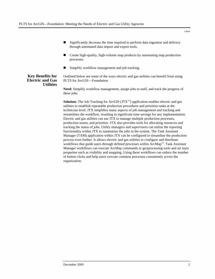
Outlined below are some of the ways electric and gas utilities can benefit from using PLTS for ArcGIS—Foundation. Need: Simplify workflow management, assign jobs to staff, and track the progress of these jobs. Solution: The Job Tracking for ArcGIS (JTX™) application enables electric and gas utilities to establish repeatable production procedures and prioritize tasks at the technician level. JTX simplifies many aspects of job management and tracking and streamlines the workflow, resulting in significant time savings for any implementation. Electric and gas utilities can use JTX to manage multiple production processes, production teams, and priorities. JTX also provides tools for allocating resources and tracking the status of jobs. Utility managers and supervisors can utilize the reporting functionality within JTX to summarize the jobs in the system. The Task Assistant Manager (TAM) application within JTX can be configured to streamline the production process even further. It allows electric and gas utilities to configure and distribute workflows that guide users through defined processes within ArcMap™. Task Assistant Manager workflows can execute ArcMap commands or geoprocessing tools and set layer properties such as visibility and snapping. Using these workflows can reduce the number of button clicks and help users execute common processes consistently across the organization.
PLTS for ArcGIS—Foundation: Meeting the Needs of Electric and Gas Utility Agencies
J-9838
ESRI White Paper 3
Establish production procedures using JTX and define processes within ArcMap using Task Assistant Manager.
Need: Optimize the production process and efficiently streamline the implementation of mapping rules and geometric network data integrity requirements. Solution: The PLTS Editing interface provides tools to streamline the creation of new residential and commercial development projects and efficiently update GIS infrastructure datasets for electrical transmission and gas distribution as well as small electric distribution agencies. Setting attributes before features are created makes it easy to maintain key attribute information. Frequently used attribute combinations can also be stored and reused, reducing the time it takes to create new features. Integrated quality control allows features to be validated as they are created or edited to ensure data integrity. The PLTS editing environment consists of a variety of single-click editing tools to enhance productivity as well as batch data processing tools for data in electric and gas networks that will snap points, split lines, and populate attributes by tracing.
PLTS for ArcGIS—Foundation: Meeting the Needs of Electric and Gas Utility Agencies
J-9838
December 2009 4
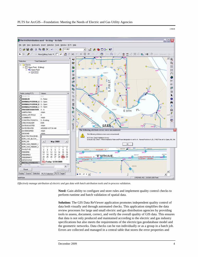
Effectively manage attribution of electric and gas data with batch attribution tools and in-process validation.
Need: Gain ability to configure and store rules and implement quality control checks to perform runtime and batch validation of spatial data. Solution: The GIS Data ReViewer application promotes independent quality control of data both visually and through automated checks. This application simplifies the data review processes for large and small electric and gas distribution agencies by providing tools to assess, document, correct, and verify the overall quality of GIS data. This ensures that data is not only produced and maintained according to the electric and gas industry specifications but also meets the requirements of the electric/gas geodatabase model and the geometric networks. Data checks can be run individually or as a group in a batch job. Errors are collected and managed in a central table that stores the error properties and
PLTS for ArcGIS—Foundation: Meeting the Needs of Electric and Gas Utility Agencies
J-9838
ESRI White Paper 5
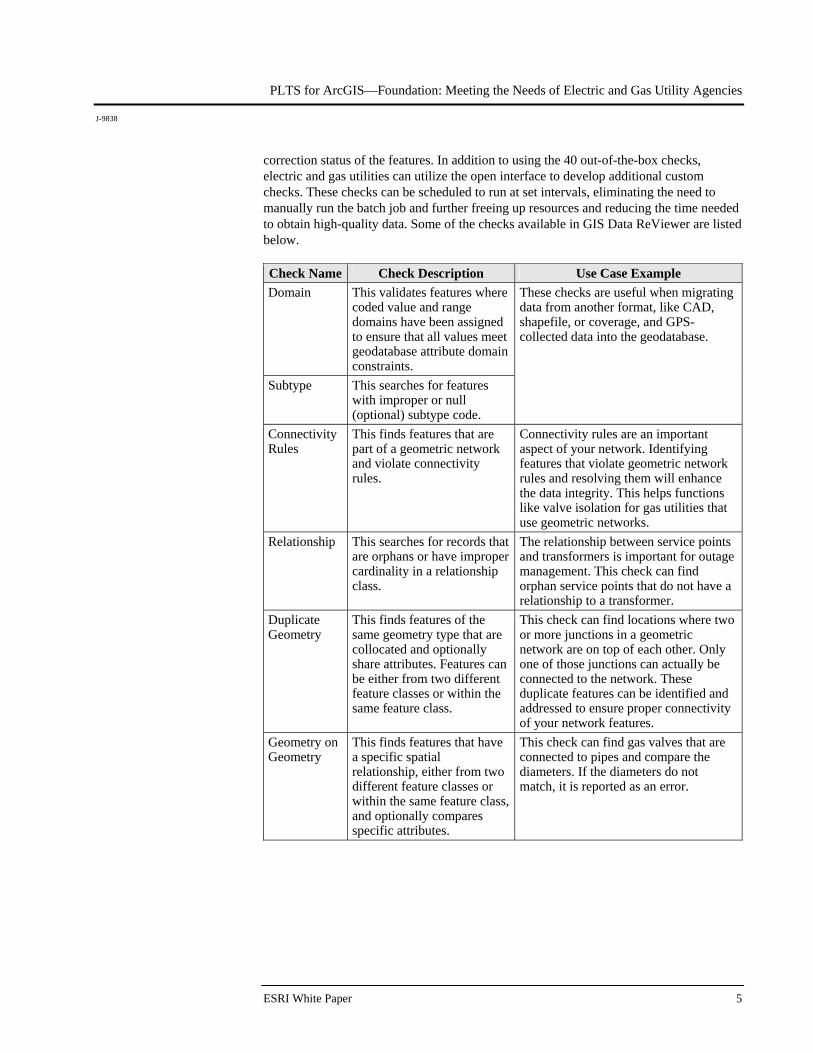
correction status of the features. In addition to using the 40 out-of-the-box checks, electric and gas utilities can utilize the open interface to develop additional custom checks. These checks can be scheduled to run at set intervals, eliminating the need to manually run the batch job and further freeing up resources and reducing the time needed to obtain high-quality data. Some of the checks available in GIS Data ReViewer are listed below. Check Name Check Description Use Case Example Domain This validates features where
coded value and range domains have been assigned to ensure that all values meet geodatabase attribute domain constraints.
Subtype This searches for features with improper or null (optional) subtype code.
These checks are useful when migrating data from another format, like CAD, shapefile, or coverage, and GPS-collected data into the geodatabase.
Connectivity Rules
This finds features that are part of a geometric network and violate connectivity rules.
Connectivity rules are an important aspect of your network. Identifying features that violate geometric network rules and resolving them will enhance the data integrity. This helps functions like valve isolation for gas utilities that use geometric networks.
Relationship This searches for records that are orphans or have improper cardinality in a relationship class.
The relationship between service points and transformers is important for outage management. This check can find orphan service points that do not have a relationship to a transformer.
Duplicate Geometry
This finds features of the same geometry type that are collocated and optionally share attributes. Features can be either from two different feature classes or within the same feature class.
This check can find locations where two or more junctions in a geometric network are on top of each other. Only one of those junctions can actually be connected to the network. These duplicate features can be identified and addressed to ensure proper connectivity of your network features.
Geometry on Geometry
This finds features that have a specific spatial relationship, either from two different feature classes or within the same feature class, and optionally compares specific attributes.
This check can find gas valves that are connected to pipes and compare the diameters. If the diameters do not match, it is reported as an error.
PLTS for ArcGIS—Foundation: Meeting the Needs of Electric and Gas Utility Agencies
J-9838
December 2009 6
Simplify the data review process with tools to assess, document, correct, and verify the overall quality of electric and gas data.
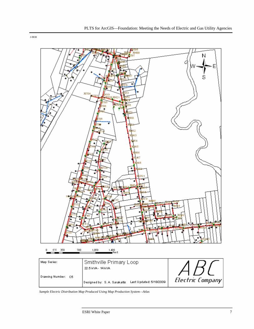
Need: Facilitate production of multiple map sheets in a series simultaneously from a common map template with dynamically changing content. Solution: The Map Production System—Atlas (MPS-Atlas™) application is a powerful tool for batch creation of cartographic products. It provides the ability to produce cartographic products, ranging from small-scale service area maps to large-scale local systems maps, either on a sheet-by-sheet basis or in batch mode, where multiple map sheets in a series are produced simultaneously from a common map template. Elements such as text, tables, and legends can be dynamically updated and placed based on the data in the map. The application also provides capabilities for batch printing and exporting maps. Electric and gas utilities can leverage these tools to create hundreds of maps in the time it usually takes to create one map.
PLTS for ArcGIS—Foundation: Meeting the Needs of Electric and Gas Utility Agencies
J-9838
ESRI White Paper 7
Sample Electric Distribution Map Produced Using Map Production System—Atlas
PLTS for ArcGIS—Foundation: Meeting the Needs of Electric and Gas Utility Agencies
J-9838
December 2009 8
Need: Decrease the time required to ingest data from disparate sources into the geodatabase. Solution: The PLTS Data Loader tool enables electric and gas utilities to load or append data into the geodatabase using parameters stored in a cross-reference database. A cross-reference database directs how the source data is loaded into the data schema and provides a repeatable way to bulk-load data into a personal or enterprise geodatabase. This allows easy importing of data from different schemas. Need: Provide a map series storage environment to enable streamlined management of map series and source material. Solution: The Product Library allows electric and gas utilities to manage their data and cartographic information. Product Library can be used to manage changes to documents by having users check out files and check in the changes. When configured in an enterprise Spatial Database Engine (SDE™) environment, users can be granted permissions to access specific parts of the Product Library and perform various actions. For more information, visit www.esri.com/plts or e-mail [email protected].