+ All Categories
Home > Documents > POINCIANA PARKWAY SOUTHPORT CONNECTOR PD&E STUDY

POINCIANA PARKWAY SOUTHPORT CONNECTOR PD&E STUDY

Date post: 25-Mar-2022
Category:
Upload: others
View: 2 times
Download: 0 times
Share this document with a friend
33
POINCIANA PARKWAY SOUTHPORT CONNECTOR PD&E STUDY 1 TECHNICAL MEMORANDUM Alternative Corridor Evaluation (ACE) Methodology Memorandum (MM) Poinciana Parkway Southport Connector Project Development and Environment (PD&E) Study From Pleasant Hill Road to Florida’s Turnpike FPID: 43369312201 ETDM #: 13961 Osceola County, Florida PREPARED BY: Florida Department of Transportation, District Five DATE: August 12, 2014 SUBJECT: Revised Alternative Corridor Evaluation Report Methodology Memorandum The purpose of this Methodology Memorandum (MM) is to document the evaluation methodology to be conducted for the Southport Connector Project Development and Environment (PD&E) Study. The memorandum details the goals of the evaluation, the methodology, how coordination with stakeholders will occur, and the basis for decision‐making. This MM was revised in response to comments from the Environmental Technical Advisory Team (ETAT) members received July 18, 2014, after a 30‐day minimum comment period. The evaluation of the corridors will be detailed in the Alternative Corridor Evaluation Report (ACER). The results in the ACER will identify the reasonable alternatives for National Environmental Policy Act (NEPA) analysis. 1.0 BACKGROUND 1.1 CONTACT PERSONNEL Amy Sirmans, PE, FDOT Project Manager FDOT District 5 (386) 943‐5404 [email protected] Alex Hull, PE, Consultant Project Manager Inwood Consulting Engineers, Inc. (407) 971‐8850 [email protected]
Transcript

POINCIANA PARKWAY SOUTHPORT CONNECTOR PD&E STUDY

1

T E C H N I C A L M E M O R A N D U M

Alternative Corridor Evaluation (ACE) MethodologyMemorandum(MM)

PoincianaParkwaySouthportConnectorProjectDevelopmentandEnvironment(PD&E)StudyFromPleasantHillRoadtoFlorida’sTurnpikeFPID:433693‐1‐22‐01ETDM#:13961OsceolaCounty,Florida

PREPAREDBY: FloridaDepartmentofTransportation,DistrictFive

DATE: August12,2014

SUBJECT: Revised Alternative Corridor Evaluation Report MethodologyMemorandum

ThepurposeofthisMethodologyMemorandum(MM)istodocumenttheevaluationmethodologytobeconductedfortheSouthportConnectorProjectDevelopmentandEnvironment(PD&E)Study.Thememorandum details the goals of the evaluation, the methodology, how coordination withstakeholderswill occur, and thebasis fordecision‐making. ThisMMwas revised in response tocomments from the Environmental Technical Advisory Team (ETAT)members received July 18,2014,aftera30‐dayminimumcommentperiod.Theevaluationofthecorridorswillbedetailedinthe Alternative Corridor Evaluation Report (ACER). The results in the ACER will identify thereasonablealternativesforNationalEnvironmentalPolicyAct(NEPA)analysis.

1.0 BACKGROUND1.1 CONTACTPERSONNEL

AmySirmans,PE,FDOTProjectManagerFDOTDistrict5(386)943‐[email protected]

AlexHull,PE,ConsultantProjectManagerInwoodConsultingEngineers,Inc.(407)971‐[email protected]

POINCIANA PARKWAY SOUTHPORT CONNECTOR PD&E STUDY

2

1.2 PROJECTINFORMATION

TheFDOT,DistrictFive,incooperationwiththeFederalHighwayAdministration(FHWA),initiatedtheSouthportConnectorPD&EStudyinOsceolaCounty,FloridaJune2013.ThePD&EStudyinvolvestheanalysisofarangeofalternativecorridorstoprovideforaconnectionbetweenPleasantHillRoadandFlorida’sTurnpike.

TheproposedSouthportConnector identified in theOsceolaCountyExpresswayAuthority (OCX)MasterPlantoserveOsceolaCounty’surbangrowtharea.OCXinitiatedadesign/buildprojectforasegmentof thebeltwaysystemreferred toasPoincianaParkwayBridgeSegmentandSouthwestSegment.TheBridgeSegmentbeginsatUS17/92andcrossesReedyCreektoapointjustnorthoftheintersectionofMarigoldAvenueandEastBourneDrive.TheSouthwestSegmentbeginsattheend of the Bridge Segment and runs south along RhododendronAvenue to Cypress Parkway. Inaddition,FDOTisconductinganindependentPD&EStudyfortheI‐4SegmentofPoincianaParkwayfromI‐4totheBridgeSegment.

1.3 PROJECTDESCRIPTION

TheproposedSouthportConnector,asenvisionedintheOCXMasterPlan,wouldbegininthevicinityof the intersectionofCypressParkwayandPleasantHillRoad.However, anadditionalbeginningpointisbeingconsideredatapointonthePoincianaParkwayjustnorthofMarigoldAvenueattheterminusofthePoincianaParkwayBridgeSegment.TheeasternterminusoftheproposedSouthportConnectorwill be at Florida’s Turnpike and several termini locations are being considered. TheprojectstudyareaisshownontheprojectlocationmapinExhibit1.

ThefollowinggoalsandobjectivesarecontainedinOCX’sMasterPlan:

Goal3.PromoteahighqualityoflifeforOsceolaCountyresidents.Objective3.1.Reducedelaybyprovidinglimitedaccesstransportationoptions.Objective3.2.Improvecapacitywithnewlineageandtransitoptions.

Therefore, in conformance with the goals and objectives of the OCX Master Plan, the proposedSouthportConnectorwillbeanewlimitedaccessfacilitywithtransitoptions.

1.4 PURPOSEANDNEED

ThepurposeandneedoftheprojectwasscreenedintheProgrammingScreenandacceptedbyFHWAonDecember12,2013.Thepurposeoftheprojectistoachievethefollowingprimarygoals:

ImproveroadwayconnectionfromthecommunityofPoincianatoFlorida’sTurnpike:ThemajorityofthePoincianaarea’sresidentsareemployedinOrangeCounty.Therefore,anewconnectiontotheFloridaTurnpikewillprovideanalternativeroutetojobsandemploymentcenters.

Enhancemobility:Duetotheanticipatedpopulationandemploymentgrowthinthestudyarea, the proposed facilitywill play a critical role in accommodating travel demands andimprovingthemovementofgoodsandpeople.

Improveoveralltrafficoperations:Theproposedfacilitywouldrelievecongestiononlocalroadsbyseparatinglocalandregionaltraffic.

Promoteregionalsystemlinkage:TheproposedfacilityisidentifiedinMetroPlanOrlando’s2030LongRangeTransportationPlan.TheproposedConnectorispartofaplannedlimited

POINCIANA PARKWAY SOUTHPORT CONNECTOR PD&E STUDY

3

access,high‐speedtollfacilityidentifiedintheOCXMasterPlantoservetheOsceolaCounty’surbangrowtharea.

Secondary objectives for the project include desirable features that support the purpose of theproject.The secondaryobjectives are to support economicdevelopment andenhanceemergencyresponse/evacuation.

2.0 GOALSANDOBJECTIVESOFTHEOFTHEALTERNATIVECORRIDOREVALUATION

The purpose of the ACE is to document and link planning activities for use in the NationalEnvironmental Policy Act (NEPA) environmental analysis in accordance with the Planning andEnvironmentLinkagesdescribedunderMovingAhead forProgressinthe21stCentury(MAP‐21).ThegoalsoftheACEaretoaddressEnvironmentalTechnicalAdvisoryTeam(ETAT)commentsandeliminateunreasonablecorridorsbasedonfactorssuchasnotmeetingthepurposeandneed,traveldemand,anddisproportionateand/orsignificantimpacts.

2.1 STATUSINPROJECTDELIVERY

The ETDM Programming Screenwas initiated on September 6, 2013 (ETDM#13961 ‐ PoincianaParkway Southport Connector, https://etdmpub.fla‐etat.org). As shown on Exhibit 2, 10 initialcorridors were developed for the purpose of the ETDM programming screen. The ETDMprogrammingscreen reviewperiodwasextended toallow foradditional agency reviewandwasclosed on November 20, 2013. An additional extension was granted for the FHWA. AgencyrepresentativesinputregardingtheinitialcorridorscompletedthereviewinDecember2013.PriortotheETDMscreening,awebinarwasheldonAugust21,2013toinformtheETATmembersofthepurposeofandneedfortheproject,initialcorridorstobescreenedandahigh‐leveloverviewofthesocial,cultural,naturalandphysicalenvironments.The 10 initial corridors entered in the ETDM programming screen were developed using LandSuitabilityMapping(LSM).UsingtheGeographic InformationSystems(GIS)‐basedEnvironmentalScreening Tool (EST), the initial corridors were 1,400‐foot wide. The corridors were initiallydevelopedatawidthof400‐footandthereforetheimpactswerequantifiedintheESTataminimumof1,400feet(400‐footwidecorridorswitha500‐footbufferdistanceoneachsideofthecorridor).These initial corridors are the starting point for the ACE process. No additional corridorswereidentifiedintheETDMprogrammingscreen.ThenamingofeachcorridororalternativewillremainconsistentthroughoutACEandbecarriedthroughthePD&Ephase.ThepurposeandneedoftheprojectwasscreenedintheProgrammingScreenandacceptedbyFHWAonDecember 12, 2013. The purpose and need is in the process of being updated to reflect newinformationregardingtrafficanalysisandthePoincianaParkwayDesign‐BuildProjectincludingtheextensionofRhododendronAvenue.ThedraftMMwasdistributedforETATreviewonJune3,2014.ETATmembersweregivenuntilJuly18,2014toprovidecomments.TheETATcommentswerereviewed,consideredandincorporatedintothisRevisedMMandintotheACEprocess,asfeasible.MeetingswereheldbetweentheFloridaDepartmentofTransportation(FDOT)andU.S.FishandWildlifeService(USFWS)onJune18,2014,withtheU.S.ArmyCorpsofEngineers(USACE)onJul1,2014,withSouthFloridaWaterManagementdistrictonJuly8,2014andwithFloridafishandWildlifeConservationCommission(FWC)onJuly

POINCIANA PARKWAY SOUTHPORT CONNECTOR PD&E STUDY

4

18,2014toinitiateprojectcoordination.UpcomingopportunitiesforpublicandagencyinputincludeasecondAgencyProjectAdvisoryGroup(APAG)meetingandthesecondpublicmeeting.

2.2 INTENTOFSTUDY

TheACEprocess,asdefinedintheProjectDevelopmentandEnvironmentManualPart2,Chapter6and Efficient Transportation Decision Making (ETDM) Manual meets the intent of 23 CFR 450(Planningregulations)andTitle23USC168(Integrationofplanningandenvironmentalreview).TheintentofthisstudyistolinkplanningdecisionssotheycanbedirectlyincorporatedintotheNEPAprocess.

2.3 IDENTIFYTHEDECISIONPOINTS/MILESTONES

This Revised MM is included in the republished Preliminary Programming Screen Report. TheRevised MM and ACE will be documented in the ACER, which will be referenced in the NEPAdocument.TheresultsoftheACEwilldeterminewhichcorridorsareconsideredunreasonableandshouldbeeliminatedfromfurtherstudy.FHWA,theLeadFederalAgency,adoptstheACERwhichisapprovedbyFDOT(per23USC168).RecommendationsmadearerecordedintheEST,andpublishedintheFinalProgrammingScreenSummaryReportforuseintheNEPAphase.ThePD&EstudywillanalyzereasonablealternativesthatmeetthepurposeandneedfortheprojecttosatisfyfederalrequirementsassociatedwithNEPA.

3.0 ALTERNATIVECORRIDOREVALUATIONMETHODOLOGY3.1 DATACOLLECTION

The data used to further evaluate the project corridor’s social, cultural, natural and physicalenvironmentalimpactswillbederivedfrom(GIS),literatureandfieldreviewswhereappropriate.VariousGISdatasetswithintheFloridaGeographicalDataLibrary(FGDL),theSouthFloridaWaterManagement District (SFWMD), the FWC and City and County data sources will be utilized. Inaddition,fieldandliteraturereviewswillbeperformedtoverifykeyprojectcorridorconstraints.ApreliminarylistofGISdatalayerswhichmaybeusedintheassessmentoftheprojectstudyareaisprovidedinTable1.

POINCIANA PARKWAY SOUTHPORT CONNECTOR PD&E STUDY

5

Table 1 POTENTIAL GIS LAYERS

GIS Layer Source (Year)

Social Layers Airports Florida Geographic Data Library (FGDL) (2012) Cemeteries FGDL(2013) Churches FGDL(2009) DRI’s FGDL(2009); Osceola County; Polk County Fire Stations FGDL(2013); Osceola County; Polk County Government Buildings FGDL(2013) High Density Residential South Florida Water Management District (SFWMD) Hospitals FGDL(2013); Osceola County; Polk County Law Enforcement FGDL(2012) Medium Density Residential SWFWMD Planned Unit Developments (PUD) FGDL(2009); Osceola County; Polk County Schools FGDL(2012); Osceola County; Polk County

Cultural Layers State Parks FGDL(2011) FFWCC Managed Lands FGDL(2010) Greenways FGDL(2012); Osceola County; Polk County Historical Sites SFWMD; Osceola County; Polk County Indian Parcels FGDL(2008) Local Parks Osceola County; Polk County Managed Lands Florida Natural Area Inventory (FNAI) Military Lands FGDL(2010) Parks and Zones SFWMD SHPO Structures FGDL(2013) SHPO Bridges FGDL(2013) SHPO Cemeteries FGDL(2013) SFWMD Lands SFWMD Wildlife Management Areas FGDL(2013) Archaeological or Historic Sites FGDL (2013) Resource Groups FGDL (2013) National Register of Historic Places FGDL (2013)

Natural Environment Layers Aquatic Preserves FGDL(2011)

Bear Nuisance Florida Fish and Wildlife Conservation Commission

(FFWCC) Class 1 Waters FDEP Eagle Nests FFWCC FDEP Mitigation Banks SFWMD (2013) Floodways FEMA(2013) Native Scrub FFWCC; SWFWMD OFW FDEP(2011) Protected Species (multiple layers) FFWCC

POINCIANA PARKWAY SOUTHPORT CONNECTOR PD&E STUDY

6

GIS Layer Source (Year) Rookeries FFWCC Water Features SFWMD Wetlands SFWMD

Physical Environment Layers Brownfields (EPA/FDEP) FGDL(2013) Electrical Power Facilities SFWMD; FDEP(2011) EPA Pollutant Sites (air, water, RCRA) FGDL(2011) Hazardous Materials Sites FDEP(2013) Industrial Sites SFWMD Landfills FGDL(2013) Nuclear Sites FDEP(2011) Oil and Gas Storage SFWMD Petroleum Contaminated Sites FGDL(2013); FDEP(2013) Power Plants Osceola County; Polk County Sewer Treatment Plants FDEP(2013); SFWMD; Osceola County; Polk County Sinkholes FDEP(2004) Solid Waste Facilities FGDL(2013) Superfund Sites FGDL(2012) TECO People’s Gas Polk County Water Treatment Plants FGDL Well Field Protection Zones Osceola County; Polk County Wellhead Protection Zones Osceola County; Polk County

3.1 IDENTIFYCORRIDORCONSTRAINTS

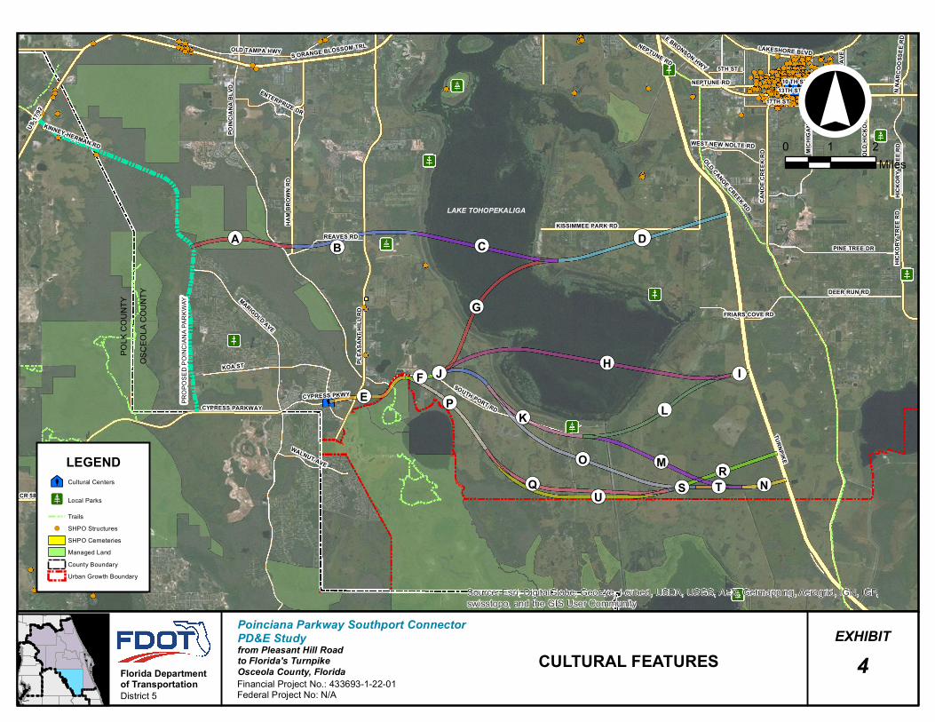
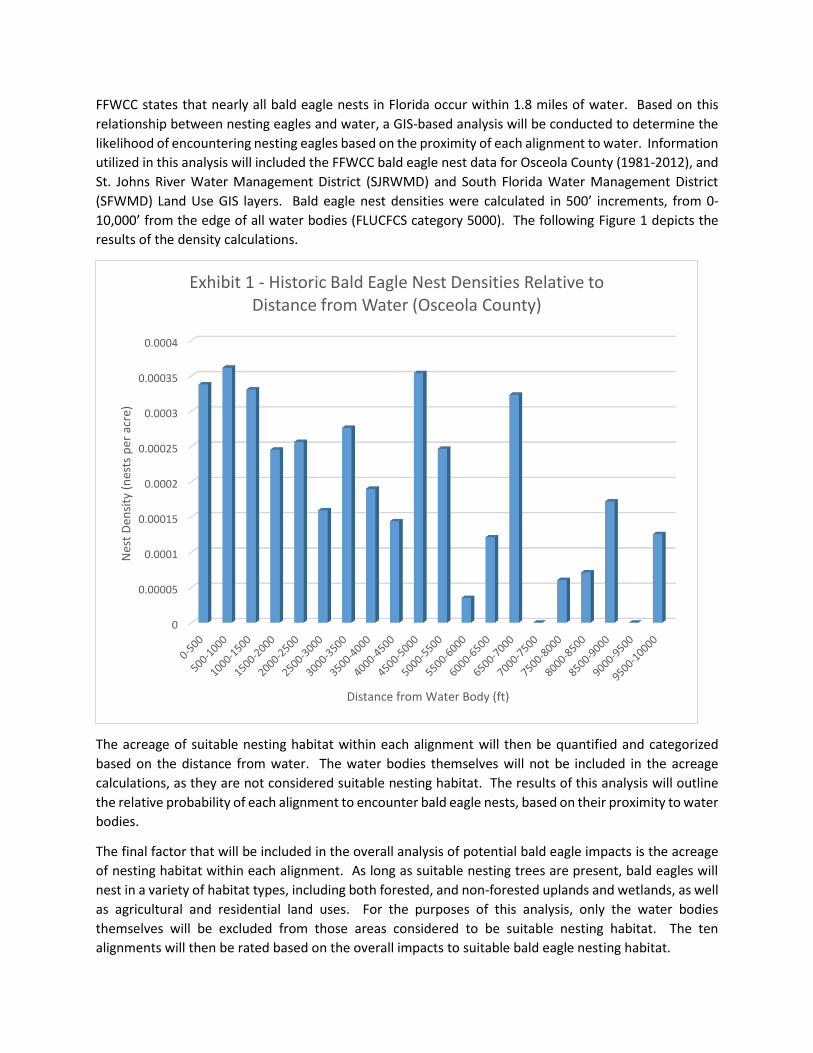
The GIS data will be used to identify those corridors that avoid and minimize impacts to sensitive environmental features to the extent possible. The attached series of maps (Exhibits 3, 4, 5 and 6) feature specific database categories showing social, cultural, natural, and physical data. Based on ETAT commentary the following features were identified as important considerations. This includes, but is not limited to, potential land use changes from agriculture/prime farm lands to high density residential, well field impacts, environmental justice, 4(f) impacts (Reedy Creek Conservation area, Upper Lakes Basin Watershed, Poinciana Scrub Conservation Area, Lake Hatchineha Watershed, Florida Forever BOT Project area, Vance Harmon Park on Cypress Parkway, the planned Mac Overstreet Regional Park, Southport Canal, Southport Park, potential historic/archaeological sites and recreational areas associated with Lake Tohopekaliga), wetlands, water quality, floodplains, wildlife and habitat (including Everglade snail kite, , wood stork, sandhill crane, bald eagle, Florida grasshopper sparrow, Audubon's crested caracara, eastern indigo snake, gopher tortoise, and Sherman’s fox squirrel), and navigable waters.

3.2 IDENTIFYPOTENTIALCORRIDORS

Potentialcorridorsweredevelopedthatprovidefora425‐footwidthshowninExhibit2,basedon:

TheOCXMasterPlan limitedaccessexpresswaywithadjacent corridors for transit andapotentialmulti‐usetrail.

Conforming to geometric design criteria and minimize impacts to the identified social,

POINCIANA PARKWAY SOUTHPORT CONNECTOR PD&E STUDY

7

cultural,naturalandphysicalfeatures.

Preliminaryconsiderationsfortheanticipatedtypicalsection,whichwillprovideforamoreaccuraterepresentationofpotentialimpacts(social,cultural,naturalandphysical).

Avoidanceofpubliclyownedconservationlandsormitigationbanks.

The 425‐foot wide corridor includes an additional 26 feet to allow for flexibility in developingproposedalignments.Thecorridorwidthwillincreasenearinterchangelocationsduetothedesignenvelopenecessarytodeveloprampsandfly‐overs.ThetypicalsectionofthecorridorisshownonExhibit7.

3.3 CORRIDORANALYSISANDEVALUATIONCRITERIA

CorridorswillbeassessedusingprojectspecificcriteriadevelopedasaresultofETATcommentsandpublicinputreceivedduringETDMScreeningandtheinitialscopingactivities.Theevaluationcriteriaallowsforthecomparativeassessmentofthecorridoralternatives.Thecorridorswillbeevaluatedbasedonconsiderationofmeeting theprojectpurposeandneed, avoidanceandminimizationofpotentialimpactstoenvironmentalresources,engineeringfeasibility,anarrativeassessmentofthecorridors, and agency/public input. The analysis and assessment for each of these factors aredescribedbelow.

3.4.1 PurposeandNeedEvaluation

Thepurposeandneedevaluationassesseshowwelleachcorridorsatisfiestheprojectpurposeandneed. For a corridor tomeet the purpose and need of the project, it would need to provide anenhanced connection as compared to the No Build (or No Action) Alternative. The need forenhancementisrelatedtounsatisfactoryfutureoperatingconditionstobedeterminedinthetrafficanalysis.Inaddition,eachcorridorwillbeevaluatedforregionalconnectivity,emergencyevacuation,and support of economic development.Table2 below provides the screening criteria related topurpose and need. Enhanced mobility, improved traffic operations, promoting regional systemlinkage,supportofeconomicdevelopmentandenhancementofemergencyevacuationwillalsobeevaluated.

POINCIANA PARKWAY SOUTHPORT CONNECTOR PD&E STUDY

8

Table 2 PURPOSE AND NEED SCREENING CRITERIA

Corridor

PrimaryObjectives SecondaryObjectives

Segments

Improved Connection

from Poinciana to Turnpike [1]

Enhance Mobility of

People and Goods[2]

Improved Traffic

Operations [3]

Promote Regional System

Linkage [4]

Support Economic

Development [5]

Enhance Emergency/

Evacuation [6]

1 A‐B‐C‐D

2 E‐F‐G‐D

3 E‐F‐H‐I

4 E‐F‐J‐K‐L‐I

5 E‐F‐J‐K‐M‐N

6 E‐F‐J‐O‐T‐N

7 E‐P‐Q‐R

8 E‐P‐Q‐S‐T‐N

9 E‐P‐U‐R

10 E‐P‐U‐S‐T‐N

Notes:Yes=HighestBenefit;Moderate=NeutralBenefit;No=Unsatisfactory

1.Basedontimeoftravelestimatesderivedfromtheprojecttrafficmodelandcorridorlength2.Basedontypicalsectiondesignspeed,highspeedfacility,SIScriteria3.Basedonprojecttrafficmodel4.Basedonplanningconsistencyandintermodalconnectivity5.MaximumsatisfactionoccurswithimprovedconnectivitytoFlorida’sturnpikeinconformancewithOCXMasterPlan.6.Basedonaccess,safetyanddesignmeasures

3.4.2 EnvironmentalEvaluation

Thepotentialdirect,indirect,andcumulativeeffectsontheenvironmentwillbeconsideredforeachcorridor.Table3providesamatrixevaluationtablethatwillbepopulatedwithdatausingtheGISlayersidentifiedinTable1andthecorridorshapesforthecorridorsshowninExhibit2.Quantifiablevaluesforsocial,culturalnatural,andphysicalenvironmentwillbeshowninthematrixevaluationtable.Non‐quantifiablefactorswillbegivenalikelihoodofimpactrating.

Table 3 ENVIRONMENTAL EVALUATION CRITERIA

Category Evaluation Criteria Unit of Measure

Potential Corridors

1 2 3 4 5 6 7 8 9 10

A-B-C-D

E-F-G-D

E-F-H-I

E-F-J-K-L- I

E-F-J-K-M-N

E-F-J-O-T-N

E-P-Q-R

E-P-Q-S-T-N

E-P-U-R

E-P-U-S-T-N

Social Potential Residential Displacements

Number

POINCIANA PARKWAY SOUTHPORT CONNECTOR PD&E STUDY

9

Category Evaluation Criteria Unit of Measure

Potential Corridors

1 2 3 4 5 6 7 8 9 10

A-B-C-D

E-F-G-D

E-F-H-I

E-F-J-K-L- I

E-F-J-K-M-N

E-F-J-O-T-N

E-P-Q-R

E-P-Q-S-T-N

E-P-U-R

E-P-U-S-T-N

Potential Non-residential Displacements

Number

Community Facilities

Number

Neighborhoods Number

Community Cohesion

Effects to residential connectivity and social interaction

Socioeconomic Impact to Special Populations

Potential for disproportionate impacts

Cultural Potential Section 106 Resources

No. of affected historic and archeological resources

Potential 4(f) Resources

Number

Approved Mitigation Banks/Conservation Lands

Acres

Natural Snail Kite Involvement

Degree

FL Grasshopper Sparrow Involvement

Degree

Bald Eagle Involvement

Degree

Audubon’s Crested Caracara Involvement

Degree

Non-forested Wetlands

Acres

Forested Wetlands Acres

Water Features Acres

Physical Potential Contamination Sites

Number

POINCIANA PARKWAY SOUTHPORT CONNECTOR PD&E STUDY

10

Category Evaluation Criteria Unit of Measure

Potential Corridors

1 2 3 4 5 6 7 8 9 10

A-B-C-D

E-F-G-D

E-F-H-I

E-F-J-K-L- I

E-F-J-K-M-N

E-F-J-O-T-N

E-P-Q-R

E-P-Q-S-T-N

E-P-U-R

E-P-U-S-T-N

Floodplain Impacts Acres

Floodway Impacts Acres

Noise Receptors

PotentialimpactsnestingandforaginghabitatfortheAudubon’screstedcaracara,Evergladesnailkite, bald eagle, andFloridagrasshopper sparrowareofparticular importance for theSouthportConnector project. For the comparative analysis, a methodology for evaluating and ranking theimpactstospecieshasbeendevelopedandiscontainedinAppendixA.

3.4.3 EngineeringConsiderations

TheengineeringconsiderationsusedtoscreencorridorsarelistedinTable4.Engineeringfactorssuchasutilityconflicts,right‐of‐way,andinterchangespacingontheTurnpike.Drainageissuesmaynotbeabletobemeasured;forinstance,acorridormayeitherbelocatedinanareawithfloodingissues or it may not. Those corridors with technical feasibility concerns are likely to have highconstructioncosts.

Table 4 ENGINEERING SCREENING CRITERIA

Corridor SegmentsMajorUtilityConflicts

Right‐of‐wayNeeds

DrainageIssues

InterchangeSpacing

1 A‐B‐C‐D

2 E‐F‐G‐D

3 E‐F‐H‐I

4 E‐F‐J‐K‐L‐I

5 E‐F‐J‐K‐M‐N

6 E‐F‐J‐O‐T‐N

7 E‐P‐Q‐R

8 E‐P‐Q‐S‐T‐N

9 E‐P‐U‐R

10 E‐P‐U‐S‐T‐N

The estimated construction,wetlandmitigation, and right‐of‐way costswill be listed inTable5below. Construction costswill bebasedongeneralFDOT long rangeestimates for roadwayandstructures using the length of the project and the four‐lane typical section shown in Exhibit 7.

POINCIANA PARKWAY SOUTHPORT CONNECTOR PD&E STUDY

11

Roadwayandstructurescostestimateswillprovideprovisionsforthetransitandtrailcomponents.Structures costs over LakeTohopekaligawill include an additional cost component for piping toconveystormwateroffofthebridgetopondlocations.Right‐of‐waycostswillbeestimatedbasedongeneralcostsof landandbuildingsinthestudyareabylandusetypeandunitright‐of‐waycostsobtainedfromFDOTDistrict5.Wetlandmitigationcostswillbebasedonin‐basinmitigationbankcreditcosts.

Table 5 PROJECT COST CRITERIA

Corridor

Segments ConstructionCosts

WetlandMitigationCosts

Right‐of‐WayCosts

TotalCosts

1 A‐B‐C‐D

2 E‐F‐G‐D

3 E‐F‐H‐I

4 E‐F‐J‐K‐L‐I

5 E‐F‐J‐K‐M‐N

6 E‐F‐J‐O‐T‐N

7 E‐P‐Q‐R

8 E‐P‐Q‐S‐T‐N

9 E‐P‐U‐R

10 E‐P‐U‐S‐T‐N

3.4.4 NarrativeofAssessment

Basedonthecorridorevaluationsdescribedabove,anarrativediscussionandassessmentofeachofthecorridorswillbeprepared incompliancewithelementsandissuescontainedin23USC168(c).Thisnarrativewillprovideadiscussionoftheaffectedenvironment,advantagesandlimitationsofeachcorridorandhighlightanyspecificfactorsthatmayresultinanunreasonablecorridor.Publicandagencyinput(considerationofinputreceivedfromtheETAT,AgencyProjectAdvisoryGroup(APAG),projectstakeholdersandthegeneralpublic)willbesummarizedinthenarrative.

3.4.5 PublicandAgencyConsiderations

Public,agencyandETATmembersinputreceivedduringtheScreeningprocesswillbeusedtorefinethepurposeandneed,corridorconstraintsandevaluationcriteriainordertoevaluatethecorridors.AcompletedescriptionoftheopportunitiesforpublicinputintothecorridorevaluationprocessisinSection4.TheresultsdocumentedintheACERwillbemadeavailabletothestakeholdersthroughtheESTfora30calendardayperiod.Notificationofthepublicmeetingswillbedistributedtoalltheindividualsontheprojectmailinglistincludinglocalofficials,agenciesincludingappropriateNativeAmericantribes,stakeholders,specialinterestgroupsandpropertyownerswithintheaffectedstudyarea.IfmeetingsareneededtoexplaintheresultsoftheACER,theywillbescheduledasnecessary.

POINCIANA PARKWAY SOUTHPORT CONNECTOR PD&E STUDY

12

3.5 APPROACHTOELIMINATINGUNREASONABLEALTERNATIVES

AnycorridorthatdoesnotmeetthepurposeandneedfortheprojectisconsideredunreasonableandwillbeeliminatedfromfurtherconsiderationuponFHWAapproval.ThecorridorsconsideredreasonablefordetailedstudyasaresultofthePurposeandNeedEvaluationwillbecomparedusingtheevaluationcriteriadescribedinSection3.4.Thecorridorevaluationinvolvesbothquantitativeandqualitativecomparisonsoftheevaluationcriteria.Thecomparativeanalysiswillincluderatingthefollowing:

• EnvironmentalImpactsandConstructionCostEstimates(Quantitative)• Engineeringfactors(technicalfeasibility)(Qualitative)• Narrativeassessment(advantagesandlimitations)(Qualitative)This rating process is discussed further in Sections 3.5.1 and 3.5.2. Upon completion of thisassessmentandFHWAapproval,remainingreasonablecorridorswillbecarriedforwardinthePD&EStudy.

ThePD&EstudyprojectdocumentationwillbepreparedinaccordancewiththePD&EManualandshall, therefore,be incompliancewithallapplicablestateandfederal laws,executiveorders,andregulations.IncompliancewiththeETDMMasterAgreement,agencyinvolvementregardingprojectneeds, issues, evaluation criteria, avoidance,minimization, decisions, and preliminarymitigationconceptswillbeacontinuouseffortthroughouttheETDMandACEprocesses.Theevaluationcriteriaandunitsofmeasureusedtoevaluateandcomparealternativeswillincluderesourcesissuesthatareconsistentandacceptabletoeachrespectiveresourceagency.TheACEprocessensuresthatallalternativesareevaluatedconsistently.

3.5.1 EnvironmentalImpactsandCostEstimates(RatingofQuantitativeData)

Theevaluationprocessincludesthedevelopmentofanevaluationmatrixtofacilitatecomparisonofcorridors.Theevaluationmatrixwillidentifythebufferwidthused,quantifypotentialimpacts,andlistthesourceofthedata.Thepotential impactsforeachcriterionwillbeprovidedfortheentirecorridorandsummarizedinamatrixsimilartoTable6.Foreachevaluationcriteria,acomparisonwillbemadeusingastandarddeviationmethod tocompareCorridors1 through10.Redwillbeassignedtopotential impactsgreaterthanonestandarddeviationabovethemean,yellowwillbeassignedtoevaluationcriteriawithinonestandarddeviationofthemean,andgreenwillbeassignedtoevaluationcriteriawithzeroorgreaterthanonestandarddeviationbelowthemean.Foreachoftheevaluationcriteria,thecorridorswillberatedbasedonascoreof1to3where1representstheleastpotentialimpact(green)and3representsthehighestpotentialimpact(red).Potentialimpactsofeachcorridorwillbeassignedacolorcodeandnumberbasedonthestandarddeviationfortheevaluation criteria results. Red indicates that the potential impacts are substantially higher thanaveragewhen compared to theother alternatives.Green indicates that thepotential impacts aresubstantiallylowerthanaveragewhencomparedtotheotheralternatives.

POINCIANA PARKWAY SOUTHPORT CONNECTOR PD&E STUDY

13

Table 6 EXAMPLE OF SUMMARY COMPARATIVE MATRIX FOR ENVIRONMENTAL IMPACTS

AND COSTS

EvaluationCriteria

BufferWidth(CL)

MeasurementWithintheScreeningBuffer

Source

ALTERNATIVES

0 1 2 3 4 5 6 7 8 9 10

RecreationalLands(Parks)

200NumberofParks

UFGEOPLAN/ParcelDerivedParks

Foreachevaluationcategory,thetotalscoreisbasedonsummingtheindividualcriteriarankings.ThetotalcostsforeachofthecorridoralternativeswillbeshowninTable7.

3.5.2 SummaryCorridorRatings

TheevaluationfactorsshallbesummarizedinaformatsimilartoTable7includingtheratingsfromtheenvironmentalimpact/costratingsummary(quantitativedata)andratingsfromtheengineering,publicandagencyinput(qualitativedata).

Table 7 CORRIDOR EVALUATION SUMMARY

Corridor SegmentsPurposeand

NeedSatisfaction

EvaluationCriteria RecommendedforFurtherConsideration

EnvironmentalImpacts

EngineeringFactors

Costs

1 A‐B‐C‐D

2 E‐F‐G‐D

3 E‐F‐H‐I

4 E‐F‐J‐K‐L‐I

5 E‐F‐J‐K‐M‐N

6 E‐F‐J‐O‐T‐N

7 E‐P‐Q‐R

8 E‐P‐Q‐S‐T‐N

9 E‐P‐U‐R

10 E‐P‐U‐S‐T‐N

3.6 ALTERNATIVECORRIDOREVALUATIONREPORT

TheresultsoftheanalysisdescribedabovewillbesummarizedinaFinalACER.ThisreportwillbesubmittedtotheETATandinterestedstakeholdersthroughtheESTfor30calendardayperiod.Oncecommentsareaddressed,acorridorpublicworkshopwillbeheldtoallowthepublictoprovideinput.

Theappropriatedecisionmakingmatrices(i.e.,theevaluationmatricessimilartoTables2,3,and4,andacorridorevaluationsummarysimilartoTable6)willbeincludedintheACERtosubstantiatefindings and the reasons for eliminating corridors and identifying corridors thatwill be carriedforward into the PD&E phase. The ACER will be included in the republished PreliminaryProgrammingScreenReport.TheNEPAclassofactiondetermination(i.e.EnvironmentalAssessmentorEnvironmental ImpactStatement),degreeofeffect, summaryofpublic comments,anddisputeresolutionissueswillbeaddressedinthePreliminaryProgrammingScreenReport.

POINCIANA PARKWAY SOUTHPORT CONNECTOR PD&E STUDY

14

4.0 OPPORTUNITYFORAGENCY/PUBLICINPUTContinuous Public outreach during the initial stages of the project has and will be used to engage stakeholders to identify community values and concerns that may affect the development and evaluation of corridors. Table 8 lists the public and agency events that have been conducted to date; Table 9 summarizes ETAT comments and Table 10 summarizes near-term outreach that will occur in conjunction with, and following the MM/ACER process.

Table 8 PUBLIC / AGENCY COORDINATION CONDUCTED TO DATE Item Description Date

A webinar with members of the ETAT The webinar was held to introduce the project and provide an opportunity for input into the project’s purpose and need and on the initial corridors.

August 21, 2013

Advanced Notification Package

The package was sent to the State Clearing House (Florida Department of Environmental Protection), participating agencies, non-participating agencies and organizations and special interest groups electronically and via hard copies to agencies as requested. The AN Package is also on the ETDM public access site (https://etdmpub.fla-etat.org).

September 5, 2012

Project Website

(www.SouthportConnector.com)

The website includes meeting information, report summaries which will be available for viewing and downloading, and provide opportunity for public comment. The website is being updated monthly and on an as need basis.

August 29, 2013

First APAG Meeting

The APAG consists of representatives from The Nature Conservancy (TNC), Audubon Society, Sierra Club, Reedy Creek Improvement District (RCID), ETAT members, FDOT District One and Five, Osceola County Expressway Authority (OCX), Osceola County, Walt Disney World, Florida’s Turnpike Enterprise, water management districts, community groups and others. The members of the APAG are anticipated to meet bi-annually and will receive monthly status e-mail updates.

August 27, 2013

ETDM comments

The most significant degrees of effect for each issue category, the ETAT organization that provided that comment, and draft responses are summarized in Table 9.

From September to November 2013.

Public Meetings

Two public meetings were held, one at the Providence Golf Club in Davenport and one at the Association of Poinciana Villages Community Center in Poinciana. These meetings were scheduled to inform local officials and the general public of the potential corridors being brought to the area

September 10 and 12, 2013

POINCIANA PARKWAY SOUTHPORT CONNECTOR PD&E STUDY

15

Table 9

SUMMARY OF ETAT COMMENTS Issue Degree of

Effect Organization FDOT Responses to ETAT Comments

Land Use Changes

Moderate to Substantial

FHWA Direct and indirect effects of the project on land use will be evaluated. Direct and indirect effects of the project on the City of St. Cloud well field will be evaluated. Planning consistency will be coordinated and documented during the PD&E study including coordination with Osceola County.

Social Substantial FHWA A sociocultural effect evaluation will be prepared during the PD&E study.

Farmlands Substantial Natural Resources Conservation Service, FHWA

Direct and indirect effects of the project on prime and unique farmlands and listed species, which will utilize farmlands, will be evaluated.

Economic None FDEO, FHWA Effects of the project alternatives on the area’s economy will be evaluated in a sociocultural effects study as part of the PD&E Study.

Section 4(f) Potential

Substantial FHWA Section 4(f) applicability will be evaluated during the study. Impacts to Section 4(f) resources will be minimized and avoided to the greatest extent practicable. An evaluation will be performed to analyze any direct or constructive use of these resources.

Historic and Archaeological Sites

Substantial FHWA Impacts to historic and archaeological resources, including underwater resources, will be evaluated during the study, and a Cultural Resource Assessment will be performed. Impacts to cultural resources will be minimized and avoided to the greatest extent practicable. An evaluation will be performed to analyze any direct or constructive use of resources protected under Section 4(f).

Recreation Areas Substantial FHWA, NPS, FDEP Section 4(f) and Section 6(f) applicability will be evaluated during the study. Impacts to Section 4(f) and Section 6(f) resources will be minimized and avoided to the greatest extent practicable. An evaluation will be performed to analyze any direct or constructive use of these resources. Should an alternative be selected that involves impacts to a Section 6(f) resource, coordination with NPS and FDEP will be initiated.

Wetlands Moderate to Substantial

South Florida Water Management District (SFWMD), US Army Corps of Engineers; US Fish and Wildlife Service

Wetlands within the project area will be delineated and functional analyses will be performed for viable alternatives that meet the purpose and need of the project. Wetland impacts will be avoided and minimized to the greatest extent practicable. Based on the ACE and ETAT input, unreasonable alternatives may be eliminated from further consideration.

Water Quality and Quantity

Moderate to Substantial

SFWMD, FHWA, FDEP Impacts to water quality and quantity will be avoided through pollutant treatment of proposed and existing roadways within the impacted basins. Wetland impacts will be avoided and minimized to the greatest extent practicable.

Floodplains Moderate to Substantial

SFWMD, FHWA Floodplain impacts will be avoided and minimized to the greatest extent practicable. Compensation will be provided for unavoidable loss of floodplain volume and conveyance structures will be sized to prevent an increase in flood elevations.

Wildlife and Habitat

Moderate to Dispute Resolution

SFWMD, FHWA, USFWS, FWC

Wildlife surveys for the Biological Assessment will be completed during the upcoming study will evaluate the presence of listed species and their habitats and evaluate potential, secondary, and cumulative impacts. Impacts to listed species and their habitats will be avoided and minimized to the greatest extent practicable.

POINCIANA PARKWAY SOUTHPORT CONNECTOR PD&E STUDY

16

Issue Degree of Effect

Organization FDOT Responses to ETAT Comments

Coastal and Marine

None FHWA, NMFS There is no involvement with coastal or marine resources.

Air Quality Minimal FHWA, USEPA The proposed project is expected to have minimal impact on air quality. The project is located in an attainment area; therefore, an Air Quality Screening Analysis will likely not be necessary.

Contamination Moderate FHWA, FDEP A Contamination Screening Evaluation Report will be prepared during the PD&E study.

Infrastructure Moderate to Substantial

FHWA Any public land corner or bench mark within the limits of construction is to be protected. The SFWMD’s Data Collection Bureau will be informed of potential impacts during the design phase. We will coordinate with SFWMD regarding any proposed crossings of Reedy Creek or C-35.

Navigation Substantial USCG A waterway study will be performed to determine the characteristics of vessels using the waterways and identify navigational needs. Also, the bridge questionnaire will be used to determine if USCG permit(s) are necessary.

Special Designations

Substantial FHWA Direct and indirect effects of the project on the City of St. Cloud well field will be evaluated. An evaluation of Prime Farmland, Save Our Rivers Lands, and Sole Source Aquifers will be included in the PD&E study.

Table 10 FUTURE PUBLIC / AGENCY COORDINATION

Item Description Date

MM Process The MM will be used as a tool during the Dispute Resolution process and to inform the ETAT and other stakeholders of the revised impacts based on the ACE

Draft submitted June 2, 2014

Dispute Resolution Meetings will be conducted with agencies as part of the Dispute Resolution process but also as requested to discuss the results of methodology

Ongoing

Second APAG Meeting This meeting will be held to discuss the results and recommendations for eliminating unreasonable alternatives.

To be determined

5.0 CONCLUSIONInconclusion,thepurposeofthisMMistodocumenttheACEmethodologytobeconductedfortheSouthport Connector PD&E Study. The memorandum details the goals of the evaluation, themethodology,howcoordinationwithstakeholderswilloccur,andthebasisfordecision‐making.TheevaluationofthecorridorswillbedetailedintheAlternativeCorridorEvaluationReport.TheresultswillidentifythereasonablealternativesforNEPAanalysis.

POINCIANA PARKWAY SOUTHPORT CONNECTOR PD&E STUDY

17

AttachmentsListofExhibitsandAppendicesExhibitNumber Title1 ProjectLocationMap2 InitialCorridors3 SocialFeatures4 CulturalFeatures5 NaturalFeatures6 PhysicalFeatures7 DraftCorridorTypicalSectionAppendixA SpeciesEvaluationMethodology

POINCIANA PARKWAY SOUTHPORT CONNECTOR PD&E STUDY

18

Exhibits

Lake Tohopekaliga

LakeRussel

LakeCypress

Lake Gentry

BrownLake

South Port Canal

CANO

E CR

EEK

RD

FLORIDA'S TURNPIKE

MARIGOLD AVE

PLEA

SANT

HILL

RD

POINCIANA BLVD

KOA ST

SOUTH PORT ROAD

KISSIMMEE PARK RD

HAM

BROW

N RD

PINE TREE DR

CYPRESS PARKWAY

REAVES RD

FRIARS COVE RD

CYPRESS PKWY

MICH

IGAN

AVE

DEER RUN RD

OLD CANOE CREEK RD

WALNUT AVE

WEST NEW NOLTE RD

POLK

COU

NTY

PROJECT LOCATION MAPEXHIBIT

Poinciana Parkway Southport ConnectorPD&E Studyfrom Pleasant Hill Roadto Florida's TurnpikeOsceola County, FloridaFinancial Project No.: 433693-1-22-01Federal Project No: N/A

1

OSCE

OLA C

OUNT

Y Nature ConservancyDisney Wilderness

PreserveSouthportMitigation

BankLegend

STUDY AREA

Florida Departmentof TransportationDistrict 5

0 0.5 1Miles

Reedy Creek Swamp

¬«C¬«D

¬«G

¬«J

¬«K

¬«L

¬«M¬«O

¬«P

¬«Q¬«U

Lake Tohopekaliga

LakeRussel

LakeCypress

LakeGentry

BrownLake

Southport Canal

CANO

E CR

EEK

RD

FLORIDA'S TURNPIKE

PLEA

SANT

HILL

RD

POIN

CIAN

A BL

VD

MARIGOLD AVE

KOA ST

13TH ST17TH ST

KISSIMMEE PARK RD

MICH

IGAN

AVE

PINE TREE DR

CYPRESS PARKWAY

HAM

BROW

N RD

REAVES RD

FRIARS COVE RD

DEER RUN RD

OLD CANOE CREEK RD

WEST NEW NOLTE RD

ENTERPRIZE DR

¬«H

¬«B

¬«R

¬«A

¬«E

¬«T ¬«N

¬«F

¬«S

¬«I

!°PO

LK C

OUNT

Y

INITIAL CORRIDORS MAPEXHIBITPoinciana Parkway Southport Connector

PD&E Studyfrom Pleasant Hill Roadto Florida's TurnpikeOsceola County, FloridaFinancial Project No.: 433693-1-22-01Federal Project No: N/A

2

OSCE

OLA

COUN

TY

Nature ConservancyDisney Wilderness

Preserve SouthportMitigation

Bank

LegendStudy AreaUrban Growth BoundaryProposed Poinciana PkwyCorridor TerminiAvoidance Areas

Florida Departmentof TransportationDistrict 5

ALIGNMENT SEGMENT1 A-B-C-D2 E-F-G-D3 E-F-H-I4 E-F-J-K-L-I5 E-F-J-K-M-N6 E-F-J-O-T-N7 E-P-Q-R8 E-P-Q-S-T-N9 E-P-U-R10 E-P-U-S-T-N

0 0.5 1Miles

¬«D¬«C

¬«G

¬«H¬«F

¬«E

¬«N¬«T

¬«I¬«J

¬«K

TURNPIKE

CANO

E CRE

EK R

D

MARIGOLD AVE

PLEA

SANT

HILL

RD

POIN

CIAN

A BL

VD

10 TH ST13TH ST

KOA ST

SOUTH PORT RDCYPRESS PARKWAY

HAM

BROW

N RD

OLD TAMPA HWY S ORANGE BLOSSOM TRL

US-17

/92

PINE TREE DR

MICH

IGAN

AVE

17TH ST

KISSIMMEE PARK RD

DEER RUN RD

NEPTUNE RD

HICK

ORY

TREE

RD

REAVES RD

FRIARS COVE RD

OLD

HICK

ORY

TREE

RD

E BRONSON HWY

CYPRESS PKWY

OLD CANOE CREEK RD

5TH ST

ORAN

GE A

VE

LAKESHORE BLVD

CR 580

WALNUT AVE

WEST NEW NOLTE RD

N NA

RCOO

SSEE

RD

ENTERPRIZE DR

KINNEY-HERMAN RD

HICK

ORY

TREE

RD

NEPTUNE RD

¬«S

¬«L

¬«M

¬«B

¬«O

¬«P

¬«Q

¬«A

¬«R

¬«U

Source: Esri, DigitalGlobe, GeoEye, i-cubed, USDA, USGS, AEX, Getmapping, Aerogrid, IGN, IGP,swisstopo, and the GIS User Community

!°PO

LK C

OUNT

Y

SOCIAL FEATURESEXHIBITPoinciana Parkway Southport Connector

PD&E Studyfrom Pleasant Hill Roadto Florida's TurnpikeOsceola County, FloridaFinancial Project No.: 433693-1-22-01Federal Project No: N/A

3

OSCE

OLA C

OUNT

Y

LEGENDn Schools

#7 Cemeteries

î Churches

²µ Fire Stations

v Health Care_ Law Enforcement²³ Government Buildings

Low-Density ResidentialMedium-Density ResidentialHigh-Density ResidentialCommercial & Services

PUD

PUDDevelopment of Regional ImpactPlanned Unit DevelopmentUrban Growth BoundaryCounty Boundary

Florida Departmentof TransportationDistrict 5

0 1 2Miles

PROP

OSED

POI

NCIAN

A PAR

KWAY

LAKE TOHOPEKALIGA

¬«H

¬«D¬«C

¬«G

¬«H¬«F

¬«E

¬«N¬«T

¬«I¬«J

¬«K

TURNPIKE

CANO

E CRE

EK R

D

MARIGOLD AVE

PLEA

SANT

HILL

RD

POIN

CIAN

A BL

VD

10 TH ST13TH ST

KOA ST

SOUTH PORT RDCYPRESS PARKWAY

HAM

BROW

N RD

OLD TAMPA HWY S ORANGE BLOSSOM TRL

US-17

/92

PINE TREE DR

MICH

IGAN

AVE

17TH ST

KISSIMMEE PARK RD

DEER RUN RD

NEPTUNE RD

HICK

ORY

TREE

RD

REAVES RD

FRIARS COVE RD

OLD

HICK

ORY

TREE

RD

E BRONSON HWY

CYPRESS PKWY

OLD CANOE CREEK RD

5TH ST

ORAN

GE A

VE

LAKESHORE BLVD

CR 580

WALNUT AVE

WEST NEW NOLTE RD

N NA

RCOO

SSEE

RD

ENTERPRIZE DR

KINNEY-HERMAN RD

HICK

ORY

TREE

RD

NEPTUNE RD

¬«S

¬«L

¬«M

¬«B

¬«O

¬«P

¬«Q

¬«A

¬«R

¬«U

Source: Esri, DigitalGlobe, GeoEye, i-cubed, USDA, USGS, AEX, Getmapping, Aerogrid, IGN, IGP,swisstopo, and the GIS User Community

!°PO

LK C

OUNT

Y

CULTURAL FEATURESEXHIBITPoinciana Parkway Southport Connector

PD&E Studyfrom Pleasant Hill Roadto Florida's TurnpikeOsceola County, FloridaFinancial Project No.: 433693-1-22-01Federal Project No: N/A

4

OSCE

OLA C

OUNT

Y

LEGEND²̧ Cultural Centers

Ï Local Parks

Trails!( SHPO Structures

SHPO CemeteriesManaged LandCounty BoundaryUrban Growth Boundary

Florida Departmentof TransportationDistrict 5

0 1 2Miles

PROP

OSED

POI

NCIAN

A PAR

KWAY

LAKE TOHOPEKALIGA

¬«H

¬«D¬«C

¬«G

¬«H¬«F

¬«E

¬«N¬«T

¬«I¬«J

¬«K

TURNPIKE

CANO

E CRE

EK R

D

MARIGOLD AVE

PLEA

SANT

HILL

RD

POIN

CIAN

A BL

VD

10 TH ST13TH ST

KOA ST

SOUTH PORT RDCYPRESS PARKWAY

HAM

BROW

N RD

OLD TAMPA HWY S ORANGE BLOSSOM TRL

US-17

/92

PINE TREE DR

MICH

IGAN

AVE

17TH ST

KISSIMMEE PARK RD

DEER RUN RD

NEPTUNE RD

HICK

ORY

TREE

RD

REAVES RD

FRIARS COVE RD

OLD

HICK

ORY

TREE

RD

E BRONSON HWY

CYPRESS PKWY

OLD CANOE CREEK RD

5TH ST

ORAN

GE A

VE

LAKESHORE BLVD

CR 580

WALNUT AVE

WEST NEW NOLTE RD

N NA

RCOO

SSEE

RD

ENTERPRIZE DR

KINNEY-HERMAN RD

HICK

ORY

TREE

RD

NEPTUNE RD

¬«S

¬«L

¬«M

¬«B

¬«O

¬«P

¬«Q

¬«A

¬«R

¬«U

Source: Esri, DigitalGlobe, GeoEye, i-cubed, USDA, USGS, AEX, Getmapping, Aerogrid, IGN, IGP,swisstopo, and the GIS User Community

!°PO

LK C

OUNT

Y

NATURAL FEATURESEXHIBITPoinciana Parkway Southport Connector

PD&E Studyfrom Pleasant Hill Roadto Florida's TurnpikeOsceola County, FloridaFinancial Project No.: 433693-1-22-01Federal Project No: N/A

5

OSCE

OLA C

OUNT

Y

Nature ConservancyDisney Wilderness

Preserve

SouthportMitigation

Bank

LEGEND!( Snail Kite Nests

Snail Kite 500' No Entry Zone

[® Wood Stork Rookeriesû Panther Telemetry[¥ Scrub Jay Observation

[̀ Caracara Observation985' Caracara Nest Buffer

[b Bald Eagle NestEagle Nest 660' Protection Zone

SFWMD Conservation EasementsReedy Creek Mitigation BankSouthport Mitigation BankDisney Wilderness PreserveSFWMD Wetlands & Surface WatersFEMA FloodwaysFEMA FloodzonesUrban Growth BoundaryCounty Boundary

Florida Departmentof TransportationDistrict 5

0 1 2Miles

PROP

OSED

POI

NCIAN

A PAR

KWAY

LAKE TOHOPEKALIGA

¬«HReedy Creek

MitigationBank

¬«D¬«C

¬«G

¬«H¬«F

¬«E

¬«N¬«T

¬«I¬«J

¬«K

TURNPIKE

CANO

E CRE

EK R

D

MARIGOLD AVE

PLEA

SANT

HILL

RD

POIN

CIAN

A BL

VD

10 TH ST13TH ST

KOA ST

SOUTH PORT RDCYPRESS PARKWAY

HAM

BROW

N RD

OLD TAMPA HWY S ORANGE BLOSSOM TRL

US-17

/92

PINE TREE DR

MICH

IGAN

AVE

17TH ST

KISSIMMEE PARK RD

DEER RUN RD

NEPTUNE RD

HICK

ORY

TREE

RD

REAVES RD

FRIARS COVE RD

OLD

HICK

ORY

TREE

RD

E BRONSON HWY

CYPRESS PKWY

OLD CANOE CREEK RD

5TH ST

ORAN

GE A

VE

LAKESHORE BLVD

CR 580

WALNUT AVE

WEST NEW NOLTE RD

N NA

RCOO

SSEE

RD

ENTERPRIZE DR

KINNEY-HERMAN RD

HICK

ORY

TREE

RD

NEPTUNE RD

¬«S

¬«L

¬«M

¬«B

¬«O

¬«P

¬«Q

¬«A

¬«R

¬«U

Source: Esri, DigitalGlobe, GeoEye, i-cubed, USDA, USGS, AEX, Getmapping, Aerogrid, IGN, IGP,swisstopo, and the GIS User Community

!°PO

LK C

OUNT

Y

PHYSICAL FEATURESEXHIBITPoinciana Parkway Southport Connector

PD&E Studyfrom Pleasant Hill Roadto Florida's TurnpikeOsceola County, FloridaFinancial Project No.: 433693-1-22-01Federal Project No: N/A

6

OSCE

OLA C

OUNT

Y

LEGENDL PETROLEUM CONTAMINATION

SR Hazardous Materials Site

!( EPA Toxic Release Inventory

dO Regulated Air Emissions Facilities

&Ê Sewer Treatment Plants

< Water Treatment PlantsElectric Power FacilitiesIndustrial SitesSolid Waste FacilitiesSource Water Assessment & Protection AreasCounty BoundaryUrban Growth Boundary

Florida Departmentof TransportationDistrict 5

0 1 2Miles

PROP

OSED

POI

NCIAN

A PAR

KWAY

LAKE TOHOPEKALIGA

¬«H

POINCIANA PARKWAY SOUTHPORT CONNECTOR PD&E STUDY

19

AppendixA

Appendix B

Listed Species Evaluation Methodology

INTRODUCTION

The following summarizes the methodology for evaluating the impacts of the alternative corridors on key

listed species. To date, no surveys for state and/or federally-listed wildlife species have been completed,

so the preliminary listed species evaluations utilized a combination of preliminary field reviews and

habitat assessments, available GIS data (Soil, FLUCFCS, habitat, and occurrence shape files), and literature

regarding the distribution, habitat requirements, and life histories of listed species with the potential to

occur within the various alignments.

Based on the preliminary desktop review, the likelihood of occurrence of each state and federally-listed

species was given a relative rating of “high,” “medium,” or “low.” Following this initial evaluation, it was

determined that some species (i.e., the sand skink [Neoseps reynoldsi] and bluetail mole skink [Eumeces

egregius lividus]) were unlikely to occur in any alignment, due to a lack of available habitat, as defined by

U.S. Fish and Wildlife Service (USFWS) guidelines (USFWS 2012). Other species (i.e., gopher tortoise

[Gopherus polyphemus], Sherman’s fox squirrel [Sciurus niger shermani], eastern indigo snake

[Drymarchon corais couperi], wood stork [Mycteria americana]) are habitat generalists, or have habitat

requirements that are satisfied by areas that occur within all alignments. Without formal survey data, it

was determined that these species could not be utilized to effectively rank/score the various alignments.

It was determined that the preliminary listed species analysis could most effectively compare each

alignment based on four (4) species, that are either known to occur within the vicinity of the alignments,

or whose presence within the project could substantially affect one alignment alternative over another.

The species utilized to score/rank the various alignments include the Audubon’s crested caracara

(Polyborus plancus audubonii), bald eagle (Haliaeetus leucocephalus), everglade snail kite (Rostrhamus

sociabilis plumbeus), and Florida grasshopper sparrow (Ammodramus savannarum floridanus). Details

regarding the assessment for each of the above species is further detailed below.

AUDUBON’S CRESTED CARACARA

No current occurrence data for this species is available within the various project corridors. However,

Inwood biologists have identified caracara within areas associated with all alignment alternatives. Based

on the presence of suitable habitat, and the observed occurrence of caracara during several, brief field

reviews, it was determined that the likelihood of occurrence of this federally threatened species was high

within all alignments. Furthermore, it was assumed that the probability of nesting caracara was the same

across all areas of suitable habitat. Based on the average nesting territory size of 750-acres

(approximately 0.6-mile radius from the nest tree), potential nesting territories were delineated within

suitable nesting habitats in the study area to provide an estimate of the potential number of nesting

territories that could occur. In addition, suitable caracara habitat (as defined in Morrison 2001) was

mapped within each project corridor.

Two criteria will be utilized to provide a relative ranking of the potential impacts to caracara: (1) acres of

suitable habitat within each alignment, and (2) potential number of nesting territories encountered by

each alignment. The acreage of suitable habitats within each alignment will then adjusted to a 10-point

rating scale that depicts the relative impact of each alignment on suitable caracara habitat. The results of

the analysis will be depicted in Table 1.

Table 1. Caracara Analysis

Caracara Analysis

Alignment Acres

Suitable Habitat

Potential Number of Territories

(based on 0.6-mile average

radius)

Rating Based on Acres Habitat

Rating Based on Potential # Territories

Sum of Ratings

Overall Rating

(Adjusted to 10-point

Scale)

1

2

3

4

5

6

7

8

9

10

BALD EAGLE

Although the bald eagle was removed from the federal and state endangered species list in 2007 and

2008, respectively, it is still afforded protection under the federal Bald and Golden Eagle Protection Act

(1940) and the Migratory Bird Treaty Act (1918). These federal protections prohibit the take of eagles,

their nests, or trees containing their nests.

The FFWCC completes nesting season surveys for Osceola County on an annual basis, and up-to-date

nesting data for the Osceola County population is readily available. As such, potential impacts to this

species and their nests could be accurately assessed based on the available nesting data. Several criteria

were developed to determine the relative potential of each alignment to impact bald eagle nests, and/or

nesting habitat, and are described below.

The FFWCC defines two (2) protection zones that surround active, and alternate bald eagle nests (FFWCC,

2008). The primary zone extends 330’ from the nest, and the secondary zone extends 660’ from the nest.

Both 330’ and 660’ protection zones will be generated in GIS utilizing the FFWCC bald eagle nest data.

Each alignment will be given a relative rating based on the number of primary and secondary zone

encroachments.

The second factor that will be utilized in the bald eagle rating analysis is proximity to water. The bald

eagle is a piscivorous raptor that is dependent on water for its primary food. Information provided by

FFWCC states that nearly all bald eagle nests in Florida occur within 1.8 miles of water. Based on this

relationship between nesting eagles and water, a GIS-based analysis will be conducted to determine the

likelihood of encountering nesting eagles based on the proximity of each alignment to water. Information

utilized in this analysis will included the FFWCC bald eagle nest data for Osceola County (1981-2012), and

St. Johns River Water Management District (SJRWMD) and South Florida Water Management District

(SFWMD) Land Use GIS layers. Bald eagle nest densities were calculated in 500’ increments, from 0-

10,000’ from the edge of all water bodies (FLUCFCS category 5000). The following Figure 1 depicts the

results of the density calculations.

The acreage of suitable nesting habitat within each alignment will then be quantified and categorized

based on the distance from water. The water bodies themselves will not be included in the acreage

calculations, as they are not considered suitable nesting habitat. The results of this analysis will outline

the relative probability of each alignment to encounter bald eagle nests, based on their proximity to water

bodies.

The final factor that will be included in the overall analysis of potential bald eagle impacts is the acreage

of nesting habitat within each alignment. As long as suitable nesting trees are present, bald eagles will

nest in a variety of habitat types, including both forested, and non-forested uplands and wetlands, as well

as agricultural and residential land uses. For the purposes of this analysis, only the water bodies

themselves will be excluded from those areas considered to be suitable nesting habitat. The ten

alignments will then be rated based on the overall impacts to suitable bald eagle nesting habitat.

0

0.00005

0.0001

0.00015

0.0002

0.00025

0.0003

0.00035

0.0004

Nes

t D

ensi

ty (

nes

ts p

er a

cre)

Distance from Water Body (ft)

Exhibit 1 - Historic Bald Eagle Nest Densities Relative to Distance from Water (Osceola County)

The values obtained in each of the three scoring categories will then be adjusted relative to each of the

10 alignments. The result will be a relative rating of each alignment for each of the three categories. The

overall rating for each alignment will then made by combining the ratings from the three scoring

categories, above and rating them on a 10 point scale. The results of the Bald Eagle Analysis will be

summarized in the following Table 2.

Table 2. Bald Eagle Analysis

Bald Eagle Analysis

Alignment

Acres Potential Nesting Habitat

Number of

Primary Zones

Number of Secondary

Zones

Rating Based on

Number of Protection

Zones

Rating Based

on Acres

Suitable Nesting Habitat

Rating Based on

Alignment Proximity to Water

Sum of Ratings

Overall Rating

(Adjusted to 10-Point Scale)

1

2

3

4

5

6

7

8

9

10

EVERGLADE SNAIL KITE

The Everglade snail kite is a federally-listed, endangered raptor whose nesting habitat is restricted to

lakeshore emergent vegetation (USFWS 1999). Within the project corridor, snail kite nesting is limited to

the Lake Tohopekaliga (Toho) shoreline, and the presence of this species has been confirmed through

visual observation by Inwood biologists. Historic snail kite nesting location data for Lake Toho from 1991-

2013 was obtained from the USFWS. This data contains point locations for yearly snail kite nests and is

collected by USFWS and the Florida Fish and Wildlife Conservation Commission (FFWCC). The USFWS

defines two areas surrounding snail kite nests that are important to consider when determining potential

impacts (USFWS 2006). An inner protective zone of 500 ft is recommended to reduce disturbance to

nesting birds. This is based on known flushing distances that have been observed for this species. The

second protective zone is a 1,640 ft area that should be protected from habitat disturbances such as

anthropogenic water level changes and vegetative alternations during the breeding season, which occurs

from January to May. This additional zone of protection is intended to protect foraging habitat for nesting

birds, who typically have a restricted foraging range when compared to non-nesting individuals such as

juveniles.

The alignments will be rated based on the number of snail kite nests and the number of “no entry” (425’)

buffer zones that are impacted by each alignment, as well as the acreage of potential nesting habitat (i.e.,

lakeshore wetlands with emergent vegetation) that is impacted. Additionally, weight will be given to the

likelihood of each alignment impacting snail kites due to their proximity to known nests and/or nesting

habitat. The results of the Everglade snail kite analysis will be summarized in Table 3, below.

Table 3. Everglade Snail Kite Analysis

Everglade Snail Kite Habitat Analysis

Alignment

Acres Potential Nesting Habitat

Number of Nests & Buffer Zones

Impacted

Rating Based on Acres of Habitat

Rating Based on

Number of Nests/Buffer

Zones

Sum of Ratings

Overall Rating

(Adjusted to 10-Point

Scale)

1

2

3

4

5

6

7

8

9

10

FLORIDA GRASSHOPPER SPARROW

The Florida grasshopper sparrow (FGS) is a federally-listed, endangered passerine species whose nesting

habitat is restricted to dry prairie that is relatively open and low, and has a history of frequent fires (USFWS

2004). According to the SLOPES, suitable habitat for FGS is dry prairie including improved pasture,

palmetto prairie, and unimproved pasture. Additional habitat characteristics include:

Open, dry habitats within less than 1 tree per acre

Minimum of 20% cover of bare ground

Large, contiguous areas of suitable habitat (240-1348 ha)

Much of the project corridor has been converted over time from dry prairie to pasture used for cattle

grazing, which usually results in the decline or extirpation of breeding populations (USFWS 2004). There

are currently six known populations for Florida grasshopper sparrows. Three populations exist on Avon

Park Air Force Range, one on Kissimmee Prairie State Preserve, one on Three Lakes Wildlife Management

Area, and one on private property (USFWS 2004).

Known populations of FGS are located approximately 12 miles south-southeast of the project corridor.

However, suitable habitat, based on the Species Conservation Guidelines for the Florida Grasshopper

Sparrow (USFWS 2004), has been identified by Inwood Biologists north of Lake Cypress Road and south of

Friar’s Cove Road just outside the project corridor with potential to support FGS. Due to their high site

fidelity, FGS surveys should include all potential habitat and include a 100-meter (328-ft) buffer

surrounding it (USFWS 2004). As no available occurrence data is available within the various alignment

corridors, a GIS-based analysis of potential FGS habitats will be completed. The following land uses and

cover types will be included in the analysis:

Improved Pastures (FLUCFCS #1100)

Unimproved Pastures (FLUCFCS #1120)

Herbaceous (Dry Prairie) (FLUCFCS #3100)

The acreages of each of these habitat types will be calculated using GIS, and the alignments will be rated

(on a 10-point scale) based on the relative occurrence of the above habitat types. It should be noted that

this analysis will focus only on the type of habitat, as defined by FLUCFCS and the SLOPES, and will not

take into account specific features like tree density, frequency of fire, grazing practices, and percent bare

ground. These characteristics are crucial when determining habitat suitability for grasshopper sparrows,

but are beyond the scope of the desktop analysis. Table 4, below, will summarize the results and ratings

of the Florida grasshopper sparrow habitat analysis.

Table 4. Results of Florida Grasshopper Sparrow Analysis

Florida Grasshopper Sparrow Habitat Analysis

Alignment Acres

Potential Habitat

Rating (adjusted to

10-Point Scale)

1

2

3

4

5

6

7

8

9

10

ADDITIONAL SCORING CONSIDERATIONS

Upon completion of the quantitative analyses for each of the above species, additional criteria will be

considered to rate each alignment’s overall impact to listed species. Whereas the above analyses will

allow for the alignments to be rated relative to a single species, the overall goal is to develop a system

that rates each alignment relative to all of the above assessed species. As an example, based on

preliminary feedback from the USFWS, and recent recovery efforts specifically directed at grasshopper

sparrows (i.e., captive breeding program), it is anticipated that avoidance of impacts to occupied habitat

will be the only option available for addressing the presence of grasshopper sparrows. In contrast,

although a “take” of bald eagle nests will not be considered viable, there are established conservation

guidelines and a permitting program in-place that will allow construction activities to occur within the

designated protection zones (REF). As such, greater weight will be given to potential impacts to

grasshopper sparrows, than bald eagles. This weighting of one species relative to another will be based

on several factors, including but not limited to:

Whether permitting protocols exist;

Availability of avoidance, minimization, and mitigation measures;

Sensitivity of species to habitat alteration;

Effect of proposed activity to ongoing species recovery efforts;

The result of the overall listed species analysis will be to provide a recommended alternative that both

minimizes adverse environmental impacts, and is also technically feasible and permissible.

References

Florida Fish and Wildlife Conservation Commission (FFWCC). 2008. Bald Eagle Management Plan,

Haliaeetus leucocephalus. FWC, Tallahassee, Florida. Available from:

http://myfwc.com/media/427567/Eagle_Plan_April_2008.pdf

Morrison, J.L. 2001. Recommended Management Practices and Survey Protocols for Audubon’s Crested

Caracara (Caracara cheriway audubonii) in Florida. Technical Report No. 18. FWC, Tallahassee, Florida.

Available from:

http://www.fws.gov/verobeach/BirdsPDFs/ManagementPracticesCaracara.pdf?spcode=A003

U.S. Fish and Wildlife Service (USFWS). 2004. Draft Species Conservation Guildelines South Florida:

Florida Grasshopper Sparrow. South Florida Ecological Services Office, Vero Beach, Florida. Available

From:

http://www.fws.gov/verobeach/BirdsPDFs/FloridaGrasshopperSparrowConservationGuidelines.pdf

U.S. Fish and Wildlife Service (USFWS). 2012. Peninsular Florida Species Conservation and Consultation

Guide: Sand Skink and Blue-tailed (Bluetail) Mole Skink. South Florida Ecological Services Office, Vero

Beach, Florida. Available From:

http://www.fws.gov/verobeach/ReptilesPDFs/20120206_Skink%20CCG_Final.pdf

U.S. Fish and Wildlife Service (USFWS). 2006. Draft Snail Kite Management Guidelines. South Florida

Ecological Services Office, Vero Beach, Florida. Available from:

http://www.fws.gov/verobeach/BirdsPDFs/20060221SnailKiteManagementGuidelines2.pdf

U.S. Fish and Wildlife Service (USFWS). 1999. South Florida Multi-Species Recovery Plan: Everglade Snail

Kite (Rostrhamus sociabilis plumbeus). South Florida Ecological Services Office, Vero Beach, Florida.

Available from: http://www.fws.gov/verobeach/MSRPPDFs/EvergladeSnailKite.pdf


Recommended