PO-1 USDA Forest Service Gen. Tech. Rep. RMRS-GTR-164-CD. 2006 Point Intercept (PO) Sampling Method John F. Caratti SUMMARY The FIREMON Point Intercept (PO) method is used to assess changes in plant species cover or ground cover for a macroplot. This method uses a narrow diameter sampling pole or sampling pins, placed at systematic intervals along line transects to sample within plot variation and quantify statistically valid changes in plant species cover and height over time. Plant species or ground cover classes that touch the pin are recorded as “hits” along a transect. Percent cover is calculated by dividing the number of hits for each plant species or ground cover class by the total number of points along a transect. This method is primarily suited for vegetation types less than 3 ft (1 m) in height and is particularly useful for recording ground cover. INTRODUCTION The Point Intercept (PO) method is designed to sample within-plot variation and quantify changes in plant species cover and height, and/or ground cover over time. This method uses transects located within the macroplot. First, a baseline is established from which to orient the transects, then transects are placed randomly along the baseline. Characteristics—such as transect length, number of transects, and number of points per transect—are recorded about the general sample design. A sampling pole or sampling pins are systematically lowered along each transect and “hits” are tallied when contact is made with a plant species or ground cover class. Percent cover is calculated as the number of hits for each plant species or ground cover class divided by the total number of points per transect. Height is also recorded for each plant species along the transect. This method is primarily used when managers want to monitor changes in plant species cover and height or ground cover and is best suited for sampling ground cover and grasses, forbs, and shrubs less than 3 ft (1 m) in height. The Point Intercept method works well for fine textured herbaceous communities, fine leaved plant species, and species with open canopies (pastures, dense grasslands, and wet meadows), which can be more difficult to estimate with the Line Intercept (LI) method. It provides a more objective estimate of cover than the ocular estimates used in the Cover/Frequency (CF) sampling method. It can be difficult to detect rare plants with the PO method unless many points are used for sampling. Point intercept sampling requires many points to sample rare species (200 points to sample at 0.5 percent cover). Quadrats sample more area and have a greater chance of detecting rare species. If rare plant species are of interest the CF or RS methods are preferred because it is more effective to sample rare
Transcript
PO-1USDA Forest Service Gen. Tech. Rep. RMRS-GTR-164-CD. 2006
Point Intercept (PO)Sampling Method
John F. Caratti
SUMMARY
The FIREMON Point Intercept (PO) method is used to assess changes in plant species cover or groundcover for a macroplot. This method uses a narrow diameter sampling pole or sampling pins, placed atsystematic intervals along line transects to sample within plot variation and quantify statistically validchanges in plant species cover and height over time. Plant species or ground cover classes that touchthe pin are recorded as “hits” along a transect. Percent cover is calculated by dividing the number of hitsfor each plant species or ground cover class by the total number of points along a transect. This methodis primarily suited for vegetation types less than 3 ft (1 m) in height and is particularly useful for recordingground cover.
INTRODUCTION
The Point Intercept (PO) method is designed to sample within-plot variation and quantify changes inplant species cover and height, and/or ground cover over time. This method uses transects located withinthe macroplot. First, a baseline is established from which to orient the transects, then transects areplaced randomly along the baseline. Characteristics—such as transect length, number of transects, andnumber of points per transect—are recorded about the general sample design. A sampling pole orsampling pins are systematically lowered along each transect and “hits” are tallied when contact ismade with a plant species or ground cover class. Percent cover is calculated as the number of hits foreach plant species or ground cover class divided by the total number of points per transect. Height isalso recorded for each plant species along the transect.
This method is primarily used when managers want to monitor changes in plant species cover andheight or ground cover and is best suited for sampling ground cover and grasses, forbs, and shrubs lessthan 3 ft (1 m) in height. The Point Intercept method works well for fine textured herbaceous communities,fine leaved plant species, and species with open canopies (pastures, dense grasslands, and wet meadows),which can be more difficult to estimate with the Line Intercept (LI) method. It provides a more objectiveestimate of cover than the ocular estimates used in the Cover/Frequency (CF) sampling method. It can bedifficult to detect rare plants with the PO method unless many points are used for sampling. Pointintercept sampling requires many points to sample rare species (200 points to sample at 0.5 percentcover). Quadrats sample more area and have a greater chance of detecting rare species. If rare plantspecies are of interest the CF or RS methods are preferred because it is more effective to sample rare
PO-2 USDA Forest Service Gen Tech. Rep RMRS-GTR-164-CD. 2006
Point Intercept (PO) Sampling Method
species using quadrats or by marking individual plants, than with points or lines. We suggest you usethe PO method if you are primarily interested in monitoring changes in ground cover. The PO methodmay be used in conjunction with the CF method to sample ground cover by using the CF samplingquadrat as a point frame.
The Point Intercept method is considered one of the most objective ways to sample cover (Bonham 1989).The observer needs to decide only whether a point intercepts a plant species or the ground. No coverestimates are required. Points offer quick and efficient data collection and can be used to estimate covervalues with minimal bias and error. However, errors can be caused by plants moving in the wind orsampling poles lowered incorrectly. The points themselves have dimensions and can be considered smallquadrats. In theory, if you sampled an infinite number of points in an area, you could measure the exactcover for each plant species. Points are either the end of the sampling pole or the intersection of cross-hairs in a sampling frame.
Cover or ground cover is estimated using individual points or collections of points. Collections of pointsare sampled either with sampling pins, grouped into a pin frame (typically 10 pins) or cross-hairsgrouped into a rectangular sighting frame. When using pin frames, the sampling pole is replaced witha pin. Pins are generally smaller in diameter than a sampling pole so are less prone to sampling error(see below). The pin frame itself helps protect sampling pins from damage. Pin spacing should bedetermined according to plant species and vegetation patterns. For instance, pins in a collection shouldnot be placed so close together that all pins hit bare ground between clumps of grasses or all fall on oneclump of grass. The number of points used determines the percent cover values that can be estimated.For example, if 50 points are sampled along a transect, then cover can be estimated in 2 percent intervals(1/50, 2/50, and so forth) for that transect. Cover is estimated by counting the number of “hits” per speciesor ground cover category divided by total number of points measured. More than one species may betallied for each pin location depending on project objectives.
Sampling pole and pin diameter can influence the accuracy of cover estimates. This is mostly an issuewith large diameter sampling poles, which overestimate cover, especially for narrow or small-leafedspecies. Pins less than 0.1 inch (2.5 mm) are impractical in the field because they move in the wind andare easily damaged (Bonham 1989). Overestimation of cover is not a problem if the monitoring objectiveis to note relative cover changes rather than absolute change in cover. Because of the effect of samplingpole and pin diameter on cover estimations, it is necessary to always use the same diameter poles or pinswhen remeasuring cover.
Point Sampling Techniques
Single pointsEach sample point is defined by a sampling pole guided vertically to the ground. We recommend usinga sturdy 0.25 inch (0.635 cm) diameter sampling pole when sampling with the FIREMON PO method.Smaller diameter poles (0.125 inch, 0.3175 cm) may be used for more precise measurements and lessobserver decisions. However, thin poles are more flexible, require more finesse to place in a straight line,and are easily bent in the field. A fiberglass tent pole, wooden dowel, or aluminum rod could all be usedas a sampling pole. It should be longer than the vegetation that will be sampled is tall and long enoughthat field crews can sample without leaning over (40 inches, 100 cm), sharpened on one end with a loopor bend on the other.
Individual points placed at systematic intervals along a transect can give a more precise cover estimatethan points grouped into point frames or grid frames, given the same number of points are sampled(Blackman 1935; Goodall 1952; Greig-Smith 1983). Using individual points requires approximatelyone-third the number of points than using points in groups (Bonham 1989). The distance betweensystematically located pins along a transect depends on plant size, plant distribution, and the distancebetween plants. The recommended FIREMON PO sampling method uses the single point samplingapproach.
PO-3USDA Forest Service Gen. Tech. Rep. RMRS-GTR-164-CD. 2006
Point Intercept (PO) Sampling Method
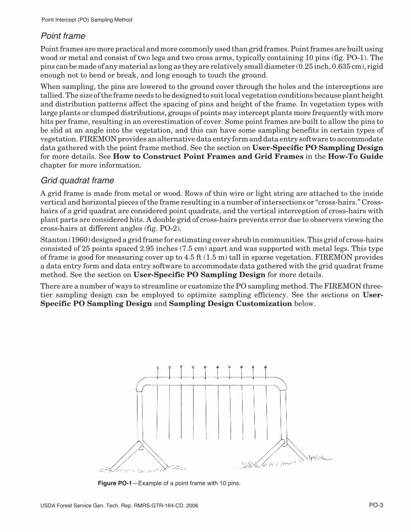
Point framePoint frames are more practical and more commonly used than grid frames. Point frames are built usingwood or metal and consist of two legs and two cross arms, typically containing 10 pins (fig. PO-1). Thepins can be made of any material as long as they are relatively small diameter (0.25 inch, 0.635 cm), rigidenough not to bend or break, and long enough to touch the ground.
When sampling, the pins are lowered to the ground cover through the holes and the interceptions aretallied. The size of the frame needs to be designed to suit local vegetation conditions because plant heightand distribution patterns affect the spacing of pins and height of the frame. In vegetation types withlarge plants or clumped distributions, groups of points may intercept plants more frequently with morehits per frame, resulting in an overestimation of cover. Some point frames are built to allow the pins tobe slid at an angle into the vegetation, and this can have some sampling benefits in certain types ofvegetation. FIREMON provides an alternative data entry form and data entry software to accommodatedata gathered with the point frame method. See the section on User-Specific PO Sampling Designfor more details. See How to Construct Point Frames and Grid Frames in the How-To Guidechapter for more information.
Grid quadrat frameA grid frame is made from metal or wood. Rows of thin wire or light string are attached to the insidevertical and horizontal pieces of the frame resulting in a number of intersections or “cross-hairs.” Cross-hairs of a grid quadrat are considered point quadrats, and the vertical interception of cross-hairs withplant parts are considered hits. A double grid of cross-hairs prevents error due to observers viewing thecross-hairs at different angles (fig. PO-2).
Stanton (1960) designed a grid frame for estimating cover shrub in communities. This grid of cross-hairsconsisted of 25 points spaced 2.95 inches (7.5 cm) apart and was supported with metal legs. This typeof frame is good for measuring cover up to 4.5 ft (1.5 m) tall in sparse vegetation. FIREMON providesa data entry form and data entry software to accommodate data gathered with the grid quadrat framemethod. See the section on User-Specific PO Sampling Design for more details.
There are a number of ways to streamline or customize the PO sampling method. The FIREMON three-tier sampling design can be employed to optimize sampling efficiency. See the sections on User-Specific PO Sampling Design and Sampling Design Customization below.
Figure PO-1—Example of a point frame with 10 pins.
PO-4 USDA Forest Service Gen Tech. Rep RMRS-GTR-164-CD. 2006
Point Intercept (PO) Sampling Method
SAMPLING PROCEDURE
This method assumes that the sampling strategy has already been selected and the macroplot hasalready been located. If this is not the case, then refer to the FIREMON Integrated SamplingStrategy and for further details.
The sampling procedure is described in the order of the fields that need to be completed on the POTransect data form, so it is best to reference the data form when reading this section. The samplingprocedure described here is the recommended procedure for this method. Later sections will describehow the FIREMON three-tier sampling design can be used to modify the recommended procedure tomatch resources, funding, and time constraints.
In the How-To Guide chapter, see How To Locate a FIREMON Plot, How To PermanentlyEstablish a FIREMON Plot, and How to Define the Boundaries of a Macroplot for moreinformation on setting up your macroplot.
Preliminary Sampling Tasks
Before setting out for your field sampling, lay out a practice area with easy access. Try to locate an areawith the same species or vegetation life form you plan on sampling. Get familiar with the plot layoutand the data that will be collected. This will give you a chance to assess the method and will help youthink about problems that might be encountered in the field. For example, will you be recording theplant status—dead or alive—for the part of the plant hit by the sampling pin or the entire plant? It isbetter to answer these questions before the sampling begins so that you are not wasting time in the field.This will also let you see if there are any pieces of equipment that will need to be ordered.
Many preparations must be made before proceeding into the field for PO sampling. First, all equipmentand supplies in the PO Equipment List must be purchased and packed for transport into the field.Travel to FIREMON plots is usually by foot, so it is important that supplies and equipment be placedin a comfortable daypack or backpack. It is also important that there be spares of each piece of equipmentso that an entire day of sampling is not lost if something breaks. Spare equipment can be stored in thevehicle rather than the backpack. Be sure that all equipment is well maintained and there are plentyof extra supplies, such as data forms, map cases, and pencils.
All PO data forms should be copied onto waterproof paper because inclement weather can easily destroyvaluable data recorded on standard paper. Data forms should be transported into the field using a
Figure PO-2—Example of a grid frame with 36 points (4 x 9).
PO-5USDA Forest Service Gen. Tech. Rep. RMRS-GTR-164-CD. 2006
Point Intercept (PO) Sampling Method
plastic, waterproof map protector or plastic bag. The day’s sample forms should always be stored in adry place (office or vehicle) and not be taken back into the field for the next day’s sampling.
We recommend that one person on the field crew, preferably the crew boss, have a waterproof, lined fieldnotebook for recording logistic and procedural problems encountered during sampling. This helps withfuture remeasurements and future field campaigns. All comments and details not documented in theFIREMON sampling methods should be written in this notebook.
It is beneficial to have plot locations for several days of work in advance in case something happens, suchas if the road to one set of plots is washed out by flooding. Plots should be referenced on maps and aerialphotos using pin-pricks or dots to make navigation easy for the crew and to provide a check of thegeoreferenced coordinates. We found that it is easy to transpose UTM coordinate digits when recordinggeoreferenced positions on the plot sheet, so marked maps can help identify any erroneous plot positions.If possible, the spatial coordinates should be provided if FIREMON plots were randomly located.
A field crew of two people is probably the most efficient for implementation of the PO sampling method.There should never be a one-person field crew for safety reasons, and any more than two people willprobably result in part of the crew waiting for tasks to be completed and unnecessary trampling on theFIREMON macroplot. The crew boss is responsible for all sampling logistics including the vehicle, plotdirections, equipment, supplies, and safety. The crew boss should be the note taker and the technicianshould perform most quadrat measurements. The initial sampling tasks of the field crew should beassigned based on field experience, physical capacity, and sampling efficiency. As the field crew gainsexperience, switch tasks so that the entire crew is familiar with the different sampling responsibilitiesand to limit monotony.
Designing the PO Sampling Method
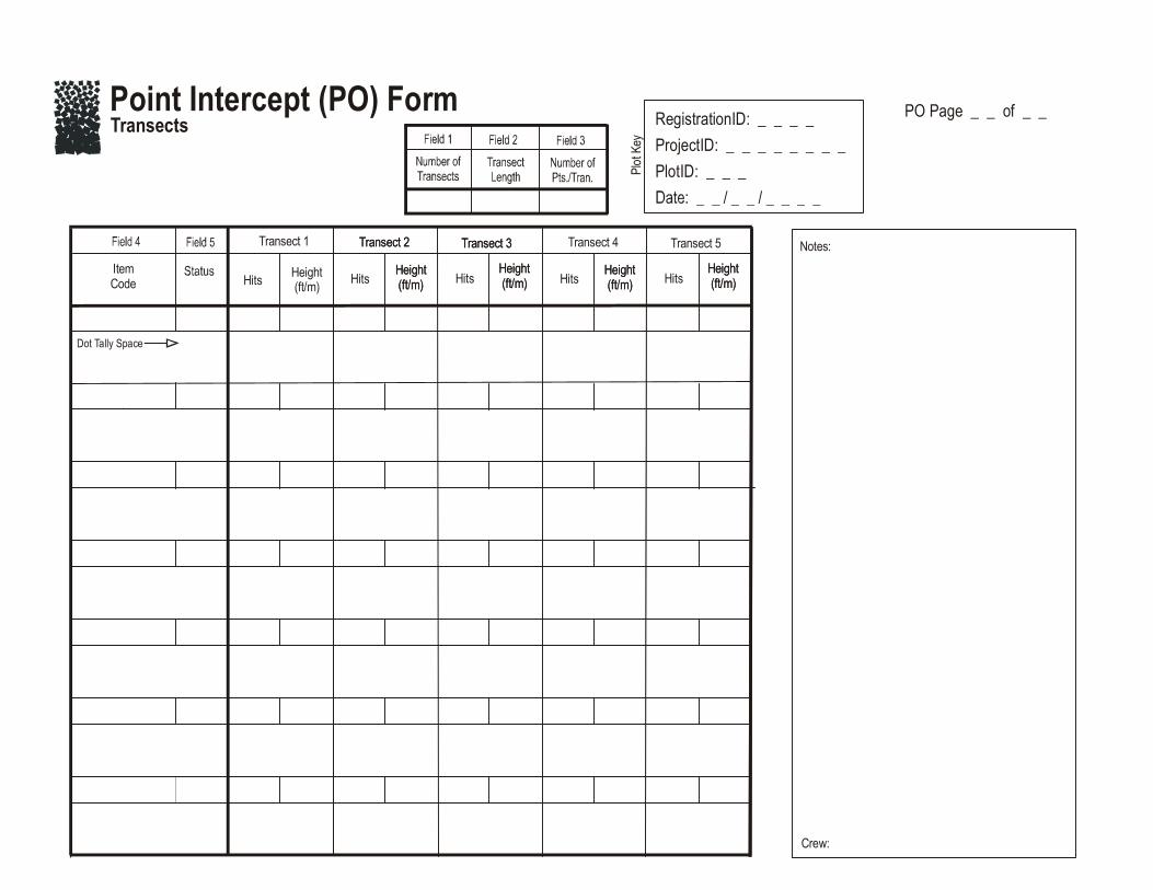
A set of general criteria recorded on the PO data form allows the user to customize the design of the POsampling method so that the sampling captures the information needed to successfully complete themanagement objective within time, money, and personnel constraints. These general fields should bedecided before the crews go into the field and should reflect a thoughtful analysis of the expectedproblems and challenges in the fire monitoring project. However, some of these fields, in particular thenumber of points per transect and number of transects, might be adjusted after preliminary samplingis conducted in the field to determine a sufficient sample size.
Plot ID constructionA unique plot identifier must be entered on the PO sampling form. This is the same plot identifier usedto describe general plot characteristics in the Plot Description or PD sampling method. Details onconstructing a unique plot identifier are discussed in the How to Construct a Unique Plot Identifiersection in the How-To Guide chapter. Enter the plot identifier at the top of the PO data form.
Determining sample sizeThe size of the macroplot ultimately determines the length of the transects and the length of the baselinealong which the transects are placed. The amount of variation in plant species composition anddistribution determines the number and length of transects and the number of quadrats required forsampling. The typical macroplot sampled in the PO method is a 0.10 acre (0.04 ha) square measuring66 x 66 ft (20 x 20 m), which is sufficient for most monitoring applications. If you are not sure of the plotsize to use, contact someone wo has sampled the same vegetation that you will be sampling. The sizeof the macroplot may be adjusted to accommodate different numbers and lengths of transects, andnumber of points per transect. It is more efficient if you use the same plot size for all FIREMON samplingmethods on the plot.
The sampling unit for Point Intercept is the transect. We recommend sampling five transects within themacroplot. However, there are situations when more transects should be sampled. See How ToDetermine Sample Size in the How-To Guide chapter for more details. Enter the number of
PO-6 USDA Forest Service Gen Tech. Rep RMRS-GTR-164-CD. 2006
Point Intercept (PO) Sampling Method
transects in Field 1 on the PO Transect data form. The recommended transect length is 66 ft (20 m) fora 66 x 66 ft (20 x 20 m) macroplot. However, the macroplot size may be adjusted to accommodate longeror shorter transects based on the variability in plant species composition and distribution. For example,transects may be lengthened to accommodate more points per transect or more widely spaced points.Enter the transect length in Field 2 of the PO Transect data form. The FIREMON PO data form anddata entry screen allow a maximum of 10 transects.
We recommend that 66 points be placed 1 ft (0.3 m) apart along each 66-ft (20-m) transect. However,when sampling with a metric tape, we recommend sampling at every 0.25 m for a total of 80 points pertransect. The number of points and spacing should be adjusted based on plant species size and spacing.For example, points should not be placed so close together that all sample points hit bare groundbetween clumps of grasses or all sample points fall on grass clumps. The number of points along atransect determines the resolution of cover recorded. If 50 points are recorded along a transect, covervalues can be recorded in increments of 2 percent (1/50, 2/50, and so forth). At a minimum, you wantenough points to sample at least some of the species of interest along each transect. Enter the numberof points per transect in Field 3 of the PO data form.
Conducting PO Sampling Tasks
Establish the baseline for transectsOnce the plot has been monumented, a permanent baseline is set up as a reference from which you willorient all transects. The baseline should be established so that the sampling plots for all of the methodsoverlap as much as possible. See How To Establish Plots with Multiple Methods in the How-ToGuide chapter. The recommended baseline is 66 ft (20 m) long and is oriented upslope with the 0-ft (0-m)mark at the lower permanent marker and the 66-ft (20-m) mark at the upper marker. On flat areas, thebaseline runs from south to north with the 0-ft (0-m) mark on the south end and the 66-ft (20-m) markon the north end. See How To Establish a Baseline for Transects in the How-To Guide chapterfor more details.
Locating the transectsTransects are placed perpendicular to the baseline and are sampled starting at the baseline. On flatareas, transects are laid out east starting at the baseline. For permanent plots, determine the compassbearing of each transect, record these on the plot layout map and permanently mark each end of thetransect. Starting locations for each transect are determined by selecting a sampling scheme using theFIREMON random transect locator or from supplied tables. If the PO method is used in conjunction withother replicated sampling methods (CF, LI, RS, or DE), use the same transects for all methods. Insuccessive remeasurement years, it is essential that transects be placed in the same location. See HowTo Locate Transects and Quadrats in the How-To Guide chapter for more details.
Sampling pointsPoints are sampled at equal intervals along the length of a transect by lowering the sampling polevertically to the ground, not perpendicular to the slope (fig. PO-3). If 66 points are sampled along a 66-fttransect, the first point is recorded at 1 ft, then every foot to the end of the tape. If 80 points are sampledat 0.25 m along a 20-m transect, the first point is sampled at 0.25 m and the last point at 20 m.
Point Intercept Sampling
Recording hitsThe FIREMON PO method may be used to sample just species cover, just ground cover, or species andground cover together. If the sampling crew is collecting species cover data, record only the plant speciesthat are “hit” by the sampling pole. FIREMON provides plant species codes from the NRCS Plantsdatabase. However, local or customized plant species codes are allowed in FIREMON. See Populating
PO-7USDA Forest Service Gen. Tech. Rep. RMRS-GTR-164-CD. 2006
Point Intercept (PO) Sampling Method
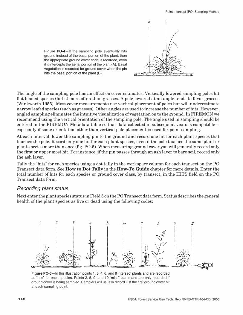
the Plant Species Codes Lookup Table in the FIREMON Database User Manual for moredetails. When using the PO method to sample species cover in clumped or sparse vegetation, you mayfind that data are only recorded at a subset of the sampling locations because there may not bevegetation at every point that is sampled. If ground cover is being sampled, use the cover codes in tablePO-1 to record sampling hits. Unlike species sampling, every point should have a ground cover coderecorded. If species and ground cover are being sampled at the same time, record the species name forthe plant that the pole hits and the appropriate ground cover code from table PO-1 (fig. PO-4). Forinstance, if you are lowering a sampling pole and it first contacts a blade of blue grama grass and then,as you continue to lower, it hits the basal portion of the plant, record the NRCS species code, (BOGR2)and the ground cover code (BAGR or BAVE). Enter the plant species and ground cover code in Field 4on the PO Transect data form.
The number of hits that are recorded for each sampling point is dependent on the project objectives. Ifthe objective is just to monitor ground cover, samplers need to record only the ground cover hits. Todevelop a complete species list, samplers should record all unique species hits at each sampling point.Multiple hits for each species can be recorded if measuring biomass, volume, or species composition.Again, this is important information to be recorded in the Metadata table.
Figure PO-3—Points are sampled by loweringthe pin vertically to the ground (point A) and notperpendicular to the slope (point B).
Table PO-1—FIREMON ground cover codes
Ground cover
Code Description Code Description
ASH Ash (organic, from fire) LICH LichenBAFO Basal forb LITT Litter and duffBAGR Basal graminoid MEGR Medium gravel (5–20 mm)BARE Bare soil (soil particles <2 mm) MOSS MossBARR Barren PAVE PavementBASH Basal shrub PEIC Permanent ieBATR Basal tree PEIS Permanent ice and snowBAVE Basal vegetation PESN Permanent snowBEDR Bedrock ROAD RoadBOUL Boulders (round and flat) ROBO Round boulder (>600 mm)CHAN Channers (2–150 mm long) ROCK RockCHAR Char ROST Round stone (250–600 mm)CML Cryptogams, mosses and lichens STON Stones (round and flat)COBB Cobbles (75–250 mm) TEPH Tephra volcanicCOGR Coarse gravel (20–75 mm) TRIC Transient iceCRYP Cryptogamic crust TRIS Transient ice and snowDEVP Developed Land TRSN Transient snowFIGR Fine gravel (2–5 mm) UNKN UnknownFLAG Flag stones (150–380 mm long) WATE WaterFLBO Flat boulders (>600 mm long) WOOD WoodFLST Flat stone (380–600 mm long) X Did not assessGRAV Gravel (2–75 mm)
PO-8 USDA Forest Service Gen Tech. Rep RMRS-GTR-164-CD. 2006
Point Intercept (PO) Sampling Method
The angle of the sampling pole has an effect on cover estimates. Vertically lowered sampling poles hitflat bladed species (forbs) more often than grasses. A pole lowered at an angle tends to favor grasses(Winkworth 1955). Most cover measurements use vertical placement of poles but will underestimatenarrow leafed species (such as grasses). Other angles are used to increase the number of hits. However,angled sampling eliminates the intuitive visualization of vegetation on to the ground. In FIREMON werecommend using the vertical orientation of the sampling pole. The angle used in sampling should beentered in the FIREMON Metadata table so that data collected in subsequent visits is compatible—especially if some orientation other than vertical pole placement is used for point sampling.
At each interval, lower the sampling pin to the ground and record one hit for each plant species thattouches the pole. Record only one hit for each plant species, even if the pole touches the same plant orplant species more than once (fig. PO-5). When measuring ground cover you will generally record onlythe first or upper most hit. For instance, if the pin passes through an ash layer to bare soil, record onlythe ash layer.
Tally the “hits” for each species using a dot tally in the workspace column for each transect on the POTransect data form. See How to Dot Tally in the How-To Guide chapter for more details. Enter thetotal number of hits for each species or ground cover class, by transect, in the HITS field on the POTransect data form.
Recording plant statusNext enter the plant species status in Field 5 on the PO Transect data form. Status describes the generalhealth of the plant species as live or dead using the following codes:
Figure PO-4—If the sampling pole eventually hitsground instead of the basal portion of the plant, thenthe appropriate ground cover code is recorded, evenif it intercepts the aerial portion of the plant (A). Basalvegetation is recorded for ground cover when the pinhits the basal portion of the plant (B).
Figure PO-5—In this illustration points 1, 3, 4, 6, and 8 intersect plants and are recordedas “hits” for each species. Points 2, 5, 9, and 10 “miss” plants and are only recorded ifground cover is being sampled. Samplers will usually record just the first ground cover hitat each sampling point.
PO-9USDA Forest Service Gen. Tech. Rep. RMRS-GTR-164-CD. 2006
Point Intercept (PO) Sampling Method
L—Live: plant with living tissue.D—Dead: plant with no living tissue visible.NA—Not Applicable.
This may be an evaluation of the entire plant or just the part of the plant that comes in contact with thesampling pole depending on the project objectives. In FIREMON we recommend recording the statusof the plant part that touches the sampling pole. Recognize that an accurate assessment of plant statusmay be difficult during the dormant season.
Plant status is purely qualitative, but it provides an adequate characteristic for stratification of preburnplant health and determining postburn survival.
Estimating average heightAt the end of each transect, estimate the average height of each plant species you tallied, in feet (m)within +/– 10 percent of the mean plant height. This is not the height above the ground where thesampling pole touches the vegetation, but rather the average total height of the plants that are tallied.See How to Measure Plant Height in the How-To Guide chapter for more details. Enter plant heightin the Height field for each transect.
Precision Standards
Use the precision standards listed in table PO-2 for the PO sampling.
SAMPLING DESIGN CUSTOMIZATION
This section presents several ways that the PO sampling method can be modified to collect more detailedinformation or streamlined to collect only the most important tree characteristics. First, the suggestedor recommended sample design is detailed, then modifications are presented.
Recommended PO Sampling Design
The recommended PO sampling design follows the Alternative FIREMON sampling intensity and islisted below:
Macroplot Size: 0.1 acre, 66 x 66 ft (400 m2, 20 x 20 m).
Number of Transects: 5.
Number of Points per Transect: 66 per 66 ft transect or 80 per 20 m transect, vertically oriented.
The number of transects sampled should be adjusted according to the appropriate methods in the How-To Guide chapter of the FIREMON manual. The number of points per transect should be adjustedbased on plant species size and spacing.
Collect plant species cover data and ground cover data.
Table PO-2—Precision guidelines for PO sampling.
Component StandardHits +3 percent total hitsHeight +10 percent average height
PO-10 USDA Forest Service Gen Tech. Rep RMRS-GTR-164-CD. 2006
Point Intercept (PO) Sampling Method
Streamlined PO Sampling Design
The streamlined PO sampling design follows the Simple FIREMON sampling intensity and is designedbelow:
Macroplot Size: 0.1 acre, 66 x 66 ft (400 m2, 20 x 20 m).
Number of Transects: 3.
Number of Points per Transect: 66 per 66-ft transect or 80 per 20-m transect, vertically oriented.
The number of transects sampled should be adjusted according to the appropriate methods in the How-To Guide chapter of the FIREMON manual. The number of points per transect should be adjustedbased on plant species size and spacing.
Collect plant species cover and average plant height data.
Comprehensive PO Sampling Design
The comprehensive PO sampling design follows the Detailed FIREMON sampling intensity and isdetailed below:
Macroplot Size: 0.1 acre, 66 x 66 ft (400 m2, 20 x 20 m).
Number of Transects: 5.
Number of Points per Transect: 100 placed at 8-inch intervals on a 66-ft transect or placed at 0.20-mintervals on a 20-m transect, vertically oriented.
The number of transects sampled should be adjusted according to the appropriate methods in the How-To Guide chapter of the FIREMON manual. The number of points per transect should be adjustedbased on plant species size and spacing.
Collect plant species cover, ground cover, and measure average plant height.
User-Specific PO Sampling Design
There are a number of ways the user can adjust the PO sample fields to make sampling more efficientand meaningful for local situations. Examiners may adjust the number of transects and points pertransect based on plant species size and distribution.
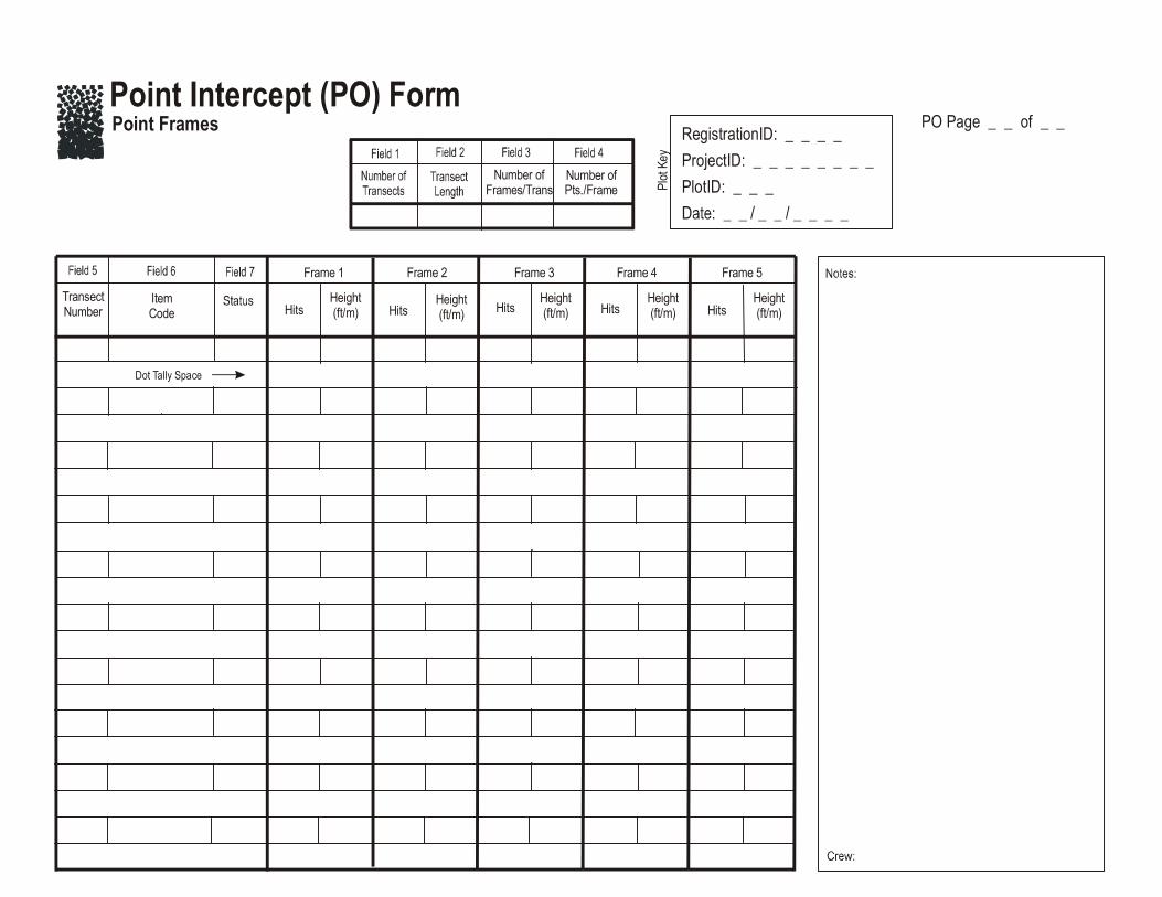
Points could be sampled in quadrats or frames placed along a transect rather than using individualpoints. Collections of points are pins grouped into a pin frame (usually 10 pins) or cross-hairs groupedinto a sighting frame. See How To Construct Point Frames and Grid Frames in the How-ToGuide chapter for more details. If 10 pins are used in a frame, percent cover can be estimated within10 percent intervals (1/10, 2/10 and so forth) for each frame. If the point frames or grid frames are placedfar enough apart (they are independent samples), the frames can be the sample units rather than thetransects.
The PO method may be used in conjunction with the CF method to sample ground cover by using theCF sampling quadrat as a point frame. A pencil or pen is used to record ground cover “hits” at the fourcorners and the four midpoints on each side of the quadrat. A total of eight points are recorded for eachquadrat.
If grid frames or point frames are being sampled along transects rather than individual points, thendetermine the number of quadrats or point frames sampled per transect using the methods in How ToDetermine Sample Size in the How-To Guide chapter. Record the number of frames per transectin Field 3, the number of points per frame in Field 4, and the transect number in Field 5 on the PO PointFrames data form. The FIREMON data entry screen and database accommodates 20 frames pertransect and an unlimited number of transects.
PO-11USDA Forest Service Gen. Tech. Rep. RMRS-GTR-164-CD. 2006
Point Intercept (PO) Sampling Method
The PO method is typically used for grasses, forbs, and small shrubs less than 3 ft (1 m) in height.However, this method can be modified to sample large shrubs and trees as well. Instead of using pinsthat drop to the ground or a grid frame that the observer looks down on, you could use a sighting device,such as a sighting tube or “moosehorn,” which allows you to look down for small plants and look up intothe canopy for larger species.
The type of cover typically estimated by points is total cover. Cover can also be measured within definedvegetation layers, or by different species. If measuring cover, record only the first hit of each pin.Multiple hits for each species can be recorded if measuring biomass, volume, or species composition.
Sampling Hints and Techniques
Examiners must be able to identify plant species, be familiar with ground cover category codes, andknow how to collect cover data using a pin. If only ground cover is being sampled, plant identificationskills are not required.
Measuring tapes are made from a variety of materials and are available in varying lengths andincrements. Examiners should choose English (metric) tapes for this method and select a tape that isat least as long, or a little longer, than the transect length being sampled. Steel tapes do not stretch andare the most accurate over the life of the tape. Steel is probably the best choice for permanent transectswhere remeasurement in exactly the same place each time is important. Cloth and fiberglass tapes willstretch over the life of the tape but are easier to use than steel tapes because they are lighter and do nottend to kink.
Point intercept cover is easily calculated if 100 points are sampled per transect. Cover values are equalto the number of “hits” for each item on the transect. Metric tapes are easily divided into 100 intervals,and sampling a 20-m tape at 20-cm intervals is relatively simple. However, if sampling with Englishtapes marked in inches and feet, sampling 100 points is impractical unless the transect length is amultiple of 100 (50, 100, 200). On a 66-ft transect, 100 points must be placed at 8-inch intervals. It istime consuming to place the point at the right mark on the tape. If a high resolution of cover is desired(for example, 1 percent), one solution is to sample along a 66-ft transect at every 0.5 ft for 132 points.Another solution is to increase the transect length to 100 ft, and place a point at every foot. Whendeciding how many points to sample per transect, it is better to sample more transects than place morepoints per transect. Sampling with fewer points and more transects will often sample more variabilitywithin the plot at a slightly lower resolution of cover (for example, 1/66 = 1.5 percent versus 1/100 = 1percent).
The sampling crew may encounter an obstacle, such as a large rock or tree, along one of the transect linesthat interferes with the quadrat sampling. If that happens, offset using the directions described in HowTo Offset a Transect in the How-To Guide chapter.
When entering data on the PO Transect data forms, examiners will most likely run out of space on thefirst page. The form was designed to print one copy of the first page, and several copies of the secondpage. The second page can be used to record more plant species on the first three transects or to recorddata for additional transects. The second page of the data form allows the examiner to write the transectnumber on the form. This allows the examiner to design the form to accommodate the number oftransects sampled. Print out enough pages to record all species on all transects for the required numberof intercepts. The FIREMON data entry screens and database allow a maximum of 10 transects.
When entering data on the PO Point Frames data forms, examiners will most likely run out of space onthe first page. As with the PO Transect form, the Frame form was designed to print one copy of the firstpage and several copies of the second page. The second page can be used to record more plant specieson the first five point frames or to record data for additional frames. The second page of the data formallows the examiner to write the frame number on the form. This allows the examiner to design the formto accommodate the number of frames sampled per transect. Print out enough pages to record all specieson all transects for the required number of intercepts. The FIREMON PO data entry screens anddatabase allow a maximum of 20 transects per plot.
PO-12 USDA Forest Service Gen Tech. Rep RMRS-GTR-164-CD. 2006
Point Intercept (PO) Sampling Method
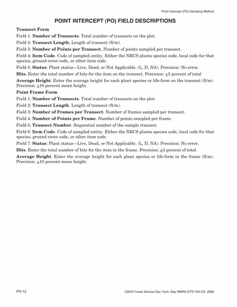
POINT INTERCEPT (PO) FIELD DESCRIPTIONS
Transect FormField 1: Number of Transects. Total number of transects on the plot.
Field 2: Transect Length. Length of transect (ft/m).
Field 3: Number of Points per Transect. Number of points sampled per transect.
Field 4: Item Code. Code of sampled entity. Either the NRCS plants species code, local code for thatspecies, ground cover code, or other item code.
Field 5: Status: Plant status—Live, Dead, or Not Applicable. (L, D, NA). Precision: No error.
Hits. Enter the total number of hits for the item on the transect. Precision: +3 percent of total
Average Height. Enter the average height for each plant species or life-form on the transect (ft/m).Precision: +10 percent mean height.
Point Frame FormField 1: Number of Transects. Total number of transects on the plot.
Field 2: Transect Length. Length of transect (ft/m).
Field 3: Number of Frames per Transect. Number of frames sampled per transect.
Field 4: Number of Points per Frame. Number of points sampled per frame.
Field 5: Transect Number. Sequential number of the sample transect.
Field 6: Item Code. Code of sampled entity. Either the NRCS plants species code, local code for thatspecies, ground cover code, or other item code.
Field 7: Status: Plant status—Live, Dead, or Not Applicable. (L, D, NA). Precision: No error.
Hits. Enter the total number of hits for the item in the frame. Precision: +3 percent of total.
Average Height. Enter the average height for each plant species or life-form in the frame (ft/m).Precision: +10 percent mean height.
FIREMON PO Cheat Sheet
Point cover (PO) equipment list
Camera with film Maps, charts and directionsPO data forms Map protector or plastic bagClipboard Magnifying glassCompass Pocket calculatorFile Point frame (pn or grid) (optional)Field notebook Pole—0.25 inch diameterGraph paper Plot sheet protector or plastic bagHammer Rebar stakes (2) for baseline plus
2 for each transectIndelible ink pen (Sharpie, Marker) Steel fence post (2) and driver (to
mark endpoints of baseline)Lead pencils with lead refills Tape 75 ft (25 m) or longer (2)
Ground cover codes
Ground cover
Code Description Code Description
ASH Ash (organic, from fire) LICH LichenBAFO Basal forb LITT Litter and duffBAGR Basal graminoid MEGR Medium gravel (5–20 mm)BARE Bare soil (soil particles <2 mm) MOSS MossBARR Barren PAVE PavementBASH Basal shrub PEIC Permanent ieBATR Basal tree PEIS Permanent ice and snowBAVE Basal vegetation PESN Permanent snowBEDR Bedrock ROAD RoadBOUL Boulders (round and flat) ROBO Round boulder (>600 mm)CHAN Channers (2–150 mm long) ROCK RockCHAR Char ROST Round stone (250–600 mm)CML Cryptogams, mosses and lichens STON Stones (round and flat)COBB Cobbles (75–250 mm) TEPH Tephra volcanicCOGR Coarse gravel (20–75 mm) TRIC Transient iceCRYP Cryptogamic crust TRIS Transient ice and snowDEVP Developed Land TRSN Transient snowFIGR Fine gravel (2–5 mm) UNKN UnknownFLAG Flag stones (150–380 mm long) WATE WaterFLBO Flat boulders (>600 mm long) WOOD WoodFLST Flat stone (380–600 mm long) X Did not assessGRAV Gravel (2–75 mm)