Date post: | 25-Jun-2018 |
Category: |
Documents |
Upload: | vuongtuong |
View: | 217 times |
Download: | 0 times |
Polar winds from highly elliptical orbiting satellites: a new
perspective
10th International Winds Workshop
Tokyo, Japan, Feb 22-26, 2010
L. Garand1, N. Wagneur1, R.
Sarrazin1, D. Santek2, J. Key2
1 Environment Canada, Dorval2 CIMSS, Madison
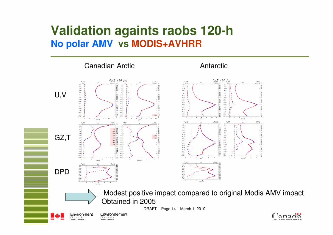
DRAFT – Page 2 – March 1, 2010
Outline
• Canada’s plan for an HEO constellation: PCW mission
• Polar winds: unique capabilities from HEO
• Recent OSE study on polar winds
• OSSE for PCW: a challenge
• Simulated radiances: improving AMV product
• AMV from simulated data over Arctic: a first look
• Conclusion and perspectives
DRAFT – Page 3 – March 1, 2010
Polar Communications and Weather mission (PCW, also called Polarsat)
2 satellites to provide
continuous GEO-likeimagery 50-90 N
0.5-1 km VIS
2 km IR
12-h period
63.4 deg. inclination
Apogee: ~39,500 km
Perigee: ~600 km
Status: Phase A
Launch: 2016
DRAFT – Page 4 – March 1, 2010
Background on Molniya concept
• Russia:
- Used extensively for communications and classified missions
- Mission including Earth observation planned: “Arctica”
• United States
- Concept for Earth observation first proposed by Kidder and VonderHaar (1990)
- NASA/Goddard proposed a mission in 2004-2005 under Earth Science Pathfinder Program. Main focus was on high latitude winds. Main payload was a 6-channel imager. Stopped at Phase A level.
• Canada- CSA initiated a satcom/EO mission concept study in 2005- Saw the opportunity to take relay from NASA in 2006- Completed a Phase 0 in November 2008- Phase A started July 2009
DRAFT – Page 5 – March 1, 2010
Specific Objectives
• To provide continuous meteorological services and information for the entire circumpolar region, with the imagery data “refreshed” as frequently as practical. GOAL 15 min.
• To improve weather prediction accuracy by providing high qualitydata currently not available or available with insufficient spatial / temporal resolution
• To improve the monitoring and prediction of air quality variables
• To improve the modeling of physical processes in the Arctic environment
• To develop measures of climate change through high quality monitoring of key atmospheric and surface variables
• To have the observing system with 2 satellites in place by 2016.Lifetime of 5 years (goal 7 years).
PCW to have an operational status linked to NRT meteorologyNot a demonstration mission: new mandate for Canada
DRAFT – Page 6 – March 1, 2010
Area of Interest
Meteorological Coverage Requirement (50ºN)
Meteorological Coverage Goal (45ºN)
Communications Coverage Requirement
Meteo requirement pertains to the entire circumpolar domain
DRAFT – Page 7 – March 1, 2010Cloud height, high level temperature
2MODIS-3614.1-14.420
Cloud height, mid level temperature2MODIS-3513.8-14.119
Cloud height, low level temperature2MODIS-3413.5-13.818
Cloud height2ABI-1613.0-13.6LIRCO217
Ash, SST2ABI-1511.8-12.816
Cloud, SST, ash2ABI-1410.8-11.615
Cloud, surface, cirrus2ABI-1310.1-10.614
Total ozone2ABI-129.42-9.8013
Total water, cloud phase2ABI-118.30-8.70LWIR12
Wind, humidity2ABI-107.24-7.4411
Wind, humidity2ABI-096.75-7.1510
Wind, humidity2ABI-085.77-6.609
fog/ fire detection, ice/cloud
separation, wind, phase. Fire
Radiation Power (FRP)
2ABI-073.80-4.00MWIR8
Cloud phase, size2ABI-062.22-2.287
Snow-cloud distinction, ice
Mapping
1ABI-051.58-1.646
Cirrus detection2ABI-041.37-1.395
Snow grain, clouds1SGLI SW11.04-1.06 SWIR4
Wind, aerosols, vegetation0.5ABI-030.85-0.893
Wind, clouds, ice mapping0.5ABI-020.59-0.69 2
Surface, clouds, aerosols1ABI-010.45-0.49VNIR1
Main applicationsGSD
(km)
HeritageWavelength
(microns)
SubgroupBand
No.
PCW Channels
VIS AMV
WV AMV
IR AMV
Height assignment
DRAFT – Page 8 – March 1, 2010
Typical AMV coverage Example of 07 Aug 2008 00 UTC AMV availability
100-400 hPa
Recognized availabilitygap 55-65 N/S
Terra/Aqua AMVs
700 hPa to surface
No AMVs above 55 N/S
PCW features to serve this application:
• High temporal sequences
• Simultaneous retrievals• Stereo views
DRAFT – Page 10 – March 1, 2010
Polar winds: unique and enhanced capabilities from PCW
• No spatial gap entire domain 55-90 N
• High temporal resolution: 15 min imagery
• CO2-slicing capability
• Stereo viewing
DRAFT – Page 12 – March 1, 2010
RECENT OSE ON POLAR WINDSOSE: JAN+FEB 2009 CNTL= all OPE data, no polar AMV, EXP1: + 2 MODIS, EXP2: +2 Modis+ 5 AVHRR. GEM 4D-var.
No polar winds assimilated below 700 hPa
On average 12850 Modis and 5373 AVHRR AMVs per 24-h
Lack of data
55-70 N/S
DRAFT – Page 14 – March 1, 2010
Validation againts raobs 120-hNo polar AMV vs MODIS+AVHRR
Canadian Arctic Antarctic
U,V
GZ,T
DPD
Modest positive impact compared to original Modis AMV impactObtained in 2005
DRAFT – Page 15 – March 1, 2010
OSSE for PCW: a challenge
• Current OSSE approach for AMV is to:
- extract model winds from nature run where AMVswere obtained and perturb “appropriately”.
Caveat: no such locations for PCW, need to identify targets suitable for getting AMVs, differentiating IR, WV, VIS targets + “perturb appropriately”
• Cleaner approach is to apply AMV software to simulated radiances
Caveat: heavy processing and need for ~2 km model output over circumpolar area
No fully satisfactory way to conduct an OSSE for AMVs
In general and for PCW area in particular
DRAFT – Page 16 – March 1, 2010
Simulated radiances: a key for improving AMV product and its QC
• Realism of model output and simulated all sky radiances now allows such studies
• In recent years, IWWG has moved in that direction, indicating strong potential
• PCW science team is preparing proxy radiance datasets over circumpolar area
DRAFT – Page 17 – March 1, 2010
Model output: defining cloud top height, amount
• Proposed definitions based on cloud transmittance tcfrom a window channel, considering cloud emissivity and overlapping assumptions
Effective cloud top height CTH: from model top, height where tc drops to 0.90
Effective cloud amount CFE: 1 – tc
Cloud amount CF: same except cloud emissivity set to 1
Cirrus indicator: CI = CFE/CF, 1 means opaque cloud
Many more measures possible: cloud base, local BT variance, surface inversion,multilayering …
Understanding AMV limitations from target characterizationand background info on atmospheric state
DRAFT – Page 18 – March 1, 2010
Experience from real and simulated AIRS CTH retrievals
using CO2-slicing technique
Global data
Model CTH vs retrieved CTH
from simulated AIRS radiances
CALIPSO CTH vs retrieved CTH
from real AIRS radiances
Model definition of CTH corresponds well to that seen by Calipso
Also confirmation of retrieval bias increasing with height
DRAFT – Page 19 – March 1, 2010
Assuming emissivity ratio = 1.0
STD excluding outsiders: 1.14 kmConfiguration with 12 channels coupled to a
reference profile peaking near the surface
Channel # Wavenumber
204 707.770
221 712.661
232 715.862
252 721.758
262 724.742
272 727.752
299 735.298
305 737.152
310 738.704
355 752.970
362 755.237
475 801.001
Reference channel
787 917.209
Emissivity ratio considerations: impact of
channel selection
Model output (true) height versus retrieved from simulated radiances
DRAFT – Page 20 – March 1, 2010
All channels on range 707 – 760 cm-1
STD excluding outsiders: 0.94 km
Emissivity ratio considerations: impact of
channel selection
Model output (true) height versus retrieved from simulated radiances
Chosen configuration: 13 pairs of coupled channels
In narrow limited rangeChannel Reference channel
Pair # # cm-1 # cm-1
1 204 707.770 252 721.758
2 221 712.661 262 724.742
3 232 715.862 272 727.752
4 252 721.758 299 735.298
5 262 724.742 305 737.152
6 272 727.752 310 738.704
7 299 735.298 355 752.970
8 305 737.152 362 755.237
9 310 738.704 375 759.485
10 355 752.970 375 759.485
11 362 755.237 262 724.742
12 375 759.485 252 721.758
13 375 759.485 204 707.770
DRAFT – Page 21 – March 1, 2010
First experiment with proxy data
2.5 km model ouput
Over Arctic domainRemapped to 2 km Polar
Stereographic
Sequence of 3 proxy images
30 min apart sent to CIMMS
For AMV extraction
Standard QC
DRAFT – Page 23 – March 1, 2010
Model cloud parameters
Cloud top height CTH (mb X 100) Effective cloud fraction ECF
DRAFT – Page 29 – March 1, 2010
Conclusion and perspectives
• PCW to provide unique imaging capability the Arctic
- no gaps 55-90 N, 15 min refresh, 0.5-2 km res
• AMV is a major product of PCW
Looking ahead
• Adapt AMV software to EC environment
• Develop proxy datasets at ~2 km over region 50-90 N H
• Seek improved QC for current polar winds
• Further evaluate possibilities for an OSSE study
• Need to form qualified personnel