janethC:\Documents and Settings\elonm\Local Settings\Temporary Internet Files\Content.Outlook\37WW5FJM\Eng Req approved by council 23 June 2010.doc POLICY ENGINEERING REQUIREMENTS FOR INFRASTRUCTURE CONSTRUCTION June 2010
Transcript
janethC:\Documents and Settings\elonm\Local Settings\Temporary Internet Files\Content.Outlook\37WW5FJM\Eng Req approved by council 23 June 2010.doc
POLICY
ENGINEERING REQUIREMENTS
FOR
INFRASTRUCTURE CONSTRUCTION
June 2010
Macedon Ranges Shire Council: Engineering Requirements for Infrastructure Construction
2.1 Engineering DOCUMENTATION .......................................................... 4 2.2 Fees ...................................................................................................... 9 2.3 Commencement of Construction .......................................................... 9 2.4 Inspections .......................................................................................... 10 2.5 Completion of Works........................................................................... 11
2.5.1 Notification of Works Completion ............................................... 11 2.5.2 Inspection of Subdivisions Works. .............................................. 11 2.5.3 Service Authority Clearance ....................................................... 11 2.5.4 Defects Liability Bond ................................................................. 11 2.5.5 Outstanding Works Bond ........................................................... 11
2.6 Issue of Compliance ........................................................................... 12 2.7 Defect Liability Period ......................................................................... 12
3. ROAD AND DRAINAGE DESIGN REQUIREMENTS FOR DEVELOPMENTS IN THE MACEDON RANGES SHIRE ........................... 13
3.3.1 General Requirements ............................................................... 23 3.4 Street Lighting ..................................................................................... 25
4. DEVELOPER CONTRIBUTIONS TO INFRASTRUCTURE AND COMMUNITY INFRASTRUCTURE LEVY .................................................. 27
4.1 Community Infrastructure Policy ......................................................... 27 4.2 Property Owner Contributions towards Road and Footpath
Construction in unconstructed or partially constructed road reserves . 27 4.3 Special Charge Schemes for Infrastructure Works. ............................ 29 4.4 Development Contribution Plans ........................................................ 29
Revision Issue Date By Comments For advertising March 2010 Nick Massie Placed in local papers For Briefing May 2010 Nick Massie For Councillor review Council Meeting June 2010 Nick Massie For Council consideration Final 23 June 2010 Nick Massie Approved by Council 23 June
2010
Macedon Ranges Shire Council: Engineering Requirements for Infrastructure Construction
1
1. INTRODUCTION
This document has been prepared by the Macedon Ranges Shire Council to detail the engineering requirements associated with infrastructure construction resulting from development within the Shire. In the preparation of this document reference is made to the provisions of the Macedon Ranges Planning Scheme. This document includes provisions that developers must comply with that reflect local conditions and directions of Council unique to local areas and Planning Zones that may be at variance to standard expectation. This document provides guidance to persons/organisations proposing developments within the Shire (including those initiated by Macedon Ranges Shire Council) and aims to minimise any delay in processing of applications. These requirements should not inhibit the submission of alternative designs, based on professional experience and established engineering practice. These alternative designs must be supported with documentation and will be considered on their merits and must at least meet the minimum standards. Complementing these requirements is Council’s Standard Drawings that are available by request from Council or by reference to Council’s web site. The standard drawings are subject to continuous improvement and those contemplating development should ensure they have the latest standard drawings applicable. In addition to these requirements, developments in the Shire are subject to relevant Victorian and Australian guidelines, standards and codes. These are listed in Section 2.1 Engineering Documentation. Applicants/Consultants should also refer to the publication Guidelines for Residential Subdivision in the Macedon Ranges Shire: Designing in Health & Wellbeing available on Council’s web site. The Guidelines set out the Engineering Requirements that all new developments are to incorporate. They specify the standards that must be satisfied when submitting engineering plans for approval. Developers should note that the basic concepts (that satisfy these Guidelines) of engineering design must be made clear at Planning Permit application stage to enable the Developments and Major Projects Unit (as a referral authority) to accept the proposed works identified in the Planning Permit Application. The following flow chart details the process prior to the issue of a permit.
Macedon Ranges Shire Council: Engineering Requirements for Infrastructure Construction
2
Approval Process Prior to Planning Permit Issue
Pre-Application Consultantion
between applicant & Council Engineering and
WSUD treatment identified Applicant submits
Conceptual Design with the Planning
Application
Does the Conceptual Design meet Engineerring
Guidelines to Council satisfaction?
Yes
NoDoes Council wish to request further
information
Yes
No
Council Engineers do not approve Conceptual
Design – Advise Planning
Council Engineers approve Conceptual
Design – Advise Planning
Permit Granted
Stage 1: A pre-application meeting with Council’s Planning Department
Stage 2: Lodgement of Planning Permit application with Council. Including full details of the proposal and attaching all relevant supporting documents. Providing an electronic copy of the permit application and supporting documents will assist in the efficient processing of the application. Hard copies of plans submitted must include one set at A3 size. If the development includes 60 or more lots applicants are expected to provide an assessment of their proposal against healthy urban design principles as outlined in the National Heart Foundation’s Healthy by Design (2004).
Macedon Ranges Shire Council: Engineering Requirements for Infrastructure Construction
3
Stage 3: Preliminary assessment by Council’s Planning Department The application is assessed to ensure it complies with provisions of the Macedon Ranges Planning Scheme. If further information is required, Council will notify the applicant. The application will not be considered further until the requested information has been received.
Stage 4: Public notice Council will give notice of the application if deemed necessary by requiring the Applicant to either:
- send notices to owners and occupiers of adjoining and adjacent land
- Place a notice on the land - Place a notice in the local newspaper/s
Or a combination of all three. An application is placed on notice for a minimum period of 14 days. Any person may lodge an objection to an application. The objection must be made in writing, and include the name and address of the objector and state the reasons for the objection.
Stage 5: Referral Council will refer an application to any referral authorities as directed by the Planning Scheme or to which it considers may have an interest in the application. Referral authorities have 28 days in which to provide comment on an application.
Stage 6: Decision Council will consider any objections received as well as the response of any referral authority and assess the proposal against the Planning Scheme and any other relevant documents. (For example, if the development includes 60 or more lots the application will be assessed against healthy urban design principles as outlined in the National Heart Foundation’s Healthy by Design (2004).) If objections are received, Council may conduct an Applicant / Objector meeting. Following this, Council will either:-
- Issue a Planning Permit, - Issue a Notice of Decision to grant a permit if there are
objectors (a notice of decision advises that Council considers that a Planning Permit should be issued but gives objectors the chance to appeal the decision), or
- Issue a Notice of Refusal. Appeals All parties have the opportunity to appeal Councils decision to the Victorian Civil & Administrative Tribunal
More information is available from Council’s website www.mrsc.vic.gov.au under Council Services, Planning and Building Services.
Macedon Ranges Shire Council: Engineering Requirements for Infrastructure Construction
4
2. ADMINISTRATIVE REQUIREMENTS
All development, unless very minor, involving alteration or addition to Council infrastructure/assets will require the preparation of engineering documentation (plans and specification) for Council approval. Engineering plans and specifications other than for these minor works must be prepared, and all works supervised on behalf of the principal, by personnel qualified in the appropriate discipline. Evidence of the qualification must be provided if requested by Council. 2.1 ENGINEERING DOCUMENTATION The Consultant/Developer must submit the following documentation prior to commencement of construction to allow Council to fully assess the proposed construction. Copy of the Planning Permit Copy of the Overall Development Plan for the area, if appropriate An overall development plan of the estate/works showing proposed lot
boundaries, reserves, street names, stage boundaries and footpath layout. Updates are to be supplied to Council whenever the layout, stage boundaries, footpath etc are altered. The overall development plan must also show the interface with existing infrastructure that bounds the development.
One (1) set of engineering plans for initial checking in hard copy. Four hard copy (4) sets are to be supplied for final approval – one (1) set of approved plans will be returned.
A copy of the specification. A copy of the drainage calculations. Stormwater Management Plan. A copy of the C.B.R. test results for the proposed road/s and a copy of
the pavement design. A traffic engineering report indicating traffic volumes and impact on
surrounding streets. Estimated traffic volumes for undeveloped areas shall be based upon 10 movements per lot for residential and 45 movements per day per lot for commercial/industrial.
Longitudinal Sections of existing roads in proximity to proposed intersections showing sight distances achieved.
Landscaping plans. Healthy Urban Environments Site Assessment. Acknowledgement and demonstration that Engineering Plans have taken
into account relevant Bicycle Strategy, Drainage Study, Flood Study and Movement Network Study.
Evidence that Road names and lot numbering has been accepted by Council.
Macedon Ranges Shire Council: Engineering Requirements for Infrastructure Construction
5
Engineering plans are to be in A1 or A3 format with scales chosen to provide legible plans prepared in accordance with the following documents and manuals, where applicable as amended from time to time by the issuing authority: • Clause 55 and 56 of Planning Scheme unless in conflict with these
guidelines; • MRSC Standard Drawings and Standard Notes; • Australian Rainfall and Runoff; • Austroads Pavement Design; • ARRB Sealed Roads Manual; • CRB Technical Bulletin No 32 Drainage of Subsurface Water from Roads; • Co-ordination of Streetworks Code of Practice; • CFA Planning Conditions and Guidelines for Subdivisions; • VicRoads Road Design Guidelines; • VicRoads section 706 – installation or replacement within road reserves; • Appropriate Australian Standards; • These engineering Guidelines; • Australian Standards for Street Lighting; • Austroads Guide to Traffic Engineering Practice Set 2009; • VicRoads Traffic Engineering Manuals Vol 1 & 2; • Construction Best Practice Guidelines; • EPA Guidelines (sediment runoff etc); • Guidelines for Residential Subdivision in the Macedon Ranges Shire:
Designing in Health & Wellbeing; • Healthy by Design, National Heart Foundation (Vic) 2004; • Macedon Ranges Shire Council Street Tree Planting Policy; • Best Practice Manual for Urban Stormwater Management; • Best Practice Guidelines for Kerbside Recycling at Multi-Occupancy
Residential Developments; • Water Sensitive Urban Design Guidelines as issued by Melbourne Water
as amended by the Addendum issued by Macedon Ranges Shire Council. The extent of the documentation to be provided may be varied dependent on the development proposed. Applicants seeking clarification should contact the Council.
Macedon Ranges Shire Council: Engineering Requirements for Infrastructure Construction
6
In general, Engineering Plans are to be prepared by a qualified Civil Engineer, to scale and include the following detail: • Title Block, Locality Plan, Layout and Stage Plan of each new road/area, • Detail Plan of each Intersection, Longitudinal Section of each road,
Standard Cross-Sections, Cross Sections of each road, • Longitudinal Section of each drain line; • Macedon Ranges Shire Council General Notes on the face sheet including
listing of Hold Points. For large subdivisions, the layout plan should show the relationship of all new roads to each other, and to existing roads adjoining the subdivision. Where development is to be carried out by stages, the boundaries of proposed stages should be shown on this plan, and the stages identified by numbering. For small subdivisions, where all new roads can be shown on one detail plan, the layout plan may be omitted. The plan of each road must include: a. Road reserve boundaries; b. Allotment boundaries, both existing and proposed; Lot numbers; c. Centre-line, or other construction line; d. Chainages, on centre-line or construction line; e. Bearings of the centre-line or construction line; f. Offsets, if the construction line is not the centre-line; g. Tangent point of chainages of each curve; h. Radius, arc length, tangent length and secant distance of each curve; i. Road reserve boundaries, centre-line, and bearing of each intersecting
road; j. Chainage of the Intersection Point of road centre-lines; k. Kerb lines, kerb radii, and chainage of all tangent points of the kerb line; l. Edge of pavement where no kerb is to be constructed; m. Dimensioned road reserve, footpath, and pavement widths. n. Location and details of signs, and road markings to be provided; o. Drain line locations, diameters, and class of pipe; p. Pit locations, and inlet and outlet invert levels; q. Gully locations, and invert and kerb levels; r. Location and levels of existing utilities or other existing features/works
within the site; s. Limits and levels of allotment filling or grading; t. Location and levels of Bench Marks and reference pegs;
Macedon Ranges Shire Council: Engineering Requirements for Infrastructure Construction
7
u. North Point; v. Kerb levels on all kerb returns, pavement contours, and channelization
works for intersection works; and w. Overland flow path shown by direction arrow on each allotment in the
direction of flow; x. Contours at 0.1m intervals; y. Location of waste and recycle bin collection areas on kerb side.
The longitudinal section of each road must include:- Longitudinal Sections of Roads
a. Chainages; b. Existing surface levels; c. Design road centreline and kerb invert levels; d. Cut or fill depths; e. Design grades; f. Chainage and levels of grade intersection points; g. Chainage of tangent points of vertical curves; h. Lengths of vertical curves; i. Sections on control lines on superelevated curves (i.e. pavement edges,
kerb, or lane edges).
A standard cross-section must be shown for each road, including:- Standard Cross-Sections
a. Road reserve width; b. Pavement widths; c. Footpath widths; d. Crossfalls of pavement and footpaths; including batters within and to
property boundaries; e. Pavement depth; f. Type of kerb and channel; g. Type of pavement surfacing; h. Pavement makeup and subsurface drains; i. Utility service location and depths; j. Trees and other road furniture; k. Show conduit locations.
Macedon Ranges Shire Council: Engineering Requirements for Infrastructure Construction
8
A cross-section must be shown at regular chainage interval on each road, except in flat country where all cross-sections conform to the standard cross-section. Cross-sections must show levels and the following:-
Cross-Sections of Roads
a. Road reserve boundaries; b. Pavement centre-line (or other construction line); c. Natural surface; d. Design Cross-Section; e. Crossfall of pavement and footpath, pavement and footpath widths, and
pavement depths wherever these differ from the standard cross-section.
A Longitudinal section must be shown for each drain line including:- Longitudinal Sections of Drain lines
a. Chainages; b. Existing surface levels; c. Design invert levels and depth to invert; d. Pit chainages, and inlet and outlet invert levels; e. Distances between pits; f. Grade of each pipe; g. Diameter of each pipe; h. Class of each pipe; and i. Design flow and velocity for each pipe; j. Hydraulic grade line; k. Pipe capacity and inverts; l. Backfill material; m. Critical utility crossings.
Where required by the permit Landscaping Plans must be submitted prior to approval of Engineering Plans. (refer section 3.3). These plans must show all landscape features including any street furniture (seats, signage, bins, park furniture and related fixtures.
Landscaping Plans
Plans must be accompanied with the estimated cost of the works. Assessment Process During the assessment of engineering plans the following may be required: Meetings with the consultant; Estimate of the cost of the construction works, always required; Third Party Road Safety Audit if required; Evidence of approval by other authorities;
Macedon Ranges Shire Council: Engineering Requirements for Infrastructure Construction
9
Certified Plan of Subdivision; Payment of Fees; Submission of amended plans (several iterations may be required).
Prior to construction commencement of works, the following may be required: Construction site management plan including environmental controls; Full details of contractor and contacts; Balance of fees; Certified copy of the tender; On site Meeting with the Contractor, Consultant and Council; Bonds required by Permit; An Asset Protection Permit. The applicant must establish if a permit is
required by application to the Council.
2.2 FEES A plan checking fee of 0.75% of the estimated value of the works including GST is due and payable to Council upon submission of the engineering documentation. A supervision fee of 2.5% of the contract sum including GST is due and payable prior to the commencement of the works. Prior to the issue of the Statement of Compliance the Consultant must submit a statutory declaration of the final cost of the works including GST. If the actual cost of works differs by more than +10% from the estimate, the fees will be adjusted accordingly. The cost of the works includes all those works included on the Civil Engineering (drainage & roads etc) and landscaping plans and will include GST. For Non Standard Street Lighting Fees see section 3.4
2.3 COMMENCEMENT OF CONSTRUCTION At least fourteen (14) days prior to commencing construction, the Consultant must notify Council of their intention to commence construction. This notification is to include the name and contact details of the successful contractor. The following documentation must accompany the notice: • Traffic Management Plan • Existing condition survey of all existing assets • Environmental Management Plan • Occupational Health & Safety and Job Safety Analysis Plans • Asset Protection Permit • Construction Site Management Plan • Evidence that the engineering plans have been approved by the relevant
authorities.
Macedon Ranges Shire Council: Engineering Requirements for Infrastructure Construction
10
2.4 INSPECTIONS Council’s supervising officer is available for inspections during Council’s normal business hours (8:30 am – 5:15 pm Monday to Friday). To ensure the availability of Council’s supervising officer a minimum of 24 hours notice of the inspection is required. Requests for inspections outside normal business hours are required in writing and are subject to the availability of Council’s supervising officer and will be charged at the applicable hourly rate. The following inspections will be carried out by Council’s supervising officer and should be treated as hold points for that item of work until approved by Council’s supervising officer. The Consultant for the development must be in attendance at these * hold point inspections. 1. Stormwater drainage, including AG drains and house connections, prior
to backfilling. 2*. Water Sensitive Urban Design prior to placement of backfill. At these
inspections and prior to backfill testing evidence to be provided that the backfill media complies with the specification.
3. Footpath, vehicle crossing and kerb and channel prior to placement of concrete.
4*. Road subgrade prior to placement of pavement (including proof-roll). 5. Road subbase prior to placement of base course (including proof-roll). 6*. Road base course prior to sealing (including proof-roll). 7*. Practical completion The following inspections are also required and will be carried out by Council’s supervising officer: • Inspection of all traffic control and signage works in accordance with the
approved engineering plans. • Inspection of works in accordance with approved landscaping plan. • Inspection prior to Statement of Compliance. • Final inspection at end of Defects Liability Period. • Any other inspections as determined by the Supervising Officer. The above inspections (including hold point inspections) shall be noted on the title page of the engineering plans. Council will advise the Consultant in writing within two (2) business days of the outcome of the hold point inspections. Where the Council is required to repeat an inspection due to works not being completed satisfactorily at the time of the first inspection the recovery of the cost of repeat inspections may be invoiced, at the discretion of Council’s officers. It is in the interests of the Consultant to supervise the construction to ensure that the development will pass the inspection first time.
Macedon Ranges Shire Council: Engineering Requirements for Infrastructure Construction
11
If works proceed past the hold point without inspection or remedial works following inspection are not completed satisfactorily, then the works will not be accepted. The supervising officer may at any time require tests (such as density, concrete strength, material compliance with specification etc.) to be carried out and/or request the consultant to provide test results that substantiate the specified requirements. These tests will be at no cost to Council.
2.5 COMPLETION OF WORKS The following is required in order for Council to approve the completed works and agree the date the subdivision commences the Defects Liability Period.
2.5.1 NOTIFICATION OF WORKS COMPLETION The Consultant is to provide written notification to Council that the works have been undertaken in accordance with the approved plans and specification and that the works are now deemed to be at practical completion. The notification is to include copies of test results that show compliance with the pavement specification.
2.5.2 INSPECTION OF SUBDIVISIONS WORKS. An inspection of the works is to be undertaken by the Contractor, Consultant and a representative/s of Council to identify any outstanding works and determine that the subdivision is constructed to the satisfaction of Council.
2.5.3 SERVICE AUTHORITY CLEARANCE A written declaration from all relevant service authorities stating that all services have been installed to their complete satisfaction.
2.5.4 DEFECTS LIABILITY BOND A defects liability bond security amounting to 5% of the gross costs of construction (including GST) is required for a period of twelve (12) months from the date of which the works were completed to the satisfaction of Council. This security may take the form of cash or a bank guarantee not limited by time. Construction costs include landscaping and must be justified by a statutory declaration of the actual costs of construction.
2.5.5 OUTSTANDING WORKS BOND A bond to the value of two times that of the outstanding works is to be lodged with Council. This bond will be returned upon satisfactory completion of the outstanding works. Bonding of outstanding works will be limited to minor works where it is unreasonable to be complete due to weather conditions or similar and must be approved by Council. The developer is to provide a bonding agreement under Section 17 of the Subdivision Act.
Macedon Ranges Shire Council: Engineering Requirements for Infrastructure Construction
12
2.6 ISSUE OF COMPLIANCE Prior to issue of compliance the following must be completed to Council satisfaction: • Sections 2.5.2, 2.5.3, 2.5.4, 2.5.5 and any outstanding works that Council
determines prior to defects liability commencing. • A set of “As Constructed” drawings on clear plastic film to show any
alterations made necessary during the construction, prior to the expiration of the Defects Liability Period. A copy of the drawings must also be provided in an approved electronic format. Supplied with the “As Constructed” drawings must be the Asset Information in the format as required by the Asset Management Coordinator that nominates for Council records the following for each street: footpath length and area; cumulative length of each size drainage pipe and type; number of manholes/Pits; number of street lights including identification of standard and none
standard lighting; road pavement length and area by type; kerb length by type; number of street trees and type; details of street furniture.
Developers must refer to the Asset Management Coordinator for advice on the current requirements.
2.7 DEFECT LIABILITY PERIOD The developer is to maintain the subdivision for a period of twelve (12), twenty four (24) months for landscaping from the date of the satisfactory completion of the works. During this time the developer is to repair any deterioration or defect that in Council’s view is the result of poor construction or workmanship. Upon the expiration of the Defects Liability Period the Consultant must request a final inspection and the refund of the maintenance security. The maintenance security will be refunded provided the works are approved and “As Constructed” drawings have been received by Council.
Macedon Ranges Shire Council: Engineering Requirements for Infrastructure Construction
13
3. ROAD AND DRAINAGE DESIGN REQUIREMENTS FOR DEVELOPMENTS IN THE MACEDON RANGES SHIRE
The Macedon Ranges Shire Council supports the general principles of Clause 55 & 56 of the Planning Scheme where applicable however local conditions require some variation. 3.1 ROADS The following typical requirements for new and reconstructed roads set the standard for each land use zoning but applicants in developing their proposal are to have regard for neighbourhood character and the surrounding environment. For example consideration will be given to construction standards that do not meet with these requirements if this will contribute to neighbourhood character. Applicants are to refer to Council for advice as certain construction details may take precedence over neighbourhood character.
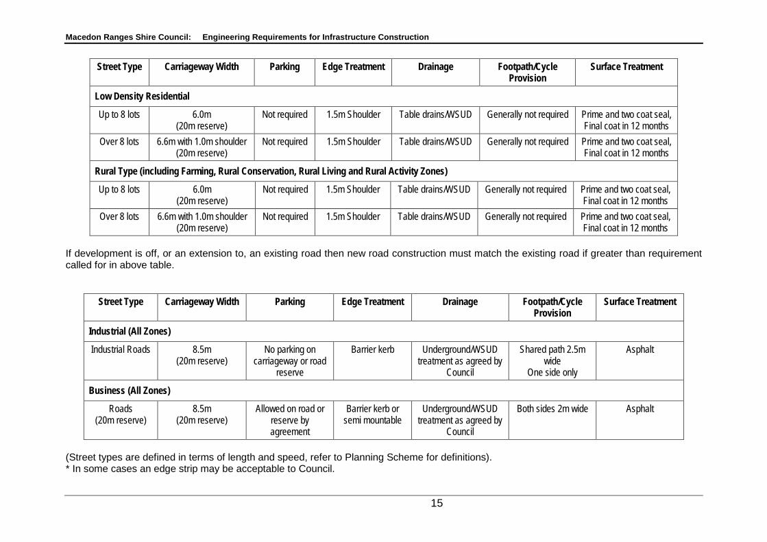
3.1.1 REQUIREMENTS 1. All roads are to be constructed in accordance with Council’s adopted
street designs outlined in the following tables:
Macedon Ranges Shire Council: Engineering Requirements for Infrastructure Construction
14
Street Type Carriageway Width Parking Edge Treatment* Drainage Footpath /Cycle Provision
Surface Treatment
Residential 1 /Township Access Lane Not Applicable Not Applicable Not Applicable Not Applicable Not Applicable Not Applicable
Access Place – up to 5 lots 5.5m (16m reserve)
1 space/lot off carriageway
Semi mountable kerb & channel
Underground/WSUD treatment as agreed by
Council
Carriageway to be designed as shared zone
and signed
Asphalt / concrete
combinations. Access Place – 6 to 20 lots 6.6m
(18m reserve) Carriageway – one
side only Semi mountable kerb
& channel Underground/WSUD
treatment as agreed by Council
One side only – 1.5m wide
Cycle no provision
Asphalt / concrete
combinations.
Access Street – Level 1 – 21 to 50 lots
6.6m (20m reserve)
Carriageway – one side only
Semi mountable kerb & channel
Underground/WSUD treatment as agreed by
Council
Both sides – 1.5m wide
Cycle on carriageway with signage
Asphalt
Access Street – Level 2 – 51 to 100 lots
7.3m (20m reserve)
Carriageway – both sides
Semi mountable kerb & channel
Underground/WSUD treatment as agreed by
Council
Both sides – 1.5m wide
Cycle on carriageway with signage
Asphalt
Connector Street – Level 1 – 101 to 200 lots
6.6m (8.5m for bus routes) (24m reserve)
7.2 – 7.5 m if parking on both sides of carriageway
1 space/lot off carriageway (off
carriageway for bus routes)
Barrier kerb or semi mountable
Underground/WSUD treatment as agreed by
Council
Both sides – 2.5m shared path.
Asphalt
Connector Street – Level 2 – greater than 201 lots
6.6m (8.5m for bus routes) (24m reserve)
7.2 – 7.5 m if parking on both sides of carriageway
1 space/lot off carriageway (off
carriageway for bus routes)
Barrier kerb or semi mountable
Underground/WSUD treatment as agreed by
Council
Both sides – 2.5m shared path.
Asphalt
If development is off, or an extension to, an existing road then new road construction must match the existing road if greater than requirement called for in above table.
Macedon Ranges Shire Council: Engineering Requirements for Infrastructure Construction
15
Street Type Carriageway Width Parking Edge Treatment Drainage Footpath/Cycle Provision
Surface Treatment
Low Density Residential
Up to 8 lots 6.0m (20m reserve)
Not required 1.5m Shoulder Table drains/WSUD Generally not required Prime and two coat seal, Final coat in 12 months
Over 8 lots 6.6m with 1.0m shoulder (20m reserve)
Not required 1.5m Shoulder Table drains/WSUD Generally not required Prime and two coat seal, Final coat in 12 months
Rural Type (including Farming, Rural Conservation, Rural Living and Rural Activity Zones)
Up to 8 lots 6.0m (20m reserve)
Not required 1.5m Shoulder Table drains/WSUD Generally not required Prime and two coat seal, Final coat in 12 months
Over 8 lots 6.6m with 1.0m shoulder (20m reserve)
Not required 1.5m Shoulder Table drains/WSUD Generally not required Prime and two coat seal, Final coat in 12 months
If development is off, or an extension to, an existing road then new road construction must match the existing road if greater than requirement called for in above table.
Street Type Carriageway Width Parking Edge Treatment Drainage Footpath/Cycle Provision
Surface Treatment
Industrial (All Zones)
Industrial Roads 8.5m (20m reserve)
No parking on carriageway or road
reserve
Barrier kerb Underground/WSUD treatment as agreed by
Council
Shared path 2.5m wide
One side only
Asphalt
Business (All Zones)
Roads (20m reserve)
8.5m (20m reserve)
Allowed on road or reserve by agreement
Barrier kerb or semi mountable
Underground/WSUD treatment as agreed by
Council
Both sides 2m wide Asphalt
(Street types are defined in terms of length and speed, refer to Planning Scheme for definitions). * In some cases an edge strip may be acceptable to Council.
Macedon Ranges Shire Council: Engineering Requirements for Infrastructure Construction
16
3.1.1 REQUIREMENTS CONTINUED: 2. If the applicant is proposing a water sensitive design for drainage then the
Reserves nominated must be increased in width by 2m. 3. Grades.
The desirable maximum grades, listed below, are to be considered the maximum for normal design purposes.
Desirable Maximum Longitudinal
Where the topography makes it difficult to provide a road location which will conform to these grades, grades up to those shown as "Absolute Maximum" may be considered. In extreme cases, the Council may give approval to the use of grades steeper than "Absolute Maximum" values, but such approval will only be given when all other possible alternatives have been fully investigated, and proven to be impracticable.
DESIRABLE ABSOLUTE MAXIMUM MAXIMUM
Residential Access 10% 16%
Collector 8% 12% Trunk Collector 6% 10%
Commercial & Industrial Access 6% 10%
Trunk Collector 6% 8% Arterial
Frontage Access 6% 8% No Frontage Access 5% 7%
The minimum grades for all roads, based on kerb and channel drainage requirements, are
Minimum Grades
Desirable Minimum 1.0% Absolute Minimum 0.5%
The normal crossfalls of pavement and shoulders on straight alignment are- Crossfall
a. Asphaltic/Concrete surfaced pavements - 1 in 30 b. Bituminous Sealed Shoulders - 1 in 30 c. Gravelled Shoulders - 1 in 25 d. Gravel Roads - 1 in 20
Macedon Ranges Shire Council: Engineering Requirements for Infrastructure Construction
17
Footpaths are detailed in item 17 below.
Where steeper or flatter crossfalls than the normal are required, for example at intersections, or turning circles of cul-de-sacs, the maximum and minimum permissible pavement crossfalls are:-
Maximum and Minimum Crossfall
Maximum Crossfall Minimum Crossfall 1 in 15 1 in 40
4. Court bowls are to be provided in all residential developments where the cul-de-sac services greater than 5 lots and are to be asphalt or concrete in accordance with the approved plans. Court bowls are to be designed to accommodate a typical CFA fire Truck and a tandem drive Refuse Collection Truck as utilised in Council’s refuse collection. This is generally a minimum radius to kerb invert of 9.3m with a minimum 9m radius to the kerb approach. T-heads are not permitted in new subdivisions.
5. Industrial court bowls must be provided in all cul-de-sacs are to be in
accordance with turning circle (minimum 16m radius) for Refuse Collection Truck template. T-heads are not permitted.
6. Court bowls are not permitted on the low side of the development without
provision of an overland drainage reserve sized to accommodate the 1 in 100 year overland flow path. 1:100 year underground drainage is not an acceptable treatment.
7. Road construction is to be designed following site investigation and by
reference to Austroads Pavement Design manual. As a minimum however a two layer asphalt surface treatment (40mm/20mm) is to be adopted with the top layer installed at completion of the defects liability period or at any earlier time as may be agreed or determined by Council.
8. The intersection of all internal roads with existing roads are to be located such
that minimum sight distances can be achieved as required in Austroads Guide to Traffic Engineering Practice part 5 Intersection at Grade. A sealed left turning lane and a sealed bypass lane are to be constructed at these intersections, if required by Council, to the requirements of the above reference, or when specified in the Planning Permit, prior to the issuing of a Statement of Compliance.
9. Sight distances as required in the Austroads guide are required for all
driveway access points. Driveways maximum grade is 1 in 4 (residential) & 1 in 6 (industrial).
10. Roundabouts are to be designed according to Austroads Handbook –
Roundabouts (part 6) for the anticipated traffic profile.
Macedon Ranges Shire Council: Engineering Requirements for Infrastructure Construction
18
11. Where a road temporarily terminates a distance greater than 30m or one lot,
whichever is less, beyond an intersection, provision is to be made for the turning of vehicles including refuse collection trucks by providing a temporary area. Fencing to be provided to prevent access to private land.
12. Where a road continues into a future stage or development the vertical grade
line is to be designed for a distance of 100m beyond the end of construction. Where a road is constructed as an extension of a previous stage or development the design vertical grade line is to match that of the previous construction for a minimum distance of 100m.
13. All lots are to be provided with one (1) fully constructed vehicle crossing in
accordance with Council’s standard drawings. Vehicle crossings are to be a minimum of 10 metres from any intersection property line, 3 metres from any tree and 1 metre from any service pit. Where new crossings or crossings that accommodate a change of use connect to a sealed road in all zones other than Rural then a sealed crossing to Macedon Ranges Shire Council approval will be required. For rural subdivisions or lots that require a new crossing then the requirement to seal the crossing will be subject to consideration of neighbourhood character, road speed, sightlines, accessibility and safety concerns. Vehicle crossings to be a minimum of 1.5m, from property boundary. Vehicle crossings to be a minimum of 12m apart. Double driveways are not to be used except in exceptional circumstances.
14. Vehicle access ways to properties at rear of existing lots are to be of sealed
construction for 6m before and past the footprint of the existing dwelling. 15. The extent of all cut and fill is to be shown on all lots on construction plans. 16. Prior to Council approving any water main locations, the consultant is to
provide proof of CFA approval of hydrant types and locations. Fence and road pavement markers are to be provided, as appropriate, for all hydrants.
17. Footpaths 1.5 m wide and Pram crossings are to be designed in accordance
with Council’s Standard Drawings. All footpaths located within parks and reserves are to be a minimum 125mm thick and 2.5m wide. The design of all footpaths (including the gradients from footpath to roads via ramps) must comply with AS1428 (2003) Design for Access and Mobility Set and the Disability Discrimination Act. Shared paths must be 2.5m wide.
18. Permanent Survey Marks (PSM’s) are to be provided at a maximum spacing
of 200 metres in urban subdivisions and at least two PSM’s are to be provided in rural subdivisions to the approval of Council. The PSM is to be provided with a vertical level to AHD and horizontal co-ordinates to AMG. The PSM is to be registered and a copy of the sketch plan forwarded to Council.
19. Utility services locations must be as set out by the Street Works Code of
Practice, Victoria. Services under roadways and traffic areas must be backfilled with 3% cement stabilised crushed rock.
Macedon Ranges Shire Council: Engineering Requirements for Infrastructure Construction
19
20.
a. Services within Nature strip/Roadside Verges
Installation or Replacement of Utility Infrastructure within Road Reserves
Underground services outside carriageways shall be parallel or at right angles to the carriageway and shall have a minimum cover of 600 mm (including under existing open drains) other than stormwater drains connected to the back of kerb. All high voltage underground electrical transmission cables shall have minimum cover of 750 mm where protected (cable in conduit) and 1000 mm where unprotected. Marking tape shall be located above all cables with wording “HIGH VOLTAGE WIRES” or similar.
b. Services Under Roads Crossings for conduits are to be made square to the road centreline and by boring from openings made outside the carriageway wherever practical. Where pipelines or carrier-conduits greater than 75 mm in diameter are to be placed under carriageways, the cover from the top of the pipe or carrier-conduit to the pavement surface shall be not less than 1000 mm and to the invert level of open drains shall not be less than 750 mm. Where pipelines or carrier-conduits less than 75 mm in diameter are placed under carriageways, the cover from the top of the pipe or carrier-conduit to the pavement surface, shall be not less than 600 mm. Where there is conflict with other services, adjustment to the minimum depth may only be made after consultation with Council’s Manager Infrastructure and Assets.
c. Open Cut of Roads Where it is not practical to bore under the road approval must be obtained before open cut can proceed. The crossing is to be straight. All bituminous, asphalt and concrete surfaces are to be saw cut when trenching is involved.
d. Boring Under Carriageways Unless otherwise specified, boring by water jetting will not be
If any damage to Council’s assets is occasioned by the use of soil displacement hammers it shall be made good by the Service Authority/Contractor to the satisfaction of Council.
permitted.
Unless otherwise specified, the annulus between the bore and the pipe or conduit-carrier of diameter greater than 75mm, shall be backfilled by pressure grouting.
21. All new electricity supply must be installed underground (high and low
voltage) in the following situations: a. Subdivisions that require the construction of internal roads. b. From the property boundary to the dwelling location.
Macedon Ranges Shire Council: Engineering Requirements for Infrastructure Construction
20
for the following zones: • Residential • Low Density Residential • Industrial • Business
All new lots within other zones must be serviced by underground electricity supply as a minimum from the property boundary to the dwelling location.
18.
Multiunit developments must be designed incorporating waste storage and pick up facilities satisfactory to Council and generally in accordance with Best Practice Guidelines for Kerbside Recycling for Residential Developments.
Multiunit Developments
3.2 DRAINAGE 1. All lots under 2ha in area are to be provided with a legal point of discharge
located at the low point of the block. On lots greater than 2ha, a building envelope is to be provided such that drainage is not concentrated onto adjoining lots, or the lot is to be provided with a legal point of discharge approved by the Responsible Authority. All new drainage is to be connected into Council’s or other authorities existing drainage network.
2. The subdivision is to be provided with an underground drainage system to a
design approved by the Responsible Authority and such that: a) the subdivision as a whole is provided with a legal point of discharge
approved by the Responsible Authority and any other statutory authority from which approval must be received for the discharge of drainage;
b) all drainage courses within the subdivision must pass through easements shown on the plan of subdivision. The easements must be registered at the Land Titles Office prior to the issue of a Statement of Compliance;
c) all drainage courses or outfall drainage lines required to provide a legal point of discharge and which pass through lands other than those within the boundaries of the subdivision must be constructed at the cost of the applicant and the applicant must secure adequate easements for such drainage to be constructed within. Such easements as required must be registered at the Land Titles Office prior to the issue of a Statement of Compliance for the subdivision;
d) all underground drainage is to be designed to 1:10 year capacity using rainfall intensity charts for the area;
e) the volume of water discharging from the subdivision in a 10% AEP storm must not exceed the peak flow experienced in a 10% AEP storm prior to development. The peak flow must be controlled by the use of retardation basins or approved retardation systems located on the subject site to the requirements and satisfaction of the Responsible Authority. The
Macedon Ranges Shire Council: Engineering Requirements for Infrastructure Construction
21
retardation system is to be designed such that it can cater for a 1:100 year storm (1% AEP). Council has a preference for control devices such as multicell and OSD4 for determination of retardation basin capacities. Council may waive a requirement for detention dependent on the location in the catchment and the subdivision is 3 lots or less and providing a financial contribution equivalent of the cost of a detention system is paid to Council;
f) retarding basins shall have a 1:8 batter, with 1:5 absolute maximum. Steeper batters may be considered if the basin is fenced;
g) the flow paths of a 1% AEP storm need to be determined and the subdivision designed such that no private property is inundated by this storm. These flow paths must be indicated on the plans and confined to roadways and reserves. Freeboard is as required by the drainage authority;
h) private lots will not be permitted downstream of low points in roadways, downhill court bowls, or other locations where flows may concentrate;
i) the drainage system must have provision for runoff from the upstream catchment and include for any downstream works necessary to manage flows from the development;
j) flow in pipes must be in the range 0.9 m/s to 5.5 m/s with grades not less than 1 in 300.
3. Open drains may be provided in easements in Low Density Residential/Rural
Living and Rural type developments subject to approval. The provision of environmental water sensitive design may also be allowed subject to design approval. Where lot sizes are less than 1 ha drainage must be underground. For lots in excess of 1 ha open drains will not be permitted if the length of the open drain exceeds five lots or the grade of fall exceeds 8%.
4. Macedon Ranges Shire Council will not permit a pumped drainage system for
stormwater drainage to more than two dwellings on a lot and only if a gravity system is not possible. For lots in excess of two dwellings the nominated legal point of discharge must be serviced by a gravity drainage system. The applicant is responsible for obtaining the necessary easements to provide the route for the outfall drain. For two dwellings or less a dual pumped system that complies with AS3500.3.2 may be permitted. Any solution must address the consequences of pump failure and ensure no properties are inundated. A pumped solution is regarded as a temporary solution and owners will be required to have registered on title a 173 Agreement that binds them to contribute to any Special Charge Scheme for the provision of drainage in the area, should this be undertaken in future.
Pumped Stormwater Systems
5. Pit lid inserts rated as 60kN are to be circular as nominated on the Macedon
Ranges Shire Council standard drawings. 6. No drainage pits are to be smaller than 600x 900mm internal and must be of
concrete construction.
Macedon Ranges Shire Council: Engineering Requirements for Infrastructure Construction
22
7. The minimum pipe diameters must be 300mm in easements and in road
reserves. If the pipe services only one residential property then 150 mm is permitted provided there is no possibility of this pipe being required to service additional properties in future developments.
8. The minimum cover to pipes must be 300mm in easements and 500mm in
road reserves. 9. Pipes to be RRJ and of reinforced concrete construction. The class of pipe
must be appropriate for its use. Curved pipes are not permitted. 10. The provision of rain water tanks is supported on environmental grounds.
Council will not however include the volume of any rain water tank in determining the on site detention volume required to provide for retardation back to predevelopment flows other than for developments of 3 lots or less when part detention of 1/3 of the total is mandatory can be provided by rainwater tanks.
11. As the shire is covered by more than one drainage authority the applicant is to
determine the drainage catchment authority for catchments above 60 ha and gain approval for the stormwater design as necessary.
12. Water Sensitive Urban Design stormwater treatment is to be included in all
stormwater design to the approval of Macedon Ranges Shire Council or other relevant authority. MUSIC software must be used to validate the removal of nitrogen, phosphorous and suspended solids as nominated by best practice guidelines.
13. Sub-soil drainage is to be provided by means of agricultural drains placed
immediately at the back of kerb. The drainage trench must be backfilled with 20mm size "Blue Stone Screenings". Scoria screenings are not permitted. Sub-soil drainage must also be provided at the interface of a widening on an existing road. The drainage trench in this instance must be backfilled using "No Fines Concrete". The pipe for agricultural drains must be 100mm corrugated PVC Class 400. Class 1000 pipe is to be used under trafficable areas with "No Fines Concrete" backfill. The pipes must discharge into pits at a level above the highest invert and any stormwater pipe open to the pit where possible.
14. Drainage under roadways and traffic areas shall be backfilled with 3% cement
stabilised crushed rock. 15. Drainage is to be provided at property boundary that directs water away from
roads. 16. Where infill multiunit developments occur then the onsite detention must be
designed on the basis of capacity of the existing drainage if this is less than the predevelopment flow.
Macedon Ranges Shire Council: Engineering Requirements for Infrastructure Construction
23
3.3 LANDSCAPING Macedon Ranges Council requires the design of all development proposals to be responsive to the particular topography, landscape and existing vegetation and features. Designers are encouraged to recognise the landscape forms (water ways, existing vegetation, etc.) by integrating them in their design.
3.3.1 GENERAL REQUIREMENTS 1. Existing Street Trees
The construction Management Plan must show: (i) A construction access plan that shows the path that is to be taken by all
vehicles that will be accessing the site during the construction works and all street trees in the road reserve that have any part of their drip line within 10 metres of these construction paths.
(ii) Recommendations prepared by a qualified arborist for how the street trees recognised on the "construction access plan" will be protected during construction works and reinstated to their former condition thereafter.
(iii) A calculation of compensation prepared in accordance with the formula set down in Council's "Street Tree Policy 2008 (as amended)" that will be paid by the owner as a cash contribution to the Macedon Ranges Shire Council in the event that any of the street trees recognized on the "construction access plan" are damaged or destroyed as a result of any construction works. All compensation provided for through this condition is to be paid within 14 days of a written request being made by the Macedon Ranges Shire Council.
(iv) A stipulation that any lopping of trees in the road reserve that must be undertaken as part of the development will be carried by the responsible authority at the expense of the owner.
2. The landscaping plan shall comply with the Macedon Ranges Shire Council
Street Tree Policy. In particular species chosen must be appropriate for the climate and soil conditions. It is the responsibility of the landscape architect to ensure that any tree planting which occurs under services or over services, if any, is clearly shown on the landscape plan and that the type of species chosen will not have any detrimental effect on the services above or below ground.
3. Plans that demonstrate compliance with Guidelines for Residential
Subdivision in the Macedon Ranges Shire: Designing in Health & Wellbeing is encouraged. Plant trees that will provide maximum shade over paths.
4. Landscaping is to be completed coincident with the civil works unless
inappropriate because of weather conditions or the season. If deferred a Bond may be required at 200% of the value of the works.
Macedon Ranges Shire Council: Engineering Requirements for Infrastructure Construction
24
5. Advanced trees with a minimum height of 2.5 to 3m height are to be provided
and maintained for 12 months from date of planting and replaced as needed in that time. Ensure tree foliage is trimmed up to an overhead clearance of 2000mm above ground level (refer AS1428.1).
6. All trees to have two water tubes installed and mulched. 7. All landscaping to be maintained for a period of 24 months including broad
leaf weed control. 8. All plants to be staked and adequately secured against damage. 9. Landscape plans to be prepared by a qualified landscape engineer/architect. 10. Grass seed to be chosen that has a low maintenance requirement (water
consumption and mowing). 11. No CCA treated timber is to be used in any landscaping or play ground
equipment. 12. Reticulated water supply is to be provided in a pit in each reserve. 13. No permanent structures identifying estates will be permitted on road
reserves. Temporary structures may be permitted for the purposes of marketing the estate for a period not exceeding 5 years from approval of engineering plans. A bond to 200% of the cost of the temporary works is to be lodged prior to Compliance. This will be returned when the works are removed and the area made good.
14. Any entry planting including median and roundabout planting must be capable
of surviving without a reticulated irrigation system. 15. All playgrounds and play equipment to conform to Australian Standards and
Council Playground Strategy 2009-2014. Council has a preference for non timber equipment.
16. All landscape designs to ensure no trees are planted in easements or swale
drains that may inhibit water flow in drains. 17. Paths through Council reserves to be designed to be sympathetic with the
neighbourhood character and facilitate disabled access. 18. Fencing to be designed for a minimum life of 10 years. Fencing not to exceed
2m in height. 19. Street Furniture must be shown on the Landscape Plans and show as
required signage, seating, bins and park furniture to Council requirements. Location of furniture must comply with recommended distances from roads and other hazards.
Proposed landscape plans to be provided with preliminary engineering plans to enable an integrated response.
Macedon Ranges Shire Council: Engineering Requirements for Infrastructure Construction
25
3.4 STREET LIGHTING Street lighting shall be provided in the following circumstances.
Planning Zoning
Location Comments
Intersection Court bowl Street Residential Zones
Yes Yes Yes Street Lighting may not be required if in conflict with neighbourhood character
Low Density Residential
By Agreement By Agreement Not Required
Township Yes Yes Yes Street Lighting may not be required if in conflict with neighbourhood character
Industrial Zones Yes Yes By Agreement
Business Zones Yes Yes Yes
Rural Not Required Not Required Not Required
Environmental Living
Not Required Not Required Not Required
Rural Living Not Required Not Required Not Required
Other By Agreement By Agreement By Agreement
The above may be varied or the requirement deleted on application by the developer to the Council where it can be demonstrated that the outcome respects the neighbourhood character of the area or is required to satisfy traffic safety issues. The installation of street lighting shall meet Australian Standards. The type of lighting is restricted to:
• Standard Powercor approved street light styles or
• The following non-standard lights can be installed by the developer where it can be demonstrated that the outcome respects the neighbourhood character of the area. o Lanterns:
o Poles: Sherwood (Hawthorn Green) Shearwater (Dark Grey)
AND the developer is to make a contribution to Council to the value of one street light lantern and pole for every ten poles installed or part thereof.
Macedon Ranges Shire Council: Engineering Requirements for Infrastructure Construction
26
• 150W HPS lights on extended arms should be provided at any intersection with Link roads as defined in Council's Road Management Plan and Road Register.
• Any lighting on declared Arterial Roads shall be negotiated with VicRoads. Council, at this time, will not accept responsibility for operating costs associated with new Arterial Road lighting unless in accordance with previous agreements.
Macedon Ranges Shire Council: Engineering Requirements for Infrastructure Construction
27
4. DEVELOPER CONTRIBUTIONS TO INFRASTRUCTURE AND COMMUNITY INFRASTRUCTURE LEVY
All new developments generate a requirement for infrastructure in the form of roads/road upgrades and drainage. In addition the occupants of any new development have to be serviced by infrastructure such as child care, schools, health centres, refuse collection. To fund these and similar services Council requires all developments to contribute to infrastructure works. 4.1 COMMUNITY INFRASTRUCTURE POLICY The Government has legislated for Councils to levy on all developments, a fee for the provision of buildings and facilities used for community or social purposes. This levy is set by the State Government and is currently lapsed and not being applied. 4.2 PROPERTY OWNER CONTRIBUTIONS TOWARDS ROAD AND
FOOTPATH CONSTRUCTION IN UNCONSTRUCTED OR PARTIALLY CONSTRUCTED ROAD RESERVES
Introduction Throughout the Shire there are many road reserves that remain unconstructed. They do not form part of the traffic network within the Shire and are not included on the road register and may remain unconstructed for many years. Developers and others may seek to undertake development along these road reserves creating the need for these roads to be constructed to provide access to the properties being developed. These developments may be in the form of a subdivision, commercial development (e.g. winery) or simply the construction of a dwelling. Council has determined that it is appropriate that when an application is made to undertake a development that requires access from an unconstructed road reserve or partially constructed road that a contribution is made towards the construction of that road including all infrastructure, as shown in the tables in Section 3. Where a development occurs that will contribute more then 100 vehicles per day (vpd) to the road network, it is considered that the development is of sufficient size to warrant a traffic study. The results of the traffic study will be used to determine the most appropriate road upgrade requirements. The planning permit when issued will include the outcome of the traffic study including the specification of the road construction required to be undertaken by the developer. In most cases where the development contributes less then 100vpd it is considered more practical to apply a standard set of conditions, however a traffic study may still be necessary to adequately address local issues.
Macedon Ranges Shire Council: Engineering Requirements for Infrastructure Construction
28
Implementation When a permit is granted for a development (generally generating less than 100 vpd) in an unconstructed or partially constructed road reserve then the permit conditions shall provide for the following: A. That if the unconstructed road or partially constructed road is maintained by
Council then no contribution other than that outlined in condition C8 and as limited by condition C9 is required.
B. When no traffic report is required and no other development is accessing the
road conditions 1 to 5 apply.
1. All properties developed shall be required to provide all weather access to the property entrance.
2. A permit to remove vegetation shall be obtained if the planning scheme requires.
3. The minimum pavement construction for an unconstructed road shall be a 4m wide pavement plus shoulders of approved road pavement material of sufficient depth to provide all weather access for the traffic expected, with associated drainage as required. The depth of formation shall be approved by the responsible authority after inspection and/or submission of geotechnical soil tests.
4. Where the length of the access road is greater then 200m, passing bays are to be provided as required in the CFA document “Planning Conditions and Guidelines for Subdivisions” September 1991. This document requires that a 20m long passing bay with a combined width of 6m be provided every 200m.
5. That the maintenance of the road remains the responsibility of the land owner unless declared as a public road in accordance with the Road Management Plan.
C. When no traffic report is required and the road is in use by more than one
development.
1. That where the development increases the expected traffic by 10 vpd or multiples thereof an additional 50mm of pavement material be added to the existing pavement for each 10vpd. This is to be provided from the Council maintained road to the property access. If the property access is beyond the existing construction then this section is to be constructed to the standard in condition B3 above.
2. 2. That the maintenance of the road remains the responsibility of the landowner unless declared a public road in accordance with the Road Management Plan.
3. Where greater than three properties are developed along the road that has been constructed, or the total traffic volume made up of existing traffic volume and predicted traffic volume generated by the development
Macedon Ranges Shire Council: Engineering Requirements for Infrastructure Construction
29
exceeds 30vpd, the subsequent developers shall be required to make a cash contribution to Council for the subsequent sealing of the road and/or, as required, the widening of the road to 6m in width. This construction is to be undertaken at a time at the Council discretion consistent with the Council forward works programme. Roads are to be widened and sealed from the nearest existing Council maintained road to the development to a maximum value of $8,270 per additional 10vpd added to the road network. The value of $8,270 shall be reviewed annually and adjusted by the CPI for Victoria. For the purpose of this policy one residential lot is considered to generate equivalent to 10vpd.
4. When the road has been upgraded to a 6.6m sealed condition by Council or sufficient funds have been received to fund 100% of the costs of the upgrade no further contribution will be required.
4.3 SPECIAL CHARGE SCHEMES FOR INFRASTRUCTURE WORKS. This Council policy is available on Council’s website and requires a developer to contribute to the construction of infrastructure to support the development. 4.4 DEVELOPMENT CONTRIBUTION PLANS This contribution differs from the Community Infrastructure Policy contribution in that it is specifically for development infrastructure within the area.