POLYGON WEATHER WARNINGS – POLYGON WEATHER WARNINGS – A NEW APPROACH A NEW APPROACH FOR THE NATIONAL WEATHER SERVICE FOR THE NATIONAL WEATHER SERVICE Ken Waters Ken Waters National Weather Service, Honolulu National Weather Service, Honolulu HI HI May 17, 2005 May 17, 2005 Public Service Meeting – Park City, UT Public Service Meeting – Park City, UT
Transcript
POLYGON WEATHER WARNINGS – POLYGON WEATHER WARNINGS – A NEW APPROACHA NEW APPROACH
FOR THE NATIONAL WEATHER SERVICE FOR THE NATIONAL WEATHER SERVICE
Ken WatersKen WatersNational Weather Service, Honolulu HINational Weather Service, Honolulu HI
May 17, 2005May 17, 2005Public Service Meeting – Park City, UTPublic Service Meeting – Park City, UT
Ken Waters, NWS Pacific RegionKen Waters, NWS Pacific Region
BackgroundBackground
National Weather Service issues four types of short-fused warnings:• Tornado Warnings (TOR)• Severe Thunderstorm Warnings (SVR)• Flash Flood Warnings (FFW)• Special Marine Warnings (SMW)
Issued normally for one county at a time• Can lead to a large false-alarm area, especially in the
case of large or irregular-sized counties Verification has been strictly county-based Legacy dissemination methods all tied to counties:
• NOAA All-Hazards/Weather Radio Uses SAME alert code based on counties
• Internet displays – again, based on counties
Ken Waters, NWS Pacific RegionKen Waters, NWS Pacific Region
WARNGENWARNGEN
• Allows forecaster to Allows forecaster to graphically highlight the graphically highlight the area of greatest threatarea of greatest threat
• Creates a template text Creates a template text product for the warning, product for the warning, including proper headers, including proper headers, issue/expiration times, issue/expiration times, county UGC codescounty UGC codes
• ALSO: includes ALSO: includes latitude/longitude vertex latitude/longitude vertex points for the pathcast, or points for the pathcast, or polygon warning --- LITTLE polygon warning --- LITTLE USED by NWS, partners, USED by NWS, partners, and publicand public
Ken Waters, NWS Pacific RegionKen Waters, NWS Pacific Region
Using GIS with Polygon WarningsUsing GIS with Polygon Warnings
Polygon vertices well-suited to include in GISPolygon vertices well-suited to include in GIS Mechanism was established to strip off the lat-Mechanism was established to strip off the lat-
long polygon information, database the long polygon information, database the polygons, and create real-time GIS shapefilespolygons, and create real-time GIS shapefiles
Using only open source (“freeware”) softwareUsing only open source (“freeware”) software• Code written in PerlCode written in Perl• Polygon values formatted in ESRI “gen” formatPolygon values formatted in ESRI “gen” format• Use “gen2shp” and “txt2dbf” packagesUse “gen2shp” and “txt2dbf” packages
Ken Waters, NWS Pacific RegionKen Waters, NWS Pacific Region
County vs. PolygonCounty vs. Polygon
Latitude/Longitude points at the bottom of all TORs, SVRs, Latitude/Longitude points at the bottom of all TORs, SVRs, FFWs, and SMWs.FFWs, and SMWs.
Ken Waters, NWS Pacific RegionKen Waters, NWS Pacific Region
Polygon AdvantagesPolygon Advantages
Shows specifically where the threat isShows specifically where the threat is More accurately shows warning area on systems displaying More accurately shows warning area on systems displaying
warnings graphicallywarnings graphically Reduction of risk area to publicReduction of risk area to public Better graphical description capabilitiesBetter graphical description capabilities Wider local distribution via cell phones, PDAs, etc.Wider local distribution via cell phones, PDAs, etc. Increase NWS role in the confirmation part of the warning processIncrease NWS role in the confirmation part of the warning process Private sector starting to turn to polygonsPrivate sector starting to turn to polygons Allows NWS to refine warnings to true threat areaAllows NWS to refine warnings to true threat area Allows us to track and set goals for false alarm areaAllows us to track and set goals for false alarm area Better warning qualityBetter warning quality Keeps NWS in technological stepKeeps NWS in technological step
Ken Waters, NWS Pacific RegionKen Waters, NWS Pacific Region
Ken Waters, NWS Pacific RegionKen Waters, NWS Pacific Region
NWS Identifies a NeedNWS Identifies a Need
Feb. 2004: Regions meet to study this issueFeb. 2004: Regions meet to study this issue Mar. 2004: Meeting Information presented to MSD ChiefsMar. 2004: Meeting Information presented to MSD Chiefs Apr. 2004: Gen. Johnson asks PR Regional Director Jeff Apr. 2004: Gen. Johnson asks PR Regional Director Jeff
LaDouce to commission a polygon warning teamLaDouce to commission a polygon warning team June 2004: Meeting information presented to Ops June 2004: Meeting information presented to Ops
Committee Committee June 2004: Polygon Team CharteredJune 2004: Polygon Team Chartered Aug. 2004: First formal Polygon Team MeetingAug. 2004: First formal Polygon Team Meeting Sept. 2004: Verification Scoring Sub-team LaunchedSept. 2004: Verification Scoring Sub-team Launched Jan. 2005: AMS PresentationJan. 2005: AMS Presentation Mar. 2005: Prototype Test StartedMar. 2005: Prototype Test Started
Ken Waters, NWS Pacific RegionKen Waters, NWS Pacific Region
Team MembersTeam Members
Mike Looney, CRH (facilitator)Mike Looney, CRH (facilitator) Mike Coyne, SRH Mike Coyne, SRH Steve Naglic, WCM WFO Columbia SC (ER)Steve Naglic, WCM WFO Columbia SC (ER) Pete Wolf, SOO WFO Wichita, KS (CR)Pete Wolf, SOO WFO Wichita, KS (CR) Jeff Lorens, WRHJeff Lorens, WRH Brent McAloney (OCWWS)Brent McAloney (OCWWS) Rich Okulski (OCWWS)Rich Okulski (OCWWS) Noreen Schwein, CRH (Hydrology)Noreen Schwein, CRH (Hydrology) Joe Shaffer, SPCJoe Shaffer, SPC Ken Waters, PRHKen Waters, PRH
Ken Waters, NWS Pacific RegionKen Waters, NWS Pacific Region
Prototype TestPrototype Test
Ken Waters, NWS Pacific RegionKen Waters, NWS Pacific Region
Jackson MS Apr 5-7Jackson MS Apr 5-7“Trial by fire”“Trial by fire”
Ken Waters, NWS Pacific RegionKen Waters, NWS Pacific Region
And now, some examples, And now, some examples, using 2004 warningsusing 2004 warnings
Ken Waters, NWS Pacific RegionKen Waters, NWS Pacific Region
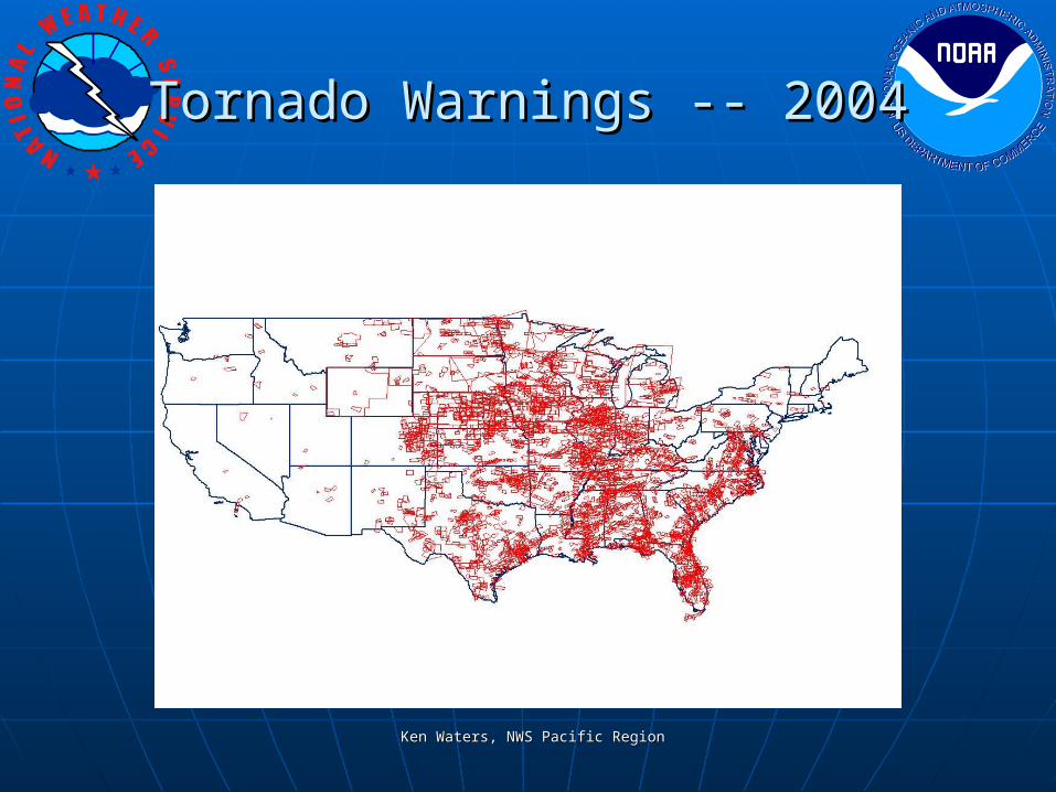
Tornado Warnings -- 2004Tornado Warnings -- 2004
Ken Waters, NWS Pacific RegionKen Waters, NWS Pacific Region
Ken Waters, NWS Pacific RegionKen Waters, NWS Pacific Region
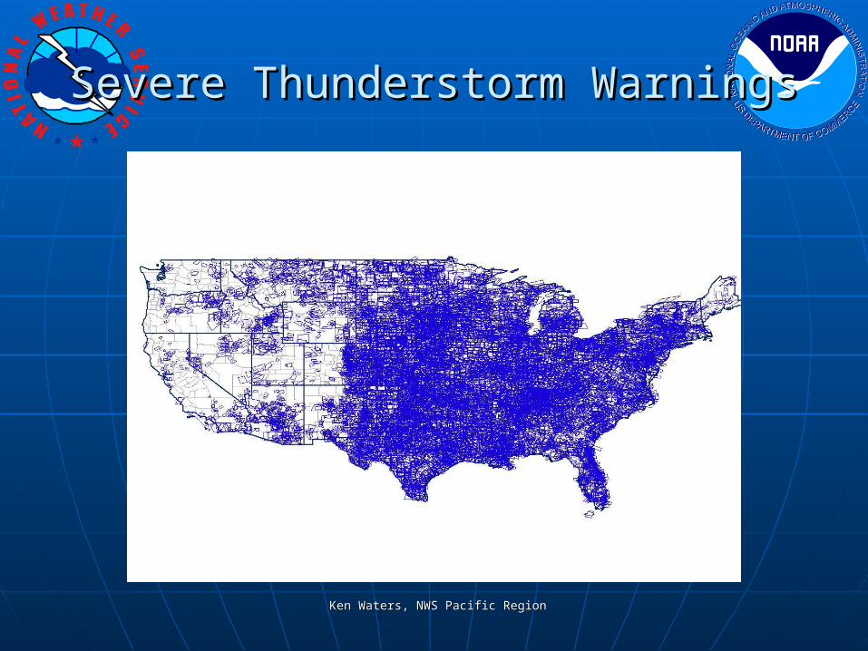
Severe Thunderstorm WarningsSevere Thunderstorm Warnings
Ken Waters, NWS Pacific RegionKen Waters, NWS Pacific Region
Severe Thunderstorm WarningsSevere Thunderstorm Warnings
Ken Waters, NWS Pacific RegionKen Waters, NWS Pacific Region
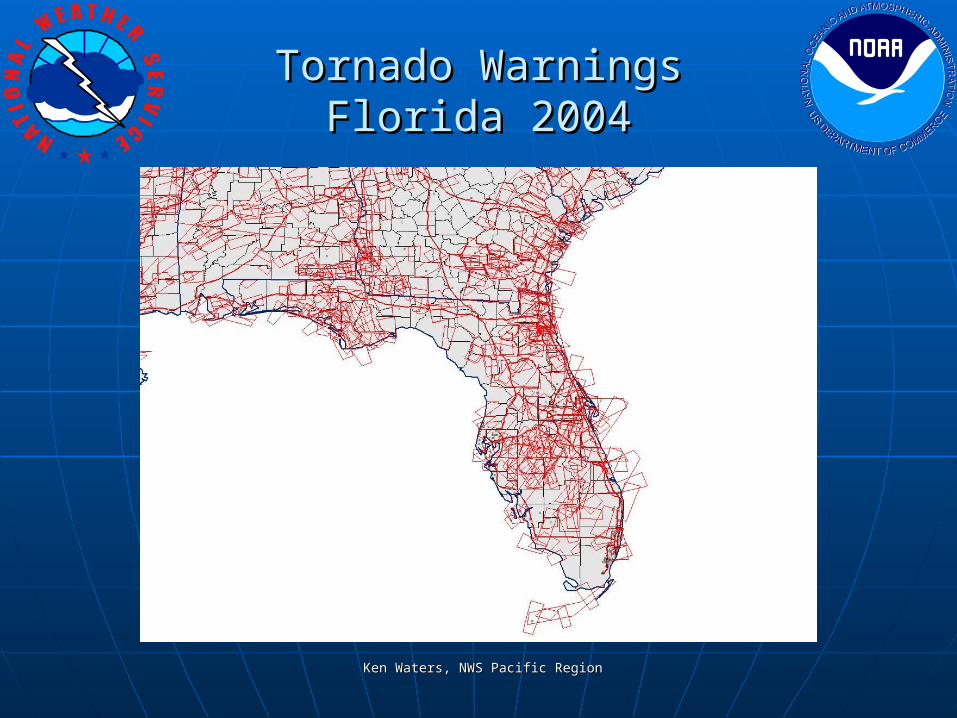
Tendency to align warnings to county Tendency to align warnings to county borders continued in 2004borders continued in 2004
Ken Waters, NWS Pacific RegionKen Waters, NWS Pacific Region
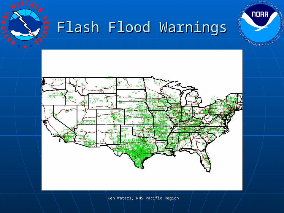
Flash Flood WarningsFlash Flood Warnings
Ken Waters, NWS Pacific RegionKen Waters, NWS Pacific Region
Special Marine WarningsSpecial Marine Warnings
Ken Waters, NWS Pacific RegionKen Waters, NWS Pacific Region
Flash Flood WarningsFlash Flood Warningsstill very “county-based”still very “county-based”
Ken Waters, NWS Pacific RegionKen Waters, NWS Pacific Region
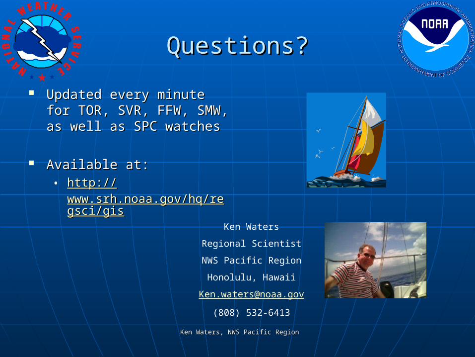
Applications For Viewing Applications For Viewing Polygon WarningsPolygon Warnings
CONUS map showing warnings, updated each CONUS map showing warnings, updated each minute: minute: http://www.prh.noaa.gov/regsci/gis/http://www.prh.noaa.gov/regsci/gis/
ArcIMS map service for historical viewing: ArcIMS map service for historical viewing: http://www.prh.noaa.gov/regsci/gis/http://www.prh.noaa.gov/regsci/gis/
Texas A&M Site (warnings + radar): Texas A&M Site (warnings + radar): http://www.prh.noaa.gov/regsci/gis/warn.htmlhttp://www.prh.noaa.gov/regsci/gis/warn.html
Ken Waters, NWS Pacific RegionKen Waters, NWS Pacific Region
The ChallengesThe Challenges
Internal to NWSInternal to NWS• Forecaster paradigm shift to focus on weather threatForecaster paradigm shift to focus on weather threat• Workload issues keeping track of warningsWorkload issues keeping track of warnings
Ensuring events don’t slip between nearly adjacent warningsEnsuring events don’t slip between nearly adjacent warnings• Verification measuresVerification measures
Changes to GPRA baselinesChanges to GPRA baselines Special verification issues (e.g., multiple warnings for same county)Special verification issues (e.g., multiple warnings for same county)
• SoftwareSoftware WARNGEN error -- periodically issues 2-point polygons well out of CWAWARNGEN error -- periodically issues 2-point polygons well out of CWA
External to NWSExternal to NWS• Dissemination!Dissemination!
Many TV Stations not prepared to display polygonsMany TV Stations not prepared to display polygons• Niche market for private sector (e.g., WeatherData)Niche market for private sector (e.g., WeatherData)
NOAA All-Hazards RadioNOAA All-Hazards Radio• Technical limitation: location is based only on countyTechnical limitation: location is based only on county• New generation of NWR needs to allow users to input either lat/long or nearest city New generation of NWR needs to allow users to input either lat/long or nearest city
to take advantage of polygon technologyto take advantage of polygon technology
Ken Waters, NWS Pacific RegionKen Waters, NWS Pacific Region
Questions?Questions?
Updated every minute for Updated every minute for TOR, SVR, FFW, SMW, as TOR, SVR, FFW, SMW, as well as SPC watcheswell as SPC watches