Port Assessment Ponce, Guayanilla, Yabucoa, and Las Mareas Port of Ponce, Guayanilla, Yabucoa, and Las Mareas, Puerto Rico, After Action Report Introduction. A Port Risk Assessment was conducted for the port of Ponce, Guayanilla, Yabucoa, and Las Mareas, Puerto Rico (South Central Puerto Rico) 9 – 10 February 2000. This report will provide the following information: • • • • Brief description of the process used for the assessment; List of participants; Numerical results from the Analytical Hierarchy Process (AHP); and Summary of risks and mitigations discussion. Follow-on strategies to develop and implement unmitigated risks will be the subject of a separate report. Process. The risk assessment process is a disciplined approach to obtaining expert judgements on the level of waterway risk. The process also addresses the relative merit of specific types of Vessel Traffic Management (VTM) improvements for reducing risk in the port. Based on the Analytic Hierarchy Process (AHP) 1 , the port risk assessment process involves convening a select group of expert/stakeholders in each port and conducting structured workshops to evaluate waterway risk factors and the effectiveness of various VTM improvements. The process requires the participation of local Coast Guard officials before and throughout the workshops. Identification of local risk factors/drivers and selecting appropriate risk mitigation measures is thus accomplished by a joint effort involving experts and stakeholders, including both waterway users and the agencies/entities responsible for implementing selected risk mitigation measures. This methodology hinges on the development of a generic model of vessel casualty risk in a port. Since risk is defined as the product of the probability of a casualty and its consequences, the model includes variables associated with both the causes and the effects of vessel casualties. The model uses expert opinion to weight the relative contribution of each variable to the overall port risk. The experts are then asked to establish scales to measure each variable. Once the parameters have been established for each risk-inducing factor, the port's risk is estimated by inputting values for the variables specific to that port into the risk model. The model also produces an index of relative merit for five VTM levels as perceived by the local experts assembled for each port. 1 1 Developed by Dr Thomas L. Saaty, et al to structure complex decision making, to provide scaled measurements, and to synthesize many factors having different dimensions.
Transcript
Port Assessment Ponce, Guayanilla, Yabucoa, and Las Mareas
Port of Ponce, Guayanilla, Yabucoa, and Las Mareas, Puerto Rico, After Action Report
Introduction. A Port Risk Assessment was conducted for the port of Ponce, Guayanilla, Yabucoa, and Las Mareas, Puerto Rico (South Central Puerto Rico) 9 – 10 February 2000. This report will provide the following information:
• • • •
Brief description of the process used for the assessment; List of participants; Numerical results from the Analytical Hierarchy Process (AHP); and Summary of risks and mitigations discussion.
Follow-on strategies to develop and implement unmitigated risks will be the subject of a separate report. Process. The risk assessment process is a disciplined approach to obtaining expert judgements on the level of waterway risk. The process also addresses the relative merit of specific types of Vessel Traffic Management (VTM) improvements for reducing risk in the port. Based on the Analytic Hierarchy Process (AHP)1, the port risk assessment process involves convening a select group of expert/stakeholders in each port and conducting structured workshops to evaluate waterway risk factors and the effectiveness of various VTM improvements. The process requires the participation of local Coast Guard officials before and throughout the workshops. Identification of local risk factors/drivers and selecting appropriate risk mitigation measures is thus accomplished by a joint effort involving experts and stakeholders, including both waterway users and the agencies/entities responsible for implementing selected risk mitigation measures. This methodology hinges on the development of a generic model of vessel casualty risk in a port. Since risk is defined as the product of the probability of a casualty and its consequences, the model includes variables associated with both the causes and the effects of vessel casualties. The model uses expert opinion to weight the relative contribution of each variable to the overall port risk. The experts are then asked to establish scales to measure each variable. Once the parameters have been established for each risk-inducing factor, the port's risk is estimated by inputting values for the variables specific to that port into the risk model. The model also produces an index of relative merit for five VTM levels as perceived by the local experts assembled for each port.
1
1 Developed by Dr Thomas L. Saaty, et al to structure complex decision making, to provide scaled measurements, and to synthesize many factors having different dimensions.
Port Assessment Ponce, Guayanilla, Yabucoa, and Las Mareas
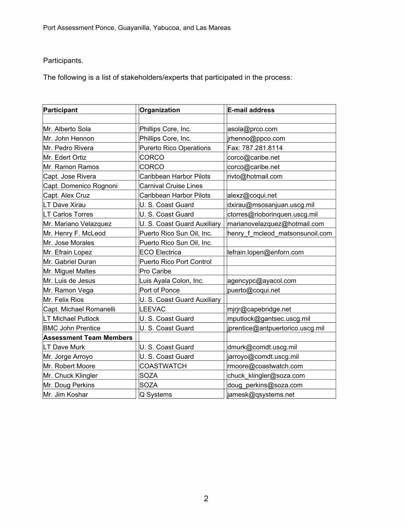
Participants. The following is a list of stakeholders/experts that participated in the process: Participant Organization E-mail address Mr. Alberto Sola Phillips Core, Inc. [email protected] Mr. John Hennon Phillips Core, Inc. [email protected] Mr. Pedro Rivera Purerto Rico Operations Fax: 787.281.8114 Mr. Edert Ortiz CORCO [email protected] Mr. Ramon Ramos CORCO [email protected] Capt. Jose Rivera Caribbean Harbor Pilots [email protected] Capt. Domenico Rognoni Carnival Cruise Lines Capt. Alex Cruz Caribbean Harbor Pilots [email protected] LT Dave Xirau U. S. Coast Guard [email protected] LT Carlos Torres U. S. Coast Guard [email protected] Mr. Mariano Velazquez U. S. Coast Guard Auxiliary [email protected] Mr. Henry F. McLeod Puerto Rico Sun Oil, Inc. henry_f_mcleod_matsonsunoil.comMr. Jose Morales Puerto Rico Sun Oil, Inc. Mr. Efrain Lopez ECO Electrica [email protected] Mr. Gabriel Duran Puerto Rico Port Control Mr. Miguel Maltes Pro Caribe Mr. Luis de Jesus Luis Ayala Colon, Inc. [email protected] Mr. Ramon Vega Port of Ponce [email protected] Mr. Felix Rios U. S. Coast Guard Auxiliary Capt. Michael Romanelli LEEVAC [email protected] LT Michael Putlock U. S. Coast Guard [email protected] BMC John Prentice U. S. Coast Guard [email protected] Assessment Team Members LT Dave Murk U. S. Coast Guard [email protected] Mr. Jorge Arroyo U. S. Coast Guard [email protected] Mr. Robert Moore COASTWATCH [email protected] Mr. Chuck Klingler SOZA [email protected] Mr. Doug Perkins SOZA [email protected] Mr. Jim Koshar Q Systems [email protected]
2
Port Assessment Ponce, Guayanilla, Yabucoa, and Las Mareas
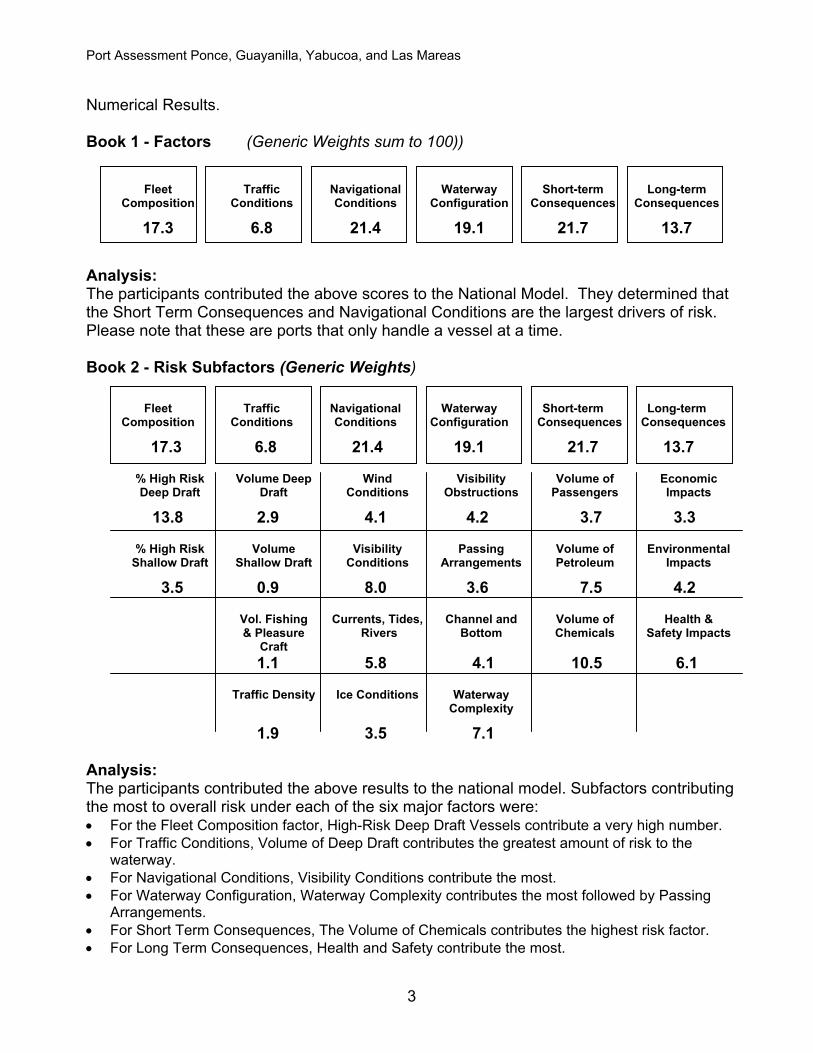
Numerical Results. Book 1 - Factors (Generic Weights sum to 100))
Analysis: The participants contributed the above scores to the National Model. They determined that the Short Term Consequences and Navigational Conditions are the largest drivers of risk. Please note that these are ports that only handle a vessel at a time. Book 2 - Risk Subfactors (Generic Weights) Fleet Traffic Navigational Waterway Short-term Long-term Composition Conditions Conditions Configuration Consequences Consequences
17.3 6.8 21.4 19.1 21.7 13.7
% High Risk Volume Deep Wind Visibility Volume of Economic Deep Draft Draft Conditions Obstructions Passengers Impacts
3.5 0.9 8.0 3.6 7.5 4.2 Vol. Fishing Currents, Tides, Channel and Volume of Health & & Pleasure Rivers Bottom Chemicals Safety Impacts Craft 1.1 5.8 4.1 10.5 6.1 Traffic Density Ice Conditions Waterway Complexity
1.9 3.5 7.1 Analysis: The participants contributed the above results to the national model. Subfactors contributing the most to overall risk under each of the six major factors were: • For the Fleet Composition factor, High-Risk Deep Draft Vessels contribute a very high number. • For Traffic Conditions, Volume of Deep Draft contributes the greatest amount of risk to the
waterway. • For Navigational Conditions, Visibility Conditions contribute the most. • For Waterway Configuration, Waterway Complexity contributes the most followed by Passing
Arrangements. • For Short Term Consequences, The Volume of Chemicals contributes the highest risk factor. • For Long Term Consequences, Health and Safety contribute the most.
3
Port Assessment Ponce, Guayanilla, Yabucoa, and Las Mareas
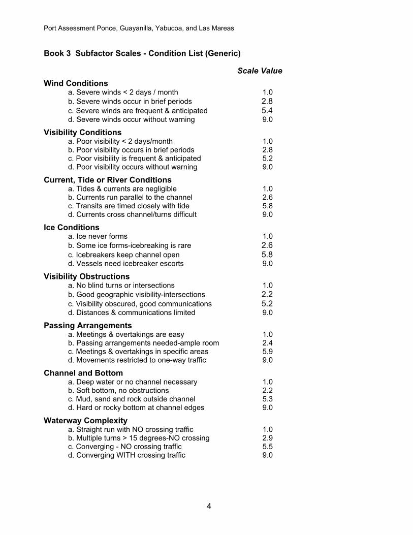
Book 3 Subfactor Scales - Condition List (Generic)
Scale Value Wind Conditions a. Severe winds < 2 days / month 1.0 b. Severe winds occur in brief periods 2.8 c. Severe winds are frequent & anticipated 5.4 d. Severe winds occur without warning 9.0 Visibility Conditions a. Poor visibility < 2 days/month 1.0 b. Poor visibility occurs in brief periods 2.8 c. Poor visibility is frequent & anticipated 5.2 d. Poor visibility occurs without warning 9.0 Current, Tide or River Conditions a. Tides & currents are negligible 1.0 b. Currents run parallel to the channel 2.6 c. Transits are timed closely with tide 5.8 d. Currents cross channel/turns difficult 9.0 Ice Conditions a. Ice never forms 1.0 b. Some ice forms-icebreaking is rare 2.6 c. Icebreakers keep channel open 5.8 d. Vessels need icebreaker escorts 9.0 Visibility Obstructions a. No blind turns or intersections 1.0 b. Good geographic visibility-intersections 2.2 c. Visibility obscured, good communications 5.2 d. Distances & communications limited 9.0 Passing Arrangements a. Meetings & overtakings are easy 1.0 b. Passing arrangements needed-ample room 2.4 c. Meetings & overtakings in specific areas 5.9 d. Movements restricted to one-way traffic 9.0 Channel and Bottom a. Deep water or no channel necessary 1.0 b. Soft bottom, no obstructions 2.2 c. Mud, sand and rock outside channel 5.3 d. Hard or rocky bottom at channel edges 9.0 Waterway Complexity a. Straight run with NO crossing traffic 1.0 b. Multiple turns > 15 degrees-NO crossing 2.9 c. Converging - NO crossing traffic 5.5 d. Converging WITH crossing traffic 9.0
4
Port Assessment Ponce, Guayanilla, Yabucoa, and Las Mareas
Passenger Volume a. Industrial, little recreational boating 1.0 b. Recreational boating and fishing 2.7 c. Cruise & excursion vessels-ferries 5.9 d. Extensive network of ferries, excursions 9.0 Petroleum Volume a. Little or no petroleum cargoes 1.0 b. Petroleum for local heating & use 2.7 c. Petroleum for transshipment inland 5.2 d. High volume petroleum & LNG/LPG 9.0 Chemical Volume a. Little or no hazardous chemicals 1.0 b. Some hazardous chemical cargo 2.4 c. Hazardous chemicals arrive daily 5.4 d. High volume of hazardous chemicals 9.0 Economic Impacts a. Vulnerable population is small 1.0 b. Vulnerable population is large 3.1 c. Vulnerable, dependent & small 5.5 d. Vulnerable, dependent & Large 9.0 Environmental Impacts a. Minimal environmental sensitivity 1.0 b. Sensitive, wetlands, VULNERABLE 2.9 c. Sensitive, wetlands, ENDANGERED 5.8 d. ENDANGERED species, fisheries 9.0 Safety and Health Impacts a. Small population around port 1.0 b. Medium - large population around port 2.5 c. Large population, bridges 5.6 d. Large DEPENDENT population 9.0
Analysis:
The participants contributed the above calibrations to the Subfactor scales for the national model. For each Subfactor above there is a low (Port Heaven) and a high (Port Hell) severity limit, which are assigned values of 1 and 9 respectively. The participants determined numerical values for two intermediate qualitative descriptions between those two extreme limits. In general, participants from this port evaluated the difference in risk between the lower limit (Port Heaven) and the first intermediate scale point as being equal to the difference in risk associated with the first and second intermediate scale points. The difference in risk between the second intermediate scale point and the upper risk limit (Port Hell) was generally 2.5 times as great.
5
Port Assessment Ponce, Guayanilla, Yabucoa, and Las Mareas
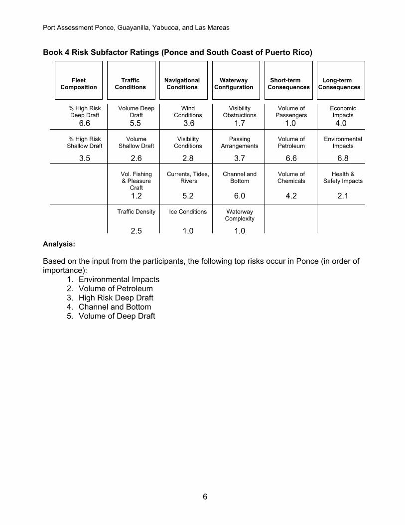
Book 4 Risk Subfactor Ratings (Ponce and South Coast of Puerto Rico)
Port Assessment Ponce, Guayanilla, Yabucoa, and Las Mareas
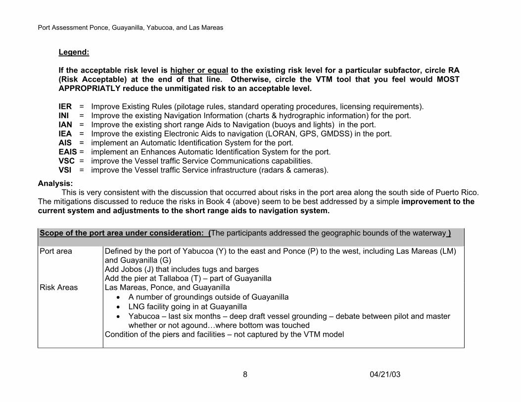
Legend: If the acceptable risk level is higher or equal to the existing risk level for a particular subfactor, circle RA (Risk Acceptable) at the end of that line. Otherwise, circle the VTM tool that you feel would MOST APPROPRIATLY reduce the unmitigated risk to an acceptable level. IER = Improve Existing Rules (pilotage rules, standard operating procedures, licensing requirements). INI = Improve the existing Navigation Information (charts & hydrographic information) for the port. IAN = Improve the existing short range Aids to Navigation (buoys and lights) in the port. IEA = Improve the existing Electronic Aids to navigation (LORAN, GPS, GMDSS) in the port. AIS = implement an Automatic Identification System for the port. EAIS = implement an Enhances Automatic Identification System for the port. VSC = improve the Vessel traffic Service Communications capabilities. VSI = improve the Vessel traffic Service infrastructure (radars & cameras).
Analysis: This is very consistent with the discussion that occurred about risks in the port area along the south side of Puerto Rico. The mitigations discussed to reduce the risks in Book 4 (above) seem to be best addressed by a simple improvement to the current system and adjustments to the short range aids to navigation system. Scope of the port area under consideration: (The participants addressed the geographic bounds of the waterway ) Port area Defined by the port of Yabucoa (Y) to the east and Ponce (P) to the west, including Las Mareas (LM)
and Guayanilla (G) Add Jobos (J) that includes tugs and barges Add the pier at Tallaboa (T) – part of Guayanilla
Risk Areas Las Mareas, Ponce, and Guayanilla • A number of groundings outside of Guayanilla • LNG facility going in at Guayanilla • Yabucoa – last six months – deep draft vessel grounding – debate between pilot and master
whether or not agound…where bottom was touched Condition of the piers and facilities – not captured by the VTM model
8 04/21/03
Port Assessment Ponce, Guayanilla, Yabucoa, and Las Mareas
Risk Factors Risks Mitigations
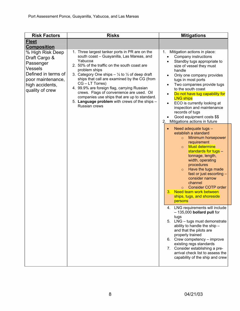
Fleet Composition
% High Risk Deep Draft Cargo & Passenger Vessels Defined in terms of poor maintenance, high accidents, quality of crew
1. Three largest tanker ports in PR are on the south coast – Guayanilla, Las Mareas, and Yabucoa
2. 50% of the traffic on the south coast are problem ships
3. Category One ships – ¼ to ½ of deep draft ships that call are examined by the CG (from CG – LT Torres)
4. 99.9% are foreign flag, carrying Russian crews. Flags of convenience are used. Oil companies use ships that are up to standard.
5. Language problem with crews of the ships – Russian crews
1. Mitigation actions in place: • Company instructions • Standby tugs appropriate to
size of vessel they must handle
• Only one company provides tugs in most ports
• Two companies provide tugs to the south coast
• Do not have tug capability for LNG ships
• ECO is currently looking at inspection and maintenance records of tugs
• Good equipment costs $$ 2. Mitigations actions in future
• Need adequate tugs – establish a standard
o Minimum horsepower requirement
o Must determine standards for tugs – tonnage, length, width, operating procedures
o Have the tugs made fast or just escorting –consider narrow channel
o Consider COTP order3. Need team work between
ships, tugs, and shoreside persons
4. LNG requirements will include – 135,000 bollard pull for tugs
5. LNG – tugs must demonstrate ability to handle the ship – and that the pilots are properly trained
1. Tugs and barges are kept up. 2. Tug pers may not be totally competent 3. From facility operators – no problems 4. LEE VAC – barges run Yabucoa, Jobos, and
Guayanilla – carrying no. 2 and no. 6 F.O. 5. LEE VAC only company running the south
coast – owners are investing in improving conditions
6. LEE VAC charters other companies – equipment, at times, may be suspect
Risks for this factor appear acceptable
Traffic Conditions
Also, look into the future
Volume of Deep Draft Vessels
1. Larger ships are calling – about 40K to 64K, 70K DWT. Limited to 80K (810-820 feet)
2. Tankers • ECO Lectrical has new facility – 1-2 times a
month – 948 feet long – LPG – will switch to LNG, then 1 ship per month (24-30 hours at the pier) – at entrance to Guayanilla Bay
• Black oil – largest – Yabucoa – 100K DWY • G – 80K DWT – 45 per month • LM – 45K DWT – largest vessel • J – Black Oil • Y – Sun Oil – 1-2 per week – 75% large size
vessels • Will not increase in size (due to dock
limitations), will increase in numbers of movements
3. Bulkers and containers ship into P – 20 per month
4. Future – mega port – location unknown – between P to Guayanilla – entire area is highly considered.
5. New gas power plant will not be affected
1. Risk today is at an acceptable level
2. Using a one-at-a time system
Volume of Shallow Draft Vessels Includes foreign fishing vessels
1. Tugs and barges • Trends should continue, may decrease if
the plants 3. Clean air act will guide efforts 4. Chemical, lumber, and general barges into P
– 2-3 per month 5. Small freighters into P – 2 per month
Volume of Fishing & Pleasure Craft Domestic F/V and PC
1. No fishing vessels 2. Recreational boats – on the weekends – 40
– 100 boats – trailered boats. Marinas in P next to the port
3. New marina in P on west side of the port
1. When have regatta – cooperative with pilots and the CG
9 04/21/03
Port Assessment Ponce, Guayanilla, Yabucoa, and Las Mareas Risk Factors Risks Mitigations
Traffic Density
1. Tugs and barges enter without pilots 2. Ships are moved 24 hours a day 3. Pick up fish traps – Las Mareas. Traps in
the middle of the approach channel – attempt to maneuver the ship to avoid the traps
1. Ports are running one ship at a time
2. Local regulations cooperatively established on some of the harbors
Navigational Conditions
Wind Conditions
1. Prevailing trade wind from the east flowing along the entire coast
2. G – 9-10 a.m. 20-35 kts until 17-1800; also approaching the berth…Coco berth
3. LM – causes crabbing and approaching the berth
4. Hurricane closes all down 5. Higher winds in rain squalls – up to 40 knots
for brief period (5-15 minutes) in winter. Casualty in Guayanilla, aground in B1 – fully loaded tanker
Visibility Conditions
1. Rain – winter – from the east in a.m., duration for 2 - 3 hours. Generally a brief period, 5-15 minutes
2. Dust (dust drops from Sahara Desert) – drop vis on approach – approach are not visible
Currents, Tides and Rivers
1. Alongshore current setting to the west – across the harbor entrances
2. Varies in intensity with water depth – ½ to 1 kt – stronger at Las Mareas (has a narrow channel, too)
3. 1.3 – 1.8 kts – logged; is cross channel, causing vessels to crab
4. Ponce and Guayanilla – wind driven current is more a problem – no current in the harbor
5. On approach, include the wind, sea and swell 6. Lite barges are wind sensitive 7. Loaded barges are behind tugs – 50 – 60 feet
and crabbing to the side limits of the channels8. Heavy rains in all ports cause freshets 9. Las Mareas – freshet carries sand to
breakwater and causes silting in the channel 10. Guayanilla – freshet brings slight current and
debris 11. Las Mareas – hydraulic affect on approach
1. Risks seem to be acceptable 2. Current information in G (datum
is in Galveston, Tex). Some information is eyeballed.
3. Currents are stable and predictable even though the books are inaccurate
Ice No ice conditions in the south coast No mitigation needed Waterway Configuration
10 04/21/03
Port Assessment Ponce, Guayanilla, Yabucoa, and Las Mareas Risk Factors Risks Mitigations
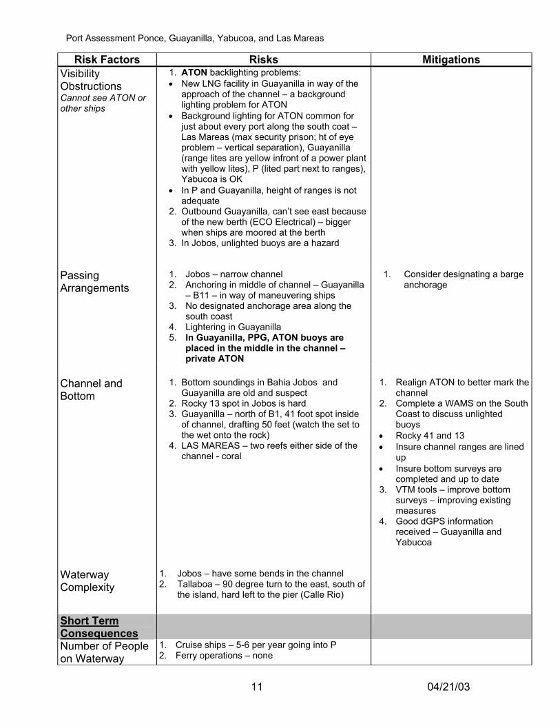
Visibility Obstructions Cannot see ATON or other ships
1. ATON backlighting problems: • New LNG facility in Guayanilla in way of the
approach of the channel – a background lighting problem for ATON
• Background lighting for ATON common for just about every port along the south coat – Las Mareas (max security prison; ht of eye problem – vertical separation), Guayanilla (range lites are yellow infront of a power plant with yellow lites), P (lited part next to ranges), Yabucoa is OK
• In P and Guayanilla, height of ranges is not adequate
2. Outbound Guayanilla, can’t see east because of the new berth (ECO Electrical) – bigger when ships are moored at the berth
3. In Jobos, unlighted buoys are a hazard
Passing Arrangements
1. Jobos – narrow channel 2. Anchoring in middle of channel – Guayanilla
– B11 – in way of maneuvering ships 3. No designated anchorage area along the
south coast 4. Lightering in Guayanilla 5. In Guayanilla, PPG, ATON buoys are
placed in the middle in the channel – private ATON
1. Consider designating a barge anchorage
Channel and Bottom
1. Bottom soundings in Bahia Jobos and Guayanilla are old and suspect
2. Rocky 13 spot in Jobos is hard 3. Guayanilla – north of B1, 41 foot spot inside
of channel, drafting 50 feet (watch the set to the wet onto the rock)
4. LAS MAREAS – two reefs either side of the channel - coral
1. Realign ATON to better mark the channel
2. Complete a WAMS on the South Coast to discuss unlighted buoys
• Rocky 41 and 13 • Insure channel ranges are lined
up • Insure bottom surveys are
completed and up to date 3. VTM tools – improve bottom
surveys – improving existing measures
4. Good dGPS information received – Guayanilla and Yabucoa
Waterway Complexity
1. Jobos – have some bends in the channel 2. Tallaboa – 90 degree turn to the east, south of
the island, hard left to the pier (Calle Rio)
Short Term Consequences
Number of People on Waterway
1. Cruise ships – 5-6 per year going into P 2. Ferry operations – none
11 04/21/03
Port Assessment Ponce, Guayanilla, Yabucoa, and Las Mareas Risk Factors Risks Mitigations
1. Mitigations today: • Limited double skinned tankers • One barge is double skin • Consider customized reporting
procedures to insure a more rapid response to a commercial grounding
Volume of Hazardous Chemical Cargoes
1. Ponce - LPG 2. Guayanilla – all the way in 3. Las Mareas – 4. Tallaboa – LPG
Long-Term Consequences
Economic Impacts
1. Based on inventory 2. In Coco, 7-15 days inventory 3. Guayanilla – 7-5 days 4. Others – 7-15 days 5. No impact on container traffic – will send to
San Juan
Environmental Impacts
1. Jobos is a marine sanctuary 2. Yabucoa is a sanctuary 3. Guayanilla is a sanctuary 4. Any incident will move west due to trade winds5. West side of Las Mareas is sensitive area 6. Includes marshlands, wetlands, endangered
species
1. Goal – minimize impact on environment
2. Meet CG standards for response equipment requirements.
3. Terminals have sufficient equipment to contain the spill until the OSRO arrives
4. 2 OSROs in south coast in G • Start time – 5-10 from facility 5. Other OSROs – 1-2 hour
response time 6. Vessel spills – terminals cannot
control – terminals do respond with clean up equipment
7. Can improve the existing system…more boom, contractors, regs
8. Traffic control can help coordinate response
9. Develop and exercise an action plan
Health and Safety Impacts
1. Power plants will go down I 15 days 2. Cooling water from ocean 3. Yabucoa,Jobos, prevailing winds are toward
town
12 04/21/03
Port Assessment Ponce, Guayanilla, Yabucoa, and Las Mareas