Precision Satellite Surveying Positioning Systems GPS | GLONASS | BEIDOU | SBAS | GALILEO Model G7H TI Asahi Co.,Ltd Focusing on true performance + Compact and durable metal housing + Better dust and weather resistance (IP67) + Equipped with IMU sensor that compensates tilting of the receiver + WiFi for direct communication with web browser for e.g. downloading data, firmware upgrades and communication between receiver and controller
Transcript
Precision Satellite Surveying
Positioning Systems
GPS | GLONASS | BEIDOU | SBAS | GALILEO
Model G7H
TI Asahi Co.,LtdFocusing on true performance
+ Compact and
durable metal housing
+ Better dust and weather resistance (IP67)
+ Equipped with IMU sensor that compensates tilting of the receiver
+ WiFi for direct communication with web browser for e.g.
downloading data, firmware upgrades and communication
between receiver and controller
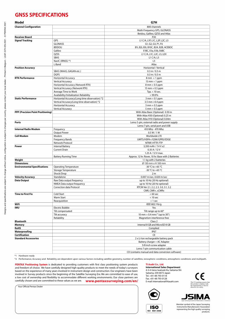
Model G7H Channel Configuration 800 channels Multi-Frequency GPS, GLONASS Beidou, Galileo, QZSS and AtlasReceiver Board P20Signal Tracking GPS L1 C/A, L1P, L1C, L2P, L2C, L5 GLONASS G1, G2, G3, P1, P2 BEIDOU B1i, B2i, B3i, B10C, B2A, B2B, ACEBOC Galileo E1BC, E5a, E5b, E6BC QZSS L1 C/A, L1C, L2C, L5, LEX SBAS L1 C/A, L5 NavIC (IRNSS) *1 L5 L-Band AtlasPosition Accuracy Horizontal / Vertical SBAS (WAAS, GAGAN etc.) 0.3 m / 0.5 m DGPS 0.3 m / 0.5 m RTK Performance Horizontal Accuracy 8 mm + 1 ppm Vertical Accuracy 15 mm + 1 ppm Horizontal Accuracy (Network RTK) 8 mm + 0.5 ppm Vertical Accuracy (Network RTK) 15 mm + 0.5 ppm Average Time to Work Typ. < 10 sec. Availability/Initialization Reliability > 99.9%Static Performance Horizontal Accuracy(Long time observation) *2 3 mm + 0.1 ppm Vertical Accuracy(Long time observation) *2 3.5 mm +0.4 ppm Horizontal Accuracy 3 mm + 0.5 ppm Vertical Accuracy 5 mm + 0.5 ppmPPP (Precision Point Positioning) With Atlas Basic (Optional) 0.50 m With Atlas H30 (Optional) 0.25 m With Atlas H10 (Optional) 0.04mPorts Lemo 5-pin, external radio and power supply Lemo 7-pin, serial port and USBInternal Radio Modem Frequency 410 Mhz - 470 Mhz Output Power 0.5 W / 1 WCell Modem Modem Worldwide LTE Frequency Bands UMTS/HSPA+/GSM/GPRS/EDGE Network Protocol NTRIP, HTTP, FTPPower Internal Battery 3,350 mAh / 7.4 V x2 Current Drain 0.35 A / 12 V 1.25 A / 12 V max. Battery Running Time Approx. 12 hr: Rover, 10 hr: Base with 2 BatteriesWeight 1.1 kg with 2 batteriesDimensions Ø 130 mm x H 100 mm Environmental Specifications Operating Temperature -30 °C to +65 °C Storage Temperature -30 °C to +65 °C Shock/Drop 2 m Velocity Accuracy Standalone 0.007 m/sec, 0.020 m/sec Data Output Raw Data output frequency up to 10 Hz (20 Hz optional) NMEA Data output frequency up to 10 Hz (20 Hz optional) Correction data Protocol RTCM Ver 2.1, 2.2, 2.3, 3.0, 3.1, 3.2 CMR, CMR+, sCMRx Time to First Fix Cold Start < 60 sec Warm Start < 10 sec Reacquisition < 1 sec WiFi IEEE 802.11b/gIMU Electric Bubble Yes Tilt compensated Tilt range up to 60° Tilt accuracy 10 mm + 0.4 mm/° (up to 30°) Reliability Magnetism interference freeBluetooth Class 2 Memory Internal 8 GB and MicroSD 8 GB RoHS Complied Waterproofing IP67 Certification CE Standard Accessories 2 x Li-Ion rechargeable battery pack Battery charger + AC Adapter 5/8 inch screw adapter Lemo 7-pin communication cable CD (contains manual and data conversion software)
GNSS SPECIFICATIONS
Your Official Pentax Dealer
www.pentaxsurveying.com/en/
TI Asahi Co., Ltd.International Sales Department 4-3-4 Ueno Iwatsuki-Ku, Saitama-ShiSaitama, 339-0073 JapanTel.: +81-48-793-0118Fax. +81-48-793-0128E-mail: [email protected]
Japan Surveying Instruments Manufacturers’ Association
Member symbol of the Japan Surveying Instruments Manufacturers’ Association representing the high quality surveying
PENTAX Positioning System is dedicated to providing customers with first class positioning system products and freedom of choice. We have carefully designed high-quality products to meet the needs of today’s surveyors based on the experience of many years involved in instrument design and construction. Our engineers have been involved in Survey products since the beginning of the Satellite Surveying Era. We are committed to ease of use, a low cost of ownership and flexibility to accommodate different working environments. Our close partners are carefully chosen and are committed to these values as we are.
*1 Hardware ready
*2 Performance, Accuracy and Reliability are dependent upon various factors including satellite geometry, number of satellites, ionospheric conditions, atmospheric conditions and multipath.