23
APPLANIX PRODUCTS AND SOLUTIONS FOR MOBILE MAPPING AND POSITIONING CAPTURE EVERYTHING POSPac MMS – HYDRO 08 November 2008

APPLANIX PRODUCTS AND SOLUTIONS FOR MOBILE MAPPING AND POSITIONING CAPTURE EVERYTHING
POSPac MMS – HYDRO 08 November 2008

PRODUCTS AND SOLUTIONS FOR MOBILE MAPPING AND POSITIONING
Accurate Post Processed Position & Orientation For Modern Port Survey Operations.
• Increasing use of sonar & laser survey equipment with sub-centimetre accuracies. • Focussed attention on the georeferencing and motion compensation. • Robust marine mobile mapping requires tightly integrated Global Positioning System (GPS) and Inertial Navigation System (INS) sensors. Inertial data aids in reducing GPS noise as well as providing high bandwidth, un-interrupted position and orientation in spite of GPS outages. •This presentation describes the Post Processed Virtual Reference Station (PPVRS) for aided Inertial Navigation which makes use of a network of GPS reference stations to determine atmospheric biases and other errors at the rover position. • The result is a continuous, high-precision position and orientation solution despite distant reference stations.

PRODUCTS AND SOLUTIONS FOR MOBILE MAPPING AND POSITIONING
Survey Vessel and Equipment

PRODUCTS AND SOLUTIONS FOR MOBILE MAPPING AND POSITIONING
Equipment Details RESON SeaBat 8125 Ultra-high resolution, focussed, multibeam echosounder. Delivering 240 depths/ping, 05. x 1.0 degree beamwidth up to 50Hz, 120 degree opening angle, time synchronised. Riegl Q240i Pulsed time-of-flight range measurement principle and beam scanning by means of an opto-mechanical scan mechanism, providing fully linear, unidirectional and parallel scan lines. Delivering 20mm ranging accuracy, 10,000 samples/sec, 80 degree opening angle, time synchronised.

PRODUCTS AND SOLUTIONS FOR MOBILE MAPPING AND POSITIONING
Ordnance Survey Network Within 200km

PRODUCTS AND SOLUTIONS FOR MOBILE MAPPING AND POSITIONING
Survey Location, north docks Liverpool, UK

PRODUCTS AND SOLUTIONS FOR MOBILE MAPPING AND POSITIONING
Bathymetry Data Flow
PDS2000 data file
PDS2000 data file
or ASCII XYZ
POS MV data
POS MV
PDS2000 Sonar
SBET
PDS2000 EDIT module
Applanix POSPac MMS
Base Stn data

PRODUCTS AND SOLUTIONS FOR MOBILE MAPPING AND POSITIONING
Laser Data Flow
POS AV Laser POS AV data SBET
LAS
Applanix POSPac MMS
Base Stn data
PRODUCTS AND SOLUTIONS FOR MOBILE MAPPING AND POSITIONING
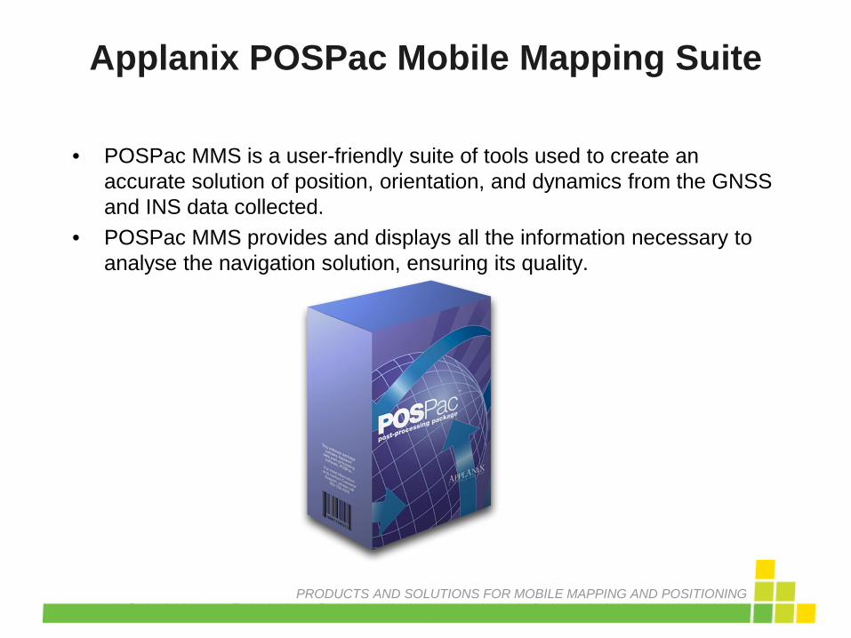
• POSPac MMS is a user-friendly suite of tools used to create an accurate solution of position, orientation, and dynamics from the GNSS and INS data collected.
• POSPac MMS provides and displays all the information necessary to analyse the navigation solution, ensuring its quality.
Applanix POSPac Mobile Mapping Suite

PRODUCTS AND SOLUTIONS FOR MOBILE MAPPING AND POSITIONING
POSPac MMS Data Flow
Base Station
data
SBET POS MV data
(2) Data
Extraction and
Quality Control
(3) Applanix
SmartBase™
Network check & VRS generation
(4) Applanix
IN-Fusion™
Processor and
Smoother
(1) Data
Extraction and
Quality Control

PRODUCTS AND SOLUTIONS FOR MOBILE MAPPING AND POSITIONING
• Drag and drop raw POS MV files into the Plan View, or use the “Import” function and select the first POS file to start data import.
• Review the real time solution by viewing: – Message Logs
• POS data import • IMU data continuity checking • GNSS continuity checking
– Real Time plots
• Or, batch process
POSPac MMS – Step 1, POS MV Data

PRODUCTS AND SOLUTIONS FOR MOBILE MAPPING AND POSITIONING
POSPac MMS – Data Extract Results

PRODUCTS AND SOLUTIONS FOR MOBILE MAPPING AND POSITIONING
• Automatically search for, download, and import base station data publicly available on the internet.
• Or load data from your own base stations.
• Base station data automatically interpolated to 1 second interval.
• Automatically download precise and broadcast ephemeris data.
POSPac MMS – Step 2, Base Data

PRODUCTS AND SOLUTIONS FOR MOBILE MAPPING AND POSITIONING
• What Is It – Post-Processed Virtual Reference Station (PPVRS) – Trimble VRS technology – Step 1: Network Adjustment, Step 2: VRS Generation
• How it works – Uses a network of reference stations, at least 4 required – At least 18hrs of continuous data required – Performs ambiguity fixed solution – Spatially models ionospheric and geometric errors at base and rover locations – Generates an optimal observation set
for a VRS near the rover location
POSPac MMS – Step 3, SmartBaseTM
PRODUCTS AND SOLUTIONS FOR MOBILE MAPPING AND POSITIONING
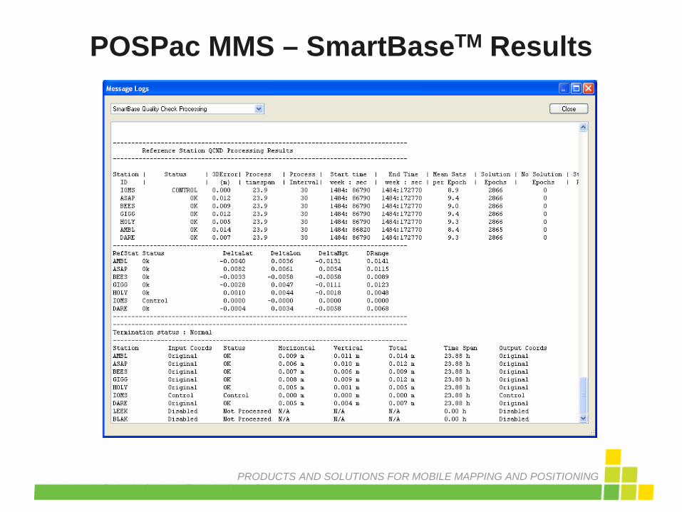
SMARTBASE Results
POSPac MMS – SmartBaseTM Results
PRODUCTS AND SOLUTIONS FOR MOBILE MAPPING AND POSITIONING
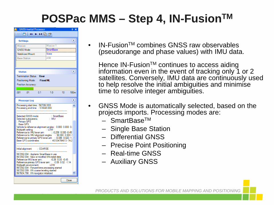
• IN-FusionTM combines GNSS raw observables (pseudorange and phase values) with IMU data. Hence IN-FusionTM continues to access aiding information even in the event of tracking only 1 or 2 satellites. Conversely, IMU data are continuously used to help resolve the initial ambiguities and minimise time to resolve integer ambiguities.
• GNSS Mode is automatically selected, based on the projects imports. Processing modes are: – SmartBaseTM
– Single Base Station – Differential GNSS – Precise Point Positioning – Real-time GNSS – Auxiliary GNSS
POSPac MMS – Step 4, IN-FusionTM

PRODUCTS AND SOLUTIONS FOR MOBILE MAPPING AND POSITIONING
• Three, automated, processing steps: – Forward – Backward – Combined
• Generates a Smoothed Best Estimate of
Trajectory (SBET) with greater precision and reliability.
POSPac MMS Applanix IN-FusionTM

PRODUCTS AND SOLUTIONS FOR MOBILE MAPPING AND POSITIONING
• To ensure a quality solution, review: – Message Logs
• GNSS-Inertial Forward Processing • GNSS-Inertial Backward Processing • GNSS-Inertial Combined Processing
– Plots • Smoothed Performance Metrics • Calibrated Installation Parameters • Solution Status • Forward Processed Estimated Errors
– Pass SBET file to post processing suite..
• Replace realtime position and orientation solution with SBET data
POSPac MMS – Step 5, Review Results

PRODUCTS AND SOLUTIONS FOR MOBILE MAPPING AND POSITIONING
POSPac MMS – Step 6, Import SBET

PRODUCTS AND SOLUTIONS FOR MOBILE MAPPING AND POSITIONING
POSPac MMS Results

PRODUCTS AND SOLUTIONS FOR MOBILE MAPPING AND POSITIONING
POSPac Different Processing Methods
Single base station, 30km distant. VRS, between 100 and 130km distant. Precise Point Positioning.

PRODUCTS AND SOLUTIONS FOR MOBILE MAPPING AND POSITIONING
Multibeam And Laser Results

APPLANIX PRODUCTS AND SOLUTIONS FOR MOBILE MAPPING AND POSITIONING CAPTURE EVERYTHING
THANK YOU


