271
Evaluator Training Version 14 December 2016 Post-Disaster Safety Assessment Program (SAP) Student Manual

Evaluator
Training Version 14
December 2016
Post-Disaster Safety
Assessment Program
(SAP)
Student Manual

Cal OES Safety Assessment Program Evaluator Manual December 2016
1
State of California
Safety Assessment Program
Evaluator Student Manual
December 2016
Version 14
For current SAP information, please visit our website at www.caloes.ca.gov, and do a Search
for Safety Assessment.

Cal OES Safety Assessment Program Evaluator Manual December 2016
2
Acknowledgements
The California Governor’s Office of Emergency Services (Cal OES) gratefully acknowledges the
assistance provided by Global Emergency Management and representatives of the Structural
Engineers Association of California, the American Institute of Architects, the American Society
of Civil Engineers, the American Construction Inspectors Association, the California Building
Officials, and the State of California Division of the State Architect, Department of
Transportation, and the Department of Water Resources for their time and consideration
regarding this document.
Cal OES wishes to acknowledge the many organizations and individuals who contributed or
permitted use of their photos for use in this instruction manual. Photo credits are found beneath
each individual photo, when known. Cal OES also acknowledges the assistance of the Applied
Technology Council in allowing the reproduction and use of their photographs and diagrams
used in this manual as well.
Jim C. Barnes, P.E.
Lead Statewide SAP Coordinator
California Governor’s Office of Emergency Services

Cal OES Safety Assessment Program Evaluator Manual December 2016
3
Table of Contents
Title page………………………………………………………………………………………...1
Acknowledgments……………………………………………………………………………….2
Introduction…………………………………………………………………………...…………5
Unit 1: Safety Assessment Program Overview………………………………………………..7
1.1 Concept of Emergency Operations…………………………………………………………..9
1.2 Evaluator Credentials……………………………………………………………………..…11
1.3 Deputizing of Individuals………………………………………………………………..….13
1.4 Liability Issues………………………………………………………………………………13
1.5 Workers Compensation for California Disaster Service Workers (DSWs)…………..……..16
1.6 Program Registration……………………………………………………………………..….17
1.7 Reimbursements……………………………………………………………………….……..18
1.8 Activation Sequence………………………………………………………………...……….19
1.9 Suggested Evaluator Assignments……………………...……………………………………20
1.10 Safety Assessment Responsibilities for Agencies and Organizations…………………..….22
1.11 Evaluator and Local Government Roles and Responsibilities……………….……………..24
1.12 Terminology…………...…………………………………………………………………....26
Unit 2: Safety Assessment Process and Procedures………………………………………….29
2.1 Earthquake Effects…………………………………………….…………………………….31
2.2 Windstorm and Flood Effects…………………………………………………....……….....39
2.3 Explosion Effects……………………………………………………………………………42
2.4 The Safety Assessment Program………………………………………………………...…..44
2.5 Placards Used for Safety Assessment……………………………………….………………45
2.6 Evaluation Process……………………………………………………………………..……62
2.7 Detailed Evaluation……………………………………………………………………...…..67
2.8 Engineering Evaluation……………………………………………………………..……….67
2.9 Evaluation Procedures…………………………………………………………………...…..70
Unit 3: Building Evaluation…………………………...……………………………………….79
3.1 Occupancy of Residential Structures to Reduce Shelter Demand…………………………..81
3.2 Mobile Homes and Manufactured Homes………………………………………………..…82
3.3 Historic Structures…………………………………………………………………………..90
3.4 Individual Activity: Evaluation of Residential Structures…………………………………..98
Unit 4: Safety Assessment Exercise………………………………………………………….105
4.1 Small Group Activity Evaluating Buildings…………………….…………………………107
Unit 5: Lifeline Systems and Facilities…………………………...…………………………..131
5.1 Assessment Form Heading…………………………………………………………………134
5.2 Geotechnical Evaluation……………………………………………………………………136
5.3 Airports……………………………………………………………………………………..143
5.4 Bridges…………………………………………………………………………..………….147
5.5 Roads and Highways………………………………………………………………….……152
5.6 Pipelines…………………………………………………………………………….………157
5.7 Pump Stations………………………………………………………………………...…….163
5.8 Reservoirs……………………………………………………………………..……………167
5.9 Wastewater Treatment Plants………………………………………………………………171
5.10 Water Treatment Plants…………………………………………………………….……..176

Cal OES Safety Assessment Program Evaluator Manual December 2016
4
Table of Contents (continued)
Unit 6: Non-Earthquake Hazards…………………………..………………………………..185
6.1 High Winds…………………………..…………………………………………………….187
6.2 Floods………………………………………………………………………………………194
6.3 Fires……………………………………………………………………………….………..202
6.4 Explosions…………………………………………………………………………………..205
Unit 7: Field Safety…………………………………………………..………………………..211
7.1 During Inspections………………………………………………………….………………213
7.2 Critical Incident Stress Disorder………………………………………………...………….219
7.3 Hazardous Materials………………………………………………………………….…….221
7.4 Urban Search and Rescue (USAR) Marking System…………………………………..…..227
7.5 Building Assessment Safety Checklist……………………………………………………..231
Appendix A, Job Aid and Evaluation Forms………………..……..………………………..233
Appendix B, SAP MOU……………………………………………………………………….267

Cal OES Safety Assessment Program Evaluator Manual December 2016
5
Introduction
The Safety Assessment Program (SAP) provides professional resources to local governments to
help with the safety evaluation of buildings and infrastructure after a disaster. The goal of the
Safety Assessment Program is to perform these safety assessments as quickly as possible. With
its origins in the response to the 1971 San Fernando Earthquake, SAP has been successful during
more recent earthquakes such as Loma Prieta (1989), Landers – Big Bear (1992), Humboldt
(1992), Northridge (1994), Napa (2000), San Simeon (2003), Baja (2010) and the 2014 Napa
Earthquake. SAP was also used under the interstate Emergency Management Assistance
Compact (EMAC) to help local governments in Louisiana and Mississippi after Hurricane
Katrina (2005).
Private industry volunteers, local government mutual aid, and state agency resources are used to
provide professional engineers, architects, geologists, and certified building inspectors to help
local governments perform safety evaluations of their built environment after a disaster. The
California Governor’s Office of Emergency Services (Cal OES) manages the Safety Assessment
Program, in cooperation with partnering professional organizations.
SAP provides two types of resources: SAP Evaluators, who work in the field performing safety
evaluations, and SAP Coordinators, who are local government lead personnel that coordinate the
field activities. The Evaluator training is the focus of this manual.
Cal OES is pleased that you are interested in participating in this program as an Evaluator. Your
role will be essential in the first days after a destructive event to evaluate the safety of potentially
damaged structures. There are also some examples of “best practices” obtained over the years
that will be passed on to you. Finally, the information that you gather will be very useful for the
recovery of the community you are assisting. We look forward to working with you in this
program.

Cal OES Safety Assessment Program Evaluator Manual December 2016
6
(This page intentionally left blank)

Cal OES Safety Assessment Program Evaluator Manual December 2016
7
UNIT 1: SAFETY ASSESSMENT PROGRAM
OVERVIEW

Cal OES Safety Assessment Program Evaluator Manual December 2016
8
UNIT 1 – SAFETY ASSESSMENT PROGRAM OVERVIEW
Overview
This unit presents an introduction to the Safety Assessment Program and discusses credentials,
how the program is organized, how deployment takes place, liability issues, and workers
compensation. It ends with a glossary of common terms used in emergency management and
safety assessment.
Training Goal
Provide the participants with a basic understanding of the program so as to see their role in it.
Objectives
At the end of this unit, participants will be able to:
Understand the liability immunity and workers compensation aspects of this program;
Know how to be deployed to a disaster;
Identify where they fit in the overall emergency operation; and
Know and use the common terms used in emergency management and safety assessment.

Cal OES Safety Assessment Program Evaluator Manual December 2016
9
1.0 Safety Assessment Program Overview
Safety assessment is the process by which structures and specific lifeline systems and facilities
are evaluated for their safety, either for immediate use, conditional use, or disuse. The Safety
Assessment Program (SAP) was developed to help local government building departments after
a disaster by providing additional architects, civil engineers, and building inspectors to help
rapidly complete the surge of safety evaluations made necessary by the event.
This program had its early beginning with the 1971 San Fernando Earthquake, when private
industry volunteers asked to help local governments with the demands caused by the event. It
became more formalized after the 1986 Whittier-Narrows Earthquake. The Applied Technology
Council of Redwood City, CA was contracted by the State of California to standardize safety
assessment methods and forms; they produced ATC-20: Procedures for Postearthquake Safety
Evaluation of Buildings, which became available in 1989, three weeks before the Loma Prieta
Earthquake struck. The program was revised after Loma Prieta to improve the placards, and was
revamped in 2002 to include damage review from windstorms, floods, and fires. In 2005,
damage from explosions was included as part of the program. Jim Alexander and Rick Ranous,
SE, both of the California Governor’s Office of Emergency Services, were early champions of
the Safety Assessment Program.
The demands on shelters and other temporary living arrangements can be quickly reduced by the
swift evaluation of structures for continued use. The process and procedures found in ATC-20
are essential for the safety evaluation of earthquake-damaged structures. More will be said
about this in Chapter 2 of this manual.
SAP has the ability to provide evaluations of both building stock and lifeline infrastructure
systems. The latter includes airports, roads, bridges, pipelines, pumping stations, water tanks,
and treatment plants. City or county building officials have the oversight responsibility for
buildings within their jurisdictions, and public works officials likewise have responsibility for
their infrastructure within their jurisdictions. Special districts can have both buildings and
infrastructure within their responsibility.
1.1 Concept of Emergency Operations
The Incident Command System (ICS) is the foundation of emergency management in California
and throughout the United States since the inception of the National Response Framework and
the National Incident Management System (NIMS). Under ICS, the lowest level of government
closest to the disaster is always responsible for the management of the emergency response
within its jurisdiction, with higher levels of government supplying needed personnel and
equipment to aid in the response. For a city, the city’s emergency services will provide direction
to the disaster response; the city building department will be requesting safety assessment
assistance in accord with the emergency services direction. It will be likewise the case for a
county to work in a similar manner for safety assessment help within their jurisdiction.
The Standardized Emergency Management System (SEMS) is based on ICS, and includes other
State of California legal arrangements, such as the Master Mutual Aid Agreement, use of
counties as Operational Areas, and the inclusion of five levels of government, as follows:

Cal OES Safety Assessment Program Evaluator Manual December 2016
10
1. Field or Incident
2. Local Government (city, county, or special district)
3. Operational Area (all local governments within the county included)
4. Cal OES Mutual Aid Region
5. State
All these levels of government are connected during emergency operations by means of an
internet-based system called Cal EOC. This allows for the swift exchange of information and
reporting throughout the event.
Control of operations starts with the incident commander at the incident, and each succeeding
level of government provides support for those locally driven priorities. In a diffused citywide
event, the emergency manager at the Emergency Operations Center (EOC) will consolidate the
requests of incident commanders, or in their absence may provide overall direction to managing
the disaster response.
Under SEMS, counties are considered as local government, and they manage operations in the
unincorporated areas. The Operational Area includes the county resources, and the cities and
special districts within the county borders; these can all be called upon to respond to an
emergency within the Operational Area. (For example, San Mateo Operational Area can call
upon the county’s own people and equipment, plus the resources of the cities of Brisbane,
Redwood City, Half Moon Bay, and Daly City, as necessary.) Cal OES Regions provide mutual
aid support from a group of Operational Areas to one another within the Region; and the State
supports the Regions. The emergency hierarchy is depicted in Figure 1-1.
The state of California is divided into six mutual aid regions. The purpose of a mutual aid region
is to accommodate swift and effective application and coordination of mutual aid personnel and
equipment, as well as other emergency-related activities. Cal OES provides oversight over the
mutual aid regions through three Administrative Regional Offices. These are located as follows:
Mather Airfield near Sacramento (Inland Region); Walnut Creek (Coastal Region); and Los
Alamitos (Southern Region). Each of these regional offices set up and maintain a Regional
Emergency Operations Center (REOC).
When statewide resources are needed, the Regions forward requests to the State Operations
Center (SOC). The SOC then coordinates resources to assist with the request. If needed, the
SOC may “mission task” state agencies to fulfill requests for assistance. This can include SAP
resources in other State of California agencies and units, such as the Department of General
Services/Division of the State Architect, the Department of Transportation (Caltrans), the
Department of Conservation, the Office of Statewide Health Planning and Development
(OSHPD), or the University of California.
For the purposes of SAP, the Operational Area can request mutual aid SAP resources from the
cities and districts within its borders. If more help is needed, the Operational Area must ask the
Region for assistance. The Region will then pass on the request to the State Operations Center
for the activation of the Safety Assessment Program.
If assistance is needed from other states, Cal OES can request aid through the Emergency
Management Assistance Compact (EMAC). Cal OES can also send aid to other states through

Cal OES Safety Assessment Program Evaluator Manual December 2016
11
this agreement. EMAC is a direct state-to-state mutual aid arrangement. Immunity from liability
and workers compensation travels with persons being sent out under EMAC. Also, the
professional licenses and certifications accepted in donor states are also accepted in receiving
states under Article 5 of EMAC, which is why SAP accepts professional licenses from states
other than California. There are hundreds of persons trained in the California Safety Assessment
Program who reside in other states, along with numerous SAP-certified trainers. The State of
California sent many resources under EMAC, including 86 SAP personnel, to Louisiana and
Mississippi in response to Hurricane Katrina in 2005.
Figure 1-1 – Response Hierarchy
There are over 480 cities and over 2,000 special districts in California making up local
governments, 58 counties serving as Operational Areas, and of course, three Cal OES Regions.
1.2 Evaluator Credentials
After the 1994 Northridge Earthquake, local governments began expressing concern over the
qualifications of SAP evaluators sent out to assess building safety. In order to maintain a high
standard, one of the following credentials is required in order for a person to be registered into
the statewide SAP cadre:
Professionally registered civil, structural, or geotechnical engineers (from any state);
Professionally licensed architects (from any state);
Professionally registered geologists or engineering geologists;
Certified building inspectors or officials as follows: Building Inspector (ICC), Building
Plans Examiner (ICC), Combination Inspector (ICC) Certified Building Official (ICC),
Commercial Building Inspector (ICC), Master Code Professional (ICC), Residential
Building Inspector (ICC), Residential Combination Inspector (ICC), Combination
Dwelling Inspector (ICC), Combination Plans Examiner (ICC), Combination Plans
State
Inland Region Coastal Region
Operational Area (County)
Operational Area (County)
Local Government
Local Government
Local Government
Southern Region

Cal OES Safety Assessment Program Evaluator Manual December 2016
12
Examiner (ICC), Building Code Official (ICC), Construction Inspector Division II
(ACIA), Division of the State Architect Class 1 & 2, and OSHPD Class A; or
Certified public works inspectors with a Construction Inspector Division IV certificate
(ACIA) or a City of Los Angeles Construction Inspector certificate. (For a current list of
recognized credentials, please visit the SAP web page at the Cal OES website,
www.caloes.ca.gov ).
CALBO resources must be employed by a local government and be responsible for inspection,
plan checking, professional design of facilities, or otherwise engaged in the use of their
credentials.
Those not possessing these credentials at the time of the class will receive a class attendance
certificate instead of a SAP ID card. When someone obtains one of the approved credentials in
the future, Cal OES can then issue a SAP ID card to that person.
Persons with professional licenses from other states can have their licenses temporarily
recognized by the State of California for the purpose of the disaster response under Article 5 of
EMAC.
Individuals sought for the statewide cadre must also have the following attributes:
A general knowledge of construction – the evaluator must be able to look at any sort of
framing system and rapidly identify it, how it works, and the corresponding load path.
Professional experience – the evaluator must have practical experience working with the
various framing systems. This experience may come from designing and detailing
systems, reviewing the designs and details prepared by others, or inspecting the actual
construction of the systems.
Good judgment – above all else, evaluators must be able to look at a damaged or
possibly damaged system and make a judgment on the ability of that system to withstand
an aftershock of similar magnitude to the original earthquake.
Determining an UNSAFE or an INSPECTED (safe) building condition may be relatively simple
in many cases. It is the RESTRICTED USE determinations that normally require the wisdom
and understanding of experienced personnel to properly determine.
SAP Evaluators available to help local governments fall into three Disaster Service Worker
(DSW) categories:
DSW – Volunteer – individuals from the private sector who are dispatched through
volunteer organizations (SEAOC, ASCE, AIA, and ACIA).
DSW – Local – local government personnel deployed through mutual aid or by
agreement.
DSW – State – state employees deployed by Cal OES “mission tasking.”
In addition, SAP Coordinators can also be deployed to help affected local governments to
request and manage the SAP Evaluator personnel. This is a different training from this SAP
Evaluator course.

Cal OES Safety Assessment Program Evaluator Manual December 2016
13
1.3 Deputizing of Individuals
Duly authorized representatives of a jurisdiction are the only persons who can post the officially
adopted placards of that jurisdiction. For that reason, Cal OES strongly recommends that local
governments deputize the SAP evaluators sent to them.
Formally adopted placards will have the jurisdictional seal on them, and will have a reference to
the adoption ordinance, as well as warnings against unlawful removal if a removal statute has
been included in the law. Placards without these features, such as those found in this manual,
can be regarded as “generic placards,” without the force of law to back them. (Jurisdictions
interested in creating their own official placards and adopting them can download .jpg versions
of the placards from the SAP website under “SAP Forms” and add the pertinent features.) In
general, if the jurisdiction receiving SAP assistance wants to have their official placards used by
the responding personnel, they must do one of the following:
Deputize the responding personnel;
Send one of their own local building inspectors with each team so that person can post
the official placards; or
Send a building inspector out after the buildings are examined by the responding SAP
evaluators to post the buildings based on their recommendations.
The most efficient method among these is the first one, so this is what Cal OES recommends.
Some jurisdictions have expressed concern that they will become liable for worker’s
compensation if they deputize SAP evaluators, but this is simply not true, as we will see in the
section dealing with worker’s compensation in this chapter.
1.4 Liability Issues
There is liability protection available for those responding to disasters in the State of California.
This is a major issue in other places around the country in regards to post-disaster safety
assessment of structures; in California, there are several ways in which protection is afforded to
those assisting in the Safety Assessment Program here.
California’s ‘Good Samaritan’ Law provides general immunity from liability for persons
helping others; this law was not intended originally for disaster situations, but nonetheless
provides some liability protection.
1799.102. (a) No person who in good faith, and not for compensation, renders emergency
medical or nonmedical care at the scene of an emergency shall be liable for any civil
damages resulting from any act or omission. The scene of an emergency shall not include
emergency departments and other places where medical care is usually offered. This
subdivision applies only to the medical, law enforcement, and emergency personnel
specified in this chapter.
(b) (1) It is the intent of the Legislature to encourage other individuals to volunteer,
without compensation, to assist others in need during an emergency, while ensuring that
those volunteers who provide care or assistance act responsibly.

Cal OES Safety Assessment Program Evaluator Manual December 2016
14
Private sector engineers, architects, and building inspectors who are California residents are
registered by Cal OES as Disaster Service Workers (DSWs). This liability protection applies
when Cal OES officially deploys volunteers into the field. In accordance with the California
Emergency Services Act, Section 8657:
“(a) Volunteers duly enrolled or registered with the California Governor’s Office of
Emergency Services or any disaster council of any political subdivision, or unregistered
persons duly impressed into service during a state of war emergency, a state of
emergency, or a local emergency, in carrying out, complying with, or attempting to
comply with, any order or regulation issued or promulgated pursuant to the provisions of
this chapter or any local ordinance, or performing any of their authorized functions or
duties or training for the performance of their authorized functions or duties, shall have
the same degree of responsibility for their actions and enjoy the same immunities as
officers and employees of the state and its political subdivisions performing similar work
for their respective entities.”
In 1977, the California State Attorney General issued a response to a series of questions
presented by Cal OES regarding the liability protection afforded by the California Emergency
Services Act. The following are extracts of that response:
Question: May structural engineers who are registered as Disaster Service Workers be
utilized to assess the extent of damages incurred by buildings in an area struck by
earthquakes?
Answer: Structural engineers who are registered as Disaster Service Workers may be
utilized to perform post-earthquake damage assessments following the proclamation of a
State of Emergency or a Local Emergency.
Question: Would the appointment of such engineers as Deputy Building Inspectors,
without pay, affect their eligibility for state worker’s compensation?
Answer: The appointment, without pay, of structural engineers who are registered
Disaster Service Workers as Deputy Building Inspectors by government entities would
not affect the engineer’s entitlement to State Disaster Workers’ Compensation Benefits,
which would remain the exclusive remedy for physical injuries suffered by them while
performing related activities.
Question: Would such engineers be required to be “fully conversant” with local building
safety codes?
Answer: Volunteer Engineer/Disaster Service Workers would not be required to be fully
conversant with local building and safety codes.
Question: If a local engineer, building inspector, or volunteer engineer certifies a
structure is safe for occupancy and, when occupied, it collapses and individuals are
injured, would the local entity, the state, or the certifying engineer be liable?
Answer: No liability would attach to a public entity, its employees, or a Disaster Service
Worker under the circumstances presented.
Cal OES Safety Assessment Program Evaluator Manual December 2016
15
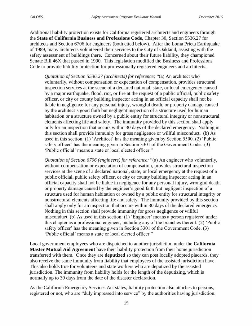
Additional liability protection exists for California registered architects and engineers through
the State of California Business and Professions Code, Chapter 30, Section 5536.27 for
architects and Section 6706 for engineers (both cited below). After the Loma Prieta Earthquake
of 1989, many architects volunteered their services to the City of Oakland, assisting with the
safety assessment of buildings there. Concerned about their future liability, they championed
Senate Bill 46X that passed in 1990. This legislation modified the Business and Professions
Code to provide liability protection for professionally registered engineers and architects.
Quotation of Section 5536.27 (architects) for reference: “(a) An architect who
voluntarily, without compensation or expectation of compensation, provides structural
inspection services at the scene of a declared national, state, or local emergency caused
by a major earthquake, flood, riot, or fire at the request of a public official, public safety
officer, or city or county building inspector acting in an official capacity shall not be
liable in negligence for any personal injury, wrongful death, or property damage caused
by the architect’s good faith but negligent inspection of a structure used for human
habitation or a structure owned by a public entity for structural integrity or nonstructural
elements affecting life and safety. The immunity provided by this section shall apply
only for an inspection that occurs within 30 days of the declared emergency. Nothing in
this section shall provide immunity for gross negligence or willful misconduct. (b) As
used in this section: (1) ‘Architect’ has the meaning given by Section 5500. (2) ‘Public
safety officer’ has the meaning given in Section 3301 of the Government Code. (3)
‘Public official’ means a state or local elected officer.”
Quotation of Section 6706 (engineers) for reference: “(a) An engineer who voluntarily,
without compensation or expectation of compensation, provides structural inspection
services at the scene of a declared national, state, or local emergency at the request of a
public official, public safety officer, or city or county building inspector acting in an
official capacity shall not be liable in negligence for any personal injury, wrongful death,
or property damage caused by the engineer’s good faith but negligent inspection of a
structure used for human habitation or owned by a public entity for structural integrity or
nonstructural elements affecting life and safety. The immunity provided by this section
shall apply only for an inspection that occurs within 30 days of the declared emergency.
Nothing in this section shall provide immunity for gross negligence or willful
misconduct. (b) As used in this section: (1) ‘Engineer’ means a person registered under
this chapter as a professional engineer, including any of the branches thereof. (2) ‘Public
safety officer’ has the meaning given in Section 3301 of the Government Code. (3)
‘Public official’ means a state or local elected officer.”
Local government employees who are dispatched to another jurisdiction under the California
Master Mutual Aid Agreement have their liability protection from their home jurisdiction
transferred with them. Once they are deputized so they can post locally adopted placards, they
also receive the same immunity from liability that employees of the assisted jurisdiction have.
This also holds true for volunteers and state workers who are deputized by the assisted
jurisdiction. The immunity from liability holds for the length of the deputizing, which is
normally up to 30 days from the date of the disaster declaration.
As the California Emergency Services Act states, liability protection also attaches to persons,
registered or not, who are “duly impressed into service” by the authorities having jurisdiction.

Cal OES Safety Assessment Program Evaluator Manual December 2016
16
This practice of ‘commandeering’ dates back to Roman times, and has been used in recent
disasters in California as well.
Under the Emergency Management Assistance Compact (EMAC), persons from outside the
State of California who are sent through EMAC to help with a disaster in California have
whatever immunities from liability that they would have in their home state. Conversely,
persons sent by the State of California under EMAC to help communities in other states have the
same protections from liability that they enjoy within California under these aforementioned
laws and regulations.
Of course, all of these liability protections do not cover malicious acts (such as red-tagging a
building because the owner is argumentative) or gross negligence (such as green-tagging a
building without any assessment).
1.5 Workers’ Compensation for California Disaster Service Workers (DSWs)
State of California employees and California local government employees are Disaster Service
Workers by definition. State of California employees are covered with workers’ compensation
from the State of California. Local government employees are covered with workers’
compensation from their respective local governments.
As stated in the previously mentioned California Attorney General’s Opinion, private sector
volunteers are covered for workers compensation by the State of California, and this is the only
source of workers’ compensation available to them. However, private sector volunteers must
become California Disaster Service Workers in order to be eligible for workers’ compensation
from the State of California. This in accord with Section 8580 of the California Emergency
Services Act, which states:
“The Emergency Council shall establish by rule and regulations various classes of
disaster service workers and the scope of the duties for each class. The Emergency
Council shall also adopt rules and regulations prescribing the manner in which disaster
service workers of each class are to be registered. All of the rules and regulations shall
be designated to facilitate the payment of workers’ compensation.”
Private sector residents of California become Disaster Service Worker volunteers by completing
the Loyalty Oath or Affirmation on the SAP Registration Form (hereafter referred to as the
“Loyalty Oath”). By State of California law, this oath must be properly witnessed by one of the
following persons:
The Executive Director of the California Governor’s Office of Emergency Services, or
one of his/her designees (one of the Statewide SAP Coordinators employed by Cal OES);
A Notary of the Public, who cannot be paid for witnessing the Loyalty Oath signature;
A county or city court clerk, a judge or retired judge, a court recorder, or a local sheriff or
chief of police.
State of California employees, as well as employees of local governments in California, are not
required to sign the Loyalty Oath, as they are already Disaster Service Workers.

Cal OES Safety Assessment Program Evaluator Manual December 2016
17
Persons who are not residents of California do not need to sign the Loyalty Oath. If they are
dispatched to California under EMAC, then they would be covered by whatever workers’
compensation arrangement exists for them in their home state.
1.6 Program Registration
Safety Assessment Program evaluators are deployed through one of two ways:
Through their professional organization; or,
Through their supervisor, if employed by a State of California agency.
In either case, registered SAP evaluators must meet the minimum requirements previously
discussed. In addition, they also must:
Complete the one-day standardized training presented by a certified SAP trainer;
Have their photo taken for identification purposes; and
Be a California Disaster Service Worker (see Section 1.5).
There were a variety of identification cards issued prior to July 2013, when Cal OES was
rebranded with its current name. The current identification cards are two-sided and have dark
bands on a white background. In the event of a deployment, persons with the older cards will
have new Cal OES identification cards made for them, so there is consistency in the field. As
was reinforced in the April 2010 Baja Earthquake event that affected Imperial County,
identification is essential in order to protect the public from fraudulent individuals seeking to
profit from the disaster. Those with older cards will otherwise receive updated identification
cards once they recertify.
All SAP identification cards expire five years from the month of the evaluator class. A refresher
course is available online at the SAP website to renew one’s SAP identification card, and thereby
one’s standing in the statewide cadre. There is also a half-day SAP recertification class that is
available though the certified instructors. Of course, one can also take the regular SAP evaluator
class again to renew. Be certain to store your SAP ID card in a safe place where you can
easily find it.
The back side of the SAP ID cards contain an emergency worker clearance statement that will
assist the SAP evaluator in crossing public safety lines. It also has a postage guarantee that
allows a lost SAP identification card to be sent back to Cal OES by simply being put into the
mail.
Also, SAP coordinators who have the credentials to do field evaluation (see Section 1.2) are
issued a card identifying them as a coordinator. This will facilitate their work in the office or
field as a lead person. (The SAP coordinator training is different from this evaluator course, and
is given as an add-on to the SAP evaluator class. A SAP coordinator who is issued an ID badge
also has the credential to perform safety assessments in the field.)
SAP evaluators who reside in states other than California will have their state of residence on
their SAP ID card.

Cal OES Safety Assessment Program Evaluator Manual December 2016
18
Figure 1-2: SAP Identification Cards for Evaluators
Figure 1-3: SAP Card Back, Other Examples
1.7 Reimbursements
The experiences from the 2014 Napa Earthquake made clear the need to solidify the mutual aid
agreements regarding safety assessment, so all parties are aware of their responsibilities, and so
eligible reimbursement from state and federal disaster programs for SAP expenses can proceed.
Therefore, Cal OES created a Safety Assessment Program Memorandum of Understanding (SAP
MOU) that spells out the terms of mutual aid for the Safety Assessment Program, and that also
supplies some operational framework for implementing this mutual aid. A copy of the SAP
MOU can be found in the Appendix.

Cal OES Safety Assessment Program Evaluator Manual December 2016
19
Cal OES strongly recommends that local governments have a SAP MOU in place before an
emergency happens that requires safety assessment assistance! If no signed agreement is in
place when a request for assistance is made, Cal OES will attempt to have the document signed
by the Receiving Agency prior to dispatching SAP personnel.
Responding volunteers may have to pay up front for hotel and meal expenses, as well as other
reasonable travel costs, but these costs are to be reimbursed by the local government that
requested their assistance. Some local governments may have a pre-arrangement with a hotel
and restaurant so the out-of-pocket expenses by the volunteers are greatly reduced.
In addition to these things, there are two other reimbursement issues that all should be aware of:
DSW Volunteers will not be able to receive wages while activated for the Safety
Assessment Program. They must be on their own time, either on vacation or on unpaid
leave, while working as a volunteer. This is so the workers’ compensation coverage from
the State of California will apply. (If a company were to pay wages to private sector
employees while they worked doing safety assessment, the company would be
responsible for the workers’ compensation, and would also not enjoy the protection from
liability that the State of California provides for volunteers.)
Local government employees might be operating on their home jurisdiction’s funding
until the Governor proclaims a state of emergency for the incident. As stated before,
these costs can be reimbursed eventually through the state and federal public assistance
programs.
1.8 Activation Sequence
Local governments must reasonably commit all their available resources once a local emergency
situation occurs. This usually happens early in the disaster response, as many inspectors are sent
out to do windshield surveys and initial tagging of essential facilities at once.
After the local building department’s personnel are committed, the local government must
evaluate their need for additional resources. If the event is beyond their capacity to respond to
with their own personnel, the local government should request assistance from the Operational
Area.
Operational Areas can draw upon the resources of the County and all the cities and special
districts within the County. The County will be the lead agency for the Operational Area. The
Operational Area can request under mutual aid the safety assessment resources from all the
agencies within its borders to assist with the local emergency response.
If these resources are not enough, and the Operational Area has reasonably committed all
available safety assessment resources it can, then the Operational Area will request SAP
assistance through the Cal OES Regional Emergency Operations Center (REOC). Since SAP is
a state-level resource, the REOC forwards the request to the Operations Chief of the State
Operation Center (SOC) and to the Statewide SAP Coordinator. The request will ask for the
number and type of personnel being requested (numbers of building inspectors, engineers, and
architects), where they are to report to, and when they are needed.

Cal OES Safety Assessment Program Evaluator Manual December 2016
20
The Statewide SAP Coordinator then (1) confirms that the SAP MOU is in place with the
requesting agencies, (2) contacts the appropriate professional organizations to mobilize their
members and (3) has them report to the identified staging area for their assignments.
The SAP evaluators must remember to bring their SAP ID card, hard hat, safety shoes, and go-
kit (see Chapter 7). Once the SAP evaluators arrive at the staging area, which should be separate
from either the local Emergency Operations Center or the local Building Department, the
evaluators report to the SAP Coordinator, sign in, and are deputized. They obtain a briefing
packet from the SAP Coordinator, and watch a video supplied to the SAP Coordinator by Cal
OES that helps remind the evaluators of their responsibilities. The briefing packet needs to have
travel expense claim forms, a map, and the phone numbers for the building department, police,
fire, haz mat, utilities, and animal control.
Then they receive their assignments as teams. It is important for their own safety that all SAP
evaluators work in teams of at least two individuals – no one should ever be allowed to go off by
themselves due to the extreme danger that can be encountered in the post-disaster theater! The
assignments may be sections of neighborhoods by blocks, or a list of afflicted properties. If the
latter is the assignment, it is good if the local government can supply a driver who is familiar
with the jurisdiction.
At the end of each day, the SAP evaluators return to the staging area to debrief with the SAP
coordinator. The coordinator reviews for completeness the assessment forms that are completed
for each property by the teams, and to discuss any safety or program issues that came up in the
field. The evaluators sign out for the day and return the next, until their assignment is over. This
sign-in and sign-out process by the local government is imperative for safety and accountability
of the SAP resources, and reimbursement for costs encumbered by the local government.
1.9 Suggested Evaluator Assignments
Both Cal OES and ATC-20 recommend the following responsibilities for the various disciplines
among the SAP evaluators. This is simply guidance in the absence of anything else; the actual
assignments of individuals with various skills will be done by the local governments based on
their own priorities.
There are two types of evaluations that are done on structures. Rapid evaluations are a quick
safety review of the building using a one-page form, and usually make up 95% of the building
reviews in earthquakes. (Windstorms and floods have slightly different percentages from this.)
Detailed evaluations are usually done for buildings that have already been reviewed and tagged;
these may be at the request of building owners, or the request of the first SAP evaluator team, if
they felt the structure was difficult to call, and a second opinion is warranted. Sometimes a
moderately affected local government may request that all evaluations be detailed. Detailed
evaluations may take much longer to do than rapid evaluations, and the form is two pages long
for buildings. All infrastructure evaluations are detailed. More information on these forms is
found in Chapters 2 and 4 of this manual.
Building inspectors perform rapid evaluations of all occupancies. Building officials
will assist with detailed evaluations also.

Cal OES Safety Assessment Program Evaluator Manual December 2016
21
Structural engineers, and civil engineers with a structures background, perform both
rapid and detailed evaluations of buildings and structures. They may also assist certain
state agencies with their work, such as the Division of the State Architect (DSA) and the
Office of Statewide Health Planning and Development (OSHPD).
Civil engineers with a background in infrastructure, along with public works
inspectors, perform the detailed evaluation of lifeline infrastructure systems and
facilities. They are also available to assist state agencies with their work, such as the
Department of Water Resources and the Department of Transportation (Caltrans).
Architects perform rapid evaluations of buildings and structures, and if needed, will also
assist with doing detailed evaluations. They can also assist state agencies such as the
Division of the State Architect with their work.
For small events, only those individuals within the disaster area or the immediate vicinity thereof
will likely be activated. This way, costs will be kept to a minimum, as the SAP evaluators can
return home at night instead of staying at hotels.
For large events, persons from within the disaster area will not be activated, as the assumption
will be made by Cal OES that these persons are already busy with disaster related duties. Local
government building inspectors and engineers will be inspecting buildings within their own
jurisdiction and will not be available. Private sector SAP evaluators who are from the affected
area will likewise have their own clients who will require assistance. The SAP evaluators who
respond to large events will come from outside the affected area, from across the State of
California or from across the country through EMAC.
Cal OES works with the five partner organizations (CALBO, AIA, ASCE, ACIA, and SEAOC)
through state-level coordinators at these organizations. In turn, the organizations usually have a
coordinator at the chapter level that does the actual call-outs in a deployment. State agencies
likewise have lead emergency managers who are contacted by Cal OES if the SAP evaluators of
their agencies are needed.
Once a volunteer receives a deployment request, they must personally make the decision if they
are able to respond or not. There may be times when personal circumstances do not allow them
to be activated; if this is the case, it is understandable if they inform the partner organization that
they are not available this time, but would like to participate another time.
Both local government and state agency SAP personnel must individually work out their
availability with their supervisors.
Volunteer SAP evaluators are activated for 5 working days. Local and State SAP evaluators are
also likely to be activated for five days, but may be held over longer if necessary in order to wrap
up the field efforts near the end of the deployment, rather than bring in a new wave of personnel
for just a few days.
Deployed SAP coordinators should have an overlapping schedule with their incoming
replacements so the new SAP coordinator can be briefed on the current situation, effective
procedures for this disaster, and to get set up for the next wave of SAP evaluators.

Cal OES Safety Assessment Program Evaluator Manual December 2016
22
1.10 Safety Assessment Responsibilities for Agencies and Organizations
Governmental entities that regulate building or lifeline construction and/or safety have safety
assessment responsibilities. This falls under the role of government to provide for the health and
safety of the public.
It is very important after a disaster to quickly identify habitable buildings. Some buildings will
be used for urgent medical care, mass shelter facilities, or emergency operations; but the vast
majority are privately owned and often key to the economy of the affected area. So, clearing
private buildings for safety will not only help free up the shelter spaces, but will also help the
local economy to get back on its feet, thus adding in the overall recovery from the disaster.
The following is a review of the government agencies involved in safety assessments on the
structures within their jurisdiction.
Buildings and Structures
Local governments are responsible for their own facilities, all privately owned
businesses, private schools, single-family residences, and multi-family residences within
their jurisdiction, as well as all structures and lifeline infrastructure not specifically
mentioned below.
California Department of General Services, Division of the State Architect (DSA) is
responsible for oversight of the new construction of all public schools, community
colleges, and state-owned or state-leased facilities. DSA currently does not have
oversight responsibility for post-disaster safety assessment of public schools, but
nevertheless has had their technical staff trained in safety assessment, and stands ready to
assist after a disaster. (The Safety Assessment Program is one resource available to
school districts after a disaster. School districts may alternatively set up a Memorandum
of Understanding with local building departments for post-disaster safety assessment, or
may choose to contract with private engineering or architectural firms to have their safety
assessments done.)
California Office of Statewide Health Planning and Development (OSHPD) has oversight
for all acute-care hospitals and skilled nursing facilities. OSHPD has also had many of
their staff trained in safety assessment.
California Office of the State Fire Marshal (SFM) is the building inspection department
for state facilities, including prisons. SFM is responsible for the fire and life safety
elements of all state-owned or state-leased facilities as well as non-ambulatory care
facilities. (Fire elements mean fire suppression systems, alarms, detectors, etc. Life
safety elements refer to exits, corridors, stairways, etc.)
California Department of Housing and Community Development (HCD) is responsible
for most of the mobile homes and manufactured home parks in California.
Federal government is responsible for all federal buildings and installations, no matter
where the facilities are located. These safety assessments are usually performed by the
U.S. Army Corps of Engineers from the area in which the disaster event occurs.
Lifelines

Cal OES Safety Assessment Program Evaluator Manual December 2016
23
Local government public works departments are responsible for all of the non-federal aid
roads and bridges, along with the storm drains, sewers, etc., which are under the
jurisdiction of the particular local government.
Special Utility Districts are responsible for the pipelines and/or transmission lines that
they install and/or maintain.
California Department of Water Resources, Flood Operations is responsible for all
levees, canals, and state water projects.
California Department of Water Resources, Division of Dam Safety is responsible for all
jurisdictional dams, except those owned or operated by the U.S. Army Corps of
Engineers, or the U.S. Bureau of Reclamation. (A jurisdictional dam must be taller than
six feet and hold back more than 50 acre-feet of water, or be taller than 25 feet and hold
back more than 15 acre-feet of water.)
California Department of Transportation (Caltrans) is responsible for state and federal
highways in California, along with buildings and other infrastructure essential to the
performance of their work.
The process of evaluating or inspecting facilities will not be limited to a local government’s
building department and any resources that they may request. Many other agencies will be in the
post-disaster theater performing such evaluations under their authority. Being prepared for the
possibility of many inspectors in the affected area can help reduce or eliminate redundant efforts,
and lead to a sharing of information and cooperation between the agencies involved.
In addition to those agencies reviewing infrastructure, the following will also respond to the
disaster:
American Red Cross (ARC) will be on the ground within 24 hours of a disaster event to
appraise the need for shelters, food, water, and temporary housing. The ARC will then
begin identifying shelters and providing assistance to survivors. The urgent need for safe
shelter locations is the primary reason why the early safety assessment of potential shelter
buildings is essential.
California Department of Insurance will send teams to assist with identifying insurance
issues out in the affected areas. These teams are called Insurance Damage Assessment
Teams (IDAT).
Insurance companies will have their adjusters in the affected area performing visual
inspections once survivors start to file insurance claims.
News media will make their presence felt very soon after the disaster event. Reporters
and camera crews will be touring the streets, looking for damage to broadcast and for
people to interview. Public officials will be high on their list of interviewees, and SAP
evaluators will look very official, so be prepared for the possibility of such an encounter.
If the media present themselves to SAP evaluators, the reporters should politely be
referred to the Public Information Officer (PIO) at the local Emergency Operations
Center (EOC). Each local government will have their own protocol for addressing media
questions, and evaluators should not be providing information about the disaster or the
response to same without the express approval and consent of the local government.
After a local government officially proclaims a state of emergency and requests state and federal
assistance through Cal OES, preliminary damage assessment (PDA) inspectors may be sent by

Cal OES Safety Assessment Program Evaluator Manual December 2016
24
Cal OES to affected local governments to review public facility damage sites and other damage-
caused expenses. These will be considered by Cal OES to see if a request for federal assistance
is warranted. If it is warranted, then the Federal Emergency Management Agency (FEMA) will
be contacted by Cal OES to join in a coordinated State-FEMA PDA. FEMA and Cal OES work
with the local governments to develop reasonably accurate estimates of disaster program eligible
work. Once the figures are in, they are used by the Governor to request a major disaster
declaration from the President.
Cal OES Disaster Assistance may be out early after the disaster to perform State PDAs.
The inspectors team up with local government representatives and review rough damage
assessment estimates. This early assessment may help provide information as to whether
or not the State can request assistance from the federal government.
FEMA public assistance inspectors will make contact with the state inspectors and join
local government representatives to perform the PDA for public facilities with federal
public assistance in mind. In the same manner as the State PDA is done, they will inspect
damaged buildings and facilities, and gather cost information related to the emergency
response and facility repairs. Once there is a Presidential declaration of a major disaster,
these inspectors and their State counterparts will perform more detailed inspections of the
damaged facilities in order to develop project worksheets, which are the funding grants
for federal disaster assistance.
FEMA individual assistance inspectors will perform the PDA for private homes and
businesses along with State inspectors and representatives of the Small Business
Administration (SBA). They gather information on the number of homes and businesses
with major damage or that are destroyed. These figures are used to request assistance.
SBA can send in inspectors to work with State individual assistance inspectors once there
is a Governor’s proclamation of a state of emergency. These SBA inspectors evaluate
how many homes are either destroyed or have sustained major damage according to their
criteria, which can be different from FEMA’s. Their inspectors perform verification
inspections after applications for SBA loans have been received. SBA can find a county
and its surrounding counties eligible for assistance independent of FEMA’s findings.
As we can see by the list of agencies involved in the disaster theater, there will be many people
milling around the affected area at any given time. Be prepared!
1.11 Evaluator and Local Government Roles and Responsibilities
There are clearly defined roles and responsibilities for the SAP evaluators and local governments
throughout the safety assessment process.
Evaluators will:
First assess the safety of those buildings essential to the management of the disaster.
These buildings include police and fire stations, the local Emergency Operations Center,
City Hall, and buildings intended for use as shelters, as well as any other facilities locally
considered essential to handling the emergency, such as communications or public
welfare buildings, water and wastewater treatment plants, grocery stores, hardware stores,
and pharmacies.
Perform rapid assessments of all other buildings.

Cal OES Safety Assessment Program Evaluator Manual December 2016
25
Perform detailed evaluation of questionable buildings, as assigned by the building
department.
Perform detailed evaluations of specified lifeline systems and facilities.
Evaluators will NOT:
Provide dollar estimates for the buildings they have evaluated. There are two reasons
why this should not be done. First, estimating disaster-caused building repair costs is
“damage assessment,” and is not eligible for direct reimbursement under state and federal
disaster grant regulations. Second, building costs can vary widely from one location to
another, so it is best left to the local government to arrive at these repair costs. (SAP
evaluators may gather non-cost data from the field, however, such as square footage and
percentage of damage, that may be used by local government to determine rough
estimates of damage.)
Perform evaluations of compliance of grandfathered conditions to current code.
Naturally, as building codes change, older buildings stock fall out of compliance, but are
normally allowed to remain as “grandfathered” until sufficient renovations are done to
them. For the SAP evaluator, this means that an older building would not be tagged
unsafe unless it had actually suffered damage from the event that warranted such. It is
entirely possible that unreinforced masonry buildings, for example, may come through an
earthquake without a crack, in which case the building could be viewed as safe as it was
before the disaster. Life safety issues caused by the event, however, would merit attention
from the SAP evaluator and must not be ignored. Also, if a SAP evaluator comes across
an unsafe code compliance issue, such as a locked exit door or other dangerous condition,
it would be proper to note that condition on the assessment form for further actions by the
building department or code enforcement, even if such did not affect the disaster-related
safety level of the building.
Perform escort or property retrieval for owners or occupants of buildings. Local
governments can provide fire/rescue or law enforcement personnel to assist with this, and
can augment their forces with mutual aid if that becomes necessary. The work of SAP
evaluators in clearing homes and businesses for safe use is very valuable and important
for the community, and must be kept on track.
The roles and responsibilities of local governments include:
Appointing a SAP coordinator who will be responsible for managing the program during
a response, and who will develop their department’s SAP Operations Plan. (Training for
SAP coordinators is available, and classes are posted on the Cal OES website.)
Formally adopting the placards and issuing them to the evaluators as needed.
Deputizing the responding evaluators. (If an individual local government does not wish to
deputize the evaluators, they must be prepared to either send their own staff out to replace
the generic placards with official ones, or to assign one of their building inspectors to
each of the SAP evaluator teams.)
Upon their arrival, provide a formal briefing to the evaluators of conditions in the
jurisdiction, what they will be doing, and who they will be reporting to upon their arrival,
along with a briefing packet. The briefing should include watching the SAP Refresher
DVD, which is issued to the SAP coordinators as part of their training. The briefing

Cal OES Safety Assessment Program Evaluator Manual December 2016
26
packet should contain a map, any referral info that might be given to residents who want
help with property retrieval, and a list of important phone numbers.
The phone list should include the Building Department (which phone number should be
written on the placards as well), police, fire, hazardous materials, utilities, and animal
control.
Provide the evaluators with lodging and meals.
See if legal authority that allows the work to be performed is in place.
1.12 Terminology
ATC-20 – INSPECTED – Habitable, minor or no damage – This green placard is
used to identify facilities that have been inspected but in which no serious damage has
been found. These structures are in a condition that allows them to be lawfully
reoccupied; however, repairs may be necessary, such as those to stucco or drywall. There
are no use restrictions on “green-tagged” buildings as far as the disaster damage is
concerned, and the facility may be used in the same manner as it was before the disaster.
This does not mean that the facility is cleared against all future damage, however. See
more discussion in Chapter 2.
ATC-20 – RESTRICTED USE – Damage which represents some degree of threat to
occupants – The yellow Restricted Use placard is intended for facilities that have been
damaged, but the extent of damage does not totally preclude using or occupying parts of
the structure. It can mean that the building could be used under certain restrictions, or
parts of a structure could be occupied. It can also mean that the facility can be only
briefly entered to remove important possessions. The use of a “yellow-tagged”
Restricted Use placard will minimize the number of buildings which will require
additional safety assessments because restrictions can be placed on the use and
occupancy of the structure until the owner can hire an engineer or architect to develop the
necessary repair program.
ATC-20 – UNSAFE – Not habitable, significant threat to life safety – The red ATC-
20 Unsafe placard is used on those facilities with the most serious damage. Typically,
these are structures that represent a threat to the life safety of persons occupying them. It
is important to note that this category does not mean that the facility so tagged must be
demolished. This placard carries the statement, “THIS IS NOT A DEMOLITION
ORDER” to simply clarify that the facility is not safe enough to occupy, not that there is
a demolition order against it. In the vast majority of cases, structures posted unsafe can
be repaired to a safe and usable condition. This designation also includes buildings with
a hazardous material spill present, or that are situated in a “collapse zone”, thus
threatened by another structure that is unstable. It also includes those buildings that are
threatened by unstable ground, whether related to the building foundation or related to a
landslide threat from a higher elevation.
Damage assessment – The cost estimating process that local and state agencies must
perform to determine the type and quantity of disaster-related damage, and to repair those
damages. This work is usually associated with disaster assistance applications from the
jurisdiction to the State, or through the State to FEMA. SAP evaluators are not to do
damage assessment, but may collect information that assists local governments to do so.

Cal OES Safety Assessment Program Evaluator Manual December 2016
27
EMAC - Emergency Management Assistance Compact – This is a state-to-state
mutual aid agreement that all 50 states and the U. S. territories (Guam, Puerto Rico, etc.)
have entered into. It allows for resources from other states to assist with disasters, and
under Article 5 allows the temporary recognition of professional licenses from other
states for the purpose of the disaster. EMAC is arranged for exclusively through the
emergency management offices of the states.
EOC – Emergency Operations Center – A local government facility that provides
support for all field operations, and through which resources are obtained and distributed
to various field operations. Policy decisions related to the disaster are also developed at
the EOC and dispersed from there.
Mutual Aid – The process used to facilitate assistance to disaster-stricken communities
without the use of the customary written agreements normally entered into by agencies
with joint powers. Mutual aid is based on the concept of ‘neighbor helping neighbor’ in
time of need without the expectation of compensation, although there are cases after the
first 12 hours of aid when compensation of responding may be sought. Mutual aid
assistance can include any type of resource from other jurisdictions, the State, and even
the private sector. The State of California Master Mutual Aid Agreement governs
California’s mutual aid system.
ICS - Incident Command System – A very successful management approach that is
used during emergency response operations. ICS is an organizational structure that
encourages communication vertically through the layers of the organization as well as
laterally between sections in the same layer. ICS also incorporates incident action
planning into operations, allowing for the definition of measurable goals to keep the
operation coordinated.
OA – Operational Area – One of the five levels of the Standardized Emergency
Management System (SEMS). An Operational Area is composed of a county and all the
cities and special districts within that county. The OA is responsible for supporting all
tactical operations of the cities and special districts within it, and communicating disaster
event operational status to the next SEMS level, the State Regional Emergency
Operations Center (REOC).
REOC – Regional Emergency Operations Center – This is the facility operated and
maintained by the State of California within the mutual aid region being served. REOCS
are located in Los Alamitos for the Southern Region, Oakland for the Coastal Region,
and Mather (near Sacramento) for the Inland Region. It is through these operations
centers that the State provides support to the Operational Areas, coordinates requests for
statewide resources, and provides the communication link between local governments
and the State of California. REOC operations are under the jurisdiction of the California
Emergency Management Agency.
Safety assessment – The process by which facilities of all occupancies and infrastructure
lifelines are evaluated for their safety for continued use or disuse. This process is under
the direction of local governments through their Building and Safety or Public Works
departments. During safety assessment, the cost estimating process known as ‘damage
assessment’ must not be done.
SOC – State Operations Center – This is the facility operated and maintained by the
State of California in Sacramento County from which all requests for assistance are
coordinated. All response efforts from State Agencies and state resources are also

Cal OES Safety Assessment Program Evaluator Manual December 2016
28
coordinated and directed from this location. EMAC is coordinated for mutual aid from
out of state, and federal agency resources are also requested and coordinated from this
location.

Cal OES Safety Assessment Program Evaluator Manual December 2016
29
UNIT 2: SAFETY ASSESSMENT PROCESS
AND PROCEDURES

Cal OES Safety Assessment Program Evaluator Manual December 2016
30
UNIT 2 – SAFETY ASSESSMENT PROCESS AND
PROCEDURES
Overview
This unit introduces the process and procedures for performing safety assessments on buildings.
Participants will review the particular hazards associated with earthquakes, windstorms, floods,
and explosions, and how they affect buildings. The remainder of the unit will address the
placards, forms, procedures, and criteria used in performing safety assessments.
Training Goal
Participants will become familiar with and understand the different types of evaluations, how to
use the forms, and the definitions and uses of the placards.
Objectives
Upon completion of this unit, participants will be able to:
Use the criteria for completing each type of evaluation.
Properly identify and complete the various forms.
Properly identify and correctly use the various assessment placards.

Cal OES Safety Assessment Program Evaluator Manual December 2016
31
2.0 Safety Assessment Process and Procedures
2.1 Earthquake Effects
Earthquakes can cause several different effects to occur at the same time. These effects are:
Faulting – The movement of ground on one side of the fault relative to the other.
Historic and geologic records show that such movement has been as large as 20 feet
horizontally and 10 feet vertically. Few structures located over the fault or next to it can
withstand this sort of disruption.
Landslides, rockslides, and mudflows – These have caused great loss of life when
entire towns have been buried (Andes Mountains). Automobile-sized boulders have
caused great damage to structures (Iran, Alaska, New Zealand), and large landslides have
moved structures hundreds of feet (Alaska).
Liquefaction – This occurs in loose deposits of fine sand that have a high water table. If
such a soil configuration is subjected to a sudden disturbance or shock, as in an
earthquake, the soil tends to lose stability under the shear stresses. The soil is
temporarily transformed into a fluid mass with greatly reduced shear strength, with a
condition resembling general soil shear failure. In the 1963 Niigata, Japan earthquake,
liquefaction caused a group of apartment buildings to drop suddenly, some by as much as
one story, and to tilt more than 30 degrees. Sand boils and other disruptions of the
ground surface have also occurred.
Tsunami or seiche – A tsunami (Japanese for “harbor wave”) is a powerful wave event
that is generated in the ocean; a seiche is a similar wave event that occurs in lakes. These
are normally caused by seismic events that uplift the underwater terrain, such as in a
subduction zone. Such a tsunami normally requires a M 7.2 or greater subduction zone
earthquake in order to be generated. Tsunamis also usually involve a series of waves
instead of a single wave. When these waves sweep ashore, they can devastate all but the
strongest structures. Earthquakes are not the only causes of tsunamis or seiches; they can
also be caused by landslides that disrupt a large volume of water, either from above the
water or underwater. They can also be generated by underwater volcanic eruptions.
Shaking – This is the most commonly experienced effect of earthquakes. Shaking can be
felt hundreds of miles from the earthquake epicenter. There are three types of ground
shaking that results from earthquakes; the first two are dampened (or “attenuated”) with
distance from the epicenter, and are called ‘near field’ effects for that reason. Pressure
waves, or P-waves, travel through the ground at about the speed of sound, and are
sinusoidal in one plane. They are precursors to the more damaging (and slower) shear
waves, or S-waves, which exert most of the lateral forces in the near field, and are
sinusoidal in two planes. Both types of seismic waves have periods less than one second
in frequency, and dissipate with distance and geologic resistance from mountains and
other features. The long waves with periods of one second or more, often travel
throughout the earth’s crust, and can be measured on the other side of the globe. They
can also cause damage at a distance if they meet up with buildings of the correct natural
period of vibration with enough force.

Cal OES Safety Assessment Program Evaluator Manual December 2016
32
Photo courtesy USGS
Figure 2-1 – Probable Ground Motion Hazard Map of the United States, 2015 update
(2% in 50 year probability, expressed in g-forces)
2.1.1 Earthquake Hazards in the United States
Figure 2-1 shows the seismic hazards in the continental United States. Besides the strong
hazards found in California, notable features of this map include the Cascadia Subduction Zone
in Washington and Oregon, the Wasatch Fault in Utah, the seismic hazards associated with the
Yellowstone Caldera feature in Wyoming, the New Madrid Fault in the Midwest, the seismic
hazards in the Charleston, South Carolina area, and the seismic hazards in New England.
2.1.2 Effects on Structures
Every structure has a fundamental or natural period of vibration, which is a function of the
building’s mass and stiffness. In a simplified manner, a building’s period could be approximated
as 0.10 N seconds, where N is equal to the number of stories. Moreover, a structure’s
fundamental period will normally decay, or grow longer, as the structure suffers damage.
Earthquake motion is generally rich in various frequencies (frequency is the inverse of period,
i.e., 1/period) that are similar to those of structures, and therefore can promote structural damage.
Note that these statements are greatly simplified; for the proper fundamental period formula, see
the most current building code.

Cal OES Safety Assessment Program Evaluator Manual December 2016
33
As ground waves move further from the epicenter, the shorter frequencies are damped, and the
longer waves remain. In the near field, where seismic waves are most intense and the
frequencies are shorter, the strongest effects are felt by shorter, stiffer structures whose periods
of vibration are closer to matching the period of the ground waves. Taller, more flexible
structures will be affected most severely by the long frequencies that will continue out beyond
the near field.
In the near field, the strong shaking that is felt by structures will have significant vertical and
lateral components. Since the vertical load system of buildings is designed for more than dead
load, or gravity load by itself, the additional vertical forces are normally not a threat to the
structure. However, lateral shaking from earthquakes subjects structures to both shear and
overturning forces. These threats require structures to have a complete lateral force resistance
system, which may either be part of the vertical load system, or separate from it.
In the far field, longer seismic waves that are not absorbed by local geology cause unusual
effects that can severely damage taller, longer period structures. When the fundamental period of
a site matches that of the structure built on it, seismic shaking can cause resonance that amplifies
the structure’s response. The collapse of buildings between 10 and 20 stories in height in
Caracas in 1967, and of 8 to 12 story buildings in Mexico City in 1985, are unfortunate examples
of this effect.
Photo courtesy FEMA
Figure 2-2 – Shear cracking in masonry infill walls
The above photo illustrates classic X-shaped shear cracking that occurs in response to lateral
seismic forces.

Cal OES Safety Assessment Program Evaluator Manual December 2016
34
Photo courtesy FEMA
Figure 2-3 – Soft story failure, San Francisco, 1989 Loma Prieta Earthquake
This building did not have sufficient lateral force resistance in its lowest floor, resulting in this
dangerous “soft story” failure.
Photo courtesy FEMA
Figure 2-4 – House off of its foundation
This house did not have enough tie-downs to hold it to its foundation.

Cal OES Safety Assessment Program Evaluator Manual December 2016
35
Photo courtesy Fred Turner, EERI
Figure 2-5 – Pounding, 2010 Chilean Earthquake
These two buildings were of dissimilar height and stiffness, and were too close together. Their
reaction to the seismic waves was different, so they pounded each other.
Photo courtesy Dave Karina, ACIA
Figure 2-6 – Roof-wall connection failure, 2010 Baja Earthquake
Roof diaphragm has failed, so building has lost its lateral load resistance capacity.

Cal OES Safety Assessment Program Evaluator Manual December 2016
36
Photo courtesy FEMA
Figure 2-7 – Unreinforced masonry building with wall failure, 2003 San Simeon EQ
Unreinforced masonry buildings have no tensile resilience, hence are brittle and very dangerous
in earthquake-prone regions.
Photo courtesy Fred Turner, EERI
Figure 2-8 – Collapse of tilt-up walls, 2010 Chilean Earthquake
Tilt-up walls may not have been anchored correctly to roof, leading to this failure.

Cal OES Safety Assessment Program Evaluator Manual December 2016
37
Photo courtesy FEMA
Figure 2-9 – Ground scarp through building
This building was torn in two by either a fault trace or a settlement scarp.
Photo courtesy Cal OES
Figure 2-10 – Partial collapse of structure
Soft story failure in this building led to its partial collapse.

Cal OES Safety Assessment Program Evaluator Manual December 2016
38
Photo courtesy FEMA
Figure 2-11 – Racking damage to porch, 1994 Northridge Earthquake
Photo courtesy Fred Turner, EERI
Figure 2-12 – Damaged chimneys

Cal OES Safety Assessment Program Evaluator Manual December 2016
39
Chimney failures are common in areas with moderate ground motion, as chimneys usually are
made of unreinforced masonry and are often not braced or reinforced at the roof line. In areas
with strong ground motion, the chimneys are often snapped off.
2.2 Windstorm and Flood Effects
Damage from lateral forces due to wind and moving floodwater is the most common structure
failure mechanism in these types of disasters. Lateral forces from strong winds can be as
damaging to a structure as those from earthquake forces. There are recorded examples of
hurricane force winds that have destroyed unreinforced masonry buildings, and the violent winds
of strong tornados can completely decimate structures.
In floods, it is not uncommon for buildings to be floated off their foundations and swept away.
In the most extreme cases, it does not matter if the building is attached firmly to a concrete slab
foundation; there are numerous examples from the 2005 Hurricane Katrina event of entire well-
built homes being raised out of the ground with their slab foundations by storm surge flooding
and pushed some distance from their original location.
Floods can also undermine foundations by scouring the soil out from under them. Additionally,
both strong winds and floods can send large objects such as cars, appliances, etc. into buildings
and cause additional damage.
Photo courtesy Raymond Lui, SEA
Figure 2-13 – Unreinforced masonry building failure due to storm surge, 2005 Hurricane
Katrina
This photo shows an unreinforced masonry garage in the process of failure. Note the water line
just below the top of the windows; the force of the water caused the damage shown.

Cal OES Safety Assessment Program Evaluator Manual December 2016
40
In Figure 2-14 (below), the house floated in the floodwaters of Hurricane Katrina off its
foundation and settled unceremoniously into its present position. Note the stairs in the
foundation wall in the foreground; there is no corresponding door on the house in the wall closest
to the stairs. This house actually does not belong to the foundation it is resting on, but floated
there from another place! The house was not attached to its foundation, which is common in
some parts of the country.
Figure 2-15 (page 41) shows how scouring causes damage. Floodwaters managed to work their
way under the sidewalk, which ended up unsupported and thereby failed. If this had been a
building, the structure would be seriously compromised.
Figure 2-16 shows a wood frame building that suffered racking damage during Hurricane
Katrina.
In Figure 2-17 (page 42), the lower parapet was blown off by hurricane-force winds. The taller
parapet with the mall signage was braced from behind with steel bracing; if the lower parapet
had been braced as well, it would likely have withstood the damaging winds.
Photo courtesy Raymond Lui, SEA
Figure 2-14 – Wood frame home floated off its foundation, 2005 Hurricane Katrina

Cal OES Safety Assessment Program Evaluator Manual December 2016
41
Photo courtesy Raymond Lui, SEA
Figure 2-15 – Scouring under sidewalk, 2005 Hurricane Katrina
Photo courtesy Raymond Lui, SEA
Figure 2-16 – Racking damage to wood frame building, 2005 Hurricane Katrina

Cal OES Safety Assessment Program Evaluator Manual December 2016
42
Photo courtesy Raymond Lui, SEA
Figure 2-17 – Parapet blown off, 2005 Hurricane Katrina
2.3 Explosion Effects
Explosions from accidental causes are more common than those caused deliberately by terrorists
and other criminals, but the effects to structures are the same. Complete destruction or extreme
damage can occur to neighboring structures, while other structures in the vicinity will suffer
damage in the form of racking and/or damaged windows and building contents. Damage from
projectiles launched by the explosion can be extensive over a wide area. Fiery debris will spread
fires that will complicate response activities, and fire damaged buildings may be part of the SAP
evaluator’s work in an explosion incident.

Cal OES Safety Assessment Program Evaluator Manual December 2016
43
Photo courtesy Texas City Fireman’s Union
Figure 2-18 – Explosion and Fire, 1947 Texas City, TX
In 1947, a former Liberty ship was carrying 2,300 tons of ammonium nitrate, which was packed
in paper bags and mixed with wax and other materials to help prevent hardening. Another ship
in the harbor also carried ammonium nitrate. The first ship caught on fire, and firefighters were
unable to put the blaze out. The first ship exploded with such force that two aircraft flying
overhead were destroyed, and a steel frame factory building three miles away suffered heavy
damage. A surface wave was created by the explosion in the harbor that resembled a tsunami and
caused extensive damage there. The explosion also set the other ship in the harbor on fire, and it,
too, eventually exploded. The incident killed 600 people, which included the entire Texas City
volunteer fire department. One hundred of the casualties were never found. Fiery debris rained
down onto the town of Texas City and set off fires. This incident was one of the largest
explosion disasters in U. S. history.
Figure 2-19 shows the damage to the Murrah Federal Building in Oklahoma City after a 1.5 ton
bomb was set off by terrorists. The building itself suffered extensive damage, and due to loss of
lateral load capacity became extremely hazardous to survivors and rescuers alike. At one point,
the wind speed increased to the extent that rescuers had to evacuate the building until the winds
reduced, due to the building remnants being so fragile. Neighboring buildings suffered racking
damage, and one had its concrete roof deck disconnected from the rest of the structure, where it
threatened to fail and to pancake the rest of the floors in the building. The destroyed cars in the
foreground have been marked with orange paint for tracking purposes.

Cal OES Safety Assessment Program Evaluator Manual December 2016
44
Photo courtesy FEMA Photo courtesy FEMA
Figure 2-19 – Terrorist bombing, 1995 Figure 2-20 – Explosion, 2002 Puerto Rico
Oklahoma City, OK
Figure 2-20 shows the damage from an explosion at the Humberto Vidal building in Puerto Rico.
The explosion caused the collapse of one of the building’s lower stories. Natural gas may have
been involved in the blast.
2.4 The Safety Assessment Program
Every successful program has a goal, and the Safety Assessment Program is no exception. It is
not simply to identify damaged structures, nor to help out with restoring tax assessment records,
or other worthwhile goals, though the information from the program has been used after the fact
for such things after the primary goal has been met. Identification of damaged structures and the
nature of their difficulties is a by-product of the program, which in itself is very useful to local
governments. However, in accord with the 1992 Post-Disaster Safety Assessment Plan, the
primary goal of the Safety Assessment Program is:
To get as many people as possible back into their buildings as quickly and safely as
possible.
This goal is accomplished by assessing and categorizing structures by their degree of safety.
This, in turn, greatly assists local governments in their recovery and reconstruction efforts. The
faster that people can be returned to their safe homes and businesses, the faster the economic

Cal OES Safety Assessment Program Evaluator Manual December 2016
45
base of the community will return to some degree of normalcy. Shelters will be reduced in use,
and the emotional strain of the survivors will be reduced as well. The community as a whole
will benefit from this compassionate and beneficent program.
Not all will appreciate the worthy motives describe above. There will be some who will be
greatly displeased with discovering that their home or business has been rendered unsafe by the
disaster. As deputized representatives of the local building departments, or as disaster service
workers of the State of California, SAP evaluators will need to conduct themselves
professionally under all situations and conditions. That may mean making some unhappy in
order to make them safe. Assistance from local governments with protection of SAP evaluators
and enforcement of their findings will greatly help with these cases.
In 1989, the Applied Technology Council presented ATC-20, Procedures for Postearthquake
Safety Evaluation of Buildings, and the companion field manual ATC-20-1. Since then, other
publications have been released by ATC:
ATC-20-2, Addendum to the ATC-20 Postearthquake Building Safety Evaluation
Procedures
ATC-20-3, Case Studies in Rapid Safety Evaluation of Buildings
ATC-45, Field Manual: Safety Evaluation of Buildings after Windstorms and Floods
These publications well define the process and procedures for determining the safety of buildings
for continued occupancy. They have essentially been incorporated into the Safety Assessment
Program as found in this manual. As time goes on, the Safety Assessment Program will no
doubt be activated for any type of event, emergency, or disaster that impacts the integrity of
structures.
In 1992, Cal OES published the state plan on safety assessment known as the Post-Disaster
Safety Assessment Plan. This plan provides local governments guidance on how to access the
resources of the Safety Assessment Program so they may receive SAP assistance.
2.5 Placards Used for Safety Assessment
The ATC-20 procedures use a three-placard system. These placards are used to clearly express
to the building owner, any tenants, and the public at large the safety condition of the building. A
rapid evaluation or detailed evaluation is used by the SAP evaluator to arrive at the correct
placard for the building, keeping in mind the overall goal of the program. These evaluations are
usually not enough to determine a scope of work for repair, or to see if the repairs are
economically feasible. The evaluation is only enough to determine whether or not the building
can be occupied, and if so, to what degree.
The history of the placards goes back to the 1970s when Cal OES and the Structural Engineers
Association of California developed the original versions. In 1989, ATC-20 introduced the three
original color-coded placards based on the earlier versions:
INSPECTED (green)
LIMITED ENTRY (yellow)
UNSAFE (red)

Cal OES Safety Assessment Program Evaluator Manual December 2016
46
The 1989 Loma Prieta Earthquake was the first time these ATC-20 placards were used. After
Loma Prieta, there was much discussion on the placard content, especially the LIMITED USE
placard. This resulted in the revision of the placards and the posting process, which was
contained in the release of ATC-20-2. The current placards used by jurisdictions, and explained
in this publication, are from ATC-20-2.
Because the older placards are no longer in wide use, if at all, among local governments, this
course will focus on the use of the most current ATC-20-2 placards.
2.5.1 Inspected (Green)
The following is an example of the INSPECTED placard.
The definition of the INSPECTED placard is:
No apparent hazard found
Repairs may be still required
Lateral and vertical load capacities have not been significantly decreased
Lawful occupancy is permitted
It is clear from this that the expression “significantly decreased” is a subjective one. There is no
scale by means of which one can measure “significant.” One must use judgment as to the impact

Cal OES Safety Assessment Program Evaluator Manual December 2016
47
of potential damage from the disaster on the lateral force and vertical load systems. Such
judgment comes from experience in either designing or reviewing designs of such structural
systems.
An “Inspector Comments” section has been added so that important information can be relayed
to the building occupant regarding the condition of the building. This placard does not mean that
the building survived unscathed; it may have some minor damage, such as stucco cracks or other
such things. The placard means simply that any damage that occurred does not represent a
hazard to the occupants. In the “Inspector Comments” section, notes can be made about indicated
repairs that the building owner should attend to. Anything written in the “Inspector Comments”
section on the placard must also be put in the “Comments” section of the evaluation form, so the
building department can follow up.
A statement warning about the effects of aftershocks was added to the placards. This is meant to
alert the building occupant that the building may have to be re-inspected after a major aftershock.
Obviously, if the placard is used for a non-earthquake event, such as a flood, the placard’s
reference to aftershocks can be ignored.
The placard also has a statement at the bottom warning not to remove the placard unless duly
authorized by the jurisdiction. This statement can be improved upon with local code citations as
part of the placard’s adoption by the local government. The official seal of the jurisdiction, and
the building department’s phone number, can also be added to the placard as part of the official
adoption of the placard. (This holds true for the other two types of placards as well.)
Keep in mind that an INSPECTED placard has no use restrictions for the structure other than
what is already established by law (a house remains a residence, a business remains a business,
etc.). A building with an INSPECTED placard can be occupied, no rooms or doorways should be
off-limits, no safety issues are present. If a structure has problems that move the SAP evaluator
to seek restrictions on its use, the other placards need to be considered.
There will occasionally be a local jurisdiction that has been directed by high officials not to tag
buildings that are deemed safe to enter. Please alert Cal OES if a California jurisdiction has
some sort of directive to that effect. Efforts will be made to correct this from higher up the chain
of command. Not only would the public be ill-served, not being sure which homes have been
looked at, but also SAP evaluators would be unable to tell what buildings have been examined,
and could end up re-examining the same buildings, thus wasting precious time and effort. If
SAP evaluators are helping another state through EMAC and are so directed, that is up to that
state’s directives; in the Hurricane Katrina response, Louisiana officials only wanted the rapid
assessment forms completed.
The INSPECTED placard means that the building survived the last incident in usable form. It
does not imply any guarantee that the building will stand up against any or all future events!
The SAP evaluation is not a thoroughgoing structural investigation, but a quick visual inspection.
The responsibility of the continued safe use of the structure rests with the building owner, who is
morally responsible to make sure that the building at least meets the life safety standard found in
the most current building codes, or better yet, is fortified beyond code requirements by
mitigation.

Cal OES Safety Assessment Program Evaluator Manual December 2016
48
2.5.1.1 Example of the use of the INSPECTED (Green) Placard
Figure 2-21 shows the Imperial County Emergency Operations Center, which was in the affected
area of the M7.2 Baja Earthquake, which occurred on April 4, 2010. (This earthquake has
technically been called the El Major – Cucupah Earthquake, but for the sake of brevity will be
termed the ‘Baja Earthquake’ in this manual.) The Emergency Operations Center is a relatively
new building with a structural design that anticipated strong ground motion. It was also properly
designed as an ‘essential facility.’ The building had no serious damage, and remained in use as
the Emergency Operations Center. It was appropriately tagged INSPECTED.
Photo courtesy Dave Karina, ACIA
Figure 2-21 – Imperial County EOC, 2010 Baja Earthquake
2.5.2 Restricted Use (Yellow)
Two types of RESTRICTED USE placards were developed under ATC-20-2; they are both just
as viable.

Cal OES Safety Assessment Program Evaluator Manual December 2016
49

Cal OES Safety Assessment Program Evaluator Manual December 2016
50
The criteria for this placard are:
The building has been damaged but may or may not be habitable
There may be a falling hazard in part of the building
There may be damage to the lateral force and/or the vertical load resisting systems, but
they are still able to resist load, in the judgment of the SAP evaluator
Occupancy is permitted in accordance with the noted restrictions
RESTRICTED USE is clearly understood by all. The idea behind this placard is that the
building has suffered some damage, but portions of it may be used, or the damaged portion is
stable and the occupant can have free access to retrieve possessions as needed. The placard must
be filled out to briefly explain the damage and to describe appropriate restrictions on how the
building can be used. These restrictions can run from restricting occupancy of certain rooms to
forbidding use of certain doorways, to allowing brief entry only to retrieve possessions. During
the 1989 Loma Prieta Earthquake and other earthquakes, it was noted that more RESTRICTED
USE placards are posted than UNSAFE or red placards. (to clarify, these buildings were not in a
“questionable” condition, but were damaged to the extent that full occupancy could not be
allowed, yet were not so badly damaged as to forbid all entry.
Possession retrieval is a major concern. Some businesses can readily relocate operations if they
can only retrieve their computers and key files. Homeowners likewise want to gather important
documents, medicines and family photos. The RESTRICTED USE placard allows ready
identification of those buildings that are safe enough to quickly do this without further
permission or monitoring from the jurisdiction.
Photo courtesy FEMA
Figure 2-22 – Home collapsed on cripple walls, 1992 Humboldt Earthquake

Cal OES Safety Assessment Program Evaluator Manual December 2016
51
Photo courtesy FEMA
Figure 2-23 – Home with blocked front door, 1994 Northridge Earthquake
2.5.2.1 Examples of the use of RESTRICTED USE (Yellow) Tagging
Figure 2-22 shows an older home that collapsed on its cripple walls in the M7.2 Humboldt
Earthquake of 1992, with its epicenter near Petrolia, CA. The home is no longer viable for
occupancy, as the cripple wall collapse broke the water and sewer piping. The California Health
and Safety Code requires that a building have working water and sewer plumbing and be
enclosed from the weather in order to be occupied, and this building’s condition violates two of
those requirements. However, the house fell as a single unit, and is not racked or otherwise
indicating any threat of collapse, so it would be possible for the occupant to go in to retrieve
important possessions. A RESTRICTED USE placard would be appropriate here.
Figure 2-23 shows a home with a collapsed overhang. The front door is now blocked by this
debris, and access through the front door is not recommended. However, the house otherwise
has no other damage, and if access through the rear door is safe, the building can be tagged
RESTRICTED USE with direction to enter the house only through the rear door. This home
could be occupied.

Cal OES Safety Assessment Program Evaluator Manual December 2016
52
Photo courtesy Raymond Lui, SEA
Figure 2-24 – Flooded URM building, 2005 Hurricane Katrina
This building has suffered some structural damage due to flood forces, but will also have an
extensive cleanup effort required in order to become usable again. Flood water carries bacteria
and chemicals obtained in its journeys through the community, so occupancy of this building at
present is not safe without proper cleanup and repairs. A RESTRICTED USE placard would be
appropriate for this structure.
2.5.3 Unsafe (Red)
The following is an example of the UNSAFE (red) placard:

Cal OES Safety Assessment Program Evaluator Manual December 2016
53
The criteria for the use of this placard have not substantially changed from ATC-20. This placard
indicates that one or more of these conditions are present:
There is an extreme hazard and the building may collapse
There is imminent danger of collapse from an aftershock
There has been a significant decrease in lateral force and/or vertical load capacity
The building is unsafe and requires the permission of the authority having jurisdiction to
enter.
The last bullet covers some additional dangerous conditions, more specifically:
There is a spill inside the building of an unknown potentially hazardous material, or a
know hazardous material
There is the threat of a taller structure or landslide falling on the building, or of the
building collapsing down a hillside.
The initial impression that the public had on seeing the UNSAFE placard in 1989 was that the
building had to be demolished. That is not the intent of the placard at all. Most buildings, even
heavily damaged ones, can be repaired. When good engineering is at hand, the question of
whether to repair a building or demolish it usually comes down to which is more cost-effective.

Cal OES Safety Assessment Program Evaluator Manual December 2016
54
As an example, of the 350 red-tagged buildings in San Francisco after the 1989 Loma Prieta
earthquake, only 50 of these buildings had to be demolished. The rest were repaired.
So as to clarify matters, ATC-20-2 added the phrase “This placard is not a demolition order.” It
is now clear that the UNSAFE placard means that there is an immediate risk associated with
entry, use, or occupancy of the structure. Since the use of the placard indicates that the building
has been assessed for safety, a brief description of the hazard and/or damage on the placard is
required.
The placard further requires written authorization from the jurisdiction for the owner or tenant to
enter the building. That includes entry for possession retrieval when deemed appropriate by the
jurisdiction. This arrangement also allows the building owner to arrange for professionals to
gain permission for entry so that abatement of the hazard by repair or demolition can be
accomplished.
2.5.3.1 Examples of the Use of the UNSAFE (Red) Placards
Photo courtesy ATC
Figure 2-25 – Palomar Inn, Santa Cruz, 1989 Loma Prieta Earthquake
The Palomar Inn suffered shear cracking in its lower floors, which constitutes a significant loss
of lateral force capacity. These cracks are the result of diagonal tension in the wall piers from the
in/plane lateral forces the wall was subjected to. When a heavily damaged tall building looms
over its neighbors, the vicinity should be assessed for this collapse hazard. Please see the
discussion starting at section 2.5.3.2.

Cal OES Safety Assessment Program Evaluator Manual December 2016
55
It is important to note that the Palomar Inn was successfully repaired; this photo was taken after
the shear cracks were chipped prior to the start of repairs. This is a good example of a building
that was tagged UNSAFE and did not have to be demolished.
Photo courtesy Fred Turner, EERI
Figure 2-26 – Heavily damaged house, 2010 Baja Earthquake
Photo courtesy ATC
Figure 2-27 – Uplifted pool and damaged URM building, 1992 Big Bear Earthquake

Cal OES Safety Assessment Program Evaluator Manual December 2016
56
Photo courtesy ATC
Figure 2-28 – Damaged column at department store, 1994 Northridge Earthquake
Photo courtesy ATC
Figure 2-29 – Detail of damaged column showing P-delta effect

Cal OES Safety Assessment Program Evaluator Manual December 2016
57
Photo courtesy Global Emergency Management
Figure 2-30 – Parapet failure into small building, 1989 Loma Prieta Earthquake
Figure 2-26 shows a house that has a porch with severe damage, and the entire house is racked,
as evidenced by the leaning columns on either corner of the house. It does not take much
racking for a structure to be pushed into failure mode; this house was correctly tagged UNSAFE.
Figure 2-27 shows an unreinforced masonry building with extensive damage. The question here
is, why did the pool come up out of the ground? There could be several reasons; if the pool is
sited in sandy soil with a high water table, liquefaction may have caused the pool to simply
become buoyant and rise up out of the ground. Another cause may have been a scarp that
pushed the pool up. If the latter, it needs to be identified, by a geologist or geotechnical engineer
if necessary, and the information supplied to the building department via the assessment form for
this building.
Figure 2-28 shows a reinforced concrete column supporting a pedestrian overcrossing that
spalled away the concrete cover protecting the rebar. Upon closer examination in Figure 2-29, it
is clear that the column is now in a type of failure mode. The rebar is bent, and there is a
diagonal crack through the center of the column. These conditions indicate that a P-delta effect
is at work, that is translating vertical load into lateral movement. The entire area should be
barricaded off, and tagged “AREA UNSAFE,” using a felt pen to insert the word AREA in front
of the word UNSAFE on the placard. The pedestrian overcrossing should also be barricaded at
both ends and placarded UNSAFE as well.
Figure 2-30 shows great damage to a small building caused by masonry collapsing into it from a
much higher one. This should also be marked AREA UNSAFE, and barricaded off from the
public. There is no need to endanger one’s life by posting the front of the building; the posting

Cal OES Safety Assessment Program Evaluator Manual December 2016
58
can be on grape sticks or other posts around the barricaded buildings, which should include both
the tall building and the shorter one, so the public is not threatened by falling debris.
2.5.3.2 Discussion of Collapse Zones
The dangers from weakened structures are not isolated to earthquake disasters. For examples,
one of the chief dangers facing fire fighters is the structural collapse that occurs while a structure
fire is being fought. A common practice is to establish a safety zone around such a structure that
is at least the height of the structure. While buildings may collapse straight down as opposed to
leaning over, there is no guarantee of how a weakened building may collapse, and it is too late to
set up the safety zone when the building starts to fail, so the caution shown by such a safety zone
is definitely appropriate.
Better yet, engineers with the Urban Search and Rescue teams are trained to create a safety zone
one and one-half times the height of the building. So, a weakened building that is 50 feet tall
would have a safety zone 75 feet in radius around it. This allows room for the building to
collapse and for the building debris to come to rest. This federally used rule of thumb is the one
preferred by the Safety Assessment Program.
Obviously, if other buildings are situated within the safety zone (or “collapse zone”), they face
the peril of being damaged or destroyed by the collapsing structure. This situation makes it
imperative that they be placarded UNSAFE. The danger from the weakened structure is too
great to do otherwise. So, in the above example, buildings within the 75 foot radius around the
weakened 50 foot high building would be tagged UNSAFE due to the collapse hazard from the
tall building nearby.
The following is an example of how these principles were used in the 2010 Baja Earthquake.
Photo courtesy Fred Turner, EERI
Figure 2-31 – 150 foot tall El Centro water tower

Cal OES Safety Assessment Program Evaluator Manual December 2016
59
Photo courtesy Dave Karina, ACIA
Figure 2-32 – Damage to water tower concrete footing
Photo courtesy Dave Karina, ACIA
Figure 2-33 – Snapped bolt at footing of water tower

Cal OES Safety Assessment Program Evaluator Manual December 2016
60
Photo courtesy Dave Karina, ACIA
Figure 2-34 – Drawn and snapped connector at footing of water tower, also note footing
damage
Photo courtesy Dave Karina, ACIA
Figure 2-35 – Water tower being tagged UNSAFE

Cal OES Safety Assessment Program Evaluator Manual December 2016
61
Photo courtesy Dave Karina, ACIA
Figure 2-36 – Water tower undergoing demolition to abate collapse hazard
The previous photos illustrate how a collapse hazard was identified in the 2010 Baja Earthquake,
the safety assessment response to it, and the abatement of the hazard.
The landmark El Centro water tower was 150 feet high, and held only a small quantity of water
at the time of the earthquake. As shown in Figures 2-32 through 2-34, the earthquake damaged
the concrete footings of the water tower, snapped one anchor bolt, and resulted in another
connection being drawn out and broken as well. With the ongoing strong aftershocks, or even
with the winds found in the area at times, there was a serious danger of the water tower
collapsing in an unknown direction. As shown in Figure 2-35, the tower was tagged UNSAFE.
Within the collapse zone of the water tower were two residences and an 8-unit apartment
building. These were all tagged UNSAFE and evacuated due to the clear and present danger
from the potential collapse of the neighboring water tower. Within a very short time, the City of
El Centro acted to demolish the water tower and remove the hazard (Figure 2-36). Then the
UNSAFE tagging of the neighboring residences in the collapse zone could be reassessed and
reversed. (Note that, if the neighboring residences had their own safety issues beyond the one
posed by the collapse hazard, the new assessments would reflect that in the posting of those
residences.)

Cal OES Safety Assessment Program Evaluator Manual December 2016
62
2.6 Evaluation Process
ATC-20 recognizes three levels in the evaluation process. The Safety Assessment Program will
be involved with only the first two of these evaluation levels.
Figure 2-37 – Evaluation flow chart
The three levels or types of evaluations are defined as follows:
Rapid Evaluation – where buildings are rapidly assessed for safety, taking about 10 to
20 minutes per building. The purpose of this type of evaluation is to quickly identify and
post the obviously safe or unsafe structures. If access to the interior is available and the
building is safe enough, the building can be entered for a quick walk-through to see if
there is any potentially serious damage or interior falling hazards inside the building.
Detailed Evaluation – where buildings are assessed more thoroughly, spending more
investigation into the structural systems. Detailed evaluations can take anywhere from
one to four hours, depending on the size of the building. This level of evaluation is used
most often for buildings where the safety of the building is controversial, or is otherwise

Cal OES Safety Assessment Program Evaluator Manual December 2016
63
not clear. However, jurisdictions can ask for all their evaluations to be detailed ones if
the damage is relatively slight and the number of buildings affected is low.
Engineering Evaluation – where buildings are inspected carefully, using all available
data to find the damage, its cause, and how to repair it. These inspections are engineering
investigations performed by architects and/or engineers retained by the building owner.
Engineering evaluations can take anywhere from one full day to a week or more,
depending on the size of the building and the type of damage. This level of evaluation is
not performed by the Safety Assessment Program.
When these levels of evaluation were first thought out, the initial idea was that rapid
evaluations would be done first to identify the obviously safe and unsafe structures, and then
detailed evaluations would be done on the structures where the conditions were not so
obvious. After all of that, it was up to the building owner to retain an engineer or architect to
perform the engineering evaluation and design the repairs.
However, experience shows that, most likely, only one level of evaluation will be done. As
said before, in a smaller disaster event the jurisdiction may decide to only have detailed
evaluations done. In larger disasters, such as the 1994 Northridge Earthquake, jurisdictions
will probably only have rapid evaluations done. The RESTRICTED USE placard has made
its way as a routine part of the rapid evaluation process, so there will be less need to do two
levels of evaluations on the same buildings in the future. The important thing for a
questionable structure is to have the correct limitations or restrictions placed on its use or
occupancy. Once that is done, the building owner can retain the services of an engineer or
architect to begin the repair process.
It should be noted that no one should be handing out their business cards while on a SAP
activation to seek business opportunities. If someone wants to pursue such after their
deployment is over and they have returned home, that is up to them, but it would be a conflict
of interest to seek business opportunities while on official business for local government, and
would lead to being dismissed as a SAP evaluator.
2.6.1 Rapid Evaluations
Early in the initial response to a disaster, local governments are very interested in getting
buildings in their jurisdiction evaluated for safety as quickly as possible. The building
official is responsible to implement priorities for safety assessment, which should always
start with essential services buildings and shelters as established in the operational plan of the
jurisdiction. It is most likely that the early evaluations will all be rapid evaluations. Later on
in the response, there will be some phone calls into the building department asking for
detailed evaluations (in the way of ‘second looks’ at their buildings), and there will be
elected officials seeking to reset priorities to ‘take care of their districts.’ It is most likely
that the number of detailed assessments will increase as these latter activities take place.
After some initial controversy, local governments weighed in to have a method of estimating
building damage placed into the ATC rapid and detailed safety assessment forms. This
feature allows local governments to come up with a somewhat rational estimate of the
damage costs. Safety assessment evaluators are not to come up with dollar amounts, but they
can gather the square footage and degree of damage information that allows local

Cal OES Safety Assessment Program Evaluator Manual December 2016
64
governments to apply a cost per square foot figure to the information and arrive at their own
rough dollar estimates.
These estimates are useful to provide to Cal OES for Initial Damage Estimate (IDE)
purposes. They may also be helpful when the Preliminary Damage Assessment (PDA needs
to be done. This is usually a joint Cal OES/FEMA overview of the costs and damages
associated with a disaster, the purpose of which is to make a case for a presidential major
disaster declaration for the state and the affected counties. It can be done by Cal OES alone
to justify a governor’s proclamation of a state of emergency. The IDE figures are useful so
Cal OES can plan the PDA with enough people in the right locations to see the major
damages quickly.
These estimates are also useful to convey to government officials and the public at large the
degree of damage the disaster created. A news report that lists 25,000 buildings damaged
may not tell the story in a way that is as universally appreciated as saying that the disaster
caused $72 million of damages to building inventories.
However, these estimates are not to be used to define repair schemes, go out to bid for
contractors, or inform insurance concerns. They are simply used to convey the degree of
damage for official purposes.
An example of how this process may work follows: The SAP evaluator identifies a three-
story structure as having a footprint of 2,000 square feet. The building also has damage to
the structure of 10% to 30%. The evaluator turns in the assessment form to the SAP
Coordinator, who turns it into the jurisdiction. The next day, the jurisdiction’s staff checks
the type of building, and conclude that the structure’s value (from R. S. Means or other
sources) is $221 per square foot. Entering this information into a spreadsheet with formulas,
they end up with a range of cost:
$221/sf x 2,000 sf x 3 stories x 0.10 = $132,600
$221/sf x 2,000 sf x 3 stories x 0.30 = $397,800
The jurisdiction can use the average of these figures to report the damage, or they can choose
to go with the high or low ends of the range, at their discretion.
A copy of the rapid evaluation form appears on the next page.
2.6.1.2 Completing the Rapid Evaluation Forms
As with the placards, it is important to be familiar with the evaluation forms. This will
greatly assist evaluators when they are activated and respond to a jurisdiction’s request for
safety assessment assistance.

Cal OES Safety Assessment Program Evaluator Manual December 2016
65

Cal OES Safety Assessment Program Evaluator Manual December 2016
66
Jurisdictions can develop their own forms, as they do placards. If this is done, they may use the
ATC forms as a starting point, then add boxes and lines for the kinds of additional information
they are looking for.
Rapid Evaluation Form
The following is a review of the information that should be provided in the Rapid Evaluation.
1. Inspector ID: This block is completed using the evaluator’s name or SAP ID number.
The jurisdiction has the right to obtain the evaluator’s name on this form if they have
deputized the evaluator. (It’s the placard where the SAP ID number should be used, to
protect the evaluator from harassment.) Use of one’s name does not minimize the
evaluator’s liability protection.
2. Affiliation: This block allows the jurisdiction to keep track of the evaluations done by
their own staff and by mutual aid or the State. The evaluator would write in their home
jurisdiction if they are from a local government, or would write in Cal OES if they are
from the private sector or from the State.
3. Inspection Date and Time: This is one of the most important boxes to be filled out on
the form. If there is a large aftershock, the jurisdiction can rapidly review the evaluations
already done and see which buildings should be re-evaluated.
4. Areas Inspected: This lets the jurisdiction to quickly see how thorough the evaluation
was. If the evaluation was performed inside as well as outside, obviously the work done
was more thorough than if one was only able to look at the outside of the building.
Often, the safety of the building overall can be determined from the exterior, and there is
no reason to go inside it.
5. Name: This is the name of the building, facility, business, or onsite manager, if
available. If you cannot find the name of the building, then use the name of the business
or the onsite manager. In the case of single-family dwellings, note the name of the owner
or tenant. If no information is available as to a name, just leave the line blank.
6. Address: Very important, this information should always be provided. If the number is
not found on the building, look at adjacent buildings to see if you can find their numbers,
and try to ascertain the street address of the building being examined. In residential
areas, if the address is not found on the building, look at adjacent homes or on the curb in
front of the home.
7. Building contact/phone: Getting the phone number of the owner or tenant in the
building is very helpful to the jurisdiction so they can easily follow up on repairs to the
building. If the person present at the time of evaluation is reluctant to give a number, or
if no one is there, simply write “Not Available” in the space provided.
8. Number of Stories Above and Below Ground: This helps record the height of the
building and helps the jurisdiction devise a cost estimate based on field information.
9. Approximate “Footprint Area” (in square feet): This will also help the jurisdiction to
arrive at a cost for the damages. The footprint area is the area of the first floor.
“Footprint area” is specified to clearly identify what is being supplied, different from
gross area or total area.
10. Number of Residential Units and Number of Units Not Inhabitable: This allows the
jurisdiction to track displaced persons, and to figure out the needs for long-term
sheltering or temporary housing.

Cal OES Safety Assessment Program Evaluator Manual December 2016
67
11. Type of Construction: This is supplied to the jurisdiction so they can (1) figure out the
cost per square foot to repair, based on standard estimating practices, and (2) for
statistical information. In rapid evaluations, this is very general information, and can
usually be determined from the exterior of the building.
12. Primary Occupancy: This information is also used for cost estimating and statistics. It
can also be helpful for an Individual Assistance major disaster declaration from the
federal government when supplied to Cal OES.
13. Observed Conditions: Under “Minor/None,” “Moderate,” or “Severe,” check off the
observed conditions related to each of the issues listed in the form. This quick check will
help establish what the safety assessment of the building should be.
14. Estimated Building Damage: This is a matter of personal judgment; there is no set
formula to calculate this information. This is where one’s years of experience come into
play. Fortunately, there is a range of percentages to place it in. This information, plus
the footprint area of the building, number of floors, type of construction, and occupancy,
allows the jurisdiction to develop a dollar estimate of the damage.
The Posting section is where the final results of the safety assessment is noted. One simply
checks the box that represents the placard that was posted. If the building is posted as
RESTRICTED USE, note below the check boxes what the damage and restrictions for continued
occupancy were. Post the building at each entry point; for residences, post at the front door area,
unless the house has an alley access, in which case it would be wise to post there as well.
An example of a completed Rapid Assessment form is found in the Appendix.
2.7 Detailed Evaluation
The next level of evaluation is the Detailed Evaluation. This type of evaluation is a thorough
visual examination of the damaged building, usually from the exterior and interior. It is
commonly performed on those buildings where the structural safety is not easily ascertained, or
where the original Rapid Evaluation posting has stirred controversy. In most cases, a building
that has a Detailed Evaluation done on it will be posted RESTRICTED USE or UNSAFE.
Detailed Evaluations are used for matters besides building structure problems. The Geotechnical
Evaluation and the wide range of infrastructure evaluations are all Detailed Evaluations. Please
see Chapter 4 of this manual for more information.
A copy of the two-paged Detailed Evaluation form is on the next pages.
2.8 Engineering Evaluation
The Engineering Evaluation is the final and most comprehensive of the three evaluation levels.
This type of evaluation is not part of the Safety Assessment Program, and is performed by a
professional engineer or architect who is retained by the building owner. This evaluation can
take anything from one day to several weeks to perform, and will determine both the cause of the
damage and an appropriate repair program. This repair program is then submitted to the building
department to ensure compliance with the jurisdiction’s repair criteria. Once the jurisdiction
approves the proposal for construction, a building permit is issued and the repair work proceeds.

Cal OES Safety Assessment Program Evaluator Manual December 2016
68

Cal OES Safety Assessment Program Evaluator Manual December 2016
69

Cal OES Safety Assessment Program Evaluator Manual December 2016
70
2.9 Evaluation Procedures
2.9.1 Inspection Procedures
The general process for inspecting buildings for safety is described below. Please refer to ATC-
20-1 (or ATC-45, in the case of flood and wind damage) for more information. Always have one
team member stay at the sidewalk as a safety watch in case something happens to other members
of the team; the safety watch can call for help. Credentialed SAP evaluators can trade off this
position as work progresses.
Per ATC-20, the one notable exception to the process below is the case of concrete tilt-up
construction. Unless an external walk-around reveals obviously that the building is not safe, the
safety assessment is not complete until the interior of the building has been accessed and the
roof-wall structural connections have been examined. This is due to the older designs having
inadequate strength to carry seismic loads properly at that connection; in the past, earthquakes
have caused failure of these connections, with roof collapse being the result.
If a safety evaluation of a concrete tilt-up building does not result at once in an obvious
UNSAFE finding, but the building is not open for interior review, Cal OES recommends posting
the building RESTRICTED USE for possession retrieval and requesting a Detailed Evaluation of
the building on the evaluation form.
If one is able to go inside the concrete tilt-up building, examine the roof-wall structural
connections as part of the safety assessment and post the building in accord with all findings.
Survey of the building exterior
Determine the structural system. To the extent possible, try to do this from the exterior.
This may be fairly simple for shear-wall type structures, but it becomes more difficult with
more sophisticated framing systems. Determining the type of framing system at hand may
provide a clue as to the types of damage to be expected.
Examine the exterior for damage. Thoroughly examine each wall of the building from the
ground to the roof. Look for any damage or hazard that poses a threat to either the building
occupants or the general public who might travel past the building. Walk around the
building, spending extra time at areas of vertical discontinuity and plan irregularities (see
Figures 2-38 through 2-40). These are the locations where damage will most likely be found.
Watch also for racking of exterior walls, glass frames, and other similar locations. Racking
will indicate that excessive drift has taken place. Make sure to look for potential falling
hazards before contemplating entering the building.
New damage to foundations. If portions of the foundation walls are exposed, look for large
cracks or evidence of wall movement relative to the foundation, both in-plane and out-of-
plane. If the foundation walls are not exposed, look for evidence of foundation damage in
the first-story walls. Also look for signs of differential settlement, or other types of ground
subsidence.
Examine the site for geotechnical hazards. When performing this part of the evaluation, keep
in mind that ground disruption can extend over a wide area and not be obvious or even visible on

Cal OES Safety Assessment Program Evaluator Manual December 2016
71
all affected sites. Consequently, be watchful of conditions at adjacent sites while evaluating a
particular building for geotechnical hazards.
Look around the site for fissures, bulged ground, or vertical ground movement.
In hillside areas, look for evidence of landslide formation, either at the top or the bottom of
the slope. At the top of the slope, look for evidence that a portion of the hillside is separating
and sliding. This will usually show itself as surface cracks or a scarp located somewhere on
the hillside. Trees or light poles may be leaning over as the slope begins to move. At the
bottom of the slope, a rotational slide will cause the slope to bulge. Also be aware of large
rocks, boulders, or other debris that the disaster may have loosened. These are significant
falling hazards that could render an otherwise undamaged structure UNSAFE.
If geotechnical hazards are suspected, request a detailed evaluation by qualified persons to
make the appropriate determination.
Inspect structural system from inside the building. This should be done in a Rapid
Evaluation only if access is available and the building is safe to enter. One should do a quick
walk-through to see any significant damage or falling hazards exist inside. It is necessary to
enter the building to perform a detailed evaluation, unless the building has been determined by
exterior inspection to be unsafe. Before entering the building, make one more check to look for
any falling hazards that might block the exits. After determining that the building is reasonably
safe to enter, do so cautiously. Be sure to have one of the team remain outside as a safety watch.
Do not enter obviously unsafe buildings. This is basic common sense. There is no
need to see the inside of a dangerous building. If the building has not been tagged
UNSAFE yet, post it accordingly at this time and complete the evaluation form.
Do not perform destructive testing. Remember that the building belongs to someone
else, treat it with respect. SAP evaluators are not authorized to perform destructive
testing. If the structural elements are covered, look for evidence of damage by the
condition of the covering material. If a reasonable evaluation cannot be made, note on
the evaluation form that an Engineering Evaluation should be made.
Look in areas where the structural system is exposed. There are many areas in the
average building where the structural system is exposed. Some of the more common
places are basements, stairwells, or equipment rooms. The easiest method to see the
structure may be to borrow a ladder and look above the suspended ceiling tiles in order to
observe the condition of the structural system. Remember to put these back when
finished.
Identify and examine vertical load system. Specifically, look for conditions where
columns or framing connections have failed, or anything else that leads to the conclusion
that the vertical load capacity has been significantly decreased. Also look for evidence
that the walls or supporting structural members are pulling away from the framing.
Identify and examine lateral load system. Look to see if the lateral load capacity has
been significantly decreased or lost. Also examine to see if the earthquake caused any
residual drift, such as racking or P-delta effect. If this is found, evaluate the P-delta
effects from the basic gravity loads.
Inspect basements. Look for differential settlement, fractured components, bulges or
cracks in the walls that might indicate damage to the foundation system.

Cal OES Safety Assessment Program Evaluator Manual December 2016
72
Examine every floor, including roof and penthouse(s). Move systematically from the
basement to the floor, or roof to basement. Make sure that every floor is adequately
investigated before proceeding to the next floor.
Inspect for nonstructural hazards. The safety assessment must not be limited to just the
structural elements of the building. This work is not always about structure, but it is about
safety! Non-structural elements can also pose a threat to the occupants.
Look for damage to nonstructural systems. Look at ceiling systems, partitions,
chimneys, finishes, corridors, and stairways. Damage to these systems can indicate how
the structural frame responded to the ground motion.
Look for damage to equipment and equipment supports. In particular, look at large
pieces of equipment such as HVAC air handlers, fire suppression and detection systems,
ductwork, and water heaters. Be certain to look for damage to ductwork and piping
hangers, since unsupported mechanical features can be a significant falling hazard. Also,
ascertain the condition of the fire suppression and detection equipment; this may play a
large role in determining if the building can be re-occupied. Be aware also of dangers
from large unsupported furnishings, such as bookcases.
Inspect for other hazards.
Spills or leaks in stored chemicals, or other hazardous or unknown materials. Be
aware that hazardous materials may be encountered in seemingly benign places. Retail
stores may have spills of cleaning solutions or pool supplies that result in toxic gases
being released. Supermarkets may have been without power for some time before the
SAP evaluators arrive, and may have filled with hydrogen sulfide from decaying meat.
One might see through the windows of a building that there has been some sort of
chemical spill inside. There may even be an illegal lab discovered by the teams, which
are especially hazardous! It is not necessary to know the type or chemical nature of the
spilled or exposed chemicals. Nor is it the job of the SAP evaluator to get samples or
even to be exposed in the least to these substances. Cal OES strongly urges that the SAP
evaluators immediately secure themselves from harm, post the building UNSAFE, and
alert the local hazardous materials response team at once of the situation. In regards to
asbestos, this may be found in older buildings. It is not a given that a building should be
posted UNSAFE simply because it might have asbestos in it. However, if there are
breaks in pipe insulation, or other evidence that asbestos may be in the air, report it and
post the building accordingly.
Complete evaluation forms and post the building. Once the evaluation is completed, fill out
the evaluation form after discussion with the rest of the team. The team should come to a
consensus on how the building should be posted. If the team finds that the building should be
posted RESTRICTED USE, make sure that enough evaluation is done to determine the
appropriate restrictions. If there is doubt, err on the side of caution and restrict access to
possession retrieval only. Also make sure that the next higher level of evaluation is
recommended. Once the posting for the building is agreed upon, finish the evaluation form.
Post the structure only if authorized by being deputized. A SAP evaluator is
authorized to post the building with official jurisdiction placards only if they have been

Cal OES Safety Assessment Program Evaluator Manual December 2016
73
deputized by the jurisdiction (see page 11). If not deputized, the SAP evaluator can only
recommend a posting and post with generic (unofficial) placards lacking the official seal
or authorizing ordinance of the jurisdiction. In such cases, jurisdictions would follow up
with their own forces and replace the unofficial placards with official ones.
Explain the significance of the placard to the occupants. This is only necessary if the
building is occupied during the investigation. Try not to use technical terminology in the
explanation. Also be prepared for the building owner or occupant who tries to convince
the SAP evaluators to change the placard to something they like better. This effort may
include offered bribes, threats, or use of third parties. If the SAP evaluator team
encounters such conditions, they may need to request of the jurisdiction that a uniformed
law enforcement officer accompany the team.
While traveling around the building during the investigation, watch for vertical and horizontal
irregularities in the building layout. The arrows in Figures 2-38 and 2-39 indicate where damage
is most likely to be found.
Soft Stories
Figure 2-38 – Vertical irregularities

Cal OES Safety Assessment Program Evaluator Manual December 2016
74
Figure 2-39 – Vertical Irregularities
For the hillside buildings, damage will most likely occur on the uphill side where the columns or
panels are much stiffer than the downhill side. Because these elements are stiffer, they will draw
more force than the more flexible side. The downhill side should also bear review, as they may
receive more damage from excessive deflection.

Cal OES Safety Assessment Program Evaluator Manual December 2016
75
Figure 2-40 – Plan Irregularities
2.9.2 Evaluation Criteria
ATC-20 has recommended criteria to assist evaluators on posting buildings. These conditions
listed below are also covered on the evaluation form. The SAP evaluator should look for these
conditions during the assessment. However, the evaluator must remember that these are very
general criteria and not hard-and-fast rules. One must use experienced judgment when
determining how to post a building.
Vertical Load System
Columns noticeably out of plumb UNSAFE
Buckled or failed columns UNSAFE
Roof or floor framing separation from walls or other vertical supports UNSAFE
Bearing wall, pilaster, or corbel cracking jeopardizing vertical support UNSAFE
Other failure of vertical load carrying elements UNSAFE
Lateral Force System
Broken, leaning, or seriously degraded moment frames UNSAFE

Cal OES Safety Assessment Program Evaluator Manual December 2016
76
Severely cracked shear walls (greater than 1/8th
inch wide) UNSAFE
Broken or buckled frame bracing UNSAFE
Broken or seriously damaged diaphragms or horizontal bracing UNSAFE
Other failure of lateral load carrying element or connection UNSAFE
P-Delta Effects
Multistory frame building with residual drift UNSAFE
Degradation of Structural System
Cracking, spalling, or local crushing of concrete or masonry UNSAFE
Falling Hazard
Falling hazard present, threatening pedestrians or entire building UNSAFE
Slope or Foundation Distress
Base of building pulled apart or differentially settled, fractured
foundations, walls, floors, or roof UNSAFE
Building in zone of fault or rupture UNSAFE
Suspected major slope movement UNSAFE
Building in danger from upslope landslide or debris UNSAFE
Other Hazards
Spill of unknown or suspected dangerous material UNSAFE
Other hazard (such as downed power lines) UNSAFE
2.9.3 Access to Unsafe Structures
For those buildings determined to be UNSAFE by a rapid evaluation, the detailed evaluation
teams will look at the potential access to the building for possession retrieval. The owners
and/or occupants of the building will want access to their building to retrieve personal
possessions and business records. Please note that the detailed evaluation team would only enter
a building tagged UNSAFE only if there was no evidence of unsafe conditions from the exterior.
If a collapse hazard is at issue, the team should only enter if the building is made safe through
shoring or other means. Please see the information on this in Chapter 6 of this manual.
If the assessment team finds their path through a corridor or other opening blocked by debris, the
team should refrain from proceeding beyond that point, and make a note in the evaluation form
that the corridor is blocked. Evaluators do not want to end up trapped by debris if an aftershock
causes it to settle or sends more debris into the corridor.
As the detailed evaluation team proceeds through the building, they can take note of the
following details of the exits, corridors, and stairways:

Cal OES Safety Assessment Program Evaluator Manual December 2016
77
Exit doors
Verify operation of the doors. Do the doors operate smoothly and easily? Do they
open fully, or are there restrictions of any kind?
Identify falling hazards. This includes exterior as well as interior. Are there parapets or
ornamentation on the exterior that could block the exit if they fell? Is there masonry or
brick veneer around the door opening, what is its condition, and could it block the door if
the connections failed? Within the building, has the ceiling fallen or is it threatening to
fall? Are there special light fixtures over the door or in the area that could be a hazard, or
block the door if they fell? What is their current condition?
Verify condition of pathway to and from the exit doors. Is the area around the
exterior of the door clear and free of debris? Is the interior pathway to the remainder of
the building free of debris?
Corridors
Identify falling hazards. What is the condition of the ceiling? What is the material?
Are there any light fixtures or other ornamentation that could block the exit if they fell?
What is the condition of their connections?
Verify operation of the doors into other rooms. Are the doors fully operational? Is the
area around both sides of the door clear? Are there potential hazards that could block the
door?
Note the level of illumination. Most likely, the electricity will be off in the building.
Therefore, one should see if there is natural light to illuminate the corridor, or if artificial
light is required.
Stairways
Determine if stairs are free of debris or obstacles.
Determine structural condition of the stairs. This investigation should include treads,
stringers, handrails and the connections of the stringers to the landing and the floor.
Since no destructive testing can be done by SAP evaluators, this part of the investigation
may have to be based largely on opinion and judgment.
Determine structural conditions of the stair landings. Be extremely careful about this,
since stairways may respond to earthquakes differently from the building overall, and
there might not be a landing where it should be! One evaluator discovered to his shock
that what he was about to walk on was only carpet, held by the tack strips at the sides; the
landing itself had collapsed beneath him!
The evaluation findings should be noted on the evaluation forms in the Remarks or Comments section, or
on a separate piece of paper attached to the form. Be certain that all information conveyed on the forms
or in debriefing is factual, as much depends on this information. Since access to UNSAFE buildings must
be only with the written permission of the building official, the jurisdiction will have a clear path to the
information gathered by the detailed evaluation team on that particular building. When the owner
requests permission to retrieve possessions, the building official does not need to conduct a new
evaluation in order to respond to the request.

Cal OES Safety Assessment Program Evaluator Manual December 2016
78
(This page intentionally left blank.)

Cal OES Safety Assessment Program Evaluator Manual December 2016
79
UNIT 3 BUILDING EVALUATION

Cal OES Safety Assessment Program Evaluator Manual December 2016
80
UNIT 3 – BUILDING EVALUATION
Overview
In this unit, we will expand on the process and procedures from the previous unit by reviewing
various types of structures, including manufactured housing and historic building. We will also
review the importance of reducing shelter demand by clearing safe homes for use.
Training Goal
Participants will become familiar with and understand the evaluation of different types of
structures and the impacts of disasters on the community.
Objectives
Upon completion of this unit, participants will be able to:
Understand the need for reducing shelter demand
Know how to evaluate and post mobile homes
Know how to identify historic structures, and issues regarding stabilization

Cal OES Safety Assessment Program Evaluator Manual December 2016
81
3.0 Evaluating Buildings
3.1 Occupancy of Residential Structures to Reduce Shelter Demand
Residential structures play a major role in the overall recovery from a disaster, therefore their
evaluation is of great importance. A major question in allowing habitation of a house or
apartment is ‘what makes a residence inhabitable?’
Major studies have been done to anticipate the short term and long term sheltering needs
following a major earthquake in the San Francisco Bay Area. (As a reminder, the M6.9 Loma
Prieta Earthquake affected the Bay Area, but was not technically a Bay Area earthquake in
origin, having its epicenter in the Santa Cruz Mountains about 60 miles from downtown San
Francisco. A similar magnitude event on one of the Bay Area faults would have far more
damaging consequences to the heavily populated San Francisco Bay Area.) The results reveal
that as many as 154,000 persons could become homeless as a result of a major earthquake on the
Hayward or San Andreas Faults. Questions on how these will be sheltered for the short term, or
provided long term shelter while rebuilding is going on, remain difficult questions.
For comparison, the M6.8 Northridge Earthquake damaged residences to the extent that more
than 114,000 households required some sort of temporary housing assistance as a result. This
included both short term and long term assistance, in some cases rental assistance for two to
three years while the individual’s residence was being repaired.
Safety assessment can help to reduce the need for short term sheltering. This section will look at
some of the significant problems related to:
Evaluating residential structures
Short term sheltering
Continued occupancy within apartment buildings
3.1.1 Requirements for Occupancy
The important question relating to the use of residential structures, both single family dwellings
and apartments, is “How much damage prevents the home from being occupied after a disaster?”
The California Health and Safety Code states that the minimum requirements include enclosure
from the elements, running potable water, and working sanitary sewer connections.
The threat from whatever damage the disaster has done to the structure can be added to this in a
practical sense. It is useful to consider what happened in the 1994 Northridge Earthquake:
About 114,000 structures received safety assessments
About 98,000 of these, or 86 percent of the total, were residential structures
About 81,000 of the residential structures, or 83 percent of the 98,000 residential
structures, were deemed to be safe enough to occupy.
The remaining 17,000 residential structures sustained sufficient damage to be posted
UNSAFE, or to have some form of restriction on their use with a RESTRICTED USE
placard.

Cal OES Safety Assessment Program Evaluator Manual December 2016
82
It was stated earlier that 114,000 households needed some form of housing assistance. These
were households, not structures. For instance, there are multiple households within an apartment
building, but only one residential structure. (The fact that the number of safety assessments and
the number of households needing housing assistance are the same is only a coincidence.)
There are structures that are tagged RESTRICTED USE that reasonably might be occupied,
while respecting the restrictions. Some residences suffer cripple wall collapse, and normally
they would not be habitable due to the loss of water and sewer connections; but a community
could allow occupancy under RESTRICTED USE if potable water and portable toilet stations
were provided by the community for those so affected. Other communities will not permit any
occupancy of homes damaged in this manner, regardless of the resource made available. This is
a local government decision, and whatever decision is made by the local Building Official or
others, it must be respected.
3.2 Mobile Homes and Manufactured Homes
The installation and alteration of mobile homes or manufactured homes is regulated in California
by the Department of Housing and Community Development (HCD). Mobile homes can be
hazardous after a disaster because of damaged utilities, foundational support systems, or
accessories such as awnings, carports, porches, and room additions.
After the 1994 Northridge Earthquake, HCD and the California Building Officials (CALBO)
began discussions on how to supplement HCD inspectors in order to ensure that mobile homes
were evaluated properly. An agreement came out of these discussions that grants the local
building officials with the authority to evaluate the safety of mobile homes following an
earthquake or other disaster. The agreement stipulated that Cal OES include a section on mobile
homes in this training program.
A mobile or manufactured home may be looked at more quickly than other types of structures;
this is the main difference in evaluating them, as opposed to other residences. The evaluation
criteria is otherwise very similar to that for other single family residences.
Damage to mobile homes or manufactured homes falls generally into these basic types:
The mobile home is partially or completely fallen off its foundation elements, whether
these be piers, blocks, or jack stands
Piers are penetrating the interior floor decking
Mobile home is partially or completely burned
Utilities are damaged and/or turned off
Water heater movement has affected the water heater vent and/or gas supply
The mobile home accessories (decks, awnings, carports, garages, etc.) are destroyed or
hazardous
After the Landers-Big Bear Earthquakes of 1992, requirements for mobile home foundation
construction were improved such that new construction must create a positive foundation
connection to the ground. This should work to reduce, if not eliminate, much of the damage
from earthquakes for new construction. However, many units remain grandfathered in their prior
conditions and remain at risk.

Cal OES Safety Assessment Program Evaluator Manual December 2016
83
Lateral motion induced failure of mobile home foundations can be easily mitigated by the
installation of seismic bracing under the mobile home, thereby restricting the free movement of
the unit on its jack stands. Such bracing stabilizes the unit and provides transmission of the
lateral force load path into the ground.
There are many ways in which mobile homes can be braced; the more common systems are steel
members installed diagonally in two directions under the unit. Another method is to provide a
fixed foundation, and anchor the unit to the foundation.
Following the 1994 Northridge Earthquake, Cal OES instituted a program with FEMA support to
install seismic bracing under all mobile homes that were damaged by the earthquake.
Seismic bracing significantly reduces the risk of damage to mobile homes caused by
earthquakes; however, thousands of units remain throughout California that do not have seismic
bracing.
The process and procedure for evaluating mobile homes is the same as for any other structure.
However, it is important to keep in mind that mobile home parks may present some unique
hazards due to post-disaster damage. Many mobile home parks are like small cities, with master
electrical, gas, water, and sewer systems. Therefore, SAP evaluators are encouraged to watch for
the hazards that these systems may pose if compromised.
For example, energized overhead electrical systems may fall on metal roofed mobile homes,
energizing the entire exterior. Gas line breaks both underground and under mobile homes can
pose both an access and a safety problem. Large waterline breaks within mobile home parks can
undermine roads and homes, and deactivate fire hydrants, creating an additional fire risk. Care
must be taken by SAP evaluators to watch for hazards and avoid dangerous situations.
3.2.1 Evaluation Procedures
When evaluating mobile homes, concentrate efforts in the following areas:
Stability of the jack stands or other foundation elements
Safety of the unit’s accessories, such as awnings, carports, etc.
Condition of the utilities
Home ingress and egress
Geotechnical issues (liquefaction, lateral spreading, etc.)
Since mobile homes are relatively light and strong, there is usually no problem with the
structural system. The mobile home tends to respond as a single unit. However, in an
earthquake it is not uncommon for fallen units to sustain chassis damage, and for doublewides to
have movement at their centerline connection and even partial separation.
Without any lateral force restraint such as seismic bracing, the movement will cause the
foundational jack stands or supports to tip over or collapse. This could be all of the jack stands,
causing the mobile home to fall to the ground, or just some of the jack stands, which may leave
the mobile home in a partially fallen (and unstable) position.

Cal OES Safety Assessment Program Evaluator Manual December 2016
84
Photo courtesy Fred Turner, EERI
Figure 3-1 – Jack stand
Some common questions for consideration when evaluating the safety of mobile homes includes:
Is the home stable on its support system? If fallen, is there a potential of it falling
further?
Are accessories such as awnings, decks, and room additions stabilized to prevent further
falling or significant movement from aftershocks or strong winds?
Are ingress and egress dangerous or markedly impaired due to debris or racking?
Have one or more of the foundation elements penetrated the floor of the unit?
Is there a potential for fire resulting from broken gas lines?
Is there a significant health contamination from displaced sewer connections?
Is there any electrical energizing of metal coverings or other metal parts due to damaged
or fallen electrical utilities or connections?
Since mobile homes are usually several feet above the ground, the utilities are often damaged
when the units fall in an earthquake. The water and sewer pipes, and possibly the gas lines, will
probably be severely damaged or destroyed when this happens. Watch carefully for the water
heaters and gas ranges or stoves when looking at the unit.
Geotechnical issues are also a concern. Differential settlement from liquefaction or
unconsolidated fill can seriously affect the level of mobile homes, and as a result, their safety. A
mobile home that is seriously out of level could have grounds for a RESTRICTED USE placard.

Cal OES Safety Assessment Program Evaluator Manual December 2016
85
3.2.2 Posting Mobile Homes
The following examples illustrate some damaged mobile homes and covers how they were
posted and/or the relevant issues pertaining to them. These examples should help give some
insight as to evaluating mobile homes using the Rapid Evaluation procedures.
As with any structure, the evaluation team must completely fill out the placard and post the
mobile home at all access points. The evaluation form should be completely filled out. If the
condition is RESTRICTED USE, make sure that the restrictions noted on the placard are also
written on the evaluation form.
Figure 3-2 shows a mobile home that has shifted on its supports. The home has been tagged
INSPECTED. Although it has moved, the evaluation must have confirmed that the utilities are
still operational, and the supports are still upright. There are no falling hazards from the porch
awning, and the access is not impaired.
Figure 3-3 shows a mobile home that has moved off its jack stands and is resting on the ground.
Looking at the buckled skirt, the level of the door with respect to the landing, and the separation
between the landing and the unit, one has an idea of how far the unit moved. The unit will not
fall further and is therefore stable.
The unit likely has damaged utilities, and the awning is now a falling hazard. Once the utilities
are turned off, the unit could be accessed for possession retrieval. This unit could be posted
RESTRICTED USE.
Photo courtesy Global Emergency Management
Figure 3-2 – Mobile home shifted on supports, 1992 Landers/Big Bear Earthquakes

Cal OES Safety Assessment Program Evaluator Manual December 2016
86
Photo courtesy Global Emergency Management
Figure 3-3 – Mobile home partially fallen, 1992 Landers/Big Bear Earthquakes
Photo courtesy Global Emergency Management
Figure 3-4 – Mobile home burned up, 1992 Landers/Big Bear Earthquakes

Cal OES Safety Assessment Program Evaluator Manual December 2016
87
The mobile home in Figure 3-4 has been obviously destroyed by fire and has been posed
UNSAFE. This is an example of what can happen when a unit falls off its supports and breaches
the gas line. With the fire out, and the gas and electricity turned off, this unit is no longer a threat
to adjacent units. Entry, of course, is dangerous.
Photo courtesy Global Emergency Management
Figure 3-5 – Mobile home collapsed on supports, 1992 Landers/Big Bear Earthquakes
In Figure 3-5, the unit is off of its supports and is stable on the ground, unable to fall any further.
However, the canopy over the side stairs is unstable and a falling hazard. This represents a
safety threat from an aftershock or strong wind.
Access to this mobile home would need to be from the other door, and the occupants could go in
to get their things. However, the utilities are likely destroyed, so the home cannot be occupied.
The RESTRICTED USE placard is appropriate. (If neither door was safe to use, the unit would
be tagged UNSAFE until the hazards were abated by removal or by bracing.)
A few mobile homes within mobile home parks, and many on private property, have been placed
on approved permanent foundations. In those cases, damage and/or movement is likely to be
minimal.
Again, most mobile homes are easy to evaluate for safety because much of the structure that is
likely to be damaged is easy to view. Seismic bracing of the support system was discussed
earlier, but there are other bracing systems. The most common alternate bracing system is the
Engineered Tie-Down System. This system has been mandated for all new mobile home
installations since September 1994. They come in many forms, most of which are large, extra
heavy duty steel jack stands with ground anchor rods attached and driven at the four corners of

Cal OES Safety Assessment Program Evaluator Manual December 2016
88
the jack stands. Thousands of these have been installed, and while they are not seismically rated,
they undoubtedly will contribute to mobile home stability. State inspectors and SAP evaluators
will encounter them often.
Photo courtesy Global Emergency Management
Figure 3-6 – Mobile home rendered unstable, 1992 Landers/Big Bear Earthquakes
This mobile home (Fig. 3-6) is dangerous in a deceptive manner. It appears at first glance to be
in fine form, but close examination shows that the steel frame of the unit is resting on the
nonstructural, unreinforced, one brick thick masonry skirting, which could give way at any time.
Further, the marriage line on this double-wide unit is pulling apart at the bottom. This unit is a
dangerous collapse hazard, and no one should enter it until it has been made safe. The UNSAFE
placard is the right call in this case. Note that barricade tape has been run across the entryway to
emphasize the denial of access.
Figure 3-7 shows a large tree that snapped off in the winds of Hurricane Katrina and sliced
through an older mobile home. This is a fairly common occurrence in windstorms, and affects
buildings of all kinds. This particular mobile home could be posted RESTRICTED USE and the
occupants allowed to perform possession retrieval. While a structure open to the elements is
generally not useable for occupancy, some jurisdictions might allow occupancy if the opening is
waterproofed with a tarp or other covering. The RESTRICTED USE placard would be written
up to convey this per the local jurisdiction’s guidance.
Figure 3-8 shows a heavily damaged mobile home that would be posted RESTRICTED USE for
possession retrieval only. Again, the home is now open to the elements and not a suitable
shelter, and with this level of damage, may have other issues as well.

Cal OES Safety Assessment Program Evaluator Manual December 2016
89
Photo courtesy Raymond Lui, SEA
Figure 3-7 – Tree in mobile home, 2005 Hurricane Katrina
Photo courtesy Raymond Lui, SEA
Figure 3-8 – Damaged mobile home, 2005 Hurricane Katrina

Cal OES Safety Assessment Program Evaluator Manual December 2016
90
Remember that we address the existing damage in relation to continued occupancy, not just in
mobile homes but in any other structure as well. For example, if a mobile home does not have
seismic bracing, but has not been damaged, it is placarded with an INSPECTED posting; the lack
of seismic bracing does not enter into the decision. There has been no change in the safety of the
unit as a result of the event.
Because the California Department of Housing and Community Development (HCD) has
primary jurisdiction over mobile homes, manufactured homes, and home communities, it is
highly recommended that technical questions and inspection information regarding these be
channeled to HCD from any local agency doing mobile home or manufactured home inspections,
so as to avoid duplication of effort and inefficiency. HCD field inspection offices are located in
Sacramento [(916) 255-2501] and Riverside [(951) 782-4420].
3.3 Historic Structures
Historic structures have presented unique problems for the safety assessment process. After
some disaster events, some jurisdictions have been accused of using the crisis as an opportunity
to eliminate some of their historic building stock. This was allegedly done by posting these
buildings UNSAFE and then ordering their demolition. Without weighing in on what may have
happened in the past, it is important to examine some of the issues surrounding historic
structures.
Cal OES was asked by the historic preservation community to develop evaluation procedures for
historic structures that would take into account their particular issues, including the demolition
concern. Cal OES resisted that effort because the issues that preclude post-disaster use of a
structure are not dependent on the age of the structure. Rather, it is the damage from the event
which creates a hazard to the occupants that determines the continued occupancy. Therefore, a
different or special set of evaluation procedures are not necessary.
However, these buildings are relatively fragile, and being aware of that will help the SAP
evaluator to assess the safety of these buildings properly. The older ones were often built using
the varied experiences and training of craftsman rather than any uniform building code, plus
have most likely grown more fragile over time. As a result, disasters tend to find and damage
them!
There are several factors that set aside a building as historic. It is not unusual to have a building
that may be old, but has no historic features at all.
Federal regulations state that any structure that was built 45 years ago or more is potentially
historic. (For this edition of the SAP Evaluator manual, that means any structure built before
1971 could be historic.) Historic structures are protected under the National Historic
Preservation Act (NHPA); from the standpoint of federal disaster assistance, any structure that is
at least 45 years old must be subject to a review under NHPA to determine its historic value, and
then the impacts of the repairs.
The first step in the process is to have the State Historic Preservation Officer (SHPO) determine
if the structure is on a local or state historic registry, or the National Register of Historic Places.
If not, SHPO must determine if the structure is eligible for inclusion in the National Register. If
all or part of the building is considered to be eligible for the National Register, then the repair

Cal OES Safety Assessment Program Evaluator Manual December 2016
91
work must comply with the Secretary of the Interior’s standards for historic structures, as well as
the State Historic Building Code. If the structure is not eligible for the National Register, then
the repairs fall under the requirements of local building codes, even though the structure is older
than 50 years.
There are four main issues that determine eligibility for the National Register. They are:
A place where a historic event occured, or that is associated with a historic person.
An example of the work of a master, such as Frank Lloyd Wright (Marin Civic Center) or
Julia Morgan (Hearst Castle).
An example of a period architecture, such as Craftsman, Victorian, or Art Deco.
A location with cultural or architectural significance.
The revisions to the original ATC-20 UNSAFE placard have reduced the fears of the
preservation community that older buildings will face wholesale demolition after a large
earthquake. Having the phrase “THIS IS NOT A DEMOLITION ORDER” on the placard
clarifies that the posting refers to the use of the building, not its state of repairability. All the
basic principles of ATC-20 apply to historic structures as much as they do to newer construction.
As discussed earlier, the SAP evaluators must be careful that the vulnerability of the inherent
pre-disaster condition of the building is not the major concern when posting the building for
safety. If the building was undamaged by the disaster, it is as usable after the disaster as it was
before. Evaluators do not post an older building with restrictions or as “unsafe” simply because
it is old.
3.3.1 Stabilization
Though stabilization is not a part of safety assessment, the time may come when an evaluator is
asked for an opinion regarding a building that has been deemed an imminent hazard. Whenever
possible, buildings that pose an imminent threat to life safety or to the public right-of-way should
be stabilized until the major hazards can be properly addressed. There will be those cases where
the only way to address the hazard is to demolish the dangerous structure.
There are many ways in which buildings can be stabilized to reduce the imminent hazard. These
methods may be very complex and involve a great deal of labor and material to accomplish, or
they can be very simple and intended to arrest the failure of the structure.
There are several publications that address the details of stabilization and that include design
examples. One such publication is Temporary Shoring & Stabilization of Earthquake Damaged
Historic Buildings by Roy W. Harthorn, published by the California Building Officials. This
document was developed with a grant from the U.S. Department of the Interior, administered by
the State of California Office of Historic Preservation.
The temporary stabilizing of buildings is not limited to those that pose an imminent hazard to life
safety or the public right-of-way. In some cases, portions of buildings can be stabilized to reduce
a threat that would allow a sidewalk or alley to reopen, or even to allow owners or tenants to
enter the building for possession retrieval. The methods described in this section are usually
measures that will allow access to a building or an area by managing a specific hazard, and are
not necessarily long-term stabilization measures.

Cal OES Safety Assessment Program Evaluator Manual December 2016
92
Photo courtesy Global Emergency Management
Figure 3-9 – Santa Cruz Commercial District, 1989 Loma Prieta Earthquake
In Figure 3-9, the parapets have fallen from the older, historic district buildings. This is a
common hazard in such areas. Unreinforced masonry parapets that have not been anchored or
braced are a major falling hazard. In this case, the parapet has mostly fallen into the street, but
loose bricks still remain, constituting a hazard to the public right-of-way. Stabilization in this
case may be as simple as removing the loose bricks and providing a temporary tieback system to
contain the remaining bricks above the opening. The tieback system could consist of sheets of
plywood on the exterior, with cables anchored to the roof framing, and pulled tight with “come-
alongs.” This temporary measure would allow the sidewalk to reopen, and potentially allow the
store owner back into the building to retrieve possessions. This also has the ability of protecting
the wall from aftershocks. Consequently, it could help minimize the cost to complete repairs.
Another workable measure would be to build a canopy across the sidewalk, similar to a
construction canopy that would protect pedestrians from falling debris as they walk past the
building. This approach would protect pedestrians, but would not do much to protect the
building from additional damage.
In both cases, the measures could be instituted in a very short period of time. Once stabilized,
the pressure for rapid repair or even demolition is reduced or eliminated. This allows for a more
thoughtful repair program that can incorporate the requirements of the Secretary of the Interior’s
standards and the State Historic Building Code.

Cal OES Safety Assessment Program Evaluator Manual December 2016
93
Photo courtesy Global Emergency Mangement
Figure 3-10 – Santa Cruz Commercial District, 1989 Loma Prieta Earthquake
In Figure 3-10, there is a falling hazard to the public right-of-way because of the loose bricks
near the window. These loose bricks can fall at any time, whether there are aftershocks or not.
The front of the building can be easily stabilized through the use of a tie back system as
described in the last building. In this case, the cable connections would be easier than in the
previous example. Using plywood with strong backs, the cables are then passed through the
opening and connected to the floor diaphragm. The tie back can be either cable or rods with
turnbuckles. This allows the system to be periodically tightened to provide the most protection.
Again, once stabilized, the building could be reopened for possession retrieval. As with the
previous example, such stabilizations can provide the owner more time to fully develop a repair
program that addresses historic restorations well.
Figures 3-11 and 3-12 show a building that was badly damaged by the Loma Prieta earthquake.
The floor and roof systems separated from the walls, and were a distinct collapse hazard. After
considerable evaluation and discussion, a system was developed to save the historic character of

Cal OES Safety Assessment Program Evaluator Manual December 2016
94
Photo courtesy Global Emergency Management
Figure 3-11 – Historic building, Santa Cruz, 1989 Loma Prieta Earthquake
Photo courtesy Global Emergency Management
Figure 3-12 – Closeup of shoring, Santa Cruz, 1989 Loma Prieta Earthquake

Cal OES Safety Assessment Program Evaluator Manual December 2016
95
this building. This is an example of a longer term, more complex stabilization procedure that is
part of the repair process.
The City of Santa Cruz deemed this building an imminent hazard. The potential for collapse was
great in even a moderate aftershock. Additionally, the building posed a significant threat to the
public right-of-way. In this case, the roof and floors were removed, and the walls were stabilized
with a system of “raker” shores. These are diagonal members connected together with steel
beams at the floor and the roofline. They are intended to replace the diaphragms and provide
out-of-plane load support for the walls. The walls were damaged, but were still able to support
themselves for in-plane loads. Each of these frames is in an “A” configuration to provide
maximum support for the walls. During the repair process, these braces can remain in place until
such time as the new diaphragms are reconnected to the walls and can provide the lateral support
needed for building stability. The raker shore frames are then removed and the final pieces of
the diaphragm are installed. In this case, a building that was on the National Register of Historic
Places was saved, and the building was reopened for operation with an extended useful life.
Photo courtesy Global Emergency Management
Figure 3-13 – Marina District, San Francisco, 1989 Loma Prieta Earthquake
Sometimes a building can look like a total loss, yet a simple method of stabilization can be
devised which can save the building from demolition. There were a number of buildings in San
Francisco’s Marina District that suffered soft story failure from the Loma Prieta Earthquake.
The example in Figure 3-13 is definitely a potential collapse hazard, yet it was stabilized in a
rather simple manner. Large timbers, 8 by 8 or larger, were installed diagonally across the
garage openings. The braces were attached to the header across the top of all the openings. The

Cal OES Safety Assessment Program Evaluator Manual December 2016
96
diagonal braces were then connected also to the base of the posts between the openings. This
stabilization design stopped the ‘failure mode’ P-delta type of continual movement that is typical
of a structure that is this far out of plumb. Once this movement was arrested by the shoring, it
was possible to allow tenants into the building for brief periods of time to retrieve possessions.
This stabilization arrangement also led to the development of a repair scheme. Cribbing was
installed inside the garages to support heavy steel beams, which were threaded through the
garage openings into the building. Hydraulic jacks were installed at equal intervals along the
length of the beams. The small posts (and in some cases, piers) on each side of the garage
openings were disconnected from the foundation. The building was raised and righted back into
a plumb position by the hydraulic jacks. The jacks were lowered, and the building supported on
the cribbing until new footings, shear panels, and connections could be installed.
This type of stabilization and repair was done a number of times to buildings in the Marina
District that suffered soft story failure.
Like repairs, stabilization must be cost-effective and reasonable. Just propping up wood braces
does not necessarily provide the required support to reduce the hazard. However, it is not wise
to spend thousands of dollars on shoring up a hazard that could be removed and abated for a few
hundred dollars. The next two examples will look at inadequate bracing and a stabilization
method that was not reasonable for the particular hazard.
Photo courtesy Global Emergency Management
Figure 3-14 – Tilt-up Concrete Wall, 1983 Coalinga Earthquake

Cal OES Safety Assessment Program Evaluator Manual December 2016
97
As stated before in Chapter 2, older concrete tilt-up wall construction has a problem with failure
of the roof-wall connection. The older designs allowed the ledger to which the roof was attached
to be split down their length at the through-bolt to the wall in response to lateral forces, resulting
in a failed lateral load system. The simplest way to brace these walls temporarily is with steel
tilt-up wall braces, similar to those used in the construction of tilt-up walls. If the stabilization
needs to be done at once, and such braces are not readily available, wood braces can be used
temporarily, provided that they have the capacity to support the walls.
In Figure 3-14, the braces are too slender to support the wall. They were installed tight as well,
indicated by the bowing in the braces. Even a moderate aftershock or wind would have the
capacity to load these braces to the failure point. If a SAP evaluator finds a situation like this in
the field, the collapse zone should be barricaded with barricade tape, tagged AREA UNSAFE,
and the building department alerted about this hazard.
Photo courtesy Global Emergency Management
Figure 3-15 – Brick veneer failure, 1991 Sierra Madre Earthquake
Figure 3-15 shows a brick veneer that is no longer well attached to the exterior wall, and an
effort to brace it has been done. It would probably be better to simply remove the veneer and
store it for re-attachment later, since the anchorages failed and the brick veneer has to be
removed anyway. Removing the veneer instead of bracing the veneer accomplishes the same
thing – removal of the potential falling hazard.

Cal OES Safety Assessment Program Evaluator Manual December 2016
98
In summary, making recommendations for stabilization is not the main focus of the safety
assessment process. However, being familiar with the concepts of stabilization will allow a SAP
evaluator to offer opinions to the building department if asked.
The design and installation of shoring and stabilization measures is ultimately the responsibility
of the building owner. Sometimes the jurisdiction will have to take action in the public interest
to protect adjacent property or the public right-of-way. In such cases, the local building
department is responsible for the design and installation. SAP evaluators having seen the
building from their perspective, and in some cases inside the building, may give them a
perspective that the jurisdiction may find useful. Certainly offering an opinion, when asked, as
to the feasibility and possible methods of stabilization for individual buildings is reasonable and
encouraged when the SAP evaluator has the background for it.
3.4 Individual Activity: Evaluation of Residential Structures
Purpose
This activity has been designed to stimulate thinking on both the safety evaluation of damaged
residences, and the potential for the continued use of these structures. These are the types of
discussions that should be an ongoing part of the evaluation team’s work. As with any part of
safety assessment, there may well be no black or white determinations, only degrees of judgment
based on facts, understanding, and experience.
Instructions
The group will discuss the questions related to the cases shown based on the descriptions of
damage. The exercise will focus on habitability of the damaged structure, not how the structure
can be repaired. The principles of ATC-20 will be used to determine habitability. Most likely,
there will not be consensus on how to handle these cases in the class, but it is important to
consider all points of view. The purpose of this exercise is to encourage the types of discussion
that should take place within the evaluation team while determining the appropriate posting for
the structure.

Cal OES Safety Assessment Program Evaluator Manual December 2016
99
Photo courtesy Global Emergency Management
Figure 3-16 – House with cripple wall damage, 1983 Coalinga Earthquake
The two-story house in Figure 3-16 has suffered failure of its cripple wall. This failure resulted
in damage to the roof over the porch, which has pulled down on one side with the house. The
main structure will not collapse further, as the walls and second floor framing are in good shape.
Therefore, the structure is stable, with the porch roof remaining a falling hazard. The home
could be accessed successfully by using the rear entrance. We know that all utility connections
were damaged except the electrical connections. Damaged utilities have been shut off.
Though fully accessible, is this home habitable?
What are the factors relating to the habitability of this structure, and why are they important?

Cal OES Safety Assessment Program Evaluator Manual December 2016
100
Photo courtesy Global Emergency Management
Figure 3-17 – House with cripple wall failure, 1992 Big Bear Earthquake
Photo courtesy Global Emergency Management
Figure 3-18 – Detail of failed cripple wall, 1992 Big Bear Earthquake

Cal OES Safety Assessment Program Evaluator Manual December 2016
101
Photo courtesy Global Emergency Management
Figure 3-19 – Collapsed house with failing upper room, 1992 Big Bear Earthquake
The 1992 Big Bear Earthquake caused the cripple wall failure of this newer home, which
illustrates that not all cripple wall failures occur in older homes. The home is a two story
structure, with a part of the second story supported by wood posts. The failure of the cripple
studs caused the structure to shift to the right, moving off the foundation. The upper room above
the carport has been shifted down by the cripple wall failure and is in danger of collapsing.
In Figure 3-18, it is clear why the cripple wall failed. The T1011 siding that was nailed to the
cripple wall studs was not nailed properly, with nails closely spaced at the siding edges. This
would have allowed proper transfer of lateral forces from the structure to the sill plate at the
foundation. Instead, it simply pulled out. Also, the metal straps that were used to anchor the sill
plate were not properly installed. Instead of coming up both sides of the sill plate and nailing
across the top, these straps as installed do not prevent the sill plate from tipping.
Figure 3-19 shows the room over the carport leaning against the rest of the house. The bracing
was installed in a hopeful manner by either a contractor or the owner. It may help somewhat
with keeping the support posts from kicking out due to gravity loads, but does not help much
with lateral loads from aftershocks or wind. The brace on the lower left is attached to a vertical
support that is not designed for lateral loads, which the brace on the lower right is attached to the
house, which now is not attached to the foundation.

Cal OES Safety Assessment Program Evaluator Manual December 2016
102
How would you post this structure, and why? If RESTRICTED USE, what restrictions would
you place?
Assuming that the utilities have been shut off, would you consider the home to be habitable?
What might be some of the structural problems with the portion of the second floor that is out of
level?
Photo courtesy Global Emergency Management
Figure 3-20 – Damaged apartment building, 1984 Morgan Hill Earthquake

Cal OES Safety Assessment Program Evaluator Manual December 2016
103
Some safety notes on Figure 3-20 – never do what the person is doing on the side of this
building! This building can be easily assessed for safety without entering it and risking one’s
life! Also, note the failed porch on the lower story. Is the upper story porch still attached? One
should not risk life and limb by walking onto such structures!
As with many hillside homes, the lowest level on this hillside home has the least strength due to
the lack of sheathed wall length. This damage likely occurred due to inadequate nailing of the
sheathing along with the fact that there is a difference in the structural stiffness between the
uphill end and the downhill end. The lateral forces tend to be drawn into the stiffer end of the
wall panels, thereby overstressing the connections. This can be seen by the loss of sheathing at
the uphill end of the wall.
Prior to beginning an evaluation, what actions can be taken by evaluators to protect them from
being involved in the failure of a porch or similar structure?
How would you post the structure in Figure 3-20?

Cal OES Safety Assessment Program Evaluator Manual December 2016
104
(This page intentionally left blank.)

Cal OES Safety Assessment Program Evaluator Manual December 2016
105
UNIT 4 SAFETY ASSESSMENT EXERCISE

Cal OES Safety Assessment Program Evaluator Manual December 2016
106
UNIT 4 – SAFETY ASSESSMENT EXERCISE
Overview
In this unit, we will use the processes and procedures from Chapters 2 and 3 to work in teams
and practice arriving at a team consensus on the safety assessment of four buildings.
Training Goal
Participants will become familiar with and understand how to evaluate different types of
structures.
Objectives
Upon completion of this unit, participants will be able to:
Know what to look for when evaluating buildings for safety
Gain experience in the process of discussing and arriving at consensus on building safety
assessment.

Cal OES Safety Assessment Program Evaluator Manual December 2016
107
4.0 Evaluating Buildings
4.1 Small Group Activity Evaluating Buildings
Purpose
The purpose of this activity is to familiarize you with the safety assessment process through
hands-on use. Additionally, this exercise will give you experience in working with team
members in discussing the condition of buildings.
Instructions
In a few minutes, you will break up into small groups of preferably two to four individuals. Each
team will select a spokesperson who will present to the whole group the decisions and
discussions of the team. Carefully review the photos of the buildings. Each group of photos
includes a complete write-up of additional details needed to evaluate the building. Once your
team has carefully read the descriptions and studied the photos, please discuss your observations,
fill out the evaluation forms, and the appropriate placard.
At the end of the exercise, each team will present their conclusions, including any discussions
that they may have had, and how they arrived at their recommendations. You will have one hour
to work through the exercise.
Notes:

Cal OES Safety Assessment Program Evaluator Manual December 2016
108
Building 1
Photo courtesy Fred Turner, EERI
Figure 4-1
Photo courtesy Fred Turner, EERI Photo courtesy Fred Turner, EERI
Figure 4-2 Figure 4-3

Cal OES Safety Assessment Program Evaluator Manual December 2016
109
Photo courtesy Fred Turner, EERI
Figure 4-4
Description of the Building
1. This is a private apartment building with earthquake damage at 1996 River Street in
Doverton, CA. There are seven apartment units - five units upstairs and two on the first
floor. Footprint area is 4,500 square feet, building is wood frame construction.
2. Earthquake damage is in evidence at this site. Figure 4-1 shows the soft story failure of
the ground level parking area. Figure 4-2 shows that a large crack has developed across
the middle of the building, and Figure 4-4 shows the rear of the building has racked out
of plane. Figure 4-3 shows no damage across the back end of the building.
3. Complete the Rapid Assessment Form adjacent to this building description and prepare
the proper placard for this building.

Cal OES Safety Assessment Program Evaluator Manual December 2016
110

Cal OES Safety Assessment Program Evaluator Manual December 2016
111

Cal OES Safety Assessment Program Evaluator Manual December 2016
112

Cal OES Safety Assessment Program Evaluator Manual December 2016
113

Cal OES Safety Assessment Program Evaluator Manual December 2016
114
Building 2
Photo courtesy Fred Turner, EERI
Figure 4-5
Courtesy Fred Turner, EERI
Figure 4-6

Cal OES Safety Assessment Program Evaluator Manual December 2016
115
Photo courtesy Fred Turner, EERI Photo courtesy Fred Turner, EERI
Figure 4-7 Figure 4-8
Photo courtesy Fred Turner, EERI Photo courtesy Fred Turner, EERI
Figure 4-9 Figure 4-10
1. This is a 1300 square foot adobe unreinforced masonry house at 492 Cypress Street in
Doverton, CA.
2. Earthquake damage includes cracking above three of the arches, spalling that reveals the
adobe wall, and a wood porch awning that collapsed. The exterior lights are flickering
intermittently, and water is also flooding the back yard from a broken pipe.
3. Perform a Rapid Evaluation and post the building accordingly.

Cal OES Safety Assessment Program Evaluator Manual December 2016
116

Cal OES Safety Assessment Program Evaluator Manual December 2016
117

Cal OES Safety Assessment Program Evaluator Manual December 2016
118

Cal OES Safety Assessment Program Evaluator Manual December 2016
119

Cal OES Safety Assessment Program Evaluator Manual December 2016
120
Building 3
Photo courtesy CA OES
Figure 4-11
Photo courtesy CA OES
Figure 4-12

Cal OES Safety Assessment Program Evaluator Manual December 2016
121
1. Cabana Bob’s Pool Supply, located 1675 Fourth Street, Doverton, CA, is a 3500 square
foot unreinforced masonry building. The photos show the north and south walls of this
long, narrow building. The alley is located on the east side of the building. The west
side faces the street and is the storefront to this business. The front third of the building
contains the retail sales department, while the back two-thirds (towards the alley) is used
as a warehouse for pool supplies.
2. The roof rafters span between the north and south walls. The rafters are full-size 2 x 12s
with no ceiling in the warehouse space. The building has a parapet on all four sides, with
the parapet height being 3 feet above the roofline on the north and south walls.
3. About 25 percent of the parapet has fallen on the south and north facing walls. There are
large cracks in the southeast and northeast corners of the building that resulted from
excessive diaphragm movement. While looking through the windows, it is seen that
several of the pool supply storage racks have fallen over, and the stored materials are
dumped all over the floor. There is also a small puddle of liquid on the floor. There is no
other apparent damage to the building.
4. Perform a Rapid Evaluation.

Cal OES Safety Assessment Program Evaluator Manual December 2016
122

Cal OES Safety Assessment Program Evaluator Manual December 2016
123

Cal OES Safety Assessment Program Evaluator Manual December 2016
124

Cal OES Safety Assessment Program Evaluator Manual December 2016
125

Cal OES Safety Assessment Program Evaluator Manual December 2016
126
Building 4
Photo courtesy Raymond Lui, SEA
Figure 4-13
1. The town of Wonder Creek, CA had a flood that overwhelmed the east portion of the
town. The above residence is at 145 Salamander Court, and is a two-story wood frame
structure with a footprint area of 850 square feet.
2. The damage to the structure includes being floated off its foundation. The water, sewer,
and gas lines have been snapped. The flood line on the house is up to the bottom of the
windows, and water has soaked up the interior sheetrock walls to about seven feet above
the floor. Mold has been observed growing on the interior walls and the furnishings.
3. A ten-gallon drum marked “pentachlorophenol” was found in the back yard that floated
there from upriver. Power lines are also seen hanging about four feet above the ground
on the side of the house.
4. Perform a Rapid Evaluation, and complete the appropriate placard for this building.

Cal OES Safety Assessment Program Evaluator Manual December 2016
127

Cal OES Safety Assessment Program Evaluator Manual December 2016
128

Cal OES Safety Assessment Program Evaluator Manual December 2016
129

Cal OES Safety Assessment Program Evaluator Manual December 2016
130

Cal OES Safety Assessment Program Evaluator Manual December 2016
131
UNIT 5 LIFELINE SYSTEMS AND
FACILITIES

Cal OES Safety Assessment Program Evaluator Manual December 2016
132
UNIT 5 – LIFELINE SYSTEMS AND FACILITIES
Overview
This unit will use the process and procedures described in Chapter 2 to evaluate the
serviceability of lifeline systems and facilities, including: airports, bridges, roads, pipelines,
pumping plants, tank reservoirs, wastewater treatment plants, and water treatment plants.
Geotechnical issues will also be discussed.
Training Goal
Participants will know how to use the evaluation forms when conducting safety evaluations of
various lifeline infrastructures.
Objectives
Upon completions of this unit, participants will be able to complete the evaluation forms and
report their findings on the condition of the lifeline system or facility.

Cal OES Safety Assessment Program Evaluator Manual December 2016
133
5.0 Lifeline Systems and Facilities
The lifeline systems and facilities discussed in this chapter comprise critical components of a
community’s infrastructure. For that reason, only Detailed Evaluations will be performed on
lifelines, and evaluators who have professional training and/or experience in the design and
operation of these systems will perform the assessment. It is well beyond the scope of the Safety
Assessment Program to teach the principles and procedures that are used in the design of these
systems.
Because of the nature of the systems involved in these evaluations, the jurisdiction is encouraged
to assign persons from public works, law enforcement, or the fire department to accompany the
SAP team. This way, information on the condition of the more critical life safety situations can
be rapidly conveyed to the proper authorities, and appropriate steps taken for life safety. For
example, a bridge on a major street that is deemed unsafe needs to be taken out of service and
barricaded immediately. Having a representative of the jurisdiction with the team allows the
information to be transferred at once to the appropriate department for action. This is especially
important since infrastructure is not placarded, but the jurisdiction is alerted for their immediate
action.
This class will familiarize evaluators with the detailed evaluation forms and how to fill them out.
The American Society of Civil Engineers, Los Angeles Chapter developed these forms for use
by Cal OES in the late 1970s, in the early days of the Safety Assessment Program. These
evaluations are not damage assessments, but are intended to determine the safety of lifeline
systems or facilities for continued use. The evaluations are enough to determine if a system or
facility is safe enough to return to service (INSPECTED, or “Green”), can be returned to service
with some restrictions (RESTRICTED USE, or “Yellow”), or must be taken out of service until
repaired (UNSAFE, or “Red”).
Only one of these forms, the Bridge Assessment form, has been used in actual responses. This
was after the 1989 Loma Prieta Earthquake in the City of Santa Cruz, and after the 2008
hurricane season in the island nation of Haiti. No doubt as these forms are used in actual
assessments, there will be input from the field on how they might be improved, in the manner
similar to how the ATC-20 forms were adjusted over time.
In Chapter 2, the goal of the Safety Assessment Program, in accord with the Post-Disaster Safety
Assessment Plan, is:
To get as many people as possible back into their buildings as quickly and safely as
possible.
We must also look at rapidly clearing for use vital services and infrastructure that will
impact the public at large. In this unit, the evaluation forms used for critical infrastructure
detailed evaluation will be examined. This effort of rapidly clearing vital services and
transportation elements will greatly help in the recovery of the damaged community, allowing
for the movement of resources in response to the disaster.

Cal OES Safety Assessment Program Evaluator Manual December 2016
134
The detailed evaluations for infrastructure that are part of the Safety Assessment Program
include:
Geotechnical Evaluation (applicable to both buildings and infrastructure)
Transportation Systems
o Airports
o Bridges
o Roads
Water and Wastewater Systems
o Pipelines
o Pump Stations
o Tank Reservoirs
o Wastewater Treatment Plants
o Water Treatment Plants
The evaluations that will be performed for these are Detailed Evaluations, and if placards are
used, they are the same as those used for buildings. Bridges, roads, and pipelines are not likely
to be placarded, but the jurisdiction will be informed at once if the SAP team’s findings are
RESTRICTED USE or UNSAFE, so proper measures for public safety can be taken. Airports,
water treatment plants, and wastewater treatment plants are complex and can have findings on
the various features therein, some with placards, some not. Pump stations and tank reservoirs
could be placarded. The posting of the various types of facilities is discussed in detail at the end
of each of the units. (All Assessment Forms can be found in the Appendix of this manual.)
5.1 Assessment Form Heading
All of the lifeline systems forms use the same header; therefore, Section A of these forms will be
reviewed before beginning the discussion on each of the infrastructure forms. See Figure 5-1.
On these forms, Facility Name, Address, and County/City are self-explanatory. The facility
name should be the name provided by the jurisdiction or used by the jurisdiction during day-to-
day operations. The address is the street address used by the jurisdiction for the facility.
“County/City” should be the name of the county or city, depending on who has jurisdiction over
the facility or system.
Mo/Day/Yr refers to the date of the evaluation being performed. Time is the time of day the
evaluation was being performed. Please note that the time should be shown using the 24-hour
clock (examples: “0800” for 8:00 a.m., and “1600” for 4:00 p.m.)
Type of disaster describes the type of event that made the safety evaluation necessary. For
example, this could be an earthquake, flood, wild land fire, etc. The actual name of the event
could be used if that is known.
At the right top of the form is where the evaluators put in their SAP ID numbers for
identification purposes. The jurisdiction that the evaluation is being done for may have its own
policy on this, and may ask the evaluator to put their name on the form. That is certainly
permissible.

Cal OES Safety Assessment Program Evaluator Manual December 2016
135
Facility Name: _________________________________
Address: _____________________________________
County/City ___________________________________
Mo/Day/Yr ________/______/_______ Time ________ use 24 hr
Type of Disaster ________________________________
SAP ID Nos. ___________ __________
Other Reports ____________________
No. Photos _____ No. Sketches ______
Ref. Dwgs. _______________________
Est. Damage %____________________
Facility Status
SAFETY INSTRUCTIONS: The possibility of the presence of toxic gases in confined spaces or of fuel leaks should be recognized as a
potential hazard. ALSO: The FAA is responsible for checking and evaluating damage to control tower equipment, lighting controls,
communication systems, navigational aids, and approach light systems. Obtain permission from tower to enter runway. Permission
obtained from ___________________
CAUTION: The primary purpose of the report is to advise of the condition of the facility for immediate continued use/occupancy.
REINSPECTION OF THE FACILITY IS RECOMMENDED. AFTERSHOCKS MAY CAUSE DAMAGE THAT REQUIRES REINSPECTION. The
conclusions reached by engineers who re-examine the facility later should take precedence. The assessment team will not render
further advice in the event of conflict of engineering recommendations.
A. CONDITION:
Existing:None Recommended: Green Posted at this assessment: Yes
Green Yellow No
Yellow Red
Red
Figure 5-1 – Assessment Form Heading
Other Reports refers to other safety assessment evaluations that may have been done already, or
to any other type of report that was used to help evaluate the overall safety of the infrastructure.
If no other reports were used, write “None”. If other reports were used, write “Over” and list the
reports by title or assessment number.
No. Photos relates to the number of photos that are part of this evaluation.
No. Sketches relates to the number of sketches developed as part of the assessment. If photos
were taken and/or sketches developed, they need to be stapled to this Detailed Evaluation.
Digital photos need to be downloaded to a media such as a CD or a flash drive and delivered to
the jurisdiction, or the photos need to be downloaded directly to the jurisdiction’s computer.
Ref. Dwgs. refers to any drawings that were used in the evaluation. If none were used, indicate
“None” in the space provided. If drawings were used, write “Over” and list the drawings by
drawing number and date on the back of the evaluation form.

Cal OES Safety Assessment Program Evaluator Manual December 2016
136
Est. Damage % refers to the percentage of damage to the particular item being evaluated. Do not
be greatly concerned about providing precise estimates, as this information will be used by the
jurisdiction to describe the impact of the disaster to others. These percentages of damage are
very preliminary, and will change many times before the actual repairs are done.
Facility Status is used to indicate the recommended status of the facility safety as a result of the
evaluation. One could write in INSPECTED, RESTRICTED USE, or UNSAFE, or could write
in the colors Green, Yellow, or Red, depending on what the jurisdiction would prefer.
The next two sections provide a safety reminder to the jurisdiction, and a cautionary statement to
the jurisdiction.
The first part of the safety reminder applies to all evaluations, while the second part of the safety
reminder only applies to airports.
The cautionary statement reminds the jurisdiction that the level of review that the SAP evaluators
are providing is not enough to counter any other engineering opinions that have been developed,
or that may be developed later, through more in-depth and thorough inspections and analysis.
This statement falls in line with the primary purpose of this review, which is simply to see if the
infrastructure element can be successfully used to some degree or is unsafe to use.
Section A of the Detailed Evaluation form header is where to show if there was a prior safety
assessment before, and if there has been any change to this recently.
In the Existing section, check off the recommendation that was made in the prior evaluation. If
there was no prior evaluation, check “None.”
The Recommended section is used to note the findings of the SAP team based on the Detailed
Evaluation, the team checking off the appropriate placard color.
At the Posted at this assessment, the team checks “Yes” or “No” based on if anything was
placarded at the site. As said before, some types of infrastructure will be placarded and some
will not.
This header on the Detailed Evaluation forms is intended for providing a quick overview of the
condition of the facility or system, all pertinent information on the posting being located here.
The remaining parts of this chapter will look at each specific type of evaluation, which gets
covered in Section B on the Detailed Evaluation forms.
5.2 Geotechnical Evaluation
The geotechnical evaluation is the only non-lifeline specific evaluation, as it can be requested for
any type of facility, whether building or infrastructure, that has been damaged or made worse by
geological conditions. Many geotechnical evaluations will be performed on facilities that have
already had a safety assessment. Hopefully, the prior SAP team has noted on the evaluation
form whatever geologic conditions led them to ask for a geotechnical evaluation. This will give
the geotechnical SAP team a starting point to begin their assessment. The new team will start at
the site in question and expand its investigation outward to see if either surface or subsurface
conditions pose a threat to the continued use of the facility or system.

Cal OES Safety Assessment Program Evaluator Manual December 2016
137
Photo courtesy FEMA
Figure 5-2 – Surface rupture, 1971 Sylmar Earthquake
Geotechnical failures, particularly liquefaction and lateral spreading, have often caused the most
severe damage to lifeline facilities. Pipelines and tanks can become buoyant in liquefiable soils,
and all features can be heavily damaged if soils liquefy, spread laterally, or settle. Liquefaction
occurs in sandy soils with high water tables. Settlement that is unrelated to liquefaction can also
occur, although is not as common as liquefaction. Landslides can occur where there is steep
topography.
Photos courtesy San Francisco Department of Public Works
Figure 5-3 – Hillside slide, San Francisco Figure 5-4 – Toe of slide, San Francisco

Cal OES Safety Assessment Program Evaluator Manual December 2016
138
Photo courtesy Cal OES
Figure 5-5 – Block failure of road subsurface, 2005-06 Winter Storms
Figures 5-3 and 5-4 show a landslide that occurred in San Francisco. The rock debris at the toe
of the slide damaged a building there.
Figure 5-5 shows a condition called “block failure.” Oversaturation of soils on hillsides can lead
to the hillside moving in large sections, or “blocks,” in this case, taking the roadway with them.
Photo courtesy Dave Swanson, EERI
Figure 5-6 – Scarp through community in China

Cal OES Safety Assessment Program Evaluator Manual December 2016
139
Photo courtesy Dave Swanson, EERI
Figure 5-7 – Lateral spreading
A copy of the Geotechnical Evaluation form is on the next two pages.
5.2.1 Completing the Geotechnical Evaluation Form
Recommendations – This section of the form can be used to request regular monitoring of the
site, to watch for continued ground movement that may cause additional damage to the facility.
Ideally, the evaluator will indicate what needs to be monitored, why, and if there is a point where
the condition could point to a re-evaluation of the facility for safety, or some other necessary
action. The second part of this section allows the evaluator to provide information about the
posting decision that would be important for the jurisdiction to know. This section can also be
used to elaborate on monitoring conditions.
Comments – This section is used to explain anything that needs additional explanation. If there
is not enough room in the provided area on the form, the evaluator can write “Over” in the
remaining space and continue on the back of the form.
Damage Observed (DO) – The damage observed scale runs from 0 to 6, and is used to rate the
damages that are found. Damage rates run from 0=None, to 3=Moderate, to 6=Total. This scale
gives the evaluator and the jurisdiction a toll to indicate the level of damage. However, the
evaluator’s use of the scales is based strictly on their professional judgment.
Section D – Observed Geotechnical Conditions with Effect on Facility – Using the Damage
Observed, the evaluator will look at all the conditions and describe the effect of the condition.
This lets the jurisdiction know how bad the geotechnical conditions are at the site. The second
part of the evaluation describes the impact of that condition. Remember, the two evaluations can

Cal OES Safety Assessment Program Evaluator Manual December 2016
140

Cal OES Safety Assessment Program Evaluator Manual December 2016
141

Cal OES Safety Assessment Program Evaluator Manual December 2016
142
be very different. For items not involved in the disaster (such as ash flow in a flood event) write
in NA (Not Applicable).
Section E – Continuing Hazards to Life and Property – This section will be used to describe the
conditions at the site that may be a threat to life safety and to property. The description should
relate some detail on the relationship between the geotechnical conditions and the original
posting of the facility, if such exists. Remember, evaluators are not performing an engineering
evaluation, so the description should be commensurate with the evaluation performed. Mapping
the area of liquefaction is useful, if time permits. Such a sketch would show the location and
size of cracks and sand boils, and an estimate of the direction and amount of lateral movement.
Photo courtesy Dave Swanson, EERI
Figure 5-8 – Earthquake-induced settlement (Japan)
5.2.2 - Posting
Upon completing the evaluation, the team will recommend the posting. If the facility is already
posted with a placard, the SAP team will update the existing placard with the new information.
If the recommendation changes the posting (for example, from RESTRICTED USE to
UNSAFE), change the placard and add the appropriate information explaining why the posting
changed). If the geotechnical conditions do not have an impact on the facility, DO NOT change
the existing placard. If a comment on the existing placard mentions the geotechnical issues,
amend the placard with an update and add the SAP team’s identification to it. Naturally, if there
is no existing placard, then post the facilities and/or alert the jurisdiction as appropriate.

Cal OES Safety Assessment Program Evaluator Manual December 2016
143
5.3 Airports
The large international airports have licensed professionals on their staff, and so probably will
not need to use the Safety Assessment Program to evaluate the airport’s features for the safety of
continued operation. These airports also have a large volume of tightly scheduled aircraft
coming and going from them, so time will be of the essence for them to reopen what can be.
SAP evaluators will be most likely used to evaluate the relatively smaller general aviation
airports located in the affected communities. These could become key facilities for moving
resources into the disaster theater, and for staging areas for aid to the afflicted region.
Photo courtesy Denali Collection
Figure 5-9 – Airport runway with lateral spreading, 2008 Denali Earthquake, Alaska
Please note in Figure 5-9 the man standing in the large crack. This is another unsafe activity that
no SAP evaluator should ever do!
In addition to the earthquake damage to buildings discussed previously, damage can occur to all
of the other systems and facilities found in an airport. Liquefaction and/or settlement have
occurred to runways, rendering them unusable. Air traffic control towers have been damaged,
including damage to the roof structures due to the poor support provided by the heavily
windowed walls. Emergency power also may not be operable due to damage to startup batteries
or to the panels that support the generator system.
A copy of the two-page Airport Evaluator form can be found on the following pages.

Cal OES Safety Assessment Program Evaluator Manual December 2016
144

Cal OES Safety Assessment Program Evaluator Manual December 2016
145

Cal OES Safety Assessment Program Evaluator Manual December 2016
146
5.3.1 Completing the Airport Evaluation Form
Recommendations – This section can be used to request monitoring of damaged features and to
elaborate on monitoring requirements. For example, a runway with cracks in it may be further
damaged over time by repeated aftershocks. The cracks could become wider, or in the worst
case scenario, end up separating vertically. The evaluator can describe in this section of the form
what features of the airport needs to be monitored, why, and if there is a point where the
condition could point to a re-evaluation of the facility for safety, or some other necessary action.
The second part of this section allows the evaluator to provide information about the posting
decision that would be important for the jurisdiction to know.
Comments – This section is used to explain anything that needs additional explanation. If there
is not enough room in the provided area on the form, the evaluator can write “Over” in the
remaining space and continue on the back of the form. If the airport needed to be posted
RESTRICTED USE, it is here that the evaluator would indicate the restrictions. If the posting is
UNSAFE, the reasons for that choice would be provided here.
Damage Observed (DO) – The damage observed scale runs from 0 to 6, and is used to rate the
damages that are found. Damage rates run from 0=None, to 3=Moderate, to 6=Total. This scale
gives the evaluator and the jurisdiction a toll to indicate the level of damage. However, the
evaluator’s use of the scales is based strictly on their professional judgment.
Surface Displacement – This section is used to note the vertical and horizontal displacement of
the various parts of the airport’s paved areas. The first line is used to indicate the level of
damage using the Damage Observed scale. The second and third lines are used to record the
actual displacements measured at the time of the evaluation. There are rare occasions when
runways pass over streets; these structures are considered bridges, and the Bridge Evaluation
form should be used for these. The same holds true for pedestrian bridges, viaducts, or
overpasses. If Bridge Evaluation forms are used, they should be attached to the Airport
Evaluation form.
Underground Utilities – For each of the utilities listed, the SAP team will estimate the level of
damage using the Damage Observed scale. If any of these utilities are damaged, it could
constitute grounds for a RESTRICTED USE posting for the airport. For example, if the sewer
system has failed, the damage might not be enough to warrant an UNSAFE posting, but there
would certainly be restrictions on using the airport restrooms until the sewer system was fixed.
This would especially be a concern if the airport was being used as a disaster response staging
area. In this case, the restrooms would be closed and locked, and portable toilets brought in if
necessary, until the sewer system was repaired.
Buildings – For each of the buildings, either a Rapid Evaluation or a Detailed Evaluation form
should be filled out. The results of those assessments will be used to provide more background
information on determining the overall level of damage and use of the airport. The building
evaluation forms should be attached to the Airport Evaluation form.
Remarks – This section of the form allows for expanding upon the safety assessment results of
the various parts of the airport facility. Further, this is a good place to cross-reference to either
the Bridge or the building evaluation forms, if these are used.

Cal OES Safety Assessment Program Evaluator Manual December 2016
147
Photo courtesy FEMA
Figure 5-10 – Damaged airport control tower
5.3.2 Posting
Upon completing the evaluation, the team will recommend the posting. This finding should be
reported to the general manager of the airport. Remember that evaluators do not have the
authority to close the airport, but can only make recommendations to the general manager, who
does have said authority. If the SAP team recommends to post the airport UNSAFE,
immediately contact the general manager, or the jurisdiction if the airport does not have a general
manager. If the airport does not have a general manager, the jurisdiction will notify the Federal
Aviation Administration, which will put out a general broadcast indicating that the airport is
closed.
Once the SAP team returns to meet with the SAP coordinator, provide the coordinator with all
the information you have gathered, and your recommendations as a result of your evaluation.
5.4 Bridges
The major bridges throughout the state are found on the federal and state highways and freeways,
which are part of the Federal Highways Administration federal aid system. The California
Department of Transportation (Caltrans) will evaluate these bridges for safety immediately
following a major disaster.
The Safety Assessment Program can be used to provide engineers to evaluate bridges that are not
on the federal aid system. These local bridges will be important to the jurisdiction for moving
resources to respond to the disaster, and eventually as part of the overall recovery.

Cal OES Safety Assessment Program Evaluator Manual December 2016
148
This form was used after the 1989 Loma Prieta earthquake to look at bridges within the City of
Santa Cruz, and also used in 2008 in Haiti to look at damaged bridges there.
Some of the damages that can occur to bridges include failure of the support columns. This is
often due to inadequate confinement steel in the column. Other damage includes bridge spans
falling off their supports. This can happen if the spans are not restrained, and/or if the seat for
the span is too narrow. The most vulnerable bridges for this are those with multiple spans, and
those that are set at an angle to the obstruction that they cross. Finally, the approaches to bridges
can settle, creating a dangerous situation for traffic attempting to cross the bridge. Traffic ends
up encountering a concrete wall instead of a reasonable ramp to the bridge surface. This has
proved to be a rather common problem observed after strong earthquakes.
Photo courtesy Dave Swanson, EERI
Figure 5-11 – Bridge with fallen span (China)
5.4.1 Completing the Bridge Evaluation Form
A copy of the two-page Bridge Evaluation form begins on the next page.
Recommendations – This section shows the typical recommendations that would apply to
bridges, though not necessarily the only ones. The overall recommendations of the SAP team
are noted here by checking the appropriate circles, after the evaluation is complete. If the
monitor circle is checked, the evaluator must be sure to note in the Comments section the

Cal OES Safety Assessment Program Evaluator Manual December 2016
149

Cal OES Safety Assessment Program Evaluator Manual December 2016
150

Cal OES Safety Assessment Program Evaluator Manual December 2016
151
Photo courtesy Cal OES
Figure 5-12 – Freeway overpass column collapse, 1994 Northridge Earthquake
conditions that need to be monitored and the criteria. Also, if another action must be taken when
a threshold is reached during the monitoring, that must be noted as well. For the other
recommendations, add information in the Comments section when appropriate. If the “shore and
brace” circle is checked, add the location for this action in the Comments section.
Comments – This section is used to provide explanations regarding any part of the evaluation
that the SAP team believes requires an explanation. When a bridge will be identified for
RESTRICTED USE, the evaluator would note the restrictions if they are not checked off in the
Recommendations section. If the bridge is to be posted UNSAFE, the reasons for that posting
are provided here. If there is not enough room for all the comments, simply note “Over” at the
bottom of the form and continue on the back side.
Bridge Description – In this section of the form, the evaluator will describe the structural system
of the bridge, its configuration, and the description of the foundation system. Dimensions asked
for on the form should be either estimated or paced off; the evaluator should not take the time to
tape measure or chain all the dimensions requested on the form.
Damage Observed - The damage observed scale runs from 0 to 6, and is used to rate the damages
that are found. Damage rates run from 0=None, to 3=Moderate, to 6=Total. This scale gives the
evaluator and the jurisdiction a toll to indicate the level of damage. However, the evaluator’s use
of the scales is based strictly on their professional judgment.
Sections E through L – These sections are for the individual components of the bridge structure.
For each component, the evaluator must estimate the level of damage using the damage scale.
For areas not seen, write in NO (Not Observed). Remember, as with buildings, do not perform
destructive investigation. The SAP team must evaluate based on what they see by walking

Cal OES Safety Assessment Program Evaluator Manual December 2016
152
around, over, and under the bridge, if it is safe to do so. The SAP team must remember not to
endanger themselves if the bridge is in imminent failure! In Section L, if any one of the noted
conditions exist, a geotechnical evaluation should be requested. This can be noted in the
Remarks section.
Remarks – This section allows for further remarks on the details of the evaluation. As with the
Comments section, if there is not enough room, simply mark “Over” at the bottom of the section
and continue on the back side of the form.
5.4.2 Posting
Upon completing the evaluation, the team will recommend the posting. If it is found that the
bridge is seriously damaged and needs to be removed from service, the jurisdiction needs to be
informed at once. The jurisdiction will then send either their public works or law enforcement
staff to barricade the road and redirect traffic. If no jurisdiction representative can be quickly
located, the SAP team must contact the SAP coordinator to report their findings. In cases where
recommendations are not time sensitive, the team can wait until they turn in their findings to the
SAP coordinator in the evening.
Bridges will not be physically posted. The placards are too small for motorists see or to
understand as they approach a bridge. Barricades are the best and most likely method to be used
for closing bridges.
5.5 Roads and Highways
Photo courtesy Fred Turner, EERI
Figure 5-13 – Road damage, 2010 Baja Earthquake
A copy of the two-page Roads/Highways Evaluation form begins on the next page.

Cal OES Safety Assessment Program Evaluator Manual December 2016
153

Cal OES Safety Assessment Program Evaluator Manual December 2016
154

Cal OES Safety Assessment Program Evaluator Manual December 2016
155
The major highways and freeways throughout the state are part of the Federal Highways
Administration federal aid system. The California Department of Transportation (Caltrans) will
evaluate these roads for safety immediately following a major disaster.
The Safety Assessment Program can be used to provide engineers to evaluate bridges that are not
on the federal aid system. These local roads will be important to the jurisdiction for moving
resources to respond to the disaster, and eventually as part of the overall recovery.
It is likely that law enforcement and fire personnel will be the first to discover which streets are
usable and which are not, because of having tried to use them on the way to provide assistance.
Other input on road damage will, of course, come from the roads or public works department of
the jurisdiction.
Roads can be made impassable as a result of geotechnical failure, or from debris caused by the
collapse of buildings or bridge overpasses. Roads constructed on liquefiable material can break
up, especially if lateral spreading occurs. Following the Kobe Earthquake in Japan, and the
Coalinga Earthquake in California, debris from collapsed buildings limited emergency response.
Photo courtesy Cal OES Photo courtesy Cal OES
Figure 5-14 – Road slipout Figure 5-15 – Scarp damage

Cal OES Safety Assessment Program Evaluator Manual December 2016
156
Photo courtesy FEMA
Figure 5-16 – Road washout, 2005 Hurricane Katrina
Roads can also be damaged or destroyed from storm and flood disasters. Roads along streams,
or with culvert crossings, can be washed out. In hilly country, roads can fail due to slip outs or
activated slides. Evaluators should use caution in approaching the edge of any washout, slide, or
slip out, as the edge could be very fragile and can give way if walked upon, leading to injury or
death.
Completing the Roads and Highways Evaluation Form
Recommendations - This section shows the typical recommendations that would apply to roads,
though not necessarily the only ones. The overall recommendations of the SAP team are noted
here by checking the appropriate circles, after the evaluation is complete. If the monitor circle is
checked, the evaluator must be sure to note in the Comments section the conditions that need to
be monitored and the criteria. Also, if another action must be taken when a threshold is reached
during the monitoring, that must be noted as well. If the “Traffic in danger due to adjacent
unstable/unsound structure” circle is marked, the SAP team must make sure to describe the
condition in the comments section.
Comments – This section is used to provide explanations regarding any part of the evaluation
that the SAP team believes requires an explanation. When a road will be identified for
RESTRICTED USE, the evaluator would note the restrictions if they are not checked off in the
Recommendations section. If the road is to be posted UNSAFE, the reasons for that posting are
provided here. If there is not enough room for all the comments, simply note “Over” at the
bottom of the form and continue on the back side.
Damage Observed - The damage observed scale runs from 0 to 6, and is used to rate the damages
that are found. Damage rates run from 0=None, to 3=Moderate, to 6=Total. This scale gives the

Cal OES Safety Assessment Program Evaluator Manual December 2016
157
evaluator and the jurisdiction a toll to indicate the level of damage. However, the evaluator’s use
of the scales is based strictly on their professional judgment.
Sections D through H – These are the individual components of the road that should be assessed.
For each component, estimate the level of damage using the damage scale; use the ‘NO” (Not
Observed) rating for areas not seen. Remember, as with buildings, do not perform destructive
investigation. Evaluate only what can be seen by walking around and over the roadway. Work
safely – do not get too close to the edges of slip-outs or other road failures where a fall could
cause injury.
Section I – Remarks – This section lets the evaluator expand in some detail on the damage
assessment of the various road components. As with the comments section, if there is not
enough room, simply mark “Over” at the bottom of the page and continue on the back side of the
form.
5.5.2 - Posting
Upon completing the evaluation, the team will recommend the posting. If it is found that the
road is seriously damaged and needs to be removed from service, the jurisdiction needs to be
informed at once. The jurisdiction will then send either their public works or law enforcement
staff to barricade the road and redirect traffic. If no jurisdiction representative can be quickly
located, the SAP team must contact the SAP coordinator to report their findings. In cases where
recommendations are not time sensitive, the team can wait until they turn in their findings to the
SAP coordinator in the evening.
Roads will not be physically posted. The placards are too small for motorists to see or to
understand as they approach an unsafe road. Barricades are the best and most likely method to
be used for closing roads.
5.6 Pipelines
Pipelines can carry anything from fuel to water to sewage. The pipelines most likely to be
evaluated in post-disaster safety assessment will be water and sewage. These are owned by
public entities, and have the most significant impact on the recovery of the community.
High and medium pressure natural gas and liquid fuel lines can have devastating effects on the
community, as evidenced by the 2010 San Bruno natural gas explosion and fire. These failures
will be the responsibility of the pipeline owner to isolate, stabilize, and repair.
How pipelines are evaluated will be up to the jurisdiction. In most cases, the evaluation team
will be given a segment of the system to assess. This may include pump stations and tank
reservoirs as part of the pipeline segment.
The evaluation of buried pipelines will be problematic in that there is not much to directly see.
The SAP team will need to base their evaluation on surface conditions, that is, if there is any
evidence at the surface to indicate that there is damage to the subsurface pipeline. For exposed
pipelines, the evaluation of course becomes more straightforward. As in all the evaluations for
safety performed in the Safety Assessment Program, evaluators will not perform destructive
testing.

Cal OES Safety Assessment Program Evaluator Manual December 2016
158
Brittle piping, such as cast iron or vitreous clay, suffers the most in earthquakes, especially in
liquefiable soils. Pipelines constructed of ductile and flexible materials, such as steel, ductile
iron, or PVC, are more flexible and will likely have fewer failures.
Pipelines can fail as a result of shear, joint damage or separation, or may simply burst.
Pressurized water systems can lose pressure and become inoperable if there are enough pipeline
failures. In many cases, pressurized water systems will reveal their damage locations by
completely washing away the road or terrain above, leaving a gaping chasm in the earth and/or
water bursting out of the ground.
Most sewer pipelines operate with gravity feed, so damage from a disaster will only be obvious
if the sewer line collapses, which leads to backup and overflow of sewage. In liquefiable soils,
sewer lines and manholes will become buoyant, changing their vertical alignment, making their
gravity feed inoperable. Identification of these types of failures will only be possible with
specialized equipment, such as pipe cameras.
Photo courtesy Global Emergency Management
Figure 5-17 – Water and gas main breaks, 1994 Northridge Earthquake
In Figure 5-17, seismic disturbance disrupted both water and natural gas mains. The natural gas
main found an ignition source, catching fire above the pool of water.
5.6.1 Completing the Pipeline Evaluation Form
A copy of the two-page Pipeline Evaluation form begins on the next page.

Cal OES Safety Assessment Program Evaluator Manual December 2016
159

Cal OES Safety Assessment Program Evaluator Manual December 2016
160

Cal OES Safety Assessment Program Evaluator Manual December 2016
161
Recommendations - This section shows the typical recommendations that would apply to
pipelines, though not necessarily the only ones. The overall recommendations of the SAP team
are noted here by checking the appropriate circles, after the evaluation is complete. If the
monitor circle is checked, the evaluator must be sure to note in the Comments section the
conditions that need to be monitored and the criteria. Also, if another action must be taken when
a threshold is reached during the monitoring, that must be noted as well. If the “Divert Flow”
circle is marked, the SAP team must make sure to describe the condition in the comments
section.
Comments – This section is used to provide explanations regarding any part of the evaluation
that the SAP team believes requires an explanation. When a pipeline will be posted
RESTRICTED USE, the evaluator would note the restrictions if they are not checked off in the
Recommendations section. If the pipeline is to be posted UNSAFE, the reasons for that posting
are provided here. If there is not enough room for all the comments, simply note “Over” at the
bottom of the form and continue on the back side.
Damage Observed - The damage observed scale runs from 0 to 6, and is used to rate the damages
that are found. Damage rates run from 0=None, to 3=Moderate, to 6=Total. This scale gives the
evaluator and the jurisdiction a toll to indicate the level of damage. However, the evaluator’s use
of the scales is based strictly on their professional judgment.
Pipeline Description – In this section of the evaluation form, the evaluator will describe the
construction and materials of the pipeline, along with the materials carried. The dimensions
requested can be either estimated, or measured with a measuring tape.
Sections E Through R – These are typical conditions that show the pipeline is damaged. For
each element, the SAP evaluator must estimate the level of damage using the damage scale. For
areas not seen, use the NO (Not Observed) rating. As with the rest of the Safety Assessment
Program, do not perform destructive investigation. Evaluate only what can be seen by walking
around, over, and under the pipeline. If the pipeline is buried, look for conditions on the surface
will indicate that these types of damage have occurred. If none are observed, mark the line with
NO. In item Q, if leakage is found, make the “best estimate” on the leakage rate. In Section R,
the closest manhole can be estimated or paced. The evaluator can indicate somewhere on the
form the direction to the nearest manhole.
Remarks – This section lets an evaluator expand in some detail the results of the evaluation. As
with the Comments section, if there is not enough room, simply mark “Over” at the bottom and
continue on the back side of the form.

Cal OES Safety Assessment Program Evaluator Manual December 2016
162
Photo courtesy Global Emergency Management
Figure 5-18 – Streambed crossing
Photo courtesy San Francisco Public Works Department
Figure 5-19 – Sink hole at storm main break

Cal OES Safety Assessment Program Evaluator Manual December 2016
163
5.6.2 - Posting
Upon completing the evaluation, the team will recommend the posting. If it is found that the
pipeline is seriously damaged and needs to be removed from service, the jurisdiction needs to be
informed at once. The jurisdiction will then contact Public Works to ensure that the proper
actions are taken. If no jurisdiction representative can be quickly located, the SAP team must
contact the SAP coordinator to report their findings. In cases where recommendations are not
time sensitive, the team can wait until they turn in their findings to the SAP coordinator in the
evening.
5.7 Pump Stations
Pump stations may be assigned for evaluation separately, or as part of a segment of pipeline.
When the pump station is located above ground in a building, the SAP team needs to include a
building Rapid or Detailed Evaluation form to cover the structural and nonstructural components
of the building.
Pump stations are part of water, wastewater, natural gas, and liquid fuel systems. All but
wastewater pump stations are usually at grade, and may have components as deep as 10 feet
below grade. The most common types of damage will include damage to the electrical power
and control systems, fallen electrical cabinets, and damage to piping. Building damage is less
likely unless the structure is unreinforced masonry.
Wastewater pump stations may be many tens of feet deep and are often found in liquefiable soils.
Such are called “lift stations.” If the soil liquefies, the pump stations can become buoyant,
breaking the connecting piping.
A copy of the two-page Pump Station Evaluation form begins on the next page.
Photo courtesy Global Emergency Management
Figure 5-20 – Pump station

Cal OES Safety Assessment Program Evaluator Manual December 2016
164

Cal OES Safety Assessment Program Evaluator Manual December 2016
165

Cal OES Safety Assessment Program Evaluator Manual December 2016
166
5.7.1 Completing the Pump Station Evaluation Form
Recommendations - This section shows the typical recommendations that would apply to pump
stations, though not necessarily the only ones. The overall recommendations of the SAP team
are noted here by checking the appropriate circles, after the evaluation is complete. If the
monitor circle is checked, the evaluator must be sure to note in the Comments section the
conditions that need to be monitored and the criteria. Also, if another action must be taken when
a threshold is reached during the monitoring, that must be noted as well. If the “Brace Structure”
circle is marked, the SAP team must make sure to describe the condition in the comments
section. For other circles, add information in the Comments section when appropriate.
Comments – This section is used to provide explanations regarding any part of the evaluation
that the SAP team believes requires an explanation. When a pump station will be posted
RESTRICTED USE, the evaluator would note the restrictions if they are not checked off in the
Recommendations section. If the pump station is to be posted UNSAFE, the reasons for that
posting are provided here. If there is not enough room for all the comments, simply note “Over”
at the bottom of the form and continue on the back side.
Pump Station Description – In this section, the evaluator describes the type of pump, and the
construction and materials of the station.
Damage Observed - The damage observed scale runs from 0 to 6, and is used to rate the damages
that are found. Damage rates run from 0=None, to 3=Moderate, to 6=Total. This scale gives the
evaluator and the jurisdiction a toll to indicate the level of damage. However, the evaluator’s use
of the scales is based strictly on their professional judgment.
Sections E through K – These sections provide the evaluation of the various components of the
station. If the station is above ground and inside a structure, a small note in this section
regarding the building safety assessment would be appropriate. For each element, estimate the
level of damage using the damage scale. For areas not seen, use the “NO” (Not Observed)
rating. Remember, as with buildings, do not do destructive testing. In Item K, if leakage is
found, make a “best estimate” on the leakage rate.
Section L – This section allows the SAP team to expand in some detail the results of the
assessment. As with the Comments section, if there is not enough room, simply mark “Over” at
the bottom and continue on the back side of the form.
5.7.2 Posting
Upon completing the evaluation, the team will recommend the posting. If it is found that the
pump station is seriously damaged and needs to be removed from service, the jurisdiction needs
to be informed at once. The jurisdiction will then contact Public Works to ensure that the proper
actions are taken. If no jurisdiction representative can be quickly located, the SAP team must
contact the SAP coordinator to report their findings. In cases where recommendations are not
time sensitive, the team can wait until they turn in their findings to the SAP coordinator in the
evening. If the pump station is in an above ground building and a building evaluation has been
performed as well, the building must be posted based on the building’s safety assessment. If the
building itself has a RESTRICTED USE or UNSAFE posting placed on it, the evaluator is to
note on the placard the reasons for the posting.

Cal OES Safety Assessment Program Evaluator Manual December 2016
167
5.8 Reservoirs (Tanks)
This section refers to steel or reinforced concrete tanks, commonly referred to as ‘reservoirs.’
Many jurisdictions around the state use water tanks for storing domestic water supplies. These
tanks are highly susceptible to damage from earthquakes. It is possible that safety evaluations
may be performed on tank reservoirs after other types of disasters, but it is most likely that tanks
will be evaluated for safety after a strong earthquake.
Because the water in these tanks is used to fight fires as well as to drink, they are very important
to local governments after a disaster, especially when the local government’s water mains have
been disrupted.
Some of the types of damage that may occur to unanchored steel tanks include uplift of the entire
tank, leading to the connecting piping being damaged or broken. When ground motions become
strong and the tank is forced into resisting overturning forces, the tank wall will buckle at the
base, leading to the condition called ‘elephant’s foot.’ In severe cases, the floor to roof seam will
burst open. Sloshing water can also damage the roof of the tank.
Concrete tanks with steel cable reinforcing can slide off their foundations and suffer roof damage
from sloshing as well. They can also suffer damage from failure of the reinforcing if the design
was not adequate for the seismic forces being resisted.
Photo courtesy Steinbrugge Collection
Figure 5-21 – Steel water tank with ‘elephant’s foot’ buckling

Cal OES Safety Assessment Program Evaluator Manual December 2016
168
5.8.1 Completing the Reservoir Evaluation Form
A copy of the four-page Reservoir Evaluation Form begins on the next page.
Two types of reservoir tanks are included in the evaluation form: steel, and reinforced concrete.
The SAP team should identify at once which type of reservoir being evaluated, and disregard or
discard the form used for the other type. If the team is unsure about any part of this form, the
item should be noted “NO” (Not Observed) or indicate unsure.
Recommendations - This section shows the typical recommendations that would apply to
reservoirs, though not necessarily the only ones. The overall recommendations of the SAP team
are noted here by checking the appropriate circles, after the evaluation is complete. If the
monitor circle is checked, the evaluator must be sure to note in the Comments section the
conditions that need to be monitored and the criteria. Also, if another action must be taken when
a threshold is reached during the monitoring, that must be noted as well. For other circles, add
information in the Comments section when appropriate.
Comments – This section is used to provide explanations regarding any part of the evaluation
that the SAP team believes requires an explanation. When a reservoir will be posted
RESTRICTED USE, the evaluator would note the restrictions if they are not checked off in the
Recommendations section. If the reservoir is to be posted UNSAFE, the reasons for that posting
are provided here. If there is not enough room for all the comments, simply note “Over” at the
bottom of the form and continue on the back side.
Section D – Description – This section is only used if the reservoir is of steel construction. In
this section, the SAP team describes in a fair amount of detail the construction of the steel
reservoir. The capacity, height, and diameter of the tank should be estimated if not known.
Damage Observed - The damage observed scale runs from 0 to 6, and is used to rate the damages
that are found. Damage rates run from 0=None, to 3=Moderate, to 6=Total. This scale gives the
evaluator and the jurisdiction a toll to indicate the level of damage. However, the evaluator’s use
of the scales is based strictly on their professional judgment.
Sections E through K – These sections are where the safety assessments of the various
components of the reservoir are recorded. Areas where rocking or sliding exist are noted, with
the direction and distance noted in the Remarks section. For each element, estimate the level of
damage using the damage scale. For areas not seen, use the “NO” (Not Observed) rating.
Remember, as with buildings, do not perform destructive testing. Rate only what can be seen by
walking around the reservoir. If there is a leak, provide an estimate of the leakage rate at the
bottom of the page.
Section L – Remarks – This section allows the SAP team to expand upon the results of the
evaluation. As with the Comments section, if there is not enough room, simply mark “Over” at
the bottom of the page and continue on the back side of the form.
Section M – Description – This part of the form is only used if the reservoir is of concrete
construction. In this section, the evaluator describes the construction of the reservoir in a fair
amount of detail. The capacity, height, and diameter should be estimate if not known. Provide

Cal OES Safety Assessment Program Evaluator Manual December 2016
169

Cal OES Safety Assessment Program Evaluator Manual December 2016
170

Cal OES Safety Assessment Program Evaluator Manual December 2016
171

Cal OES Safety Assessment Program Evaluator Manual December 2016
172

Cal OES Safety Assessment Program Evaluator Manual December 2016
173
the size and strength of the steel tendons only if this information is known. This information
about the steel tendons can be found on construction drawings if these are available.
Sections N through T - These sections are where the safety assessments of the various
components of the reservoir are recorded. Areas where rocking or sliding exist are noted, with
the direction and distance noted in the Remarks section. For each element, estimate the level of
damage using the damage scale. For areas not seen, use the “NO” (Not Observed) rating.
Remember, as with buildings, do not perform destructive testing. Rate only what can be seen by
walking around the reservoir. If there is a leak, provide an estimate of the leakage rate at the
bottom of the page.
Section U – Remarks - This section lets an evaluator expand in some detail the results of the
evaluation. As with the Comments section, if there is not enough room, simply mark “Over” at
the bottom and continue on the back side of the form.
5.8.2 Posting
Upon completing the evaluation, the team will recommend the posting. If it is found that the
reservoir is seriously damaged and needs to be removed from service, the jurisdiction needs to be
informed at once. The jurisdiction will then contact Public Works to ensure that the proper
actions are taken. If no jurisdiction representative can be quickly located, the SAP team must
contact the SAP coordinator to report their findings. In cases where recommendations are not
time sensitive, the team can wait until they turn in their findings to the SAP coordinator in the
evening.
5.9 Wastewater Treatment Plants
Photo courtesy San Francisco Department of Public Works
Figure 5-22 – Oceanside Wastewater Treatment Plant, San Francisco

Cal OES Safety Assessment Program Evaluator Manual December 2016
174
Wastewater treatment plants are complex systems made up of many components. These include
buried and above ground piping, concrete basins and galleries, buildings, chemical piping, and
electrical control systems. Be prepared to not only complete the Wastewater Treatment Plant
forms, but also the Rapid Assessment or Detailed Assessment forms for the buildings associated
with the plant.
The goal with this is to recommend whether or not the facility should remain in operation. With
the level of complexity involved, it could be easy to forget that the SAP team is to remain
focused on this goal. As with the rest of the safety assessments, do not perform any destructive
testing. The facility operators and staff will perform any testing or addition of chemicals in
accord with standard operating procedures and/or state and local regulations.
In a wastewater treatment plants, widespread damage can occur due to liquefaction, lateral
spreading, and settlement. Among the many types of damage are these:
Sewer lines broken
Concrete basins and buildings settling
Failed expansion joints at basins, allowing sewage to flow into galleries
Galleries flooded from broken pipes
Flooding from broken pipes submerging electrical controls
Baffles in large basins broken as a result of sloshing sewage
Chemical storage and piping systems being broken, including that for chlorine gas
Guides on floating digester roofs breaking, allowing sludge gas (methane) to escape and
possibly explode or catch on fire.
Unanchored electrical equipment can overturn
Buildings can be damaged or destroyed
Along with evaluating if the plant should remain in operation, the next goal is to keep as much of
the plant in operation as possible. It would be desirable to maintain operations of the headworks,
primary sedimentation basins, and chlorine disinfection system as a minimum, even if the
secondary or tertiary systems were heavily damaged and not operational.
5.9.1 Completing the Wastewater Treatment Plant Evaluation Form
A copy of the three-page Wastewater Treatment Plant Evaluation form begins on the next page.
Recommendations - This section shows the typical recommendations that would apply to
wastewater treatment plants, though not necessarily the only ones. The overall recommendations
of the SAP team are noted here by checking the appropriate circles, after the evaluation is
complete. If the monitor circle is checked, the evaluator must be sure to note in the Comments
section the conditions that need to be monitored and the criteria. Also, if another action must be
taken when a threshold is reached during the monitoring, that must be noted as well. For other
circles, add information in the Comments section when appropriate. If the “Chlorinate and by-
pass” or “Check effluent quality/safety” circles are checked, these instructions are directed to the
plant operator. These are only recommendations, and the plant operators will follow their
standard operating procedures.

Cal OES Safety Assessment Program Evaluator Manual December 2016
175

Cal OES Safety Assessment Program Evaluator Manual December 2016
176

Cal OES Safety Assessment Program Evaluator Manual December 2016
177

Cal OES Safety Assessment Program Evaluator Manual December 2016
178
Comments – This section is used to provide explanations regarding any part of the evaluation
that the SAP team believes requires an explanation. When a plant will be posted RESTRICTED
USE, the evaluator would note the restrictions if they are not checked off in the
Recommendations section. If the plant is to be posted UNSAFE, the reasons for that posting are
provided here. If there is not enough room for all the comments, simply note “Over” at the
bottom of the form and continue on the back side.
Damage Observed - The damage observed scale runs from 0 to 6, and is used to rate the damages
that are found. Damage rates run from 0=None, to 3=Moderate, to 6=Total. This scale gives the
evaluator and the jurisdiction a toll to indicate the level of damage. However, the evaluator’s use
of the scales is based strictly on their professional judgment.
Sections D and E – These sections provide the evaluation of the various structural, electrical, and
mechanical components of the plant. For each element, estimate the level of damage using the
damage scale. For areas not seen, use the “NO” (Not Observed) rating. As with buildings, SAP
evaluators are not to perform destructive testing. Provide the information for Section E only if
the SAP team has access to the information. If there is no access to the information, note that the
information is Not Available. Do not use “NA,” as that can mean that the section is Not
Applicable.
Section F – Tributary Gravity Sewer System – This section allows the team to summarize their
evaluation of the condition of the gravity sewer system. This should be a brief statement, as the
team is not performing an engineering evaluation.
Last Page – This section records the team’s observations regarding overall plant operation in
dealing with these processes. At the top of the page is a checklist to assist with performing the
evaluation.
5.9.2 Posting
Upon completing the evaluation, the team will recommend the posting. If it is found that the
plant is seriously damaged and needs to be removed from service, the jurisdiction needs to be
informed at once. The jurisdiction will then contact Public Works to ensure that the proper
actions are taken. If no jurisdiction representative can be quickly located, the SAP team must
contact the SAP coordinator to report their findings. In cases where recommendations are not
time sensitive, the team can wait until they turn in their findings to the SAP coordinator in the
evening.
If the team has performed building evaluations at the facility, the team must be certain to post the
buildings accordingly. If the buildings are posted RESTRICTED USE, list the restrictions on the
space provided on the placard. If the buildings are posted UNSAFE, note the conditions leading
to the UNSAFE posting. The SAP team must attaché the Rapid or Detailed (building)
Evaluation forms to the Wastewater Treatment Plant form accordingly.
5.10 Water Treatment Plants
Water treatment plants will be evaluated for safety much the same as wastewater treatment plants
are. These facilities likewise include many complex systems and elements. These include buried
and above ground piping, concrete basins and galleries, buildings, chemical piping, and electrical

Cal OES Safety Assessment Program Evaluator Manual December 2016
179
control systems. Be prepared to not only complete the Wastewater Treatment Plant forms, but
also the Rapid Assessment or Detailed Assessment forms for the buildings associated with the
plant.
The goal with this is to recommend whether or not the facility should remain in operation. With
the level of complexity involved, it could be easy to forget that the SAP team is to remain
focused on this goal. As with the rest of the safety assessments, do not perform any destructive
testing. The facility operators and staff will perform any testing or addition of chemicals in
accord with standard operating procedures and/or state and local regulations.
Water treatment plants might be constructed far from liquefiable soils, and if so, are less likely to
suffer damage than the wastewater treatment plants are. Sloshing water inside basins can
damage baffle plates. Unanchored equipment will slide or topple over. The concrete basins may
have limited damage if they are built on competent soil. There are many chemicals used in water
treatment, including possibly gaseous chlorine, although some facilities have eliminated this
chemical from use due to its hazardous nature.
4.10.1 Completing the Water Treatment Plant Evaluation Form
A copy of the three-page Water Treatment Plant Evaluation form begins on the next page.
Recommendations - This section shows the typical recommendations that would apply to water
treatment plants, though not necessarily the only ones. The overall recommendations of the SAP
team are noted here by checking the appropriate circles, after the evaluation is complete. If the
monitor circle is checked, the evaluator must be sure to note in the Comments section the
conditions that need to be monitored and the criteria. Also, if another action must be taken when
a threshold is reached during the monitoring, that must be noted as well. For other circles, add
information in the Comments section when appropriate. If the “Chlorinate and by-pass” or
“Check effluent quality/safety” circles are checked, these instructions are directed to the plant
operator. These are only recommendations, and the plant operators will follow their standard
operating procedures.
Comments – This section is used to provide explanations regarding any part of the evaluation
that the SAP team believes requires an explanation. When a plant will be posted RESTRICTED
USE, the evaluator would note the restrictions if they are not checked off in the
Recommendations section. If the plant is to be posted UNSAFE, the reasons for that posting are
provided here. If there is not enough room for all the comments, simply note “Over” at the
bottom of the form and continue on the back side.
Damage Observed - The damage observed scale runs from 0 to 6, and is used to rate the damages
that are found. Damage rates run from 0=None, to 3=Moderate, to 6=Total. This scale gives the
evaluator and the jurisdiction a toll to indicate the level of damage. However, the evaluator’s use
of the scales is based strictly on their professional judgment.
Sections D through J – These are the individual components of the plant that should be evaluated
for safety. For each component, estimate the level of damage using the damage scale. For areas
not seen, use the “NO” (Not Observed) rating. As with buildings, the evaluators are not to
perform destructive testing. Rate only what can be seen by walking around the plant.

Cal OES Safety Assessment Program Evaluator Manual December 2016
180

Cal OES Safety Assessment Program Evaluator Manual December 2016
181

Cal OES Safety Assessment Program Evaluator Manual December 2016
182

Cal OES Safety Assessment Program Evaluator Manual December 2016
183
Section K – Remarks – This section lets the team expound in some detail on the evaluation of the
various components. As with the Comments section, if there is not enough room, simply mark
“Over” at the bottom and continue on the back side of the form.
Last Page – This section records the team’s observations regarding overall safety of the plant.
At the top of the page is a checklist to assist with this effort.
5.10.2 Posting
Upon completing the evaluation, the team will recommend the posting. If it is found that the
plant is seriously damaged and needs to be removed from service, the jurisdiction needs to be
informed at once. The jurisdiction will then contact Public Works to ensure that the proper
actions are taken. If no jurisdiction representative can be quickly located, the SAP team must
contact the SAP coordinator to report their findings. In cases where recommendations are not
time sensitive, the team can wait until they turn in their findings to the SAP coordinator in the
evening.
If the team has performed building evaluations at the facility, the team must be certain to post the
buildings accordingly. If the buildings are posted RESTRICTED USE, list the restrictions on the
space provided on the placard. If the buildings are posted UNSAFE, note the conditions leading
to the UNSAFE posting. The SAP team must attaché the Rapid or Detailed (building)
Evaluation forms to the Water Treatment Plant form accordingly.

Cal OES Safety Assessment Program Evaluator Manual December 2016
184
(This page intentionally left blank.)

Cal OES Safety Assessment Program Evaluator Manual December 2016
185
UNIT 6 NON-EARTHQUAKE HAZARDS

Cal OES Safety Assessment Program Evaluator Manual December 2016
186
UNIT 6 – NON-EARTHQUAKE HAZARDS
Overview
The Safety Assessment Program can be activated for hazards other than earthquakes. The
potential exists for activation following high wind events (hurricane, tornado, and windstorms),
flood events, fires, and explosions. In this unit, we will look at these other hazards and how the
buildings would be posted.
Goal
Participants will know how to conduct evaluations for other types of hazards. Primarily, this unit
will look at using safety assessment principles and personnel to evaluate buildings following
high wind events, floods, fires, and explosions.
Objectives
Respond effectively to non-earthquake types of disasters or emergencies

Cal OES Safety Assessment Program Evaluator Manual December 2016
187
6.0 Non-Earthquake Hazards
The Safety Assessment Program was originally developed to assist local governments after
earthquakes. To this end, the Applied Technology Council developed the process and
procedures found in ATC-20 to evaluate the safety of buildings damaged by earthquakes. Since
being published in 1989, ATC-20 procedures have been used around the world.
Earthquakes, of course, are not the only events that can damage buildings or require large
numbers of evaluators for safety evaluation. The principles of ATC-20 have therefore been
expanded to cover other types of hazards such as high winds (including hurricanes and tornados),
floods, fires, and explosions.
Evaluators must watch for damage from aftershocks in post-earthquake disasters, but with these
other hazards, once the event is over, there may not be much likelihood of the structure having to
survive a similar event before it can be repaired or stabilized.
6.1 High Winds
Hurricanes are a serious threat to coastal communities in the Gulf of Mexico and the East Coast.
They combine the damaging effects of both high winds and flooding.
Hurricane force winds (74 miles per hour and above) greatly impact the lateral force resistance
system within a building. However, the major damage from a hurricane often comes from the
accompanying storm surge or flood. Flooding occurs when the hurricane drops excessive
rainfall into the watersheds; storm surge occurs due to a combination of ocean-related effects,
and is unlikely to damage communities beyond the coastline. In storm surge, the ocean is
actually pulled upward by the low pressure system in the eye of the hurricane. The ocean is also
mounted up by the strong winds as it approaches shore. Between the two effects, the storm surge
can be devastating. The 2005 Hurricane Katrina was a Category 4 hurricane before it reached
landfall as a Category 3. As a result, the wave-driven storm surge was greater than it might have
been, reaching over 20 feet high in St. Bernard Parish, Louisiana as the storm passed by on its
way to landfall in Hancock County, Mississippi.
Tornados are much smaller than hurricanes, but can be far greater in intensity. Tornados
severely damage buildings due to the strong winds (above 200 mph at times) found near their
centers. The pressure drop at the center of a tornado can cause damage by itself; buildings
containing normal air pressure may find themselves surrounded by the partial vacuum of the
tornado’s eye, leading to an explosive disruption of the structure. Tornados can also hurl
projectiles and cause significant as well as unusual damage. For example, large pieces of wood
can be driven through substantial walls like a missile.
Since tornados are created in large thunderstorm cells, heavy rains may accompany them, but
this does not necessarily lead to flooding. The storms can cause some local flooding conditions.
Whereas hurricanes cause a great deal of damage with their flooding, tornados cause damage by
means of their exceptionally high winds.
Linear wind storms are much more common and troublesome in California than either hurricanes
or tornados. Hurricane force winds in excess of 74 mph can be produced by powerful Pacific
storms, or by the dry Santa Ana winds common in Southern California at certain times of the

Cal OES Safety Assessment Program Evaluator Manual December 2016
188
year. There are a number of locations in California where building codes require that the
structures be designed to withstand winds of 80 mph or above. Even storms of tropical storm
strength can wreak havoc, knocking trees down into buildings and downing power poles.
When evaluating structures damaged in non-earthquake events, SAP teams will follow
procedures similar to those used to evaluate earthquake damaged structures (as described in
Chapter 2 of this manual).
Survey of the building exterior
Determine the building’s structural system
Examine the exterior for damage
Look for new damage to foundations
Examine the site for geotechnical hazards
This step needs to be done if the storm was accompanied by heavy rains and flooding. In
these cases, the SAP evaluator would be looking for signs of settlement, slope failure due
to oversaturation, or undermining (scouring) of the foundation.
Inspect the structural system from inside the building - enter the building only if needed, and
if it has been determined safe to do so.
Do not enter obviously unsafe buildings
Do not perform destructive testing
Look in areas where the structural system is exposed
Identify and examine vertical loads system
Identify and examine lateral force resistance system
Inspect basements. Usually, this only needs to be done if there has been some flooding.
The SAP team sees if the basement is flooded, or if the water has receded. If it has
receded, then the SAP team examines the basement structure for evidence of failure or
other problems.
Examine every floor, including the roof and penthouse.
Watch for damage to nonstructural systems. If there has been significant flooding, the
ceilings on the lower levels could be saturated and pose a falling hazard.
Look for damage to equipment and equipment supports
Inspect for other hazards
Watch for spills or leaks in stored chemicals or other hazardous materials. Once strong
winds make their way into a building, they can knock over stored chemicals and
materials, leading to much the same situation that lateral shaking from earthquakes can
cause.
Watch for evidence of mold growth
Complete the evaluation forms and post the building

Cal OES Safety Assessment Program Evaluator Manual December 2016
189
Photo courtesy FEMA
Figure 6-1 – Damaged roof, U.S. Virgin Islands, 1999 Hurricane Lenny
Photo courtesy FEMA
Figure 6-2 – Damaged warehouse, Virginia, 1999 Hurricane Floyd

Cal OES Safety Assessment Program Evaluator Manual December 2016
190
Figure 6-1 shows a home with substantial roof damage. This is one of the more common types of
damage from wind to one- or two-story residences. With the roof missing, there has also been
damage to the interior from rain.
There has been a great deal of damage to both the lateral and vertical load resistance systems in
the residence. Since aftershocks are not a consideration in this case, and since there may not be
another storm system to stress the building further, a likely posting for this building would be
RESTRICTED USE to allow for possession retrieval and repairs. If there is a falling hazard in
the building, then those areas with the falling hazard could be restricted from all use until the
falling hazard is dealt with.
Figure 6-2 shows a hurricane damaged prefab warehouse where the wind blew out the sheet
metal exterior wall. In some structures, this could have lead to a collapse or partial collapse of
the structure. However, these light steel-framed buildings use moment frames to resist many of
the lateral forces (X-brace tension bars carry the rest of the lateral forces), so this sort of damage
to this structure should not pose a significant hazard to occupants. This building could be posted
RESTRICTED USE for possession retrieval, cleanup and repairs.
Figure 6-3 shows a reinforced concrete column that suffered some flexure damage due to the
high winds of Hurricane Katrina. It is easy to see from this photo that taller buildings without
sufficient steel reinforcing could be severely damaged in such storms.
Figure 6-4 shows a wood frame house where the back end and part of the roof was torn off by
Hurricane Katrina. The wall of the house is noticeably leaning, indicating that the house is no
longer stable.
Photo courtesy Raymond Lui, SEA
Figure 6-3 - Damaged concrete column, 2005 Hurricane Katrina

Cal OES Safety Assessment Program Evaluator Manual December 2016
191
Photo courtesy Raymond Lui, SEA
Figure 6-4 – Damaged house, 2005 Hurricane Katrina
Photo courtesy FEMA
Figure 6-5 – Windsor, CO tornado damage, 2008

Cal OES Safety Assessment Program Evaluator Manual December 2016
192
Photo courtesy FEMA
Figure 6-6 – Completely missing home, Lexington, MS tornado, 2010
Photo courtesy FEMA
Figure 6-7 – Damaged neighborhood, Chapman, KS tornado, 2008

Cal OES Safety Assessment Program Evaluator Manual December 2016
193
Photo courtesy FEMA
Figure 6-8 – Roof torn off elementary school, Chapman, KS tornado, 2008
Figure 6-5 shows a neighborhood damaged by the F3 tornado that struck Windsor, Colorado in
2008. Over 70 mutual aid building inspectors were mobilized in Colorado in response to this
disaster to evaluate structures for safety.
Figure 6-6 shows a site in Lexington, Mississippi where the house was completely removed from
its foundation by the tornado that struck there in 2010. This might be tagged RESTRICTED USE
if there is no dangerous debris, so cleanup of the site can begin.
Figure 6-7 shows a neighborhood in Chapman, Kansas that was damaged by an F3 tornado in
2008. Note the Urban Search and Rescue (USAR) marking on the wall of one of the damaged
homes. This tornado destroyed 65 homes in Chapman and damaged 175 other homes there.
That same tornado caused the damage seen in Figure 6-8. The roof of the Chapman Elementary
School was torn off, and the windows were blown out. In the same event, the school
administration building, the high school, and the middle school were all destroyed.
As seen in these photos, damage from tornados can be very severe, yet localized to the path of
the tornado. Generally, as a tornado moves through a community, the extreme damage will
usually be in the middle of the path, with moderate damage on either side, and little to no
damage beyond that. Tornados can be cruelly capricious, however, absolutely devastating one
block of homes, while leaving the next block with no damage at all.
The safety assessment process may be simplified, as the path of complete devastation could be
posted AREA UNSAFE and barricaded off. This may help local governments control entry so
only residents with identification can enter under supervision to retrieve possessions.

Cal OES Safety Assessment Program Evaluator Manual December 2016
194
Photo courtesy Raymond Lui, SEA
Figure 6-9 – Destroyed commercial building, 2005 Hurricane Katrina
Strong winds have been known to damage or destroy unreinforced masonry buildings. Note the
building in Figure 6-9; this unreinforced masonry commercial building was practically
demolished by Hurricane Katrina. Many of the walls have been debilitated, and the roof is gone.
Water from the hurricane reached about seven feet high, and the structure at some point caught
fire, burning everything above the water line. It is interesting to note that the door appears to be
unscathed through all of this, and likely still works!
6.2 Floods
There are two types of floods: the slow moving, inundation type of flood, and the fast moving
and very dangerous flash flood.
Inundation flooding is the most common type of flood in the United States. From the
perspective of managing the safety assessment of submerged or affected buildings, there is
plenty of time to mobilize SAP evaluators, as safety assessments cannot be performed until the
water recedes. It may be weeks in some cases before buildings become accessible.
Inundation flooding damages building elements and contents from submersing them in water.
The water in such floods is not safe due to its carrying hazardous materials, coliform bacteria,
and other noxious components picked up as the flood water traveled through the community.
The flood may have overrun septic tanks, sewage percolation ponds, and chemical or industrial
plants on its way, and so many unhealthy or undesirable materials may be in its waters.

Cal OES Safety Assessment Program Evaluator Manual December 2016
195
Flooding can cause damage to wood floor diaphragms due to warping as the flooring structure
dries out. This may mean replacing of the affected flooring is necessary.
In the case of flash floods, the damage is much more catastrophic due to the great amount of
force the wall of water will deliver against structures. Such floods can readily cause scour at the
foundations of structures, leaving these unsupported and prone to failure. Collapse, partial
collapse, or relocation of the structure are all possible in a flash flood. Such floods can lead to an
inundation condition for a time, or the water might quickly drain away, allowing SAP evaluators
to examine the remaining buildings for safety.
Flood events will present other dangers or issues to the SAP evaluator that may not be found in
other disasters. For example, entering an inundated building where the water line is above the
electrical outlets will lead to quick electrocution if the power has not been turned off! This is the
main reason why people are not allowed into flooded structures until the power is off. Even if
the power is deactivated by the utility, it is best if the power is off also at the individual homes,
due to the fact that emergency generators being used by homeowners may be feeding power back
into the power grid if the homeowner forgot to shut off his own power.
Another common problem is the issue of animals reacting to the floods. Poisonous snakes, rats,
and other such creatures will be seeking high ground, and may be very defensive.
SAP evaluators must never be out looking at structures while water is still on the ground. One
cannot see the condition of the foundation, for example, if it is obscured from view by the murky
flood water. It is also dangerous to maneuver in flood water when the ground conditions are not
in sight; one could step into a hole or onto a sharp object hidden in the water. The flood water
may also be moving, and one could suddenly get swept away by water that does not appear to be
moving quickly at all. Flood water itself is laced with contaminants, and so contact with it must
be avoided. Then there are the hazards from animals. In summary, SAP evaluators must wait
for the water to be gone and the ground to be dry before going out to examine the safety of
structures.
A common problem also created by floods is black mold, which can proliferate abundantly in the
days and weeks after a flood event. Flood water can leave abundant nutrients in everything it
soaks into, including the wallboard, carpets, drapes, and furnishings of an inundated home. The
warm, dark, damp conditions inside a flooded building are perfect for mold growth.
Mold spores can be resisted by the human immune system in normally encountered quantities,
but the quantities encountered after a flood can be dangerously overwhelming. Moreover, mold
does not announce whether it is a dangerous variety or not, so the safe thing to do is to treat all
mold as risky. This means that the SAP evaluator should be wearing a properly fitted NIOSH
(National Institutes of Occupational Safety and Health) N95 filter mask in mold-laden
environments to keep the mold spores out of their lungs. Of course, if one is allergic to mold,
there is no need for such a person to enter any mold-laden house at all.
The evaluation procedures for floods are the same as for earthquakes and winds, except that the
SAP evaluator does not have to consider much in the way of geotechnical problems beyond
scour, settlement, or saturated hillside ground. Also, evaluation of floors above the flood line
can be done quickly, since the likelihood of damage at these levels is remote.

Cal OES Safety Assessment Program Evaluator Manual December 2016
196
Photo courtesy FEMA
Figure 6-10 – Inundation flooding, Louisiana, 2001 Hurricane Allison
Photo courtesy Raymond Lui, SEA
Figure 6-11 – Damaged neighborhood, 2005 Hurricane Katrina

Cal OES Safety Assessment Program Evaluator Manual December 2016
197
As seen in Figure 6-10, the water line from flooding can be seen on the exterior of a building,
which will indicate how much of the interior was inundated. In this case, the water line is at the
top of the windows. The walls, floors, and contents will be soaked with flood water, and there
will be a great deal of work to be done before the building can be inhabited again. However, if
there is no other risk such as a hazardous material spill or structural damage, the building can be
posted RESTRICTED USE so content removal and repair can begin. If the ceilings have been
soaked, the placard should have a caution that the ceilings were soaked and might fall.
Figure 6-11 shows the widespread damage that often results from flooding. The storm surge
from a hurricane scatters buildings and debris in its wake. In this case, homes are left sitting in
the road, pushed again trees, and half-buried in debris. This photo was taken after the roads were
cleared, except for the occasional house still in the road.
Photo courtesy Raymond Lui, SEA
Figure 6-12 – Mold growth, 2005 Hurricane Katrina
As stated before, mold should be treated as risky or hazardous, and protection must be worn
before entering a mold spore laden environment. Figure 6-12 shows a relatively mild case of
mold in an inundated home. (It can be worse!) Naturally, if a person is allergic to mold, entering
a house like this one is not an option!
Figure 6-13 shows what needs to be done as part of the repairs: the wallboard, insulation, and
electrical must be stripped out, and even the studs may have to be treated with bleach or
fungicide before rebuilding can start.

Cal OES Safety Assessment Program Evaluator Manual December 2016
198
Photo courtesy Raymond Lui, SEA
Figure 6-13 – Wood frame structure under cleanup, 2005 Hurricane Katrina
Photo courtesy FEMA
Figure 6-14 – Raised house, Louisiana, 2001 Tropical Storm Alison

Cal OES Safety Assessment Program Evaluator Manual December 2016
199
The house in Figure 6-14 was built on pillars, which allows for good air flow in normal
conditions, and allows flood water to flow under the house in a flood. The water line on this
home is a few inches below the first floor level, so the flood water never entered the house or
affected the utilities. So, safety evaluation of this structure would include examining the
foundation pillars to make sure that they were sound, and that there has been no scouring or
settlement at the foundation pillars. Of course, this evaluation would be done only after all the
water drained away and the ground was dry. The water line indicates that the first floor framing
became wet. If warping is not evident at the time of the safety assessment, the house could be
posted INSPECTED. A note could be made about potential warping to be watched for on the
placard and the evaluation form.
Photo courtesy FEMA
Figure 6-15 – Flash flood debris, 2001 West Virginia flood
Mud and other debris must be considered in safety assessments due to blocked doorways that
deny access to buildings. In Figure 6-15, the mud and debris covers about half the door height.
Access is not fully available until the debris is removed. If an evaluation was done before the
debris was removed, the most likely posting would be RESTRICTED USE, with no access until
the debris was removed.
Flash floods and other swift water situations can cause significant structural damage to buildings.
This type of flood is extremely hazardous to structures, especially if they are not anchored to
foundations or have unbraced cripple walls. The force of swift water striking an unanchored
structure will not only take it off its foundation, but float it away downstream.

Cal OES Safety Assessment Program Evaluator Manual December 2016
200
Photo courtesy FEMA
Figure 6-16 – Garage shed swept away, 2001 West Virginia Flood
Photo courtesy FEMA
Figure 6-17 – House resting on car, Arboga, CA, 1997 Northern California Floods

Cal OES Safety Assessment Program Evaluator Manual December 2016
201
In Figure 6-16, a garage shed was swept away and found left resting on a fence downstream
somewhere. This building likely was just sitting on sleepers and was never attached to a
foundation, so when the flood came, the shed did not stand a chance. The building is a collapse
hazard in its present situation, so it should be posted UNSAFE.
Figuring out the address (for the placard and evaluation form) for a building that drifted away
from its proper location is next to impossible. In such cases, the best a SAP evaluator can hope
for is to use a global positioning system (GPS) unit to find the latitude and longitude for the
building in its present location. If there is a personal item attached to the shed, such as an old
license plate, the SAP evaluator can put that information in the Comments section of the
evaluation form, and perhaps that will help locate the owner and the shed’s original location.
In Figure 6-17, this home came to rest on top of a vehicle. The vehicle is much more prone to
being moved around than the house it, so it must have been stopped in the flood flow by some
obstruction. Then, as the water level dropped, the floating house landed on top of it. It is
unknown, though unlikely, that the house belongs with the vehicle. There is no doubt that the
house would be posted UNSAFE, as the old house was certainly not designed for partial support
in this manner, and is therefore a collapse hazard.
This house would at least have a number on it, though the street it came from remains unknown.
Again, a GPS unit would be useful to pin down at least where the house is presently located.
Short of that, noting the house’s present location with nearby landmarks would be good to do.
Photo courtesy Raymond Lui SEA
Figure 6-18 – Floated home with post-tensioned concrete slab, 2005 Hurricane Katrina

Cal OES Safety Assessment Program Evaluator Manual December 2016
202
Swift water, such as that found in hurricane storm surges, can also remove well-built homes with
their attached concrete foundations and move them downstream. There were more than a few
cases of this observed due to Hurricane Katrina in Louisiana and Mississippi. Figure 6-18 shows
a modern, well-built home that was solidly attached to its post-tensioned concrete foundation in
St. Bernard Parish, Louisiana. The storm surge in this area was well over 20 feet high. This
home was not the only one in this subdivision that was floated out of the ground and driven
against other structures in the neighborhood. This house would likely be posted RESTRICTED
USE for possession retrieval; it is not a collapse hazard, but cannot be lived in.
Coastal flooding and wave action during storms will also lead to hazardous conditions for
buildings on coastal cliffs. Figure 6-19 shows a house in Pacifica, California that is cantilevered
over the cliff’s edge due to erosion of the cliff from storm-driven wave action. This building
must receive an UNSAFE posting, and there is absolutely no need for a SAP evaluator to enter
this building!
Photo courtesy FEMA
Figure 6-19 – Unsafe house due to cliff erosion, Pacifica, CA, 1998 El Nino Storms
6.3 Fires
Most fire disasters will probably not call for the statewide resources of the Safety Assessment
Program, but local building inspectors trained in SAP can use the principles of ATC-20 to
evaluate buildings or their remnants for safety.
Historically, there has been one exception to this so far. The 1991 Oakland Hills Fire resulted in
the destruction of about 3,000 homes inside the jurisdictions of the cities of Oakland and
Berkeley. In this case, structural engineers from the San Francisco Bay Area were used to

Cal OES Safety Assessment Program Evaluator Manual December 2016
203
evaluate the potential re-use of the concrete foundations, so as to speed the reconstruction of the
homes.
The reason why statewide SAP resources are not requested for even the vast urban-wild land
interface fires in California appears to be the diffused nature of these fires. Even though the
firestorms of 2003, 2007, and 2008 covered multiple counties and hundreds or thousands of
destroyed homes, there were apparently enough trained building inspectors in each of the
affected jurisdictions to go out and evaluate whatever was left by the fires.
When a burned building is evaluated for safety, it is usually not done to evaluate the building’s
suitableness for re-occupancy, but more likely to see if it is a hazard to people and property if it
is left standing while awaiting repair or demolition. Many times, the debris-strewn lot is all that
is left to post, and if so, is usually posted UNSAFE so as to keep people from wandering into a
dangerous situation from toxics or sharp metals at the burn site.
Photo courtesy FEMA
Figure 6-20 – Burned property, San Bernardino, 2003 Southern California Firestorms
Entire neighborhoods can be burned to the ground. The extreme heat generated by such fires can
cause serious damage to concrete or masonry foundation elements; trapped moisture in the
cementitous materials can explode, leading to spalling or cracking. However, if firemen were on
scene at the time, the heat of the fire may have been reduced enough for the foundation elements
to remain usable.
If SAP teams were used to evaluate re-use of concrete foundations, the homeowner would still be
well served to hire their own engineer to evaluate the foundations for re-use. The findings of the
SAP evaluators should be used as an indicator of the foundation damage, not as the final say for
reconstruction.

Cal OES Safety Assessment Program Evaluator Manual December 2016
204
Photo courtesy FEMA
Figure 6-21 – Marina District, San Francisco, 1989 Loma Prieta Earthquake
Photo courtesy Cal OES
Figure 6-22 – Modjeska Canyon, 2007 Southern California Firestorms

Cal OES Safety Assessment Program Evaluator Manual December 2016
205
Photo courtesy Cal OES
Figure 6-23 – Red-tagged house, 2010 San Bruno Explosion/Fire
6.4 Explosions
Most explosions historically have been accidental in nature, either occurring from a domestic gas
leak or boiler mishap, or in industrial settings in the routine storage and handling of dangerous
chemicals. A few explosions have been caused by terrorists and other criminals bent on political
or financial gain. Regardless of how explosions may occur, the effects to structures are similar.
Large explosions in urban settings can cause lateral forces to rack nearby buildings, and
depending on the degree of force, even at some distance from the center of the explosion (also
termed the ‘ground zero’). Structures that are not completely destroyed at the ground zero may
become very unstable, being unsafe for anyone to approach and subject to imminent collapse.
Projectiles can cause damage to other structures and set fires at great distances from the initial
blast site. In addition, powerful explosions can generate seismic shock waves; if set off in a
body of water, surface waves resembling tsunamis can spread damage to places far removed
from the blast site. It is quite likely that there will be much to do for SAP evaluators after an
explosion disaster.
Figure 6-24 shows a granary built of reinforced concrete that was blown apart in a dust
explosion. Flammable dusts present an explosion hazard when in the right fuel-to-air ratio and in
the presence of a spark or flame. Flammable dusts can include flour, paper or wood dust, or
even the dusts of certain metals.

Cal OES Safety Assessment Program Evaluator Manual December 2016
206
Figure 6-24 – Explosion – damaged granary
Photo courtesy Cal OES
Figure 6-25 – Asphalt projectile, 2010 San Bruno Explosion/Fire

Cal OES Safety Assessment Program Evaluator Manual December 2016
207
Granary explosions are historically rather common, and are the chief reason why granaries are
built of concrete or masonry instead of wood.
Figure 6-25 shows a slab of road asphalt that was flung into the position shown in the photo by
the 2010 San Bruno natural gas explosion, in which a 30 inch pipeline ruptured and exploded.
Asphalt projectiles landed all over the vicinity of the explosion, including one the size of a small
car that fell through the roof of a house.
The 1947 Texas City, TX ammonium nitrate explosion event destroyed or damaged much of that
small community. The photos found in this manual only show small pieces of the incredible
overall damage picture. In Figure 6-26, the parapet of this small building was peeled off by the
force of the blast. It is interesting that only part of the building was damaged this way; the rest
must have been shielded from the blast by a structure in front of it. Note also the debris on the
sidewalk. This photo was taken after the streets were cleared of debris.
Figure 6-27 shows part of the heavily damaged community in Texas City. Note the building on
the right side of the photo that became a projectile and is seen lying on its side atop another
building. Several buildings in the foreground are flattened.
Figure 6-28 shows the wreckage of a fire engine tossed on top of the remnants of a barge. The
barge ended up on shore due to the tsunami-like surface wave that resulted from the explosion.
Finally, Figure 6-29 shows the extent of the projectile issue in Texas City. It takes between 6 psi
and 8 psi of blast force on the side of an automobile to make it airborne. These particular
vehicles are showing complete disregard for the “do not park here” sign.
Photo courtesy Texas City Fireman’s Union
Figure 6-26 – Damaged parapet, 1947 Texas City explosion

Cal OES Safety Assessment Program Evaluator Manual December 2016
208
Photo courtesy Texas City Fireman’s Union
Figure 6-27 – Damaged or destroyed homes, 1947 Texas City explosion
Photo courtesy Texas City Fireman’s Union
Figure 6-28 – Barge cast ashore with fire engine debris, 1947 Texas City explosion

Cal OES Safety Assessment Program Evaluator Manual December 2016
209
Photo courtesy Texas City Fireman’s Union
Figure 6-29 – Vehicle projectiles, 1947 Texas City explosion

Cal OES Safety Assessment Program Evaluator Manual December 2016
210
(This page intentionally left blank)

Cal OES Safety Assessment Program Evaluator Manual December 2016
211
UNIT 7 FIELD SAFETY

Cal OES Safety Assessment Program Evaluator Manual December 2016
212
UNIT 7 – FIELD SAFETY
Overview
Safety assessment evaluators need to know how to conduct their evaluations in a safe manner.
This includes basic field safety and equipment, safe conduct around and when entering damaged
buildings, being mentally and emotionally prepared for working in the disaster theater, and being
able to identify (and stay away from) hazardous materials that are in the area.
Training Goal
Participants will know how to conduct themselves safely while they complete their work. They
will also be able to protect themselves from critical incident stress and hazardous materials.
Objectives
Upon completion of this unit, participants will be able to:
Take appropriate steps to protect themselves and their team members from potential
hazards while working in the disaster area
Read the hazardous materials placards
Read Urban Search and Rescue tagging

Cal OES Safety Assessment Program Evaluator Manual December 2016
213
7.0 Field Safety
Safety in the field is one of the most important topics to be discussed in safety assessment
training. In the classroom, most safety concepts will seem entirely reasonable and even
‘common sense.’ However, once in the field, it is easy to become overly enthusiastic and forget
these basic safety rules.
At the end of this chapter is the “Building Assessment Safety Checklist.” There are two copies,
one to remain in the student manual, and one that has been reduced in size so it can be copied,
cut out, and inserted in the ATC-20-1 Field Manual, so it can be easily referred to during a
response.
7.1 During Inspections
There has not been a single serious injury related to the safety assessment program from the start
of the program in the 1970s to the issuance of this version of the SAP manual. There was an
individual working on the 1992 Humboldt Earthquake who was not in the Safety Assessment
Program who was injured when the porch he walked onto collapsed. This individual sadly
suffered permanent back injuries. The importance cannot be emphasized enough of being aware
of one’s surroundings, and determining if it is actually safe to enter a building or part of a
building before doing so.
These are general safety rules that apply at all times while performing safety assessments.
Be aware and cautious. An evaluator must be aware of what the dangers are in the
vicinity. The built environment has changed as a result of the disaster, and features that
might appear to be stable could be on the edge of failure. Keep in mind that SAP
evaluators might be the first persons to face dangers around these damaged buildings. No
one else may know the hazards that the SAP teams may be walking into. Evaluators
should therefore assume the worst and be prepared.
Always work in teams of at least two individuals. No one must be allowed to go out
into the field by themselves; they might not come back! Evaluation teams must always be
established with at least two individuals. Never split up in order to cover the area more
quickly. Always use the ‘buddy system’ and know where the other members of the team
are. One of the team members remains outside the building waiting for the other to
return; if there is trouble, the one outside the building can call immediately for help. For
Detailed Evaluation teams, where it is necessary to enter damaged buildings, evaluation
teams must be composed of three individuals, wherever possible, so one team member
can remain outside the building while the other two enter it. If a Rapid Evaluation team
is composed of only two individuals, they should not enter a building unless absolutely
necessary, and then only if it is safe to do so.
Always wear a hard hat and safety shoes. Falling hazards abound around damaged
structures, so it is imperative to wear a hard hat. Hard hats can also protect from low-
hanging exposed electrical wires. Safety shoes likewise are essential to protect from
dangerous conditions in the field. Individuals without these personal protection items
must not be allowed to work in the field. In addition, one must not assume that the local
government being assisted will provide any of these things to SAP evaluators.

Cal OES Safety Assessment Program Evaluator Manual December 2016
214
If an injury occurs… Alert 911, let them know the location of the injured person in
terms of cross streets and address, if available.
Do not enter obviously unsafe buildings. This seems like common sense, but it may be
easy to forget when observing building after building in the field that has not collapsed
yet. For the most part, unsafe buildings are those that have suffered partial or complete
collapse. A building that is racked should automatically be considered unsafe to enter,
not only for the occupants, but also for the SAP team. The team should also look for
evidence of separation between walls and framing before entering a building. If such
exists, and the team needs to enter the building, the areas near the separated walls must be
avoided.
Do not enter buildings or part of buildings located on potentially unstable slopes. The condition found in Figure 6-19 is a good example of this; there is simply no reason to
enter such a dangerous building. If a building is sited on an unstable slope, it is not
known when the slope will give way. With aftershocks especially, the conditions can
rapidly change, and what seemed stable a few minutes ago may not be stable now.
Basically, the SAP team must make sure that the building’s foundation and soils can
support the added weight of the team; if there is any question at all about this, the team
must not enter the building.
Do not enter buildings where falling hazards exist that can block exits. The
condition where a length of parapet or other feature falls and blocks the building exits
while evaluators are in the building is a real concern. The team must be aware of the
potential for falling hazards before entering or exiting a building.
If the building being evaluated is leaning excessively or is significantly out of plumb,
do not enter. Both of these conditions represent a racked condition, which easily can
place the building in a ‘failure mode.’ It is only a question of time before such a building
collapses due to P-delta effects, or lateral loading from wind or aftershocks. It does not
take much racking to place a building into a collapse hazard. Whenever possible, stay on
the high side of the building (opposite direction of the racking) and be aware of the
potential hazard.
Before entering any building, make sure exit doors are fully operable, pathways are
clear, and there are no falling hazards that could obstruct the pathway. If pathways
are blocked by debris, do not bother to enter! A SAP evaluator can end up in danger if
sudden evacuation becomes necessary due to an aftershock, and the pathway is blocked
by debris that may move and become impossible to get past. Also, before entering a
building, the SAP evaluator must make sure that the exit doors work, and that there are
no falling hazards inside the building (such as cabinets or shelves) that can block doors
and prohibit exiting. When entering a building, make sure to keep in fairly direct access
to those exits that are operational.
Be aware of hanging or exposed electrical wires. Always assume that electrical wires
are alive! There should be virtually no case where one needs to move an electrical wire.
If one does have to be moved, take every reasonable precaution!
After the Rapid Evaluations, there may be a need for subsequent evaluations. These may be
Detailed Evaluations, or more Rapid Evaluations needed because of aftershock activity. If an
unsafe building must be entered that has not been braced, shored, or otherwise stabilized, the
following steps must be taken:

Cal OES Safety Assessment Program Evaluator Manual December 2016
215
Visually assess the damage from the exterior and evaluate the potential for collapse.
If the building appears to be facing imminent collapse, do not enter! No matter the
issues, SAP teams must never enter a building that is facing imminent collapse. Such a
structure must be braced, shored, or otherwise stabilized before anyone goes inside.
Once you are able to enter the building, stay away from weaker open areas or rooms.
Do not enter a building in which a hazardous material spill or release has occurred.
Before entering a building, observe the warning placard on the outside of the building
that describes the hazardous materials hazard. (The hazardous materials placards will be
discussed in Section 7.3.) If there is a hazardous materials spill potential, be aware of
this before seeking entry to the building. If the SAP evaluator observes through windows
suspicious liquids spilled onto the floor, or opens the door and finds an unusual or
obnoxious smell present, the building should be posted UNSAFE (if it has not been
already) and the hazardous materials response team notified at once. The SAP evaluator
should not linger to try to figure out the nature of the spill; such a decision could be
deadly.
One member of the team must remain outside to monitor the building while the
other members are inside. The team member outside the building must know where the
other team members are. If the situation becomes dire inside the building, the team
member outside the building must be told immediately so the necessary assistance can be
requested from first responders.
To the extent possible, verify the stability of every room or part of a structure before
entering. Determine those parts of the building that can be entered safely. If there are
any indications of instability contributing to an imminent collapse hazard, do not enter
that portion of the building. Verify the stability of each room before entering. If there is
any indication of an imminent collapse hazard for any part of a structure, do not enter it!
These are basic safety rules that are ‘common sense’ when dealing with dangerous conditions.
However, it is very easy during a SAP response to get wrapped up in the cause of safety
assessment and helping others, and forget the safety rules that will protect the individual from
harm. SAP evaluators are urged to insert the safety checklist in the back of this manual into the
ATC-20-1 field manual, and refer to it frequently while performing safety assessments.
Figure 7-1 is a startling photo of a swarm of flies encountered by SAP evaluators while
responding to Hurricane Katrina. This is not the only photo available of such swarms from that
response. Flies, mosquitoes, ticks, rats, and snakes can become very troublesome after a disaster,
and can present health and safety hazards to SAP evaluators in the field. SAP evaluators are
encouraged to bring and use insect repellant, and to be careful about hygiene in the field. There
may be other explosions in animal species that creates problems after a disaster; stay informed
on local conditions, and be prepared.
Figure 7-2 shows a shed that floated onto a fence; the SAP evaluator is getting a little too close
to this! SAP evaluators are encouraged to be careful when evaluating unstable structures not to
get too close.
Figures 7-3 and 7-4 show some vehicles stranded onto buildings. SAP evaluators must avoid
walking under these sorts of things! The roofs are not designed for these types of loads!

Cal OES Safety Assessment Program Evaluator Manual December 2016
216
Photo courtesy Raymond Lui, SEA
Figure 7-1 – Swarm of flies, 2005 Hurricane Katrina
Photo courtesy Raymond Lui, SEA
Figure 7-2 – Shed on fence, 2005 Hurricane Katrina

Cal OES Safety Assessment Program Evaluator Manual December 2016
217
Photo courtesy Raymond Lui, SEA
Figure 7-3 – Stranded cars, 2005 Hurricane Katrina
Photo courtesy Raymond Lui, SEA
Figure 7-4 – Stranded motor home, 2005 Hurricane Katrina

Cal OES Safety Assessment Program Evaluator Manual December 2016
218
Photo courtesy Raymond Lui, SEA
Figure 7-5 – Roof fragment falling hazard, 2005 Hurricane Katrina
Photo courtesy Raymond Lui, SEA
Figure 7-6 – Mold growth, 2005 Hurricane Katrina

Cal OES Safety Assessment Program Evaluator Manual December 2016
219
Photo courtesy Raymond Lui, SEA
Figure 7-7 – Mud slipping hazard, 2005 Hurricane Katrina
7.2 Critical Incident Stress Disorder
Critical Incident Stress Disorder (CISD) can affect emergency workers after working long hours
over a number of days. SAP evaluators are only deployed for five days in the field so as to
reduce exposure to this problem. However, the local government staff have been working the
disaster since it started, and they may be exhibiting symptoms of CISD. This disorder can also
creep into the mindset of SAP evaluators also, if stress relieving measures are not taken.
Knowing the causes and symptoms will help SAP evaluators to better understand what others are
feeling. This will also help SAP evaluators to avoid getting CISD themselves.
Critical Incident Stress Disorder can be caused, in whole or in part, by the following:
Long hours, working 12 to 14 hour shifts (or longer), or performing heavy manual work
for long periods of time.
Emotional turbulence incurred in dealing with the disaster. People encountered in the
disaster are frightened, exhibiting high emotional states, encouraging the same high level
of emotions in the disaster workers.
Loss – a sense of loss when looking around and taking stock of the damage. ‘Will the
community ever recover?’
Destruction – the sense of utter devastation associated with large events such as powerful
earthquakes.

Cal OES Safety Assessment Program Evaluator Manual December 2016
220
Injuries and death – working with and dealing with a large number of injured or dead is a
constant reminder of the horrific incident. This can lead to feelings of futility, survivor’s
guilt, and frustration.
Lack of sleep or food – this is probably the most common cause of CISD. The mind and
body are starved as dedicated staff work single-mindedly on the disaster, forgoing proper
food and rest. At the end of the shift, disaster workers are still keyed up, and it is difficult
to sleep.
Separation from family and setting aside one’s own needs – this is probably more
prevalent among local government emergency workers, or those who are directly
involved in care and shelter. However, separation from one’s family could affect an
evaluator if one is worried about issues at home, especially if home life was affected by
the same disaster the SAP evaluator is responding to.
7.2.1 Symptoms
CISD will manifest itself by any one or more of the following symptoms:
Inability to make decisions – One’s mind is blank, and the ‘deer in the headlights’
syndrome is in evidence, despite how many people are waiting for a decision.
Slowness of thought and confusion – One doesn’t have a clue as to what the information
or data coming in means, and doesn’t know what to do with the information.
Inability to express one’s self – frustration arises as evaluators try to speak, but can’t say
what they mean.
Depression, irritability, and anxiety – these can result in feelings of futility, such as ‘why
am I doing this?’ or ‘what difference does this make, anyway?’
Exhaustion, loss of energy – The stress generated by working the disaster can take its toll
physically as well as mentally. Persons can feel physically ill, with no energy to do
anything. It becomes an effort to continue with one’s duties. There is no desire to eat;
the thought of eating food becomes almost too much to contemplate. In many cases,
sleep eludes persons, who continue worrying about the operation despite being
exhausted.
7.2.2 Stress Relieving Measures
There are several simple steps that can be taken to be protected from suffering the effects of
CISD, as follows:
Take frequent breaks – pace oneself so as to be working at a constant level.
Eat good meals at regular times – stay away from junk food and eat well, the mind and
body need it! Schedule time for several good meals a day.
Drink plenty of fluids and keep hydrated. Consider carrying a canteen or water jug.
Avoid alcoholic beverages during the deployment, as they dehydrate the body and
interfere with deep sleep.
Freely talk about the experiences encountered. After work, join with fellow SAP
evaluators and freely discuss the things seen and heard that day, along with how it made
one feel. In turn, be a good listener.
Get plenty of sleep, do not stay up all night talking. Set a time for sleep and keep to it.

Cal OES Safety Assessment Program Evaluator Manual December 2016
221
Awareness of CISD is one of the key preventative measures for avoiding CISD for oneself
and others. Watch for the signs and take action to minimize the impact. If CISD symptoms
are observed in a fellow SAP evaluator, take him or her aside and take a break. Try to get
them to rest, drink water, and talk about their feelings.
7.3 Hazardous Materials
The world we live in is surrounded by hazardous materials that are properly contained.
Disasters have the potential to release these dangerous materials into the environment,
exposing disaster workers and the populace to their often deadly effects. Floods can carry
toxins and corrosives in solution for great distances, while earthquakes, fires, and explosions
can disable containment and cause releases. Moreover, released chemicals can react with
one another in ways never dreamed of by their day-to-day users. Awareness of these risks
can truly improve one’s safety profile and prolong life!
This section will look at some basic information regarding the posting of hazardous materials
that can be used to increase safety while evaluating building damage. This information is
strictly to help improve the safety of SAP evaluators, and is not intended to make anyone an
expert in this difficult field.
Understanding the hazardous materials placard systems for buildings and for individual
containers will give evaluators a better idea of the kinds of materials being dealt with in a
very general sense. One of the first rules to remember is to use one’s common sense; it is
possible, for example, for a building to have a changed use, but the new owners forgot to take
down the old hazardous material diamond-shaped placard when they changed the use of the
building. A drum of material may have had its contents changed to something else, and no
one bothered to change the hazardous material sticker on the drum. This can lead to
situations that are less dangerous or more dangerous than the placards may indicate.
The placards also don’t say what can happen if the stored materials become mixed. The level
of hazard can become significantly greater when containers are leaking and the materials
come together.
One should never be asked to identify hazardous materials; leave this work for those
specially trained and equipped to do so.
There are more hazardous materials labeling systems than can be presented in the scope of
this manual. Three labeling systems that are commonly used throughout the United States
are mentioned here. They are:
National Fire Protection Association (NFPA) 704M system used for identifying
hazards of materials within facilities that manufacture, process, store, or use
hazardous materials.
Federal Department of Transportation (DOT) system used to label hazardous
materials during transport.
American Coatings Association’s Hazardous Materials Identification System (HMIS)
used to label hazardous materials within manufacturing plants and facilities.

Cal OES Safety Assessment Program Evaluator Manual December 2016
222
The Emergency Response Guidebook (ERG) covers the hazardous materials designations as
applied to transported hazardous materials in North America and their hazards. It can be
downloaded for free as a .pdf file from the following website, as of this June 2016 version:
http://phmsa.dot.gov/staticfiles/PHMSA/DownloadableFiles/Files/Hazmat/ERG2016.pdf
The Federal Department of Transportation website for the ERG in general is found at:
http://phmsa.dot.gov/hazmat/outreach-training/erg
ERG number designations are found on DOT placards in addition to the information shown
in Figure 7-10. For example, gasoline’s ERG number is 1203, and this is seen clearly on the
placards on the back of gasoline tanker trucks. These numbers key into information found in
the ERG on how to handle these materials and what their risks are.
Photo courtesy DOT
Figure 7-8 – Emergency Response Guidebook
7.3.1 National Fire Protection Association (NFPA) Placard System
This system is intended to provide basic hazardous materials information on chemicals found
within a structure so fire fighters, police, and other emergency personnel can make decisions
whether to evacuate an area, or commence with emergency control procedures. This system
of placard is voluntary unless it is adopted into local codes.

Cal OES Safety Assessment Program Evaluator Manual December 2016
223
The NFPA system identifies materials by their health hazard, fire hazard, reactivity, and
specific hazard. The placard used is shown in Figure 7-9 on this page. The color coding is
consistent and does not relate to the particular level of hazard; the numbers in the color coded
areas relate to the level of hazard.
Blue denotes the health hazard, red denotes the fire or flammability hazard, yellow denotes
the reactivity of the materials, and white denotes the specific hazard. All except the specific
hazard are rated by a number system of 0 to 4, with 4 being the worst hazard and 0 being the
least.
Photo courtesy NFPA
Figure 7-9 – NFPA Hazardous Materials Classification System
7.3.2 Department of Transportation (DOT) Placard System
Federal DOT regulations define a hazardous material as “a substance or material, including
a hazardous substance, which has been determined by the Secretary of Transportation to be
capable of posing an unreasonable risk to health, safety, and property when transported in
commerce, and which has been so designated.”
The DOT system is primarily used for labeling containers of transported hazardous materials.
The placards are classified by hazard class names, hazard class numbers, associated color,

Cal OES Safety Assessment Program Evaluator Manual December 2016
224
identifying pictographs, and an identification number (found in the Emergency Response
Guidebook, as per the previous discussion on that). Figure 7-10 outlines these categories,
and Figure 7-11 shows examples of the placards.
The pictographs are commonly used symbols for various hazards; for example, flames
indicate fire hazard, a skull and crossbones indicates poisonous material. The identification
number on the placards indicates the primary hazard class of the hazardous material
contained.
HAZARD CLASS NAME HAZARD CLASS
NUMBER
COLOR
Explosives 1 Orange
Poisonous gases 2 White
Compressed gases 2 Green
Flammable gas 2 Red
Flammable liquids 3 Red
Flammable solids (dangerous when wet) 4 Blue/red/white
Oxidizers 5 Yellow
Poisonous liquids 6 White
Radioactive substances 7 Yellow/white
Corrosives 8 Black/white
Miscellaneous hazardous materials 9
Figure 7-10 – DOT Hazardous Materials Classification System
Figure 7-11 shows some examples of the DOT placards. In addition to these, containers with
materials that have multiple classifications will have a placard for each classification. As
with the building placards, remember that these placards indicate what is supposed to be in
the container, not what may actually be in it. A placard showing a benign chemical could be
inaccurate!
7.3.3 American Coatings Association Placard System
The American Coatings Association has developed a Hazardous Materials Information
System (HMIS) for use in the manufacturing industries. This system complies with the
California hazards communication system. The labels are divided into four categories:
health, flammability, physical hazard, and recommended personal protection. Note that these
designations are different from the NFPA hazard designations. Figure 7-12 shows what this
placard looks like.
For reference, the HMIS numbering system is explained on page 222.

Cal OES Safety Assessment Program Evaluator Manual December 2016
225
Figure 7-11 – Examples of DOT Placards
Figure 7-12 – Sample of HMIS Placard
The HMIS placard system uses the following designations:

Cal OES Safety Assessment Program Evaluator Manual December 2016
226
Health (blue field)
Two boxes are in the Health field. If the first box has an asterisk (*), then the
chemical in the container can lead to a serious chronic health hazard over long-term
exposure.
4 – Life threatening, major or permanent damage may result from single or repeated
overexposures.
3 – Major injury likely unless prompt action is taken and medical treatment is given.
2 – Temporary or minor injury may result.
1 – Irritation or minor reversible injury possible.
0 – No significant risk to health.
Flammability (red field)
4 – Flammable gases or volatile liquids with flash points below 73 degrees F., may
ignite spontaneously with air.
3 – Materials capable of ignition under almost all normal temperature conditions,
including liquids with flash points below 100 degrees F.
2 – Materials which must be moderately heated or exposed to high ambient
temperatures before ignition will occur. Includes liquids with flash points from 100
degrees to 200 degrees F.
1 – Materials which must be preheated before ignition will occur; includes materials
with flash points above 200 degrees F.
0 – Materials that will not burn.
Physical Hazard
4 – Materials readily capable of explosive water reaction, explosion, or self-reaction
at normal temperature and pressure.
3 – Materials that may form explosive mixtures with water, and are capable of
detonation or explosion in the presence of a strong initiating source. Have a moderate
risk of self-detonation at normal temperature and pressure.
2 – Materials that are unstable and may undergo violent chemical changes at normal
temperature and pressure with a low risk for explosion. Materials may react violently
with water or form peroxides upon exposure to air.
1 – Materials that are normally stable but can become unstable (self-react) at high
temperatures and pressures. May react non-violently with water or undergo
hazardous reactions in the absence of inhibitors.
0 – Materials that are normally stable, even under fire conditions, and will not react
with water or self-react. Non-explosives.
Personal Protection
HMIS uses a letter code to key to the personal protection needed (safety goggles, gloves,
etc.) to handle the material. Pictographs are also used, sometimes in conjunction with the
lettering.

Cal OES Safety Assessment Program Evaluator Manual December 2016
227
7.3.4 Occupational Safety and Health Administration (OSHA)
OSHA released the Biohazard symbol, which is used to signify a dangerous biohazard in a
container or room. SAP evaluators should regard this signage with great respect, as it is quite
possible to imperil life and health by exposure to pathogens from these sources. It would be
best to avoid all contact with the contents of containers or of rooms that are marked with this
symbol (Figure 7-13).
Figure 7-13 – OSHA Biohazard Symbol
7.4 Urban Search and Rescue (USAR) Marking System
Urban Search and Rescue (USAR) teams are multi-discipline task forces that are sent out to
rescue persons trapped in heavy debris. These teams of 70 persons include fire rescue and
medical personnel, search dogs, and engineers, among others, and are dispatched by FEMA
to serious disasters throughout the country. California has eight USAR teams.
USAR teams are usually on site before SAP evaluations are carried out. As a result, SAP
evaluators may encounter markings on buildings that were placed there by USAR teams.
The markings will be discussed herein so SAP evaluators are familiar with what these
markings mean. SAP evaluators are not to place such markings on buildings.
7.4.1 Structure/Hazards Mark
The structural and hazardous materials specialists on the USAR team complete their
assessments and complete the Structure/Hazards Evaluation form. Generally, the specialists
then spray paint a two foot by two foot box on the outside wall (in International Orange) and
complete the symbol as shown in the following examples.
This box represents a relatively safe structure.

Cal OES Safety Assessment Program Evaluator Manual December 2016
228
This box represents a structure that is significantly damaged.
Shoring of some areas may be needed.
This box indicates that the building is a collapse hazard.
Do not enter! Verify its condition as UNSAFE and post it.
An arrow next to the box shows the safest path of travel into
the building.
“HM” indicates a hazardous material
condition in or near the structure. HM
15JUN10
HM NATURAL GAS
OR-1
The above symbol means that entry is forbidden until the natural gas is turned off. Then the
“HM NATURAL GAS” will be lined out and a new date put in. “OR-1” means Oregon
Team 1 placed this symbol on the wall.
7.4.2 Search Assessment Marking
The following figures show the symbols that may be found near the building entry point as a
result of the search and rescue effort. This provides information regarding any hazards
found, and if there were victims located inside the structure. (Note: “TF” means “Task
Force.”)

Cal OES Safety Assessment Program Evaluator Manual December 2016
229
Figure 7-14 – Search Assessment Markings
The third symbol from the top of Figure 7-14 is the completed search assessment marking.
The last symbol is used when the previous assessment is replaced by a new assessment.
Figure 7-15 – Incomplete Search Assessment Marking

Cal OES Safety Assessment Program Evaluator Manual December 2016
230
The symbol with the large dot is used when a task form team is not able to complete their
work, and must mark the building to indicate what has been done.
7.4.3 Victim Location Marking
In order to provide a quick status of the victims in a particular structure, the following
markings are used. The USAR Task Force symbol goes in the top of all of these.
Potential Confirmed Dead
Confirmed Alive Victim Removed

Cal OES Safety Assessment Program Evaluator Manual December 2016
231
7.5 Building Assessment Safety Checklist
General
Be aware and cautious.
Always work in teams of at least two individuals
Always wear a hard hat and safety shoes.
Initial Assessment of Building that is Not Posted
Do not enter obviously unsafe buildings.
Do not enter buildings or access parts of buildings located on potentially unstable slopes.
Do not enter buildings where falling hazards exist that could block building exits.
If the building is racked, leaning, or out-of-plumb, do not enter unless it is absolutely
necessary to determine the appropriate posting. Try to stay on the side of the building
away from the direction it is leaning.
Before entering any building, make sure that exit doors are fully operable and one can
leave quickly.
Make sure that exits are clear and there are no falling hazards that could obstruct the
pathway.
Be aware of hanging or exposed electrical wiring.
Subsequent Assessments
If an unsafe building must be entered which has not been stabilized, take the following
steps:
Visually assess the damage from the exterior and evaluate the potential for collapse.
If it is unsafe, do not enter unless the building has been stabilized.
One member of the team remains outside to monitor the building while other team
members are inside. If necessary, the team member outside calls for help.
To the extent possible, verify stability of every room or part of the building before
entering it.
Do not enter a building where a hazardous materials spill or release has occurred.
Do not enter buildings, or enter parts of buildings, located on a hillside known to be
moving, or where a slide potential exists.

Cal OES Safety Assessment Program Evaluator Manual December 2016
232
(This page is intentionally left blank.)

Cal OES Safety Assessment Program Evaluator Manual December 2016
233
APPENDIX A – JOB AID, EVALUATION
FORMS

Cal OES Safety Assessment Program Evaluator Manual December 2016
234
JOB AID – Safety Assessment Program Evaluator
ACTIONS AFTER REGISTRATION WITH CAL OES, PRIOR TO DEPLOYMENT
Ensure that Cal OES and your professional organization has your correct contact
information, including cell phone, email address, and mailing address. Your professional
organization is identified on your SAP ID card.
Be sure to have available your hard hat and safety shoes for the field.
Prepare a go-kit; most items in the list below will be useful in all sorts of disasters, while
some may not be necessary. For example, there may be hotels available to stay in, or the
rooming arrangements might involve tents. Please use your good judgment.
Contact your professional organization, or your State of California agency, if you hear
about an event and wish to be deployed. You may also contact Cal OES directly by
email. In any case, knowing there are willing persons ready and able to assist will be
useful.
Go-kit items
Protection and safety items
Cell phone with charger
NIOSH N-95 masks, or respirator
Earplugs
Gloves
Flashlight with extra batteries
Hand sanitizer or hand wipes
Hard hat
Safety shoes
Insect repellant
Magnetic compass
Rain gear and rubber boots (if rain and mud are issues)
Safety glasses
Safety whistle (wear around neck)
Small first aid kit
Sunscreen
Water container or canteen
Water purification tablets (only if there is a ‘boil water’ notice for potable water – do
not try to purify flood water with these!)
Field work items
Backpack with lock (most things can be put in this)

Cal OES Safety Assessment Program Evaluator Manual December 2016
235
Clipboard
ATC-20-1 and ATC-45 field manuals (if you do not have these, they may be
purchased from the Applied Technology Council, www.atcouncil.org.)
Paper or notebook
Professional ID card
SAP ID card with lanyard
Waterproof marking pens
Waterproof writing pens or pencils
Necessary personal items
Credit card, traveler’s checks, and/or cash, include change for pay phones
Extra clothing and towels
Personal hygiene supplies
Personal identification (driver’s license is OK)
Prescription medication for at least the length of stay plus two days
Sleeping bag and inflatable mattress, depending on whether tents will be used or not.
Suggested items that may be considered
Binoculars (to observe conditions too high or remote to see easily)
Global positioning system (GPS) unit with charger and/or batteries
Knee pads
Reading materials for after-hours
Small battery-powered radio for after-hours
Reflective safety vest
Shower slippers, if in a tent or camping setting
Swiss army knife or multi-tool
Tape measure
Waterproof paper or notebook
DURING DEPLOYMENT
When you are contacted by a professional organization, or by your California state agency
supervisor if you are a state employee, and you agree to be deployed:
Provide your cell phone number and other means for you to be contacted.
Write down the information on where you are going, when, and the contact person and
their phone number.
Obtain maps and other pertinent information on the area from the Internet or a library.
Check the Deployment Updates link at the SAP website (www.caloes.ca.gov, “Recovery”
header, “Safety Assessment Program” links, then the “SAP Updates” link) for ongoing
updates and recommendations.
Wear identifying safety vest or other clothing while deployed.
Travel safely to destination. Be prepared to show your SAP identification card at all
official road stops.
Sign in at deployment center, check in with SAP Coordinator, and attend initial briefings.
Become deputized, if local officials are deputizing SAP evaluators.

Cal OES Safety Assessment Program Evaluator Manual December 2016
236
Obtain field assignment with other SAP evaluators and/or local building inspectors.
Never go into the field alone!
Obtain official placards, Evaluation Forms, briefing packets, placard fasteners (might be
staple guns, clear packing tape, etc.), caution tape, and other equipment from local
officials.
Obtain assignment for your SAP team.
Travel to assignment.
Review a structure together as a group, and discuss the issues and procedures in order to
get everyone ‘on the same page.’
For each structure, follow the procedure for safety evaluation, and arrive at a team
consensus on how the structure should be posted.
Write all pertinent information on the placards and post the structure.
Write the same information on the Assessment Form that is on the placard for each
structure, and retain the form for the local jurisdiction’s records.
Upon completion of the assignment, return to the designated deployment center.
Attend daily debriefing with SAP coordinator, review the Assessment Forms for
completeness, and give them to the SAP coordinator.
Sign out at the end of the work day.
If you are needed the following day, proceed to your evening arrangements and return the
next day to obtain your next assignment and more placards, Assessment Forms, etc. as
needed.
If you are no longer needed, proceed with demobilization.
Hand in all local government equipment and materials.
Complete any leftover issues at your final debriefing.
Round up all personal items and receipts.
Understand the procedure for travel and other extraordinary expense
reimbursements.
Return home as safely as possible.
AFTER DEPLOYMENT
Submit to the local government the travel expense claim forms and receipts for
unreimbursed meals and travel, using the form provided in the Briefing Packet or during
demobilization.
Respond to Cal OES requests for improvement suggestions or other After Action
information.
Examine your go-kit and re-stock any depleted items.
Contact your professional organization’s contact person to inform them of your
deployment completion, and your redeployment availability in the aftermath of a large
disaster event.
Continue to ensure that your professional organization has your updated contact
information at all times.

Cal OES Safety Assessment Program Evaluator Manual December 2016
237

Cal OES Safety Assessment Program Evaluator Manual December 2016
238

Cal OES Safety Assessment Program Evaluator Manual December 2016
239

Cal OES Safety Assessment Program Evaluator Manual December 2016
240

Cal OES Safety Assessment Program Evaluator Manual December 2016
241

Cal OES Safety Assessment Program Evaluator Manual December 2016
242

Cal OES Safety Assessment Program Evaluator Manual December 2016
243

Cal OES Safety Assessment Program Evaluator Manual December 2016
244

Cal OES Safety Assessment Program Evaluator Manual December 2016
245

Cal OES Safety Assessment Program Evaluator Manual December 2016
246

Cal OES Safety Assessment Program Evaluator Manual December 2016
247

Cal OES Safety Assessment Program Evaluator Manual December 2016
248

Cal OES Safety Assessment Program Evaluator Manual December 2016
249

Cal OES Safety Assessment Program Evaluator Manual December 2016
250

Cal OES Safety Assessment Program Evaluator Manual December 2016
251

Cal OES Safety Assessment Program Evaluator Manual December 2016
252

Cal OES Safety Assessment Program Evaluator Manual December 2016
253

Cal OES Safety Assessment Program Evaluator Manual December 2016
254

Cal OES Safety Assessment Program Evaluator Manual December 2016
255

Cal OES Safety Assessment Program Evaluator Manual December 2016
256

Cal OES Safety Assessment Program Evaluator Manual December 2016
257

Cal OES Safety Assessment Program Evaluator Manual December 2016
258

Cal OES Safety Assessment Program Evaluator Manual December 2016
259

Cal OES Safety Assessment Program Evaluator Manual December 2016
260

Cal OES Safety Assessment Program Evaluator Manual December 2016
261

Cal OES Safety Assessment Program Evaluator Manual December 2016
262

Cal OES Safety Assessment Program Evaluator Manual December 2016
263

Cal OES Safety Assessment Program Evaluator Manual December 2016
264

Cal OES Safety Assessment Program Evaluator Manual December 2016
265

Cal OES Safety Assessment Program Evaluator Manual December 2016
266

Cal OES Safety Assessment Program Evaluator Manual December 2016
267
APPENDIX B – SAP MEMORANDUM OF
UNDERSTANDING (MOU)

Cal OES Safety Assessment Program Evaluator Manual December 2016
268

Cal OES Safety Assessment Program Evaluator Manual December 2016
269

Cal OES Safety Assessment Program Evaluator Manual December 2016
270


