BC Ministry of Energy and Mines 65 POTENTIAL FOR FRESHWATER BEDROCK AQUIFERS IN NORTHEAST BRITISH COLUMBIA: REGIONAL DISTRIBUTION AND LITHOLOGY OF SURFACE AND SHALLOW SUBSURFACE BEDROCK UNITS (NTS 093I, O, P; 094A, B, G, H, I, J, N, O, P) Janet Riddell 1 ABSTRACT Freshwater bedrock aquifers are hosted almost entirely by Cretaceous strata in northeast British Columbia. The most important prospective regional bedrock units for freshwater aquifers are the coarse clastic Cenomanian Dunvegan and Campanian Wapiti formations. Much of the Lower Cretaceous Fort St. John Group and the Upper Cretaceous Kotaneelee, Puskwaskau and Kaskapau formations are dominated by shale strata and generally behave as regional aquitards, but locally contain members that may host aquifers, including fractured shale sequences and coarse clastic intervals. In the Peace River valley, some of these aquifers are well known, but outside that region, hydrogeological data are sparse and many aquifers remain to be formally identified and delineated. Hydrocarbon exploration activity is occurring in new areas because of shale gas development. New exploration will generate lithological and geochemical data from areas where data is currently sparse, and will significantly improve our knowledge about the hydrostratigraphy of Cretaceous clastic units across northeast British Columbia. Riddell, J. (2012): Potential for freshwater bedrock aquifers in northeast British Columbia: regional distribution and lithology of surface and shallow subsurface bedrock units (NTS 093I, O, P; 094A, B, G, H, I, J, N, O, P); in Geoscience Reports 2012, British Columbia Ministry of Energy and Mines, pages 65-78. 1 British Columbia Ministry of Energy and Mines, Victoria, British Columbia; [email protected]Key Words: Fresh water, Bedrock aquifers, Groundwater, Northeast British Columbia, Cretaceous, Jurassic, Dunvegan Formation, Wapiti Formation, Unconventional gas, Shale gas, Fort St. John Group, Kotaneelee Formation, Puskwaskau Formation, Kaskapau Formation, Montney, Horn River Basin, Bullhead Group, Cadomin Formation INTRODUCTION Bedrock aquifers are an important source of fresh water in British Columbia. The recent expansion of shale gas development in northeast British Columbia has signifi- cantly increased the demand for water in this region. In re- sponse, the British Columbia Ministry of Energy and Mines (MEM) has initiated several groundwater studies, including this study, which is a preliminary investigation of potential aquifer-hosting bedrock formations in the zone between 600 m depth and surface. The MEM and its collaborators, the British Colum- bia Oil and Gas Commission (OGC) and Geoscience BC (GBC), are undertaking complementary water studies in British Columbia’s natural gas–producing regions. Hayes (2010) and Hayes et al. (2011) evaluated deep saline aqui- fers in the Horn River Basin and the Montney play for their capabilities to produce the volumes of water necessary to support completions and to accept spent hydraulic fractur- ing (flow-back) fluids by deep well injection. Brown (2011) reported on the Montney Water Project, a GBC-sponsored collaboration that included projects directed at aquifer mapping and classification (Lowen, 2011), surficial map- ping compilation (Hickin and Fournier, 2011) and delinea- tion of paleovalleys that may host unconsolidated aquifers (Hickin, 2011). Wilford (2012) and Hickin and Best (2012) are expanding on this work in the Dawson Creek area. In British Columbia, drilling and production regula- tions under the Oil and Gas Activities Act (2010) protect nonsaline groundwater by prohibiting hydraulic fracturing above 600 m depth and stipulates that surface casing must be set to a base of known fresh groundwater aquifers or to a depth of 600 m. The 600 m protection datum is conserva- tive but necessary in the absence of an adequate database. Freshwater supply wells are rarely drilled to depths greater than 150 m. Drilling costs increase with depth; at depths greater than 150 m, other water sources become more cost effective. Most of the oil and gas–producing region of northeast British Columbia is underlain at the surface and shallow subsurface (i.e., less than 600 m depth) by Cretaceous clas- tic sequences (Fig. 1) that were deposited along the western margin of the Western Canadian Sedimentary Basin (Irish,
Transcript
BC Ministry of Energy and Mines 65
poTenTial For FresHwaTer bedroCK aquiFers in norTHeasT briTisH Columbia: regional disTribuTion and liTHology oF
surFaCe and sHallow subsurFaCe bedroCK uniTs (nTs 093i, o, p; 094a, b, g, H, i, J, n, o, p)
Janet Riddell1
AbstrActFreshwater bedrock aquifers are hosted almost entirely by Cretaceous strata in northeast British Columbia. The most important prospective regional bedrock units for freshwater aquifers are the coarse clastic Cenomanian Dunvegan and Campanian Wapiti formations. Much of the Lower Cretaceous Fort St. John Group and the Upper Cretaceous Kotaneelee, Puskwaskau and Kaskapau formations are dominated by shale strata and generally behave as regional aquitards, but locally contain members that may host aquifers, including fractured shale sequences and coarse clastic intervals. In the Peace River valley, some of these aquifers are well known, but outside that region, hydrogeological data are sparse and many aquifers remain to be formally identified and delineated. Hydrocarbon exploration activity is occurring in new areas because of shale gas development. New exploration will generate lithological and geochemical data from areas where data is currently sparse, and will significantly improve our knowledge about the hydrostratigraphy of Cretaceous clastic units across northeast British Columbia.
Riddell, J. (2012): Potential for freshwater bedrock aquifers in northeast British Columbia: regional distribution and lithology of surface and shallow subsurface bedrock units (NTS 093I, O, P; 094A, B, G, H, I, J, N, O, P); in Geoscience Reports 2012, British Columbia Ministry of Energy and Mines, pages 65-78.
1British Columbia Ministry of Energy and Mines, Victoria, British Columbia; [email protected]
Key words: Fresh water, Bedrock aquifers, Groundwater, Northeast British Columbia, Cretaceous, Jurassic, Dunvegan Formation, Wapiti Formation, Unconventional gas, Shale gas, Fort St. John Group, Kotaneelee Formation, Puskwaskau Formation, Kaskapau Formation, Montney, Horn River Basin, Bullhead Group, Cadomin Formation
inTroduCTion
Bedrock aquifers are an important source of fresh water in British Columbia. The recent expansion of shale gas development in northeast British Columbia has signifi-cantly increased the demand for water in this region. In re-sponse, the British Columbia Ministry of Energy and Mines (MEM) has initiated several groundwater studies, including this study, which is a preliminary investigation of potential aquifer-hosting bedrock formations in the zone between 600 m depth and surface.
The MEM and its collaborators, the British Colum-bia Oil and Gas Commission (OGC) and Geoscience BC (GBC), are undertaking complementary water studies in British Columbia’s natural gas–producing regions. Hayes (2010) and Hayes et al. (2011) evaluated deep saline aqui-fers in the Horn River Basin and the Montney play for their capabilities to produce the volumes of water necessary to support completions and to accept spent hydraulic fractur-ing (flow-back) fluids by deep well injection. Brown (2011) reported on the Montney Water Project, a GBC-sponsored
collaboration that included projects directed at aquifer mapping and classification (Lowen, 2011), surficial map-ping compilation (Hickin and Fournier, 2011) and delinea-tion of paleovalleys that may host unconsolidated aquifers (Hickin, 2011). Wilford (2012) and Hickin and Best (2012) are expanding on this work in the Dawson Creek area.
In British Columbia, drilling and production regula-tions under the Oil and Gas Activities Act (2010) protect nonsaline groundwater by prohibiting hydraulic fracturing above 600 m depth and stipulates that surface casing must be set to a base of known fresh groundwater aquifers or to a depth of 600 m. The 600 m protection datum is conserva-tive but necessary in the absence of an adequate database. Freshwater supply wells are rarely drilled to depths greater than 150 m. Drilling costs increase with depth; at depths greater than 150 m, other water sources become more cost effective.
Most of the oil and gas–producing region of northeast British Columbia is underlain at the surface and shallow subsurface (i.e., less than 600 m depth) by Cretaceous clas-tic sequences (Fig. 1) that were deposited along the western margin of the Western Canadian Sedimentary Basin (Irish,
66 Geoscience Reports 2012
1958; Stott and Taylor, 1968a, b; Stott, 1975, Thompson, 1975a–c; Taylor, 1979; McMechan 1994; Taylor and Stott, 1999). These Cretaceous units represent the primary tar-get horizons for freshwater resource exploration. Oil and gas exploration target horizons occur at depths generally between 1000 and 2500 m and range in age from the Devo-nian to the earliest Late Cretaceous (Table 1). On the plains of northeast British Columbia, the structural geology is relatively simple, consisting of near-horizontal sedimentary strata. In the Rocky Mountain Foothills, the geology is more complex and pre-Cretaceous rocks occur at the surface as a result of uplift, folding and faulting along the deformation front (Taylor, 1972; Cecile et al., 2000; Hinds and Cecile, 2003). Pre-Cretaceous rock units occur at the surface at a few of the westernmost gas-producing fields and may host local aquifers.
This report identifies data sources and previous work that provide tools for freshwater resource exploration and describes characteristics of shallow (<600 m) bedrock units in terms of their predicted hydrostratigraphic properties (i.e., aquifer versus aquitard), lithology and distribution. Major widespread units are described first, followed by dis-cussion of units of limited distribution grouped according to the specific geographic regions (Fig. 1 inset) where they occur.
previous worK and daTa sourCes: Tools For FresHwaTer resourCe exploraTion, managemenT and proTeCTion
Five significant sources of information are available for shallow subsurface geology and water chemistry in northeast British Columbia: previous aquifer studies, sur-face geology maps, detailed stratigraphic studies of specific geological formations, water well logs and oil and gas ex-ploration well records.
Previous aquifer studies
Mathews (1950, 1955) conducted preliminary investi-gations in the Peace River District for groundwater pros-pects for domestic and agricultural use. Mathews (1950) identified several surficial and bedrock-hosted aquifers and provided general comments about their yields and water quality. Mathews (1955) defined six physiographic units in the district and assessed their groundwater prospectivity. Ronneseth (1983) and Cowen (1998) compiled quantitative data on water well yields and water quality from surficial and bedrock-hosted aquifer units in the Peace River valley and commented on local and regional trends. Both noted that bedrock aquifers generally have lower water yields
and quality than surficial aquifers, and that quality tends to be poorer on the plains and better in the Rocky Mountain Foothills. Lowen (2004, 2011) identified, delineated and classified developed aquifers in the Peace River region. Jones (1966), Barnes (1977), Hitchon (1990) and Bachu et al. (1993) conducted hydrogeological studies in correlative strata in the Peace River valley in adjacent Alberta.
Groundwater monitoring and aquifer classification studies are conducted by the British Columbia Ministry of Environment (MoE; http://www.env.gov.bc.ca/wsd/index.html). Aquifer classification mapping and classification is prioritized for regions with high domestic, agricultural and commercial water demands, especially where surface water supplies are restricted due to dry climate or low relief (for example, the Gulf Islands and the Okanagan Valley). Aquifers are classified according to their level of devel-opment and vulnerability to contamination (Berardinucci and Ronneseth, 2002; British Columbia Water Resources Atlas, 2012). In northeast British Columbia, the aquifers that have been delineated and classified to date are located in the Dawson Creek and Fort St. John areas. There are certainly many more bedrock aquifers throughout the rest of northeast British Columbia that have yet to be formally delineated because of data scarcity and previous relatively low demand. There is likely local and corporate knowledge about many of them among drillers and users.
Surface geology maps
The distribution of major geological units in the shallow subsurface can be predicted using bedrock geology maps. Bedrock geology mapping conducted by the Geological Survey of Canada is available for the all of northeast British Columbia at 1:250 000 scale (Irish, 1958; Stott and Taylor, 1968a, b; Taylor, 1972; Thompson, 1975a–c; Stott and Tay-lor, 1979; Taylor, 1979; Stott et al., 1983; McMechan, 1994; Taylor and Stott, 1999) and other regional scales (Cecile et al., 2000; McMechan, 2000; Okulitch et al., 2002). This mapping is compiled at the provincial scale on the British Columbia Ministry of Energy and Mines MapPlace website (MapPlace, 2012). The MapPlace compilation was used to construct Figure 1. Cretaceous rock units on Figure 1 are coloured to reflect their predicted potential to host aquifers.
Stratigraphic studies
Detailed stratigraphic studies on specific formations are abundant (for example, Fanti and Catuneanu [2010] for the Wapiti Formation, Hay and Plint [2009] for the Dunve-gan Formation and many others referenced below). These studies can be valuable exploration tools as they provide descriptions of mappable markers in outcrop and in subsur-face gamma-ray logs.
BC Ministry of Energy and Mines 67
PeaceReach
Upper Cretaceous
Jurassic to Cretaceous units
Pre-Jurassic units
Legend
Lower Cretaceous
Jurassic to Lower Cretaceous
Permian
Pre-Devonian formations
Mississippian to Pennsylvanian
Devonian to Mississippian
Devonian
Smoky Group and Kotaneelee Formation
Fort St. John Group
Bullhead Group
Besa River Formation
Prophet, Rundle and Kindle Formations
Mattson Formation
Fantasque Formation and other Permian chert units
Stone, Muncho, McConnell, formations
Fernie Group
Minnes Group
Puskwaskau Formation, Kotaneelee Formation
Wapiti Formation
Dunvegan Formation
Sikanni Formation, Goodrich Formation
Shaftesbury Formation
Hasler Formation,Lepine member of Buckinghorse Formation
Boulder Creek Formation, Scatter member of Buckinghorse Formation
Hulcross Formation
Gates Formation
Gething Formation
Cadomin Formation
Moosebar Formation, Garbutt member of Buckinghorse Formation
Fort St. John Formation undivided
Third s
equence
(S
tott,1
975)
Se
con
d s
eq
ue
nce
(S
tott
,19
75
)F
irst
sequence
(S
tott,1
975)
Cardium Formation
Kaskapau Formation
TriassicPardonet and Baldonnel Formations
Toad and Grayling Formations
Charlie Lake and Liard Formations
INSET
Nelson Forks
Fort Nelson
Trutch
Pink Mountain
Hudson’s Hope
Fort St. John
Dawson Creek
TumblerRidge
Chetwynd
and
Deep Basin
Fort St. John
Liard Basin and Fold Belt
Northern Foothills
Southern Foothills
Fort Nelson/Northern Plains
N
Scale 125 km
Peace Reach
Beaver RiverField
MaxhamishLakeField
ClarkeLakeField
JulienneFields
MoniasField
NoelField
SukunkaField
GunnellCreekField
Figure 1. Bedrock geology map compilation of northeast British Columbia. Cretaceous bedrock units are coloured according to their pre-dicted aquifer characteristics. Coarse clastic formations that can be expected to host aquifers are brighter hues of yellow, orange or green. For contrast, dominantly shaly formations that are expected to form aquitards are coloured dull grey or brown. The same colour scheme is used for Figure 2 and Table 1. The Montney trend and the Horn River Basin are active regions for shale gas development. The Liard Basin and the Cordova Embayment have shale gas potential. These regions overlap many conventional oil and gas plays. Digital geology base map by Massey et al. (2005). Inset: oil and gas geographic regions in northeast British Columbia (Adams, 2009).
68 Geoscience Reports 2012
Water well logs
Historical demand and exploitation dictates the level of knowledge of the aquifer characteristics for a particu-lar geological formation. The WELLS online searchable database for British Columbia (British Columbia Ministry of Environment, 2012b), and its linked spatial counterpart, the British Columbia Water Resources Atlas (2012), are repositories for voluntarily submitted water well informa-tion, maintained by the British Columbia Ministry of En-vironment (MoE). These databases host valuable data for the Peace River region (including the southern end of the Montney trend) from water wells drilled for domestic, agri-cultural, municipal and industrial use.
Oil and gas exploration logs
At the time of this publication, more than 22 000 oil and gas exploration wells have been drilled and logged in
northeast British Columbia. Exploration well logs include a wealth of subsurface geological, geochemical and geo-physical data and are publicly available after a confidential-ity period.
HydrosTraTigrapHy oF JurassiC and CreTaCeous geologiCal FormaTions in norTH-easT briTisH Columbia
The vast majority of freshwater bedrock aquifer poten-tial in the oil and gas–producing regions of northeast Brit-ish Columbia is hosted in Cretaceous coarse clastic units. Stott (1975) provides a summary of the development of three major Mesozoic clastic sequences, each formed by a major transgressive-regressive cycle. The lowest sequence includes marine shale of the Jurassic Fernie Formation, overlain by coarse clastic sediments of the Jurassic to Low-er Cretaceous Minnes Group. Erosion preceded deposition
ERAPERIOD
&EPOCH
ME
SO
ZO
ICJU
RA
SS
ICT
RIA
SS
IC
CE
NO
ZO
IC
CR
ETA
CE
OU
SL
OW
ER
UP
PE
R
PA
LA
EO
ZO
ICLIARDBASIN
LIARD BASIN AND FOLD BELT FORT NELSON/NORTHERN PLAINS NORTHERN FOOTHILLS FORT ST. JOHN
LIARDBASIN
Beaver RiverField
MaxhamishField
Clarke LakeField
Gunnell CreekField
JulienneField
MoniasField
SukunkaField
NoelField
SOUTHERN FOOTHILLS DEEP BASIN
MONTNEY TREND - PLAINS
MONTNEY TREND - SOUTH
SUKUNKA-PINERIVERS
HORN RIVER BASIN
HORN RIVER BASIN
MONTNEY TREND - NORTH
QUATERNARY
DUNVEGANFORT NELSON
WAPITI
KOTANEELEE
WAPITI
PUSKWASKAU
DUNVEGAN
MINNES GROUP
DUNVEGAN
HAUTERIVIAN
NEO
CO
MIA
N
BERRIASIAN
VALANGINIAN
PERMIAN
PENNSYLVANIAN
MISSISSIPPIAN
CA
RB
ON
IFE
RO
US
DE
VO
NIA
N
ALBIAN
CAMPANIAN
SANTONIAN
CONIACIAN
TURONIAN
TERTIARY
UPPER
UPPER
UPPER
SILURIAN
ORDOVICIAN
CAMBRIAN
MIDDLE
MIDDLE
MIDDLE
LOWER
LOWER
LOWER
APTIAN GARBUTT GARBUTT
CHINKEH
GETHING/CADOMINGETHING/CADOMINGETHING/CADOMIN
MOOSEBAR
HULCROSS
NIKANASSIN
FANTASQUE BELLOY
BALDONNEL PARDONETBALDONNEL
HALFWAY HALFWAY
TAYLOR FLAT TAYLOR FLATMATTSON/BANFFMATTSON
HALFWAYDOIG
MONTNEY
CHARLIE LAKEHALFWAY
DOIG MONTNEY
MUSKWA MUSKWA
OTTER PARK/EVIE
DEBOLT DEBOLTDEBOLT
NAHANNI Pine Pt., Slave Pt.
Evie, Otter Park
SCATTER
BU
CK
ING
HO
RS
E F
M
BU
CK
ING
HO
RS
E F
M
SH
AF
TE
SB
UR
Y F
M
FORT ST. JOHN GPUNDIVIDED
SCATTER
LEPINE
CENOMANIAN
SIKANNI SIKANNI
HASLER
CRUISER
GATES
BOULDER CK
LEPINE
BARREMIAN
Vertical bluebars indicatewhich units occur at surface and/orin the shallowsubsurface at that field
Predictedaquifers
Coarse clasticformations
are coloured in bright hues
orange,yellow and
green
Colour schemefor shallow units
Predicted aquitards
or aquicludesShale-dominated
formations are coloured
in greys and browns
conventional gas-producing formation
unconventional/shale gas target
conventional oil-producing formation
waste water disposal formation
DUNVEGANDUNVEGAN
FORT ST. JOHN GP.UNDIVIDED
FORT ST. JOHN GP.UNDIVIDED
JEAN MARIE/MUSKWA
PEKISKO
SLAVE PT./PINE PT./ EVIE
Depth range:670 - 1450 m
Depth range:2400+ m
Depth range:1100-1800 m
Depth range: 500 - 650 m
Depth range:1200-1600 m
Depth range:600 - 2350m
Depth range:1300-1500 m
Depth range:550-600 m
Depth range:1100 - 1600 m
KASKAPAU
CARDIUMMUSKIKI
MARSHYBANK
BLUESKY BLUESKY
FALHER
CADOTTEFORT ST. JOHN
GROUP
MAASTRICHTIAN
FS
J G
P
FS
J G
P
GOODRICH
SYMBOLS
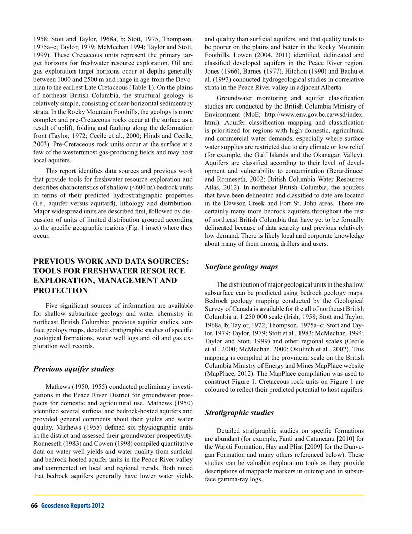
Table 1. Table of formations at eight selected gas fields in northeast British Columbia. Locations of selected gas fields are shown in red on Figure 1. units occurring at surface or in the shallow subsurface are shown by a blue vertical bar. For reference, the target gas, oil or water disposal formations at the various fields are noted with coloured dots and the depth range of the shallowest producing formations are noted. Information on the target formations and their depths were determined using AccuMap® and geoSCoUT®. Sources: Stott (1975); British Columbia Ministry of Energy and Mines (2012).
BC Ministry of Energy and Mines 69
of the second cycle, which includes Lower Cretaceous to early Cenomanian marine and nonmarine clastic rocks of the Bullhead and Fort St. John groups and the Dunvegan Formation. The third sequence includes mainly marine strata of the Smokey Group, deposited during major trans-gressions during the Turonian and Santonian stages of the Late Cretaceous, succeeded by mainly nonmarine coarse clastic sediments of the Campanian to Maastrichtian Wapiti Formation.
At a regional scale, coarse clastic regressive sequences (Bullhead Group, Dunvegan and Wapiti formations) can be viewed as potential aquifer hosts, and the marine shale units (Fort St. John Group, Kaskapau, Puskwaskau and Kotaneelee formations) as aquitards or aquicludes. Gen-eralizations about aquifer characteristics at the formation scale, however, are not sufficiently accurate for groundwa-ter exploration purposes because none of the Cretaceous formations is lithologically homogeneous. Within the three major, basin-wide regressive-transgressive cycles, many minor and spatially constrained cycles occurred. All of the coarse clastic formations contain shale members, and all of the shale formations contain continuous or lensoid coarse clastic members. In addition, fracture enhancement of po-rosity is seen in both shale and coarse clastic formations, producing local aquifers.
Major regional units
FirsT sequenCe: Fernie–minnes
Fernie FormationThe Jurassic Fernie Formation forms a significant re-
gional aquitard (Bachu, 2002) in the Canadian Cordillera. It is an important marine shale unit that represents a major transgressive phase (Stott, 1975). The measured thickness of the Fernie Formation is highly variable due to its reces-sive character and its deformed nature. It generally does not exceed 300 m, but is reported to reach a thickness of 900 m in the western Rocky Mountain Foothills (Stott, 1975). The Fernie Formation has a limited extent at surface and in the shallow subsurface east of the deformed belt, but is present at shallow depths at the Murray gas field in the Southern Foothills (NTS 093I) and the Elbow Creek field north of the Halfway River (Fig. 1).
Minnes GroupThe Late Jurassic to Early Cretaceous Minnes Group
is a regressive sequence overlying the Fernie Formation that includes marine and nonmarine sandstone formations that may form small discontinuous aquifers. In British Co-lumbia, the Minnes Group comprises the Monteith, Beattie Peaks, Monach, Bickford and Gorman Creek formations.
The Minnes Group is exposed in the Rocky Mountain Foothills as far north as the Halfway River and is up to 2100 m thick (Stott, 1975). Minnes Group rocks are pre-sent at surface and in the shallow subsurface at the Brazion, Bullmoose, Murray, Burnt River and Sukunka fields of the Southern Foothills (NTS 093O, P), and at the Federal field and part of the Sikanni field in the Northern Foothills (NTS 094B and 094G, respectively). Minnes Group formations are age-equivalent to the Nikannassin Formation in the subsurface of the Peace River and Athabasca River regions.
After deposition of the Minnes Group, the sea retreated from the Alberta trough and extensive erosion and bevelling of the Fernie and Minnes groups occurred before deposition of the succeeding Bullhead Group (Stott, 1975).
seCond sequenCe: bullHead–ForT sT. JoHn–dunvegan
Bullhead GroupThe Bullhead Group was deposited in an alluvial-
deltaic environment from Barremian to early Albian time (Stott, 1975). It includes a massive conglomerate of the Cadomin Formation and a coal-bearing sandstone of the Gething Formation. Both the Cadomin and the Gething formations have potential to host aquifers along the Rocky Mountain Foothills from the upper Halfway River (NTS 094B) to the British Columbia–Alberta border south of the Wapiti River (NTS 093I). The Bullhead Group correlates with the Lower Mannville aquifer of the southern Alberta plains (McLean, 1977).
The Cadomin Formation is dominantly a coarse (gravel to cobble) nonmarine conglomerate. Much of the Cadomin was deposited on a pediment surface (Stott, 1975; McLean, 1977) as a single thin conglomerate bed, resulting in a distinctive contiguous bed that forms an important marker throughout the Rocky Mountain Foothills. The Cadomin Formation ranges from 30 to 150 m in thickness in British Columbia.
The Gething Formation includes conglomerate, sand-stone, siltstone and mudstone. It is dominantly nonmarine but includes marine members (Legun, 1990). It is generally coarser in the Peace River area and it thins and grades to finer sandstone and mudstone to the northeast. Its maximum thickness of 600 m (Stott, 1975) is found in the Southern Foothills, where it is an important coal-bearing unit.
The Cadomin and Gething formations are present at surface and in the shallow subsurface at the Pocketknife, Sikanni, Elbow Creek, Cypress and Federal fields at the north end of the Montney trend in the Northern Foothills, and at the Butler, Boulder, Brazion, Burnt River, Highhat Mountain, Sukunka, Bullmoose West and Murray fields of the Southern Foothills.
70 Geoscience Reports 2012
Along the east side of the northern Montney trend (for example, at the Julienne field (Table 1) the Gething and Cadomin formations are deeper and can be gas charged. On the plains, the formations of the Bullhead Group are too deeply buried to be freshwater exploration targets. The Cadomin Formation is a gas producer at the Cutbank field south of Swan Lake (NTS 093P) and in western Alberta. The age-equivalent Chinkeh Formation in the Liard River area is an important gas-producing unit in the Maxham-ish field. The Gething Formation has been identified as a potential hydrocarbon target deep in the subsurface of the Kahntah River region, where its good reservoir properties are documented by Gingras et al. (2010).
Fort St. John GroupThe Fort St. John Group is dominated by shale forma-
tions that record four transgressive events that occurred through Albian time (Stott, 1975). Regionally, much of the Fort St. John Group correlates with the Wilrich, Harmon and Shaftesbury aquitards of Alberta (Jones, 1966; Bachu, 2002). Other parts of the group include sandstone and silt-stone formations that correlate with the Upper Mannville and Paddy aquifers.
Three aquifers hosted by rocks of the undivided Fort St. John Group in the Peace River valley (aquifers 765, 928 and 934) are delineated in the British Columbia Water Atlas and are described in detail by Lowen (2011). It is not clear in every case whether the water is produced from fractured shale, from sandstone formations or from both. Mathews (1950) and Cowen (1998) both noted that some shale units of the Fort St. John Group in the Peace River block produce sufficient water yields for commercial or agricultural use, and that water quality from shale beds tends to be poor due to high levels of dissolved salts and low levels of infiltration of fresh meteoric water. Available data on yields and water quality from sandstone units in the Fort St. John Group are mainly from the Peace River block (Mathews, 1950; Ronneseth, 1983; Cowen, 1998; Lowen, 2011) and are dis-cussed in more detail below.
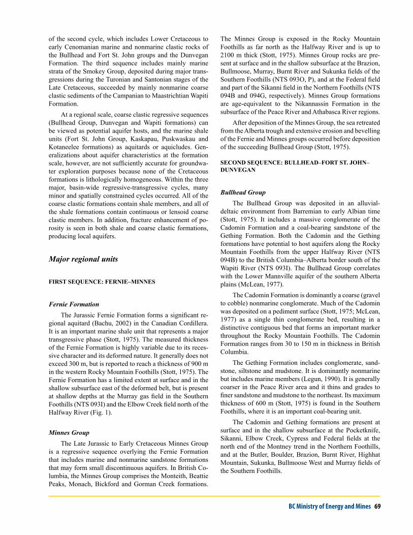
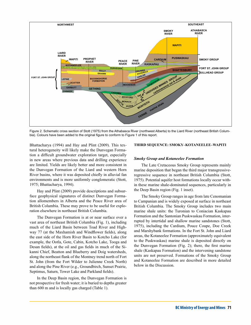
The Fort St. John Group lies above the Bullhead Group and below the Dunvegan Formation throughout most of northeast British Columbia. Where exposure is adequate, intervening coarse clastic units document regressive events within the dominantly shaly Fort St. John Group and allow for its subdivision into many formations. Formation nomen-clature varies across northeastern British Columbia (Irish, 1958; Stott and Taylor, 1968a, b; Taylor, 1972; Stott and Taylor, 1979; Taylor, 1979; Stott et al., 1983; McMechan, 1994; Taylor and Stott, 1999; Cecile et al., 2000). Stott (1975) concisely illustrated the variation in nomenclature of the Fort St. John Group (and other Jura-Cretaceous for-mations) across northeast British Columbia with a series of formation tables and schematic cross-sections. One of these cross-sections is reproduced here (Fig. 2); it crosses
northeast British Columbia from northwest (Liard River area) to southeast (Athabasca River in northeast Alberta). The image is coloured to match Figure 1 and Table 1 of this report. A helpful table of Fort St. John Group formations across northeast British Columbia and Alberta is provided by Leckie et al. (1994). Where outcrop is scarce or where shale units cannot be confidently distinguished, the undi-vided Fort St. John Group is mapped as a single unit (Fig. 1, 2, Table 1; Thompson, 1975a–c). This can cause border inconsistencies on large compilation maps (for example, Fig. 1; Okulitch et al., 2002).
Dunvegan FormationThe Dunvegan Formation is a widespread coarse
clastic unit in northeastern British Columbia (Fig. 1) and northwestern Alberta, where it is the host for many bedrock aquifers (Mathews, 1950; Jones, 1966; Ronneseth, 1983; Cowen, 1998). The Dunvegan Formation is the most used bedrock aquifer host because it underlies the relatively pop-ulated Peace River valley and has supplied water demands from agriculture, communities and conventional oil and gas operations. Lowen (2011) delineated 12 aquifers hosted by the Dunvegan Formation in the Peace River valley. In that report, several hundreds of well records were examined and an average well yield of 0.6 L/s (9.5 gpm) was determined for Dunvegan-hosted wells. Lowen noted that the Dunve-gan Formation is more productive in general than fractured shale units, and that in some locations the primary porosity is further enhanced by fracture porosity. One such enhanced well near Chetwynd can produce up to 14.3 L/s (227 gpm).
The Dunvegan Formation was deposited in Cenoma-nian time under terrestrial and shallow coastal marine conditions, including coastal plain, delta, lacustrine and fluvial environments. In British Columbia, the dominant lithology of the Dunvegan Formation is sandstone, except in the Liard River area, where it is commonly conglom-eratic. The Dunvegan Formation ranges in thickness from approximately 170 m in the north along the Yukon border to approximately 270 m in the Southern Foothills between the Peace and Pine rivers (Stott, 1975). Mathews (1950) noted that the water quality from Dunvegan aquifers in the Peace River valley is highly variable, and that it generally deteriorates with depth. Water from deeper wells can be too saline for domestic or livestock use. Cowen (1998) ob-served that in the Peace River valley, the Dunvegan Forma-tion hosts aquifers that yield satisfactory quality and quan-tities of groundwater; however, the productive zones are not laterally extensive and are commonly greatly vertically separated. This is likely to be the case with the Dunvegan Formation outside the Peace River valley as well, given the variety of depositional environments (i.e., fluvial channel, paleovalley, delta fronts, shallow coastal plains and minor marine transgressions) represented by the unit. This lateral and vertical variability is well described and illustrated by
BC Ministry of Energy and Mines 71
Bhattacharya (1994) and Hay and Plint (2009). This tex-tural heterogeneity will likely make the Dunvegan Forma-tion a difficult groundwater exploration target, especially in new areas where previous data and drilling experience are limited. Yields are likely better and more consistent in the Dunvegan Formation of the Liard and western Horn River basins, where it was deposited chiefly in alluvial fan environments and is more uniformly conglomeratic (Stott, 1975; Bhattacharya, 1994).
Hay and Plint (2009) provide descriptions and subsur-face geophysical signatures of distinct Dunvegan Forma-tion allomembers in Alberta and the Peace River area of British Columbia. These may prove to be useful for explo-ration elsewhere in northeast British Columbia.
The Dunvegan Formation is at or near surface over a vast area of northeast British Columbia (Fig. 1), including much of the Liard Basin between Toad River and High-way 77 (at the Maxhamish and Windflower fields), along the east side of the Horn River Basin to Kotcho Lake (for example, the Ootla, Gote, Cabin, Kotcho Lake, Tooga and Desan fields), at the oil and gas fields in much of the Si-kanni Chief, Beatton and Blueberry and Doig watersheds, along the northeast flank of the Montney trend north of Fort St. John (from the Fort Wilder to Julienne Creek North) and along the Pine River (e.g., Groundbirch, Sunset Prairie, Septimus, Saturn, Tower Lake and Parkland fields).
In the Deep Basin region, the Dunvegan Formation is not prospective for fresh water; it is buried to depths greater than 600 m and is locally gas charged (Table 1).
THird sequenCe: smoKy–KoTaneelee–wapiTi
Smoky Group and Kotaneelee FormationThe Late Cretaceous Smoky Group represents mainly
marine deposition that began the third major transgressive-regressive sequence in northeast British Columbia (Stott, 1975). Potential aquifer host formations locally occur with-in these marine shale-dominated sequences, particularly in the Deep Basin region (Fig. 1 inset).
The Smoky Group ranges in age from late Cenomanian to Campanian and is widely exposed at surface in northeast British Columbia. The Smoky Group includes two main marine shale units: the Turonian to Coniacian Kaskapau Formation and the Santonian Puskwaskau Formation, inter-rupted by intertidal and shallow marine sandstones (Stott, 1975), including the Cardium, Pouce Coupe, Doe Creek and Marshybank formations. In the Fort St. John and Liard areas, the Kotaneelee Formation (approximately equivalent to the Puskwaskau) marine shale is deposited directly on the Dunvegan Formation (Fig. 2); there, the first marine shale (Kaskapau Formation) and the intervening sandstone units are not preserved. Formations of the Smoky Group and Kotaneelee Formation are described in more detailed below in the Discussion.
sst
sst
conglomerate
GETHING
WAPITI
WAPITI
KOTANEELEE
NORTHWEST SOUTHEAST
ATHABASCA RIVER
SMOKYRIVER
PINERIVER
PEACERIVER
PROPHETRIVER
LIARDRIVER
FORT ST. JOHN GROUP
PINERIVER
marine shale
carbonaceous sst & shale
WAPITI
PUSWASKAU
SHAFTESBURYBULLHEAD GROUP
FORT ST. JOHN GROUP
SMOKY GROUPCARDIUM
GETHING
DUNVEGAN
CHINKEH
FERNIE
BICKFORD
MONACHBEATTIE
PEAKS
KASKAPAU
UNDIVIDED MINNES G
ROUP
carbonaceous sst & shale
MONTEITH
CADOMIN
conglomerate{ MOOSEBAR
GOODRICHSIKANNI
GARBUTT
SCATTER
LEPINEHASLER
CRUISERSULLY
DUNVEGANSULLY
BUCKINGHORSE FORMATION
KOTANEELEE
Figure 2. Schematic cross section of Stott (1975) from the Athabasca River (northwest Alberta) to the Liard River (northeast British Colum-bia). Colours have been added to the original figure to conform to Figure 1 of this report.
72 Geoscience Reports 2012
Wapiti FormationThe youngest bedrock unit exposed at surface in north-
east British Columbia is the Wapiti Formation. The Wapiti Formation is known to host aquifers in the Clayhurst and Kelly Lake (aquifers 444 and 621; British Columbia Water Resources Atlas, 2012) areas in British Columbia (Lowen, 2011) and in the Peace River region of Alberta (Jones, 1966). It has potential to host aquifers where it occurs else-where, including the Tupper Creek, Cutbank, Kelly, Noel, Hiding Creek and Noel gas fields in the Deep Basin, and in parts of the Maxhamish field in the Liard Basin.
Lowen (2011) reports generally moderate yields (up to 3.1 L/s or 50 gpm) in the Clayhurst and Kelly Lake aqui-fers. In the Mount Robson–Wapiti plains area of Alberta, Barnes (1977) noted a decrease in well yields from the Wapiti Formation in a southwest direction from the plains toward the disturbed belt, possibly due to the destruction of intergranular porosity by increased low-grade metamor-phism associated with regional tectonism. Jones (1966) reported both intergranular and fracture permeability in Wapiti Formation–hosted aquifers in the Peace River Dis-trict of Alberta, and water yields ranging from 0.3–6.3 L/s (5–100 gpm). Jones observed irregular aquifer distributions and abrupt variations in yields laterally and vertically in individual sandstone units within the Wapiti in the Peace River area of Alberta, possibly because porous zones are not planar, but are lens-shaped beds and channel deposits. Both Barnes (1977) and Lowen (2011) reported spot high iron concentrations in the water from Wapiti Formation water wells.
The Wapiti Formation is exposed at surface in the Dawson Creek (NTS 093P) and Monkman Pass (NTS 093I) map areas, where it ranges from 0 to 450 m in thickness and consists of continentally derived sandstone, shale and coal (Stott, 1975). In the Liard Basin (NTS 094N, O) on the British Columbia–Yukon border, the Wapiti is poorly exposed at surface near Maxhamish Lake and west of the Beaver River field (Stott and Taylor, 1968a). There, only the lower part of the formation is preserved, where it con-sists of coarse-grained conglomeratic sandstone. The top of the Wapiti Formation is not preserved anywhere in British Columbia.
The Wapiti Formation represents a major Campanian to Maastrichtian regression that deposited a nonmarine clastic wedge, following marine shale sedimentation of the Puswaskau Formation in the southern plains and the Kota-neelee Formation in the Liard area (Stott, 1975). The work of Fanti and Catuneanu (2010) in the Wapiti Formation of west-central Alberta and into the Deep Basin of northeast British Columbia identify and describe a fluvial sequence, basal channel-fill deposits that grade into floodplain depos-its, channelized sediments and extensive overbank facies. Fanti and Catuneanu (2009) provide detailed descriptions of mappable markers in outcrop and in subsurface gamma-ray
logs for the Wapiti Formation in the Deep Basin region and adjacent Alberta.
disCussion: loCal variabiliTy oF sHallow bedroCK uniTs by oil and gas region
Local variability within the above-described major regional units is concisely outlined and illustrated by Stott (1975). In some parts of northeast British Columbia, local formations or members have the potential to be important hydrostratigraphic units (whether as aquifers or aquitards). A map of the oil and gas geographic regions of northeast British Columbia appears as an inset on Figure 1.
Deep Basin area
This region includes areas east of the deformation front to the Alberta border and south of Dawson Creek and Highway 97. There, the Upper Cretaceous Kaskapau, Marshybank, Muskiki, Cardium, Puskwaskau and Wapiti formations (Stott and Taylor, 1979, McMechan, 1994) are present at surface and shallow subsurface. The stratigraphy of the Noel gas field (Table 1) is representative of much of the region.
KasKapau FormaTion
The Kaskapau Formation is dominantly a marine mud-stone unit that overlies the Dunvegan Formation in much of the Dawson Creek (NTS 093P) and Monkman Pass (NTS 093I) map areas. It forms a regional aquitard unit (Hitchon, 1990; Bachu, 2002) but grades laterally on its eastern and western borders into shallow marine or deltaic sandstones that form local aquifers. These subunits locally include the 2 m thick Doe Creek sandstone (Mathews, 1950; Jones, 1966; Plint and Kreitner, 2007) and the 9 m thick Pouce Coupe sandstone (Mathews, 1950; Canadian Geoscience Knowledge Network, 2012) near the Alberta border south of Dawson Creek, and Dickbusch, Trapper, Tuskoola, Wartenbe and Mt. Robert sandstones in the Tumbler Ridge area of the Southern Foothills (McMechan, 1994; Varban and Plint, 2005). These western sandstone tongues repre-sent the western shoreface facies of the basin and are 15–50 m thick (Varban and Plint, 2005).
The Kaskapau Formation ranges in thickness from 300 to 550 m along the British Columbia–Alberta border to a maximum of approximately 670 m at the deformation front (Varban and Plint, 2005). It ranges in age from Late Cenomanian to Middle Turonian. It correlates with the Sec-ond White Speckled Shale unit of the plains of Alberta and Saskatchewan (Leckie et al., 1994).
BC Ministry of Energy and Mines 73
Mathews (1950) noted that wells and springs in the Pouce Coupe sandstone member of the Kaskapau Forma-tion yield good-quality water at the Doe River and Seven Mile Corner locations north of Dawson Creek. Lowen (2004, 2011) has documented the Groundbirch-Progress aquifer (aquifer 591; British Columbia Water Resources Atlas, 2012) as being hosted by the Kaskapau Formation (unspecified member) and reports variable productivity (from 0 to 3.15 L/s [50 gpm]) and variable water quality over 99 wells. The Dawson Creek–Arras aquifer (aquifer 593; British Columbia Water Resources Atlas, 2012) is hosted in the Kaskapau (unspecified member) and the over-lying Cardium Formation. Lowen (2011) reported a median well yield of 0.32 L/s (5 gpm) from aquifer 593, with no reported quality issues.
Cardium FormaTion
The Cardium Formation hosts known aquifers in the Peace River valley near the British Columbia–Alberta bor-der (Mathews, 1950; Jones, 1966; Hitchon, 1990). It lies between black marine shale of the Kaskapau and Muskiki formations and is exposed at surface in escarpments from south of Dawson Creek to Tumbler Ridge (McMechan, 1994). Mathews (1950) reported production of good-quality water from the Cardium Formation at three loca-tions between Dawson Creek and Tomslake. Lowen (2011) identified the Cardium Formation as the host for part of the Dawson Creek–Arras aquifer (aquifer 593; British Colum-bia Water Resources Atlas, 2012).
The Cardium Formation is an intertidal shallow marine unit that is dominated by fine-grained marine sandstone and includes lesser mudstone and conglomerate (Stott, 1975; McMechan, 1994). It can be traced in subsurface logs through the southeast quadrant of the Dawson Creek map area (NTS 093P). In British Columbia, the Cardium Formation is approximately 20 m thick near the Alberta border and thickens to the southwest to a maximum of ap-proximately 100 m along the deformation front (Canadian Geoscience Knowledge Network, 2012). Details of the internal stratigraphy, correlations, distribution of important conglomeratic members and their subsurface wireline log signatures are described by Hart and Plint (2003).
The Cardium Formation is an important oil-producing unit in Alberta, notably at the Pembina field (Krause et al., 1994).
musKiKi FormaTion
The Late Cretaceous Muskiki Formation is dominantly a rusty-weathering pyritic shale unit (Leckie et al., 1994) and is likely to behave as an aquitard. It is exposed in river escarpments from southwest of Dawson Creek, continuing southeast to the British Columbia–Alberta border (NTS 093O, P; Stott and Taylor, 1979; McMechan, 1994). It lies over the Cardium Formation sandstone and under the
Marshybank Formation. The Muskiki Formation is gen-erally less than 95 m thick and thins toward the Southern Foothills (Plint, 1990).
marsHybanK FormaTion
In British Columbia, the Marshybank Formation consists of basal marine sandstone overlain by nonmarine strata and may host aquifers. It has a maximum thickness of approximately 50 m and is exposed southwest of Dawson Creek, continuing southeast to the Alberta border (Plint, 1990; McMechan, 1994). It overlies the Muskiki Forma-tion.
badHearT FormaTion
The Badheart Formation is a medium- to coarse-grained marine sandstone unit of Coniacian age (Late Cre-taceous), which may host aquifers in the Peace River region of Alberta (Jones, 1966). In British Columbia, the distribu-tion of the Badheart Formation is confined to the northeast corner of the Monkman Pass map area (NTS 093I), where it underlies the Wapiti Formation (Stott and Taylor, 1979). The Badheart Formation in British Columbia is a few me-tres thick and is a potential aquifer host in the southernmost Deep Basin and Southern Foothills.
pusKwasKau FormaTion
The Puskwaskau Formation underlies the Wapiti For-mation and is dominantly a shaly unit that is expected to behave generally as an aquitard. It is Santonian in age and occurs in the southeast quadrant of the Dawson Creek map area (NTS 093O) and the northeastern corner of the Monk-man Pass map area (NTS 093I). It is also exposed north of the Peace River in the Fort St. John region. Hu and Plint (2009) detail the stratigraphy of the Puskwaskau Formation and describe subsurface log signatures of allomembers. The formation ranges from <70 to >340 m thick. Silty and sandy layers occur within the 14 allomembers, which may have potential as thin, localized, laterally limited aquifers.
An aquifer south of Pouce Coupe (aquifer 622; Brit-ish Columbia Water Resources Atlas, 2012) is identified by Lowen (2011) as being hosted by the Puskwaskau For-mation. This aquifer is near surface at the Swan Lake gas field. The Puskwaskau Formation there includes dark grey shale, calcareous shale and siltstone (McMechan, 1994). Lowen (2011) notes a wide variety of hydraulic responses across this aquifer, but with generally moderate well yields between 0.06 and 6.31 L/s (1–100 gpm), and averaging 0.95 L/s (15 gpm). Hard water was reported in some well records from this aquifer.
74 Geoscience Reports 2012
Southern Foothills
This region includes areas along and west of the defor-mation front and south of Peace Reach (Fig. 1, inset). The stratigraphy of the Sukunka field (Table 1) is representative of much of the region. Rock units exposed at the surface include the Minnes Group, the Gething and Cadomin for-mations of the Bullhead Group, several local formations of the Fort St. John Group and the Dunvegan Formation. These units are present at the surface and shallow subsur-face at the following oil and gas fields: Stone Creek, Com-motion, Highhat Mountain, Boulder, Brazion, Burnt River Sukunka, Gwillim, Bullmoose, Wolverine, Murray, Grizzly North, Grizzly South and Red Deer.
Local units of the Fort St. John Group are described below.
moosebar FormaTion
The Moosebar Formation overlies the Bullhead Group and consists of dark grey sideritic marine shale (McMechan, 1994). It is equivalent to the Wilrich aquitard in the subsur-face of the Peace River plains and is part of the Garbutt Formation of the Liard region. The Moosebar Formation is approximately 289 m thick near Hudson’s Hope and thins towards the southeast to 43 m at the British Columbia–Al-berta border (Stott, 1975).
gaTes FormaTion
The Gates Formation is a coarse clastic unit. Lowen (2011) delineates an aquifer (aquifer 441; British Columbia Ministry of Environment, 2012b) hosted by the Gates For-mation at Lynx Creek, northeast of Hudson’s Hope. Based on 16 wells, the average yield from the Lynx Creek aquifer is 0.63 L/s (10 gpm).
The Gates Formation lies between the marine shales of the Moosebar and Hasler formations. It was deposited in alluvial-deltaic environments (Stott, 1975) and includes sandstone, shale, coal, siltstone and mudstone (McMechan, 1994). It is 20 m thick near Hudson’s Hope and thickens towards the southeast to 263 m approaching the British Co-lumbia–Alberta border (Canadian Geoscience Knowledge Network, 2012). The Gates Formation is time equivalent to the Scatter Formation of the Liard region. Wadsworth et al. (2003) demonstrated methods for high-resolution strati-graphic correlation of facies in the Gates Formation using available wireline logs and subsurface cores.
sHaFTesbury FormaTion and equivalenTs
A single unit, the dominantly shaly Shaftesbury For-mation (Stott and Taylor, 1979), represents the entire Al-bian stage in the Monkman Pass map area (NTS 093I). Regionally, the Shaftesbury Formation is an important aquitard (Bachu, 2002). To the north and west, regressive episodes produced tongues of coarse clastic sedimentary
strata within the shale. Stott et al. (1983) and McMechan (1994) distinguish five formations (Hulcross, Boulder Creek, Hasler, Goodrich and Cruiser) within the Albian sec-tion. Of these formations, the coarse clastic Boulder Creek and Goodrich formations may host aquifers.
boulder CreeK FormaTion
The Boulder Creek Formation has potential to host aquifers. It is a well-sorted marine sandstone up to 280 m thick and gradationally overlies the Hulcross shale (Fig. 2). The Boulder Creek Formation correlates with the Cadotte member of the Peace River plains and the upper part of the Scatter member of the Liard area (Stott, 1975).
goodriCH FormaTion
The Goodrich Formation is composed of sandstone deposited in near-shore and delta-front environments and represents a potential aquifer. It overlies the Hasler shale (Table 1, Fig. 2) and is up to 390 m thick. The Goodrich Formation correlates with the Sikanni sandstone unit north of the Peace River (Stott, 1975).
HulCross, Hasler and Cruiser FormaTions
The Hulcross, Hasler and Cruiser formations are all ma-rine shale that can be generally expected to behave as aqui-tards. The Hulcross overlies the Gates sandstone and ranges from 0 to 135 m thick (Canadian Geoscience Knowledge Network, 2012). It is correlative with the Harmon member in the subsurface of the Peace River plains, and is part of the Scatter Formation in the Liard region (Stott, 1975). The Hasler Formation shale lies on the Boulder Creek Forma-tion and is 250–265 m thick. It is equivalent to the Lepine Formation in the Liard area. The Cruiser Formation shale overlies the Goodrich sandstone, is 105–230 m thick (Cana-dian Geoscience Knowledge Network, 2012) and is equiva-lent to the Sully Formation of the Fort St. John Group north of Peace River. An aquifer in the Chetwynd area (aquifer 627; British Columbia Ministry of Environment, 2012b) is hosted by the Cruiser Formation in fractured shale. Lowen (2011) reports an average well yield of 1 L/s (16 gpm) from this aquifer, with no documented water quality concerns.
Fort St. John and Fort Nelson/Northern Plains regions
Over much of the plains regions of northeast British Columbia, the Dunvegan Formation and formations of the Fort St. John Group are exposed at the surface. Strati-graphic columns for the Gunnell Creek and Monias fields (Table 1) represent the shallow bedrock geology for parts of these regions. The stratigraphy at the Gunnell Creek field is representative of much the eastern side of the Horn River Basin and the Cordova Embayment. The stratigraphy at the
BC Ministry of Energy and Mines 75
Monias field is representative of the northeastern margin of the Montney trend. At some wells in the Monias field, the sandy Sikanni Formation can be distinguished in the shal-low subsurface within the dominantly shaly Fort St. John Group.
siKanni FormaTion
The Sikanni Formation is a sandstone unit within the upper Fort St. John Group that has potential to host aqui-fers along the part of the Montney trend north of the Peace River. The Sikanni Formation was deposited in near-shore to delta-front environments in the late Albian. It is up to 300 m thick, and thins and shales out to the east under the plains. It is equivalent to the Goodrich Formation sandstone south of the Peace River (Stott, 1975). Webb et al. (2003) provide detailed descriptions of mappable markers in sub-surface wireline logs for the upper part of the Fort St. John Group from the Peace River to the Liard area.
Northern Foothills
The surface geology of the Northern Foothills is repre-sented on Figure 2 by stratigraphic columns for the Clarke Lake field in the southern Horn River Basin and the Julienne field in the northern Montney trend. The Dunvegan Forma-tion and Fort St. John Group are the important surface and shallow subsurface units. In much of this area, the Fort St. John Group is mapped as an undivided unit; however, along the eastern edge of the Northern Foothills from the Halfway River to the Liard River, the sandy Sikanni Formation is distinguishable (Stott and Taylor, 1968a, b; Taylor, 1979; Taylor and Stott, 1999). The Sikanni Formation has poten-tial to host aquifers. It is described above in the ‘Fort St. John and Fort Nelson/Northern Plains’ section above. The Sikanni Formation is present at surface and shallow sub-surface in the Clarke Lake area (Evie Bank, Roger, Clarke Lake, Klua, Hoffard and Milo fields), near Trutch and along the Prophet River (Adsett, Bougie, Trutch, Caribou and Green Creek fields), and along the northwest edge of the Montney trend (at the Lily Lake, Cypress, Chowade, Dai-ber, Graham, Butler, Farrell Creek West and Altares fields).
Liard Basin and Fold Belt
Shallow bedrock stratigraphy varies considerably across the Liard Basin as the geological structure becomes increasingly complex to the west. On the eastern edge of the Liard Basin, the shallow stratigraphy is much like the plains, as represented by the stratigraphic column for the Maxhamish field (Table 1), with near-horizontal strata rang-ing from the latest Cretaceous Wapiti Formation down to the Albian Lepine member of the Fort St. John Group (Fig. 1, 2). In the Liard River region, the Dunvegan Formation
was deposited in alluvial fan environments (Stott, 1975; Bhattacharya, 1994) and contains more conglomerate than it does farther south, which may prove to increase its prospectivity as an aquifer. To the west, increasingly older strata are brought to surface along a number of steep north-striking faults (Taylor and Stott, 1999; Walsh, 2004). At the Beaver River field, the youngest surface formations are Lower Cretaceous Lepine, Scatter and Garbutt formations. The oldest is the Permian Fantasque Formation (Table 1), which is exposed in an anticline (Taylor and Stott, 1999).
FanTasque FormaTion
The Permian Fantasque Formation is a bedded chert up to 55 m thick (Canadian Geoscience Knowledge Network, 2012). It is exposed at the surface in the centre of the anti-cline that underlies the Beaver River gas field. Its potential to host aquifers is unknown.
buCKingHorse FormaTion: garbuTT, sCaTTer and lepine FormaTions
The upper part of the Fort St. John Group in the Liard River area includes the Lepine, Scatter, and Garbutt forma-tions, which are sometimes grouped together as the Aptian to Albian Buckinghorse Formation. The Scatter Forma-tion is composed of deltaic sandstone and has potential to host aquifers. It is approximately equivalent to the Gates and Boulder Creek sandstones (Stott, 1975). Its thickness ranges from 60 to 375 m (Canadian Geoscience Knowledge Network, 2012).The Garbutt and Lepine formations are dominated by marine shale and correlate with the Moosebar and Hasler shales, respectively. Leckie and Potocki (1998) describe the stratigraphy of the Scatter and Garbutt forma-tions in the Liard Basin and demonstrate how they can be distinguished on wireline logs.
The Garbutt Formation has been evaluated for shale gas potential (Ferri et al., 2011), but at the date of this pub-lication, no shale gas has been produced from this unit.
KoTaneelee FormaTion
The Late Cretaceous Kotaneelee Formation is exposed on both sides of the Liard River in the Liard Basin near the British Columbia–Yukon border. The Kotaneelee Forma-tion is dominated by marine shale and is expected to gener-ally behave as an aquitard. It is 152–305 m thick (Canadian Geoscience Knowledge Network, 2012) and is equivalent to the Puskwaskau Formation of the Deep Basin and east-ern Fort St. John regions (Stott, 1975).
76 Geoscience Reports 2012
ConClusions
• Freshwater bedrock aquifers are mainly hosted by Cretaceous strata in northeast British Columbia. The most important prospective regional bedrock units for freshwater aquifers are the coarse clastic Wapiti and Dunvegan formations. Other less extensive units lo-cally host significant local bedrock aquifers.
• In the Peace River valley, bedrock aquifers have pro-vided fresh water to meet domestic, agricultural and commercial demands. Some of these aquifers have been delineated and studied. Certainly many more aq-uifers exist in northeast British Columbia that have not yet been formally identified or delineated because of low data density.
• Bedrock aquifer yields in the Peace River area are gen-erally much lower than those of surficial aquifers. Most bedrock aquifer yields are not sufficient to supply the volumes required for major industrial use, but can be adequate for domestic needs. Fracture porosity, how-ever, can substantially enhance yields in both coarse clastic and shale units. Bedrock units with significant yields may yet be discovered outside the Peace River valley as shale gas development continues.
• The Kotaneelee, Puskwaskau and Kaskapau forma-tions and the majority of the Fort St. John Group are mainly shale units that can be expected to behave as regional aquitards; however, minor coarse clastic units within these formations may host small aquifers local-ly. Fractured shale units are known to host freshwater aquifers in the Peace River valley and may be present in other regions.
• Water quality is generally better (lower in dissolved solids) in the Rocky Mountain Foothills and poorer on the plains. This characterization is supported in the Peace River valley, where significant data exist and it is reasonable to expect that it will hold true throughout northeast British Columbia.
• The depth to the base of fresh groundwater is unknown almost everywhere in northeast British Columbia be-cause of the data gap between the base of water wells (generally less than 150 m deep) and top of logged and sampled oil and gas exploration wells (generally great-er than 300 m deep). This data gap can be addressed by obtaining new lithological and geochemical data from the upper few hundred metres in a representative num-ber of exploration wells in oil and gas fields. Explora-tion activity occurring in previously undeveloped areas will provide opportunities to obtain new lithological and aqueous geochemistry data where information has previously been absent or limited.
• Detailed stratigraphic studies have been published on many of the bedrock formations that are prospective for fresh groundwater. These can be valuable explo-ration tools; they provide descriptions of mappable outcrop and subsurface log markers in outcrop and in subsurface gamma-ray logs.
aCKnowledgmenTs
The author is most grateful to Adrian Hickin, Elizabeth Johnson and Nicole Barlow for editorial reviews of earlier versions of this article.
reFerenCes
Bachu, S. (2002): Suitability of the subsurface in northeastern British Columbia for geological sequestration of anthropogenic carbon dioxide; Alberta Geological Survey, Alberta Energy and Utilities Board, 87 pages.
Bachu, S., Underschultz, J.R., Hitchon, B. and Cotterill, D.K. (1993): Regional-scale subsurface hydrogeology in northeast Alberta; Alberta Research Council–Alberta Geological Survey, Bulletin No. 61, 44 pages.
Barnes, R. (1977): Hydrogeology of the Mount Robson–Wapiti area, Alberta; Alberta Research Council, Report 76, 33 pages.
Berardinucci, J. and Ronneseth, K. (2002): Guide to using the BC aquifer classification maps for the protection and management of groundwater; British Columbia Ministry of Water, Land and Air Protection, 61 pages.
Bhattacharya, J.P. (1994): Cretaceous Dunvegan Formation of the Western Canada Sedimentary Basin; Chapter 22 in Geological Atlas of the Western Canada Sedimentary Basin, Mossop, G.D. and Shetsen, I., Compilers, Canadian Society of Petroleum Geologists and Alberta Research Council, Special Report 4, pages 365–373. URL <http://www.ags.gov.ab.ca/publications/wcsb_atlas/atlas.html> [November 2011].
British Columbia Ministry of Energy and Mines (2012): Strati-graphic correlation chart; British Columbia Ministry of Energy and Mines, URL <http://www.em.gov.bc.ca/Mining/Geosci-ence/PublicationsCatalogue/OilGas/Maps/Documents/2011_1.pdf> [February 2012].
British Columbia Ministry of Environment (2012a): EcoCat: the ecological reports catalogue; British Columbia Ministry of En-vironment, URL <http://a100.gov.bc.ca/pub/acat/public/wel-come.do> [January 2012].
British Columbia Ministry of Environment (2012b): WELLS da-tabase for British Columbia: water well application; British Co-lumbia Ministry of Environment, URL <https://a100.gov.bc.ca/pub/wells/public/indexreports.jsp> [January 2012].
British Columbia Ministry of Environment (2012): Water protec-tion & sustainability branch: an aquifer classification system for ground water management in British Columbia; British Columbia Ministry of Environment, URL <http://www.env.gov.bc.ca/wsd/plan_protect_sustain/groundwater/aquifers/Aq_Classification/Aq_Class.html> [January 2012].
BC Ministry of Energy and Mines 77
British Columbia Water Resources Atlas (2012): Aquifer classifi-cation layer; British Columbia Ministry of Environment, URL <http://webmaps.gov.bc.ca/imf5/imf.jsp?site=wrbc> [January 2012].
Brown, D.A. (2011): Overview of the Montney Water Project: a new Geoscience BC initiative in northeastern British Columbia (NTS 093P, 094A, B); in Geoscience BC Summary of Activi-ties 2010, Geoscience BC, Report 2011-1, pages 195–200.
Canadian Geoscience Knowledge Network (2012): WEBLEX Canada: lexicon of Canadian Geological names on-line; Ca-nadian Geoscience Knowledge Network, URL <http://cgkn1.cgkn.net/weblex/weblex_e.pl> [January 2012].
Cecile, M.P., Khudoley, A.K. and Currie, L.D. (2000): Compos-ite geological map of Marion Lake (94G/3), Mount Withrow (94G/6) and Minaker River (94G/11), northeastern British Co-lumbia; Geological Survey of Canada, Open File 3874, 1:50 000 scale.
Cowen, A. (1998): BC Peace Region Groundwater Initiative In-terim Report 1998; Peace River Regional District, 25 pages.
Fanti, F. and Catuneanu, O. (2009): Stratigraphy of the Upper Cretaceous Wapiti Formation, west-central Alberta, Canada; Canadian Journal of Earth Sciences, Volume 46, no 4, pages 263–286.
Fanti, F. and Catuneanu, O. (2010): Fluvial sequence stratigraphy: the Wapiti Formation, west-central Alberta, Canada; Journal of Sedimentary Research, Volume 80, pages 320–338.
Ferri, F., Hickin, A. and Huntley, D.H. (2011): Geochemistry and shale gas potential of the Garbutt Formation, Liard Basin, Brit-ish Columbia (parts NTS 094N, O; 095B, C); British Columbia Ministry of Energy and Mines, Geoscience Reports 2011, pages 19–35.
Gingras, M.K., Zonneveld, J.-P. and Blakney, B.J. (2010): Pre-liminary assessment of ichnofacies in the Gething Formation of NE British Columbia; Bulletin of Canadian Petroleum Geol-ogy, Volume 58, no 2, pages 159–172.
Government of British Columbia (2012): Oil and Gas Activi-ties Act; Government of British Columbia, URL <http://www.bclaws.ca/EPLibraries/bclaws_new/document/ID/freesi-de/00_08036_01> [January 2012]
Hart, B.S. and Plint, A.G. (2003): Stratigraphy and sedimentol-ogy of shoreface and fluvial conglomerates: insights from the Cardium Formation in NW Alberta and adjacent British Co-lumbia; Bulletin of Canadian Petroleum Geology, Volume 51, no 4, pages 437–464.
Hay, M.J. and Plint, A.G. (2009): An allostratigraphic framework for a retrogradational delta complex: the uppermost Dunvegan Formation (Cenomanian) in subsurface and outcrop, Alberta and British Columbia; Bulletin of Canadian Petroleum Geol-ogy, Volume 57, no 3, pages 323–349.
Hayes, B.J.R. (2010): Horn River Basin aquifer characteriza-tion project, northeastern British Columbia (NTS 094I, J, O, P): progress report; in Geoscience BC Summary of Activities 2009, Geoscience BC, Report 2010-1, pages 245–248.
Hayes, B.J.R, Hume, D.W., Costanzo, S., Hopkins, M. and Mc-Donald, D. (2011): Deep aquifer characterization in support of Montney gas development, northeastern British Columbia (parts of NTS 093, 094): progress report; in Geoscience BC
Summary of Activities 2010, Geoscience BC, Report 2011-1, pages 189–194.
Hickin, A.S. (2011): Preliminary bedrock topography and drift thickness of the Montney plan; British Columbia Ministry of Energy and Mines, Energy Open File 2011-1 and Geoscience BC, Report 2011-07, 2 maps, scale 1:500 000.
Hickin, A.S. and Best, M.E. (2012): Stratigraphy and proposed geophysical survey of the Groundbirch paleovalley: a contribu-tion to the collaborative Northeast British Columbia Aquifer Project; in Geoscience Reports 2012, British Columbia Minis-try of Energy and Mines, pages 91-103.
Hickin, A.S. and Fournier, M.A. (2011): Compilation of Geologi-cal Survey of Canada surficial geology maps for NTS 94A and 93P; British Columbia Ministry of Energy and Mines, Energy Open File 2011-2 and Geoscience BC, Map 2011-08-1, scale 1:250 000.
Hinds, S.J. and Cecile, M.P. (2003): Geology, Pink Mountain and Northwest Cypress Creek, British Columbia; Geological Sur-vey of Canada, Open File 1464, scale 1:50 000.
Hitchon, B. (1990): Hydrochemistry of the Peace River Arch area, Alberta and British Columbia; Alberta Research Council, Open File 1990-18, 81 pages.
Hu, Y.G. and Plint, A.G. (2009): An allostratigraphic correlation of a mudstone-dominated, syn-tectonic wedge: the Puskwaskau Formation (Santonian-Campanian) in outcrop and subsurface, Western Canada Foreland Basin; Bulletin of Canadian Petro-leum Geology, Volume 57, pages 1–33.
Irish, E.J.W. (1958): Geology, Charlie Lake, British Columbia; Geological Survey of Canada, Map 17-1958, scale 1: 253 440.
Jones, J.F. (1966): Geology and groundwater resources of the Peace River District, northwestern Alberta; Research Council of Alberta, Bulletin 16, 143 pages.
Krause, F.F., Deutsch, K.B., Joiner, S.D., Barclay, J.E., Hall, R.L. and Hills, L.V. (1994): Cretaceous Cardium Formation of the Western Canada Sedimentary Basin; in Geological Atlas of the Western Canada Sedimentary Basin, Mossop, G.D. and Shetsen, I., Compilers, Canadian Society of Petroleum Geolo-gists and Alberta Research Council, Special Report 4, pages 375–386, URL <http://www.ags.gov.ab.ca/publications/wcsb_atlas/a_ch23/ch_23.html> [November 2011].
Leckie, D.A., Bhattacharya, J.P., Bloch, J., Gilboy, C.F. and Norris, B. (1994): Cretaceous Colorado/Alberta Group of the Western Canada Sedimentary Basin; in Geological Atlas of the West-ern Canada Sedimentary Basin, Mossop, G.D. and Shetsen, I., Compilers, Canadian Society of Petroleum Geologists and Alberta Research Council, Special Report 4, pages 335–352.
Leckie, D.A. and Potocki, D.J. (1998): Sedimentology and petrog-raphy of marine shelf sandstones of the Cretaceous, Scatter and Garbutt formations, Liard Basin, northern Canada; Bulletin of Canadian Petroleum Geology, Volume 46, pages 30–50.
Legun, A. (1990): Stratigraphic trends in the Gething Formation; British Columbia Ministry of Energy and Mines, Open File 1990-33, 18 pages.
Lowen, D. (2004): Aquifer classification mapping in the Peace River region—final report; British Columbia Ministry of Water, Land and Air Protection, 30 pages.
78 Geoscience Reports 2012
Lowen, D. (2011): Aquifer classification mapping in the Peace River region for the Montney Water Project; Geoscience BC, 12 pages, URL <http://a100.gov.bc.ca/pub/acat/public/viewRe-ort.do?reportId=23247> [January 2012].
MapPlace (2012): Mineral resource assessment layer, British Co-lumbia Ministry of Energy and Mines, MapPlace website, URL <http://www.empr.gov.bc.ca/Mining/Geoscience/MapPlace/Pages/default.aspx> [January 2012].
Massey, N.W.D, MacIntyre, D.G., Desjardins, P.J. and Cooney, R.T. (2005): Geology of British Columbia; British Columbia Ministry of Energy and Mines, Geoscience Map 2005-3, scale 1:1 000 000.
Mathews, W.H (1950): Preliminary report on ground water stud-ies, Peace River, BC: notes to accompany groundwater studies and map; British Columbia Ministry of Energy and Mines, 12 pages.
Mathews, W.H. (1955): Groundwater possibilities of the Peace River Block, British Columbia; British Columbia Ministry of Energy and Mines, Groundwater Paper #3, 11 pages.
McLean, J.R. (1977): The Cadomin Formation: stratigraphy, sedi-mentology and tectonic implications; Bulletin of Canadian Pe-troleum Geology, Volume 25, no 4, pages 792–827.
McMechan, M.E. (1994): Geology and structure cross-section, Dawson Creek, British Columbia; Geological Survey of Can-ada, Map 1858A, scale 1:250 000.
McMechan, M.E. (2000): Structure section and geological map of the Foothills and Front Ranges, Carbon Creek area, northeast British Columbia; Geological Survey of Canada, Open File 3553, scale 1:125 000.
Okulitch, A.V., MacIntyre, D.G., Taylor, G.C., Gabrielse, H., Cul-len, B., Massey, N. and Bellefontaine, K., Compilers (2002): Geology, Fort Nelson, British Columbia; Geological Survey of Canada, Central Foreland Map NO-10-G, Open File 3604, scale 1:500 000.
Plint, A.G. (1990): An allostratigraphic correlation of the Muskiki and Marshybank formation (Coniacian to Santonian) in the Foothills and subsurface of the Alberta Basin; Bulletin of Ca-nadian Petroleum Geology, Volume 38, no 3, pages 288–306.
Plint, A.G. and Kreitner, M.A. (2007): Extensive thin sequences spanning Cretaceous foredeep suggest high-frequency eustatic control: Late Cenomanian, Western Canada foreland basin; Ge-ology, Volume 35, no 8, pages 735–738.
Ronneseth, K. (1983): Preliminary assessment of groundwater prospects for the Peace River strategic plan; British Columbia Ministry of Environment, Groundwater Section, 96 pages.
Stott, D.F. (1975): The Cretaceous system in northeastern British Columbia; in The Cretaceous system in the western interior of North America, Caldwell, W.G.E., Editor, Geological Associa-tion of Canada, Special Paper 13, pages 441–467.
Stott, D.F., McMechan, M.E., Taylor, G.C. and Muller, J.E. (1983): Geology of Pine Pass (93O) map area, British Columbia; Geo-logical Survey of Canada, Open File 925, scale 1:250 000.
Stott, D.F. and Taylor, G.C. (1968a): Geology, Maxhamish Lake, British Columbia, 94O; Geological Survey of Canada, Map 2-1968, scale 1:253 440.
Stott, D.F. and Taylor, G.C. (1968b); Geology, Fort Nelson, Brit-ish Columbia, 94J; Geological Survey of Canada, Map 3-1968, scale 1:253 440.
Stott, D.F. and Taylor, G.C. (1979): Geology of Monkman Pass map-area (093I), northeastern British Columbia; Geological Survey of Canada, Open File 630, 1: 250 000 scale.
Taylor, G.C. (1972): Geology of Tuchodi Lakes (94K) map area, British Columbia; Geological Survey of Canada, Open File 925, scale 1:250 000.
Taylor, G.C. (1979): Geology of Trutch and Ware (east half) map areas, British Columbia; Geological Survey of Canada, Open File 606, scale 1:250 000.
Taylor, G.C. and Stott, D.F., Compilers (1999): Geology, Toad River, British Columbia; Geological Survey of Canada, Map 1955A, scale 1:250 000.
Thompson, R.I. (1975a): Geology, Beatton River, British Colum-bia, 94H; Geological Survey of Canada, Map 1446A, scale 1:250 000.
Thompson, R.I. (1975b): Geology, Fontas River, British Colum-bia, 94I; Geological Survey of Canada, Map 1447A, scale 1:250 000.
Thompson, R.I. (1975c): Geology, Petitot River, British Colum-bia, 94P; Geological Survey of Canada, Map 1448A, scale 1:250 000.
Varban, B.L. and Plint, A.G. (2005): Allostratigraphy of the Kaskapau Formation (Cenomanian-Turonian) in the subsurface and outcrop: NE British Columbia and NW Alberta, Western Canada Foreland Basin; Bulletin of Canadian Petroleum Geol-ogy, Volume 34, no 4, pages 357–389.
Wadsworth, J., Boyd, R., Diessel, C. and Leckie, D. (2003): Strati-graphic style of coal and non-marine strata in a high accom-modation setting: Falher member and Gates Formation (Lower Cretaceous), western Canada; Bulletin of Canadian Petroleum Geology, Volume 51, pages 275–303.
Walsh, W. (2004): Geology—Liard Basin (compilation), well pen-etrations and drill stem test results of Middle Devonian car-bonates; British Columbia Ministry of Energy and Mines, scale 1:250 000, URL <http://www.empr.gov.bc.ca/OG/oilandgas/petroleumgeology/ConventionalOilAndGas/Documents/Liard-Basin.pdf> [January 2012].
Webb, A.C., Shröder-Adams, C.J. and Pedersen, P.K. (2003): Re-gional subsurface correlations of Albian sequences north of the Peace River in NE British Columbia: northward extent of sand-stone of the Falher and Notikewin members along the eastern flank of the foredeep; Bulletin of Canadian Petroleum Geology, Volume 53, no 2, pages 165–188.
Wilford, D., Hickin, A.S., Chapman, A., Kelly, J., Janicki, E.P., Kerr, B., van Geloven, C., Dessouki, T., Henry, K., Heslop, K., Kirste, D., McCarville, M., Ronneseth, K., Sakals, M. and Wei, M. (2012): Collaborative interagency water projects in Brit-ish Columbia: introduction to the Northeast British Columbia Aquifer Project and Streamflow Modelling Decision Support Tool; in Geoscience Reports 2012, British Columbia Ministry of Energy and Mines, pages 79-89.


![[Alexander Lowen] Language of the Body(Bookos.org)](https://static.documents.pub/doc/80x56/546126c0af79592b708b5876/alexander-lowen-language-of-the-bodybookosorg.jpg)


