43
POWER LINE TRAIL CONNECTOR FEASIBILITY STUDY DRAFT REPORT December 2013 MONTGOMERY TOWNSHIP, MONTGOMERY COUNTY, PA PREPARED BY:

POWER LINE TRAIL CONNECTOR
FEASIBILITY STUDY
DRAFT REPORTDecember 2013
MONTGOMERY TOWNSHIP, MONTGOMERY COUNTY, PA
PREPARED BY:

ACKNOWLEDGMENTS
MONTGOMERY TOWNSHIP BOARD OF SUPERVISORSRobert J. BirchCandyce Fluehr ChimeraMichael J. Fox Jeffrey W. McDonnellJoseph P. Walsh
ENVIRONMENTAL ADVISORY COMMITTEEVere Archibald Barry Baker Jeffrey GibbonsJeanine HurryMahbubur R. MeenarBeth StaabTerry Wilson
OPEN SPACE COMMITTEEKim GreeneJay GlickmanLaurence PoliRoy RodriguezBeth Staab
PLANNING COMMISSIONMichael BeattyJay GlickmanSteve KrumenackerLeon McGuireJames RallEllen ReynoldsJonathan Trump
PARK& RECREATION BOARDMark AngeloneLinda BrooksAngelo GrassoKim GreeneMichael OkinoAl QuastiAnthony Ruggieri
This project funded through the Delaware Valley Regional Planning Commission’s (DVRPC’s) Regional Trails Program.
PAGE2

PAGE3
TABLE OF CONTENTS
POWER LINE TRAIL CONNECTOR FEASIBILITY STUDY
INTRODUCTION -PROJECT SCOPE -REGIONAL CONTEXT -PROJECTED USE -TRAIL CHARACTERISTICS
INVENTORY AND ANALYSIS -PHYSICAL CONDITIONS -USAGE FEASIBILITY -LEGAL FEASIBILITY
METHODOLOGY -EXISTING PLANS AND FIELD INVENTORY -PUBLIC PARTICIPATION -DESIGN CRITERIA
RECOMMENDATIONS -TRAIL ALIGNMENT -PROPOSED EASEMENTS -OPERATION AND MAINTENANCE -IMPLEMENTATION -OPINION OF PROBABLE COST -FUNDING -PERMITTING AND COORDINATION
APPENDIX -PHOTO REFERENCE SHEETS -MONTGOMERY COUNTY PRIMARY TRAIL NETWORK PLAN -PENNSYLVANIA BIKE ROUTE S PLAN

INTRODUCTION PROJECT SCOPE
REGIONAL CONTEXT
PAGE4
POWER LINE TRAIL CONNECTOR FEASIBILITY STUDY
202 PARKWAY TRAIL SEGMENT WITH DEDICATED BIKE LAND AND SIDE TRAIL
The purpose of the Montgomery Township Power Line Connector Trail Feasibility Study is to evaluate routing options that will best connect the recently constructed Route 202 Parkway Trail to the partially constructed Power Line Trail. Both of these trails are identified on Montgomery County’s proposed primary trail network plan, which was prepared by the Montgomery County Planning Commission. Feasibility criteria include pedestrian safety, physical barriers, financial consideration, connectivity to residential populations and to existing and proposed amenities within Montgomery Township as well as surrounding municipalities.
Montgomery Township is situated on the eastern edge of Montgomery County, bordered by Horsham Township, Lower Gwynedd Township, Upper Gwynedd Township, Lansdale Borough, Hatfield Township and New Britain Township, Bucks County to the East. The Township is densely populated and composed of a large range of residential and non-residential uses. In addition to the multitude of existing sidewalk networks existing throughout the Township, several existing and planned regional trail routes
also exist. The Route 202 Parkway trail is a nine (9) mile multi-use trail that runs from Doylestown to Montgomeryville. The other significant trail network that is proposed within the Township is the Power Line Trail. This proposed seventeen (17) mile trail will extend from Evansburg State Park in Skippack Township to the Pennypack Trail and Cross County Trail in Upper Moreland Township. The Trail follows a PECO utility corridor. Approximately five (5) miles of the trail has been constructed in adjacent Horsham Township.
In addition to these regional, off road trails, Pennsylvania Department of Transportation’s Bicycle PA Bike Route S utilizes portions of Route 309, Hartman Road, Horsham Road and Kenas Road within Montgomery Township. This on-

INTRODUCTION
PAGE5
PROJECTED USE
POWER LINE TRAIL CONNECTOR FEASIBILITY STUDY
PROJECTED USE
BICYCLE PA ROUTES
road bike route extends four hundred sixteen miles in length, beginning at the West Virginia state line just west of West Alexander and extending east to the New Jersey state line in Washington Crossing. Although the Bicycle PA routes do not necessarily provide specific bicycle facilities, they are intended to provide experienced bicyclists with a guide to available highways and rail trails to traverse across the state.
Montgomery Township anticipates the Power Line Connector Trail to be a Multi-Use trail, utilized by bicyclists and pedestrians for transportation and exercise. The proposed Trail system will provide a multitude of recreational opportunities for the Township and Surrounding Communities by linking residents to regional trail networks. These trail networks provide access to various parks, open space, commercial areas and cultural/historical sites. Implementation of the trails will also open up opportunities for enhancement of natural areas.

TRAIL CHARACTERISTICS
INTRODUCTION
PAGE6
TYPICAL SEPARATED MULTI-USE TRAIL OFF ROAD
TYPICAL ON ROAD SHARED ROUTE
POWER LINE TRAIL CONNECTOR FEASIBILITY STUDY
This feasibility study considers several types of trails to create the link between the Parkway Trail and the Power Line Trail. Multi-Use, or Shared Use trails
which are physically separated from vehicular traffic, as well as On-Road cycling routes are noted as potential routes.

��������������������������������������������������������������������������������������������������������������
�������������������������������������������������������������������������������������
��������������������������������������������������������������������������������������������������������������
������������� ���������������������� ���������������������� ���������������������� ���������������������� ���������
������������������������������������������������������������
�����������������������������������������������������������������������������������������������������������������������������
���������������������������������������������������������������������������
����������������������������������������������������������������������
�����������������������������������������������������������������
������������������������������������������������������������
��������������������������������������������������������������������������������
���������� ������������� ������������� ������������� ������������� ���
�������������������������������������������������������
������������ ����������������� ����������������� ����������������� ����������������� �����
��� �������� �������� �������� �������� ����� ������������ ��������������� ��������������� ��������������� ��������������� ���
��������������������������������������������������������������������������������
����� � �������� � �������� � �������� � �������� � ���
���� ��������������� ��������������� ��������������� ��������������� �����������
� ��������������� ��������� ��������������� ��������� ��������������� ��������� ��������������� ��������� ��������������� ��������
���������������� ������������������ ������������������ ������������������ ������������������ ��
4040404040
4141414141
4242424242
4343434343
4444444444
4545454545
4646464646
4747474747
4848484848
4949494949
4A4A4A4A4A
4B4B4B4B4B
4C4C4C4C4C
4D4D4D4D4D
4E4E4E4E4E
4F4F4F4F4F
5050505050
5151515151
5252525252
5353535353
5454545454
5555555555
5656565656
5757575757
5858585858
5959595959
5A5A5A5A5A
5B5B5B5B5B
5C5C5C5C5C
5D5D5D5D5D
5E5E5E5E5E
5F5F5F5F5F
6060606060
6161616161
6262626262
6464646464
6565656565
6666666666
6767676767
6868686868
6969696969
6A6A6A6A6A
6B6B6B6B6B
6D6D6D6D6D
6E6E6E6E6E
6F6F6F6F6F
7070707070
7171717171
7474747474
7575757575
7676767676
7777777777
7878787878
7979797979
D0D0D0D0D0
D1D1D1D1D1
D2D2D2D2D2
D3D3D3D3D3
D4D4D4D4D4
D5D5D5D5D5
D6D6D6D6D6
104104104104104
105105105105105
106106106106106
107107107107107
108108108108108
10A10A10A10A10A
D7D7D7D7D7
D8D8D8D8D8
D9D9D9D9D9
DADADADADA
DBDBDBDBDB
DDDDDDDDDD
DEDEDEDEDE
DFDFDFDFDF
E0E0E0E0E0
E1E1E1E1E1
E2E2E2E2E2
E3E3E3E3E3
E4E4E4E4E4
E5E5E5E5E5
E6E6E6E6E6
E7E7E7E7E7
E8E8E8E8E8
E9E9E9E9E9
EAEAEAEAEA
EBEBEBEBEB
ECECECECEC
EDEDEDEDED
EEEEEEEEEE
EFEFEFEFEF
F0F0F0F0F0
F1F1F1F1F1
F2F2F2F2F2
F3F3F3F3F3
F4F4F4F4F4
F5F5F5F5F5
F6F6F6F6F6
F7F7F7F7F7
F8F8F8F8F8
F9F9F9F9F9
FAFAFAFAFA
10B10B10B10B10B
10C10C10C10C10C
10D10D10D10D10D
10E10E10E10E10E
10F10F10F10F10F
110110110110110
112112112112112
113113113113113
114114114114114
116116116116116
117117117117117
118118118118118
11A11A11A11A11A
11B11B11B11B11B
11C11C11C11C11C 11F11F
11F11F11F
120120120120120
122122122122122
125125125125125
126126126126126
127127127127127
129129129129129
12B12B12B12B12B
12C12C12C12C12C
12E12E12E12E12E
12F12F12F12F12F
130130130130130
131131131131131
132132132132132
135135135135135
137137137137137
13D13E
13F13F13F13F13F
142142142142142
143143143143143
144144144144144
145145145145145 146146
146146146
147147147147147
148148148148148
14A14A14A14A14A
14C14C14C14C14C
14D14D14D14D14D
153153153153153
154154154154154
155155155155155
156156156156156
157157157157157
158158158158158
15D15D15D15D15D
15E15E15E15E15E
160160160160160
161161161161161
162162162162162
164164164164164
165165165165165
166166166166166 167167
167167167
168168168168168
169169169169169
16A16A16A16A16A16B16B
16B16B16B
16C16C16C16C16C
16D16D16D16D16D
16E16E16E16E16E
16F16F16F16F16F
1AC1AC1AC1AC1AC
1AD1AD1AD1AD1AD
���������
�������������������������������������������������������������������������������������
��������������������������������������������������������������������������������
����������� ������������� ������������� ������������� ������������� ��
����������������������������������������
���������������������������������������������������������������������������
����������������������������������������������������������������������
����������������������������������������������������������������������
�������������������������������������������������������
����������������������������������������������������������������������
� � �������� � �������� � �������� � �������� � �������
������������������������������������������������������������
���������������������������������������������
���������������������������������������������������������������������������
���������������������������������������������
����������������������������������������������������������������������
�������������������������������������������������������
���������������������������������������������
���������������������������������������������
������� ������������ ������������ ������������ ������������ �����
�������������������������������������������������������
�������������������������������������������������������
19B19B19B19B19B
19C19C19C19C19C
19D19D19D19D19D
19E19E19E19E19E
19F19F19F19F19F
1A01A01A01A01A0
1A11A11A11A11A1
1A21A21A21A21A2
1A31A31A31A31A3 1A41A41A4
1A41A4
1A51A51A51A51A5
1A61A61A61A61A6
1A71A71A71A71A7
1A81A81A81A81A8
1A91A91A91A91A9
1AA1AA1AA1AA1AA
1AF1AF1AF1AF1AF
1BD1BD1BD1BD1BD
1BE1BE1BE1BE1BE
1BF1BF1BF1BF1BF
1C11C11C11C11C1
1C31C31C31C31C3
1C51C51C51C51C5
1C61C61C61C61C6
1C71C71C71C71C7
1C81C81C81C81C8
1C91C91C91C91C9
1CA1CA1CA1CA1CA
1CB1CB1CB1CB1CB
1CC1CC1CC1CC1CC
1CD1CD1CD1CD1CD
1CE1CE1CE1CE1CE
1D11D11D11D11D1
1D21D21D21D21D2
1D31D31D31D31D3
1D51D51D51D51D5
1D61D61D61D61D6
1D81D81D81D81D8
1D91D91D91D91D9
1DA1DA1DA1DA1DA
1DB1DB1DB1DB1DB
1DC1DC1DC1DC1DC
1DD1DD1DD1DD1DD
1DE1DE1DE1DE1DE
1DF1DF1DF1DF1DF
1E01E01E01E01E0
1E11E11E11E11E1
1E21E21E21E21E2
1E31E31E31E31E3
1E41E41E41E41E4
1E51E51E51E51E5
1E61E61E61E61E6
1E81E81E81E81E8
1EC1EC1EC1EC1EC
1ED1ED1ED1ED1ED
��������������� Neighborhoods
Streets
Features
Streams
Buildings
Parcels OverView
Zoning Layers
Zoning OverlaysBECPODHLIHLI II
ZoningBPCCAL1MHPR1R2R3R3AR3BR5R6RSS
Montgomery Twp
INVENTORY AND ANALYSIS
PAGE7
PHYSICAL CONDITIONS
POWER LINE TRAIL CONNECTOR FEASIBILITY STUDY
Land Use The land that exists between the 202 Parkway Trail and the proposed connection to the Power Line Trail is primarily urbanized land with rolling topography. Land uses include a wide range of Industrial, Commercial and Mid-Density Residential.

INVENTORY AND ANALYSIS
PAGE8POWER LINE TRAIL CONNECTOR FEASIBILITY STUDY
Natural Areas and Parks Due to the highly urbanized and densely populated condition of the project area, there are limited Natural Areas. There is a vegetated corridor that follows the path of the Little Neshaminy Creek which flows through the project site as well as vegetated tributary areas. These tributary areas exhibit signs of the highly urbanized environment in which they are located, having eroded banks from high velocity flows.
There is a Township Park located within the project area. Whispering Pines Park is located at Orchard and Stump Roads.Notable Sites The area of the Connector Trail contains several notable sites that were influential in the recommended trail routing. The first site is The Joseph Ambler Inn property. Several historic structures
are located on this property, including a stone-bank barn which was constructed in 1820, a cottage built in 1929, The Thomas Wilson House and The John Roberts House. The land was originally owned by William Penn and was granted to Richard Pearce, who then sold a piece to William Morgan. Joseph Amber acquired the property after the death of William Morgan. This site is full of history and charm. Another important site in the project area is the Montgomery Township Municipal Complex. The Township complex is home to the Township’s Government, Administration and Police. There are existing trails and open space on this site as well. This complex has ample parking, and could serve as a trail head for the Connector Trail. Looking to the future, there is one more notable site within the Connector Trail project area. The approximately twelve (12) acre site is located on the south side of Horsham Road, to the east of Stump Road. This is the future home of the Montgomery Township Community Center. This will be a wonderful asset to the community, providing programs and amenities for residents of all ages. The facility will also have ample parking and could serve as a trail head for the Connector Trail.
LITTLE NESHAMINY CREEK

POWER LINE TRAIL CONNECTOR FEASIBILITY STUDY
INVENTORY AND ANALYSIS
PAGE9
LEGAL FEASIBILITYUSAGE FEASIBILITY
Proposed Easements will be necessary to obtain from all properties not owned by Montgomery Township or within Township road rights-of-way, including PECO and PennDOT. The recommended routes, as described, utilize Township owned property where possible to limit the number of easements that would be necessary from private property owners. Trail construction and maintenance easements would need to be executed.
The Connector Trail connects into the existing network of sidewalks that reach into densely populated residential neighborhoods, providing the necessary hierarchy of access to the available regional trail systems and their associated amenities and resources. The proposed trail route avoids roadways with high volume vehicular traffic where possible to create a safe, inviting environment for trail users. In addition to the access provided to residential properties, it is also important to recognize the proximity to the many employees that work in the Commercial and Industrial sites within the project area. This creates opportunities for before-work, lunch break and after-work use of the trail system. Pedestrian commuting is also a potential benefit to employees living and working in close proximity to this trail network.

POWER LINE TRAIL CONNECTOR FEASIBILITY STUDY
METHODOLOGY
PAGE10
EXISTING PLAN ANDFIELD INVENTORY
PUBLIC PARTICIPATION
DESIGN CRITERIA
The Montgomery County Trail Plan which was prepared by the Montgomery County Planning Commission identifies the Power Line Trail and 202 Parkway Trail within the Township. This Feasibility Study was prepared utilizing aerial imagery flown in 2005, and obtained from the Delaware Valley Regional Planning Commission (DVRPC), as well as Geographical Information System (GIS) parcel data obtained from the Montgomery Township GIS database. Potential Trail Routes were walked and a photographic inventory of conditions was taken.
The Draft Plan and Routing Options were presented publicly at the Township’s Plan-ning Commission meeting in April 2013, the Park & Recreation meeting in June 2013, the Environmental Advisory Com-mittee meeting in September of 2013 and the Open Space Committee meeting in October of 2013. General consensus was reached to support the proposed trail routes.
There are several guidelines for the design of Multi-Use Trails, the most current of which are still in draft form as of the date of this report. The following chart provides a comparison between the most current recommendations as provided by the Architectural and Transportation Barriers Board (Access Board) and the American Association of State Highway and Transportation Officials (AASHTO). These criteria were considered during the preparation of this feasibility study and shall also be utilized to guide the detailed design and engineering of the Connector Trail. The American Association of State Highway and Transportation Official’s (AASHTO) current guidelines for Shared Use Paths recommend a minimum width of ten (10) feet for a two-directional Shared Use Path. A graded, shoulder area of at least three (3) feet should also be provided. These guidelines also recommend a minimum lane width of fourteen (14) feet for Shared Lanes on roadways, in conjunction with proper signage and roadway markings.

POWER LINE TRAIL CONNECTOR FEASIBILITY STUDYPAGE
11
METHODOLOGY
Shared Use Trail Design GuidelinesTrail Type Required Width Agency/Guideline Signage MarkingsOff Road 10' minimum with 2'
clear shoulders having 6:1 max. slope (3) 5' clear shoulders shall be provided where there is an adjacent water hazard or down-ward slope of 3:1 or greater
American Association of State High-way and Transportation Officials (AASHTO) Design of Shared Use Path (Feb. 2010) (DRAFT)
Part 9 of MUTCD Solid/Broken Retrore-flectorized Yellow line to clarify the direction of travel and organize pathway traffic
Off Road (Adjacent to Roadways) 10' minimum with a minimum of 5' clear to adjacent roadway
American Association of State High-way and Transportation Officials (AASHTO) Design of Shared Use Path (Feb. 2010) (DRAFT)
Part 9 of MUTCD Solid/Broken Retrore-flectorized Yellow line to clarify the direction of travel and organize pathway traffic
On Road (Shared Lanes) Minimum of 14' lane width. (1)
American Association of State High-way and Transportation Officials (AASHTO) Design of On-Road Facilities (Feb. 2010) (DRAFT)
W11-1 & W16-1P (Share the Road) R4-11 (Bicylces May Use Full Lane)
Bike Lane Symbol Mark-ing Placement imme-dately after an intersec-tion and at intervals not greater than 250 ft.
On Road (Bike Lanes) Minimum of 4' where no curb and gutter and there is no on-street parking Adjacent to On-Street Parking: 6' recommended (5' min.) 7' Adjacent to Nar-row Parking Lane with High Turnover 6-8' In Area of High Bicycle Use
American Association of State High-way and Transportation Officials (AASHTO) Design of On-Road Facilities (Feb. 2010) (DRAFT)
R3-17 (Bike Lane) & R3-17aP/bP (Ahead/Ends) Spaced as needed, based on context
4" Solid White Line and Bike Lane Symbol Mark-ing spaced as needed, based on context
On Road (Paved Shoulder) 4' with no vertical obstructions adjacent 5' with vertical obstruc-tion adjacent
American Association of State High-way and Transportation Officials (AASHTO) Design of On-Road Facilities (Feb. 2010) (DRAFT)
W11-1 & W16-1P (Share the Road) R4-11 (Bicylces May Use Full Lane)
W11-1 & W16-1P (Share the Road) R4-11 (Bicylces May Use Full Lane)
Path within a Public Right-Of-Way functioning as a sidewalk
Public Rights of Way Accessibility Guidelines (PROWAG)
Shared Use Path in Independent Corridors
Architectural Barriers Act Accessibility Guidelines for Outdoor Developed Areas (ADOGA)
(1) Less than 14' may be designated for bicycles with adequate sigange and markings(2) Shared Lane Marking not to be used on roadways having a speed limit greater than 35 mph(3) 8' width is allowable in rare cases/physical constraints

POWER LINE TRAIL CONNECTOR FEASIBILITY STUDY
RECOMMENDATIONS
PAGE12
TRAIL ALIGNMENT
Multiple potential trail alignments were explored and evaluated through the process of determining the feasibility of the connector trail. The various trail options are described below.
Option A - Off-Road: (Route shown in RED on the overall trail feasibility diagram on Page 17 and shown in detail on Pages 18-20) Route A proposes to connect to the existing stub trail that currently connects to the 202 Parkway Trail at the western property edge of the Joseph Ambler Inn property. The trail follows along the northern property line of the Joseph Ambler Inn, heading east towards the Montgomery Township Municipal Complex. Easements will need to be secured to cross the Joseph Ambler Inn property. The trail would extend across the western property line of the Montgomery Township Municipal Complex into a wooded area. A stream crossing would be necessary to traverse over the Little Neshaminy Creek, which flows through the Township property and under Horsham Road. An alternate to this stream crossing would be a routing out to Horsham Road to utilize the existing road crossing. The negatives of this routing would be a less
scenic route and safety concerns utilizing the highly trafficed State roadway. The trail would then connect to the existing paved trails north of the parking area for the municipal complex. Safety improvements such as signage and striping would be needed to better identify the pedestrian crossing of the driveway which provides access to the municipal complex from Stump Road. The trail would then follow the existing access drive and traverse along the eastern side of the municipal building and meet the intersection of Horsham and Stump Roads. Gated access and fencing is recommended to secure the access area and storage tanks. Pedestrian crossing buttons exist at the intersection of Horsham and Stump roads. These signals and curb ramps should be closely evaluated to ensure they are fully compliant with Penn-DOT requirements since they fall within Horsham Road’s right-of-way, which is a State road. Continental crosswalk striping should be implemented to create better vehicular awareness of the pedestrian crossings. The trail would then continue east along Horsham Road and follow the vacated road parcel which is located between two storm-water management facilities, the eastern facility

POWER LINE TRAIL CONNECTOR FEASIBILITY STUDY
RECOMMENDATIONS
PAGE13
being located on the site of the future Montgomery Township Community Center. Routing the trail though the Community Center site is a great opportunity to connect to a major Community Amenity. The trail would continue east, along the southern property line, following the existing tree line. The trail then crosses over several properties where easements would need to be obtained. The first is the Cedar Run Landscapes property. There are existing storage areas and bulk mulch bins located in the area where the trail is proposed. Once past the Cedar Run property, the trail accesses the property of TEVA Pharmaceuticals. The TEVA facility is completely enclosed by an eight (8) foot high chain link fence. There is lawn and landscape area between the property line and the chain link fence that would be ample to support the ten (10) foot wide trail. Following the perimeter of the TEVA property, the trail crosses over to the parcel to the south of TEVA, the Hartman Corporate Center property. Again, ample area exists between the parking area for the Hartman Corporate Center and the TEVA fence line. This route provides a continuous trail which is not impeded by a significant number of roadway or driveway
crossings. The trail continues between the TEVA and Hartman Corporate Center properties until it reaches Hartman Road. The trail then advances across the entrance drive to the Harman Corporate Center and continues south along Hartman Road. A five (5) foot wide concrete sidewalk exists along portions of this stretch of the proposed trail. There are also several obstacles to traverse along this stretch, including existing culvert crossing head walls, wet areas, utility poles and slopes. The trail will intersect with the PECO power line corridor which is the future location of the Power Line Trail, heading towards Horsham Township to the east. A mid-block crossing will be needed to cross Hartman Road at this location. Preliminary discussions with property owners along this Route, particularly in the vicinity of the TEVA parcels, which indicated that this route would likely not be a viable option due to security concerns as well as potential future development. Therefore, an alternate route is also shown on the plan, which would basically become a side trail along Horsham and Hartman Roads. There are existing concrete sidewalks which could be widened or replaced to accomodate the multi-use trail

POWER LINE TRAIL CONNECTOR FEASIBILITY STUDY
RECOMMENDATIONS
PAGE14
width that is required. This option appears to be viable with the drawback of the proximity to the high volumes of vehicular traffic along Horsham Road.
Option B - On-Road (Shown in ORANGE on the overall trail feasibility diagram located on Page 17 and shown in detail on Pages 21-23) Route Option B traverses through the industrial complex. This route proposes to separate the walkers from the cyclists. Evaluating this route identified approximately twenty (20) access driveways would need to be crossed in order to move through the campus. These crossings would create dangerous conditions for cyclists, in particular. The proposed routing utilizes the existing thirty (30) foot wide paved cart way as an on-road shared roadway. In addition to the shared roadway for cyclists, a five (5) foot wide walkway would be located on the south side of Commerce Drive. The walkway would be continued along the east side of Stump Road to fill in the sidewalk gap that exists in that area, which connects to an existing mid-block crossing, connecting to The Village Shopping Center. Once on the west side of Stump Road, this also creates a link to Whispering Pines Park, which has
a tot lot, basketball court, street hockey court and opens lawn. Signage, street markings and bicycle safe storm drain grates are needed to properly mark the shared roadway. The walkway continues along the western side of Commerce Drive to eliminate the need for a crossing at Domorah Drive, along Hartman Road, in order to connect with the Power Line Trail. A culvert extension would be necessary where a piped tributary currently exists. At the intersection of Domorah Drive and Hartman Road, the ten (10) foot wide multi-use trail would head south on the western side of Hartman Road and connect to the future Power Line Trail system by way of a mid-block crossing with a pedestrian refuge island in Hartman Road. The intersection of the Township’s Connector Trail and Power Line trail would have a kiosk containing information and maps of the various trail systems for users to utilize to determine their desired route and identify amenities and destinations along the trails. An alternative to the continuation of the route as described above is to divert the trail through the secondary PECO power line corridor prior to Domorah Drive. The difficulty with this routing option is the ability to safely navigate through the Public Works area to connect with the primary

POWER LINE TRAIL CONNECTOR FEASIBILITY STUDY
RECOMMENDATIONS
PAGE15
PECO power line corridor. Significant changes to the parking and vehicle access would need to take place to accommodate a safe pedestrian route through this area.
Option C: (Route shown in BLUE on the overall trail feasibility diagram on Page 17)This route explores the use of an existing privately owned open space/utility easement adjacent to The Terrace at Montgomery residential development. This area is to the east side of the development, following the existing Little Neshaminy Creek stream corridor. This corridor, at first blush, appears to be a promising opportunity due to the fairly flat terrain and lack of mature trees and vegetation. This route would also need to traverse some steep slopes, cross the Little Neshaminy Creek, provide a mid-block crossing of Stump Road and navigate through an existing auto dealership property. Evaluating the overall feasibility and value to the Township and its residents, we do not feel this route provides the most value
for several reasons:1. Duplicate Routing. Option A routing would provide convenient trail access to the Terrace at Montgomery residents, however they currently have access to the 202 Parkway trail that runs parallel , just to the west. An existing sidewalk network and crosswalks provide convenient, safe access to the 202 Parkway Trail where it intersects with Stump Road.2. Bypass Notable Township Sites. Routing Option A would parallel the 202 Parkway and Route 309 corridors, rather than connect to the Township’s historic and cultural resources, including the Joseph Ambler Inn, Montgomery Township Municipal Complex and future Community Center.3. Financial Consideration. Trail Routing Option A does not allow for utilization of existing infrastructure and Township owned properties. This will increase the cost and complexity of acquiring easements and constructing the necessary infrastructure to support trail implementation.

POWER LINE TRAIL CONNECTOR FEASIBILITY STUDY
RECOMMENDATIONS
PAGE16
PROPOSED EASEMENTS
Proposed Easements will be necessary to obtain from all properties not owned by Montgomery Township or within Township road rights-of-way, including PECO and PennDOT. The recommended routes as described utilize Township owned property where possible to limit the number
of easements that would be necessary from private property owners. Anticipated easements will be necessary from the following property owners/parcels:
List of Potential Easements Needed to Facilitate Connector Trail (On-Road Route)
Parcel Block and Unit # Owner Name Approximate Easement Area Required
Block 15, Unit 10 N/L Joseph Inn Real Estate 13,125 s.f.*Block 18A, Unit 9 N/L Lloyd, William P 4,800 s.f.**Block 18, Unit 63 N/L PECO 3,100 s.f.**Block 18, Unit 62 N/L Ambrose, Francis J. & Freida 3,500 s.f.**Block 18, Unit 61 N/L Lansdale Realty Assoc. 2,650 s.f.**Block 18, Unit 60 N/L Vink & Beri LLC 2,150 s.f.**
Block 18, Unit 59 N/L RMS Development Company, LP
7,700 s.f.**
*Based on a 15’ wide easement across the length of the property.** Based on a 10’ wide easement across the length of the property.

PREFERRED ROUTE
VEHICULAR TRAVEL
PLAYGROUNDS
RECREATIONAL TRAIL
OBSERVATION AREAS
RAIN GARDENS
MEADOW/LAWN AREAS
WETLAND AREAS
INFORMATIONAL KIOSKS
LEGEND
FUTURE COMMUNITY
CENTER
JOSEPH AMBLER
INN
MONTGOMERY TOWNSHIP BUILDING
LEGEND
ROUTE OPTION A (OFF ROAD ROUTE)
ROUTE OPTION B (ON ROAD ROUTE)
ROUTE OPTION C (UTILITY EASEMENT)
FUTURE POWER LINE TRAIL (TO HORSHAM)
EXISTING 202 PARKWAY TRAIL
SEWER EASEMENT
SECONDARY PECO CORRIDOR THROUGH MONTGOMERY TOWNSHIP
PUBLIC WORKS
SEWER EASEMENT
PARKWAY TRAIL COMMERCE DRIVE
HARTMAN CORPORATE CENTER ENTRANCE DRIVE
POWER LINE
1
2
3
4
5
6
6
5
4
1
2
3
PAGE17

HORSHAM ROAD
JOSEPH AMBLER INN MONTGOMERY
TOWNSHIP MUNICIPAL COMPLEX
STUMP RO
ADGEN
ERA
L H
AN
COCK
BLV
D
RED H
AVEN
DRI
VE
ORCHARD DRIVE
COMMERCE DRIVE
FUTURE COMMUNITY
CENTER
US
202
US
202
PARK
WAY
TRA
IL
VILLAGE OF NESHAMINY
FALLS
MONTGOMERY GREENE
LOCATION REFERENCE PLANSCALE: 1”=1500’
HA
RTM
AN
RO
AD
US
202
STU
MP
ROA
D
RT 309
HORSHAM ROAD 463
EASEMENT NEEDED
CONNECTION TO EXISTING 202 PARKWAY TRAIL STUB
DEVON CT.
JOSHUA CT.
THE TERRACE AT MONTGOMERY
THE ORCHARDSAMY CT.
PROPOSED SIDEWALK CONNECTION
EXISTING CROSSING TO THE VILLAGE SHOPPING CENTER
i
i
i
i
i
1.
PAINTED CROSS WALK
LEGEND
EXISTING PAVED TRAIL
SHARE THE ROAD BIKE ROUTE
PROPOSED SIDEWALK/PEDESTRIAN CONNECTION
EXISTING CROSS WALK
PEDESTRIAN BRIDGE
EXISTING MULTI-USE TRAIL
EXISTING SIDEWALK
EASEMENT NEEDED
PHOTO REFERENCE
KIOSK/INFORMATIONi
PROPOSED MULTI-USE TRAIL (OFF ROAD ROUTE)
1.
2. 3. 4. 5.
6.
7.
8.
10.
9.
11.
12.
PAGE18

SECONDARY PECO P
OWER LIN
E CORRIDORTEVA
PHARMACEUTICALS
CEDAR RUN LAND-
SCAPES
HARTMAN CORPORATE
CENTER
i
i
MONTGOMERY CROSSING
ALT
ERN
ATE
ROU
TE
ALTERNATE ROUTEALTERNATE ROUTE
ROUTE NOT FEASIBLE:POTENTIAL FUTURE EXPANSION
HORSHAM ROAD
HA
RTM
AN
RO
AD
COM
MER
CE D
RIV
E
CORPORATE DRIVE
LOCATION REFERENCE PLANSCALE: 1”=1500’
HA
RTM
AN
RO
AD
US
202
STU
MP
ROA
D
RT 309
HORSHAM ROAD 463
13.
14.
33.
35.
34.
15. 16.
17.
18.
1.
PAINTED CROSS WALK
LEGEND
EXISTING PAVED TRAIL
SHARE THE ROAD BIKE ROUTE
PROPOSED SIDEWALK/PEDESTRIAN CONNECTION
EXISTING CROSS WALK
PEDESTRIAN BRIDGE
EXISTING MULTI-USE TRAIL
EXISTING SIDEWALK
EASEMENT NEEDED
PHOTO REFERENCE
KIOSK/INFORMATIONi
PROPOSED MULTI-USE TRAIL (OFF ROAD ROUTE)
PAGE19

LOCATION REFERENCE PLANSCALE: 1”=1500’
1.
PAINTED CROSS WALK
LEGEND
EXISTING PAVED TRAIL
SHARE THE ROAD BIKE ROUTE
PROPOSED SIDEWALK/PEDESTRIAN CONNECTION
EXISTING CROSS WALK
PEDESTRIAN BRIDGE
EXISTING MULTI-USE TRAIL
EXISTING SIDEWALK
EASEMENT NEEDED
PHOTO REFERENCE
KIOSK/INFORMATIONi
PROPOSED MULTI-USE TRAIL (OFF ROAD ROUTE)
MONTGOMERY OAKS
PRIMARY PECO POWER LINE CORRIDOR
SECONDARY PECO P
OWER LI
NE CORRID
OR
i
DOMORAH DRIVE
COM
MER
CE D
RIV
E
REG
ENCY
DRI
VE
DRAKE LANE
CORP
ORA
TE D
RIV
E
HA
RTM
AN
RO
AD
US
202
STU
MP
ROA
D
RT 309
HORSHAM ROAD 463
FUTURE POWER LINE TRAIL
TO HORSHAM
HA
RTM
AN
RO
AD
22.
21.
23.
19.
24.
20.
PAGE20

HORSHAM ROAD
JOSEPH AMBLER INN
STU
MP
ROA
D
FUTURE COMMUNITY
CENTER
RED
HAV
EN D
RIV
E
ORC
HA
RD D
RIV
E
LOCATION REFERENCE PLANSCALE: 1”=1500’
HA
RTM
AN
RO
AD
US
202
STU
MP
ROA
D
RT 309
HORSHAM ROAD 463
MONTGOMERY GREENE
VILLAGE OF NESHAMINY
FALLS
THE VILLAGE SHOPPING
CENTER
MONTGOMERY TOWNSHIP
MUNICIPAL COMPLEX
1.
2. 3. 4.5.
6.
7.
8.
10.
9.
11.
25.
26.
EASEMENT NEEDED
ALT
ERN
ATE
ROU
TE
ALTERNATE ROUTE
CONNECTION TO EXISTING TRAIL STUB
PEDESTRIAN CROSSING OVER LITTLE NESHAMINY
EXTEND SIDEWALK TO CREATE LINK TO SHOPPING CENTER
THE TERRACE AT MONTGOMERY
DEVON CT.
JOSHUA CT.
THE ORCHARDS
1.
PAINTED CROSS WALK
LEGEND
EXISTING PAVED TRAIL
SHARE THE ROAD BIKE ROUTE
PROPOSED SIDEWALK/PEDESTRIAN CONNECTION
EXISTING CROSS WALK
PEDESTRIAN BRIDGE
EXISTING MULTI-USE TRAIL
EXISTING SIDEWALK
EASEMENT NEEDED
PHOTO REFERENCE
KIOSK/INFORMATIONi
PROPOSED MULTI-USE TRAIL (ON ROAD ROUTE)
ALTERNATE TRAIL ROUTE
AMY CT.
i
i
i i
i
GEN
ERA
L H
AN
COCK
BLV
D
COMMERCE DRIVE
US
202
US
202
PARK
WAY
TRA
IL
PAGE21

SHARE THE ROAD ROUTE TO AVOID MULTIPLE DRIVEWAY CROSSINGS
COM
MER
CE D
RIV
E
ENTERPRISE ROAD
STU
MP
ROA
D
ORC
HA
RD D
RIV
EJO
NAT
HA
N D
RIV
E
CORP
ORA
TE D
RIV
E
HA
RTM
AN
RO
AD
US
202
STU
MP
ROA
D
RT 309
HORSHAM ROAD 463
28.
26.
27.
COMMERCE DRIVE
LOCATION REFERENCE PLANSCALE: 1”=1500’
THE VILLAGE SHOPPING
CENTER
WHISPERING PINES PARK
SECONDARY PECO P
OWER LIN
E CORRIDOR
1.
PAINTED CROSS WALK
LEGEND
EXISTING PAVED TRAIL
SHARE THE ROAD BIKE ROUTE
PROPOSED SIDEWALK/PEDESTRIAN CONNECTION
EXISTING CROSS WALK
PEDESTRIAN BRIDGE
EXISTING MULTI-USE TRAIL
EXISTING SIDEWALK
EASEMENT NEEDED
PHOTO REFERENCE
KIOSK/INFORMATIONi
PROPOSED MULTI-USE TRAIL (ON ROAD ROUTE)
ALTERNATE TRAIL ROUTE
PAGE22

FUTURE POWER LINE TRAIL
TO HORSHAM
i
i
HA
RTM
AN
RO
AD
CORP
ORA
TE D
RIV
E
REG
ENCY
DRI
VE
DRAKE LANE
LOCATION REFERENCE PLANSCALE: 1”=1500’
HA
RTM
AN
RO
AD
US
202
STU
MP
ROA
D
RT 309
HORSHAM ROAD 463
SECONDARY
PECO P
OWER
LINE C
ORRIDOR
PRIMARYPECO POWER LINE CORRIDORALTERNATE TRAIL ROUTE
COM
MER
CE D
RIV
E
DOMORAH DRIVE
PECO ELECTRICITY SUB-STATION
CULVERT EXTENSION TO ALLOW WALKWAY CONSTRUCTION
CROSSING NEEDED
29.
31.
32.
30.
24.
20.
19.
1.
PAINTED CROSS WALK
LEGEND
EXISTING PAVED TRAIL
SHARE THE ROAD BIKE ROUTE
PROPOSED SIDEWALK/PEDESTRIAN CONNECTION
EXISTING CROSS WALK
PEDESTRIAN BRIDGE
EXISTING MULTI-USE TRAIL
EXISTING SIDEWALK
EASEMENT NEEDED
PHOTO REFERENCE
KIOSK/INFORMATIONi
PROPOSED MULTI-USE TRAIL (ON ROAD ROUTE)
ALTERNATE TRAIL ROUTE
PAGE23

POWER LINE TRAIL CONNECTOR FEASIBILITY STUDY
RECOMMENDATIONSOPERATION AND MAINTENANCE
PAGE24
The long-term success of the trail will rely on a regular maintenance schedule. This is important for the enjoyment of the trail user as well as the risk management of the Township, in its role as the trail operator. It is anticipated that the proposed trail route will be maintained by the Montgomery Township Public Works Department, in conjunction with the maintenance
performed at the Township Park facilities. The following list represents a generalized list of maintenance activities that may pertain to the Connector Trail. A detailed trail maintenance manual and schedule should be provided by the trail design consultant upon completion of detailed design drawings for the trail.
Trails Maintenance ChecklistActivity Description Frequency Notes
Mowing Maintain 4’ wide mow strip adja-cent to trail.
Monthly During Grow-ing Season
Use Flail-Type Mower
Pruning
Prune woody plant material to maintain 4’ clear adjacent to trail and provide 14’ vertical clearance.
Annual. Check trail after severe storms.
Treat & Remove inva-sive vines
Tree Removal Removal of hazard trees Annual. Check trail after severe storms.
Signage
Trail Surface Crack Seal/Resurfacing As needed Anticipated 15 year cycle
Drainage Structures Remove debris from inlets & swales Annual. Check trail after severe storms.
Litter Removal Trail-side litter pickup Monthly Encourage Carry In-Car-ry Out policy
Trash Collection Empty Trash Receptacles Weekly
Bridge InspectionInspection by Professional Engineer Every 2 years Inspection conducted
by Municipal Engineer
Graffiti Removal Painting/Graffiti Removal Annual/As Needed

POWER LINE TRAIL CONNECTOR FEASIBILITY STUDY
RECOMMENDATIONSIMPLEMENTATION
PAGE25
OPINION OF PROBABLE COST
The total length of the proposed Connector Trail is approximately two (2) miles in length. Implementation is assumed to be completed in one phase. Depending upon the timing of construction of the Community Center, pieces of the trail could potentially be constructed in conjunction with that site work, independent of the remainder of the trail.
The total cost of the Connector Trail will potentially include easement acquisition costs, design costs and actual construction costs. Opinion of Probable Construction Costs have been prepared for both the Off-Road Option (Option A) and the On-Road (Option B) as described in this study. See charts on following page.

G GILMORE & ASSOCIATES, INC.&A ENGINEER'S OPINION OF PROBABLE COSTCLIENT:MONTGOMERY TOWNSHIPPROJECT NAME:POWERLINE CONNECTOR TRAIL FEASIBILITY STUDY - OPTION A (OFF ROAD)PROJECT NUMBER: DATE:2013-03011
UNIT# DESCRIPTION UNITS QTY PRICE AMOUNT
1 Easement Acquisition SF 16,500 1.60$ 26,400.00$ 2 Mobilization LS 1 20,000.00$ 20,000.00$ 3 E & S: 18" Silt Fence LF 16,800 1.50$ 25,200.00$ 4 Clear/Grub SY 1,750 3.00$ 5,250.00$ 5 Remove Concrete Sidewalk (4" Thick) SF 3,800 35.18$ 133,684.00$ 6 Drainage Improvements/SWM LS 1 50,000.00$ 50,000.00$ 7 Grading LS 1 50,000.00$ 50,000.00$ 8 Seeding/Mulching SY 5,600 0.20$ 1,120.00$ 9 Landscaping LS 1 25,000.00$ 25,000.00$
10 Pedestrian Bridge (12' Width, 80' Span) LS 1 200,000.00$ 200,000.00$ 11 Bypass Pumping for Bridge Installation LS 1 15,000.00$ 15,000.00$ 12 3" 19mm Superpave Wearing Course SY 9,500 16.50$ 156,750.00$ 13 6" Aggregate Subbase SY 9,500 10.00$ 95,000.00$ 14 PennDOT/ADA Compliant Curb Ramp EA 14 4,500.00$ 63,000.00$ 15 Pedestrian Refuge Island EA 1 5,000.00$ 5,000.00$ 16 Pedestrian Scale Stop Sign EA 18 150.00$ 2,700.00$ 17 Wayfinding Signage EA 15 150.00$ 2,250.00$ 18 Wayfinding/Information Kiosk EA 4 15,000.00$ 60,000.00$ 19 Split Rail Fencing LF 250 75.00$ 18,750.00$ 20 6' High Privacy Fencing LF 500 120.00$ 60,000.00$
21 Double Sided Guard Rail (Hartman Road Separation)
LF 2,750 120.00$ 330,000.00$
22 Segmental Block Retaining Wall SF 150 55.00$ 8,250.00$ 23 Line Striping LF 8,400 3.00$ 25,200.00$ 24 Painted Crosswalk (24") LF 620 100.00$ 62,000.00$ 25 Pedestrian Warning Signal EA 1 25,000.00$ 25,000.00$ 26 Pedestrian Warning Signage EA 4 200.00$ 800.00$
Subtotal: 1,466,354.00$ 15% Contingency: 219,953.10$
15% Design/Engineering: 219,953.10$
Total Estimated Construction Cost: 1,906,260.20$
20-Nov-13
POWER LINE TRAIL CONNECTOR FEASIBILITY STUDY
RECOMMENDATIONS
PAGE26

G GILMORE & ASSOCIATES, INC.&A ENGINEER'S OPINION OF PROBABLE COSTCLIENT: MONTGOMERY TOWNSHIPPROJECT NAME:POWERLINE CONNECTOR TRAIL FEASIBILITY STUDY - OPTION B (ON ROAD)PROJECT NUMBER: DATE:2013-03011
UNIT# DESCRIPTION UNITS QTY PRICE AMOUNT
1 Easement Acquisition SF 37,205 1.60$ 59,528.00$ 2 Mobilization LS 1 20,000.00$ 20,000.00$ 3 E & S: Silt Fence 18" LF 17,600 1.50$ 26,400.00$ 4 Clear/Grub SY 1,750 3.00$ 5,250.00$ 5 Remove Concrete Sidewalk (4" Thick) SF 1,500 35.18$ 52,770.00$ 6 Grading LS 1 50,000.00$ 50,000.00$ 7 Drainage Improvements/SWM LS 1 50,000.00$ 50,000.00$ 8 Seeding/Mulching SY 6,000 0.20$ 1,200.00$ 9 Landscaping LS 1 25,000.00$ 25,000.00$
10 Pedestrian Bridge (10' Width, 80' Span) LS 1 200,000.00$ 200,000.00$ 11 Bypass Pumping for Bridge Installation LS 1 15,000.00$ 15,000.00$ 12 3" 19mm Superpave Wearing Course SY 3,500 16.50$ 57,750.00$ 13 6" Aggregate Subbase SY 3,500 10.00$ 35,000.00$ 14 PennDOT/ADA Compliant Curb Ramp EA 14 4,500.00$ 63,000.00$ 15 Concrete Pavement SY 3,150 27.00$ 85,050.00$ 16 Pedestrian Refuge Island EA 1 5,000.00$ 5,000.00$ 17 Pedestrian Scale Stop Sign EA 18 150.00$ 2,700.00$ 18 Wayfinding Signage EA 15 150.00$ 2,250.00$ 19 Wayfinding/Information Kiosk EA 4 15,000.00$ 60,000.00$
20 Double Sided Guardrail (Hartman Road Separation)
LF 550 $ 120.00 $ 66,000.00
21 6' Privacy Fencing LF 500 125.00$ 62,500.00$ 22 Line Striping LF 3,150 3.00$ 9,450.00$ 23 Painted Crosswalk (24") LF 1,160 100.00$ 116,000.00$ 24 Thermoplastic Sharrow Marking EA 40 300.00$ 12,000.00$ 25 Bicycle Safe Inlet Grates EA 10 750.00$ 7,500.00$ 26 Share the Road Signs EA 40 150.00$ 6,000.00$ 27 Pedestrian Warning Signal EA 1 25,000.00$ 25,000.00$ 28 Pedestrian Warning Signage EA 4 200.00$ 800.00$
Subtotal: 1,121,148.00$ 15% Contingency: 168,172.20$
15% Design/Engineering: 168,172.20$
Total Estimated Construction Cost: 1,457,492.40$
20-Nov-13
POWER LINE TRAIL CONNECTOR FEASIBILITY STUDY
RECOMMENDATIONS
PAGE27

POWER LINE TRAIL CONNECTOR FEASIBILITY STUDY
RECOMMENDATIONS
PAGE28
FUNDING
Trail development continues to be a high priority for grantors. It is recommended to discuss the project with Regional Advisors from each potential funding source to have the best opportunity to secure funds for implementation. The following represents a comprehensive list of current potential grant sources specifically for regional trail projects:
Montgomery County Open Space FundsMontgomery County has a history of supporting trail development throughout the County, dedicating over $2.8 million through 2016. Although most of this funding has already been allocated, the County’s commitment to regional trails indicates that future funding may become available. Due to the connectivity of the proposed connector trail to the 202 Parkway Trail and the Power Line Trail, there may also be opportunities for multi-municipal partnerships. http://www.montcopa.org/
Act 13: Marcellus Shale Impact FeesAct 13/Impact Fee provides for the imposition of an unconventional gas well fee (also called an impact fee), and the distribution of those funds to local and state governments. Act 13/Impact Fee also contains provisions regarding how the impact fee may be spent. A significant portion of the funds collected will be distributed directly to local governments to cover the local impacts of drilling. Also, several state agencies will receive funding to be used for a variety of other purposes. More information can be found at:http://www.puc.state.pa.us/filing_resources/issues_laws_regulations/act_13_impact_fee_.aspx
DVRPC Regional Trails ProgramThis program, administered by the Delaware Valley Regional Planning Commission, with funding from the William Penn Foundation, aims to capitalize upon opportunities for trail development by providing funding for targeted, priority trail design, construction and planning projects that will promote a truly connected, regional network of multi-use trails with Philadelphia and Camden as its hub. The program will also provide technical assistance to trail developers, counties, municipalities and nonprofit organizations. Although funding is currently depleted, additional funding may be added due to the success of the program. More information can be found at:http://www.dvrpc.org/RegionalTrailsProgram/

POWER LINE TRAIL CONNECTOR FEASIBILITY STUDY
RECOMMENDATIONS
PAGE29
PA DCNR Bureau of Recreation and ConservationOne of the priorities for these grants are regionally significant trail development in the state. Grant applications are slated to open January 15, 2014 and are due April 16, 2014.The grants typically require an 80-20 or 50-50 match. More information can be found at: http://www.dcnr.state.pa.us/brc/grants/c2p2programguidance/index.htm
PA DCED Greenways, Trails and Recreation Grant ProgramFunding for projects which involve development, rehabilitation and improvements to public parks, recreation areas, greenways, trails and river conservation. Grants shall be awarded to eligible applicants for projects that do not exceed $250,000. Most projects require a 50% local match of the total project cost. Applications from municipalities with a population of fewer than 5,000 require a 20% match of the total project cost. Match may be cash or non-cash and must be directly related to the approved scope of work. More information can be fount at: http://www.newpa.com/find-and-apply-for-funding/funding-and-program-finder/greenways-trails-and-recreation-program-gtrp
MAP-21 Under MAP-21, programs continue for active transportation programs including Transportation Enhancements, Safe Routes to School and Recreational Trails programs. More information can be found at: http://www.fta.dot.gov/map21/
Transportation Alternatives Program (TAP)Transportation Alternatives (TA) are Federal highway and transit funds set-aside under the Surface Transportation Program (STP) for community-based “non-traditional” projects designed to strengthen the cultural, aesthetic, and environmental aspects of the nation’s inter-modal transportation system. The TE funding category, which has historically funded many pedestrian and bicycle supportive projects such as streetscape improvements, was originally established by Congress in 1991 under the IS-TEA transportation authorization legislation, and was most recently affirmed as TA under the Moving Ahead for Progress in the 21st Century Act (MAP-21). The next selection cycle for the PA Transportation Alternatives Projects may occur in FY2014. More information can be found at:http://www.dvrpc.org/TA/

POWER LINE TRAIL CONNECTOR FEASIBILITY STUDY
RECOMMENDATIONS
PAGE30
Recreational Trails ProgramMAP-21 authorized funding for the Recreational Trails Program (RTP) as a setaside of the new Transportation Alternatives Program (TAP) (23 U.S.C. 213). The RTP funding is the same as the FY 2009 amount (unless the State opts out; see below): whatever a State received for the RTP in FY 2009 (as revised) will be the RTP amount. This will be up to $84.16 million nationwide, annually, for FY 2013 and 2014. More information can be found at: http://www.fhwa.dot.gov/environment/recreational_trails/overview/map21.cfm
Safe Routes To SchoolMAP-21 establishes a new program to provide for a variety of alternative transportation projects that were previously eligible activities under separately funded programs. This program is funded at a level equal to two percent of the total of all MAP-21 authorized Federal-aid highway and highway research funds, with the amount for each State set aside from the State’s formula apportionments. Unless a State opts out, it must use a specified portion of its TA funds for recreational trails projects. Safe Routes to Schools Program is an eligible activity under this program. More information can be found at: http://www.dot.state.pa.us/Internet/Bureaus/CPDM.nsf/SRTSHomepage
PECO Green Region GrantsThe aim of these grants is to assist communities in their efforts to acquire and improve open lands. Green Region grants are available to municipalities in amounts up to $10,000. The grants can be used with other funding sources to cover a wide variety of planning and direct expenses associated with developing and implementing open space programs, including consulting fees, surveys, environmental assessments, habitat improvement, and capital improvements for passive recreation More information can be found at:https://www.peco.com/Community/CharitableGiving/GreenRegion/Pages/GrantDetails.aspx and the Green Region Program Administrator, Holly Harper (610)353-5587.

POWER LINE TRAIL CONNECTOR FEASIBILITY STUDY
PERMITTING AND COORDINATIONRECOMMENDATIONS
PAGE31
Pennsylvania Department of Transportation (Penn-DOT) will require permitting for all trail construction which occurs within a State owned road rights-of-way. State owned roads within our project area include: 1) S.R. 0463 (Horsham Road) 2) Hartman Road
Pennsylvania Department of Environmental Protection (DEP) will require: 1) Permitting for pedestrian bridge stream crossings. It is likely the General Permit Seven (GP-7) will be required for a Minor Road Crossing. 2) National Pollution Discharge Elimination System (NPDES) permit will be required for construction disturbance greater than one (1) acre in size. This permit is coordinated through the Montgomery County Conservation District in conjunction with the Erosion and Sedimentation Control permitting that is required.
Montgomery County Conservation District will require: 1) Permitting for Erosion and Sedimentation Control Measures
Montgomery Township will require: 1) Grading Permit and review of proposed storm-water management design by the Township Engineer. 2) Approval of plans and specifications by the Board of Supervisors in order to authorize the solicitation of bids for construction.

APPENDIX
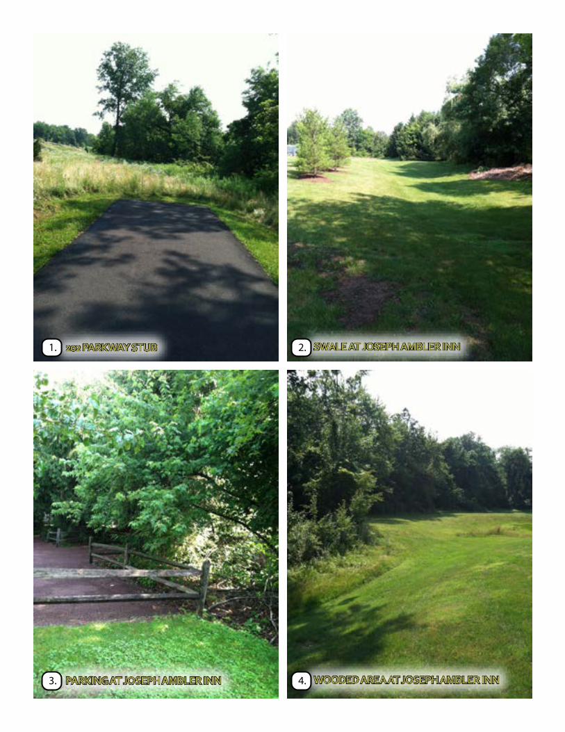
PHOTO REFERENCES:1- 202 PARKWAY STUB
2- SWALE AT JOSEPH AMBLER INN
3- PARKING AT JOSEPH AMBLER INN
4- WOODED AREA AT JOSEPH AMBLER INN
5- POTENTIAL STREAM CROSSING LOCATION
6- EXISTING TRAIL SYSTEM AT MUNICIPAL COMPLEX
7- EXISTING MUNICIPAL COMPLEX ENTRANCE DRIVE
8- EXISTING ACCESS DRIVE AT MUNICIPAL COMPLEX
9- EAST SIDE OF MUNICIPAL COMPLEX
10- CORNER OF HORSHAM & STUMP ROADS
11- EXISTING STORMWATER MANAGEMENT WEST OF FUTURE
COMMUNITY CENTER SITE
12- SOUTHERN PROPERTY LINE OF FUTURE COMMUNITY CENTER SITE
13- SOUTHERN SIDE OF CEDAR RUN LANDSCAPE PARCEL
14- SOUTHERN SIDE OF TEVA PARCEL
15- LAWN STRIP BETWEEN TEVA & HARTMAN CORPORATE CENTER
16- HARTMAN CORPORATE CENTER ENTRANCE DRIVE
17- HORSHAM ROAD AT POWER LINE LOOKING EAST
18- EXISTING WALKWAY ALONG HARTMAN ROAD
19-HARTMAN ROAD AND DOMORAH DRIVE
20- HARTMAN ROAD - SOUTH OF DOMORAH DRIVE
21- HARTMAN ROAD - ADJACENT WET AREA
22- HARTMAN ROAD - HEAD WALL
23- HARTMAN ROAD - UTILITY POLE AND SLOPE
24- LINK TO FUTURE POWER LINE TRAIL
25- STUMP ROAD AND COMMERCE DRIVE
26- MISSING SIDEWALK CONNECTION TO COMMERCE DRIVE
27- CROSSING TO VILLAGE SHOPPING CENTER
28- COMMERCE DRIVE
29- DOMORAH DRIVE - EXISTING GRATE
30- COMMERCE DRIVE AND DOMORAH CONNECTION
31- PECO CORRIDOR
32- PECO CORRIDOR AND PUBLIC WORKS
33- EXISTING WALK ALONG HORSHAM ROAD AT TEVA
34- EXISTING WALK ADJACENT TO WETLANDS
35- EXISTING WALK ALONG HARTMAN ROAD AT TEVA
202 PARKWAY STUB1.
PARKING AT JOSEPH AMBLER INN3.
SWALE AT JOSEPH AMBLER INN2.
WOODED AREA AT JOSEPH AMBLER INN 4.

POTENTIAL STREAM CROSSING LOCATION 5.
EXISTING MUNICIPAL COMPLEX ENTRANCE DRIVE
7.
EXISTING TRAIL SYSTEM AT MUNICIPAL COMPLEX
6.
EXISTING ACCESS DRIVE AT MUNICIPAL COMPLEX
8.

EAST SIDE OF MUNICIPAL COMPLEX9. CORNER OF HORSHAM & STUMP ROADS10.
SOUTHERN PROPERTY LINE OF COMMUNITY CENTER SITE
12.EXISTING STORMWATER MANAGEMENT WEST OF FUTURE COMMUNITY CENTER SITE
11.

SOUTHERN SIDE OF CEDAR RUN LANDSCAPE PARCEL 13.
LAWN STRIP BETWEEN TEVA & HARTMAN CORPORATE CENTER
15.
SOUTHERN SIDE OF TEVA PARCEL 14.
HARTMAN CORPORATE CENTER ENTRANCE DRIVE
16.

HORSHAM AT POWER LINE LOOKING EAST 17.
HARTMAN ROAD & DOMORAH DRIVE 19.
EXISTING WALK ALONG HARTMAN ROAD18.
HARTMAN ROAD - SOUTH OF DOMORAH DR.20.

HARTMAN ROAD - ADJACENT WET AREA21.
HARTMAN ROAD - UTILITY POLE & SLOPE 23.
HARTMAN ROAD - HEAD WALL 22.
LINK TO FUTURE POWER LINE TRAIL 24.

30' TYPICAL WIDTH
STUMP ROAD AND COMMERCE DRIVE25.
CROSSING TO VILLAGE SHOPPING CENTER27.
MISSING SIDEWALK CONNECTION TO COMMERCE DRIVE
26.
COMMERCE DRIVE 28.

DOMORAH DRIVE - EXISTING GRATE 29.
PECO CORRIDOR31.
COMMERCE DRIVE AND DOMORAH DRIVE30.
PECO CORRIDOR AND PUBLIC WORKS 32.

EXISTING WALK ALONG HORSHAM ROAD AT TEVA
33.
EXISTING WALK ALONG HARTMAN ROAD AT TEVA
35.
EXISTING WALK ADJACENT TO WETLANDS34.

1. Chester Valley Trail2. Cresheim Trail3. Cross County Trail4. Evansburg Trail5. Liberty Bell Trail6. Manatawny Trail7. Pennypack Trail8. Perkiomen Trail
9. Power Line Trail10. Schuylkill East Trail11. Schuylkill River Trail12. Stony Creek Trail13. Sunrise Trail14. West County Trail15. Wissahickon Green Ribbon Trail16. 202 Trail
Completed TrailIn Design/Future ConstructionProposed TrailFreight StationCounty-Owned LandState-Owned LandValley Forge National Historical ParkHistoric Sites
MONTGOMERY COUNTY
Primary Trail Network
Click on any red trail number/name or green park/historic site name for a link to individual websites.
See individual trail brochures for trailhead access to parking, public transit, restrooms, water, and other information.
0 1/2 1 2 Miles
MC
PC Montgomery
CountyPlanningCommissionMontgomery County Courthouse - Planning CommissionPO Box 311 Norristown PA 19404-0311(p) 610 278-3722 (f) 610 278-3941www.montcopa.org/plancom
RD
AVE
RD
BYBERRYDAV
ISVI
LLE
OLD
CR
EEK
TO
OK
AN
Y
PHIL
MO
NT
WELSH
PIK
E
RD
RD
OLD
YO
RK
TOWNSHIP LINE RD
RD
CHELTENHAM
LIMEKILN
RD
CHURCH
PIKE
AVE
YORK
HU
NTIN
GD
ON
EASTON
LINE
LIMEKILN
BETHLEHEM
BLA
IR M
ILL
RD
RD
PIKE
NORRISTOWN
BETHLEHEM
PIKE
RD
PIKE
BU
TLE
R
PIKE
PIK
E
DE
KA
LB
MORRIS
PIK
ED
EK
ALB
RD
WH
ITE
HA
LL
RDHORSHAMCOWPATH RD
AVENUE
LANCASTER
BELMONT AVE
CIT
Y L
INE
AV
E
RD
PLYMOUTH
CONSHO
HOCKEN RD
RIDGE PIKE
MONTGOMERY
RD
RIVER
SP
RIN
G M
ILL
RD
FA
YE
TT
E S
T
RD
SW
ED
E
ST
ST
4TH
MA
RK
LEY
ST
AIRY
SA
ND
Y H
ILL
RD
VA
LLE
Y
FORGE
DEK
ALB
PIK
E
RD
GULPH RD
VALLEY
AV
E
TOWNSHIP LINE RD
FO
RG
E
COUNTY
RD
RD
RD
FO
RT
Y
FO
OT
RO
AD
SKIPPACK R
IDG
E
SUMNEYTOWN
PIKE
RDBIG
ALLENTOWN
GERYVILLE
GRAVEL
KNIGHT RD
RD
RD
LAY
FIE
LD
RD
RD
HOFFMANSVILLE
KUTZTOWN
PIKE
BR
IDG
E
ST
PIKE
3RD
A
VE
MAIN
EGYPT RD
S T
RA
PP
E R
D
RO
AD
RIDGE PIKE
LEW
IS R
D
TO
WN
SH
IP
LI
NE
PIKE
SWAMP
KE
IM S
T
ST
RIDGE PIKE
CH
AR
LOT
TE
BIG
GRAVEL
PA
RK
RIDGE PIKE
PIKE
RD
PIK
E
AVENUE
HO
LLO
W
RD
GULPH RD
CONSHOHOCKEN
STATE
RD
PA
PE
R M
ILL
RD
MA
N
ATAW
NY ST
FARMING
TON AV
EH
AN
OVER
ST
ST ATE
ST
GIL
BE
RT
SV
ILLE
RD
LINFI
ELD R
D
CO
LL
EG
EV
ILL
E R
D
SECOND AVE
BLACK ROCK RD
BLACK RO
CK
RD
PAWLINGS RD
EGYPT RD
RD
STATE G
AME FARM R
OAD
HIGH ST MA
IN S
T
STUMP RD
GERMANTOWN PIKE
GERMANTOWN PIKE
SKIPPACK RD
SOUDERTON PIKE
WELSH
OLD
EA
ST
ON
RD
RD
MA
TSO
NS
F
OR
D
RD
SO
UD
ER
TO
N -
HA
RLE
YS
VIL
LE
PIK
E
MAIN ST
POTTSTOWN EXPRESSWAY
PENNSYLVANIA TURNPIKE NORTHEAST EXTENSION
PENN
SYLV
AN
IA
TURNPI
KE
MID
-CO
UN
TY
EX
PR
ESS
WAY
SCHUYLKILL
EXPRESSWAY
SCHUYLKILL EXPRESSWAY
FORT WASHING
TON E
XP
RESSWAY
RO
UTE 100 E
XP
RE
SS
WAY
100
422
73
663
73
29
29
563
113
63
73
463
611
63
332
263
232309
152
73
73
611
73
23320
23
363
113
422
202
N202
S202
202
202
I-476
I-276
I-276
I-476
I-76
30
1
I-76
422
29
63
63
152
63
Chester County
City ofPhiladelphia
DelawareCounty
Bucks CountyLehigh County
BerksCounty
UpperHanover
EastGreenville
RedHill
PennsburgSalford
UpperSalford
UpperFrederick
NewHanover
Douglass
Marlborough
LowerFrederick
GreenLane
WestPottsgrove
Limerick
UpperPottsgrove Lower
Pottsgrove
Schwenksville
Royersford
Pottstown
UpperGwynedd
Worcester
WestNorriton
EastNorriton
LowerSalford
Skippack
UpperProvidence
Perkiomen
Towamencin
LowerProvidence
CollegevilleTrappe
CheltenhamWhitpain
Springfield
Whitemarsh
LowerMerion
UpperMerion
Plymouth
Narberth
Conshohocken
WestConshohocken
Norristown
Bridgeport
Franconia
Hatfield
Ambler
Lansdale
TelfordSouderton
HatfieldBorough
BrynAthyn
Jenkintown
Rockledge
NorthWales
LowerMoreland
Abington
UpperMoreland
Horsham
Montgomery
UpperDublin
LowerGwynedd
Hatboro
6 11
14
10 8
84
14
8
13
4
9
11
1
11
3 15
5
15
5
12 5
3
169
2
3
7
VALLEY FORGE
NATIONALHISTORICAL
PARK
NorristownFarm Park
EvansburgState Park
FortWashingtonState Park
GreenLanePark
LowerPerkiomenValley Park
LorimerPark
CentralPerkiomenValley Park
UpperSchuylkill
Valley Park
7
11 Lock 60 at the Schuylkill Canal Park
PottsgroveManor
SunriseMill
PennypackerMills
John JamesAudubonCenter atMill Grove
Peter WentzFarmstead
MorganLog House
Evans-Mumbower
Mill
GraemePark
The Highlands
Hope Lodge

0 0.6 1 Mil" Scale 1 1 1
1:66,000 I I 0 0.6 1


