1 Powys LDP HS6 Action Points Council Responses Powys LDP Examination – Council’s Response to Action Points from Hearing Session 6 – Transport, Infrastructure & Delivery Action Point To be completed by Officer Agreed AP1 – CPRW to provide additional evidence on projected traffic movements arising from proposed four- turbine wind farm (Reeves Hill). 12 May 2017 CJ/PM Agreed Council Action/Matters Arising Change The following information was received by email from CPRW 11 th April 2017: “Proposed Reeves Hill Wind Farm Construction Traffic The RHWF example on p16 of the attachment was given to show the volume of traffic renewable energy schemes can generate. The RHWF Plan was submitted to both Powys CC and Herefordshire C because the proposed turbines were in Herefordshire and the proposed access was in Powys (but Herefordshire permission expired in 2015 so the scheme will not be built). The proposed turbines were 4 x Enercon with blade-tip height 105m and rotor diameter 70.5m. The wind turbines envisaged for the Local Search Areas are considerably larger at blade-tip height 120m and rotor diameter 80m and we estimate that 25MW wind farms would each contain 11 or 12 turbines and thus each would generate traffic over three times these figures. The RHWF traffic estimate does not include the substantial off-site road works for access. For attachment - Click to Download” The Council notes this information which relates to a planning application in 2008 for 4 wind turbines located in Herefordshire. A new access road to serve the proposal was proposed through the county of Powys with the actual turbines located in Herefordshire. While consent was granted for the turbines by Herefordshire two planning applications in Powys relating to the access were withdrawn. The development has not proceeded and the planning consent lapsed. Powys County Council Local Development Plan - 2011 – 2026
Transcript
1
Powys LDP HS6 Action Points Council Responses
Powys LDP Examination – Council’s Response to Action Points from
AP1 – CPRW to provide additional evidence on projected traffic movements arising from proposed four-turbine wind farm (Reeves Hill).
12 May 2017
CJ/PM Agreed
Council Action/Matters Arising Change
The following information was received by email from CPRW 11th April 2017:
“Proposed Reeves Hill Wind Farm Construction Traffic
The RHWF example on p16 of the attachment was given to show the volume of traffic renewable energy schemes can generate.
The RHWF Plan was submitted to both Powys CC and Herefordshire C because the proposed turbines were in Herefordshire and the proposed access was in Powys (but Herefordshire permission expired in 2015 so the scheme will not be built). The proposed turbines were 4 x Enercon with blade-tip height 105m and rotor diameter 70.5m. The wind turbines envisaged for the Local Search Areas are considerably larger at blade-tip height 120m and rotor diameter 80m and we estimate that 25MW wind farms would each contain 11 or 12 turbines and thus each would generate traffic over three times these figures. The RHWF traffic estimate does not include the substantial off-site road works for access.
For attachment - Click to Download”
The Council notes this information which relates to a planning application in 2008 for 4 wind turbines located in Herefordshire. A new access road to serve the proposal was proposed through the county of Powys with the actual turbines located in Herefordshire. While consent was granted for the turbines by Herefordshire two planning applications in Powys relating to the access were withdrawn. The development has not proceeded and the planning consent lapsed.
The data relating to wind turbines envisaged in the Local Search Areas above is purely speculative. The LSAs are search areas only and no specific proposals relating to any developments have been made.
AP2 – CPRW to submit suggested wording, and PCC to consider changing Policy DM15(10).
12 May 2017
CJ/PM Agreed
Council Action/Matters Arising Change
The following information was received by email from CPRW 11th April 2017:
“I am attaching the Herefordshire Traffic Policy and the Reeves Hill Wind Farm Construction Management Plan mentioned by CPRW Powys Branches at Hearing Session 6.
When considering proposals for development of new or expanded businesses that generate commercial road traffic, regard will be had to the environmental effects of heavy goods vehicles and other service vehicles and to the traffic impacts on both the strategic and local road network. Proposals that generate service vehicle movements that would unacceptably affect the amenity, safety and character of the existing or neighbouring environments by virtue of danger, noise, traffic generation and congestion, air pollution, visual intrusion or causing parking problems, will not be permitted. All proposals will be expected to incorporate adequate operational arrangements within their layout, and include traffic management measures and workplace travel plans and more sustainable delivery systems where appropriate.
In addition, the whole UDP is incorporated into the Core Strategy, concertina-fashion with around a dozen traffic policies merged under MT1 - T9 is echoed in the first para below (https://www.herefordshire.gov.uk/downloads/file/1804/section_5_-_general_policies)
Policy MT1 – Traffic management, highway safety and promoting active travel
Development proposals should incorporate the following principle requirements covering movement and transportation:
1. demonstrate that the strategic and local highway network can absorb the traffic impacts of the development without adversely affecting the safe and efficient flow of traffic on the network or that traffic impacts can be managed to acceptable levels to reduce and mitigate any adverse impacts from the development;
2. promote and, where possible, incorporate integrated transport connections and supporting infrastructure (depending on the nature and location of the site), including access to services by means other than private motorised transport;
3. encourage active travel behaviour to reduce numbers of short distance car journeys through the use of travel plans and other promotional and awareness
4. ensure that developments are designed and laid out to achieve safe entrance and exit, have appropriate operational and manoeuvring space, accommodate provision for all modes of transport, the needs of people with disabilities and provide safe access for the emergency services;
5. protect existing local and long distance footways, cycleways and bridleways unless an alternative route of at least equal utility value can be used, and facilitate improvements to existing or provide new connections to these routes, especially where such schemes have been identified in the Local Transport Plan and/or Infrastructure Delivery Plan; and
6. have regard to with both the council’s Highways Development Design Guide and cycle and vehicle parking standards as prescribed in the Local Transport Plan - having regard to the location of the site and need to promote sustainable travel choices.”
The Council has considered the wording submitted by CPRW above and noted that Policy
T9 forms part of the Herefordshire Unitary Development Plan ⋅ March 2007, which has been superseded by Herefordshire Local Plan – Core Strategy 2011-2031 from which Policy MT1 is derived.
The Council proposes to delete existing DM15 (10):
10. It meets all highway access requirements and vehicular parking standards and incorporates the access needs of all transport users, especially pedestrians and cyclists and those with disabilities or mobility impairment. Proposals considered to generate significant amounts of travel or traffic will only be considered where they include a satisfactory Transport Assessment and/or a Travel Plan.
Replace with the following proposed criterion (10):
10. The development has been designed and located to minimise the impacts on the transport network - journey times, resilience and efficient operation - whilst ensuring that highway safety for all transport users is not detrimentally impacted upon. Development proposals should meet all highway access requirements, (for all transport users), vehicular parking standards and demonstrate that the strategic and local highway network can absorb the traffic impacts of the development without adversely affecting the safe and efficient flow of traffic on the network or that traffic impacts can be managed to acceptable levels to reduce and mitigate any adverse impacts from the development.
Accordingly, as a consequential change make deletions and changes to paragraphs 4.2.51A & 4.2.52A to 4.2.53A:
4.2.51A & 4.2.52A Transport requirements. Highway access and parking requirements are important considerations for most developments, especially the implications they have for highway safety, the environment, local communities and the economy. All proposals that
4
Powys LDP HS6 Action Points Council Responses
the Council considers would generate significant traffic will require a Transport Assessment and/ or a Travel Plan. This process seeks to assess the transport implications of new developments, to reduce the reliance on travel by private cars and to promote sustainable modes of transport. The need for and scope for an Assessment or Travel Plan should be agreed with the Council as early as possible in the planning process. Development proposals that could detrimentally impact on highway safety and amenity will be expected to incorporate evidence demonstrating how they are to be mitigated. The Council will encourage developments which promote pedestrian and cycle friendly access, avoiding conflict with private motorised vehicles and provide appropriate links where possible. Proposals considered to generate significant amounts of travel or traffic should be in sustainable locations, accessible by means other than private car. Alternatively, such developments will be required to demonstrate how traffic and/or any sustainability, environmental quality, amenity or safety impacts are to be mitigated. These development proposals should be accompanied by satisfactory travel plans and/or transport assessments.
4.2.53A Where considered appropriate planning obligations in respect of transport or traffic requirements may be sought in accordance with Policy DM1 – Planning Obligations. Proposals that generate significant travel demands will only be permitted where adequate public and other sustainable forms of transport are incorporated as part of the proposal and are consistent with the role and function of the transport network.
AP3 – PCC to consider reference to Mid-Wales Transport Plan and the schemes identified in the agenda in RJ to T1.
12 May 2017
CJ Agreed
Council Action/Matters Arising Change
See AP5
AP4 – PCC to consider reference to Mid-Wales Transport Plan and the schemes identified in the agenda in RJ to T1; delete reference to Welsh Government in Policy T1.
12 May 2017
CJ Agreed
Council Action/Matters Arising Change
See AP5
AP5 – PCC to consider revision of T1 (policy wording or RJ) to reflect need for Active Travel in rural areas, and to clarify the application of the Road Traffic Reduction Act 1997 requirements.
12 May 2017
CJ Agreed
Council Action/Matters Arising Change
The Authority proposes to delete existing Policy T1 – Transport Infrastructure:
5
Powys LDP HS6 Action Points Council Responses
Policy T1 – Transport Infrastructure Transport infrastructure and traffic management improvements will be permitted where they support Welsh Government priorities for promoting growth and sustainable jobs, tackling poverty, and ensuring sustainable rural communities. In particular this would be where such measures: 1. Improve the safety of transport users, especially those making ‘active travel’ journeys by walking or cycling.
2. Reduce traffic congestion and/or improve the local environment.
3. Reduce demand for travel by private transport.
4. Provide, promote and improve sustainable forms of travel.
Replace with:
Policy T1 – Travel, Traffic & Transport Infrastructure
Transport infrastructure, traffic management improvements and development
proposals should incorporate the following principle requirements:
1. Safe and efficient flow of traffic for all transport users, including more
vulnerable users, and especially those making ‘Active Travel’ journeys by
walking or cycling;
2. Manage any impacts to the network and the local environment to acceptable
levels and mitigate any adverse impacts; and,
3. Minimise demand for travel by private transport and encourage, promote and
improve sustainable forms of travel including Active Travel opportunities in all
areas.
Transport infrastructure improvements will be supported where they promote
sustainable growth, maximise the efficiency and safety of the transport systems,
improve public and private transport integration and encourage passenger and
freight rail operations.
4.5.1A The policy seeks to enable transport and traffic infrastructure improvements to
ensure an efficient, effective and integrated system but one which has regard to the safety
of all road users in all areas especially those making ‘purposeful journeys’ as Active Travel
and the impact it may have on the transport network and the local environment.
4.5.1 This policy It seeks to support the coordination of a wide range of traffic management measures and transport interchange developments that will maximise the efficiency and safety of the transport system including road, rail, pedestrian and cyclist travel networks and connections. 4.5.2 Appropriately located public transport interchange developments support sustainable travel and can reduce the demand for travel by private car. Developments that support
6
Powys LDP HS6 Action Points Council Responses
public and private transport integration, such as Park and Ride/Share Schemes and Bus Stops that complement the use of local and national bus or rail services, taxi ranks and train and bus stations will be supported. 4.5.3 Proposals that benefit rail passenger operations and proposals that support rail freight
opportunities will be encouraged. Transport policy applicable to all developments including
the safeguarding of key transport corridors, the requirements for transport assessments
and travel plans, and access and parking requirements are addressed by the Development
Management and Strategic Policies.
4.5.4 The Mid Wales Joint Local Transport Plan (Mid Wales LTP) is a statutory document
that was approved by the Welsh Government (WG) in May 2015. The Mid Wales LTP
covers a programme of projects for the period 2015-2020 and provides a longer term
framework for schemes up until 2030. Should funding become available it will facilitate the
progression of the following specifically identified proposals:
A44 Radnor Forest Bends and East-West routes (2015 – 2020)
B4385 Beulah to A4081 Llanyre (2020 – 2030)
The Road Traffic Reduction Act 1997
For clarification, it is understood that the Welsh Government undertook via the Wales Transport Act 2006 to discharge the requirements of the “transport functions” as required under the “The Road Traffic Reduction Act 1997” by local authorities under the requirements of the production of the Regional Transport Plan 2009, and subsequent Local Transport 2014. Subsequently, WG have approved both the RTP 2009 and LTP 2014, and therefore PCC would consider that we and the other regional authorities have discharged the duty within PPW Transport 1.1.8.
AP6 – Delete para 4.2.54a with revised paragraph and another standards document – Setting Local Speed Limits in Wales, 2009.
12 May 2017
CJ Agreed
Council Action/Matters Arising Change
In accordance with Council’s Statement (ED032.6) for Hearing session 6: Delete paragraph: 4.2.54A Further guidance is provided by PPW, TAN18: Transport, the CSS Wales Parking Standards 2008, the Council’s Design Guide for Industrial and Residential Infrastructure, Manual for Streets and Manual for Streets II. The Design Manual for Roads and Bridges (DMRB) is the relevant standard where developments may impact on trunk roads.
7
Powys LDP HS6 Action Points Council Responses
Replace with: 4.2.54A For the county road network further guidance is provided by PPW, TAN 18, Manual for Streets, Manual for Streets 2, Design Manual for Roads and Bridges (DMRB), the CSS Wales Parking Standards and Setting Local Speed Limits in Wales 2009. Developments that access onto and impact the trunk road network will be assessed by the Welsh Government, who solely use the DMRB standards.
AP7 – PCC to update Appendix 1 in light of updated flood assessments. Phasing info on employment allocations. Include revised text at 6a9 is included in Appendix 1.
12 May 2017
CS/AH Agreed
Council Action/Matters Arising Change
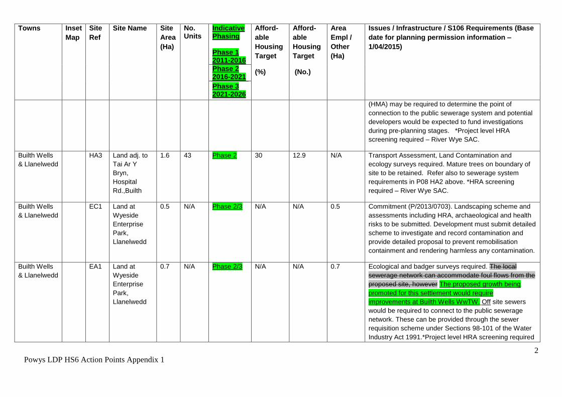
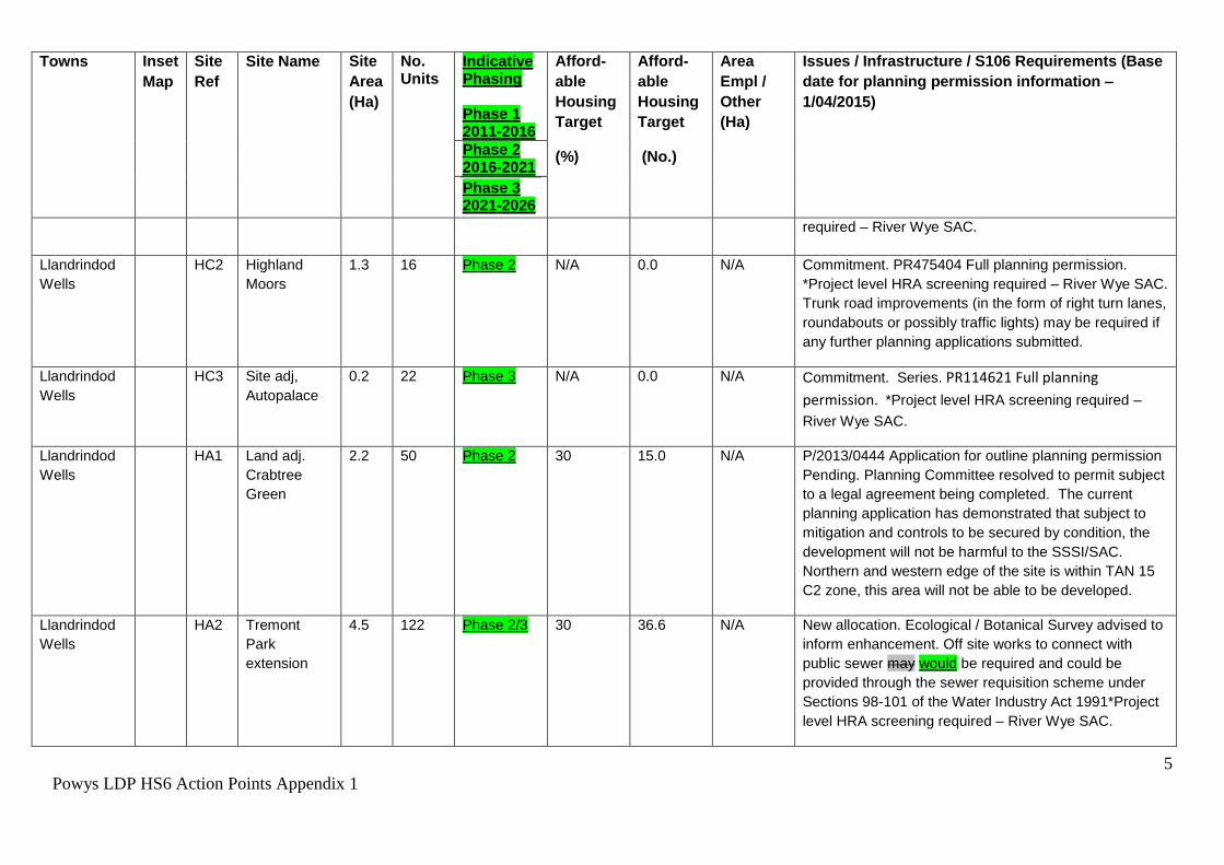
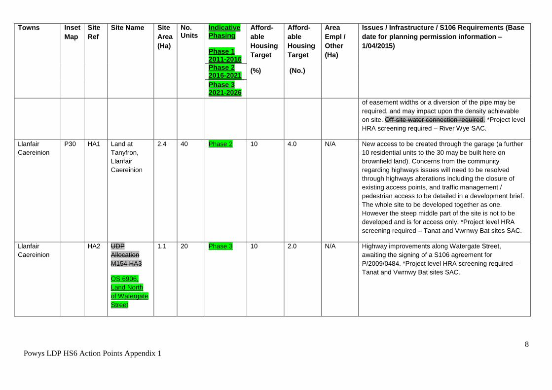
Appendix 1 to this statement includes a revised Appendix 1 of the Plan showing the proposed Matters Arising Changes. The proposed Matters Arising Changes include phasing information on the employment allocations and commitments and the insertion of text beneath the allocations table to display the paragraph proposed in the Council’s statement to hearing session 6 regarding the updating of FCAs following the publication of Policy Clarification Letter CL-03-16.
The information on FCAs and flood risk in the issues / infrastructure column of the Settlement allocations table has also been updated to include the information submitted with the Council’s statement to hearing session 6 (paragraph 6.a.1). This Matters Arising Change has been proposed to provide consistency on how the nature of the flood risk is described, on what is required and where appropriate how the site has been informed by the Strategic Flood Consequences Assessment (SFCA).
Please note that there are other proposed Matters Arising Changes highlighted in Appendix 1, these relate to Action Points arising from other hearing sessions but reflect the ‘live’ LDP document.
AP8 - Amendment to reasoned justification of DM4 to include reference to uplands.
12 May 2017
CS Agreed
Council Action/Matters Arising Change
The insertion of the following sentence into the reasoned justification of DM4 is proposed as a Matters Arising Change 4.2.30a “The definition of floodplain within this Policy is consistent with Planning Policy Wales; it is where water flows in times of flood and includes upland areas”. Please see Appendix 2
AP9 – Review policy DM5(2) by removing criteria and make amendment to reasoned justification to refer to WG non-statutory guidance.
12 May 2017
CS Agreed
Council Action/Matters Arising Change
Appendix 2 to this document contains the proposed Matters Arising Changes for revised
8
Powys LDP HS6 Action Points Council Responses
wording to DM4 and DM5 and the reasoned justification text. This change has been conducted so that it is not more onerous than national policy but is in line with para 10.11 of TAN 15.
A consequential change to this proposal will be the renaming of the SPG to “Land Drainage” rather than “Sustainable Drainage Systems (SUDS)”. Paragraph 4.2.33a (“A SPG will be produced to provide further guidance on the minimum amount of information required to demonstrate that the proposed approach is feasible and/ or that the detailed design could be covered by way of a planning condition) has been inserted into the reasoned justification of Policy DM5, this paragraph shows why the SPG is required and how it will aid the implementation of the policy.
Policy DM11 - Protection of Existing Community Facilities and Services The loss of the following existing Community Facilities and Services will only be permitted in respect of:as follows: 1. An existing community or indoor recreation facility, where it can be demonstrated that:
i. Appropriate alternative provision is to be made available or the potential for continued use is no longer viable; and ii. Alternative solutions to support the long term use of the facility for the community have been adequately explored.
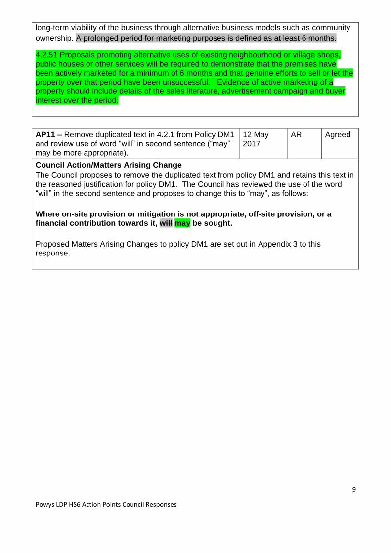
2. An existing neighbourhood shop, village shop, public house or service where it can be demonstrated that:
i. The premises have been for sale and/or vacant for a prolonged period minimum of 6 months and genuine attempts at actively marketing the existing use during that time have been unsuccessful. ii. Alternative solutions to support the long-term economic viability of the business have been demonstrated to be adequately explored.
4.2.49 Proposals that would result in the loss of community facilities and indoor recreation should be justified. Alternative solutions should be considered unless it can be proven that continued provision is not economically viable. 4.2.50 Given their importance, the Council recognises the need to retain existing
neighbourhood and village shops and services. A flexible approach to the use of existing
premises can help sustain much needed facilities and it may be appropriate for a local
village pub to operate as a village shop or sub-post office. This may reduce the need for
local people to travel long distances in search of essential services, and at the same time
may provide additional revenue for the business. It may also be possible to secure the
9
Powys LDP HS6 Action Points Council Responses
long-term viability of the business through alternative business models such as community
ownership. A prolonged period for marketing purposes is defined as at least 6 months.
4.2.51 Proposals promoting alternative uses of existing neighbourhood or village shops, public houses or other services will be required to demonstrate that the premises have been actively marketed for a minimum of 6 months and that genuine efforts to sell or let the property over that period have been unsuccessful. Evidence of active marketing of a property should include details of the sales literature, advertisement campaign and buyer interest over the period.
AP11 – Remove duplicated text in 4.2.1 from Policy DM1 and review use of word “will” in second sentence (“may” may be more appropriate).
12 May 2017
AR Agreed
Council Action/Matters Arising Change
The Council proposes to remove the duplicated text from policy DM1 and retains this text in the reasoned justification for policy DM1. The Council has reviewed the use of the word “will” in the second sentence and proposes to change this to “may”, as follows:
Where on-site provision or mitigation is not appropriate, off-site provision, or a financial contribution towards it, will may be sought.
Proposed Matters Arising Changes to policy DM1 are set out in Appendix 3 to this response.
10
Powys LDP HS6 Action Points Council Responses
General note on Action Points (APs):
These will normally be agreed in principal by the Inspector and the LPA, and any other
participant as required, at the end of the relevant hearing session. Where possible the AP
will specify an agreed timeframe for completion. If it is not possible to determine the
timeframe at the time of discussion, the LPA will liaise with the Inspector over this via the
Programme Officer. The Planning Inspector will send the suggested form of wording for the
APs to the LPA via the Programme Officer as soon as practicable after the end of a hearing
session. Once the LPA is satisfied that the contents are accurate, they will be published to
the Examination website as soon as possible in the interests of transparency. The LPA will
work on the schedule of Matters Arising Changes (MACs) in parallel with the APs and their
AP responses, ensuring that MACs are accurately recorded at the earliest possible stage.
The Inspector will confirm when she expects to be sent an up to date MAC Schedule; this
will normally be in advance of the final hearing session.
Appendices
Appendix 1 - Action Point 7, Revised Appendix 1 to the Plan
Appendix 2 - Action Points 8 and 9, Revised Policies DM4 and DM5
Appendix 3 - Proposed Matters Arising Changes to Policy DM1
1
Powys LDP HS6 Action Points Appendix 1
Appendix 1 - Hearing Session 6 Action Point 7,
Revised Appendix 1 to the Plan – Settlement Allocations
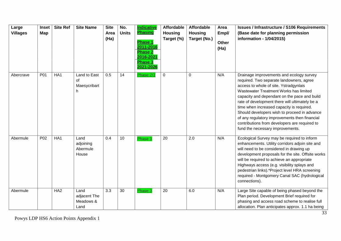
contamination surveys required. Due to the amount and
close proximity of sites, it will be necessary for
developers to fund a hydraulic modelling assessment of
the water supply network to establish any improvements
required to serve the sites with an adequate water
supply. Ystradgynlais Wastewater Treatment Works has
limited capacity and dependant on the pace and build
rate of development there will ultimately be a time when
increased capacity is required. Should developers wish
to proceed in advance of any regulatory improvements
then financial contributions from developers are required
to fund the necessary improvements.
29
Powys LDP HS6 Action Points Appendix 1
Towns Inset
Map
Site
Ref
Site Name Site
Area
(Ha)
No. Units
Indicative Phasing Phase 1 2011-2016
Afford-
able
Housing
Target
(%)
Afford-
able
Housing
Target
(No.)
Area
Empl /
Other
(Ha)
Issues / Infrastructure / S106 Requirements (Base
date for planning permission information –
1/04/2015)
Phase 2 2016-2021
Phase 3 2021-2026
Ystradgynlais
Area
HA5 Glanrhyd
Farm,
Ystradgynlais
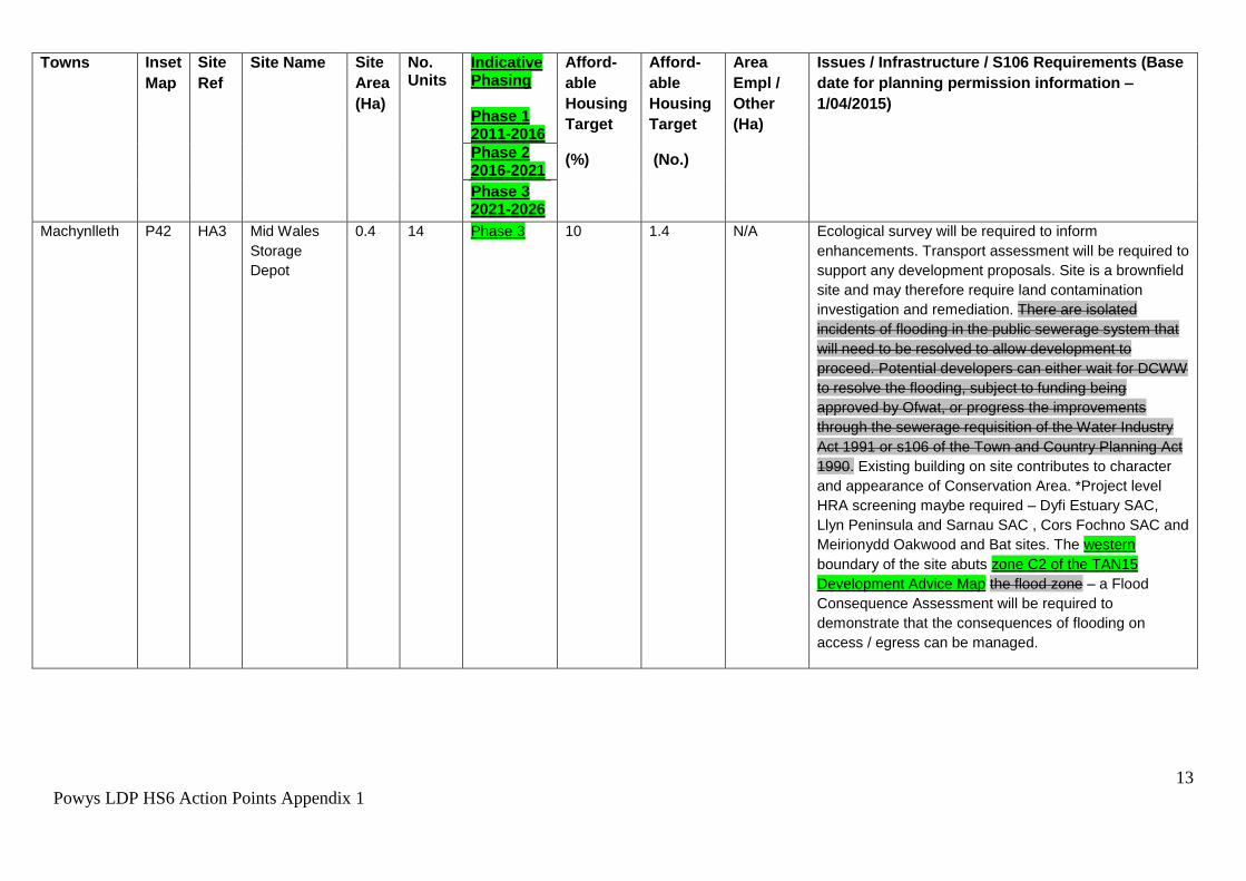
0.3 8 Phase 2 0 0 N/A Ecology and land contamination surveys required. The
site is crossed by a sewer and protection measures in
the form of easement widths or a diversion of pipe would
be required, which may impact upon the density
achievable on site. Due to the amount and close
proximity of sites, it will be necessary for developers to
fund a hydraulic modelling assessment of the water
supply network to establish any improvements required
to serve the sites with an adequate water supply.
Ystradgynlais Wastewater Treatment Works has limited
capacity and dependant on the pace and build rate of
development there will ultimately be a time when
increased capacity is required. Should developers wish
to proceed in advance of any regulatory improvements
then financial contributions from developers are required
to fund the necessary improvements.
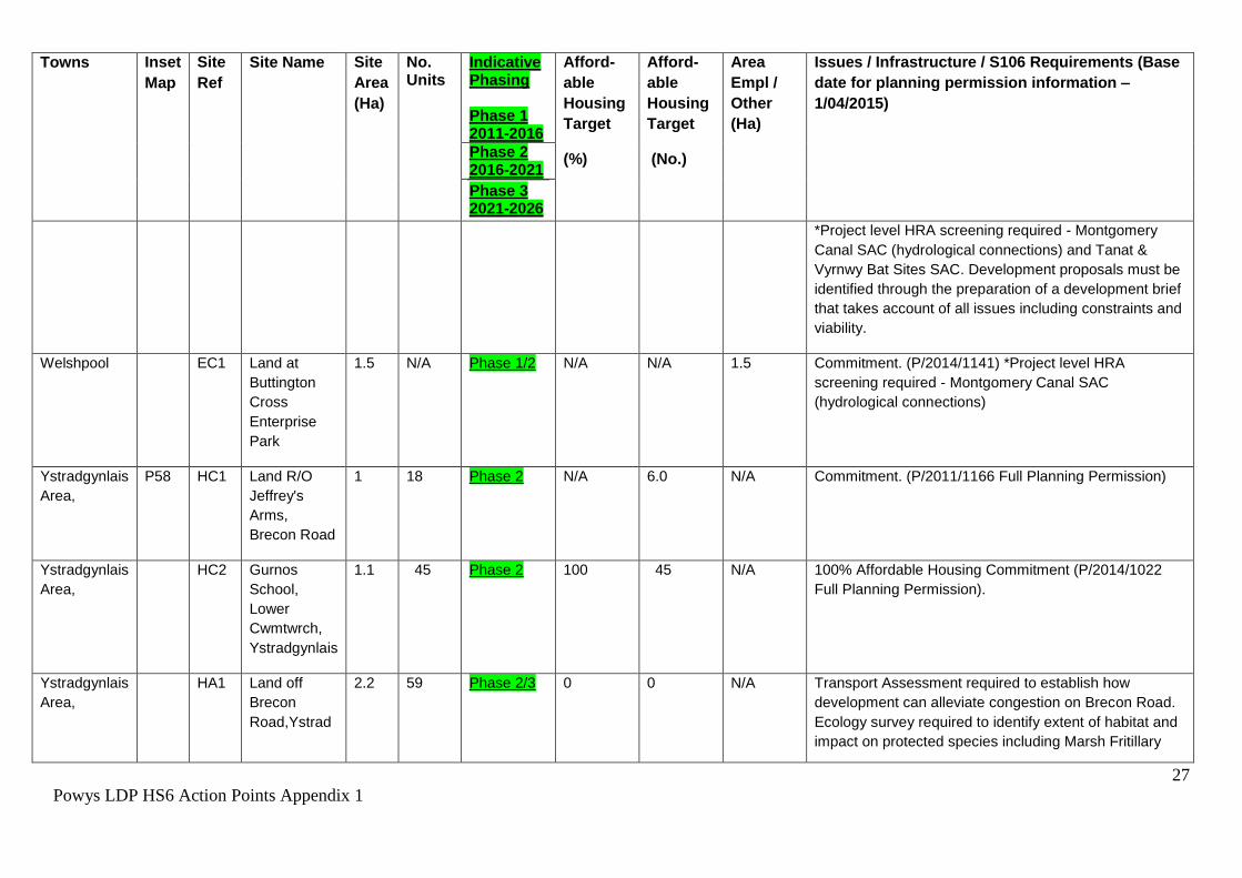
Ystradgynlais
Area
HA9 Penrhos
Farm
3 76 Phase 3 0 0 N/A Highways improvement, ecology, land contamination assessments required. Site within buffer zone of existing minerals extraction permission. 0.52ha for access, landscaping and open space. Due to the amount of proposed development, and the close proximity of sites, it may be necessary for developers to fund the undertaking of a hydraulic modelling assessment of the water supply network to establish any improvements required to serve the sites with an adequate water supply. Ystradgynlais Wastewater Treatment Works (WwTW)
30
Powys LDP HS6 Action Points Appendix 1
Towns Inset
Map
Site
Ref
Site Name Site
Area
(Ha)
No. Units
Indicative Phasing Phase 1 2011-2016
Afford-
able
Housing
Target
(%)
Afford-
able
Housing
Target
(No.)
Area
Empl /
Other
(Ha)
Issues / Infrastructure / S106 Requirements (Base
date for planning permission information –
1/04/2015)
Phase 2 2016-2021
Phase 3 2021-2026
has limited capacity. Should potential developers wish to commence in advance of the AMP6 scheme then financial contributions from developers are required to fund the necessary improvements.
4.5 122 Phase 2/3 0 0 N/A Highways access via P58 HA3. Within 100m of former
landfill so risk assessment required. Ecology and
contamination surveys required. Due to the amount and
close proximity of sites, it will be necessary for
developers to fund a hydraulic modelling assessment of
the water supply network to establish any improvements
required to serve the sites with an adequate water
supply. Ystradgynlais Wastewater Treatment Works has
limited capacity and dependant on the pace and build
rate of development there will ultimately be a time when
increased capacity is required. Should developers wish
to commence in advance of the AMP6 scheme then
financial contributions from developers are required to
fund the necessary improvements.
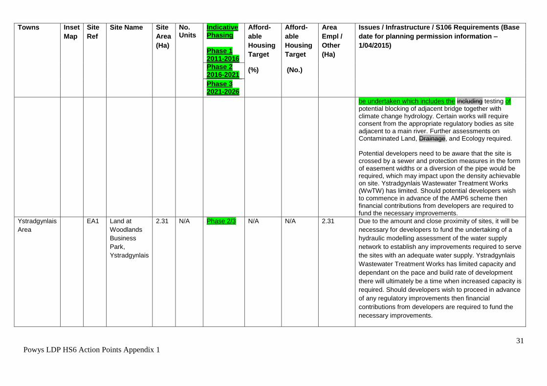
Ystradgynlais
Area,
HA1
2
Cynlais
Playing
Fields
0.64 10 Phase 2 0 0 N/A Requires remodelling of layby exit to form satisfactory access to site. Part of site within TAN15 C2 flood zone and a larger extent within Zone B. Flood Consequence Assessment required The south western boundary of this site includes a small area (0.02ha) of zone C2 of the TAN15 Development Advice Map; this area cannot be developed, a Flood Consequence Assessment should
31
Powys LDP HS6 Action Points Appendix 1
Towns Inset
Map
Site
Ref
Site Name Site
Area
(Ha)
No. Units
Indicative Phasing Phase 1 2011-2016
Afford-
able
Housing
Target
(%)
Afford-
able
Housing
Target
(No.)
Area
Empl /
Other
(Ha)
Issues / Infrastructure / S106 Requirements (Base
date for planning permission information –
1/04/2015)
Phase 2 2016-2021
Phase 3 2021-2026
be undertaken which includes the including testing of potential blocking of adjacent bridge together with climate change hydrology. Certain works will require consent from the appropriate regulatory bodies as site adjacent to a main river. Further assessments on Contaminated Land, Drainage, and Ecology required. Potential developers need to be aware that the site is crossed by a sewer and protection measures in the form of easement widths or a diversion of the pipe would be required, which may impact upon the density achievable on site. Ystradgynlais Wastewater Treatment Works (WwTW) has limited. Should potential developers wish to commence in advance of the AMP6 scheme then financial contributions from developers are required to fund the necessary improvements.
Ystradgynlais
Area
EA1 Land at
Woodlands
Business
Park,
Ystradgynlais
2.31 N/A Phase 2/3 N/A N/A 2.31 Due to the amount and close proximity of sites, it will be
necessary for developers to fund the undertaking of a
hydraulic modelling assessment of the water supply
network to establish any improvements required to serve
the sites with an adequate water supply. Ystradgynlais
Wastewater Treatment Works has limited capacity and
dependant on the pace and build rate of development
there will ultimately be a time when increased capacity is
required. Should developers wish to proceed in advance
of any regulatory improvements then financial
contributions from developers are required to fund the
necessary improvements.
32
Powys LDP HS6 Action Points Appendix 1
Towns Inset
Map
Site
Ref
Site Name Site
Area
(Ha)
No. Units
Indicative Phasing Phase 1 2011-2016
Afford-
able
Housing
Target
(%)
Afford-
able
Housing
Target
(No.)
Area
Empl /
Other
(Ha)
Issues / Infrastructure / S106 Requirements (Base
date for planning permission information –
1/04/2015)
Phase 2 2016-2021
Phase 3 2021-2026
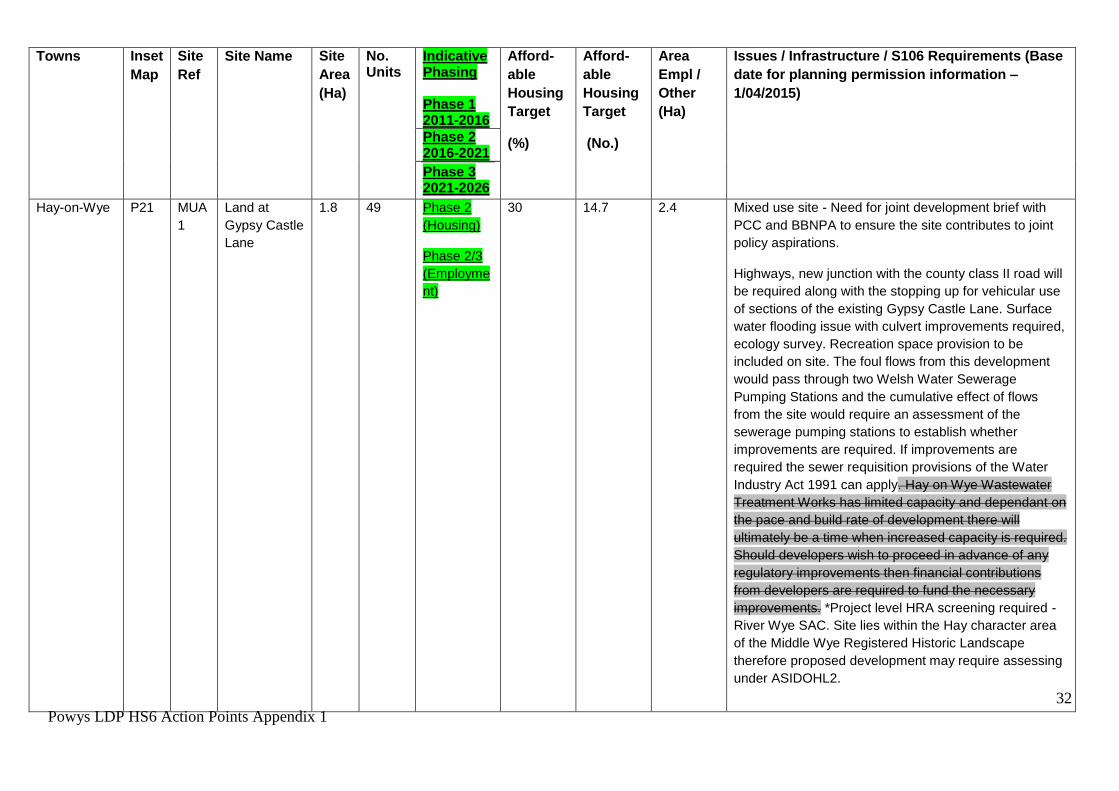
Hay-on-Wye P21 MUA
1
Land at
Gypsy Castle
Lane
1.8 49 Phase 2
(Housing)
Phase 2/3
(Employme
nt)
30 14.7 2.4 Mixed use site - Need for joint development brief with
PCC and BBNPA to ensure the site contributes to joint
policy aspirations.
Highways, new junction with the county class II road will
be required along with the stopping up for vehicular use
of sections of the existing Gypsy Castle Lane. Surface
water flooding issue with culvert improvements required,
ecology survey. Recreation space provision to be
included on site. The foul flows from this development
would pass through two Welsh Water Sewerage
Pumping Stations and the cumulative effect of flows
from the site would require an assessment of the
sewerage pumping stations to establish whether
improvements are required. If improvements are
required the sewer requisition provisions of the Water
Industry Act 1991 can apply. Hay on Wye Wastewater
Treatment Works has limited capacity and dependant on
the pace and build rate of development there will
ultimately be a time when increased capacity is required.
Should developers wish to proceed in advance of any
regulatory improvements then financial contributions
from developers are required to fund the necessary
improvements. *Project level HRA screening required -
River Wye SAC. Site lies within the Hay character area
of the Middle Wye Registered Historic Landscape
therefore proposed development may require assessing
0.4 10 Phase 3 20 2.0 N/A Ecological Survey may be required to inform
enhancements. Utility corridors adjoin site and
will need to be considered in drawing up
development proposals for the site. Offsite works
will be required to achieve an appropriate
Highways access (e.g. visibility splays and
pedestrian links).*Project level HRA screening
required - Montgomery Canal SAC (hydrological
connections).
Abermule HA2 Land
adjacent The
Meadows &
Land
3.3 30 Phase 3 20 6.0 N/A Large Site capable of being phased beyond the
Plan period. Development Brief required for
phasing and access road scheme to realise full
allocation. Plan anticipates approx. 1.1 ha being
34
Powys LDP HS6 Action Points Appendix 1
Large
Villages
Inset
Map
Site Ref Site Name Site
Area
(Ha)
No.
Units
Indicative Phasing Phase 1 2011-2016
Affordable
Housing
Target (%)
Affordable
Housing
Target (No.)
Area
Empl/
Other
(Ha)
Issues / Infrastructure / S106 Requirements
(Base date for planning permission
information - 1/04/2015)
Phase 2 2016-2021
Phase 3 2021-2026
adjacent
Parkside
developed. Site comprises 3 distinct parts that
are subject of a number of constraints relating to
issues such as highways access, utility corridors
and flooding. The western boundary of this
southern parcel of the site abuts zone C2 of the
TAN15 Development Advice Map; as a
precaution a Flood Consequence Assessment
should be undertaken. A comprehensive scheme
for the development of the entire allocation shall
be identified through the preparation of a
development brief that takes account of all
constraints, viability and phasing (with no more
than 30 dwellings within the Plan period).*Project
level HRA screening required - Montgomery
Canal SAC (hydrological connections).
Abermule EA1 Abermule
Business
Park
2.6 N/A Phase 2/3 N/A N/A 2.6 The site previously benefitted from O outline
planning permission P/2009/1353 which has
lapsed. Serviced site. *Project level HRA
screening required - Montgomery Canal SAC
(hydrological connections). Flood risk - at risk in
the 0.1% annual probability fluvial flood event
and sSite falls wholly within TAN 15 C2 Flood
Zone, proposals will need to be in line with
national policy – TAN 15 and will require a Flood
Consequence Assessment. A previous Flood
Consequence Assessment for this site was able
35
Powys LDP HS6 Action Points Appendix 1
Large
Villages
Inset
Map
Site Ref Site Name Site
Area
(Ha)
No.
Units
Indicative Phasing Phase 1 2011-2016
Affordable
Housing
Target (%)
Affordable
Housing
Target (No.)
Area
Empl/
Other
(Ha)
Issues / Infrastructure / S106 Requirements
(Base date for planning permission
information - 1/04/2015)
Phase 2 2016-2021
Phase 3 2021-2026
to demonstrate that B1 uses (FCA36594/FCA01)
were acceptable in line with TAN 15. If any
further planning application is submitted the
developer will need to revisit the Flood
Consequences Assessment to ensure flood risk
is up to date. Recommend consultation with
Emergency Services / Emergency Planners re
access / egress.
Arddleen P03 HA1 Land West of
Trederwen
House
1.7 17 Phase 2 20 3.4 Large Site capable of being phased beyond the
Plan period. Development Brief required for
provision of community car park to realise full
allocation. Plan anticipates approx. 0.6 ha being
developed. Sensitive heritage - listed Trederwen
House nearby. Sympathetically designed car
park could usefully buffer listed building. *Project
level HRA screening required - Montgomery
Canal SAC (hydrological connections) and Tanat
and Vyrnwy Bat sites SAC. This site is within a
catchment that is failing WFD objectives (due to
phosphate levels). Therefore foul water disposal
must go to a mains public sewer or developer
must show private connection is not adding to
phosphate levels in the catchment.
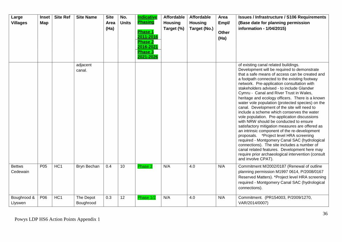
Berriew P04 HA1 Land to east
of the village,
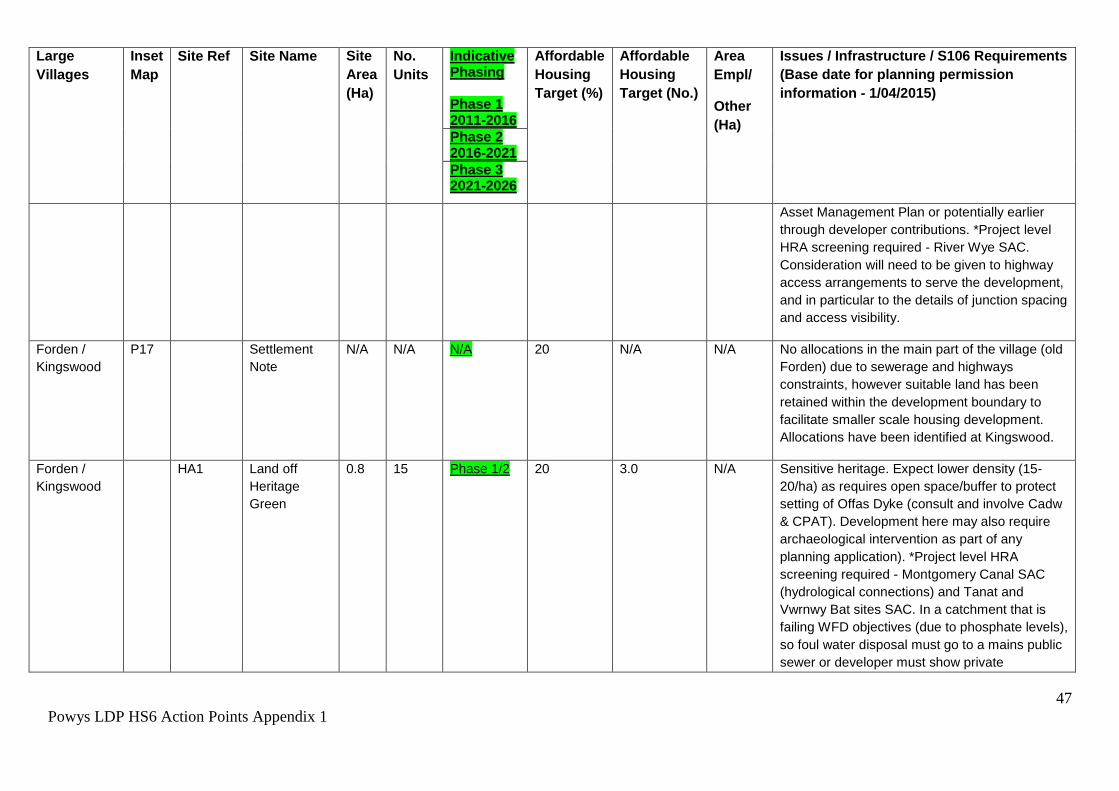
0.7 12 Phase 3 20 2.4 Sensitive canal side site at gateway into village. Density has been reduced to reflect need for a canal buffer and presence/potential preservation
36
Powys LDP HS6 Action Points Appendix 1
Large
Villages
Inset
Map
Site Ref Site Name Site
Area
(Ha)
No.
Units
Indicative Phasing Phase 1 2011-2016
Affordable
Housing
Target (%)
Affordable
Housing
Target (No.)
Area
Empl/
Other
(Ha)
Issues / Infrastructure / S106 Requirements
(Base date for planning permission
information - 1/04/2015)
Phase 2 2016-2021
Phase 3 2021-2026
adjacent
canal.
of existing canal related buildings. Development will be required to demonstrate that a safe means of access can be created and a footpath connected to the existing footway network. Pre-application consultation with stakeholders advised - to include Glandwr Cymru - Canal and River Trust in Wales,
heritage and ecology officers. There is a known water vole population (protected species) on the canal. Development of the site will need to include a scheme which conserves the water vole population. Pre-application discussions with NRW should be conducted to ensure satisfactory mitigation measures are offered as an intrinsic component of the re-development proposals. *Project level HRA screening required - Montgomery Canal SAC (hydrological connections). The site includes a number of canal related features. Development here may require prior archaeological intervention (consult and involve CPAT).
0.3 6 Phase 3 N/A 0.0 N/A Commitment. Site lies within the Yr Ystog
character area of the Vale of Montgomery
Registered Historic Landscape depending on its
size and nature any proposed development here
may require assessing under the ASIDOHL2 as
43
Powys LDP HS6 Action Points Appendix 1
Large
Villages
Inset
Map
Site Ref Site Name Site
Area
(Ha)
No.
Units
Indicative Phasing Phase 1 2011-2016
Affordable
Housing
Target (%)
Affordable
Housing
Target (No.)
Area
Empl/
Other
(Ha)
Issues / Infrastructure / S106 Requirements
(Base date for planning permission
information - 1/04/2015)
Phase 2 2016-2021
Phase 3 2021-2026
part of any planning application.
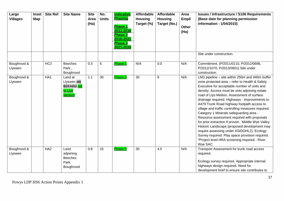
Churchstoke HC3 Land at the
Hatchery
0.5 12 Phase 2 N/A 5.0 N/A Commitment. Site lies within the Yr Ystog
character area of the Vale of Montgomery
Registered Historic Landscape depending on its
size and nature any proposed development here
may require assessing under the ASIDOHL2 as
part of any planning application.
Churchstoke HC4 Land
adjacent The
View
0.43 11 Phase 3 N/A 0 N/A Committed Site
Churchstoke HA1 Land west of
Fir House
1.34 36 Phase 2/3 20 7.2 Site lies within the Yr Ystog character area of the Vale of Montgomery Registered Historic Landscape depending on its size and nature any proposed development here may require assessing under the ASIDOHL2 as part of any planning application. Access works will be required to meet acceptable highways standards. Highways advise that access works should have regard to the potential residential use of land opposite. Ecological survey is likely to be required to inform enhancements. The Strategic Flood Consequences Assessment has identified land drainage issues on this site, these should be addressed through a site specific
44
Powys LDP HS6 Action Points Appendix 1
Large
Villages
Inset
Map
Site Ref Site Name Site
Area
(Ha)
No.
Units
Indicative Phasing Phase 1 2011-2016
Affordable
Housing
Target (%)
Affordable
Housing
Target (No.)
Area
Empl/
Other
(Ha)
Issues / Infrastructure / S106 Requirements
(Base date for planning permission
information - 1/04/2015)
Phase 2 2016-2021
Phase 3 2021-2026
Flood Consequence Assessment at the planning application stage.
Churchstoke EA1 Churchstoke 1.28 N/A Phase 2/3 N/A N/A 1.28 Housing Commitment P/2014/0559 at north of
site. This allocation takes forward into the LDP
the same parcel of land previously allocated in
the past plan. Site lies within the Yr Ystog
character area of the Vale of Montgomery
Registered Historic Landscape depending on its
size and nature any proposed development here
may require assessing under the ASIDOHL2 as
part of any planning application. This site is
within a catchment that is failing WFD objectives
(due to phosphate levels). Further loading of
phosphates in this catchment through
inappropriate drainage could prevent achieving
WFD objectives. All trade and foul water effluent
should be disposed via mains public sewer in the
first instance. If not, an assessment is required
at planning application stage to show
development is not adding to phosphate levels.
45
Powys LDP HS6 Action Points Appendix 1
Large
Villages
Inset
Map
Site Ref Site Name Site
Area
(Ha)
No.
Units
Indicative Phasing Phase 1 2011-2016
Affordable
Housing
Target (%)
Affordable
Housing
Target (No.)
Area
Empl/
Other
(Ha)
Issues / Infrastructure / S106 Requirements
(Base date for planning permission
information - 1/04/2015)
Phase 2 2016-2021
Phase 3 2021-2026
Clyro P13 HC1 Land South
east of Clyro
(A)
0.6 21 Phase 2 N/A 6.0 N/A Commitment. (RAD/2003/0557). Six local needs
units under construction
Clyro HA1 Land South
east of Clyro
(B)
0.5 14 Phase 3 30
4.2
N/A Highways & access improvements essential.
Potential developers need to be aware that the
site is crossed by a sewer and protection
measures in the form of easement widths or a
diversion of the pipe would be required, which
may impact upon the density achievable on site.
The proposed growth being promoted for this
settlement would require improvements to Clyro
Wastewater treatment works which would need
to be funded through Welsh Water's Asset
Management Plan or potentially earlier through
developer contributions. Land contamination and
ecology surveys required. *Project level HRA
screening required - River Wye SAC. Site lies
within the Bryn-yr-hydd character area of the
Middle Wye Registered Historic Landscape.
Depending on its size and nature any proposed
development here may require assessing under
the ASIDOHL2 as part of any planning
application
46
Powys LDP HS6 Action Points Appendix 1
Large
Villages
Inset
Map
Site Ref Site Name Site
Area
(Ha)
No.
Units
Indicative Phasing Phase 1 2011-2016
Affordable
Housing
Target (%)
Affordable
Housing
Target (No.)
Area
Empl/
Other
(Ha)
Issues / Infrastructure / S106 Requirements
(Base date for planning permission
information - 1/04/2015)
Phase 2 2016-2021
Phase 3 2021-2026
Crewgreen P15 HA1 Land
Opposite The
Firs (between
Malt House
Farm & Bryn
Mawr)
1.5 23 Phase 2 20 4.6 N/A Expect reduced density and careful design to
* In line with the Habitats Regulations it will be necessary for project level assessments to be undertaken where there is a potential for significant effects from development on
European Sites. Any development project that could have an adverse effect on integrity of a European site will not be in accordance with the development plan, within the
meaning of S.38 (6) of the Planning and Compulsory Purchase Act 2004. Where sites are shown as committed (have planning permission), screening of any fresh
applications will be necessary.
It is likely that many of the allocations in this list have the potential to support protected species and/or other features of biodiversity interest. The table identifies the sites
where ecological surveys are known to be required. However, as there will be no previous records available for some sites and therefore uncertainty regarding the presence
of protected species and features of biodiversity interest at many of the sites where no ecological survey is currently identified, the applicant is advised to consider whether an
ecological survey is required when preparing a scheme to be submitted for planning permission, and to ensure that all the necessary information is submitted in support of an
application to enable its likely impacts to be assessed.
All Flood Consequence Assessments (FCAs) prepared before 1st December 2016 will need to be revisited at the planning application stage to take into account the latest
climate change allowances as detailed in policy clarification letter and associated guidance note – ‘CL-03-16 - Climate change allowances for Planning purposes’.
Other Outstanding Housing Commitments elsewhere in the Plan Area (as at 01/04/2015) *
Location Additional Inset
(AI) Maps
Site
Ref.
Site Name Site
Area
(Ha)
No.
Units
Indicative Phasing Phase 1 2011-2016
Affordable
Housing
Target (%)
Affordable
Housing
Target (No.)
Area Empl/
Other (Ha)
Phase 2 2016-2021
Phase 3 2021-2026
Adfa Additional Inset 01 HLB1 The Former Timber Yard 0.24 8 Phase 2 N/A 3 N/A
* These sites are not in Towns or Large Villages as defined by the LDP Settlement Hierarchy. They are sites which have an extant planning permission at the
base date: 01/04/2015, they have been permitted under Unitary Development Plan Policy and are therefore part of the Housing Land Bank (HLB).
However the sites may be contrary to the LDP’s Policies and Proposals, any renewals or resubmissions of planning applications on these sites will need to
demonstrate compliance with LDP Policy H1.
69
Powys LDP HS6 Action Points Appendix 1
1
Powys LDP HS6 Action Points Appendix 2
APPENDIX 2 – Hearing Session 6 Action Points 8 and 9 Revised Policies DM4 and DM5 Policy DM4 – Development and Flood Risk Development proposals must be located away from tidal or fluvial flood plains unless it can be demonstrated that the site is justified in line with national guidance and an appropriate detailed technical assessment has been undertaken to ensure that the development is designed to reduce / avoid the threat and alleviate the consequences of flooding over its lifetime. In addition the development must not increase flood risk elsewhere, and shall where possible allow floodplains to provide water storage to reduce flooding in the catchment, unless:
1. The development is of a very minor nature such as an extension to a dwelling; or
2. There is an overriding need in the public interest for the development. 4.2.27 Avoiding unnecessary flood risk will be achieved by strictly assessing the flood risk implications of development proposals within areas susceptible to tidal or fluvial flooding and preventing development that unacceptably increases risk. In accordance with TAN15: Development and Flood Risk no highly vulnerable development will be permitted in Development advice zone C2. Development will only be considered in other areas at high risk of flooding where it can be demonstrated that the site can comply with the justification and assessment requirements of TAN15. Further information is found in “TAN 15 – Development and Flood Risk” and “The Chief Planning Policy Officers Letter (9th January 2014) - Planning Policy on Flood Risk and Insurance Industry Changes”. (moved from DM5 RJ) 4.2.28 TAN15 states that the Development Advice Maps are based on the best available information considered sufficient to determine when flood risk issues need to be taken into account in planning future development. Development advice zones C1 and C2 of the maps show high flood risk areas and are based on Natural Resources Wales’ extreme flood outlines for tidal and fluvial flooding. 4.2.29 Applications for the variation or renewal of planning permission will only be approved, in line with Policy H2, where it can be demonstrated that the development complies with the current Development Plan policies. This means that where planning permission lapses an application for its renewal will not be granted if it is for highly vulnerable development within an area of flood risk (Development advice zone C2). 4.2.30a The definition of floodplain within this Policy is consistent with Planning Policy Wales; it is where water flows in times of flood and includes upland areas.
2
Powys LDP HS6 Action Points Appendix 2
Policy DM5 – Flood Prevention Measures and Land Drainage
In addition to the requirements set out in National Guidance, Development proposals must avoid unnecessary flood risk by assessing the implications of development within areas susceptible to all types of flooding. Any development that unacceptably increases risk will be refused. In addition to this: 1. Proposals near a watercourse or within an area of floodplain must comply with the following:
i. 1. In areas identified at risk of flooding (fluvial, tidal, surface water and groundwater) or where a watercourse has insufficient channel capacity, opportunities to improve existing flood risk by using Sustainable Drainage Systems (SuDS), wetlands or other agreed and appropriate measures are investigated and implemented wherever possible.
ii. 2. wWhere possible, opportunities are taken on previously developed land to make space for water by reinstating the functional floodplain.
iii. 3. Opportunities to make space for water by undertaking restoration and enhancement as part of the development, are identified and implemented.
iv. 4. Actions are taken to de-culvert wherever possible. Where this is not possible, an assessment of the structural integrity of the culvert, with any required remedial work, should be carried out prior to the development. A maintenance schedule should be developed for all culverts to ensure regular clearance, and
v. 5. Any developments located adjacent to a watercourse should leave an appropriate undeveloped buffer strip, maintaining the watercourse and the immediate riparian zone as an enhancement feature and allowing for routine maintenance. The width of any buffer strip should be agreed with the relevant authorities on a site by site basis. Such sites should have a maintenance strategy for clearing and maintaining the channel, with particular regard to structures such as trash screens and bridges.
Satisfactory provision shall be made for land drainage and Sustainable Drainage Systems (SuDS) in all developments and this should include consideration of the use of Sustainable Drainage Systems (SuDS). In addition to the requirements set out in national guidance, proposals must comply with the following:
i. The post development runoff volumes and peak flow rates are maintained at either the greenfield rate for greenfield sites or deliver a 50% reduction to surface water runoff rates for
3
Powys LDP HS6 Action Points Appendix 2
brownfield sites (up to and including the 1 in 100 year event inclusive of an appropriate allowance for climate change for both development scenarios).
ii. SuDS are included for all new development; space should be integrated or set aside for SuDS and used to inform the overall site layout.
iii. Hardstanding areas are kept to a minimum and infiltration techniques and the re-use of water are considered before attenuation devices.
iv. SuDS have a maintenance strategy to ensure they are maintained and working efficiently.
If SuDS cannot be implemented, a full written justification should be submitted explaining why this is the case.
4.2.30 TAN15: Development and Flood Risk, advises that no highly vulnerable development will be permitted in development advice zone C2; and that development will only be considered in other areas defined to be at high risk of flooding in the Development Advice Maps where it can be demonstrated that the site can comply with the justification and assessment requirements of TAN15. However as the Lead Local Flood Authority - Powys County Council is responsible for managing local flood risk from other sources of flooding such as ordinary watercourses, surface runoff and groundwater. The Council’s Local Flood Risk Management Strategy contains measures and objectives, “To ensure that planning decisions are properly informed by flooding issues and the impact future development may have on flood risk management and long term developments”. To ensure that the LDP assists the Council in fulfilling this role the Strategic Flood Consequences Assessment (SFCA) advises that “The vulnerability of the development from other sources of flooding should be considered as well as the effect of the new development on surface water runoff.” 4.2.31 The policy seeks to implement and reflect the actions identified in the relevant River Basin Management Plans and Catchment Flood Management Plans together with the recommendations from the LDP’s Strategic Flood Consequences Assessment (Stages 1 and 2). 4.2.31A - It is not the intention for this Policy to be applied to canals. 4.2.32 Proposals near a watercourse or within an area of floodplain need to take due consideration of the implications of new development on water courses and floodplains and aid the reduction or better management of existing flood risk for communities, infrastructure and businesses. Powys is also important as an upstream catchment for several major rivers including the Rivers Wye and Severn for water storage and alleviating flooding downstream. By including within the policy the identification of opportunities to undertake river restoration and enhancement, and to make space for water, as part of the development it is proposed that actions such as the removal of in-stream obstructions and anthropogenic features, removal of non-native species and the erection of fencing to control access to the river bank could
4
Powys LDP HS6 Action Points Appendix 2
potentially be implemented. Further information is found in “TAN 15 – Development and Flood Risk” and “The Chief Planning Policy Officers Letter (9th January 2014) - Planning Policy on Flood Risk and Insurance Industry Changes” (moved to DM4 RJ). 4.2.33 Sustainable Drainage Systems. The use of SuDS to manage surface water flows can be an important tool in minimising flood risk by increasing permeable surfaces in an area which allows water to seep into the ground rather than running off into the drainage system. The Welsh Government has produced “Recommended non-statutory standards for sustainable drainage (SuDS) in Wales – designing, constructing, operating and maintaining surface water drainage systems” (January 2016). It would be of assistance at the development management stage if developers could have regard to these standards in submitting planning applications where relevant. The effective use of permeable surfaces, soakaways and water storage areas should be incorporated in development where technically possible. Schemes for the use of rainwater harvesting (and storage such as cisterns) for non-drinking water purposes and/or grey water recycling for toilets and other relevant purposes will also be supported. SuDs are not only important for the minimisation of flood risk but also have wider benefits for water quality, pollution prevention together with recreational and social benefits. 4.2.33a An SPG will be produced to provide further guidance on the minimum amount of information required to demonstrate that the proposed approach is feasible and or that the detailed design could be covered by way of a planning condition. 4.2.34 The Flood and Water Management Act (2010) requires SuDS to be incorporated into all construction works that have drainage implications. However, this Part (3) of the Act has yet to be implemented in Wales and the SuDS policy above is intended to bridge the gap until the Act does come into force. Appendix 4 of TAN15 provides information and advice about the use and implementation of SUDS as part of a proposed development. SPG will also be produced to provide further guidance of the use and implementation of SUDS. 4.2.35 With regard to hydrology, development must be designed so that the rate of water leaving the site is kept at existing rates and where practicable slowed and is channelled to the most appropriate location. The use of sustainable drainage systems, green roofs, porous surfaces, storage systems and native planting is encouraged where appropriate.
1
Powys LDP HS6 Action Points Appendix 3
APPENDIX 3 - Hearing Session 6 Action Point 11
Proposed Matters Arising Changes to Policy DM1
Policy DM1 – Planning Obligations
Planning obligations will be sought by agreement with applicants, where necessary, to ensure that:
1. The development provides for adequate infrastructure necessary to serve the proposal, and that satisfactory maintenance and / or restoration arrangements are achieved;
2. Significant adverse socio-economic and environmental impacts are addressed and mitigated;
3. Benefits are secured in the public interest to meet the additional demands of development proposals on local communities.
Where on-site provision or mitigation is not appropriate, off-site provision, or a financial contribution towards it, will may be sought. In securing improvements to infrastructure, facilities, services and related works through planning obligations, where they are necessary to make the development acceptable, the Council will pay due regard to the overall development viability, including the cost of measures that are necessary to physically deliver a development and ensure that it is acceptable in planning terms. Such obligations may include:
Essential infrastructure or utilities.
The provision of affordable housing within residential developments.
Community, educational, health, recreation, leisure and open space facilities.
Transport infrastructure including sustainable transport measures and the rights of way network.
Renewable/low carbon energy infrastructure.
Ecological mitigation.
Welsh Language mitigation.
Other facilities and services and/or mitigation measures as considered necessary.
In the event that Should it be demonstrated that for viability reasons considerations indicate that not all of the identified contributions can be reasonably required, priority contributions will be determined on the basis of the individual circumstances of each case.
2
Powys LDP HS6 Action Points Appendix 3
4.2.1 The Council will only look to use planning obligations where planning conditions are considered inappropriate.1 In securing improvements to infrastructure, facilities, services and related works through planning obligations, where they are necessary to make the development acceptable, the Council will pay due regard to the overall development viability, including the cost of measures that are necessary to physically deliver a development and ensure that it is acceptable in planning terms. Such obligations may include: • Essential infrastructure or utilities. • The provision of affordable housing within residential developments. • Community, educational, health, recreation, leisure and open space facilities. • Transport infrastructure including sustainable transport measures and the rights of way network. • Renewable/low carbon energy infrastructure. • Ecological mitigation. • Welsh Language mitigation. • Other facilities and services and/or mitigation measures as considered necessary. 4.2.2 Planning obligations will be negotiated under section 106 of the Town and Country Planning Act 1990 and in accordance with the guidance set out within Welsh Office Circular 13/97 (or subsequent revisions), and the viability of development will be taken into account. In general priority will be given to ensuring that essential transport and utility infrastructure required for development to be implemented is provided (e.g. water, sewage, access). Once this has been secured, in the case of housing developments, the delivery of affordable housing required by Strategic Policy SP3 and Housing Policy H4 will be the priority in any further negotiations unless there is an overwhelming need for the available contribution, in whole or in part, to be allocated for some other necessary purpose/s. Further guidance on securing planning obligations will be provided within a Supplementary Planning Guidance. 4.2.3 The Planning Act 2008 made provision for Councils to seek contributions from development for infrastructure through a Community Infrastructure Levy (CIL)22. Contributions from a CIL can be used to fund infrastructure at a county-wide level including transport schemes, schools and leisure centres. In order to encourage authorities to introduce CIL, the regulations restricted the pooling of S106 contributions to a maximum of 5 contributions from the 6th April 2015 (including all relevant S106 contributions received since 6th April 2010). 4.2.4 The Powys Local Development Plan and Community Infrastructure Levy Viability Assessment (2014) considered the impact on development viability of the proposed LDP policies and from introducing a CIL. It concluded that there was scope to introduce a CIL although the Council will not make a decision on whether to 1 Planning conditions – see PPW, Section 3.6; Planning Obligations – see PPW, Section 3.7. http://wales.gov.uk/topics/planning/policy/ppw/?lang=en
pursue a CIL until the LDP has been adopted. It should be noted that the deliverability of site allocations proposed by the plan is not dependant on the introduction of a CIL, although site-specific planning obligations will continue to be sought in accordance with the regulations.