Kern, F.: Precise Determination of Volume with Terrestrial 3D-Laserscanner. In: Kahmen, H. (Hrsg.), Niemeier, W. (Hrsg.), Retscher, G. (Hrsg.): Geodesy for Geotechnical and Structural Engineering II, 21.-24. Mai 2002, Berlin, S. 531-534 Precise Determination of Volume with Terrestical 3D-Laserscanner Fredie Kern Technical University of Braunschweig Institute of Geodesy and Photogrammetry Gaußstraße 22, D-38106 Braunschweig, Germany [email protected]Abstract: This paper describes a procedure for precise volume determination by using the method of laser scanning. The method was used to determine the material density during an excavation of a landfill site. Key words: laser scanning, volume determination, landfill site 1 Background and Measurement Task The Institute for Geodesy and Photogrammetry participates in the Collaborative Research Center "SFB 477 – Life Cycle Assessment of Structures via Innovative Monitoring", as Project C4, "Geodetic Sensors and Models for Structural Monitoring". The Collaborative Research Center set itself the goal to improve methods and technologies in structural monitoring towards more precise and reliable prognosis of the structure's lifespan. A special kind of building are landfills. Landfills are not built in a common sense like a normal building. During a long term material of different kinds and with different physical parameters pile up on a landfill therefore most of the static parameters of a landfill are unknown. To better understand the construction of a landfill a part of the landfill in Deiderode, sited in neighbourhood of Göttingen, was excavated in November 2001 on a bank site with good condition of infrastructure. The excavation (Fig. 1) was done in four stages. Each stage involved the taking out of a 2m thick layer. The gradual excavation of the material allowed the determination of material density at three stages. Density is an important parameter to assess the stability of landfill construction. For determination of the density, the volume and weight of each layer has to be measured. Fig. 1: Panoramic view of the excavation produced by merging the laser scanning data.
Transcript
Kern, F.: Precise Determination of Volume with Terrestrial 3D-Laserscanner. In: Kahmen, H. (Hrsg.), Niemeier, W. (Hrsg.), Retscher, G. (Hrsg.): Geodesy for Geotechnical and Structural Engineering II, 21.-24. Mai 2002, Berlin, S. 531-534
Precise Determination of Volume with Terrestical 3D-Laserscanner
Fredie Kern
Technical University of Braunschweig Institute of Geodesy and Photogrammetry
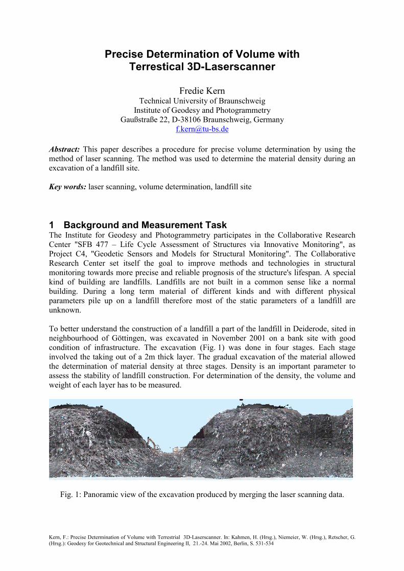
Abstract: This paper describes a procedure for precise volume determination by using the method of laser scanning. The method was used to determine the material density during an excavation of a landfill site. Key words: laser scanning, volume determination, landfill site 1 Background and Measurement Task The Institute for Geodesy and Photogrammetry participates in the Collaborative Research Center "SFB 477 – Life Cycle Assessment of Structures via Innovative Monitoring", as Project C4, "Geodetic Sensors and Models for Structural Monitoring". The Collaborative Research Center set itself the goal to improve methods and technologies in structural monitoring towards more precise and reliable prognosis of the structure's lifespan. A special kind of building are landfills. Landfills are not built in a common sense like a normal building. During a long term material of different kinds and with different physical parameters pile up on a landfill therefore most of the static parameters of a landfill are unknown. To better understand the construction of a landfill a part of the landfill in Deiderode, sited in neighbourhood of Göttingen, was excavated in November 2001 on a bank site with good condition of infrastructure. The excavation (Fig. 1) was done in four stages. Each stage involved the taking out of a 2m thick layer. The gradual excavation of the material allowed the determination of material density at three stages. Density is an important parameter to assess the stability of landfill construction. For determination of the density, the volume and weight of each layer has to be measured.
Fig. 1: Panoramic view of the excavation produced by merging the laser scanning data.
Kern, F.: Precise Determination of Volume with Terrestrial 3D-Laserscanner. In: Kahmen, H. (Hrsg.), Niemeier, W. (Hrsg.), Retscher, G. (Hrsg.): Geodesy for Geotechnical and Structural Engineering II, 21.-24. Mai 2002, Berlin, S. 531-534
Due to limitation by a strict cost control all necessary fieldwork had to be done in two days. During the excavation at each step two horizontal drillings were performed. The drillings were later used to install sensors for monitoring. So the geodetic fieldwork was time limited just like the uncomfortable and time-consuming weighting of the lorries filled with the material dug out. A time span of 30min was planed for the surface determination for each layer. The measurement concept is based on the fast and high resolution properties of a 3d laser scanner. The laser scanner system (Callidus) used can measure a whole hemisphere in 15min time and captures max. 800.000 points (cloud of points) in three dimensions. An accuracy of 1cm could be guaranteed for a simple point determination. In addition to the raw measurement time, extra time was required for the installation of the scanner on a optimal position, for connection with the controller hardware, and for establishing the power connect over 100m. Including the reinstallation time all surface measurements were realized within the planned time span. Due to the difficult terrain conditions sometimes three employees were required to set up the laser scanner for operation. 2 Concept of Measurement The laser scanner was located in the middle of the pit, so that one scan can capture the situation completely(Fig. 2). Best conditions for scanning were achieved when the laser scanner was located on the bottom of the pit. In which case the excavation had to be stopped during the scanning. So that the position and the orientation of the scan was always unknown and had to be determined afresh. A special concept for reference measurements was realized, six reference spheres were placed around the pit. For each surface of reference sphere more than 12 point measurements was made by using a reflectorless tachymeter. These points define after a sphere approximation process the sphere centre relative to the reference frame. The sphere centre in the laser scanner reference frame (cloud of points) is calculated just like the one from the reflectorless tachymeter measurement. Using the 3d coordinates of corresponding sphere centres a similarity transformation gives the solution for the registration of a scan into the reference frame.
Fig. 2: The laser scanner at work. On the top two reference spheres are visible.
The Concept of Measurement consists of following components:
1. Realisation of a reference frame by using GPS-RTK.
Kern, F.: Precise Determination of Volume with Terrestrial 3D-Laserscanner. In: Kahmen, H. (Hrsg.), Niemeier, W. (Hrsg.), Retscher, G. (Hrsg.): Geodesy for Geotechnical and Structural Engineering II, 21.-24. Mai 2002, Berlin, S. 531-534
2. Positioning six reference spheres and fixing them into the reference frame by using reflectorless tacheometry
3. Producing a scan at each step at a rate of 0.25° and capturing simultaneous digital photos.
4. Checking the location of the reference spheres during the scanning process by using reflectorless tacheometry.
3 Concept of Data Processing Evaluation of data is based on the concept that in this special case a body is bounded by two surfaces. The first surface results from the scan produced before the excavation. The second describe the situation after the probe body is excavated. Conventional strategies for volume determination use a simplified modelling of the surfaces, both surfaces were represented by an explicit function of height: . This is similar to a parallel projection of the surface on a reference plane. Because of the steep pit walls and the rough surface of the material a lot of areas exist which cover themselves or other areas (“self-covering”). One solution for this problem is to triangulate both surface separately. The vertices of each triangle of the triangulation in addition with a free selectable pole form a tetrahedron. The sum of all volumes of tetrahedrons define a virtual volume of the triangulated surface contaminated by a constant defect. The volume difference of both triangulations is then free of the defect and results in the needed volume. At best one uses the rotation-centre of the laser scanner as the pole. Then the cloud of points are mapped by a spherical projection and the effect resulting by “self-covering” is minimized. Outlined below are the steps used in data processing:
1. Approximation of the reference spheres by using the tacheometric and laser scanner measurements.
2. Registration of both cloud of points (scan A+B) in the reference frame. 3. Selection of the region of the probe body in the registered scan A plus a small region
at the boundary to guarantee that both scans overlap. 4. Calculation the bounding box of the selection. 5. Selection of the corresponding region in the registered scan B by using the bounding
box of scan A. 6. Triangulation of both regions and calculation of the volumes relative to the laser
scanner position. 7. Calculation of the volume difference.
4 Some Results and Conclusion The results for the probe body #2 are presented as an example. Both scans for the volume determination are registered by using four reference spheres. Only a rotation around the Z-axis has to be estimated by the similarity transformation, because Callidus-System is levelled. See Fig. 3 for the resulting surfaces of the corresponding regions. The volume of this probe is 16m³.
Kern, F.: Precise Determination of Volume with Terrestrial 3D-Laserscanner. In: Kahmen, H. (Hrsg.), Niemeier, W. (Hrsg.), Retscher, G. (Hrsg.): Geodesy for Geotechnical and Structural Engineering II, 21.-24. Mai 2002, Berlin, S. 531-534
Fig. 3: The probe body at stage 2 in reality and its surfaces before and after excavation. With this experiment it could be demonstrated, that with 3d laser scanning technology it is possible to measure surface with high resolution, precise accuracy, and efficiently. A closer look at the shape of a body, consisting of garbage, one deduces that the shape depends on users interpretation and on the scanner resolution. Similar to a coastline whose length increases with the map scale and converges to infinity, the area surface increases with increasing the resolution. Because the volume is geometrically bounded by the surface the design of a “fractal” body had to be defined separately from the measurements. For the experiment presented here, the design of the body was always defined by the cloud of points, because no other and better information was available for modelling the body’s shape. The consequence of this consideration is, that the volume is determined and there shapes too, with a better quality than can be achieved by other methods. The accuracy of volume determination depends on the ratio between the surface area S and the volume V. A sphere with radius r has a optimal ratio:
rrr
VS 1
44
3
2
==ππ
If the radius increases then the ratio decreases and the accuracy of volume determination will be better. If you compare this ratio with that of ratio a cubic body, the length of the edges had to be increased. The laser scanner used has an accuracy of 1cm in point measurement. To achieve an accuracy of 5% for the material density it is necessary to use cubic bodies with a volume of more than 100m³. The project manager unfortunately decided to differ from this guideline to save on time thus the full potential of laser scanning could not be completely implemented in practice. References Niemeier, W., Kern, F.: Anwendungspotentiale von scannenden Meßverfahren. In: Weferling, U., Heine, K., Wulf, U. (Eds.): Von Handaufmaß bis High Tech; Philipp von Zabern, Mainz, 2001, S. 134-140 u. Anhang VII Kern, F.: Supplementing Laser Scanner Geometric Data with Photogrammetric Images for Modeling. XVIII. International CIPA Symposium. Surveying and Documentation of Historic Buildings - Monuments - Sites Traditional and Modern Methods., Potsdam, 18.-21. September 2001, in print