1 PRELIMINARY ENVIRONMENTAL IMPACT ASSESSMENT REPORT PROPOSED INTERCHANGE AT NYAHURURU JUNCTION A104/B5, JUNCTION OF B1/A1 AT AHERO TOWN, NJORO TURNOFF INTERCHANGE AT JUNCTION OF A104/C56 ROADS AND MAU SUMMIT JUNCTION WITH A 104 Public Disclosure Authorized Public Disclosure Authorized Public Disclosure Authorized Public Disclosure Authorized Public Disclosure Authorized Public Disclosure Authorized Public Disclosure Authorized Public Disclosure Authorized
PROPOSED INTERCHANGE AT NYAHURURU JUNCTION A104/B5, JUNCTION OF B1/A1 AT AHERO TOWN, NJORO TURNOFF INTERCHANGE AT JUNCTION OF A104/C56
ROADS AND MAU SUMMIT JUNCTION WITH A 104
Pub
lic D
iscl
osur
e A
utho
rized
Pub
lic D
iscl
osur
e A
utho
rized
Pub
lic D
iscl
osur
e A
utho
rized
Pub
lic D
iscl
osur
e A
utho
rized
Pub
lic D
iscl
osur
e A
utho
rized
Pub
lic D
iscl
osur
e A
utho
rized
Pub
lic D
iscl
osur
e A
utho
rized
Pub
lic D
iscl
osur
e A
utho
rized
wb370910
Typewritten Text
E2690 v7
2
Contents 1 INTERCHANGE AT NYAHURURU JUNCTION A104/B5 ............................................................5
1.1 DESIGN .......................................................................................................................5 Figure 2.1: Principle design at the intersection............................................................................5 1.2 BASELINE INFORMATION .......................................................................................5
1.2.1 Location .................................................................................................................5 1.2.2 Physical features ......................................................................................................5 1.2.3 Rainfall ...................................................................................................................6 1.2.4 Soils .......................................................................................................................6 1.2.5 Agriculture..............................................................................................................6 1.2.6 Vegetation ..............................................................................................................6 1.2.7 Economic and land use ...........................................................................................6 1.2.8 Conservation ..........................................................................................................7
1.3 Consultations and Public Participation ............................................................................7 1.4 General Issues raised by the Public .................................................................................8
2.8 Environmental Management ......................................................................................... 16 2.9 Objectives of the Environment Management Plan (EMP) .............................................. 16
3 INTERCHANGE AT AHERO A1/B1 ........................................................................................17 3.1 DESCRIPTION OF THE PROJECT ENVIRONMENT ............................................ 17
3.2 ANTICIPATED IMPACTS OF THE PROJECT ......................................................... 17 3.3 POTENTIAL NEGATIVE IMPACTS ........................................................................ 18
3.3.1 Deviations and Route Clearing............................................................................... 18 3.3.2 Outfall onto public land and property .................................................................... 18 3.3.3 Workmen Camps .................................................................................................. 18 3.3.4 Material Sites ........................................................................................................ 19 3.3.5 Solid waste ............................................................................................................ 19 3.3.6 Road Safety........................................................................................................... 19 3.3.7 Soil Erosion .......................................................................................................... 19 3.3.8 Pollution ............................................................................................................... 19 3.3.9 Public Health ........................................................................................................ 19 3.3.10 Air and noise pollution due to vehicular circulation ................................................ 20 3.3.11 Landscape disfigurement ....................................................................................... 20
3.4 PROPOSED MITIGATION MEASURES .................................................................. 20 3.4.1 Soil Erosion .......................................................................................................... 20 3.4.2 Deviations and Route Clearing............................................................................... 20 3.4.3 Land acquisition and Compensation....................................................................... 20 3.4.4 Material Sites ........................................................................................................ 21 3.4.5 Livelihoods ........................................................................................................... 21 3.4.6 Public Health and Occupational Safety ................................................................... 21 3.4.7 Visual Enhancement ............................................................................................. 21
3.5 PUBLIC PARTICIPATION AND CONSULTATIONS .............................................. 21 3.5.1 Introduction ......................................................................................................... 21
4 NJORO TURNOFF INTERCHANGE LOCATED AT JUNCTION OF A104/C56 ROADS .................23 4.1 DESIGN ..................................................................................................................... 23 4.2 ANTICIPATED IMPACTS OF THE IMPROVED TURNOFF AT NJORO .............. 23
4.5.3 Compensation....................................................................................................... 26 4.5.4 Inconveniences ..................................................................................................... 26 4.5.5 Vegetation ............................................................................................................ 26 4.5.6 Public Health and Occupational Safety ................................................................... 26 4.5.7 Visual Enhancement ............................................................................................. 27 4.5.8 Public Awareness/Involvement ............................................................................. 27
4.6 PUBLIC PARTICIPATION AND DISCLOSURE ...................................................... 27 4.7 Environmental Management plan ................................................................................. 28 4.8 Environmental Management Plan during Construction Phase ..................................... 29 4.9 Environment Management Plan: Operation Phase ....................................................... 33 4.10 Environmental Audit and Monitoring Plan .................................................................... 34
5 SOCIAL IMPACT ASSESSMENT ............................................................................................35 5.1 METHODOLOGY ..................................................................................................... 35 5.2 BASELINE CONDITIONS ........................................................................................ 35 5.3 PUBLIC INVOLVEMENT ......................................................................................... 36 5.4 ANTICIPATED SOCIAL IMPACTS .......................................................................... 36
1.2.1 Location Nakuru is located in the heart of the Great Rift Valley between latitude 0010' and 0020' South and longitude 360 and 36010' East, at a distance of 160 km north-west of Nairobi. The largest part of the town lies at an altitude of about 1700 meters above sea level. The project will be located at the Nyahururu junction A104/B5, thus will act as a turnoff from the main Nairobi- Nakuru highway. The road falls under class A.
1.2.2 Physical features In the northern part, on the slopes of the Menengai Crater, the altitude rises to about 1850 metres. Nakuru is located in the midst of a concentration of geographical features together constituting the Lake Nakuru catchment basin. These include the Menengai Crater to the
6
north, the Bahati Highlands to the northeast, the Eburu Hills and Lake Nakuru to the south and the Mau Escarpment to the southwest. The lake water catchment is served by an array of small, seasonal rivers, including the Enjoro and Ng'ossor which flow through the town. There also exist a depression covering Section 58 and Manyani estates which collects storm water during rainy season, the depression starts form Oginga Odinga Street and deepen downwards channeling all the storm water and drains to Lake Nakuru and the Nakuru Municipal Sewerage Treatment plant down slope. This could be one of the sources of Lake Nakuru water pollution and sedimentation/siltation during the interchange construction period.
1.2.3 Rainfall Nakuru has an average annual rainfall of about 950 mm; Nakuru has a dry sub-humid equatorial climate. There are two rainy seasons: the long rains during March-May and the short rains during October-December.
1.2.4 Soils Due to its location on the floor of the Rift Valley with its volcanic soils, during the dry season Nakuru is engulfed with whirlwinds of dust, giving the town its name (nakuru means 'a place of winds' in the Maasai language).
1.2.5 Agriculture Farming is done everywhere within the boundaries of Nakuru municipality. In the peri-urban zone - i.e. the zone between the built-up areas and the town boundary - farming is the dominant economic activity, either on large farms (west and northwest) or on smaller farms (southwest and southeast). But also in the built-up areas, farming activities are all around. Crops are not only being cultivated in the people's compounds but also along roads, along the railways, under power lines, as well as on each piece of vacant land. Livestock, too, is kept in compounds, but is also seen freely roaming around on pieces of open space, including the streets.
1.2.6 Vegetation There are trees which might be cleared to pave way for the construction of the proposed interchange/ turnoff at the Nyahururu junction. Trees like Jacaranda mimosifolia, Acacia xanthophlea, Grevillea robusta, cypress and Boungenvellia (used in hotel Kunste fence) are found in the project area. Since project space required by the project is limited destruction of most of these trees can be avoided.
1.2.7 Economic and land use The centres within the project area are mostly commercial centres with residential houses and other infrastructures like industries, Hotels, Banks, Hospitals, railway, schools e .t .c. Other land use includes tourism, livestock rearing, farming and rural settlements.
7
1.2.8 Conservation Nakuru National park is within Nakuru Town. The project will have no impact on the park.
1.3 Consultations and Public Participation NAME COMMENTS AND ISSUES RAISED DECISION Kunste Hotel- Manager - The project should be implemented
to enable them secure customers form Nairobi who end up in Nakuru town due to lack of turn-off
No Objection
Mr. Njuguna-Deputy Head Teacher, Nakuru Boys High School
- The project will lead to interruption with their grazing land, though this will have minimal impact as compared to the expected benefits
No objection
Mrs. Nancy Ng’eno – Principal, Nakuru Girls High School
- Perimeter wall to be constructed before construction commences to reduce cases of insecurity to the school
- Project will enhance easier road crossing and safety to students.
- Proposed re-carpeting of the access road to the school by contractor as a form of reward.
- Expansion of the existing hospital road to Milimani estate due to expected traffic congestion during construction period
No objection
Mr. Stephene Macharia – Chief, Free area Location
- project will lead to reduced accidents incidences in the area
- There will be increased business opportunities/ income e.g. the hotels, petrol stations, motor cyclist and shops in the location.
- Access road obstruction during construction
No objection
Mr. Omondi – North Rift KeNHA Regional Manager
- Those who will be affected through demolishment of space acquisition should be compensated.
- Safety concerns must be put in place and project has to be o a
No objection
8
separate grid. - Social and economic impacts during
construction and operation should be considered
1.4 General Issues raised by the Public
1.4.1 Increased business opportunities - Those with businesses within the area supported the construction of the proposed
interchanges. According to them, the number of customers will increase right from the construction to operation once complete.
- Business owners (petrol station and hotels) complain of the poor road design that reduces the number of customers and the profit margins they get.
- Some temporary business structures at Nyahururu junction may have to be demolished as they are located on the road reserve or project area. Shop owners are aware of that eventuality, but complained about the loss of business that will be occasioned by the demolitions.
- There would also be increased business due to improved local economy as a result of employment created by workers.
1.4.2 Improved Security - The local residents were optimistic that the establishment of the interchanges will
lead to improved security situation in the area as it will exclude traffic congestion and jam hence no time is left for thugs to invade the vehicles or motorists.
1.4.3 Employment Opportunities - The persons interviewed were positive that during construction, the project will
create numerous employment opportunities for the local residents most of whom are currently jobless. They strongly felt that there was a need to utilize local labour and materials in the construction process as far as possible.
1.4.4 Dust - The people expressed concern over possibility of generation of large amount of dust
and fumes within the project site and surrounding areas as a result of excavation works and transportation of construction materials. The contractor will ensure that dust levels at the site are minimized through sprinkling water in areas being excavated and along the tracks used by the transport trucks within the site. Additional mitigation measures presented within the EMP will be fully implemented to minimize the impacts of dust generation.
9
- The respondents indicated that they are willing to bear with the noise and dust from the construction activities, though they should be moderated.
1.4.5 Reduced transport cost - Current lack of turn-off has made private/ public vehicles and motorized transport
very expensive as all the vehicles form Nairobi intending to access Nyahururu route has to go all the way to Nakuru town round-about to make a turn.
- There would be reduced cost of transportation, as the public and personal vehicle heading to Nyahururu will make a turn at the interchange without having to go the long way to Nakuru town.
1.4.6 Improved access - Accessibility to essential services like health facilities and schools around the area is
seriously impeded especially Nakuru Girls and Nakuru Boys whose students experience hard time in crossing the road, thus the school has to employ security to assist the students.
- There would be inconveniences during construction due to presence of heavy construction machinery on the road. In addition, the respondents suggest that deviations be made wide enough to allow vehicles to move easily. In addition, narrow diversions could cause accidents.
1.4.7 Reduced accidents - Cases of accidents have increased in the area involving vehicles knocking cyclists and
pedestrians trying to cross the road. Several respondents suggested that warning signs prominently be displayed. Thus there could be reduced accidents due decreased traffic after the project is completed.
1.4.8 Degradation of ecosystem - There are few trees in the project area that will be cleared according to the
respondents, these include some few observed Jacaranda mimosifollia, Acacia xanthophlea, Grevillea robusta, cypress and Boungenvellia (used in hotel Kunste fence) Since project construction will take limited space, their destruction will be avoided. But in case of destruction then they will be compensated by re-afforestration within the area. No wildlife was observed in the project area that might be interfered with as a result of proposed project.
10
1.5 POTENTIAL ENVIRONMENTAL IMPACTS AND MITIGATION MEASURES
Environmental impacts likely to happen from the project undertaking will vary from one phase to another. As a result requirements for mitigation measures will have to be different too.
1.5.1 Possible Environmental Impacts The impacts expected to happen from undertaking the project is in summarized tabular format as shown here below for different project phases. Possible Environmental Impacts S/N Project Phase Possible Impacts 1 Planning and Designing No impacts 2 Mobilization and
construction Solid and Liquid Waste generation, Noise pollution, Dust emissions and air pollution, Extraction of building materials , Energy use, Employment opportunities Excavation effect on flora and fauna, Occupational accidents and related hazards. Temporary and permanent loss of vegetation Dust Erosion/siltation of surface waters Soil contamination from hydrocarbon spills Soil compaction
Solid and Liquid Waste generation, Noise pollution, Land destabilization. Re- colonization of disturbed areas by fauna and
flora Potential for invasive species
11
2 PROPOSED INTERCHANGE/ TURNOFF AT MAU SUMMIT JUNCTION A104/B1
2.1 DESIGN Figure 2.2: Principle design at the junction
2.2 BASELINE ENVIRONMENTAL CONDITIONS
2.2.1 Location The project is located in Nakuru District at the Mau Summit/A104 turn-off within the larger Mau ecosystem.
2.2.2 Topography/ Geology To the Northeast are the Tinderet Hills and Mau Escarpment and between them is the undulating land around Londiani. To the Northwest are the hilly areas of Kipkelion and Chichila while the Mau ranges to the East and in the centre of these hills lies the Kericho plateau. The soil and rocks in the environs range from rich volcano soils, igneous and metamorphic rocks in Nakuru, black cotton soil towards Kericho area. It lies at Latitude -0.1666667°, Longitude 35.6833333° and has an elevation of 2325m above sea level.
12
2.2.3 Rainfall The main annual rainfall in the district varies with rainfall sharply declining with altitude along the west Mau escarpment. The mean annual rainfall in the project area varies from 560 mm to 2000 mm.
2.2.4 Temperature The temperature varies from Mau Summit to the base of Mau Escarpment with average values of 150 C to 250 C.
2.2.5 Land use Within the proposed site is a commercial center with residential houses and other facilities like Hotels, dispensary, schools, churches, mosques, offices, shops and public amenities e. g fields, and rural settlements. The main economic activities within the project area is farming which include: maize, pyrethrum and dairy farming. The key facilities within the Project, area includes petrol stations, hotels and hawking. The road serves as an important communication and commercial link to other parts of the country and beyond. As such, the traffic along the project road is high. Mau summit is at an altitude of about 2400 meters and receives rainfall of about 1270mm with moisture index of less than 10. About 55% of the population comprises young people below 20 years of age and about 74% aged under 30. The implication here is that more school and training facilities and gainful employment opportunities are critical. The youthful group also has potential to contribute to the socio-economic development of the area. The migration pattern is also high and has further contributed to the steady increase in population. Mau summit area has high agricultural potential with 48% of the households depending on agriculture as the mainstay of their economy. But poor marketing outlets for agricultural products and poor infrastructural facilities particularly feeder roads in high potential areas combined with high transport costs due to poor state of roads have limited the agricultural economy. The collapse of major co-operations in Nakuru that once processed agricultural products has also contributed to low agricultural returns. The cross cutting issues facing the upcoming centers along the highway include population growth, poverty, HIV/Aids and gender inequality. Poverty remains high and the major causes include un-employment, lack of water, insecurity, inaccessibility to basic services such as health, education, social services, and lack of credit facilities. Women, children, un-employed and the elderly form the segments of the most affected members of the community.
13
The post election violence also created tension, insecurity, forced migration and destruction of life and property and time which would have been otherwise directed towards productive activities.
2.2.6 Drainage Rivers Silibwet and R. Kiboko are within 500 m of the project site.
2.2.7 Consultation and Public Participation (CPP) It is recognized that CPP is an important process in EIA studies and is specifically to ensure community involvement and to create a sense of responsibility and commitment towards implementation of the project. Considering the geographical location of the project, we adopted the use of questionnaires, interpersonal contacts and consultations with the public, key informants and government officials. In particular, consultations were carried out with the following key informants:
1. Head Teacher – Pele Primary School 2. Area chief – Mr. Kuria Mburu 3. Business men / women 4. Area residents
2.3 Analysis of Impacts The direct impact on land use will be negligible but the requirements for land acquisition are potentially high. Several properties will be demolished, especially those surrounding the market. According to the local community, major positive environmental and social impacts anticipated as a result of the project are:
i. Increased business opportunities (shop owners and hawkers at the junction) ii. Reduced road accidents particularly of passenger vehicles and motorbikes plying
the route. iii. Creation of employment especially during construction and particularly at this
time when there is high unemployment iv. Enhanced security within the centre
2.4 Negative Impacts The following adverse impacts are anticipated during project construction phase
i. Resettlement issues, land acquisition and property damage ii. Clearing / vegetation loss iii. Soil erosion associated with exposed earth iv. Air and noise pollution during construction v. Sedimentation of the two rivers during construction vi. Re- channeling of surface run off vii. Material sites excavation viii. Loss of parking bays for heavy vehicle at the Mau Summit centre ix. Transmission of diseases e. g. HIV/AIDS
14
2.4.1 Displacement / demolition of premises Some displacement of businesses and residences is foreseen upon land acquisition at the site, Although some of these businesses are on the road reserve, they have depended on the land for many years therefore the effect on their livelihood will be high. Our estimation is that about 3,000 people depend directly and indirectly on trade within Mau summit centre. Fortunately, the Resettlement Action Plan that will be produced for the road project should be used for acquisition, compensation and resettlement as is appropriate.
2.4.2 Environmental pollution During construction, additional dust, noise and toxic fumes from construction traffic and plant and machinery could cause health problems to the residents. During operation, concentration of trucks at one place will increase about threefold, and this will lead to near triple concentrations of toxic gases in the ambient air, especially for Salgaa and Mau Summit. Presently, dust levels at Salgaa and Mau Summit are high as estimated by visual observation. Fortunately, concentration of fugitive dust will be lessened by paving of the parking area and access roads.
2.4.3 Road Safety Issues Although the amenities will eventually improve road safety, accidents from road crossings especially in Mau Summit where children have to cross the road to attend school is possible. In Hill T, many traders pose for customers by the roadside and this is likely to cause accidents especially during construction. In Salgaa, road blockage and the presence of heavy machinery may compromise road safety. Large number of manoeuvring trucks could cause accidents involving other motorists and pedestrians. Danger from petrol tankers is also perceived and could cause fatalities if preventive measures are not taken into consideration and emergency response mechanism is weak.
2.4.4 Main Impacts during Operation During the operation phase of the project, the following impacts are anticipated
i) Water quality degradation ii) Air pollution iii) Solid waste dumping iv) Oil spills v) Road safety
As a result the Ministry of Roads and Public Works Environmental Unit will have to develop a system for monitoring and to ensure compliance with for example air emission standards. The public must be sensitized with regard to solid waste disposal into drainage channels. The responsibility for cleanup of materials and spills will lie with NEMA. Maintenance of the road will cover drainage maintenance; prevent re- encroachment, road safety and roadside
15
litter. Social economic parameters that will need to be monitored include changes in land use and settlements, impacts on economic activities and traffic volume.
2.5 Mitigation Measures Most of the adverse impacts that may result from the proposed improvement of the road project can be mitigated. Soil Erosion caused by major drainage structure s can be mitigated by protecting susceptible surface with mulch or fabric and plant vegetation, while for the side drains increasing the number of drain outlets to avoid cascade effect. Impacts due to earthworks can be reduced by carrying out the work during dry season, routine watering of diversions and installations of mufflers on equipment, roadside tree planting for future physical barrier; to noise and to rehabilitate the access roads to acceptable standards. Possible transmission of communication diseases from workers to local people and Vice versa can be mitigated by creating awareness on HIV/IDS and other related diseases and also avail health care services to deal with any incidents.
2.6 Recommendations It is recommended that:-
All the proposed mitigation measures be implemented. Environmental and HIV/Aids sensitization in the road sector be undertaken by
MoRPW in collaboration with NEMA, MOH and relevant NGOs Sourcing of labour be from the local communities and should involve both men and
women. Environmental mitigation measures should be Incorporated into the road project
tender documents and contractual agreements The project proponent should consider allocating small percentage of the
implementation budget for environmental and HIV/AIDs sensitization. The key stakeholders in the roads sector should be sensitized on environmental,
social, gender and HIV/AIDS issues. Capacity and awareness building, mitigation measures and monitoring are essential to
the effective implementation of the Environmental Management Plan. To achieve this, key target groups such as road workers, road users and project
affected people must be trained. The Environment and Social Unit has to be formally established and strengthened by
capacity building (staffing), training, provision of adequate resources and facilities.
16
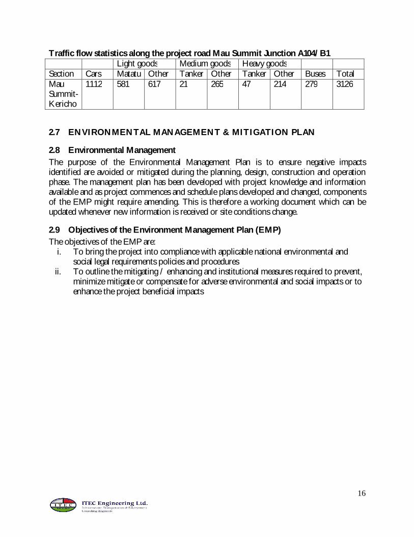
Traffic flow statistics along the project road Mau Summit Junction A104/B1 Light goods Medium goods Heavy goods Section Cars Matatu Other Tanker Other Tanker Other Buses Total Mau Summit- Kericho
1112 581 617 21 265 47 214 279 3126
2.7 ENVIRONMENTAL MANAGEMENT & MITIGATION PLAN
2.8 Environmental Management The purpose of the Environmental Management Plan is to ensure negative impacts identified are avoided or mitigated during the planning, design, construction and operation phase. The management plan has been developed with project knowledge and information available and as project commences and schedule plans developed and changed, components of the EMP might require amending. This is therefore a working document which can be updated whenever new information is received or site conditions change.
2.9 Objectives of the Environment Management Plan (EMP) The objectives of the EMP are:
i. To bring the project into compliance with applicable national environmental and social legal requirements policies and procedures
ii. To outline the mitigating / enhancing and institutional measures required to prevent, minimize mitigate or compensate for adverse environmental and social impacts or to enhance the project beneficial impacts
17
3 INTERCHANGE AT AHERO A1/B1
3.1 DESCRIPTION OF THE PROJECT ENVIRONMENT
3.1.1 Environmental Setting The project area lies within Nyando District of Nyanza Province. The geology of the project area comprise of black cotton soils with calcareous and non-calcareous variants. Surface water is abundant in the project area. River Nyando that is about 700 m west of the site is the main water body and is a major resource, being the main source of domestic water requirements, general irrigation and agro-industrial activities. Others water bodies are mainly water pans that are highly polluted. Other sources of water in the area include boreholes mainly in private premises and institutions like Boya Polytechnic and Ahero Girls both have undergrounds and sell the resource at affordable prices to the locals. Climate and temperature in the project area are influenced by altitude. In general temperatures are fairly uniform with coolest months occurring from June to August while hottest temperatures typically occur from December to March. Rainfall is bimodal in with long rains occurring from March to June while the short rainy period occurs from October to December. There is no significant wildlife in the project, a situation associated with intensive human activities and no migratory routes exist across the road. Vegetation generally comprises grassland characteristic of savanna and scattered trees. However, again due to intensive human activities, the natural vegetation has all but disappeared.
3.1.2 Social/ Economic Setting The project area of influence is characterized by mixed land use patterns but typically urban.
3.2 ANTICIPATED IMPACTS OF THE PROJECT The major positive environmental and social impacts anticipated as a result of the project are:
1. The reduction of “on-the-spot” vehicular aerial emissions emitted by stationary vehicles as they wait to turn into any of the major roads.
2. Reduced road accidents, particularly of heavy trucks, which would reduce the number of injuries and fatalities, as well as the risk of pollution of soil and water sources from spills.
3. Reduced congestion within the section immediate to the proposed interchange, resulting in time savings and improved productivity.
18
3.3 POTENTIAL NEGATIVE IMPACTS
3.3.1 Deviations and Route Clearing During improvement works, it will be necessary to have deviations in order to allow uninterrupted traffic flow. Although deviations should ideally remain within the road reserve, this is not always practical or possible and therefore traffic may have to be diverted temporarily across private land. In such cases, landowners will have to be compensated for loss of crops/grazing land, nuisance and fencing. A few settlements and commercial structures such as shops, kiosks and instituitions such as Boya Polytechnic and Osawo Apida pan will be affected as they fall within the project site. Impacts on land will include erosion and soil loss, degradation in quality, loss of land and changes in land use, due to surface runoff, erosion, acquisition for the purposes of road rehabilitation and materials extraction. As soon as works have been completed at particular locations, areas cleared of vegetation within the road reserve will be re-vegetated, while materials sites landscaped and rehabilitated, as agreed with the landowners.
3.3.2 Outfall onto public land and property Construction of the road will result into disturbances to the public caused by disruption of business activities, hindering access to the highway, their homes and places of work, noise & vibrations and road safety concerns. This is anticipated to occur although the activities are relatively localized.. If construction takes place at night, noise produced by heavy trucks may disturb sleep. Disturbance to sleep affects the productivity of workers and the performance of school children. The impact of noise generated by construction vehicles will decrease with distance from the source of such noise. Consultations must be held with the affected communities to sensitize them on these temporally impacts while the implementation of the environment management plan will reduce impacts on safety and noise.
3.3.3 Workmen Camps During the improvement works, there will be some direct employment opportunities for both skilled and unskilled labour within the project area. Furthermore, indirect employment opportunities are bound to arise from the provision of services to the construction team. Considering tthat the project will be located within an urban setting, workers’ camp will not be required since workers can easily rent houses in Ahero Town, while others can operate from their homes.
19
3.3.4 Material Sites It is expected that material sites to be used in the current works of the kericho – Kisumu road will be used. It is assumed that a separate EIA was done for the Kericho – Kisumu road including the material sites themselves.
3.3.5 Solid waste During road construction various ditches, trenches, disused tyres, and containers are sometimes left lying around, and these can collect water.
3.3.6 Road Safety Detours along the road being constructed pose a danger to traffic particularly if there are inadequate road signs. There is a very large non-motorized traffic in the project area and this mode of transport can be affected, especially during the rainy season when deviations can be muddy.
3.3.7 Soil Erosion Soil erosion is not likely to be a major issue, since the topography is flat, and the area is normally flooded.
3.3.8 Pollution Exhaust and engine emissions from vehicles cause air pollution, which can have an impact on public health as well as soils, crops and water supplies. Where culverts, drains and retention ditches are required, sediment loads may increase as a result of construction debris and excavation works. The Resident Engineer should ensure that the contractor dispose of all construction debris in a sensible manner. Air, noise and dust pollution is already evident and the situation may be exacerbated temporarily during construction but will also occur during operation, specifically to vehicular air pollution and noise as a result of anticipated traffic along the area. During construction and operation, oil wastes may become an issue if oil is carelessly stored, handled, or drained from construction vehicles and equipment
3.3.9 Public Health The project area is a holoendemic malaria area and more impeded drainage leading to ponding could exacerbate malaria prevalence in the area. Any increase associated with new ponding is, however, expected to be minor to insignificant. The site is located within an urban setting, and the general area is also known to have high HIV prevalence rates. Since most workers are likely to operate from their homes or from rented homes within Ahero, increase in prevalence of sexually transmitted diseases associated with the project are not foreseen.
20
3.3.10 Air and noise pollution due to vehicular circulation Since the site is largely urban, ambient noise levels are already high and the impacts of incremental noise during construction will not be very serious. However, Noise could be a factor in regards to sensitive institutions mainly the adjacent Onjiko high school and Ahero primary school. The impacts as relates to these institutions can be moderate to high. Dust Fugitive and windblown dust can be a serious impact, considering the large population that are resident in the area and high pedestrian and non-motorized traffic. These can be managed by keeping the work surfaces damp at all times, maintaining construction equipment and minimizing dust prone construction activities.
3.3.11 Landscape disfigurement Construction of the interchange will involve clearance of vegetation along the road reserve. In addition, construction will also involve civil works that will, no doubt, interfere with the landscape. Considering that there is an existing junction, the impact is not expected to be major within the general project area.
3.4 PROPOSED MITIGATION MEASURES This chapter focuses on measures that can be incorporated into the design, and taken during the improvement works and operation stages of the project in order to mitigate the negative environmental impacts and enhance the positive ones.
3.4.1 Soil Erosion Whereas soil erosion is not a major impact, areas that have been cleared of vegetation for improving sight distance or for deviations must be planted with shrubs or grasses to reduce the risk of erosion and stability problems in the future. Material borrow pits must be landscaped and re-vegetated soon after construction is complete.
3.4.2 Deviations and Route Clearing Deviations should wherever practical, be located within the road reserve. All deviations will be planned and their routes specified in the relevant documents. Provision should be included in the tender documents for trees/shrubs removed for purposes of deviation, to be planted when the road works are complete and the deviation ceases to be of use.
3.4.3 Land acquisition and Compensation Land may have to be acquired permanently for the interchange and slight re-alignment and the expanded road reserve and temporarily for deviations. For both permanent and temporary land acquisition description of the agreement with each land owner and elaboration on means of rehabilitating – where necessary - must be done. Compensation for private land must be adequate and reflect the market rates.
21
3.4.4 Material Sites Material sites for the works are those that will be used for construction of the Kericho – Kisumu road. Management of these sites are assumed to be contained in the contract details for the Kerich – Kisumu road and the accompanying ESIA.
3.4.5 Livelihoods Osawa Apida water pan is likely to fall within the project and will be eliminated. This is a major watering point for livestock and source of domestic water especially during the dry season. Alternative water pan within the vicinity need to be explored and if necessary constructed.
3.4.6 Public Health and Occupational Safety A central canteen for the workforce, where necessary, would contribute towards the general hygiene in the camp as Kitchen wastes can be disposed off in an organized manner in addition to monitoring the hygiene. The location of sanitary conveniences should preferably be located away from natural drainage channels. STI awareness campaigns should be conducted in the camps. Workmen should be provided with suitable personal protective equipment (PPE), such as nose masks, earmuffs, helmets, overalls, industrial boots, gloves, etc. On site a fully equipped first aid kit and a Safety Officer who has first aid training and knowledge of safety regulations should be available. In addition, the contractor must have workmen’s compensation cover.
3.4.7 Visual Enhancement Once road works are complete, the contractor should be instructed to ensure that the landscape is as much as possible restored to its original form and where possible trees should be planted to improve aesthetics.
3.5 PUBLIC PARTICIPATION AND CONSULTATIONS
3.5.1 Introduction Consultations were done to obtain the views of relevant authorities specific to the interchange. In particular consultations were carried out with the (KenHa) Regional Manager Kisumu, the local administration including area Chief Mr. James Otieno Gwada Kochogo Location. During the Barazas held at Chief camp, the residents were mainly concerned with compensation of land that may be acquired for the proposed development. In addition, public health related concerns were rated as high in the project area and the proposed development would increase the vulnerability of the inhabitants to respiratory infections.
22
They however suggested that prior notification and compensation be made before such construction begin. In general, the consultations indicated that proposed project is welcome, as it would improve communication links, economy and more importantly the safety of non motorised traffic. Apart from the government officials, twenty three members of the public were consulted to give their views on the proposed improvement. The general views captured from the consultation were;
1. The contractor to secure an alternative source of water and not to draw water from Osawa Apida dam which the locals use for watering livestock and domestic uses
2. All diversions should be watered frequently enough especially during the dry season 3. Compensation be done to those who will be affected, not necessarily by land
acquisition, such as disrupted businesses. 4. The proposed interchange will make the road accessible to both motorized and non
motorized traffic 5. Temporary employment opportunities will be created during road upgrading 6. The proposed project will improve security in the area 7. Safety of school going children is a concern due to the likelihood of speeding vehicles 8. The proposed road upgrading will improve drainage hence reduce flooding in some
sections of the road 9. Priority be given to local youths in employment opportunity during construction.
23
4 NJORO TURNOFF INTERCHANGE LOCATED AT JUNCTION OF A104/C56 ROADS
4.1 DESIGN
4.2 ANTICIPATED IMPACTS OF THE IMPROVED TURNOFF AT NJORO
4.2.1 Employment opportunities During the construction period, new jobs will be created in the form of skilled and unskilled labour. A majority of unskilled labor will be sourced from the communities close to the road. Indirect employment will be in the form suppliers and other forms of sub-contracted works that will be required for construction. Support businesses such as food kiosks may also grow near labor camps and along the road. In the operation phase of the project more job opportunities will arise in various sectors such as the transport industry, the tourism sector, commerce and trade. Taken together, job creation will help to reduce the problem of unemployment with attendant improvement in income for the workers’ household and revenue for the country.
24
4.2.2 Economic benefits Improvement of the Njoro Turnoff will greatly enhance traffic flow and further contribute to the national economy. The proposed interchange forms the continuous link between Nakuru and other major towns such as Kisumu and Eldoret, increasing efficiency and safety. Transport of goods will be enhanced especially by the smooth flow of traffic from Nakuru which has major economic sectors as commerce, industries, tourism, agriculture and tertiary services.
4.3 SUGGESTIONS ON ENHANCING THE POSITIVE IMPACTS Most of the aforementioned positive impacts are socio-economic in nature. To enhance their impacts will require a programmatic approach. This will include, but not be limited to the following:
1. The Contractor(s) who carry out the construction works should consider sourcing non-skilled labour from the project area.
2. Long-term regional economic planning taking into account the improved infrastructure as the key economic driver.
3. The Government could provide incentives to investors in the area, and promote development of sectors such as agriculture and tourism.
4. Long range plans for provision of water and electricity, at least within accessible distances to the local people.
5. Communities in the project area should devise projects that will enhance income generation such as cultural centers where they can display their artifacts.
4.4 POTENTIAL ENVIRONMENTAL IMPACTS
4.4.1 Dust and inconveniences caused by deviations During the works, it will be necessary to have deviations in order to allow uninterrupted traffic flow. Although deviations should ideally remain within the road reserve, this is not always practical or possible and therefore traffic may have to be diverted temporarily across private land. However, this is anticipated to be minimal as a large parcel of land in the project area belongs to the government. In such cases, landowners will have to be compensated for loss of crops/grazing land, nuisance and fencing. A few settlements in form of shops, kiosks and institutions such as Uhuru Secondary and Primary Schools in addition to the Ministry of Agriculture will be affected as they fall within the vicinity of the proposed improvement. Deviations will be demolished and allowed to re-vegetate after construction phase.
4.4.2 Material sources It is assumed that the same material sites used for construction of Lanet – Njoro turnoff road will supply materials for the works. Additional impacts associated with material sites will not be new and therefore minor.
25
4.4.3 Workmen Camps Workers camp is not expected since the project is located in Nakuru Town. The workers can rent houses within the town and report to work as required.
4.4.4 Road Safety This can only be an issue during construction. Construction phase will lead yo substantial disruption and inconveniences for both motorized and non motorized traffic in Nakuru and and transit traffic to western Kenya. However, during operation, road safety will be improved.
4.4.5 Soil Erosion Earthworks during construction and soil disturbance can result in soil erosion. Improper drainage of runoff from the road to lower catchments which are mainly farmlands can also cause erosion from these farmlands. Incorporating soil conservation measures during construction would help to mitigate damage caused by erosion.
4.4.6 Pollution It is projected that there will be minimal construction traffic and equipment to be used in the works and pollution related to emissions are likely to be low and not substantially above the ambient. However, fugitive dust could be an issue. Dust is already evident and the situation may be exacerbated temporarily during construction During construction oil wastes may become an issue if oil is carelessly stored, handled, or drained from construction vehicles and equipment.
4.5 PROPOSED MITIGATION MEASURES This chapter focuses on measures that can be incorporated into the design, and taken during the improvement works and operation stages of the project in order to mitigate the negative environmental impacts and enhance the positive ones as described above
4.5.1 Soil Erosion The speed of runoff is one of the major contributing factors to erosion and scouring in the side drains along the slopes of the road. In order to reduce the impact of runoff, scour checks and gabion mattresses should be introduced in the side drains depending on the gradient of the slope. In order to minimize any soil and gravel loss, construction activities have to be organized in a very efficient manner. The contract documents should stipulate that as far as possible, soil and gravel should be shaped and compacted immediately after transport to its final destination
26
Construction activities should be carried out during the beginning and or towards the end of the rainy season. This will aid in compaction of the surface material and also reduce the loss of soil and gravel by storm water runoff. Areas that have been cleared of vegetation for improving sight distance or for deviations must be planted with shrubs or grasses to reduce the risk of erosion and stability problems in the future. Material borrow pits must be landscaped and re-vegetated soon after construction is complete.
4.5.2 Deviations Deviations should wherever practical, be constructed within the road reserve. All deviations will be planned and their routes specified in the relevant documents. Provision should be included in the tender documents for trees/shrubs removed for purposes of deviation, to be planted when the road works are complete and the deviation ceases to be of use.
4.5.3 Compensation Loss of land and crops is mitigated through compensation. Compensation for private land must be adequately done. All technical details of the road design and gravel pits (including drawings and plans, details of location, volume of materials required) must be submitted along with the letter of notification.
4.5.4 Inconveniences Activities during construction of the Njoro turnoff interchange must, as far as possible, not affect the usual activities in the neighbourhood. Construction activities will result in disturbance to the public caused by: disruption of business activities; hindered access to the highway, noise and vibration; and in some cases road safety issues. Warning signs should be erected indicating alternative traffic deviations. Further mitigation measures could include proper planning and monitoring by the local authority.
4.5.5 Vegetation Vegetation should not be cleared unnecessarily during the works, whether for the existing alignment or the excavation of gravel pits. Trees should be planted along the edge of the road reserve after completion of the road works. The contractor should be instructed to do this by the Resident Engineer and the Town Council should later take responsibility of caring for the trees. This would augment the aesthetic of the town and would help to prevent soil erosion along the roadside. Trees also filter dust and particulate matter from the air.
4.5.6 Public Health and Occupational Safety A central canteen for the workforce, where necessary, would contribute towards the general hygiene in the camp as Kitchen wastes can be disposed off in an organized manner in addition to monitoring the hygiene.
27
The location of sanitary conveniences should preferably be located away from natural drainage channels. STI awareness campaigns should be conducted in the camps. Workmen should be provided with suitable personal protective equipment (PPE), such as nose masks, earmuffs, helmets, overalls, industrial boots, gloves, etc. On site a fully equipped first aid kit and a Safety Officer who has first aid training and knowledge of safety regulations should be available. In addition, the contractor must have workmen’s compensation cover.
4.5.7 Visual Enhancement Once road works are complete, the contractor should be instructed to ensure that the landscape is as much as possible restored to its original form and where possible trees should be planted to improve aesthetics.
4.5.8 Public Awareness/Involvement It is important that affected people within the project area of influence are aware of the proposed interchange. The District Works Officer (DWO) or the regional KeNHA representative should informed through the District Development Committees and at a minimum he must inform the district administration of the progress of the project. The district administration, in turn should keep the local population posted on the progress of the project and of any relevant developments relating to the project. Other effective channels for dissemination of information are churches, women groups and self help groups
4.6 PUBLIC PARTICIPATION AND DISCLOSURE As part of preliminary EIA process, consultations were undertaken to obtain the views of relevant authorities specific to the interchange. In particular consultations were carried out with the (KenHa) Regional Manager Nakuru, Ministry of Agriculture at the Njoro Turnoff and headteachers at Uhuru primary and secondary schools. The parcel of land in the proposed development is majorly bordered by government institutions which include Uhuru Primary and Secondary and the Ministry of Agriculture. Resettlement impacts were thus rated as low with most of the respondents welcoming the proposed development. They however warned that prior notification and possible transfers be made before such construction began. In general, the consultations indicated that proposed upgrading works was welcome, as it would improve communication links, economy and more importantly the safety of both motorized and non motorized traffic.
28
Apart from the government officials, twenty members of the public were consulted to give their views on the proposed improvement. The general views captured from the consultation were;
The proposed interchange will make the road accessible to both motorized and non motorized traffic
Temporary employment opportunities will be created during road upgrading The proposed project will improve security in the area Safety of school going children is a concern due to the likelihood of speeding vehicles Spread of diseases like STIs and HIV/AIDS The proposed road upgrading will improve drainage hence reduce flooding in some
sections of the road Personal protective equipments should be provided and a responsible person be put
to ensure they are warn at all times
4.7 Environmental Management plan Environmental management plan presented below are applicable to all sites. However, there are specific environmental issues that are specific to each site.
29
4.8 Environmental Management Plan during Construction Phase
Environmental Issues
Anticipated impact
Management and Mitigation measure
Actors
Vegetation loss due to clearance of site
Impact on ecology and vegetation cover
The extent of clearing within the project area should be clearly marked Contractor The clearance of the site for construction purposes should be kept to a minimum Instruct all construction workers to restrict clearing to the marked areas and not to work outside defined work areas. Rehabilitate all disturbed areas by planting vegetation cover and reforestation
Trench excavation
Disturbance, soil erosion and siltation in rivers
Earthworks should be carried out during the dry season to prevent the highly erosive soils from being washed away by rain.
Contractor
Control of earthworks so that land not required for construction works is not disturbed Excavated materials should be kept / stockpiled at appropriate sites for possible reuse Protect areas susceptible to erosion by installing necessary temporally and permanent drainage works. Also minimize the need for cut and fill
Open trenches hazardous to individuals
Backfilling trenches as soon as works are completed Contractor Warning signs at both deep and shallow trenches Provide protection rails when constructing sections of the bypass
Dumping of collapsed culverts and surplus excavated material
Dump at designated sites
Diversion of storm water to nearby drainages
Spillage into farms destroying crops
Construction of storm water channels Contractor Consultation with affected land owners on possibility of constructing pans with spillways
Construction activities
Soil, water and groundwater contamination
Construct oil- water interceptors to capture discharge of oils, fuels and other polluting liquids
Contractor
Ensure proper handling of lubricants, fuels and solvents while maintaining the equipments
30
Surface runoff to be controlled by provision of detention works A safety and emergency response plan to be developed for all operations with emphasis on the protection of the environment
Contractor’s campsite
Solid waste generation which pollutes the environment may cause water borne diseases
Bins should be strategically placed within the campsite and construction site. They should also be covered to prevent access by vermin and minimize odors.
Contractor
The bins at both the campsite and construction site should be emptied regularly to prevent overfilling Use of cleaner technologies / generation to minimize on generation of solid wastes A waste management plan to be developed to handle temporary storage, transport and disposal of hazardous waste Solid waste should be recycled, reused and utilized in an environmentally acceptable manner
Pollution Gaseous emissions which pollutes air causing respiratory problems (SO, CO, NO)
Maintaining machines at manufacturers specifications Contractor Site roads should be dampened within reasonable time to prevent dust nuisance. Cover or wet construction materials such as sand to prevent dust nuisance. Also minimize cleared areas to those that are needed for construction Limit removal of vegetation and a rehabilitation program of the site and associated infrastructure following construction
Noise pollution and vibrations which are nuisance and may cause health complications
Use equipments that have low noise emissions as stated by the manufacturers Contractor Use equipment that is properly fitted with noise reduction devices such as mufflers Operate noise generating equipment during regular working hours so as to reduce the potential of producing noise during night hours Heavy equipment should be transported early morning with proper pilotage Construction workers operating equipment that generates noise greater than 80 dB should be equipped with noise protection devices
Access roads for haulage trucks used during road construction should not be located near schools, hospitals and residential areas.
Provide warning to shop owners and other commercial businesses close to the road at least two weeks before use of such equipment near their premises.
31
Occupational health and safety (OHS)
Impacts on health of workers
Training of all workers in Safety Health and Environment (SHE) All employees must be trained on safety at work, how to work safely, how to use the PPEs correctly emergency evacuation procedures, fire fighting, etc.
Contractor
Rehabilitate excavated sites as soon as construction is complete Ensure workers health and safety through awareness campaign and provision of protective personal equipment (PPE) eg: Safety shoes or gumboots, High visibility vests, Safety Helmets, Hearing protection, Eye protection, Gloves, Working clothing.
Road construction workers should be informed about diseases that are prevalent in the project area, and how they can minimize their transmissions.
The company should consider hiring a permanent nurse to attend to emergencies and to mount awareness campaigns amongst the workers.
The contractor should regularly consult those providing health services to determine any changes in disease patterns that may be associated with road construction.
Safe work procedures and measures must be provided for all hazardous works like: Work at height, Hot work processes, Work in confined areas, High voltage operations.
Fire Safety Provide appropriate fire fighting appliances. Train employees on fire safety and emergency evacuation procedures. Provide safe storage, handling and use of flammable substances.
Welfare Provisions. Provide wholesome drinking water. Provide sanitary facilities. Provide First Aid facilities under the care of trained first aiders. Provide clothing accommodation for clothes not used during working hours. Provide washing facilities.
Signages Appropriate safety notices and signages must be provided for the safety of employees, visitors, road users, and other stake holders.
Site Security Appropriate hoarding and security measures must be provided around the work area to keep unauthorized persons from accessing the area.
32
Safety Supervision. A competent person will be appointed to supervise all the safety measures at the work place.
Registration of the Construction Site
The contractor will have to register the construction site with the local DOHSS office.
Control of Environmental Dust and Noise
Appropriate measures shall be taken to control the emission of dust and excessive noise into the atmosphere
Outfalls into private land and property
Temporally relocation causing inconveniences
Need to develop traffic management plan to provide for safe and efficient movement of traffic during construction.
Contractor
Providing alternative access to dwellings and roadside businesses and feeder roads.
Warn residents and businesses within trading centers of possible generation of dust beyond normal levels.
Land acquisition and resettlement
Description of the agreement with each landowner and means of rehabilitation like in the case of borrow pits
MORPW / Contractor
Landscaping to blend with existing environment MORPW to ensure road reserve is available for construction works
Commercial activities
Changes in the local economy Unplanned settlements Employment opportunities
The contractor should wherever possible obtain various types of goods from the local area
Contractor / Local Authority Local entrepreneurs should be given first priority when subcontracting road
construction related activities e.g. provision of food and accommodation Preference should be given to the locals when recruiting labour force so as to minimize development of unplanned settlements
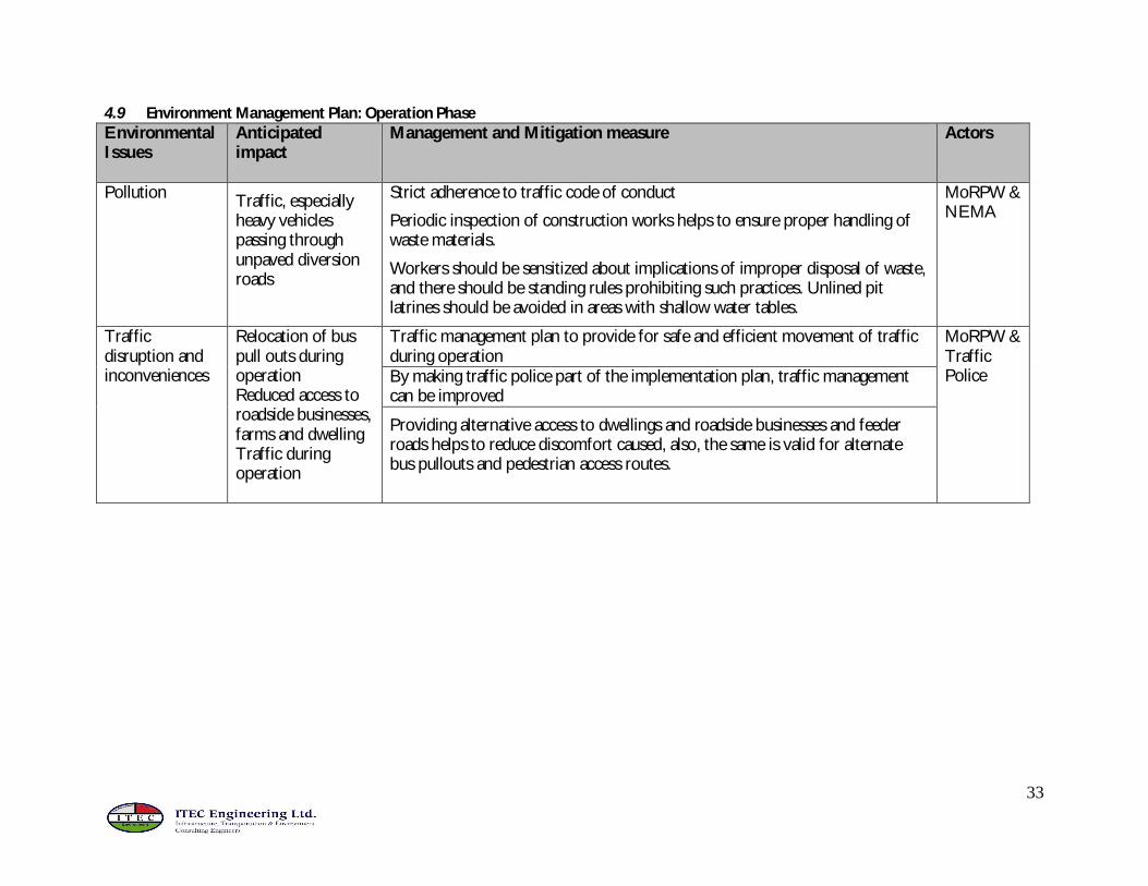
Pollution Traffic, especially heavy vehicles passing through unpaved diversion roads
Strict adherence to traffic code of conduct
Periodic inspection of construction works helps to ensure proper handling of waste materials.
Workers should be sensitized about implications of improper disposal of waste, and there should be standing rules prohibiting such practices. Unlined pit latrines should be avoided in areas with shallow water tables.
MoRPW & NEMA
Traffic disruption and inconveniences
Relocation of bus pull outs during operation Reduced access to roadside businesses, farms and dwelling Traffic during operation
Traffic management plan to provide for safe and efficient movement of traffic during operation
MoRPW & Traffic Police By making traffic police part of the implementation plan, traffic management
can be improved
Providing alternative access to dwellings and roadside businesses and feeder roads helps to reduce discomfort caused, also, the same is valid for alternate bus pullouts and pedestrian access routes.
34
4.10 Environmental Audit and Monitoring Plan Environmental Auditing will be done annually and reports presented to NEMA for review. Monitoring plan will be undertaken to ensure mitigation measures are implemented, have the intended results and that remedial measures are undertaken if mitigation measures are inadequate or impacts have been under estimated within EIA report. Monitoring Schedule Activity Timeframe Decision on most appropriate quarry sites Pre-construction
Decision on construction camp locations Pre-construction
Plan layout (in conjunction with public health officer and contractor) of construction camp and facilities especially sanitation, waste management and recycling system
Pre-construction
Establishment of tree nurseries Pre-construction
Organize public awareness “barazas” to inform local public about upcoming construction activities and likelihood of temporary nuisance.
Pre-construction
Organize a workshop for the contractor on requirements for compliance/good environmental practice during construction
Pre-construction
Monitoring visits, to inspect all mitigation points, and to provide support/advisory to contractor and resident engineer
Construction
35
5 SOCIAL IMPACT ASSESSMENT
This section briefly outlines the social consequences that are likely to follow after implementation of the proposed road projects and possible mitigation. It is hoped that the SIA will enable the proposed projects to be more responsive to social development.
5.1 METHODOLOGY To capture the salient concerns and related issues at the local level, a number of methods were used. These included oral interviews, key informant interviews, observation and documentary review. The sources of data included local men, women, youth and also groups. The data collection tools used included a semi-structured questionnaire, key informant guide and an observation checklist. Selection of respondents was mainly through purposive sampling and snowballing.
5.2 BASELINE CONDITIONS The four areas described above are mainly agricultural and commercial zones. Common economic activities include crop growing, cattle keeping, hawking and small and medium enterprises (SMEs). Like many other parts of Kenya, these areas face problems of poverty, youth unemployment, insecurity, water and food shortages, illiteracy, disease and poor infrastructure. Most of the project areas are inhabited by different ethnic groups. Partly because of this, the areas experience ethnic tensions and conflict mainly over land use rights and competition for political power. The ethnic groups in the areas in question comprise the Kikuyu, Kalenjin, Luo, Kisii, Luhya and Kamba. At the Nyahururu Turnoff, the dominant ethnic group is the Kikuyu. Other groups include Kalenjin, Luo, Kisii, Luhya and the Kamba. At the Njoro Turnoff, the area is mainly inhabited by the Kalenjin and the Kikuyu. Other groups here include the Kisii and the Luo. At the Mau Summit Turnoff, the dominant groups are the Kikuyu and Kalenjin. To be found here are also the Luo. The area surrounding the Ahero Turnoff is mainly inhabited by the Luo. There are also other groups particularly the Luhya and Kisii. During the data collection exercise, the consultant noted that many interviewees were uncomfortable to talk about their ethnic affiliations. While some simply said they were ‘Kenyans’ others said ‘it is not important’. These responses are partly attributed to the post-election violence and the continued politicization of ethnicity in the country.
36
5.3 PUBLIC INVOLVEMENT
Initial contacts have been made with the local people during data collection. In addition to
this, more elaborate community forums will be organized so that the public, and particularly
those to be directly affected by the projects, can present their concerns and opinions
regarding the proposed project. This will be done through the so-called Community Forum
Approach
5.4 ANTICIPATED SOCIAL IMPACTS Generally, the people interviewed had difficulties identifying possible impacts of the proposed projects. This was attributed to two reasons one, the fact that some people were not aware of the nature and scope of the proposed projects and two, the interchanges are to affect a relatively small area compared to the typical road projects that affect many people. That notwithstanding, some of the identified positive and negative impacts are listed below.
5.4.1 Positive Impacts The following are the anticipated positive impacts:
1. The road projects are expected to ease transport for commuters
2. The projects are expected to attract investors particularly around the interchanges. Likely investments would include shops, restaurants and service stations.
3. The interchanges would boost farming activities as they would provide market avenues.
4. The projects could promote local tourism
5. Lower cost of transport as interchanges may lead to an increase in PSVs
6. Easy access to social amenities such as schools (e.g. Uhuru High School near the Njoro Turnoff, Nakuru Girls and Boys schools near the Nyahururu Turnoff)
7. Create employment opportunities during construction and thereafter
37
5.4.2 Negative Impacts Because of the limited scope of the proposed projects, anticipated losses in terms of land, structures, livelihoods, crops/trees and of access to community infrastructure or public utility lines are at a small scale. Nevertheless, the people identified a number of negative impacts. These include:
1. There are some expected displacements or loss of structures near the sites. These will include business premises like Kunste Hotel in Nakuru, service stations, shops and restaurants. Still at the Nyahururu Turnoff, Nakuru Girls and Nakuru Boys schools are expected to lose some land to create space for the new developments. At the Njoro Turnoff, residential houses and business premises will be affected. At the Mau Summit Junction, traders near the site anticipate loss of structures and business. At Njoro Turnoff, the proposed project may use Uhuru High School land reserved for expansion and playground. The project could also affect a children’s home.
2. In all the areas, noise pollution was identified as a likely problem. This will be experienced both during and after construction.
3. Increased road traffic and a complex interchange may also lead to increased road accidents and loss of lives. Speeding could see many people being knocked down by vehicles as they cross the roads. Of grave concern is the safety of children when crossing the roads going to school or other places. In addition, some motorists might have a problem maneuvering their way through the junctions.
4. Crime is also expected to increase as people migrate to the project areas in search of construction jobs. On completion of the projects, criminals could hide in the complex interchange structures or tunnels.
5. Increased influx of people from different areas will lead to other vices such as prostitution (including child prostitution), rape, defilements, STDs and drug abuse.
6. The projects will impact on land value. While appreciation of land is a positive development for land/property owners, there those who fear that it would be difficult to buy land or rent business premises.
7. Express passage for those who have no business in the towns near the turnoff (e.g. Nakuru) may mean loss of business.
8. Likely ethnic tensions and conflicts particularly if the locals feel that ‘others’ have benefited more from the construction jobs.
9. Some fear that the proposed projects may stall or not take off.
38
5.4.3 Mitigation Measures The following are the proposed mitigation measures to address the identified impacts:
1. There should be compensation for those who will lose land or business premises. There should be alternative land for public facilities like schools.
2. Awareness campaigns should be conducted so that local people can clearly understand the nature of the proposed projects and how the same will impact on their lives.
3. An integrated approach should be adopted where the Ministry of Roads (KENHA) works with other stakeholders (e.g. Ministries of Transport and Internal Security and local authorities)
4. To reduce crime, there should be increased police presence and surveillance. The locals should also be involved in the security arrangements through community policing. Creation of income generating activities or jobs for the youth could also reduce crime rates.
5. To prevent likely ethnic tensions, priority should be given to the locals when it comes to construction jobs.
6. If there are any tunnels, the contractor should ensure that they are well lit to enhance security.
7. To curb vices such as prostitution, rape, defilements, STDs and drug abuse, there should be awareness campaigns to sensitize people on these likely consequences. People should know that among other remedial measures, the law will take its own course. However, there should be VCTs at the project sites.