44
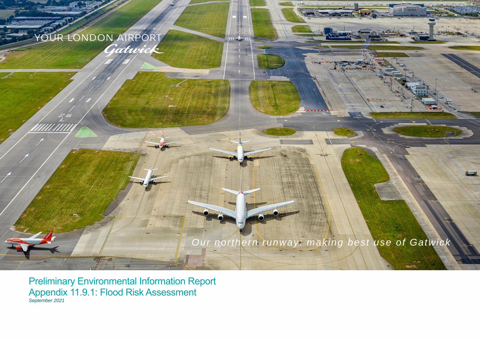
Our northern runway: making best use of Gatwick Preliminary Environmental Information Report Appendix 11.9.1: Flood Risk Assessment September 2021
Our northern runway: making best use of Gatwick
Preliminary Environmental Information Report Appendix 11.9.1: Flood Risk Assessment September 2021

Preliminary Environmental Information Report: September 2021 Appendix 11.9.1: Flood Risk Assessment Page i
Our northern runway: making best use of Gatwick
Table of Contents
1 Introduction 1
2 Project and Environmental Overview 1
3 Legislation and Policy 3
4 Assessment Methodology 7
5 Existing Flood Risk 7
6 Flood Risk due to the Project 14
7 Flood Mitigation Strategy 15
8 Planning and Development Considerations 21
9 Summary and Conclusions 24
10 References 24
11 Glossary 25

Preliminary Environmental Information Report: September 2021 Appendix 11.9.1: Flood Risk Assessment Page 1
Our northern runway: making best use of Gatwick
1 Introduction
1.1 General
1.1.1 This Flood Risk Assessment (FRA) forms Appendix 11.9.1 of the
Preliminary Environmental Information Report (PEIR) prepared
on behalf of Gatwick Airport Limited (GAL). The PEIR presents
the preliminary findings of the Environmental Impact Assessment
(EIA) process for the proposal to make best use of Gatwick
Airport’s existing runways (referred to within this report as ‘the
Project’). The Project proposes alterations to the existing northern
runway which, together with the lifting of the current restrictions
on its use, would enable dual runway operations. The Project
includes the development of a range of infrastructure and
facilities which, with the alterations to the northern runway, would
enable the airport passenger and aircraft operations to increase.
Further details regarding the components of the Project can be
found in the Chapter 5: Project Description.
1.1.2 All technical terms and abbreviations used within this FRA report
are defined in the Glossary included in Section 11.
1.2 Objectives
1.2.1 The purpose of this FRA is to demonstrate that the Project
complies with flood risk requirements of relevant national and
local planning policy, including the Airports National Policy
Statement (Airports NPS) and the National Planning Policy
Framework (NPPF). Mainly, that the Project would not
exacerbate existing levels of flood risk on or off site and that it
would be safe for users for its lifetime including a consideration of
the predicted impacts of climate change.
1.2.2 To achieve this, the FRA:
▪ includes an assessment of flood risk to the Project,
demonstrating that the intended land use is appropriate in
terms of flood risk;
▪ includes an assessment of the predicted impact of the
Project upon flood risk, taking account of future climate
change impacts;
▪ demonstrates that the Project would not increase flood risk
to surrounding areas and third parties and would be safe for
its lifetime; and
▪ details mitigation measures required to achieve this
outcome.
1.3 FRA Structure
1.3.1 This section describes the main objectives of the FRA and
provides a brief summary of the report structure and contents.
1.3.2 Section 2 briefly describes the study area and provides the
overview of the Project elements that could affect or be affected
by flood risk. This section also describes some specific study
area characteristics that are of interest to flood risk in general,
including topography, local watercourses, rainfall, geology and
hydrogeology, as well as land use. Further information on the
study area and Project is included in PEIR Chapter 4: Existing
Site and Operation and PEIR Chapter 5: Project Description.
Only information that underpins this FRA is summarised in this
chapter.
1.3.3 Section 3 provides an overview of the national and local planning
policy that applies to the application for development consent for
the Project. It refers to national guidance and drivers, as well as
specific requirements for nationally significant infrastructure. It
also explains the flood risk vulnerability classification for
proposed developments and the application of the Sequential and
Exception Tests as set out in the NPPF and its supporting
guidance. Finally, Section 3 describes guidance and
requirements regarding the impact of climate change on flood
risk, throughout the lifetime of the Project.
1.3.4 Section 4 defines the scope of the assessment and any issues
that have been scoped out of this FRA. This section also includes
the assumptions made during the assessment and any related
limitations that could potentially affect the conclusions of this
document.
1.3.5 Section 5 describes the existing level of flood risk to the Project,
considering all potential sources of flooding. The assessment
includes fluvial, surface water and groundwater flooding, as well
as flooding due to reservoir failure, flood defence failure and
sewer/ water distribution infrastructure flooding. The data used
include publicly available information and site-specific hydraulic
modelling that has been developed by GAL (surface water
drainage and wastewater) and in partnership with the
Environment Agency (fluvial). This section also briefly describes
historic flood events that have affected Gatwick.
1.3.6 Section 6 describes how the Project could affect flood risk to the
Project site, as well as to third parties, assuming no mitigation
was in place. Hydraulic modelling results have been used to
determine the degree of fluvial and surface water drainage flood
risk due to the Project, providing the basis for the assessment to
be made. A desktop study has also been undertaken to consider
potential Project qualitative impacts on groundwater flooding.
1.3.7 Section 7 describes the flood mitigation strategy that has been
developed as part of the Project. This includes flood
compensation areas, syphons, watercourse diversions and where
required, the introduction, relocation and reconfiguration of
surface water storage and attenuation features. Hydraulic
modelling results have been used to determine the effectiveness
of the proposed measures in mitigating fluvial, wastewater and
surface water flooding.
1.3.8 Section 8 describes the planning and development requirements
that have been considered as part of this assessment and
explains how these have been addressed within the FRA
document. This section covers relevant national planning policies,
local planning requirements and Strategic Flood Risk
Assessment (SFRA) recommendations for the study area.
1.3.9 Finally, Section 9 provides the summary and conclusions of this
FRA.
2 Project and Environmental Overview
2.1 Study Area
2.1.1 A full description of the study area and Project is provided in
Chapter 4: Existing Site and Operation and Chapter 5: Project
Description. Only information that underpins this FRA is
summarised in this chapter.
2.1.2 The land subject to the application for development consent
extends to approximately 838 hectares, of which approximately
760 hectares lie within the ownership of Gatwick. The Project site
boundary and study area for the purposes of this assessment is
shown in Figure 2.1.1.
2.1.3 The study area used for this FRA is defined by a 2 km radius
beyond the Project site boundary. Taking into account the nature
of the Project, impacts are expected to occur in close proximity to
the Project site and it is considered that a 2 km study area would
be sufficient to identify any significant flood risk effects to third
parties. In the case that impacts are identified at the edge of the
study area, this would be locally extended until the point where
no impacts are identified.
Preliminary Environmental Information Report: September 2021 Appendix 11.9.1: Flood Risk Assessment Page 2
Our northern runway: making best use of Gatwick
2.2 Project Description
2.2.1 The Project includes a number of proposed elements which are
shown in Figure 2.2.1. The following key components are
considered most likely to affect or be affected by flood risk and
are considered relevant to this assessment:
▪ amendments to the existing northern runway including
repositioning its centreline 12 metres further north to enable
dual runway operations;
▪ reconfiguration of taxiways;
▪ pier and stand alterations (including a proposed new pier);
▪ reconfiguration of other airfield facilities;
▪ extensions to the existing airport terminals (north and south);
▪ provision of additional hotel and office space;
▪ provision of reconfigured car parking, including new car
parks;
▪ surface access (including highway) improvements;
▪ reconfiguration of existing utilities, including surface water,
foul drainage and power; and
▪ landscape/ecological planting and environmental mitigation.
2.2.2 The details of construction methods, timing and phasing are
broad at this stage and would be dependent on securing
development consent and the discharge of associated
requirements. The indicative construction programme is based on
construction commencing in 2024, although some preliminary
works may commence in 2023. The programme for the core
airfield construction works would be of approximately five years
duration enabling the altered northern runway and taxiways to be
complete and fully operational in combination with the main
runway in 2029. The indicative phases of the project are
described in Chapter 5: Project Description of the PEIR.
2.3 Study Area Characteristics
Topography
2.3.1 Gatwick Airport is generally flat, at an average ground level of
around 58 to 59 metres Above Ordnance Datum (AOD).
However, areas around the North and South Terminals have
ground levels ranging from approximately 56 metres to 58 metres
AOD.
Local Watercourses
2.3.2 Gatwick Airport is located within the Upper Mole catchment within
the River Thames River Basin District. The River Mole flows
through the airport, south to north, passing under the main and
existing northern runways in culvert and a syphon. Tributaries of
the River Mole, including Burstow Stream, Crawter’s Brook, the
Gatwick Stream, Man’s Brook and Westfield Stream all run
through or close to the Project site. Most of these watercourses,
including the River Mole, have been previously diverted. Main
Rivers and Ordinary Watercourses in the vicinity of the Project
are shown in Figure 2.1.1.
2.3.3 The Burstow Stream rises to the east of the South Terminal
roundabout and flows northwards under the M23 spur before
turning north-westwards skirting the east and north of Horley to
join the Mole north west of the town, approximately 2 km north of
Gatwick airport.
2.3.4 Crawter’s Brook enters the airport boundary to the east of the
industrial area of Lowfield Heath and has been previously
diverted into an engineered channel, along the southern edge of
the airside operational area. Its confluence with the River Mole is
located just upstream of the culvert under both existing runways.
2.3.5 The Gatwick Stream runs along the eastern airport boundary,
between the eastern end of the airside operational area and the
London to Brighton mainline railway. It is culverted under the
South Terminal before running north through Riverside Garden
Park and joining the River Mole.
2.3.6 Man’s Brook runs along a small part of the north-west airport
boundary before discharging directly into the River Mole, west of
the Boeing Hangar and Pond M.
2.3.7 Westfield Stream runs through Gatwick airport, north of the
existing fire training ground, from its source to the west of the
airfield. The watercourse comprises open channel sections with
earth banks and a number of culverts with associated headwalls
where the channel passes under obstructions such as access
roads and airport boundary fences. The watercourse has
previously been diverted to its current location discharging to the
River Mole north of the existing Pond A.
Geology and Hydrogeology
2.3.8 The study area is underlain by made ground, superficial deposits
and bedrock strata.
2.3.9 Made ground is widespread near the surface, particularly beneath
airport buildings and associated infrastructure. This varies in
thickness, composition and extent.
2.3.10 The superficial deposits comprise Alluvium, Head and River
Terrace Deposits (RTD). The Alluvium and RTD are primarily
associated with existing and former courses of the River Mole,
Crawter’s Brook and Gatwick Stream, to the west, centre and
east of the airport. These deposits occur in broad, but mostly
separated ‘bands’ beneath the airport. These are primarily
orientated south to north, although toward the northern perimeter
of the airport there is a band of Alluvium and RTD aligned east
west, parallel with a former course of the River Mole. Away from
the airport, to the north east of the A23, there is a wider expanse
of RTD.
2.3.11 The Alluvium comprises clay, silt, sand and gravel and where
present is likely to be relatively thin, perhaps up to 2 metres thick.
The RTD comprises sand and gravel and is likely to be thicker, of
the order of 5 metres. Both deposits are likely to thin toward their
margins. Head deposits, comprising clay, silt, sand and gravel
occur only in a small area to the centre of the airport.
2.3.12 For the large majority of the study area, these superficial deposits
are underlain by the Weald Clay Formation. This comprises
mudstone, with seams of clay-ironstone in the south east and
west. Although absent from the far south and east of the study
area, this formation is likely to be of significant thickness.
2.3.13 To the south east of the study area, the underlying bedrock is the
Upper Tunbridge Wells Sand Formation. This comprises
sandstone, siltstone and mudstone, but only occurs with very
limited sub-crop within the extreme south east of the Project
boundary (to the south and east of the A23 London Road/
Perimeter Road South).
2.3.14 The Alluvium and RTD, in combination, are classified by the
Environment Agency as a Secondary A aquifer. Groundwater is
likely to occur in these deposits although this is unlikely to
comprise a continuous body of groundwater and there may be
isolated pockets of groundwater, with both vertical and horizontal
discontinuity.
2.3.15 Typically, groundwater levels within the superficial deposits are
shallow, less than 1 metre deep in some locations, although this
varies significantly (typically 0.8 metres to 3 metres, but up to
5 metres deep and perhaps deeper) across the study area.
2.3.16 Close by and adjacent to the main surface watercourses (River
Mole, Gatwick Stream, Crawter’s Brook) groundwater in the
superficial deposits maybe in hydraulic continuity with the surface
water.

Preliminary Environmental Information Report: September 2021 Appendix 11.9.1: Flood Risk Assessment Page 3
Our northern runway: making best use of Gatwick
2.3.17 The Weald Clay Formation is classified by the Environment
Agency as Unproductive Strata and generally contains little
groundwater, however, near surface weathering of this formation
may allow some groundwater storage and flow, perhaps in
hydraulic continuity overlying superficial deposits. Groundwater
has been encountered at depths of around 10 metres within this
formation.
2.3.18 The Upper Tunbridge Wells Sand Formation is classified as a
Secondary A aquifer, although the mudstones within the
formation are classified as unproductive strata. Locally, depth to
groundwater is unknown, but layering in the aquifer may lead to
some vertical stratification of water bodies within this formation.
Land Use
2.3.19 Gatwick Airport covers an area of approximately 760 hectares.
The airport has two main passenger terminals – South Terminal,
which is located on the eastern side of the airport and North
Terminal on the north side. In addition to the two main passenger
terminals it is characterised by substantial areas of built
development comprising an airfield environment of stands,
taxiways and runways which are separated by extensive grassed
areas; the airport’s road network; surface and decked car
parking; and ancillary developments such as hotels, maintenance
and cargo facilities.
3 Legislation and Policy
3.1 National Planning Policy
Airports National Policy Statement: new runway
capacity and infrastructure at airports in the South
East of England
3.1.1 NPSs set out the Government’s objectives for the development of
nationally significant infrastructure and are therefore relevant
sources of planning policy against which applications for
development consent are determined by the Secretary of State.
3.1.2 The Airports NPS (Department for Transport, 2018), although
primarily provided in relation to a new runway at Heathrow
Airport, remains a relevant consideration for other applications for
airport infrastructure in London and the south east of England.
3.1.3 Paragraphs 5.147 to 5.171 of the Airports NPS refer to flood risk
and set out the policies regarding climate change impacts, FRA
requirements, flood risk management bodies and responsibilities,
sustainable drainage systems and the application of the
Sequential and Exception Tests.
3.1.4 Paragraph 5.154 states that:
‘In preparing a flood risk assessment the applicant
should:
- Consider the risk of all forms of flooding arising
from the development comprised in the preferred
scheme, in addition to the risk of flooding to the
project, and demonstrate how these risks will be
managed and, where relevant, mitigated, so that
the development remains safe through its lifetime;
- Take into account the impacts of climate change,
clearly stating the development lifetime over which
the assessment has been made;
- Consider the need for safe access and exit
arrangements;
- Include the assessment of residual risk after risk
reduction measures have been taken into account,
and demonstrate that this is acceptable for the
development;
- Consider if there is a need to remain operational
during a worst case flood over the preferred
scheme’s lifetime; and
- Provide evidence for the Secretary of State to
apply the Sequential Test and Exception Test, as
appropriate.’
3.1.5 These FRA requirements have been addressed within this report.
Compliance with planning policy recommendations is set out in
Section 8.
National Policy Statement for National Networks
3.1.6 The NPS for National Networks (Department for Transport, 2015)
covers flood risk within paragraphs 5.90 to 5.115. These
paragraphs refer to the same flood risk policies as the Airports
NPS (Department for Transport, 2018) and add some specific
considerations for linear infrastructure. These would be relevant
to surface access (including highways) improvements works that
are proposed as part of the Project. Paragraphs 5.102 to 5.104 of
the NPS for National Networks (Department for Transport, 2014)
state that:
‘The Secretary of State should expect that reasonable
steps have been taken to avoid, limit and reduce the
risk of flooding to the proposed infrastructure and
others. However, the nature of linear infrastructure
means that there will be cases where:
- Upgrades are made to existing infrastructure in an
area at risk of flooding;
- Infrastructure in a flood risk area is being replaced;
- Infrastructure is being provided to serve a flood
risk area; and
- Infrastructure is being provided connecting two
points that are not in flood risk areas, but where
the most viable route between the two passes
through such an area.
The design of linear infrastructure and the use of
embankments in particular, may mean that linear
infrastructure can reduce the risk of flooding in the
surrounding area. In such cases, the Secretary of State
should take account of any positive benefit to placing
linear infrastructure in a flood-risk area.
Where linear infrastructure has been proposed in a
flood risk area, the Secretary of State should expect
reasonable mitigation measures to have been made, to
ensure that the infrastructure remains functional in the
event of predicted flooding.’
National Planning Policy Framework
3.1.7 The National Planning Policy Framework (NPPF) (Ministry of
Housing, Community and Local Government, 2021) sets out the
planning policies for England. It sets strict tests to protect people
and property from flooding which all local planning authorities are
expected to follow. Where these tests are not met, national policy
is clear that new development should not be allowed. The main
steps are designed to ensure that if there are better sites in terms
of flood risk, or a proposed development cannot be made safe, it
should not be permitted.
Preliminary Environmental Information Report: September 2021 Appendix 11.9.1: Flood Risk Assessment Page 4
Our northern runway: making best use of Gatwick
3.1.8 Paragraphs 159 to 169 set out flood risk policies to be followed
by all proposed developments.
3.1.9 The National Planning Practice Guidance (NPPG) (Ministry of
Housing, Communities and Local Government, 2019b) supports
the NPPF and provides guidance across a range of topic areas,
including flood risk.
3.2 Local Planning Policy and Guidance
3.2.1 Gatwick Airport lies within the administrative area of Crawley
Borough Council and adjacent to the boundaries of Mole Valley
District Council to the north west, Reigate and Banstead Borough
Council to the north east and Horsham District Council to the
south west. The administrative area of Tandridge District Council
is located approximately 1.9 km to the east of Gatwick. Gatwick is
located in the county of West Sussex and immediately adjacent
to the bordering county of Surrey.
3.2.2 Relevant local planning policies applicable to flood risk, as well as
supporting documents regarding flood risk are summarised in this
section.
Crawley Local Plan 2015-2030
3.2.3 Crawley Local Plan, Crawley 2030, was adopted in December
2015. It forms the Council’s development plan and sets out the
planning policies under which development control decisions are
taken. Policy ENV8 refers to flood risk considerations for
development applications.
Policy ENV8: Development and Flood Risk
Development proposals must avoid areas which are
exposed to an unacceptable risk from flooding and
must not increase the risk of flooding elsewhere. To
achieve this, development will:
i. be directed to areas of lowest flood risk having
regard to its compatibility with the proposed location in
flood risk terms, and demonstrating (where required)
that the sequential and exceptions tests are satisfied;
ii. refer to the Environment Agency Flood Map for
Planning and Crawley Strategic Flood Risk Assessment
to identify whether the development location is situated
in an area identified as being at risk of flooding;
iii. where identified in the SFRA, demonstrate through
a Flood Risk Assessment how appropriate mitigation
measures will be implemented as part of the
development to ensure risk is made acceptable on site,
and is not increased elsewhere as a result of the
development;
iv. ensure that proposals on all sites of 1 hectare or
greater are accompanied by a Flood Risk Assessment,
to include detail of mitigation demonstrating how
surface water drainage from the site will be addressed;
v. reduce peak surface water run-off rates and
annual volumes of run-off for development through the
effective implementation, use and maintenance of
SuDS, unless it can be demonstrated that these are not
technically feasible or financially viable;
Crawley Emerging Local Plan 2021-37
3.2.4 Crawley Borough Council is currently consulting on a draft Local
Plan to reflect national policy updates and local change.
Policy EP1: Development and Flood Risk
3.2.5 Policy EP1 repeats the current Policy ENV8 and includes that
development is not permitted within 8 metres of a main river and
12 metres from an ordinary watercourse without prior consent
form the Environment Agency or within 3 metres of a Thames
Water sewer system without their prior consent. Post construction
council certification is required to ensure the drainage has bene
constructed in line with the planning application.
Policy GI1: Green Infrastructure
3.2.6 Policy GI1 requires that large development proposals will be
required to provide new and/or create links to green
infrastructure, consider the use of Sustainable Drainage Systems
(SuDS) and blue infrastructure, in part to reduce surface water
runoff.
Crawley Borough Council Strategic Flood Risk
Assessment 2020
3.2.7 Crawley Borough Council, as the local planning authority, is
responsible for producing a SFRA as part of the evidence base
that supports the development of its Local Plan.
3.2.8 Therefore, the Crawley SFRA (Crawley Borough Council, 2020)
was published in 2020 and is a key background document to the
Local Plan. It is intended to be used in conjunction with Local
Plan Policy ENV8, in order to ensure that development is directed
to the most sustainable location in flood risk terms. A key
outcome of the SFRA process is to enable the application of the
Sequential Test (see Section 3.4) and to provide an indication of
the feasibility of the proposed development passing the Exception
Test (see Section 3.5).
3.2.9 The SFRA document provides advice for areas of the borough
that are susceptible to flood risk and outlines development
management recommendations that should be considered in
determining planning applications. These have been addressed
within the Project and compliance is demonstrated in Section 8.3.
West Sussex County Council Local Flood Risk
Management Strategy 2013
3.2.10 West Sussex County Council as Lead Local Flood Authority
(LLFA) is required to set out how it will deliver local flood risk
management under the Flood and Water Management Act 2010.
The Local Flood Risk Management Strategy (LFRMS) (West
Sussex County Council, 2014) summarises historical, current and
future flood risk knowledge for West Sussex and defines flood
risk management roles and responsibilities. It covers the period
from 2013 to 2018 and its principal aim is to oversee and direct
the reduction of flood risk for the Council’s residents.
Reigate and Banstead Borough Council, Mole Valley
Distrct Council and Tandridge District Council Level 1
Strategic Flood Risk Assessment 2017
3.2.11 This joint SFRA report has been prepared as a planning tool that
will assist the Councils in their selection and development of
sustainable development sites away from vulnerable flood risk
areas in accordance with the NPPF (Ministry of Housing,
Community and Local Government, 2019a). The SFRA is a
supporting document to Councils’ local plans; flood risk policies
within local plans relevant to the Project are included in Table
8.2.1.
3.2.12 The SFRA includes an appraisal of all potential sources of
flooding, provides mapping of the location and extent of functional
floodplain, reports the standard of protection provided by existing
flood risk management infrastructure and considers the potential
increase of flood risk due to climate change. It also provides an
assessment of flood warning and emergency planning
Preliminary Environmental Information Report: September 2021 Appendix 11.9.1: Flood Risk Assessment Page 5
Our northern runway: making best use of Gatwick
procedures and includes recommendations for future
development considerations.
3.2.13 The area covered within this SFRA does not encroach on
Gatwick itself but includes part of the study area as defined for
this FRA. Therefore, if there are any residual effects within these
neighbouring districts, the SFRA requirements and
recommendations should be considered.
3.3 Vulnerability Classification
3.3.1 Table 2 of the Flood Risk and Coastal Change section of the
NPPG (Ministry of Housing, Community and Local Government,
2019b) classifies the flood risk vulnerability of all land uses. In
Table 3 of the same document (reproduced here as Table 3.3.1),
these vulnerability classes are aligned against Flood Zones to
indicate where a development is ‘appropriate’, where it should
only be permitted if the Exception Test is passed and where it
should not be permitted. The flood risk compatibility of the Project
for its proposed location is considered in Table 5.9.1.
Table 3.3.1: Flood Risk Vulnerability Classification (reproduced from the NPPG, Table 3)
Flood Risk Vulnerability Classification Essential Infrastructure Highly Vulnerable More Vulnerable Less Vulnerable Water Compatible
Flood Zones
1 ✓ ✓ ✓ ✓ ✓
2 ✓ Exception Test required ✓ ✓ ✓
3a Exception Test required Exception Test required ✓ ✓
3b Exception Test required ✓
✓ = ‘appropriate’
= ‘not permitted’
3.4 The Sequential Test
3.4.1 The Sequential Test is defined in paragraphs 158-159 of the
NPPF as follows:
‘The aim of the sequential test is to steer new
development to areas with the lowest risk of flooding.
Development should not be allocated or permitted if
there are reasonably available sites appropriate for the
proposed development in areas with a lower risk of
flooding. The strategic flood risk assessment will
provide the basis for applying this test. The sequential
approach should be used in areas known to be at risk
now or in the future from any form of flooding.
If it is not possible for development to be located in
zones with a lower risk of flooding (taking into account
wider sustainable development objectives), the
exception test may have to be applied. The need for the
exception test will depend on the potential vulnerability
of the site and of the development proposed, in line with
the Flood Risk Vulnerability Classification set out in
national planning guidance.’
3.4.2 The Sequential Test has been applied to the Project, refer to
paragraphs 5.9.3 to 5.9.7.
3.5 The Exception Test
3.5.1 If a development is proposed that is not ‘appropriate’ as defined
in Table 3 of the NPPG (and reproduced at Table 3.3.1), the
Exception Test is used to demonstrate and ensure that flood risk
to people and property will be managed satisfactorily, while
allowing necessary development to go ahead in situations where
suitable sites at lower risk of flooding are not available.
3.5.2 Paragraph 160 of the NPPF sets out the two elements that need
to be satisfied for the Exception Test to be passed:
‘For the exception test to be passed it should be
demonstrated that:
a) The development would provide wider sustainability
benefits to the community that outweigh flood risk;
and
b) The development will be safe for its lifetime taking
account of the vulnerability of its users without
increasing flood risk elsewhere, and, where
possible, will reduce flood risk overall.’
3.5.3 Compliance with the Exception Test is addressed in paragraphs
5.9.8 to 5.9.10 and Section 7.
3.6 Climate Change
3.6.1 There is clear scientific evidence that global climate change is
happening now and cannot be ignored. Increases in rainfall depth
or fluvial flows due to climate change will increase the probability
of a given magnitude of flood. This means that a site currently
located within a lower risk zone (Flood Zone 1 or 2) could in the
future be re-classified as lying within a high-risk zone (Flood Zone
3a or 3b). This in turn could have implications for the type of
development that is appropriate according to its vulnerability to
flooding.
3.6.2 Therefore, any increase in surface water runoff or fluvial flooding
as a result of the Project should be attenuated on-site and the
capacity should be provided for the design flood event, including
an appropriate allowance for climate change. According to the
NPPG (Ministry of Housing, Communities and Local Government,
Preliminary Environmental Information Report: September 2021 Appendix 11.9.1: Flood Risk Assessment Page 6
Our northern runway: making best use of Gatwick
2019b), the design event is generally taken as the 1 per cent (1 in
100) annual exceedance probability (AEP1) event.
3.6.3 The Airports NPS (Department for Transport, 2018) refers to the
NPPF and its supporting guidance as the key source of policies
regarding climate change impacts on flood risk. Paragraph 5.168
also states that:
‘The applicant should take into account the potential
impacts of climate change using the latest Climate
Change Risk Assessment, the latest UK Climate
Projections, and other relevant sources of climate
change evidence.’
3.6.4 The UK Climate Projections 2018 (UKCP18), (Met Office et. al.,
2018) are a set of climate change projections that replace the
previous set: UKCP09. These new projections have informed the
update of the current guidance from the Environment Agency as
to how the predicted impact of climate change should be
considered as part of the spatial planning process, published in
July 2021. The update incorporates new guidance for the
consideration of future changes to peak river flow, the allowances
for rainfall intensity are yet to be reviewed and potentially
amended.
3.6.5 Due to project timescales this FRA adopts the climate change
allowances published in February 2016 and last updated in July
2020 (Environment Agency, 2020) are the best national
representation of how climate change is likely to affect flood risk
for peak river flow and peak rainfall intensity available (from a
policy and guidance perspective). It is anticipated that this FRA
will be updated to support the ES and will incorporate the latest
guidance (published in July 2021). A review of the latest guidance
indicates that the requirements for peak river flow have reduced
compared to those based on UKCP09 data, therefore the current
assessment is considered to be conservative and mitigation
requirements for the scheme are likely to reduce. The uplift factor
to be applied is determined by the location, design life and
vulnerability classification of the proposed development.
3.6.6 For this Project the design life and therefore the allowance for
climate change varies. For the surface access works the adopted
lifetime for the Project is 100 years (up to 2132) and for the rest
1 Annual Exceedance Probability (AEP) refers to the chance that a flood event of a particular magnitude is experienced or exceeded during any one year.
of the works (airfield and associated elements) 40 years (up to
2069). It is considered that a longer design life would not be
realistic given it is likely there will be further significant changes to
the Airport in that timescale. Gatwick Airport has changed
considerably during the past 40 years and this rate of change is
anticipated to continue. Assessment of climate change
allowances over a longer design life is therefore considered
disproportionate.
3.6.7 The uplift factors to be applied for peak rainfall intensity in small
urban catchments are indicated in Table 3.6.1.
Table 3.6.1: Predicted potential change of peak rainfall intensity
Applies to
across all of
England
Total potential
change
anticipated for
2015 to 2039
Total potential
change
anticipated for
2040 to 2069
Total potential
change
anticipated for
2070 to 2115
(and beyond)
Upper End 10% 20% 40%
Central 5% 10% 20%
3.6.8 When determining the potential impact of climate change on
rainfall, the guidance states that both the ‘Upper end’ and
‘Central’ allowances as outlined in Table 3.6.1 should be
considered, to understand the range of the impact.
3.6.9 Therefore, the 10 per cent and 20 per cent climate change
allowances can be applied for peak rainfall intensity. However, as
a conservative approach, the 20 per cent value has been used as
the main design climate change allowance, while the 40 per cent
has also been tested as an exceedance scenario (as a sensitivity
analysis), in order to test the impact of a larger potential change
as a result of climate change. Given their longer lifetime the
surface access works incorporate a 40 per cent allowance
applied to their design life to 2032.
3.6.10 The allowance to be made for the predicted impact of climate
change on peak river flows is subject to the river basin district, in
this case identified as the Thames River Basin. Table 3.6.2
details the applied uplift factors for the Thames River Basin, in
line with the current Environment Agency climate change
allowances.
Table 3.6.2: Recommended climate change allowance for peak river flow
Applies to
Thames
River Basin
Total potential
change
anticipated for
2015 to 2039
Total potential
change
anticipated for
2040 to 2069
Total potential
change
anticipated for
2070 to 2115
Upper End 25% 35% 70%
Higher
Central 15% 25% 35%
Central 10% 15% 25%
3.6.11 According to relevant guidance (Environment Agency, 2016), the
Higher Central and Upper End allowances should be used for
Essential Infrastructure in Flood Zone 2, in this case 25 per cent
and 35 per cent. When in Flood Zone 3, the Upper End
allowance, in this case 35 per cent, should be used. For the
purposes of this assessment, given that elements of the Project
are in Flood Zone 3, the effects of core airfield works on fluvial
flood risk have been assessed against the 35 per cent increase in
peak river flow for the one per cent (1 in 100) AEP event. The 70
per cent climate change allowance has been tested as an
exceedance scenario (as a sensitivity analysis), in order to
assess the impact of a larger potential increase in peak river flow.
3.6.12 Again, given their longer lifetime the surface access elements
have been assessed against a 70 per cent allowance. The use of
the 35 per cent and 70 per cent climate change allowances for
the design event(s) peak river flow (see Table 3.6.2) has been
confirmed in discussions between GAL and the Environment
Agency.
Preliminary Environmental Information Report: September 2021 Appendix 11.9.1: Flood Risk Assessment Page 7
Our northern runway: making best use of Gatwick
4 Assessment Methodology
4.1 Scope of the Assessment
4.1.1 This FRA considers all sources of flooding including flooding to
the Project site, as well as impacts elsewhere due to the
development of the Project. The assessment of residual risk
arising from exceedance events has been considered on the
basis of higher climate change uplift factors being applied. This
approach allows the assessment of a larger potential increase in
flood risk due to climate change and provides insight on the risk
of flooding to, and as a result of, the Project after 2069.
4.1.2 Tidal flooding has been scoped out of this assessment. The
watercourses that flow through the study area are the River Mole
and its tributaries and are ultimately a tributary of the River
Thames. The River Mole confluence with the River Thames is
upstream of the tidal extent of the Thames at Teddington Lock.
The airport is approximately 35 km north of the nearest coastline
and ground levels are generally above 55 metres AOD and
therefore are not at tidal/coastal flood risk. No impact pathway
has therefore been identified that could lead to an effect on flood
risk.
4.2 Assumptions and Limitations
4.2.1 This FRA has been prepared as a preliminary information
document and includes best available information at the time of
writing. Determination of flood risk from all sources to the Project
is based on published flood risk mapping as well as detailed
hydraulic modelling results produced specifically for Gatwick
Airport.
4.2.2 The Upper Mole Hydraulic Model has been produced in
partnership with the Environment Agency to allow for assessment
of fluvial flood risk in the study area. The model has been further
developed since its original approval by the Environment Agency
in order to incorporate recent changes to the airport infrastructure
(including Larkins Road and Boeing Hangar) and refinements
made upstream in Crawley by the Environment Agency. The 1D-
2D model, which applies current best practice and makes use of
quality reviewed local data, is considered to produce reliable
model results. The model has been calibrated based on three
historic events (between 2000 and 2002) and an additional 2013
event has been used as the verification event.
4.2.3 The Project design development is currently ongoing. Minor
changes to the proposed works have been completed since
hydraulic modelling was undertaken. However, these are not
considered to affect the overall conclusion of the assessment on
flood risk.
4.2.4 Any changes to ground levels due to proposed car parks (except
those used as flood compensation areas) have not been
incorporated in the model at this stage. However, the design of
the proposed car parks is intended to ensure that no loss of
floodplain occurs for each site.
4.2.5 The assessment of surface water flood risk was undertaken using
a drainage and surface model built with the Infoworks™ ICM
software.
4.2.6 In order to validate the model for its surface water flooding
performance, an existing model was rebuilt and revalidated
against an extensive flow survey of 32 monitors.
4.2.7 At this stage, the elevations of the development are not finalised,
and therefore it is not possible to develop a full post development
drainage model, and the post development model is therefore
conceptual in nature. A more detailed assessment will be
undertaken alongside detailed design. Therefore, the mapped
surface water flood extents and depths that are included in
supporting figures of this FRA should only be used as an
indication of the scale of the change in surface water flooding. In
particular, the alterations in ground levels within the airfield due to
the Project have not been assessed as the model is still being
prepared. Therefore, the exact locations of flooding for the
development cannot be verified. The surface water flood extents
and depths will be updated following the finished ground levels
being available and will be taken into account within the FRA
accompanying the application for development consent.
4.2.8 It has been assumed, at this stage, that the Project would
introduce up to approximately 17.9 hectares of additional
hardstanding areas within the airport boundary. That represents a
7% increase above the current development. This will be refined
based on the final Project design for the FRA to accompany the
application for development consent. Any changes to the Project
will be incorporated into the updated FRA that supports the ES.
4.2.9 Overall, the fluvial and surface water hydraulic modelling results
successfully allow consideration of the effectiveness of the
proposed flood mitigation strategy. However, at this stage, the
design of flood mitigation measures is subject to discussion with
the LLFA and/or the Environment Agency. Therefore, details
regarding their location and arrangements are subject to change.
4.2.10 Where a new surface water discharge to a Main River is
proposed (eg the River Mole) or where existing discharge
arrangements are altered, this would be subject to discussions
with the Environment Agency.
4.2.11 GAL has developed a model of the wastewater network within its
estate to assess the impact of the Project. This model has been
utilised to determine the risk of wastewater flooding.
4.2.12 At this stage, groundwater and water supply flood risk have been
assessed based on existing available information and previous
known flooding incidents within the study area. Additionally, a
qualitative assessment has been undertaken to inform the
indication of areas that are likely to be vulnerable to groundwater
flooding.
5 Existing Flood Risk
5.1 Basis of the Assessment
5.1.1 In accordance with the NPPG (Ministry of Housing, Community
and Local Government, 2019b), an assessment of flood risk to
the Project site has been undertaken based on the following
sources of information.
▪ Flood risk information available from the Environment
Agency website (Flood Map for Planning, Risk of Flooding
from Surface Water, Reservoir Flood Risk Map, Historic
Flood Map).
▪ Crawley Borough Council Strategic Flood Risk Assessment,
2020.
▪ West Sussex County Council Local Flood Risk Management
Strategy, 2013.
▪ Groundwater Flooding Susceptibility Areas and Groundwater
Flooding Confidence Areas mapping (British Geological
Survey).
5.1.2 The Upper River Mole fluvial hydraulic model recently completed
by GAL and the surface water drainage model have also been
used to confirm existing flood risk to the site.
5.1.3 Overall, the risk of flooding from all relevant sources has been
considered, covering:
▪ fluvial;
▪ surface water;
▪ sewer and water distribution infrastructure flooding;
▪ groundwater flooding;
Preliminary Environmental Information Report: September 2021 Appendix 11.9.1: Flood Risk Assessment Page 8
Our northern runway: making best use of Gatwick
▪ reservoirs failure; and
▪ flood defence failure.
5.2 Fluvial Flood Risk
5.2.1 Gatwick is located in the Thames River Basin District (RBD) and
within the Upper Mole catchment. The River Mole flows through
the airport, passing under the main and existing northern runways
in culvert. Tributaries of the River Mole, including Crawter’s
Brook, the Gatwick Stream, Man’s Brook and Westfield Stream
all run through or adjacent to the Project site.
5.2.2 Therefore, fluvial flood risk is one of the main sources of flood risk
to the Project.
5.2.3 This section provides an assessment of existing fluvial flood risk
within the Project site. The assessment is based on a number of
data sources including:
▪ Environment Agency Flood Zones; and
▪ Gatwick Upper Mole Hydraulic Model.
Environment Agency Flood Zones
Overview
5.2.4 The classification of Flood Zones is used as the basis on which
the Sequential Test is applied. It identifies the probability of
flooding in each Flood Zone. Flood Zones 1, 2 and 3a are defined
by the Environment Agency, ignoring the presence of flood
defences and without taking account of the possible impacts of
climate change to the future probability of flooding. Flood Zone 3b
should be defined by local planning authorities in agreement with
the Environment Agency and should consider the presence of
defences. Table 5.2.1 sets out the classification of Flood Zones in
accordance with the NPPG (Ministry of Housing, Community and
Local Government, 2019b).
Table 5.2.1: Environment Agency Flood Zones Definition
Flood Zone Definition
Flood Zone 1 –
Low Probability
of Flooding
Land having a less than 1 in 1,000 AEP of river or sea
flooding.
Flood Zone 2 -
Medium
Probability of
Flooding
Land having between a 1 in 100 and 1 in 1,000 AEP of
river flooding; or land having between a 1 in 200 and 1
in 1,000 AEP of sea flooding.
Flood Zone Definition
Flood Zone 3a -
High Probability
of Flooding
Land having a 1 in 100 or greater AEP of river flooding;
or land having a 1 in 200 or greater AEP of sea
flooding.
Flood Zone 3b
– Functional
Floodplain
This zone comprises land where water has to flow or be
stored in times of flood (typically a 1 in 20 or greater
AEP event). Local planning authorities should identify in
their SFRAs, areas of functional floodplain and its
boundaries accordingly, in agreement with the
Environment Agency.
5.2.5 In this case, the Crawley SFRA (Crawley Borough Council, 2020)
includes the following approach regarding Flood Zone 3b: “Flood
Zone 3b, unlike other Zones, does show flood risk that takes
account of the presence of existing flood risk management
features and flood defences, as land afforded this standard of
protection is not appropriately included as functional flood plain”.
5.2.6 The Gatwick Upper Mole Hydraulic Model, includes results for the
5 per cent (1 in 20) AEP event.
Assessment
5.2.7 The Environment Agency Flood Zones have been mapped in
Figure 5.2.1. This demonstrates that there are areas of Flood
Zone 3 (areas at risk of flooding in a 1 per cent (1 in 100) AEP
event) and Flood Zone 2 (area at risk of flooding in between a 1
per cent and 0.1 per cent (1 in 100 to 1 in 1000) AEP event)
within the Project site boundary. These are associated with the
River Mole, Westfield Stream, Man’s Brook and Crawter’s Brook
on the western and southern sides of the airport and with the
Gatwick Stream on the eastern side.
5.2.8 Outside of the airport, there are extensive areas of Flood Zones 2
and 3 in which are situated a number of third party receptors for
the Project, including residential areas and transport
infrastructure that serves both Gatwick and the wider study area.
These flood extents are generally associated with the River Mole
and/or Gatwick Stream and, therefore, could potentially be
affected by the Project.
Upper Mole Hydraulic Model
Overview
5.2.9 The Upper Mole Fluvial Modelling study was undertaken as a
partnership between GAL and the Environment Agency. The
purpose of the study was to develop a better understanding of
flood risk in the area, particularly to Gatwick Airport, and provide
updated flood risk information for the catchment. The objectives
of the study were to develop an updated model which reflects the
urban nature of the catchment, including Crawter’s Brook and
Gatwick Stream and the more rural nature of Man’s Brook and
the Upper Mole, and to calibrate this model against at least three
historic high flow events.
5.2.10 The model was run for design events between 20 per cent (1 in
5) AEP and 0.1 per cent (1 in 1000) AEP, including climate
change scenarios for the 1 per cent (1 in 100) AEP event of +35
per cent and +70 per cent. The 20 per cent (1 in 5) AEP flood
event would often be adopted to determine the extents of Flood
Zone 3b (refer to Figure 5.2.3). The Crawley SFRA 2020 confirms
this approach but indicates that where 5 per cent data is not
available, 1 per cent (1 in 100) AEP event results are used
following a precautionary principle.
5.2.11 The study focuses on the Upper Mole catchment, up to its
downstream extent to the west of Horley, in West Sussex. The
main watercourses considered are the Upper Mole, Gatwick
Steam, Crawter’s Brook and Man’s Brook.
5.2.12 Two models have been created. The first model represents the
catchment without any formal defences as per the situation
before the Upper Mole Flood Alleviation Scheme (FAS). This is
the undefended scenario and was used as a calibration model.
The second model represents the situation once the Upper Mole
FAS had been completed. The Upper Mole FAS is an
Environment Agency project, in partnership with GAL, designed
to reduce flooding at Gatwick Airport and to nearby areas
including Horley and Crawley. According to the Crawley
Infrastructure Plan (Crawley Borough Council, 2021), the Upper
Mole FAS has now been completed and comprises the following
items:
▪ Raising of Tilgate Dam;
▪ Worth Farm storage area;
▪ Grattons Park stream enhancements; and
▪ Clay’s Lake storage reservoir.
5.2.13 The study built a new 1D-2D hydrodynamic model of the
catchment using Flood Modeller 1D and TUFLOW 2D software.
This combined 1D-2D model was selected as the most suitable
approach on the basis of the following.
▪ Using a single 1D model in combination with linked 2D
domains on the floodplain allows for interactions between
individual watercourses and structures to be accurately
Preliminary Environmental Information Report: September 2021 Appendix 11.9.1: Flood Risk Assessment Page 9
Our northern runway: making best use of Gatwick
modelled and mapped. This approach therefore represents
an effective way to describe the complex flow routes
expected through urbanised parts of the study area.
▪ The use of a 1D-2D linked model provides an accurate
simulation of in-channel hydraulics, coupled with detailed
out-of-bank representation of flood routes, depths, flows and
velocities. The combined model therefore enables robust
simulation of the effect of key hydraulic features (such as
bridges, culverts, flood relief areas and flood defences) both
in-bank and out-of-bank.
▪ A combined 1D-2D approach enables robust estimation of
hazards in the floodplain, including the combined impact of
coincident velocities and depths.
Assessment
5.2.14 According to results from the baseline scenario of the Upper Mole
Fluvial Model recently completed by GAL, flooding occurs within
the Project site boundary for the 1 per cent (1 in 100) AEP event.
As with the Environment Agency Flood Zones, flooding is mainly
associated with the River Mole and Crawter’s Brook on the
western and southern sides of the airport, and with the Gatwick
Stream on the eastern side, around the South Terminal building.
However, the actual flooding extents are significantly different to
the Environment Agency Flood Zones. The flooding extent for the
1 per cent (1 in 100) AEP event based on the Upper Mole
Hydraulic model is mapped against Flood Zone 3 in Figure 5.2.2.
The differences between the two models and extents are
discussed in more detail in paragraphs 5.2.19 to 5.2.22.
5.2.15 According to Figure 5.2.3, all areas of the Project site falling
within flood extents for the 5 per cent (1 in 20) AEP event are
directly related to watercourses and do not encroach in areas that
would be developed for the Project except for a small area at the
western end of the airport, where parts of the proposed Taxiway
Juliet West Spur and along the edge of Taxiway Juliet fall into the
5 per cent (1 in 20) flood extent and the surface access works to
the A23 at the northern terminal access roundabout and at the
Longbridge roundabout.
5.2.16 The requirements for considering the potential future impacts of
climate change on fluvial flooding are described in Section 3.6.
Suitable climate change allowances are chosen based on the
specified River Basin (in this case, the Thames River Basin), the
vulnerability of the development and the lifetime of the Project.
Based on that information a 35 per cent allowance for climate
change has been applied within the baseline scenario of the
Upper Mole Hydraulic Model. A 70 per cent climate change
allowance has also been tested, as an exceedance scenario (as
a sensitivity analysis). Results are illustrated in Figure 5.2.3.
5.2.17 For the 35 per cent allowance, extents are increased compared
to the 1 per cent (1 in 100) AEP event in areas south of the main
runway and areas around the North Terminal and adjacent
infrastructure.
5.2.18 For the 70 per cent allowance, flooding extends to several
proposed and existing elements in the northern part of the airport
and flood extents also encroach on the south-east part of the
airport, including on runways and taxiways.
Differences Between the Environment Agency
Published Flood Zones and Gatwick Model
5.2.19 This section compares the Environment Agency Flood Zone
Mapping with the Upper Mole Hydraulic Model baseline scenario
results, as shown in Figure 5.2.2, in order to identify the
differences that should be considered within this assessment.
5.2.20 The overall pattern of flooding is significantly different for the
Upper Mole model and the Environment Agency Flood Zones,
with the first indicating flood extents that are more confined and,
in some cases, diverted from the Environment Agency flood
extents. This can be explained considering the fact that the Upper
Mole model has considered local flood defence schemes that
were being constructed or had recently been built within the
catchment.
5.2.21 The new model also better reflects the urban nature of the
catchment, including Crawter’s Brook and Gatwick Stream and
the more rural nature of Man’s Brook and the Upper Mole, and
has been calibrated against historic high flow events. Therefore, it
is considered that it provides a more realistic understanding of
flood extents and depths within the catchment.
5.2.22 In summary, it is considered that the Upper Mole Hydraulic Model
outputs offer a more realistic and informative approach to
assessing fluvial flood risk to the Project. However, in most
cases, the Environment Agency Flood Zones would offer the
worst-case scenario for the assessment. Therefore, the
assessment undertaken has been based on a combination of
both models, bearing in mind that the Upper Mole model offers
the most up-to-date approach where the undefended scenario
has also been considered.
5.3 Surface Water Flood Risk
Existing Surface Water Management Strategy
5.3.1 There are currently eight surface water drainage catchments
within the Project site that directly receive runoff as shown in
Figure 5.3.1. Generally, four of these serve the main airfield,
discharging to Pond A, Pond M, the Dog Kennel Pond and Pond
D. During cold weather, de-icer is regularly used, which, together
with other pollutants, enters the surface water drainage system.
When there is sufficient storage capacity in the system, the four
attenuation ponds provide a degree of treatment through aeration
and settlement. Figure 2.1.1 includes the main attenuation
features of the existing surface water drainage network.
5.3.2 Pond D receives the majority of runoff from Gatwick including that
transferred from Pond A, Pond M, and the dirty side of Dog
Kennel Pond. Runoff from the Pond D catchment drains to Pond
D (lower) and is then raised by three Archimedes screws to Pond
D (upper). In general, when runoff meets the required water
quality standard of a biochemical oxygen demand (BOD) below
10 mg/l, water is discharged to the River Mole, via the attenuation
ponds at a consented rate controlled by a series of vortex flow
control devices and pumps. When water quality falls below the
required standard, the ponds discharge to the polluted water
pumped main which conveys runoff for further treatment and
temporary storage at two Long Term Storage Lagoons (Old and
New Lagoons) with storage capacities of 220,000 m3 and
100,000 m3 respectively and then ultimately to Crawley Sewage
Treatment Works (STW), which is operated by Thames Water.
There are restrictions placed on the peak flow that can be
transferred to the STW under a trade effluent consent agreed
with Thames Water. In very heavy rainfall events, contaminated
water diluted by rainfall may be pumped directly to the River Mole
from Pond D if the incoming runoff is greater than the capacity of
Pond D and there is insufficient capacity in the pumping system
that transfers it to the pollution storage lagoons.
5.3.3 Pond E, Pond F, and Pond G provide attenuation for car parks
east of the Railway line, and discharge to the Gatwick Stream.
The clean side of Dog Kennel pond provides attenuation for the
car parks north of Larkins Road, and is pumped into the River
Mole.
5.3.4 The assessment of existing surface water flood risk to the Project
site has been based on the Environment Agency Risk of Flooding
from Surface Water mapping as well as surface water drainage
modelling produced by GAL.

Preliminary Environmental Information Report: September 2021 Appendix 11.9.1: Flood Risk Assessment Page 10
Our northern runway: making best use of Gatwick
Environment Agency Risk of Flooding from Surface
Water Mapping
5.3.5 The Environment Agency Risk of Flooding from Surface Water
(RoFSW) mapping has been used to make an overarching
assessment of the existing surface water flood risk to the Project.
It has been used to determine overall patterns of surface water
flooding and therefore to steer the assessment of risks, impacts
and mitigation measures that follow.
5.3.6 According to the Environment Agency RoFSW flood extents
mapping, illustrated in Figure 5.3.2, surface water flooding occurs
in several areas of the airport. Areas at high risk (greater that 3.3
per cent (1 in 30) AEP of flooding) are predominately associated
with areas around existing watercourses or drainage features,
although there are isolated pockets of high risk likely to be the
result of rainfall filling local depressions rather than overland flow
paths. Areas at medium risk (between 3.33 per cent and 1 per
cent (1 in 30 and 1 in 100) AEP of flooding) are generally small
and adjacent to the areas at high risk. A large area at medium
risk is located near the River Mole and south of the existing main
runway. This flooding is likely to occur due to the existing River
Mole culvert’s capacity being exceeded. There are larger areas
predicted to be at low risk (between 1 per cent and 0.1 per cent
(1 in 100 and 1 in 1000) AEP of flooding) within the airport,
particularly to the south of the main runway and in proximity to
existing terminal buildings.
Gatwick Surface Water Hydraulic Model
5.3.7 The assessment of surface water flood risk was undertaken using
a drainage and surface model built with the InfoWorks™ ICM
software. An existing model was rebuilt and revalidated against
an extensive flow survey of 32 monitors.
5.3.8 At this stage, the finished elevations of the development are not
finalised, and therefore it is not possible to develop a full post
development drainage model, and the post development model is
conceptual in nature. A more detailed assessment will be
undertaken alongside detailed design.
5.3.9 Therefore, the mapped surface water flood extents and depths
that are included in supporting figures of this FRA should only be
used as an indication of the scale of the change in surface water
flooding. In particular, the alterations in ground levels within the
airfield due to the Project have not been assessed as the model
is still being prepared. Therefore, the exact locations of flooding
cannot be verified. The surface water flood extents and depths
will be updated following the finished ground models being
available and will be taken into account within the FRA
accompanying the application for development consent.
5.3.10 It has been assumed, at this stage, that the Project would
introduce up to approximately 17.9 hectares of additional
hardstanding areas within the airport boundary. That represents a
7% increase above the current development. This will be refined
based on the final Project design for the FRA to accompany the
application for development consent. Any changes to the Project
will be incorporated into the ES.
5.3.11 The model has been run for the baseline (existing condition)
scenario as well as the with-Project scenario, including the
proposed surface water mitigation measures. The baseline
scenario is based on current land use, asset location and ground
model data.
5.3.12 There are two critical return periods for the surface water
drainage system at Gatwick. The first is a 30-minute summer
event, which generates the maximum flood volume and extent in
a convective type storm event across the entire airfield. Typically,
a 60-minute or 30-minute storm event would be expected to be
the critical event for a land area of hardstanding such as Gatwick.
However, because Gatwick has a controlled outlet at Pond D,
influencing flood risk in the North Terminal and apron during
longer, higher volume, less intense rainfall events, a second
1440-minute winter event has also been used. The critical return
periods will be reassessed when the with development model is
built for the ES.
5.3.13 The model results of the baseline scenario for the 1 per cent (1 in
100) AEP event, including a 20 per cent climate change
allowance have been mapped in Figure 5.3.3 and Figure 5.3.4 for
the 30-minute and 1440-minute storm durations respectively.
5.3.14 It is apparent that the 30-minute duration is the worst-case
scenario in terms of flood extent. This is likely to be due to flow
control measures and attenuation ponds within Gatwick Airport
that would restrain flow paths for longer events. Therefore, the
30-minute event with a 1 per cent (1 in 100) plus 20 per cent
climate change AEP can be used to provide a comparison with
the patterns illustrated in Environment Agency RoFSW extents.
Generally, both extents seem to follow a similar pattern, with
ponding mainly forming between taxiways, around runways and
towards the South Terminal.
5.3.15 An area of surface water flooding included in the Environment
Agency maps is located south of the existing main runway,
around the River Mole. This area is not included in the GAL
surface water modelling results. However, it is included in the
Upper Mole Hydraulic Model extents as being at risk of fluvial
flooding for the 1 per cent (1 in 100) AEP event.
5.3.16 Flood extents for the 1440-minute event with a 1 per cent (1 in
100) plus 20 per cent climate change AEP are much more
confined and mainly located at the North Terminal.
5.3.17 The model has also been run for the 1 per cent AEP event,
including a 40 per cent climate change allowance, as shown in
Figures 5.3.3 and 5.3.4, in order to examine a potential larger
impact of climate change to existing conditions. The extents of
surface water flow paths and ponding areas are wider in some
areas, but mostly follow the same pattern as the lower climate
change allowance. This is due to topographical conditions and
existing drainage infrastructure directing surface water flows
within the airport.
5.4 Groundwater Flood Risk
5.4.1 Groundwater is present in the superficial deposits beneath the
site. This may occur in relatively small discreet and discontinuous
bodies, or, particularly adjacent to watercourses, may form more
continuous groundwater bodies.
5.4.2 Groundwater levels respond to direct recharge from rainfall but
also, adjacent to water bodies, may respond to changes in river
and stream levels. The rate of this response and the ‘outward’
propagation of these levels from surface waters, may vary
considerably across the site, depending upon the transmissivity
and storage properties of the aquifer.
5.4.3 Groundwater levels in superficial deposits adjacent to
watercourses are likely to mimic the water level response in those
surface waters, although there may be a lag in, and attenuation
of, the water level response.
5.4.4 There are relatively sparse data for groundwater levels, but
where these are available, they suggest groundwater levels are
close to the surface (and may be less than 1 metre depth).
Annual groundwater level fluctuation may be of the order
0.5 metres - 1.5 metres, but this is based on a very limited data
set, mostly away from the influence of surface watercourses.
5.4.5 Groundwater flooding may be defined as the emergence of
groundwater at the ground surface or the rising of groundwater
into underground infrastructure (such as basements) under

Preliminary Environmental Information Report: September 2021 Appendix 11.9.1: Flood Risk Assessment Page 11
Our northern runway: making best use of Gatwick
conditions where the normal range of groundwater level and flow
is exceeded.
5.4.6 Groundwater flooding may either be associated with shallow
unconsolidated sedimentary aquifers which overlie unproductive
aquifers (superficial deposits flooding), or with unconfined
aquifers (“clearwater” flooding).
5.4.7 Mapping developed by the British Geological Survey (BGS)
identifies areas of groundwater flooding susceptibility, with
associated mapping identifying the confidence level in the data
used to develop the susceptibility mapping. The groundwater
flooding susceptibility mapping correlates geological data and
water level data held by BGS and has been included in Figure
5.4.1.
5.4.8 The mapping identifies that there is susceptibility to groundwater
flooding throughout the areas underlain by superficial deposits (ie
superficial deposits flooding), with a moderate level of
confidence.
5.4.9 There is also identified susceptibility to groundwater flooding from
the Tunbridge Wells Sand (clearwater flooding), but with a low
level of confidence.
5.4.10 Given the normally recorded range of groundwater levels within
the superficial deposits, which show shallow depth to
groundwater, the mapped susceptibility to flooding is
unsurprising, however this does not necessarily mean
groundwater flooding will occur (ie as per the definition,
groundwater flooding is associated with groundwater levels
above “the norm”).
5.4.11 Based on the Crawley SFRA there have been only two
occurrences of groundwater flooding recorded in the Crawley
Borough Council administrative area. These are not located near
the airport. The SFRA identifies groundwater flood risk as being
low for the Crawley Borough Council administrative area as a
whole and that there is no conclusive evidence of elevated
susceptibility to groundwater flooding within the Borough.
5.4.12 There are anecdotal reports of flooding of basements and other
buried infrastructure in parts of the site which may be the result of
the inundation of shallow groundwater. Furthermore, there is
2 Long term flood risk information. Available from: https://flood-warning-information.service.gov.uk/long-term-flood-risk/map
anecdotal evidence of surcharging of sewers (eg in pipework to
Crawley STW) discharges by infiltrating groundwater. However,
these events, if they have occurred, do not necessarily constitute
groundwater flooding.
5.4.13 Although groundwater levels beneath Gatwick Airport may be at
shallow depth, there is no conclusive evidence of groundwater
flooding occurring at the airport. Although it is not possible to fully
quantify, it is concluded that the current risk from groundwater
flooding at the airport site is low.
5.5 Flood Risk from Reservoir Failure
5.5.1 According to the Environment Agency Risk of Flooding from
Reservoirs Maximum Outline data2, much of the western side of
the airport would be at risk of flooding in the event of failure of the
Ifield Mill Pond, while the eastern side, including sections of both
terminal buildings, would be at risk from a failure of the pollution
lagoons adjacent to Crawley STW. The reservoir flood risk flood
extents are illustrated in the map shown in Figure 5.5.1. However,
as large, raised reservoirs, these structures are maintained and
operated in accordance with the Reservoirs Act (1975) and
therefore the risk of failure is considered very low due to their
monitoring and inspection regime.
5.5.2 A number of flood storage reservoirs have also been created as
part of the Upper Mole Flood Alleviation Scheme on tributaries of
the Gatwick Stream to the south and east of Crawley. These
appear to be included in the Environment Agency Risk of
Flooding from Reservoirs mapping, available online2.
5.5.3 GAL undertook a study in 2019 to assess the potential failure of
the two storage lagoons to the east of Crawley STW (see Figure
2.1.1). The hydraulic modelling produced flood depth and hazard
mapping that could result from the potential failure of each
lagoon. A worst-case scenario was assumed that each lagoon
would be full (impounded water would be at crest level) and that
the pumps sending water to them from Pond D would continue to
operate. Three breach locations were tested and the results are
included in Figure 5.5.1. They indicate that the resultant flow path
would travel northwards primarily through the airport car parks to
the east of the London to Brighton mainline railway. The flow path
does not cross the railway and would pass under the M23 spur
via the B0236 bridge and then towards the residential areas to
the north of the motorway. The A23 and M23 would not be
flooded. In the unlikely event of a breach of the lagoons during
construction, the project elements that would be affected would
be those that are east of the railway line, principally the Surface
Access works to the South Terminal, works to the car parks
located in this area and the hotel and office provision after 2032.
5.5.4 The residual risk of failure of the Gatwick Stream Flood Storage
Area has not been considered as part of the current assessment
but will be assessed for the updated FRA that will support the ES.
However, similarly to other structures that fall under the auspices
of the Reservoirs Act, the strict inspection and maintenance
regime results in a very low likelihood of failure.
5.6 Sewer/Water Distribution Infrastructure Flooding
5.6.1 Gatwick Airport has a complex water distribution and sewerage
network that should be considered as a potential source of flood
risk.
5.6.2 The failure of sewerage or water distribution infrastructure within
or upstream of the Project site could result in flooding, although
the risk of this is likely to be low given the maintenance and
monitoring activities undertaken by Gatwick Airport to avoid this.
5.6.3 The hydraulic model built by GAL to assess the impact of the
Project on the wastewater network has not identified any
locations predicted to flood based on current and future flows as
a result of the Project.
5.6.4 At the time of writing of this FRA it was reported that part of the
Thames Water network, located in Horley, periodically has
reached its capacity, causing flows to back up to the airport.
5.6.5 The Crawley SFRA (2020) includes a specific section on
recorded sewer or water distribution infrastructure flooding events
based on the Thames Water Sewer Flooding History Database.
This records that there have been 102 instances of flooding in
postcodes covered by the Crawley SFRA although some may be
outside the boundary as the postcodes cover a wider area. For
the Postcode area covering Gatwick Airport (RH6 0), only one
incident is recorded and this may be outside the area of the
airport as the postcode area covers a much larger area of land.
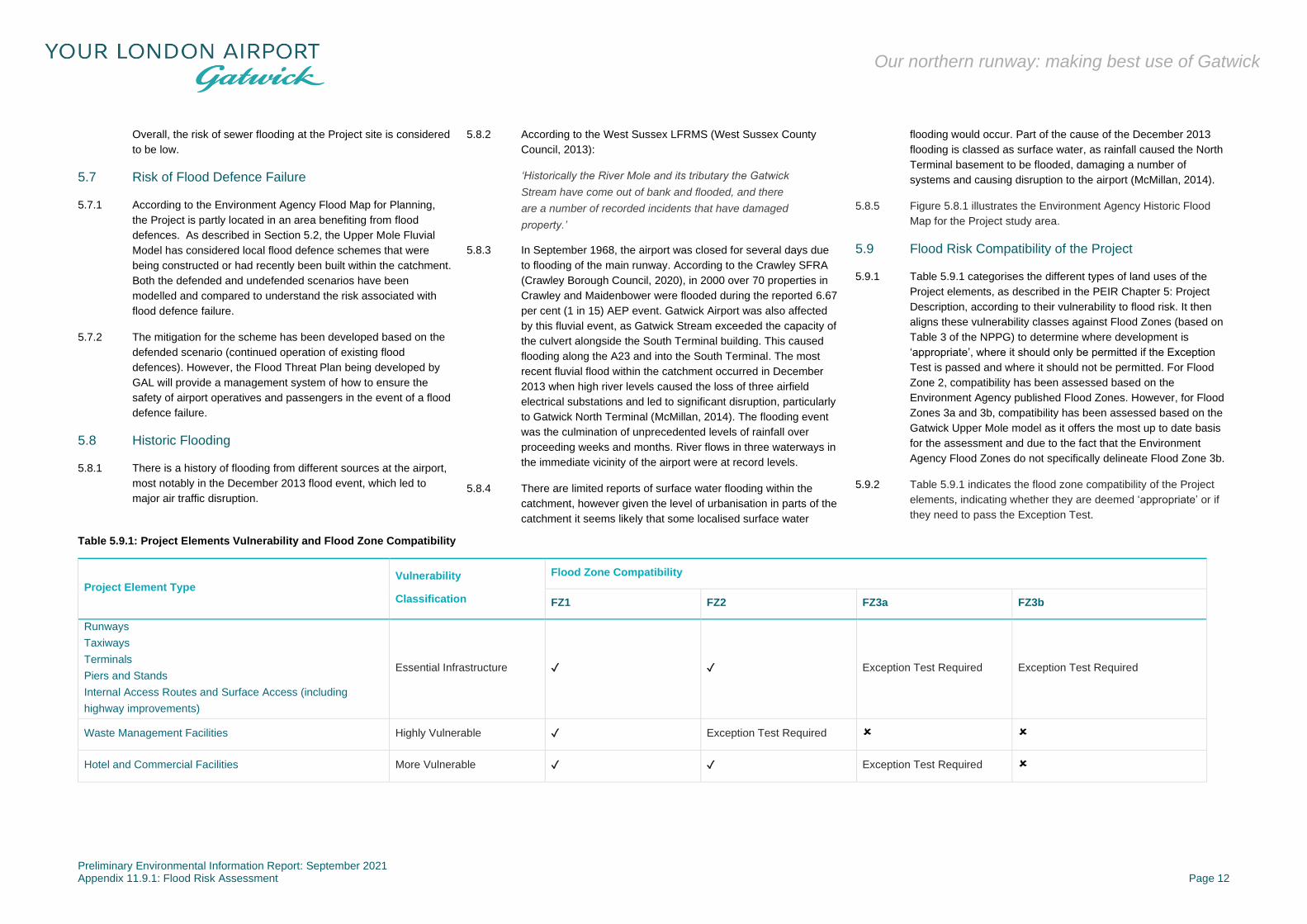
Preliminary Environmental Information Report: September 2021 Appendix 11.9.1: Flood Risk Assessment Page 12
Our northern runway: making best use of Gatwick
Overall, the risk of sewer flooding at the Project site is considered
to be low.
5.7 Risk of Flood Defence Failure
5.7.1 According to the Environment Agency Flood Map for Planning,
the Project is partly located in an area benefiting from flood
defences. As described in Section 5.2, the Upper Mole Fluvial
Model has considered local flood defence schemes that were
being constructed or had recently been built within the catchment.
Both the defended and undefended scenarios have been
modelled and compared to understand the risk associated with
flood defence failure.
5.7.2 The mitigation for the scheme has been developed based on the
defended scenario (continued operation of existing flood
defences). However, the Flood Threat Plan being developed by
GAL will provide a management system of how to ensure the
safety of airport operatives and passengers in the event of a flood
defence failure.
5.8 Historic Flooding
5.8.1 There is a history of flooding from different sources at the airport,
most notably in the December 2013 flood event, which led to
major air traffic disruption.
5.8.2 According to the West Sussex LFRMS (West Sussex County
Council, 2013):
‘Historically the River Mole and its tributary the Gatwick
Stream have come out of bank and flooded, and there
are a number of recorded incidents that have damaged
property.’
5.8.3 In September 1968, the airport was closed for several days due
to flooding of the main runway. According to the Crawley SFRA
(Crawley Borough Council, 2020), in 2000 over 70 properties in
Crawley and Maidenbower were flooded during the reported 6.67
per cent (1 in 15) AEP event. Gatwick Airport was also affected
by this fluvial event, as Gatwick Stream exceeded the capacity of
the culvert alongside the South Terminal building. This caused
flooding along the A23 and into the South Terminal. The most
recent fluvial flood within the catchment occurred in December
2013 when high river levels caused the loss of three airfield
electrical substations and led to significant disruption, particularly
to Gatwick North Terminal (McMillan, 2014). The flooding event
was the culmination of unprecedented levels of rainfall over
proceeding weeks and months. River flows in three waterways in
the immediate vicinity of the airport were at record levels.
5.8.4 There are limited reports of surface water flooding within the
catchment, however given the level of urbanisation in parts of the
catchment it seems likely that some localised surface water
flooding would occur. Part of the cause of the December 2013
flooding is classed as surface water, as rainfall caused the North
Terminal basement to be flooded, damaging a number of
systems and causing disruption to the airport (McMillan, 2014).
5.8.5 Figure 5.8.1 illustrates the Environment Agency Historic Flood
Map for the Project study area.
5.9 Flood Risk Compatibility of the Project
5.9.1 Table 5.9.1 categorises the different types of land uses of the
Project elements, as described in the PEIR Chapter 5: Project
Description, according to their vulnerability to flood risk. It then
aligns these vulnerability classes against Flood Zones (based on
Table 3 of the NPPG) to determine where development is
‘appropriate’, where it should only be permitted if the Exception
Test is passed and where it should not be permitted. For Flood
Zone 2, compatibility has been assessed based on the
Environment Agency published Flood Zones. However, for Flood
Zones 3a and 3b, compatibility has been assessed based on the
Gatwick Upper Mole model as it offers the most up to date basis
for the assessment and due to the fact that the Environment
Agency Flood Zones do not specifically delineate Flood Zone 3b.
5.9.2 Table 5.9.1 indicates the flood zone compatibility of the Project
elements, indicating whether they are deemed ‘appropriate’ or if
they need to pass the Exception Test.
Table 5.9.1: Project Elements Vulnerability and Flood Zone Compatibility
Project Element Type Vulnerability
Classification
Flood Zone Compatibility
FZ1 FZ2 FZ3a FZ3b
Runways
Taxiways
Terminals
Piers and Stands
Internal Access Routes and Surface Access (including
highway improvements)
Essential Infrastructure ✓ ✓ Exception Test Required Exception Test Required
Waste Management Facilities Highly Vulnerable ✓ Exception Test Required
Hotel and Commercial Facilities More Vulnerable ✓ ✓ Exception Test Required
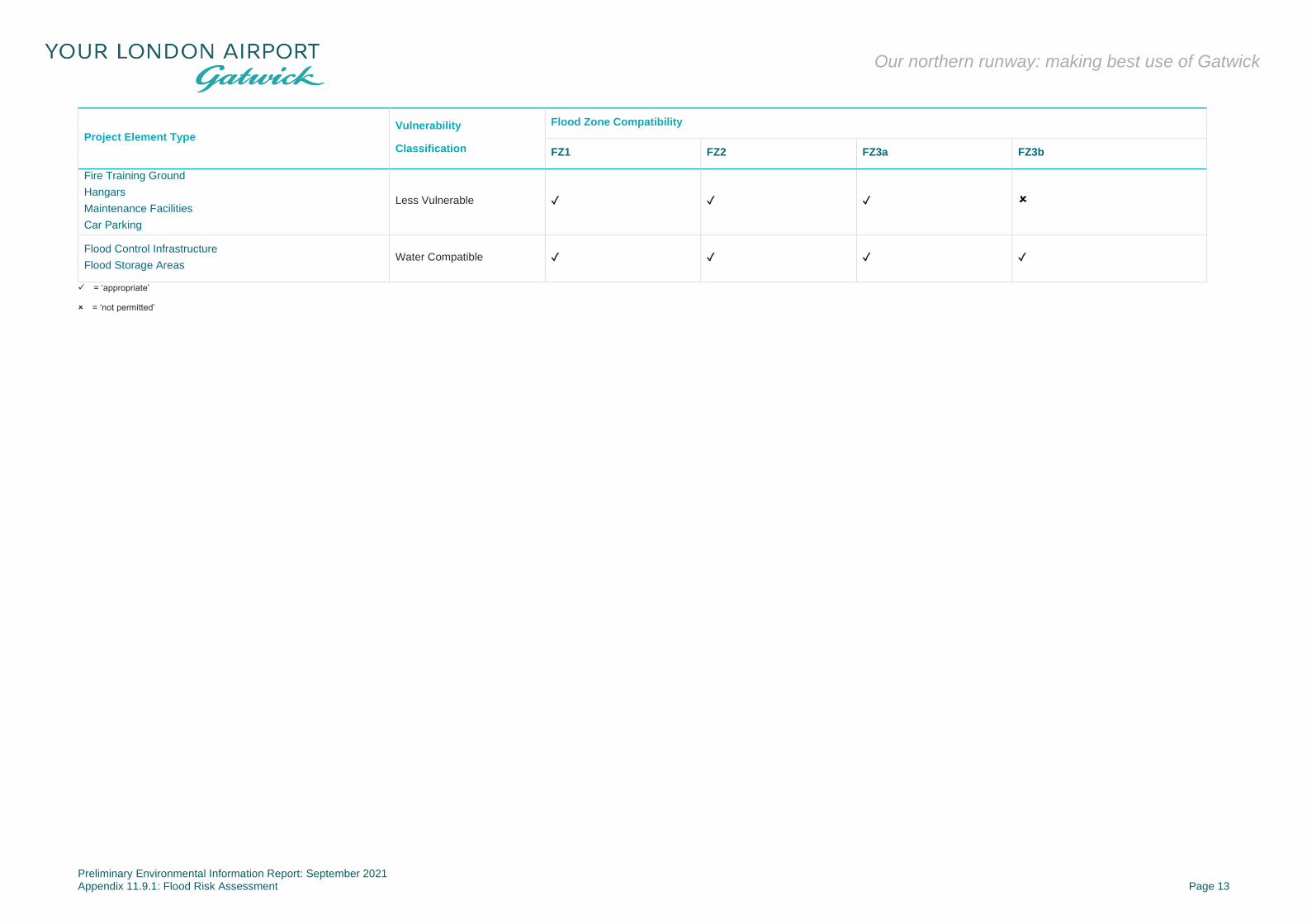
Preliminary Environmental Information Report: September 2021 Appendix 11.9.1: Flood Risk Assessment Page 13
Our northern runway: making best use of Gatwick
Project Element Type Vulnerability
Classification
Flood Zone Compatibility
FZ1 FZ2 FZ3a FZ3b
Fire Training Ground
Hangars
Maintenance Facilities
Car Parking
Less Vulnerable ✓ ✓ ✓
Flood Control Infrastructure
Flood Storage Areas Water Compatible ✓ ✓ ✓ ✓
✓ = ‘appropriate’
= ‘not permitted’

Preliminary Environmental Information Report: September 2021 Appendix 11.9.1: Flood Risk Assessment Page 14
Our northern runway: making best use of Gatwick
The Sequential Test
5.9.3 The Sequential Test, as described in Section 3.4, ensures that a
sequential approach is followed to steer new development to
areas with the lowest probability of flooding. The flood zones, as
defined by the Environment Agency Flood Map for Planning,
provide the basis for the test to be applied. The aim is to steer
new development to Flood Zone 1 (areas with a low probability of
river or sea flooding). Where there are no reasonably available
sites in Flood Zone 1, local planning authorities in their decision-
making should take into account the flood risk vulnerability of land
uses and consider reasonably available sites in Flood Zone 2
(areas with a medium probability of river or sea flooding),
applying the Exception Test if required. Only where there are no
reasonably available sites in Flood Zones 1 or 2 should the
suitability of sites in Flood Zone 3 (areas at high probability of
river and sea flooding) be considered, taking into account the
flood risk vulnerability of land uses and applying the Exception
Test if required.
5.9.4 According to the Environment Agency Flood Zones (Figure
5.2.1), the majority of the altered northern runway and proposed
taxiways located in the western part of the airport fall within Flood
Zone 2. Existing infrastructure, including runways and taxiways
as well as the South and North Terminals also fall within Flood
Zone 2 and partly, Flood Zone 3. Both the existing main runway
and the proposed altered northern runway are located outside of
Flood Zone 3, but there are small strips of taxiways, both existing
and proposed, around the western end of the airfield that fall
within Flood Zone 3.
5.9.5 In applying the Sequential Test, it should be considered that the
adopted approach has been to make best use of existing
infrastructure. This is a strategic decision by the Airports
Commission but also an approach to minimise wider
environmental impacts by Gatwick.
5.9.6 The Airports Commission: Final Report (Airports Commission,
2015) concluded that a new runway at Heathrow would be the
most beneficial long-term expansion solution for London airports
and did not propose to take forward the proposal of a new runway
in Gatwick Airport at this time. A number of alternative options for
the runway and other Project elements have been considered
(see PEIR Chapter 3: Need and Alternatives Considered). The
final selection for the location of these options has taken account
of various factors, including flood risk. Therefore, it can safely be
assumed that alternative locations for the Project, outside of
Flood Zone 2 and 3 are not available and that the Sequential Test
would be passed.
5.9.7 Table 5.9.1 shows that the Exception Test needs to be applied for
some elements of the Project.
The Exception Test
5.9.8 The Exception Test is described in Section 3.5. Essentially, there
are two parts to the Exception Test that require the applicant to
demonstrate that a proposed development will provide wider
sustainability benefits to the community that outweigh flood risk
and that it will be safe for its lifetime, without increasing flood risk
elsewhere and where possible reducing flood risk overall.
5.9.9 The first part of the Exception Test will be considered through the
planning and EIA processes and within the Sustainability
Statement that will accompany the application for development
consent. Gatwick’s sustainability policy goals and objectives lie
at the heart of the Project sustainability framework. In addition,
the framework reflects both the objectives used by the
Government in the Airports NPS (Department for Transport,
2018) and the sustainability priorities relevant to the host local
authorities within the context of local aspects. More information
on wider aspects of sustainability can be found within the PEIR,
with a brief description of Gatwick’s ongoing sustainability
objectives included in Chapter 5: Project Description.
5.9.10 The second part of the Exception Test is addressed in Section 7,
where it is demonstrated how a flood mitigation strategy is in
place that would ensure the Project remains safe throughout its
lifetime and does not increase flood risk elsewhere.
6 Flood Risk due to the Project
6.1 Introduction
6.1.1 The development of the Project could itself affect flood risk within
the wider study area, if no mitigation was in place. This section
describes how and where flood risk would be increased due to
the Project, with regards to types of flooding that have the
potential to be affected by new development. These include
fluvial, surface water, groundwater and sewer/ water distribution
infrastructure flood risk. The Project would not increase the
likelihood of reservoir and/ or flood defence failure, or change the
magnitude of impact, if these occurred. Therefore, these types of
flooding have been scoped out of this assessment.
6.2 Fluvial Flood Risk
6.2.1 According to the Environment Agency Flood Zones and the
Upper Mole Hydraulic Model results, areas downstream and
upstream of Gatwick are also at risk of fluvial flooding and hence,
further development within the airport has the potential to
influence flood risk upstream and downstream.
6.2.2 This section provides an assessment of the Project’s effect on
fluvial flood risk, assuming no mitigation would be in place. This
assessment is based on the comparison of flood extents and
flood depths between the baseline 1 per cent (1 in 100) AEP
event including a 35 per cent climate change allowance and the
with-Project results for the same event, Figure 6.2.1, and the
comparison of flood extents and flood depths between the
baseline 1 per cent (1 in 100) AEP event including a 70 per cent
climate change allowance and the with-Project results, Figure
6.2.2.
6.2.3 Where differences are indicated between the two scenarios,
these are discussed in the context of the magnitude of change of
flood depth as well as the vulnerability of the potential receptor/
land use.
6.2.4 According to Figure 6.2.1, the with-Project scenario would result
in an increase in flood depths south of the existing main runway,
including in areas outside of the airport boundary, around the
River Mole (>10 mm and up to 50 mm increase) and Crawter’s
Brook (mainly up to 100 mm flood depth increase), where a
number of industrial properties are located. Moreover, flood
depths would increase within the airport (>100 mm), around the
western part and an area in the north, where the proposed
Taxiway Lima extension is located. Figure 6.2.2. shows that the 1
percent (1 in 100) AEP event including a 70 per cent climate
change allowance would result in more significant flooding south
of the main runway, on the east side of the End Around Taxiway
East, in and immediately north of Taxiway Lima, and west of the
Longbridge roundabout. There is some increased betterment
south of the runway, in Crawter’s Brook and west of Taxiway
Lima.
6.2.5 The surface access improvements would result in the loss of
floodplain at Longbridge Roundabout and to the south of the A23,
north-east of North Terminal as a result of the construction of an
embankment for the A23 flyover. These would result in an
increase in flood risk if no mitigation was provided by the Project.
Preliminary Environmental Information Report: September 2021 Appendix 11.9.1: Flood Risk Assessment Page 15
Our northern runway: making best use of Gatwick
6.2.6 An increased risk of flooding would also result around the
Riverside Garden Park area from the Gatwick Stream and would
affect residential properties within Horley. Therefore, it is
essential that a flood mitigation strategy is developed as part of
the Project. This is described in Section 7.
6.3 Surface Water Drainage Flood Risk
6.3.1 This section provides an assessment of the Project’s impact on
local surface water flood risk. At this stage, detailed design of the
drainage system has not been undertaken, and finished ground
levels of the development are still being finalised. Therefore
conceptual modelling has been undertaken to examine the
effects that the Project would have on surface water flows and an
evaluation of the storage required to prevent any increase in
discharge rates from the development has been undertaken.
6.3.2 The Project includes the addition of up to approximately
17.9 hectares of hardstanding area and new roof area within the
airport and would therefore increase surface water runoff.
Furthermore, the introduction of new infrastructure has the
potential to block or divert existing surface water flow paths
through landform changes, potentially increasing flood risk
elsewhere.
6.3.3 Existing surface water flow paths and ponding areas show the
patterns of surface water flooding within the airport. Assuming no
changes to the drainage system and no mitigation strategy, the
addition of impermeable area would exacerbate flood risk within
areas already at risk and flooding would be expected to extend to
adjacent low-lying areas.
6.3.4 This assessment therefore highlights the need for the
development of a flood mitigation strategy that would mitigate
surface water flood risk within the airport (refer to Section 7).
6.4 Groundwater Flood Risk
6.4.1 Some elements of the Project include structures or other
elements that are likely to penetrate into shallow groundwater.
These may have a local impact on groundwater flow paths and
levels in their immediate vicinity.
6.4.2 Furthermore, some buried services (such as cabling ducts) may
be susceptible to impacts from high groundwater levels (whether
or not these are due to groundwater levels higher than the norm).
6.4.3 These risks may be addressed by adopting appropriate design
practices, for example by adopting resilience measures. These
measures may be passive (using sealing materials to exclude the
entry of groundwater) or active (by building in sumps and
pumping arrangements) and overall it is considered that the risk
from groundwater flooding would not be adversely affected by the
Project, and the risk from groundwater flooding would remain low.
6.5 Sewer/ Water Distribution Infrastructure Flooding
6.5.1 During the operational phase of the Project, peak daily passenger
numbers would increase, introducing additional loading to the foul
sewerage system of the airport. This could have a potential long-
term impact on sewer flood risk. However, modelling of this
increase, undertaken for the PEIR (Chapter 11: Water
Environment), has shown that the sewerage system would not be
significantly affected by the Project. The foul sewerage system
(with mitigation) would have adequate capacity to accommodate
the increase in flows expected to be caused by the Project.
6.5.2 Additional water distribution infrastructure would also have to be
installed as part of the Project, in order to accommodate new
buildings and infrastructure. However, this would be new
infrastructure and would be considered to be at low risk of failing
and causing flooding. In the case that parts of the existing water
distribution network are replaced as part of the Project, this could
provide an overall betterment in terms of flood risk.
6.6 Flood Risk During Construction
6.6.1 The precise location and layout of construction compounds would
be determined by the Principal Contractor. However, at this
stage, the principal expected compounds have been described
and mapped in the PEIR Chapter 5: Project Description. In terms
of flood risk, the location of construction compounds would be
compared against the 1 per cent (1 in 100) AEP event flood
extents, with a 25 per cent allowance for climate change as the
compound would only be in place during years within the 2015-
2039 period referenced in Table 3.6.2.
6.6.2 The satellite airfield construction compound, which would be
located adjacent to the River Mole, falls within the 1 per cent (1 in
100) AEP floodplain. However, this compound has been
considered in the timing of the construction of compensatory
floodplain storage (see Section 7.2) and the proposed mitigation
adequately replaces that lost to ensure no increase in flood risk.
At this stage, other proposed construction compounds are
expected to be located outside of the extent of the 1 per cent
AEP +25 per cent event.
6.6.3 Overall, construction methods are necessarily broad at this stage.
It is assumed that a construction flood management plan (FMP)
and appropriate drainage strategy would be developed to ensure
all flood risks related to construction activities would be mitigated
or safely managed within the Project boundary. This FRA
provides information that can be used as a basis when preparing
the construction FMP in order to ensure that people and
infrastructure remain protected from identified flood risks to the
Project site.
7 Flood Mitigation Strategy
7.1 Introduction
7.1.1 As described in Section 6.2, the Project would encroach on
existing floodplain areas and therefore result in a net reduction in
flood storage that would require mitigation. There are also
additional areas of pavement and other changes that alter
surface water runoff. Therefore, a flood mitigation strategy has
been developed as part of the Project, focused on fluvial and
surface water flood risk.
7.1.2 The overall approach for fluvial flood risk mitigation has been to
maximise the compensatory flood storage capacity within the
airport. For surface water flood risk, the approach is focused on
providing additional attenuation storage and flow control
measures where possible.
7.2 Fluvial Flood Mitigation Strategy
7.2.1 A number of flood mitigation measures have been proposed as
part of the Project, to ensure it would remain safe from flooding
throughout its lifetime and would not increase flood risk
elsewhere. All mitigation measures proposed for inclusion within
the Project have been mapped in Figure 7.2.1 and are described
in this section.
7.2.2 All the embedded fluvial mitigation measures of the Project are
represented in the Upper Mole Hydraulic Model for the with-
Project, with-mitigation scenario, which provides the basis for
assessment of the mitigation strategy.
7.2.3 All of the proposed flood mitigation measures are planned to be
constructed during the early years of the project to ensure that
mitigation is provided in advance of the associated encroachment
and loss of floodplain, including the temporary construction
compound (see Section 6.6.2).
Preliminary Environmental Information Report: September 2021 Appendix 11.9.1: Flood Risk Assessment Page 16
Our northern runway: making best use of Gatwick
Proposed Fluvial Flood Mitigation Measures
7.2.4 Preliminary designs for the flood compensation areas, relocated
Pond A and the River Mole reconfiguration are included in Annex
1. These are likely to evolve as the Project design progresses,
but they do provide an indication of the intended features.
Floodplain Compensation Areas
7.2.5 The Project would encroach on existing floodplain areas and
therefore result in a net reduction in flood storage that would
need to be compensated for. The overall approach has been to
maximise the compensatory flood storage capacity of the airport
as close to where it has been lost due to the Project. This would
be achieved with the development of new Flood Compensation
Areas (FCAs) to ensure there is no increase in flood risk arising
from the Project. The proposed FCAs have been mapped in
Figure 7.2.1 and include; the Museum Field FCA (including east
of Museum Field FCA) which is located north of the proposed
relocated fire training ground and west of the River Mole; car park
X FCA, located south of the main runway and adjacent to
Crawter’s Brook; and the east of Gatwick Stream FCA, located
south of the Crawley STW.
Pond A Relocation and River Mole Reconfiguration
7.2.6 The proposed extension of the airfield encroaches on the existing
Pond A, which would therefore require relocation or replacement.
It has been proposed that Pond A is relocated directly to the north
of its existing location. The volume of the relocated Pond A would
take into account any additional storage requirements due to the
introduction of new impermeable area as part of the Project.
7.2.7 The proposed relocation of Pond A north of its existing location,
also requires the realignment of the River Mole such that the
Pond would lay on the left bank of the river, to allow gravity
drainage from the catchment serving the western airfield.
Syphons
7.2.8 The new taxiway levels are governed by the need to tie into
existing taxiway or runway levels, potentially impacting on areas
of floodplain. Areas of lost floodplain storage would result not only
from the new taxiways, but also by hydraulically isolating part of a
floodplain where the taxiway crosses it. This would be addressed
by connecting both sides of the floodplain with syphon structures
under the taxiways. This approach has been adopted due to the
areas of lost floodplain that would be difficult to compensate for
within the vicinity of where the floodplain is lost. There are two
proposed syphons, as shown in Figure 7.2.1.
Assessment of Proposed Fluvial Mitigation
7.2.9 The Gatwick Upper Mole Hydraulic Model has been run for the
with-mitigation scenario in order to determine the effectiveness of
the proposed mitigation strategy in keeping all Project elements
safe for their lifetime and in mitigating all flooding to third parties
due to the Project. This assessment allows for a judgement to be
made on whether the second part of the Exception Test can be
passed (refer to paragraphs 5.9.8 to 5.9.10).
7.2.10 Figure 7.2.2 illustrates flood extents within Gatwick, for the
mitigated, with Project scenario, for the 5 per cent (1 in 20) and 1
per cent (1 in 100) AEP fluvial event, as well as the 1 per cent (1
in 100) AEP event including 35 per cent and 70 per cent climate
change allowances. This illustrates that the proposed runways
and new taxiways would not be at risk of flooding during the
design event (1 per cent (1 in 100) AEP event, including a 35 per
cent climate change allowance). However, some Project
elements, including the edge of the end around taxiway next to
Taxiway Yankee, the edge of the reconfigured Taxiway Zulu, the
edge of the fire training ground and Crawter’s Field car park,
which is located south east of the main runway, would fall within
flood extents for the 1 per cent (1 in 100) AEP event including 35
per cent climate change design event for the airfield. These areas
of flooding are not expected to affect the ability of the airport to
remain operational and safe. The planned response to an event
of this magnitude will be laid out in the Gatwick Flood Threat Plan
to ensure continued safe operation.
7.2.11 At the fire training ground, flood depths would be <200 mm for the
design event (1 per cent (1 in 100) AEP event including a 35 per
cent climate change allowance) and the flood extents are very
localised and would not block any access and egress routes. The
facility would not be expected to be used during extreme flooding
events. Therefore, the facility would remain safe for its lifetime.
7.2.12 Similarly, for the end around taxiway and Taxiway Zulu, flood
depths would be <200 mm (mainly <100 mm), and these parts of
the airfield are not expected to be required to remain operational
during the design flood event. Therefore, there would be no
safety risk to users of the airfield.
7.2.13 Finally, for Crawter’s Field Car Park, flood depths for the design
event would be mainly <400mm. The car park would be expected
to remain closed in extreme flooding events, and users would be
informed of the risk of flooding. Overall, the majority of the car
park area would experience no flooding or flooding up to 300 mm
for the design event. Access and egress routes would not be
blocked during such an event and there are no dry islands that
would represent a significant risk for users.
7.2.14 Figure 7.2.3 illustrates the difference in fluvial flood depths
between the baseline and with-scheme, with-mitigation scenarios,
for the 1 per cent (1 in 100) AEP event, including a 35 per cent
allowance for climate change, allowing for a more detailed
assessment of potential impacts. It shows that there are much
greater areas benefiting from the development of the Project
compared to the areas where flood risk is increased. The most
obvious new areas of flooding are intentional and are associated
with the proposed FCAs; Museum Field, Car Park X and the
Gatwick Stream FCA (see Figure 7.2.1). Another flood depth
increase shown is located at the north-west edge of the proposed
fire training ground. However, the fire training ground facility
would not be classified as ‘Essential Infrastructure’ and would not
have to remain fully operational during such an extreme event. In
any case, the flood extents are located on the edge of the facility
and are not expected to affect its ability to remain operational,
and therefore, this is acceptable from an Exception Test
perspective.
7.2.15 Directly south of the fire training ground there is a narrow strip of
increased flood depths. However, this area remains unused and
does not encroach on any infrastructure and therefore, the
change is not considered to result in a significant effect.
7.2.16 The South Terminal building would be at risk of flooding during
the 1 per cent (1 in 100) AEP event including a 35 per cent
climate change allowance, as for the baseline scenario (less than
10 mm betterment). However, dry access and egress routes from
above flood levels, via high-link bridges and multi-storey car
parks are in place for the terminal buildings.
7.2.17 Similarly, for the 5 per cent (1 in 20) AEP event, Figure 7.2.4
illustrates the difference in fluvial flood depths compared to the
baseline scenario. As for the 1 per cent (1 in 100) AEP event,
Figure 7.2.4 shows that the only areas where flood depths would
be increased are associated with the proposed FCAs, the area on
the edge of the fire training ground and the small undeveloped
area directly south of the fire training ground. For all other areas
flood depths would be reduced significantly.
7.2.18 Overall, there would be large areas with reduced fluvial flood risk
within Gatwick Airport and the wider study area after the
development of the Project with the mitigation measures
proposed and it is estimated that approximately 100 residential
properties in the area of Horley would benefit from the Project (ie
Preliminary Environmental Information Report: September 2021 Appendix 11.9.1: Flood Risk Assessment Page 17
Our northern runway: making best use of Gatwick
>10 mm reduction in peak flood depth for the 1 per cent (1 in 100)
AEP event, including a 35 per cent allowance for climate
change). An additional 40 industrial properties would also be
likely to benefit.
7.2.19 Small areas of increase in flood depths would be located within
the airport boundary and would not affect its ability to remain
operational during times of flood, or to operate safely. The
runways would remain operational for the design event (ie the 1
per cent (1 in 100) AEP event, including a 35 per cent allowance
for climate change). For the terminal buildings, flooding would be
equivalent to existing. For taxiways and supporting airport
infrastructure, flood risk would be reduced or equivalent to
existing, with the exception of small areas of locally increased
flood risk. These areas have been described in paragraphs
7.2.10 to 7.2.16, where it is shown that these would not result in
safety or operational risks. There would be no increase in
flooding to third parties due to the Project.
7.2.20 The mitigation measures included to address changes in fluvial
flood risk on the airfield would also provide mitigation for the
surface access elements of the Project. Given its longer lifetime
the impact of the surface access proposals on fluvial flood risk
have considered the design event to be the 1 per cent (1 in 100)
AEP event, including a 70 per cent allowance for climate change.
Figure 7.2.5. demonstrates that the fluvial mitigation measures
would also ensure that there would be no increase in fluvial flood
risk beyond the airport boundary for this event (other than the
floodplain compensation areas that would be deliberately
designed to flood safely).
Exceedance Scenario
7.2.21 The 1 per cent (1 in 100) AEP event, including a 70 per cent
climate change allowance, has been tested as an exceedance
scenario for the airfield (as a sensitivity analysis) and results are
mapped in Figure 7.2.5. It is shown that flood risk is not increased
by the Project outside the Project boundary and that there is
betterment to third parties (flood depths decreased by up to
100 mm in some areas). Flooding within Gatwick Airport is locally
increased compared to the design event (1 per cent (1 in 100)
AEP event including a 35 per cent climate change allowance),
affecting some taxiways and stands but not the existing and
proposed main runways or terminal buildings. Safe access and
egress routes as described in paragraph 7.2.16. would not be
affected by flooding and available for use.
7.2.22 As a further, worst case scenario, the impact of failure of the flood
defences has been assessed to understand the potential impacts.
Figure 7.2.6. shows the Mitigated with Project Scenario (1 per
cent AEP +35 per cent climate change) together with the
Undefended with Project 1 per cent AEP +35 per cent climate
change and +70 per cent with climate change scenarios. In the
+35% climate change scenario, the impacts of increased flood
from flood defence failure are restricted to the airport for which
management response procedures will be implemented. There is
one area East of the Railway that is at risk of flooding from the
failure of defences. In the +70 per cent climate change scenario,
there are small additional areas south of the runway, across the
runway at the eastern end which may represent an operational
risk, but it is likely that aircraft operation would be stopped in this
scenario. Small areas of additional risk are on the Gatwick
Stream east of the railway, near the Longbridge roundabout and
to the edge of the River Mole south of the airport. Safe access
and egress routes as described in paragraph 7.2.16 would not be
affected by flooding.
7.3 Surface Water Drainage Mitigation Strategy
Proposed Surface Water Drainage Measures
7.3.1 A surface water drainage strategy has been developed as part of
the Project. The objective of the strategy has been to make best
use of the existing surface water management network, while
providing additional attenuation facilities and/ or floodplain
compensation where needed and reconfiguring existing
infrastructure where that would provide wider flood risk benefits.
South West zone attenuation tank and pumping station
7.3.2 A new surface water attenuation tank and pump station is
proposed south of the existing runway. This underground
attenuation tank and pumping station will be sized based on the
final design of the Project and will ensure new impermeable area
from the runway and taxiways within the existing Pond M
Catchment is controlled to greenfield runoff rates. This is shown
in Figure 7.3.1. This pumping station will discharge into Pond M,
which has a controlled discharge rate.
Pond A discharge control improvements
7.3.3 Pond A currently has a free outfall to the River Mole, with no
designed discharge control. The Northern Runway fringes will
impinge on Pond A, meaning that it will reduce in area, reducing
its potential volume. However, the new outlet control will ensure
that Pond A acts as surface water attenuation. Figure 7.3.2.
shows the conceptual design of Pond A.
7.3.4 Table 7.3.1 summarises the additional storage provided by the
Project.
Table 7.3.1: Additional Storage (m3) Provided by the Development
Storage Baseline Project
Pond A 0 16,000
New Pumping Station 0 2,800
Dog Kennel Pond Clean Side 525 525
Pond Mclean Side 19,268 19,268
Pond D (Lower) 20,400 20,400
Total Storage 39,668 55.668
Surface Access Improvements Drainage Strategy
7.3.5 The surface access improvements proposed as part of the
Project would include North Terminal and South Terminal
roundabout works and works to improve capacity at the
Longbridge roundabout and to provide better integration with the
North Terminal roundabout improvements. As part of these
works, it is proposed that a drainage network is installed,
consisting of carrier drains, filter drains, ditches and attenuation
ponds, along with flow control arrangements to limit discharges to
watercourses. Therefore, surface water drainage runoff from new
areas of highway would be restricted to pre-development rates,
and where possible, greenfield runoff rates. This would ensure no
increase in flood risk as a result of these works. Further details of
the surface access outline drainage design are included in Annex
2.
7.3.6 The proposed works would locally encroach on areas currently at
risk of surface water ponding. However, this would be safely
managed by the road drainage network associated with the
highway works. No major surface water flow paths would be
expected to be interrupted as part of the surface access
improvements proposed.
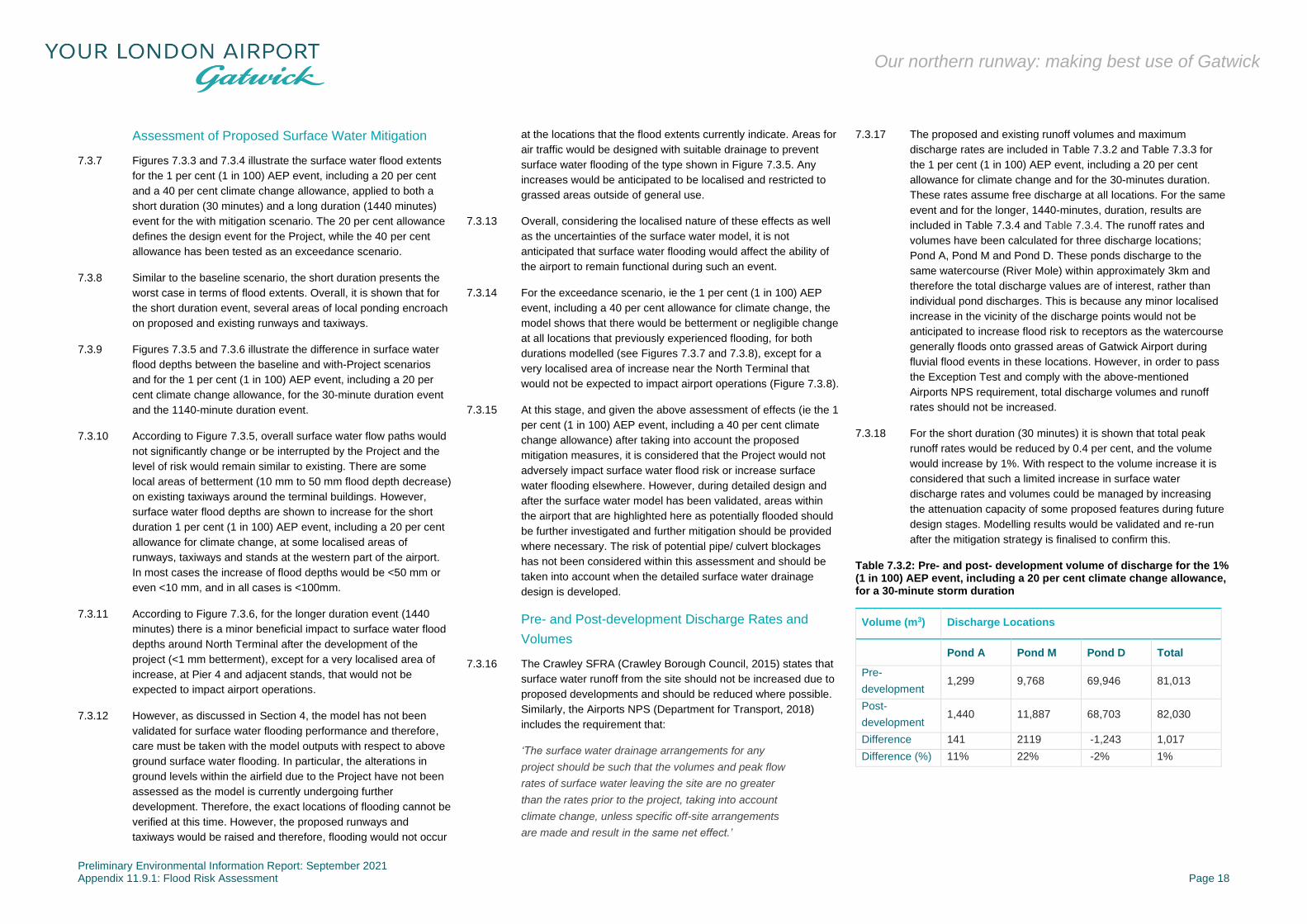
Preliminary Environmental Information Report: September 2021 Appendix 11.9.1: Flood Risk Assessment Page 18
Our northern runway: making best use of Gatwick
Assessment of Proposed Surface Water Mitigation
7.3.7 Figures 7.3.3 and 7.3.4 illustrate the surface water flood extents
for the 1 per cent (1 in 100) AEP event, including a 20 per cent
and a 40 per cent climate change allowance, applied to both a
short duration (30 minutes) and a long duration (1440 minutes)
event for the with mitigation scenario. The 20 per cent allowance
defines the design event for the Project, while the 40 per cent
allowance has been tested as an exceedance scenario.
7.3.8 Similar to the baseline scenario, the short duration presents the
worst case in terms of flood extents. Overall, it is shown that for
the short duration event, several areas of local ponding encroach
on proposed and existing runways and taxiways.
7.3.9 Figures 7.3.5 and 7.3.6 illustrate the difference in surface water
flood depths between the baseline and with-Project scenarios
and for the 1 per cent (1 in 100) AEP event, including a 20 per
cent climate change allowance, for the 30-minute duration event
and the 1140-minute duration event.
7.3.10 According to Figure 7.3.5, overall surface water flow paths would
not significantly change or be interrupted by the Project and the
level of risk would remain similar to existing. There are some
local areas of betterment (10 mm to 50 mm flood depth decrease)
on existing taxiways around the terminal buildings. However,
surface water flood depths are shown to increase for the short
duration 1 per cent (1 in 100) AEP event, including a 20 per cent
allowance for climate change, at some localised areas of
runways, taxiways and stands at the western part of the airport.
In most cases the increase of flood depths would be <50 mm or
even <10 mm, and in all cases is <100mm.
7.3.11 According to Figure 7.3.6, for the longer duration event (1440
minutes) there is a minor beneficial impact to surface water flood
depths around North Terminal after the development of the
project (<1 mm betterment), except for a very localised area of
increase, at Pier 4 and adjacent stands, that would not be
expected to impact airport operations.
7.3.12 However, as discussed in Section 4, the model has not been
validated for surface water flooding performance and therefore,
care must be taken with the model outputs with respect to above
ground surface water flooding. In particular, the alterations in
ground levels within the airfield due to the Project have not been
assessed as the model is currently undergoing further
development. Therefore, the exact locations of flooding cannot be
verified at this time. However, the proposed runways and
taxiways would be raised and therefore, flooding would not occur
at the locations that the flood extents currently indicate. Areas for
air traffic would be designed with suitable drainage to prevent
surface water flooding of the type shown in Figure 7.3.5. Any
increases would be anticipated to be localised and restricted to
grassed areas outside of general use.
7.3.13 Overall, considering the localised nature of these effects as well
as the uncertainties of the surface water model, it is not
anticipated that surface water flooding would affect the ability of
the airport to remain functional during such an event.
7.3.14 For the exceedance scenario, ie the 1 per cent (1 in 100) AEP
event, including a 40 per cent allowance for climate change, the
model shows that there would be betterment or negligible change
at all locations that previously experienced flooding, for both
durations modelled (see Figures 7.3.7 and 7.3.8), except for a
very localised area of increase near the North Terminal that
would not be expected to impact airport operations (Figure 7.3.8).
7.3.15 At this stage, and given the above assessment of effects (ie the 1
per cent (1 in 100) AEP event, including a 40 per cent climate
change allowance) after taking into account the proposed
mitigation measures, it is considered that the Project would not
adversely impact surface water flood risk or increase surface
water flooding elsewhere. However, during detailed design and
after the surface water model has been validated, areas within
the airport that are highlighted here as potentially flooded should
be further investigated and further mitigation should be provided
where necessary. The risk of potential pipe/ culvert blockages
has not been considered within this assessment and should be
taken into account when the detailed surface water drainage
design is developed.
Pre- and Post-development Discharge Rates and
Volumes
7.3.16 The Crawley SFRA (Crawley Borough Council, 2015) states that
surface water runoff from the site should not be increased due to
proposed developments and should be reduced where possible.
Similarly, the Airports NPS (Department for Transport, 2018)
includes the requirement that:
‘The surface water drainage arrangements for any
project should be such that the volumes and peak flow
rates of surface water leaving the site are no greater
than the rates prior to the project, taking into account
climate change, unless specific off-site arrangements
are made and result in the same net effect.’
7.3.17 The proposed and existing runoff volumes and maximum
discharge rates are included in Table 7.3.2 and Table 7.3.3 for
the 1 per cent (1 in 100) AEP event, including a 20 per cent
allowance for climate change and for the 30-minutes duration.
These rates assume free discharge at all locations. For the same
event and for the longer, 1440-minutes, duration, results are
included in Table 7.3.4 and Table 7.3.4. The runoff rates and
volumes have been calculated for three discharge locations;
Pond A, Pond M and Pond D. These ponds discharge to the
same watercourse (River Mole) within approximately 3km and
therefore the total discharge values are of interest, rather than
individual pond discharges. This is because any minor localised
increase in the vicinity of the discharge points would not be
anticipated to increase flood risk to receptors as the watercourse
generally floods onto grassed areas of Gatwick Airport during
fluvial flood events in these locations. However, in order to pass
the Exception Test and comply with the above-mentioned
Airports NPS requirement, total discharge volumes and runoff
rates should not be increased.
7.3.18 For the short duration (30 minutes) it is shown that total peak
runoff rates would be reduced by 0.4 per cent, and the volume
would increase by 1%. With respect to the volume increase it is
considered that such a limited increase in surface water
discharge rates and volumes could be managed by increasing
the attenuation capacity of some proposed features during future
design stages. Modelling results would be validated and re-run
after the mitigation strategy is finalised to confirm this.
Table 7.3.2: Pre- and post- development volume of discharge for the 1% (1 in 100) AEP event, including a 20 per cent climate change allowance, for a 30-minute storm duration
Volume (m3) Discharge Locations
Pond A Pond M Pond D Total
Pre-
development 1,299 9,768 69,946 81,013
Post-
development 1,440 11,887 68,703 82,030
Difference 141 2119 -1,243 1,017
Difference (%) 11% 22% -2% 1%
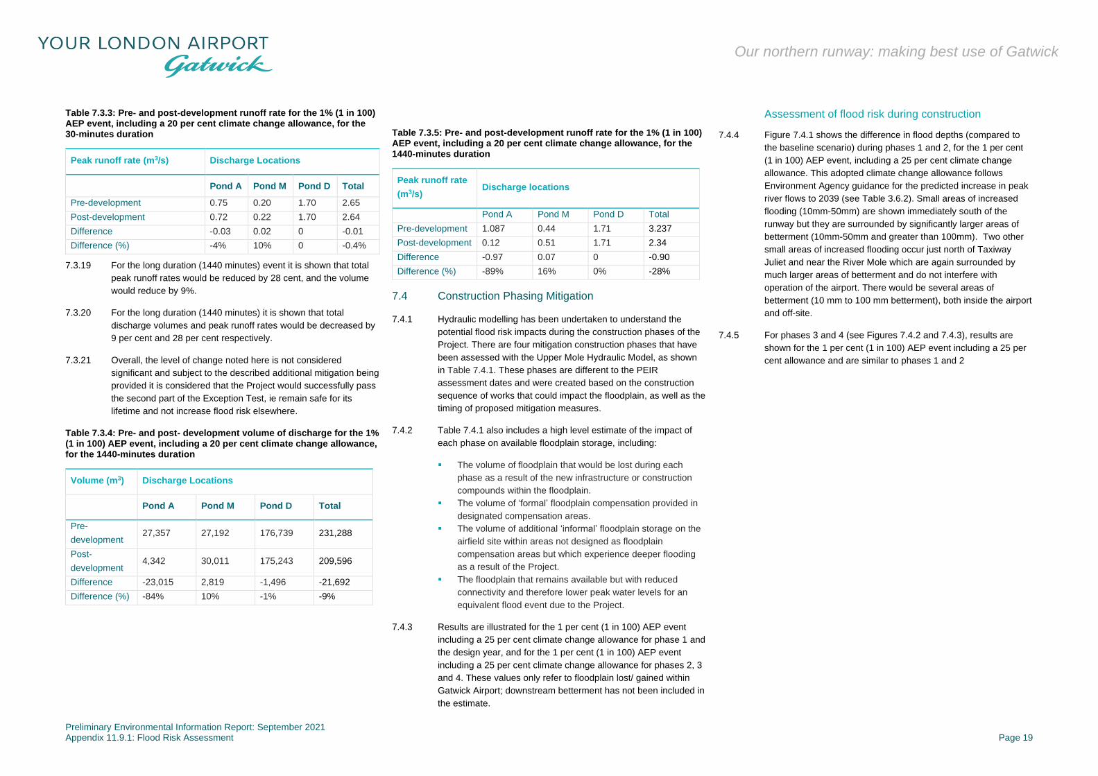
Preliminary Environmental Information Report: September 2021 Appendix 11.9.1: Flood Risk Assessment Page 19
Our northern runway: making best use of Gatwick
Table 7.3.3: Pre- and post-development runoff rate for the 1% (1 in 100) AEP event, including a 20 per cent climate change allowance, for the 30-minutes duration
Peak runoff rate (m3/s) Discharge Locations
Pond A Pond M Pond D Total
Pre-development 0.75 0.20 1.70 2.65
Post-development 0.72 0.22 1.70 2.64
Difference -0.03 0.02 0 -0.01
Difference (%) -4% 10% 0 -0.4%
7.3.19 For the long duration (1440 minutes) event it is shown that total
peak runoff rates would be reduced by 28 cent, and the volume
would reduce by 9%.
7.3.20 For the long duration (1440 minutes) it is shown that total
discharge volumes and peak runoff rates would be decreased by
9 per cent and 28 per cent respectively.
7.3.21 Overall, the level of change noted here is not considered
significant and subject to the described additional mitigation being
provided it is considered that the Project would successfully pass
the second part of the Exception Test, ie remain safe for its
lifetime and not increase flood risk elsewhere.
Table 7.3.4: Pre- and post- development volume of discharge for the 1% (1 in 100) AEP event, including a 20 per cent climate change allowance, for the 1440-minutes duration
Volume (m3) Discharge Locations
Pond A Pond M Pond D Total
Pre-
development 27,357 27,192 176,739 231,288
Post-
development 4,342 30,011 175,243 209,596
Difference -23,015 2,819 -1,496 -21,692
Difference (%) -84% 10% -1% -9%
Table 7.3.5: Pre- and post-development runoff rate for the 1% (1 in 100) AEP event, including a 20 per cent climate change allowance, for the 1440-minutes duration
Peak runoff rate
(m3/s) Discharge locations
Pond A Pond M Pond D Total
Pre-development 1.087 0.44 1.71 3.237
Post-development 0.12 0.51 1.71 2.34
Difference -0.97 0.07 0 -0.90
Difference (%) -89% 16% 0% -28%
7.4 Construction Phasing Mitigation
7.4.1 Hydraulic modelling has been undertaken to understand the
potential flood risk impacts during the construction phases of the
Project. There are four mitigation construction phases that have
been assessed with the Upper Mole Hydraulic Model, as shown
in Table 7.4.1. These phases are different to the PEIR
assessment dates and were created based on the construction
sequence of works that could impact the floodplain, as well as the
timing of proposed mitigation measures.
7.4.2 Table 7.4.1 also includes a high level estimate of the impact of
each phase on available floodplain storage, including:
▪ The volume of floodplain that would be lost during each
phase as a result of the new infrastructure or construction
compounds within the floodplain.
▪ The volume of ‘formal’ floodplain compensation provided in
designated compensation areas.
▪ The volume of additional ‘informal’ floodplain storage on the
airfield site within areas not designed as floodplain
compensation areas but which experience deeper flooding
as a result of the Project.
▪ The floodplain that remains available but with reduced
connectivity and therefore lower peak water levels for an
equivalent flood event due to the Project.
7.4.3 Results are illustrated for the 1 per cent (1 in 100) AEP event
including a 25 per cent climate change allowance for phase 1 and
the design year, and for the 1 per cent (1 in 100) AEP event
including a 25 per cent climate change allowance for phases 2, 3
and 4. These values only refer to floodplain lost/ gained within
Gatwick Airport; downstream betterment has not been included in
the estimate.
Assessment of flood risk during construction
7.4.4 Figure 7.4.1 shows the difference in flood depths (compared to
the baseline scenario) during phases 1 and 2, for the 1 per cent
(1 in 100) AEP event, including a 25 per cent climate change
allowance. This adopted climate change allowance follows
Environment Agency guidance for the predicted increase in peak
river flows to 2039 (see Table 3.6.2). Small areas of increased
flooding (10mm-50mm) are shown immediately south of the
runway but they are surrounded by significantly larger areas of
betterment (10mm-50mm and greater than 100mm). Two other
small areas of increased flooding occur just north of Taxiway
Juliet and near the River Mole which are again surrounded by
much larger areas of betterment and do not interfere with
operation of the airport. There would be several areas of
betterment (10 mm to 100 mm betterment), both inside the airport
and off-site.
7.4.5 For phases 3 and 4 (see Figures 7.4.2 and 7.4.3), results are
shown for the 1 per cent (1 in 100) AEP event including a 25 per
cent allowance and are similar to phases 1 and 2
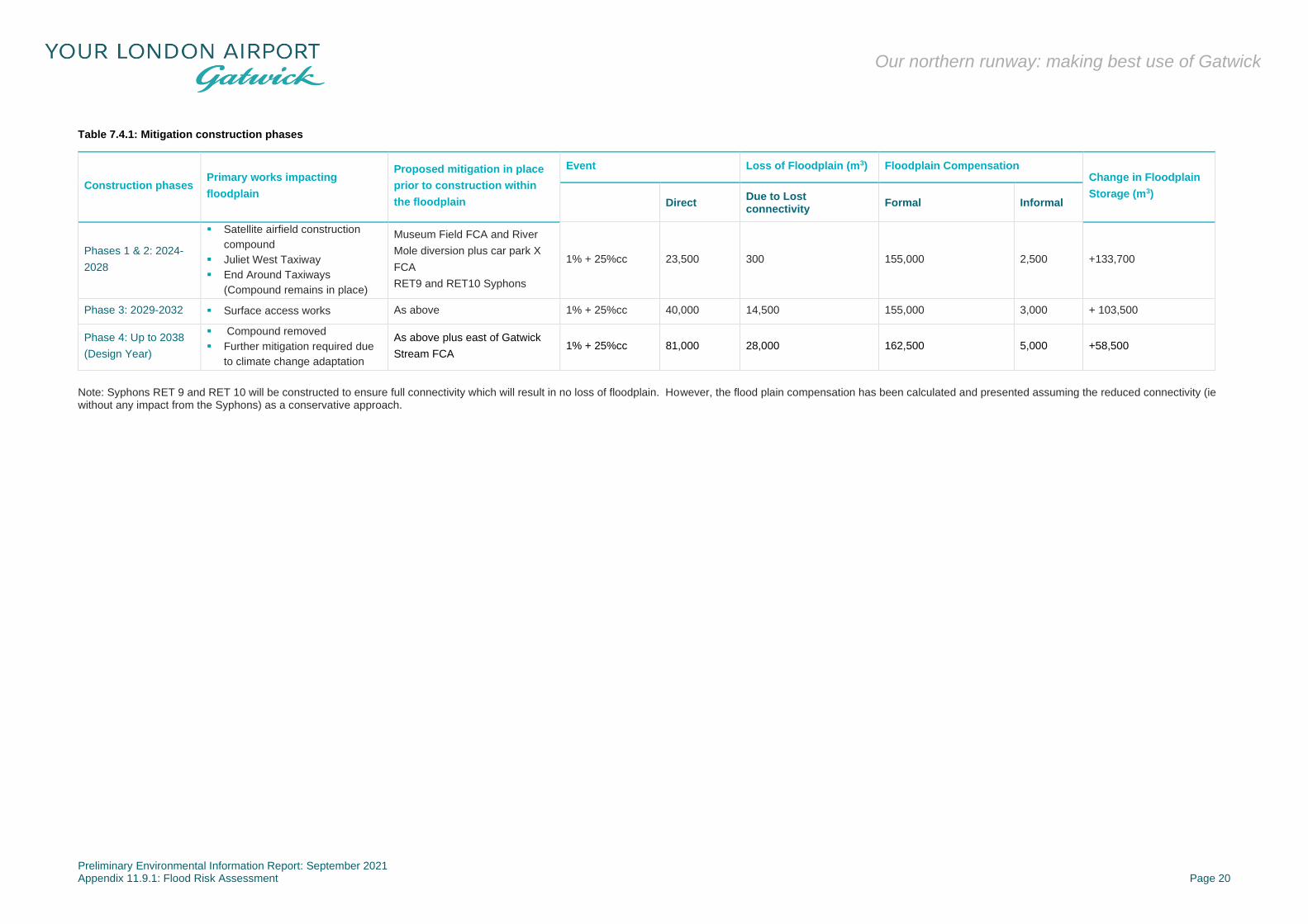
Preliminary Environmental Information Report: September 2021 Appendix 11.9.1: Flood Risk Assessment Page 20
Our northern runway: making best use of Gatwick
Table 7.4.1: Mitigation construction phases
Construction phases Primary works impacting
floodplain
Proposed mitigation in place
prior to construction within
the floodplain
Event Loss of Floodplain (m3) Floodplain Compensation Change in Floodplain
Storage (m3) Direct
Due to Lost connectivity
Formal Informal
Phases 1 & 2: 2024-
2028
▪ Satellite airfield construction
compound
▪ Juliet West Taxiway
▪ End Around Taxiways
(Compound remains in place)
Museum Field FCA and River
Mole diversion plus car park X
FCA
RET9 and RET10 Syphons
1% + 25%cc 23,500 300 155,000 2,500 +133,700
Phase 3: 2029-2032 ▪ Surface access works As above 1% + 25%cc 40,000 14,500 155,000 3,000 + 103,500
Phase 4: Up to 2038
(Design Year)
▪ Compound removed
▪ Further mitigation required due
to climate change adaptation
As above plus east of Gatwick
Stream FCA 1% + 25%cc 81,000 28,000 162,500 5,000 +58,500
Note: Syphons RET 9 and RET 10 will be constructed to ensure full connectivity which will result in no loss of floodplain. However, the flood plain compensation has been calculated and presented assuming the reduced connectivity (ie without any impact from the Syphons) as a conservative approach.
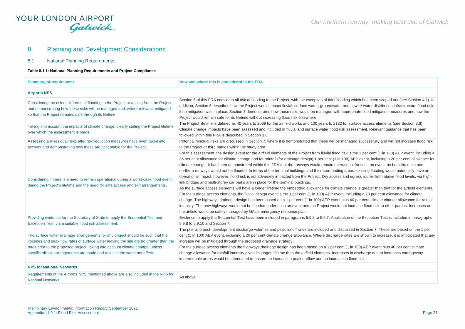
Preliminary Environmental Information Report: September 2021 Appendix 11.9.1: Flood Risk Assessment Page 21
Our northern runway: making best use of Gatwick
8 Planning and Development Considerations
8.1 National Planning Requirements
Table 8.1.1: National Planning Requirements and Project Compliance
Summary of requirement How and where this is considered in the FRA
Airports NPS
Considering the risk of all forms of flooding to the Project or arising from the Project
and demonstrating how these risks will be managed and, where relevant, mitigated,
so that the Project remains safe through its lifetime.
Section 5 of this FRA considers all risk of flooding to the Project, with the exception of tidal flooding which has been scoped out (see Section 4.1). In
addition, Section 6 describes how the Project would impact fluvial, surface water, groundwater and sewer/ water distribution infrastructure flood risk
if no mitigation was in place. Section 7 demonstrates how these risks would be managed with appropriate flood mitigation measures and how the
Project would remain safe for its lifetime without increasing flood risk elsewhere.
Taking into account the impacts of climate change, clearly stating the Project lifetime
over which the assessment is made.
The Project lifetime is defined as 40 years to 2069 for the airfield works and 100 years to 2132 for surface access elements (see Section 3.6).
Climate change impacts have been assessed and included in fluvial and surface water flood risk assessment. Relevant guidance that has been
followed within this FRA is described in Section 3.6.
Assessing any residual risks after risk reduction measures have been taken into
account and demonstrating how these are acceptable for the Project.
Potential residual risks are discussed in Section 7, where it is demonstrated that these will be managed successfully and will not increase flood risk
to the Project or third parties within the study area.
Considering if there is a need to remain operational during a worst-case flood event
during the Project’s lifetime and the need for safe access and exit arrangements.
For this assessment, the design event for the airfield elements of the Project from fluvial flood risk is the 1 per cent (1 in 100) AEP event, including a
35 per cent allowance for climate change and for rainfall (for drainage design) 1 per cent (1 in 100) AEP event, including a 20 per cent allowance for
climate change. It has been demonstrated within this FRA that the runways would remain operational for such an event, as both the main and
northern runways would not be flooded. In terms of the terminal buildings and their surrounding areas, existing flooding would potentially have an
operational impact, however, flood risk is not adversely impacted from the Project. Dry access and egress routes from above flood levels, via high-
link bridges and multi-storey car parks are in place for the terminal buildings.
As the surface access elements will have a longer lifetime the embedded allowance for climate change is greater than that for the airfield elements.
For the surface access elements, the fluvial design event is the 1 per cent (1 in 100) AEP event, including a 70 per cent allowance for climate
change. The highways drainage design has been based on a 1 per cent (1 in 100) AEP event plus 40 per cent climate change allowance for rainfall
intensity. The new highways would not be flooded under such an event and the Project would not increase flood risk to other parties. Increases on
the airfield would be safely managed by GAL’s emergency response plan.
Providing evidence for the Secretary of State to apply the Sequential Test and
Exception Test, via a suitable flood risk assessment.
Evidence to apply the Sequential Test have been included in paragraphs 5.9.3 to 5.9.7. Application of the Exception Test is included in paragraphs
5.9.8 to 5.9.10 and Section 7.
The surface water drainage arrangements for any project should be such that the
volumes and peak flow rates of surface water leaving the site are no greater than the
rates prior to the proposed project, taking into account climate change, unless
specific off-site arrangements are made and result in the same net effect.
The pre- and post- development discharge volumes and peak runoff rates are included and discussed in Section 7. These are based on the 1 per
cent (1 in 100) AEP event, including a 20 per cent climate change allowance. Where discharge rates are shown to increase, it is anticipated that any
increase will be mitigated through the proposed drainage strategy.
For the surface access elements the highways drainage design has been based on a 1 per cent (1 in 100) AEP event plus 40 per cent climate
change allowance for rainfall intensity given its longer lifetime than the airfield elements. Increases in discharge due to increases carriageway
impermeable areas would be attenuated to ensure no increase in peak outflow and no increase in flood risk.
NPS for National Networks
Requirements of the Airports NPS mentioned above are also included in the NPS for
National Networks. As above

Preliminary Environmental Information Report: September 2021 Appendix 11.9.1: Flood Risk Assessment Page 22
Our northern runway: making best use of Gatwick
Summary of requirement How and where this is considered in the FRA
Where linear infrastructure has been proposed in a flood risk area, the Secretary of
State should expect reasonable mitigation measures to have been made to ensure
that the infrastructure remains functional in the event of predicted flooding.
Where surface access improvements are proposed, these are accompanied by a proposed drainage strategy (see Annex 2) that includes the
introduction of carrier drains, filter drains, ditches and attenuation ponds, along with flow control arrangements. Therefore, surface water runoff
would be safely managed and restricted to pre-development or greenfield values, subject to detailed design.
Moreover, the Project and proposed mitigation measures would decrease flood depths in the vicinity of the area where surface access
improvements are proposed. Therefore, these are expected to remain functional during the 1 per cent (1 in 100) AEP event, including a 70 per cent
allowance for climate change.
8.2 Local Planning Requirements
Table 8.2.1: Local Planning Requirements and Project Compliance
Policy Summary of requirement How and where this is considered in the FRA
Crawley 2030: Crawley Borough Local Plan 2030
Policy ENV8
Developments should be directed to areas at low flood risk, considering the suitability of their intended
use for the area and demonstrating that the Sequential Test and, where require, the Exception Test can
be passed.
Evidence to apply the Sequential Test have been included in paragraphs 5.9.3 to 5.9.7. Application of the
Exception Test is included in paragraphs 5.9.8 to 5.9.10 and Section 7.
The Environment Agency Flood Map for Planning should be used to assess flood risk to the area and a
site-specific flood risk assessment should demonstrate how appropriate mitigation measures will ensure
flood risk is acceptable for the site and will not be increased elsewhere.
Environment Agency Flood Zones (as shown in Flood Map for Planning at the time of writing of this FRA,
May 2021) have been mapped and used for the assessment of fluvial flood risk. The proposed flood
mitigation strategy is described in Section 7.
Peak surface runoff rates and annual volumes of runoff should be reduced through the effective
implementation, use and maintenance of SuDS, unless it can be demonstrated that these are not
technically feasible or financially viable.
The proposed surface water drainage strategy and associated discharge volumes and rates have been
described in Section 7.3 of this report.
Reigate and Banstead Borough Local Plan 2005
Policy Ut4: Flooding
Development (including redevelopment) in floodplains should be avoided and appropriate flood
protection and mitigation measures should be considered as part of development in areas at risk of
flooding.
Where development in floodplains is proposed as part of the Project, this would be compensated for via
the introduction of new floodplain compensation areas, providing, where possible, level-to-level
compensation.
Reigate and Banstead Borough Development Management Plan 2019
Policy CCF2: Flood
Risk
Development proposals must not increase the existing and future flood risk elsewhere. Proposals
should seek to secure opportunities to reduce both the cause and impact of flooding for existing and
proposed development.
The proposed flood mitigation strategy is described in Section 7, demonstrating that the Project would not
increase flood risk elsewhere and, where possible, decrease overall flood risk.
Where SuDS are proposed, schemes should include appropriate arrangements for the ongoing
maintenance for the lifetime of the development.
At this preliminary stage, a detailed maintenance strategy has not been proposed. However, guidance
from the SuDS Manual, CIRIA C753 (CIRIA, 2015) is to be followed for the effective maintenance of the
proposed surface water drainage systems. Maintenance activities would be dependent on the final
drainage strategy, subject to detailed design and manufacturer’s recommendations. It is anticipated that
maintenance activities would be the responsibilities of Gatwick and would be included within general
airport maintenance arrangements.
Horsham District Planning Framework 2015
Strategic Policy 38:
Flooding
Where there is the potential to increase flood risk, proposals must incorporate the use of SuDS where
technically feasible or incorporate water management measures that reduce the risk of flooding and
ensure that flood risk is not increased elsewhere. New developments should undertake detailed
As above
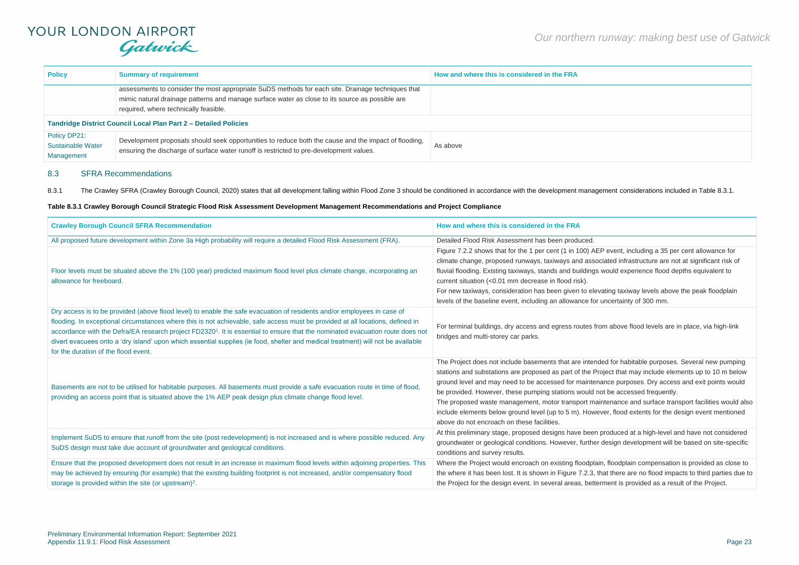
Preliminary Environmental Information Report: September 2021 Appendix 11.9.1: Flood Risk Assessment Page 23
Our northern runway: making best use of Gatwick
Policy Summary of requirement How and where this is considered in the FRA
assessments to consider the most appropriate SuDS methods for each site. Drainage techniques that
mimic natural drainage patterns and manage surface water as close to its source as possible are
required, where technically feasible.
Tandridge District Council Local Plan Part 2 – Detailed Policies
Policy DP21:
Sustainable Water
Management
Development proposals should seek opportunities to reduce both the cause and the impact of flooding,
ensuring the discharge of surface water runoff is restricted to pre-development values. As above
8.3 SFRA Recommendations
8.3.1 The Crawley SFRA (Crawley Borough Council, 2020) states that all development falling within Flood Zone 3 should be conditioned in accordance with the development management considerations included in Table 8.3.1.
Table 8.3.1 Crawley Borough Council Strategic Flood Risk Assessment Development Management Recommendations and Project Compliance
Crawley Borough Council SFRA Recommendation How and where this is considered in the FRA
All proposed future development within Zone 3a High probability will require a detailed Flood Risk Assessment (FRA). Detailed Flood Risk Assessment has been produced.
Floor levels must be situated above the 1% (100 year) predicted maximum flood level plus climate change, incorporating an
allowance for freeboard.
Figure 7.2.2 shows that for the 1 per cent (1 in 100) AEP event, including a 35 per cent allowance for
climate change, proposed runways, taxiways and associated infrastructure are not at significant risk of
fluvial flooding. Existing taxiways, stands and buildings would experience flood depths equivalent to
current situation (<0.01 mm decrease in flood risk).
For new taxiways, consideration has been given to elevating taxiway levels above the peak floodplain
levels of the baseline event, including an allowance for uncertainty of 300 mm.
Dry access is to be provided (above flood level) to enable the safe evacuation of residents and/or employees in case of
flooding. In exceptional circumstances where this is not achievable, safe access must be provided at all locations, defined in
accordance with the Defra/EA research project FD23201. It is essential to ensure that the nominated evacuation route does not
divert evacuees onto a ‘dry island’ upon which essential supplies (ie food, shelter and medical treatment) will not be available
for the duration of the flood event.
For terminal buildings, dry access and egress routes from above flood levels are in place, via high-link
bridges and multi-storey car parks.
Basements are not to be utilised for habitable purposes. All basements must provide a safe evacuation route in time of flood,
providing an access point that is situated above the 1% AEP peak design plus climate change flood level.
The Project does not include basements that are intended for habitable purposes. Several new pumping
stations and substations are proposed as part of the Project that may include elements up to 10 m below
ground level and may need to be accessed for maintenance purposes. Dry access and exit points would
be provided. However, these pumping stations would not be accessed frequently.
The proposed waste management, motor transport maintenance and surface transport facilities would also
include elements below ground level (up to 5 m). However, flood extents for the design event mentioned
above do not encroach on these facilities.
Implement SuDS to ensure that runoff from the site (post redevelopment) is not increased and is where possible reduced. Any
SuDS design must take due account of groundwater and geological conditions.
At this preliminary stage, proposed designs have been produced at a high-level and have not considered
groundwater or geological conditions. However, further design development will be based on site-specific
conditions and survey results.
Ensure that the proposed development does not result in an increase in maximum flood levels within adjoining properties. This
may be achieved by ensuring (for example) that the existing building footprint is not increased, and/or compensatory flood
storage is provided within the site (or upstream)2.
Where the Project would encroach on existing floodplain, floodplain compensation is provided as close to
the where it has been lost. It is shown in Figure 7.2.3, that there are no flood impacts to third parties due to
the Project for the design event. In several areas, betterment is provided as a result of the Project.
Preliminary Environmental Information Report: September 2021 Appendix 11.9.1: Flood Risk Assessment Page 24
Our northern runway: making best use of Gatwick
Crawley Borough Council SFRA Recommendation How and where this is considered in the FRA
A minimum 8 m buffer zone must be provided to ‘top of bank’ within sites immediately adjoining the main river corridor. This
requirement may be negotiated with the Environment Agency in heavily constrained locations.
This Project and its associated flood mitigation strategy propose works being undertaken within Main River
channels, including the realignment of the River Mole. Discussions with the Environment Agency will
continue throughout the EIA process to mitigate the impacts.
1 FD2320 “Flood Risk Assessment Guidance for New Development” (Defra/EA, 2005)
2 Compensatory flood storage should be located as close as practically possible to the proposed development.
9 Summary and Conclusions
9.1.1 This FRA represents Appendix 11.9.1 to the PEIR Chapter 11:
Water Environment and is a preliminary assessment of flood risk
for the Project. It also includes the assessment of potential flood
effects on external receptors due to the Project and describes the
flood mitigation strategy proposed as part of the Project to
mitigate these risks.
9.1.2 Fluvial flooding is the main source of flooding to the Project.
When determining the Project location, the adopted approach has
been to make best use of existing runways and airport
infrastructure. Therefore, the levels of flood risk are equivalent to
existing and it is anticipated that the Sequential Test (refer to
paragraphs 5.9.3 to 5.9.7) would be successfully passed.
9.1.3 Part of the proposed, as well as existing, taxiways fall within
Flood Zone 3. According to Table 5.9.1, the Exception Test would
have to be passed for these elements to be deemed suitable for
development in Flood Zone 3. Based on the provision of wider
sustainability benefits, the first part to the Exception Test would
be passed (refer to paragraphs 5.9.8 to 5.9.10).
9.1.4 Hydraulic modelling results show that the Project would also
increase the risk of flooding to other areas if no mitigation was in
place. Therefore, flood mitigation measures have been proposed,
mainly in the form of Flood Compensation Areas (FCAs). These
mitigation measures have been incorporated into the Gatwick
fluvial hydraulic model and it has been shown that the Project
would remain safe for its lifetime without increasing flood risk
elsewhere.
9.1.5 Surface water flooding is also a key source of flooding for the
Project. However, in most cases surface water flow paths and
ponding areas are small in extent and do not encroach on
proposed elements of the Project. The development of the
Project would introduce new impermeable areas and could also
increase surface water flooding if no mitigation was in place.
Therefore, a surface water management strategy has been
proposed and incorporated into the Gatwick surface water
hydraulic model in order to assess their effectiveness.
9.1.6 At this stage, the finished elevations of the development are not
finalised, and therefore it is not possible to develop a full post
development drainage model. A more detailed assessment will
be undertaken alongside detailed design. However, it has been
shown that the Project would decrease peak runoff rates offsite.
Change in flood risk to the Gatwick property itself will be re-
evaluated alongside detailed drainage design for the
development.
9.1.7 Therefore, it is considered that the Exception Test would
successfully be passed for the Project.
9.1.8 At this stage, it has not been possible to fully quantify
groundwater flood risk to the Project site; however, it is
considered that the current risk from groundwater flooding at the
airport site is low. Any groundwater flood risk that could occur
elsewhere due to the Project would be addressed by adopting
appropriate design practices. Overall, it is considered that the risk
from groundwater flooding would not be adversely affected by the
Project and risk from groundwater flooding would remain low.
9.1.9 The risk of flooding from other sources, including reservoirs,
water distribution infrastructure and sewers, is considered
medium to low. The reference to “medium” is because whilst
there is lack of recorded sewer/ water distribution infrastructure
flooding events and the Gatwick maintenance regime would be
expected mitigate any issues that could lead to flooding, there are
some known problems relating to flows backing up to the airport
from the Horley Thames Water network.
9.1.10 Overall, the Sequential and, where required, Exception Tests
have been applied to the Project. It has been shown that there
are no alternative sites for the Project which would have a lower
risk of flooding than the proposed location, that the development
would be safe for its lifetime and that, once further mitigation is
applied, there would be no increase in flood risk to third parties.
10 References
Legislation
Reservoirs Act, 1975
Published Documents
Airports Commission (2015) Airports Commission: Final Report,
July 2015. Available at:
https://assets.publishing.service.gov.uk/government/uploads/syst
em/uploads/attachment_data/file/440316/airports-commission-
final-report.pdf
British Geological Survey (n.d.) Groundwater Flooding
Susceptibility Areas and Groundwater Flooding Confidence Areas
mapping (Digital Data). Available at:
https://www.bgs.ac.uk/products/hydrogeology/groundwaterFloodi
ng.html
CIRIA C753 (2015) The SuDS Manual. Available at:
https://www.ciria.org/Memberships/The_SuDs_Manual_C753_Ch
apters.aspx
Crawley Borough Council (2020) Strategic Flood Risk
Assessment. Available at:
https://crawley.gov.uk/sites/default/files/2020-
09/Strategic%20Flood%20Risk%20Assessment.pdf
Crawley Borough Council (2015) Crawley 2030: Crawley Borough
Local Plan 2015-2030 Available at:
http://www.crawley.gov.uk/pw/Planning_and_Development/Planni
ng_Policy/Crawley2029/index.htm
Crawley Borough Council (2019) Draft Infrastructure Plan.
Available at: http://crawley.gov.uk/pw/index.htm
Crawley Borough Council (2021) Draft Crawley Borough Local
Plan 2021-2037. Available at:
https://crawley.gov.uk/sites/default/files/2021-
Preliminary Environmental Information Report: September 2021 Appendix 11.9.1: Flood Risk Assessment Page 25
Our northern runway: making best use of Gatwick
01/Submission%20Draft%20Local%20Plan%20January%202021
Defra/ EA (2005) Flood Risk Assessment Guidance for New
Development. Available at:
http://sciencesearch.defra.gov.uk/Default.aspx?Menu=Menu&Mo
dule=FJPProjectView&Location=None&ProjectID=12015
Department for Transport (2015) National Policy Statement for
National Networks. Available at:
https://www.gov.uk/government/publications/national-policy-
statement-for-national-networks
Department for Transport (2018) Airports National Policy
Statement: new runway capacity and infrastructure at airports in
the south-east of England. Available at:
https://www.gov.uk/government/publications/airports-national-
policy-statement
Environment Agency (2016) Flood risk assessments: climate
change allowances. Available from:
https://www.gov.uk/guidance/flood-risk-assessments-climate-
change-allowances
Environment Agency (n.d.) Flood map for planning. [Online]
Available at: https://flood-map-for-planning.service.gov.uk/
Environment Agency (n.d.) Long term flood risk map. [Online]
Available at: https://flood-warning-
information.service.gov.uk/long-term-flood-risk/map
Horsham District Council (2015) Horsham District Planning
Framework 2015. Available at:
https://beta.horsham.gov.uk/__data/assets/pdf_file/0016/60190/H
orsham-District-Planning-Framework-2015.pdf
Met Office, Department for Environment, Food and Rural Affairs
(Defra), Department for Business, Energy and Industrial Strategy
(BEIS) and Environment Agency (2009) UK Climate Projections
2009/ Available
at:https://www.metoffice.gov.uk/research/approach/collaboration/
ukcp/ukcp09-users
McMillan D (2014) Disruption at Gatwick Airport. Report to the
Board of Gatwick Airport Limited. Available at:
https://www.gatwickairport.com/globalassets/publicationfiles/busi
ness_and_community/all_public_publications/2014/mcmillan_rep
ort_feb14.pdf
Ministry of Housing, Communities and Local Government (2021)
National Planning Policy Framework (NPPF), HMSO. Available
at: https://www.gov.uk/government/publications/national-
planning-policy-framework--2
Ministry of Housing, Communities and Local Government (2019)
National Planning Practice Guidance (NPPG). Available at:
https://assets.publishing.service.gov.uk/government/uploads/syst
em/uploads/attachment_data/file/1005759/NPPF_July_2021.pdf
Reigate and Banstead Borough Council (2005) Reigate and
Banstead Borough Local Plan 2005. Available at:
http://www.reigate-
banstead.gov.uk/downloads/file/4120/reigate_and_banstead_bor
ough_local_plan_2005
Reigate and Banstead Borough Council (2019) Reigate and
Banstead Borough Development Management Plan. Available at:
http://www.reigate-
banstead.gov.uk/info/20380/current_planning_policy/888/develop
ment_management_plan
Reigate and Banstead Borough Council, Mole Valley District
Council and Tandridge District Council (2017) Level 1 Strategic
Flood Risk Assessment. Available at:
https://www.molevalley.gov.uk/media/pdf/o/f/2017s5672_-
_Three_Authorities_Level_1_SFRA_v5.0.pdf
Tandridge District Council (2015) Tandridge Local Plan Part 2 –
Detailed Policies. Available at:
https://www.tandridge.gov.uk/Portals/0/Documents/Planning%20
and%20building/Planning%20strategies%20and%20policies/Curr
ent%20and%20adopted%20planning%20policies/Core%20strate
gy/Local-Plan-part-2-Detailed-policies.pdf
West Sussex County Council (2013) West Sussex Local Flood
Risk Management Strategy. Available at:
https://www.westsussex.gov.uk/media/1596/west_sussex_lfrms_
strategic_environmental_assessment_final.pdf
11 Glossary
11.1 Glossary of Terms
Table 11.1.1: Glossary of Terms and List of Acronyms
Term Description
AEP
Annual Exceedance Probability, eg 1 per cent
AEP is equivalent to 1 in 100 probability of
flooding occurring in any one year (or, on
average, once in every 100 years).
AOD Above Ordnance Datum
BGS British Geological Survey
BOD Biochemical Oxygen Demand
Defra
Department for Environment, Food and Rural
Affairs. The government department
responsible for environmental protection, food
production and standards, agriculture, fisheries
and rural communities in the UK. Among its
responsibilities, Defra publishes guidance on,
for example, flood modelling approaches and
approaches to accounting for climate change in
flood studies.
Development
The carrying out of building, engineering, mining
or other operations, in, on, over or under land,
or the making of any material change in the use
of a building or other land.
DCO Development Consent Oder
Environment Agency
(EA)
The Environment Agency is a non-departmental
public body, established in 1995 and sponsored
by DEFRA. Its responsibilities relate to the
protection and enhancement of the environment
in England. Environment Agency
EIA Environmental Impact Assessment
ES Environmental Statement
Exception Test
The Exception Test should be applied if,
following application of the Sequential Test, it is
not possible for the development to be located
in Flood Zones with a lower probability of
flooding. For the Exception Test to be passed it
must be demonstrated that:
Preliminary Environmental Information Report: September 2021 Appendix 11.9.1: Flood Risk Assessment Page 26
Our northern runway: making best use of Gatwick
Term Description
▪ The development provides wider
sustainability benefits to the community that
outweigh flood risk; and
▪ That the development will be safe for its
lifetime taking account of the vulnerability of
its users, without increasing flood risk
elsewhere, and, where possible will reduce
flood risk overall.
FWMA Flood & Water Management Act.
Part of the UK Government response to Sir
Michael Pitt's Review on the Summer 2007
floods, the aim of which (partly) is to clarify the
legislative framework for managing surface
water flood risk in England.
FCA Flood Compensation Area.
Land which provides a volume of floodplain that
compensates for the loss of floodplain
elsewhere, where practicable to an equal
volume as that lost and on a level-to-level basis.
Flood Map for
Planning (Rivers and
Sea)
Nationally consistent delineation of ‘high’,
‘medium’ and ‘low’ probability of fluvial and tidal
flooding, published on a quarterly basis by the
Environment Agency.
Flood Zone 1 Low
Probability (FZ1)
NPPG Flood Zone, defined as areas outside
Zone 2 Medium Probability. This zone
comprises land assessed as having a less than
1 in 1,000 annual exceedance probability of
river or sea flooding (<0.1 per cent) in any year.
Flood Zone 2 Medium
Probability (FZ2)
NPPG Flood Zone which comprises land
assessed as having between a 1 in 100 and 1 in
1,000 annual exceedance probability of river
flooding (1 per cent – 0.1 per cent) or between a
1 in 200 and 1 in 1,000 annual exceedance
probability of sea flooding (0.5 per cent - 0.1 per
cent) in any year.
Flood Zone 3a High
Probability (FZ3a)
NPPG Flood Zone which comprises land
assessed as having a 1 in 100 or greater annual
exceedance probability of river flooding (>1 per
cent) or a 1 in 200 or greater annual
exceedance probability of sea flooding (>0.5 per
cent) in any year.
FMP Flood Management Plan
Term Description
FRA Flood Risk Assessment.
A site-specific assessment of flood risk. This is
a statutory report for submission with planning
applications in England.
Functional Floodplain
(Flood Zone 3b)
(FZ3b)
NPPG Flood Zone, defined as areas in which
water has to flow or be stored in times of flood.
GAL Gatwick Airport Limited
Groundwater
Flooding
Emergence of groundwater at the ground
surface or the rising of groundwater into
underground infrastructure (such as basements)
under conditions where the normal range of
groundwater level and flows is exceeded.
LLFA Lead Local Flood Authority.
Unitary Authorities or County Councils
responsible for developing, maintaining and
applying a strategy for local flood risk
management in their areas and for maintaining
a register of flood risk assets. Also, responsible
for managing local flood risk (flooding from
surface water, groundwater and ordinary
watercourses).
LFRMS Local Flood Risk Management Strategy.
LLFAs produce Local Flood Risk Management
Strategies as part of their duty to manage local
flood risk under the Flood and Water
Management Act 2010.
LPA Local Planning Authority.
A local planning authority is the local authority
or council that is empowered by law to exercise
statutory town planning functions for a particular
area of the UK.
Main River A watercourse shown as such on the Main
River Map, and for which the Environment
Agency has responsibilities and powers. N.B.
Main River designation is not necessarily an
indication of size, although it is often the case
that they are larger than Ordinary
Watercourses.
NPPF National Planning Policy Framework.
Term Description
National planning policy published by the
Government, most recently in July 2021. It
replaces most of the previous Planning Policy
Statements, including that regarding flood risk
(PPS25).
NPPG National Planning Practice Guidance.
Supporting guidance to the NPPF, published by
the Government in March 2014 and updated
since as an online resource, available at:
(http://planningguidance.planningportal.gov.uk/).
It replaces previously published Government
guidance, including that regarding flood risk.
NPS National Policy Statement
Ordinary Watercourse All watercourses that are not designated Main
Rivers, and which are the responsibility of Local
Authorities or, where they exist, Internal
Drainage Boards. Note that Ordinary
Watercourse does not imply a “small” river,
although it is often the case that Ordinary
Watercourses are smaller than Main Rivers.
PEIR Preliminary Environmental Investigation Report
RBD River Basin District
Residual Risk A measure of the outstanding flood risks and
uncertainties that have not been explicitly
quantified and/or accounted for as part of the
design process.
RoFSW Risk of Flooding from Surface Water
RTD River Terrance Deposits
Sequential Test A national planning policy requirement that
seeks to steer new development to areas with
the lowest probability of flooding. In
demonstrating that the requirements of the
sequential test have been met, proposals
should refer to the NPPF and Planning
Practice Guidance, and the Environment
Agency Flood Zones.
SFRA Strategic Flood Risk Assessment.
There are two levels of SFRA. All local planning
authorities need to carry out a Level 1
assessment at least and it may be necessary to
expand the scope of this assessment to a more

Preliminary Environmental Information Report: September 2021 Appendix 11.9.1: Flood Risk Assessment Page 27
Our northern runway: making best use of Gatwick
Term Description
detailed Level 2 assessment. A Level 1 SFRA
should provide sufficient detail to apply the
Sequential Test. A Level 2 SFRA should build
on the information in the Level 1 assessment
and include sufficient information for the
Exception Test to be applied. Where a Level 2
SFRA is produced, the Sequential Test should
also be applied to identify sites with the lowest
risk of flooding within Flood Zones 2 and 3.
STW Sewage (waste/foul water) treatment works
SuDS Sustainable Drainage System.
Term covering the whole range of sustainable
approaches to surface drainage management.
These are designed to control surface water
runoff close to where it falls and mimic natural
drainage as closely as possible.

Preliminary Environmental Information Report: September 2021 Appendix 11.9.1: Flood Risk Assessment Annex 1
Our northern runway: making best use of Gatwick
Annex 1
Fluvial Mitigation Measures Indicative Designs

Preliminary Environmental Information Report: September 2021 Appendix 11.9.1: Flood Risk Assessment Annex 1
Our northern runway: making best use of Gatwick
Preliminary Environmental Information Report: September 2021 Appendix 11.9.1: Flood Risk Assessment Annex 1
Our northern runway: making best use of Gatwick
Preliminary Environmental Information Report: September 2021 Appendix 11.9.1: Flood Risk Assessment Annex 1
Our northern runway: making best use of Gatwick
Preliminary Environmental Information Report: September 2021 Appendix 11.9.1: Flood Risk Assessment Annex 1
Our northern runway: making best use of Gatwick

Preliminary Environmental Information Report: September 2021 Appendix 11.9.1: Flood Risk Assessment Annex 2
Our northern runway: making best use of Gatwick
Annex 2
Surface Access Drainage Summary
Preliminary Environmental Information Report: September 2021 Appendix 11.9.1: Flood Risk Assessment Annex 2
Our northern runway: making best use of Gatwick
Introduction
11.1.1 The project at Gatwick Airport to make the best use of their
runways (‘the Project’) incorporates improvements to surface
access that are planned to manage the expected increase in
passenger numbers and associated movements in and out of the
airport. These improvements are planned to be constructed
between 2029 and 2032.
11.1.2 The improvements to surface access incorporate three elements:
▪ South Terminal Roundabout Improvements (constructed
between 2029-2030)
▪ North Terminal Roundabout Improvements (2029-2032)
▪ Works to Longbridge Roundabout (2030-2032)
11.1.3 The surface access improvements do include encroachment into
the River Mole and Gatwick Stream floodplains that are mitigated
via the provision of compensatory floodplain storage as part of
the Project. These measures would be installed in advance of
any encroachment as part of the surface access works. Further
information on this element is included in the main body of the
Flood Risk Assessment.
Existing Drainage
South Terminal Roundabout
11.1.4 The southern terminal roundabout has three arms, M23
motorway (on the east), Airport Way (on the west) and Airport
Ring Road (on the south). Highways England are the highway
authority.
11.1.5 Information is available for the existing highway drainage in
Highways England’s asset records (HADDMS) (see Figure 11-1).
The existing surface runoff is mainly collected by kerb and gully
system and combined kerb drainage (CKD) as visible in aerial
photography and outlined in HADDMS.
11.1.6 The existing highway east of the B2036 Balcombe Road
overbridge outfalls to a tributary of the Burstow Stream via an
attenuation pond (Pond 8-5 in Figure 11-1) on the north side of
the M23 Spur approximately 950 metres to the east of the
roundabout.
11.1.7 Aside from one gully at the overbridge, there are no connections
from the motorway drainage to the Burstow Stream tributary.
11.1.8 The roads west of the B2036 Balcombe Road overbridge outfall
to the Gatwick Stream approximately 600 metres west of the
existing roundabout. Based on available records this is via a
675 metre diameter surface water pipe that starts on the north
side of the M23 Spur immediately east of the existing roundabout,
crosses the Spur from north to south, and then elbows east
around the south side of the roundabout and then under the
Airport ring road. It then runs from east to west parallel to the A23
Airport Way along the south side and crosses under the railway
line and outfalls to the Gatwick Stream. Available as built record
drawings indicate that this pipe may be a Public Sewer, however
this is not yet confirmed. The Sewerage Undertaker in this area is
Thames Water.
11.1.9 The record drawings for the original road construction (dated
1972) also indicate provision for connection from an attenuation
basin for “BAA” immediately to the east of the railway line. There
is now a large pond (Pond F) at this location, so it reasonable to
assume that this is a facility serving the airport and does not fulfil
an attenuation function for the highway drainage systems.
North Terminal Roundabout
11.1.10 Limited information is available for the existing highway drainage
(0-20% in HADDMS), see Figure 11-2. The gullies appear to
outfall to existing ditches for the slip roads connecting the north
terminal roundabout to A23 London road. The ditches appear to
fall towards the River Mole. Therefore, existing drainage
assumed to discharge to River Mole (section possibly discharges
through Gatwick Stream). The proposed drainage is also
proposed to outfall to same watercourse as existing site.
Longbridge Roundabout
11.1.11 The existing roundabout and road levels are approximately 57 to
56 mAOD. The roads appear to fall away from the roundabout.
The existing level of the watercourse passing underneath the
bridge on Brighton Road is approximately 52 mAOD.
11.1.12 There is very limited available information on the highway
drainage at this stage. The highway authority responsible for
maintaining the existing highway drainage systems is West
Sussex County Council for the A23 and Surrey County Council
for the Longbridge roundabout and the other three associated
roads, ie Brighton Road, A217 and Povey Cross Road.
11.1.13 The runoff for the central island and the south and western side
of the existing junction is collected by kerb and gully systems.
The eastern limbs are served by CKD. The dedicated slip lane on
the eastern side of the junction is an underbridge with a parapet.
This slip lane is served by iron shallow bridgedeck type units
(Figure 11-3).
11.1.14 The site is bounded on the east side by the River Mole which
passes underneath a bridge on Brighton Road (see Figure 11-3).
It is assumed that the runoff from the roundabout, Brighton Road
and A23 south approach outfall to the River Mole to the east and
south east.
Surface Access Improvement Works
11.1.15 Full details of the surface access improvements are included in
Chapter 5 of the PEIR: Project Description.
South Terminal Roundabout Improvements
11.1.16 The proposed improvements to the south terminal roundabout will
incorporate a flyover which would carry the M23 Spur
Motorway/Airport Way over the existing roundabout. Access to
the terminal, car parking and hotels/offices would be maintained
as existing whilst four slip roads would be provided to link the
existing roundabout circulatory to the elevated section. The
existing drainage culvert under the M23 Spur Road will be
extended to accommodate the new slip roads.
North Terminal Roundabout Improvements
11.1.17 In order to provide for the predicted growth in passengers
associated with the Project, a grade-separated junction design is
required. The outline concept for this junction is to replace the
existing roundabout with a signalised junction arrangement. This
would provide extra capacity for movements to and from the
airport and would separate airport and non-airport traffic,
reducing conflict in peak periods, thereby reducing congestion.
As part of this solution, an elevated flyover would be built to carry
traffic between Airport Way (from South Terminal and the M23)
and the A23 towards Horley. Additional improvements would be
made to Gatwick Way to accommodate an increase in traffic flow
towards Northgate Road.
11.1.18 The flyover structure is anticipated to require three separate
spans to cross at-grade carriageways and is expected to
comprise a typical steel beam superstructure with a concrete slab
deck on concrete abutments and piers, with piled foundations.
The overall structure would be approximately 200 metres long.
Retaining walls would be required to separate adjacent links at
different levels or gradients.
Preliminary Environmental Information Report: September 2021 Appendix 11.9.1: Flood Risk Assessment Annex 2
Our northern runway: making best use of Gatwick
Works to Longbridge Roundabout
11.1.19 The Longbridge junction is an existing signalised roundabout to
the north of Gatwick Airport and becomes congested at peak
times. Increases in traffic associated with future growth of the
airport would further increase congestion and delays at the
junction.
11.1.20 To increase capacity at the Longbridge roundabout and future
proof the junction for further growth an enlarged signalised
roundabout layout has been progressed that would widen the ICD
and central island of the roundabout, providing wider circulatory
lane widths and improved deflection to facilitate increased traffic
demand and accommodate turning movements of HGV’s.
Additionally, increased stacking capacity has been applied to the
arms of the junction.
Drainage Design Proposals
Calculation of Greenfield Runoff Rate
11.1.21 The control of runoff from sites is prescribed in the joint Defra and
Environment Agency Flood and Coastal Erosion Risk
Management R&D Programme document: Rainfall runoff
management for developments Report –SC030219. The Institute
of Hydrology IH124 (Institute of Hydrology, Report 124, Flood
Estimation for Small Catchments, 1994) method has been
adopted to estimate greenfield runoff). The results of this
calculation have been checked against the ‘greenfield runoff
estimation for sites’ online tool found at www.uksuds.com. The
key parameters are summarised in Table 11.1.2.
Table 11.1.2: Calculation of Greenfield Runoff
Catchment NT ST LB
Hydrological Region 6
Soil Type (S) 4 – Heavy Clay
Annual Rainfall (SAAR) (mm) 760 760 754
Soil Runoff Coefficient (SPR) 0.47
Mean annual peak flow per unit area
(QBar/A) (l/s/ha) 5.3
QBar/A x 0.85 1 year (l/s/ha) 4.52 4.06
QBar/A x 2.3 30 year (l/s/ha) 12.23 12.08
QBar/A x 3.19 100 year (l/s/ha) 16.96 16.75
Allowance for Climate Change
11.1.22 In accordance with Environment Agency requirements the
volume of attenuation storage required to achieve greenfield
runoff rates has been sized to accommodate the 1 per cent AEP
event plus a 40 per cent increase in rainfall intensity to
accommodate the predicted impact of climate change.
South Terminal Roundabout - East
11.1.23 It is assumed that the Project would maintain the existing outfalls
and principal catchment areas. Consequently areas east and
west of the Balcombe Road overbridge would continue to be
treated as separate sub catchments.
11.1.24 The existing outfall to the watercourse next to pond no 8-5 would
be maintained. The additional paved area drained by the Project
would be 0.5ha which would require an estimated attenuation
volume of 500m3 to achieve a greenfield runoff rate.
11.1.25 It is assumed that any attenuation storage would be provided
within the pipe network near the connection to existing systems
and upstream of the existing pond. The current assumption is that
the storage would be provided in the form of tank sewers within
the road cross-section (see image below). Alternatively, off-line
geocellular storage outside the carriageway can be proposed if
land is available. It is estimated that a box culvert of 2m x 2m;
125m long would be required.
11.1.26 There would be opportunities to modify the existing basin to
remove the need for this storage. For example, it could be
possible to replace the existing control which is thought to be a
pipe or orifice plate (150mm diameter or less) with a proprietary
device such as a Hydrobrake that would provide more efficient
usage of the existing storage volume in the pond. This may
enable the surface water management requirements of the LLFA
to be met without the need for new storage infrastructure in the
upstream network.
South Terminal Roundabout - West
11.1.27 The existing outfall to Gatwick Stream via the Public Sewer would
be maintained. The additional paved area drained would be
2.16ha requiring an estimated storage volume of 2,200m3 to
achieve greenfield runoff rates.
11.1.28 The surface water collection systems from the highway would be
discharged to a perimeter drainage ditch to the north of the
proposed road embankment.
11.1.29 This ditch would have a conveyance function but may be
enlarged to serve a storage function. At this stage, the storage
volume within the ditch has been discounted for the purposes of
these calculations. The ditch will convey the runoff into a new
attenuation pond (with 2,200m3 attenuation capacity) adjacent to
Balcombe Road. The attenuation pond will possess a flow control
on its outfall to limit the discharge flows to the 1-year greenfield
runoff rate of 9.76l/s. The outfall pipe will connect to the existing
Public Sewer at the north side of the roundabout.
North Terminal Roundabout
11.1.30 The drainage proposals at North Terminal roundabout will drain
the combined existing and proposed highways layout of 4.39ha to
greenfield rates to the Gatwick Stream and River Mole. The
layout will consist of four separate catchments each with their
own attenuation storage (tanks or ponds) as indicated in Figure
11-5. The estimated attenuation storage volumes required are
summarised in Table 11.1.3.
Table 11.1.3: North Terminal Roundabout Catchment Characteristics and Attenuation Volumes
Catchment 1 2 3 4
Area (ha) 0.56 2.09 1.23 0.53
1yr Storm Peak Outflow Rate (l/s) 2.53 9.44 5.56 2.39
Minimum Attenuation Volume
Required (m3) 404 1505 882 381
Maximum Attenuation Volume
Required (m3) 564 2103 1234 532
Adopted Attenuation Volume
Required (m3) 600 2100 1300 600
Longbridge Roundabout
11.1.31 The surface area of the proposed upgraded Longbridge
Roundabout is estimated to be 15,200m2 (1.52 hectares) that
includes an increase in impermeable area of 1,800m2 (0.18
hectares) compared with the current layout. The preferred
solution is for all storm water runoff to be collected for all
proposed works (1.520ha) discharged at greenfield runoff rate to
the River Mole. The discharge rate will be 6.78l/s being the 1-
year greenfield run off rate for a 1.520ha site that would require a
volume of attenuation of between 1,096m3 and 1,531m3
attenuation – for the purposes of high-level design this has been
assumed as 1,600m3 including the allowance for climate change.
Preliminary Environmental Information Report: September 2021 Appendix 11.9.1: Flood Risk Assessment Annex 2
Our northern runway: making best use of Gatwick
11.1.32 Four catchments are proposed at Longbridge roundabout, each
with a separate outfall and avoiding new cross-drains under live
carriageways, as shown in Figure 11-6. The characteristics and
the estimated attenuation volumes including climate change
required to achieve greenfield runoff rates are included in Table
11.1.4.
Table 11.1.4: Longbridge Roundabout Drainage Catchment Characteristics and Attenuation Volumes
Catchment 1 2 3 4
Area (ha) 0.29 0.76 0.23 0.25
1yr Storm Peak Outflow Rate (l/s) 2.00 3.39 2.00 2.00
Minimum Attenuation Volume
Required (m3) 184 584 136 151
Maximum Attenuation Volume
Required (m3) 261 766 194 215
Adopted Attenuation Volume
Required (m3) 300 800 200 200
11.1.33 The estimated storage volumes required will be provided by two
new attenuation ponds to the north of the roundabout that would
outfall to the River Mole and two attenuation tanks that would
drain to existing ditches that are assumed to receive existing
highways runoff.
Conclusions
11.1.34 The surface access works to be undertaken as part of the Project
would require an increase in impermeable area to accommodate
the expected increase in passenger numbers and associated
movements in and out of the airport. Surface access
improvement works will be required at three locations:
▪ South Terminal Roundabout
▪ North Terminal Roundabout
▪ Longbridge Roundabout
11.1.35 The additional runoff that would result from the increased
impermeable areas would be stored in new facilities and
attenuated to achieve greenfield runoff rates. The storage
facilities have been sized to accommodate the 1 per cent AEP
event plus an allowance for climate change of +40 per cent in
accordance with Environment Agency requirements.
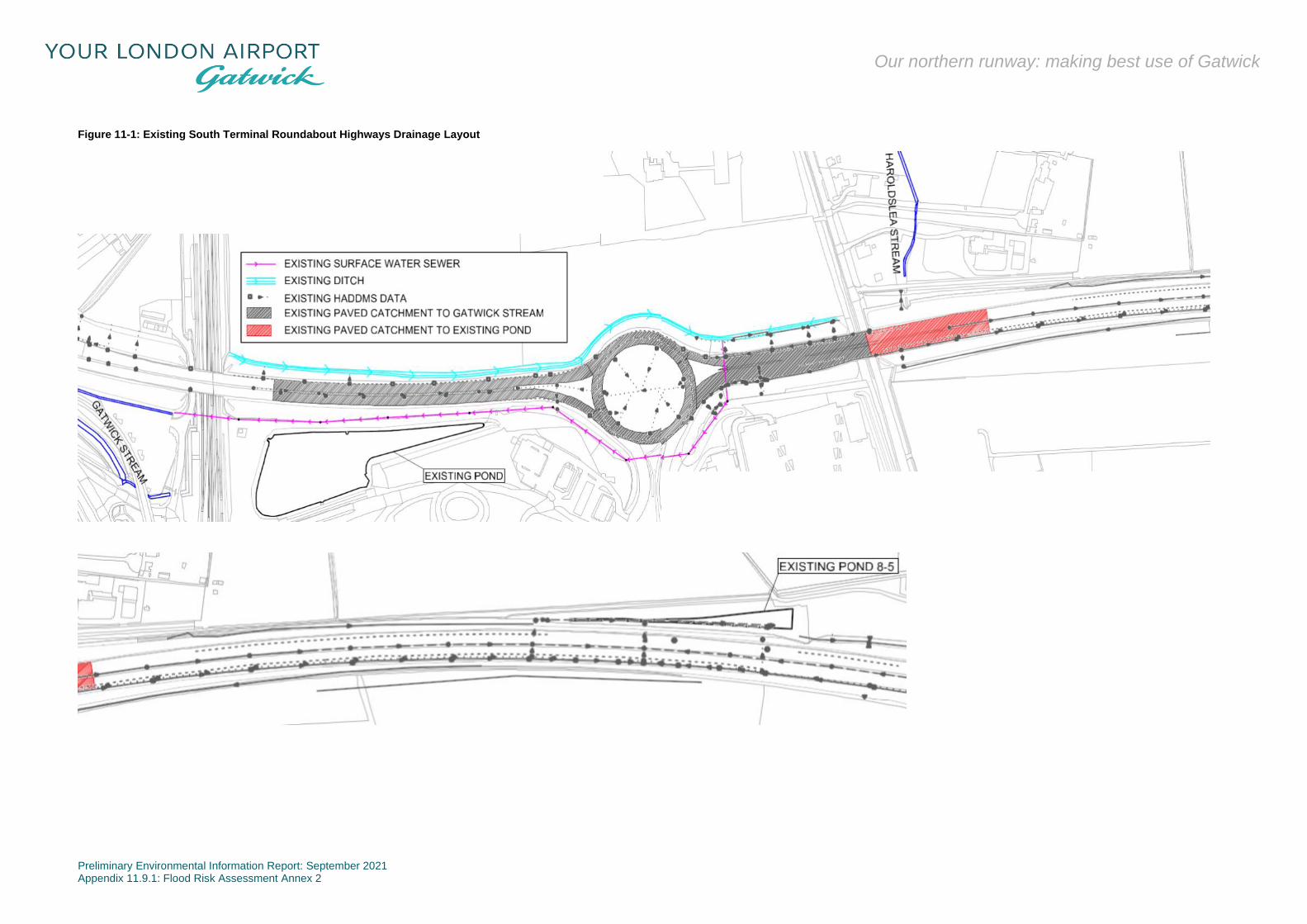
Preliminary Environmental Information Report: September 2021 Appendix 11.9.1: Flood Risk Assessment Annex 2
Our northern runway: making best use of Gatwick
Figure 11-1: Existing South Terminal Roundabout Highways Drainage Layout
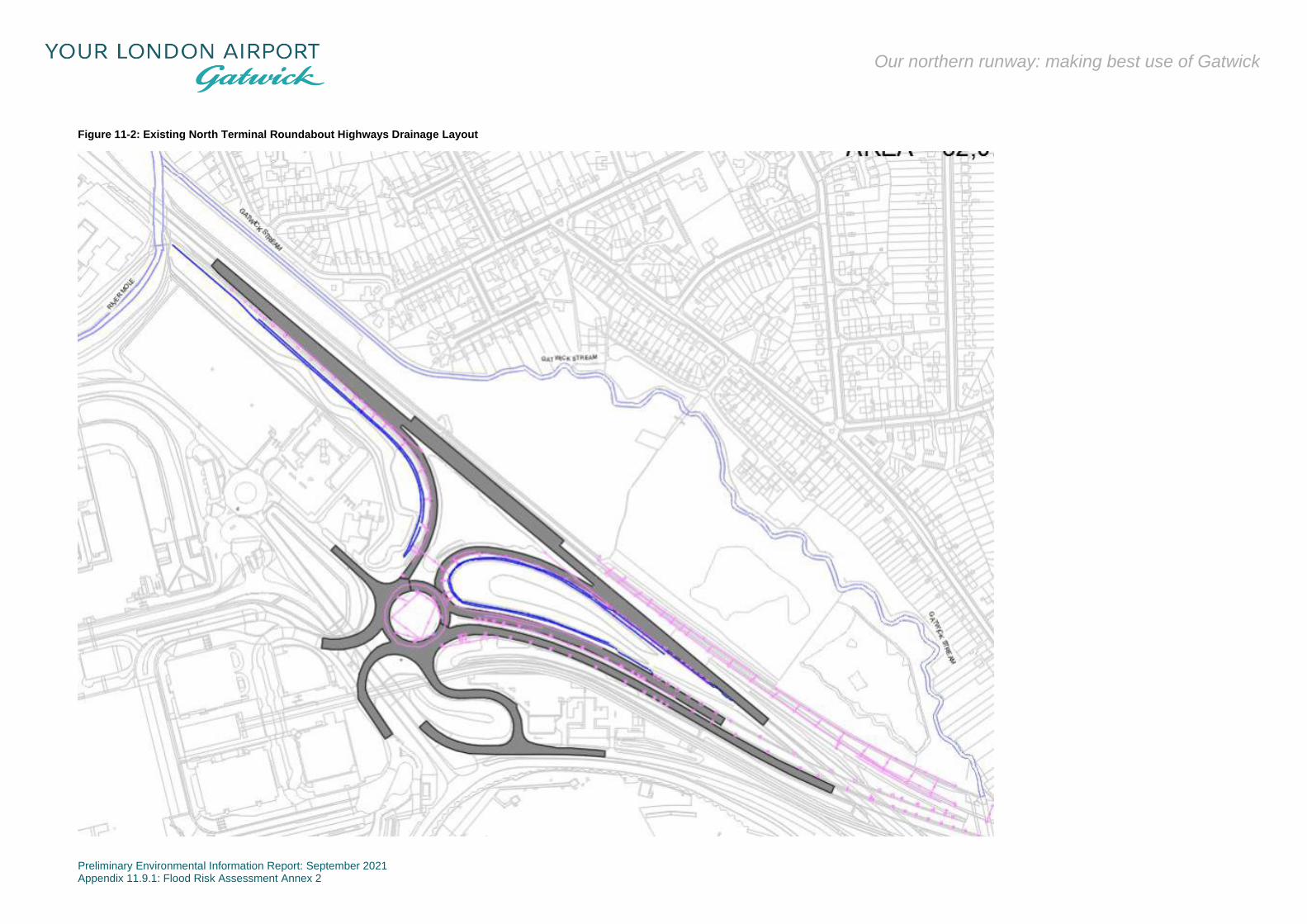
Preliminary Environmental Information Report: September 2021 Appendix 11.9.1: Flood Risk Assessment Annex 2
Our northern runway: making best use of Gatwick
Figure 11-2: Existing North Terminal Roundabout Highways Drainage Layout
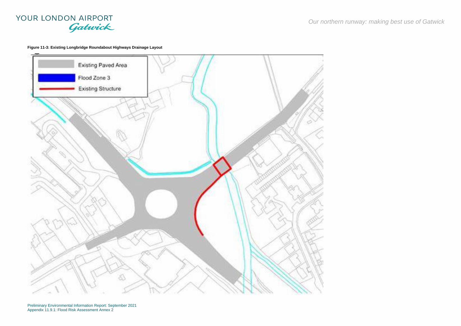
Preliminary Environmental Information Report: September 2021 Appendix 11.9.1: Flood Risk Assessment Annex 2
Our northern runway: making best use of Gatwick
Figure 11-3: Existing Longbridge Roundabout Highways Drainage Layout

Preliminary Environmental Information Report: September 2021 Appendix 11.9.1: Flood Risk Assessment Annex 2
Our northern runway: making best use of Gatwick
Figure 11-4: Indicative Proposed South Terminal Roundabout Drainage Layout
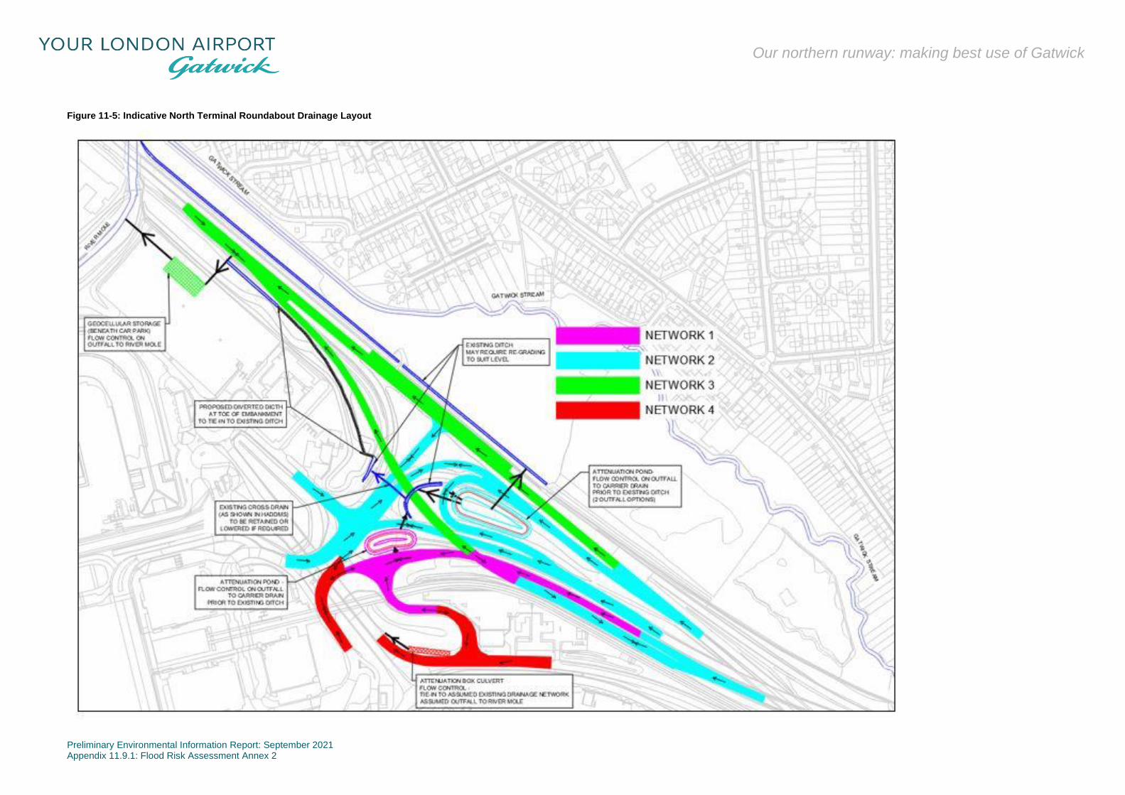
Preliminary Environmental Information Report: September 2021 Appendix 11.9.1: Flood Risk Assessment Annex 2
Our northern runway: making best use of Gatwick
Figure 11-5: Indicative North Terminal Roundabout Drainage Layout
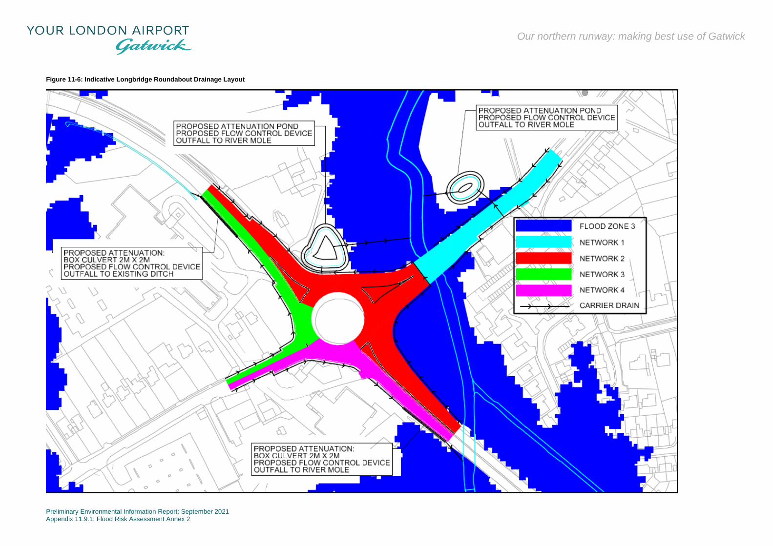
Preliminary Environmental Information Report: September 2021 Appendix 11.9.1: Flood Risk Assessment Annex 2
Our northern runway: making best use of Gatwick
Figure 11-6: Indicative Longbridge Roundabout Drainage Layout


