Green Infrastructure Action Plan for Hamilton Township, Atlantic County, New Jersey Prepared for Hamilton Township by the Rutgers Cooperative Extension Water Resources Program April 19, 2021
Transcript
Green Infrastructure Action Plan for
Hamilton Township, Atlantic County, New Jersey
Prepared for Hamilton Township by the Rutgers Cooperative Extension Water Resources Program
April 19, 2021
ACKNOWLEDGEMENTS:
This document has been prepared by the Rutgers Cooperative Extension Water Resources Program, with funding and direction from The Sustainable Township of Hamilton Green Team and the New Jersey Agricultural Experiment Station, to highlight green infrastructure opportunities within Hamilton Township. We would like to thank The Sustainable Township of Hamilton Green Team, the New Jersey Agricultural Experiment Station, and Hamilton Township for their input and support in creating this document.
Appendix A: Climate Resilient Green Infrastructure
a. Green Infrastructure Sites
b. Proposed Green Infrastructure Concepts
c. Summary of Existing Conditions
d. Summary of Proposed Green Infrastructure Practices
1
Introduction
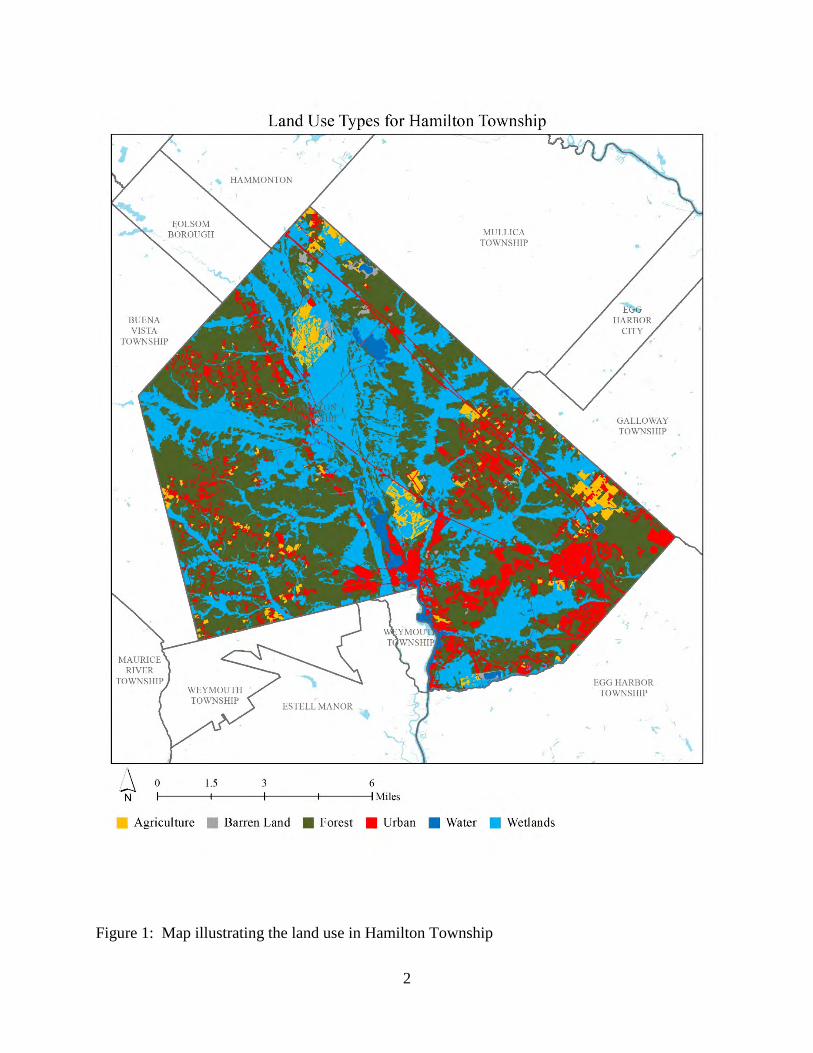
Located in Atlantic County, New Jersey, Hamilton Township covers approximately 113 square
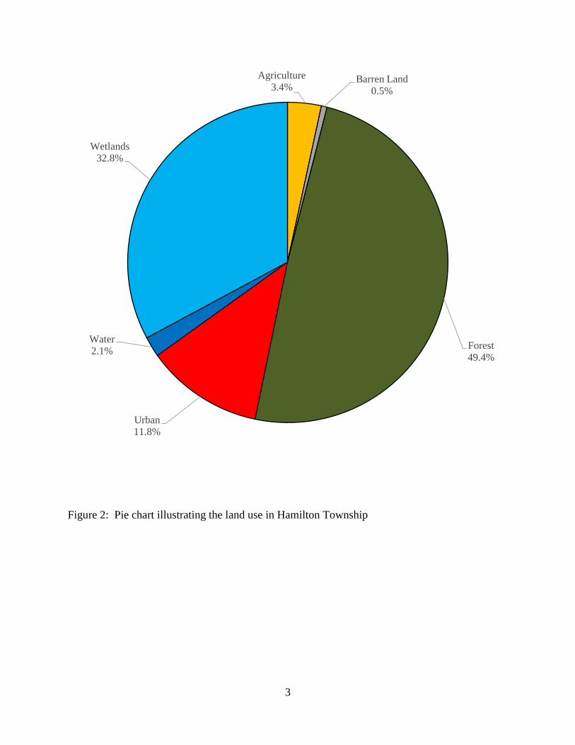
miles. Figures 1 and 2 illustrate that Hamilton Township is dominated by forest land use. A total
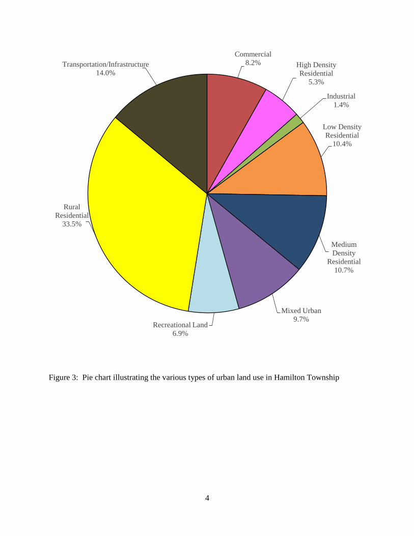
of 11.8% of the municipality’s land use is classified as urban. Of the urban land in Hamilton
Township, rural residential is the dominant land use (Figure 3).
The New Jersey Department of Environmental Protection’s (NJDEP) 2015 land use/land cover
geographical information system (GIS) data layer categorizes Hamilton Township into many
unique land use areas, assigning a percent impervious cover for each delineated area. These
impervious cover values were used to estimate the impervious coverage for Hamilton Township.
Based upon the 2015 NJDEP land use/land cover data, approximately 5.2% of Hamilton Township
has impervious cover. This level of impervious cover suggests that the streams in Hamilton
Township are likely sensitive streams. 1
Methodology
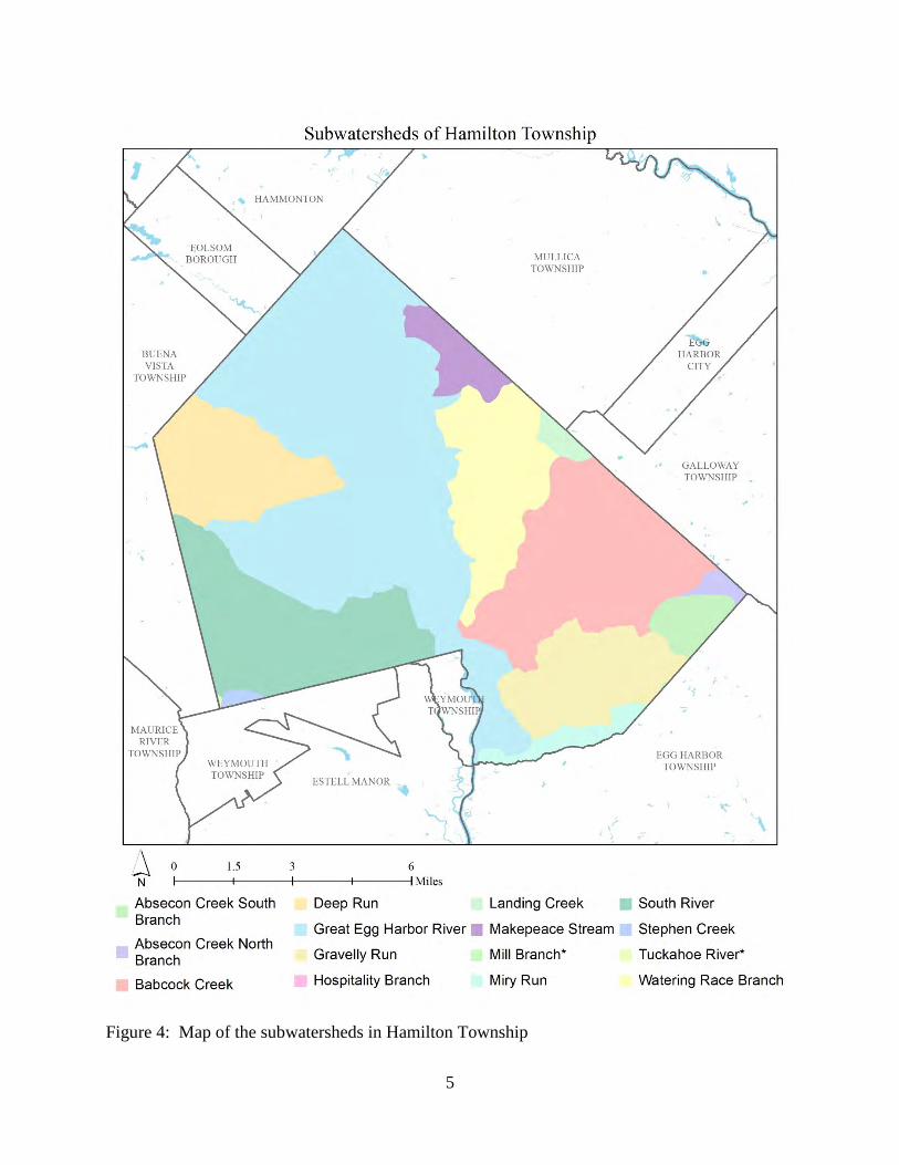
Hamilton Township contains portions of 15 subwatersheds (Figure 4). For this green infrastructure
action plan, projects have been identified in four of these subwatersheds. Initially, aerial imagery
was used to identify potential project sites that contain extensive impervious cover. Field visits
were then conducted at each of these potential project sites to determine if a viable option exists
to reduce impervious cover or to disconnect impervious surfaces from draining directly to the local
waterway or storm sewer system. During the site visit, appropriate green infrastructure practices
for the site were determined. Sites that already had stormwater management practices in place
were not considered.
1 Schuler, T.R., L. Fraley-McNeal, and K. Cappiella. 2009. Is Impervious Cover Still Important? Review of Recent Research. Journal of Hydrologic Engineering 14 (4): 309-315.
2
Figure 1: Map illustrating the land use in Hamilton Township
3
Figure 2: Pie chart illustrating the land use in Hamilton Township
Agriculture3.4%
Barren Land0.5%
Forest49.4%
Urban11.8%
Water2.1%
Wetlands32.8%
4
Figure 3: Pie chart illustrating the various types of urban land use in Hamilton Township
Commercial8.2% High Density
Residential5.3%
Industrial1.4%
Low Density Residential
10.4%
Medium Density
Residential10.7%
Mixed Urban9.7%
Recreational Land6.9%
Rural Residential
33.5%
Transportation/Infrastructure14.0%
5
Figure 4: Map of the subwatersheds in Hamilton Township
6
For each potential project site, specific aerial loading coefficients for commercial land use were
used to determine the annual runoff loads for total phosphorus (TP), total nitrogen (TN), and total
suspended solids (TSS) from impervious surfaces (Table 1). These are the same aerial loading
coefficients that NJDEP uses in developing total maximum daily loads (TMDLs) for impaired
waterways of the state. The percentage of impervious cover for each site was extracted from the
2015 NJDEP land use/land cover database. For impervious areas, runoff volumes were determined
for the water quality design storm (1.25 inches of rain over two hours) and for the annual rainfall
total of 44 inches.
Preliminary soil assessments were conducted for each potential project site identified in Hamilton
Township using the United States Department of Agriculture Natural Resources Conservation
Service Web Soil Survey, which utilizes regional and statewide soil data to predict soil types in an
area. Several key soil parameters were examined (e.g., natural drainage class, saturated hydraulic
conductivity of the most limiting soil layer (Ksat), depth to water table, and hydrologic soil group)
to evaluate the suitability of each site’s soil for green infrastructure practices. In cases where
multiple soil types were encountered, the key soil parameters were examined for each soil type
expected at a site.
For each potential project site, drainage areas were determined for each of the green infrastructure
practices proposed at the site. These green infrastructure practices were designed to manage the
2-year design storm, enabling these practices to capture 95% of the annual rainfall. Runoff
volumes were calculated for each proposed green infrastructure practice. The reduction in TSS
loading was calculated for each drainage area for each proposed green infrastructure practice using
the aerial loading coefficients in Table 1. The maximum volume reduction in stormwater runoff
for each green infrastructure practice for a storm was determined by calculating the volume of
runoff captured from the 2-year design storm. For each green infrastructure practice, peak
discharge reduction potential was determined through hydrologic modeling in HydroCAD. For
each green infrastructure practice, a cost estimate is provided. These costs are based upon the
square footage of the green infrastructure practice and the real cost of green infrastructure practice
implementation in New Jersey.
7
Table 1: Aerial Loading Coefficients2
Land Cover TP load (lbs/acre/yr)
TN load (lbs/acre/yr)
TSS load (lbs/acre/yr)
High, Medium Density Residential 1.4 15 140
Low Density, Rural Residential 0.6 5 100
Commercial 2.1 22 200
Industrial 1.5 16 200
Urban, Mixed Urban, Other Urban 1.0 10 120
Agriculture 1.3 10 300
Forest, Water, Wetlands 0.1 3 40
Barrenland/Transitional Area 0.5 5 60
2 New Jersey Department of Environmental Protection (NJDEP), Stormwater Best Management Practice Manual, 2004.
8
Green Infrastructure Practices
Green infrastructure is an approach to stormwater management that is cost-effective, sustainable,
and environmentally friendly. Green infrastructure projects capture, filter, absorb, and reuse
stormwater to maintain or mimic natural systems and to treat runoff as a resource. As a general
principle, green infrastructure practices use soil and vegetation to recycle stormwater runoff
through infiltration and evapotranspiration. When used as components of a stormwater
management system, green infrastructure practices such as bioretention, green roofs, porous
pavement, rain gardens, and vegetated swales can produce a variety of environmental benefits. In
addition to effectively retaining and infiltrating rainfall, these practices can simultaneously help
filter air pollutants, reduce energy demands, mitigate urban heat islands, and sequester carbon
while also providing communities with aesthetic and natural resource benefits3. A wide range of
green infrastructure practices have been evaluated for the potential project sites in Hamilton
Township Each practice is discussed below.
Disconnected downspouts
This is often referred to as simple disconnection. A downspout is simply
disconnected, prevented from draining directly to the roadway or storm
sewer system, and directed to discharge water to a pervious area (i.e., lawn).
Pervious pavements
There are several types of permeable pavement systems including porous asphalt, pervious
concrete, permeable pavers, and grass pavers. These surfaces are hard and support vehicle traffic
but also allow water to infiltrate through the surface. They have an underlying stone layer to store
stormwater runoff and allow it to slowly seep into the ground.
3 United States Environmental Protection Agency (USEPA), 2013. Watershed Assessment, Tracking, and Environmental Results, New Jersey Water Quality Assessment Report. http://ofmpub.epa.gov/waters10/attains_state.control?p_state=NJ
These are landscaped features that are designed to capture, treat, and
infiltrate stormwater runoff. These systems can easily be incorporated into
existing landscapes, improving aesthetics and creating wildlife habitat
while managing stormwater runoff. Bioretention systems also can be used
in soils that do not quickly infiltrate by incorporating an underdrain into the
system.
Downspout planter boxes
These are wooden boxes with plants installed at the
base of a downspout that provide an opportunity to
beneficially reuse rooftop runoff.
Rainwater harvesting systems (cistern or rain barrel)
These systems capture rainwater, mainly from rooftops, in cisterns or rain barrels. The water can
then be used for watering gardens, washing vehicles, or for other non-potable uses.
Bioswale
Bioswales are landscape features that convey stormwater from one
location to another while removing pollutants and providing water an
opportunity to infiltrate.
10
Stormwater planters
Stormwater planters are vegetated structures that are built into the
sidewalk to intercept stormwater runoff from the roadway or
sidewalk. Many of these planters are designed to allow the water to
infiltrate into the ground while others are designed simply to filter the
water and convey it back into the stormwater sewer system.
Tree filter boxes
These are pre-manufactured concrete boxes that contain a special soil
mix and are planted with a tree or shrub. They filter stormwater runoff
but provide little storage capacity. They are typically designed to
quickly filter stormwater and then discharge it to the local sewer
system.
Potential Project Sites
Appendix A contains information on potential project sites where green infrastructure practices
could be installed as well as information on existing site conditions. The recommended green
infrastructure practices and the drainage area that the green infrastructure practices can treat are
identified for each potential project site. For each practice, the recharge potential, TSS removal
potential, maximum volume reduction potential per storm, the peak reduction potential, and
estimated costs are provided. This information is also provided so that proposed development
projects that cannot satisfy the New Jersey stormwater management requirements for major
development can use one of the identified projects to offset a stormwater management deficit. 4
4 New Jersey Administrative Code, N.J.A.C. 7:8, Stormwater Management, Statutory Authority: N.J.S.A. 12:5-3, 13:1D-1 et seq., 13:9A-1 et seq., 13:19-1 et seq., 40:55D-93 to 99, 58:4-1 et seq., 58:10A-1 et seq., 58:11A-1 et seq. and 58:16A-50 et seq., Date last amended: April 19, 2010.
11
Funding Strategy, Implementation Agenda, and Community Engagement
The Sustainable Township of Hamilton Green Team will create a green infrastructure
subcommittee that meets monthly to discuss opportunities for projects and coordinates the
implementation of projects. The goal is to install five to ten projects per year and possibly increase
this number as funding becomes available. Projects can be designed throughout the year with most
being installed in the spring, summer, and fall. These are exciting times for Hamilton Township
as they hope to be on the forefront of the green infrastructure movement.
Funding Sources
Hamilton Township is committed to implementing green infrastructure throughout the
municipality and is currently partnering with the Rutgers Cooperative Extension (RCE) Water
Resources Program on a municipal-wide green infrastructure initiative. A source of funding would
be through local, state, and federal grant programs. The NJDEP provides some grant funding for
stormwater management projects. Other groups like the National Fish and Wildlife Foundation,
US Environmental Protection Agency, Sustainable Jersey, and ANJEC (Association of New Jersey
Environmental Commissions) have also provided grant funding for stormwater management
projects in the past. Private foundations could be another source of funding for designing and
building green infrastructure projects. The final possible source of funding is the New Jersey
Water Bank (formerly known as the Environmental Infrastructure Trust) Financing Program. This
program provides low interest loans for water projects. Hamilton Township could seek funding
from the New Jersey Water Bank for green infrastructure projects.
Incentive Programs
Hamilton Township may pursue a rain garden rebate program to install rain gardens throughout
the municipality. The environmental commission will seek funding for this initiative. As the green
infrastructure initiative moves forward, there will be opportunities to provide additional incentive
programs for homeowners and businesses to participate in the effort. As stormwater utilities
become a reality in New Jersey, there may also be opportunities to offer incentives to homeowners
and businesses to install green infrastructure. A stormwater utility can provide a reduced utility
fee to property owners that have installed green infrastructure. A stormwater utility program can
also provide direct funding to property owners to install green infrastructure.
12
Short-term Goal
With the existing municipal impervious cover at 5.2%, Hamilton Township’s green infrastructure
initiative short term (i.e., less than five years) impervious cover management goal is to manage
stormwater runoff for 10 acres of impervious cover. This goal is highly dependent on securing
adequate funding for the implementation of green infrastructure projects.
Conclusion
This green infrastructure action plan is meant to provide the municipality with a blueprint for
implementing green infrastructure practices that will reduce the impact of stormwater runoff from
impervious surfaces. These projects can be implemented by a wide variety of people such as boy
scouts, girl scouts, school groups, faith-based groups, social groups, watershed groups, and other
community groups.
Additionally, development projects that are in need of providing off-site compensation for
stormwater impacts can use the projects in this plan as a starting point. The municipality can
quickly convert this green infrastructrue action plan into a stormwater mitigation plan and
incorporate it into the municipal stormwater control ordinance.
-
Appendix A: Climate Resilient Green Infrastructure
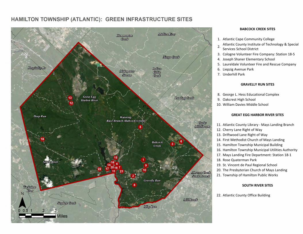
a. Green Infrastructure Sites
BABCOCK CREEK SITES
1. Atlantic Cape Community College
2. Atlantic County Institute of Technology & Special Services School District
3. Cologne Volunteer Fire Company: Station 18-54. Joseph Shaner Elementary School5. Laureldale Volunteer Fire and Rescue Company 6. Liepzig Avenue Park7. Underhill Park
GRAVELLY RUN SITES
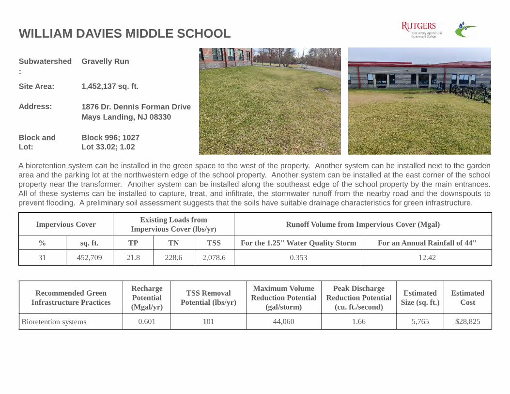
8. George L. Hess Educational Complex9. Oakcrest High School
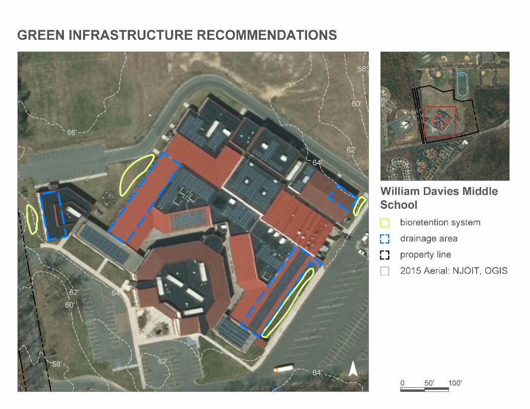
10. William Davies Middle School
GREAT EGG HARBOR RIVER SITES
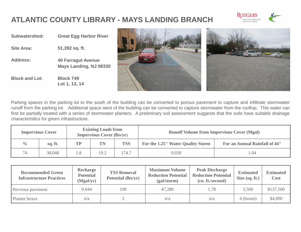
11. Atlantic County Library - Mays Landing Branch12. Cherry Lane Right of Way13. Driftwood Lane Right of Way14. First Methodist Church of Mays Landing15. Hamilton Township Municipal Building16. Hamilton Township Municipal Utilities Authority 17. Mays Landing Fire Department: Station 18-118. Rose Quaterman Park19. St. Vincent de Paul Regional School 20. The Presbyterian Church of Mays Landing21. Township of Hamilton Public Works
SOUTH RIVER SITES
22. Atlantic County Office Building
b. Proposed Green Infrastructure Concepts
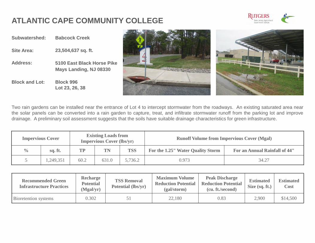
Subwatershed: Babcock Creek
Site Area: 23,504,637 sq. ft.
Address: 5100 East Black Horse Pike Mays Landing, NJ 08330
Block and Lot: Block 996Lot 23, 26, 38
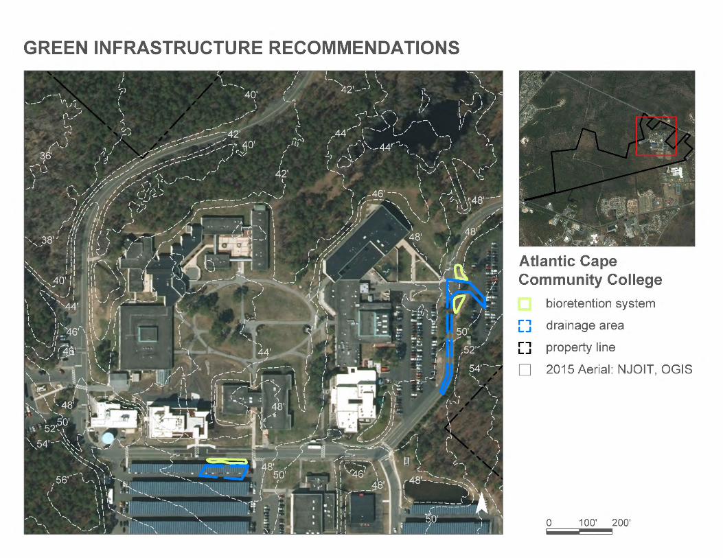
ATLANTIC CAPE COMMUNITY COLLEGE
Two rain gardens can be installed near the entrance of Lot 4 to intercept stormwater from the roadways. An existing saturated area nearthe solar panels can be converted into a rain garden to capture, treat, and infiltrate stormwater runoff from the parking lot and improvedrainage. A preliminary soil assessment suggests that the soils have suitable drainage characteristics for green infrastructure.
Recommended Green Infrastructure Practices
Recharge Potential (Mgal/yr)
TSS Removal Potential (lbs/yr)
Maximum Volume Reduction Potential
(gal/storm)
Peak Discharge Reduction Potential
(cu. ft./second)
EstimatedSize (sq. ft.)
Estimated Cost
Bioretention systems 0.302 51 22,180 0.83 2,900 $14,500
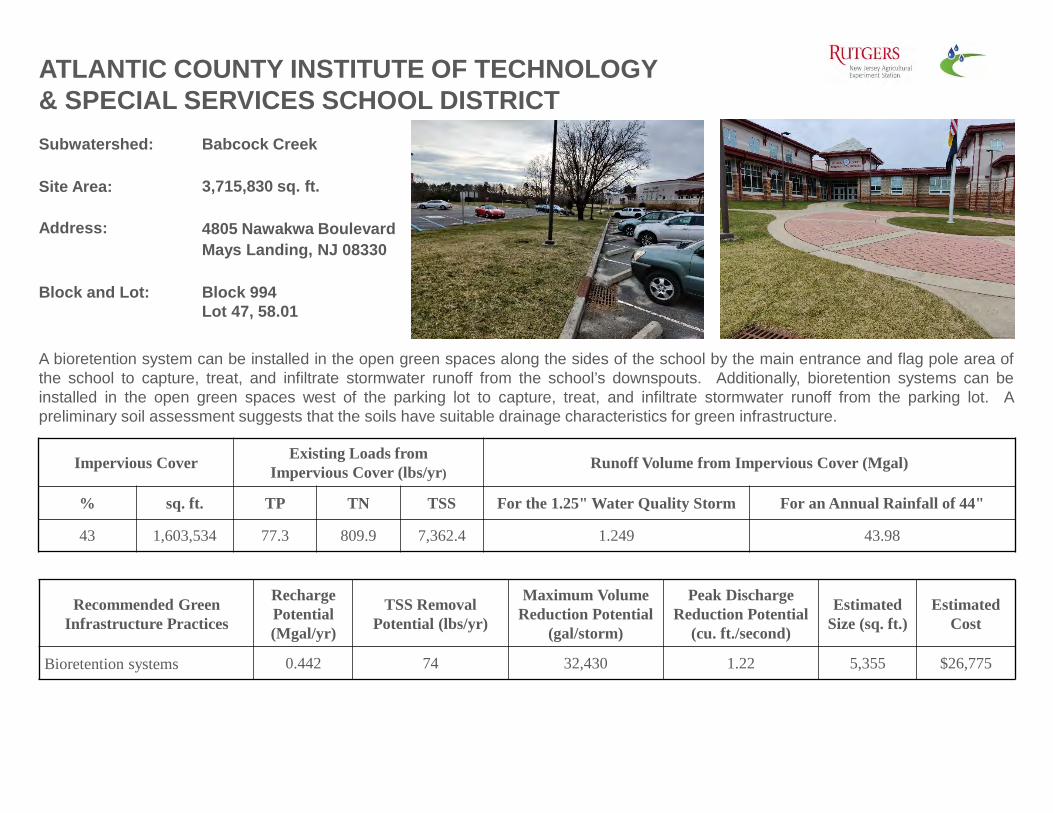
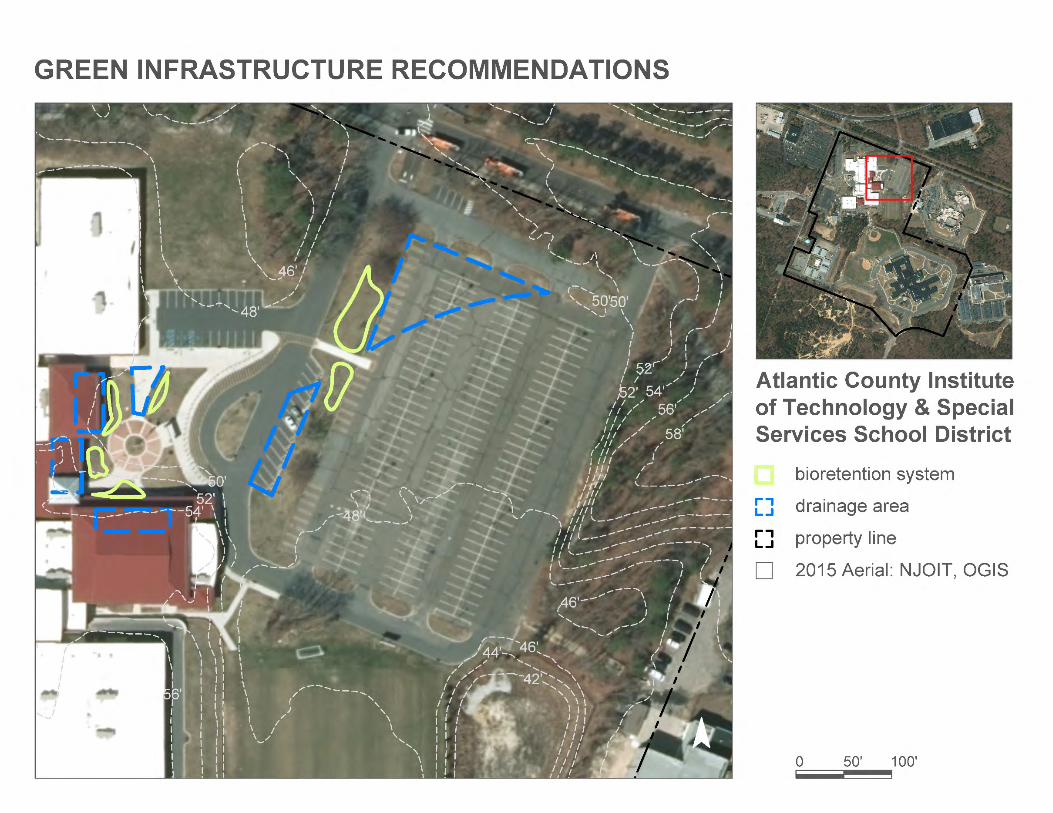
ATLANTIC COUNTY INSTITUTE OF TECHNOLOGY & SPECIAL SERVICES SCHOOL DISTRICT
A bioretention system can be installed in the open green spaces along the sides of the school by the main entrance and flag pole area ofthe school to capture, treat, and infiltrate stormwater runoff from the school’s downspouts. Additionally, bioretention systems can beinstalled in the open green spaces west of the parking lot to capture, treat, and infiltrate stormwater runoff from the parking lot. Apreliminary soil assessment suggests that the soils have suitable drainage characteristics for green infrastructure.
Recommended Green Infrastructure Practices
Recharge Potential (Mgal/yr)
TSS Removal Potential (lbs/yr)
Maximum Volume Reduction Potential
(gal/storm)
Peak Discharge Reduction Potential
(cu. ft./second)
EstimatedSize (sq. ft.)
Estimated Cost
Bioretention systems 0.442 74 32,430 1.22 5,355 $26,775
% sq. ft. TP TN TSS For the 1.25" Water Quality Storm For an Annual Rainfall of 44"
43 1,603,534 77.3 809.9 7,362.4 1.249 43.98
Subwatershed: Babcock Creek
Site Area: 115,741 sq. ft.
Address: 2870 South Cologne AvenueMays Landing, NJ 08330
Block and Lot: Block 1140Lot 2
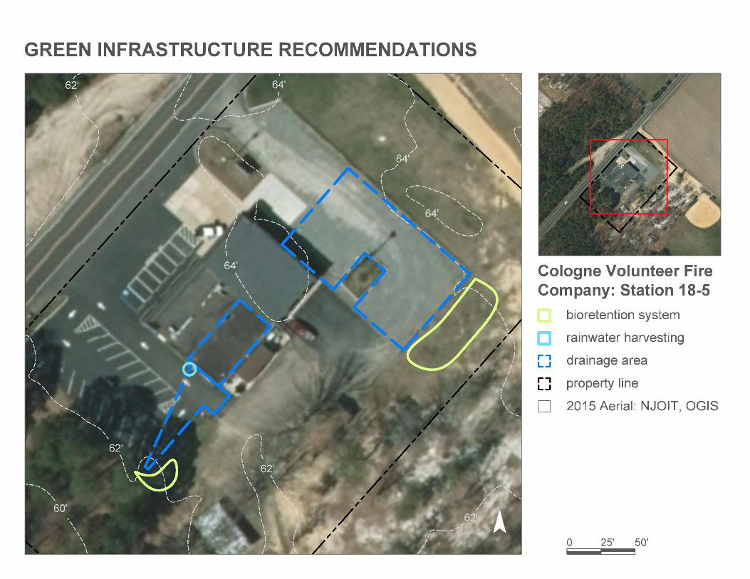
COLOGNE VOLUNTEER FIRE COMPANY: STATION 18-5
Rain gardens can be installed to intercept stormwater coming from the parking areas at the east and south corners of the site. A cisterncan be installed to capture stormwater that can be reused for washing firetrucks or for watering existing landscaping. A preliminary soilassessment suggests that the soils have suitable drainage characteristics for green infrastructure.
Recommended Green Infrastructure Practices
Recharge Potential (Mgal/yr)
TSS Removal Potential (lbs/yr)
Maximum Volume Reduction Potential
(gal/storm)
Peak Discharge Reduction Potential
(cu. ft./second)
EstimatedSize (sq. ft.)
Estimated Cost
Bioretention systems 0.244 41 17,880 0.67 2,425 $12,125
% sq. ft. TP TN TSS For the 1.25" Water Quality Storm For an Annual Rainfall of 44"
42 48,450 2.3 24.5 222.5 0.038 1.33
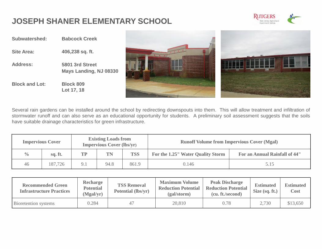
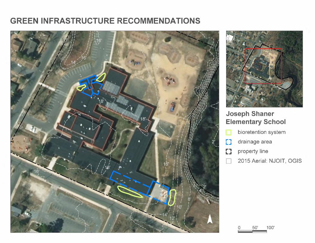
Subwatershed: Babcock Creek
Site Area: 406,238 sq. ft.
Address: 5801 3rd StreetMays Landing, NJ 08330
Block and Lot: Block 809Lot 17, 18
JOSEPH SHANER ELEMENTARY SCHOOL
Several rain gardens can be installed around the school by redirecting downspouts into them. This will allow treatment and infiltration ofstormwater runoff and can also serve as an educational opportunity for students. A preliminary soil assessment suggests that the soilshave suitable drainage characteristics for green infrastructure.
Recommended Green Infrastructure Practices
Recharge Potential (Mgal/yr)
TSS Removal Potential (lbs/yr)
Maximum Volume Reduction Potential
(gal/storm)
Peak Discharge Reduction Potential
(cu. ft./second)
EstimatedSize (sq. ft.)
Estimated Cost
Bioretention systems 0.284 47 20,810 0.78 2,730 $13,650
% sq. ft. TP TN TSS For the 1.25" Water Quality Storm For an Annual Rainfall of 44"
46 187,726 9.1 94.8 861.9 0.146 5.15
Subwatershed: Babcock Creek
Site Area: 246,629 sq. ft.
Address: 2657 NJ-50Mays Landing, NJ 08330
Block and Lot: Block 865Lot 13, 14
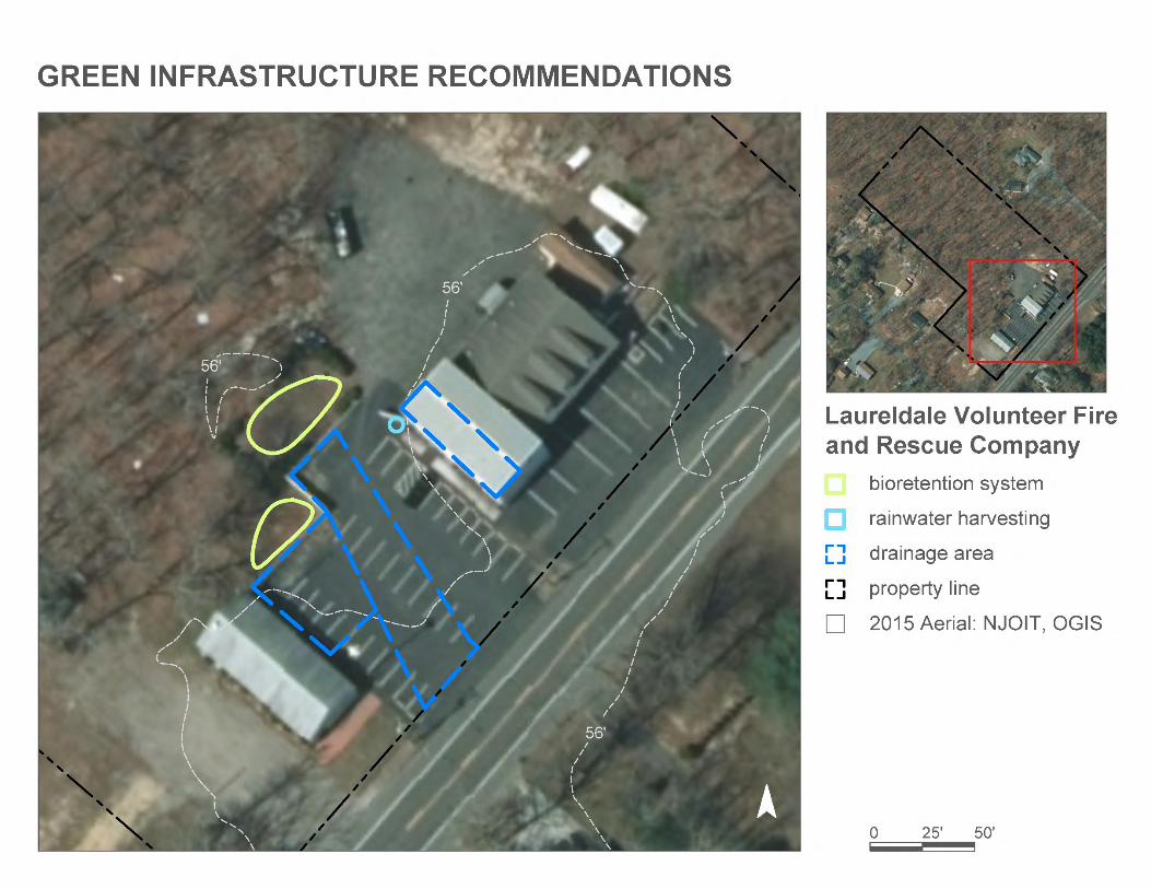
LAURELDALE VOLUNTEER FIRE AND RESCUE COMPANY
Rain gardens can be installed to intercept stormwater coming from the parking areas to the northwest. A cistern can be installed tocapture stormwater that can be reused for washing firetrucks or for watering existing landscaping. A preliminary soil assessment suggeststhat the soils have suitable drainage characteristics for green infrastructure.
Recommended Green Infrastructure Practices
Recharge Potential (Mgal/yr)
TSS Removal Potential (lbs/yr)
Maximum Volume Reduction Potential
(gal/storm)
Peak Discharge Reduction Potential
(cu. ft./second)
EstimatedSize (sq. ft.)
Estimated Cost
Bioretention systems 0.148 25 10,850 0.41 1,420 $7,100
% sq. ft. TP TN TSS For the 1.25" Water Quality Storm For an Annual Rainfall of 44"
18 45,153 2.2 22.8 207.3 0.035 1.24
Subwatershed: Babcock Creek
Site Area: 2,626,707 sq. ft.
Address: 3155 South Leipzig AvenueMays Landing NJ, 08330
Block and Lot: Block 1141Lot 12
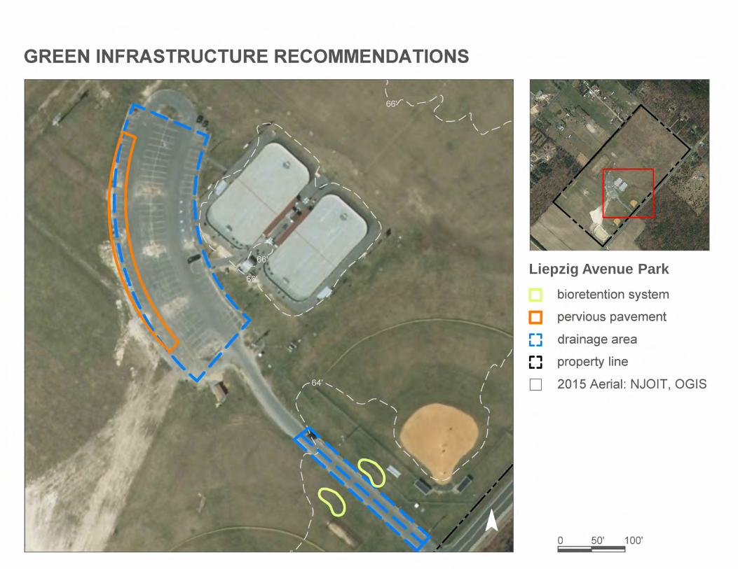
LIEPZIG AVENUE PARK
The pavement along the west edge of the parking lot can be replaced with pervious pavement to capture and infiltrate the stormwaterrunoff from the parking lot. Bioretention systems can be installed near the entrance on both sides of the road connecting Leipzig Avenueand the parking lot to capture, treat, and infiltrate stormwater runoff from the surrounding area to prevent flooding. A preliminary soilassessment suggests that the soils have suitable drainage characteristics for green infrastructure.
Recommended Green Infrastructure Practices
Recharge Potential (Mgal/yr)
TSS Removal Potential (lbs/yr)
Maximum Volume Reduction Potential
(gal/storm)
Peak Discharge Reduction Potential
(cu. ft./second)
EstimatedSize (sq. ft.)
Estimated Cost
Bioretention systems 0.177 30 13,000 0.49 1,700 $8,500
% sq. ft. TP TN TSS For the 1.25" Water Quality Storm For an Annual Rainfall of 44"
6 160,261 7.7 80.9 735.8 0.125 4.40
Liepzig Avenue Park
Subwatershed: Babcock Creek
Site Area: 3,114,676 sq. ft.
Address: 129 Old Egg Harbor AvenueMays Landing, NJ 08330
Block and Lot: Block 809; 996Lot 32; 8,13
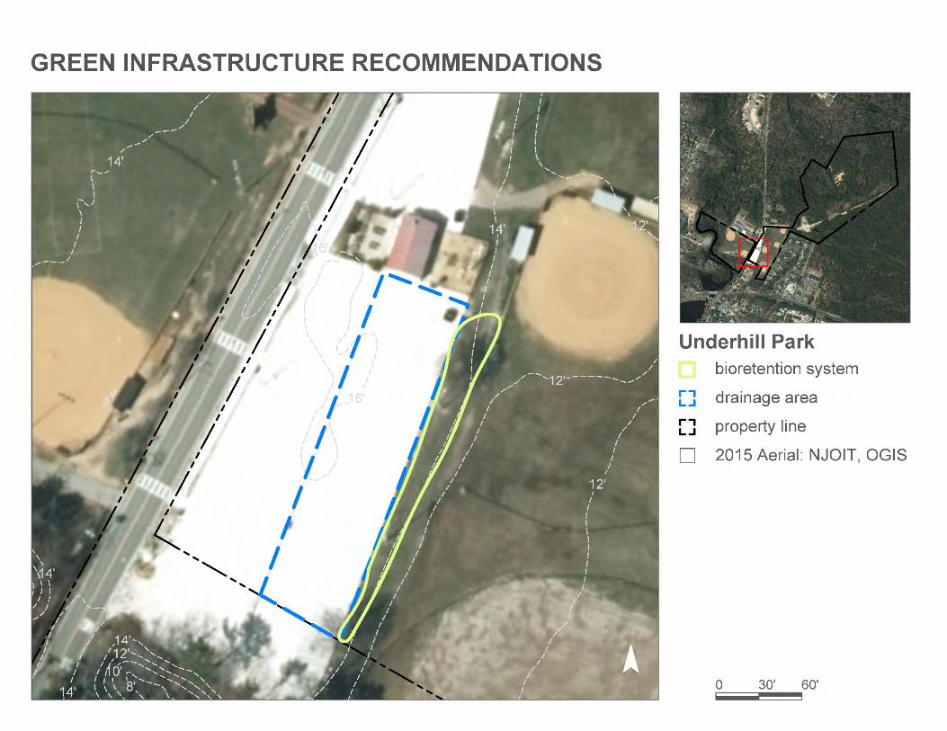
UNDERHILL PARK
A bioretention system can be installed to the east of the crushed shell parking lot at the base of the hill but before the baseball field line tocapture, treat, and infiltrate stormwater runoff and to help prevent flooding in the baseball field. A preliminary soil assessment suggeststhat the soils have suitable drainage characteristics for green infrastructure.
Recommended Green Infrastructure Practices
Recharge Potential (Mgal/yr)
TSS Removal Potential (lbs/yr)
Maximum Volume Reduction Potential
(gal/storm)
Peak Discharge Reduction Potential
(cu. ft./second)
EstimatedSize (sq. ft.)
Estimated Cost
Bioretention system 0.403 67 29,540 1.11 3,865 $19,325
% sq. ft. TP TN TSS For the 1.25" Water Quality Storm For an Annual Rainfall of 44"
5 148,619 7.2 75.1 682.4 0.116 4.08
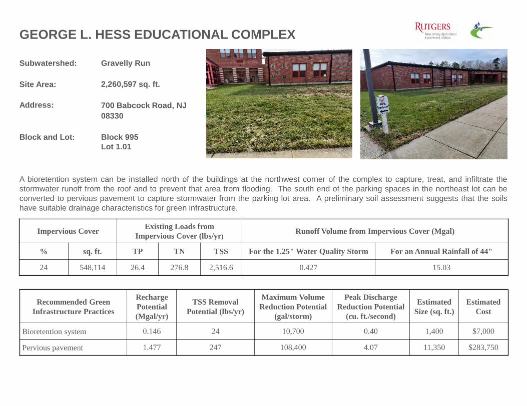
GEORGE L. HESS EDUCATIONAL COMPLEX
Subwatershed: Gravelly Run
Site Area: 2,260,597 sq. ft.
Address: 700 Babcock Road, NJ 08330
Block and Lot: Block 995Lot 1.01
A bioretention system can be installed north of the buildings at the northwest corner of the complex to capture, treat, and infiltrate thestormwater runoff from the roof and to prevent that area from flooding. The south end of the parking spaces in the northeast lot can beconverted to pervious pavement to capture stormwater from the parking lot area. A preliminary soil assessment suggests that the soilshave suitable drainage characteristics for green infrastructure.
Recommended Green Infrastructure Practices
Recharge Potential (Mgal/yr)
TSS Removal Potential (lbs/yr)
Maximum Volume Reduction Potential
(gal/storm)
Peak Discharge Reduction Potential
(cu. ft./second)
EstimatedSize (sq. ft.)
Estimated Cost
Bioretention system 0.146 24 10,700 0.40 1,400 $7,000
% sq. ft. TP TN TSS For the 1.25" Water Quality Storm For an Annual Rainfall of 44"
24 548,114 26.4 276.8 2,516.6 0.427 15.03
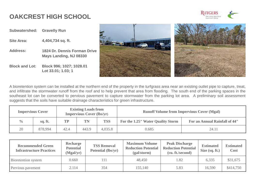
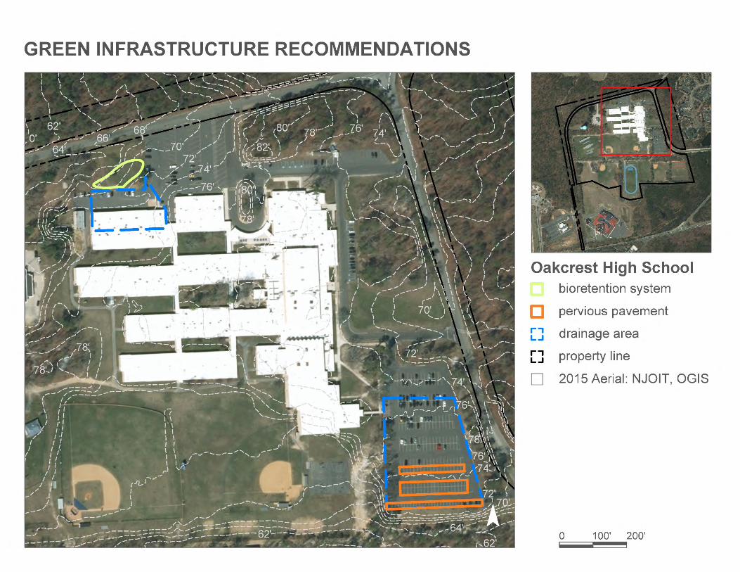
OAKCREST HIGH SCHOOL
Subwatershed: Gravelly Run
Site Area: 4,404,734 sq. ft.
Address: 1824 Dr. Dennis Forman Drive Mays Landing, NJ 08330
Block and Lot: Block 996; 1027; 1028.01Lot 33.01; 1.03; 1
A bioretention system can be installed at the northern end of the property in the turfgrass area near an existing outlet pipe to capture, treat,and infiltrate the stormwater runoff from the roof and to help prevent that area from flooding. The south end of the parking spaces in thesoutheast lot can be converted to pervious pavement to capture stormwater from the parking lot area. A preliminary soil assessmentsuggests that the soils have suitable drainage characteristics for green infrastructure.
Address: 1876 Dr. Dennis Forman Drive Mays Landing, NJ 08330
Block and Lot:
Block 996; 1027Lot 33.02; 1.02
A bioretention system can be installed in the green space to the west of the property. Another system can be installed next to the gardenarea and the parking lot at the northwestern edge of the school property. Another system can be installed at the east corner of the schoolproperty near the transformer. Another system can be installed along the southeast edge of the school property by the main entrances.All of these systems can be installed to capture, treat, and infiltrate, the stormwater runoff from the nearby road and the downspouts toprevent flooding. A preliminary soil assessment suggests that the soils have suitable drainage characteristics for green infrastructure.
Recommended Green Infrastructure Practices
Recharge Potential (Mgal/yr)
TSS Removal Potential (lbs/yr)
Maximum Volume Reduction Potential
(gal/storm)
Peak Discharge Reduction Potential
(cu. ft./second)
EstimatedSize (sq. ft.)
Estimated Cost
Bioretention systems 0.601 101 44,060 1.66 5,765 $28,825
% sq. ft. TP TN TSS For the 1.25" Water Quality Storm For an Annual Rainfall of 44"
31 452,709 21.8 228.6 2,078.6 0.353 12.42
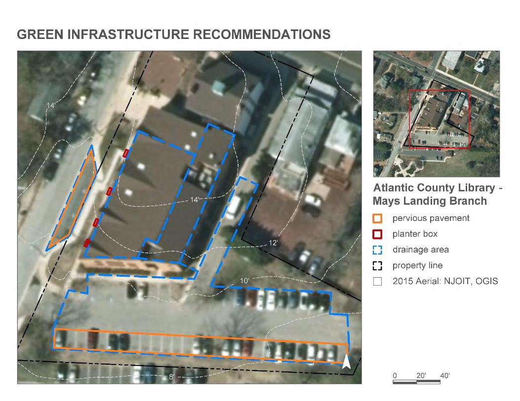
Subwatershed: Great Egg Harbor River
Site Area: 51,392 sq. ft.
Address: 40 Farragut AvenueMays Landing, NJ 08330
Block and Lot: Block 749Lot 1, 13, 14
ATLANTIC COUNTY LIBRARY - MAYS LANDING BRANCH
Parking spaces in the parking lot to the south of the building can be converted to porous pavement to capture and infiltrate stormwaterrunoff from the parking lot. Additional space west of the building can be converted to capture stormwater from the rooftop. This water canfirst be partially treated with a series of stormwater planters. A preliminary soil assessment suggests that the soils have suitable drainagecharacteristics for green infrastructure.
% sq. ft. TP TN TSS For the 1.25" Water Quality Storm For an Annual Rainfall of 44"
74 38,048 1.8 19.2 174.7 0.030 1.04
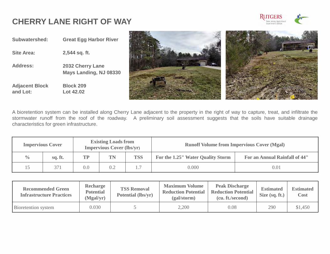
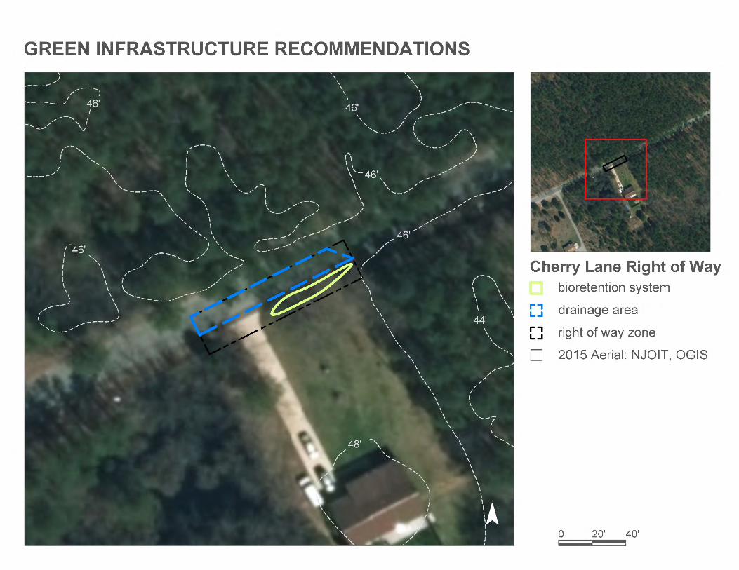
Subwatershed: Great Egg Harbor River
Site Area: 2,544 sq. ft.
Address: 2032 Cherry LaneMays Landing, NJ 08330
Adjacent Block and Lot:
Block 209Lot 42.02
CHERRY LANE RIGHT OF WAY
A bioretention system can be installed along Cherry Lane adjacent to the property in the right of way to capture, treat, and infiltrate thestormwater runoff from the roof of the roadway. A preliminary soil assessment suggests that the soils have suitable drainagecharacteristics for green infrastructure.
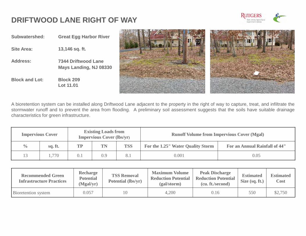
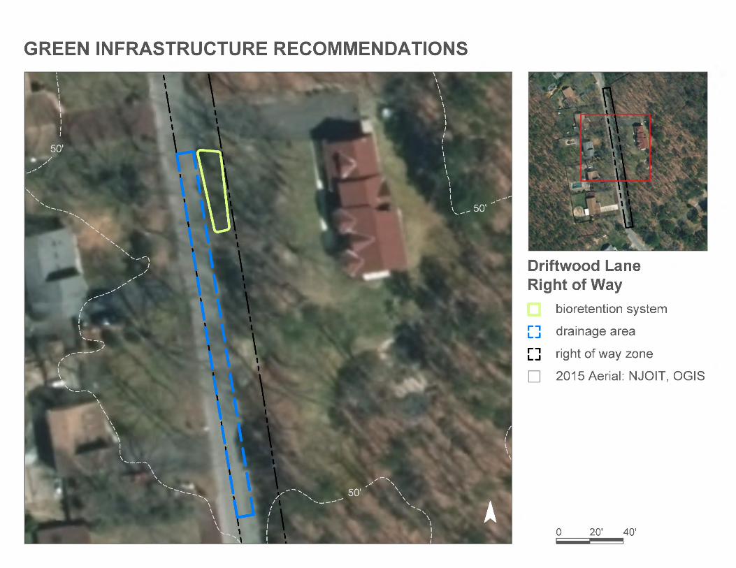
A bioretention system can be installed along Driftwood Lane adjacent to the property in the right of way to capture, treat, and infiltrate thestormwater runoff and to prevent the area from flooding. A preliminary soil assessment suggests that the soils have suitable drainagecharacteristics for green infrastructure.
Recommended Green Infrastructure Practices
Recharge Potential (Mgal/yr)
TSS Removal Potential (lbs/yr)
Maximum Volume Reduction Potential
(gal/storm)
Peak Discharge Reduction Potential
(cu. ft./second)
EstimatedSize (sq. ft.)
Estimated Cost
Bioretention system 0.057 10 4,200 0.16 550 $2,750
% sq. ft. TP TN TSS For the 1.25" Water Quality Storm For an Annual Rainfall of 44"
13 1,770 0.1 0.9 8.1 0.001 0.05
Subwatershed: Great Egg Harbor River
Site Area: 46,434 sq. ft.
Address: 6011 Main StreetMays Landing, NJ 08330
Block and Lot: Block 757Lot 7, 15, 16, 17
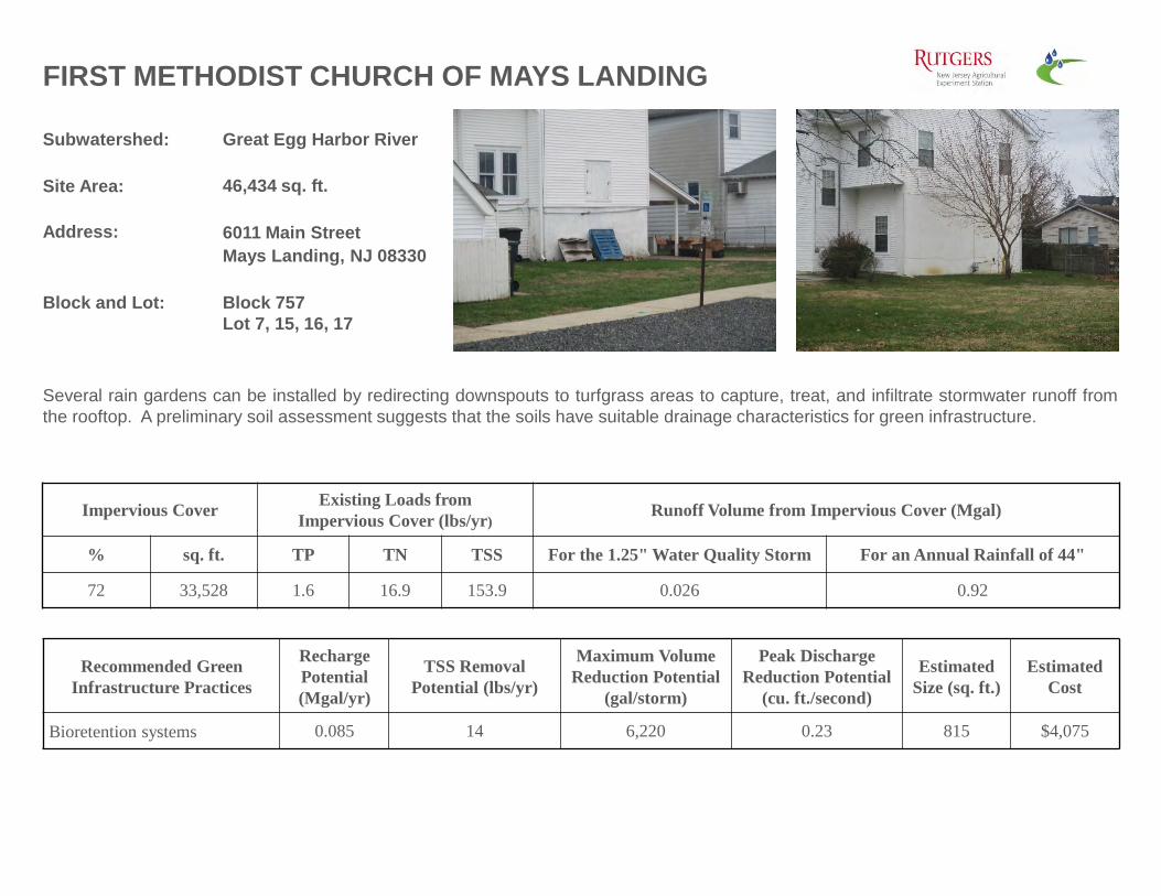
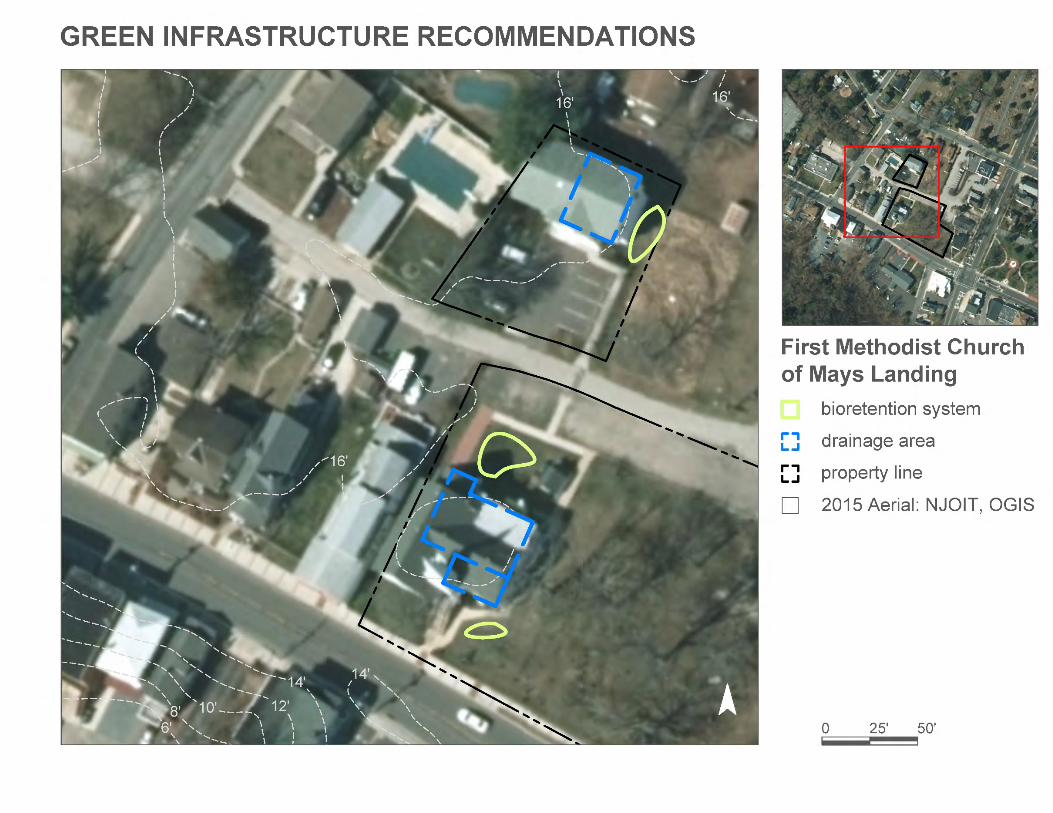
FIRST METHODIST CHURCH OF MAYS LANDING
Several rain gardens can be installed by redirecting downspouts to turfgrass areas to capture, treat, and infiltrate stormwater runoff fromthe rooftop. A preliminary soil assessment suggests that the soils have suitable drainage characteristics for green infrastructure.
Recommended Green Infrastructure Practices
Recharge Potential (Mgal/yr)
TSS Removal Potential (lbs/yr)
Maximum Volume Reduction Potential
(gal/storm)
Peak Discharge Reduction Potential
(cu. ft./second)
EstimatedSize (sq. ft.)
Estimated Cost
Bioretention systems 0.085 14 6,220 0.23 815 $4,075
% sq. ft. TP TN TSS For the 1.25" Water Quality Storm For an Annual Rainfall of 44"
72 33,528 1.6 16.9 153.9 0.026 0.92
Subwatershed: Great Egg Harbor River
Site Area: 542,597 sq. ft.
Address: 6101 13th StreetMays Landing, NJ 08330
Block and Lot: Block 786; 791Lot 1.01; 2
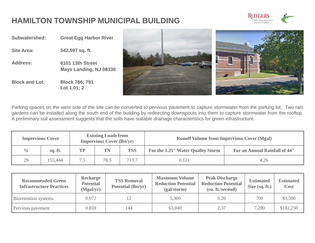
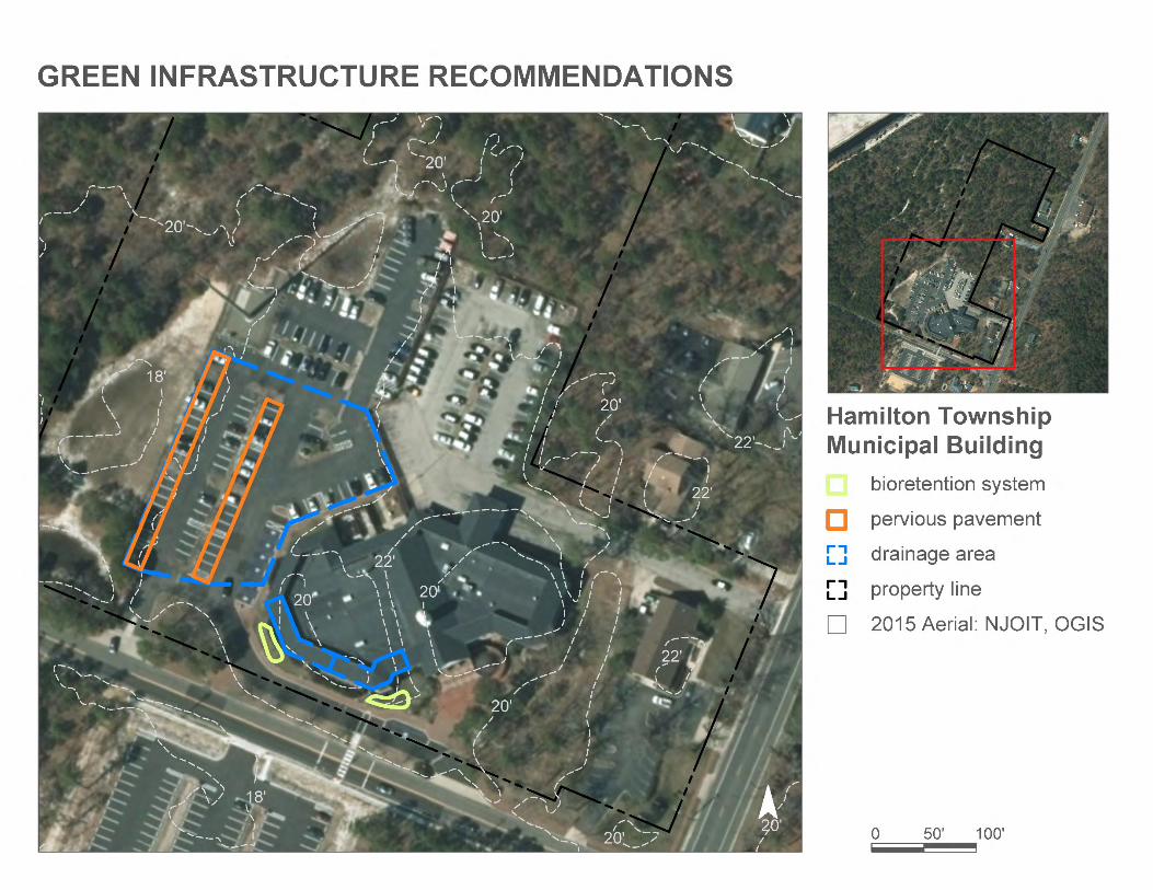
HAMILTON TOWNSHIP MUNICIPAL BUILDING
Parking spaces on the west side of the site can be converted to pervious pavement to capture stormwater from the parking lot. Two raingardens can be installed along the south end of the building by redirecting downspouts into them to capture stormwater from the rooftop.A preliminary soil assessment suggests that the soils have suitable drainage characteristics for green infrastructure.
Recommended Green Infrastructure Practices
Recharge Potential (Mgal/yr)
TSS Removal Potential (lbs/yr)
Maximum Volume Reduction Potential
(gal/storm)
Peak Discharge Reduction Potential
(cu. ft./second)
EstimatedSize (sq. ft.)
Estimated Cost
Bioretention systems 0.072 12 5,300 0.20 700 $3,500
% sq. ft. TP TN TSS For the 1.25" Water Quality Storm For an Annual Rainfall of 44"
29 155,444 7.5 78.5 713.7 0.121 4.26
Subwatershed: Great Egg Harbor River
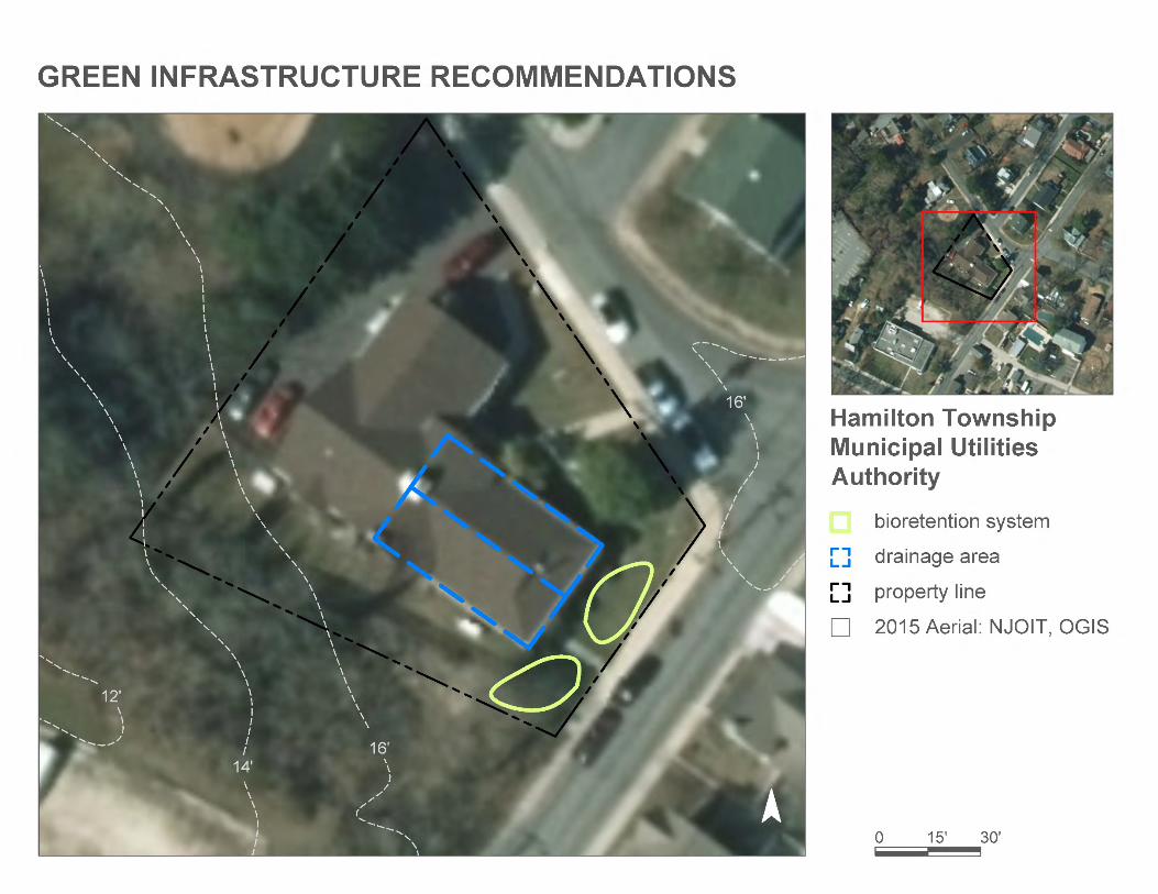
Site Area: 14,460 sq. ft.
Address: 6024 Ken Scull AvenueMays Landing, NJ 08330
Block and Lot: Block 753Lot 14
HAMILTON TOWNSHIP MUNICIPAL UTILITIES AUTHORITY
Two rain gardens can be installed at the southeast end of the building by redirecting downspouts into them to capture, treat, and infiltratestormwater runoff from the rooftop. A preliminary soil assessment suggests that the soils have suitable drainage characteristics for greeninfrastructure.
Recommended Green Infrastructure Practices
Recharge Potential (Mgal/yr)
TSS Removal Potential (lbs/yr)
Maximum Volume Reduction Potential
(gal/storm)
Peak Discharge Reduction Potential
(cu. ft./second)
EstimatedSize (sq. ft.)
Estimated Cost
Bioretention systems 0.051 9 3,730 0.14 500 $2,500
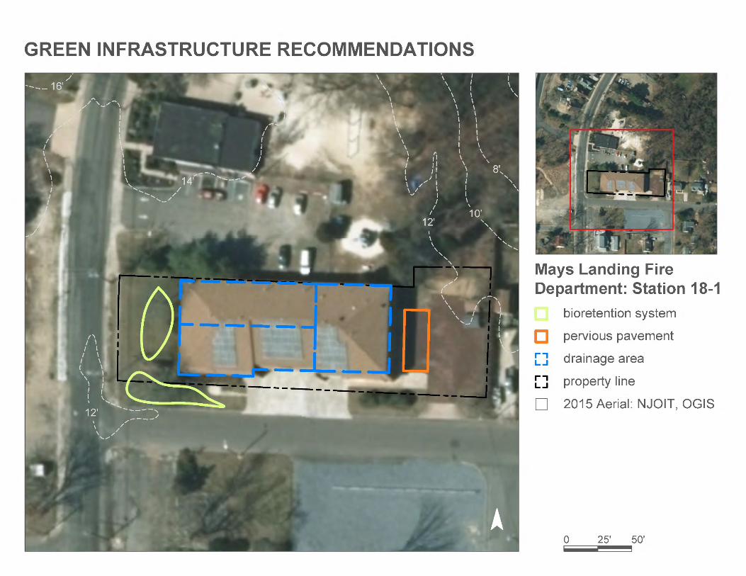
Two rain gardens can be installed at the west end of the building by redirecting downspouts into them to capture, treat, and infiltratestormwater runoff from the rooftop. Parking spaces adjacent to the east face of the building can be retrofitted to pervious pavement tocapture stormwater from the rooftop by redirecting downspouts into them. A preliminary soil assessment suggests that the soils havesuitable drainage characteristics for green infrastructure.
Recommended Green Infrastructure Practices
Recharge Potential (Mgal/yr)
TSS Removal Potential (lbs/yr)
Maximum Volume Reduction Potential
(gal/storm)
Peak Discharge Reduction Potential
(cu. ft./second)
EstimatedSize (sq. ft.)
Estimated Cost
Bioretention systems 0.174 29 12,760 0.48 1,670 $8,350
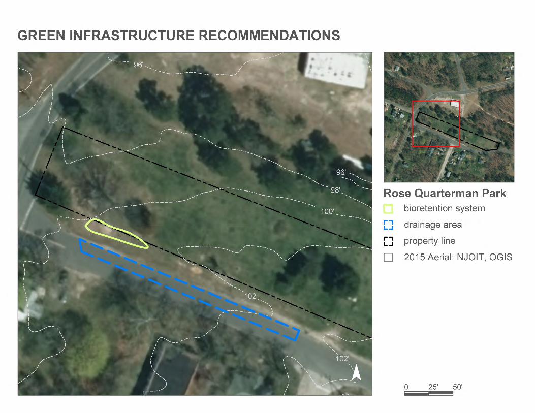
A bioretention system can be installed near at the southwest end of the park to capture, treat, and infiltrate stormwater runoff and to helpprevent flooding. A preliminary soil assessment suggests that the soils have suitable drainage characteristics for green infrastructure.
Recommended Green Infrastructure Practices
Recharge Potential (Mgal/yr)
TSS Removal Potential (lbs/yr)
Maximum Volume Reduction Potential
(gal/storm)
Peak Discharge Reduction Potential
(cu. ft./second)
EstimatedSize (sq. ft.)
Estimated Cost
Bioretention system 0.069 12 5,060 0.19 665 $3,325
% sq. ft. TP TN TSS For the 1.25" Water Quality Storm For an Annual Rainfall of 44"
16 9,131 0.4 4.6 41.9 0.007 0.25
Subwatershed: Great Egg Harbor River
Site Area: 93,914 sq. ft.
Address: 5809 Main StreetMays Landing, NJ 08330
Block and Lot: Block 807Lot 4
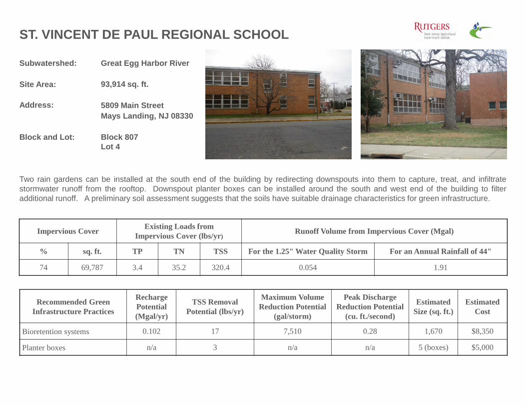
ST. VINCENT DE PAUL REGIONAL SCHOOL
Two rain gardens can be installed at the south end of the building by redirecting downspouts into them to capture, treat, and infiltratestormwater runoff from the rooftop. Downspout planter boxes can be installed around the south and west end of the building to filteradditional runoff. A preliminary soil assessment suggests that the soils have suitable drainage characteristics for green infrastructure.
Recommended Green Infrastructure Practices
Recharge Potential (Mgal/yr)
TSS Removal Potential (lbs/yr)
Maximum Volume Reduction Potential
(gal/storm)
Peak Discharge Reduction Potential
(cu. ft./second)
EstimatedSize (sq. ft.)
Estimated Cost
Bioretention systems 0.102 17 7,510 0.28 1,670 $8,350
% sq. ft. TP TN TSS For the 1.25" Water Quality Storm For an Annual Rainfall of 44"
74 69,787 3.4 35.2 320.4 0.054 1.91
Subwatershed: Great Egg Harbor River
Site Area: 26,900 sq. ft.
Address: 6001 Main StreetMays Landing, NJ 08330
Block and Lot: Block 757Lot 13, 14
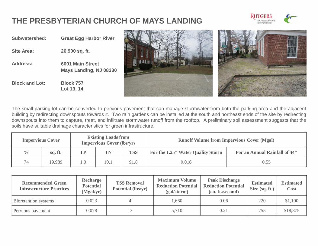
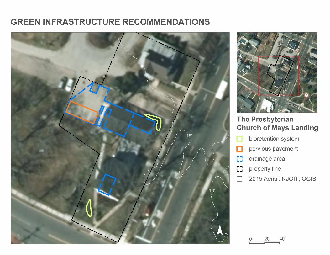
THE PRESBYTERIAN CHURCH OF MAYS LANDING
The small parking lot can be converted to pervious pavement that can manage stormwater from both the parking area and the adjacentbuilding by redirecting downspouts towards it. Two rain gardens can be installed at the south and northeast ends of the site by redirectingdownspouts into them to capture, treat, and infiltrate stormwater runoff from the rooftop. A preliminary soil assessment suggests that thesoils have suitable drainage characteristics for green infrastructure.
Recommended Green Infrastructure Practices
Recharge Potential (Mgal/yr)
TSS Removal Potential (lbs/yr)
Maximum Volume Reduction Potential
(gal/storm)
Peak Discharge Reduction Potential
(cu. ft./second)
EstimatedSize (sq. ft.)
Estimated Cost
Bioretention systems 0.023 4 1,660 0.06 220 $1,100
% sq. ft. TP TN TSS For the 1.25" Water Quality Storm For an Annual Rainfall of 44"
57 130,970 6.3 66.1 601.3 0.102 3.59
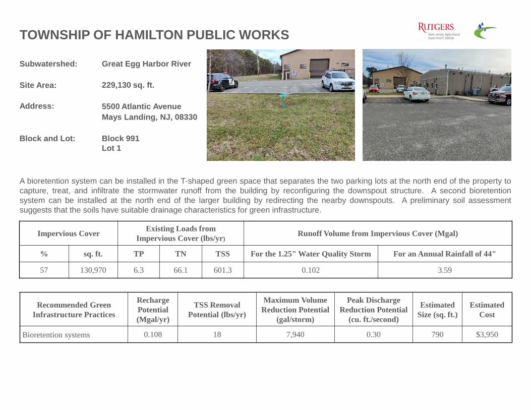
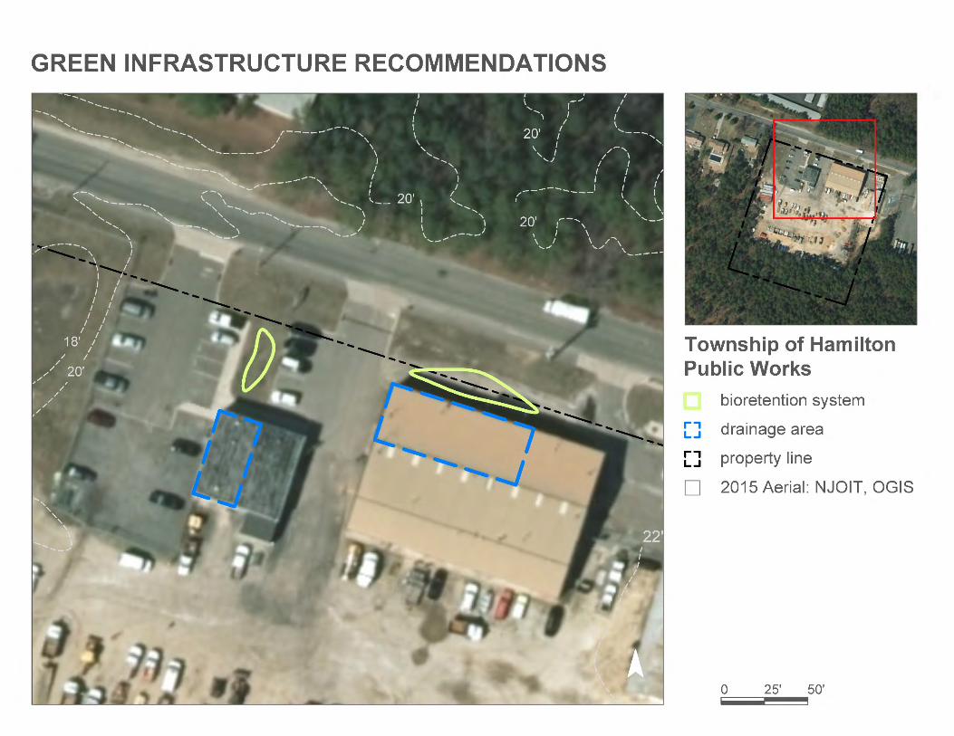
A bioretention system can be installed in the T-shaped green space that separates the two parking lots at the north end of the property tocapture, treat, and infiltrate the stormwater runoff from the building by reconfiguring the downspout structure. A second bioretentionsystem can be installed at the north end of the larger building by redirecting the nearby downspouts. A preliminary soil assessmentsuggests that the soils have suitable drainage characteristics for green infrastructure.
Subwatershed: South River
Site Area: 173,279 sq. ft.
Address: 6260 Old Harding Highway Mays Landing, NJ 08330
Block and Lot: Block 732Lot 35
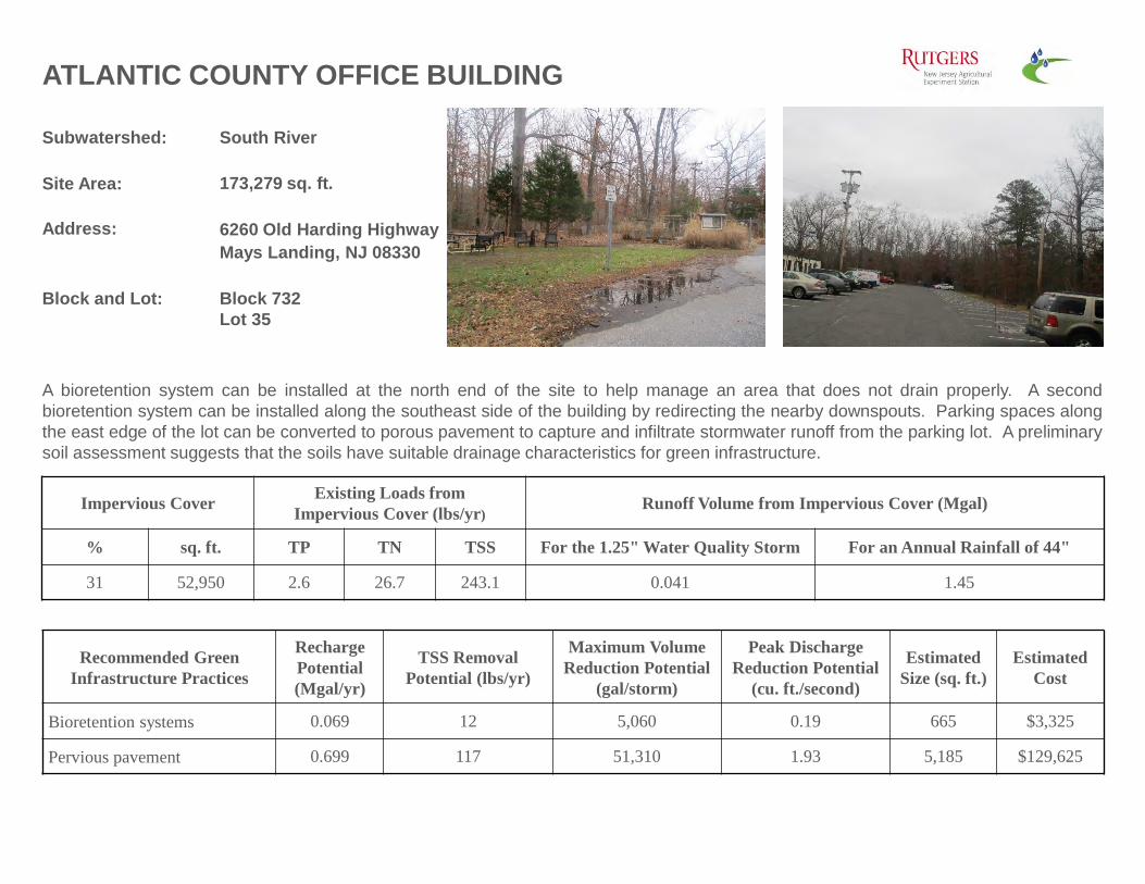
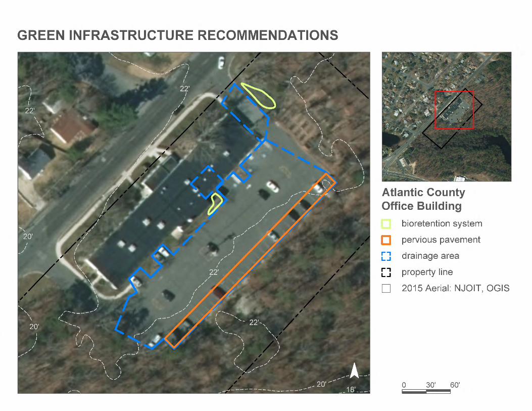
ATLANTIC COUNTY OFFICE BUILDING
A bioretention system can be installed at the north end of the site to help manage an area that does not drain properly. A secondbioretention system can be installed along the southeast side of the building by redirecting the nearby downspouts. Parking spaces alongthe east edge of the lot can be converted to porous pavement to capture and infiltrate stormwater runoff from the parking lot. A preliminarysoil assessment suggests that the soils have suitable drainage characteristics for green infrastructure.
Recommended Green Infrastructure Practices
Recharge Potential (Mgal/yr)
TSS Removal Potential (lbs/yr)
Maximum Volume Reduction Potential
(gal/storm)
Peak Discharge Reduction Potential
(cu. ft./second)
EstimatedSize (sq. ft.)
Estimated Cost
Bioretention systems 0.069 12 5,060 0.19 665 $3,325
% sq. ft. TP TN TSS For the 1.25" Water Quality Storm For an Annual Rainfall of 44"
31 52,950 2.6 26.7 243.1 0.041 1.45
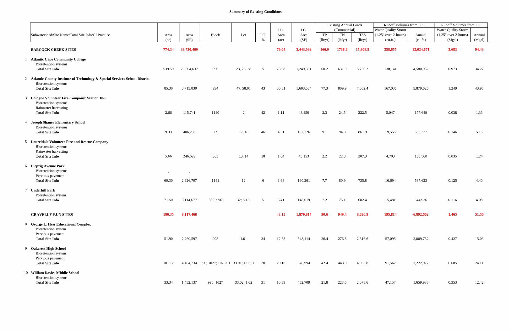
c. Summary of Existing Conditions
Summary of Existing Conditions
I.C. I.C. Water Quality Storm Water Quality StormSubwatershed/Site Name/Total Site Info/GI Practice Area Area Block Lot I.C. Area Area TP TN TSS (1.25" over 2-hours) Annual (1.25" over 2-hours) Annual
(ac) (SF) % (ac) (SF) (lb/yr) (lb/yr) (lb/yr) (cu.ft.) (cu.ft.) (Mgal) (Mgal) BABCOCK CREEK SITES 774.34 33,730,460 79.04 3,443,092 166.0 1738.9 15,808.5 358,655 12,624,671 2.683 94.43 1 Atlantic Cape Community College Bioretention systems Total Site Info 539.59 23,504,637 996 23, 26, 38 5 28.68 1,249,351 60.2 631.0 5,736.2 130,141 4,580,952 0.973 34.27 2 Atlantic County Institute of Technology & Special Services School District Bioretention systems Total Site Info 85.30 3,715,830 994 47, 58.01 43 36.81 1,603,534 77.3 809.9 7,362.4 167,035 5,879,625 1.249 43.98 3 Cologne Volunteer Fire Company: Station 18-5 Bioretention systems Rainwater harvesting Total Site Info 2.66 115,741 1140 2 42 1.11 48,450 2.3 24.5 222.5 5,047 177,649 0.038 1.33 4 Joseph Shaner Elementary School Bioretention systems Total Site Info 9.33 406,238 809 17, 18 46 4.31 187,726 9.1 94.8 861.9 19,555 688,327 0.146 5.15 5 Laureldale Volunteer Fire and Rescue Company Bioretention systems Rainwater harvesting Total Site Info 5.66 246,629 865 13, 14 18 1.04 45,153 2.2 22.8 207.3 4,703 165,560 0.035 1.24 6 Liepzig Avenue Park Bioretention systems Pervious pavement Total Site Info 60.30 2,626,707 1141 12 6 3.68 160,261 7.7 80.9 735.8 16,694 587,623 0.125 4.40 7 Underhill Park Bioretention system Total Site Info 71.50 3,114,677 809; 996 32; 8,13 5 3.41 148,619 7.2 75.1 682.4 15,481 544,936 0.116 4.08 GRAVELLY RUN SITES 186.35 8,117,468 43.15 1,879,817 90.6 949.4 8,630.9 195,814 6,892,662 1.465 51.56 8 George L. Hess Educational Complex Bioretention system Pervious pavement Total Site Info 51.90 2,260,597 995 1.01 24 12.58 548,114 26.4 276.8 2,516.6 57,095 2,009,752 0.427 15.03 9 Oakcrest High School Bioretention system Pervious pavement Total Site Info 101.12 4,404,734 996; 1027; 1028.01 33.01; 1.03; 1 20 20.18 878,994 42.4 443.9 4,035.8 91,562 3,222,977 0.685 24.11
10 William Davies Middle School Bioretention systems Total Site Info 33.34 1,452,137 996; 1027 33.02; 1.02 31 10.39 452,709 21.8 228.6 2,078.6 47,157 1,659,933 0.353 12.42
Existing Annual Loads (Commercial)
Runoff Volumes from I.C. Runoff Volumes from I.C.
Summary of Existing Conditions
I.C. I.C. Water Quality Storm Water Quality StormSubwatershed/Site Name/Total Site Info/GI Practice Area Area Block Lot I.C. Area Area TP TN TSS (1.25" over 2-hours) Annual (1.25" over 2-hours) Annual
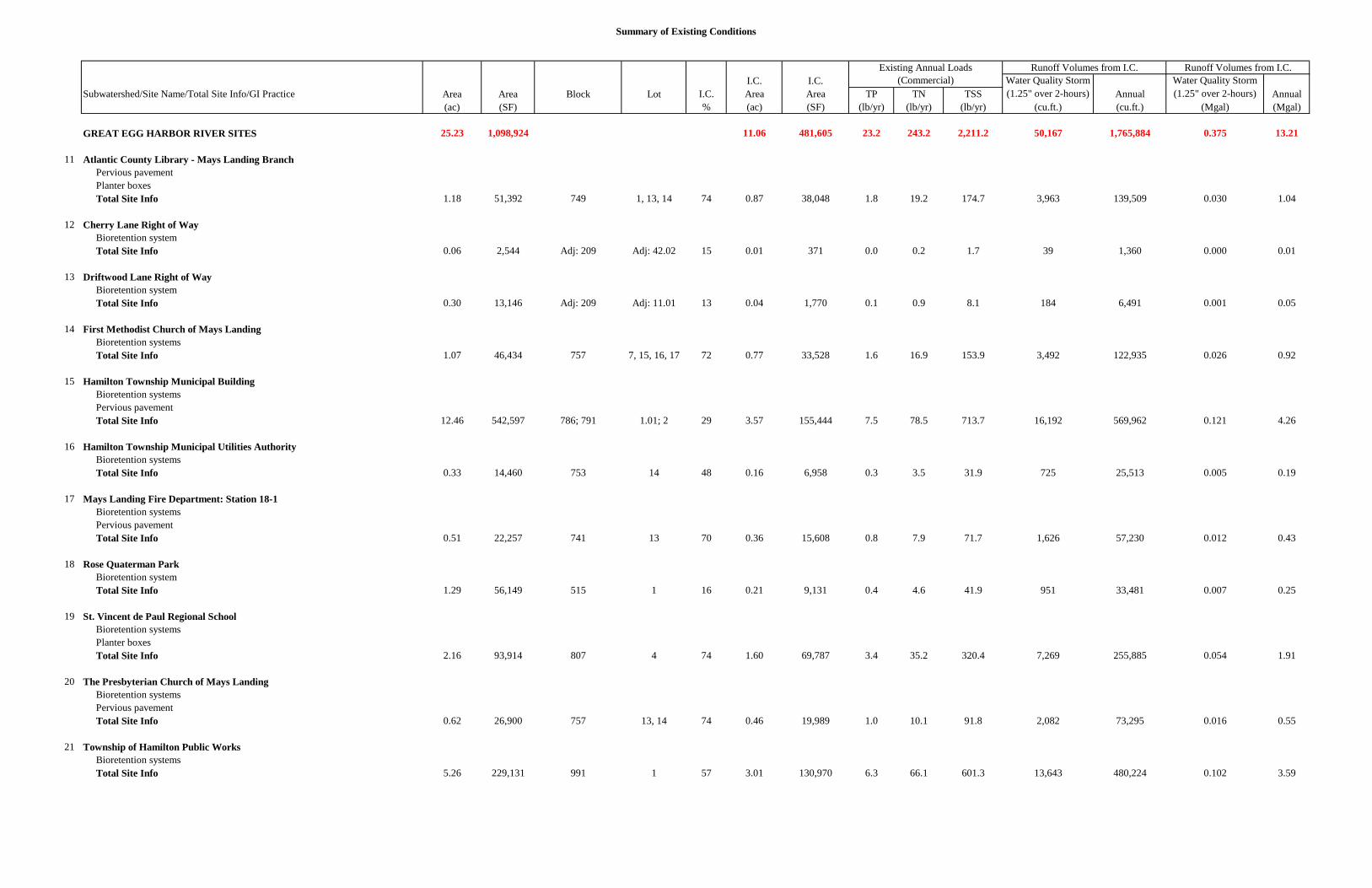
GREAT EGG HARBOR RIVER SITES 25.23 1,098,924 11.06 481,605 23.2 243.2 2,211.2 50,167 1,765,884 0.375 13.21
11 Atlantic County Library - Mays Landing Branch Pervious pavement Planter boxes Total Site Info 1.18 51,392 749 1, 13, 14 74 0.87 38,048 1.8 19.2 174.7 3,963 139,509 0.030 1.04
12 Cherry Lane Right of Way Bioretention system Total Site Info 0.06 2,544 Adj: 209 Adj: 42.02 15 0.01 371 0.0 0.2 1.7 39 1,360 0.000 0.01
13 Driftwood Lane Right of Way Bioretention system Total Site Info 0.30 13,146 Adj: 209 Adj: 11.01 13 0.04 1,770 0.1 0.9 8.1 184 6,491 0.001 0.05
14 First Methodist Church of Mays Landing Bioretention systems Total Site Info 1.07 46,434 757 7, 15, 16, 17 72 0.77 33,528 1.6 16.9 153.9 3,492 122,935 0.026 0.92
15 Hamilton Township Municipal Building Bioretention systems Pervious pavement Total Site Info 12.46 542,597 786; 791 1.01; 2 29 3.57 155,444 7.5 78.5 713.7 16,192 569,962 0.121 4.26
16 Hamilton Township Municipal Utilities Authority Bioretention systems Total Site Info 0.33 14,460 753 14 48 0.16 6,958 0.3 3.5 31.9 725 25,513 0.005 0.19
17 Mays Landing Fire Department: Station 18-1 Bioretention systems Pervious pavement Total Site Info 0.51 22,257 741 13 70 0.36 15,608 0.8 7.9 71.7 1,626 57,230 0.012 0.43
18 Rose Quaterman Park Bioretention system Total Site Info 1.29 56,149 515 1 16 0.21 9,131 0.4 4.6 41.9 951 33,481 0.007 0.25
19 St. Vincent de Paul Regional School Bioretention systems Planter boxes Total Site Info 2.16 93,914 807 4 74 1.60 69,787 3.4 35.2 320.4 7,269 255,885 0.054 1.91
20 The Presbyterian Church of Mays Landing Bioretention systems Pervious pavement Total Site Info 0.62 26,900 757 13, 14 74 0.46 19,989 1.0 10.1 91.8 2,082 73,295 0.016 0.55
21 Township of Hamilton Public Works Bioretention systems Total Site Info 5.26 229,131 991 1 57 3.01 130,970 6.3 66.1 601.3 13,643 480,224 0.102 3.59
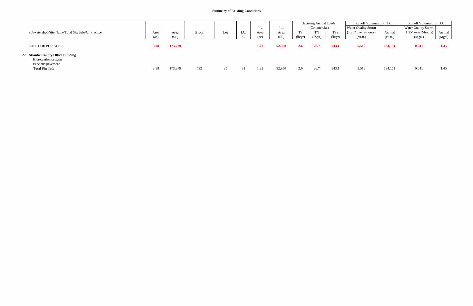
Summary of Existing Conditions
I.C. I.C. Water Quality Storm Water Quality StormSubwatershed/Site Name/Total Site Info/GI Practice Area Area Block Lot I.C. Area Area TP TN TSS (1.25" over 2-hours) Annual (1.25" over 2-hours) Annual
SOUTH RIVER SITES 3.98 173,279 1.22 52,950 2.6 26.7 243.1 5,516 194,151 0.041 1.45
22 Atlantic County Office Building Bioretention systems Pervious pavement Total Site Info 3.98 173,279 732 35 31 1.22 52,950 2.6 26.7 243.1 5,516 194,151 0.041 1.45
d. Summary of Proposed Green Infrastructure Practices
Summary of Proposed Green Infrastructure Practices
Max Volume Peak Discharge Recharge TSS Removal Reduction Reduction Size of Unit Total I.C. Subwatershed/Site Name/Total Site Info/GI Practice Area Area Potential Potential Potential Potential BMP Cost Unit Cost Treated (SF) (ac) (Mgal/yr) (lbs/yr) (gal/storm) (cfs) ($/unit) ($) % BABCOCK CREEK SITES 125,515 2.88 3.270 547 236,980 8.90 $306,675 3.6% 1 Atlantic Cape Community College Bioretention systems 11,600 0.27 0.302 51 22,180 0.83 2,900 $5 SF $14,500 0.9% Total Site Info 11,600 0.27 0.302 51 22,180 0.83 $14,500 0.9% 2 Atlantic County Institute of Technology & Special Services School District Bioretention systems 16,965 0.39 0.442 74 32,430 1.22 5,355 $5 SF $26,775 1.1% Total Site Info 16,965 0.39 0.442 74 32,430 1.22 $26,775 1.1% 3 Cologne Volunteer Fire Company: Station 18-5 Bioretention systems 9,350 0.21 0.244 41 17,880 0.67 2,425 $5 SF $12,125 19.3% Rainwater harvesting 1,740 0.04 0.045 8 1,500 0.06 1,500 $2 gal $3,000 3.6% Total Site Info 11,090 0.25 0.289 48 19,380 0.73 $15,125 22.9% 4 Joseph Shaner Elementary School Bioretention systems 10,885 0.25 0.284 47 20,810 0.78 2,730 $5 SF $13,650 5.8% Total Site Info 10,885 0.25 0.284 47 20,810 0.78 $13,650 5.8% 5 Laureldale Volunteer Fire and Rescue Company Bioretention systems 5,675 0.13 0.148 25 10,850 0.41 1,420 $5 SF $7,100 12.6% Rainwater harvesting 1,050 0.02 0.027 5 850 0.03 850 $2 gal $1,700 2.3% Total Site Info 6,725 0.15 0.175 29 11,700 0.44 $8,800 14.9% 6 Liepzig Avenue Park Bioretention systems 6,800 0.16 0.177 30 13,000 0.49 1,700 $5 SF $8,500 4.2% Pervious pavement 46,000 1.06 1.199 201 87,940 3.30 8,000 $25 SF $200,000 28.7% Total Site Info 52,800 1.21 1.376 230 100,940 3.79 $208,500 32.9% 7 Underhill Park Bioretention system 15,450 0.35 0.403 67 29,540 1.11 3,865 $5 SF $19,325 10.4% Total Site Info 15,450 0.35 0.403 67 29,540 1.11 $19,325 10.4% GRAVELLY RUN SITES 191,840 4.40 4.998 837 366,750 13.78 $766,000 10.2% 8 George L. Hess Educational Complex Bioretention system 5,600 0.13 0.146 24 10,700 0.40 1,400 $5 SF $7,000 1.0% Pervious pavement 56,700 1.30 1.477 247 108,400 4.07 11,350 $25 SF $283,750 10.3% Total Site Info 62,300 1.43 1.623 272 119,100 4.47 $290,750 11.4% 9 Oakcrest High School Bioretention system 25,340 0.58 0.660 111 48,450 1.82 6,335 $5 SF $31,675 2.9% Pervious pavement 81,150 1.86 2.114 354 155,140 5.83 16,590 $25 SF $414,750 9.2% Total Site Info 106,490 2.44 2.775 464 203,590 7.65 $446,425 12.1%
10 William Davies Middle School Bioretention systems 23,050 0.53 0.601 101 44,060 1.66 5,765 $5 SF $28,825 5.1% Total Site Info 23,050 0.53 0.601 101 44,060 1.66 $28,825 5.1%
Potential Management Area
1
Summary of Proposed Green Infrastructure Practices
Max Volume Peak Discharge Recharge TSS Removal Reduction Reduction Size of Unit Total I.C. Subwatershed/Site Name/Total Site Info/GI Practice Area Area Potential Potential Potential Potential BMP Cost Unit Cost Treated (SF) (ac) (Mgal/yr) (lbs/yr) (gal/storm) (cfs) ($/unit) ($) %
Potential Management Area
GREAT EGG HARBOR RIVER SITES 95,395 2.19 2.444 415 179,340 6.73 $407,225 19.8%
11 Atlantic County Library - Mays Landing Branch Pervious pavement 24,730 0.57 0.644 108 47,280 1.78 5,500 $25 SF $137,500 65.0% Planter boxes 860 0.02 n/a 3 n/a n/a 4 $1,000 box $4,000 2.3% Total Site Info 25,590 0.59 0.644 111 47,280 1.78 $141,500 67.3%
12 Cherry Lane Right of Way Bioretention system 1,150 0.03 0.030 5 2,200 0.08 290 $5 SF $1,450 310.1% Total Site Info 1,150 0.03 0.030 5 2,200 0.08 $1,450 310.1%
13 Driftwood Lane Right of Way Bioretention system 2,200 0.05 0.057 10 4,200 0.16 550 $5 SF $2,750 124.3% Total Site Info 2,200 0.05 0.057 10 4,200 0.16 $2,750 124.3%
14 First Methodist Church of Mays Landing Bioretention systems 3,250 0.07 0.085 14 6,220 0.23 815 $5 SF $4,075 9.7% Total Site Info 3,250 0.07 0.085 14 6,220 0.23 $4,075 9.7%
15 Hamilton Township Municipal Building Bioretention systems 2,775 0.06 0.072 12 5,300 0.20 700 $5 SF $3,500 1.8% Pervious pavement 32,975 0.76 0.859 144 63,040 2.37 7,290 $25 SF $182,250 21.2% Total Site Info 35,750 0.82 0.931 156 68,340 2.57 $185,750 23.0%
16 Hamilton Township Municipal Utilities Authority Bioretention systems 1,950 0.04 0.051 9 3,730 0.14 500 $5 SF $2,500 28.0% Total Site Info 1,950 0.04 0.051 9 3,730 0.14 $2,500 28.0%
17 Mays Landing Fire Department: Station 18-1 Bioretention systems 6,675 0.15 0.174 29 12,760 0.48 1,670 $5 SF $8,350 42.8% Pervious pavement 3,520 0.08 0.092 15 6,730 0.25 810 $25 SF $20,250 22.6% Total Site Info 10,195 0.23 0.266 44 19,490 0.73 $28,600 65.3%
18 Rose Quaterman Park Bioretention system 2,650 0.06 0.069 12 5,060 0.19 665 $5 SF $3,325 29.0% Total Site Info 2,650 0.06 0.069 12 5,060 0.19 $3,325 29.0%
19 St. Vincent de Paul Regional School Bioretention systems 3,930 0.09 0.102 17 7,510 0.28 1,670 $5 SF $8,350 5.6% Planter boxes 725 0.02 n/a 3 n/a n/a 5 $1,000 box $5,000 1.0% Total Site Info 4,655 0.11 0.102 20 7,510 0.28 $13,350 6.7%
20 The Presbyterian Church of Mays Landing Bioretention systems 870 0.02 0.023 4 1,660 0.06 220 $5 SF $1,100 4.4% Pervious pavement 2,985 0.07 0.078 13 5,710 0.21 755 $25 SF $18,875 14.9% Total Site Info 3,855 0.09 0.100 17 7,370 0.27 $19,975 19.3%
2
Summary of Proposed Green Infrastructure Practices
Max Volume Peak Discharge Recharge TSS Removal Reduction Reduction Size of Unit Total I.C. Subwatershed/Site Name/Total Site Info/GI Practice Area Area Potential Potential Potential Potential BMP Cost Unit Cost Treated (SF) (ac) (Mgal/yr) (lbs/yr) (gal/storm) (cfs) ($/unit) ($) %
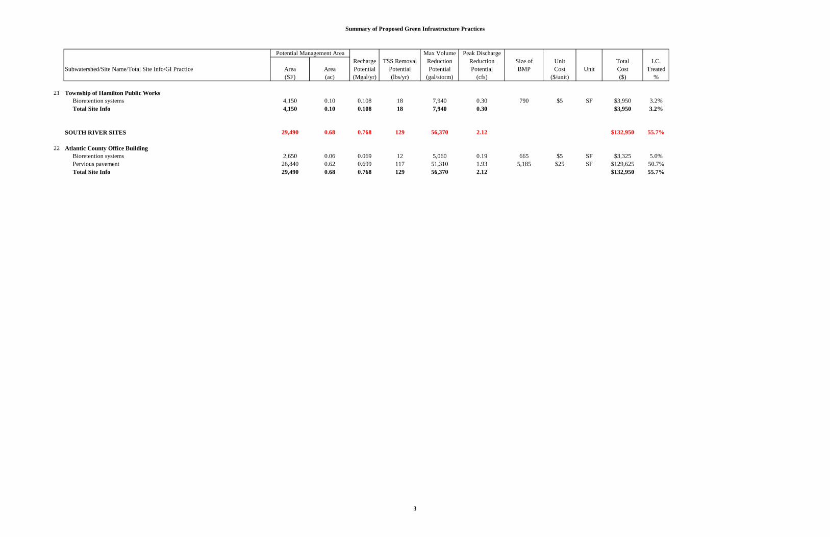
Potential Management Area
21 Township of Hamilton Public Works Bioretention systems 4,150 0.10 0.108 18 7,940 0.30 790 $5 SF $3,950 3.2% Total Site Info 4,150 0.10 0.108 18 7,940 0.30 $3,950 3.2% SOUTH RIVER SITES 29,490 0.68 0.768 129 56,370 2.12 $132,950 55.7%
22 Atlantic County Office Building Bioretention systems 2,650 0.06 0.069 12 5,060 0.19 665 $5 SF $3,325 5.0% Pervious pavement 26,840 0.62 0.699 117 51,310 1.93 5,185 $25 SF $129,625 50.7% Total Site Info 29,490 0.68 0.768 129 56,370 2.12 $132,950 55.7%