30
Impervious Cover Assessment for Elmer Borough, Salem County, New Jersey Prepared for Elmer Borough by the Rutgers Cooperative Extension Water Resources Program August 10, 2016

Impervious Cover Assessment
for
Elmer Borough, Salem County, New Jersey
Prepared for Elmer Borough by the
Rutgers Cooperative Extension Water Resources Program
August 10, 2016

1
Introduction
Pervious and impervious are terms that are used to describe the ability or inability of water to flow
through a surface. When rainfall hits a surface, it can soak into the surface or flow off the surface.
Pervious surfaces are those which allow stormwater to readily soak into the soil and recharge
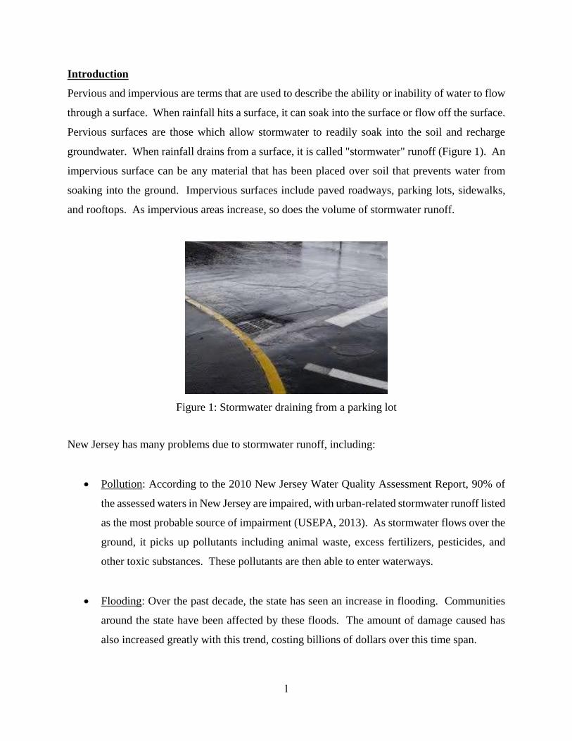
groundwater. When rainfall drains from a surface, it is called "stormwater" runoff (Figure 1). An
impervious surface can be any material that has been placed over soil that prevents water from
soaking into the ground. Impervious surfaces include paved roadways, parking lots, sidewalks,
and rooftops. As impervious areas increase, so does the volume of stormwater runoff.
Figure 1: Stormwater draining from a parking lot
New Jersey has many problems due to stormwater runoff, including:
Pollution: According to the 2010 New Jersey Water Quality Assessment Report, 90% of
the assessed waters in New Jersey are impaired, with urban-related stormwater runoff listed
as the most probable source of impairment (USEPA, 2013). As stormwater flows over the
ground, it picks up pollutants including animal waste, excess fertilizers, pesticides, and
other toxic substances. These pollutants are then able to enter waterways.
Flooding: Over the past decade, the state has seen an increase in flooding. Communities
around the state have been affected by these floods. The amount of damage caused has
also increased greatly with this trend, costing billions of dollars over this time span.
2
Erosion: Increased stormwater runoff causes an increase in the velocity of flows in our
waterways. The increased velocity after storm events erodes stream banks and shorelines,
degrading water quality. This erosion can damage local roads and bridges and cause harm
to wildlife.
The primary cause of the pollution, flooding, and erosion problems is the quantity of impervious
surfaces draining directly to local waterways. New Jersey is one of the most developed states in
the country. Currently, the state has the highest percent of impervious cover in the country at
12.1% of its total area (Nowak & Greenfield, 2012). Many of these impervious surfaces are
directly connected to local waterways (i.e., every drop of rain that lands on these impervious
surfaces ends up in a local river, lake, or bay without any chance of being treated or soaking into
the ground). To repair our waterways, reduce flooding, and stop erosion, stormwater runoff from
impervious surfaces has to be better managed. Surfaces need to be disconnected with green
infrastructure to prevent stormwater runoff from flowing directly into New Jersey's waterways.
Disconnection redirects runoff from paving and rooftops to pervious areas in the landscape.
Green infrastructure is an approach to stormwater management that is cost-effective, sustainable,
and environmentally friendly. Green infrastructure projects capture, filter, absorb, and reuse
stormwater to maintain or mimic natural systems and to treat runoff as a resource. As a general
principal, green infrastructure practices use soil and vegetation to recycle stormwater runoff
through infiltration and evapotranspiration. When used as components of a stormwater
management system, green infrastructure practices such as bioretention, green roofs, porous
pavement, rain gardens, and vegetated swales can produce a variety of environmental benefits. In
addition to effectively retaining and infiltrating rainfall, these technologies can simultaneously
help filter air pollutants, reduce energy demands, mitigate urban heat islands, and sequester carbon
while also providing communities with aesthetic and natural resource benefits (USEPA, 2013).
The first step to reducing the impacts from impervious surfaces is to conduct an impervious cover
assessment. This assessment can be completed on different scales: individual lot, municipality, or
watershed. Impervious surfaces need to be identified for stormwater management. Once
impervious surfaces have been identified, there are three steps to better manage these surfaces.
3
1. Eliminate surfaces that are not necessary. For example, a paved courtyard at a public
school could be converted to a grassed area.
2. Reduce or convert impervious surfaces. There may be surfaces that are required to be
hardened, such as roadways or parking lots, but could be made smaller and still be
functional. A parking lot that has two-way car ways could be converted to one-way car
ways. There also are permeable paving materials such as porous asphalt, pervious
concrete, or permeable paving stones that could be substituted for impermeable paving
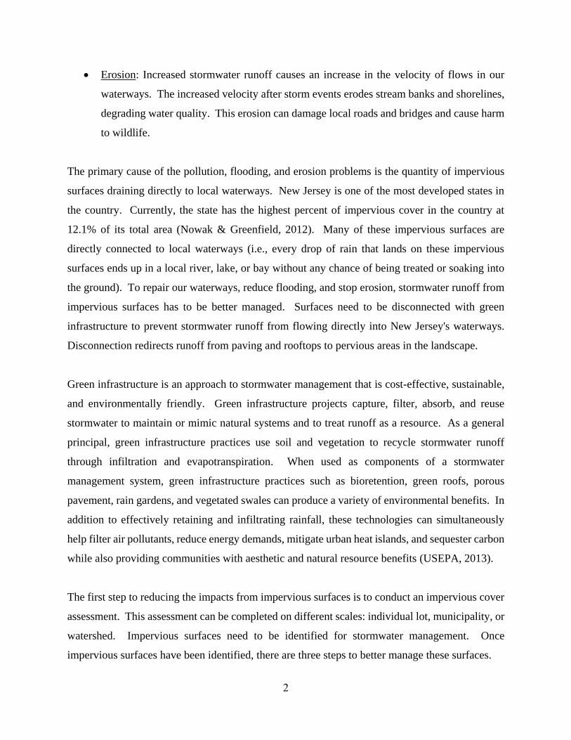
materials (Figure 2).
3. Disconnect impervious surfaces from flowing directly to local waterways. There are
many ways to capture, treat, and infiltrate stormwater runoff from impervious surfaces.
Opportunities may exist to reuse this captured water.
Figure 2: Rapid infiltration of water through porous pavement is demonstrated at the
USEPA Edison New Jersey test site
4
Elmer Borough Impervious Cover Analysis
Located in Salem County in southern New Jersey, Elmer Borough covers approximately 0.91
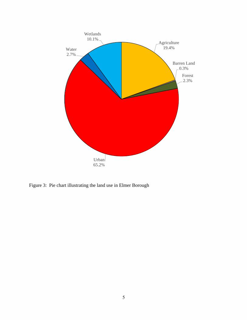
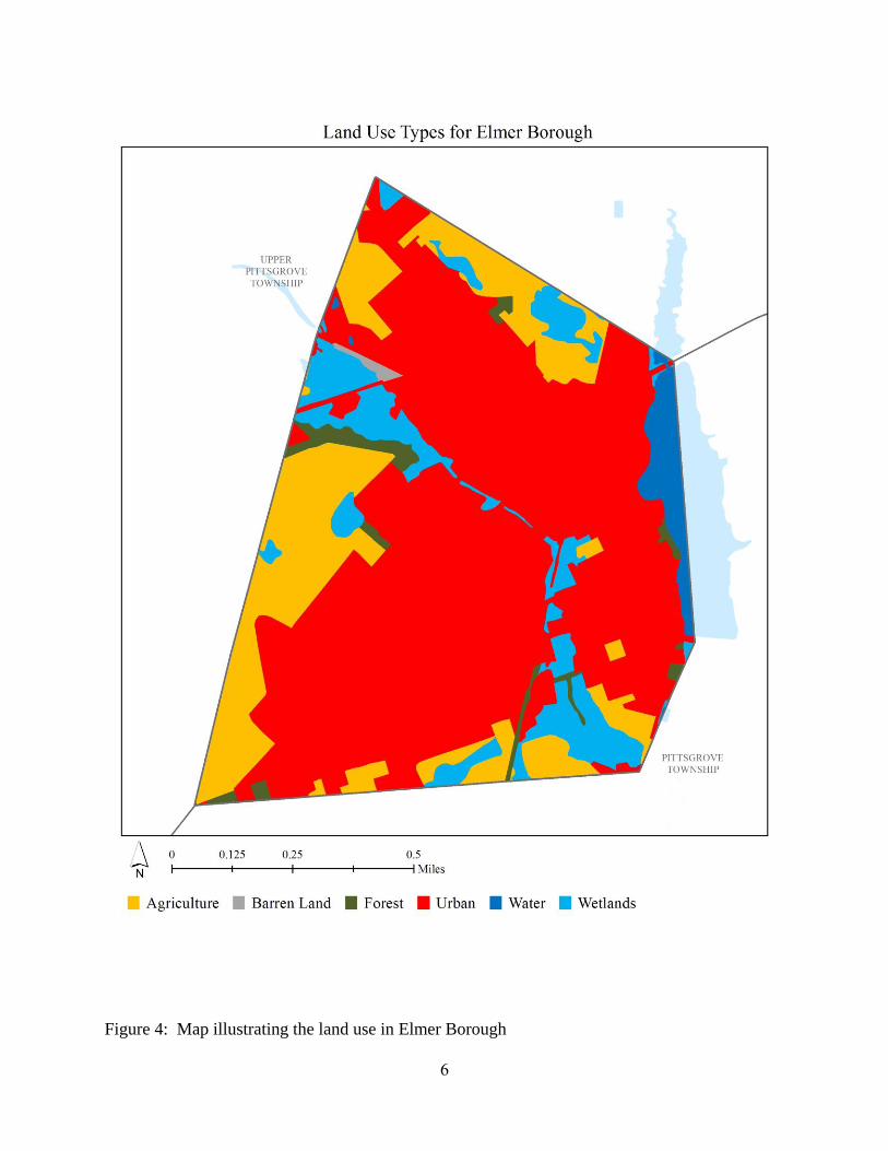
square miles. Figures 3 and 4 illustrate that Elmer Borough is dominated by urban land uses. A
total of 65.2% of the municipality’s land use is classified as urban. Of the urban land in Elmer
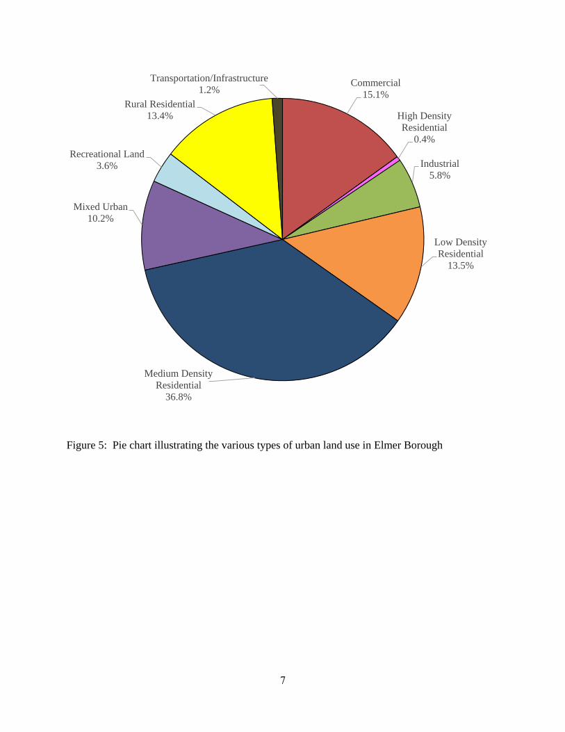
Borough, medium density residential is the dominant land use (Figure 5).
The literature suggests a link between impervious cover and stream ecosystem impairment starting
at approximately 10% impervious surface cover (Schueler, 1994; Arnold and Gibbons, 1996; May
et al., 1997). Impervious cover may be linked to the quality of lakes, reservoirs, estuaries, and
aquifers (Caraco et al., 1998), and the amount of impervious cover in a watershed can be used to
project the current and future quality of streams. Based on the scientific literature, Caraco et al.
(1998) classified urbanizing streams into the following three categories: sensitive streams,
impacted streams, and non-supporting streams. Sensitive steams typically have a watershed
impervious surface cover from 0 – 10%. Impacted streams have a watershed impervious cover
ranging from 11-25% and typically show clear signs of degradation from urbanization. Non-
supporting streams have a watershed impervious cover of greater than 25%; at this high level of
impervious cover, streams are simply conduits for stormwater flow and no longer support a diverse
stream community.
The New Jersey Department of Environmental Protection’s (NJDEP) 2012 land use/land cover
geographical information system (GIS) data layer categorizes Elmer Borough into many unique
land use areas, assigning a percent impervious cover for each delineated area. These impervious
cover values were used to estimate the impervious coverage for Elmer Borough. Based upon the
2012 NJDEP land use/land cover data, approximately 20.1% of Elmer Borough has impervious
cover. This level of impervious cover suggests that the streams in Elmer Borough are likely
impacted streams.
5
Figure 3: Pie chart illustrating the land use in Elmer Borough
Agriculture
19.4%
Barren Land
0.3%
Forest
2.3%
Urban
65.2%
Water
2.7%
Wetlands
10.1%
6
Figure 4: Map illustrating the land use in Elmer Borough
7
Figure 5: Pie chart illustrating the various types of urban land use in Elmer Borough
Commercial
15.1%
High Density
Residential
0.4%
Industrial
5.8%
Low Density
Residential
13.5%
Medium Density
Residential
36.8%
Mixed Urban
10.2%
Recreational Land
3.6%
Rural Residential
13.4%
Transportation/Infrastructure
1.2%
8
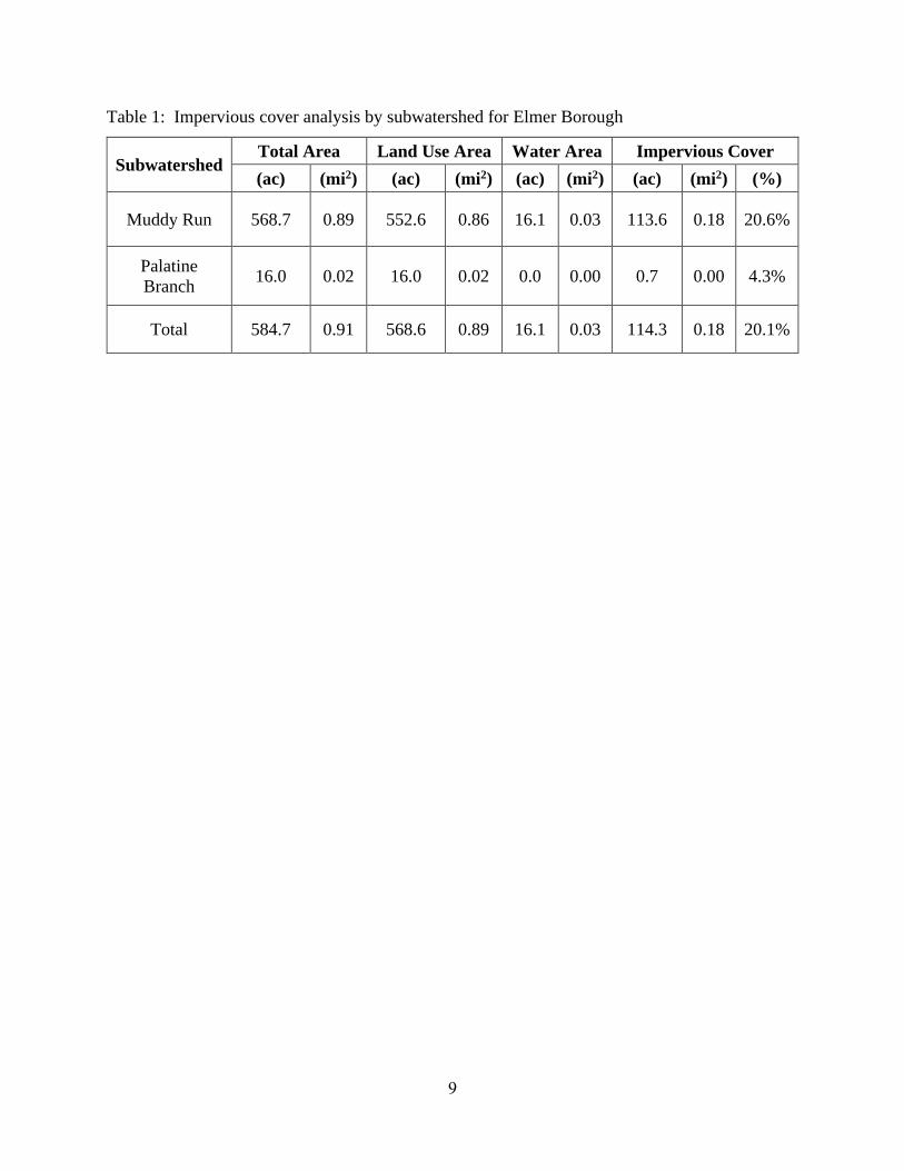
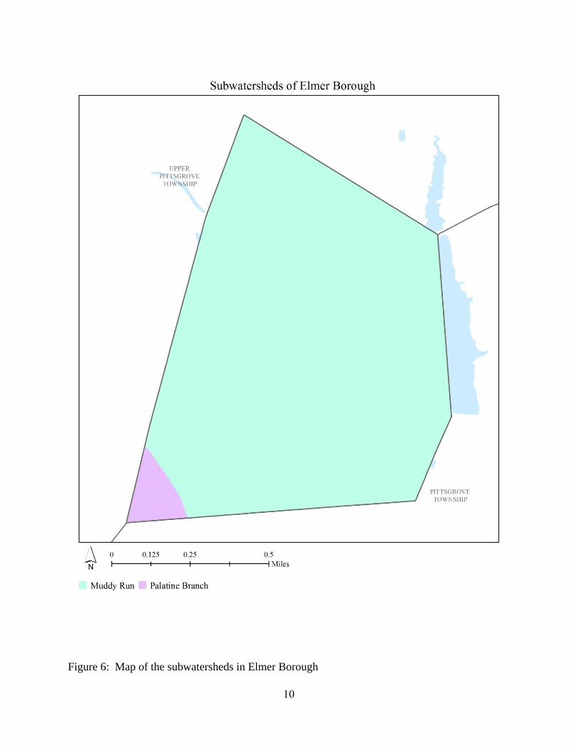
Water resources are typically managed on a watershed/subwatershed basis; therefore an
impervious cover analysis was performed for each subwatershed within Elmer Borough (Table 1
and Figure 6). On a subwatershed basis, impervious cover ranges from 4.3% in the Palatine Branch
subwatershed to 20.6% in the Muddy Run subwatershed. Evaluating impervious cover on a
subwatershed basis allows the municipality to focus impervious cover reduction or disconnection
efforts in the subwatersheds where frequent flooding occurs.
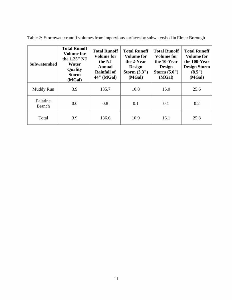
In developed landscapes, stormwater runoff from parking lots, driveways, sidewalks, and rooftops
flows to drainage pipes that feed the sewer system. The cumulative effect of these impervious
surfaces and thousands of connected downspouts reduces the amount of water that can infiltrate
into soils and greatly increases the volume and rate of runoff that flows to waterways. Stormwater
runoff volumes (specific to Elmer Borough, Salem County) associated with impervious surfaces
were calculated for the following storms: the New Jersey water quality design storm of 1.25 inches
of rain, an annual rainfall of 44 inches, the 2-year design storm (3.3 inches of rain), the 10-year
design storm (5.0 inches of rain), and the 100-year design storm (8.5 inches of rain). These runoff
volumes are summarized in Table 2. A substantial amount of rainwater drains from impervious
surfaces in Elmer Borough. For example, if the stormwater runoff from one water quality storm
(1.25 inches of rain) in the Muddy Run subwatershed was harvested and purified, it could supply
water to 36 homes for one year1.
1 Assuming 300 gallons per day per home
9
Table 1: Impervious cover analysis by subwatershed for Elmer Borough
Subwatershed Total Area Land Use Area Water Area Impervious Cover
(ac) (mi2) (ac) (mi2) (ac) (mi2) (ac) (mi2) (%)
Muddy Run 568.7 0.89 552.6 0.86 16.1 0.03 113.6 0.18 20.6%
Palatine
Branch 16.0 0.02 16.0 0.02 0.0 0.00 0.7 0.00 4.3%
Total 584.7 0.91 568.6 0.89 16.1 0.03 114.3 0.18 20.1%
10
Figure 6: Map of the subwatersheds in Elmer Borough
11
Table 2: Stormwater runoff volumes from impervious surfaces by subwatershed in Elmer Borough
Subwatershed
Total Runoff
Volume for
the 1.25" NJ
Water
Quality
Storm
(MGal)
Total Runoff
Volume for
the NJ
Annual
Rainfall of
44" (MGal)
Total Runoff
Volume for
the 2-Year
Design
Storm (3.3")
(MGal)
Total Runoff
Volume for
the 10-Year
Design
Storm (5.0")
(MGal)
Total Runoff
Volume for
the 100-Year
Design Storm
(8.5")
(MGal)
Muddy Run 3.9 135.7 10.8 16.0 25.6
Palatine
Branch 0.0 0.8 0.1 0.1 0.2
Total 3.9 136.6 10.9 16.1 25.8
12
The next step is to set a reduction goal for impervious area in each subwatershed. Based upon the
Rutgers Cooperative Extension (RCE) Water Resources Program's experience, a 10% reduction
would be a reasonably achievable reduction for these subwatersheds in Elmer Borough. While it
may be difficult to eliminate paved areas or replace paved areas with permeable pavement, it is
relatively easy to identify impervious surfaces that can be disconnected using green infrastructure
practices. For all practical purposes, disconnecting an impervious surface from a storm sewer
system or a water body is an "impervious area reduction." The RCE Water Resources Program
recommends that all green infrastructure practices that are installed to disconnect impervious
surfaces should be designed for the 2-year design storm (3.3 inches of rain over 24-hours).
Although this results in management practices that are slightly over-designed by NJDEP standards,
which require systems to be designed for the New Jersey water quality storm (1.25 inches of rain
over 2-hours), these systems will be able to handle the increase in storm intensities that are
expected to occur due to climate change. By designing these management practices for the 2-year
design storm, these practices will be able to manage 95% of the annual rainfall volume. The
recommended annual reductions in runoff volumes are shown in Table 3.
As previously mentioned, once impervious surfaces have been identified, the next steps for
managing impervious surfaces are to 1) eliminate surfaces that are not necessary, 2) reduce or
convert impervious surfaces to pervious surfaces, and 3) disconnect impervious surfaces from
flowing directly to local waterways.
Elimination of Impervious Surfaces
One method to reduce impervious cover is to "depave." Depaving is the act of removing paved
impervious surfaces and replacing them with pervious soil and vegetation that will allow for the
infiltration of rainwater. Depaving leads to the re-creation of natural space that will help reduce
flooding, increase wildlife habitat, and positively enhance water quality as well as beautify
neighborhoods. Depaving also can bring communities together around a shared vision to work
together to reconnect their neighborhood to the natural environment.
13
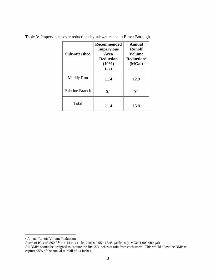
Table 3: Impervious cover reductions by subwatershed in Elmer Borough
Subwatershed
Recommended
Impervious
Area
Reduction
(10%)
(ac)
Annual
Runoff
Volume
Reduction2
(MGal)
Muddy Run 11.4 12.9
Palatine Branch 0.1 0.1
Total 11.4 13.0
2 Annual Runoff Volume Reduction =
Acres of IC x 43,560 ft2/ac x 44 in x (1 ft/12 in) x 0.95 x (7.48 gal/ft3) x (1 MGal/1,000,000 gal)
All BMPs should be designed to capture the first 3.3 inches of rain from each storm. This would allow the BMP to
capture 95% of the annual rainfall of 44 inches.
14
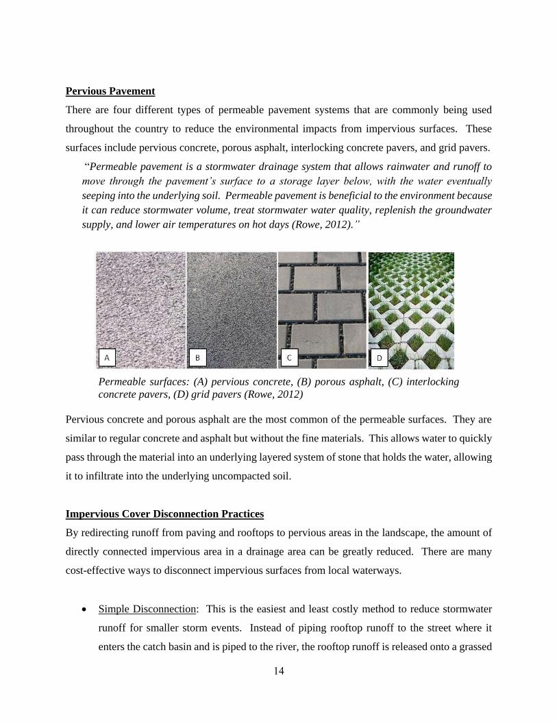
Pervious Pavement
There are four different types of permeable pavement systems that are commonly being used
throughout the country to reduce the environmental impacts from impervious surfaces. These
surfaces include pervious concrete, porous asphalt, interlocking concrete pavers, and grid pavers.
“Permeable pavement is a stormwater drainage system that allows rainwater and runoff to
move through the pavement’s surface to a storage layer below, with the water eventually
seeping into the underlying soil. Permeable pavement is beneficial to the environment because
it can reduce stormwater volume, treat stormwater water quality, replenish the groundwater
supply, and lower air temperatures on hot days (Rowe, 2012).”
Permeable surfaces: (A) pervious concrete, (B) porous asphalt, (C) interlocking
concrete pavers, (D) grid pavers (Rowe, 2012)
Pervious concrete and porous asphalt are the most common of the permeable surfaces. They are
similar to regular concrete and asphalt but without the fine materials. This allows water to quickly
pass through the material into an underlying layered system of stone that holds the water, allowing
it to infiltrate into the underlying uncompacted soil.
Impervious Cover Disconnection Practices
By redirecting runoff from paving and rooftops to pervious areas in the landscape, the amount of
directly connected impervious area in a drainage area can be greatly reduced. There are many
cost-effective ways to disconnect impervious surfaces from local waterways.
Simple Disconnection: This is the easiest and least costly method to reduce stormwater
runoff for smaller storm events. Instead of piping rooftop runoff to the street where it
enters the catch basin and is piped to the river, the rooftop runoff is released onto a grassed
15
area to allow the water to be filtered by the grass and soak into the ground. A healthy lawn
typically can absorb the first one to two inches of stormwater runoff from a rooftop. Simple
disconnection also can be used to manage stormwater runoff from paved areas. Designing
a parking lot or driveway to drain onto a grassed area, instead of the street, can dramatically
reduce pollution and runoff volumes.
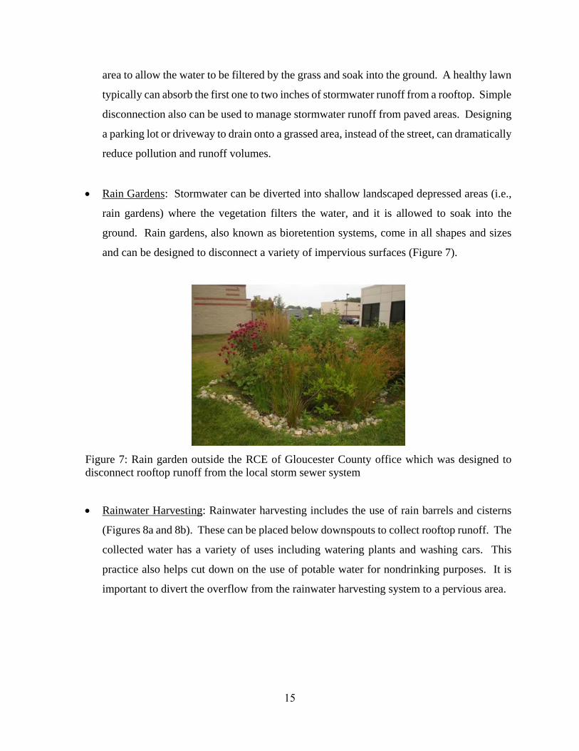
Rain Gardens: Stormwater can be diverted into shallow landscaped depressed areas (i.e.,
rain gardens) where the vegetation filters the water, and it is allowed to soak into the
ground. Rain gardens, also known as bioretention systems, come in all shapes and sizes
and can be designed to disconnect a variety of impervious surfaces (Figure 7).
Figure 7: Rain garden outside the RCE of Gloucester County office which was designed to
disconnect rooftop runoff from the local storm sewer system
Rainwater Harvesting: Rainwater harvesting includes the use of rain barrels and cisterns
(Figures 8a and 8b). These can be placed below downspouts to collect rooftop runoff. The
collected water has a variety of uses including watering plants and washing cars. This
practice also helps cut down on the use of potable water for nondrinking purposes. It is
important to divert the overflow from the rainwater harvesting system to a pervious area.

16
Figure 8a: Rain barrel used to
disconnect a downspout with
the overflow going to a flower
bed
Figure 8b: A 5,000 gallon cistern used to disconnect the rooftop of the
Department of Public Works in Clark Township to harvest rainwater for
nonprofit car wash events
17
Examples of Opportunities in Elmer Borough
To address the impact of stormwater runoff from impervious surfaces, the next step is to identify
opportunities in the municipality for eliminating, reducing, or disconnecting directly connected
impervious surfaces. To accomplish this task, an impervious cover reduction action plan should
be prepared. Aerial photographs are used to identify sites with impervious surfaces in the
municipality that may be suitable for inclusion in the action plan. After sites are identified, site
visits are conducted to photo-document all opportunities and evaluate the feasibility of eliminating,
reducing, or disconnecting directly connected impervious surfaces. A brief description of each
site discussing the existing conditions and recommendations for treatment of the impervious
surfaces is developed. After a number of sites have been selected for inclusion in the action plan,
concept plans and detailed green infrastructure information sheets are prepared for a selection of
representative sites.
For Elmer Borough, three sites have been included in this assessment. Examples of concept plans
and detailed green infrastructure information sheets are provided in Appendix A. The detailed
green infrastructure information sheets describe existing conditions and issues, proposed solutions,
anticipated benefits, possible funding sources, potential partners and stakeholders, and estimated
costs. Additionally, each project has been classified as a mitigation opportunity for recharge
potential, total suspended solids removal, and stormwater peak reduction. Finally, these detailed
green infrastructure information sheets provide an estimate of gallons of stormwater captured and
treated per year by each proposed green infrastructure practice. The concept plans provide an
aerial photograph of the site and details of the proposed green infrastructure practices.
Conclusions
Elmer Borough can reduce flooding and improve its waterways by better managing stormwater
runoff from impervious surfaces. This impervious cover assessment is the first step toward better
managing stormwater runoff. The next step is to develop an action plan to eliminate, reduce, or
disconnect impervious surfaces where possible and practical. Many of the highly effective
disconnection practices are inexpensive. The entire community can be engaged in implementing
these disconnection practices.

18
References
Arnold, C.L. Jr. and C.J. Gibbons. 1996. Impervious Surface Coverage The Emergence of a Key
Environmental Indicator. Journal of the American Planning Association 62(2): 243-258.
Caraco, D., R. Claytor, P. Hinkle, H. Kwon, T. Schueler, C. Swann, S. Vysotsky, and J. Zielinski.
1998. Rapid Watershed Planning Handbook. A Comprehensive Guide for Managing Urbanizing
Watersheds. Prepared by Center For Watershed Protection, Ellicott City, MD. Prepared for U.S.
Environmental Protection Agency, Office of Wetlands, Oceans and Watersheds and Region V.
October 1998.
May, C.W., R.R. Horner, J.R. Karr, B.W. Mar, E.G. Welch. 1997. Effects of Urbanization on
Small Streams in the Puget Sound Lowland Ecoregion. Watershed Protection Techniques 2(4):
483-493.
Nowak, D. J., and E. J. Greenfield, 2012. Trees and Impervious Cover in the United States.
Landscape and Urban Planning 107 (2012): 21-30.
http://www.nrs.fs.fed.us/pubs/jrnl/2012/nrs_2012_nowak_002.pdf
Rowe, A., 2012. Green Infrastructure Practices: An Introduction to Permeable Pavement. Rutgers
NJAES Cooperative Extension, FS1177, pp. 4.
http://njaes.rutgers.edu/pubs/publication.asp?pid=FS1177
Schueler, T. 1994. The Importance of Imperviousness. Watershed Protection Techniques1(3):
100-111.
United States Environmental Protection Agency (USEPA), 2013. Watershed Assessment,
Tracking, and Environmental Results, New Jersey Water Quality Assessment Report.
http://ofmpub.epa.gov/waters10/attains_state.control?p_state=NJ

Appendix A
Examples of Impervious Cover Reduction Action Plan Projects
Concept Plans and Detailed Green Infrastructure Information Sheets
Elmer Borough
Impervious Cover Assessment
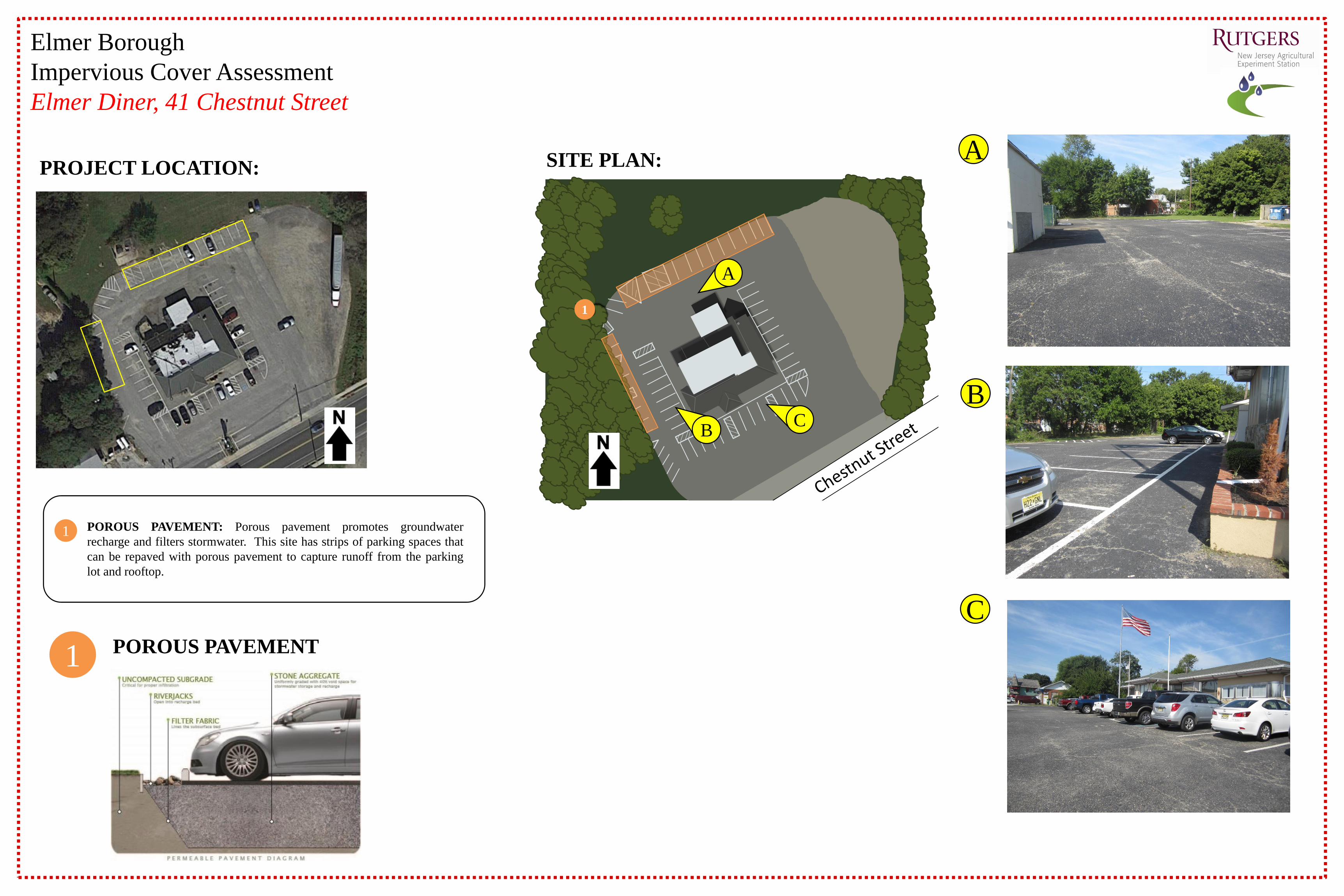
Elmer Diner, 41 Chestnut Street
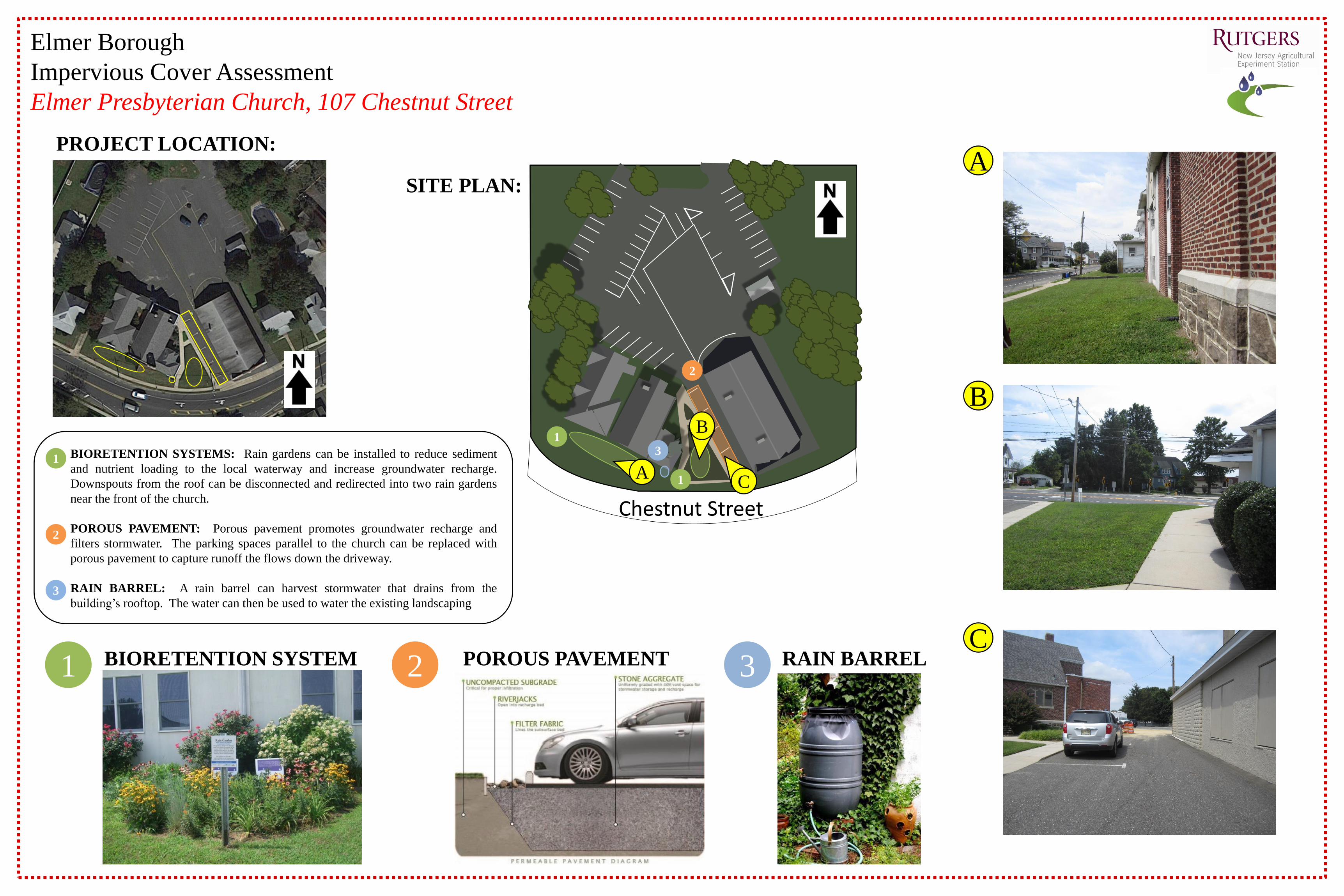
PROJECT LOCATION: SITE PLAN:
POROUS PAVEMENT
POROUS PAVEMENT: Porous pavement promotes groundwater
recharge and filters stormwater. This site has strips of parking spaces that
can be repaved with porous pavement to capture runoff from the parking
lot and rooftop.
A
C
1
1
B
1
BC
A
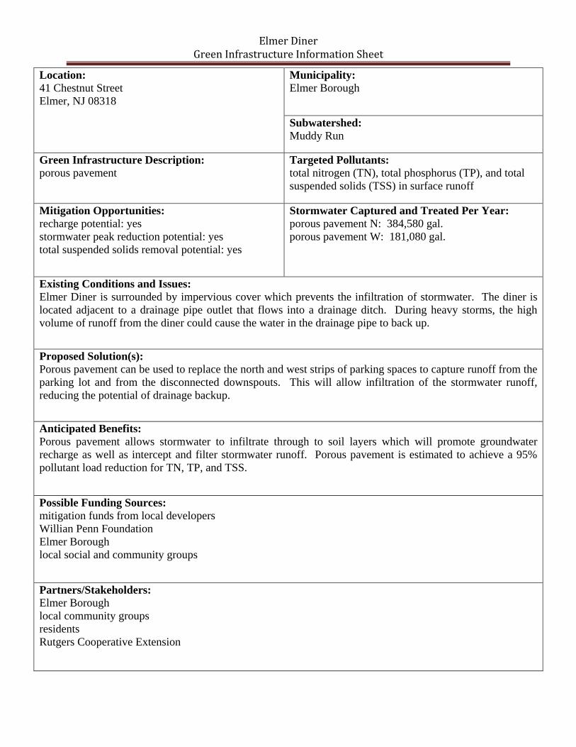
Elmer Diner Green Infrastructure Information Sheet
Location:
41 Chestnut Street
Elmer, NJ 08318
Municipality:
Elmer Borough
Subwatershed:
Muddy Run
Green Infrastructure Description: porous pavement
Targeted Pollutants: total nitrogen (TN), total phosphorus (TP), and total
suspended solids (TSS) in surface runoff
Mitigation Opportunities:
recharge potential: yes
stormwater peak reduction potential: yes
total suspended solids removal potential: yes
Stormwater Captured and Treated Per Year:
porous pavement N: 384,580 gal.
porous pavement W: 181,080 gal.
Existing Conditions and Issues:
Elmer Diner is surrounded by impervious cover which prevents the infiltration of stormwater. The diner is
located adjacent to a drainage pipe outlet that flows into a drainage ditch. During heavy storms, the high
volume of runoff from the diner could cause the water in the drainage pipe to back up.
Proposed Solution(s):
Porous pavement can be used to replace the north and west strips of parking spaces to capture runoff from the
parking lot and from the disconnected downspouts. This will allow infiltration of the stormwater runoff,
reducing the potential of drainage backup.
Anticipated Benefits:
Porous pavement allows stormwater to infiltrate through to soil layers which will promote groundwater
recharge as well as intercept and filter stormwater runoff. Porous pavement is estimated to achieve a 95%
pollutant load reduction for TN, TP, and TSS.
Possible Funding Sources:
mitigation funds from local developers
Willian Penn Foundation
Elmer Borough
local social and community groups
Partners/Stakeholders: Elmer Borough
local community groups
residents
Rutgers Cooperative Extension

Elmer Diner Green Infrastructure Information Sheet
Estimated Cost:
The north section of porous asphalt would cover 2,520 square feet and have a two-foot stone reservoir under
the surface. At $25 per square foot, the cost of the porous asphalt system would be $63,000. The west section
of porous asphalt would cover 1,820 square feet and have a two-foot stone reservoir under the surface. At $25
per square foot, the cost of the porous asphalt system would be $45,500.
The total cost of the project will be approximately $108,500.
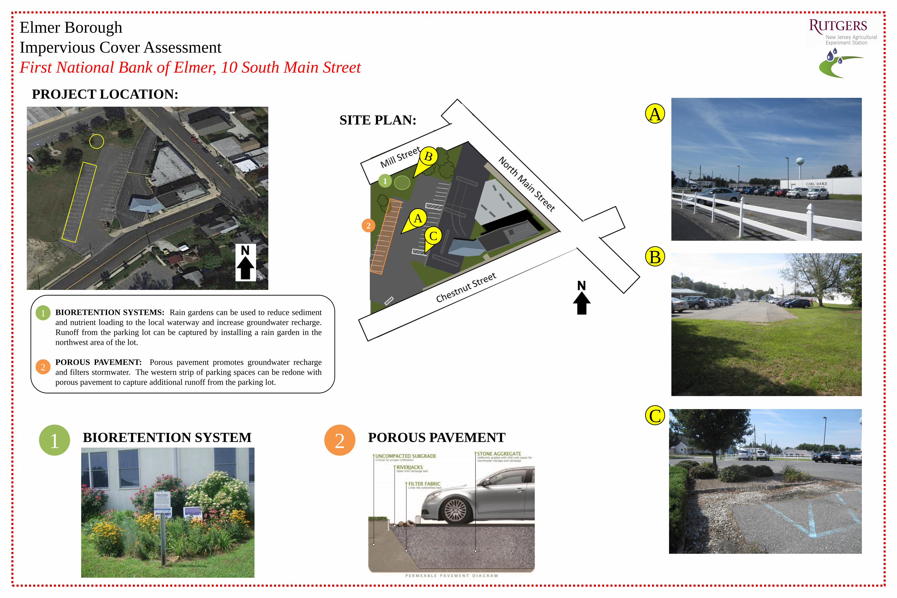
Elmer Borough
Impervious Cover Assessment
First National Bank of Elmer, 10 South Main Street
PROJECT LOCATION:
POROUS PAVEMENT
D
1
2
1 2
BIORETENTION SYSTEMS: Rain gardens can be used to reduce sediment
and nutrient loading to the local waterway and increase groundwater recharge.
Runoff from the parking lot can be captured by installing a rain garden in the
northwest area of the lot.
POROUS PAVEMENT: Porous pavement promotes groundwater recharge
and filters stormwater. The western strip of parking spaces can be redone with
porous pavement to capture additional runoff from the parking lot.
SITE PLAN:
B
C
A
BIORETENTION SYSTEM
C
A2
1
First National Bank of Elmer Green Infrastructure Information Sheet
Location:
10 South Main Street
Elmer, NJ 08318
Municipality:
Elmer Borough
Subwatershed:
Muddy Run
Green Infrastructure Description:
bioretention system (rain garden)
porous pavement
Targeted Pollutants:
total nitrogen (TN), total phosphorus (TP), and total
suspended solids (TSS) in surface runoff
Mitigation Opportunities:
recharge potential: yes
stormwater peak reduction potential: yes
total suspended solids removal potential: yes
Stormwater Captured and Treated Per Year:
bioretention system: 80,640 gal.
porous pavement: 351,360 gal.
Existing Conditions and Issues:
This site has areas of impervious cover that contribute to stormwater runoff. The parking lots are sloped
generally toward the west with some areas sloping toward the roadways.
Proposed Solution(s):
A rain garden could be installed in the grass area northwest of the parking lot to capture runoff from the adjacent
parking lot area. The western strip of parking spaces can be redone with porous pavement to capture runoff
from a majority of the remaining parking lot.
Anticipated Benefits:
Since the bioretention system would be designed to capture, treat, and infiltrate the entire 2-year design storm
(3.3 inches of rain over 24 hours), this system is estimated to achieve a 95% pollutant load reduction for TN,
TP, and TSS. A bioretention system would also provide ancillary benefits, such as enhanced wildlife and
aesthetic appeal to the local residents of Elmer Borough.
Porous pavement allows stormwater to penetrate though to soil layers which will promote groundwater
recharge as well as intercept and filter stormwater runoff. The porous pavement system will achieve the same
level of pollutant load reduction for TN, TP and TSS as the bioretention system.
Possible Funding Sources:
mitigation funds from local developers
William Penn Foundation
Elmer Borough
local social and community groups
Partners/Stakeholders:
Elmer Borough
local community groups
residents
Rutgers Cooperative Extension

First National Bank of Elmer Green Infrastructure Information Sheet
Estimated Cost:
A rain garden to capture the parking lot runoff would need to be approximately 775 square feet. At $5 per
square foot, the estimated cost of the rain garden is $3,875.
The porous asphalt would cover 3,585 square feet and have a two foot stone reservoir under the surface. At
$25 per square foot, the cost of the porous asphalt system would be $89,625.
The total cost of the project will be approximately $93,500.
PROJECT LOCATION:
SITE PLAN:
POROUS PAVEMENT1 2BIORETENTION SYSTEM
A
C
B
A
Chestnut Street
Elmer Borough
Impervious Cover Assessment
Elmer Presbyterian Church, 107 Chestnut Street
C
B
2
1
1
RAIN BARREL3
3BIORETENTION SYSTEMS: Rain gardens can be installed to reduce sediment
and nutrient loading to the local waterway and increase groundwater recharge.
Downspouts from the roof can be disconnected and redirected into two rain gardens
near the front of the church.
POROUS PAVEMENT: Porous pavement promotes groundwater recharge and
filters stormwater. The parking spaces parallel to the church can be replaced with
porous pavement to capture runoff the flows down the driveway.
RAIN BARREL: A rain barrel can harvest stormwater that drains from the
building’s rooftop. The water can then be used to water the existing landscaping3
1
2
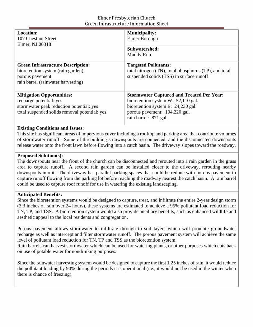
Elmer Presbyterian Church Green Infrastructure Information Sheet
Location:
107 Chestnut Street
Elmer, NJ 08318
Municipality:
Elmer Borough
Subwatershed:
Muddy Run
Green Infrastructure Description:
bioretention system (rain garden)
porous pavement
rain barrel (rainwater harvesting)
Targeted Pollutants:
total nitrogen (TN), total phosphorus (TP), and total
suspended solids (TSS) in surface runoff
Mitigation Opportunities:
recharge potential: yes
stormwater peak reduction potential: yes
total suspended solids removal potential: yes
Stormwater Captured and Treated Per Year:
bioretention system W: 52,110 gal.
bioretention system E: 24,230 gal.
porous pavement: 104,220 gal.
rain barrel: 871 gal.
Existing Conditions and Issues:
This site has significant areas of impervious cover including a rooftop and parking area that contribute volumes
of stormwater runoff. Some of the building’s downspouts are connected, and the disconnected downspouts
release water onto the front lawn before flowing into a catch basin. The driveway slopes toward the roadway.
Proposed Solution(s):
The downspouts near the front of the church can be disconnected and rerouted into a rain garden in the grass
area to capture runoff. A second rain garden can be installed closer to the driveway, rerouting nearby
downspouts into it. The driveway has parallel parking spaces that could be redone with porous pavement to
capture runoff flowing from the parking lot before reaching the roadway nearest the catch basin. A rain barrel
could be used to capture roof runoff for use in watering the existing landscaping.
Anticipated Benefits:
Since the bioretention systems would be designed to capture, treat, and infiltrate the entire 2-year design storm
(3.3 inches of rain over 24 hours), these systems are estimated to achieve a 95% pollutant load reduction for
TN, TP, and TSS. A bioretention system would also provide ancillary benefits, such as enhanced wildlife and
aesthetic appeal to the local residents and congregation.
Porous pavement allows stormwater to infiltrate through to soil layers which will promote groundwater
recharge as well as intercept and filter stormwater runoff. The porous pavement system will achieve the same
level of pollutant load reduction for TN, TP and TSS as the bioretention system.
Rain barrels can harvest stormwater which can be used for watering plants, or other purposes which cuts back
on use of potable water for nondrinking purposes.
Since the rainwater harvesting system would be designed to capture the first 1.25 inches of rain, it would reduce
the pollutant loading by 90% during the periods it is operational (i.e., it would not be used in the winter when
there is chance of freezing).
Elmer Presbyterian Church Green Infrastructure Information Sheet
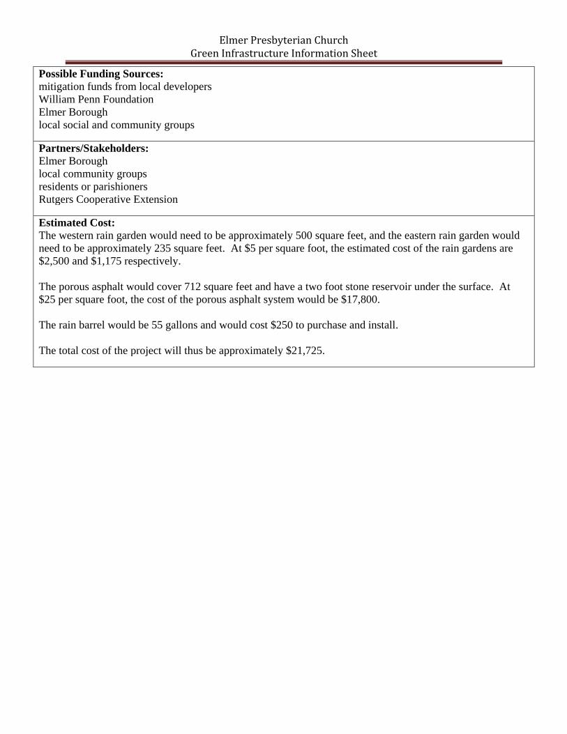
Possible Funding Sources:
mitigation funds from local developers
William Penn Foundation
Elmer Borough
local social and community groups
Partners/Stakeholders:
Elmer Borough
local community groups
residents or parishioners
Rutgers Cooperative Extension
Estimated Cost:
The western rain garden would need to be approximately 500 square feet, and the eastern rain garden would
need to be approximately 235 square feet. At $5 per square foot, the estimated cost of the rain gardens are
$2,500 and $1,175 respectively.
The porous asphalt would cover 712 square feet and have a two foot stone reservoir under the surface. At
$25 per square foot, the cost of the porous asphalt system would be $17,800.
The rain barrel would be 55 gallons and would cost $250 to purchase and install.
The total cost of the project will thus be approximately $21,725.


![Elmer Book[1]](https://static.documents.pub/doc/80x56/577d245c1a28ab4e1e9c4a9f/elmer-book1.jpg)


