Principals of Groundwater Groundwater: the subsurface water of the saturated zone Saturated zone: the zone in which, the pores and fissures of the soil and rocks are completely filled with water.
Transcript
Principals of Groundwater
Groundwater: the subsurface water of the saturated zone
Saturated zone : the zone in which, the pores and fissures of the so il and rocks are completely filled with water.
Occurrence, Amount, Quality of Groundwater are cont rolled by many factors:
1. Geology (Type of Rocks)
2. Topography
3. Climate and
4. Geometry of Aquifer
Recharge Zone
Storage ZoneDischarge Zone
Porosity: It is the ratio of pore space to the total volume o f rock
Permeability : It is the capability of a rock to pass water or oth er fluids
Type of Aquifers:
1. Aquifer: It is that Rock formation that have the ability to store and transmit substantial quantities of groundwater under ordinary hydraulic gradients.
2. Aquitard: (Leaky Aquifer) It is less permeable than aquifer, but may be permeable enough to transmit significant quantities of water.
3. Aquiclude: It is that Rock formation that have very low permeability to permit the flow of significant quantities of groundwater
4. Aquifuge: It is impermeable formation i.e
Neither containing nor transmitting water
AQUIFERS
Aquiclude
Aquifuge
Aquifer
Aquitard
Unconfined Aquifer:
Confined Aquifer:
Perched Aquifer:
Hydrogeological Characteristics of the rock units i n Yemen Important Aquifers
Good Aquifers
Spatial Distribution of Regional Aquifers in YemenA new small scale schematic hydrogeological map of Y emen was prepared by (
Van de Jun et al, 1995)
Based on:
- the previous hydrogeological maps carried out by Robertson Group, 1991 and theRussian company (zarubezhgeologia, 1992),
- Study of numerous reports and
- Observation on the field during many years
In this map the UNESCO classification of aquifer units was followed,
But
in between porousAquifer and fissure aquifer
a category of mixed pore/fissure aquifer is defined.
The following classes of the hydrogeological aquifer s in Yemen then resulted:
1a. Highly productive pore aquifers
1b. Moderately or poorly productive pore aquifers
2a. Highly productive fissure aquifers
2b. Moderately or poorly productive fissure aquifer s
3a. Highly productive mixed pore/fissure aquifers
3b. Moderately or poorly productive mixed pore / fi ssure aquifers
a. Strata with local and limited groundwater resour ces
4b. Units with essentially no groundwater.
8 classes
1. Alluvial wadi fills (strip aquifers):
characteristics:
• Consist of Quaternary sedimentary aquifers
• Formed by the wadi (alluvial deposits)
• Recharged by the wadi
• Highly permeable.
• They have a small width compared to their length.
• They were the most convenient places to look for shallow subsurface water
Principal groundwater systems in Yemen
Example of of wadi (Strip aquifers):
I. Alluvial strip aquifers
a. Embedded in impervious rocks (cross-section)
b. Hydraulically connected to permeable rocks (cross-section)
c. Underlain by a regional aquifer (cross-section)
A B
B A
A
B
A
B
BA BA BA BA
a. Wadi Mawr(Yemen)
b. Wadi Hadhramawt(Yemen)
Catchment area
2. Alluvial Wadi Plain (Fans and Delta) aquifers:
Characteristics:
• Consist of Quaternary sedimentary aquifers
• Situated at the mouth of wadi
• Recharged by the wadi
• Highly permeable.
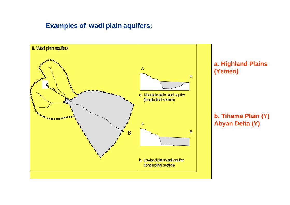
Examples of wadi plain aquifers:
II. Wadi plain aquifers
a. Mountain plain wadi aquifer (longitudinal section)
b. Lowland plain wadi aquifer (longitudinal section)
A
B
A
B
B
A
a. Highland Plains(Yemen)
b. Tihama Plain (Y)Abyan Delta (Y)
The most important representatives of Wadi Plain aquifers are:
A. The Quaternary aquifer complexes of Tihama plain
B. The Quaternary aquifer of southern coastal plains ( Tuban , Abyan, Ahwar & Maif’ah Plain).
C. The Quaternary aquifer at the western and southern e dges of Ramlat-as-Sabatayn, and
D. The Quaternary aquifer of Wadi Hadramout.
A. The Quaternary Aquifer System in the Tihama Plain:
• The Tihama coastal plain consistsof Tertiary and Quaternary sediment.
• The Tertiary sediments are poorly permeable and containing saline water.
• The Quaternary sediments contain fresh groundwater and extend over more than 400 km along the coast over a width of 30 to 60 km between the escarpment and Red Sea.
• This Quaternary aquifer is recharged by the streams descending from the mountains (Wadis Mawr, Sudud, Siham, Rima, Zabid, rasyan, etc…).
Quaternary Aquifer:
-Thickness : 50 and 250 m.
- Transmissivities : 500 to 3000 m 2/d
- Groundwater flow: from E to W
The Tihama Quaternary aquifer system is not a singl e, laterally homogenous aquifer.
Recent studies on Tihama Quaternary aquifers system subdivided the Tihama aquifer into separate groundwater provinces as follows:
1. Wadi Harad
2. Wadi Hayran
3. Wadi Mawr
4. Wadi Surdud
5. Wadi Siham
6. Wadi Rima/ Wadi Zabid
7. Wadi Rasyan and
8. Wadi Mawza
B. The Quaternary Aquifer of the Southern Coastal Plains:
• The southern coastal plains are located in the Gulf of Aden rift.• They show similarity to the Tihama, but the thickne ss is less.
• A number of independent flow domains from west to e ast are:
1. Tuban Delta2. Abyan Delta3. Ahwar Delta and Maif’ah Plain
1. The Aquifer system of Tuban Delta:
• The thickness may increase from 30 m to some 120-17 0 m,
• No highly transmissive zones are observed at depths below 90 m.
• Aquifer depths increase in the lower Delta, at leas t to 200 m
• The aquifer type change from Unconfined
to semi confined conditions near
the coast.
• Groundwater is known to be
brackish in the coastal fringes.
2. The Aquifer system of Abyan Delta:
• Two major wadis dissect and recharge Abyan Delta:
Wadi Bana and Wadi Hassan
• The maximum thickness:
100 m in southern zone,
some 50-60 m in the central zone and
more than 100 m in the northern zone.
• Transmissivities vary:
from 300 to 10000 m 2/day.
3. The Quaternary Delta of Wadi Ahwar:
- It is smaller than the Tuban and Abyan Deltas
- It is made up of Quaternary alluvial and marine deposits
- Maximum thickness: 50 m
- Depth of water: vary from 2 m near the sea to some 20 m further inland (1995).
4. The Quaternary aquifer of Wadi Maifa’ah:
- It opens to a vast plain which slopes gently down t owards the sea from an absolute height of 700 m.
-The aquifer consists of Quaternary series of gravel -pebble material, unsorted sands and loams.
- The thickness of the aquifer is about tens of mete rs.
C. Quaternary aquifers at western and southern margins of th e Ramlat-as-sabatayn:
The largest wadi systems running from the Yemen moun tain massif towards theRamlat-as-sabatayn are:
1. Wadi Al-Jawf
2. Wadi Adhana
3. Wadi Beihan and
4. Wadi Markhah
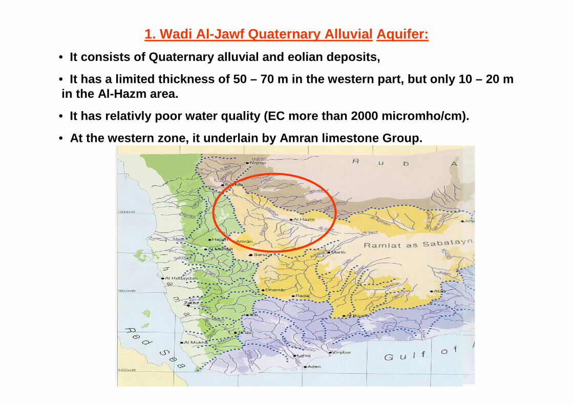
1. Wadi Al-Jawf Quaternary Alluvial Aquifer:
• It consists of Quaternary alluvial and eolian depos its,
• It has a limited thickness of 50 – 70 m in the weste rn part, but only 10 – 20 m in the Al-Hazm area.
• It has relativly poor water quality (EC more than 20 00 micromho/cm).
• At the western zone, it underlain by Amran limeston e Group.
2. Wadi Adhana Quaternary Alluvial Aquifer:
• It covers marib plain and having a thickness of 50-7 0 m.
• It has a high transmissivity
• The main groundwater flow coincides with that of wa di, which is north-east.
• The recharge process has been altered by the constr uction of dam in the Wadi Adhana in 1986.
3. Wadi Markhah and Wadi Beihan Quaternary Alluvial Aquifer:
• These Quaternary aquifers shows similarities with o ther systems, but the groundwater systems are less productive due to:
1. Smaller catchment2. Dry climatic conditions
D. Quaternary Alluvial Aquifer of Wadi Hadramawt:
Wadi Hadramawt is located in a canyon cut into the carbonate rocks of the Hadramawt Group.
• The vertical sides of the canyon rise to some 300 m above the top of the Quaternary deposits.
• The aquifer has approx. 90 km long, from 1.5 to 20 km wide and locally more than 100 m thick.
• It has high transmissivities and good sources of rec harge
• Various large tributaries quickly brings floods fro m around 22500 km 2 of limestone plateaus to Wadi Hadramawt canyon
2. Groundwater basins of the Highland Plains:
The most important highland groundwater basin are f rom north to south:
A. The Sadah Basin
B. The Amran Basin
C. The Sana’a Basin
D. The Ma’bar – Dhamar Plain and
E. The Rada Basin
A. The Sadah Basin
• It is defined by the Sadah graben, a strongly down faulted block.
• Wajid Sandstones occur under a 30-60 m thick cover o f unconsolidated Quaternary deposits.
• It has a thickness between 300 – 600 m.
• The Wajid sandstone has low porosity and hydraulic c onductivities
B. The Amran Basin
• It is filled with Quaternary alluvial deposits with intercalations of Quaternary basalts .
• Transmisivities of the aquifer range from 75 to 860 m2/day.
• Groundwater pumping in the Amran basin is intensive .
• The Wajid sandstone has low porosity and hydraulic c onductivities
C. The Sana’a Basin
• It characterized by a complex groundwater system.
• Several major studies carried out during the last 2 0 years including:
1. Italconsult, 1972
2. Mosgiprovodkhoz, 1986;
3. SAWAS Project, …… ..
3. Bloemendaal et al, 1994
4. TS-HWC, 1992
5. WEC, 2002
But still imperfectly known.
The following Fig. gives an impression of the geology of Sana’a Basin
The most important groundwateraquifers in Sana’a Basin are:
• Quaternary alluvial aquifer
• Tertiary Yemen Volcanic
• Tawilah Sandstones and
• perhaps Kohlan sandstones
1. Quaternary alluvial aquifer:
• Alluvial deposits used to be an important source in groundwater in the past.
• Serious declines of groundwater tables have reduced their role.
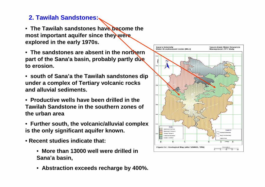
2. Tawilah Sandstones:
• The Tawilah sandstones have become the most important aquifer since they were explored in the early 1970s.
• The sandstones are absent in the northern part of the Sana'a basin, probably partly due to erosion.
• south of Sana’a the Tawilah sandstones dip under a complex of Tertiary volcanic rocks and alluvial sediments.
• Productive wells have been drilled in the Tawilah Sandstone in the southern zones of the urban area
• Further south, the volcanic/alluvial complex is the only significant aquifer known.
• Recent studies indicate that:
• More than 13000 well were drilled in Sana’a basin,
• Abstraction exceeds recharge by 400%.
D. The Ma’bar – Dhamar – Kitab Plains
• They consist of a number of larger and smaller plains.
• Some of them such as Qa Jahranare filled to great depths (more than 100 m) with alluvial deposits, which constitute the main aquifer system.
• In these plains, due to tectonic features, the volcanic rocks form a highly productive and permeable aquifer.
E. The Rada Basin
• The Fractured Tawilah sandstones represent the main aquifer in Rada Basin.
• The Quaternary alluvial deposits in Rada Basin forms a locally shallow aquifer.
• The volcanic rocks forms a less important groundwater systems.
• All these groundwater system are interconnected.
• Groundwater is intensively abstracted in Rada Basin leading to significant declines of the groundwater levels.
The Regional Mukalla Sandstone Aquifer
• Location: East of the Arabian Shield
North of Al-Ghaydah Basin and Gulf of Aden rift zone
• It forms a continuous regional aquifer of large lateral extent
• It constitute the largest groundwater system in Yemen.
• It is equivalent to Tawilah group that presents in the West
• Lithology: Sandstone
• Thickness:300-400 m, Max.thickness(1000 m) in Shabwa area.
• In the western part (Ramlat-as-Sabatayn) it rests upon Jurassic sediments, containing saline groundwater.
• I has higher porosity (up to 25 %)
• I has high transmissivites(3000 to 3500 m2/day).
• It recharged from Wadis in the Western and Central parts
Other Regionally Extensive Aquifers:
1. Amran Limestone Aquifer
2. Yemen Volcanics Aquifer
3. Um-Er-Radhumma Aquifer
1. Amran Limestone Aquifer
• It forms an extensive and thick outcrop between Sana’a and Sadah.
• In this aquifer groundwater predominantly flows through fissures
• The hydraulic properties of this aquifer are generally not favorable for groundwater development
• The productive wells are observed locally especially near the Wadis.
2. Yemen Volcanic Aquifer
• It present predominantly south of Sana’a and between Hajjah and Sadah.
• It forms a poor, fissured regional aquifer system except in the Central Higher Plains Area where it forms favorable zone due to
the tectonic activity
3. Um-Er-Radhumma Aquifer
• It forms outcrops in the eastern part of Yemen especially Hadramout and Ramalt –as- Sabatayn.
• In this aquifer groundwater predominantly flows through fissures