Missouri University of Science and Technology Missouri University of Science and Technology Scholars' Mine Scholars' Mine International Conferences on Recent Advances in Geotechnical Earthquake Engineering and Soil Dynamics 2010 - Fifth International Conference on Recent Advances in Geotechnical Earthquake Engineering and Soil Dynamics 28 May 2010, 8:00 am - 8:30 am Principles and Practices of Seismic Microzonation: Case Studies Principles and Practices of Seismic Microzonation: Case Studies in India in India T. G. Sitharam Indian Institute of Science, India P. Anbazhagan Indian Institute of Science, India K. S. Vipin Indian Institute of Science, India Follow this and additional works at: https://scholarsmine.mst.edu/icrageesd Part of the Geotechnical Engineering Commons Recommended Citation Recommended Citation Sitharam, T. G.; Anbazhagan, P.; and Vipin, K. S., "Principles and Practices of Seismic Microzonation: Case Studies in India" (2010). International Conferences on Recent Advances in Geotechnical Earthquake Engineering and Soil Dynamics. 7. https://scholarsmine.mst.edu/icrageesd/05icrageesd/session12/7 This work is licensed under a Creative Commons Attribution-Noncommercial-No Derivative Works 4.0 License. This Article - Conference proceedings is brought to you for free and open access by Scholars' Mine. It has been accepted for inclusion in International Conferences on Recent Advances in Geotechnical Earthquake Engineering and Soil Dynamics by an authorized administrator of Scholars' Mine. This work is protected by U. S. Copyright Law. Unauthorized use including reproduction for redistribution requires the permission of the copyright holder. For more information, please contact [email protected].
Transcript
Missouri University of Science and Technology Missouri University of Science and Technology
Scholars' Mine Scholars' Mine
International Conferences on Recent Advances in Geotechnical Earthquake Engineering and Soil Dynamics
2010 - Fifth International Conference on Recent Advances in Geotechnical Earthquake
Engineering and Soil Dynamics
28 May 2010, 8:00 am - 8:30 am
Principles and Practices of Seismic Microzonation: Case Studies Principles and Practices of Seismic Microzonation: Case Studies
in India in India
T. G. Sitharam Indian Institute of Science, India
P. Anbazhagan Indian Institute of Science, India
K. S. Vipin Indian Institute of Science, India
Follow this and additional works at: https://scholarsmine.mst.edu/icrageesd
Part of the Geotechnical Engineering Commons
Recommended Citation Recommended Citation Sitharam, T. G.; Anbazhagan, P.; and Vipin, K. S., "Principles and Practices of Seismic Microzonation: Case Studies in India" (2010). International Conferences on Recent Advances in Geotechnical Earthquake Engineering and Soil Dynamics. 7. https://scholarsmine.mst.edu/icrageesd/05icrageesd/session12/7
This work is licensed under a Creative Commons Attribution-Noncommercial-No Derivative Works 4.0 License.
This Article - Conference proceedings is brought to you for free and open access by Scholars' Mine. It has been accepted for inclusion in International Conferences on Recent Advances in Geotechnical Earthquake Engineering and Soil Dynamics by an authorized administrator of Scholars' Mine. This work is protected by U. S. Copyright Law. Unauthorized use including reproduction for redistribution requires the permission of the copyright holder. For more information, please contact [email protected].
PRINCIPLES AND PRACTICES OF SEISMIC MICROZONATION: CASE STUDIES IN INDIA
ABSTRACT This paper presents an overview of the principles and practices of seismic microzonation with some case studies in India. India has experienced major damages and loss of life due to earthquakes. Macrozonation map in Indian seismic code IS-1893 is frequently revised soon after a major earthquake in the country. New revision which was published in 2002 after Bhuj earthquake in 2001 contains four macro zones. These zones are based on geology and limited seismology input without considering geotechnical aspects such as site effects and liquefaction. In order to understand the earthquake vulnerability of major urban centers and prepare new zonation map, the Govt. of India has initiated microzonation of 63 cities in India after 2001 earthquake. Many microzonation studies are under progress and few of them have been completed. This paper presents an overview of these studies. Seismic microzonation of Jabalpur urban area is the first work in India towards seismic microzonation of Indian cities. Jabalpur study has provided many learning lessons to other studies. Preliminary microzonation of Delhi has been completed and detailed one is under progress. Seismic Hazard and Microzonation Atlas of the Sikkim Himalaya has been published with geological and seismological background. Microzonation of Guwahati was done based on geology, geomorphology, seismotectonics, soil characteristics, pre-dominant frequencies, peak ground acceleration, seismic hazard and demography. Seismic Microzonation of Dehradun has been prepared based on shear wave velocity with site response. First order Microzonation of Haldia has been developed based on peak ground acceleration, predominant frequency and elevation map. Different maps and results were presented for Gujarat microzonation based on noise survey and after shock data. None of these studies included the geotechnical aspects. The geotechnical aspects were fully incorporated in the recently completed Microzonation work of Bangalore and the ongoing study of Chennai microzonation. An overview of seismic microzonation studies in India is presented in this paper. INTRODUCTION In the last three decades, large earthquakes have caused massive loss of lives and extensive physical destruction throughout the world (Armenia, 1988; Iran, 1990; US, 1994; Japan, 1995; Turkey, 1999; Taiwan, 1999, India 2001, Sumatra 2004, Pakistan, 2005). India has been facing threat from earthquakes since ancient times. In India, the recent destructive earthquakes are Killari (1993), Jabalpur (1997), Bhuj (2001), Sumatra (2004) and Indo-Pakistan (2005). Very preliminary process of reducing the effects of earthquake is by assessing the hazard itself. Seismic microzonation is first and fore most steps to minimize seismic related damages and loss of lives.
Microzonation has generally been recognized as the most accepted tool in seismic hazard assessment and risk evaluation and it is defined as the zonation with respect to ground motion characteristics taking into account source and site conditions [TC4-ISSMGE, 1999]. Making improvements on the conventional macrozonation maps and regional hazard maps, microzonation of a region generates detailed maps that predict the hazard at much smaller scales. Seismic microzonation is the generic name for subdividing a region into individual areas having different potentials, hazardous earthquake effects, defining their specific seismic behavior for engineering design and land-use planning. The role of geological and geotechnical data is becoming very important in the microzonation in particular to plan city urban infrastructure, which can recognize, control and prevent geological hazards (Bell et al.,
T.G. Sitharam, Professor, Department of Civil Engineering, Indian Institute of Science, Bangalore, India, 560012. email - [email protected]
K.S. Vipin, Research scholar, Dept of Civil Engg, Indian Institute of Science, Bangalore, India, 560012. email - [email protected]
P. Anbazhagan, Lecturer, Dept of Civil Engg, Indian Institute of Science, Bangalore, India, 560012. email - [email protected]
Paper No. OSP 10 2
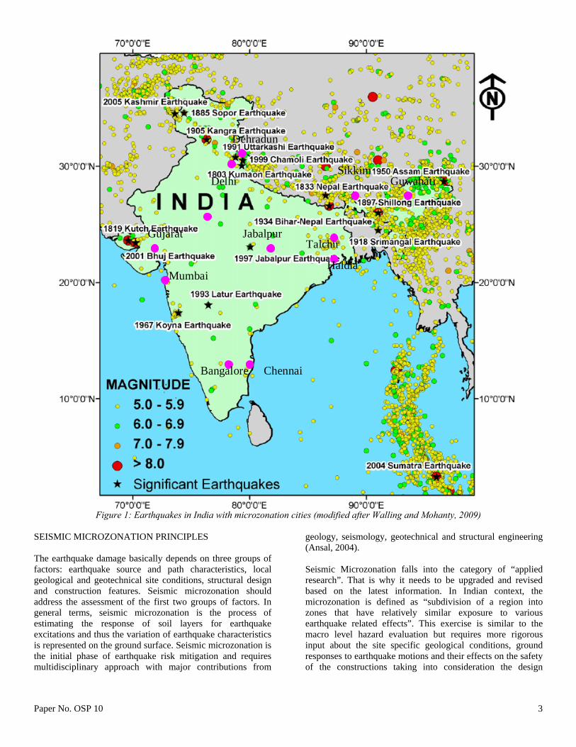
1987; Legget, 1987; Hake, 1987; Rau, 1994; Dai et al., 1994, 2001; Van Rooy and Stiff, 2001). The basis of microzonation is to model the rupture mechanism at the source of an earthquake, evaluate the propagation of waves through the earth to the top of bed rock, determine the effect of local soil profile and thus develop a hazard map indicating the vulnerability of the area to potential seismic hazard. Seismic microzonation will also help in designing buried lifelines such as tunnels, water and sewage lines, gas and oil lines, and power and communication lines. This paper summarizes the seismic microzonation studies in India. This is a revised version of Sitharam and Anbazhagan (2008) and more details of the study can be found in that paper. As part of the national level microzonation programme, Department of Science and Technology, Govt. of India has initiated microzonation of 63 cities in India (Bansal and Vandana, 2007). As an initial experiment, seismic hazard analysis and microzonation was taken up for Jabalpur city in Madhya Pradesh. Further, for many other cities such as Sikkim, Mumbai, Delhi, North East India, Guwahati, Ahmedabad, Bhuj, Dehradun, Haldia and Chennai, an attempt has been made to carryout microzonation considering geomorphological features and detailed geotechnical studies. Among the above Jabalpur, Sikkim, Guwahati and Bangalore microzonation works have been completed. MACROZONATION AND CODAL PROVISIONS IN INDIA India has two types of earthquakes distribution, irregular occurrence of earthquakes in Peninsular India and regular occurrence of earthquake in northern, northeastern, and the northwestern part of India. Earthquake in Peninsular India are intraplate earthquake and earthquakes in other parts are intraplate as well as interplate earthquake due to collision of boundary of the Eurasian and Indian Plate. Summary of Indian seismicity were presented by many authors in particular Khattri and Wyss, (1978); Bilham et al. (1997); Verma et al., (1976); Molnar and Tapponnier, (1977); Khattri and Tyagi, (1983); Seeber and Armbruster (1981), Khattri (1999) and Bilham and Gaur (2000). Purnachandra Rao, (1999); Ramalingeswara Rao, (2000); Iyengar and RaghuKanth, (2004); Sitharam and Anbazhagan (2007); Anbazhagan et al (2009); Vipin et al (2009); Walling and Mohanty (2009). Even though the great earthquakes may be possible in plate boundaries, the chances of great intraplate earthquake are also of great concern. Figure 1 shows the Earthquake distribution of the Indian subcontinent and location of cities with seismic microzonation study.
First seismic macrozonation map was prepared by Geological Survey of India (GSI) in 1935 after the 1934 Bihar-Nepal earthquake. After Indian Standards Institution (ISI) established in 1947 and renamed as Bureau of Indian Standards in 1986, it is the agency responsible for producing and publishing the seismic hazard maps and codes in India. BIS published the seismic macrozonation map of India in 1962 (BIS-1893, 1962) based on earthquake epicenters and the isoseismal map published by the GSI in 1935. The macro zoning was reviewed and included additional information of geology and tectonic features. Revised macrozonation map was published in 1966 (BIS-1893, 1966), this map developed with more weightage to the tectonic maps, that delineated the fault systems (Tandon, 1992; Walling and Mohanty, 2009). Soon after 1967 Koyna earthquake, the zonation map underwent major revision in 1970 by including both geological and geophysical data (BIS-1893, 1970). In 1984 the regions of different seismogenic potential were identified on the basis of past earthquakes and the regional tectonic features, which was incorporated in zonation map and published in 1984 (BIS-1893, 1984). None of these macrozonation maps have considered the seismic hazard at different locations the return periods of the required design seismic coefficients. The occurrence of the 1993 Latur earthquake (mb: 6.3), 1997 Jabalpur (mb: 6.0) and 2001 Bhuj (Mw: 7.6) in the lower seismic zone (according to old zonation) raised questions on the validity of the seismic zonation map of Peninsular India (Walling and Mohanty, 2009). This further forced to revise the seismic macrozonation map and in 2002. The new macrozonation map was developed with four seismic zones by assigned peak ground acceleration (PGA) values ranging from 0.1 g to 0.4 g (Walling and Mohanty, 2009). Besides the PGA, the expected maximum intensity of shaking in each zone was also estimated based on the Comprehensive Intensity Scale (CIS-64) (BIS-1893, 2002). But still the modifications in the zonation map of India with the occurrence of significant earthquakes suggest the assessment of hazard on a regional scale is not consistent with the local variation (Walling and Mohanty, 2009). Many individuals have produced national and regional hazard maps (Tandon, 1956; Krishna, 1959; Guha, 1962; Gubin, 1968 and 1971; Basu and Nigam, 1978; Kaila and Rao, 1979; Khattri et al., 1984; Bhatia et al. 1999; Parvez et al. 2003; Sitharam and Anbazhagan, 2007; Jaiswal, and Sinha, 2007; Anbazhagan et al., 2009; Vipin et al, 2009). The zonation maps and regional hazard maps produced by researchers represent only the status of the present knowledge about the seismicity and the various methodologies available. This has to be used with caution for specific projects.
Paper No. OSP 10 3
ChennaiBangalore
Mumbai
Gujarat
SikkimGuwahati Delhi
Jabalpur
Dehradun
Talchir
Haldia
Figure 1: Earthquakes in India with microzonation cities (modified after Walling and Mohanty, 2009)
SEISMIC MICROZONATION PRINCIPLES The earthquake damage basically depends on three groups of factors: earthquake source and path characteristics, local geological and geotechnical site conditions, structural design and construction features. Seismic microzonation should address the assessment of the first two groups of factors. In general terms, seismic microzonation is the process of estimating the response of soil layers for earthquake excitations and thus the variation of earthquake characteristics is represented on the ground surface. Seismic microzonation is the initial phase of earthquake risk mitigation and requires multidisciplinary approach with major contributions from
geology, seismology, geotechnical and structural engineering (Ansal, 2004). Seismic Microzonation falls into the category of “applied research”. That is why it needs to be upgraded and revised based on the latest information. In Indian context, the microzonation is defined as “subdivision of a region into zones that have relatively similar exposure to various earthquake related effects”. This exercise is similar to the macro level hazard evaluation but requires more rigorous input about the site specific geological conditions, ground responses to earthquake motions and their effects on the safety of the constructions taking into consideration the design
Paper No. OSP 10 4
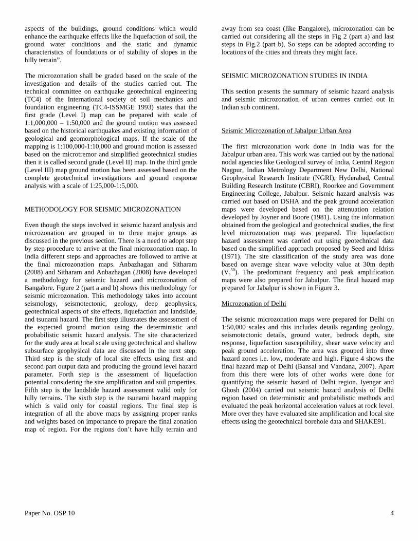
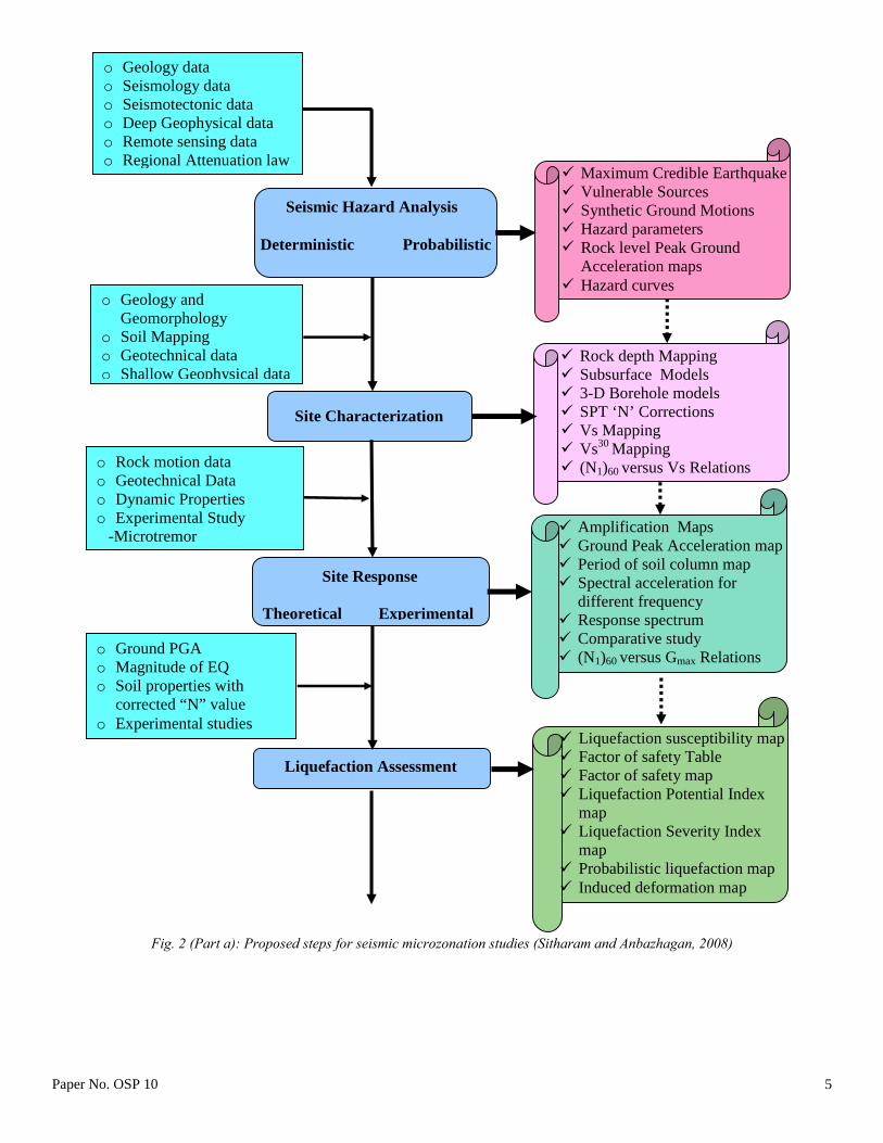
aspects of the buildings, ground conditions which would enhance the earthquake effects like the liquefaction of soil, the ground water conditions and the static and dynamic characteristics of foundations or of stability of slopes in the hilly terrain”. The microzonation shall be graded based on the scale of the investigation and details of the studies carried out. The technical committee on earthquake geotechnical engineering (TC4) of the International society of soil mechanics and foundation engineering (TC4-ISSMGE 1993) states that the first grade (Level I) map can be prepared with scale of 1:1,000,000 – 1:50,000 and the ground motion was assessed based on the historical earthquakes and existing information of geological and geomorphological maps. If the scale of the mapping is 1:100,000-1:10,000 and ground motion is assessed based on the microtremor and simplified geotechnical studies then it is called second grade (Level II) map. In the third grade (Level III) map ground motion has been assessed based on the complete geotechnical investigations and ground response analysis with a scale of 1:25,000-1:5,000. METHODOLOGY FOR SEISMIC MICROZONATION Even though the steps involved in seismic hazard analysis and microzonation are grouped in to three major groups as discussed in the previous section. There is a need to adopt step by step procedure to arrive at the final microzonation map. In India different steps and approaches are followed to arrive at the final microzonation maps. Anbazhagan and Sitharam (2008) and Sitharam and Anbazhagan (2008) have developed a methodology for seismic hazard and microzonation of Bangalore. Figure 2 (part a and b) shows this methodology for seismic microzonation. This methodology takes into account seismology, seismotectonic, geology, deep geophysics, geotechnical aspects of site effects, liquefaction and landslide, and tsunami hazard. The first step illustrates the assessment of the expected ground motion using the deterministic and probabilistic seismic hazard analysis. The site characterized for the study area at local scale using geotechnical and shallow subsurface geophysical data are discussed in the next step. Third step is the study of local site effects using first and second part output data and producing the ground level hazard parameter. Forth step is the assessment of liquefaction potential considering the site amplification and soil properties. Fifth step is the landslide hazard assessment valid only for hilly terrains. The sixth step is the tsunami hazard mapping which is valid only for coastal regions. The final step is integration of all the above maps by assigning proper ranks and weights based on importance to prepare the final zonation map of region. For the regions don’t have hilly terrain and
away from sea coast (like Bangalore), microzonation can be carried out considering all the steps in Fig 2 (part a) and last steps in Fig.2 (part b). So steps can be adopted according to locations of the cities and threats they might face. SEISMIC MICROZONATION STUDIES IN INDIA This section presents the summary of seismic hazard analysis and seismic microzonation of urban centres carried out in Indian sub continent. Seismic Microzonation of Jabalpur Urban Area The first microzonation work done in India was for the Jabalpur urban area. This work was carried out by the national nodal agencies like Geological survey of India, Central Region Nagpur, Indian Metrology Department New Delhi, National Geophysical Research Institute (NGRI), Hyderabad, Central Building Research Institute (CBRI), Roorkee and Government Engineering College, Jabalpur. Seismic hazard analysis was carried out based on DSHA and the peak ground acceleration maps were developed based on the attenuation relation developed by Joyner and Boore (1981). Using the information obtained from the geological and geotechnical studies, the first level microzonation map was prepared. The liquefaction hazard assessment was carried out using geotechnical data based on the simplified approach proposed by Seed and Idriss (1971). The site classification of the study area was done based on average shear wave velocity value at 30m depth (Vs
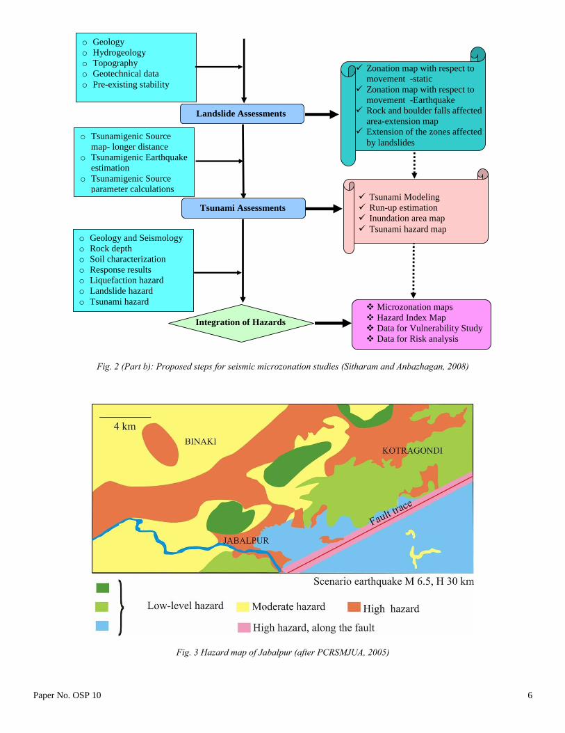
30). The predominant frequency and peak amplification maps were also prepared for Jabalpur. The final hazard map prepared for Jabalpur is shown in Figure 3. Microzonation of Delhi The seismic microzonation maps were prepared for Delhi on 1:50,000 scales and this includes details regarding geology, seismotectonic details, ground water, bedrock depth, site response, liquefaction susceptibility, shear wave velocity and peak ground acceleration. The area was grouped into three hazard zones i.e. low, moderate and high. Figure 4 shows the final hazard map of Delhi (Bansal and Vandana, 2007). Apart from this there were lots of other works were done for quantifying the seismic hazard of Delhi region. Iyengar and Ghosh (2004) carried out seismic hazard analysis of Delhi region based on deterministic and probabilistic methods and evaluated the peak horizontal acceleration values at rock level. More over they have evaluated site amplification and local site effects using the geotechnical borehole data and SHAKE91.
Paper No. OSP 10 5
o Geology data o Seismology data o Seismotectonic data o Deep Geophysical data o Remote sensing data o Regional Attenuation law
Fig. 2 (Part a): Proposed steps for seismic microzonation studies (Sitharam and Anbazhagan, 2008)
Paper No. OSP 10 6
o Geology o Hydrogeology o Topography o Geotechnical data o Pre-existing stability
Microzonation maps Hazard Index Map Data for Vulnerability Study Data for Risk analysis
Integration of Hazards
o Geology and Seismology o Rock depth o Soil characterization o Response results o Liquefaction hazard o Landslide hazard o Tsunami hazard
Zonation map with respect to movement -static
Zonation map with respect to movement -Earthquake
Rock and boulder falls affected area-extension map
Extension of the zones affected by landslides
Landslide Assessments
Tsunami Assessments
o Tsunamigenic Source map- longer distance
o Tsunamigenic Earthquake estimation
o Tsunamigenic Source parameter calculations
Tsunami Modeling Run-up estimation Inundation area map Tsunami hazard map
Fig. 2 (Part b): Proposed steps for seismic microzonation studies (Sitharam and Anbazhagan, 2008)
Fig. 3 Hazard map of Jabalpur (after PCRSMJUA, 2005)
Paper No. OSP 10 7
In another study the bed rock level PGA maps for Delhi were developed by Rao and Neelima Satyam (2005) by considering five seismic sources in Delhi region. A Geotechnical site characterization was carried out based on the borehole data, geophysical data and VS
30. Estimation of soil amplification factors were carried out using DEGTRA software and microzonation map for amplification factors was generated. The seismic response of the soil was estimated using the microtremor measurements at different locations in Delhi. Based on the shape of the resonance spectra and H/V amplitude, the predominant frequency and fundamental frequency map of the Delhi was prepared. Based on the SPT values obtained from the borehole data, the liquefaction potential of Delhi was also evaluated (Rao and Neelima Satyam, 2007). Mohanty et al (2007) prepared a first order seismic microzonation map of Delhi using five thematic layers viz., Peak Ground Acceleration (PGA), different soil types at 6 m depth, geology, groundwater fluctuation and bedrock depth, and integrating them using GIS platform.
Fig. 4 Final hazard map of Delhi (after Bansal and Vandana, 2007)
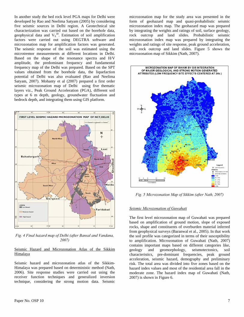
Seismic Hazard and Microzonation Atlas of the Sikkim Himalaya Seismic hazard and microzonation atlas of the Sikkim-Himalaya was prepared based on deterministic method (Nath, 2006). Site response studies were carried out using the receiver function techniques and generalized inversion technique, considering the strong motion data. Seismic
microzonation map for the study area was presented in the form of geohazard map and quasi-probabilistic seismic microzonation index map. The geohazard map was prepared by integrating the weights and ratings of soil, surface geology, rock outcrop and land slides. Probabilistic seismic microzonation index map was prepared by integrating the weights and ratings of site response, peak ground acceleration, soil, rock outcrop and land slides. Figure 5 shows the microzonation map of Sikkim (Nath, 2007).
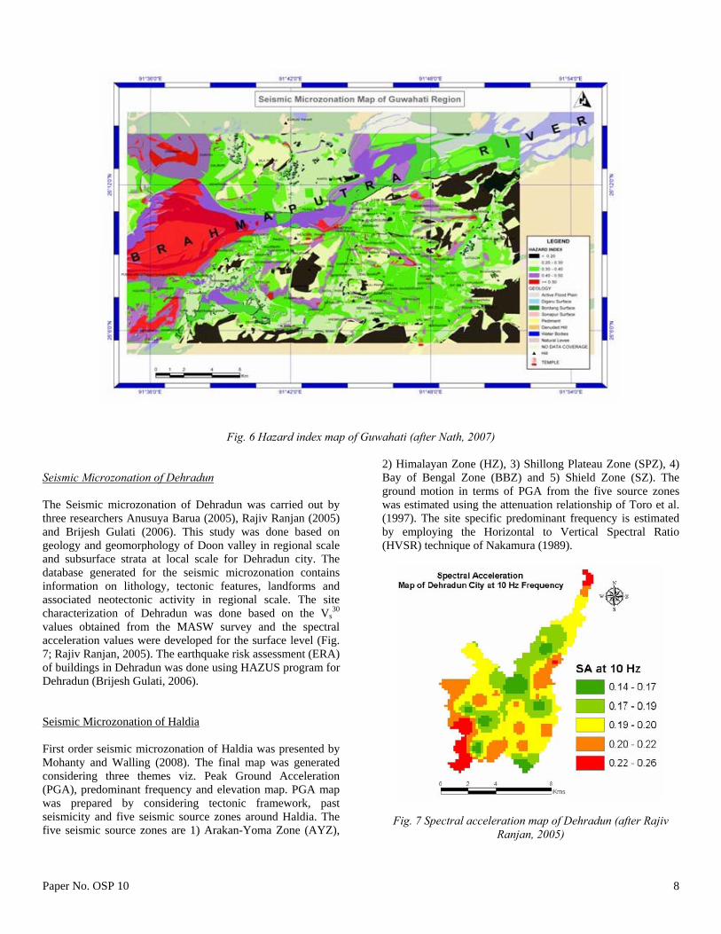
Fig. 5 Microzonation Map of Sikkim (after Nath, 2007) Seismic Microzonation of Guwahati The first level microzonation map of Guwahati was prepared based on amplification of ground motion, slope of exposed rocks, shape and constituents of overburden material inferred from geophysical surveys (Baranwal et al., 2005). In that work the soil profile was categorized in terms of their susceptibility to amplification. Microzonation of Guwahati (Nath, 2007) contains important maps based on different categories like, geology and geomorphology, seismotectonics, soil characteristics, pre-dominant frequencies, peak ground acceleration, seismic hazard, demography and preliminary risk. The total area was divided into five zones based on the hazard index values and most of the residential area fall in the moderate zone. The hazard index map of Guwahati (Nath, 2007) is shown in Figure 6.
Paper No. OSP 10 8
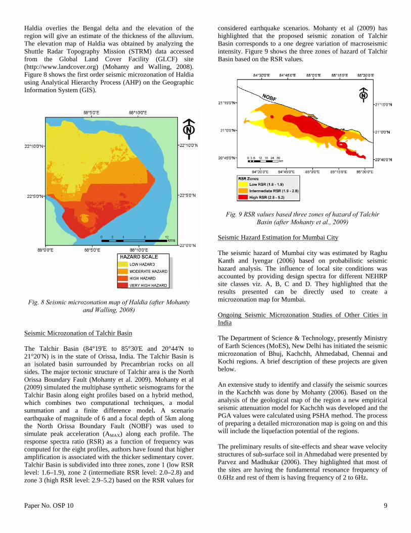
Fig. 6 Hazard index map of Guwahati (after Nath, 2007) Seismic Microzonation of Dehradun The Seismic microzonation of Dehradun was carried out by three researchers Anusuya Barua (2005), Rajiv Ranjan (2005) and Brijesh Gulati (2006). This study was done based on geology and geomorphology of Doon valley in regional scale and subsurface strata at local scale for Dehradun city. The database generated for the seismic microzonation contains information on lithology, tectonic features, landforms and associated neotectonic activity in regional scale. The site characterization of Dehradun was done based on the Vs
30 values obtained from the MASW survey and the spectral acceleration values were developed for the surface level (Fig. 7; Rajiv Ranjan, 2005). The earthquake risk assessment (ERA) of buildings in Dehradun was done using HAZUS program for Dehradun (Brijesh Gulati, 2006). Seismic Microzonation of Haldia First order seismic microzonation of Haldia was presented by Mohanty and Walling (2008). The final map was generated considering three themes viz. Peak Ground Acceleration (PGA), predominant frequency and elevation map. PGA map was prepared by considering tectonic framework, past seismicity and five seismic source zones around Haldia. The five seismic source zones are 1) Arakan-Yoma Zone (AYZ),
2) Himalayan Zone (HZ), 3) Shillong Plateau Zone (SPZ), 4) Bay of Bengal Zone (BBZ) and 5) Shield Zone (SZ). The ground motion in terms of PGA from the five source zones was estimated using the attenuation relationship of Toro et al. (1997). The site specific predominant frequency is estimated by employing the Horizontal to Vertical Spectral Ratio (HVSR) technique of Nakamura (1989).
Fig. 7 Spectral acceleration map of Dehradun (after Rajiv
Ranjan, 2005)
Paper No. OSP 10 9
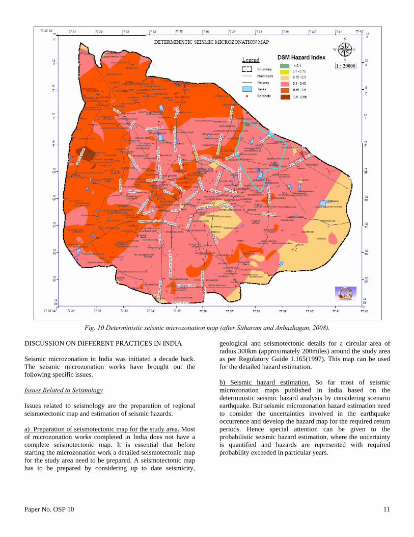
Haldia overlies the Bengal delta and the elevation of the region will give an estimate of the thickness of the alluvium. The elevation map of Haldia was obtained by analyzing the Shuttle Radar Topography Mission (STRM) data accessed from the Global Land Cover Facility (GLCF) site (http://www.landcover.org) (Mohanty and Walling, 2008). Figure 8 shows the first order seismic microzonation of Haldia using Analytical Hierarchy Process (AHP) on the Geographic Information System (GIS).
Fig. 8 Seismic microzonation map of Haldia (after Mohanty and Walling, 2008)
Seismic Microzonation of Talchir Basin The Talchir Basin (84°19'E to 85°30'E and 20°44'N to 21°20'N) is in the state of Orissa, India. The Talchir Basin is an isolated basin surrounded by Precambrian rocks on all sides. The major tectonic structure of Talchir area is the North Orissa Boundary Fault (Mohanty et al. 2009). Mohanty et al (2009) simulated the multiphase synthetic seismograms for the Talchir Basin along eight profiles based on a hybrid method, which combines two computational techniques, a modal summation and a finite difference model. A scenario earthquake of magnitude of 6 and a focal depth of 5km along the North Orissa Boundary Fault (NOBF) was used to simulate peak acceleration (AMAX) along each profile. The response spectra ratio (RSR) as a function of frequency was computed for the eight profiles, authors have found that higher amplification is associated with the thicker sedimentary cover. Talchir Basin is subdivided into three zones, zone 1 (low RSR level: 1.6–1.9), zone 2 (intermediate RSR level: 2.0–2.8) and zone 3 (high RSR level: 2.9–5.2) based on the RSR values for
considered earthquake scenarios. Mohanty et al (2009) has highlighted that the proposed seismic zonation of Talchir Basin corresponds to a one degree variation of macroseismic intensity. Figure 9 shows the three zones of hazard of Talchir Basin based on the RSR values.
Fig. 9 RSR values based three zones of hazard of Talchir Basin (after Mohanty et al., 2009)
Seismic Hazard Estimation for Mumbai City The seismic hazard of Mumbai city was estimated by Raghu Kanth and Iyengar (2006) based on probabilistic seismic hazard analysis. The influence of local site conditions was accounted by providing design spectra for different NEHRP site classes viz. A, B, C and D. They highlighted that the results presented can be directly used to create a microzonation map for Mumbai. Ongoing Seismic Microzonation Studies of Other Cities in India The Department of Science & Technology, presently Ministry of Earth Sciences (MoES), New Delhi has initiated the seismic microzonation of Bhuj, Kachchh, Ahmedabad, Chennai and Kochi regions. A brief description of these projects are given below. An extensive study to identify and classify the seismic sources in the Kachchh was done by Mohanty (2006). Based on the analysis of the geological map of the region a new empirical seismic attenuation model for Kachchh was developed and the PGA values were calculated using PSHA method. The process of preparing a detailed microzonation map is going on and this will include the liquefaction potential of the regions. The preliminary results of site-effects and shear wave velocity structures of sub-surface soil in Ahmedabad were presented by Parvez and Madhukar (2006). They highlighted that most of the sites are having the fundamental resonance frequency of 0.6Hz and rest of them is having frequency of 2 to 6Hz.
Paper No. OSP 10 10
The seismic hazard and site response study of Chennai city was done by Suganthi and Boominathan (2006). They have concluded from the ground response analysis that significant amplification is present only in the low range of frequencies. Center for Earth Science Studies (CESS) is carrying out the seismic microzonation of Kochi city. In this work the site response is measured using ambient noise (microtremor). This will be related to the available information on geology, geomorphology, lineament patterns, soil type/ lithology, structural features etc. in the region. Seismic Microzonation of Bangalore Seismic microzonation of Bangalore was carried out by considering two major attributes 1) Geomorphological attributes and 2) Seismological attributes. The usual geomorphological attributes considered in seismic microzonation mapping are geology and geomorphology (GG), rock depth/ soil thickness (RD/ST), soil type and strength (represented in terms of average shear wave velocity) (SS), drainage pattern (DP) and elevation of the ground (EL). The seismological attributes have been generated based on detailed studies of seismic hazard analysis, site response studies and liquefaction analysis. From the detailed study different earthquake hazard parameters were generated and they are as follows: 1. Peak ground acceleration (PGA) at rock level generated
based on synthetic ground motions considering MCE based on DSHA.
2. PGA at rock level at 10 % probability of exceedance in 50 years based on PSHA.
3. Amplification factor based on ground response analysis using SHAKE2000.
4. Predominant frequency based on site response and experimental studies.
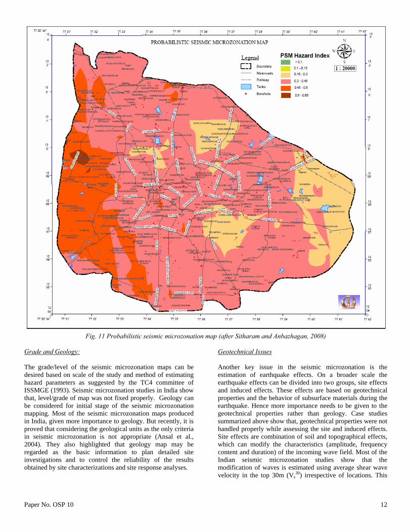
5. Factor of safety against Liquefaction potential These attributes were arrived based on microzonation steps given in Figure 2. Based on the above attributes, two types of hazard index map were generated. One is the deterministic seismic microzonation map (DSM), which is the deterministic hazard index map using PGA from deterministic approach and other themes. Another map is the probabilistic seismic microzonation map (PSM). Probabilistic hazard index are calculated similar to DSM but PGA is obtained from probabilistic seismic hazard analysis.
Deterministic seismic microzonation map is the hazard index map for worst scenario earthquake. One of the important factors, PGA, is estimated from synthetic ground motions, which were generated based on MCE of 5.1 in moment magnitude for the closest vulnerable source of Mandya – Channapatna - Bangalore lineament (Sitharam and Anbazhagan 2008). Hazard index values were estimated based on normalized weights and ranks through the integration of all themes using the following equation:
W
rwrwrWrWrW
rWrWrWrW
GGGGDRDRELELPFPFFSFS
SSSSSTSTAFAFDSM /
DPGADPGA (1)
Based on these estimated values, the deterministic seismic microzonation map has been generated. Figure 10 shows the deterministic seismic microzonation map for Bangalore. Integrated GIS map shows that hazard index values vary from 0.10 to 0.66. These values are grouped into four groups, <0.1, 0.10-0.15, 0.15-0.30, 0.3-0.45, 0.45-0.6 and 0.6 to 0.66. The maximum hazard is at the western part of Bangalore. Eastern part of city is having a lower hazard when compare to other areas. Western and southern part has mixed hazard and northern part is having moderate hazard. Similar to DSM hazard index calculation, probabilistic hazard index has been estimated. In this the PGA values were taken from the probabilistic seismic hazard analysis. PGA at 10% probability of exceedance in 50 years has been estimated considering six seismogenic sources and regional recurrence relation. Based on probabilistic hazard index values probabilistic seismic microzonation map (PSM) has been generated. Probabilistic hazard index values were estimated based on normalized weights and ranks through the integration of all themes using the following equation:
W
rwrwrWrWrW
rWrWrWrW
GGGGDRDRELELPFPFFSFS
SSSSSTSTAFAFPSM /
PPGAPPGA (2)
Figure 11 shows the probabilistic seismic microzonation map based on hazard index. Probabilistic hazard index values vary from 0.10 to 0.66 and have been divided into four groups such as < 0.1, 0.10 - 0.15, 0.15 - 0.30, 0.3 - 0.45, 0.45 - 0.6 and 0.6 to 0.66. These values are lesser than that of deterministic hazard index. The maximum hazard is attached to the seismic hazard index greater than 0.6 at south western part of Bangalore. Southern part of Bangalore is having moderate to maximum hazard when compare to the northern part.
DISCUSSION ON DIFFERENT PRACTICES IN INDIA Seismic microzonation in India was initiated a decade back. The seismic microzonation works have brought out the following specific issues. Issues Related to Seismology Issues related to seismology are the preparation of regional seismotectonic map and estimation of seismic hazards: a) Preparation of seismotectonic map for the study area. Most of microzonation works completed in India does not have a complete seismotectonic map. It is essential that before starting the microzonation work a detailed seismotectonic map for the study area need to be prepared. A seismotectonic map has to be prepared by considering up to date seismicity,
geological and seismotectonic details for a circular area of radius 300km (approximately 200miles) around the study area as per Regulatory Guide 1.165(1997). This map can be used for the detailed hazard estimation. b) Seismic hazard estimation. So far most of seismic microzonation maps published in India based on the deterministic seismic hazard analysis by considering scenario earthquake. But seismic microzonation hazard estimation need to consider the uncertainties involved in the earthquake occurrence and develop the hazard map for the required return periods. Hence special attention can be given to the probabilistic seismic hazard estimation, where the uncertainty is quantified and hazards are represented with required probability exceeded in particular years.
Grade and Geology: The grade/level of the seismic microzonation maps can be desired based on scale of the study and method of estimating hazard parameters as suggested by the TC4 committee of ISSMGE (1993). Seismic microzonation studies in India show that, level/grade of map was not fixed properly. Geology can be considered for initial stage of the seismic microzonation mapping. Most of the seismic microzonation maps produced in India, given more importance to geology. But recently, it is proved that considering the geological units as the only criteria in seismic microzonation is not appropriate (Ansal et al., 2004). They also highlighted that geology map may be regarded as the basic information to plan detailed site investigations and to control the reliability of the results obtained by site characterizations and site response analyses.
Geotechnical Issues Another key issue in the seismic microzonation is the estimation of earthquake effects. On a broader scale the earthquake effects can be divided into two groups, site effects and induced effects. These effects are based on geotechnical properties and the behavior of subsurface materials during the earthquake. Hence more importance needs to be given to the geotechnical properties rather than geology. Case studies summarized above show that, geotechnical properties were not handled properly while assessing the site and induced effects. Site effects are combination of soil and topographical effects, which can modify the characteristics (amplitude, frequency content and duration) of the incoming wave field. Most of the Indian seismic microzonation studies show that the modification of waves is estimated using average shear wave velocity in the top 30m (Vs
30) irrespective of locations. This
Paper No. OSP 10 13
practice need to be completely reviewed, because Vs30 is not a
standard parameter to reflect the site effects. Pitilakis (2004) shows the inability of the Vs
30 for estimation of site amplification of soil layers. Particularly large amplifications of the deep incident wave field are practically absent when amplification are computed using the transfer ratio for shallower depths. The author has also showed that the use of Vs
30 as a basis for site amplification is misleading in many cases. Hence it is necessary to use actual engineering rock depth (shear wave velocity more than 700 m/s) rather than Vs
30 for amplification study. Another major issue is the estimation of induced effects such as liquefaction hazard and land slide hazard. Most of the case studies summarized above shows that liquefaction hazard was estimated using the old correlations and attenuation relation without much of local geotechnical knowledge. It is always recommended the liquefaction hazard has to be estimated based on recent developments in earthquake geotechnical engineering. Most of the land slide hazards in seismic microzonation studies in India were estimated based on geological data. However detailed geotechnical inputs are required for the precise mapping of landslide prone area during earthquake. There is a need of carrying out detailed geotechnical studies for seismic microzonation. SUMMARY An overview of seismic microzonation practices in India has been presented in this paper. It can be seen that most of the studies were done without giving due attention to the geotechnical aspects. The results obtained from the recent studies suggest that it will be advisable to incorporate the geotechnical aspects in the microzonation studies and they should be given proper weightage. REFERENCES Anbazhagan, P. and Sitharam, T.G. [2008]. “Seismic Microzonation of Bangalore”, J Earth Sys Sci., 117, S2, pp 833-852. Anbazhagan, P. and Sitharam, T.G. [2008]. “Mapping of Average Shear Wave Velocity for Bangalore Region: A Case Study”, J Environmental & Engg Geophy., 13(2), pp. 69-84. Anbazhagan, P., Vinod, J.S. and Sitharam, T.G. [2009]. “Probabilistic seismic hazard Analysis for Bangalore”, J. Nat. Haz., 8, pp 145-166. Ansal, A (ed) [2004]. “Recent Advances in Earthquake Geotechnical Engineering and Microzonation”, Kluwer Academic Publishers. Printed in the Netherlands. Ansal, A., Biro, Y., Erken, A. and Gülerce, U. [2004]. “Seismic Microzonation: A Case Study- Chapter 8 in Recent Advances in Earthquake Geotechnical Engineering and
Microzonation”, edited by Ansal, A. Kluwer Academic Publishers. Printed in the Netherlands, pp 253–266. Anusuya Barua [2005]. “Generation of Geological Database for Seismic Microzonation of Dehradun” M.Sc Thesis, International Institute for Geo-Information Science and Earth Observations -Enschede, Netherlands, P-102. Bansal, B.K and Vandana, C. [2007]. “Microzonation Studies in India: DST initiatives”, Proceedings of Workshop on Microzonation, Indian Institute of Science Bangalore, pp 1-6. Baranwal, M., Pathak, B. and Syiem, S.M. [2005]. “Preliminary First Level Seismic Microzonation of Guwahati”, J Geophysics, Vol. XXVI(1), pp 32-40. Basu, S., Nigam, N.C. [1978]. “On seismic zoning map of India”, Proceedings of the 6th Symposium of Earthquake Engineering, Roorkee, vol. I, pp. 83–90. Bell, F.G., Cripps, J.C., Culshaw, M.G. and O’Hara, M. [1987]. “Aspects of geology in planning: In Planning and Engineering Geology”, Engineering Geology Special Publication, No 4, Culshaw, M.G., Bell, F.G., Cripps, J.C., O’Hara, M. (Eds.), Geological Society, London, pp. 1– 38. Bhatia, S.C., Ravi Kumar, M. and Gupta, H.K. [1999]. “A probabilistic seismic hazard map of India and adjoining regions”, Annali di Geofisica, 42 (6), pp 1153–1164. Bilham, R. and Gaur, V.K. [2000]. “The geodetic contribution to Indian seismotectonics”, Curr Sci., 79, 1259–1269. Bilham, R., Larson, K., Freymueller, J. and Project Idyllhim members [1997]. “GPS measurements of present-day convergence across the Nepal Himalaya”, Nature 386, 61–64. BIS-1893 [1962]. “IS 1893–1962: Indian standard recommendations for earthquake resistant design of structures”, Bureau of Indian Standards, New Delhi. BIS-1893 [1966]. “IS 1893–1966: Indian standard criteria for earthquake resistant design of structures”, Bureau of Indian Standards, New Delhi. BIS-1893 [1970]. “IS 1893–1970: Indian standard criteria for earthquake resistant design of structures”, Bureau of Indian Standards, New Delhi. BIS-1893 [1984]. “IS 1893–1984: Indian standard criteria for earthquake resistant design of structures”, Bureau of Indian Standards, New Delhi. BIS-1893 [2002]. “IS 1893–2002 (Part 1): Indian standard criteria for earthquake resistant design of structures, Part 1 — general provisions and buildings”, Bureau of Indian Standards, New Delhi.
Paper No. OSP 10 14
Brijesh Gulati [2006]. “Earthquake Risk Assessment of Buildings: Applicability of AZUS in Dehradun, India” M.Sc Thesis, International Institute for Geo-Information Science and Earth Observations -Enschede, Netherlands, P-109. Dai, F.C., Lee, C.F. and Zhang, X.H. [2001]. “GIS-based geo-environmental evaluation for urban land-use planning: a case study”, Engg Geology, 61, 257–271. Dai, F.C., Liu, Y. and Wang, S. [1994]. “Urban geology: a case study of Tongchuan City, Shaanxi Province, China”, Engg Geology, 38, 165–175. Gubin, I.E. [1968]. “Seismic zoning of Indian Peninsula”, Bull of the International Institute of Seismology and Earthquake Engg., 5, 109–139. Gubin, I.E. [1971]. “Multi-element seismic zoning (considered on the example of the Indian Peninsula)”, Earth Physics 12, 10–23. Guha, S.K. [1962]. “Seismic regionalization of India”, Proc of the 2nd Symposium on Earthquake Engineering, Roorkee, pp. 191–207. Hake, S.S. [1987]. “A review of engineering geological and geotechnical aspects of town and country planning with particular reference to minerals and the extractive processes. In Planning and Engineering Geology”, Geological Society Engineering Geology Special Publication, no. 4, Culshaw, M.G., Bell, F.G., Cripps, J.C., O’Hara, M. (Eds.), pp. 69–74. Iyengar, R. N. and Ghosh, S. [2004]. “Microzonation of earthquake hazard in greater Delhi area”, Curr. Sci., 87, pp 1193–1202. Iyengar, R.N. and Raghukanth, S.T.G. [2004]. “Attenuation of Strong Ground Motion in Peninsular India”, Seismo Res Lett., 75(4), pp 530-540. Jaiswal K. and Sinha R. [2007]. “Probabilistic seismic-hazard estimation for peninsular India”, Bull of the Seismo Soc of Am., 97(1B), pp 318-330. Joyner, W.B. and Boore, D.M. [1981]. “Peak horizontal accelerations and velocity from strong-motion records including records from the 1979 Imperial Valley”, California, earthquake, 71, pp 2011-2038. Kaila, K.L. and Rao, M. [1979]. “Seismic zoning maps of Indian subcontinent”, Bull of Geophysical Res., 17 (4), 293–301. Khattri, K.N. [1999]. “An evaluation of earthquakes hazard and risk in northern India”, Himalayan Geology 20, 1–46. Khattri, K.N. and Tyagi, A.K. [1983]. “Seismicity patterns in the Himalayan plate boundary and identification of the areas of high seismic potential”, Tectonophysics 96 (3-4), 281–297.
Khattri, K.N. and Wyss, M. [1978]. “Precursory variation of seismicity rate in the Assam area, India”, Geology, 6, 685–688. Khattri, K.N., Rogers, A.M., Perkins, D.M. and Algermissen, S.T. [1984]. “A seismic hazard map of India and adjacent areas”, Tectonophysics, 108, 93–134. Krishna, J. [1959]. “Seismic zoning of India”, Earthquake Engineering Seminar, Roorkee University, pp. 32–38. Legget, R.F. [1987]. “The value of geology in planning. In Planning and Engineering Geology”, Engineering Geology Special Publication, no. 4, Culshaw, M.G., Bell, F.G., Cripps, J.C., O’Hara, M. (Eds.),. Geological Society, London, pp. 53– 58. Mohanty, M. [2006]. “India bolsters GPS network for earthquake hazard assessment”, EOS Trans. AGU, 87(37): 375-375. Mohanty, W.K. and Walling, M.Y. [2008]. “First order seismic microzonation of Haldia, Bengal Basin (India) using a GIS Platform”, Pure and Applied Geophysics 165 (7), 1325–1350. Mohanty, W.K., Walling, M.Y., Nath, S.K. and Pal, I. [2007]. “First Order Seismic Microzonation of Delhi, India Using Geographic Information System (GIS)”, Nat Hazards, 40(2), pp 245-260. Mohanty,W.K., Walling, M.Y., Vaccari, F., Tripathy, T. and Panza, G.F. [2009]. “Modelling of SHand P-SV-wave fields and seismic microzonation based on response spectra ratio for Talchir Basin, India”, Engg Geology, 104, 80–97. Molnar, P. and Tapponnier, P. [1977]. “Relation of the tectonics of Eastern China to the India− Eurasia collision: application of slip-line field theory to large-scale control tectonics”, Geology 5, 212–216. Nakamura, Y. [1989]. “A method for dynamic characteristics estimation of subsurface using microtremor on the ground surface”, Quarterly Report of Railway Technical Research Institute 30 (1), 25–33. Nath, S.K. [2006]. “Seismic Hazard and Microzonation Atlas of the Sikkim Himalaya”, published by Department of Science and Technology, Government of India, India. Nath, S.K. [2007]. “Seismic Microzonation Framework – Principles & Applications”, Proceedings of Workshop on Microzonation, Indian Institute of Science, Bangalore, pp 9-35.
Paper No. OSP 10 15
Parvez, I.A. and Madhukar, K. [2006]. “Site Response in Ahmedabad City using Microtremor Array Observation”, A Preliminary Report, PD CM 0602, http://www.cmmacs.ernet.in/cmmacs/Publications/proj_docs/proj_docs1.html. Parvez, I.A., Vaccari, F. and Panza, G.F. [2003]. “A deterministic seismic hazard map of India and adjacent areas”, Geophysical Journal International 155, 489–508. PCRSMJUA [2005]. “Project Completion Report of Seismic Microzonation of Jabalpur Urban Area”, published by Department of Science and Technology, Government of India, India.2 volumes. Pitilakis, K. [2004]. “Site effects, Chapter 5, Recent Advances in Earthquake Geotechnical Engineering and Microzonation”, edited by Ansal, A, Kluwer Academic Publishers. Printed in the Netherlands. pp 139-197. Purnachandra Rao, N. [1999]. “Single station moment tensor inversion for focal mechanisms of Indian intra-plate earthquakes”, Curr Sci.,. 77, 1184-1189. RaghuKanth, S.T.G. and Iyengar, R.N. [2006]. “Seismic hazard estimation for Mumbai city”, Current Science, 91(11), pp 1486-1494. Rajiv Ranjan [2005]. “Seismic Response Analysis of Dehradun city, India”, M.Sc Thesis, International Institute for Geo-Information Science and Earth Observations -Enschede, Netherlands, P-86. Ramalingeswara Rao, B. [2000]. “Historical Seismicity and deformation rates in the Indian Peninsular Shield”, J Seismology, 4, pp 247-258. Rao, K.S and Neelima Satyam D. [2005]. “Seismic Microzonation Studies for Delhi Region”, Symposium on Seismic Hazard Analysis and Microzonation, September 23-24, Roorkee, pp 213-234. Rao, K.S. and Neelima Satyam, D. [2007], “Liquefaction studies for seismic microzonation of Delhi region”, Current Science, 92(5), pp 646-654. Rau, J.L. [1994]. “Urban and environmental issues in East and Southeast Asian coastal lowlands”, Engineering Geology, 37, 25–29. Regulatory Guide 1.165 [1997]. “Identification and characterization of seismic sources and determination of safe shutdown earthquake ground motion”, Published by U.S. Nuclear Regulatory Commission USNRC.
Seeber, L. and Armbruster, J.G. [1981]. “Great detachment earthquakes along the Himalayan arc and long-term forecasting. In earthquake prediction— An International Review”, Simpson, D.E., Maurice Ewing, Richards (Eds.), The American Geophysical Union, Washington DC, pp. 259–277. Series 4. Seed, H.B. and Idriss, I.M. [1971]. “Simplified procedure for evaluating soil liquefaction potential”, Journal of the Soil Mechanics and Foundation Division, ASCE, 97(9), pp 1249-1274. Sitharam, T.G. and Anbazhagan, P. [2007]. “Seismic Hazard Analysis for the Bangalore Region”, Natural Hazards, 40, pp 261–278. Sitharam, T.G. and Anbazhagan, P. [2008]. “Seismic Microzonation: Principles, Practices and Experiments”, EJGE Special Volume Bouquet 08, online, http://www.ejge.com/Bouquet08/Preface.htm, P-61. Suganthi, A. and Boominathan, A. [2006], “Seismic Response Study of Chennai City Using Geotechnical Borelog Data and GIS”, Proceedings of Indian Geotechnical Conference -2006, 14-16, December-2006, Chennai, India, pp 831-832. Tandon, A.N. [1956]. “Zones of India liable to earthquake damage”, Indian Journal of Meteorology and Geophysics 10, 137–146. Tandon, A.N. [1992]. “Seimology in India –an Overview up to 1970”, Current science, 62 (1&2), 9-16. TC4-ISSMGE [1993]. “Manual for Zonation on seismic Geotechnical Hazards”, Technical Committee for Earthquake Geotechnical Engineering of the International Society of Soil Mechanics and Geotechnical Engineering (ISSMGE). TC4-ISSMGE [1999]. “Manual for Zonation on Seismic Geotechnical Hazard”, Revised edition, Technical Committee for Earthquake Geotechnical Engineering (TC4) of the International Society of Soil Mechanics and Geotechnical Engineering (ISSMGE), 209. Toro, G.R., Abrahamson, N.A. and Schneider, J.F. [1997]. “Model of strong ground motions from earthquakes in Central and Eastern North America: best estimates and uncertainties”, Seismo Res Lett., 68 (1), 41–57. Van Rooy, J.L. and Stiff, J.S. [2001]. “Guidelines for urban engineering geological investigations in South Africa”, Bull Engg and Geological Environment 59, 285–295. Verma, R.K., Mukhopadhyay, M. and Ahluwalia, M.S. [1976]. “Seismicity, gravity and tectonics of Northeast India and Northern Burma”, Bull Seismo Soc Am., 66 (5), 1683–1694.
Paper No. OSP 10 16
Vipin, K.S., Anbazhagan, P. and Sitharam, T.G. [2009]. “Estimation of peak ground acceleration and spectral acceleration for South India with local site effects: probabilistic approach”, Nat. Haz. and Ear. Sys. Sci, 9, 865 - 878. Walling, M.Y. and Mohanty, W.K. [2009]. “An overview on the seismic zonation and microzonation studies in India”, Earth Sciences Review, 96(1-2), pp 67-91.