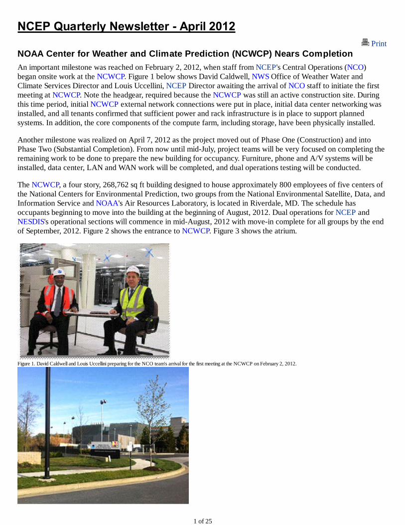
Print NOAA Center for Weather and Climate Prediction (NCWCP) Nears Completion An important milestone was reached on February 2, 2012, when staff from NCEP's Central Operations (NCO) began onsite work at the NCWCP . Figure 1 below shows David Caldwell, NWS Office of Weather Water and Climate Services Director and Louis Uccellini, NCEP Director awaiting the arrival of NCO staff to initiate the first meeting at NCWCP . Note the headgear, required because the NCWCP was still an active construction site. During this time period, initial NCWCP external network connections were put in place, initial data center networking was installed, and all tenants confirmed that sufficient power and rack infrastructure is in place to support planned systems. In addition, the core components of the compute farm, including storage, have been physically installed. Another milestone was realized on April 7, 2012 as the project moved out of Phase One (Construction) and into Phase Two (Substantial Completion). From now until mid-July, project teams will be very focused on completing the remaining work to be done to prepare the new building for occupancy. Furniture, phone and A/V systems will be installed, data center, LAN and WAN work will be completed, and dual operations testing will be conducted. The NCWCP , a four story, 268,762 sq ft building designed to house approximately 800 employees of five centers of the National Centers for Environmental Prediction, two groups from the National Environmental Satellite, Data, and Information Service and NOAA's Air Resources Laboratory, is located in Riverdale, MD. The schedule has occupants beginning to move into the building at the beginning of August, 2012. Dual operations for NCEP and NESDIS 's operational sections will commence in mid-August, 2012 with move-in complete for all groups by the end of September, 2012. Figure 2 shows the entrance to NCWCP . Figure 3 shows the atrium. Figure 1. David Caldwell and Louis Uccellini preparing for the NCO team's arrival for the first meeting at the NCWCP on February 2, 2012. 1 of 25
Transcript
Print NOAA Center for Weather and Climate Prediction (NCWCP) Nears Completion
An important milestone was reached on February 2 2012 when staff from NCEPs Central Operations (NCO) began onsite work at the NCWCP Figure 1 below shows David Caldwell NWS Office of Weather Water and Climate Services Director and Louis Uccellini NCEP Director awaiting the arrival of NCO staff to initiate the first meeting at NCWCP Note the headgear required because the NCWCP was still an active construction site During this time period initial NCWCP external network connections were put in place initial data center networking was installed and all tenants confirmed that sufficient power and rack infrastructure is in place to support planned systems In addition the core components of the compute farm including storage have been physically installed
Another milestone was realized on April 7 2012 as the project moved out of Phase One (Construction) and into Phase Two (Substantial Completion) From now until mid-July project teams will be very focused on completing the remaining work to be done to prepare the new building for occupancy Furniture phone and AV systems will be installed data center LAN and WAN work will be completed and dual operations testing will be conducted
The NCWCP a four story 268762 sq ft building designed to house approximately 800 employees of five centers of the National Centers for Environmental Prediction two groups from the National Environmental Satellite Data and Information Service and NOAAs Air Resources Laboratory is located in Riverdale MD The schedule has occupants beginning to move into the building at the beginning of August 2012 Dual operations for NCEP and NESDISs operational sections will commence in mid-August 2012 with move-in complete for all groups by the end of September 2012 Figure 2 shows the entrance to NCWCP Figure 3 shows the atrium
Figure 1 David Caldwell and Louis Uccellini preparing for the NCO teams arrival for the first meeting at the NCWCP on February 2 2012
1 of 25
Figure 2 Entrance to NCWCP
Figure 3 Atrium in NCWCP
GEFS Implementation
A major upgrade to the Global Ensemble Forecast System (GEFS) was implemented into NCEP operations on Tuesday February 14 2012
The upgrade increased the horizontal resolution of the GEFS model integration from about 70km (T190) to about 55km (T254) for the first 8 days of the forecast while the number of vertical levels is increased from 28 to 42 throughout the 16-day forecast The new GEFS is based on the upgraded version of the Global Forecast System (GFS) model which has been employed at NCEP for deterministic high resolution global forecasts since July 2010 With upgraded physics packages and a modified code structure the implementation has unified the GEFS and GFS The increased resolution and adoption of an upgraded NWP model raised the GEFS forecast to state-of-the-art levels
A major component of this implementation is the modification of the Ensemble Transform with Rescaling (ETR) scheme used in generating the initial perturbations for the ensemble forecast The initial perturbations below 500hPa are increased by up to 20 to tackle the under-dispersion problem in the lower troposphere The Stochastic Total Tendency Perturbation (STTP) scheme introduced in the last implementation in February 2010 to represent model related uncertainty has been tuned to accommodate the resolution change at 192 hours The modification of ETR and optimization of STTP lead to further improvement in GEFS forecasts
2 of 25
Northern Hemisphere anomaly correlation for 500hPa geopotential height of GFS and ensemble means (GEFS - operational GEFSx - plan for upgrade and NAEFS (NCEP_GEFS + CMC_GEFS)) for the period of 1st September to 30th November 2011
While the forecast skill increases for general circulation (Figure 1 three month average AC score for Northern Hemisphere 500hPa geopotential height new package (GEFSx) compared with the old GEFS) and near surface variables the most striking feature of the new GEFS is the improvement in predicting tropical cyclone tracks especially in the Atlantic Basin (see Figure 2) For the retrospective runs of the 2011 season and partial 2010 season track errors are reduced by 10-20 for the day 1-5 forecast For the first time in GEFS history its TC track forecast provides excellent guidance up to day 7 Enhancement of the precipitation forecast over mountainous areas has also noticed by forecasters
3 of 25
2011 summer seasons hurricane tracks for Atlantic Basin by comparing operational GEFS (GEFSo) planning upgrade GEFS (GEFSx) and operational GFS (GFS)
Due to limitations in computing data storage and delivery resources the GEFS products available to the customers are still on 1 degree by 1 degree grids although output at half by half degree is possible for the day-1 to day-8 forecasts We will begin work on this half degree ensemble product in the near future
Quarterly Implementation Summary
On December 20 2011 the Global Wave Model was upgraded to run using WAVEWATCH-III v314 However the spectral resolution of the model was maintained at a 25x24 spectral domain for backward compatibility This upgrade provides consistent partitioning for gridded and point outputs and removes obsolete wave partitioning software for point output while still providing output at the highest model spectral resolution In addition this implementation was done in a way that will provide a new framework for improved operational code sharing between EMC and NCO and result in more efficient implementations of all models in the future
4 of 25
Image of GFS WaveWatch-III forecast
The Environmental Modeling Center (EMC) developed an Interim Dust Prediction model using an improved dust source emission scheme with North American Mesoscale (NAM) model soil moisture as a restraint This Interim Dust Prediction implementation marks the first time that a CONUS HYSPLIT dust forecast is provided This upgrade expands operational prediction products to include predictions of dust from dust storms over the CONUS from the 06 UTC and 12 UTC prediction cycles This model was made operational on January 31 2012
On February 14 the Global Ensemble Forecast System (GEFS) was upgraded to increase resolution improve the probabilistic forecast skill and provide significant improvement in tropical storm track forecast This very significant upgrade is described in a separate item
As of February 28 2012 the NWS is producing experimental Global Forecast System (GFS)-based gridded MOS guidance for the CONUS at 25-km resolution These gridded MOS products contain guidance on a 25 km Lambert Conformal grid covering the same expanse as the National Digital Forecast Database (NDFD) CONUS grid Grids are being generated from the 0000 and 1200 Universal Coordinated Time (UTC) model runs at projections of 1 to 7 days in advance Guidance is available for the following elements
Daytime Maximum and Nighttime Minimum Temperature 2-Meter Temperature 2-Meter Dewpoint Temperature Relative Humidity Wind Direction Wind Speed Wind Gusts Probability of Precipitation 6-h and 12-h Probability of a Thunderstorm 3- 6- and 12-h Quantitative Precipitation Amount 6-h and 12-h Total Sky Cover 24-h Snowfall Amount
5 of 25
GFS CONUS Gridded MOS at 5km and 25km
System Synchronization and Archive Optimization
The current utilization of the primary NOAA Central Computing System (CCS) the supercomputer used for operational Numerical Weather Prediction exceeds the planned maximum and all previous highs At times some processes are delayed due to resource contention
In late 2011 there were periods where data transfer jobs (software used to keep the backup CCS synchronized with the primary CCS and ready to run the production suite in the event of a fail-over) were backlogged over 3 hours In addition the jobs that archive a days worth of data were taking almost 24 hours to run
NCEP Central Operations Production Management Branchs Senior Production Analyst team analyzed the problem to determine how to maximize use of computing resources and to execute transfer and archive jobs more efficiently while minimizing resource utilization
6 of 25
Major model beforeafter transfer latency in each cycle
This complex optimization task included correlating the number of jobs running on a node the time model output was available the number of archive jobs running and the availability of appropriate computing nodes as well as ensuring that multiple versions of a transfer job were not running simultaneously The optimization effort took 2 months and the results were significant
Through the optimization effort the number of job transfer jobs executed per day was reduced by half from around 14000 to 7000 jobs per day The latency in the best case scenario was reduced nearly 100 minutes and the average latency reduction was nearly 30 minutes reducing the time needed to recover from an unplanned fail-over Archive jobs that were taking almost 24 hours to complete now complete in less than 10 hours These changes also reduced the use of computing resources which has additional benefits to other tasks sharing the resources
Proving Ground Activities
The Geostationary Operational Environmental Satellite R-Series (GOES-R) will mark the first major technological advance in geostationary observations since 1994 heralding in increased spatial temporal and spectral resolutions for Earth monitoring and new operational capabilities such as lightning mapping The GOES-R Proving Ground project engages the NWS forecast and warning community to realize the benefits of the GOES-R system as soon as the satellites are launched and operational through product demonstration and training
The GOES-R Proving Ground at the World Weather Building is led by Michael Folmer a research associate from the Cooperative Institute for Climate and Satellites (CICS) at the University of Maryland College Park Michael interacts with operational forecasters and satellite analysts from the Hydrometeorological Prediction Center (HPC) Ocean Prediction Center (OPC) National Hurricane Center Tropical Analysis and Forecast Branch (TAFB) and the National Environmental Satellite Data and Information Service (NESDIS) Satellite Analysis Branch (SAB) to prepare them for new satellite dependent products which will become available operationally following the launch of the GOES-R satellite series
The Proving Ground started evaluating the Red Green Blue (RGB) Airmass product during January 2012 This
7 of 25
product provides additional value as a compliment to current satellite imagery by identifying features such as stratospheric intrusions potential vorticity anomalies and baroclinc zones Training on the RGB Airmass product has been made specific to aid OPC forecasters in identifying systems that undergo explosive cyclogenesis in the North Atlantic HPC forecasters have been introduced to this product in relation to the Model Diagnostics and Day 1 Quantitative Precipitation Forecast desks with a few forecasters taking the opportunity to reference how well the product depicts potential vorticity anomalies in their product discussions The Precipitation desk at SAB has been evaluating how well the imagery can identify areas of potential heavy precipitation Forecasters are very engaged in the Proving Ground activities and look forward to evaluating and using future GOES-R products in operations
Michael Folmer (far left) is training HPC forecasters (from left to right - Brendon Ruben-Oster Richard Otto and Anthony Fracasso) on the Red Green Blue Airmass product while Andrew Orrison (HPC Satellite Focal Point) oversees the training Jennifer Vogt (SAB analyst) can be seen in the background at the SAB Precipitation desk which works in close coordination with HPC
International Flight Folder Documentation Program
As a contracting state of the International Civil Aviation Organization (ICAO) the United States is obligated to provide flight documentation services to the international aviation community Since October 1 1998 in accordance with Chapter 9 of Annex 3 to the Convention on Civil Aviation the Aviation Weather Center has faxed the required meteorological information to airline operators and flight crew members for the purposes of dispatch planning preflight briefing and enroute guidance This outdated and expensive faxing system called the International Flight Folder Documentation Program (IFFDP) was replaced by the Internet based WebIFFDP as of February 28th 2012 (httpwwwaviationweathergoviffdp)
The new WebIFFDP system offers users a Qualified Internet Communications Provider (QICP) certified Website for obtaining international aviation weather information QICP certification which is required by the Federal Aviation Administration indicates that a Website meets specific security availability and transaction-time standards WebIFFDP also introduces users to an enhanced service which includes custom virtual Flight Folders and other features not available through the fax-based system
8 of 25
Graphic showing a folder with flight maps
2012 Women in Aviation Conference
On March 8-10 2012 Ingrid Gotchel Forecaster JoAnn Becker Forecaster and Commander Joe Bishop NOAA Commissioned Officer Corps hosted an outreach booth at the Women in Aviation Conference Exhibition in Dallas Texas The Aviation Weather Center partnered with the DallasFt Worth WFO for this event The DallasFt Worth WFO was represented by Bill Bunting Meteorologist in Charge Dan Shoemaker Meteorologist and Matt Bishop Meteorologist Conference attendees included pilots dispatchers air traffic controllers meteorologists flight instructors and aircraft maintenance personnel from different aviation sectors Additionally high school and college students pursuing aviation certifications and degrees attended this conference in large numbers The US military and international aviation personnel were also in attendance In addition to the outreach booth JoAnn Becker presented a 45 minute educational seminar during the conference on the Aviation Weather Center Forecast Products and Services The educational seminar was well attended and well received -- many questions were discussed during the QampA portion
Overall this event was a unique opportunity to educate users on NWS aviation weather support and to highlight career opportunities The attendees provided very positive feedback on the wwwAviationWeathergov (AWC) website and the Aviation Digital Data Service (ADDS) Commander Joe Bishop fielded many inquiries about opportunities for pilots in the NOAA Commissioned Officer Corps The WFO staff shared their expertise with TAFS and CWSU forecast services
9 of 25
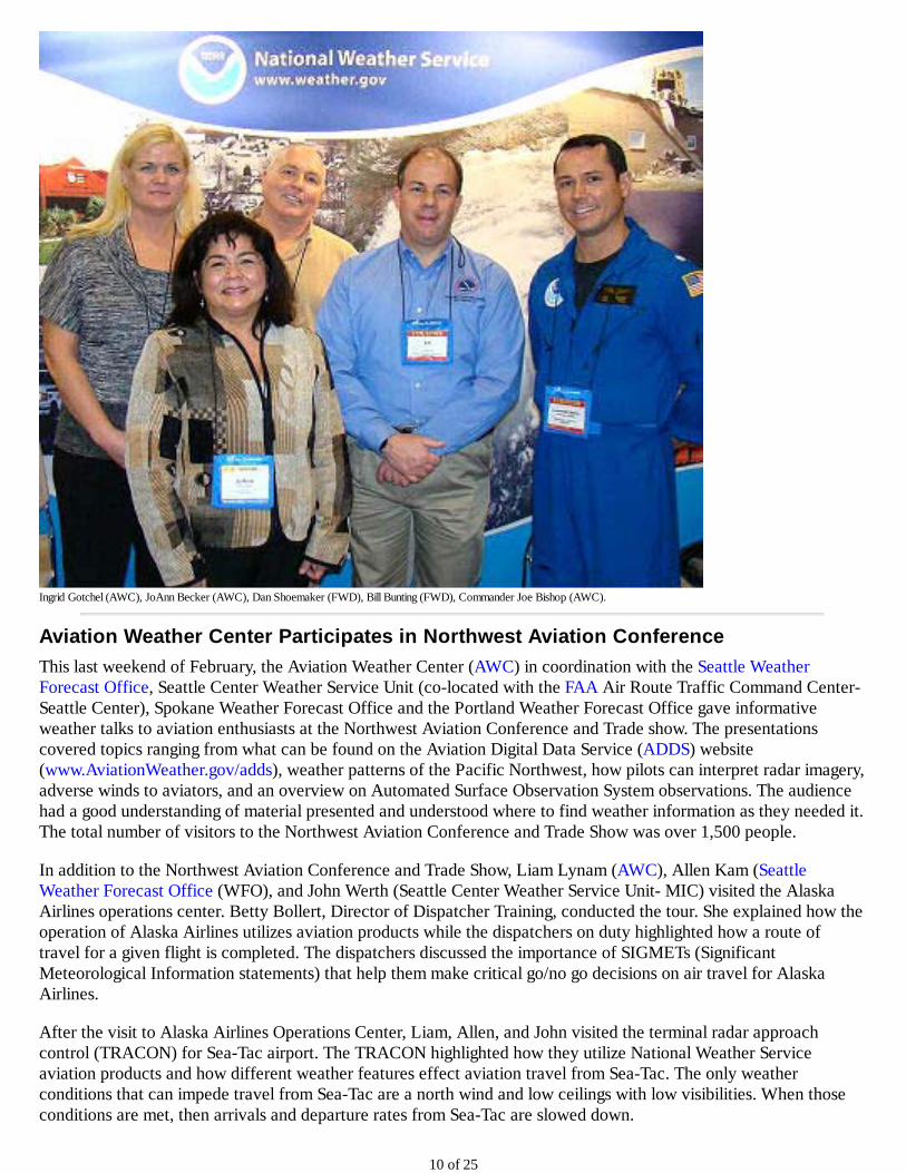
Ingrid Gotchel (AWC) JoAnn Becker (AWC) Dan Shoemaker (FWD) Bill Bunting (FWD) Commander Joe Bishop (AWC)
Aviation Weather Center Participates in Northwest Aviation Conference
This last weekend of February the Aviation Weather Center (AWC) in coordination with the Seattle Weather Forecast Office Seattle Center Weather Service Unit (co-located with the FAA Air Route Traffic Command Center-Seattle Center) Spokane Weather Forecast Office and the Portland Weather Forecast Office gave informative weather talks to aviation enthusiasts at the Northwest Aviation Conference and Trade show The presentations covered topics ranging from what can be found on the Aviation Digital Data Service (ADDS) website (wwwAviationWeathergovadds) weather patterns of the Pacific Northwest how pilots can interpret radar imagery adverse winds to aviators and an overview on Automated Surface Observation System observations The audience had a good understanding of material presented and understood where to find weather information as they needed it The total number of visitors to the Northwest Aviation Conference and Trade Show was over 1500 people
In addition to the Northwest Aviation Conference and Trade Show Liam Lynam (AWC) Allen Kam (Seattle Weather Forecast Office (WFO) and John Werth (Seattle Center Weather Service Unit- MIC) visited the Alaska Airlines operations center Betty Bollert Director of Dispatcher Training conducted the tour She explained how the operation of Alaska Airlines utilizes aviation products while the dispatchers on duty highlighted how a route of travel for a given flight is completed The dispatchers discussed the importance of SIGMETs (Significant Meteorological Information statements) that help them make critical gono go decisions on air travel for Alaska Airlines
After the visit to Alaska Airlines Operations Center Liam Allen and John visited the terminal radar approach control (TRACON) for Sea-Tac airport The TRACON highlighted how they utilize National Weather Service aviation products and how different weather features effect aviation travel from Sea-Tac The only weather conditions that can impede travel from Sea-Tac are a north wind and low ceilings with low visibilities When those conditions are met then arrivals and departure rates from Sea-Tac are slowed down
10 of 25
The conference provided opportunities for AWC Seattle CWSU Seattle WFO Alaska Airlines operations center Spokane WFO and the Portland WFO to discuss products and services that the different NWS offices provide to the public The Aviation Weather Center representative was Liam Lynam The Seattle CWSU was represented by Aviation Meteorologists John Werth (MIC) and Jim Vasilj The Seattle WFO was represented by Allen Kam The Portland WFO was represented by Clinton Rockey and the Spokane WFO was represented by Robin Fox
Pictured from Left to Right Allen Kam (Seattle WFO) Clinton Rockey (Portland WFO) Liam Lynam (AWC) Robin Fox (Spokane WFO) Not Pictured Jim Vasilj (Seattle CWSU) John Werth (Seattle CWSU)
NOAA and German Weather Service Collaboration
Mr Bodo Erhardt of the German Weather Service visited NCEPs Aviation Weather Center (AWC) Hydrometeorological Prediction Center as well as NOAAs Washington Volcanic Ash Advisory Center Mr Erhardt himself an aviation meteorologist at the Munich Meteorological Watch Office spent nearly two weeks in the United States exchanging knowledge and sharing forecast best practices in support of safe and efficient flight
Over half of Mr Erhardts time in the United States was spent at the Aviation Weather Center in Kansas City While there he was able to spend time working with each of AWCs 8 operational forecast desks Mr Erhardt collaborated with AWC forecasters while they produced AIRMETs Convective SIGMETs Area Forecasts mid and high level Significant Weather Charts and Collaborative Convective Forecast Products Time was also spent with the AWC Science and Operations Officer reviewing the latest techniques and applied research used by AWC for life-saving forecasts and warnings for turbulence icing and convection Following this review he was able to see these techniques incorporated in forecast operations
In addition to science and forecasting operations Mr Erhardt was able to spend time with the AWCs Warning Coordination Meteorologist Operations Branches Chiefs and the Aviation Weather Testbed NextGen Meteorologists The Aviation Weather Center collaborates closely with customers and partners to respond to user needs and requirements Mr Erhardt learned firsthand about the collaboration-based efforts of AWC outreach and how they partner in the development of impact-based aviation products and services Mr Erhardt was exposed to the Rapid Prototyping concepts of the Aviation Weather Testbed and how AWC is on the leading edge of evolving
11 of 25
The temperature outlook (left) shows that above-average temperatures are most likely from the Desert Southwest through the central and southern Great Plains the Great Lakes and the Eastern US while the Pacific Northwest and Alaska are favored to be cooler than average For precipitation (below) odds favor drier-than-average conditions mainly in the West and parts of the Southeast Hawaii is favored to be relatively cool and wet (not shown)
Supported by the temperature and precipitation outlook drought forecasters say drought conditions should persist across much of the southern US and expand in the Southwest through the spring But improvement is possible from the southern and central Plains to the southern Appalachians in the upper Midwest and the Northwest The Southwest is moving into the dry season which should reduce chances for relief
April - June 2012 Precipitation Outlook Shaded areas are favored to have below average (brown) precipitation
CPCs New Performance Measure
The Climate Prediction Center (CPC)s official Office of Management and Budget Government Performance and Results Act (GPRA) metric is the 48-month running mean of the Heidke Skill Score (HSS) of US seasonal temperature forecasts The metric shows the percent improvement over a random or chance forecast This metric is prone to large fluctuations due in part to natural climate variability and often does not accurately reflect the current climate state or the performance of other CPC outlook products To address these shortfalls with the current measure CPC has developed a new metric that incorporates all of CPCs official extended- and long-range surface temperature and precipitation outlooks
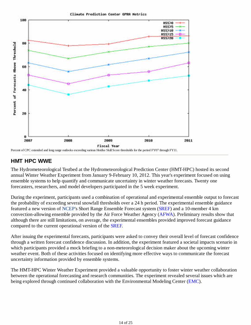
The new metric will be the percent of useful CPC forecasts defined as the number of CPC outlooks that exceed a certain threshold of skill (preliminary work suggests this value will be a HSS of 10) during the course of an entire year The percent of forecasts exceeding various thresholds ranging from HSS of 0 to 20 are shown below Results have been created based on forecasts for the previous five fiscal years (FY07-FY11) and show that the percentage of forecasts above the threshold have been steadily increasing since FY08 The new metric is also a step in the direction toward providing a metric that can demonstrate value as well as improvements in performance since users would have the ability to track the accuracy of CPCs forecasts by various thresholds (see figure) The expectation is that this metric will replace the current seasonal metric as CPCs official GPRA measure
13 of 25
Percent of CPC extended and long range outlooks exceeding various Heidke Skill Score thresholds for the period FY07 through FY11
HMT HPC WWE
The Hydrometeorological Testbed at the Hydrometeorological Prediction Center (HMT-HPC) hosted its second annual Winter Weather Experiment from January 9-February 10 2012 This years experiment focused on using ensemble systems to help quantify and communicate uncertainty in winter weather forecasts Twenty one forecasters researchers and model developers participated in the 5 week experiment
During the experiment participants used a combination of operational and experimental ensemble output to forecast the probability of exceeding several snowfall thresholds over a 24 h period The experimental ensemble guidance featured a new version of NCEPs Short Range Ensemble Forecast system (SREF) and a 10-member 4 km convection-allowing ensemble provided by the Air Force Weather Agency (AFWA) Preliminary results show that although there are still limitations on average the experimental ensembles provided improved forecast guidance compared to the current operational version of the SREF
After issuing the experimental forecasts participants were asked to convey their overall level of forecast confidence through a written forecast confidence discussion In addition the experiment featured a societal impacts scenario in which participants provided a mock briefing to a non-meteorological decision maker about the upcoming winter weather event Both of these activities focused on identifying more effective ways to communicate the forecast uncertainty information provided by ensemble systems
The HMT-HPC Winter Weather Experiment provided a valuable opportunity to foster winter weather collaboration between the operational forecasting and research communities The experiment revealed several issues which are being explored through continued collaboration with the Environmental Modeling Center (EMC)
14 of 25
HMT-HPC Winter Weather Experiment participants consider the forecast problem of the day (Photo credit Jim Hoke) From left to right Faye Barthold (HPC) DaNa Carlis (EMC) Mike Bodner (HPC) Andrew Orrison (HPC) Tom Workoff (HPC) Brian Lasorsa (WFO LWX) and Michael Scotten (WFO AMA)
NHC Director Announces Retirement
National Hurricane Center Director Bill Read has announced his decision to step down from that position effective June 1 2012 He has been the director since 2008 and says he never intended to work more than five years in that job
Read is retiring after 40 years of government service and states he now would prefer to work part-time in some other opportunities NOAA is currently searching for a replacement with the goal to have that person in place by June 1 the start of the Atlantic hurricane season
During his tenure at NHC Read oversaw operations during such US landfalling hurricanes as 2008s Gustav and Ike as well as 2011s Irene
15 of 25
Miami-based media outlets line up to speak with NHC Director Bill Read regarding his plan to retire on June 1
NHC Hosts Series of Classes for Emergency Managers
As part of FEMAs National Hurricane Program FEMA program managers teamed with the National Hurricane Center and Emergency Management Institute staff to offer a L324 Hurricane Preparedness Course for Decision Makers The course instructs emergency managers on how to plan and conduct safe evacuation of their communities as a hurricane approaches their area
Each of the three week-long classes provide instruction from NHC forecasters on how to use hurricane forecasts to determine who must evacuate from an approaching storm and when to do so FEMA regional program managers explain how to use model data from their state and local hurricane evacuation studies to formulate their local evacuation plans The final event was a hurricane exercise to practice the skills of the course
16 of 25
Participants in the FEMA class take part in the hands-on decision-making exercise
AWIPS II
On January 18 NCEPs Ocean Prediction Center (OPC) sent their first operational marine forecast products from AWIPS II OPC was the first National Center to issue operational products from AWIPS II and the third office in the country OPC sent the Atlantic High Seas text forecasts and also issued the Tropical Analysis and Forecast Branch (TAFB) products as part of a scheduled operational backup OPC now creates and disseminates all our text products with AWIPS II and has backed up WFO Honolulus offshore and High Seas texts Many people in the National Centers for Environmental Prediction and the Office of Science and Technology contributed to this effort
17 of 25
Senior Marine Forecaster Jim Clark using AWIPS II workstation
The transition to AWIPS II has 2 phases for the National Centers Phase 1 is to use AWIPS II for text generation It was critical to get Phase 1 done before NCEP moves to the NOAA Center for Weather and Climate Prediction (NCWCP) in College Park MD in the spring and summer of 2012 Phase 2 is to use the National Centers Perspective in AWIPS II to create and disseminate graphical forecast products This will be completed after the move to the NCWCP
OPC has started the move to gridded marine forecasts using the Graphical Forecast Editor (GFE) More than half the staff volunteered to participate in shadow shifts that test the capabilities of creating the text forecasts for the offshore zones from the gridded data This will enhance the offshore marine forecasts and allow for better collaboration with marine Weather Forecast Offices
Ocean Winds from Indian Ocean Sat
In mid-January NCEP Ocean Prediction Center (OPC) and National Hurricane Center (NHC) Tropical Analysis and Forecast Branch (TAFB) began to benefit from remotely sensed ocean winds from the Indian OceanSat-2 satellite for marine warnings forecasts and products In September 2009 the Indian Space Research Organisation (ISRO) launched the OceanSat-2 satellite with the OSCAT scatterometer on board Scatterometers measure high density ocean surface winds across the global ocean OSCAT is the first scatterometer designed built and launched by ISRO
A team of scientists from NOAA NESDIS NASA Jet Propulsion Laboratory and Netherlands Meteorological institute (KNMI) worked diligently with Indian colleagues to optimize the basic output data and establish data access through the European Organization for the Exploitation of Meteorological Satellites (EUMETSAT) in Darmstadt Germany Significant improvements to the basic output data were implemented in late December 2011 by ISRO These improvements allowed NOAA NESDIS to begin generating a 25-km resolution wind product using a NESDIS developed wind algorithm The high wind algorithm was developed using aircraft data acquired during the Winter Ocean Winds flight experiments using the NOAA P-3 aircraft
18 of 25
OPC and NHC forecasters (from both the Hurricane Specialist Unit and Tropical Analysis Forecast Branch) used ocean winds from the NASA QuikSCAT scatterometer from 1999 to November 2009 when the scanning mechanism on QuikSCAT stopped spinning The EUMETSAT Advanced SCATterometer (ASCAT) became the only operational source of remotely sensed winds ASCAT is an excellent instrument but due to its design observes only 54 of the global ocean daily and only sees portions of storms
OSCAT winds are delivered to NCEP OPC and NHC forecasters within three hours of observation The winds are still under evaluation by OPC and NHC forecasters but so far the Indian scatterometer shows significant promise to fill the void left by QuikSCAT OSCAT observes nearly 90 of the global ocean daily and greatly complements the ASCAT scans Marine forecasters have regained an increased situational awareness for severe winds (especially those produced by non-tropical cyclones) and have begun to use OSCAT winds to issue and verify marine warnings
In summary OSCAT winds bullEnhance forecaster awareness of dangerous winds bullGive forecasters the ability to assess in real time the accuracy of numerical model short term predictions bullUsed in short term high wind warnings and forecasts bullServe as basis for verification of wind warnings
OSCAT wind vectors over the mid-North Pacific from 23 January 2012 Wind vectors are color coded by wind speed based on the color scale in the upper right in knots (nautical miles per hour) Yellow and orange brown wind speeds meet GALE warning criteria (34 to 47 knots) dark brown - STORM (48 to 62 knots) and red - HURRICANE FORCE (63 knots and greater)
SPC National Severe Weather Workshop
The 2012 NSWW a unique and growing workshop focused on hazardous weather information-sharing and discussions on the effective transmission of messages about meteorological risk Emergency managers weather enthusiasts teachers students meteorologists broadcasters storm spotters and vendors in threat alerting sheltering and communications gathered to present and discuss inter-related topics about weather hazards March 1-3 The 2012 workshop featured over two days of topics The agenda was formed in such a way as to have one day devoted to A Look Back at some of the significant weather events of 2011 and other recent years The second day of the workshop featured speakers and topics concentrated on A Look Forward We talked about lessons learned from the events of the recent past to build and identify partnerships and progress that will lead to better prepared communities and the ultimate goal of a Weather Ready Nation The Saturday session on Severe Weather Awareness Training concluded the program The event was attended by more than 400 people from across the United States 4 from Japan and a Canadian
19 of 25
The 2012 National Severe Weather Workshop Banquet was held on Friday evening March 2 with guest speaker Mr Keith Stammer Director of the Joplin - Jasper County Missouri Emergency Management Agency Mr Stammer talked about the incredible challenges in response to and recovery from the deadliest single tornado in the US in over 60 years
Attendees gather to view exhibits from companies providing services in emergency response preparedness and meteorological information at the National Severe Weather Workshop
SWPC Begins Forecast Collaboration with UKMet
During 2011 NCEP began a new era of its relationship with the UK Met Office (UKMO) when it expanded its collaborative efforts to the domain of space weather The recent efforts of these two centers were even highlighted during a State Visit to the United Kingdom (UK) in May 2012 During this visit President Obama and UK Prime Minister Cameron agreed to increase collaboration within the areas of higher education science and innovation The Space Weather Prediction Center (SWPC) has taken the lead for NCEP to fully establish these space weather collaborations which have been focused in the areas of forecasting operational backup and model development
The most recent milestone in these efforts came on March 1 2012 when SWPC began daily forecaster collaboration calls with the UKMO forecasters assigned to their all-hazards desk of which space weather is a part SWPC forecasters are currently providing ad-hoc training which covers the current solar events and their impacts at Earth SWPC expects that by the end of April 2012 the calls will become much more collaborative in nature
These calls occur seven days a week regardless of the level of space weather activity We have also made special off-cycle calls to the UKMO forecast staff when we experienced significant solar events The purpose of these off-cycle calls are to make sure everyone is in sync on the assessment of the evolving activity and also to provide the UKMO forecasters with our expectations of the impacts
These collaboration calls with the UKMO are a natural extension of the existing calls SWPC has been making for years with the US Air Force SWPC is eager to receive the input and point of view of a new group of growing space weather experts This interaction can only help SWPC provide better forecasts and products for what is truly a global phenomenon
20 of 25
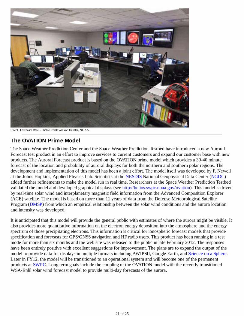
SWPC Forecast Office - Photo Credit Will von Dauster NOAA
The OVATION Prime Model
The Space Weather Prediction Center and the Space Weather Prediction Testbed have introduced a new Auroral Forecast test product in an effort to improve services to current customers and expand our customer base with new products The Auroral Forecast product is based on the OVATION prime model which provides a 30-40 minute forecast of the location and probability of auroral displays for both the northern and southern polar regions The development and implementation of this model has been a joint effort The model itself was developed by P Newell at the Johns Hopkins Applied Physics Lab Scientists at the NESDIS National Geophysical Data Center (NGDC) added further refinements to make the model run in real time Researchers at the Space Weather Prediction Testbed validated the model and developed graphical displays (see httpheliosswpcnoaagovovation) This model is driven by real-time solar wind and interplanetary magnetic field information from the Advanced Composition Explorer (ACE) satellite The model is based on more than 11 years of data from the Defense Meteorological Satellite Program (DMSP) from which an empirical relationship between the solar wind conditions and the aurora location and intensity was developed
It is anticipated that this model will provide the general public with estimates of where the aurora might be visible It also provides more quantitative information on the electron energy deposition into the atmosphere and the energy spectrum of those precipitating electrons This information is critical for ionospheric forecast models that provide specification and forecasts for GPSGNSS navigation and HF radio users This product has been running in a test mode for more than six months and the web site was released to the public in late February 2012 The responses have been entirely positive with excellent suggestions for improvement The plans are to expand the output of the model to provide data for displays in multiple formats including AWIPSII Google Earth and Science on a Sphere Later in FY12 the model will be transitioned to an operational system and will become one of the permanent products at SWPC Long term goals include the coupling of the OVATION model with the recently transitioned WSA-Enlil solar wind forecast model to provide multi-day forecasts of the aurora
21 of 25
Example of an Auroral Forecast
International Space Weather Product Portal
The international coordination of space weather was recently enhanced with the establishment of a new web portal for space weather products in January 2012
The space weather service enterprise is growing around the globe This growth is being driven by the increasing need to mitigate the impacts of space weather which affect our economic and security infrastructures both in space and on the ground Many countries are initiating new programs to deliver space weather services while others are expanding their efforts Within the United States the number of both domestic and foreign customers of NOAAs space weather products has been rising steadily
With this growth in space weather services come both opportunities for improvement and the need for coordination Providing the space weather services demanded today and in the future requires a global network of strong partners At the 16th World Meteorological Congress last spring the Congress affirmed that a coordinated effort by Members is needed to address the observing and service requirements to protect against the global hazards of Space Weather The new World Meteorological Organization (WMO) space weather portal serves to strengthen our partnerships and will facilitate this coordination
The portal will be an important focal point for promoting space weather services First the portal will enhance awareness of the products and services being issued today among the entire international community and it will give
22 of 25
users easy access to them Second by increasing the number of countries who are benefiting from these products we will be increasing the number of participants in the global space weather enterprise This will lead to a stronger observing network improved science and better products and services And third by bringing products together under this unified framework we will be encouraging their quantitative inter-comparisons and learning from each others best practices
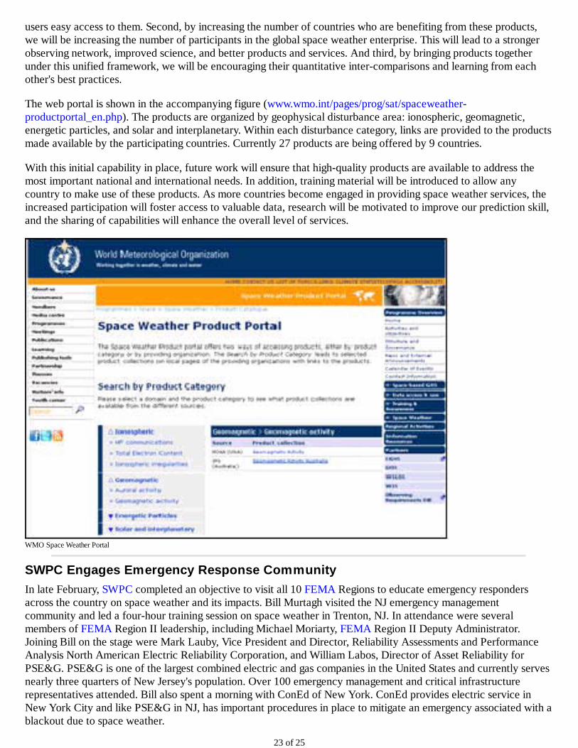
The web portal is shown in the accompanying figure (wwwwmointpagesprogsatspaceweather-productportal_enphp) The products are organized by geophysical disturbance area ionospheric geomagnetic energetic particles and solar and interplanetary Within each disturbance category links are provided to the products made available by the participating countries Currently 27 products are being offered by 9 countries
With this initial capability in place future work will ensure that high-quality products are available to address the most important national and international needs In addition training material will be introduced to allow any country to make use of these products As more countries become engaged in providing space weather services the increased participation will foster access to valuable data research will be motivated to improve our prediction skill and the sharing of capabilities will enhance the overall level of services
WMO Space Weather Portal
SWPC Engages Emergency Response Community
In late February SWPC completed an objective to visit all 10 FEMA Regions to educate emergency responders across the country on space weather and its impacts Bill Murtagh visited the NJ emergency management community and led a four-hour training session on space weather in Trenton NJ In attendance were several members of FEMA Region II leadership including Michael Moriarty FEMA Region II Deputy Administrator Joining Bill on the stage were Mark Lauby Vice President and Director Reliability Assessments and Performance Analysis North American Electric Reliability Corporation and William Labos Director of Asset Reliability for PSEampG PSEampG is one of the largest combined electric and gas companies in the United States and currently serves nearly three quarters of New Jerseys population Over 100 emergency management and critical infrastructure representatives attended Bill also spent a morning with ConEd of New York ConEd provides electric service in New York City and like PSEampG in NJ has important procedures in place to mitigate an emergency associated with a blackout due to space weather
23 of 25
The emergency response community has two key concerns regarding space weather (1) that space weather may directly or indirectly cause or exacerbate a major disaster or emergency and (2) that space weather may interfere with or seriously degrade response amp recovery capability during a natural disaster Space weather storms have significantly impacted the electric power grid in the past and continue to pose a threat to the grid stability across the Nation Space weather may also interfere with critical communications during a disaster recovery effort In early March 2012 space weather was suspected in a significant outage of a key satellite used for emergency response Fortunately there were no response and recovery events in progress during the outage
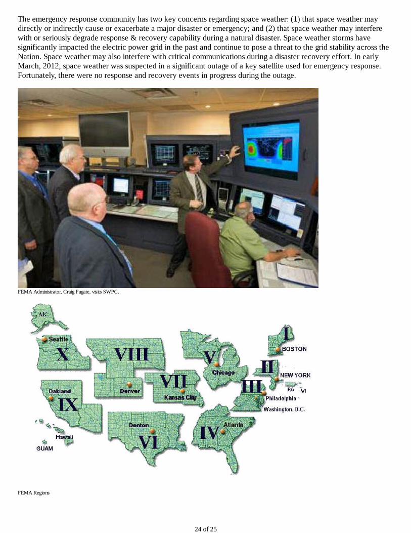
FEMA Administrator Craig Fugate visits SWPC
FEMA Regions
24 of 25
httpwwwncepnoaagovnewsletter
25 of 25
Figure 2 Entrance to NCWCP
Figure 3 Atrium in NCWCP
GEFS Implementation
A major upgrade to the Global Ensemble Forecast System (GEFS) was implemented into NCEP operations on Tuesday February 14 2012
The upgrade increased the horizontal resolution of the GEFS model integration from about 70km (T190) to about 55km (T254) for the first 8 days of the forecast while the number of vertical levels is increased from 28 to 42 throughout the 16-day forecast The new GEFS is based on the upgraded version of the Global Forecast System (GFS) model which has been employed at NCEP for deterministic high resolution global forecasts since July 2010 With upgraded physics packages and a modified code structure the implementation has unified the GEFS and GFS The increased resolution and adoption of an upgraded NWP model raised the GEFS forecast to state-of-the-art levels
A major component of this implementation is the modification of the Ensemble Transform with Rescaling (ETR) scheme used in generating the initial perturbations for the ensemble forecast The initial perturbations below 500hPa are increased by up to 20 to tackle the under-dispersion problem in the lower troposphere The Stochastic Total Tendency Perturbation (STTP) scheme introduced in the last implementation in February 2010 to represent model related uncertainty has been tuned to accommodate the resolution change at 192 hours The modification of ETR and optimization of STTP lead to further improvement in GEFS forecasts
2 of 25
Northern Hemisphere anomaly correlation for 500hPa geopotential height of GFS and ensemble means (GEFS - operational GEFSx - plan for upgrade and NAEFS (NCEP_GEFS + CMC_GEFS)) for the period of 1st September to 30th November 2011
While the forecast skill increases for general circulation (Figure 1 three month average AC score for Northern Hemisphere 500hPa geopotential height new package (GEFSx) compared with the old GEFS) and near surface variables the most striking feature of the new GEFS is the improvement in predicting tropical cyclone tracks especially in the Atlantic Basin (see Figure 2) For the retrospective runs of the 2011 season and partial 2010 season track errors are reduced by 10-20 for the day 1-5 forecast For the first time in GEFS history its TC track forecast provides excellent guidance up to day 7 Enhancement of the precipitation forecast over mountainous areas has also noticed by forecasters
3 of 25
2011 summer seasons hurricane tracks for Atlantic Basin by comparing operational GEFS (GEFSo) planning upgrade GEFS (GEFSx) and operational GFS (GFS)
Due to limitations in computing data storage and delivery resources the GEFS products available to the customers are still on 1 degree by 1 degree grids although output at half by half degree is possible for the day-1 to day-8 forecasts We will begin work on this half degree ensemble product in the near future
Quarterly Implementation Summary
On December 20 2011 the Global Wave Model was upgraded to run using WAVEWATCH-III v314 However the spectral resolution of the model was maintained at a 25x24 spectral domain for backward compatibility This upgrade provides consistent partitioning for gridded and point outputs and removes obsolete wave partitioning software for point output while still providing output at the highest model spectral resolution In addition this implementation was done in a way that will provide a new framework for improved operational code sharing between EMC and NCO and result in more efficient implementations of all models in the future
4 of 25
Image of GFS WaveWatch-III forecast
The Environmental Modeling Center (EMC) developed an Interim Dust Prediction model using an improved dust source emission scheme with North American Mesoscale (NAM) model soil moisture as a restraint This Interim Dust Prediction implementation marks the first time that a CONUS HYSPLIT dust forecast is provided This upgrade expands operational prediction products to include predictions of dust from dust storms over the CONUS from the 06 UTC and 12 UTC prediction cycles This model was made operational on January 31 2012
On February 14 the Global Ensemble Forecast System (GEFS) was upgraded to increase resolution improve the probabilistic forecast skill and provide significant improvement in tropical storm track forecast This very significant upgrade is described in a separate item
As of February 28 2012 the NWS is producing experimental Global Forecast System (GFS)-based gridded MOS guidance for the CONUS at 25-km resolution These gridded MOS products contain guidance on a 25 km Lambert Conformal grid covering the same expanse as the National Digital Forecast Database (NDFD) CONUS grid Grids are being generated from the 0000 and 1200 Universal Coordinated Time (UTC) model runs at projections of 1 to 7 days in advance Guidance is available for the following elements
Daytime Maximum and Nighttime Minimum Temperature 2-Meter Temperature 2-Meter Dewpoint Temperature Relative Humidity Wind Direction Wind Speed Wind Gusts Probability of Precipitation 6-h and 12-h Probability of a Thunderstorm 3- 6- and 12-h Quantitative Precipitation Amount 6-h and 12-h Total Sky Cover 24-h Snowfall Amount
5 of 25
GFS CONUS Gridded MOS at 5km and 25km
System Synchronization and Archive Optimization
The current utilization of the primary NOAA Central Computing System (CCS) the supercomputer used for operational Numerical Weather Prediction exceeds the planned maximum and all previous highs At times some processes are delayed due to resource contention
In late 2011 there were periods where data transfer jobs (software used to keep the backup CCS synchronized with the primary CCS and ready to run the production suite in the event of a fail-over) were backlogged over 3 hours In addition the jobs that archive a days worth of data were taking almost 24 hours to run
NCEP Central Operations Production Management Branchs Senior Production Analyst team analyzed the problem to determine how to maximize use of computing resources and to execute transfer and archive jobs more efficiently while minimizing resource utilization
6 of 25
Major model beforeafter transfer latency in each cycle
This complex optimization task included correlating the number of jobs running on a node the time model output was available the number of archive jobs running and the availability of appropriate computing nodes as well as ensuring that multiple versions of a transfer job were not running simultaneously The optimization effort took 2 months and the results were significant
Through the optimization effort the number of job transfer jobs executed per day was reduced by half from around 14000 to 7000 jobs per day The latency in the best case scenario was reduced nearly 100 minutes and the average latency reduction was nearly 30 minutes reducing the time needed to recover from an unplanned fail-over Archive jobs that were taking almost 24 hours to complete now complete in less than 10 hours These changes also reduced the use of computing resources which has additional benefits to other tasks sharing the resources
Proving Ground Activities
The Geostationary Operational Environmental Satellite R-Series (GOES-R) will mark the first major technological advance in geostationary observations since 1994 heralding in increased spatial temporal and spectral resolutions for Earth monitoring and new operational capabilities such as lightning mapping The GOES-R Proving Ground project engages the NWS forecast and warning community to realize the benefits of the GOES-R system as soon as the satellites are launched and operational through product demonstration and training
The GOES-R Proving Ground at the World Weather Building is led by Michael Folmer a research associate from the Cooperative Institute for Climate and Satellites (CICS) at the University of Maryland College Park Michael interacts with operational forecasters and satellite analysts from the Hydrometeorological Prediction Center (HPC) Ocean Prediction Center (OPC) National Hurricane Center Tropical Analysis and Forecast Branch (TAFB) and the National Environmental Satellite Data and Information Service (NESDIS) Satellite Analysis Branch (SAB) to prepare them for new satellite dependent products which will become available operationally following the launch of the GOES-R satellite series
The Proving Ground started evaluating the Red Green Blue (RGB) Airmass product during January 2012 This
7 of 25
product provides additional value as a compliment to current satellite imagery by identifying features such as stratospheric intrusions potential vorticity anomalies and baroclinc zones Training on the RGB Airmass product has been made specific to aid OPC forecasters in identifying systems that undergo explosive cyclogenesis in the North Atlantic HPC forecasters have been introduced to this product in relation to the Model Diagnostics and Day 1 Quantitative Precipitation Forecast desks with a few forecasters taking the opportunity to reference how well the product depicts potential vorticity anomalies in their product discussions The Precipitation desk at SAB has been evaluating how well the imagery can identify areas of potential heavy precipitation Forecasters are very engaged in the Proving Ground activities and look forward to evaluating and using future GOES-R products in operations
Michael Folmer (far left) is training HPC forecasters (from left to right - Brendon Ruben-Oster Richard Otto and Anthony Fracasso) on the Red Green Blue Airmass product while Andrew Orrison (HPC Satellite Focal Point) oversees the training Jennifer Vogt (SAB analyst) can be seen in the background at the SAB Precipitation desk which works in close coordination with HPC
International Flight Folder Documentation Program
As a contracting state of the International Civil Aviation Organization (ICAO) the United States is obligated to provide flight documentation services to the international aviation community Since October 1 1998 in accordance with Chapter 9 of Annex 3 to the Convention on Civil Aviation the Aviation Weather Center has faxed the required meteorological information to airline operators and flight crew members for the purposes of dispatch planning preflight briefing and enroute guidance This outdated and expensive faxing system called the International Flight Folder Documentation Program (IFFDP) was replaced by the Internet based WebIFFDP as of February 28th 2012 (httpwwwaviationweathergoviffdp)
The new WebIFFDP system offers users a Qualified Internet Communications Provider (QICP) certified Website for obtaining international aviation weather information QICP certification which is required by the Federal Aviation Administration indicates that a Website meets specific security availability and transaction-time standards WebIFFDP also introduces users to an enhanced service which includes custom virtual Flight Folders and other features not available through the fax-based system
8 of 25
Graphic showing a folder with flight maps
2012 Women in Aviation Conference
On March 8-10 2012 Ingrid Gotchel Forecaster JoAnn Becker Forecaster and Commander Joe Bishop NOAA Commissioned Officer Corps hosted an outreach booth at the Women in Aviation Conference Exhibition in Dallas Texas The Aviation Weather Center partnered with the DallasFt Worth WFO for this event The DallasFt Worth WFO was represented by Bill Bunting Meteorologist in Charge Dan Shoemaker Meteorologist and Matt Bishop Meteorologist Conference attendees included pilots dispatchers air traffic controllers meteorologists flight instructors and aircraft maintenance personnel from different aviation sectors Additionally high school and college students pursuing aviation certifications and degrees attended this conference in large numbers The US military and international aviation personnel were also in attendance In addition to the outreach booth JoAnn Becker presented a 45 minute educational seminar during the conference on the Aviation Weather Center Forecast Products and Services The educational seminar was well attended and well received -- many questions were discussed during the QampA portion
Overall this event was a unique opportunity to educate users on NWS aviation weather support and to highlight career opportunities The attendees provided very positive feedback on the wwwAviationWeathergov (AWC) website and the Aviation Digital Data Service (ADDS) Commander Joe Bishop fielded many inquiries about opportunities for pilots in the NOAA Commissioned Officer Corps The WFO staff shared their expertise with TAFS and CWSU forecast services
9 of 25
Ingrid Gotchel (AWC) JoAnn Becker (AWC) Dan Shoemaker (FWD) Bill Bunting (FWD) Commander Joe Bishop (AWC)
Aviation Weather Center Participates in Northwest Aviation Conference
This last weekend of February the Aviation Weather Center (AWC) in coordination with the Seattle Weather Forecast Office Seattle Center Weather Service Unit (co-located with the FAA Air Route Traffic Command Center-Seattle Center) Spokane Weather Forecast Office and the Portland Weather Forecast Office gave informative weather talks to aviation enthusiasts at the Northwest Aviation Conference and Trade show The presentations covered topics ranging from what can be found on the Aviation Digital Data Service (ADDS) website (wwwAviationWeathergovadds) weather patterns of the Pacific Northwest how pilots can interpret radar imagery adverse winds to aviators and an overview on Automated Surface Observation System observations The audience had a good understanding of material presented and understood where to find weather information as they needed it The total number of visitors to the Northwest Aviation Conference and Trade Show was over 1500 people
In addition to the Northwest Aviation Conference and Trade Show Liam Lynam (AWC) Allen Kam (Seattle Weather Forecast Office (WFO) and John Werth (Seattle Center Weather Service Unit- MIC) visited the Alaska Airlines operations center Betty Bollert Director of Dispatcher Training conducted the tour She explained how the operation of Alaska Airlines utilizes aviation products while the dispatchers on duty highlighted how a route of travel for a given flight is completed The dispatchers discussed the importance of SIGMETs (Significant Meteorological Information statements) that help them make critical gono go decisions on air travel for Alaska Airlines
After the visit to Alaska Airlines Operations Center Liam Allen and John visited the terminal radar approach control (TRACON) for Sea-Tac airport The TRACON highlighted how they utilize National Weather Service aviation products and how different weather features effect aviation travel from Sea-Tac The only weather conditions that can impede travel from Sea-Tac are a north wind and low ceilings with low visibilities When those conditions are met then arrivals and departure rates from Sea-Tac are slowed down
10 of 25
The conference provided opportunities for AWC Seattle CWSU Seattle WFO Alaska Airlines operations center Spokane WFO and the Portland WFO to discuss products and services that the different NWS offices provide to the public The Aviation Weather Center representative was Liam Lynam The Seattle CWSU was represented by Aviation Meteorologists John Werth (MIC) and Jim Vasilj The Seattle WFO was represented by Allen Kam The Portland WFO was represented by Clinton Rockey and the Spokane WFO was represented by Robin Fox
Pictured from Left to Right Allen Kam (Seattle WFO) Clinton Rockey (Portland WFO) Liam Lynam (AWC) Robin Fox (Spokane WFO) Not Pictured Jim Vasilj (Seattle CWSU) John Werth (Seattle CWSU)
NOAA and German Weather Service Collaboration
Mr Bodo Erhardt of the German Weather Service visited NCEPs Aviation Weather Center (AWC) Hydrometeorological Prediction Center as well as NOAAs Washington Volcanic Ash Advisory Center Mr Erhardt himself an aviation meteorologist at the Munich Meteorological Watch Office spent nearly two weeks in the United States exchanging knowledge and sharing forecast best practices in support of safe and efficient flight
Over half of Mr Erhardts time in the United States was spent at the Aviation Weather Center in Kansas City While there he was able to spend time working with each of AWCs 8 operational forecast desks Mr Erhardt collaborated with AWC forecasters while they produced AIRMETs Convective SIGMETs Area Forecasts mid and high level Significant Weather Charts and Collaborative Convective Forecast Products Time was also spent with the AWC Science and Operations Officer reviewing the latest techniques and applied research used by AWC for life-saving forecasts and warnings for turbulence icing and convection Following this review he was able to see these techniques incorporated in forecast operations
In addition to science and forecasting operations Mr Erhardt was able to spend time with the AWCs Warning Coordination Meteorologist Operations Branches Chiefs and the Aviation Weather Testbed NextGen Meteorologists The Aviation Weather Center collaborates closely with customers and partners to respond to user needs and requirements Mr Erhardt learned firsthand about the collaboration-based efforts of AWC outreach and how they partner in the development of impact-based aviation products and services Mr Erhardt was exposed to the Rapid Prototyping concepts of the Aviation Weather Testbed and how AWC is on the leading edge of evolving
11 of 25
The temperature outlook (left) shows that above-average temperatures are most likely from the Desert Southwest through the central and southern Great Plains the Great Lakes and the Eastern US while the Pacific Northwest and Alaska are favored to be cooler than average For precipitation (below) odds favor drier-than-average conditions mainly in the West and parts of the Southeast Hawaii is favored to be relatively cool and wet (not shown)
Supported by the temperature and precipitation outlook drought forecasters say drought conditions should persist across much of the southern US and expand in the Southwest through the spring But improvement is possible from the southern and central Plains to the southern Appalachians in the upper Midwest and the Northwest The Southwest is moving into the dry season which should reduce chances for relief
April - June 2012 Precipitation Outlook Shaded areas are favored to have below average (brown) precipitation
CPCs New Performance Measure
The Climate Prediction Center (CPC)s official Office of Management and Budget Government Performance and Results Act (GPRA) metric is the 48-month running mean of the Heidke Skill Score (HSS) of US seasonal temperature forecasts The metric shows the percent improvement over a random or chance forecast This metric is prone to large fluctuations due in part to natural climate variability and often does not accurately reflect the current climate state or the performance of other CPC outlook products To address these shortfalls with the current measure CPC has developed a new metric that incorporates all of CPCs official extended- and long-range surface temperature and precipitation outlooks
The new metric will be the percent of useful CPC forecasts defined as the number of CPC outlooks that exceed a certain threshold of skill (preliminary work suggests this value will be a HSS of 10) during the course of an entire year The percent of forecasts exceeding various thresholds ranging from HSS of 0 to 20 are shown below Results have been created based on forecasts for the previous five fiscal years (FY07-FY11) and show that the percentage of forecasts above the threshold have been steadily increasing since FY08 The new metric is also a step in the direction toward providing a metric that can demonstrate value as well as improvements in performance since users would have the ability to track the accuracy of CPCs forecasts by various thresholds (see figure) The expectation is that this metric will replace the current seasonal metric as CPCs official GPRA measure
13 of 25
Percent of CPC extended and long range outlooks exceeding various Heidke Skill Score thresholds for the period FY07 through FY11
HMT HPC WWE
The Hydrometeorological Testbed at the Hydrometeorological Prediction Center (HMT-HPC) hosted its second annual Winter Weather Experiment from January 9-February 10 2012 This years experiment focused on using ensemble systems to help quantify and communicate uncertainty in winter weather forecasts Twenty one forecasters researchers and model developers participated in the 5 week experiment
During the experiment participants used a combination of operational and experimental ensemble output to forecast the probability of exceeding several snowfall thresholds over a 24 h period The experimental ensemble guidance featured a new version of NCEPs Short Range Ensemble Forecast system (SREF) and a 10-member 4 km convection-allowing ensemble provided by the Air Force Weather Agency (AFWA) Preliminary results show that although there are still limitations on average the experimental ensembles provided improved forecast guidance compared to the current operational version of the SREF
After issuing the experimental forecasts participants were asked to convey their overall level of forecast confidence through a written forecast confidence discussion In addition the experiment featured a societal impacts scenario in which participants provided a mock briefing to a non-meteorological decision maker about the upcoming winter weather event Both of these activities focused on identifying more effective ways to communicate the forecast uncertainty information provided by ensemble systems
The HMT-HPC Winter Weather Experiment provided a valuable opportunity to foster winter weather collaboration between the operational forecasting and research communities The experiment revealed several issues which are being explored through continued collaboration with the Environmental Modeling Center (EMC)
14 of 25
HMT-HPC Winter Weather Experiment participants consider the forecast problem of the day (Photo credit Jim Hoke) From left to right Faye Barthold (HPC) DaNa Carlis (EMC) Mike Bodner (HPC) Andrew Orrison (HPC) Tom Workoff (HPC) Brian Lasorsa (WFO LWX) and Michael Scotten (WFO AMA)
NHC Director Announces Retirement
National Hurricane Center Director Bill Read has announced his decision to step down from that position effective June 1 2012 He has been the director since 2008 and says he never intended to work more than five years in that job
Read is retiring after 40 years of government service and states he now would prefer to work part-time in some other opportunities NOAA is currently searching for a replacement with the goal to have that person in place by June 1 the start of the Atlantic hurricane season
During his tenure at NHC Read oversaw operations during such US landfalling hurricanes as 2008s Gustav and Ike as well as 2011s Irene
15 of 25
Miami-based media outlets line up to speak with NHC Director Bill Read regarding his plan to retire on June 1
NHC Hosts Series of Classes for Emergency Managers
As part of FEMAs National Hurricane Program FEMA program managers teamed with the National Hurricane Center and Emergency Management Institute staff to offer a L324 Hurricane Preparedness Course for Decision Makers The course instructs emergency managers on how to plan and conduct safe evacuation of their communities as a hurricane approaches their area
Each of the three week-long classes provide instruction from NHC forecasters on how to use hurricane forecasts to determine who must evacuate from an approaching storm and when to do so FEMA regional program managers explain how to use model data from their state and local hurricane evacuation studies to formulate their local evacuation plans The final event was a hurricane exercise to practice the skills of the course
16 of 25
Participants in the FEMA class take part in the hands-on decision-making exercise
AWIPS II
On January 18 NCEPs Ocean Prediction Center (OPC) sent their first operational marine forecast products from AWIPS II OPC was the first National Center to issue operational products from AWIPS II and the third office in the country OPC sent the Atlantic High Seas text forecasts and also issued the Tropical Analysis and Forecast Branch (TAFB) products as part of a scheduled operational backup OPC now creates and disseminates all our text products with AWIPS II and has backed up WFO Honolulus offshore and High Seas texts Many people in the National Centers for Environmental Prediction and the Office of Science and Technology contributed to this effort
17 of 25
Senior Marine Forecaster Jim Clark using AWIPS II workstation
The transition to AWIPS II has 2 phases for the National Centers Phase 1 is to use AWIPS II for text generation It was critical to get Phase 1 done before NCEP moves to the NOAA Center for Weather and Climate Prediction (NCWCP) in College Park MD in the spring and summer of 2012 Phase 2 is to use the National Centers Perspective in AWIPS II to create and disseminate graphical forecast products This will be completed after the move to the NCWCP
OPC has started the move to gridded marine forecasts using the Graphical Forecast Editor (GFE) More than half the staff volunteered to participate in shadow shifts that test the capabilities of creating the text forecasts for the offshore zones from the gridded data This will enhance the offshore marine forecasts and allow for better collaboration with marine Weather Forecast Offices
Ocean Winds from Indian Ocean Sat
In mid-January NCEP Ocean Prediction Center (OPC) and National Hurricane Center (NHC) Tropical Analysis and Forecast Branch (TAFB) began to benefit from remotely sensed ocean winds from the Indian OceanSat-2 satellite for marine warnings forecasts and products In September 2009 the Indian Space Research Organisation (ISRO) launched the OceanSat-2 satellite with the OSCAT scatterometer on board Scatterometers measure high density ocean surface winds across the global ocean OSCAT is the first scatterometer designed built and launched by ISRO
A team of scientists from NOAA NESDIS NASA Jet Propulsion Laboratory and Netherlands Meteorological institute (KNMI) worked diligently with Indian colleagues to optimize the basic output data and establish data access through the European Organization for the Exploitation of Meteorological Satellites (EUMETSAT) in Darmstadt Germany Significant improvements to the basic output data were implemented in late December 2011 by ISRO These improvements allowed NOAA NESDIS to begin generating a 25-km resolution wind product using a NESDIS developed wind algorithm The high wind algorithm was developed using aircraft data acquired during the Winter Ocean Winds flight experiments using the NOAA P-3 aircraft
18 of 25
OPC and NHC forecasters (from both the Hurricane Specialist Unit and Tropical Analysis Forecast Branch) used ocean winds from the NASA QuikSCAT scatterometer from 1999 to November 2009 when the scanning mechanism on QuikSCAT stopped spinning The EUMETSAT Advanced SCATterometer (ASCAT) became the only operational source of remotely sensed winds ASCAT is an excellent instrument but due to its design observes only 54 of the global ocean daily and only sees portions of storms
OSCAT winds are delivered to NCEP OPC and NHC forecasters within three hours of observation The winds are still under evaluation by OPC and NHC forecasters but so far the Indian scatterometer shows significant promise to fill the void left by QuikSCAT OSCAT observes nearly 90 of the global ocean daily and greatly complements the ASCAT scans Marine forecasters have regained an increased situational awareness for severe winds (especially those produced by non-tropical cyclones) and have begun to use OSCAT winds to issue and verify marine warnings
In summary OSCAT winds bullEnhance forecaster awareness of dangerous winds bullGive forecasters the ability to assess in real time the accuracy of numerical model short term predictions bullUsed in short term high wind warnings and forecasts bullServe as basis for verification of wind warnings
OSCAT wind vectors over the mid-North Pacific from 23 January 2012 Wind vectors are color coded by wind speed based on the color scale in the upper right in knots (nautical miles per hour) Yellow and orange brown wind speeds meet GALE warning criteria (34 to 47 knots) dark brown - STORM (48 to 62 knots) and red - HURRICANE FORCE (63 knots and greater)
SPC National Severe Weather Workshop
The 2012 NSWW a unique and growing workshop focused on hazardous weather information-sharing and discussions on the effective transmission of messages about meteorological risk Emergency managers weather enthusiasts teachers students meteorologists broadcasters storm spotters and vendors in threat alerting sheltering and communications gathered to present and discuss inter-related topics about weather hazards March 1-3 The 2012 workshop featured over two days of topics The agenda was formed in such a way as to have one day devoted to A Look Back at some of the significant weather events of 2011 and other recent years The second day of the workshop featured speakers and topics concentrated on A Look Forward We talked about lessons learned from the events of the recent past to build and identify partnerships and progress that will lead to better prepared communities and the ultimate goal of a Weather Ready Nation The Saturday session on Severe Weather Awareness Training concluded the program The event was attended by more than 400 people from across the United States 4 from Japan and a Canadian
19 of 25
The 2012 National Severe Weather Workshop Banquet was held on Friday evening March 2 with guest speaker Mr Keith Stammer Director of the Joplin - Jasper County Missouri Emergency Management Agency Mr Stammer talked about the incredible challenges in response to and recovery from the deadliest single tornado in the US in over 60 years
Attendees gather to view exhibits from companies providing services in emergency response preparedness and meteorological information at the National Severe Weather Workshop
SWPC Begins Forecast Collaboration with UKMet
During 2011 NCEP began a new era of its relationship with the UK Met Office (UKMO) when it expanded its collaborative efforts to the domain of space weather The recent efforts of these two centers were even highlighted during a State Visit to the United Kingdom (UK) in May 2012 During this visit President Obama and UK Prime Minister Cameron agreed to increase collaboration within the areas of higher education science and innovation The Space Weather Prediction Center (SWPC) has taken the lead for NCEP to fully establish these space weather collaborations which have been focused in the areas of forecasting operational backup and model development
The most recent milestone in these efforts came on March 1 2012 when SWPC began daily forecaster collaboration calls with the UKMO forecasters assigned to their all-hazards desk of which space weather is a part SWPC forecasters are currently providing ad-hoc training which covers the current solar events and their impacts at Earth SWPC expects that by the end of April 2012 the calls will become much more collaborative in nature
These calls occur seven days a week regardless of the level of space weather activity We have also made special off-cycle calls to the UKMO forecast staff when we experienced significant solar events The purpose of these off-cycle calls are to make sure everyone is in sync on the assessment of the evolving activity and also to provide the UKMO forecasters with our expectations of the impacts
These collaboration calls with the UKMO are a natural extension of the existing calls SWPC has been making for years with the US Air Force SWPC is eager to receive the input and point of view of a new group of growing space weather experts This interaction can only help SWPC provide better forecasts and products for what is truly a global phenomenon
20 of 25
SWPC Forecast Office - Photo Credit Will von Dauster NOAA
The OVATION Prime Model
The Space Weather Prediction Center and the Space Weather Prediction Testbed have introduced a new Auroral Forecast test product in an effort to improve services to current customers and expand our customer base with new products The Auroral Forecast product is based on the OVATION prime model which provides a 30-40 minute forecast of the location and probability of auroral displays for both the northern and southern polar regions The development and implementation of this model has been a joint effort The model itself was developed by P Newell at the Johns Hopkins Applied Physics Lab Scientists at the NESDIS National Geophysical Data Center (NGDC) added further refinements to make the model run in real time Researchers at the Space Weather Prediction Testbed validated the model and developed graphical displays (see httpheliosswpcnoaagovovation) This model is driven by real-time solar wind and interplanetary magnetic field information from the Advanced Composition Explorer (ACE) satellite The model is based on more than 11 years of data from the Defense Meteorological Satellite Program (DMSP) from which an empirical relationship between the solar wind conditions and the aurora location and intensity was developed
It is anticipated that this model will provide the general public with estimates of where the aurora might be visible It also provides more quantitative information on the electron energy deposition into the atmosphere and the energy spectrum of those precipitating electrons This information is critical for ionospheric forecast models that provide specification and forecasts for GPSGNSS navigation and HF radio users This product has been running in a test mode for more than six months and the web site was released to the public in late February 2012 The responses have been entirely positive with excellent suggestions for improvement The plans are to expand the output of the model to provide data for displays in multiple formats including AWIPSII Google Earth and Science on a Sphere Later in FY12 the model will be transitioned to an operational system and will become one of the permanent products at SWPC Long term goals include the coupling of the OVATION model with the recently transitioned WSA-Enlil solar wind forecast model to provide multi-day forecasts of the aurora
21 of 25
Example of an Auroral Forecast
International Space Weather Product Portal
The international coordination of space weather was recently enhanced with the establishment of a new web portal for space weather products in January 2012
The space weather service enterprise is growing around the globe This growth is being driven by the increasing need to mitigate the impacts of space weather which affect our economic and security infrastructures both in space and on the ground Many countries are initiating new programs to deliver space weather services while others are expanding their efforts Within the United States the number of both domestic and foreign customers of NOAAs space weather products has been rising steadily
With this growth in space weather services come both opportunities for improvement and the need for coordination Providing the space weather services demanded today and in the future requires a global network of strong partners At the 16th World Meteorological Congress last spring the Congress affirmed that a coordinated effort by Members is needed to address the observing and service requirements to protect against the global hazards of Space Weather The new World Meteorological Organization (WMO) space weather portal serves to strengthen our partnerships and will facilitate this coordination
The portal will be an important focal point for promoting space weather services First the portal will enhance awareness of the products and services being issued today among the entire international community and it will give
22 of 25
users easy access to them Second by increasing the number of countries who are benefiting from these products we will be increasing the number of participants in the global space weather enterprise This will lead to a stronger observing network improved science and better products and services And third by bringing products together under this unified framework we will be encouraging their quantitative inter-comparisons and learning from each others best practices
The web portal is shown in the accompanying figure (wwwwmointpagesprogsatspaceweather-productportal_enphp) The products are organized by geophysical disturbance area ionospheric geomagnetic energetic particles and solar and interplanetary Within each disturbance category links are provided to the products made available by the participating countries Currently 27 products are being offered by 9 countries
With this initial capability in place future work will ensure that high-quality products are available to address the most important national and international needs In addition training material will be introduced to allow any country to make use of these products As more countries become engaged in providing space weather services the increased participation will foster access to valuable data research will be motivated to improve our prediction skill and the sharing of capabilities will enhance the overall level of services
WMO Space Weather Portal
SWPC Engages Emergency Response Community
In late February SWPC completed an objective to visit all 10 FEMA Regions to educate emergency responders across the country on space weather and its impacts Bill Murtagh visited the NJ emergency management community and led a four-hour training session on space weather in Trenton NJ In attendance were several members of FEMA Region II leadership including Michael Moriarty FEMA Region II Deputy Administrator Joining Bill on the stage were Mark Lauby Vice President and Director Reliability Assessments and Performance Analysis North American Electric Reliability Corporation and William Labos Director of Asset Reliability for PSEampG PSEampG is one of the largest combined electric and gas companies in the United States and currently serves nearly three quarters of New Jerseys population Over 100 emergency management and critical infrastructure representatives attended Bill also spent a morning with ConEd of New York ConEd provides electric service in New York City and like PSEampG in NJ has important procedures in place to mitigate an emergency associated with a blackout due to space weather
23 of 25
The emergency response community has two key concerns regarding space weather (1) that space weather may directly or indirectly cause or exacerbate a major disaster or emergency and (2) that space weather may interfere with or seriously degrade response amp recovery capability during a natural disaster Space weather storms have significantly impacted the electric power grid in the past and continue to pose a threat to the grid stability across the Nation Space weather may also interfere with critical communications during a disaster recovery effort In early March 2012 space weather was suspected in a significant outage of a key satellite used for emergency response Fortunately there were no response and recovery events in progress during the outage
FEMA Administrator Craig Fugate visits SWPC
FEMA Regions
24 of 25
httpwwwncepnoaagovnewsletter
25 of 25
The emergency response community has two key concerns regarding space weather (1) that space weather may directly or indirectly cause or exacerbate a major disaster or emergency and (2) that space weather may interfere with or seriously degrade response amp recovery capability during a natural disaster Space weather storms have significantly impacted the electric power grid in the past and continue to pose a threat to the grid stability across the Nation Space weather may also interfere with critical communications during a disaster recovery effort In early March 2012 space weather was suspected in a significant outage of a key satellite used for emergency response Fortunately there were no response and recovery events in progress during the outage