Page 1
Project Concept Report
Project: Bluebonnet Blvd. Sidewalks (N. Mall Dr. to Bluebonnet Centre Blvd.)
Date: November 21, 2019
This is a conceptual report. The project features and
layouts will be further refined through planning and
design phases.
Page 2
1 | Page
Image above represents broad outline of the project area as shown in 2018 MOVEBR tax plan proposition
Project: Bluebonnet Blvd. (N. Mall Dr. to Bluebonnet Centre Blvd.)
MOVEBR Program ID: CEP-66
Project Length (feet): 2,200 Estimated Cost: $1,000,000
Funded from Proposition: $1,000,000
PROJECT OVERVIEW
This project is proposed to enhance pedestrian mobility by constructing sidewalks on
each side of Bluebonnet Boulevard, providing pedestrian access to the Mall of Louisiana
and Our Lady of the Lake Children’s Hospital, as well as various other commercial
developments from N. Mall Dr. to Bluebonnet Centre Blvd. Design will be coordinated
with the MOVEBR projects Dijon Drive Phase II and Bluebonnet Blvd. (Perkins Rd. to Picardy
Avenue), as well as current and future City of Baton Rouge infrastructure improvements.
Current Condition: Four-lane divided
Proposed Condition: Four-lane divided with standard sidewalks on both sides
Page 3
2 | Page
PROJECT STATUS
This project is currently in the planning phase.
COMPLETE STREETS
The MOVEBR Program has developed design guidelines that aim to institutionalize the
Complete Streets policy by accommodating pedestrians, bicyclists or transit, regardless
of age and ability. For the purposes of this project, pedestrian mobility is the primary focus.
DRAINAGE AND GREEN INFRASTRUCTURE CONSIDERATIONS
Among the drainage considerations for this specific project are the following:
This project is located entirely in flood zone X, which is outside of the Special Flood
Hazard Area (SFHA).
This project location is not in an area identified as an “estimated inundation area”
from the 2016 floods. This map can be viewed at
https://www.arcgis.com/home/webmap/viewer.html?webmap=cb332217bdab
4572b4930e02d6655f84
Existing drainage for this project area utilizes a closed (sub-surfaced) system.
The project budget will consider funding for green infrastructure to improve water quality
and mitigate impacts of stormwater runoff. Examples of green infrastructure include but
are not limited to porous pavement, creation or maintenance of a tree canopy,
bioswales, planter boxes, rain gardens, and land conservation efforts.
ENVIRONMENTAL CONSIDERATIONS
Initial reviews support the following;
Minimal environmental considerations have been identified and must be reviewed and
potentially addressed.
*Note that this is not exhaustive of possible future environmental considerations.
Page 4
3 | Page
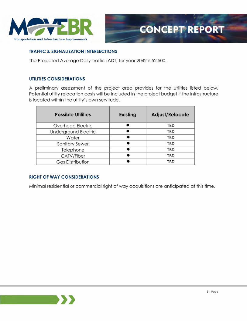
TRAFFIC & SIGNALIZATION INTERSECTIONS
The Projected Average Daily Traffic (ADT) for year 2042 is 52,500.
UTILITIES CONSIDERATIONS
A preliminary assessment of the project area provides for the utilities listed below.
Potential utility relocation costs will be included in the project budget if the infrastructure
is located within the utility’s own servitude.
Possible Utilities Existing Adjust/Relocate
Overhead Electric TBD
Underground Electric TBD
Water TBD
Sanitary Sewer TBD
Telephone TBD
CATV/Fiber TBD
Gas Distribution TBD
RIGHT OF WAY CONSIDERATIONS
Minimal residential or commercial right of way acquisitions are anticipated at this time.
Page 5
4 | Page
PROJECT CONCEPT PLANS
The following pages provide a potential solution(s) for the proposed project. The project
features and layouts, shown within the typical section(s) and concept plans, will be
further refined through planning and design phases of the project.
Page 6
SCALE: 1" = 50'
0 50 100
1of4
BLUEBONNET BLVD.
N.
MA
LL D
R.
CA
PA
CIT
Y P
ROJE
CT)
(MO
VE
BR N
EW
DIJ
ON D
R.
11/12/19
Sheet No.BLUEBONNET BLVD.
(N. MALL ROAD TO BLUEBONNET CENTRE BLVD.)
PAVEMENTEDGE OF
LOT LINES
LEGEND:
DOME INSETW/ TRUNCATED REQ'D ADA RAMP
BUS STOPCURRENT
EXIST. S/W
S/WREQ'D NEW
REMOVALREQ'D S/W
ROADWAYPROJECTCAPACITY
SIDEWALKPROJECTCAPACITY
11/21/19
Page 7
SCALE: 1" = 50'
0 50 100
BLUEBONNET BLVD.
EN
TR
AN
CE R
AM
PE
B I-1
0
EXIT R
AM
PW
B I-1
0
WB I-1
0
EB I-1
0
2of4
RA
MP
I-10 E
XIT
EB
RA
MP
EN
TR
AN
CE
WB I-1
0
CR
EE
KW
AR
DC
RE
EK
WA
RD
STRIPINGEXIT RAMPPROJECTCAPACITY
11/12/19
Sheet No.BLUEBONNET BLVD.
(N. MALL ROAD TO BLUEBONNET CENTRE BLVD.)
PAVEMENTEDGE OF
LOT LINES
LEGEND:
DOME INSETW/ TRUNCATED REQ'D ADA RAMP
BUS STOPCURRENT
EXIST. S/W
S/WREQ'D NEW
REMOVALREQ'D S/W
ROADWAYPROJECTCAPACITY
SIDEWALKPROJECTCAPACITY
11/21/19
Page 8
EXIT R
AM
P
WB I-1
0
BLUEBONNET BLVD.
SCALE: 1" = 50'
0 50 100
3of4
RA
MP
ENTR
ANCE
WB I-10
BATON ROUGEWYNDHAM GARDEN
11/12/19
Sheet No.BLUEBONNET BLVD.
(N. MALL ROAD TO BLUEBONNET CENTRE BLVD.)
PAVEMENTEDGE OF
LOT LINES
LEGEND:
DOME INSETW/ TRUNCATED REQ'D ADA RAMP
BUS STOPCURRENT
EXIST. S/W
S/WREQ'D NEW
REMOVALREQ'D S/W
ROADWAYPROJECTCAPACITY
SIDEWALKPROJECTCAPACITY
11/21/19
Page 9
BLUEBONNET BLVD.
CE
NT
RE B
LV
D.
BL
UE
BO
NN
ET
4 of4
SCALE: 1" = 50'
0 50 100
PK
WY.
CR
OS
S
BL
UE
EXXON
11/12/19
Sheet No.BLUEBONNET BLVD.
(N. MALL ROAD TO BLUEBONNET CENTRE BLVD.)
PAVEMENTEDGE OF
LOT LINES
LEGEND:
DOME INSETW/ TRUNCATED REQ'D ADA RAMP
BUS STOPCURRENT
EXIST. S/W
S/WREQ'D NEW
REMOVALREQ'D S/W
ROADWAYPROJECTCAPACITY
SIDEWALKPROJECTCAPACITY
11/21/19