170


Federal Consistency Review
Northern Guam Lens Aquifer Monitoring System
Expansion/Rehabilitation Project Description Page 1 of 5
Project Description
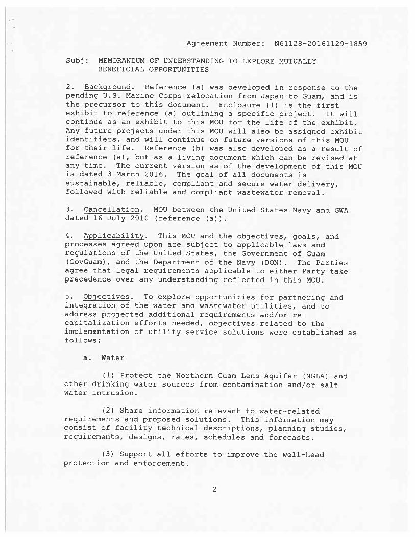
In 2016, Guam Waterworks Authority, (GWA), the applicant, secured federal grant funding from
the Department of Defense’s (DoD) Office of Economic Adjustment (OEA) under Grant
OCON676-16-03 for the Northern Guam Lens Aquifer Monitoring System Expansion and
Rehabilitation Project. The intent of the project is to rehabilitate twelve existing groundwater
monitoring wells and construct seven new monitoring wells, also known as deep observation
wells (DOW). Nine of the new and rehab well sites are located on military property. GWA will
coordinate with Joint Region Marianas, Naval Base Guam, and Andersen Air Force Base to
resolve any issues related to obtaining easements for utility access during the period of
construction for this project. GWA and the Department of Defense have agreed, as part of the
“One-Guam Water” Memorandum of Understanding (See Appendix A), to cooperate to improve
the NGLA Observation Well System including expansion of the current system and
rehabilitation of existing wells. This project will enhance monitoring and management of the
NGLA in order to mitigate impacts to NGLA. Project funding covers the design, rehabilitation,
construction, and project/construction management for both GWA wells and DOD wells. Under
this MOU, GWA and DOD agree to share access and responsibilities for the maintenance of
those wells located on their respective properties.
Project Background and Intent
Both GWA and Joint Region Marianas, Naval Base Guam (NBG) and Andersen Air Force Base
(AAFB), provide water and wastewater services to the residents of Guam, with a population of
approximately 178,000 people. Ninety percent of GWA’s drinking water supply is sourced from
the Northern Guam Lens Aquifer (NGLA), the island’s main freshwater source. The aquifer is
characterized primarily by coral/karst geology and water permeates to the aquifer through six
groundwater basins. Only three of those basins are currently monitored via groundwater wells.
The two existing military bases rely on water supplies developed by DoD. All of AAFB’s current
water demand is supplied from NGLA groundwater wells, while NBG relies on NGLA
groundwater wells, Fena Valley Lake Reservoir, and natural spring water.
In 2010, the DoD prepared an Environmental Impact Statement (EIS) and released a Record of
Decision (ROD) summarizing the plan for the military’s expansion and the impacts the
expansion would have on the island. The military realignment includes the design and
construction of a new Marine Cantonment on the northwestern coast of Guam (north of NCTS
Finegayan), family housing at AAFB, a live-fire training range complex on the northern coast
(AAFB Northwest Field), an Urban Combat training area in central Guam, and upgraded
water/wastewater services to support the new development. The DoD altered their 2010 plans,
and in July 2015, the DoD completed a Supplemental Environmental Impact Statement (SEIS)
for the military realignment; the resulting ROD was issued in August 2015. The DoD plans to
relocate approximately 5,000 military and 1,300 dependents to Guam over a 13-year period,
increasing the military population on Guam by nearly 50 percent over 2014 levels. The expected
population increase will peak by 9,721 people in 2023, including the military and dependent
relocation as well as the influx of construction personnel and civilian DoD personnel associated
with the realignment.

Federal Consistency Review
Northern Guam Lens Aquifer Monitoring System
Expansion/Rehabilitation Project Description Page 2 of 5
With the peak population increase of 9,721 people by 2023, Guam will quickly face a 6.1%
increase in population over 2010 levels and an increase in potable water demand. Per the 2015
SEIS, the estimated increased potable water demand resulting from the military realignment is
1.7 mgd (620.5 mgals annually). It is anticipated that the DoD will meet this demand via
increased groundwater production. To date, the DoD has not developed any additional
groundwater wells. However, Marine Corps Activity Guam (MCAG), the entity responsible for
leading the construction activities for the realignment, currently has a project in the design phase
to drill new production wells. Most of these wells are planned to be located in optimal
production zones of the Northern Guam Lens Aquifer (NGLA) in the Northwest Field area of
AAFB. The plan is to develop an adequate number of production wells to meet the projected
demand. The location and number of wells will be determined based upon field investigations
and test wells which began in early 2019.
As a mitigation measure for the military realignment’s impact to the island’s water supply, GWA
initiated the NGLA Monitoring System Expansion and Rehabilitation Project to ensure
comprehensive long-term water quality monitoring for five of the six groundwater basins of the
NGLA. The primary focus of the monitoring program is salinity, an indicator of aquifer
drawdown and seawater intrusion. Because the project was initiated as a response to the military
realignment, GWA sought funding from the federal government in the form of OEA grant funds.
With the military and civilian populations highly dependent upon this critical aquifer,
maintaining its integrity is of the utmost importance. Increased water demand and the emerging
threats triggered by environmental conditions put the aquifer at risk of contamination and salt-
water intrusion, and the intent of this project is to help mitigate those effects through enhanced
monitoring.
Location Description
This project features rehabilitation activities at twelve existing well sites and drilling/
construction activities at seven new well sites. The locations, coordinates, and current land
ownership are listed in Table 1, and Figure 1 presents a map of all nineteen sites across northern
Guam.
Scope of Work – Expansion
The objective of the work is to construct seven new monitoring wells. The work at each site
includes the following:
1. Clearing and vegetation removal, as necessary, and not to exceed the designated 100-ft x
100-ft area of potential effect.
2. Borehole drilling (between approximately 510 to 780 feet below ground surface,
depending on well location) using the air rotary drilling method.
a. 18-inch borehole to a depth of 40-feet
b. 10 ¾ -inch borehole from 40-feet to depth
3. Installation of 12-inch-diameter stainless steel surface casing.
4. Installation of 6-inch-diameter Schedule 80 polyvinyl chloride (PVC) blank casing.
Federal Consistency Review
Northern Guam Lens Aquifer Monitoring System
Expansion/Rehabilitation Project Description Page 3 of 5
5. Installation of well screen, gravel filter material and bentonite pellets, and cement grout
surface seal.
6. Monitoring well development.
7. Wellhead improvements including the construction of a 16-ft x 16-ft x 8-inch concrete
wellhead pad and the installation of a wellhead enclosure.
8. 12-ft x 12-ft security chain-link site fencing (except at DOW-NCSB1).
9. Provide locks for wellhead cap, enclosure, and fence.
Scope of Work – Rehabilitation
The objective of the work is to rehabilitate twelve existing monitoring wells to enhance each
well’s life-time. The work common to each site includes:
1. Demolish and remove existing wellhead enclosures, concrete pad, concrete pedestal and
fencing, where applicable.
2. Remove any floating debris from water surface, as applicable.
3. Construct new concrete wellhead pad (size varies per site).
4. Provide new wellhead enclosure and chain-link site fencing (size varies per site).
5. Provide locks for wellhead cap, enclosure, and fence.
Work specific to certain sites includes:
1. The removal of well fill from BPM-1.
2. The removal of trees and shallow roots impacting M-10A.
3. Installation of PVC surface casing (size varies), PVC blank casing (size varies), well
screen, and gravel filter material and bentonite pellets, and develop the well at five
monitoring well sites (A-16, A-20, BPM-1, M-10A, and NCS-3A).

Federal Consistency Review
Northern Guam Lens Aquifer Monitoring System
Expansion/Rehabilitation Project Description Page 4 of 5
Table 1. Monitoring Well Locations and Property Ownership Well
Type Well
Property
Ownership Location Description Latitude Longitude
New DOW-NWF1 U.S. Air Force Off shoulder of Route 3A outside of AAFB fence
line 13.59569 144.8622
New DOW-AAFB1 U.S. Air Force On a utility road through AAFB's main gate 13.588623 144.906147
New DOW-NCSF1 U.S. Navy On NCTS site in a utility corridor 13.580071 144.850181
New DOW-NCSF2 U.S. Navy On NCTS site near gymnasium 13.566813 144.842522
New DOW-NCSB1 U.S. Navy On NCS-Radio Barrigada 13.478581 144.843912
New DOW-M1 U.S. Air Force Within the Marbo Annex 13.506319 144.852678
New DOW-Y1 U.S. Air Force To the east side of Yigo Fire Station 13.52225 144.880164
Rehab A-16 GovGuam Carbullido Elementary School 13.471361 144.792528
Rehab A-20 GovGuam Chalan Pago Elementary School 13.44175 144.759639
Rehab BPM-1 Frank T.
Pangelinan Private property 13.446528 144.804333
Rehab EX-1 GovGuam San Miguel Elementary School 13.461389 144.773611
Rehab EX-10 GovGuam Swamp Road, off of Route 3 13.54183 144.83389
Rehab EX-4 GovGuam In the front yard of a private home, near Father
Duenas School 13.441583 144.790028
Rehab EX-6
GovGuam,
Lessee: Frederic
Lujan Guerrero
To the side of a private driveway to a home 13.51086 144.83767
Rehab EX-8 U.S. Air Force On the far north of AAFB, near the old air field 13.60945 144.86116
Rehab EX-9 GovGuam To the side of PC Lujan Elementary School 13.46967 144.80753
Rehab GHURA-
Dededo
GovGuam, on
GICC golf
course
Guam International Country Club golf course near
hole S-1 13.524257 144.849912
Rehab M-10A GovGuam Juan Guerrero Elementary School - large old tree
and palm tree 13.51061 144.82414
Rehab NCS-3A U.S. Navy Near the Radio Barrigada site on U.S. Navy
property, across from the former Nimitz Golf Course 13.470258 144.823545
Federal Consistency Review
Northern Guam Lens Aquifer Monitoring System
Expansion/Rehabilitation Project Description Page 5 of 5
Figure 1. NGLA Monitoring System Expansion and Rehabilitation Map
GUAM COASTAL MANAGEMENT PROGRAM
ASSESSMENT FORM
DATE OF APPLICATION: January 8, 2020
NAME OF APPLICANT: Guam Waterworks Authority
ADDRESS: 688 Route 15
Gloria B. Nelson Public Service Building, Suite 200
Mangilao, GU 96913
PHONE NO.: (671) 300-6846 FAX NO.: (671) 648-3290 CELL NO.:
E-MAIL ADDRESS: [email protected]
TITLE OF PROPOSED PROJECT:
Northern Guam Lens Aquifer Monitoring System Expansion/Rehabilitation Project
COMPLETE FOLLOWING PAGES
FOR BUREAU OF STATISTICS AND PLANS ONLY:
DATE APPLICATION RECEIVED:
OCRM NOTIFIED: LIC. AGENCY NOTIFIED:
APPLICANT NOTIFIED: PUBLIC NOTICE GIVEN:
OTHER AGENCY REVIEW
REQUESTED:
DETERMINATION:
( ) CONSISTENT ( ) NON-CONSISTENT ( ) FURTHER INFORMATION REQUESTED
OCRM
NOTIFIED:
LIC. AGENCY
NOTIFIED:
APPLICANT NOTIFIED:
ACTION LOG:
1.
2.
3.
4.
5.
6.
DATE REVIEW
COMPLETED:
FEDERAL CONSISTENCY
SUPPLEMENTAL INFORMATION FORM
Date: January 8, 2020
Project/Activity Title or
Description: Northern Guam Lens Aquifer Monitoring System Expansion/Rehabilitation Project
Location: Dededo, Yigo, Mangilao, Barrigada, Ordot, Mongmong-Toto-Maite
Other applicable area(s) affected, if appropriate:
N/A
Est. Start Date: Jun. 2020 Est. Duration: 10 Months
APPLICANT
Name & Title: Miguel C. Bordallo, General Manager
Agency/Organization: Guam Waterworks Authority
Address: 688 Route 15, Gloria B. Nelson Public Service Building, Suite 200
Mangilao, GU Zip Code: 96913
Telephone No. during business hours:
Primary (671) 300-6846
Alternate
Fax (671) 648-3290
E-mail Address: [email protected]
AGENT
Name & Title: Thomas Konner, Environmental Engineer
Agency/Organization: United States Environmental Protection Agency
Address: 75 Hawthorne St., EPA, Region IX, Water Division
San Francisco, CA Zip Code: 94105
Telephone No. during business hours:
Primary (415) 972-3408
Alternate (415) 972-3545
Fax
E-mail Address: [email protected]

CATEGORY OF APPLICATION (check one only)
( ) I – Federal Agency Activity
( ) II – Federal Permit or License
(X) III – Federal Grants & Assistance
TYPE OF STATEMENT (check one only)
(X) Consistency
( ) General Consistency (Category I only)
( ) Negative Determination (Category I only)
( ) Non-Consistency (Category I only)
APPROVING FEDERAL AGENCY (Categories II & III only)
Agency Office of Economic Adjustment
Contact Person Timothy B. Robert
Telephone No. during business hours:
Primary (916) 557-7315
Alternate (504) 628-9007
FEDERAL AUTHORITY FOR ACTIVITY
Title of Law
Section
OTHER GUAM APPROVALS REQUIRED:
Agency Type of Approval Date of Application Status

SUMMARY OF FINDINGS
DEVELOPMENT POLICIES (DP):
DP1. Shore Area Development
Intent: To ensure environmental and aesthetic compatibility of shore area land uses.
Policy: Only those uses shall be located within the Seashore Reserve which:
– enhance, are compatible with or do not generally detract from the
surrounding coastal area's aesthetic and environmental quality and beach
accessibility; or
– can demonstrate dependence on such a location and the lack of feasible
alternative sites.
Discussion:
The new and existing wells for this project lie outside Guam’s Seashore Reserve. This project will not
impact the environmental and aesthetic quality of shore area land use. The wells are neither located along
the shoreline nor within beach access points.
DP2. Urban Development
Intent: To cluster high impact uses such that coherent community design, function,
infrastructure support and environmental compatibility are assured.
Policy: Commercial, multi-family, industrial and resort-hotel zone uses and uses requiring
high levels of support facilities shall be concentrated within appropriate zone as
outlined on the Guam Zoning Code.
Discussion:
This project does not include any high-density developments nor will result in any high density or new
developments. The project will be a rehabilitation and expansion of the deep observation well system used
to monitor and collect data from the Northern Guam Lens Aquifer (NGLA). This is intended as a mitigation
measure for the military realignment’s impact to the island’s water supply.

DP3. Rural Development
Intent: To provide a development pattern compatible with environmental and
infrastructure support suitability and which can permit traditional lifestyle patterns
to continue to the extent practicable.
Policy: Rural districts shall be designated in which only low density residential and
agricultural uses will be acceptable. Minimum lot size for these uses should be
one-half acre until adequate infrastructure including functional sewer is provided.
Discussion:
This project will not interfere with rural development patterns and will not result in any new high-density
developments. The project will provide data to observe the effects on the NGLA due to the population
increase resulting from the relocation of Marines to Guam.
DP4. Major Facility Siting
Intent: To include the national interest in analyzing the siting proposals for major
utilities, fuel and transport facilities.
Policy: In evaluating the consistency of proposed major facilities with the goals, policies,
and standards of the Comprehensive Development and Coastal Management Plans,
Guam shall recognize the national interest in the siting of such facilities, including
those associated with electric power production and transmission, petroleum
refining and transmission, port and air installations, solid waste disposal, sewage
treatment, and major reservoir sites.
Discussion:
Several well sites lie near military utility corridors. However, they have been vetted and approved by the
military and should not garner national interest.

DP 5. Hazardous Areas
Intent: Development in hazardous areas will be governed by the degree of hazard and
the land use regulations.
Policy: Identified hazardous lands, including flood plains, erosion-prone areas, air
installations’ crash and sound zones and major fault lines shall be developed only
to the extent that such development does not pose unreasonable risks to the health,
safety or welfare of the people of Guam, and complies with the land use
regulations.
Discussion:
The project is not located in any known hazardous areas that may adversely affect the health, safety and
welfare of the people of Guam.
DP 6. Housing
Intent: To promote efficient community design placed where the resources can support it.
Policy: The government shall encourage efficient design of residential areas, restrict such
development in areas highly susceptible to natural and manmade hazards, and
recognize the limitations of the island's resources to support historical patterns of
residential development.
Discussion:
The project does not include or directly affect local housing.

DP 7. Transportation
Intent: To provide transportation systems while protecting potentially impacted resources.
Policy: Guam shall develop an efficient and safe transportation system, while limiting
adverse environmental impacts on primary aquifers, beaches, estuaries, coral reefs
and other coastal resources.
Discussion:
The project does not provide transportation for the island. Existing roadways will be utilized for ingress
and egress to the construction site. During construction for the project, appropriate highway
encroachment procedures will be adhered to based on an approved DPW Highway Encroachment permit.
If at any time the project requires complete or partial closures within Guam’s roadways, the contractor
shall take all necessary measures to maintain a normal flow of vehicular and pedestrian traffic, if any, in
accordance with the standards and regulations established by Guam DPW.
DP 8. Erosion and Siltation
Intent: To control development where erosion and siltation damage is likely to occur.
Policy: Development shall be limited in areas of 15% or greater slope by requiring strict
compliance with erosion, sedimentation, and land use regulations, as well as other
related land use guidelines for such areas.
Discussion:
The project sites are not located on areas with a slope of 15% or greater. Best management practices for
erosion control will be implemented during construction of the NDWWTP. Appropriate erosion control
BMPs will be installed to mitigate and manage erosion and siltation which follows local environmental
policies.

RESOURCES POLICIES (RP):
RP1. Air Quality
Intent: To control activities to insure good air quality.
Policy: All activities and uses shall comply with all local air pollution regulations and all
appropriate Federal air quality standards in order to ensure the maintenance of
Guam's relatively high air quality.
Discussion:
The project will not release significant air pollution as a result of the construction/rehabilitation of the
observation wells.
RP2. Water Quality
Intent: To control activities that may degrade Guam's drinking, recreational, and
ecologically sensitive waters.
Policy: Safe drinking water shall be assured and aquatic recreation sites shall be protected
through the regulation of uses and discharges that pose a pollution threat to Guam's
waters, particularly in estuaries, reef and aquifer areas.
Discussion:
The construction and operations of the observation wells for the project will not affect Guam’s drinking,
recreational, and ecologically sensitive waters. The project sites are located well away from the
boundaries of the marine preserve areas (MPA) and other recreational and ecologically sensitive waters.
If required, appropriate erosion control BMPs will be incorporated into the project design to ensure that
there will not be any discharge to critical aquatic resources.
RP3. Fragile Areas
Intent: To protect significant cultural areas, and natural marine and terrestrial wildlife
and plant habitats.
Policy: Development in the following types of fragile areas including Guam’s Marine
Protected Areas (MPA) shall be regulated to protect their unique character.
- historical and archeological sites
- wildlife habitats
- pristine marine and terrestrial communities
- limestone forests
- ravine forests
- mangrove stands and other wetlands
- coral reefs
Discussion:
The project does not interfere with any of the above indicated fragile areas.
The Archaeological Inventory Survey for Northern Guam Lens Aquifer (NGLA) Monitoring System
Expansion/Rehabilitation Project was completed on December 2019. Through communication with the
State Historic Preservation Officer, it was determined that four of the new and rehab observation well
sites required survey and determination of effect. The results of the study indicated that there were no
National Register of Historic Places-eligible properties present in the areas of potential effect, no
archaeological or cultural resources were encountered, and subsurface testing produced no evidence of
subsurface cultural deposition. The completed study is attached. See Appendix B.
The Biological Assessment for Northern Guam Lens Aquifer (NGLA) Monitoring System Expansion was
also completed on December 2019. Federally protected plant species were identified in close proximity to
proposed well sites DOW-AAFB1 and DOW-NCSF1, but no significant species were observed within
forty feet of the proposed wellhead locations. No federally protected endangered flora or fauna species
were observed at the other proposed or rehabilitation well sites. The complete study is attached. See
Appendix C.
Although the project is located outside the MPAs, appropriate erosion control BMPs will be incorporated
during the project construction phase to ensure that coral reefs are not impacted from siltation during
construction.

RP4. Living Marine Resources
Intent: To protect marine resources in Guam's waters.
Policy: All living resources within the waters of Guam, particularly fish, shall be
protected from over harvesting and, in the case of corals, sea turtles and marine
mammals, from any taking whatsoever.
Discussion:
This project does not involve the harvesting or taking of any aquatic species. Although the project is
located well away from the boundaries of the marine preserve areas (MPA), if excavation is required,
appropriate erosion control BMPs will be incorporated into the project design to ensure that there will not
be any discharge to Guam’s marine environment.
RP5. Visual Quality
Intent: To protect the quality of Guam's natural scenic beauty
Policy: Preservation and enhancement of, and respect for the island's scenic resources shall
be encouraged through increased enforcement of and compliance with sign, litter,
zoning, subdivision, building and related land-use laws. Visually objectionable
uses shall be located to the maximum extent practicable so as not to degrade
significant views from scenic overlooks, highways and trails.
Discussion:
This project will not interfere with scenic overlooks, highways, or trails, nor should it affect the visual
quality of Guam’s scenic beauty. Upon completion, areas that were aesthetically disturbed during
construction will be restored to its original condition.
RP6. Recreation Areas
Intent: To encourage environmentally compatible recreational development.
Policy: The Government of Guam shall encourage development of varied types of
recreational facilities located and maintained so as to be compatible with the
surrounding environment and land uses, adequately serve community centers and
urban areas and protect beaches and such passive recreational areas as wildlife,
marine conservation and marine protected areas, scenic overlooks, parks, and
historical sites.
Developments, activities and uses shall comply with the Guam Recreational Water
Use Management Plan (RWUMP).
Discussion:
This project will not develop any new recreational facilities, nor should the constructed wells interfere
with Guam’s recreational facilities.
RP7. Public Access
Intent: To ensure the right of public access.
Policy: The public's right of unrestricted access shall be ensured to all non-federally owned
beach areas and all Guam recreation areas, parks, scenic overlooks, designated
conservation areas and their public lands. Agreements shall be encouraged with
the owners of private and federal property for the provision of releasable access to
and use of resources of public nature located on such land.
Discussion:
The project is not located on a beach area or Territorial recreational area, park, scenic overlook,
designated conservation area, or other public land. The projects will not hinder access to recreational
areas, parks or public lands. During construction, appropriate highway encroachment procedures will be
adhered to based on the approved DPW Highway Encroachment permit. Construction work will not
impede the right of public access to adjacent public facilities.
RP8. Agricultural Lands
Intent: To stop urban types of development on agricultural land.
Policy: Critical agricultural land shall be preserved and maintained for agricultural use.
Discussion:
Of the nineteen well sites, five are identified to be located on agricultural land based on current available
GIS shapefiles. Two are on public school property, two are near private homes, and one is located on a
golf course. The project should not affect agricultural use of these sites, nor are they expected to induce
urban development.
Federal Consistency Certification Application
Northern Guam Lens Aquifer Monitoring System Expansion/
Rehabilitation Project
Appendix A
One-Guam Water Memorandum of Understanding
December 7, 2016


Federal Consistency Certification Application
Northern Guam Lens Aquifer Monitoring System Expansion/
Rehabilitation Project
Appendix B
Archaeological Inventory Survey for the Northern Guam Lens Aquifer
(NGLA) Monitoring System Expansion/Rehabilitation Project
December 3, 2019

FINAL—Archaeological Inventory Survey for the
Northern Guam Lens Aquifer (NGLA) Monitoring System
Expansion/ Rehabilitation Project,
Dededo, Mangilao, and Yigo Municipalities, Guam
Prepared For:
Brown and Caldwell
414 West Soledad Avenue, Suite 602
Hagåtña, Guam 96910
Prepared By:
Cacilie E. Craft, MA, RPA
David Byerly, BA
and
Amanda Sims, BA
Garcia and Associates
146 Hekili Street, Suite 101
Kailua, Hawaiʻi 96734
GANDA Report No. 2415-2-2
3 December 2019


i
ABSTRACT
At the request of Brown and Caldwell and on behalf of the Guam Waterworks Authority and
the U.S. Environmental Protection Agency, Garcia and Associates conducted a Phase I
Archaeological Inventory Survey for the Northern Guam Lens Aquifer Monitoring System
Expansion/ Rehabilitation Project (GWA Project No. S17-001-OEA; RC2019-0035). The
archaeological investigation is in support of Section 106 compliance under the National Historic
Preservation Act for this federally-funded undertaking. The objective of the archaeological
inventory survey was to determine the presence of historic properties within the study area and to
evaluate any extant properties for National Register of Historic Places eligibility.
Investigations resulted in a finding of no NRHP-eligible historic properties being present in
the Area of Potential Effect. The transect survey and excavation of 12 shovel test pits encountered
no cultural or archaeological resources or subsurface cultural deposition. No further archaeological
work is recommended for the undertaking based on the extent of prior disturbance evidenced in
the APE, shallow limestone soils, and lack of cultural deposition.

ii
TABLE OF CONTENTS
ABSTRACT .................................................................................................................................. I
FIGURES .................................................................................................................................... IV
TABLES ...................................................................................................................................... V
1.0 INTRODUCTION ................................................................................................................... 1
1.1 Description of the Undertaking ............................................................................................ 1
1.2 Area of Potential Effect ........................................................................................................ 3
2.0 BACKGROUND ..................................................................................................................... 5
2.1 Environmental Context ......................................................................................................... 5
2.2 Cultural History .................................................................................................................... 9
2.2.1 Pre-Latte Period (1500 BCE–500CE) and Transitional Period (500–800 CE) .............. 9
2.2.2 Latte Period (800–1521 CE) ........................................................................................ 10
2.2.3 Pre-Colonial European Trade Period (1521–1668 CE)................................................ 11
2.2.4 Spanish Missionization Period/ CHamoru Spanish Wars (1668–1700 CE) ................ 12
2.2.5 Spanish Colonial Period (1700–1898 CE) ................................................................... 14
2.2.6 First American Territorial Period (1898–1941) ........................................................... 14
2.2.7 World War II/ Japanese Military Occupation Period (1941–1944) ............................. 15
2.2.7.1 Battle of Guam ....................................................................................................... 20
2.2.8 Post-World War II/ Second American Territorial Period (1944–1950) ....................... 20
2.2.9 Organic Act/ Home Rule/ Economic Development Period (1950–Present) ................ 25
2.3 Archaeological Context ...................................................................................................... 25
2.3.1 Archaeological Expectations ........................................................................................ 35
3.0 PROJECT DESIGN ............................................................................................................... 36
3.1 Research Objectives ........................................................................................................... 36
3.2 Field Methods ..................................................................................................................... 38

iii
4.0 RESULTS ........................................................................................................................... 39
4.1 DOW-AAFB1 Survey Results ........................................................................................... 39
4.1.1 DOW-AAFB1 Subsurface Testing .............................................................................. 41
4.2 DOW-M1 Survey Results ................................................................................................... 45
4.2.1 DOW-M1 Subsurface Testing ...................................................................................... 48
4.3 DOW-NCSB1 Survey Results ............................................................................................ 50
4.3.1 DOW-NCSB1 Subsurface Testing ............................................................................... 52
4.4 DOW-NCSF1 Survey Results ............................................................................................ 55
4.4.1 DOW-NCSF1 Subsurface Testing ............................................................................... 58
5.0 DISCUSSION AND CONCLUSION ......................................................................................... 60
5.1 Recommendations .............................................................................................................. 61
6.0 REFERENCES ..................................................................................................................... 62
APPENDIX A: ARCHAEOLOGICAL REPORT SUMMARY FORM .................................................. 66
APPENDIX B: GHRD SECTION 106 REVIEW LETTERS ............................................................. 68

iv
FIGURES
Figure 1. APE within the Western Pacific and the island of Guam. ............................................... 2
Figure 2. Noncontiguous APE in Dededo, Mangilao, and Yigo Municipalities. ........................... 4
Figure 3. Soils in and around the northern wells. ........................................................................... 7
Figure 4. Soils in and around the southern wells. ........................................................................... 8
Figure 5. Seventeenth-century Spanish map of Guam designating village names and locations . 13
Figure 6. Portion of ACOE 1913–1914 cartographic survey of Guam showing northern wells. . 16
Figure 7. Portion of ACOE 1913–1914 cartographic survey of Guam showing southern wells.. 17
Figure 8. Portion of 1944 Army Map of Island of Guam showing northern wells....................... 18
Figure 9. Portion of 1944 Army Map of Island of Guam showing southern wells. ..................... 19
Figure 10. Portion of 1949 U.S. Navy aerial photograph showing DOW-AAFB1 APE. ............ 22
Figure 11. Portion of 1949 U.S. Navy aerial photograph showing DOW-M1 APE..................... 23
Figure 12. Portion of 1949 U.S. Navy aerial photograph showing DOW-NCSF1 APE. ............. 24
Figure 13. Portion of 1949 U.S. Navy aerial photograph showing DOW-NCSB1 APE. ............. 26
Figure 14. Previous archaeological investigations and recorded sites in DOW-AAFB1 APE .... 27
Figure 15. Previous archaeological investigations and recorded sites in DOW-M1 APE ............ 28
Figure 16. Previous archaeological investigations and recorded sites in DOW-NCSB1 APE ..... 29
Figure 17. Previous archaeological investigations and recorded sites in DOW-NCSF1 APE ..... 30
Figure 18. Results of archaeological investigations at DOW-AAFB1. ........................................ 40
Figure 19. DOW-AAFB1, view to northwest showing utility corridor and access road. ............. 41
Figure 20. DOW-AFFB1, STP 1. ................................................................................................. 42
Figure 21. DOW-AFFB1, STP 2. ................................................................................................. 42
Figure 22. DOW-AFFB1, STP 3. ................................................................................................. 43
Figure 23. Stratigraphic profiles for STPs excavated at each well location. ................................ 44
Figure 24. DOW-M1, view to northeast. ...................................................................................... 45
Figure 25. Results of archaeological investigations at DOW-M1. ............................................... 46
Figure 26. DOW-M1, view to southwest of exposed limestone bedrock. .................................... 47
Figure 27. DOW-M1, view to southeast of modern refuse found in the area. .............................. 47
Figure 28. DOW-M1, STP 1. ........................................................................................................ 48
v
Figures
Figure 29. DOW-M1, STP 2. ........................................................................................................ 49
Figure 30. DOW-M1, STP 3. ........................................................................................................ 49
Figure 31. Results of archaeological investigations at DOW-NCSB1. ........................................ 51
Figure 32. DOW-NCSB1, view to southeast. ............................................................................... 52
Figure 33. DOW-NCSB1, STP 1. ................................................................................................. 53
Figure 34. DOW-NCSB1, STP 2. ................................................................................................. 53
Figure 35. DOW-NCSB1, STP 3. ................................................................................................. 54
Figure 36. Results of archaeological investigations at DOW-NCSF1. ......................................... 56
Figure 37. DOW-NCSF1, view to northwest................................................................................ 57
Figure 38. DOW-NCSF1, view to west. ....................................................................................... 57
Figure 39. DOW-NCSF1, STP 1. ................................................................................................. 58
Figure 40. DOW-NCSF1, STP 2. ................................................................................................. 59
Figure 41. DOW-NCSF1, STP 3. ................................................................................................. 59
TABLES
Table 1. Previous Archaeological Investigations Conducted within 0.25 mile of APE ............... 31
Table 2. DOW-AAFB1 Stratigraphic Descriptions ...................................................................... 43
Table 3. DOW-M1 Stratigraphic Descriptions ............................................................................. 50
Table 4. DOW-NCSB1 Stratigraphic Descriptions ...................................................................... 54
Table 5. DOW-NCSF1 Stratigraphic Descriptions ....................................................................... 60


1
1.0 INTRODUCTION
At the request of Brown and Caldwell and on behalf of the Guam Waterworks Authority
(GWA) and the U.S. Environmental Protection Agency (USEPA), Garcia and Associates
conducted a Phase I Archaeological Inventory Survey (AIS) for the Northern Guam Lens Aquifer
(NGLA) Monitoring System Expansion/ Rehabilitation Project (GWA Project No. S17-001-OEA;
RC2019-0035) (Figure 1). The archaeological investigation is in support of Section 106
compliance under the National Historic Preservation Act for this federally-funded undertaking.
The objective of the AIS was to determine the presence of historic properties within the study area
and to evaluate any extant properties for National Register of Historic Places (NRHP) eligibility.
This document presents the results of the archaeological investigation as well as the
theoretical, methodological, and procedural framework that guided its implementation. This
includes a review of the survey area’s environmental, cultural-historical, and archaeological
background, which provides a useful context for interpreting the results of the study as well as its
intended research objectives.
1.1 Description of the Undertaking
This project is federally-funded by the Department of Defense, Office of Economic
Adjustment (OEA). It is therefore an undertaking as defined in 36 Code of Federal Regulation
800.16(y) and requires compliance with Section 106 of the National Historic Preservation Act of
1966 (as amended). This AIS was conducted to support Section 106 consultation efforts for the
undertaking which will be led by the USEPA, who has been designated as the federal action agency
representative for the OEA.

2
Figure 1. APE within the Western Pacific and the island of Guam.

3
The proposed undertaking is intended to improve Guam’s water-resource management
program in response to projected population growth over the next decade and concerns over fresh
water level decline and potential for increased salinity in the island’s NGLA. The NGLA
Monitoring System Expansion/Rehabilitation Project proposes to expand and rehabilitate the
NGLA monitoring system by drilling seven new deep monitoring wells and rehabilitating 12
existing monitoring wells on Guam’s northern limestone plateau. Per Section 106 consultation
between the USEPA and the Guam Historic Resources Division (GHRD) in January 2019
(RC2019-0035, letter dated January 18, 2019, Appendix B), GHRD has “no concerns” with the
existing 12 wells to be rehabilitated and two of the seven new wells to be drilled. On June 19,
2019, GHRD issued a statement to the USEPA that investigations were also not required for the
DOW-NWF1 well site. Thus, the remaining 4 new wells to be drilled (DOW-AAFB1, DOW-
NCSF1, DOW-NCSB1, and DOW-M1) required identification efforts and determination of effect,
resulting in this report presenting results of a Phase I AIS of four of these well sites.
1.2 Area of Potential Effect
The Area of Potential Effect (APE) consists of four noncontiguous construction footprints
totaling 3,600 square meters (0.36 hectares) distributed across Dededo, Mangilao, and Yigo
Municipalities (Figure 2). Each footprint is designated for construction for drilling one of four new
water wells. These include new wells DOW-AAFB1, DOW-NCSF1, DOW-NCSB1, and DOW-
M1. Each footprint encompasses a 30 by 30-meter area centered on the new well location to allow

4
Figure 2. Noncontiguous APE in Dededo, Mangilao, and Yigo Municipalities.

5
room for construction equipment and laydown areas. DOW-AAFB1 is approximately 700 meters
northwest of Perimeter Road along an unnamed utility road on Andersen Air Force Base (AAFB)
in Yigo Municipality. DOW-M1 is approximately 500 meters northeast of the southern terminus
of Liguan Avenue along an unnamed road on the U.S. Air Force Marianas-Bonin (MARBO)
Annex in Dededo Municipality. DOW-NCSB1 is approximately 400 meters west of Route 15 on
U.S. Naval Communications Center Radio-Barrigada in Mangilao Municipality. DOW-NCSF1 is
approximately 300 meters northwest of Route 3 on U.S. Naval Computer and Telecommunications
Station (NCTS) in a utility corridor in Dededo Municipality.
2.0 BACKGROUND
The background information presented below establishes the environmental, historical, and
archaeological setting of the study area. This information provides a contextual framework within
which cultural resources identified during the archaeological survey can be interpreted and
evaluated for significance.
2.1 Environmental Context
Guam is the largest and southernmost island in the Mariana Islands archipelago. Situated at
13 degrees north latitude and 144 degrees east longitude, the island experiences a tropical marine
climate that is typically hot and humid throughout the year. Precipitation averages from 216 to
292 centimeters per year with the wet season beginning in July and the dry season beginning from
the end of November to the beginning of December (Gingerich 2003:1).
Geologically, Guam is divided into two distinct regions separated by the Pago-Adelup Fault
line. The northern half of Guam is a broad undulating uplifted limestone plateau bounded by sea

6
cliffs, while the southern portion of Guam features rugged volcanic highlands with ravines and
protected embayments. The APE is situated on the northern limestone plateau where fresh water
resources are limited due to the permeability of the porous limestone.
Soils on the northern plateau of Guam are generally entisols, consisting of poorly-developed
soils without B-horizons (Young 1988). These typically very shallow soils developed from the
erosion of the limestone plateau and the decomposition of organic matter. Soils classified within
the APE consist exclusively of the Guam cobbly clay loam series with 3 to 7 percent slopes (Young
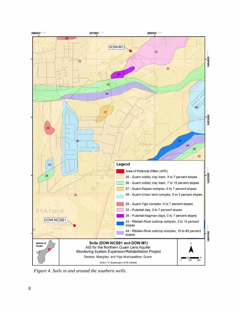
1988) (Figure 3 and Figure 4). This soil series consists of very shallow, well-drained soils that
developed from the underlying parent material consisting of porous coralline limestone. Depth to
limestone ranges from 5 to 40 centimeters. Permeability of these shallow soils is moderately rapid,
runoff is slow, and the hazard of water erosion is slight. This soil series is primarily suited for
urban development and grazing. Without extensive landscape alterations, the shallow soil depth
and cobbles limit agricultural production.
Vegetation in the APE primarily consists of secondary growth thicket with simple structure
and canopy height no more than 4.6 meters (15 feet), consistent with a history of recent
disturbance. Dominant trees/shrubs include tangantangan (Leuceana lecocephala), lada (Morinda
citrifolia), and custard apple (Annona reticulata). Native trees/shrubs, such as pago (Hibiscus
tiliaceus), ahgao (Premna serratifolia), and chosga (Phyllanthus mariannensis) were observed
occasionally. False ratan (Flagellaria indica) and the invasive mile-a-minute (Mikania micrantha)
as well as native and introduced herbs and subshrubs are also encountered.

7
Figure 3. Soils in and around the northern wells.
8
Figure 4. Soils in and around the southern wells.

9
2.2 Cultural History
Guam’s cultural history is broadly divided into the Pre-Contact and Historic eras. The Pre-
Contact Era encompasses indigenous settlement of the Marianas during the Pre-Latte, Transitional,
and Latte periods. Guam’s Historic Era is characterized by increasing influence by colonial powers
during the Pre-Colonial European Trade, Spanish Missionization/ CHamoru Spanish Wars,
Spanish Colonial, First American Territorial, World War II/ Japanese Military Occupation, Post-
World War II/ Second American Territorial, and Organic Act/ Home Rule/Economic Development
periods (GHRD 2014). These chronological divisions are used to structure the following overview
of Guam’s cultural history as it relates to the current APE.
2.2.1 Pre-Latte Period (1500 BCE–500CE) and Transitional Period (500–800 CE)
The Pre-Latte Period, extending from 1500 BCE to 500 CE, can be divided into the Early
(1500–1000 BCE), Middle (1000–500 BCE), and Late (500 BCE–500 CE) Pre-Latte periods
(GHRD 2014). Archaeological evidence, although sparse when compared to the subsequent Latte
Period, indicates that the island’s early settlers favored resource-rich coastal environments where
they exploited reef flats for fish and shellfish. Habitation sites during the Pre-Latte Period probably
consisted of small, nucleated groups of stilt houses near the shoreline as well as caves and
rockshelters useful for storm protection (Russell 1998:90–91). The Transitional Period (500–800
CE) is marked by an expansion from coastal sites to the island’s interior (potentially including the
project region), likely for exploitation of natural resources and fresh water.
The Tarague embayment on the north coast of Guam (Kurashina et al. 1981; Liston 1996) and
Huchunao on the east coast of Guam (Dilli et al. 1998) represent the closest known Pre-Latte

10
habitation centers to the APE at DOW-AAFB1. Transitional Period use and habitation of Guam’s
north coast has been recorded at Tarague (Guam Historic Properties Inventory [GHPI] Site 66-07-
1614) and Pati Point (GHPI Site 66-07-0016) (Tomonari-Tuggle et al. 2003:32). On the island’s
northwest coast, leeward embayments and smaller coves were occupied or utilized during this
period, including Ague Cove and Pugua Point west of the DOW-NCSF1 APE (Hunter-Anderson
et al. 2001; Olmo et al. 2000). Tumon Bay, southwest of the DOW-NCSF1 APE, supported
extensive coastal habitation during this long period (Graves and Moore 1985). Abutting these
coastal environments, the limestone interior (where the APE is situated) presumably did not
support Pre-Latte habitation, and yet nearby populations may have exploited its native forest
communities for food and other resources.
2.2.2 Latte Period (800–1521 CE)
The Latte Period (800–1521 CE) is differentiated from the Pre-Latte largely by the appearance
of stone foundation structures called latte. Relatively few Latte Period habitation sites are
documented in the northern interior of the island (Reinman 1977). And yet an increase in
population densities during this period led to increased demands for “firewood, construction
materials, forest fruits, and agriculturally produced foods,” which led to greater use of inland
environments in the Marianas (Dixon et al. 2011a:393). Latte Period pottery scatters, ubiquitously
documented in lieu of long-term habitation sites in Guam’s northern interior, may represent inland
field camps where coastal populations managed and collected from native forest communities and
farmed arable soil (Dixon et al. 2011a; Dixon et al. 2012; Moore 2005). Inland forest clearing and
associated occupation (often brief or intermittent) of the northern interior is also represented
archaeologically by dark middle soil, lithic and artifact scatters, rock walls and platforms, and

11
stone mounds often situated directly above large coastal embayments (Dixon et al. 2011a; Dixon
et al. 2012; Liston 1996).
While large populations were residing in and around Tarague and Ritidian on the north coast
by this time, archaeological evidence suggests that only small, short-term habitation centers or
temporary use sites associated with resource exploitation and agricultural encampments would
have been present in the APE or its vicinity. Larger archaeological sites, some with latte sets, have
been documented in such northern interior areas as Finegayan and Mataguac (southwest of the
DOW-AAFB1 APE), which are situated near fresh water sources. However, shallow subsurface
cultural deposits recorded at these sites indicate that they were occupied intermittently or for a
relatively short duration (Reinman 1977). The DOW-NCSF1 APE’s proximity to extensive coastal
habitation sites, consisting of latte complexes, human burials, artifact scatters, and utilized caves
and rockshelters at Tumon, Hila’an, and Haputo, indicates that this portion of the limestone plateau
may also have been occupied or utilized at least intermittently by nearby populations.
Despite the lack of archaeological evidence for permanent habitation near the DOW-M1 and
DOW-NCSB1 APE, the adjacent landmark, Mount Barrigada, is culturally significant for its
association with the traditional oral account of Puntan and Fu’una’s creation of the island of Guam
from Puntan’s body. Mount Barrigada is thought to have been created from Puntan’s stomach or
flank (Griffin et al. 2010:25).
2.2.3 Pre-Colonial European Trade Period (1521–1668 CE)
The Magellan expedition landed in Guam in 1521, ushering in the Pre-Colonial European
Trade Period (1521–1668 CE). Soon thereafter, foreign seafarers anchored in Guam and bartered

12
with the local population for fresh provisions in exchange for foreign materials, iron being the
local favorite. Spain did not formally acknowledge colonial possession of the Mariana Island chain
until 1565, the same year the Manila-Acapulco galleon trade made its first stop in the Marianas.
The Marianas became a regular stop—weather permitting—for the galleons during their annual
trade route, where they would offload provisions, soldiers, and eventually missionaries.
2.2.4 Spanish Missionization Period/ CHamoru Spanish Wars (1668–1700 CE)
Indigenous settlement patterns largely continued during the early phases of European
encounters, but in 1668 a Jesuit mission, led by Pale Diego Luis de San Vitores, arrived in the
Marianas on a mission to convert the local population to Christianity. The ensuing Spanish
missionization and colonization of the Marianas disrupted traditional settlement patterns and
transformed local villages into Spanish mission parishes. The Spanish cartographer Alonso Lopez
recorded this transformation in an early map depicting Spanish villages and churches across the
island (Figure 5). The main village of Agadña (later Agaña, now Hagåtña) and its church are
shown, along with several subsidiary and mostly coastal villages. The project APE appears to be
situated near Hanum on the east coast and in the general area of an inland trail and the village of
Upi in the north.
The indigenous population had dwindled by the 1690s, after roughly two centuries of
introduced disease and almost 30 years of confrontation with the Spanish missionaries and
colonizers. The Spanish government ultimately relocated the archipelago’s dwindling population
into seven mission villages, none of which were in the project vicinity (Rogers 1995). The
dissolution of indigenous settlement practices thereby ended with the intensification of Spanish
colonialism and missionization in the late seventeenth century.

13
Figure 5. Seventeenth-century Spanish map of Guam designating village names and locations
(Le Gobien 1700).

14
2.2.5 Spanish Colonial Period (1700–1898 CE)
By 1886, most of the island’s population was concentrated in the Spanish capital at Hagåtña,
which supported 5,979 people by that time (Garcia 2006:59). Spanish municipalities were largely
confined to the coasts, particularly along the coastal route (el Camino Real) from the port of
Umatac north to Hagåtña. Nonetheless, CHamoru maintained lånchos (ranches) in the island
interior. The Spanish government encouraged cattle ranching in the northern interior by offering
land grants to CHamoru-Spanish families to establish small ranches on the limestone plateau.
2.2.6 First American Territorial Period (1898–1941)
In 1898, the United States won the Spanish-American War and secured Guam from Spain.
The island was put under the jurisdiction of the U.S. Department of the Navy and commanded like
a battleship, with over two dozen naval officers acting as governors from 1903 until the Japanese
occupation in December 1941 (Rogers 1995:119–120).
The Spanish-CHamoru way of life persisted for the first several years of the early 20th century
as naval officers took varying levels of interest in governing the island and bettering the lives of
its inhabitants (Rogers 1995:120). The northern region of the island received telephone service
during this period through the extension of a line from Agaña. Such improvements likely
contributed to intensified utilization of the area. Otherwise, the northern interior, including the
APE, remained largely uninhabited during this period, albeit with scattered lånchos and copra
production plantations. Maps from this period note the traditional place names of Magua, Astobias,
Adacao, and Mogfog in the APE vicinity and show road and trail networks traversing the area,
15
including a trail passing directly east of the DOW-NCSF1 APE, but no farms or ranches are
recorded in the APE vicinity (Figure 6 and Figure 7).
2.2.7 World War II/ Japanese Military Occupation Period (1941–1944)
Guam was unfortified in 1941 in compliance with the 1922 Washington Naval Treaty,
enabling Japan to easily take possession of the island. Japanese forces, numbering almost 6,000,
overtook the capital and other major villages, occupying public buildings and many residences
(Rogers 1995:158). Throughout the occupation, the CHamoru population was forced to toil in
agricultural fields to feed the influx of troops and administrators and to construct airfields and
defensive positions, often with inadequate tools over long, grueling hours.
The APE does not appear to have been occupied or utilized by the Japanese during this period.
Military fortification during the Japanese occupation was not extensive in the project region, since
Japanese efforts focused on airfields and defenses along the island’s southern coasts and Orote
Peninsula. In addition to limited military activity in the project area, CHamorus may have accessed
the general region during the occupation, as many families permanently relocated to pre-war
lånchos in an attempt to avoid the Japanese (Blaz 2008). The 1944 U.S. Army map prepared for
the subsequent invasion of the island continues to show a trail directly east of the DOW-NCSF1
APE, similar to earlier maps. No lånchos are marked within the boundaries of any part of the APE
(Figure 8 and Figure 9).

16
Figure 6. Portion of Army Corps of Engineers 1913–1914 cartographic survey of Guam (on file at MARC)
showing northern wells.

17
Figure 7. Portion of Army Corps of Engineers 1913–1914 cartographic survey of Guam
(on file at MARC) showing southern wells.

18
Figure 8. Portion of 1944 Army Map of Island of Guam showing northern wells.

19
Figure 9. Portion of 1944 Army Map of Island of Guam showing southern wells.

20
2.2.7.1 Battle of Guam
U.S. troops invaded Asan and Agat beaches on Guam’s southwest coast on July 21, 1944. On
July 28, after heavy fighting on both sides, U.S. forces joined the northern and southern
beachheads. On July 30, General Roy S. Geiger (USMC) ordered his troops to pursue the retreating
Japanese Army north. By the first of August 1944, units of the U.S. Army’s 77th Infantry Division
had pushed Japanese forces as far north as Yigo where they faced Japanese resistance just north of
Barrigada village in the approximate area of DOW-M1 and DOW-NCSB1 (Crowl 1993:386). The
units fought difficult terrain, dense vegetation, and scattered Japanese resistance through this area
from the 3rd to the 6th of August (Crowl 1993:398–417). By the 7th of August, U.S. troops were
sweeping through the region near DOW-AAFB1 on their way north to secure the island. Japanese
forces had set up their final defensive line in this area from Mount Mataguac to Mount Santa Rosa.
U.S. forces engaged and succeeded against the last Japanese strongholds on the island at Mount
Santa Rosa on August 8th and at Lt. General Obata's Mataguac Hill command post on August 11th
(Crowl 1993:436).
Following the battle for Mount Santa Rosa and grueling reconnaissance of the island’s
northern plateau, General Geiger announced the end of organized resistance on Guam on August
10th. The remaining Japanese forces, numbering more than 9,000, were dispersed and unorganized
within the jungles of Guam, necessitating extensive reconnaissance operations long after the island
was declared secure.
2.2.8 Post-World War II/ Second American Territorial Period (1944–1950)
After the American invasion, the U.S. military embarked on a rapid and extensive construction
program to position Guam as a major forward operating base in the Western Pacific. Large plots

21
of land were acquired and bulldozed to accommodate new airfields, depots, headquarters, and
related facilities. The United States’ goal of securing the Mariana Islands was fully realized with
the construction of specialized airfields to support long-range, high-altitude bombers, known as
the B-29 Superfortress, which were commanded by the XXI Bomber Command. The unique
capability of the Superfortress allowed for air strikes on the Japanese home islands. Two of these
new airfields were constructed in northern Guam: North Field (now known as AAFB) and
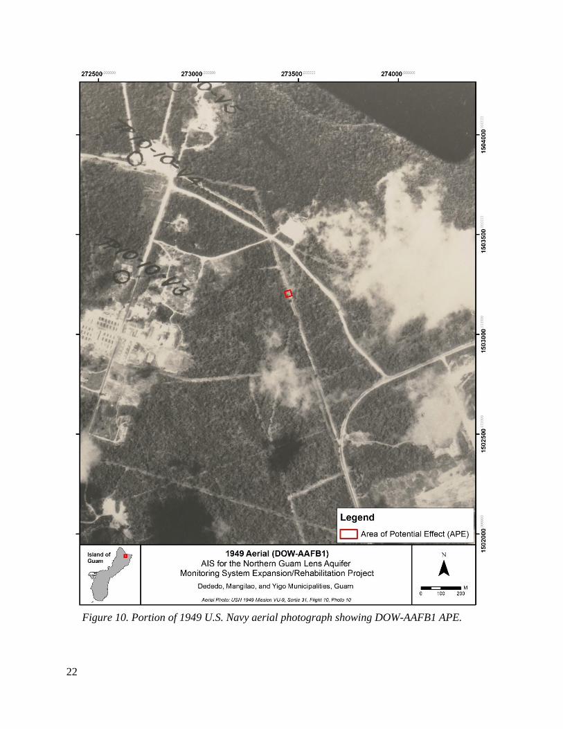
Northwest Field. Naval aerial imagery from 1949 shows the edge of North Field to the southeast
of DOW-AAFB1 and the buildings of the 1864th Army Engineer Aviation Battalion to the west
(Figure 10). The location of DOW-AAFB1 is situated directly adjacent to a military access road.
Other facilities constructed during this time include the MARBO Annex near Barrigada and
the NCTS in northwest Guam. The MARBO Annex, which included the 204th Army hospital,
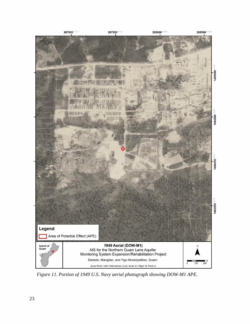
roads, and other infrastructure, is visible in 1949 naval aerial imagery just north of DOW-M1
(Figure 11). The location of DOW-M1 is located directly adjacent to a road and appears to have
been cleared of vegetation around this time. The NCTS can be seen on 1949 naval aerial imagery
northwest of DOW-NCSF1 (Figure 12). This location appears to be adjacent to a jeep trail or
unimproved road. Minimal vegetation clearance is evident, possibly related to a copra plantation.
A large swathe of Barrigada village, where CHamoru families from Hagåtña had established
ranches before the war, was taken over by the Navy for the establishment of a radio transmission
station, initially known as Radio Barrigada and now the Naval Communications Center Radio-
Barrigada. The radio base was comprised of temporary facilities in Quonset huts surrounded by
22
Figure 10. Portion of 1949 U.S. Navy aerial photograph showing DOW-AAFB1 APE.
23
Figure 11. Portion of 1949 U.S. Navy aerial photograph showing DOW-M1 APE.

24
Figure 12. Portion of 1949 U.S. Navy aerial photograph showing DOW-NCSF1 APE.

25
bracketed antenna equipment. The edge of the radio station can be seen to the west of DOW-
NCSB1 in a 1949 naval aerial image (Figure 13). This area witnessed extensive land clearance
during development of the radio station and its extensive antenna array.
2.2.9 Organic Act/ Home Rule/ Economic Development Period (1950–Present)
Since 1950, the APE has been left largely abandoned albeit with several nearby access points
and roads. DOW-AAFB1 has the same roads today as in the previous period but the infrastructure
to the west has been removed. DOW-M1 has the most dramatic change with the removal of the
MARBO Annex north of the APE. DOW-NCSB1 and DOW-NCSF1 are similar with the remains
of naval telecommunications infrastructure still visible in the area.
2.3 Archaeological Context
Eight archaeological studies have been conducted within a 0.25-mile/0.4-kilometer radius of
the four well locations: Kurashina et al. (1988), Amesbury and Moore (1989), Olmo et al. (2000),
Grant et al. (2007), Athens (2009), Welch (2010), and Dixon et al. (2011b, 2015) (Figure 14–
Figure 17; Table 1). Five of these studies yielded an absence of historic properties, while the other
three studies documented potential cultural or historical resources. The studies and their findings
are discussed below.
Grant et al. (2007) conducted archaeological and architectural cultural resource inventories
and shovel testing of the approximately 85-hectare (210-acre) Intelligence, Surveillance,
Reconnaissance and Strike Capability study area northwest of AAFB. A portion of this survey is
located northeast of the DOW-AAFB1 APE (Figure 14). Overall, the study recorded 20 prehistoric

26
Figure 13. Portion of 1949 U.S. Navy aerial photograph showing DOW-NCSB1 APE.

27
Figure 14. Previous archaeological investigations and recorded sites in DOW-AAFB1
APE vicinity.

28
Figure 15. Previous archaeological investigations and recorded sites in DOW-M1 APE
vicinity.

29
Figure 16. Previous archaeological investigations and recorded sites in DOW-NCSB1
APE vicinity.

30
Figure 17. Previous archaeological investigations and recorded sites in DOW-NCSF1
APE vicinity.
31
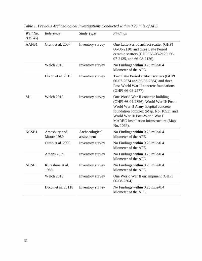
Table 1. Previous Archaeological Investigations Conducted within 0.25 mile of APE
Well No.
(DOW-)
Reference Study Type Findings
AAFB1 Grant et al. 2007 Inventory survey One Latte Period artifact scatter (GHPI
66-08-2110) and three Latte Period
ceramic scatters (GHPI 66-08-2120, 66-
07-2125, and 66-08-2126).
Welch 2010 Inventory survey No Findings within 0.25 mile/0.4
kilometer of the APE.
Dixon et al. 2015 Inventory survey Two Latte Period artifact scatters (GHPI
66-07-2574 and 66-08-2584) and three
Post-World War II concrete foundations
(GHPI 66-08-2577).
M1 Welch 2010 Inventory survey One World War II concrete building
(GHPI 66-04-2326), World War II/ Post-
World War II Army hospital concrete
foundation complex (Map. No. 1051), and
World War II/ Post-World War II
MARBO installation infrastructure (Map
No. 1066).
NCSB1 Amesbury and
Moore 1989
Archaeological
assessment
No Findings within 0.25 mile/0.4
kilometer of the APE.
Olmo et al. 2000 Inventory survey No Findings within 0.25 mile/0.4
kilometer of the APE.
Athens 2009 Inventory survey No Findings within 0.25 mile/0.4
kilometer of the APE.
NCSF1 Kurashina et al.
1988
Inventory survey No Findings within 0.25 mile/0.4
kilometer of the APE.
Welch 2010 Inventory survey One World War II encampment (GHPI
66-08-2304).
Dixon et al. 2011b Inventory survey No Findings within 0.25 mile/0.4
kilometer of the APE.

32
sites, four historic sites, and one multi-component site. Four of these sites were recorded within
0.25 mile of DOW-AAFB1 APE: one Latte Period artifact scatter (GHPI 66-08-2110) and three
Latte Period ceramic scatters (GHPI 66-08-2120, 66-07-2125, and 66-08-2126). These sites were
considered ineligible for NRHP as they lacked integrity of association (Grant et al. 2007:210).
As part of the 2007 fieldwork for the proposed Joint Guam Build-up, Welch (2010) conducted
archaeological survey of previously unsurveyed areas at NCTS Finegayan, the GLUP 77 parcel,
the new magazines area at Ordnance Annex, AAFB Main Base, Potts Junction Fuel Tank Farm,
and Andersen South. Thirty-four new sites were recorded during this fieldwork: 22 prehistoric and
12 historic. In addition to this survey, Welch (2010) conducted field verification of 46 known
archaeological sites as well as archaeological testing, and archival research. DOW-M1 and DOW-
NCSF1 are within the Welch (2010) survey area and DOW-AAFB1 is located on the western edge
of this survey (Figure 14, Figure 15, and Figure 17). Three sites were recorded within 0.25 mile of
DOW-M1 APE: one World War II concrete building (GHPI 66-04-2326), a World War II/ Post-
World War II Army hospital concrete foundation complex (Map. No. 1051), and World War II/
Post-World War II MARBO installation infrastructure (Map No. 1066). One site was recorded
within 0.25 mile of the DOW-NCSF1 APE: a World War II encampment consisting of four artifact
scatters (GHPI 66-08-2304). GHPI 66-04-2326 lacked enough information to recommend it as
NRHP-eligible, and further archival and oral history research by an architectural historian was
recommended to determine the function and importance of the building (Welch 2010: 324). GHPI
66-08-2304 and Map. Nos. 1051 and 1066 were recommended ineligible for nomination to the
NRHP (Welch 2010: 351, 357).

33
Dixon et al. (2015) conducted archaeological surveys and architectural inventories of
previously unsurveyed areas for the Guam and Commonwealth of the Northern Mariana Islands
Military Relocation 2012 Roadmap Adjustments Supplemental Environmental Impact Statement,
including those areas associated with the Live-Fire Training Range Complex, access routes, utility
corridors, and Main Cantonment/Housing alternatives. DOW-AAFB1 is located between two
Dixon et al. (2015) survey areas, one to the west and one to the northeast (Figure 14). A total of
107 new sites were recorded: 51 prehistoric and 56 historic. Three of these sites were recorded
within 0.25 miles of DOW-AAFB1 APE: two Latte Period artifact scatters (GHPI 66-07-2574 and
66-08-2584) and three Post-World War II concrete foundations (GHPI 66-08-2577). All three sites
were recommended ineligible for nomination to the NRHP (Dixon et al. 2015: 4-142, 4-143).
The remaining five surveys yielded an absence of historic properties within 0.25 miles of the
four well locations. These include Kurashina et al. (1988), Amesbury and Moore (1989), Olmo et
al. (2000), Athens (2009), and Dixon et al. (2011b). Kurashina et al. (1988) conducted an
archaeological survey along a 5.8-mile stretch of Route 3 in Dededo Municipality; a portion of
this survey is located southeast of the DOW-NCSF1 APE (Figure 17). The investigation yielded
widespread evidence of Post-World War II and recent disturbance, including rubble piles, newly
installed concrete power poles, and monuments indicating the presence of buried utility lines. No
previously documented or newly recorded sites were encountered within this survey area.
Amesbury and Moore (1989) conducted an archaeological assessment along an 8.6-mile
length of a proposed waterline corridor along Routes 4 and 15 and Dairy Road; a portion of this
survey is located southeast of the DOW-NCSB1 APE (Figure 16). The entire project area appeared

34
to have been graded. Two previously unrecorded sites were documented outside of the project
corridor: a latte set and a Latte Period pottery scatter (Amesbury and Moore 1989: 38).
Olmo et al. (2000) conducted an archaeological survey and detailed recording of three separate
properties totaling 2,205 hectares (5,446.6 acres) of the Commander, U.S. Naval Forces Marianas
Communications Annex; a portion of this survey is located on either side of the DOW-NCSB1
APE (Figure 16). Twenty-six sites identified during the project were evaluated for listing on the
NRHP: thirteen rock shelters, three latte sites, two artifact scatters, two sinkholes, a wall, a roughly
constructed enclosure, and four World War II sites. Of these, one was recommended as eligible
for listing for the NRHP under Criterion C, two were recommended as eligible under Criteria C
and D, eighteen were recommended as eligible under Criterion D, and five were recommended not
eligible (Olmo et al. 2000: 214). None of these sites are in the APE vicinity.
Athens (2009) conducted archaeological inventory survey and subsurface test excavations on
various parcels on Guam administered by the U.S. Navy and Air Force for the Joint Guam Build-
Up; DOW-NCSB1 APE is located within a portion of this survey (Figure 16). Most of the survey
areas were found to be heavily disturbed. Numerous prehistoric and historic sites were identified
and evaluated for listing on the NRHP (Athens 2009). None of these sites are in the APE vicinity.
Dixon et al. (2011b) conducted archaeological surveys of various parcels in AAFB and along
non-Department of Defense highways in northern Guam for the Joint Guam Build-Up; a portion
of this survey is located southeast of the DOW-NCSF1 APE (Figure 17). A total of 50
archaeological sites were recorded within AAFB: 30 Latte Period sites, one multicomponent site,
and 19 World War II or Cold War facilities. All Latte Period sites and the multicomponent site are
recommended as eligible for listing on the NRHP and the historic sites are recommended as not

35
eligible for listing on the NRHP (Dixon et al. 2011b: 4-65). None of these sites are in the APE
vicinity.
2.3.1 Archaeological Expectations
Although Pre-Contact artifact and pottery scatters are recorded in the vicinity of the APE
(GHPI 66-082584, 66-072125, 66-08-2126, and 66-08-2110), there is a low to medium potential
for encountering such deposits within the current APE. Historical aerial imagery indicates that all
but one of the well footprints (DOW-AAFB1) has undergone some level of prior land clearance
since the World War II Period, with the DOW-NCSB1 APE having undergone the most extensive
land modification associated with development of the adjacent telecommunications station. Due
to the extent of previous disturbance in this area particularly, it likely that only re-deposited
resources void of their original context would be encountered, which would have limited research
potential. The DOW-AAFB1 APE appears to have witnessed the least amount of direct disturbance
since the World War II Period and thus may have a higher potential of yielding cultural or historic
resources.
There are no recorded pre-war lånchos in the APE or its direct vicinity, although even if
present at one time, prior land clearance has likely also impacted evidence associated with pre-war
ranching and other activities. However, minimal vegetation clearance visible on historic aerial
imagery for the NCSF1 APE may indicate the presence of a small, isolated copra plantation.
World War II to Post-World War II infrastructure has also been encountered in the APE
vicinity. There may be a higher potential for encountering historic military infrastructure or
isolated material associated with military activity within the proposed well footprints. Resource

36
types may include remnant concrete foundations, military paraphernalia, and historic glass
beverage bottles.
3.0 PROJECT DESIGN
Archaeological investigations for the APE involved three primary work tasks:
• Preparation of research objectives based on historical research, previous
archaeological investigations, and the environmental context of the project
area.
• Determination of presence or absence of historic properties in the APE.
• Preparation of archaeological recommendations for the APE and
production of a technical report.
Research objectives and methods and protocols followed during archaeological investigations
are detailed in the following sections.
3.1 Research Objectives
The primary research goal for the current investigation was to identify whether NRHP-eligible
historic properties exist within the APE, per Section 106 of the National Historic Preservation Act.
Beyond this, research objectives were developed to investigate specific topics during the
archaeological investigation. Questions were formulated based on traditional settlement patterns,
previous land use history, and a review of historical documents and previous archaeological
reports. The following research questions were intended to provide insight into how extensively

37
the project area may have been utilized in the Pre-Contact to late Historic eras as well as how late
historic to modern land use may have impacted this utilization.
1. Is there evidence of Pre-Contact activity in the APE, and if so, what is the nature
or extent of this activity and what can it tell us about Pre-Contact land use in
general within the interior northern plateau?
The APE’s proximity to Pre-Contact coastal habitation centers below the limestone plateau
indicates that brief or intermittent use sites represented by pottery and artifact scatters may have
once been present within the APE. Dryland agricultural features, as encountered in other upland
areas in the Marianas (Dixon et al. 2011a; Dixon et al. 2012; Moore 2005), may also have once
been present within the APE. Such features have the potential to yield important information
regarding Pre-Contact utilization or occupation of the upland limestone plateau and information
about how these sites compare or contrast with nearby coastal sites.
2. To what extent have historic land use practices and modern activity removed
evidence of Pre-Contact land use within the project area?
U.S. Navy aerial photography indicates that late historic land clearing activities encroached
into the APE and its immediate vicinity in the Pre-World War II to Post-World War II periods.
This type of activity would have greatly impacted if not obliterated historic properties that may
have been present before that period. The current investigation searched for evidence of prior
disturbance to ascertain whether this activity may have affected the potential for encountering pre-
war cultural or historic resources and its effect on the answer to Research Question No. 1 above.

38
3.2 Field Methods
Archaeological fieldwork included a pedestrian survey and subsurface testing to determine
the presence or absence of historic properties in the APE. The survey included pedestrian transects
spaced at approximately 5 meters (depending on vegetation and terrain) to inspect the ground
surface for the presence of cultural resources in the form of artifacts, surface structures, and
cultural material. Any cultural resources encountered during the survey were to be described,
mapped, photographed, and recorded with a Trimble Global Positioning System (GPS) device with
sub-meter accuracy (field data will be post-processed following fieldwork) and a digital camera
(5-megapixels or higher). All photographs were taken with a photograph board, scale, and north
arrow, as appropriate (e.g., landscape photos may not include a photograph board but will include
a scale or scale references).
Subsurface testing included the excavation of three 50- by 50-centimeter shovel test pits
within each of the four new well footprints, for a total of twelve test pits. Shovel tests were
systematically distributed throughout the APE to determine the presence or absence of subsurface
cultural deposition and to document a representative sample of project area soils.
Shovel tests were manually excavated (i.e., by shovel and trowel) and terminated 30
centimeters into culturally sterile soil or at limestone bedrock. Excavated material was sieved
through a ¼-inch mesh screen when possible. Stratigraphic profiles were recorded for each shovel
test with soil and sediment descriptions prepared following U.S. Soil Conservation Service
standards and the Munsell color notation system. Each shovel test was digitally photographed and
recorded with a Trimble GPS following excavation.
39
4.0 RESULTS
Results of the AIS indicate there are no National Register of Historic Places-eligible historic
properties present in the APE. No archaeological or cultural resources were encountered during
archaeological investigations at each of the four proposed water well locations (DOW-AAFB1,
DOW-M1, DOW-NCSB1, and DOW-NCSF1). Subsurface testing produced no evidence of
subsurface cultural deposition. Although results for each well location are slightly redundant, they
are presented individually, per each well location, below.
4.1 DOW-AAFB1 Survey Results
No archaeological or cultural resources were encountered during archaeological
investigations at DOW-AAFB1 (Figure 18). DOW-AAFB1 is situated on a utility corridor and
access road which extend through an otherwise undeveloped portion of Andersen AFB (Figure
19). This utility corridor extends southeast off an unnamed perimeter road—this is the first left
after passing through the Andersen AFB access gate for contractors and commercial services. The
transect survey covered 100 percent of the 30 by 30-meter APE. Survey transects were oriented
70 degrees east-northeast by 250 degrees west-southwest. Roughly 30 percent of the survey area
consists of a minimally vegetated (e.g., grass and other ground cover), cut and graded surface
associated with utility corridor construction. The remaining 70 percent is fairly level and vegetated
in a tangantangan thicket with a relatively open understory. This understory provided a reasonable
level of visibility throughout the survey area. A thick layer of leaf litter, however, minimized
ground visibility such that smaller cultural material, such as pottery sherds, may be obscured.
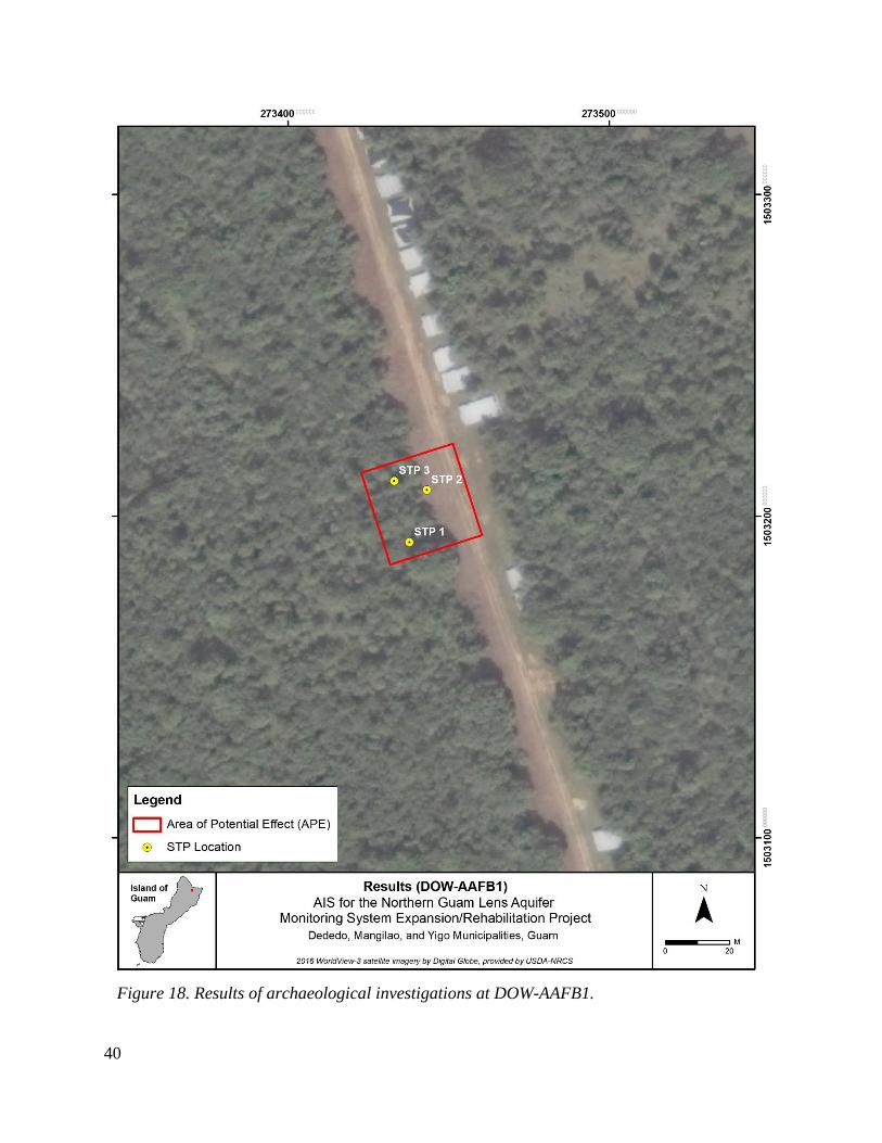
40
Figure 18. Results of archaeological investigations at DOW-AAFB1.

41
Figure 19. DOW-AAFB1, view to northwest showing utility corridor and access
road.
4.1.1 DOW-AAFB1 Subsurface Testing
No evidence of subsurface cultural deposition was encountered during test excavations at the
DOW-AAFB1 location. Three (n=3) STPs were excavated, which yielded a weakly developed A-
horizon (dark brown silty clay) overlying a B-horizon (dark reddish-brown silty clay) formed over
eroding limestone bedrock (Figure 20 through Figure 22). Stratigraphic descriptions for these STPs
are presented in Table 2, and stratigraphic profiles are shown in Figure 23.

42
Figure 20. DOW-AFFB1, STP 1.
Figure 21. DOW-AFFB1, STP 2.

43
Figure 22. DOW-AFFB1, STP 3.
Table 2. DOW-AAFB1 Stratigraphic Descriptions
STP
No.
Layer Depth
(cmbs)
Description Interpretation
1 I 0–2 7.5YR 3/4 dark brown silty clay; moist, loose, fine
to very fine granular structure, few roots; clear
abrupt lower boundary.
Weakly developed
A-horizon
II 2–41 2.5YR 2.5/4 dark reddish-brown silty clay; moist,
loose, fine to very fine granular structure, root
common, large limestone inclusions. [STP
terminated at limestone bedrock.]
B-horizon
2 I 0–5 7.5YR 3/4 dark brown silty clay; moist, loose, fine
to very fine granular structure, few roots; clear
abrupt lower boundary.
Weakly developed
A-horizon
II 5–30 2.5YR 2.5/4 dark reddish-brown silty clay; moist,
loose, fine to very fine granular structure, root
common. [STP terminated at limestone bedrock.]
B-horizon
3 I 0–18 2.5YR 2.5/4 dark reddish-brown silty clay; moist,
loose, fine to very fine granular structure, roots
common; clear abrupt lower boundary.
Disturbed B-
horizon
II 18–22 7.5YR 8/1 white eroding limestone bedrock;
cemented structure.
C-horizon

44
Figure 23. Stratigraphic profiles for STPs excavated at each well location.

45
4.2 DOW-M1 Survey Results
No archaeological or cultural resources were encountered during archaeological
investigations at DOW-M1 (Figure 25). DOW-M1 is located adjacent to a utility line corridor
which extends from Liguan Avenue into largely undeveloped land (Figure 24). DOW-M1 is
situated on the south side of the utility corridor’s concrete utility poles. The transect survey covered
100 percent of the 30 by 30-meter APE. Survey transects were oriented 45 degrees northeast by
225 degrees southwest. The survey area has been cut and graded in the past and currently consists
of various grasses and exposed limestone bedrock, which afforded nearly 100 percent ground
visibility (Figure 26). Recent dumping episodes are evident across the survey area and include
tires, automobile parts, and aluminum cans (Figure 27).
Figure 24. DOW-M1, view to northeast.
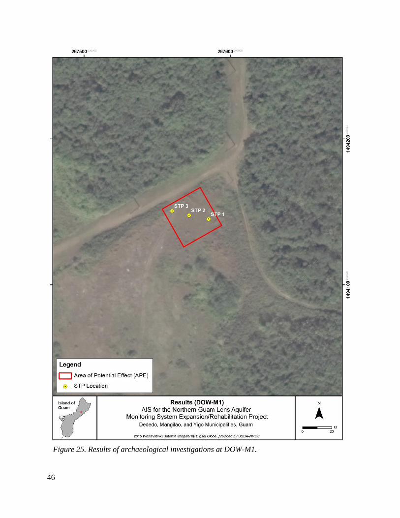
46
Figure 25. Results of archaeological investigations at DOW-M1.

47
Figure 26. DOW-M1, view to southwest of exposed limestone bedrock.
Figure 27. DOW-M1, view to southeast of modern refuse found in the area.

48
4.2.1 DOW-M1 Subsurface Testing
No evidence of subsurface cultural deposition was encountered during test excavations at
DOW-M1. Three (n=3) STPs were excavated across the APE footprint, which yielded a very
shallow layer of disturbed sediment (dark brown silty clay) overlying limestone bedrock,
indicative of prior land clearing (Figure 28 through Figure 30). Only one small pocket (ca. 20 by
25-centimeter area) of an intact B-horizon (strong brown silty clay) was encountered during
subsurface testing at this location (see STP 3 in Table 3). Stratigraphic descriptions for these STPs
are presented in Table 3, and stratigraphic profiles are shown in Figure 23.
Figure 28. DOW-M1, STP 1.
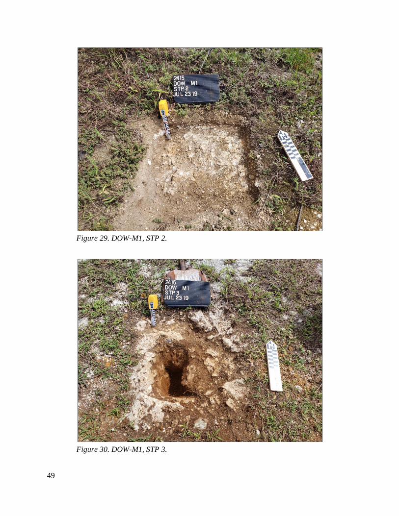
49
Figure 29. DOW-M1, STP 2.
Figure 30. DOW-M1, STP 3.

50
Table 3. DOW-M1 Stratigraphic Descriptions
STP
No.
Layer Depth
(cmbs)
Description Interpretation
1 I 0–14 7.5YR 3/3 dark brown silty clay; dry, loose, fine
to very fine granular structure, root common.
[STP terminated at limestone bedrock.]
Disturbed sediment
2 I 0–6 7.5YR 4/3 brown silty clay; dry, loose, fine to
very fine granular structure, few roots; clear
abrupt lower boundary.
Disturbed sediment
II 6–12 7.5YR 8/1 white eroding limestone bedrock;
cemented structure.
C-horizon.
3 I 0–5 7.5YR 4/3 brown silty clay; dry, loose, fine to
very fine granular structure, few roots; clear
abrupt lower boundary.
Disturbed sediment
II 5–8 7.5YR 8/1 white eroding limestone bedrock;
cemented structure.
C-horizon
4.3 DOW-NCSB1 Survey Results
No archaeological cultural resources were encountered during archaeological investigations
at DOW-NCSB1 (Figure 31). DOW-NCSB1, located on Radio-Barrigada, is situated along a
utility corridor next to a large radio antenna. The transect survey covered 100 percent of the 30 by
30-meter APE. Survey transects were oriented 45 degrees northeast by 225 degrees southwest.
Roughly 30 percent of the survey area consisted of a cut and graded surface associated with utility
corridor and adjacent antenna pad construction. The vegetated portion of the survey area was fairly
level and consisted of a very thick understory of grasses and tangantangan that limited ground
visibility (Figure 32).
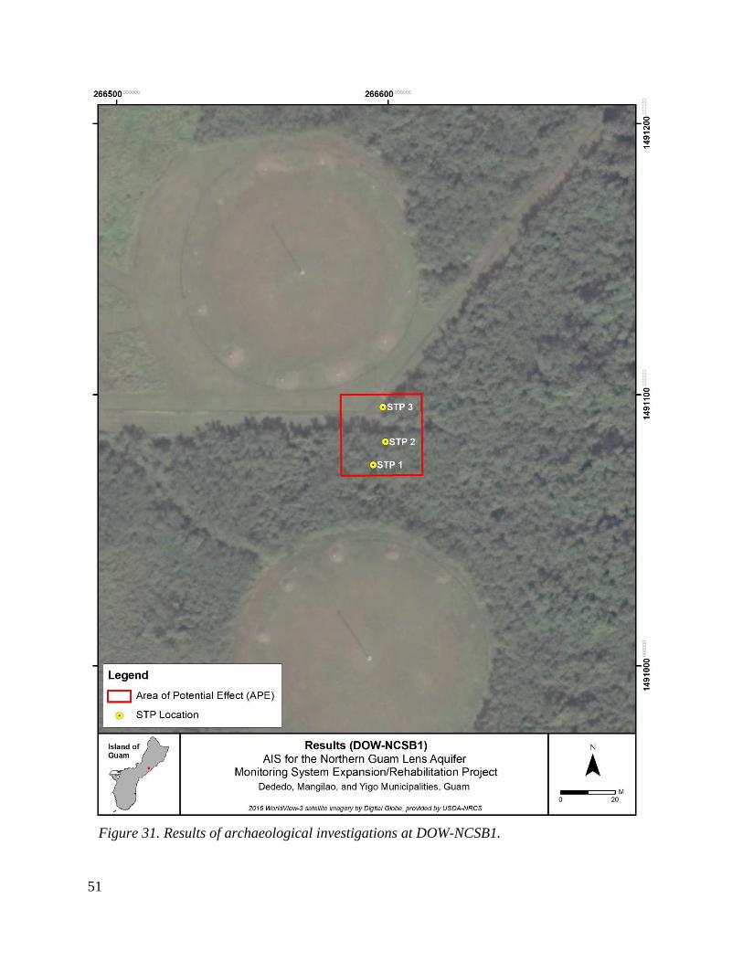
51
Figure 31. Results of archaeological investigations at DOW-NCSB1.

52
Figure 32. DOW-NCSB1, view to southeast.
4.3.1 DOW-NCSB1 Subsurface Testing
No evidence of subsurface cultural deposition was encountered during test excavations at
DOW- NCSB1. Three (n=3) STPs were excavated, which yielded a weakly developed A-horizon
(2.5YR 3/4 or 5YR 3/4 dark reddish-brown silty clay) overlying a B-horizon (dark red silty clay
or dark reddish-brown silty clay) on top of eroding limestone bedrock (Figure 33 through Figure
35). Stratigraphic descriptions for these STPs are presented in Table 4, and stratigraphic profiles
are shown in Figure 23.

53
Figure 33. DOW-NCSB1, STP 1.
Figure 34. DOW-NCSB1, STP 2.

54
Figure 35. DOW-NCSB1, STP 3.
Table 4. DOW-NCSB1 Stratigraphic Descriptions
STP
No.
Layer Depth
(cmbs)
Description Interpretation
1 I 0–6 2.5YR 3/4 dark reddish-brown silty clay; moist,
loose, fine to very fine granular structure, few
roots; smooth lower boundary
Weakly developed A-
horizon
II 6–25 2.5YR 3/6 dark red silty clay; moist, loose, fine
to very fine granular structure, few roots;
smooth lower boundary
B-horizon
III 25–33 7.5YR 8/1 white eroding limestone bedrock;
cemented structure.
C-horizon
2 I 0–9 2.5YR 2.5/4 dark reddish-brown silty clay;
moist, loose, fine to very fine granular structure,
few roots; smooth lower boundary.
Weakly developed A-
horizon
II 9–31 2.5YR 3/6 dark red silty clay; moist, loose, fine
to very fine granular structure, few roots. [STP
terminated at limestone bedrock.]
B-horizon
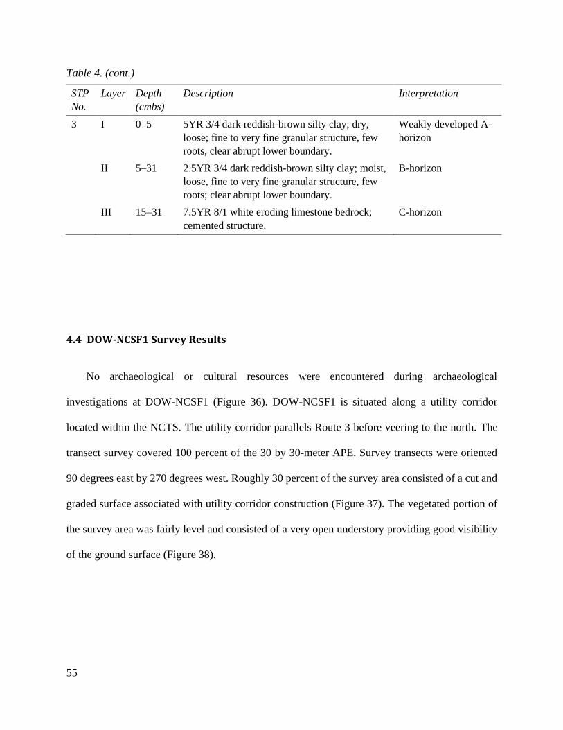
55
Table 4. (cont.)
STP
No.
Layer Depth
(cmbs)
Description Interpretation
3 I 0–5 5YR 3/4 dark reddish-brown silty clay; dry,
loose; fine to very fine granular structure, few
roots, clear abrupt lower boundary.
Weakly developed A-
horizon
II 5–31 2.5YR 3/4 dark reddish-brown silty clay; moist,
loose, fine to very fine granular structure, few
roots; clear abrupt lower boundary.
B-horizon
III 15–31 7.5YR 8/1 white eroding limestone bedrock;
cemented structure.
C-horizon
4.4 DOW-NCSF1 Survey Results
No archaeological or cultural resources were encountered during archaeological
investigations at DOW-NCSF1 (Figure 36). DOW-NCSF1 is situated along a utility corridor
located within the NCTS. The utility corridor parallels Route 3 before veering to the north. The
transect survey covered 100 percent of the 30 by 30-meter APE. Survey transects were oriented
90 degrees east by 270 degrees west. Roughly 30 percent of the survey area consisted of a cut and
graded surface associated with utility corridor construction (Figure 37). The vegetated portion of
the survey area was fairly level and consisted of a very open understory providing good visibility
of the ground surface (Figure 38).

56
Figure 36. Results of archaeological investigations at DOW-NCSF1.
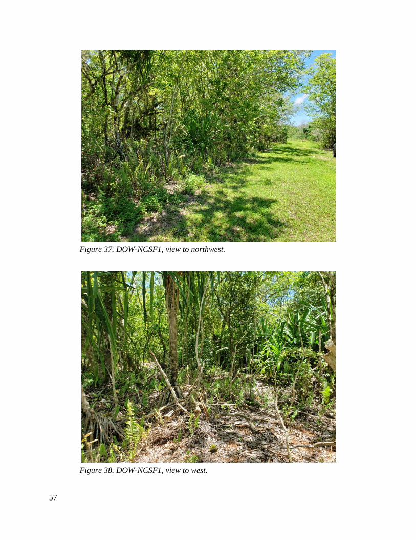
57
Figure 37. DOW-NCSF1, view to northwest.
Figure 38. DOW-NCSF1, view to west.

58
4.4.1 DOW-NCSF1 Subsurface Testing
No evidence of subsurface cultural deposition was encountered during test excavations at
DOW- NCSF1. Three (n=3) STPs were excavated, which yielded a weakly developed A-horizon
(2.5YR 3/4 or 5YR 3/3 dark reddish-brown silty clay) overlying a B-horizon (dark reddish brown
silty clay or dark red silty clay) formed over eroding limestone bedrock (Figure 39 through Figure
41). Stratigraphic descriptions for these STPs are presented in Table 5, and stratigraphic profiles
are shown in Figure 23.
Figure 39. DOW-NCSF1, STP 1.

59
Figure 40. DOW-NCSF1, STP 2.
Figure 41. DOW-NCSF1, STP 3.

60
Table 5. DOW-NCSF1 Stratigraphic Descriptions
STP
No.
Layer Depth
(cmbs)
Description Interpretation
1 I 0–4 2.5YR 3/4 dark reddish-brown silty clay; moist,
loose, fine to very fine granular structure, few
roots; clear abrupt lower boundary.
Weakly developed A-
horizon
II 4–25 2.5YR 2.5/4 dark reddish-brown silty clay;
moist, loose, fine to very fine granular structure,
few roots; clear abrupt lower boundary.
B-horizon
III 25–28 7.5YR 8/1 white eroding limestone bedrock;
cemented structure.
C-horizon
2 I 0–3 5YR 3/3 dark reddish-brown silty clay; moist,
loose, fine to very fine granular structure, few
roots; clear abrupt lower boundary.
Weakly developed A-
horizon
II 3–24 5YR 3/2 dark red silty clay; moist, loose, fine to
very fine granular structure, few roots. [STP
terminated at limestone bedrock.]
B-horizon
3 I 0–4 2.5YR 3/4 dark reddish-brown silty clay; moist,
loose, fine to very fine granular structure, few
roots; clear abrupt lower boundary.
Weakly developed A-
horizon
II 4–15 2.5YR 2.5/4 dark reddish-brown silty clay;
moist, loose, fine to very fine granular structure,
few roots. [STP terminated at limestone
bedrock.]
B-horizon
5.0 DISCUSSION AND CONCLUSION
The primary objective of this AIS for the NGLA Monitoring System Expansion/
Rehabilitation Project was to assess the presence and nature of NRHP-eligible historic properties
in the undertaking APE. Investigations at each of the four proposed water well locations
encountered no significant archaeological or cultural resources eligible for NRHP listing. This
report concludes, therefore, that there are no historic properties present in the APE.

61
It appears that extensive prior land clearing associated with utility line installation and
construction of antenna pads and access roads has altered much of the original land surface at each
water well location. This is evidenced by nearly flat and level terrain with exposed limestone
bedrock in some areas (e.g., DOW-M1), disturbed and truncated native sediment, and secondary
growth vegetation (e.g., tangantangan thicket). This prior land alteration has likely removed
evidence of former land use (e.g., Latte Period occupation and resource procurement, Spanish to
First American Period farming and ranching), if it was once present in the APE.
5.1 Recommendations
The results of this study indicate there are no NRHP-eligible historic properties or significant
cultural or archaeological resources in the undertaking APE. Further, the disturbed nature of the
APE in general, shallow limestone soils, and lack of any pre-Contact deposits indicate a low
probability for inadvertent discovery of intact cultural or archaeological resources within the area
of impact. Therefore, no further archaeological work is recommended for the APE.

62
6.0 REFERENCES
Amesbury, J.R. and D.R. Moore
1989 Archaeological Survey of Portions of Routes 4 and 15 and Dairy Road, Guam.
Prepared for Juan Tenorio and Associates, Agana, Guam. On file at Guam Historic
Preservation Office, Agana Heights, Guam.
Athens, J.S.
2009 Archaeological Surveys and Cultural Resources Studies on Guam and the
Commonwealth of the Northern Mariana Islands in Support of the Joint Guam Build-Up
Environmental Impact Statement. Volume I: Guam. Prepared for Department of the Navy,
Naval Facilities Engineering Command Pacific, Pearl Harbor, Hawai‘i. International
Archaeological Research Institute, Inc., Honolulu, and TEC Inc. Joint Venture,
Charlottesville, Virginia.
Blaz, V.
2008 Bisita Guam: Let Us Remember Nihi Ta Hasso: Remembrances of the Occupation
Years in World War II. MARC Publication Series 30. University of Hawai‘i Press,
Honolulu.
Crowl, P.A.
1993 Campaign in the Marianas. Center of Military History, United States Army,
Washington, D.C.
Dilli, B.J., A. Haun, and S.T. Goodfellow
1998 Volume I: Introduction, Research Design, and Data Recovery Results, Archaeological
Mitigation Program, Mangilao Golf Course Project Area, Mangilao Municipality,
Territory of Guam. Prepared for Mr. Jetan Sahni, GMF, Guam. Paul H. Rosendahl, Ph.D.,
Inc., Hilo, Hawai‘i.
Dixon, B., H. Barton, J. Coil, W. Dickinson, G. Murakami, and J. Ward
2011a Recognizing inland expansion of Latte Period agricultural from multi-disciplinary data
on Tinian, Commonwealth of the Northern Mariana Islands. The Journal of Island and
Coastal Archaeology 6:375–397.
Dixon, B., S. Walker, and R. Schaefer
2011b Cultural Resources Investigations Conducted in the Territory of Guam Supporting the
Joint Guam Build-Up Environmental Impact Statement: Archaeological Surveys on Guam
2010 on Andersen AFB and Highway Utilities. Prepared for the Department of the Navy
Naval Facilities Engineering Command, Pacific. Pearl Harbor, Hawai‘i. TEC, Inc.
Dixon, B., S. Walker, M. Golabi, and H. Manner
2012 Two probably Latte Period agricultural sites in Northern Guam: Their plants, soils, and
interpretations. Micronesica 42(1/2):209–257.
Dixon, B., T. Rudolph, A. Jalandoni, I. Nelson, M. Hroncich-Conner, S. Leary, R. Schaefer, E.
Lash, M. Todd
2015 Final Proposed Guam and CNMI Military Relocation 2012 Roadmap Adjustments SEIS
Live-Fire Training Range Complex Footprint and Main Cantonment Alternatives and

63
Access Route Options In-Fill Cultural Resource Studies. Prepared for the Naval Facilities
Engineering Command, Pacific Division. Cardno TEC, Inc., Honolulu.
Garcia, F.
2006 The Mariana Islands, 1884–1887: Random Notes. Translated by M.G. Driver.
Micronesian Area Research Center, University of Guam, Mangilao, Guam.
Gingerich, S.B.
2003 Hydrologic Resources of Guam. Water-Resources Investigation Report 03-4126. U.S.
Geological Survey, Honolulu.
Grant, M., M. Travisano, S. Wenzlau, and M. Durst
2007 Results of Cultural Resource Inventories for Establishment and Operation of an
Intelligence, Surveillance, Reconnaissance, and Strike Capability and the Deployment of
the Red Horse Squadron, Andersen Air Force Base, Guam. Prepared for Department of the
Air Force, Headquarters Pacific Air Forces/A7P, and Air Force Center for Environmental
Excellence. Submitted to Parsons. Geo-Marine Inc., Plano, Texas.
Graves, M. and D. Moore
1985 Tumon Bay Area Overview: Cultural and Historical Resources. Prepared for Guam
Department of Parks and Recreation, Hagåtña, Guam. Micronesian Area Research Center,
University of Guam, Mangilao, Guam.
Griffin, A. E., M. Carson, and J. Peterson
2010 A Study of Potential Traditional Cultural Properties in Guam. Prepared for Department
of the Navy, Pacific Division, Naval Facilities Engineering Command, Pearl Harbor,
Hawai‘i.
Guam Historic Resources Division (GHRD)
2014 Guam Historic Properties Inventory Data Form. Guam Department of Parks and
Recreation, Hagåtña, Guam.
Hunter-Anderson, R., D. Dixon, and T. Mangieri
2001 Cultural Resources Survey of Five Navy Surplus Guam Land Use Plan Parcels,
Territory of Guam. Prepared for the Department of the Navy, Pacific Division, Naval
Facilities Engineering Command, Pearl Harbor, Hawai‘i. Micronesian Archaeological
Research Services, Inc., Mangilao, Guam, and International Archaeological Research
Institute, Inc., Honolulu.
Kurashina, H., D. Moore, O. Kataoka, R. Clayshulte, and E. Ray
1981 Prehistoric and protohistoric cultural occurrences at Tarague, Guam. Asian Perspectives
24 (1):57–68.
Kurashina, H., D. Wooster, T. McGrath, and J. Toenjes
1988 Archaeological Investigations of the Route 3 Road Corridor, Territory of Guam,
Mariana Islands. Prepared for Juan C. Tenorio and Associates, Inc., Agana, Guam. On file
at Guam Historic Preservation Office, Agana Heights, Guam.
64
Le Gobien, C.
1700 History of the Mariana Islands Newly Converted to the Christian Religion and of the
Glorious Death of the First Martyrs who Preached the Faith There. Translated by Father
P.V. Daly, C.P.S. (1949). Ms. on file, Micronesian Area Research Center, University of
Guam, Mangilao, Guam.
Liston, J.
1996 The Legacy of Tarague Embayment and Its Inhabitants, Andersen AFB, Guam.
Prepared for Andersen Air Force Base, Guam. International Archaeological Research
Institute, Inc., Honolulu.
Moore, D.
2005 Archaeological evidence of a prehistoric farming technique on Guam. Micronesica 38:
93–120.
Olmo, R., T. Mangieri, D. Welch, and T. Dye
2000 Phase II Archaeological Survey and Detailed Recording at Commander, U.S. Naval
Forces Marianas, Communications Annex (Formerly Naval Computer and
Telecommunications Area Master Station, Western Pacific), Territory of Guam, Mariana
Islands. Prepared for the Department of the Navy, Honolulu. International Archaeological
Research Institute, Inc., Honolulu.
Reinman, F.R.
1977 An Archaeological Survey and Preliminary Test Excavations on the Island of Guam,
Mariana Islands, 1965–66. Micronesian Area Research Center, University of Guam,
Mangilao, Guam.
Rogers, R.F.
1995 Destiny’s Landfall: A History of Guam. University of Hawai‘i Press, Honolulu.
Russell, S.
1998 Tiempon I Manomofo’ona: Ancient Chamorro Culture and History of the Northern
Marianas Islands. Micronesian Archaeological Survey Report, 32. Division of Historic
Preservation, Saipan, CNMI.
Tomonari-Tuggle, M.J., H.D. Tuggle, and D.J. Welch
2003 Integrated Cultural Resource Management Plan for Andersen Air Force Base, Guam,
2003 Update. Prepared for Earth Tech, Inc. Global and Environmental Services.
International Archaeological Research Institute, Inc., Honolulu.
Welch, D.J.
2010 Archaeological Surveys and Cultural Resources Studies Conducted in 2007 on the
Island of Guam in Support of the Joint Guam Build-up Environmental Impact Statement.
Volume I: Narrative; Volume II: Site Descriptions. Prepared for Department of the Navy,
Naval Facilities Engineering Command Pacific, Pearl Harbor, Hawai‘i. International
Archaeological Research Institute, Inc., Honolulu, and TEC Inc. Joint Venture,
Charlottesville, Virginia.

65
Young, F.J.
1988 Soil Survey of the Territory of Guam. United States Department of Agriculture, Soil
Conservation Service in cooperation with the Guam Department of Commerce and the
University of Guam. Washington, D.C.

66
APPENDIX A: ARCHAEOLOGICAL REPORT SUMMARY FORM

Guam Historic Resource Division
(State Historic Preservation Office)
Department of Parks and Recreation
Archaeological Report Summary Form (ARSF)
Please print clearly when completing this form. Include completed forms in all reports to be
submitted to the Department, such as management summaries, abbreviated reports, draft and
final reports, etc. This form may be downloaded or expanded as needed, but do not eliminate
any fields.
Guam Historic Resource Division, Department of Parks and Recreation, 490 Chalan Palasyo, Agana Heights GU 96910
http://historicguam.org
June 28, 2013
1. Report Title: _____________________________________________________________________________________
2. PI __________________________________ MA PhD / Firm or Institution_____________________________
3. Report Date: (01-06-2002) ________________ Number of Pages ______ Draft Report______
Revised Report___ Letter of Acceptance of Final Report ___ Two (2) Final Reports (spiraled) and one CD _____
Research Design: Yes___ No___ Scope of Work: Yes___ No___ RC #_________________
4. Type of Report: Terrestrial _____ Marine ____ Architecture:___ Historic _____ Prehistoric _______
Type of Work: Identification____ Evaluation____ Data Recovery____ Monitoring____ Shapefiles Provided: Y / N
Further work recommended Yes____ No_____ What? ______________________________ Preservation Y / N
5. Agency/Lessees Name: _____________________________________ Federal Guam Private
Company / Land Owner: ________________________________________ Lot No. (s):________________________
6. Project Area: Quad, Municipality, Village, (list all) Place Name/s: _________________________________________
Quad Municipality Village Place Name
7. Nearest Project Area Drainage (s): __________________________________ Distance from site: ______________
8. Basic Field Information: Series of Soil: _____________________________________________________________
a. Area of Potential Effect (APE) / Project Area in Hectares: _____ Acres: ______ Square Miles: _______
b. Type of Proposed Project/ Impacts: _______________ Dates of Field Investigation(s): ______________
c. Closest Recorded Historic Property to APE (Site Name, Site #, Reference): _____________________________
d. Description of Field Conditions and Disturbance (wooded, previously cleared, recently bulldozed, untouched,
etc.):_____________________________________________________________________________________
9. GHPI Site Numbers, for unrecorded sites, if any: ______________________________________________________
a. Guam Historic Properties Inventory (GHPI) Data Form/s submitted : Yes ___ No ___
10. Number of sites “Meeting” National Register Criteria: _________ Guam Register Criteria______
11. Number of sites “Not Meeting” National Register Criteria: ________ Guam Register Criteria:_____
12. Number of Sites with No Effect Determination ______ No Adverse Effect ______ Adverse Effect ______
13. Other agreements or requirements: Certificate of Approval # _____________ Notice of Violation # ___________
Memorandum of Agreement __________Programmatic Agreement ___________ Artifact Catalog # ___________
14. Disposition of Artifacts / Stored With / At / Date:______________________________________________________
GHRD USE ONLY RC #:_____________________
Date: _____________________
Reviewer: __________________
GIS Logger: ________________
Date: _____________________
GHRD #___________________
MS__ AB __ Draft __ Final __
68
APPENDIX B: GHRD SECTION 106 REVIEW LETTERS

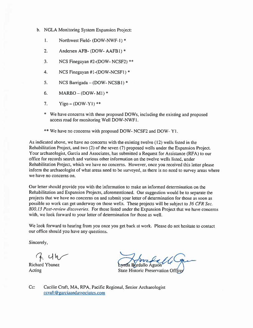
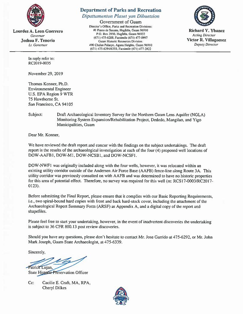

Federal Consistency Certification Application
Northern Guam Lens Aquifer Monitoring System Expansion/
Rehabilitation Project
Appendix C
Biological Assessment for Northern Guam Lens Aquifer (NGLA)
Monitoring System Expansion
December 4, 2019

Biological Assessment
for
Northern Guam Lens Aquifer (NGLA)
Monitoring System Expansion
Prepared For
578 North Marine Corps Drive
Tamuning, Guam 96913
Prepared By
1001 Army Drive, Suite 103
Barrigada, Guam 96913
4 December 2019

This page intentionally left blank

TOC December 2019
i
Table of Contents
Table of Contents ............................................................................................................................. i
List of Tables .................................................................................................................................. ii
List of Figures ................................................................................................................................. ii
.......................................................................................................................... ii
Acronyms and Abbreviations ........................................................................................................ iii
Introduction .......................................................................................................................... 1-1
Purpose and Objectives ............................................................................................ 1-1
Proposed Action ....................................................................................................... 1-1
Project Description ............................................................................................................... 2-1
Project Area .............................................................................................................. 2-3
Listed Species with the Potential to Occur within the Action Area ......................... 2-4
Species/Critical Habitat Considered ..................................................................................... 3-1
Species and Critical Habitat ..................................................................................... 3-1
Identification of Listed Resources ............................................................................ 3-3
3.2.1. Field Survey Methodology .................................................................................... 3-4
Species Observed in the Area of Effect .................................................................... 3-5
Effects Analysis .................................................................................................................... 4-1
Micronesian Cycad (Cycas micronesica) ................................................................. 4-1
Tuberolabium guamense .......................................................................................... 4-2
Mariana Fruit Bat (Pteropus mariannus) ................................................................. 4-2
Conclusion and Determination of Effects ............................................................................ 5-1
Literature Cited ..................................................................................................................... 6-1
List of Contacts Made and Preparers .................................................................................... 7-1

TOC December 2019
ii
List of Tables
Table 1. Monitoring Well Locations and Property Ownership.................................................... 2-1
Table 2. Guam Federally Protected Flora and Fauna and Their Potential to Occur
on NGLA Well Sites ................................................................................................ 3-1
Table 3. Threatened and Endangered Species Observed at Each Well Location ........................ 3-6
Table 4. Species with a Section 7 Determination of No Effect .................................................... 5-1
Table 5. Species with a Section 7 Determination of May Affect, but not Likely to
Adversely Affect ........................................................................................................ 5-2
List of Figures
Figure 1. Well Site Locations .................................................................................................. 2-5
Figure 3. DOW-AAFB1........................................................................................................... 3-7
Figure 4. DOW-M1 .................................................................................................................. 3-8
Figure 5. DOW-NCSB1 ........................................................................................................... 3-9
Figure 6. DOW-NCSF1 ......................................................................................................... 3-10
Figure 7. DOW-NCSF2 ......................................................................................................... 3-11
Figure 8. DOW-NWF1 .......................................................................................................... 3-12
Figure 8. DOW-Y1 ................................................................................................................ 3-13
Figure 9. Exclusion Zones within Footprint at DOW-AAFB1 ................................................ 4-3
Figure 10. Exclusion Zones within Footprint at DOW-NCSF1 ............................................... 4-4
Appendix A – Site Photographs

TOC December 2019
iii
Acronyms and Abbreviations
CFR Code of Federal Regulations
DOI Department of Interior
DOW Deep Observation Wells
EA EA Engineering, Science, and Technology, Inc., PBC
ESA Endangered Species Act
ft. feet
GWA Guam Waterworks Authority
HVT High Value Tree
in. inch
N.C.N. no common name
NGLA Northern Guam Lens Aquifer
WERI University of Guam Water and Environmental Research Institute
USFWS United States Fish and Wildlife Service
USGS United States Geological Survey

TOC December 2019
iv
This page intentionally left blank
Introduction December 2019
1-1
Introduction
Purpose and Objectives
The purpose of this Biological Assessment is to review the natural resources affected by actions
associated with the installation of seven new deep-monitoring wells and rehabilitation of 12 existing
wells within the Northern Guam Lens Aquifer (NGLA) Monitoring System. This review includes
sufficient detail to determine the extent to which the project might affect any threatened,
endangered, proposed, or otherwise protected or sensitive species.
This Biological Assessment was developed in accordance with the legal requirements set forth
under the federal Endangered Species Act (ESA) (16 United States Code [U.S.C.] 1531 et seq.).
Proposed Action
The proposed action is the installation of new deep-monitoring wells and rehabilitation of existing
wells within the NGLA.

Introduction December 2019
1-2
This page intentionally left blank

Project Description December 2019
2-1
Project Description
Guam Waterworks Authority (GWA), United States Geological Survey (USGS) and the University
of Guam Water and Environmental Research Institute (WERI) of the Western Pacific propose to
install seven new deep-monitoring wells and rehabilitate 12 existing wells within the Northern
Guam Lens Aquifer (NGLA) Monitoring System. Expansion of the groundwater monitoring system
will provide long-term hydrologic data and information needed for effective management of
Guam’s drinking-water resources.
The seven new deep observations wells (DOW) are located across Northern Guam (Figure 1) and
are designated with the identifiers DOW-AAFB1, DOW-M1, DOW-NCSB1, DOW-NCSF1,
DOW-NCSF2, DOW-NWF1 and DOW-Y1. The 12 existing wells selected for rehabilitation are
designated with identifiers A-16, A-20, BPM-1, EX-1, EX-4, EX-6, EX-8, EX-9, EX-10, GHURA-
Dededo, M-10A and NCS-3A. The locations, coordinates, and current land ownership are listed in
Table 2 below. Rehabilitation and construction activities (i.e. drilling for new wells) will have
limited surface impact. The new wells are anticipated to disturb less than 10,000 ft2 of surrounding
area, while rehabilitation activities will only impact the previously disturbed well locations.
Table 2. Monitoring Well Locations and Property Ownership
Well Type Well Property Ownership Location Description Latitude Longitude
New DOW-NWF1 U.S. Air Force Off shoulder of Route 3A outside of AAFB
fence line 13.59569 144.8622
New DOW-AAFB1 U.S. Air Force On a utility road through AAFB's main
gate 13.588625 144.906150
New DOW-NCSF1 U.S. Navy On NCTS site in a utility corridor 13.580095 144.850202
New DOW-NCSF2 U.S. Navy On NCTS site near gymnasium 13.566813 144.842522
New DOW-NCSB1 U.S. Navy On NCS-Radio Barrigada 13.478581 144.843912
New DOW-M1 U.S. Air Force Within the Marbo Annex 13.506293 144.852779
New DOW-Y1 U.S. Air Force To the east side of Yigo Fire Station 13.52225 144.880164
Rehab A-16 GovGuam Carbullido Elementary School 13.471361 144.792528
Rehab A-20 GovGuam Chalan Pago Elementary School 13.44175 144.759639
Rehab BPM-1 Frank T. Pangelinan Private property 13.446528 144.804333
Rehab EX-1 GovGuam San Miguel Elementary School 13.461389 144.773611
Rehab EX-10 GovGuam Swamp Road, off of Route 3 13.54183 144.83389
Rehab EX-4 GovGuam In the front yard of a private home, near
Father Duenas School 13.441583 144.790028

Project Description December 2019
2-2
Well Type Well Property Ownership Location Description Latitude Longitude
Rehab EX-6 GovGuam, Lessee: Frederic
Lujan Guerrero
To the side of a private driveway to a
home 13.51086 144.83767
Rehab EX-8 U.S. Air Force On the far north of AAFB, near the old air
field 13.60945 144.86116
Rehab EX-9 GovGuam To the side of PC Lujan Elementary
School 13.46967 144.80753
Rehab GHURA- Dededo GovGuam, but on GICC golf
course
Guam International Country Club golf
course near hole S-1 13.5242569 144.8499119
Rehab M-10A GovGuam Juan Guerrero Elementary School - large
old tree and palm tree 13.51061 144.82414
Rehab NCS-3A U.S. Navy Near the Radio Barrigada site on U.S.
Navy property, across from the former
Nimitz Golf Course
13.47025816 144.8235445
Construction equipment expected on the new well sites is assumed to include the following:
• Air Rotary Drill Rig (37 feet long x 8 feet wide x 12 feet high),
• two flatbed support trucks (20 feet long x 8 feet wide x 8 feet high),
• Non-potable water tanker (16 feet long x 8 feet wide x 8 feet high),
• two 40-yard trash containers (22 feet long x 7.5 feet wide x 8 feet high).
Photo 1. Typical Drill Site Layout with Air Rotary Drill Completing Deep Well
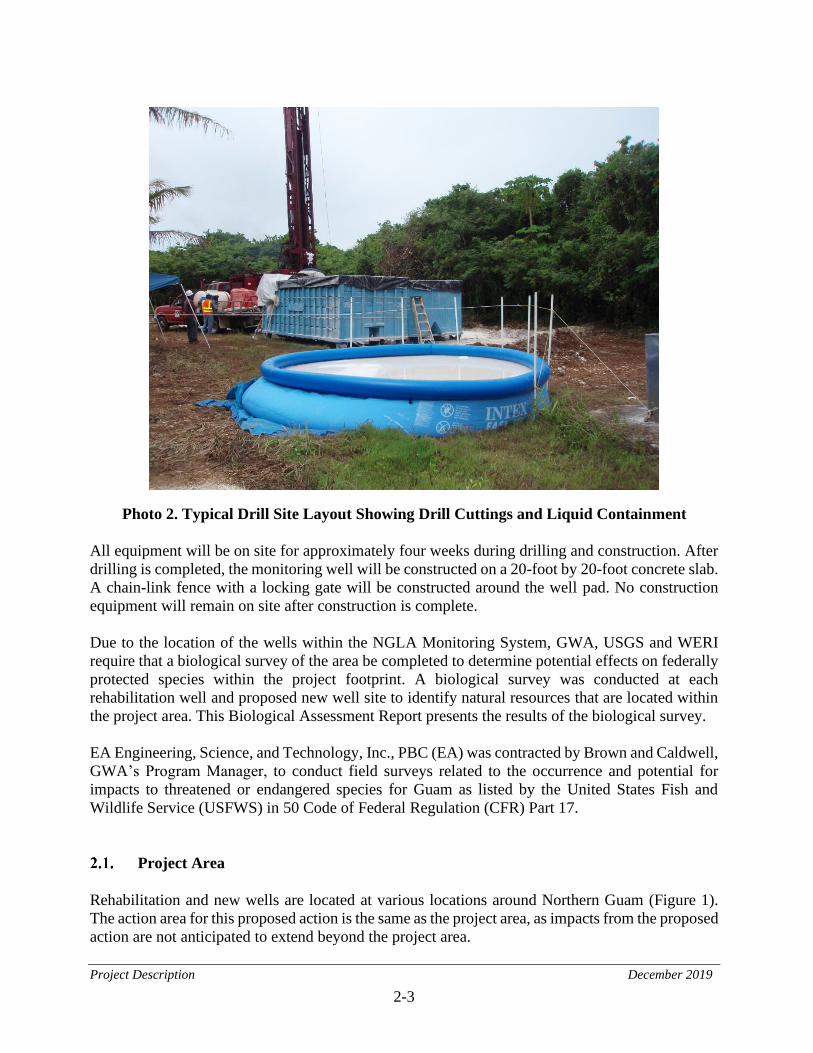
Project Description December 2019
2-3
Photo 2. Typical Drill Site Layout Showing Drill Cuttings and Liquid Containment
All equipment will be on site for approximately four weeks during drilling and construction. After
drilling is completed, the monitoring well will be constructed on a 20-foot by 20-foot concrete slab.
A chain-link fence with a locking gate will be constructed around the well pad. No construction
equipment will remain on site after construction is complete.
Due to the location of the wells within the NGLA Monitoring System, GWA, USGS and WERI
require that a biological survey of the area be completed to determine potential effects on federally
protected species within the project footprint. A biological survey was conducted at each
rehabilitation well and proposed new well site to identify natural resources that are located within
the project area. This Biological Assessment Report presents the results of the biological survey.
EA Engineering, Science, and Technology, Inc., PBC (EA) was contracted by Brown and Caldwell,
GWA’s Program Manager, to conduct field surveys related to the occurrence and potential for
impacts to threatened or endangered species for Guam as listed by the United States Fish and
Wildlife Service (USFWS) in 50 Code of Federal Regulation (CFR) Part 17.
Project Area
Rehabilitation and new wells are located at various locations around Northern Guam (Figure 1).
The action area for this proposed action is the same as the project area, as impacts from the proposed
action are not anticipated to extend beyond the project area.
Project Description December 2019
2-4
Protected Species with the Potential to Occur within the Action Area
The purpose of the biological field survey was to determine if federally protected species occur
within the footprint of the project and to document and locate their occurrence, if observed. The
objective of this project is to ensure that actions associated with the NGLA Monitoring System
Expansion project are consistent with the requirements of ESA, Section 7 and to identify and avoid
the potential impacts on listed species identified within or immediately adjacent to the project area.

Figure 1. V

Project Description November 2019
2-6
This page intentionally left blank
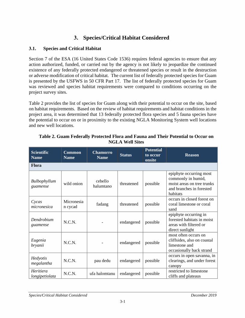
Species/Critical Habitat Considered December 2019
3-1
Species/Critical Habitat Considered
Species and Critical Habitat
Section 7 of the ESA (16 United States Code 1536) requires federal agencies to ensure that any
action authorized, funded, or carried out by the agency is not likely to jeopardize the continued
existence of any federally protected endangered or threatened species or result in the destruction
or adverse modification of critical habitat. The current list of federally protected species for Guam
is presented by the USFWS in 50 CFR Part 17. The list of federally protected species for Guam
was reviewed and species habitat requirements were compared to conditions occurring on the
project survey sites.
Table 2 provides the list of species for Guam along with their potential to occur on the site, based
on habitat requirements. Based on the review of habitat requirements and habitat conditions in the
project area, it was determined that 13 federally protected flora species and 5 fauna species have
the potential to occur on or in proximity to the existing NGLA Monitoring System well locations
and new well locations.
Table 2. Guam Federally Protected Flora and Fauna and Their Potential to Occur on
NGLA Well Sites
Scientific
Name
Common
Name
Chamorro
Name Status
Potential
to occur
onsite
Reason
Flora
Bulbophyllum
guamense wild onion
cebello
halumtano threatened possible
epiphyte occurring most
commonly in humid,
moist areas on tree trunks
and branches in forested
habitats
Cycas
micronesica
Micronesia
n cycad fadang threatened possible
occurs in closed forest on
coral limestone or coral
sand
Dendrobium
guamense N.C.N. - endangered possible
epiphyte occurring in
forested habitats in moist
areas with filtered or
direct sunlight
Eugenia
bryanii N.C.N. - endangered possible
most often occurs on
cliffsides, also on coastal
limestone and
occasionally back strand
Hedyotis
megalantha N.C.N. pau dedu endangered possible
occurs in open savanna, in
clearings, and under forest
canopy
Heritiera
longipetiolata N.C.N. ufa halomtanu endangered possible
restricted to limestone
cliffs and plateaus

Species/Critical Habitat Considered December 2019
3-2
Scientific
Name
Common
Name
Chamorro
Name Status
Potential
to occur
onsite
Reason
Maesa walkeri N.C.N. - threatened possible
limestone ridges with no
overstory and exposure to
wind
Nervilia
jacksoniae N.C.N. - threatened possible
typically occurs in shady
places in rocky areas with
leaf litter
Phyllanthus
saffordii N.C.N. - endangered no
lack of suitable habitat -
occurs in savannah
badlands in areas with red
clay soil
Psychotria
malaspinae N.C.N.
aplokating
palaoan endangered possible occurs on limestone forest
Serianthes
nelsonii fire tree hayun lagu endangered possible
this species is known to
occur at Andersen Air
Force Base
Solanum
guamense N.C.N.
Biringenas
halumtanu endangered possible
occurs on limestone cliffs,
terraces near the sea, and
edge plants along roads
Tabernaemont-
ana rotensis N.C.N. - threatened possible
occurs on limestone
plateaus, usually areas
with soil
Tinospora
homosepala N.C.N. - endangered possible
occurs on limestone; back
strand - hangs from tall
canopies
Tuberolabium
guamense N.C.N. - threatened possible
occurs in moist shady
(~60% light) areas,
common in higher
elevations in southern
Guam and older limestone
forests in northern Guam
Fauna
Aerodramus
vanikorensis
bartschi
Mariana
gray
swiftlet
yayaguak endangered no
closest active
roosting/nesting caves
over 15 miles away
Chelonia
mydas
green sea
turtle hagan betde endangered no lack of suitable habitat
Corvus kubaryi Mariana
crow aga endangered no
two Mariana crows were
translocated to Andersen
Air Force Base from
Rota, but they have not
been documented for
several years
Emballonura
semicaudata
rotensis
Pacific
sheath
tailed bat
payeyi endangered no
species only has possible
historical occurrence on
Guam
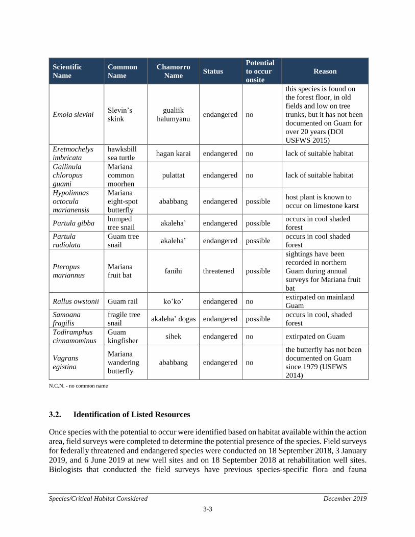
Species/Critical Habitat Considered December 2019
3-3
Scientific
Name
Common
Name
Chamorro
Name Status
Potential
to occur
onsite
Reason
Emoia slevini Slevin’s
skink
gualiik
halumyanu endangered no
this species is found on
the forest floor, in old
fields and low on tree
trunks, but it has not been
documented on Guam for
over 20 years (DOI
USFWS 2015)
Eretmochelys
imbricata
hawksbill
sea turtle hagan karai endangered no lack of suitable habitat
Gallinula
chloropus
guami
Mariana
common
moorhen
pulattat endangered no lack of suitable habitat
Hypolimnas
octocula
marianensis
Mariana
eight-spot
butterfly
ababbang endangered possible host plant is known to
occur on limestone karst
Partula gibba humped
tree snail akaleha’ endangered possible
occurs in cool shaded
forest
Partula
radiolata
Guam tree
snail akaleha’ endangered possible
occurs in cool shaded
forest
Pteropus
mariannus
Mariana
fruit bat fanihi threatened possible
sightings have been
recorded in northern
Guam during annual
surveys for Mariana fruit
bat
Rallus owstonii Guam rail ko’ko’ endangered no extirpated on mainland
Guam
Samoana
fragilis
fragile tree
snail akaleha’ dogas endangered possible
occurs in cool, shaded
forest
Todiramphus
cinnamominus
Guam
kingfisher sihek endangered no extirpated on Guam
Vagrans
egistina
Mariana
wandering
butterfly
ababbang endangered no
the butterfly has not been
documented on Guam
since 1979 (USFWS
2014)
N.C.N. - no common name
Identification of Listed Resources
Once species with the potential to occur were identified based on habitat available within the action
area, field surveys were completed to determine the potential presence of the species. Field surveys
for federally threatened and endangered species were conducted on 18 September 2018, 3 January
2019, and 6 June 2019 at new well sites and on 18 September 2018 at rehabilitation well sites.
Biologists that conducted the field surveys have previous species-specific flora and fauna

Species/Critical Habitat Considered December 2019
3-4
experience, habitat-specific knowledge, and experience with the survey methods also used on other
threatened and endangered species field surveys.
3.2.1. Field Survey Methods
Two biologists simultaneously searched for all threatened and endangered species by conducting
meandering surveys throughout the entire interior of each site. One GPS unit was used by the
survey team and location data was collected by only one person during the survey. Biologists
closely surveyed the project areas for flora and fauna species with the potential to occur within
habitats in the project area as shown in Table 1. The biologist team walked in tandem within
eyesight of each other, 10 to 20 feet apart during the survey. Meandering survey tracks varied due
to the habitat type encountered. Certain well locations (DOW-M1, DOW-NWF1, DOW-NCSF2)
were in areas of developed land, characterized by pavement, human disturbance and
maintained/mowed grasses. These locations required fewer meanders as the lack of trees and tall
vegetation allowed for higher levels of visibility across the Areas of Potential Effects (APE). For
well sites located in primary and secondary mixed limestone forest or scrub forest (DOW-NCSF1,
DOW-NCSB1, DOW-AAFB1, DOW-Y1), surveys required a higher number of meanders because
of lower visibility throughout the APE. During surveys in these more complex habitats, biologists
worked simultaneously, keeping a maximum distance 20 feet from each other to ensure maximum
coverage and assessment of all sides of trees and vegetation.
The surveys consisted of surveys for threatened and endangered species searching primarily for
protected flora species, snails, Mariana fruit bat, and migratory birds. Federally protected species
observed 5 ft. outside the project area were also recorded to bring awareness of their presence.
Protected fauna species other than the bats and snails are very unlikely to occur on the site, but
were searched for because habitat conditions might, but are very unlikely to, support their
occurrence.
Intensive visual surveys were conducted of trees with the potential to support Bulbophyllum
guamense, Dendrobium guamense and Tuberolabium guamense. In addition, special attention was
paid to areas with the potential for the occurrence of smaller understory species such as Nervilia
jacksoniae. All suitable habitats within project footprint were surveyed for the occurrence of listed
species with the potential to occur in the project areas. Along with federally protected species,
culturally significant high value trees (HVT), previously determined by natural resource personnel
of the Government of Guam and Department of Chamorro Affairs were marked with flagging tape.
Intensive visual surveys for humped tree snail (Partula gibba), Guam tree snail (Partula
radiolata), and fragile tree snail (Samoana fragilis) were conducted following variations to
methods used by Hopper and Smith (1992) and Fiedler (2019). During surveys, biologists slowly
walked throughout the area searching for protected snails. Using the methods outlined by Fiedler
(2019) surveys were conducted by sampling the plants listed as category 1 plants/trees for a longer
period and category 4 plants/trees for a shorter period for snails. Several broadleaved canopy trees
and host trees are commonly associated with partulid snails on Guam (e.g. Artocarpus sp.,
Barringtonia asiatica, Cocos nucifera, Merilliodendron megacarpum, Ochrosia oppositifolia).

Species/Critical Habitat Considered December 2019
3-5
Biologists searched the undersides of all leaves, stems, branches, and trunks (if tree), and identified
tall, broadleaved canopy trees and examined them and the plants in their understory. Biologists
prioritized broadleaved plants, examined groundcover plants, and ground and leaf litter for snails.
The ground and leaf litter under the broadleaved trees were examined for vacant shells. As
biologists continued vegetation surveys at the site, visual examinations of trunks and foliage of all
types of vegetation, as well as the ground layer (for empty shells) were performed. On Guam,
partulid snails have previously been observed on approximately 50 species with varying levels of
association. The project area for each well location was limited and the vegetation was searched
by biologists to ensure that no presence of protected partulid species was found within the affected
areas. During surveys, biologists searched for migratory birds and nests in the vegetation or birds
flying overhead.
EA compiled all data collected during the survey including all observed federally protected
species, the general condition of species observed, photographs, locations and track logs recorded
with a Trimble GPS unit with sub-meter accuracy.
Species Observed in the Area of Effect
Biological field survey results for each well site are listed below (Table 3). A total of six
Tuberolabium guamense and two Cycas micronesica were observed in close proximity to the
proposed new wellhead locations. Survey foot tracks as well as the listed species and high-value
trees (HVT) observed at each new well location are located in Figures 2 through 8. The footprint
and footpath at DOW-NWF1 represent the same line, as the DOW-NWF1 footprint consisted
entirely of maintained grass (Figure 7). No federally protected species were observed at any of the
rehabilitation well sites. All rehabilitation wells are located on previously disturbed sites and will
only impact the area previously disturbed. Pictures of both rehabilitation sites and new well
locations are included in Appendix A.

Species/Critical Habitat Considered December 2019
3-6
Table 3. Threatened and Endangered Species Observed at Each Well Location
Well ID Date of Survey Protected Species Observed
New Wells
DOW-AAFB1 3 Jan, 2019 Two Cycas micronesica (cycads) observed in close proximity to the
proposed new well sites. The two cycads are located 47 and 89 feet
away from the proposed well location.
DOW-M1 3 Jan, 2019 None
DOW-NCSB1 18 Sep, 2018 None
DOW-NCSF1 3 Jan, 2019 Six Tuberolabium guamense observed in close proximity to the
proposed new well sites. The six orchids were found on three trees,
which were located 52, 92 and 120 feet away from the proposed
well location.
Two Elaeocarpus joga (yoga) trees were found in close proximity
to the proposed new well sites. E. joga is not federally protected but
is considered culturally significant and is classified as a high-value
tree (HVT). The yoga trees were located 61 and 66 feet away from
the proposed well location.
DOW-NCSF2 18 Sep 2018 None
DOW -NWF1 6 June, 2019 None
DOW-Y1 3 Jan, 2019 None
Rehabilitation Wells
A-20 18 Sep, 2018 None
A-16 18 Sep, 2018 None
BPM-1 18 Sep, 2018 None
EX-1 18 Sep, 2018 None
EX-4 18 Sep, 2018 None
EX-6 18 Sep, 2018 None
EX-8 18 Sep, 2018 None
EX-9 18 Sep, 2018 None
EX-10 18 Sep, 2018 None
GHURA-
Dededo
18 Sep, 2018 None
M-10A 18 Sep, 2018 None
NCS-3A 18 Sep, 2018 None

LegendWell Head LocationsEV PointsArea of Potential EffectSurvey Line Foot Paths
0 50 10025 FeetEA Engineering, Science, and Technology, Inc.
1001 Army Drive, Suite 103, Barrigada, 96913-1402
Telephone: (671) 646-5231Facsimile: (671) 646-5230
1993 Guam Geodetic Network Transverse_MercatorÍ
EA Project No. 63169.01
Task 4 - Biological Assessments for the 7 New Groundwater Monitoring
Wells on the Northern Guam Lens AquiferFigure 2
Threatened and Endangered Species Survey at DOW-AAFB1
Drawing No.Well DOW-AAFB1 Date: 06/17/19 Drawn By: TCC
!(
!(
!(
DOW-AAFB1Latitude: 13.588625 °E Longitude: 144.906150 °N
CYMI
CYMI
89'
47'
100'-0"
100'-0"
N
Project Location

Legend! Proposed_Wellhead_Location
Area of Potential Effect0 125 25062.5 Feet
EA Engineering, Science, and Technology, Inc.1001 Army Drive, Suite 103,
Barrigada, 96913-1402Telephone: (671) 646-5231Facsimile: (671) 646-5230
1993 Guam Geodetic Network Transverse_MercatorEA Project No. 63169.01
Task 4 - Biological Assessments for the 7 New Groundwater Monitoring
Wells on the Northern Guam Lens AquiferFigure 3
Threatened and EndangeredSpecies Survey at DOW-M1
Drawing No.Fig_3_Well DOW-M1 Date: 11/15/19 Drawn By: KFisk
100'-0"
100'-0"
!(
DOW-M1Latitude: 13.506293° N Longitude: 144.852779° E
Ü
Project Location

LegendWell Head LocationsEV PointsArea of Potential EffectSurvey Line Foot Paths
0 40 8020 FeetEA Engineering, Science, and Technology, Inc.
1001 Army Drive, Suite 103, Barrigada, 96913-1402
Telephone: (671) 646-5231Facsimile: (671) 646-5230
1993 Guam Geodetic Network Transverse_MercatorÍ
EA Project No. 63169.01
Task 4 - Biological Assessments for the 7 New Groundwater Monitoring
Wells on the Northern Guam Lens AquiferFigure 4
Threatened and EndangeredSpecies Survey at DOW-NCSB1
Drawing No.Fig_4_Well DOW-NCSB1 Date: 06/24/19 Drawn By: TC
100'-0"
100'-0"
N
DOW-NCSB1Latitude: 13.478581 °E
Longitude: 144.843912 °N
Project Location

LegendWell Head LocationsEV PointsArea of Potential Effect Survey Lines Foot Paths
0 50 10025 FeetEA Engineering, Science, and Technology, Inc.
1001 Army Drive, Suite 103, Barrigada, 96913-1402
Telephone: (671) 646-5231Facsimile: (671) 646-5230
1993 Guam Geodetic Network Transverse_MercatorÍ
EA Project No. 63169.01
Task 4 - Biological Assessments for the 7 New Groundwater Monitoring
Wells on the Northern Guam Lens AquiferFigure 5
Threatened and EndangeredSpecies Survey at DOW-NCSF1
Drawing No.Fig_5_Well DOW-NCSF1 Date: 06/17/19 Drawn By: TC
61'120'
92'
52'
ELJO1-2
TUGU2-3
100'-0"
100'-0"
TUGU1
TUGU4-6
N
DOW-NCSF1Latitude: 13.580095 °E Longitude: 144.850202 °N
Project Location
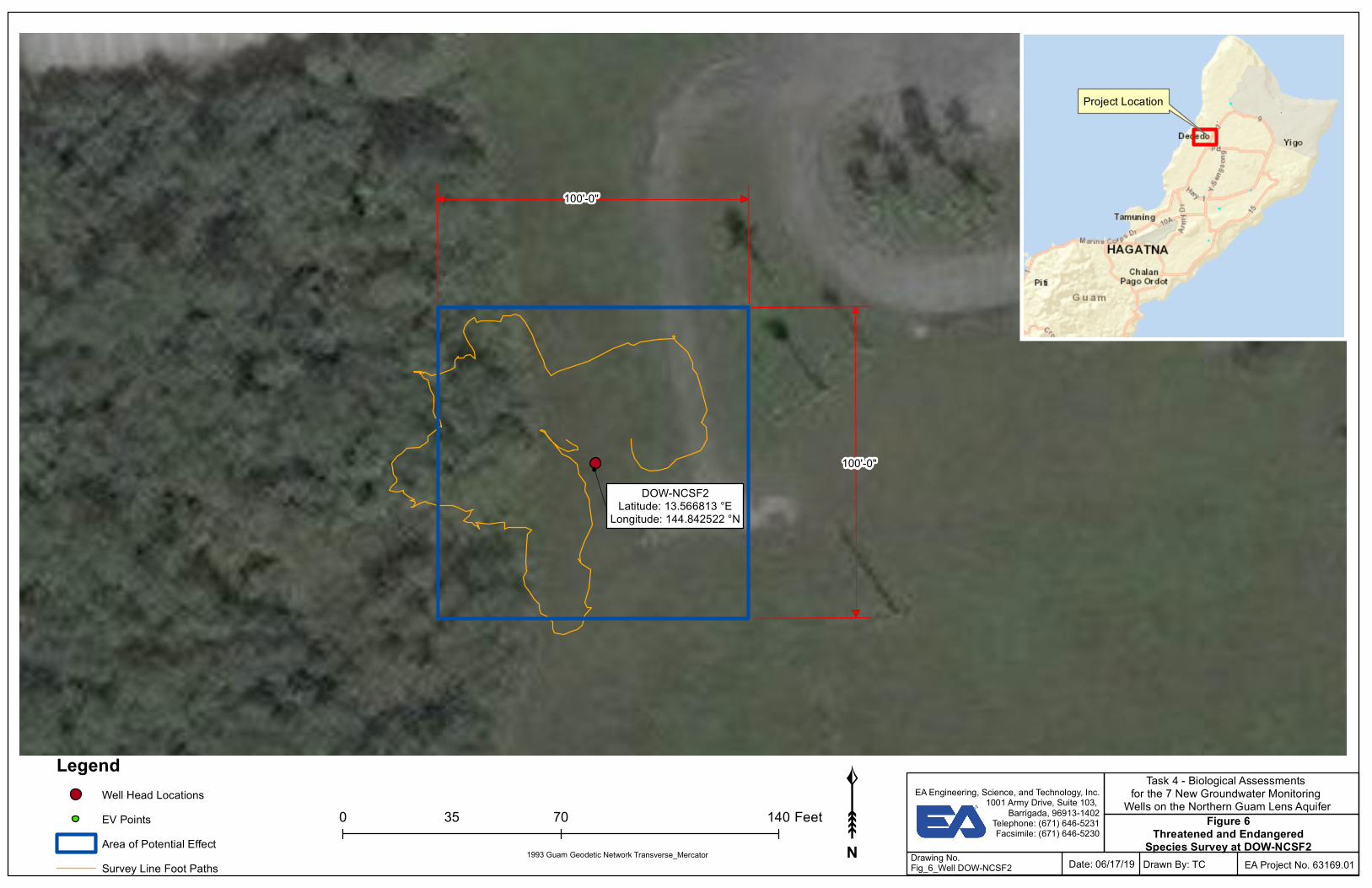
LegendWell Head LocationsEV PointsArea of Potential EffectSurvey Line Foot Paths
0 70 14035 FeetEA Engineering, Science, and Technology, Inc.
1001 Army Drive, Suite 103, Barrigada, 96913-1402
Telephone: (671) 646-5231Facsimile: (671) 646-5230
1993 Guam Geodetic Network Transverse_MercatorÍ
EA Project No. 63169.01
Task 4 - Biological Assessments for the 7 New Groundwater Monitoring
Wells on the Northern Guam Lens AquiferFigure 6
Threatened and EndangeredSpecies Survey at DOW-NCSF2
Drawing No.Fig_6_Well DOW-NCSF2 Date: 06/17/19 Drawn By: TC
100'-0"
100'-0"
N
DOW-NCSF2Latitude: 13.566813 °E
Longitude: 144.842522 °N
Project Location

LegendWell Head LocationsEV PointsArea of Potential Effect Survey Lines Foot Paths
0 50 10025 FeetEA Engineering, Science, and Technology, Inc.
1001 Army Drive, Suite 103, Barrigada, 96913-1402
Telephone: (671) 646-5231Facsimile: (671) 646-5230
1993 Guam Geodetic Network Transverse_MercatorÍ
EA Project No. 63169.01
Task 4 - Biological Assessments for the 7 New Groundwater Monitoring
Wells on the Northern Guam Lens AquiferFigure 7
Threatened and EndangeredSpecies Survey at DOW-NWF1
Drawing No.Fig_7_Well DOW-NWF1 Date: 06/17/19 Drawn By: TC
100'-0"
100'-0"
N
DOW-NWF1Latitude: 13.59569 °ELongitude: 144.8622 °N
Project Location
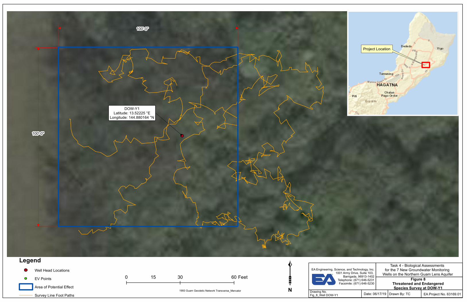
LegendWell Head LocationsEV PointsArea of Potential EffectSurvey Line Foot Paths
0 30 6015 FeetEA Engineering, Science, and Technology, Inc.
1001 Army Drive, Suite 103, Barrigada, 96913-1402
Telephone: (671) 646-5231Facsimile: (671) 646-5230
1993 Guam Geodetic Network Transverse_MercatorÍ
EA Project No. 63169.01
Task 4 - Biological Assessments for the 7 New Groundwater Monitoring
Wells on the Northern Guam Lens AquiferFigure 8
Threatened and EndangeredSpecies Survey at DOW-Y1
Drawing No.Fig_8_Well DOW-Y1 Date: 06/17/19 Drawn By: TC
100'-0"
100'-0"
N
DOW-Y1Latitude: 13.52225 °E
Longitude: 144.880164 °N
Project Location

Species/Critical Habitat Considered November 2019
3-14
This page intentionally left blank

Effects Analysis December 2019
4-1
Effects Analysis
The presence of listed species or their habitat within the proposed project area was assessed during
field surveys conducted at the proposed new well sites on 18 September 2018, 3 January 2019, 22
February 2019 and 6 June 2019, as well as on 18 September 2018 at rehabilitation well sites. The
biological field surveys were conducted to document the presence and potential impacts to
federally protected threatened or endangered species in the project area. The objective of the
biological field survey was to ensure that actions associated with the proposed installation and
rehabilitation of groundwater monitoring wells is consistent with the requirements of ESA, Section
7 and to identify and avoid potential for impacts if listed species are identified within, or
immediately adjacent to, the project area.
The surveys identified two federally protected Cycas micronesica (cycads) near proposed well
DOW-AAFB1 and a total of six federally protected Tuberolabium guamense observed on three
separate trees near proposed well DOW-NCSF1. Details about the number and location of each
federally protected endangered species are outlined below. No federally protected endangered
species were observed at the other proposed well sites or the rehabilitation well sites. Although
the species detailed below were identified in close proximity to the proposed wells DOW-AAFB1
and DOW-NCSF1, no significant species were observed within 40 feet of the proposed wellhead
locations.
Micronesian Cycad (Cycas micronesica)
Two cycads were identified at DOW-AAFB1 on 3 January 2019. These individuals were located
47 and 89 feet from the well location. AAFB1 is a new well location, which would have the
potential to result in disturbance of up to 10,000ft2 of surrounding area during construction. Cycads
are heavily threatened by pests, scale, and predation (DOI USFWS 2015). Due to these factors,
many individuals are found in poor health, with low seed production and little growth or
recruitment of juveniles. The use of construction equipment in proximity to the individuals of C.
micronesica has the potential to compact soils, damaging roots. The misuse of equipment could
also result in damage or mortality of C. micronesica individuals if they were hit or run over during
construction activities. Dust may also impact individuals of C. micronesica during construction
activities. In order to prevent impacts to cycads during the 4-week construction period, a buffer
zone with a minimum 30-foot radius has been established around each C. micronesica individual
observed. Based on the locations of the buffer zones, exclusion zones have been established within
the DOW-AAFB1 footprints (Figure 9).
The exclusion zones will be cordoned off using rope or temporary construction fencing by the
contractor. Once established, no personnel, equipment or machinery will be allowed to enter or
work in the environmental exclusion zones. While active work is going on within the APE, but
outside the exclusion zones, dust control will be implemented as necessary using a water spray.
By establishing these exclusion zones, listed species found near the well locations will be protected
during construction activities. As a result of these conservation measures to protect cycads, it is
anticipated that the proposed action may affect, but is not likely to adversely affect C. micronesica.

Effects Analysis December 2019
4-2
Cycads occur in limestone forest habitats and were once abundant on Guam. Other potential
projects on Anderson AFB or in the project vicinity have the potential to impact cycads. There are
no known current or future additional projects within the action area that would have the potential
to affect protected cycads.
Tuberolabium guamense
Six individuals of T. guamense were identified on three trees within the vicinity of DOW-NCSF1
on 3 January 2019. These three trees were located 52, 92, and 120 feet from the well location. This
species faces decreasing abundance as a result of habitat loss as well as the introduction of non-
native species, herbivory, and typhoons (DOI USFWS 2015). The use of construction equipment
in proximity to the host trees for T. guamense could result in damage to trees or their root
structures. If host trees were damaged or lost it would result in impacts to the orchids. In addition,
there could be a direct impact to the individuals of T. guamense from construction equipment or
dust. In order to prevent impacts to orchids during the four-week construction period, a buffer
zone with a minimum 30-foot radius has been established around the T. guamense three host trees
observed during the field surveys. Based on the locations of the buffer zones, exclusion zones have
been established within the DOW-NCSF1 footprints (Figure 10).
The exclusion zones will be cordoned off using rope or temporary construction fencing by the
contractor. Once established, no personnel, equipment or machinery will be allowed to enter or
work in the environmental exclusion zones. While active work is going on within the APE, but
outside the exclusion zones, dust control will be implemented as necessary using a water spray.
By establishing these exclusion zones, listed species found near the well locations will be protected
during construction activities. As a result of these measures to protect orchids and their host trees,
it is anticipated that the proposed action may affect, but is unlikely to adversely affect T. guamense.
Other potential projects on Anderson AFB or in the project vicinity have the potential to impact T.
guamense. However, there are no known current or future additional projects within the action
area that would have the potential to affect listed orchids.
Mariana Fruit Bat (Pteropus mariannus)
No Mariana fruit bats were observed during the surveys, but this project does include suitable
Mariana fruit bat habitat. In order to ensure that proposed actions do not result in adverse effects
to this species, the bat surveys would be conducted one week prior to the onset of vegetation
clearing. A buffer zone at DOW-NCSF1 would also be established around the single Elaeocarpus
joga tree observed within the APE, which is considered a high value tree (Figure 10). E. joga is a
known food plant for Mariana fruit bats (Wiles and Fujita 1992)
If a Mariana fruit bat is present within 492 ft (150 m) of the project area during any time of the
project, the work will be halted and postponed until the bat has left the area. The measure is
intended to prevent, avoid and minimize potential effects to fruit bats, and will be implemented
during pre-construction and construction activities. With the implementation of these conservation
measures, it is anticipated that the proposed action may affect, but is not likely to adversely affect
the Mariana fruit bat.

40 0 40 80 12020Feet
EA Engineering, Science, and Technology, Inc.1001 Army Drive, Suite 103,
Barrigada, 96913-1402Telephone: (671) 646-5231Facsimile: (671) 646-5230
1993 Guam Geodetic Network Transverse_Mercator
ÍEA Project No. 63169.01
Task 4 - Biological Assessments for the 7 New Groundwater Monitoring
Wells on the Northern Guam Lens AquiferFigure 9
Exclusion Zones withinFootprint at DOW-AAFB1
Drawing No.Fig_9_Well DOW-AAFB1 Date: 10/09/19 Drawn By: TC
!(
!(
!(
DOW-AAFB1Latitude: 13.588625 °ELongitude: 144.906150 °N
47'
Cycas micronesica
89'
Cycas micronesica
100'-0"
100'-0"
Maintained Utility Corridor
Maintained Utility Corridor
Drill Rig
Water TankFlatbed
Trash Containers
Flatbed
5'
N
Project Location
LegendWell Head LocationsThreatened and Endangered Species PointsDrilling Equipment20' X 20' Concrete PadT&E Species 30 ft Radius Buffer ZoneExclusion ZoneArea of Potential EffectUtility Easement

25 0 25 50 75 10012.5Feet
EA Engineering, Science, and Technology, Inc.1001 Army Drive, Suite 103,
Barrigada, 96913-1402Telephone: (671) 646-5231Facsimile: (671) 646-5230
1993 Guam Geodetic Network Transverse_Mercator
ÍEA Project No. 63169.01
Task 4 - Biological Assessments for the 7 New Groundwater Monitoring
Wells on the Northern Guam Lens AquiferFigure 10
Exclusion Zones WithinFootprint at DOW-NCSF1
Drawing No.Fig_10_Well DOW-NCSF1 Date: 10/09/19 Drawn By: TC
61'
120'
92'
52
Elaeocarpus joga 1-2
Tuberolabium guamense 2-3
Tuberolabium guamense 1
Tuberolabium guamense 4-6 Maint
ained
Utilit
y Corr
idor
100'-0"
100'-0"
Drill Rig
Water Tank
Trash Containers
Flatbed Trucks
18'
8'
N
DOW-NCSF1Latitude: 13.580095 °ELongitude: 144.850202 °N
Project Location
LegendWell Head LocationsThreatened and Endangered Species PointsDrilling Equipment20' X 20' Concrete PadT&E Species 30 ft Buffer ZoneExclusion ZoneArea of Potential EffectUtility Easement

Conclusion and Determination of Effects December 2019
5-1
Conclusion and Determination of Effects
Field surveys for threatened and endangered species and migratory birds were conducted at the
proposed new well sites on 18 September 2018, 3 January 2019, 22 February 2019 and 6 June
2019, as well as on 18 September 2018 at the sites proposed for rehabilitation.
EA recommends a determination that the proposed action would have no effect on the species
presented in Table 4, based on the rationale provided and their absence during the biological
surveys.
Table 4. Protected Species with a Section 7 Determination of No Effect
Scientific Name Common Name Status Reason
Phyllanthus saffordii - E No suitable habitat for this species occurs in the
project area
Aerodramus
vanikorensis bartschi
Mariana gray
swiftlet E
The closest active roosting/nesting caves for this
species are over 15 miles away
Chelonia mydas Green sea turtle E No suitable habitat for this species occurs in the
project area
Corvus kubaryi Mariana crow E Species has not been documented on Guam in
several years
Emballonura
semicaudata rotensis
Pacific sheath
tailed bat E
Species is only known on Guam from historical
occurrences
Emoia slevini Slevin’s skink E Species has not been documented on Guam for
over 20 years (DOI USFWS 2015)
Eretmochelys
imbricata
Hawksbill sea
turtle E
No suitable habitat for this species occurs in the
project area
Gallinula chloropus
guami
Mariana common
moorhen E
No suitable habitat for this species occurs in the
project area
Rallus owstonii Guam rail E Species is extirpated on mainland Guam
Todiramphus
cinnamominus Guam kingfisher E Species is extirpated on mainland Guam
Vagrans egistina
Mariana
wandering
butterfly
E Species has not been documented on Guam
since 1979 (USFWS 2014)
E for Endangered, T for Threatened
EA recommends a determination that the proposed action may affect, but not likely to adversely
affect the species presented in Table 5, based on the rationale provided in the table. The Federal
Action Agency will request concurrence from the USFWS on the determination of may affect, but
not likely to adversely affect finding for these species.
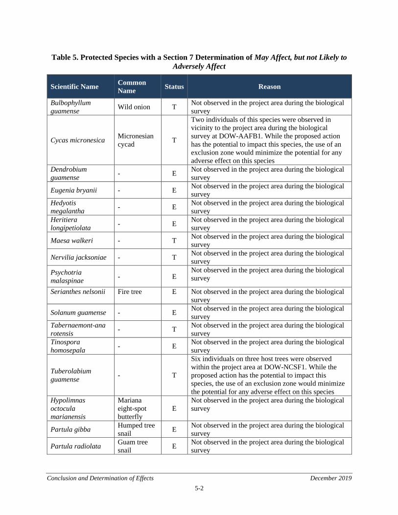
Conclusion and Determination of Effects December 2019
5-2
Table 5. Protected Species with a Section 7 Determination of May Affect, but not Likely to
Adversely Affect
Scientific Name Common
Name Status Reason
Bulbophyllum
guamense Wild onion T
Not observed in the project area during the biological
survey
Cycas micronesica Micronesian
cycad T
Two individuals of this species were observed in
vicinity to the project area during the biological
survey at DOW-AAFB1. While the proposed action
has the potential to impact this species, the use of an
exclusion zone would minimize the potential for any
adverse effect on this species
Dendrobium
guamense - E
Not observed in the project area during the biological
survey
Eugenia bryanii - E Not observed in the project area during the biological
survey
Hedyotis
megalantha - E
Not observed in the project area during the biological
survey
Heritiera
longipetiolata - E
Not observed in the project area during the biological
survey
Maesa walkeri - T Not observed in the project area during the biological
survey
Nervilia jacksoniae - T Not observed in the project area during the biological
survey
Psychotria
malaspinae - E
Not observed in the project area during the biological
survey
Serianthes nelsonii Fire tree E Not observed in the project area during the biological
survey
Solanum guamense - E Not observed in the project area during the biological
survey
Tabernaemont-ana
rotensis - T
Not observed in the project area during the biological
survey
Tinospora
homosepala - E
Not observed in the project area during the biological
survey
Tuberolabium
guamense - T
Six individuals on three host trees were observed
within the project area at DOW-NCSF1. While the
proposed action has the potential to impact this
species, the use of an exclusion zone would minimize
the potential for any adverse effect on this species
Hypolimnas
octocula
marianensis
Mariana
eight-spot
butterfly
E
Not observed in the project area during the biological
survey
Partula gibba Humped tree
snail E
Not observed in the project area during the biological
survey
Partula radiolata Guam tree
snail E
Not observed in the project area during the biological
survey

Conclusion and Determination of Effects December 2019
5-3
Scientific Name Common
Name Status Reason
Pteropus mariannus Mariana fruit
bat T
Species was not observed in the project area during
the biological survey. Surveys would be conducted
one week prior to vegetation clearing to ensure that
bats were not present. If a bat was found at any point
during construction work would be halted until the bat
left the project area
Samoana fragilis Fragile tree
snail E
Not observed in the project area during the biological
survey E for Endangered, T for Threatened
Conservation measures would be employed to prevent effects to federally protected species with
the potential to occur within the project area. These measures include the following:
• A buffer exclusion of approximately 30 feet around each identified cycad, the single
observed E. joga, and host tree for orchids would be cordoned off using rope or temporary
construction fencing by the contractor. Once established, no personnel, equipment or
machinery will be allowed to enter or work in the environmental exclusion zones.
• While active work is going on within the APE, but outside the exclusion zones, dust control
will be implemented as necessary using a water spray.
• If a Mariana fruit bat is present within 492 ft (150 m) of the project area during any time
of the project, the work will be halted and postponed until the bat has left the area.
• If work is completed more than 3 months from the date of the biological field surveys, a
snail survey will be conducted in the project area within 3 months of the start of
construction to ensure no snails are present in the project area.

Conclusion and Determination of Effects December 2019
5-4
This page intentionally left blank

Literature Cited December 2019
6-1
Literature Cited
Department of the Interior, Fish and Wildlife Service (DOI USFWS), 2015. Endangered and
Threatened Wildlife and Plants; Endangered Status for 16 Species and Threatened Status
for 7 Species in Micronesia. Federal Register Volume 80, Number 190. Rules and
Regulations. Thursday, October 1, 2015.
Fiedler, G.C. 2019. DRAFT Biomonitor Support for Natural Resource Management Surveys at
Joint Region Marianas Area of Responsibility (Partulid Snail Survey Methods),
Cooperative Agreement N40192-17-2-8005, Prepared for Naval Facilities Engineering
Command, Marianas.
University of Guam, 2014. Federal candidate species surveys on Guam. Final project report.
Prepared for Naval Facilities Engineering Command under Cooperative Agreement
N40192-12-2-8001.
USFWS (U.S. Fish and Wildlife Service), 2014. Mariana Islands Plant and Animal Species Being
Considered for Listing as Threatened or Endangered under the Endangered Species Act.
May 2014.
USFWS (U.S. Fish and Wildlife Service), 2014. Mariana Islands Plant and Animal Species Being
Considered for Listing as Threatened or Endangered under the Endangered Species Act.
May 2014.
Wiles, G.J. and Fujita, M. 1992. Food plants and economic importance of flying foxes on Pacific
Islands. Pp. 24-35 In Proceedings of an international conservation conference Ed by D.E.
Wilson and G.L. Graham. USFWS Biological Report 90(23). Washington, DC., USA.

Literature Cited December 2019
6-2
This page intentionally left blank

List of Contacts Made and Preparers December 2019
7-1
List of Contacts Made and Preparers
Contacts:
Jacqueline Flores – USFWS
Toni Mizerek - USFWS
List of Preparers:
Thomas Konner – Environmental Engineer, U.S. EPA WTR-3-3
Cheryl Dilks – Environmental Engineer, Brown and Caldwell
Daniel M. Savercool, CSE, CERP – Senior Biologist, EA Engineering, Science, and Technology,
Inc., PBC
Kathryn Cerny-Chipman – Biologist, EA Engineering, Science, and Technology, Inc., PBC

List of Contacts Made and Preparers December 2019
7-2
This page intentionally left blank

APPENDIX A
SITE PHOTOGRAPHS

This page intentionally left blank

Appendix A December 2019
A-1
Rehabilitation Wells
Site overview of A-16
Site overview of A-20
Site overview of BPM-1
Site overview of EX-1

Appendix A December 2019
A-2
Site overview of EX-4
Site overview of EX-6
Site overview of EX-8
Site overview of EX-9

Appendix A December 2019
A-3
Site overview of EX-10
Site overview of M-10A
Site overview of GHURA-Dededo

Appendix A December 2019
A-4
Site overview of NCS-3A

Appendix A December 2019
A-5
New Wells
Site overview of DOW-AAFB1
Cycas micronesica at DOW-AAFB1
Site overview of DOW-M1
Site overview of DOW-NCSB1

Appendix A December 2019
A-6
Site overview of DOW-NCSF1
Tuberolabium guamense observed at DOW-
NCSF1
Site overview of DOW-NCSF2
Site overview of DOW-Y1
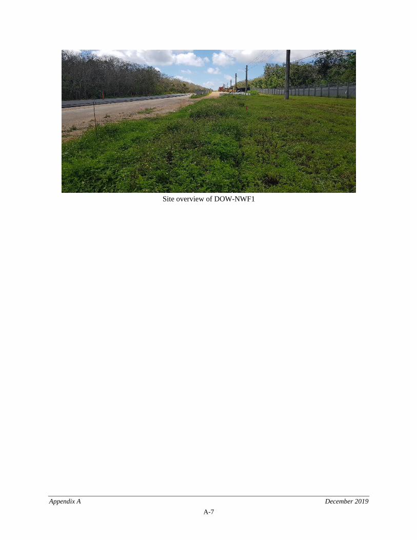
Appendix A December 2019
A-7
Site overview of DOW-NWF1


