United Nations Development Programme Country: Pakistan PROJECT DOCUMENT Project Title: Sustainable forest management to secure multiple benefits in Pakistan's high conservation value forests UNDAF Outcome(s): Environmental Sustainability UNDP Strategic Plan Environment and Sustainable Development Primary Outcome: Growth and development are inclusive and sustainable, incorporating productive capacities that create employment and livelihoods for the poor and excluded. Expected CP Outcome(s): Pakistan is better able to address key environmental key environmental challenges including climate change and natural resource management. Expected CPAP Output: A set of coherent policies and plans are prepared or updated to strengthen (1) management of protected areas and biodiversity conservation, and (2) environment management at national and community levels. Executing Entity/Implementing Partner: Ministry of Climate Change (MoCC) Implementing Entity/Responsible Partners: Ministry of Climate Change, Provincial Forest Departments, and United Nations Development Programme Brief Description: The objective of the proposed project is to promote sustainable forest management in Pakistan's Western Himalayan Temperate Coniferous, Sub-tropical broadleaved evergreen thorn (Scrub) and Riverine forests for biodiversity conservation, mitigation of climate change and securing of forest ecosystem services. In particular, it aims at implementation of three inter-related and mutually complementary components that are focussed at addressing the barriers of inadequate planning, regulatory and institutional frameworks to integrated forest resource management, and the limited experience among key government and civil society stakeholders in developing and implementing SFM practices on the ground. Component 1 will support the incorporation of sustainable forest management objectives and safeguards in forest management planning, forestland allocation and compliance of monitoring systems at the local level. Component 2 will identify, demarcate and implement on-the-ground approaches to improving management of high conservation value forests within seven landscapes covering an area of 67,861 ha with the aim of meeting the life requisites of the target species, and 1
Transcript
United Nations Development ProgrammeCountry: Pakistan
PROJECT DOCUMENT
Project Title: Sustainable forest management to secure multiple benefits in Pakistan's high conservation value forestsUNDAF Outcome(s): Environmental SustainabilityUNDP Strategic Plan Environment and Sustainable Development Primary Outcome: Growth and development are inclusive and sustainable, incorporating productive capacities that create employment and livelihoods for the poor and excluded.
Expected CP Outcome(s): Pakistan is better able to address key environmental key environmental challenges including climate change and natural resource management.Expected CPAP Output: A set of coherent policies and plans are prepared or updated to strengthen (1) management of protected areas and biodiversity conservation, and (2) environment management at national and community levels.Executing Entity/Implementing Partner: Ministry of Climate Change (MoCC)Implementing Entity/Responsible Partners: Ministry of Climate Change, Provincial Forest Departments, and United Nations Development Programme
Brief Description:The objective of the proposed project is to promote sustainable forest management in Pakistan's Western Himalayan Temperate Coniferous, Sub-tropical broadleaved evergreen thorn (Scrub) and Riverine forests for biodiversity conservation, mitigation of climate change and securing of forest ecosystem services. In particular, it aims at implementation of three inter-related and mutually complementary components that are focussed at addressing the barriers of inadequate planning, regulatory and institutional frameworks to integrated forest resource management, and the limited experience among key government and civil society stakeholders in developing and implementing SFM practices on the ground.Component 1 will support the incorporation of sustainable forest management objectives and safeguards in forest management planning, forestland allocation and compliance of monitoring systems at the local level. Component 2 will identify, demarcate and implement on-the-ground approaches to improving management of high conservation value forests within seven landscapes covering an area of 67,861 ha with the aim of meeting the life requisites of the target species, and habitats such as breeding areas, feeding areas, water sources, dispersal and connectivity corridors, etc. Component 3 will develop practical approaches to enhancing carbon sequestration through restoring degraded and former forested areas (LULUCF activities) by a combination of restoration and reforestation of 10,005 ha of degraded conifer forests; 3,400 ha of degraded scrub forests, and reforestation of 13,099 ha of Riverine forests with native species.
1
Programme Period: 2015-2019
Atlas Award ID: 00086910Project ID: 00094079
PIMS # 4674Start date: January 2016End Date December 2020
Management Arrangements NIMPAC Meeting Date
2015______________
Total Resources required: $ 57,758,000
Total Resources allocated $ 57,758,000 Regular: (UNDP) $ 1,000,000 Other:
o GEF: $ 8,338,000o Government $ 47,770,000o Other (donors) $ 650,000
57
Agreed by (Government): Date/Month/Year
Agreed by (UNDP): Date/Month/Year
Table of Contents
PART I: SITUATION ANALYSIS............................................................................................................8
Geographic and Environmental Context..............................................................................................8Biodiversity Context..........................................................................................................................13Legal and Policy Context...................................................................................................................14Institutional Context..........................................................................................................................15Root Causes, Threats and Impacts.....................................................................................................17Long-term Solution and Barriers to be addressed.............................................................................21Baseline Analysis and scenario without GEF support.......................................................................22Stakeholder Analysis.........................................................................................................................26
PART II: STRATEGY..............................................................................................................................29
2
Project Rationale and Policy Conformity..........................................................................................29Fit with the GEF Focal Area Strategy and Strategic Program...........................................................29Rationale and summary of GEF Alternative......................................................................................29Project Goal, Objective, Outcomes and Outputs/Activities..............................................................30Risks and Assumptions......................................................................................................................50Incremental Reasoning and Expected Global, National and Local Benefits.....................................52Details on the Calculation of Climate Change Benefits....................................................................54Socio-Economic Benefits including Gender Dimensions and Environmental Sustainability...........65Cost Effectiveness..............................................................................................................................68Project Consistency with National Priorities/Plans...........................................................................69Country Ownership: Country Eligibility and Country Driveness.....................................................70Coordination with Other Initiatives...................................................................................................71Sustainability.....................................................................................................................................72Replicability.......................................................................................................................................73Comparative Advantage of Implementing Agency...........................................................................74
PART III: MANAGEMENT ARRANGEMENTS...................................................................................76
PART IV: MONITORING AND EVALUATION FRAMEWORK........................................................80
PART V: LEGAL CONTEXT..................................................................................................................84
PART I: CO-FINANCING LETTERS & LOA..............................................................................104
DESCRIPTION OF UNDP COUNTRY OFFICE SUPPORT SERVICES............................................113
PART II: TERMS OF REFERENCE FOR KEY PROJECT STAFF.............................................114PART III: UNDP ENVIRONMENTAL AND SOCIAL SCREENING.........................................122PART IV: DESCRIPTION OF LANDSCAPE SITES....................................................................138PART V: CARBON CALCULATION OVERVIEW.....................................................................149PART VI: METHODOLOGIES FOR CARBON STOCK MEASUREMENT - PUNJAB FOREST RESAERCH INSTITUTE...............................................................................................................157PART VII: STAKEHOLDER INVOLVEMENT PLAN................................................................173PART VIII: TRACKING TOOLS...................................................................................................182
3
ACRONYMS AND ABBREVIATIONS
ADP Annual Development ProgramAFOLU Agriculture, Forestry and Other Land UsesAJK Azad Jammu and KashmirAPR Annual Progress ReviewAWP Annual Work PlanBCS Balochistan Conservation StrategyBTOR Back to Office ReportCBD Convention on Biological Diversity
4
CBO Community Based OrganizationCBP Carbon Benefits ProjectCDM Clean Development MechanismCITES Convention on International Trade in Endangered SpeciesCMS Convention on the Conservation of Migratory Species of Wild AnimalsCOP Conference of PartiesCPAP Country Program Action PlanDbh diameter at breast heightDFID Department for International Development (U.K.)E&CC Environment and Climate ChangeEIA Environmental Impact AssessmentEKN Embassy of the Kingdom of the NetherlandsERBM Enhanced Results Based ManagementERC Evaluation Resource CenterESCOs Energy (or Environmental) Service CompaniesESIA Environmental and Social Impact AssessmentEU European UnionFATA Federal Administered Tribal AreasFD Forest DepartmentFDC Forest Development CooperationFDF Forest Development FundGDP Gross Domestic ProductGHG Green House GasesGIS Geographic Information SystemGNP Gross National ProductGOP Government of PakistanHCVF High Conservation Value ForestsIA Implementing agencyICIMOD International Centre for Integrated Mountain DevelopmentICT Islamabad Capital TerritoryIDDV Integrated District Development VisionIEE Initial Environmental ExaminationIGF Inspector General of ForestsIPCC International Panel on Climate ChangeIUCN International Union for Conservation of Nature and Natural ResourcesIWRB International Wetlands Research BureauJFM Joint Forest ManagementJFMC Joint Forest Management CommitteeKP Khyber PakhtunkhwaLEAD Leadership for Environment and DevelopmentLULUCF Land use, land-use change and forestryMAB Man and BiosphereMACP Mountain Area Conservancy ProjectMAI Mean Annual IncrementM&E Monitoring and EvaluationMIS Management Information System
5
MOCC Ministry of Climate ChangeMRV Measurement, Reporting and VerificationNCCW National Council for Conservation of WildlifeNCS National Conservation StrategyNEX Nationally ExecutedNGO Non-governmental OrganizationNPD National Project DirectorNPM National Project ManagerNSDS National Sustainable Development StrategyNTFP Non Timber Forest ProductsNWFP North Western Frontier Province (now Khyber Pakhtunkhwa) OIGF Office of the Inspector General of ForestsPES Payment for Environmental ServicesPFI Pakistan Forest InstitutePFRI Punjab Forest Research InstitutePIF Project Information FormPIMS Project Information Management SystemPIR Project Implementation ReviewPKR Pakistani RupeesPMIU Provincial Management and Implementation UnitPMU Project Management UnitPPC Provincial Project CoordinatorPPD Provincial Project Director PPG Project Preparation GrantPPR Project Progress Report/ ReviewPRA Participatory Rural AppraisalPRSP Pakistan Poverty Reduction Strategy PaperQPR Quarterly Progress ReportREDD+ Reduced Emissions from Deforestation and Forest Degradation RPP REDD+ Readiness Preparation ProposalSCS Sindh Conservation StrategySDC Swiss Development CorporationSDPI Sustainable Development Policy InstituteSESA Strategic Environmental and Social AssessmentSESP Social and Environmental Screening ProcedureSFM Sustainable Forest ManagementSIP Stakeholder Involvement PlanSPCS Sarhad Provincial Conservation StrategyUNCCD United Nations Convention to Combat DesertificationUNFCCC United Nations Framework Convention on Climate ChangeUNFF United Nations Forum on ForestsUNDP United Nations Development ProgramUNDP CO UNDP Country OfficeUNDP RCU UNDP Regional Coordinating UnitUNESCO United Nations Educational Scientific and Cultural OrganizationUSAID United States Agency for International Development
6
USD (US$) United States DollarsWWF-P World Wildlife Fund-Pakistan
7
SECTION I: ELABORATION OF THE NARRATIVE
PART I: SITUATION ANALYSIS
GEOGRAPHIC AND ENVIRONMENTAL CONTEXT
Pakistan with a population of 188 million people, occupies a land area of over 880,000 square km in the South Asian Sub-continent. It harbours a great variety of landscapes and diversified relief that start from sea and move up to K2, the second highest peak of the world and includes the majestic high mountain ranges of Himalayas, Karakoram and Hindu Kush, as well as snow covered peaks, eternal glaciers and mountain valleys in the north; the Potohar plateau and vast rich irrigated plains in the Indus River basin, and the stark deserts and dry rocky expanse of plateaus in the south west. The Indus River system supplies water to the largest contiguous irrigation system in the world that accounts for 90% of the food production in Pakistan.
The country consists of four largely self-governing provinces – the Punjab, the Khyber Pakhtunkhwa (KP), Sindh and Balochistan. Gilgit Baltistan is administered like a province. The Federal Administered Tribal Areas (FATA) and the Islamabad Capital Territory are directly managed by the Federal Government. Azad Jammu and Kashmir (AJK) is a self-governing State that has its own government structure. Federal Ministries coordinate with the provinces and Azad Jammu and Kashmir. Further sub units of administrative divisions include civil division, district, tehsil and union council.
Pakistan lays in the tropical, subtropical, moist and dry temperate, sub alpine and alpine zones. The climate is generally arid, characterized by hot summers and cold winters with wide variations between extremes of temperature and low rainfall. The temperature regimes in the various zones as indicated in Table 1.
Table 1: Temperature Regimes in Various Climatic Zones of Pakistan
Zone Mean Annual Temperature
Mean January Temperature Type of winter
Tropical Over 75°F Over 60°F Mild, no frost.
Sub-tropical 65 – 75°F 50 - 60°F Definite but not severe, and occasional frost.
Temperate 50 - 65°F 30 - 50°F Pronounced with frost in lower and snow on higher reaches.
Alpine Under 50°F Under 30°F Severe cold and much snow in winter but pleasant in summer.
8
The landscapes in Pakistan range from ocean, islands, beaches, deltas, rivers, floodplains, deserts, plateaus and the mountain ranges of the Himalayas, Karakorum and Hindu Kush. The combinations of great variations in relief, landscape and climate have given rise to a large number of ecosystems including alpine, sub alpine, forest, wetland, agriculture, desert, deltoid, coastal and marine ecosystems with high diversity of species in each of these. The main forest types present in the country include sub alpine, dry and moist temperate, sub tropical pine and evergreen broadleaved thorn, dry tropical thorn, juniper, chalghoza (Pinus gerardiana forests), riverine and mangrove forests and 21 different types of wetlands. Most of these ecosystems are represented in the protected areas system of Pakistan. The Western Himalayan moist temperate forests ecosystem of Pakistan is included in the list of global 200 priority ecosystems of the Millennium Ecosystem Assessment. Many bird areas are amongst the globally recognised ones. All these ecosystems have been played a crucial role in meeting the needs of local communities as well as in economic development and growth of the country.
The forests of the country are the main source of large-scale eco-system services, i.e. provisioning, regulatory, cultural, and supportive. These forests provide provisioning services like fresh water, and other resources like fuel-wood, timber, fodder, honey, gum, medicinal plants and other sources of livelihood support. The vegetation cover provides a vital regulating service by preventing soil erosion, and supplying the soil with nutrients required to support plant growth. Insects and wind pollinate plants and trees that are essential for the development of fruits, vegetables and seeds. The natural ecosystems help regulate pests and diseases through the activities of predators and parasites such as birds, bats, flies, wasps, frogs and fungi. The forests provide habitat for viable populations of native species, maintain clean water and productive soils. The forest industry has helped to sustain communities and is a key contributor to rural, regional, and provincial economies.
Forests also provide support for many socio-economic and cultural benefits to citizens of the country, including recreational and outdoor tourism activities, hunting and fishing opportunities, firewood cutting for meeting domestic needs, and many other outdoor pursuits that citizens regard as part of their cultural heritage. Forests protect watersheds, used as a source for drinking water, irrigation, and power generation. Forest biodiversity, ecosystems and natural landscapes have been the source of inspiration for much of the art, culture and increasingly for development of science in the country.
However, these ecosystems are heavily strained and rapidly degrading under the rapidly growing human and livestock populations and increasing anthropogenic pressure. Some of the other key reasons for the deterioration of the ecosystems are explained in the ensuing sections of this document.
In Pakistan, communities are complex entities, within which differences of ethnicity, class, caste, age, gender, religion, profession and economic and social status create profound differences in interests, capacities and willingness to invest in the management of natural resources. The local elite usually tend to marginalize households of lower class/caste and men tend to marginalize women in the decision making processes at the community level.
9
The most devastating effects of climate change are heavy flooding, landslides, soil erosion and drainage problems on the one hand and drought, deforestation and forest degradation on the other. The climate change has caused erratic change in the frequency and intensity of rainfall and temperature and is also effecting human health due to wide spread vector, water and air borne diseases. Amongst the main climate change induced impacts are the frequency and intensity of natural disasters such as floods, flash floods, glacial lake outburst floods, landslides, edge failure, avalanches, damming of rivers and streams followed by their outburst, and sheet and gully erosion that destroy the agricultural lands and forests. Most of the forests in the earthquake-affected areas of AJK and Khyber Pakhtunkhwa (KP) were damaged due to landslides caused by the earthquake in 2005. Such disasters have caused heavy losses of life and property and the affected the economy of Pakistan year after year, especially after 2000. In the earthquake of 2005, over 70,000 people lost their lives, over 120,000 were seriously injured, 3.5 million were rendered homeless, and over 600,000 houses were destroyed.
The prevailing land tenure system in Pakistan is flawed in many aspects such as the inequity in land ownership, where private land holding range from less than one hectare of land to thousands of hectares, the latter generally cultivated by occupancy tenants or tenants-at-will. The former enjoy considerable security of tenure being ancestral tenants whereas the latter could be ejected at any time – thus they have no security of tenure and are reluctant to make any long-term investment on the land. The latter cultivate for a share of the produce. The forestland owners, especially the absentees, are generally not interested in the sustainable use of forest resources.
In Sindh, state forestland has been leased out by the forest department (FD) for agro-forestry to raise forest trees on 20% of the leased area and use the remaining area for cultivation of agricultural crops. Generally, Forest Departments have neither achieved these objectives nor have they been able to recover the leased out lands after the expiry of leases. The practice and efficacy of agro-forestry leases needs evaluation and corrections, if needed to ensure that these leased out lands are used for their intended purpose.
Forests and trees planted on farmlands cover about 4.392 million hectares or 5.01% of the land area of Pakistan. The main types of forests in Pakistan include conifer, including juniper (moist and dry temperate; 1.913 million hectare), tropical thorn broad-leaved or scrub (1.191 million hectare), riverine (0.173 million hectare) and mangrove (0.207 million hectare) forests (Figure 1). Additionally, there are irrigated plantations in the floodplains. Figure1 summarises the statistics of forest cover in Pakistan.
10
Conifer 45.3%
Scrub 28.2%
Riverine 4.1%
Mangrove 4.9%
Irrigated Plan-tations 2.4% Farmland trees
11.0%
Linear planting 0.4%Misc. Planting 3.7%
Figure 1: Forest tree plantation in Pakistan
Conifer Scrub Riverine Mangrove Irrigated Plantations Farmland trees Linear planting Misc. Planting
Tenure wise, 3.823 million hectares are covered by state owned forests that are legally protected as Reserved, Protected, Un-classed forests and Resumed lands and are managed by the Forest Departments (FDs); and communal, such as Guzara forests and privately owned forests [notified under Pakistan Forest Act 1927’s Section 38 Areas and the Land Preservation Act (Chos Act)]. Local people generally do not have rights and privileges in Reserved forests unless specifically recognised by Government notification, but in Protected forests, they have rights and concessions for grazing, grass cutting, collection of fuel-wood, and any other forest produce which is not protected specifically.
The provincial governments in Pakistan have established a wide network of protected areas (PAs) as shown in Table 2.
Table 2: Protected Areas Network in Pakistan
No. PA Category Number Area (ha) No. PA Category Number Area (ha)
1. National Park 29 1,364,895 5 Private Game Reserve
17 1,515
2. Wildlife Sanctuary
93 8,789,397 6 Wildlife Park 5 49,373
3. Game Reserve 101 3,606,203 7 Wildlife Refuge 2 3,321
4. Community Game Reserve
62 390,215 8 Unclassified PAs 31 132,070
Total 334 14,336,989
11
About 40% of the total area of forests in Pakistan is in the Khyber Pakhtunkhwa Province, mostly located in the mountainous tract of Malakand and Hazara civil divisions. The remaining forests are in Balochistan (14%), Punjab (14.4%), Sindh (9.4%), Gilgit Baltistan (GB) 15.7%) and AJK (6.5%). The average per capita forest and woodland area in the country is 0.023 ha/capita, which is amongst the lowest in the world.
The local communities living in or around forests, especially in the mountains are poor and depend mainly on forests for their subsistence and other needs. They are compelled by circumstances, notwithstanding the legal restrictions, to over exploit forests for timber (for domestic needs and sale for income) and firewood, especially for warming their abodes during the cold months of winter. The rapidly increasing human (2.6% annual growth) and livestock populations and their dependence on forests has put heavy pressure on the existing forests and protected areas due to unsustainable use and lack of affordable alternatives. As a result, the forests are depleting and degrading fast; and traditional forest policy, regulatory, institutional frameworks and planning and management approaches are no longer effective.
The forests and PAs provide jobs, goods (timber, firewood, grazing, fodder food and other NTFPs), and ecosystem services including soil and water conservation and regulation, carbon sequestration, biodiversity conservation, ecotourism value etc.
Forests are vital in protecting the catchment areas of reservoirs used for power generation and irrigation. Agriculture, which contributes 26% to GDP, is highly dependent on irrigation water in Pakistan. The annual losses due to flooding, soil erosion in upland watersheds and siltation in reservoirs and irrigation works is estimated at Rs.2.3 billion (USD 23 million).
The forest resources of Pakistan are deteriorating both qualitatively and quantitatively and the annual change rate during 1990-2000 period was 1.8% and 2.1%, during the period from 2000-2005 The mangrove forests depleted at a rate of 4,900 hectares per annum (2.37%) during the ten-year period from 1992 to 2001, coniferous forests at 40,100 hectares per annum (2.09%) and riverine forests at 2,300 hectares per annum (1.33 %). Further, the quality of forests has been severely affected. The coniferous forests being the most fragile due to their high timber value and mountainous location are rapidly degrading and being deforested. Over 50% of the coniferous forests have tree cover of less than 25% while 22% have tree cover between 25-50%, 14% have tree cover between 50-75% and only 9% have tree cover more than 75%.
BIODIVERSITY CONTEXT
Due to high variations in rainfall and geomorphology, Pakistan has a remarkable diversity of forest and other ecosystems, resulting in high species diversity and high endemism (about 7% of species), particularly in the forested mountainous regions. Pakistan harbours 174 mammal species (3 endemics), 668 bird species (10 endemics), 177 reptile species (13 endemics), 22 amphibian species (9 endemics)
12
and 198 fresh water species (29 endemics). In total 53 vertebrate species are threatened. Pakistan’s forests provide an important habitat for over 300 migratory bird species using the Central Asian Flyway and 55 Important Bird Areas have been identified in the country.
The forest ecosystems in the country include alpine and sub-alpine, dry and moist coniferous forests, including Juniper forests, sub-tropical pine forests, sub-tropical; broad leaved (scrub) forests, tropical dry thorn forests and riverine and mangrove forests. Among these forest ecosystems, moist temperate coniferous, sub-tropical scrub and riverine forests are targeted by this project.
Pakistan’s wetlands, forests and other habitats provide important wildlife habitat but deforestation, degradation and fragmentation have resulted in great loss of biodiversity. Coniferous forests harbour one critically endangered bird species, one endangered bird, 4 critically endangered mammals [e.g. snow leopard (Uncia uncial) and brown bear (Ursus arctos isanellinus)] and 6 endangered mammals, as well as one endemic mammal (Eupetaurus cinereus). The Sub-tropical broadleaved evergreen thorn or scrub forest harbours 5 critically endangered bird species, 5 endangered bird species, nine critically endangered mammals, and 7 endangered mammals as well as 2 endemic mammals (Baluchistan black bear (Ursus thibetanus gedrosianus), and Punjab urial (Ovis vignei punjabensis). The Indus basin harbours several endangered aquatic bird species and riverine forests are a critically important habitat for migratory birds and for nesting birds such as the Pallas fish eagle (Haliaetus leucoryphus) and other raptors, cranes and heron species. Forests are essential for regulating the water supply within the Indus river basin that supports important threatened aquatic reptiles and mammals such as the mugger crocodile (Crocodilus palustris) and Indus river dolphin (Platanista gangetica minor).
Ninety percent of water in Pakistan’s rivers originates from watersheds in the northern mountains. The most valuable function of forests and rangelands in Pakistan is sustained supply of sediment-free water for generation of electricity, and water supply for agriculture. Erosion and sedimentation, following the loss of forests brings enormous social and political costs as a result of reduced storage capacity of reservoirs, loss of fertile soils, enhanced maintenance cost of irrigation infrastructure, reduction in agricultural and industrial production, and higher cost of production of hydro power. Non-timber forest products constitute an important resource and include medicinal and aromatic plants, mushrooms, honey, wild fruits, resin, mazri leaves (Nannorhops ritchieana), chilgoza (Pinus gerardiana) nuts etc. Many rural people earn their livelihood or add to their income by collection and sale of medicinal
LEGAL AND POLICY CONTEXT
Ministry of Climate Change has developed the draft National Forest Policy 2015. The objectives of the draft policy include the following:
Preparation and implementation of forest and range management plans, on modern ecosystem approaches, to ensure sustainable management of natural resources.
13
Stopping encroachments and halting transfer of forest land for all forms of non-forestry uses and bringing new lands under forests to increase the total forest area up to 6.0% of the country’s land area by 2015
Establishment of a regular system of forest resources assessment and periodic monitoring
Proper valuation of forests, ranges, watersheds and ecosystems
Launching national, provincial and local level campaigns of environmental awareness and education
Restoration of ecological balance with prime emphasis on indigenous forest species
Conservation, management and utilization of natural resources with the involvement of custodian communities and stakeholders
Improvement of socio-economic conditions of the communities by promoting cheaper and renewable biomass energy resources
Fostering public-private partnerships
Meeting national obligations under different international agreements such as CBD, UNCCD, UNFCCC and UNFF
Promoting forestry research and education in collaboration with regional and international institutions.
All provinces, except Balochistan have approved provincial forest policies. The Balochistan Forest Policy is under preparation. It is a proven fact that none of the policy initiative or the policy in itself can be successful and effective without a legal basis and supporting laws. The Public forests in Gilgit Baltistan, Punjab, Sindh and Islamabad Capital Territory (ICT) are managed under the Forest Act 1927 (Formerly Indian Forest Act 1927) which was adopted by Pakistan after 1947; in Balochistan under the Balochistan Forest Regulation of 1890 (amended in 1974) as well as the Forest Act 1927, while in AJK they are managed under the Jammu and Kashmir Forest Regulation 2 of 1930. The Khyber Pakhtunkhwa Forest Ordinance, which was promulgated in 2002, defines the institutional details for forestry in the province, following the guidelines given by the Provincial Forest Policy 2001. Other rules, regulations related to forest management in Khyber Pakhtunkhwa include Timber Transit Rules, 1927; Guzara Regulations in Hazara 1935/1956; Joint Forest Management (JFM) Rules 2002; Forest Regulations 1970; NWFP Management of Protected Forests Rules, 1975 and NWFP Forest Development Corporation Ordinance, 1980. Punjab has approved the Punjab Forest Act of 2010. Other laws for managing plantation of trees in Punjab include Punjab Plantation and Maintenance of Trees Act, 1974 and Cutting of Trees Act, 1975. These policy and legal frameworks focus on protection of forests and wildlife in a broad way.
Provincial Wildlife Acts and Ordinances include the Punjab Wildlife Act, 1974 and Rules, 1974; Sindh Wildlife Protection Ordinance, 1972 and Rules, 1972; NWFP Wildlife Act, 1975 and Rules, 1976; Balochistan Wildlife Protection Act, 1974 and Rules, 1975; and Islamabad Wildlife Ordinance, 1979/80.
14
Other national laws and regulations impacting the forestry sector include Pakistan Environmental Protection Act 1997; EIA/IEE Regulation 2000; Bio-Safety Rules 2005; Cattle Trespass Act (Repealed); Sale of Timber Act 1913; Land Preservation Act (Chos Act) 1900. Acts managing the land revenue include West Pakistan Land Revenue Act, 1967; Punjab Land Revenue Act, 1887; Punjab Tenancy Act, 1887; Punjab Alienation of Land Act, 1913; and Punjab Pre-emption Act, 1913 and Sindh Land Revenue Code (Bombay Act 1879).
Most of policy initiatives, until recently, were aimed at forest conservation and ignored the livelihood provisions for local communities. The conservation aspect of those policies was never implemented effectively. People’s participation in plantation and management of forests was not given sufficient attention and social and cultural aspects of forest management were ignored. The roots of this approach can be traced back to the colonial era. The draft forest policy of 2015, which is being formulated provides for the concepts such as active participation of stakeholders, sustainable forest management, sustainable livelihoods etc. Policies like National Climate Change Policy 2013 and National Environment Policy 2005 recognizes the importance of forest conservation measures.
Khyber Pakhtunkhwa Forest Ordinance provides a legal cover for the participatory approach of village land use planning and joint forest management and describes the forest staff’s involvement in forest activities with communities.
INSTITUTIONAL CONTEXT
The Ministry of Climate Change, through its Office of the Inspector General of Forests, is the lead ministry for forestry and REDD+ policy-making and programming activities. It facilitates inter-provincial and inter-ministerial coordination on issues related to forest management. The Pakistan Forest Institute (PFI) is the prime forestry research and education institute but there is growing recognition that its programmes have not kept pace with the changing needs of the sector. Under the Constitution of Pakistan, responsibility for forestry planning and management is devolved to the provincial level with financial resources allocated by provincial governments mainly through recurrent development programme budgets. Increasingly, the provinces themselves have begun to develop new policies and laws for forest management and biodiversity conservation. The Draft National Forest Policy (2004), formulated through a multi-stakeholder consultative process is awaiting approval. It sought to launch a process to eliminate the fundamental causes of forest depletion through the participation of all stakeholders, to enable conservation, development and sustainable use of these resources. The policy encouraged non-timber uses of forests in line with sustainable forest management principles.
In the mean while, the subjects of ecology and environment were fully devolved to the provinces by dropping the subjects of environment and ecology from the Concurrent List of the Constitution and for taking cognizance of newly emerging areas and aspects, the Draft National Forest Policy 2015 has been developed and launched for wider consultation and input. It seeks to provide greater focus on carbon
15
stored in forests as a new commodity to attract the benefits related to forests under the UNFCCC, such as REDD+, and other financial mechanisms including Green Climate Fund; providing federal support to federating units for meeting international obligations under the conventions and agreements and filling their financial gaps regarding climate change; national-level actions and the cooperation of all federating units regarding climate change mitigation and adaptation measures, loss of biodiversity, desertification together with air and water pollution; and fulfilling commitments and obligations related to forests through national-level actions and with the cooperation of all federating units
The policy aims at expanding forest cover through mass afforestation involving youth, integrating forests with economic sectors and providing ecological corridors; curbing deforestation and promoting conservation; regulating inter-provincial timber movement and trade; benefitting from the Reduced Emissions from Deforestation & Forest Degradation (REDD+) mechanism; resolving the conflicts of forest ownership and rights; promoting integrated approach of forests, wildlife and biodiversity management; fulfilling international obligations; resorting to scientific planning, and policy and legal reforms; strengthening national institutions for research, education, training and monitoring; seeking and arranging financing and making efficient use; and implementing and establishing monitoring mechanisms.
Current biodiversity policies and plans tend to place heavy emphasis on fauna, especially game animals and other species having trade and value as live pets, their parts and products, and relate extensively to the establishment of protected areas, and hunting and trade controls for the listed species. The three categories of Protected Areas (national parks, wildlife sanctuaries and game reserves) include many forests, sometimes with multiple legal designations e.g. a Reserved Forest under Pakistan Forest Act, 1927 and a National Park under a provincial wildlife law. Other sectoral policies do not address biodiversity or forestry in any detail, and thus integration of forestry and biodiversity into sectoral development policies is lacking.
The provincial forest departments are responsible to develop, maintain, conserve and maximize forestry sector resources in the provinces for sustainable development, biodiversity and environment conservation and help improve the quality of life of the people. Their functions include sound scientific management of existing forests; creation of new forest resources; management of watersheds to conserve soil and water; management of rangelands to boost production of forage and livestock; promotion of social/farm forestry on private farmlands; education of public and other government departments for tree planting and care, providing technical and advisory services; and research and training in various disciplines of forestry. The Forest Department of the KP has been active in introducing sustainability and participation-oriented forest policy and law; re-organisation and strengthening of the forest department and wildlife department; and introduction of Joint Forest Management (JFM) mechanism and procedures. Some donors provided assistance in introducing reforms by the forest department in the KP province.
16
International conservation organizations like International Union for the Conservation of Nature and Natural Resources (IUCN), International Centre for Integrated Mountain Development (ICIMOD), InterCooperation-Pakistan and NGOs like World Wide Fund for Nature (WWF)-Pakistan, Leadership for Environment and Development (LEAD)-Pakistan are providing technical assistance to government; assisting local community based organizations (CBOs) building capacities; and facilitating knowledge sharing. Other national NGOs like Sustainable Development Policy Institute (SDPI) have played their role in forest policy discussions and capacity building of stakeholders. Rural Support Programs have been organizing communities into CBOs. Some of these communities were living in and around forest areas or owned Guzara forests. SDPI provides technical knowledge through workshops and awareness raising programs. Private sector organizations like Shell-Pakistan, Pakistan Tobacco Company have also supported forest related activities including forest planting.
ROOT CAUSES, THREATS AND IMPACTS
There are threats of loss or degradation of wildlife habitats and biological diversity, and accelerated deforestation and forest degradation in many parts of the country. The threats and underlying causes of forest degradation are:
a) Increasing pressure on natural resources and land - Pakistan’s population has increased five times since independence in 1947 with a current annual growth rate of 2.6%. This has resulted in a growing demand for timber, fuel wood and land for agriculture, grazing and infrastructure. In 2002-03, the country’s total demand for timber was estimated at 12.24 million m³ and for firewood 31.52 million m³. As the annual yield of the country’s forests is estimated at 14.4 million m³, the gap between demand and supply for 2002-03 was 29.4 million m³. High population and industrial growth (6%/year) boost the demand for timber and fuel-wood, motivating the powerful timber dealers to engage in unsustainable exploitation of timber and forcing the poor rural forest dependent communities to over utilize forests for meeting their subsistence and livelihood requirements in the absence of alternatives of fuel wood and timber as well as sustainable alternative livelihoods. It also causes drying of aquifers, reduced carbon sequestration, aridity in climate, reduction in water retaining capacity of soil, excessive water runoff, destruction and deterioration of wildlife resulting in lower numbers of wild animals and birds and lost or degraded habitats.
b) Poverty and lack of sustainable alternative livelihoods: Poverty coupled with a lack of alternative livelihoods, forces rural communities to clear the forest and practice unsustainable agriculture and pasturing for subsistence and for income-generating activities.
c) Government priority and Policies: Forestry is amongst the low priority sectors in the country. The government policies, like lease of state forests to people, have resulted in deforestation and degradation of forest land.
d) Natural resources governance and land tenure - Following land reforms, territorial Forest Departments manage land that was previously owned by local nobility and other large land-owners.
17
The tenants occupying the agricultural land inside these forests were also allotted some forest land, which created an ambiguous ownership of forest land by the Forest Departments, the traditional land owners and the tenants of the forests. In Sindh, all the resumed lands transferred to the Forest Department are still under the illegal possession of the former feudal lords owners.
Rural populations have traditionally enjoyed usufruct rights for grazing animals, collection of fuel wood and some timber from the Protected and Communal (Guzara) forests. The communities had a history of regulated use of these natural resources through unwritten laws in the past. Indigenous management characterized Pakistan’s natural forests, both at the organizational and practical level. This simple management system was characterized by voluntarism and local solutions with little or no external support. However, centralization of control, lack of community involvement and disincentives to communal investment in sustainable forest management has eroded traditional management systems. Forest land is often converted to agriculture land due to an underestimation of forest values by rural communities, who may acknowledge direct benefits of forests, but do not value environmental benefits of the forests because they are unable to visualize and estimate such less obvious benefits. The urban communities downstream are not aware of the (opportunity) costs that upstream forest-dependent communities bear for conserving forest resources to ensure quality and quantity of fresh water for them for drinking, agriculture, forestry, wetland and biodiversity conservation and industry. Land systems in Pakistan have for centuries been defined by family or tribal relationships that allowed access to land on the basis of size of the household and kinship. Changes in land tenure due to increasing population are resulting in fragmentation of land holdings. There is weak governance of tenure. The main land tenure issues are lack of a sense of participation in public forests, haqdari (ownership) rights in fragile watershed ecosystem (unsustainable), tree tenure in community forests (village shamlats), tree tenure in tenant at will and land lessees, and land tenure in Guzara forests (individual and joint community ownership).
The issue of trade in rights remains controversial. Forest contractors employed by forest departments for harvesting, road construction, and carriage of timber, exploit poor locals by purchasing their property rights. Some of the Joint Forest Management Committees (JFMCs) formulated in Khyber Pakhtunkhwa province, are still dependent on the timber mafia from whom they have to borrow money. There is no credit available for JFMCs.
It has been noted that deforestation accelerates when local communities’ rights to forests are not respected and where efforts are made to protect the government-owned forests through paramilitary forest departments. It is believed that deforestation can be arrested if governments choose to assist communities in managing their forests
Natural disasters and climate change - Floods, earthquakes, landslides and droughts are common natural disasters, and their effects are exacerbated by reduced resilience in forest structure. During an earthquake in 2005 for example, 0.15 million ha of forest in Azad Jammu and Kashmir and 0.02 million ha of forest in Khyber Pakhtunkhwa Province were damaged due to the increased demand for fuel wood, timber and land and consequently excessive forest cutting during the rehabilitation phase. The total need for fuel wood and timber was estimated to be 1.7million m³/year and 6.8
18
million m³/year respectively, estimated to consume almost 18-23 years’ yield of the forest resources. Similar impacts are observed from glacial lake outburst floods, flash floods and droughts, which are increasing due to climate change that also affects species composition and abundance in ecosystems through changing precipitation and temperature. It was noted that situation of deforestation was further worsened in Pakistan after the devastating floods of 2010.
e) Absence of financial/social incentives for resource dependent communities: Resource dependent communities and land owners are not rewarded for resource conservation as no funding and sharing mechanisms exist to cover their opportunity costs related to forest exploitation. For example compensation payments for watershed protection paid by downstream provinces to an upstream province are not specifically used for SFM in the latter territories at local level. Institutional and regulatory frameworks at provincial level are not effective in supporting Payment for Environmental Services (PES), including REDD+ and tuning with national strategies and requirements in the framework of UNFCCC. As discussed in the project baseline, while the REDD+ process is underway it is still dealing with fundamental issues of methodologies and measurement, review and verification (MRV) system, whereas forest degradation continues. This is complicated by the need for common standards among provinces on the one hand, and different approaches to deal with considerable variations in ecological conditions (from arid to alpine) and socioeconomic conditions (particularly tenure and land use practices) on the other hand.
f) Lack of integration of sustainable forest management in development planning: Sustainable forest management is not integrated in the development planning at the provincial and country level.
g) Spread of invasive alien species: There are certain invasive species like Eucalyptus, Mesquite (Prosopis juliflora), Paper mulberry and Lantana spp,. which cause severe disturbances to natural ecosystems. Direct effects of alien invasive species occur through processes such as the predation of, competition with, and pathogen and parasite transmission to individual organisms, eventually leading to population declines and species extinctions. People living in and around invaded forest areas may also suffer allergic or other negative reactions to the alien invasive species themselves or to the measures used to control them such as chemical pesticides and biological control.
In the country, as an impact of deforestation and climate change, floods have been occurring every year from 2010, one of the reasons for such amplified intensity of floods is the increased runoff due to absence of trees and ground flora in the deforested mountainous areas, which allowed the floodwater and sediments to flow without any hindrance, and immediately fill the waterways and rivers beyond their natural limits, which decreases their capacity to handle floods. The water storage capacity of the biggest dam – Tarbela – is decreasing by 90,000 acre feet each year. Water storage capacity of other dams like Mangla and barrages has also been decreased. This results in decreases in power generation and control of floods, due to the limited capacity of the dams.
The damages due to floods increases due to dislodging and washing away of timber with the floodwater, weakening the dams and retaining walls, which were otherwise supposed to protect the land from floods; sweeps away bridges, people and anything else in its way.
19
In the Moist Temperate forests, population pressure, urbanization, political influence, unclear rights and concessions, lack of alternatives, shortage of energy and revenue based management are the most severe drivers causing forest degradation and deforestation. Regarding dry temperate forests, poverty, lack of alternatives, weak governance and policies, unemployment, lack of resources and shortage of energy are the most severe drivers of deforestation. In Scrub Forests, urbanization, lack of awareness, poverty, unemployment, political influence, out-dated legal instruments, unclear rights and concessions, land tenure issues, lack of alternatives, lack of resources, shortage of energy have been identified as the most severe drivers. In riverine forests, population pressure, lack of alternatives, unemployment, political influence, shortage of energy and low water flow in rivers have been identified as the most severe drivers of deforestation.
20
LONG-TERM SOLUTION AND BARRIERS TO BE ADDRESSED
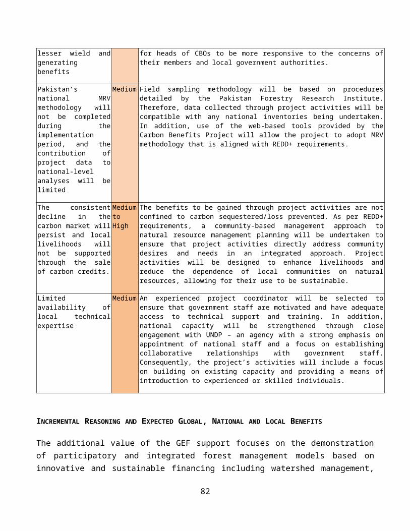
The long-term solution envisaged by the Government of Pakistan is to take an integrated landscape-scale approach to sustainable forest management, which conserves biodiversity, stores carbon and delivers other ecosystem services. To be sustainable, this system should be less dependent on Provincial Annual Development Planning or project funding, and must include funding generated through ecosystem services such as watershed management, non-timber forest products (NTFPs), carbon marketing, tourism and other sources. The current strategic activities being pursued under the REDD Readiness Programme (RRP) and other significant investments to address the threats to Pakistan’s forests, elaborated under the baseline description. The following barriers prevent the forestry departments and other direct users of forest resources from adopting forest management practices based on sustainable use of forest ecosystem services:
A. Barriers to implementing SFM
(i) Insufficient knowledge on sustainable forest management and the consequences of deficient management. Due to the lack of evidence of gainful opportunities related to sustainable forest management (SFM), training and successful demonstrations of good practice, including appropriate cross-sectoral plans and governance arrangements, the line departments responsible for forestry at provincial and local level and local communities are unaware of the real value of forests and forest ecosystem services and are unable to deliver sustainable forest management. Knowledge of the values of ecosystem services is insufficient to allow determination of optimal management objectives, and sustainable financing options. In many cases forest users lack the understanding of how their activities lead to forest degradation and what is needed for achieving sustainable management.
(ii) No proven incentive models for sustainable forest management. Resource users and landowners are not rewarded for resource conservation as no funding and economic incentive mechanism exist to cover opportunity costs related to forest exploitation. For example, compensation payments for watershed protection or sustainable forest management in upstream areas are not borne by downstream territories, even though the latter are the direct beneficiary from such actions. Institutional and regulatory frameworks at the provincial level are not effective in supporting PES or REDD+, nor are they in harmoned with national strategies and requirements in the framework of UNFCCC. As discussed in the project baseline, the REDD+ process is just starting to deal with fundamental issues of methodologies and Monitoring, Reporting and Verification (MRV), including recognizing the considerable variations in ecological conditions (from arid to alpine) and socioeconomic conditions (particularly tenure and land use practices) in developing uniform methodology and standards for all provinces and territories in the country.
(iii) Insufficient control of resources due to unclear or limited access rights . Forests have various user groups, both legal and illegal. Forest Departments have insufficient resources to control forest use effectively. Further, successful participatory and effective collaborative forest management models have not been established even in Khyber Pakhtunkhwa province, where this approach has been
21
recognized and provided with legal cover. The provinces of Punjab and Sindh are further behind in this process. Consequently, forest users pursue short-term benefits for their own interests. The management capacity of the provincial forest departments for creating successful SFM models, in particularly at community level is limited.
B. Barrier to biodiversity conservation
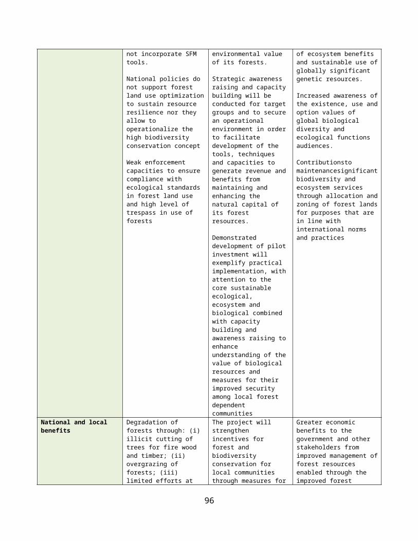
(iv) Limited capacity and knowledge to conserve biodiversity especially at a landscape level planning and management. The main activities to conserve forest biodiversity are limited to protected areas and, even here, by provincial wildlife departments to species protection. The lack of species and habitat management for biodiversity conservation and of measures for management at the landscape scale represents a huge missed opportunity for forest biodiversity conservation. The line departments have little experience in developing strategic plans on how to manage forest habitats for biodiversity, or how to manage forest habitats and species for biodiversity considerations when planning and undertaking restoration, reforestation and afforestation or other forest operations such as thinning or logging. Generally, there are no demonstration models of landscape-scale application of forest biodiversity conservation, and capacity to deliver these is currently insufficient. Knowledge of the distribution, trends and ecological requirements of forest biodiversity are insufficient to guide the identification, planning and management of high conservation value forests (HCVFs) to conserve biodiversity effectively. There is a critical need to assess, map and secure critical areas of high biodiversity richness in forest landscapes, so that these can be accorded adequate levels of protection and management. Similarly, the links between biodiversity, ecosystem goods and services, and the wellbeing of people are poorly understood or valued. As a result, neither forestry nor other-sector stakeholders are able to mainstream biodiversity conservation into their planning. The current forest, wildlife and other sectoral laws, guidelines and implementation (compliance and enforcement) capacity is deficient to address this gap. The local communities lack economic incentives, along with awareness, capacity and support in the planning and sustainable management of forests for biodiversity conservation, climate change mitigation and carbon sequestration.
C. Additional barrier to climate change mitigation
(v) Forests not being managed to optimise carbon benefits. Restoration and reforestation activities undertaken to date are largely concerned with raising timber stocks for harvesting rather than securing carbon sequestration benefits. There is minimal experience within the government line departments and local communities of using silvicultural techniques that enhance carbon sequestration, for example through assisted natural regeneration and best practices in forest restoration, reforestation and afforestation. The lack of capacity and appropriate practical demonstration of silvicultural techniques and best practices is a major hindrance to large-scale roll out of REDD+ initiatives throughout the country.
BASELINE ANALYSIS AND SCENARIO WITHOUT GEF SUPPORT
22
A number of baseline programs are addressing the threats and barriers described above at the national, provincial and local levels that would serve as a foundation for the GEF project. However, under the business-as-usual scenario, they will not be sufficient to enable a shift towards integrated planning and more enhanced sustainable management of forests on the ground. Past investmentThere has been significant investment in the past that constitutes an important contribution to the baseline. As a result of donor funded projects in the 1990s, extensive experience with social forestry has been developed in Pakistan, particularly in Khyber Pakhtunkhwa Province. All these activities were local initiatives mainly driven by projects and NGOs and not by federal or regional policies. Since the end of the 1990s, however, security issues and disasters shifted the attention of donors and the Pakistan Government away from the development of innovative forest management, such that Pakistan now lags behind in the development of SFM and REDD+ compared to other countries in the region. Most of the initiatives stalled when donor support decreased as no effective sustainable funding mechanisms had been established to implement management plans. Nevertheless, the Government of Pakistan continued to undertake a number of projects aimed at strengthening environmental management of forests. Since mid-2000, some 15 forestry and watershed management-related projects have been implemented with a total budget of US$ 330 million (see examples in Table 4 below).
At the federal level, the World Bank is funding REDD+ Readiness Preparation Project and Guddu Barrage Rehabilitation Project is under implementation. A Project Proposal on National Flood Protection Plan – IV (2015-25) is under preparation. Provincial Forest Departments are implementing reforestation programmes from its Annual Development Programme. Key past projects in this regard is provided below:
Table 3: Past Investment in SFM in Pakistan
Project Name / Period Short Description Implementing Partner
Budget ($m)
Development of forestry sector resources in Pakistan. (2007-13)
The major output of the project is sequestering carbon and gaining carbon credits in the context of CDM through mass scale afforestation programme.
All Provinces (Punjab, Sindh, KP, GB, Balochistan and AJK)
150
Tarbela Watershed Management Project. (2005-11)
Institutional strengthening of all provincial Forest Departments through training programmes and enhancing their physical resources, e.g. improved infrastructure, equipment.
7 Districts of Khyber Pukhtunkhwa Province
70
Mangla Watershed Management Project. (2007-12)
Financed under Public Sector Development Programme (PSDP) of GoP as follow-up of WFP sponsored programme for enhancing functional life of Tarbela Hydro Power Dam through Integrated Watershed Management
Azad State of Jammu and Kashmir (AJK)
35
AJK Watershed Management Project. (2005-11)
Financed under Public Sector Development Programme (PSDP) of GoP as follow-up of WFP sponsored programme for enhancing functional life of Mangla Hydropower Dam through integrated watershed management measures
AJK 58
Integrated Natural Financed under Public Sector Development Programme (PSDP) AJK district 3
23
Project Name / Period Short Description Implementing Partner
Budget ($m)
Resources Management Projects under One UN Joint Programme on Environment. (2011-13)
of GoP. Integrated watershed management activities in all AJK districts administration
Capacity building for REDD readiness in Pakistan. (2011-12)
Sponsored by Embassy of the Kingdom of Netherlands, jointly implemented by UNDP and Ministry of Climate Change. Integrated watershed management, biodiversity conservation and slope stabilization through bio-engineering
All provinces coordinated by the office of Inspector General of Forests
0.20
At local level, some successful Payments for Ecosystem Services (PES) models have been established by territorial Forest Departments in Gilgit Baltistan, and Khyber Pakhtunkhwa Province with support from IUCN and WWF, based on revenues from hunting and forestry to compensate local community conservation efforts; and some attempts of voluntary “Clean Development Mechanism” arrangements with the private sector have also been undertaken. Although, Khyber Pakhtunkhwa has implemented a program called "adopt a forest" based on a PES approach at a cost of around USD 20,000, this has been applied without any clear policy, rules and procedures and payment mechanisms on the basis of forest conservation outcomes. PES has further not yet been institutionalised in Pakistan, but is applied on an ad hoc basis in various sectors. For example, provinces using Indus water for irrigation contribute compensation to upstream provinces and other territories. In practice however, these funds are not particularly used for conservation and the development of upstream communities. At sub-catchment level, these models have so far been more successful for watershed management in some occasions where arrangements were made between communities and local water users. Benefit sharing has also been introduced for the exploitation of non-state forests, but this has not yet been fully successful, among others due to the ban on tree felling and ineffective benefit sharing models. The lessons from these schemes were scrutinized and used when designing the Community Conservation Area demonstrations.
Strengthening Forest Management
The 11th Five Year People’s Plan (2014-19) includes substantial investments for programmes related to sustainable management of land and natural resources including forestry (for reforestation and afforestation). Annual Development Program (ADP) projects of provincial and territorial Forest Departments are partly focussing on SFM-related efforts. Aligning these projects with the GEF project provides an important opportunity to increase impact and up-scaling. The approximate total annual budget of ADP is in the order of 3.0 billion PKR ($30 million per year). Around 10% of these funds will be used for SFM, but some provinces expect to allocate even up to 25% of their ADP for SFM. Thus a total contribution of at least US$ 16 million could be allocated from provincial governments for SFM and improving of policy and regulatory frameworks. Several donors (USAID, DFID and EU) are preparing watershed management programmes that will complement the GEF project for SFM activities.
24
Biodiversity management
There are several government investments (both national and provincial) in watershed management that integrate biodiversity conservation and protected areas management into watershed and regional integrated land use planning (e.g. Tarbela watershed, Mangla watershed). Similarly, significant amount of investments will also flow through the 11th Five Year People’s Plan for various projects and programmes related to sustainable management of natural resources including strengthening the conservation of nationally and globally important habitats and species in several Protected Areas in the country, albeit slightly skewed towards awareness raising and institution building (in particular developing and strengthening local institutions and empowering local stakeholder groups). Also noteworthy is the fact that the Provinces on their own are taking several important steps such as investing in the implementation of provincial conservation strategies, district conservation strategies and integrated district development plans (e.g. Khyber Phakuntwa, Balochistan, Gilgit-Baltistan, Sindh and Punjab). This is significant in light of the recent decentralization and greater autonomy given to the Provinces whereby Provincial authorities have the sole mandate for planning, conservation and management of land, forestry and other natural resources in their respective provinces. The total baseline investment under all these national and provincial initiatives has been estimated to be around US$ 8.3 million. The World Bank will be implementing a program for conservation of the Indus dolphin and fish migration restoration in the Indus river that will closely complement the GEF project in terms of riverine forest restoration and conservation. However, under the baseline situation, forest biodiversity conservation will continue to have a very low profile in Pakistan, with most of the budget allocations from government focussing on activities within the protected areas. Even within protected areas, the focus will continue to emphasise species protection activities, rather than conservation measures to mainstream biodiversity into sustainable forest management through effective habitat conservation and restoration. Re-afforestation programmes will continue to focus solely on increasing tree cover, without addressing biodiversity conservation as would be needed under a landscape-wide SFM strategy. Moreover they do not necessarily use indigenous trees, nor take into account the effect of tree monocultures on biodiversity. Failure to address livestock husbandry, overgrazing by cattle and goats degrades valuable under-storey habitats which are vital for biodiversity.
REDD Plus readiness
The REDD+ Preparedness Phase project (R-PP) is an important element of the baseline. It will help to shape the institutional and regulatory environment for SFM projects supporting REDD+ initiatives in the country, with the objective of conserving forests through private sector led carbon credit generation. It is anticipated that the REDD+ strategy project will complete assessments of data availability and capacity needs, as well as an action plan for MRV. It is developing a REDD+ Readiness Roadmap for Pakistan, and has approved a Readiness Preparation Proposal (R-PP), for the World Bank Forest Carbon Partnership Facility1. All these initiatives amount to around US$ 6.5 million. REDD+ implementation 1 The R-PP was approved recently with a request for US$ 3.8 million in funding to: (i) operationalize REDD+ Readiness Management Arrangements; (ii) facilitate information sharing and dialogue with key stakeholders; (iii) define the consultation and participation process
25
activities have the potential to deliver significant social and environmental co-benefits, however, many stakeholders have highlighted the potential risks, particularly for forest-dependent communities. Some of the strategic environmental and social issues considered at the REDD+ readiness stage includes the conservation of biodiversity and ecosystem services; food security, land ownership, land tenure, land accessibility, energy supply and gender equity amongst others. In addition the major output expected of the government programme “development of forestry resources in Pakistan” is sequestering carbon and gaining carbon credits in the context of Clean Development Mechanism (CDM) through mass scale afforestation programme. Furthermore, in anticipation of the development of the carbon market, private companies have started to solicit opportunities to invest in REDD+ projects. These companies sometimes offer millions of dollars to forest managers in return for contracts covering large areas of land. This phenomenon has raised the forest manager's eagerness for REDD+, but the reliability and integrity of the "REDD companies" is not always evident. Forest managers lack the proper knowledge and experience with REDD+ to manage these companies and it is clear that the policy and regulatory framework needs to be strengthened. Similarly, there is a need to demonstrate landscape-scale sustainable forest management on the ground.
Overall, there are a number of key gaps in the current baseline programs that constraint the application of effective forest management practice. Most of the on-going projects do not focus effectively on sustainable forest management. Most reforestation efforts are directed at planting barren areas rather than on the more cost-effective and viable approach of regeneration of degraded areas through assisted natural regeneration and protection of regenerated areas. Further, forest management lacks the use of an ecosystem and landscape approach to forest conservation and there is a reluctance to use of community-based organizations for forest conservation and management. Within protected areas, the focus will continue to emphasise species protection activities, rather than conservation measures to mainstream biodiversity into sustainable forest management through effective habitat conservation and restoration. Re-afforestation programs of provincial Annual Development Programs (ADPs) focus solely on increasing tree cover, without addressing biodiversity conservation as would be needed under a landscape-wide SFM strategy. Moreover they do not necessarily use indigenous trees, nor take into account the effect of tree monocultures on biodiversity. Failure to address livestock husbandry, overgrazing by cattle and goats degrades valuable under-storey habitat, which are vital for biodiversity.
STAKEHOLDER ANALYSIS
The project will follow a cross-sectoral and participatory approach that involves a number of stakeholders, who current roles and responsibilities are discussed in Table 4. Section IV, Part VII (Stakeholder Involvement Plan) of the UNDP Project Document includes a Table that defines the
for REDD; (iv) assess land use, land use change drivers, forest law, policy and governance; (v) assess REDD+ strategy options; (vi) develop a REDD+ implementation framework; (vii) to assess the likely social and environmental impacts of REDD+; (viii) develop a national forest reference emission level; (ix) design a system for national forest monitoring and to generate information on safeguards; and (x) design a programme monitoring and evaluation framework.
26
specific roles and responsibilities of key stakeholders in the project as well as the mechanisms and strategies for ensuring their direct participation in project activities.
Table 4: Stakeholder Roles and ResponsibilitiesKey Stakeholder Role and responsibilities
Ministry of Climate Change, Inspector General Forests
The MOCC, through its Office of the IGF, is the lead ministry for forestry and REDD+ policy-making and programming. It facilitates inter-provincial and inter-ministerial coordination on issues related to forestry, wildlife, biodiversity conservation, and desertification control as well as ensuring national compliance with international conventions. The Ministry is coordinating Pakistan's REDD Readiness Programme (RRP, 2011-14), which is set to provide the enabling environment and strategy for SFM implementation. As the project proponent and proposed executing agency of this new GEF project MOCC will coordinate with the Provincial Forest Departments to take Pakistan's RRP to a practical level by demonstration in the target areas and building capacity and thus breaking barriers to future market-led REDD activity. MOCC will chair the Project Board, which will provide the interface with federal policy and planning, and will allocate co-financing such as ADP, FDF and recurrent budgets. Federal Government, under the impression of devastating floods in September 1992, imposed a total ban on commercial timber harvesting in 1993.
Other Federal Ministries like Planning and Development Division, Economic Affairs Division
Arrange funds for sustainable forest management from local sources and foreign donors.
Pakistan Forest Institute The prime forestry research and education institute in the country; provides training and education in various forestry disciplines to meet the needs of federal institutions, provincial forestry departments, the private sector and civil society organizations. The new approaches to SFM demonstrated by the project will be mainstreamed into the educational curriculum.
Punjab Forestry Research Institute, Faisalabad
Conducts research on forest related issues.
Zoological Survey Department
Conducts survey and research on distribution, population, and status of animal life in Pakistan.
Provincial/territorial Forest Departments and their local offices
Provincial line departments responsible for forest management. Current focus is mainly on protection through law enforcement mainly in the state-owned forests and rangelands. They will provide technical and extension services for undertaking SFM activities with local communities and the private sector. Provincial forest departments are the key implementing agencies at the provincial and local level.
Board of Revenue in Provincial governments
Management of ownership of forestlands rests with the Board of Revenue of provincial governments. The Board of Revenue undertakes studies related to land tenure.
Forest Community having user rights in Protected Forests
Forest Community having user rights in Protected Forests have a few rights, such as share in timber sales proceeds for local right holders from areas that are harvested according to a management plan of the FD (so-called ‘royalties’; 60% share in Malakand Division, 80% share in Hazara Division). Use of timber for local purpose is allowed with the permission of the FD. Additionally, collecting fuel wood and grazing of animals is permitted.
Forest community with ownership and user rights in Guzara forests
Local communities as owners or having some user rights in Guzara Forests managed by the Forest Department can cut wood for timber with the permission of the Forest Department.They can also collect dry wood, as long as the owners or right-holders do not have any objections; the same is valid for grazing.Guzara forests can be found in Hazara Division, but not in Malakand
Forest community with user rights in collective land holdings (Shamlat)
Such communities use the forest in Shamlat land to meet their fuel wood, fodder and timber requirements. They rarely clear forestlands for subsistence level agriculture or for other land uses.
Other Forest Landscape The communities in the forest landscapes are the key users and custodians of the forest resources.
Their participation in forest management and sharing the benefits is a key target of the project.
Women take branches of trees for firewood, and other NTFPs for livelihood needs and rearing of livestock. They play a prominent role in agricultural production, households and the utilisation of forest resources such as fire wood and NTFPs. However, their participation in forest management committees and land use planning procedures is presently negligible, and will require particular attention. Youth are the present and future human resource to interact and shape their role in forest management. They are likely to be more receptive and better learners and require more attention.Local elders and politicians play a role in conflict resolution among communities and resource mobilization for their development schemes.Migratory pastoralists are another key group because overgrazing is an important cause of forest degradation. They use the forests based on user-rights and not on ownership, and are poorly organized. Strong attention must therefore be given to their participation in planning and decision making.
Nomads, and refuges who are non-local including persons coming from neighbouring countries
Nomads are local, non-local as well from neighbouring countries like Afghanistan and refugees from occupied Kashmir. They use the forest resources for their livelihood and rangeland for grazing of their animals. Nomads or seasonal migrants sometimes pay a certain fee (qalang) to local land owners or forest right holders in order to let their animals graze and collect fuel wood.
Downstream communities Urban populations and downstream resource users, particularly water and timber users, are beneficiaries of many ecosystem services and forest products. Potential source of PES funding.
Private sector and Chambers of Commerce
Increasing direct role in the management and use of forests (timber, hydro-power, NTFP, land conversion). It is therefore crucial to ensure that SFM approaches are embedded in their practices and that they have the necessary skills. Larger companies also have important potential for investment in SFM through PES and CDM funding. Examples are emerging in Pakistan of private firms contributing to environmental protection (e.g. Engro Group, Nestle Pakistan, Coca Cola Company, Shell foundation and Dawood Group)
Local NGOs, CBOs of community (including male and female members) with their livelihood related to forests
Local NGOs mobilize the local communities, including women, school children and pastoralists into CBOs. CBOs assist in coordinating members of the local population, assist in protection of forest resources, conflict resolution and generating resources for developmental activities of the area. The CBOs representing the interests and views of local people at local and national levels. their credibility is greatest where their membership is genuinely representative – especially with regard to issues of equity and discrimination. Networking and/or federating are important mechanisms for CBOs to be effective in advocacy and contribute to the elaboration of forest policy. Local NGOs have a particular role in building the capacities of local people and empowering them to claim their rights.
International NGOs The role of international NGOs lies more at the national level, and includes providing technical assistance to government, and introduction of innovative approaches; assisting local CBOs; facilitating knowledge sharing with international communities by building networks and alliances, providing outside expertise and experience for developing capacities, informing forest policy discussions, and profiling relevant issues of international importance.Key groups are WWF-Pakistan, IUCN, ICIMOD, InterCooperation-Pakistan and LEAD-Pakistan)
International donors Co-financing and technical assistance to the government to address environmental degradation, biodiversity conservation and climate change. Key donors are: GEF, UNDP, World Bank, USAID, DFID, EU and other bi-laterals
Print and electronic media, Green Journalists Society
Public awareness and outreach for sustainable forest management.
Timber, Fuel-wood and NTFP dealers/ Contractors
Usually, the felling, conversion and transportation of trees is not done by the FD itself. Since 1977, this is in the hands of the so-called Forest Development Corporation (FDC), an institution external to the FD hiring professionals on contract-basis for harvesting particular areas. De facto bound to working plans issued by the Forest Department, these contractors often tend to cut more than required in order to increase their profit which results in increased deforestation.
Timber Mafia Because profits in the Pakistani timber business are very attractive (due to shortage in domestic supply and import restrictions), a whole cluster of local élites such as wealthy villagers, local
28
politicians, and rich outsiders are actively involved in illegal timber business. Local residents are often hired for logging and transportation – what makes it very difficult for officials to get hold of the wire-pullers.
Owners of housing societies Cut forest trees to create new land for housing
Preliminary stakeholder consultation was carried out for the elaboration of this PIF. During the PPG phase, detailed stakeholder consultations was organised at national, provincial and local (landscape) level.
PART II: STRATEGY
PROJECT RATIONALE AND POLICY CONFORMITY
Fit with the GEF Focal Area Strategy and Strategic Program
Pakistan is eligible for GEF funding and this multi-focal area project addresses the objectives of the GEF-V Sustainable Forest Management, Biodiversity and Climate Change Mitigation programming strategic objectives in an integrated way, as follows:
(i) SFM-1 Reduce pressures on forest resources and generate sustainable flows of forest ecosystem services. This objective will be addressed under Components 1 and 3, by piloting SFM good practices across seven forested landscapes in three distinct ecological systems covering 67,861 ha, ensuring that SFM approaches are adopted by economic actors and local communities, and thus sustaining and restoring multiple ecosystem services.(ii) BD-2 Mainstream biodiversity conservation and sustainable use into production landscapes/ seascapes and sectors. This objective will be addressed through component 2 and 3, which will deliver conservation and sustainable use of biodiversity in selected high conservation value and biologically rich forest target areas covering a total of 41,357 ha. And consisting of under-represented habitats that harbour IUCN red list species (e.g. snow leopard, brown bear, Punjab urial, and Pallas fish eagle, and other key species such as the Indus dolphin, Koklass pheasant and White-crested Kalij pheasant).(iii)CCM-5 Promote conservation and enhancement of carbon stocks through sustainable management of land use, land use change and forestry. These objectives will be delivered mainly through component 3 which will promote improved carbon sequestration through forest restoration in 10,772 ha and reforestation in 5,732 ha.
The GEF contribution to the proposed projects is required to cover the incremental costs related to address global environmental issues such as forest management, biodiversity conservation and climate change mitigation. Baseline activities in this respect are funded from national sources and other donors.
Rationale and summary of GEF Alternative
29
The long-term solution sought is to facilitate a shift from unsustainable to sustainable forest management in Pakistan. The target area are landscapes within three key forest ecosystems, namely Temperate coniferous, Sub-tropical broadleaved evergreen thorn and Riverine forests that provides essential ecosystem services including water provision (for urban use and food production), river bank erosion control and carbon storage and sequestration. The forests also provide critical habitats for wildlife and host globally important biodiversity. Notwithstanding this significance, the forests within these three ecosystems suffer from accelerating degradation, which is undermining ecosystem functions and derivative services. The target area trajectory of the baseline approach is to facilitate a transformative shift from unsustainable to integrated sustainable forest management that recognizes the many values these forests provide to the local, regional and national economies. The project will promote an integrated approach towards fostering sustainable forest management – seeking to balance environmental management with development and community needs. It will attempt to reduce conflicting forest land-uses and improve the sustainability of forest management so as to maintain the flow of vital ecosystem services and sustain the livelihoods of local forest-dependent communities (and downstream users). This effort will be underpinned by a robust forest management planning and monitoring framework that will inform plans for the forests in these areas. Further, the project will demonstrate sustainable forest management practices – testing new management measures, as needed to reduce environmental and consumptive stressors.
To achieve planned outcomes, the project strategy is to address the barriers described through a coherent combination of corresponding incremental outputs organized into three complimentary components/ outcomes, the first one focusing on developing an enabling environment to plan, monitor and adapt sustainable forest management at a landscape level that will facilitate incorporation of sustainable forest, and environmental management objectives and safeguards in forest management planning, forest land allocation and management and compliance monitoring systems at the local level. The second component will help to strengthen biodiversity conservation in the high conservation value forests in the landscape so as to conserve species and restore their populations to optimum levels, conserve habitats and establish ecological linkages with area that have rich biodiversity through the implementation of conservation, sustainable use and management efforts in the seven forest landscapes covering 41,357 ha of high conservation value forests (HCVF) in the three forest ecosystems as a means to change the way the fundamentals of forest management are undertaken so as to derive multiple forest benefits of biodiversity conservation, carbon stocking and sequestration improvement, water retention and erosion prevention, grazing management, community sustainable use of non-timber forest products (NTFPs). Through, such on-the-ground process and trainings, it is expected to enhance capacities of forest staff and community representatives for enhancing sustainable forest management and potential for further expansion and replication elsewhere in the country. The third component aims to enhance carbon sequestration in and around the high conservation value forests through a combination of restoration, reforestation and maintenance covering an additional forest area of 26,504 ha.
The global benefits that will be delivered primarily include the adoption of SFM practices that will reduce forest degradation, secure ecosystem services and mainstream biodiversity conservation within
30
the planning and management of the forested areas in the three ecosystems (covering 67,861 ha) and and in testing particular SFM approaches.
PROJECT GOAL, OBJECTIVE, OUTCOMES AND OUTPUTS/ACTIVITIES
The objective of the proposed project is to promote sustainable forest management in Pakistan's Western Himalayan Temperate coniferous, Sub-tropical broadleaved evergreen thorn (Scrub) and Riverine forests for biodiversity conservation, mitigation of climate change and securing of forest ecosystem services. In particular, it aims at implementation of three inter-related and mutually complementary components that are focussed at addressing the barriers of inadequate planning, regulatory and institutional frameworks to integrated forest resource management, and enhancing the limited experience among key government and civil society stakeholders in developing and implementing SFM practices on the ground.
The project’s incremental value lies in demonstrating, using the case of the pilot forest landscapes 2 to develop sustainable forest management plans by adding the layer of biodiversity and ecosystem values, and climate change mitigation to forest management. A GIS database and maps will be developed for each forest landscape, listing areas of high biodiversity conservation and climate mitigation, timber and firewood production, and community resource use. These layers will allow for defining which ecosystems can be manipulated and which should be conserved in order to retain ecosystem integrity and ensure productivity of forestlands in the long term. It will help develop capacities and required enabling frameworks through "learning-by-doing" approaches in the selected target forest landscapes. SFM approaches will be based on assessments of ecosystem services and will build on capacities and concepts established during the interventions of earlier projects in Pakistan, as well as globally. The project will be able to develop and demonstrate a matrix of best practices of SFM for scaling up and replication in forest landscapes nationally and globally. A series of publications and workshops will be launched to accomplish this.
The target pilot forest landscapes have been selected based on their global and national significance for biodiversity conservation and climate mitigation, operational feasibility, local security, governance, and well defined land tenure. The target areas include state-owned and managed forests as well as communal and private forests. The target forested landscapes will comprise the following forest types:
(i) Temperate Coniferous forests cover a total of 1,767,000 ha, of which 56% is protected. Further degradation and deforestation of the forest cover in this area is predicted due to over-exploitation. Some typical species in Dry Temperate Coniferous Forests include Cedrus deodara, Pinus gerardiana, Juniperus excelsa, Pinus wallichiana, Picea smithiana and Quercus ilex; in Moist Temperate Coniferous Forests there are Pinus wallichiana, Cedrus
2 A Forest landscapes is defined as a system of interacting ecosystems within a defined broader area that serves as a functional unit of productivity, protection and socio-economic benefit.
31
deodara, Picea smithiana, Abies pindrow, Quercus spp,. Fraxinus excelsior, Taxus Wallichiana syn baccata, Juglans regia and Aesculus indica. Interventions in temperate forests of Hazara Civil Division are proposed for SFM to cover approximately 28,005 ha of state and community forests, of which approximately 18,000 ha is of high conservation value, 7,848 ha requires forest restoration3 and 2,157 ha requires reforestation4. Approximately 93,000 people would directly benefit from SFM;
(ii) Sub-tropical broadleaved evergreen thorn forests (Scrub forests) cover a total of 1,636,000 ha of which 91% is protected. The main tree species in this ecosystem are Olea ferruginea, Acacia modesta and Pistacia integerrima. The location of the Scrub Forest Landscape is proposed in the Salt Range districts covering approximately 7,859 ha of Reserved forests and their buffer zone forests in community owned areas like Shamlat. Forest restoration and reforestation would be implemented in 2,924 ha and 476 ha of buffer zone around high conservation value scrub forests in community owned areas like Shamlat, respectively. Another 4,459 ha of high conservation value forests will be conserved. About 66,000 people would directly benefit from this intervention.
(iii) Riverine forest ecosystem is found in Punjab and Sindh and covers a total of 295,000 ha (1987 figures). The main tree species are Acacia nilotica, Tamarix aphylla, Tamarix dioica, Prosopis cineraria, and Populus euphratica. Dalbergia sissoo and eucalyptus plantations have been raised over small areas, which are now far removed from the river and do not receive river inundation. Riverine forests are predicted to decrease in Punjab and Sindh due to reduced flooding and lack of reforestation efforts after land erosion followed by accretion, resulting in conversion into agricultural use by the land encroachers. Recently, about 14,000 ha of encroached riverine forests has been recovered by the Government of Punjab in Rajan Pur District because of political will and awareness of the rapid decrease and degradation of riverine forests.
Of the approximately 225,000 ha of riverine forests with protection status in Sindh, 44% has been deforested through encroachment (19%) and due to non compliance of agro-forestry lease agreements by the influential lessees (25%). The flooding of riverine forests has declined significantly downstream of Sukkur Barrage due to abstraction, extraction and diversion of river waters upstream through barrages, head-works, and link canals. The process of forestland erosion and accretion remains active in greater part of the year in the stretch of Indus River between Sukkur Barrage and Guddu Barrage. The reforestation of degraded areas through seeding in the accreted and inundated areas has been limited in Sindh due to financial constraints.
3 Restoration refers to soil working, trenching, planting of seedlings and protection to facilitate assisted natural regeneration in forest areas with less than 50% forest cover4 Reforestation is the planting of blank areas (areas with no cover) with seedlings, restocking and protection
32
The Punjab and Sindh Forest Departments intend to reforest about 13,099 ha of regularly inundated areas with project support on the basis of existing capacity within the respective forest departments. Another 18,898 ha of high conservation value forests will be set-aside for conservation. This will also ensure that these areas are are not further deforested. Approximately 208,000 local people in the two provinces would directly benefit from the project intervention.
The project will deliver SFM to 67,861 ha of critical forest habitats, conserving globally important biodiversity, as well as secure carbon benefits totalling 9,908.1 KtCO2-eq calculated for a period of 30 years. Without the project, successful demonstration of landscape approach to SFM is unlikely to take place, putting at risk the success of the UN REDD+ implementation in Pakistan. As a result, these critical forest landscapes of high biodiversity significance would continue to face habitat destruction and loss of globally important species and ecosystems; and the capacity, planning, institutional and financial barriers elaborated earlier will continue to constrain any efforts to mainstream biodiversity into land use planning and management at landscape-level as well as the use of forests for SFM/REDD to deliver carbon benefits. The project has three components, each addressing different barriers for a distinct outcomes:
5 Target for conservation and avoided deforestation (avoided emissions of CO2)6 Includes forests with 25-50% cover that will be targeted for restoration through a combination of interventions, such as trenching, seeding (planting of seedlings) and protection (carbon sequestration)7 Blank areas or areas with little or no cover (or with weed cover) will be targeted for reforestation (carbon sequestration)
33
Component/Outcome 1: Embedded sustainable forest management into landscape spatial planning.
This component focuses on addressing the barrier related to lack of knowledge and incentive models in planning, regulatory and institutional frameworks for sustainable forest management.
Under this component, the GEF incremental support would incorporate sustainable forest management objectives and safeguards in forest management planning, forestland allocation and compliance of monitoring system at the local level. Sustainable forest management plans will be developed for seven landscapes, two in the temperate coniferous, one in the sub-tropical broadleaved evergreen thorn and four in the riverine forests, ensuring optimal allocation of land resources to generate development benefits and critical environmental benefits (including avoided degradation, conflict reduction, biodiversity conservation, climate change mitigation and adaptation and community sustainable use and management or involvement) in tandem.
All important forestland users including the forestry sector and local communities will be involved in the process. The adjustments to forest management planning process will be built on successfully tested models and bring together - federal, provincial and district entities, and local community groups exposed to opportunities and trained and tasked for improving forest management. This collaborative planning process will ensure an integrated approach in planning and management, implementation, enforcement for achieving SFM to result in sustainable use of forests, and accrue benefits to the forest dependent communities. This would also ensure ownership of the plans by the local stakeholders thereby increasing the chances of their successful implementation. This component will have eight outputs, which would contribute to achieving the overall goal of developing working models of sustainable forest management at the landscape level and in establishing capacity for implementation and monitoring of the landscape management plans.
Output 1.1 Forest resources and ecosystem services inventory and mapping informs forest management planning, implementation and monitoring at the landscape level
Under output 1.1, in order to ensure that SFM plans are based on up-to-date and verifiable information, the project would take stock of existing inventory and mapping of the forest and biodiversity resources and of the available tools to identify major information gaps. The stock taking exercise will evaluate the extent to which the mapping and inventory has integrated the value and multi-functions of the forest landscape, including the kinds and volumes of ecosystem services including carbon capture. The intent of the stock-taking and any additional work is to seek information on the location of critical habitats, identify indicators to assess ecosystem functions and their resilience, carbon stocks, impact of climate change and community use regimes. Through stock-taking and subsequent work, the provincial and district governments and local community organisations will know of critical habitats and endangered
34
and threatened species, threats to habitats and species as well as ecosystem components and values inclusive of carbon sinks. This exercise will also enable the identification of the predominant land uses, what the current as well as potential impacts of forest degradation on ecosystem services are, and what forests best suited for multiple benefits and their sharing and use by local communities. Part of the inventory and map updating exercise will help analyse and decide the trade-off between various systems for sustainable forest management, including valuation of costs/benefits of different SFM practices and production systems and of those dedicated for biodiversity conservation, climate protection, ecosystem services and community resource use. The outcome of this activity would be accurate maps of forest and surrounding areas in the landscape, information regarding main characteristics of ecosystem and habitat types; potential of production, protection and conservation, for setting aside forest areas for biodiversity conservation, production of wood and NTFPs (potential sites for meeting the subsistence and livelihood needs of local communities and providing other ecosystem services as well as for assisted regeneration or reforestation for restoration and rehabilitation of deforested and degraded areas to enhance carbon sequestration or carbon stocks alongside protection against grazing), etc.
GEF funds will be used to contract a team of technical experts to support integration of biodiversity information and ecosystem values into the forest inventory and mapping exercise. The inventory team will support each of the three provincial Forest Departments’ project management and implementation teams in preparation of inventory and maps through the following key steps: (i) definition and delineation of boundaries of the target forests and their landscape through a participatory consultative process making use of the existing revenue records and forest working plans, satellite imagery, and forest maps; (ii) collection, collating and maintaining key environmental information (state, communal and private land, land use (forest, wildlife protected area, agriculture, pasture, wetlands (more relevant in case of riverine forests landscapes) to develop inventory and maps; (iii) supporting extensive consultations with forest and sector staff, graziers, forest dependants, community groups and other stakeholders to establish a system of sustainable use based on norms, criteria, needs assessment, production capacity of the natural resources and trade-offs including alternatives; (iv) defining clear guidelines to assist in decision making regarding allocation of forest land for different uses and management regimes and guidance for assessing and defining trade-offs between different uses and users; (iv) providing technical guidance for integration of environmental information and parameters in mapping, planning tools and processes respectively; and (v) providing on-the-ground training and capacity development for forest staff, representatives of community organizations and other stakeholders on forest inventory and mapping techniques, and in the interpretation and use of information arising from these exercises; and (vi) the final output would be a series of maps and technical support for guiding the allocation of forest land for different purposes. The final outcome of these steps would be a map (preferably 1:25,000 scale) depicting the spatial and temporal distribution of the biological elements and priority status of the habitats required for the survival of the landscape species or the minimum set of landscape cover types and their spatial distribution necessary to conserve maximum biological diversity within the landscape and maintain the integrity of the landscape itself. It would also recommend specific areas suitable for carbon stock improvement, soil and water conservation for
35
watershed protection, and areas for production, rehabilitation and restoration through reforestation and changes in community use regimes.
Output 1.2 Updated guidelines, planning tools and regulations facilitate harmonization and mainstreaming ecosystem, climate risk mitigation and biodiversity considerations into forest management planning
Under this output, the GEF incremental investment will facilitate the improvement and/or adjustment of existing guidelines of forest management planning, including forest working plan code and manuals, and monitoring protocols to promote an integrated and sustainable approach to forest resources management that helps to balance the competing environmental, social and economic objectives in forest planning and management and associated investments. Integration of biodiversity and wetland conservation, and climate adaptation/mitigation and carbon accumulation aspects into guiding documents such as the Forest Working Plans Code will be the main focus of this effort. The forest management guidelines would serve as a planning tool for forest and associated land management that take into consideration the allocation and management of forest lands for deriving multiple ecosystem services including water conservation, climate amelioration, soil erosion control, biodiversity conservation, grazing management and community resource use. Revised protocols for monitoring the implementation of sustainable forest management plans would make specific reference to assessing impacts on ecosystem services’ delivery and benefits from biodiversity conservation, community use of NTFPs and other productive forest management operations.
The development of protocols/guidelines will be guided by the following activities: (i) review of international and regional best practices for integration of ecosystem perspectives into forest planning and management processes, (ii) review of current practices of forest management planning and the extent to which these integrate the stability of ecosystem, biodiversity conservation and community resource use; (iii) collation and review of key environmental information required to support the updating of protocols, including information on requirements for maintaining species and habitats, ensuring ecosystem services, managing threats to biodiversity and ecosystem services, environmental risks of climate change, environmental hazards and the state of forest and land degradation; (iv) extensive consultation with key stakeholders, including local communities on their expected needs and services from the forests; (iv) revision or development anew of protocols to ensure provision of guidance on conservation assessment tools and technologies to identify and prioritize areas for biodiversity and species conservation, restoration and maintenance of ecosystems and habitats and assessing trade-offs between different forest uses. The outcome of this activity would be a set of protocols and guidelines that would help forest managers and land-use planners on the use of ecosystem-based planning approaches in the preparation of forest management plans. The protocols/guidelines will provide instructions on information needs, consultative process and procedures for assessing trade-offs, compromise on allocation of land for different purposes, and instruction for management planning and monitoring.
36
Output 1.3. Landscape level forest plans integrates considerations of biodiversity, ecosystem services, climate mitigation and community resource use
Based on the sustainable forest management planning guidelines and inventory and mapping exercise to guide the definition of the allocation of forest lands for a multitude of forest uses, the GEF incremental investment would support the preparation of sustainable forest management landscape level plans for 67,861 ha of forests and their surrounding land use areas to ensure mainstreaming biodiversity and wetland conservation, climate mitigation and carbon stock improvement, grazing management, and firewood and NTFP supply and other demand aspects into the plans. The sustainable forest management plans at the landscape level will reconfirm a shift from the current emphasis on forest production to a more holistic approach of management of landscape for multiple benefits of biodiversity conservation, climate amelioration, ecosystem services, water retention and soil erosion control, sustainable management of non-timber forest products, community benefit sharing and livelihood improvement. The new sustainable forest management plans would emphasize management practices for the different parcels of land within the forest landscape to ensure multiple ecosystem benefits and conservation outcomes.
This output would help establish a range of sustainable forest management practices across the landscapes. The specific activities to be undertaken in this output will include: (i) systematic biodiversity conservation and ecosystem services assessment tools and technologies to identify and prioritize the forest areas for conservation use, improvement and protection of ecosystem and climate mitigation functions, mitigation of the impacts of fuel wood extraction on sensitive habitats and species, institutionalising sustainable use of forest resources by community, reducing the impacts of unsustainable grazing and exploiting the potential of natural and assisted natural forest regeneration; (ii) facilitation of a consultative process for identifying, delineating and designating forest areas of high conservation value that are currently outside the protected area network, (iii) strengthening the management planning of the delineated high conservation value areas, through guidelines and procedures for preparation of stand-alone conservation management plans, or integrating conservation management practices into forest working plans and landscape management plans; (iv) support a process for participatory development and adoption of guidelines and procedures for delineating community extractive use areas to streamline the haphazard and un-sustainable harvest of firewood and other major extractive uses into sustainable use regime, in particular from sensitive habitats of species in high conservation value forests or zones; (vi) facilitate a consultative process for defining and development of guidelines and procedures for the restoration of degraded forest lands and their sustainable management; (vii) develop criteria for identifying degraded forests for assisted natural regeneration and re-forestation and develop procedures for their regeneration; (viii) define, in consultation with forest dependent communities, a range of measures to ensure sustainable resource use and reduce environmental impacts of unsustainable harvesting of NTFPs; restoration and management; and (ix) provide for technical support and on-the-ground training in sustainable forest management planning to forest staff, community groups and other stakeholders.
37
Output 1.4 Stakeholders’ benefits of current unsustainable and sustainable forest practices and status of forest resources assessed
There are various user groups that are dependent on the forests within the landscape, some of whom are right holders and others are landless and non-right holders. The project would support the socio-economic assessment of current resource uses and of dependent user groups defining the location, type, production and intensity of resource use (timber and firewood harvest, NTFP extraction level, and of fisheries) as well as livelihood and resource dependencies associated with forest resources in the landscape. This would provide an overall baseline of the landscape that summarizes the socio-economically, geographically and occupationally (livelihood) dis-aggregated data for overview of the carrying capacity, state of resource use and dependence on the resources in the landscape.
This information would subsequently help in identifying areas where human activities threaten significantly the survival of forests, habitats and the species, their populations, critical land cover types and the integrity of the landscape itself. It would entail mapping of village locations within the general landscape along with attributes such as demography, agronomic and livelihood patterns, human resource parameters, and resource use dependencies. The information on resource use patterns would include types of resources extracted, quantity and method of extraction, purpose (subsistence or commercial), periodicity and seasonality of resource use etc. The mapping of the socio-economic (production and livelihoods), would be conducted as a rapid assessment using secondary information and broad village level consultations that would be subsequently revised and updated as more information becomes available from the landscape, forest management planning process and comprehensive socio-economic baseline and analysis, particularly in the community managed conservation areas.
Under the GEF alternative, the project would support the assessment of the resource dependencies to better understand if these activities are sustainable or not, assess the trends of the resource use to understand the condition of the resource and their ability to sustain existing and projected resource use, and help define interventions to better manage the resource. The project would support the following sequence of activities: (i) review of existing information of resource use, including satellite imagery to assess trends in forest cover and condition: (ii) undertake consultations with resource users to assess resource dependencies and trends; (iii) undertake rapid assessment to determine condition of forests and exploited resources, including methods of harvesting resources to evaluate if these methods are environmentally sound and sustainable; (iv) prepare maps that identify resource use areas, types of resources extracted, quantity and method of extraction, purpose of use (subsistence or commercial), periodicity and seasonality of resource use, and resource use conflicts; and (v) through consultative process, assess needs and interests of all users and stakeholders with regard to resource use, management responsibility over parts of the landscape, which stakeholders are affected by changes in land use and management, which stakeholders are likely to be willing or unwilling to support conservation actions and goals. This would provide an assessment of how and when stakeholders might
38
be interested in sustainable resource use and conservation, and what specific measures and incentives might be necessary to build interest amongst all stakeholders in support of conservation.
Output 1.5 System for effective monitoring and enforcement of forest management plans, including clear delineation of roles and responsibilities of key partners and management of participatory processes informs forest management and development
The GEF increment will ensure that the roles and responsibilities of organizations involved in supervision and implementation of SFM plans at the landscape level are clarified, ensuring that the monitoring and enforcement systems draws on the expertise of all relevant actors and clearly allocates roles and responsibilities based on comparative advantage in-line with on-the-ground realities and institutional norms. Monitoring protocols will be developed as part of the preparation of and based on the sustainable forest management planning guidelines and the project will support recommendations on technical aspects of implementing SFM standards. Further, monitoring of compliance will be strengthened in order to eliminate the silo approach, where for example forest officials will monitor impacts on forestry, biodiversity, sustainable supply of NTFPs and community resource use, natural regeneration of restoration areas as part of a more integrated approach that allows for monitoring the various aspects of forest ecosystem services. Planning and monitoring teams comprised of officials from provincial and district forest offices, local NGOs and local community representatives as relevant will be trained on this new approach.
Output 1.6 Forest resource use conflict management and resolution processes established in multiple use zones
On the basis of Outputs 1.1 through 1.4, the project would identify key existing or potential resource use and inter-sectoral conflicts within the forest landscapes, the nature and intensity of the conflict, the impacts of the conflict on the resource and its management, the actors in the conflict and potential options for their resolution. The GEF alternative would support the development of a transparent participatory process for resolution of key resource use conflicts, test participatory models at conflict management and establish a grievance redresser mechanism for management of conflict, and enforcement and monitoring of conflict resolution.
Output 1.7 Capacity building for provincial and district level forest agencies, local communities and other stakeholders, including (i) training workshops and courses (ii) vocational training modules (iii) on-the-ground demonstration and training and (iv) patrolling skills and forest fire controlling training enhances capacity for sustainable land and forest management within key agencies and communities.
The project will build capacity within the various organizations on core principles and practical skills development and the use of strategic measures and tools to enable effective sustainable forest
39
management. Needs assessment will be conducted to develop a comprehensive and targeted training program using individual training modules designed and implemented. The needs’ assessment will take into consideration on-going capacity building activities, including at the Pakistan Forest Institute and provincial forestry and wildlife education and training facilities. The training will focus upon enabling stakeholders to apply practical skills in their daily work to strengthen SFM. The developed modules will form the basis of multi-component training program to be organized and conducted within the Pakistan Forest Institute and/or provincial forestry and wildlife education and training facilities over the life of the project. The prior purpose of the training will be to inform forestry staff of the existence of these new forest planning tools and guidelines and train them in their use. The training will help understand and implement SFM policies, strategies and programs. It will focus on key government agencies such as the provincial Forest Departments and Wildlife Departments on how to implement the sustainable forest management guidelines that would be developed under the project to address the multiple values of forests and ecosystem functions for assessing trade-offs between the varying uses of the forests. Part of the training will be supported through the on-the-ground mapping and inventory exercises and planning processes that would be complemented by specific technical training on use of GIS, MIS and satellite imagery techniques for mapping and inventory, and valuation of ecosystem services. Training courses would be conducted to enhance management planning of high conservation value areas, species inventory and monitoring, methodology for community mobilization and community forest management planning, livelihood investments, methodology for assessing ecosystem functions and values and for evaluating trade-offs between the different choices, options and components.
In terms of SFM activities, the training will deal with the basics of forest degradation, its causes, and understanding the impact of land use and forest management practices on the health of the forest resources, biodiversity, carbon sequestration potential, and returns for users, stakeholders and other forest dependents. This will also include forest management planning practices and land use management planning and training on inventory methods, identifying areas of concern, mapping, data management and related aspects. It will also focus on sustainable forest use practices for grazing management and forest resource use, where improved management efforts are most usefully put and how to apply them and overview of best practices in forest regeneration, reforestation rehabilitation, restoration, and erosion control methods. Training in fire management and control would be supported provided with potential co-financing from the Turkish Cooperation and Coordination Agency (TICA).
1.8 Recommendations for facilitating adoption (institutionalising), scaling up and replication of sustainable forest management practices promoted
Based on the outcomes of the forest landscape SFM pilots, efforts for promotion of SFM practices widely will be facilitated with a set of necessary recommendations that can guide and influence future national level policies, regulations and practices. Recommendations will be provided for considering adoption of approaches that stipulate the process for identification and setting aside of High Conservation Value Forests (HCVF) in forest management planning; develop structures and methodologies for integrating community managed conservation, sustainable forestry, sustainable NTFP
40
and agro-forestry systems on private and/or communal lands in the landscape into the forest management planning; defining options for assessment of economic value of ecosystem functions and climate amelioration; and conflict resolutions of forest issues will be sought to adopt methodologies and criteria for assessing the condition of forests and other land uses in the landscape for the purposes of subsequent forest and land use decision making; recommendations will be developed for securing additional finances for SFM investments and aligning the existing financial contributions in the forestry and wildlife sectors to support SFM practices; guidance and resource distribution criteria for allocations – to improve the efficacy of SFM investments (reduce overlap and redundancy) will be designed; regulations for spatial management in ecologically sensitive areas will be put in place, protocols for identification and demarcation of corridors for wildlife movement; and regulations on identification of ecosystem goods and services that will be mandatory to be addressed in the land use planning.
Component/Outcome 2: Biodiversity conservation strengthened in and around High Value Conservation Forests
This component will demonstrate on-the-ground approaches to improving sustainable forest management within the seven forest landscapes covering an area of 67,861 ha. forestlands. The criteria for allocation of HCVFs will be determined by a number of characteristics including biological values in terms of species richness, endemism, threatened and endangered status of species using IUCN Red List and Pakistan Red List, species of concern to CITES, CMS and those protected under provincial wildlife laws, or any conservation convention or other relevant protocols, degree of disturbance, human value and use, characterization of the habitats for the life requisites of the target species, such as breeding areas, feeding areas, water sources, dispersal and connectivity corridors, etc. The inventory and forest mapping exercises, coupled with a decision support system would be an instrument to make decisions on the prioritization of conservation areas and actions. Conservation institutions and groups, biological experts and relevant government agencies and local communities and private land/forest owners in the landscapes would be involved in the prioritization exercise. This will provide the basis to demarcate forest areas for restricted land and forest use, in particular non-extractive use, for setting aside high conservation value forests for biodiversity conservation, for establishing priority corridors for movement of wildlife, and NTFP areas to be set-aside for community resource management and use. In case, where specific landscape species are the focus of the conservation exercise, maintaining connectivity becomes an important feature for delineating the HCVFs keeping in view the range of species in terms of their life requisites to help these target species meet all requirements of their life cycles and allow the movement of individuals among populations for cross breeding and colonization of new areas following disturbance, and to permit the flow of water, nutrients and other materials across the system.
The outcome of this component would be the prioritization of areas within the landscape that are critical or important for either the conservation of species, their populations and habitats and the conservation of representative forest cover in the landscapes, climate mitigation and maintenance of essential ecosystem functions. It would also, in particular in the community (Guzara) forest areas, promote a shift from the current practice of management of these forests by the forest departments to management by the pwner
41
communities. Community organizations will be strengthened and their representatives trained to take responsibility for planning and management of these forests, making decisions on allocation of forestland for different purposes, and enhancing local capacity for implementing forest based sustainable livelihood options. The forest dependent communities will be provided technical support and capacity building training to ensure the paradigm shift in the management of community forests. The methodology and tools and techniques developed under the project for prioritization of areas for conservation of biodiversity, habitats and species would be documented and disseminated. This will serve as a basis for undertaking an assessment and identification of high conservation value forests throughout the country.
Output 2.1 Avoided deforestation of High Conservation Value Forests with forest use regime change from unsustainable use to biodiversity conservation and non-exhaustive community forest management instituted
The ecological connectivity between existing protected areas and surrounding forests complexes will be further enhanced by improving the management of 41,357 ha (which also include the current categories of forests of special significance for biodiversity conservation, generally with dual protected status under forest law as “reserved forest” or “protected forest” and under wildlife laws as “wildlife sanctuary” or “game reserve” within intact production forests) as high value conservation forest areas (for reducing or preventing logging, firewood collection and grazing in these areas). A multi-functional zoning approach will be applied to define HCVF areas to the extent it is relevant. As part of this output, the GEF increment will support (i) improved management of seven existing protected areas (covering around 20,000 ha) and the surrounding state and community forests that are embedded within the selected forest landscape and these will be managed for biodiversity outcomes. To achieve this output, the GEF increment will support boundary demarcation, zonation and buffer zone management, restoration of degraded areas to enhance connectivity and improve ecological viability, biodiversity assessment and monitoring, identification and assessment of invasive alien species in project sites, forest protection and enforcement, management planning, capacity building and training, preparation of local level guidelines and field manuals, biodiversity friendly NTFP use and non-extractive ecotourism. In case of grazing rights in these areas, Agreements with communities will ensure that grazing is restricted. The biodiversity rich forest areas will be demarcated and managed for specific conservation outcomes. The delineation of forest complexes as HCVFs as well as identification of areas for rehabilitation will be undertaken with a view towards improvement of habitat inside the forests and creating linear ecological corridors with reforestation in areas adjacent to the existing protected areas or the designated forests in the landscape as stepping stone corridors (e.g. rather by proclaiming a protected forest or reforest an area between two existing reserved forest complexes rather than at a stand-alone site) in order to further increase the functional connectivity of the forest. The boundaries of the HCVFs will be delineated and marked and the forest staff and communities capacitated in the management of these forests. This may include the reduction of firewood extraction from forests that are important for the delivery of critical ecosystem services, moving high-value forests from the ‘harvested’ to the set-aside category for biodiversity conservation and implementing non-exhaustive forest use in cooperation with the local communities, as well as non-consumptive livelihood improvement activities. It will also include
42
capacity building to restrict forest felling, forest fire management including early warning systems and fire combating techniques, as well as the control on grazing activities by restricting grazing in these areas. The GEF increment will support the preparation of management plans for the HCVFs, as a part of the landscape management plan, and also the mainstreaming of HCVFs management prescriptions in the forest working plans to ensure effective management of these high value conservation forests that might be outside of the legally defined protected areas in Pakistan. Annual monitoring of key indicator species, would help assess impact of conservation measures in the existing protected areas and the set-aside HCVFs. Monitoring protocols would focus on assessment of change in population trends of key indicator species and change in average number of individual species populations in linear transects for indicator species.
Output 2.2 Community-Managed Conservation Area model of community governance and management system operational
The project will work closely with local communities to pilot Community Managed Forest initiatives covering at least 8,000 ha of high conservation value temperate coniferous forests in Khyber Pakhtunkhwa, building on, and strengthening existing models of ‘Conservancy’ i.e. community biodiversity management at landscape level to strengthen community ownership and management to improve forest conservation and biodiversity conservation and reduce deforestation, improve sustainable forest resource use and enhance forest and non-forest based incomes and livelihoods, but, most importantly strengthen the role and collective responsibility of the community in decision making regarding the management of the forests for conservation. The areas to be set-aside for community-managed conservation would be validated through the mapping and participatory management planning process, and might include private owned forests, communal forests and ‘Protected Forests’ in KP or a mix of these. The management initiatives will focus on management by the organized community body of forest owners including community or private or both (as against the current management by the forest department) as the case may be; technical support and capacity building for sustainable management of forests, with particular emphasis on promoting biodiversity-conservation-friendly livelihood options such as local employment generation through ecotourism, trophy and other game hunting and NTFPs, reducing dependencies on timber and firewood from forests and supporting farm forestry or agro-forestry instead as well as other alternatives, building the role of women, youth and students and using indigenous knowledge to strengthen local initiatives relating to forest management. The aim of this output is to develop a model where local communities play a significant role in management of the forests, including for biodiversity conservation, while at the same time enhancing their livelihoods through forest friendly investments. Options would be investigated during project implementation based on progress in several and on-going parallel initiatives being funded by donors, to identify the most appropriate mechanism to provide economic incentives to the members of local communities to sustainably use and conserve biological resources, including exploiting the potential for
43
operating a carbon PES based on REDD+ approach. The estimated CC benefit 8 is 4,759,145 tCO2-eq over a total 30-year mitigation benefit from avoided conversion under Outputs 2.1 and 2.2.
The community managed conservation area output would be developed through a participatory consultative process that involves relevant private forest owners, community members or their representatives, staff of forest and wildlife departments and other relevant stakeholders. The key steps of the participatory process would include: (i) community orientation and mobilization to disseminate project objectives and other information and to know from them the existing resource management practices, options for better management, opportunities of livelihood and income improvement, and identify key representatives of the community for participation in resource mapping, planning and management; (ii) a participatory mapping of forest and biodiversity resources held and managed by the communities (building on the forest inventory and mapping exercise) to determine appropriate management options for each of the individual components of conservation values. The mapping exercise will help identify critical areas of biodiversity and ecosystem functioning and locations of high pressure and vulnerability. This mapping would provide the basis for defining options for management of resources in the conservation area; (iii) defining community resources and resource use practices and community share within the conservation area to establish the baseline for monitoring, review and evaluation and for input to the planning of activities for improvement in management to control over exploitation. The forest use related socio-economic mapping will also include the mapping of rights and resource dependencies of communities in the outer parts of the landscape. Information generated through this participatory mapping exercise will be used to facilitate the formulation of plans and adjusting the use regimes to bring these in the fold of sustainability. Alternatives will be required in certain cases in which GEF increment would support in the short term to the extent admissible in its framework. The mapping of resource uses will draw on PRA techniques, site inspections, and provide information on (a) scale and seasonality of specific forms of resource utilization (e.g. agriculture, grazing, fuel wood collection, extraction of medicinal and economic plants, fishing and other NTFPs.) from within the landscape, in particular from the conservation areas; (b) the location, quantity and reasons for the stakeholders to use specific resources, and (c) Rights and conflicts in resource use by users and stakeholders within the landscapes. The mapping would provide information on the location and condition of the resource; primary users, including those belonging to vulnerable group and those generally not having rights, that currently use or depend on common lands; and secondary users and types of uses. This might provide the basis for initiation of adjustment of uses within the landscapes on the basis of existing government legislation and regulations and the likely option for flexibility, if any, in the context of sustainable use; (iv) strengthening existing or supporting new community organizations at the village, valley and Union Council levels through specially tailored training in resource mapping, forest resource management evaluation, forest planning, monitoring of forest operations, community organizations maintaining and sharing minutes of meetings, basic account keeping and monitoring of resources and their use, and implementation of access restriction agreements; (v) seeking community and stakeholders’ agreement on conservation and sustainable use of forests and other natural resources
8 Details on the calculations are presented in the Part V of this document.
44
in the landscape, developing and implementing natural resource and conservation strategies, access to resources, if called for sustainable use, and agreement on implications; GEF increment to support sustainable livelihood improvement strategies, and community participation and contributions to conservation, sustainable resource use and livelihood improvement activities. The selected activities for project support must comply with the following pre-requisites: (i) all investment will be based on some minimum level of cost sharing by involving local communities; (ii) a clear and transparent linkage must exist between improving conservation and sustainable resource use and the proposed investment, so that the project agreements between communities/CBOs and Forest and Wildlife Departments support sustainable practices by creating adequate incentives for local communities to take measurable action that supports conservation of natural resources and their sustainable use; (iii) all investments, including restrictions on resource access (if any) must evolve through a common understanding and consensus amongst the local communities/CBOs that is communicated through a resolution of the community/ CBO; (iv) to be eligible for inclusion in the landscape conservation area investment plan for funding, activities should comply with the criteria of sustainability, equitable sharing of benefits, cost effectiveness and innovativeness and environmentally sound and be selected and owned by the local communities and be incremental in nature, and socially, institutionally, technically and financially feasible; (v) implementation plan for conservation area plan would be developed and supported with technical assistance from the forest and wildlife departments; and (vi) participatory self monitoring by the implementing community organizations keeping project work plans and Strategic Results Framework plan and achievements of objectives, outcomes and outputs on track and to provide continuous learning and adjustment of approaches, as well as quarterly and annual targets for input, output, implementation by community groups and forest department; and (vii) Independent mid-term and end-term evaluation of achievement of objectives, impacts and outcomes, and experiences/lessons learned..
A monitoring and evaluation framework will be developed for each landscape including the actions and activities of conservation, rehabilitation, reforestation and regeneration areas and institutional arrangements and processes that incorporate participatory monitoring and learning systems, selection of indicators, sampling methods, interval and intensity of sampling and mechanisms for feedback and improvement of project implementation. Three areas of significance for monitoring and achievement of project objectives will be (i) the ecological aspects of field activities for biodiversity conservation and sustainable forest management; (ii) community participation (including women and school children in buffer zones) in conservation, sustainable use and livelihood improvement, community compliance with conservation and resource use agreements, and outcome of livelihood activities; and (iii) institutional aspects at the landscape levels and modalities for conflict resolution and new community-based agreements on resource use. The project will explore options, during the implementation phase, for developing sustainable financial mechanism for sustaining the community managed conservation areas in particular and sustainable forest management in general. The options with brighter chances of success include development of business models of sustainable forest resource use and carbon PES based on REDD+ approach (depending on the progress of the REDD+ Readiness Preparation Project).
45
Output 2.3 Biodiversity conservation and capacities in and around high conservation value forests reinforced through training, enhanced enforcement, guidelines and strengthening with community managed conservation forests and involvement of communities in state managed forests
Component/Outcome 2 seeks to build capacity of the key stakeholders, in particular staff of the respective forest and wildlife departments, private forest owners and community organizations to mange communal and/or privately owned HCVFs and other forests for biodiversity conservation and sustainable forest management and to evolve management models. Training of communities is envisaged for planning and management of community forestry initiatives and socio-economic investments, sustainable grazing and other NTFPs extraction regime, land management, forest and non-forest income generation, and conservation streamlined agricultural techniques. Specific training on income generating activities, product development and value addition, cost-benefit analysis of income opportunities, market access and financial management would also be delivered.
The training will focus on application of SFM concepts in the community managed and community involved models. This will include trainings on forest planning and management of forest resource use, wildlife, agriculture, pasture, wetland, fisheries and other land uses, as well as inventory and mapping methods and data management.
Trainings will also focus on methods of engaging and building consensus among all stakeholders, including forest dependents, community mobilization and participation in forest management planning, community forest management, livelihood improvement, sustainable grazing management, sustainable forest resource use and agro-forestry approaches. Training of community groups in resource mobilization, alternative income generation (including product development, small business development, processing, value addition and marketing), alternative energy approaches, improvements in livestock productivity as well as on monitoring the impacts of their actions on the state and health of the forest resources. In terms of HCVFs, training would focus on methodology for monitoring of indicator species, evaluation of effectiveness of SFM, conservation practices, forest cover and health trends and forest rehabilitation activities. IUCN’s Biodiversity working group will also be activated to provide guidance and training support in conservation.
Component/Outcome 3: Enhanced carbon sequestration in and around HCVF in target forested landscapes
This component aims to develop practical approaches to enhancing carbon sequestration through restoring degraded and former forested areas (LULUCF activities). The project will enhance carbon stocks by a combination of restoration and reforestation of 10,005 ha of degraded conifer forests; 3,400 ha of degraded scrub forests, and reforestation of 13,099 ha of Riverine forests with native species. Degraded and blank forest landscapes with crown-cover of near zero or weed infested areas will be targeted for reforestation to enhance crown cover and those with crown-cover between 25 – 50% will be targeted for restoration to enhance crown cover up beyond 50%, giving a total sequestration potential of
46
5,148,943 tCO2-eq for a 30 year carbon sequestration benefit. The project will implement best practice silvicultural approaches in land preparation, soil analysis, selection of appropriate indigenous species, planting and management (including avoiding damage from grazing by livestock) to build resilience and support biodiversity, management of pests, diseases and fire control, and effective management of age structures and tree densities. Each aspect will be supported by capacity building of local communities and line departments, with the development of local language guidelines and training modules that can be inserted into the curriculum of the Pakistan Forest Institute and the provincial forest education, training and research facilities. Finally the project will implement and demonstrate the nationally-tailored methodology for measuring carbon stocks (to be developed under the REDD+ Readiness Preparation Project); this will be validated at the start or after the finalization of methodology, mid-term and end of project for each target area.
Output 3.1 Restoration of degraded Temperate Conifer forests and Sub-tropical Broadleaved Evergreen Thorny forests with indigenous species, realizing carbon benefits
As a complementary activity to the improved management of HVCFs (Component/Outcome 2), the GEF increment will directly target on-the-ground SFM interventions in and around 10,005 ha of Western Himalayan Temperate Coniferous Forests and 3,400 ha of sub-tropical broadleaved evergreen thorn (scrub) forests to enhance density and quality of the forests, and reducing pressures on existing forest resource from grazing and other anthropogenic factors. This output will be implemented in the Siran and Kaghan Temperate Conifer forest landscape and in Salt Range Scrub Forests Landscape, the latter mostly in community forests in the buffer zones, with the intent of demonstrating a viable regime for forest restoration through a combination of soil conservation, trenching, seedling and planting of seedlings and their protection. In particular, this output will include the restoration of a total of 13,405 ha of degraded forests (e.g. burnt forests, blanks created by degradation) in these two major ecosystems through a mix of reforestation and assisted regeneration. By triggering the return of degraded forests to a more natural condition, the project will restore their ecosystem functions, including carbon sequestration. Forest rehabilitation and restoration activities in degraded forest lands will be defined following the inventory and mapping exercise and validated through a participatory consultative process with local communities and other stakeholders. To the extent feasible, the sites for rehabilitation would be selected to represent different ecological sub-forest types, using specific criteria based on the potential for rehabilitation and linked to the condition and status of the area, availability of seed sources, soil, precipitation and climatic conditions, existing pressures and disturbances, willingness of adjacent communities to participate in the rehabilitation effort, including protection against grazing and browsing and maintenance, etc. The specific activities that would be undertaken in this output will include the: (i) review of national and regional best practices in restoration of state and community owned scrub forests in dry sub tropics; (ii) preparation of a rehabilitation plan for the identified sites, including assessment of best silvicultural and soil conservation practices and working methodologies, and protection and maintenance measures; (ii) establishment and maintenance of a suitable mix of protection and social fencing measures to reduce grazing, wood collection and forest fire pressures; (iii) support the implementation and monitoring of forest rehabilitation plans; (iv) documentation and dissemination of
47
successes and failures at each of the rehabilitation sites; and (v) preparation of a manual that describes rehabilitation and restoration approaches for different forest types.
Output 3.2 Reforestation of degraded Riverine forests with indigenous species, realizing carbon benefits and biodiversity conservation
The intent of this output is to apply a landscape management approach for improving connectivity across a range of riverine ecosystems (e.g. riverine forests, creeks, floodplain marshes, wetlands, ponds, agro-forestry, agriculture, forest plantations, pastures, etc.) to improve habitat for wildlife and aquatic species of wild animals, enhance tree cover for reducing the impact of flood waters on land, soils, agricultural crops and infrastructure, enhancing forest resources for quantitative and qualitative improvement in the existing natural forests and also for the forest dependent local communities, and enhancing potential value for carbon stocking. Areas selected for restoration would be based on whether whole or part of the riverine area receive annual inundation at least during normal flood years and if accreted areas are available for reforestation through traditional seeding practices. Other criteria in selecting areas for restoration would include its conservation value, ability to provide multiple ecosystem services (productive, protective and socio-economic), well defined land tenure and community rights or concessions, security and willingness of adjoining forest dependent communities to participate in the conservation efforts. A total of 13,099 ha would be selected as part of larger riverine landscapes for restoration in the Sindh and Punjab provinces.
The selection of sites for restoration/reforestation would be based on the mapping exercise and the results of participatory landscape planning process. Following the selection of the sites for restoration/reforestation the following steps would be undertaken: (i) collection of seeds of two main species, namely Acacia nilotica and Prosopis cineraria from dung pellets of livestock, and raising of planting stock of Populus euphratica. The naturally and profusely growing species such as Tamarix do not need any assistance and Sacharrum needs to be weeded out to reduce fire hazard; (ii) land preparation, as necessary in particular where Tamarix, Sacharrum spontaneum, and a mat of grasses have taken over, requiring ploughing or pulverizing all land or in alternate strips, before flooding for seed broadcasting at newly accreted, but stable areas or for planting of seedlings; (iii) carrying out of the seed broadcasting during the last receding flood (and repeated broadcasting, if another floods occurs due and causes the burial of the pervious seeded stock under newly deposited sediment) and the re-seeding of blank areas (where seeds did not germinate or survive) in the subsequent flood seasons. After the flood water recedes and the soil becomes muddy to wet, plants of Populus euphratica are planted to improve the mixture of desirable species, in particular those that are facing extinction; (iv) maintenance of the restoration area for a few years, including watering in drought years from ponds dug and fed from nearby creaks; light pruning and thinning, protection from grazing and browsing until the establishment of pole crop (4-5 years) and subsequent protection against forest fires land encroachment, wood cutting, hunting and poaching of wildlife; and (v) development and implementation of a plan for sustainable
48
forest resource use and the wise exploitation of the riverine forest resources in these landscapes through formal agreement (s) with local communities for conservation and benefit sharing.
Output 3.3 Best practice silvicultural approaches to forest restoration and reforestation documented, and capacities enhanced through training and local language guidelines.
The topic of sustainable forest management, although not new in Pakistan, has limited application in terms of assessment and its management for ecosystem benefits at a landscape level. In view of this, knowledge development and dissemination is seen as extremely important in an efforts to apply, scale up, replicate and promote the SFM concept more widely in the country. The project will make use of the websites of the Ministry of Climate Change and provincial agencies for online information dissemination besides carrying out the following activities to develop and disseminate knowledge emanating from pilot landscape conservation sites in Pakistan:
Analysis of best practices and lessons from SFM and related activities in the country supported with specific theme-based case studies;
A national seminar towards the end of the project to take stock of the experiences of SFM implementation and to disseminate best practices and lessons learned, and deliberate on the way forward. The proceedings would be published, disseminated online as well as its hard and soft copies by the Ministry of Climate Change, and the provincial forest and/or wildlife departments
Pakistan’s project partners will also try to organize side events at future CBD COPs, UNFF or simliar international meetings on SFM, as a means of disseminating experiences and lessons learned, to a wider global audience, and will attend other SFM-related regional/international workshops, seminars and conferences to facilitate sharing of information and experience.
A national consultant would be recruited to undertake the analysis and documentation of the lessons learned and experiences from the pilot landscape sites, including the documentation of community managed SFM initiatives. Briefs, papers and other communication tools would be used to disseminate the lessons for potential scaling up and replication elsewhere in the country. Pakistan’s project partners will showcase lessons emanating from the project at international and regional meetings and conferences so as to inform the global community.
Output 3.4 On-the-ground application of Nationally-tailored methodology for measuring carbon stocks (to be developed under a parallel REDD Readiness Preparation Project) applied, demonstrated and validated for the target areas.
The GEF alternative will support the demonstration of nationally-tailored methodology (to be developed under REDD+ Readiness Preparation project) for measuring C stocks in the pilot landscapes and its validation in key forest types in Pakistan as part of a longer term strategy for establishing a tried and tested carbon stock monitoring system in the country. The project activities will include the establishment of sample sites – representative of Pakistan’s ecosystems and land uses – in which
49
measurements of above-ground biomass will be undertaken and recorded. These measurements will constitute part of the inventory and mapping activities conducted under Component 1. The data collected through these measurements will allow for accurate, country-specific values to be derived and for IPCC Tier 2 methodology to be applied in the calculation of various carbon pools, which is currently not feasible in the absence of ground truthed measurements. The data collected through the project activities will allow: (i) carbon stock calculations to be extrapolated into the broader forest landscape; and (ii) remote sensing data to be ground-truthed.
To ensure that the data collected during the project activities can be incorporated into a national MRV program, a methodology for sampling will be developed based on the stock-change (stock-difference) approach detailed by the Pakistan Forest Research Institute (PFRI) and included in Section IV, Part V of this document. Biomass measurements will be undertaken annually in a subset of fixed plots identified for the forest inventory under Component 1. The forest inventory will be stratified by forest type (based on dominant species composition) and bonitet classes (based on diameter at breast height [dbh]). The tree volume measurements will be converted to tree biomass values using algorithms9 derived from allometric data. Variables such as soil carbon, litter, wood, below-ground biomass will not be measured during field sampling as a result of: (i) the cost of intensive sampling techniques; and (ii) the complexity reporting and recording each variable. The use of cost-effective and user-friendly methods will support the active participation of local community members in the ongoing monitoring of project sites.
The periodic field sampling of above-ground biomass will be used to track the amount of carbon sequestered by the project’s activities over time, using for example the web-based tools developed by The Carbon Benefits Project (CBP)10. This methodology provides a cost-effective system of integrating remote sensing technology, ground-based measurements and statistical analyses. That is, the CBP tracking tools will allow the project to collate, store, analyze, project and report net C stock changes for baseline and project scenarios in SFM interventions. As the CBP tools are aligned with the UN-REDD+ approach, they are a suitable basis for the measurement, reporting and verification (MRV) of Pakistan’s forests until a national MRV program has been implemented.
For a coordinated carbon MRV methodology to be adopted nationally, cooperation between responsible ministries and departments (for example the Pakistan Forest Institute and the relevant government agencies) will be required. The project activities under Component 1 include a capacity needs assessment to clarify and define the specific training required by the ministries and related agencies for carbon monitoring. This needs assessment will be completed by the project’s mid-term and will inform the development of the project’s training program. The training will focus on introducing forest inventory methods (listed below) and carbon measurement protocols to be used during the next national
9 FAO (2000). Global Forest Resources Assessment. Available at: http://www.fao.org/forestry/fra/en/.10 Milne, E., Paustian, K., Easter, M., Batjies, N.H., Cerri, C.E.P., Kamoni, P. & Gilkes, R.J. 2010. Estimating the carbon benefits of sustainable land management projects: the carbon benefits project. In Proceedings of the 19th World Congress of Soil Science: Soil solutions for a changing world, Brisbane, Australia, 1-6 August 2010. Congress Symposium 4: Greenhouse gases from soils , pp. 73–75. International Union of Soil Sciences. Vienna.
50
forest inventory. GEF resources will complement those of the governmental entities to develop and adopt a systematic long-term approach to capacity-building for SFM. Likely components of the training program will include: (i) specialized instruction on the importance of forest carbon in emissions and sequestration of carbon; (ii) the importance of SFM in maintaining and improving forest carbon; (iii) the sources and sinks of carbon in forests (above-ground biomass, below-ground biomass, litter, dead wood, and soil carbon); and (iv) relevant policies, conventions and programs (REDD+, LULUCF, UNFCCC, etc.) associated with the measurement and mitigation of GHG emissions. The training will demonstrate methods used for monitoring forest carbon, reporting methods, as well as improved methods of forest inventory using new equipment. In addition, the training will provide instruction on the value of community or user participation in monitoring, especially of community forests.
RISKS AND ASSUMPTIONS
Risk Rating MitigationEnabling legal and institutional framework is not modified/adopted or adoption is not timely.
Medium The project is led by the government agencies responsible for setting up environmental policies in Pakistan; the local provincial ownership of the project is high. The Government of Pakistan has initiated some reform of its forestry policies. Inevitably, the fundamental changes to the roles of the federal and provincial authority under a reformed forest management system will be difficult unless there is clear political understanding of the need for these changes, and a full commitment to making this. To some extent this understanding and commitment have already been built. This will be further strengthened in making the economic case for SFM and biodiversity conservation and showcasing its value in landscapes in the country. In order to further mitigate this risk, UNDP will maintain a watching brief over commitment and work with national and provincial regional authorities to expedite and engineer such change.
Security situation may -delay project implementation
Medium Insecure areas will be avoided for the selection of target areas. By adopting a participatory approach and involving all local stakeholders, risks related to social instability is reduced. Continual engagement with local political structures will enhance legitimacy and community ownership. In addition the project’s reliance on local institutions, who are well-respected and familiar to local communities to implement field level activities and the fact that field level implementation will be coordinated by the provincial authorities ensures that much of project implementation can happen under moderate security threats.
Resistance of local communities to change from traditional forestry practices / agree on resource access and benefit sharing
Medium Target areas will be selected where communities already show high interest and potential for SFM approaches. Project will be implemented with full community participation and agreement in spatial, management and business planning. Win:Win activities will be supported. Community based monitoring of adherence to management plans and regulations with reduce infractions.
Disasters (including those linked to climate change)
Medium The project is designed to increase resilience of forests to disasters. Risk of flooding can be reduced by improved forest management (e.g. no clear-felling), including reforestation. Large scale SFM upstream will mitigate flooding risks downstream. Riverine forests are prone to the risks of flooding. Most of the riverine forest species are however adapted to moderate flooding.
Competing priorities at national and provincial levels may reduce political and financial support for
Low to Medium
Awareness and technical capacity relating to climate change mitigation is relatively low within government. However, several on-going initiatives are focused on increasing institutional capacity and awareness of climate change, for example, the REDD-RPP is developing a solid baseline at national level. The project will demonstrate and generate
51
SFM. evidence of the economic, social and ecological success of landscape level SFM. This is critical to deepen the investment case for SFM and secure SFM funding over the long-term. In addition, the project’s activities will include focus on establishing data, information and policy briefs to inform the GOPs response to climate change, particularly with respect to monitoring and reporting of GHG emissions
Elite capture power at local levels so that the marginalized will have authority to planning groups lesser wield and generating benefits
Medium Develop transparent and inclusive arrangements for power sharing with local bodies responsible for sustainable forest management. This would facilitate the participation of traditionally marginalized groups (landless, women, youth and school children). CBOs will be strengthened and forest governance mechanisms will be improved, creating incentives for heads of CBOs to be more responsive to the concerns of their members and local government authorities.
Pakistan’s national MRV methodology will not be completed during the implementation period, and the contribution of project data to national-level analyses will be limited
Medium Field sampling methodology will be based on procedures detailed by the Pakistan Forestry Research Institute. Therefore, data collected through project activities will be compatible with any national inventories being undertaken. In addition, use of the web-based tools provided by the Carbon Benefits Project will allow the project to adopt MRV methodology that is aligned with REDD+ requirements.
The consistent decline in the carbon market will persist and local livelihoods will not be supported through the sale of carbon credits.
Medium to High
The benefits to be gained through project activities are not confined to carbon sequestered/loss prevented. As per REDD+ requirements, a community-based management approach to natural resource management planning will be undertaken to ensure that project activities directly address community desires and needs in an integrated approach. Project activities will be designed to enhance livelihoods and reduce the dependence of local communities on natural resources, allowing for their use to be sustainable.
Limited availability of local technical expertise
Medium An experienced project coordinator will be selected to ensure that government staff are motivated and have adequate access to technical support and training. In addition, national capacity will be strengthened through close engagement with UNDP – an agency with a strong emphasis on appointment of national staff and a focus on establishing collaborative relationships with government staff. Consequently, the project’s activities will include a focus on building on existing capacity and providing a means of introduction to experienced or skilled individuals.
INCREMENTAL REASONING AND EXPECTED GLOBAL, NATIONAL AND LOCAL BENEFITS
The additional value of the GEF support focuses on the demonstration of participatory and integrated forest management models based on innovative and sustainable financing including watershed management, non-consumptive resource use (e.g. ecotourism), use of NTFPs, carbon marketing and other PES mechanisms. Such models are not yet part of conventional forest management practice in Pakistan which so far has mainly addressed timber production and which is basically organised in a top-down manner. New management practices require adequate policy and regulatory frameworks and implementation capacity at local, provincial and federal level. Particularly at federal level, the REDD+ project will contribute to fulfilling the requirements in the context of UNFCCC. The principal focus of GEF support will be the practical development of consistent SFM models based on international best practice, supported by knowledge transfer and capacity building. Through capacity building of
52
provincial and territorial Forest and Wildlife Departments and supporting the participatory and integrated working of the public and private sectors and local communities, the GEF project will facilitate development, implementation and up-scaling of the REDD+ process across Pakistan. The global environmental benefits will include improved conservation of globally significant biodiversity, such as migratory birds of the Central Asian flyway as well as globally threatened resident forest-dependent species such as snow leopard (Uncia uncia), Punjab urial (Ovis vignei punjabensis), Pallas fish eagle (Heliaeetus leucoryphus), Monal pheasant (Lophorus lophorus impejanus and Himalayan grey langur (Semnopithecus entellus).
Restoration of 10,005 ha of Conifer forest and 3,400 ha of Scrub forest and reforestation of 13,099 ha of Riverine forest, will enhance ecosystem services such as stabilisation of soil and levees, flood control and climate change resilience. This restoration of 10,005 ha of Conifer forest would result in 3,355,339 tCO2-eq over a 30-year period. Similarly, the total carbon benefits from 3,400 ha of restored state and community owned Scrub forest planted with Olea ferruginea syn cuspidate, Acacia modesta, Ziziphus nummularia, and Dodonea viscose would be around 211,992 tCO2-eq over a thirty-year period. The reforestation of 13,099 ha with indigenous species in the riverine forest zone will result in total carbon benefit of 1,581,612 tCO2-eq over a thirty-year period. Thus the total sequestration benefit from this activity is 5,148,943 tCO2-eq over a thirty-year period.
Overall, SFM and LULUCF carried out in the selected target areas will lead to an annual atmospheric reduction of 9,908,090 tCO2-eq over a period of thirty-year. Up-scaling of activities as a result of project implementation will have a multiplying effect.
Table 6: Baseline scenario, project alternative and global benefitsBaseline Scenario Alternatives to be put in place by the project Expected global benefits
Forest management 67,861 ha of forest habitats including 41,357 ha high conservation value forests brought under conservation management, resulting in increased ecosystem connectivity, resilience and services.
Enhanced protection and reduced threats ensure that populations of globally threatened forest species (snow leopard, brown bear, Baluchistan black bear, Punjab urial, Pallas fish eagle , Himalayan grey langur and Monal pheasant, etc.) remain stable or increase
Unsustainable forest management practices: - Further conversions of forests to
agriculture- Severe degradation of forests from
over-harvesting and over-grazing- Forestry continues to focus on timber
harvesting- Low capacity to implement SFM and
no good models at landscape scale
The current REDD+ Readiness Preparation Project for Pakistan, will help to shape the institutional and policy/regulatory environment for SFM to support REDD+ initiatives in the country and provides important pre-conditions to establish Pakistan’s access to the international carbon market. However, on the ground capacity to implement SFM
Through the practical implementation of integrated and participatory approaches across 3 landscape scale target areas, the project will demonstrate reduction of carbon emission through SFM by: Identification, mapping and valuation of forest
ecosystem services Participatory planning and zoning Management and business plans Diversity of sustainable financing options Regulations, incentives and guidelines Reduced conflicts over land tenure Integrated stakeholder governance mechanisms Improved monitoring and enforcementAll these measures will be supported by a substantial capacity building programme, guidelines and regulations for up-scaling and replication.
53
approaches at landscape scale will remain weak with no models of implementation for up-scaling
Threats to surrounding buffer and multiple use areas reduced and rate of biodiversity loss is slowed.
Community incomes augmented through the development of biodiversity-friendly businesses involving communities in 2 target landscapes in the Temperate Coniferous Forests resulting in reduced conversion rates and degradation of natural habitat
CC benefits (please see below)
Biodiversity conservationUnsustainable biodiversity conservation practices: - Direct losses of forest habitats
through conversion to agriculture- Degradation of forests habitats
through inappropriate management- Declines in the range and abundance
of many species, including globally threatened and endemic
Forest biodiversity conservation in the target areas will be demonstrated through a series of integrated measures including: Detailed spatial biodiversity assessment of target
areas Gazetting of additional high nature conservation
value set-asides Biodiversity action plans for existing PAs, and
new set-asides, corridors and buffer areas Guidelines and regulations for biodiversity
conservation particularly targeted at communal and private forests
Specific measures for globally threatened species Reduced pressures on biodiversity as a result of
the development of alternative livelihoodsClimate change mitigationThe Government continues to invest in traditional forms of reforestation in the target areas. Species management will continue to favour mono-cultures and some non-native species; high crown cover and CC benefits will not be achieved because of ineffective management
Carbon-focused restoration and reforestation of degraded forests (with crown-cover <25% recreates crown cover of over 50%) demonstrated over 26,504 ha with sequestration potential (please see below).
DETAILS ON THE CALCULATION OF CLIMATE CHANGE BENEFITS
Based on the assumptions provided in Section IV, Part V, the following predictions are made regarding the carbon stock sequestered by the project in each ecosystem type (Table 7). This carbon stock is predicted for periods of 4, 10 and 30 years11. For the project’s reforestation and restoration activities, it was assumed that biomass would grow at a sigmoidal rate, (accumulating carbon slowly at first, then exponentially before tapering off towards equilibrium at maturity). For HCVF activities, avoided carbon stock emissions were assumed to accumulate at a linear rate. A visual demonstration of these carbon stock predictions is also provided below (Figures 2, 3 and 4).
Table 7: Carbon sequestrated/loss prevented (tonnes CO2e) in each ecosystem type (coniferous forest, salt range scrub forest and riverine forest) and for each activity (HCVF, restoration and reforestation) at three time intervals (4, 10 and 30 years). A sigmoidal growth model was assumed for restoration and reforestation.
11 The values presented are calculated for a period of 30 years, including the project implementation period. It is proposed that this timeframe is the most realistic approach to estimating the carbon stock sequestered/emissions avoided by the project. This is particularly relevant for the project’s reforestation and restoration activities, where growth rates only accelerate 15–20 years after initial planting. As a result of the time required for this growth, the project’s activities will only begin to sequester the majority of carbon stocks after ~15 years.
Ecosystem type HCVF Restoration Reforestation TotalConiferous Forest 1,437,306 136,496 56,627 1,630,430 Salt Range Scrub Forest 52,098 800 196 53,095 Riverine Forest 96,976 - 10,708 107,757 Total CO2e (tonnes) 1,586,381 137,296 67,604 1,791,283
c. After 30 years:
Ecosystem type HCVF Restoration Reforestation TotalConiferous Forest 4,311,920 2,371,493 983,846 7,667,259 Salt Range Scrub Forest 156,296 170,176 41,816 368,288 Riverine Forest 290,929 - 1,581,612 1,872,542 Total CO2e (tonnes) 4,759,145 2,541,669 2,607,274 9,908,090
Figure 2. Prediction of carbon stocks sequestered/emissions avoided (tonnes CO2e) by the project’s reforestation and restoration activities over a period of 30 years, starting from project implementation. Reforestation and restoration were modelled using a sigmoidal equation, with the terms Bt (carbon stock of the current year), Bt-1 (carbon stock of the preceding year), r (intrinsic growth rate) and K (carbon stock at equilibrium).
55
Figure 3. Prediction of carbon stock emissions avoided (tonnes CO2e) by the project activity in HCVFs. The carbon emissions avoided through HCVF were determined under the assumption that baseline deforestation (which would occur at a consistent rate without HCVF) was reduced to 0%. The linear equation is indicated, with the terms Bt (carbon stock of the current year), Bt-1 (total carbon stock emissions avoided up until that year) and i (the carbon stock emissions avoided for that year).
Figure 4. Prediction of carbon stocks sequestered/emissions avoided (tonnes CO2e) by all project activities over a period of 30 years, starting from project implementation.
56
0 5 10 15 20 25 300
1000000
2000000
3000000
4000000
5000000
6000000 Reforestation and restoration
Years
Car
bon
sequ
este
red/
emis
sion
s av
oide
d (to
nnes
CO
2e)
0 5 10 15 20 25 300
500000
1000000
1500000
2000000
2500000
3000000
3500000
4000000
4500000
5000000 HCVF
Years
Car
bon
sequ
este
red/
emis
sion
s av
oide
d (to
nnes
CO
2e)
INCREMENTAL COST SUMMARY
This Project aims to enhance sustainable forest management in seven landscapes in three key ecosystems in Pakistan to secure the continued flow of multiple ecosystem benefits. The project’s incremental value lies in demonstrating that forest management plans can be made sustainable through adding layers of ecosystem and environmental services so as to generate development and environmental benefits, such as biodiversity conservation, water conservation, climate mitigation and carbon sequestration, land slide control, and community use and benefit generation.
Baseline trends: The Government of Pakistan has identified that a paradigm shift from unsustainable to sustainable forest management is necessary to reverse deforestation and over- exploitation of forest resources in the country. This paradigm shift requires a better understanding of the functions and values of the forests and the recognition of the multiple services and benefits that forest could provide to local and regional development. There are a limited number of on-going programs that are aimed and addressing the threats and barriers that constraint the implementation of a more sustainable approach to forest resource management. These measures are being implemented at various levels at the national, provincial and local level that could serve as a foundation for the GEF alternative. However, under the existing scenario, these programs are few and not sufficiently coordinated to engineer a shift to a more integrated planning and targeted approach towards a sustainable management of forest resources for multiple benefits. Efforts to date have been inadequate to remove the existing barriers to the introduction of an effective forest management that will contribute towards biodiversity conservation and encourage sustainable use of forests and biological resources, therefore the threats of ecosystem degradation, deforestation and land conversion remain, forgoing the opportunity of deriving future
57
0 5 10 15 20 25 300
2000000
4000000
6000000
8000000
10000000
All activities
Years
Car
bon
sequ
este
red/
emis
sion
s av
oide
d (to
nnes
CO
2e)
ecosystem benefit options.
Without GEF investment in the proposed project, the incorporation of sustainable forest management objectives and safeguards in the forest management planning, forest land allocation and compliance monitoring at the local level and implementation of integrated forest management plans would take considerably longer, and it would be more difficult to maximize the array of full and essential ecosystem services that the forests are capable of providing. It would be more difficult to convince upstream decision-makers that the sustainable forest management policy and regulations are required, and to put in place appropriate institutional mechanisms for their implementation. The lack of technical expertise towards the development of integrated forest and ecosystem planning and regulations will affect the completion and quality of forest management, and supporting information, guidance and on-the-ground experiences and best practice materials may not be readily available. Inter-agency coordination for sustainable and integrated planning will remain weak, resulting in potential conflicts and confusion that may adversely affect the reversal of forest destruction trends and its over- exploitation and reduce the confidence of local communities to participate in such efforts.
Lack of capacity will continue to be one of the key constraints for the introduction of a more integrated approach to forest management across a wide range of stakeholders and at all levels – national, local/community and sectoral. Resources will not be adequate to support the level of capacity building needed to bring Provincial forest departments, sector entities, local administration and local communities and stakeholders to implementation readiness in the short term, and local experience and information-sharing on the development of sustainable forest management plans that integrate ecosystem service and biodiversity values will remain inadequate. On-the-ground implementation of community forest and multiple use activities, grazing management, assisted natural forest regeneration, reforestation (in particular of badly degraded riverine landscapes) and sustainable use of non-wood forest products will continue to be weak, therefore forest dependent communities in these landscapes would remain at risk of not fully benefiting from the full services associated with the forests and there will be little incentive for improving the security of forest, land and biological resources at local level.
Levels of awareness among decision makers, sectoral agencies, the commercial sector and local forest dependent communities amongst others concerning the potential benefits of an effective forest management system will continue to remain low. At the national level, there is little understanding of sustainable forest management issues and the ecosystem services that can be derived through direct conservation and development of forests and biological resources.
The Government of Pakistan therefore aims to ensure that all stakeholders, including the provincial and local administration and local forest dependent communities stand to benefit through an integrated and sustainable management regime and the realization of the full, fair and equitable distribution of benefits from the forest estate. Efforts to date have been inadequate to remove the existing barriers to the introduction of an effective and sustainable management regime that will contribute towards biodiversity conservation and encourage sustainable use of forest biological resources, while reaping the full benefits
58
of the ecosystem services that the forest can provide, therefore the threat of forest and ecosystem degradation remains, which may reduce future potential benefits and services from the forests. Overall, the constituency and financial resources for sustainable forest management will not advance beyond baseline levels.
Global environmental benefits: The project intervention will achieve incremental global environmental benefits by directly addressing Sustainable Forest Management/REDD-plus Objective 1: “Reduce Pressures on Forest Resources and generate Sustainable flows of Forest Ecosystem Services” through the enhancement of the enabling environment within the forest sector and across sectors and applying good management practices in existing forests. The project is also aligned to the Biodiversity Strategy in particular to Objective Two: “Mainstream Biodiversity Conservation and Sustainable Use into Production Landscapes/Seascapes and Sectors” through the development of integrated forest management planning that incorporates biodiversity and ecosystem valuation. Further, the project is closely aligned to the Climate Change Mitigation Strategy Objective 5: “Promote Conservation and Enhancement of Carbon Stocks through Sustainable Management of Land Use, and Land-use Change, and Forestry” through the establishment of carbon stock assessment and monitoring systems. From the climate change mitigation cost-effectiveness perspective, the total investment from the climate change focal area of US$ 2,774,000 (GEF) will conservatively generate total carbon benefits (emissions avoided plus carbon sequestered) amounting to 9,908,090 tCO2-eq over a 30-year time horizon. The unit cost of mitigation is therefore far below the cost of most of the presently known climate change mitigation approaches.
In the Alternative scenario enabled by the GEF, the project aims to develop and implement sustainable forest management objectives and safeguards in the forest management planning and forest land allocation for different uses to enhance the ecosystem and biological conservation benefits from the forest estate, build national and provincial capacities and facilitate the implementation of ecosystem based forest management regimes in several landscapes in Pakistan. The project will support the preparation and of development of ecosystem-based forest management plans at the forest landscape level, and the development, operationalization and promulgation of the forest management rules and regulations encompassing sustainable ecosystem values and services. It will build the necessary capacity within Provincial Forest and Wildlife Departments and the Federal Ministry of Climate Change, local communities and other related stakeholders for the implementation of the new framework and guidelines. The national forest management planning and monitoring protocols will be revised and operationalized. At least seven forest landscape management plans would be developed to assign ecosystem and biodiversity values to different components of the forests based on inventory, mapping and application of ecosystem based tools and approaches, and these areas managed for their key aspects. In addition over 10,772 ha would be supported for regeneration, 13,099 ha for reforestation and 18,898 ha for biodiversity conservation and sustainable non-timber forest products and other related income generation activities by local communities. Intensive awareness raising and capacity building efforts will ensure that all concerned stakeholders understand the principles behind integrated and sustainable forest management, the requirements for its implementation, and the potential benefits that can be realized to
59
different parties. The project will also facilitate that benefits from community multi-purpose agreements will provide incentives for biodiversity conservation and galvanizing the benefits of ecosystem services from the forest estate. Through the seven forest landscape management interventions, the inclusion of appropriate incentives and agreements in sustainable resource use and product development processes will be demonstrated. Knowledge resources on key aspects of sustainable forest management and implementation, including best practices and lessons, will be developed from the experience in the country and disseminated through publications and a national seminar. These in turn can also provide useful guidance to the on-going regional and global processes related to sustainable forest management.
Summary of Costs: The Baseline associated with this project is estimated at US$31,062,970. The GEF Alternative has been estimated at US$ 88,820,970 and the GEF increment as US$ 57,758,000. Of this amount, $ 8,338,000 is solicited from GEF. GEF funds have leveraged US$ 49,420,000 in co-financing for the Alternative strategy. Costs have been estimated for five years, the duration of the planned project Alternative. These costs are summarized below in the incremental costs matrix.
Table 8: Incremental Cost Matrix
BENEFITS Baseline Alternative Increment
Global benefits Forest management planning does not account for ecosystem values, biodiversity, and carbon pool integrity, leading to continued forest degradation and loss of ecosystem functions
Narrow forest sectoral approach prevails in terms of forest land allocation and use decision making; forest planning does not incorporate SFM tools.
National policies do not support forest land use optimization to sustain resource resilience nor they allow to operationalize the high biodiversity conservation concept
Weak enforcement capacities to ensure compliance with ecological standards in forest land use and high level of trespass in use of forests
The project aims to establish a national practice and implementing regulations on mainstreaming SFM into forest management planning, and the institutional framework and supporting measures for their implementation. This national system will enable Pakistan to try to retain the full ecological and environmental value of its forests.
Strategic awareness raising and capacity building will be conducted for target groups and to secure an operational environment in order to facilitate development of the tools, techniques and capacities to generate revenue and benefits from maintaining and enhancing the natural capital of its forest resources.
Demonstrated development of pilot investment will exemplify practical implementation, with attention to the core sustainable ecological, ecosystem and biological combined with capacity building and awareness raising to enhance
The introduction of guidelines and practices that facilitates introduction of SFM approaches, forest mapping and inventory and technical assistance and training for upgrading and improving forest management planning for multiple benefits that will move towards biodiversity conservation and encourage the generation and capture of ecosystem benefits and sustainable use of globally significant genetic resources.
Increased awareness of the existence, use and option values of global biological diversity and ecological functions audiences.
Contributionsto maintenancesignificant biodiversity and ecosystem services through allocation and zoning of forest lands for purposes that are in line with international norms and practices
60
understanding of the value of biological resources and measures for their improved security among local forest dependent communities
National and local benefits Degradation of forests through: (i) illicit cutting of trees for fire wood and timber; (ii) overgrazing of forests; (iii) limited efforts at rehabilitation of degraded lands; and (iv) limited opportunities for community decision making ion forest issues
No incentive for community forest conservation and management and for participation in sustainable NTFP use
The project will strengthen incentives for forest and biodiversity conservation for local communities through measures for their active participation in forest planning and management, sharing of NTFP and other forest related benefits through multi-purpose forestry activities, sustainable grazing management and livelihood improvement opportunities from sustainable forest resource use and other livelihood opportunities. Demonstration of integration of ecosystem and biodiversity approaches into pilot community development plans and ensuring sharing of benefits from forest resource management
Greater economic benefits to the government and other stakeholders from improved management of forest resources enabled through the improved forest inventory and planning, thereby providing incentives for biodiversity conservation and ensuring ecosystem benefits;
Communities that are using forest are provided with decision making and forest management responsibilities and livelihood options that result in economic benefits, thereby reducing pressures for unsustainable use of forest resources and conversion of ecosystems; and critical wildlife habitats;
Nationalstrategiesfor growthreducing poverty and poverty- associated threats to ecosystem integrity.
COSTS BASELINE (B) ALTERNATIVE (A) INCREMENT (A-B)Outcome 1: Embedded SFM into landscape-scale forest management planning
Baseline: USD 1,630,000
(A) Khyber Pakhtunkhwa Government:(i) Capacity building for interpretation of laws and regulations (USD 30,000)
(B) Punjab Government:(i) Capacity development for planning and research in wildlife management (USD 1,600,000
(A). Punjab Government: (i) Human Resources capacity development in forest management (USD 80,000)
(B) Khyber Pakhtunkhwa Government:(i) Strengthening forest management planning (USD 300,000)(ii) Remote sensing for forest change detection (USD 700,000)(iii) Capacity building for forest staff and communities on forest management (USD 300,000)(iv) Strengthening of CDE and GAD Directorate in province
61
(USD 80,000)(v) Integrated Forestry Research Initiative and Computerization of important timbers (USD 390,000)(vi) In-kind contribution, including staff time, communications, vehicles etc. (USD 700,000)(v) Strengthening forest capacity and education at PFI (USD 400,000)
(C) Sindh Government(i) In-kind contribution, including staff time, communications, vehicles etc. (USD 450,000)
Outcome 2: Biodiversity Conservation Strengthened in and around High Conservation Value Forests
Baseline: USD 14,334,320
(A) Khyber Pakhtunkhwa Government:(i) Protection and management of Game Reserves (USD 78,000)(ii) Conservation and Management of wildlife in Central and Northern areas (USD 220,000)(iii) Expansion of NTFP activities for livelihood improvement (USD 247,000)(vi) Promotion of NTFP through value chain development (USD 20,000)
(B) Punjab Government:(i) Promotion of social forestry (USD 1,500,000)(ii) Development of rangelands (USD 600,000)
(C) Sindh Government(i) Management of network of biodiversity parks (USD 4,940,000)(ii) Conservation and enhancement of biodiversity and ecotourism in wetland complexes (USD 729,320)
(D) World Bank (i) Indus River Guddu Barrage environmental management, including dolphin conservation and management, fish migration restoration, biodiversity and environmental monitoring and capacity building and staffing (USD 6,000,000)
(A). Sindh Government(i) Restoration and management of biodiversity in Pal forests (USD 800,000)(ii) In-kind contribution, including staff time, communications, vehicles etc. (USD 600,000)
(B) Khyber Pakhtunkhwa Government:(i) Conservation and improvement of forest ecosystems in Hazara (USD 3,237,200)(ii) Forestry extension and community development program (USD 75,000)(iii) Introduction of Rangeland management (USD 600,000)(iv) Conservation and Sustainable use of high value medicinal plants and IK (USD 76,400)(v) Promotion of sustainable use of NTFPs (USD 100,000)(vi) Biodiversity conservation and management in Hazara (USD 97,000)(vii) Development and management of national parks (USD 7,120,000)(viii) Demarcation of forests in
62
Hazara and southern region, including protected forests (USD 424,400)(ix) In-kind contribution, including staff time, communications, vehicles etc. (USD 900,000)
(C) Punjab Government(i) Promotion of indigenous forest species for biodiversity (USD 360,000)(ii) Promotion, conservation and sustainable development of wetlands (USD 345,400)(iii) Feasibility study for public-private partnership in wildlife conservation (USD 20,000)(iv) Feasibility study for establishment of park in Salt range (USD 110,050)(v) Establishment of park in Salt Range (USD 3,490,000)
(D) GIZ – Conservation and Management of biodiversity in KP (USD 650,000)
Component 3: Enhanced Carbon sequestration in and around HCVF in target forested landscapes
Baseline: USD 15,098,650
(A) Khyber Pakhtunkhwa Government:(i) Propagation and afforestation of indigenous species in Hazara division (USD 400,000)(ii) Carbon stock assessment of forests of KP (USD 44,000)
(B) Punjab Government:(i) Afforestation of Riparian forests (USD 524,650)
(C) Sindh Government(i) Mass scale tree plantation to mitigate climate change impacts (USD 7,050,000)(ii) Enhancing forest cover on state forest lands (USD 7,080,000)
(A) Punjab Government(i) Afforestation of forest land retrieved from encroachments (USD 1,153,180)(ii) Mechanization of forestry operations for impact reduction (USD 745,800)(iii) Satellite GIS mapping of major forest types for REDD+ Readiness (USD 85,630)(iv) Chief Ministers Special Initiative of Afforestation (USD 379,940)(v) Afforestation and soil conservation in Scrub forests (USD 700,000)
(B) Sindh Government(i) Geo-referenced demarcation and development of conservation soil measures in forest lands (USD 2,550,000)(ii) In-kind contribution,
63
including staff time, communications, vehicles etc. (USD 1,000,000)
(C) Khyber Pakhtunkhwa Government (i) Development of designated forest carbon stock assessment for REDD+ and promotion of C credit marketing (USD 366,000)(ii) Billion trees afforestation program (USD 11,956,300)(iii) Promotion of fast growing and multi-purpose trees in Hazara division (USD 597,700)(iv) Collection and storage of seeds of forest species (USD 180,000)(v) In-kind contribution, including staff time, communications, vehicles etc. (USD 1,400,000)
(D) Ministry of Climate ChangeREDD+ Preparedness Program (USD 3,800,000)
(A) UNDP: (i) Cash for staff and project-related management (USD 800,000)(ii) In-kind contribution, including staff time, communications, vehicles etc. (USD 200,000)
(B) Khyber Pakhtunkhwa Government(i) In-kind contribution, including staff time, communications, vehicles etc. (USD 650,000)
(C) Sindh Government(i) In-kind contribution, including staff time, communications, vehicles etc. (USD 450,000)
TOTAL COSTS Baseline Alternative Increment: USD 57,758,000
64
USD 31,062,970 USD 88,820,970 GEF: USD 8,338,000
COF: USD 49,420,000
SOCIO-ECONOMIC BENEFITS INCLUDING GENDER DIMENSIONS AND ENVIRONMENTAL SUSTAINABILITY
Livelihood options are limited in rural landscapes selected as pilot sites for the project. Livelihoods of the people of the area depend mainly on agriculture including Non-timber forest products (NTFP), Livestock and pastures. The project would promote sustainable forest management in Pakistan's Western Himalayan Temperate Coniferous in KP, Scrub forests in the Salt Range and Riverine forests in Punjab and Sindh for biodiversity conservation, mitigation of climate change and securing forest ecosystem services i.e. provisioning, regulating, cultural and supporting services.
The local communities dependent on 67,861 hectares of forests in the selected landscapes will benefit from the improved forest and biodiversity resource base. Tapping community's energies and potential for sustainable forest management through civil society organizations, in particular community organizations by developing their capacities in terms of improved awareness, mobilization and organization, skills and management expertise resources and economic incentives to effectively manage or participate in SFM, biodiversity conservation and mitigation of climate change.
The project aims at improving forest and biodiversity resources by decreasing anthropogenic pressures, controlling forest fires, enhancing conservation measures and creating additional resources through afforestation, reforestation and rehabilitation; assisting the local communities to enhance income from alternative livelihoods improvements, non-destructive collection of NTFPs, value addition, growing orchards and off season vegetables and access to market. Other livelihood opportunities would be explored e.g. exploring potential of sharing carbon finance for the local communities and helping them in harnessing such resources, to the extent these are considered feasible. The assistance in reducing consumption of natural resources through improving efficiency and promoting affordable alternatives, e.g. fuel-efficient stoves and biogas plants is another option that would be investigated.
There would be options for better management and sustainable grazing opportunities for about 300,000 livestock heads, which will result in a likely improvement in livestock and their productivity. The enhanced (based on traditional knowledge cum modern technology) production-capacity based regulated supply of NTFPs including firewood, fodder, grazing, honey, medicinal plants, and mushroom would enable sustainability. Value addition of NTFPS and local employment in ecotourism and forest-related businesses will also provide benefits to the local communities. There would be enhanced retention of precipitation as groundwater and decrease of run off, reduced intensity of flooding, and increased water availability. Expansion of eco-tourism, and improved and diversified sustainable livelihood
65
opportunities could result in creation of job opportunities and increased incomes that will reduce pressure on the forest resources. By introducing off season vegetables, kitchen gardening and plant nursery growing by women and organic farming, and promoting agriculture crops that reduce erosion of soils in mountain landscapes and sustainably managing and improving fisheries in the riverine tract will help in income generation for the local communities. The opportunity of carbon marketing and REDD+ will be investigated during the project period. The social mobilization, improved awareness and development of new skills will help improve individual and collective performance, improve community decision making and ownership of forest practices and facilitate conflict resolution over the management and use of forest resources.
It is estimated that the project would directly benefit about 360,000 persons, including about 25% women, landless, poor, disabled and elderly persons as well as minorities among local communities. It is estimated that local people participating in NFTP and livelihood programs would have about 10% increase in the income in the target landscapes.
While performing social and environmental screening procedure (Part III, Attachment I of the UNDP Project Document), it was realized that the proposed project would not have adverse impacts on human rights (civil, political, economic, social or cultural) nor would it have major negative impacts on marginalized groups. While there is some likelihood that restrictions on the availability, quality of, and access to resources or basic services, in particular to marginalized individuals or groups might occur, the project has built in mechanisms to ensure that all persons and communities are involved in the decision making process regarding forest resource use and that any decision on the restriction of access to resources by local communities is made through a collective decision making process, and not imposed on them. Local communities or individuals have not raised any concern regarding human rights issues relating to the proposed project during the stakeholder engagement process. There is also no risk that the project would exacerbate conflicts among and/or the risk of violence to project-affected communities and individuals.
Improved forests management will also result in climate amelioration and increase local people resilience to the effects of climate change and natural disasters such as drought, soil erosion and other weather related events. The direct total 30 year carbon sequestration benefit from the implementation of the conservation, restoration afforestation, and reforestation activities will be about ten million tCO2-eq. over a 30-year period. Availing of potential carbon financing options (to the extent these become feasible during the life of the project) and equitable distribution of benefits would add significantly to the income of local communities. The replication and up-scaling of the landscape based SFM, biodiversity conservation and climate change mitigation model to be generated by this project will benefit the forests and dependent communities in Pakistan and globally. The project would result into improved conservation of globally significant biodiversity (species and habitats), such as migratory birds of the Central Asian Flyway as well as globally threatened resident forest-dependent species such as endemic Punjab urial (Ovis vignei punjabensis) and chinkara (Gazella gazelle)in Salt Range; endemic Indus dolphin (Platinista gangiatica minor), Pallas fish eagle (Haliaeetus leucoryphus) as well as
66
nationally endangered hog deer (Axis porcinus) in riverine tract, and yew tree (Taxis willicheana syn bacata) Monal pheasant (Lophorus lophorus impejanus) and Himalayan grey langur (Semnopithecus entellus) in temperate coniferous forests.
In the pilot forest landscapes, women are mainly responsible for collecting fuel wood and water and livestock rearing, so they are most adversely affected by deforestation and forest degradation, so special efforts will be made during project implementation to ensure representation of women in the local communities or the creation of women sub-communities to ensure that they have an active role in decision making on forest resource use and management, access to and control over resources such as land, income, credit, labour, education and training; identification of opportunities for sustainable use of natural resources, and in developing strategy for equitable participation of women and other disadvantaged groups in project planning, implementation, review and benefits sharing. During the social and environmental screening process for gender equality and women’s empowerment, (Part III, Attachment I of the UNDP Project Document), it was found that it was highly unlikely that the proposed project would have adverse impacts on gender equality and/or the situation of women and girls. The project would not potentially result in discrimination against women based on gender, including their participation in design and implementation of project activities or their access to opportunities and benefits presented by the project. Women’s groups/leaders have not raised any gender equality concerns regarding the project during the stakeholder engagement process. The project would not potentially limit women’s ability to use, develop and protect natural resources, taking into account different roles and positions of women and men in accessing environmental goods and services.
It would be ensured that about 25% of the members of the CBOs are women or formal women groups are formed in the areas of cultural constrains, who would be trained in community organization and development and activity and livelihood related skills including making energy-efficient stoves, raising nurseries of fruit, ornamental and forest plants for domestic and commercial use; kitchen gardening, poultry, sustainable harvesting, processing and value addition of NTFPs, honey bee keeping, handicrafts etc. For this purpose, inclusive criteria for selection of participants in training activities, contents and schedule of trainings and awareness raising programs will be developed to ensure equitable participation. To the extent feasible, help from NGOs will be solicited to ensure that women will attend and participate in forest management decisions. Guidelines on SFM, biodiversity conservation and landscape management plans, baseline studies and all other planning, implementation and reporting activities will integrate gender and ensure involvement of women and youth in decision making and active participation in project-related activities. Improvement of products, access to market and business opportunities for income generation would be undertaken with the intent of actively seeking the participation of women,
The project will undergo systematic screening and adjustment in activities at inception planning stage, after the results of baseline study becoming available, during annual work planning, and after formal external midterm review to improve and engage women in the project activities.
67
COST EFFECTIVENESS
The project is designed primarily to ensure that investments are the most cost-effective to ensure that project approaches and institutional mechanisms are easily replicated and scaled up using existing budgetary constraints that operate within the region and country. Removing the barriers to the sustainable forest land management as discussed in previous sections of this document that currently impede the sustainable and efficient conservation of such resources will increase the conservation dividend of the resources and provide a real incentive for local communities to engage in sustainable management and conservation of the resource. Cost effectiveness would be ensured through the design features of the project.
The project will use existing government, and local level institutional arrangements for delivery of project interventions, rather than creating additional and costly alternative project-specific institutions. The project will operate through the existing institutional arrangements within the respective provincial forest departments to help coordinate, oversee and implement project related activities and will work within the existing protected areas through the respective provincial wildlife departments.
At the community village, the project will work through existing local institutions to the extent feasible, but will institute a local level planning process to plan and deliver activities that are related to community forest management, community forestry, grazing and livestock management and community livelihood investments, as well as help coordinate other socio-economic development investments available at the provincial, district and local levels. The planning process will be instituted through administrative approaches that are envisaged under existing government policy rather that create new systems that are not cost-effective
The project will make available lower-cost methods and tools to aid biodiversity conservation and SFM. The management of grazing within the forest areas will be integrated into the community forest management programs. The proper management of pastures is critical for prevention of the degradation of the forests. The environmental benefits of the project’s proposed alternative also contribute to the cost-effectiveness, sustainability and feasibility of the low cost project alternative. These benefits include a maintenance and enhancement of natural forest ecosystem functioning through better conservation approaches, forest restoration and reforestation measures reliant upon natural regeneration and re-forestation of forests in areas where forests were as opposed to afforestation in areas that are not naturally fit for forests to grow. Finally an important measure of cost-effectiveness is GEF funding per ton of CO2 benefit. In this project, that cost of mitigation of climate change is far below the cost of most of the presently known mitigation approaches.
On the basis of the Environmental and Social screening process undertaken during the design of the project (Part III, SESP attachment I), it is clear that the proposed project would not potentially cause adverse impacts to habitats and/or ecosystems and ecosystem services. Some project activities are likely to be undertaken within or adjacent to critical habitats and/or environmentally sensitive areas, including legally protected areas. However, these do not involve changes to the use of lands and resources that
68
may have adverse impacts on habitats, ecosystems, and/or livelihoods. The project activities would not pose risks to endangered species and introduction of invasive alien species. The project does not entail the harvesting of natural forests, plantation development, or reforestation within high conservation value forests or protected areas. It also does not involve the production and/or harvesting of fish populations or other aquatic species, significant extraction, diversion or containment of surface or ground water. The Project would not generate potential adverse trans-boundary or global environmental concerns and would not result in secondary or consequential development activities that could lead to adverse social and environmental effects, nor is it likely to generate cumulative impacts with other known existing or planned activities in the area.
The proposed project will not result in significant greenhouse gas emissions nor would it enhance climate change impacts. The project is not likely to directly or indirectly increase social and environmental vulnerability to climate change now or in the future. The project does not involve large-scale infrastructure development. The project will not involve support for employment or livelihoods that may pose a potential risk to health and safety of communities and/or individuals or to biodiversity and ecosystem functions. The project would not potentially involve temporary or permanent physical displacement, nor will there be the need for land acquisition or access restrictions – even in the absence of physical relocation. It would not exacerbate land tenure arrangements and/or community based property rights/customary rights to land, territories and/or resources.
PROJECT CONSISTENCY WITH NATIONAL PRIORITIES/PLANS
The country strategic policy and planning documents at the national level such as the National Sustainable Development Strategy (NSDS), Pakistan National Conservation Strategy (NCS) of 1992, Pakistan’s Poverty Reduction Strategy Paper (PRSP), Growth Strategy and sectoral policies as well as provincial conservation strategies (SPCS, BCS, SCS) and integrated district development visions (IDDVs) e.g. for Abbottabad, Chitral, D I Khan, Gawadar, Badin, Qila Saifullah, Ziarat, Pishin, Quetta, Mastung, Lasbela,districts call for integrated and holistic management of not only for land and water resources, but for all social, economic and environment cum natural resource sectors and cross sectoral thematic areas such as gender, information, technology.
According to the NSDS, environmental degradation costs Pakistan 6% of GDP per annum. Launched in 2012, the NSDS enlists detailed strategic goals for environmental problems including forestry issues and protection of the country’s unique biodiversity. The strategy emphasizes adoption of integrated approaches as a cost effective tool for adapting to, as well as mitigating climate change and combating forest and land degradation. The project is therefore strongly aligned with the NSDS.
69
The "Vision 2030" elaborated by the Pakistan Planning Commission in 2007, aims at equitable sharing of environmental benefits, increasing community management of national resources, and integrating environmental issues into socio-economic planning to achieve sustainable development.
The National Environmental Policy (2005) aims to protect, conserve and restore Pakistan’s environment to improve the quality of life through sustainable development, meeting international obligations effectively in line with national aspirations. The policy recommends among others: sustainable management of natural forests and increased tree cover for safeguarding economic growth and food security; institutional and legal reforms to promote good forest governance; social forestry; farm forestry and irrigated plantations; sustainable management of riverine forests along with irrigated plantations and tree planting on farmlands; protection and rehabilitation of mangroves with community participation; preservation of relic and unique forest ecosystems such as Juniper forests in Baluchistan; conservation and restoration of critically threatened ecosystems; alternative sources of energy; and strengthening existing forest research and training institutions with adequate human and technical capacity.
The draft National Forest Policy (2015) provides a framework for reversing the decline of Pakistan’s forests through among others: preparation and implementation of ecosystem-based forest and rangeland management plans; valuation of forests, rangelands, watersheds and ecosystems; restoration of ecological balance with emphasis on indigenous forest species; conservation, management and utilisation of natural resources involving custodian stakeholders; fostering public-private partnerships; and meeting national obligations under different international conventions and mechanisms such as CBD, UNCCD, UNFCCC and UNFF.
The project is well aligned with Pakistan’s National Communication (2003) and (more recent) National Climate Change Policy 2012) which recognizes the importance of SFM as an important climate change mitigation measure by preventing deforestation and increasing carbon sequestration through improved forest management, restoration and reforestation. The related action plans provide practice level details on SFM.
COUNTRY OWNERSHIP: COUNTRY ELIGIBILITY AND COUNTRY DRIVENESS
Pakistan’s commitment to sound forest management dates back to her establishment in 1947 when it inherited the British colonial legacy of adequate and technically sound policies, legislation, management systems and institutional framework. Pakistan’s international involvement started in mid-sixties with support and encouragement from WWF International which catalysed formation of high powered wildlife committee headed by the Chairman of the Planning Commission, significant progress in institutional framework with the establishment of National Council for Conservation of Wildlife (NCCW) at the federal and wildlife departments at the provincial levels, enactment of state-of- the-art wildlife legislation in all provinces and Islamabad Capital Territory (ICT) and simultaneous designation
70
of the protected areas (PAs) in 3- 4 categories as well as ratification of global conservation conventions including CITES, Ramsar Convention, World Heritage Convention and membership of UNEP, IUCN, IWRB and MAB Programme of UNESCO in 1970s. In 1980s Pakistan ratified Bonn CMS, served as the Chair of the Standing Committee of Ramsar Committee (1987-1990) and started development of National Conservation Strategy through a very wide consultative process with support from IUCN, which proved important watershed of methodology for almost all major initiatives in the country thereafter.
The National Forestry Sector Master Plan was developed in 1991 and the NCS was launched in 1992. Pakistan represented the Group of 77 in UNCED 1992, wherein CBD, UNFCC and UNCCD and Forest Principles were agreed. Pakistan signed and became a Party to these. Pakistan later launched its Biodiversity Action Plan in 2000 in compliance of the requirement of CBD, which too was developed through very wide consultative process and with support from IUCN. Pakistan has been implementing these conventions and instruments, and contributing to global forums.
The GEF/UNDP/GOP funded Mountain Conservancy Areas Project (MACP), which adopted the landscape, and community involvement approaches by providing economic incentives, was successfully implemented by Pakistan to enhance and sustainably use biodiversity in 1990s - 2000s.
The objectives of Pakistan's National Conservation Strategy's (NCS, 1992) are conservation of natural resources, sustainable development as well as improved efficiency in natural resource management and use. It emphasizes protecting watersheds, supporting forestry and plantations, restoring rangelands & improving livestock, conserving biodiversity, increasing energy efficiency, developing and deploying renewable resources and enhancing public participation in natural resource management, watershed protection, forestry plantation and biodiversity conservation.
COORDINATION WITH OTHER INITIATIVES The project will facilitate learning from experiences and good practices (which have proved to be feasible and sustainable) both in Pakistan and from other countries by linking partners to the international community of SFM and REDD+, particularly countries in the same region such as Nepal and India. The project has been designed to fit seamlessly with Pakistan’s REDD Readiness Preparation Project (R-PP) that will deliver many of the enabling mechanisms at federal and provincial levels required for successful implementation of SFM on the ground (see further in the baseline section). Collaboration with the UNDP/GEF Sustainable Land Management project-Phase-I and Sustainable Land Management Program to Combat Desertification in Pakistan, which has completed its pilot phase and is now up-scaling in second phase has huge potential value. The SLM project has successfully trialled various community engagement and governance mechanisms that will also be used by this SFM project, such as village level agreements, development of alternative livelihoods and inter-sectoral interaction mechanisms at provincial and local levels. The project will also interact with the World
71
Bank funded “Guddu Barrage Rehabilitation Project “especially in implementing its natural resource management component.
The proposed project will also learn from the documented lessons learned, and experiences of the now-completed (1) GEF/UNDP/GOP funded Mountain Areas Conservancy Project (MACP), which restored depleted wildlife populations in habitats through community organization and its involvement in planning and management at conservancy (landscape) level by providing economic incentives; and (2) GEF/UNDP/EKN/ WWF-International funded Pakistan Wetlands Project, wherein management plans for wetland complexes (like conservancies) were developed and implemented, and capacities and public awareness was raised; and (3) GEF-supported project "Mountains and Markets: Biodiversity and Business in Northern Pakistan" which is promoting development of ecosystem-based enterprises in the northern Pakistan. The key implementers of these three other similar projects will be approached for guidance as and when required. The project will also coordinate and collaborate with and learn from other relevant initiatives led by conservation organizations such as IUCN and WWF-P.
SUSTAINABILITY
a) Innovative aspectsThe establishment of seven landscape scale target areas, which demonstrate the integration of SFM, biodiversity conservation and climate change mitigation through enhanced sequestration will be highly innovative for Pakistan, and will provide a benchmark for the roll-out of REDD+ activity. Participatory and integrated planning for the establishment of integrated forest land use plans, involving both key public and private sector partners as well as local communities would also be a new approach, as would the development of business plans identifying sustainable financing mechanisms for SFM. Furthermore, piloting model community governance and management of more than 8,000 ha of forest to be operated through a suitable financial incentive mechanisms to ensure community involvement in forest planning, decision making and management, selecting and working on potential options for income generation through sustainable NTFP harvesting, processing and value addition, and availing opportunity of alternative income generation activities. Additionally, if the progress in the development of a carbon PES based on the REDD+ approach is achieved through on-going UN-REDD efforts, these would provide a further innovative option for the project. b) Financial and Institutional Sustainability: The project will build the capacity of existing public (particularly the Forest and Wildlife Departments) and private sector bodies and the local communities to work in participatory and integrated ways. By involving these stakeholders in forest management planning, and clearly defining their roles and responsibilities, the project will help build alliances for SFM that will be expected to continue to operate after the end of the project. This work at landscape level will be supported by the REDD+ strategy and other frameworks which are being developed at federal and sub-national level, aimed at ensuring environmental and socio-economic sustainability through improved policies and legislation. There is an urgent need to develop new business models for SFM that recognise the full range of ecosystem services provided by Pakistan’s forests. Implementation of such models through carefully developed business
72
plans could lead to a diversification of funding based on sources such as carbon sequestering through the voluntary and compliance markets, watershed conservation, employment in ecotourism activities, NTFPs and other PES mechanisms, when these become available. This will result in far higher sustainability for Pakistan’s forests than the current reliance on government and international donor support.
Potential for scale-up: The project is designed to provide demonstration models for further up-scaling of SFM approaches in Pakistan. In particular, the capacity building and the development of guidelines and regulations for each aspect of the project will strongly support up-scaling. In addition, the project will ensure that activities, impacts and lessons learnt are recorded and disseminated widely in Pakistan for example through the curriculum of the Pakistan Forest Institute (and internationally through GEF and UNDP knowledge management mechanisms) to generate a bottom-up demand for similar activities throughout the country. The involvement of NGOs and the private sector is also expected to lead to further up-scaling of the project’s actions and successes. Improvement in capacity, awareness and regulatory frameworks will ensure post-project sustainability and encourage investments from public and private sector in SFM and hence contribute to up-scaling.
REPLICABILITY
The practicability of replicating SFM models, governance and capacity building programs will be the basis for the success of this project. The overall goal of widely integrating SFM into planning and programs in the three ecosystems implies that the models developed in the targeted landscapes are replicable outside of those locations. The project’s approach of integrated forest land planning and management and the introduction of new planning and monitoring guidelines specifically for sustainable forest management under the first component will provide the basis for application in other regions of the country as well. The project introduces participatory preparation of integrated forest management, forest restoration and reforestation plans by directly involving community members in the planning process. The participatory forest management planning can be replicated in other areas in the country affected by increasing degradation of land and water-based resources due to inappropriate practices and climate change impacts.
To this end, Component 1 is expected to provide strong justification of the benefits of mainstreaming SFM at a larger policy and planning levels. This will require facilitating an understanding at the national level amongst decision makers that forest degradation is a constraint to economic development and poverty alleviation. This component, through various communications mediums, will serve to provide targeted support to forest planning at various levels to facilitate mainstreaming of SFM issues. Successful implementation of this component will create an enabling framework for SFM replication throughout the country.
The Project’s investment component will seek to develop synergies among rural development actors and programs with an objective of raising additional investments that will fund sustainable resources use
73
practice models and other alternative livelihood generation activities within and outside of the targeted landscapes. This component will also seek to catalyze a process whereby regional and local NGOs, CBOs and forest development agencies seek to obtain commitments from provincial budgets for SFM and related community actions.
The Carbon monitoring component of the project aims at testing guidelines and practical tools for carbon monitoring and measurement in the forestry sector that could be further adopted as part of national carbon monitoring framework and used at national level for preparation of green-house gases inventory and national communication to UNFCCC.
COMPARATIVE ADVANTAGE OF IMPLEMENTING AGENCY
UNDP is working in 29 countries and a number of eco-regions around the world on SFM and REDD+, focusing on forest governance frameworks, planning, and monitoring. This project fits well under UNDP's Biodiversity and Ecosystems Global Framework 2012-2020 (“The Future We Want: Biodiversity and Ecosystems - Driving Sustainable Development”), and specifically Signature Programme 1 “integrating biodiversity and ecosystem management into development planning and production sector activities to safeguard biodiversity and maintain ecosystem services that sustain human wellbeing” and Signature Programme 3: “Managing and rehabilitating ecosystems for adaptation to and mitigation of climate change”. Through its Global Strategic Plan (2014-2017), UNDP also brings to the forefront its recognition that the process of expanding capabilities and opportunities for people should be undertaken in ways that are sustainable from the economic, social and environmental standpoint. It supports changing unsustainable, and promotion of sustainable patterns of production and consumption and protecting and managing the natural resource base for economic and social development as overarching objectives of sustainable development. UNDP offers policy advice to the Government of Pakistan on environmental issues while engaging civil society and communities to address these issues at the grassroots level. Core areas of interventions include natural resources management, urban development and biodiversity and climate change. In support of sustainable development in this sector, UNDP Pakistan has played key roles in the formulation of the National Policies on Climate Change, Forests and Wetlands. Given the relatively large size of its programme, UNDP has been able to activate stakeholders at the national, provincial and local levels, NGOs, private sector, and local communities. The E&CC Programme has supported preparation of policies, development of guidelines and regulations, and community-based initiatives at the local level, habitat management and biodiversity conservation, energy efficiency, and climate change adaptation. UNDP has been able to source funds for all these initiatives, serve as a hub for all Implementing Partners and project participants, and develop and maintain the relationships and dialogue between key stakeholders. UNDP has an acknowledged comparative advantage for capacity building and technical assistance in the field of climate change and land degradation, and is working with the proposed executing agency, the Ministry of Climate Change, on the Sustainable Land Management program to Combat Desertification in Pakistan and Mountain and Markets project. Previously UNDP
74
has successfully implemented the Pakistan Wetlands Project and the Mountain Areas Conservancy Project with the Ministry of Climate Change. The project complies with the comparative advantages matrix approved by the GEF Council.
75
PART III: MANAGEMENT ARRANGEMENTS
IMPLEMENTATION ARRANGEMENTS
76
Project implementation arrangement:
Project Board
The Secretary, Ministry Climate Change Division, will be the Chairman of the Project Board. The Board will have high level, cross-sectoral representation including of representatives of line ministries, Provincial Planning and Development Departments, provincial Forest and Wildlife departments, UNDP, relevant national and provincial research institutions, and relevant NGOs. The Board may, however, choose to co-opt additional members,, as and when required to enhance its efficacy. It will meet at least twice a year or as needed. The Project Management Unit will serve as the Secretariat of the Project Board and the National Project Director (NPD) will take responsibility for calling its meetings, preparation of agenda, documentation and distribution of minutes and ensuring that decisions of the Board are implemented in letter and spirit. Specific responsibilities of the Project Board would include the following:
- Provide strategic direction and guidance for implementation of the project;
- Review project’s progress, review and evaluation reports and make and ensure for follow-up actions for timely and quality implementation;
- Approve annual work-plans and budgets and any essential deviations from the original plans and budgets;
- Provide coordination and conflict resolution forum for implementing agencies and key stakeholders i.e. concerned ministries, provincial line departments, and relevant research institutions;
- Oversee and support the commitment and funding and other support for the project;
- Oversee prudent and efficient use of project budgets and other resources;
- Decide on conceptual and design changes and other recommendations of external mid-term review; and
- Provide guidance on post-project sustainability, institutional and financial arrangements, keeping in view the recommendations of external reviews.
Project Assurance
The UNDP Country Office (UNDP-CO) will be responsible for Project Assurance that supports the Project Board by carrying out objective and independent project oversight and monitoring functions. The project is to be nationally executed (NEX), in line with the Standard Basic
Assistance Agreement between the UNDP and the Government of Pakistan, and with the Country Program Action Plan (CPAP). The proposed Project will be executed in accordance with the rules and procedures laid down under the National Implementation Modality (National Implementation of the UNDP Supported Projects). A UNDP staff member will be assigned the responsibility for the day-to-day management and control over project finances. The following aspects need to be checked by the Project Assurance throughout the project:
- Maintenance of liaison throughout the project between the donors and project implementers;
- Beneficiary needs and expectations are being met or managed;
- Risks are being controlled;
- Adherence to the Project Justification;
- Providing financial and audit services to the project through appointment of independent financial auditors and evaluators;
- Overseeing financial expenditures against project budgets approved by the Project Board;
- Ensuring that all activities including staff and equipment procurement and financial services are carried out in strict compliance with UNDP/GEF procedures
- The project remains viable, so that the scope of the project is not “creeping upwards” unnoticed;
- Internal and external communications are working;
- Applicable standards are being used and followed;
- Any legislative constraints are being observed; and
- Adherence to quality assurance standards.
Ministry of Climate Change
Ministry of Climate Change (MOCC) will have overall responsibility for project execution. It serves as the focal ministry for climate change and environment related international conventions and forums, particularly UNFCCC, UNCBD, UNFF and UNCCD. The MOCC will support and monitor project implementation through the Project Management Unit (PMU) headed by Inspector General (Forests) as the National Project Director, and will report to the Project Board, to ensure timely and verifiable attainment of project objectives and results (outcomes,
UNDP Environmental Finance Services Page 78
outputs and impacts) and maintain long-term vision and direction. It will provide oversight to project financing, spending, recruitment of project staff, contracting of consultants and service providers, under the advice of UNDP as required by the contracting arrangements. The MOCC and PMU will support and provide input for implementation of all project activities, coordinating overall project delivery with and through the provincial agencies responsible for the daily execution of the project.
Project Management Unit
The Project Management Unit (PMU) will comprise of a National Project Manager, Monitoring and Evaluation Officer, Finance & Administrative Officer and support staff as relevant and will be established in MOCC. The MOCC will provide necessary office space for the PMU. The PMU, in collaboration with the MOCC will have overall management and administrative responsibility for coordination with the individual PMIUs for planning, implementation, monitoring, evaluation and impact assessment of project initiatives; facilitating stakeholder involvement and ensuring increased provincial level ownership of the project. The PMU staff will be located in Islamabad to ensure coordination among key stakeholders at the federal level and with provincial Forest and Wildlife departments (as field implementing agencies) supported by PMIUs during the project period.
The National Project Manager (NPM) will be responsible for overall project coordination with MOCC, provincial Forest and Wildlife departments, PMIUs and other relevant stakeholders; providing technical backstopping to the NPD and provincial Forest and Wildlife departments and PMIUs in managing operational activities, preparation of work-plans; budgets; reporting to the donors and MOCC on quarterly and annual basis; assisting MOCC and Provincial Project Directors (PPDs) in recruitment of staff, consultants and experts for the project and supervising their work; and financial management to ensure that the project produces the results specified in the project document, to the required standard of quality and within the specified constraints of time and cost. Under the direct supervision of the NPM, the Capacity Building and Outreach Specialist will provide support in activities related to capacity building, awareness raising andoutreach, Monitoring and Evaluation Officer will monitor the project interventions and activities at the provincial and national levels; undertake assessments of project results and coordinate and facilitate external mid-term review and end-line evaluation, and; Finance and Administrative Officer will be responsible for full administrative, logistical and financial support
Provincial Management Committees
Provincial Management Committees of the project would be established at the provincial levels to coordinate engagement of relevant provincial stakeholders like Planning and Development, Forest and Wildlife departments and local stakeholders including NGOs, CBOs and the private sector. The committee will support implementation and oversee annual work plans, progress and budgets of the project in the province and provide guidance for the project’s consistency and synergy with the other ongoing development projects and processes in the
UNDP Environmental Finance Services Page 79
province. The Committee will be headed by the Additional Chief Secretary or Secretary of the Provincial Planning and Development Departments.
Provincial Management and Implementation Units
The Provincial Management and Implementation Units (PMIU) will be established in Provincial Forest Departments of Punjab, Sindh and Khyber Pakhtunkhwa to support the provincial Forest and Wildlife departments as representatives of the PMU in implementing the project and for active and effective coordination with the PMU. The PMIU will comprise of a Provincial Project Coordinator (PPC), Project Administrative and Finance Assistant, and support staff as relevant. The PMIU, in collaboration with the MOCC and PMU will have overall management and administrative responsibility for facilitating stakeholder involvement and ensuring increased provincial level ownership of the project. The Provincial Forest Departments will provide necessary space for staff of for its effective functioning. Working under the Provincial Project Director, the Provincial Project Coordinator (PPC) would be responsible for technical and operational aspects of the project, capacity building of stakeholders, supporting the M & E Officer in monitoring, evaluation and assessment of project interventions and activities at the provincial and local levels. The PPC will also support the Divisional Forest Officers incharge of the target forest landscapes and the relevant staff of the provincial wildlife departments in implementing field activities. To implement project activities at the state forests, he will coordinate with the Forest Department staff. To implement activities of social mobilization and involvement of local communities and livelihood improvement, the relevant local CBO-support NGOs/Rural Support Programs would be selected through competitive process. The selected NGO would implement the community support activities through Community Based Organizations having at least 30 per cent representation of women and vulnerable households.
PART IV: MONITORING AND EVALUATION FRAMEWORK
1. The project will be monitored through the following M& E activities. The M& E budget is provided in the table below.
Project start: 2. A Project Inception Workshop will be held within the first 2 months of project start with the participation of all relevant stakeholders that have been assigned roles in project management and implementation, beside UNDP country office staff and where appropriate/feasible regional UNDP Environmental Finance Services Page 80
technical policy and program advisors as well as other stakeholders. The Inception Workshop is crucial to building ownership of the project for delivering results. The output of the inception workshop will be an agreed project implementation plan outlining the agreed concepts and approaches, prioritization of interventions and phasing, elaboration of strategic tracking tool, annual ork plan and budget for the first year of the project. The process will result in a comprehensive ans collective understanding of the project, roles and responsibilities of implementing partners and other stakeholders, implementation arrangements, partnership arrangements, reporting requirements, monitoring and evaluation mechanisms and budgeta nd accounting procedures.
3. The Inception Workshop should address a number of key issues including:
a) Assist all partners to fully understand and take ownership of the project. Detail the roles, support services and complementary responsibilities of UNDP CO and MOCC staff vis à vis the project team. Discuss the roles, functions, and responsibilities within the project's decision-making structures, including reporting and communication lines, and conflict resolution mechanisms. The Terms of Reference for project staff will be discussed again as needed.
b) Based on the project results framework, finalize the first annual work plan. Review and agree on the indicators, targets and their means of verification, and recheck assumptions and risks.
c) Provide a detailed overview of reporting, monitoring and evaluation (M&E) requirements. The Monitoring and Evaluation work plan and budget should be agreed and scheduled.
d) Discuss financial reporting procedures and obligations, and arrangements for annual audit.
e) Plan and schedule Project Board meetings. Roles and responsibilities of all project organisation structures should be clarified and meetings planned.
f) The first Project Board meeting should be held within the first three months following the inception workshop for early familiarization of all aspects of the project and ensuring its advise and guidance for approval of the annual work plan and budget for the first year of the project.
4. An Inception Workshop report is a key reference document and must be prepared and shared with participants to formalize various agreements and plans decided during the meeting.
Quarterly: Progress made shall be monitored in the UNDP Enhanced Results Based Management Platform.UNDP Environmental Finance Services Page 81
Based on the initial risk analysis submitted, the risk log shall be regularly updated in ATLAS. Risks become critical when the impact and probability are high. Note that for UNDP GEF projects, all financial risks associated with financial instruments such as revolving funds, microfinance schemes, or capitalization of ESCOs are automatically classified as critical on the basis of their innovative nature (high impact and uncertainty due to no previous experience justifies classification as critical).
Based on the information recorded in ATLAS, a Project Progress Reports (PPR) can be generated in the Executive Snapshot.
Other ATLAS logs can be used to monitor issues, lessons learned etc... The use of these functions is a key indicator in the UNDP Executive Balanced Scorecard.
Annually:5. Annual Project Review/Project Implementation Reviews (APR/PIR ): This key report is prepared to monitor progress made since project start and in particular for the previous reporting period (30 June to 1 July). The APR/PIR combines both UNDP and GEF reporting requirements.
6. The APR/PIR includes, but is not limited to, reporting on the following:
Progress made toward project objective and project outcomes - each with indicators, baseline data and end-of-project targets (cumulative)
Project outputs delivered per project outcome (annual).
Lesson learned/good practice.
AWP and other expenditure reports
Risk and adaptive management
ATLAS QPR
Portfolio level indicators (i.e. GEF focal area tracking tools) are used by most focal areas on an annual basis as well.
Periodic Monitoring through site visits:7. UNDP CO and the UNDP RCU will conduct visits to project sites based on the agreed schedule in the project's Inception Report/Annual Work Plan to assess first hand project progress. Other members of the Project Board may also join these visits. A Field Visit Report/BTOR will be prepared by the CO and UNDP RCU and will be circulated no less than one month after the visit to the project team and Project Board members.
UNDP Environmental Finance Services Page 82
Mid-term of project cycle:8. The project will undergo an independent Mid-Term Evaluation at the mid-point of project implementation (2018). The Mid-Term Evaluation will determine progress being made toward the achievement of outcomes and will identify course correction if needed. It will focus on the effectiveness, efficiency and timeliness of project implementation; will highlight issues requiring decisions and actions; and will present initial lessons learned about project design, implementation and management. Findings of this review will be incorporated as recommendations for enhanced implementation during the final half of the project’s term. The organization, terms of reference and timing of the mid-term evaluation will be decided after consultation between the parties to the project document. The Terms of Reference for this Mid-term evaluation will be prepared by the UNDP CO based on guidance from the Regional Coordinating Unit and UNDP-GEF. The management response and the evaluation will be uploaded to UNDP corporate systems, in particular the UNDP Evaluation Office Evaluation Resource Center (ERC).
9. The relevant GEF Focal Area Tracking Tools will also be completed during the mid-term evaluation cycle.
End of Project:10. An independent Final Evaluation will take place three months prior to the final Project Board meeting and will be undertaken in accordance with UNDP and GEF guidance. The final evaluation will focus on the delivery of the project’s results as initially planned (and as corrected after the mid-term evaluation, if any such correction took place). The final evaluation will look at impact and sustainability of results, including the contribution to capacity development and the achievement of global environmental benefits/goals. The Terms of Reference for this evaluation will be prepared by the UNDP CO based on guidance from the Regional Coordinating Unit and UNDP-GEF.
11. The Terminal Evaluation should also provide recommendations for follow-up activities and requires a management response which should be uploaded to PIMS and to the UNDP Evaluation Office Evaluation Resource Center (ERC).
12. The relevant GEF Focal Area Tracking Tools will also be completed during the final evaluation.
13. During the last three months, the project team will prepare the Project Terminal Report. This comprehensive report will summarize the results achieved (objectives, outcomes, outputs), lessons learned, problems met and areas where results may not have been achieved. It will also lay out recommendations for any further steps that may need to be taken to ensure sustainability and replicability of the project’s results.
Learning and knowledge sharing:14. Results from the project will be disseminated within and beyond the project intervention zone through existing information sharing networks and forums.
15. The project will identify and participate, as relevant and appropriate, in scientific, policy-based and/or any other networks, which may be of benefit to project implementation though lessons learned. The project will identify, analyze, and share lessons learned that might be beneficial in the design and implementation of similar future projects.
16. Finally, there will be a two-way flow of information between this project and other projects of a similar focus.
Audit Clause
17. The Government will provide the Resident Representative with certified periodic financial statements, and with an annual audit of the financial statements relating to the status of UNDP (including GEF) funds according to the established procedures set out in the Programming and Finance manuals. The Audit will be conducted according to UNDP financial regulations, rules and audit policies by the legally recognized auditor of the Government, or by a commercial auditor engaged by the Government.
Communications and visibility requirements:18. Full compliance is required with UNDP’s Branding Guidelines. These can be accessed at http://intra.undp.org/coa/branding.shtml, and specific guidelines on UNDP logo use can be accessed at: http://intra.undp.org/branding/useOfLogo.html. Amongst other things, these guidelines describe when and how the UNDP logo needs to be used, as well as how the logos of donors to UNDP projects needs to be used. For the avoidance of any doubt, when logo use is required, the UNDP logo needs to be used alongside the GEF logo. The GEF logo can be accessed at: http://www.thegef.org/gef/GEF_logo. The UNDP logo can be accessed at http://intra.undp.org/coa/branding.shtml.
19. Full compliance is also required with the GEF’s Communication and Visibility Guidelines (the “GEF Guidelines”). The GEF Guidelines can be accessed at: http://www.thegef.org/gef/sites/thegef.org/files/documents/C.40.08_Branding_the_GEF%20final_0.pdf. Amongst other things, the GEF Guidelines describe when and how the GEF logo needs to be used in project publications, vehicles, supplies and other project equipment. The GEF Guidelines also describe other GEF promotional requirements regarding press releases, press conferences, press visits, visits by Government officials, productions and other promotional items.
20. Where other agencies and project partners have provided support through co-financing, their branding policies and requirements should be similarly applied.
Table 9: Monitoring and Evaluation Work-plan and Budget
ARR/PIR Project manager and team UNDP CO UNDP RTA UNDP EEG
None Annually
Meeting of Project Board and relevant meeting procedures
Project Manager UNDP CO Other stakeholders
3,000 Following Project Inception Workshop and at least one a year
Periodic status/ progress reports Project manager and team None QuarterlyTechnical monitoring, evaluation and reporting of project components
Project team National consultants Safeguard monitoring
15,000 Continuous, staring at project inception
Mid-term Evaluation Project manager and team UNDP CO UNDP RCU External Consultants (i.e. evaluation team)
Indicative cost: 13,000 At the mid-point of project implementation.
Final Evaluation Project manager and team, UNDP CO UNDP RCU External Consultants (i.e. evaluation team)
Indicative cost: 15,000 At least three months before the end of project implementation
Project Terminal Report Project manager and team UNDP CO local consultant
0At least three months before the end of the project
Audit UNDP CO Project manager and team
Indicative cost per year: 500 (total 2,500)
Yearly
Visits to field sites UNDP CO UNDP RCU (as appropriate) Government representatives
For GEF supported projects, paid from IA fees and operational budget
Yearly
Project Final Workshop Project team UNDP CO UNDP/GEF RCU Other stakeholders
5,000
At least one month before end of project
UNDP Environmental Finance Services Page 85
Type of M&E activity Responsible Parties Budget US$Excluding project team staff time
Time frame
TOTAL indicative COST Excluding project team staff time and UNDP staff and travel expenses US$ Approx: 58,500
(+/- 1% of total budget)
PART V: LEGAL CONTEXT 21. Standard text has been inserted in the template. It should be noted that although there is no specific statement on the responsibility for the safety and security of the executing agency in the SBAA and the supplemental provisions, the second paragraph of the inserted text should read in line with the statement as specified in SBAA and the supplemental provision, i.e. “the Parties may agree that an Executing Agency shall assume primary responsibility for execution of a project.”
22. This document together with the CPAP signed by the Government and UNDP which is incorporated by reference constitute together a Project Document as referred to in the SBAA [or other appropriate governing agreement] and all CPAP provisions apply to this document.
23. Consistent with the Article III of the Standard Basic Assistance Agreement, the responsibility for the safety and security of the implementing partner and its personnel and property, and of UNDP’s property in the implementing partner’s custody, rests with the implementing partner.
24. The implementing partner shall:
a) put in place an appropriate security plan and maintain the security plan, taking into account the security situation in the country where the project is being carried;
b) assume all risks and liabilities related to the implementing partner’s security, and the full implementation of the security plan.25. UNDP reserves the right to verify whether such a plan is in place, and to suggest modifications to the plan when necessary. Failure to maintain and implement an appropriate security plan as required hereunder shall be deemed a breach of this agreement.
26. The implementing partner agrees to undertake all reasonable efforts to ensure that none of the UNDP funds received pursuant to the Project Document are used to provide support to individuals or entities associated with terrorism and that the recipients of any amounts provided by UNDP hereunder do not appear on the list maintained by the Security Council Committee established pursuant to resolution 1267 (1999). The list can be accessed via http://www.un.org/Docs/sc/committees/1267/1267ListEng.htm. This provision must be included in all sub-contracts or sub-agreements entered into under this Project Document.
This project will contribute to achieving the following Country Programme Outcome as defined in CPAP or CPD: Country Programme Outcome Indicators:Primary applicable Key Environment and Sustainable Development Key Result Area (same as that on the cover page, circle one): 1. Mainstreaming environment andenergy OR2. Catalyzing environmental finance OR 3. Promote climate change adaptation OR 4. Expanding access to environmental and energy services for the poor.Primary applicable Key Environment and Sustainable Development Key Result Area (same as that on the cover page, circle one): 2. Catalysing environmental finance Applicable GEF Strategic Objective and Program: BD 2, CCM 5, SFM/REDD 1Applicable GEF Expected Outcomes: SFM-REDD-1: - Outcome 1.2 Good management practices applied in existing forests. CCM-5 - Outcome 5.2: Promote conservation and enhancement of carbon stocks through sustainable management of land use, land use change and forestry BD -2-Outcome 2.1 Increase in sustainably managed landscapes and seascapes that integrate biodiversity conservation.Applicable GEF Outcome Indicators: SFM-REDD-1: Outcome 1.2 Indicator: Integrated management plans developed and implementedCCM-5Outcome 5.2 Indicator: Number of tons of CO2 equivalent (tCO2e) avoided and/or sequestrated- BD-2Outcome 2.1 Indicator: National and sub-national land use plans that incorporate biodiversity and ecosystem services valuation.
UNDP Environmental Finance Services Page 87
Indicator Baseline Targets End of Project
Source of verification Risks and Assumptions
Project Objective12
Promotion of Sustainable Forest Management in Pakistan’s Western Himalayan Coniferous, Sub-tropical broadleaved evergreen thorn and Riverine forest (scrub forests) for biodiversity conservation, mitigation of climate change and securing forest ecosystem services
Number of forest landscape management plans integrating considerations of biodiversity, ecosystem services, climate mitigation and community resource use (integrating sustainable forest management principles)
0 7 - Landscape management plans
- - Project work plan. Progress and monitoring reports
-
- Assumptions: - -The GoP and Provincial
Governments actively promoting and supporting sustainable forest management principles, planning and practices
- -The GoP and Provincial Governments maintains suitable policies and legal frameworks to ensure land use changes do not undermine forest conservation
-- Risks: - -Failure to generate adequate
revenues from SFM might change government priorities
-Failure to effectively engage local stakeholders (herders, land owners, forest dependents and other stakeholders leads to conflict
12 Objective (Atlas output) monitored quarterly ERBM and annually in APR/PIR
UNDP Environmental Finance Services Page 88
Total avoided and/or sequestrated carbon benefits over thirty-year period due to improved sustainable management of forests.
N/A 9,908,090 tCO2.eq Updates on forest cover, carbon monitoring reports
Assumptions:-The GOP and Provincial Governments remain committed to sustainable management of forests and land, as well as set-aside of areas conservation.-Federal and Provincial institutions develop capacity and skills for monitoring and assessing C benefits-The affects of climate change on forests is unlikely to be significant to undermine forest rehabilitation
Risks:-Reduced revenues from reduced timber exploitation and meeting demands of communities for timber and fuelwood might shift government priorities away from sustainable use and conservation.
Extent in hectares of forest area managed for multiple sustainable forest management and ecosystem benefits
0 67,861 ha Quarterly and Annual project progress reports, forest monitoring reports and independent evaluation reports
- Assumption: - -The Federal and provincial
Governments are committed to management of the forest for multiple benefits and not just timber production
-- Risks:-Management of forests for multiple benefits might impinge on user rights and misunderstandings that needs to be managed
Outcome 113
Embedding SFM into landscape-scale spatial
Number of forest management plan protocols/guidelines for mainstreaming ecosystem, climate
0 One set of SFM guidelines (for the three forest types included in the project) approved by Ministry of Climate Change and adopted by the provinces, by the
- forest management guidelines/protocols
-
Assumptions:-Federal and Provincial Governments commitment to sustainable forest management and shift from wood production to ecosystem benefits and
13All outcomes monitored annually in the APR/PIR. It is highly recommended not to have more than 4 outcomes.
UNDP Environmental Finance Services Page 89
planning risk mitigation and biodiversity considerations into forest management in Pakistan
fourth year of the project biodiversity conservation
Risks:Inability to assess economic benefits of ecosystem services and derive direct measurable benefits to local economy may result in reluctance to move away from forestry related economic activities
Number of forest landscapes completed forest inventory and maps in support of sustainable forest management
0 7 - Forest inventory and GIS maps
Assumptions:-Provincial governments and Forest communities and private forest owners remain committed to integrated forest planning and management-Provincial forest entities other implementing entities have adequate staffing, capacity and counterpart funding for forest inventory and mapping
Risks:Rapid turnover of staff can undermine capacity improvements for inventory and mapping skills
Number of provincial/district level forest entities effectively applying consideration of the needs for biodiversity, climate mitigation, forest ecosystem services and community sustainable use
0 3
-Sustainable Forest management plans
Assumptions:-Provincial and District governments and Private Forest Owners and forest communities remain committed to integrated forest planning and management-Provincial and district forest agencies and other implementing entities have adequate staffing, capacity and counterpart funding for forest management-Stakeholders are willing to participate in conservation and protection-Incentives are adequate and targeted to correct recipients, and benefits are equitable and fair
UNDP Environmental Finance Services Page 90
Risks:Longer gestation period to see visible benefits may hamper efforts at selling SFM principles to policy makers
Number of forest monitoring protocols to assess effectiveness of adoption for SFM in forestlands
0 (Existing practice, monitoring protocols used for recording forest violations and fires, not for consideration of ecosystem values and functions)
3 sets of monitoring protocols, one for each of the 3 forest types of pilots, approved by the Ministry of climate change and adopted by the provincial respective Forest Departments
Forest management plan monitoring reports
Assumptions:-Monitoring protocols would be easy to measure, be low cost and do not need highly developed skills.-Implementing entities have established monitoring system and capacity to monitor threats and impacts of conservation actions
Number of provincial and district staff trained in the use of ecosystem based planning tools
0 30 Training records and training evaluation reports
Assumptions:-Staff are provided adequate incentives for training and capacity development for SFM-Training designed for practical and on-the-job application
Risks:-staff turnover may constraint improvement in capacity development and retention
Number of forest community members and private forest owners undergone technical and skills training and development in sustainable forest management
0 At least 200 (of which at least 10% are women)
Training records and training evaluation reports
Assumptions:-Forest dependent stakeholders willingness to engage in management of forest resources-Provincial and district forest staff committed to community forest management and resource use-Training design simple and easy to apply in the field
Risks:- Failure of Provincial and district forest staff to effectively engage local stakeholders in forest management decision-making
UNDP Environmental Finance Services Page 91
Number of Baseline assessment report on current unsustainable and sustainable resource use practices, state and/or condition of resources and baseline of key indicator species
0 At least seven baseline assessment reports completed, one for each forest landscape
- -Baseline assessment reports, progress reports and self monitoring report
-
Assumption:Capacity and skills for development of such technical reports are available in the country
Number of forest resource use conflicts effective resolved
0 At least 50% of identified and documented conflicts effectively resolved
- -List of identified and documented conflicts with necessary details
- - Case studies of resolved conflicts
-Progress reports
- Assumption:- Political will, and negotiation and
mediation skills as well as processes will be used to resolve the conflicts
-- Risk- Lack of political will, objectivity
and weak governance may impede success in certain types of conflicts e.g retrieval of encroached forest lands and of non compliant agro-forestry leased lands
Number of comprehensive recommendations for scaling-up and replication of sustainable forest management approaches emanating from the project sites
0 One set each of best practices, successful models and composite recommendations developed by the project implementing provincial governments in consultation with the Ministry of Climate Change, adopted, publicized and supported in the country as part of future regular or development programs and shared widely through case studies etc.
Project progress reports, Mid Term Review report and end line evaluation report
- Assumptions:- -Federal and provincial agencies
willing and committed to sustainable forest management
-- Risk:
-GoP and provincial governments would be less conducive to make changes from existing narrowly focused forest production priorities
UNDP Environmental Finance Services Page 92
Outcome 2 Biodiversity conservation strengthened in and around High Conservation Value Forests
Hectares of high biodiversity conservation value forests identified, designated and effectively managed for biodiversity and climate mitigation
0 At least 18,000 ha of Western Himalayan Conifer forests, 4,459 ha of sub-tropical evergreen thorny forests and 18,898 ha of riverine forests
- Landscape management plans;
- Forest working plans include SFM prescriptions
- Assumptions:- -Provincial governments
willingness to provide staff and resource mobilization for meeting biodiversity conservation outcomes in areas already assigned for this purpose
- - Additional areas set-aside for conservation are based on clearly defined criteria for biodiversity conservation
Risk: -Government priorities may change from forest protection to industrial use.
-Population trends of key indicator species of Ovis vignei punjabensis, Axis porcinus, Pucrasia macrolop, Platanista gangetica minor stable or increasing
Riverine forests14:Axis porcinus 345Plantanista gangetice minor –1,650
willingness to set-aside areas for conservation from current production
14 Numbers are estimates for the four riverine landscapes as follows: Plantanista gangetice minor (Sukkur-1,100, Southern Punjab and Taunsa-500, Dhingano Lakhat-50) and Axis porcinus ((Sukkur-150, Southern Punjab-100, Taunsa-70 and Dhingano Lakhat-25) 15 Numbers are estimates for the two temperate conifer sites as follows: Lophophorus impeyanus (Kaghan-250, Siran-125); Semnopithecus entellus (Kaghan-150)16 Pre-project baseline numbers will be validated and adjusted during Year 1 of the project
UNDP Environmental Finance Services Page 93
(activity data) - -Provincial government commitment and resources available for carbon monitoring
- Risks:-Lack of capacity and skills for C assessments
Extent of forest ecosystem covered under a model for Community Managed Conservation in High Value Coniferous Forests with high potential for replication established in
0 At least 8,000 ha-Community surveys and records of forest improvement and increased incomes and production of NTFP-Self monitoring and
independent evaluations
- Independent evaluations
Assumption: - -Local community members and
private forest owners are willing and cooperate in implementation of SFM practices
Risks:-Level on incentives generated through SFM practice might be insufficient to ensure adequate commitment to SFM-Climate change impacts may increase to the extent that even if the project implements activities to improve pasture lands may not be enough to make a difference
Percentage of households reporting increased incomes in Community managed conservation areas from forest and non-forest resources
Baseline incomes would be assessed once forest inventory and mapping completed and locations for community forest use identified
20%, of which at least 30% of beneficiaries are women
Social surveys and reports at village level
Risks:-Engaging local stakeholders more robustly contains some risk in Pakistan, where centralized approaches are still the norm. -Elite capture at local level would prevent marginalized groups and forest dependents from generating benefits of project
Number of forest dependent community members and private forest owners trained in technical and community organizational skills for conservation-based sustainable
0 At Least 100, of which at least 10% would be women
-Training modules-Socio-economic and
social organizational activities’ reports
-Progress reports-Monitoring reports
Assumption:- All stakeholders will participate in
the trainings which will not only enhance their capacities but would also positively change their mindset
Risk:Owners and big right holders may not
UNDP Environmental Finance Services Page 94
resource use. agree to joint trainings with the members of the community organizations for maintaining the status quo
Number of provincial forest staff trained in use of tools and techniques for improved protected area management and species conservation
0 60 forest and 30 wildlife staff of different levels trained in forest biodiversity conservation in two weeks to three months training courses
- Training modules- Training activities
reports-Progress reports-Monitoring reports
Assumption:- The staff at different levels and the
provincial government including forest departments and wildlife departments will be interested in such training courses and allow the trainee staff to attend these.
- There is capacity in the country to conduct such courses effectively
Risks- Middle level and senior staff may shy
to attend the formal training courses- The trainee staff may not be released
for attending the courses for attending to short term priorities
The risks (if any) would be avoided by motivating and providing incentives to the trainees and joint planning of these courses with the senior government staff
Outcome 3 Enhanced carbon sequestration in and around HCVF in target forested landscapes
Number of hectares of Sub-tropical broadleaved evergreen thorny forests and Western Himalayan Temperate Coniferous forests rehabilitated
0 3,400 ha of Sub-tropical broadleaved evergreen thorny forests and 10,005 ha of Western Himalayan Temperate Coniferous forests
Provincial forest department and community records of forest activities
Assumptions: - Areas selected for natural
regeneration are based on potential for assisted natural regeneration, reforestation, rehabilitation, conservation including availability of seeding stocks, land suitability water availability and other biotic, edaphic and socio-economic factors
Risks:-Climate change impacts may increase to the extent that even if the project implements activities to improve
UNDP Environmental Finance Services Page 95
condition in forest lands it may not be enough to make a difference
Number of hectares of riverine forest reforested with native species
0 13,099 ha Provincial forest department records of reforestration activities; department and community records of forest activities and project self-monitoring reports
Assumptions: Areas selected have potential for assisted natural regeneration, are regularly flooded by the mighty River Indus, and fulfil other conditions including availability of seed stocks, receptive land and other biotic and edaphic factors are conducive
Metric tons of CO2 eq sequestrated through regeneration and reforestation over 30-year period
0 5,148,943 metric tons CO2 eq - Forest (biomass) carbon inventory/baseline (emission data) and deforestation rate (activity data)
- Assumption:- -Criteria for selection of degraded
lands assisted natural regeneration has adequate soil and biological conditions conducive for forest regeneration and reforestation
-Risks:-Lack of capacity and skills for assessments of carbon
Number of best practice notes documenting forest restoration and reforestation and SFM
0 At least 5 best practice notes document and disseminated
- Best practice notes,Number of dissemination events undertaken
Assumption: - -The Project management, in
particular its self monitoring system will be able to identify, document and disseminate the best practices
-Mid Term Review and Terminal Evaluation of the project will also contribute to identifying the best practices
Number of Carbon stock assessments and coefficients for key forest types in Pakistan developed and monitored
0 One set of baseline assessment completed and monitoring
Notes to budget1. Mid-term review & end line evaluation (30 w/d X $700, + International travel and accommodation cost)2. National consultants/ local experts (2,887 w/d X $150/day, including travel, boarding & lodging) for data collection & assessment for update on of Forest Management plan codes;
Baseline studies of 7 landscapes; Planning & management guidelines for SFM, Biodiversity Conservation & CC mitigation/REDD+; Updating existing inventory and mapping of the forest resources of Pakistan; Development of methodology for mapping & evaluation of Forest, other NR and forest ecosystem services in target areas ; Mapping & evaluation of Forest, other NR and forest ecosystem services in target areas; Landscape Management Plan of 7 landscapes; Stakeholder Involvement Strategy; Assessment, mapping & analysis of land tenure, land use, resource use and conflicts arising from these in project areas including Evaluation of agro-forestry leases in Sindh riverine forests; Training Needs Assessment & development of training program; Development of Communication strategy, preparation of awareness raising material; Preparation of training modules; Identification and demarcation of corridors for wildlife movement; Regulations on sustainable use of ecosystem goods and services; and Regulations for special management in ecological sensitive areas
3. Printing and publication of project materials;4. Awareness raising and outreach through print & electronic media by hiring companies, activation of IUCN Biodiversity Working Group ;5. Inception workshop. Training and awareness raising sessions for key government agencies such as Provincial Forestry and Wildlife Agencies, local provincial and district
administration, NGOs and local community on management planning practice for forest including high conservation value areas, pasture and land use management planning, sustainable pasture and forest use practices for grazing management, forest resource use: where improved management efforts are most usefully put and how to apply them, species monitoring and inventory, methodology for assessing ecosystem functions and values and evaluating trade-offs between the different components, basics of forest degradation, its causes, and understanding the impact of land use and forest management practices on the health of the forest resources, carbon sequestration potential, and returns for pastoralists and other forest dependents, GIS, MIS and satellite imagery techniques for mapping, data management and identifying areas of concern, forest inventory and mapping techniques and in the interpretation of information arising from these exercises, methodology for community mobilization and community forest management planning and livelihood investments, overviews of best practice in pasture and forest restoration, erosion control methods. Exchange/ study visits for staff of line agencies and local community.
6. Wildlife (fauna & flora) habitat & spp. Surveys of 7 landscapes (800 w/d X $150 , including travel, boarding & lodging), Indus dolphin surveys of South Punjab and Sindh conducted through individual consultants, consulting firms, or national NGOs (200 w/d X $200, including travel, boarding & lodging)
7. (i) Formation/ restoration of CBO (130 CBOs X $2,000/CBO); (ii) Alternate livelihoods & Initiatives like energy efficient cook stoves, bio-gas digesters and energy efficient building designs ($400,000); Local Eco-tourism employment (through NGOs, $58,000); Conservation and protection by community involvement in Kaghan & Siran landscapes (1,020 w/months X $130/month/person), Fire line clearance to separate chir pine areas below in Kaghan ($8,000), Forest fire management including early warning systems and fire combating techniques in Kagan & Siran ($75,000), Sustainable harvesting, processing & marketing of biodiversity friendly NTFPs in Kaghan & Siran (through Provincial Forest Department, $40,000),
17 Summary table should include all financing of all kinds: GEF financing, cofinancing, cash, in-kind, etc..
UNDP Environmental Finance Services Page 101
Species & habitat specific development activities, alien species assessment & Buffer zone management for protected areas including support in provision of alternatives of NR in Kaghan & Siran (through Provincial Forest and Wildlife Departments, $255,000), project operational cost including contingencies ($357,316).
8. Capacity building in biodiversity conservation (Community) through Provincial Wildlife Department9. Salt range Landscape ($725,917): Soil Conservation (Soil Bio-engineering, 30 ha X $150), Construction of fire lines (6 k m X $200), Stock water ponds (2 ponds X $1,000),
Construction of path (3 km X $100), Protection of regenerated areas (171 w/months X $130), dry afforestation in blank areas & its maintenance for 2 years (476 ha X $455), Dry afforestation in under-stocked forests & its maintenance for 2 years (2,924 ha X $131.3), Removal of exotic plants like Prosopis (mesquite) (10 ha X $25), project operational cost including contingencies ($94,935.8)South Punjab Riverine Forest Landscape ($695,786): Conservation and protection of HCV areas by community involvement (102 w/months X $130), Protection of regenerated areas (228 w/months X $130), Regeneration on low lying areas in blank areas & its maintenance for 2 years (451 ha X $321.104), Regeneration after ploughing and cross ploughing on trampled soil in blank areas & its maintenance for 2 years (329 ha X $335.4), Regeneration on low lying areas in under-stocked forests & its maintenance for 2 years (2,345.26 ha X $130), Jeep-worthy Clearance of compartment roads (3 km X $200), Construction of boundary pillars (5 Nos.X$160), Removal of exotic plants like Saccharum munja (kana) & Prosopis (mesquite) (10 ha X $25), construction of temporary huts/tents (2 Nos.X$100), project operational cost including contingencies ($90,987.7)
Taunsa-Isanwala Riverine Forest Landscape ($550,614): Conservation and protection of HCV areas by community involvement (57 w/months X $130), Construction of platform including plantations ($1,300), Protection of regenerated areas (48 w/months X $130), Regeneration after ploughing & cross ploughing on trampled soil in blank areas & its maintenance for 2 years (600 ha X $335.4), Regeneration after ploughing & cross ploughing on trampled soil in under-stocked forests & its maintenance for 2 years (1,825 ha X $143), Construction of boundary pillars (5 Nos.X$160), Removal of exotic plants like Saccharum munja (kana) & Prosopis (mesquite) (20 ha X $25), construction of temporary hut/tent ($100), project operational cost including contingencies ($72,049)
Sukkur Riverine Forest Landscape ($984,541): Conservation and protection of HCV areas by community involvement (342 w/months X $130), Protection of regenerated areas (144 w/months X $130), Regeneration on low lying areas in blank areas & its maintenance for 2 years (164 ha X $321.1), Regeneration after ploughing and cross ploughing on trampled soil in blank areas & its maintenance for 2 years (150 ha X $335.4), Regeneration on low lying areas in under-stocked forests & its maintenance for 2 years (5,281 ha X $130), Survey of compartments (110 ha X $1.75), Jeep-worthy Clearance of compartment roads (5 km X $200), Construction of boundary pillars (5 Nos.X$160), Removal of exotic plants like Saccharum munja (kana) and Prosopis (mesquite) (48 ha X $25), project operational cost including contingencies ($128,668.1)
Dhingano-Lakhat Riverine Forest Landscape ($154,636): Conservation and protection of HCV areas by community involvement (57 w/months X $130), Protection of regenerated areas (48 w/months X $130), Regeneration on low lying areas in blank areas & its maintenance for 2 years (65 ha X $321.1), Regeneration after ploughing and cross ploughing on trampled soil in blank areas & its maintenance for 2 years (60 ha X $335.4), Regeneration on low lying areas in under-stocked forests & its maintenance for 2 years (551.25 ha X $130), Jeep-worthy Clearance of compartment roads (5 km X $100), Construction of boundary pillars (10 Nos.X$160), Removal of exotic plants like Saccharum munja (kana) & Prosopis (mesquite) (9 ha X $25), project operational cost including contingencies ($26,003)154661
Kaghan Temperate coniferous landscape ($940,299): Assisted regeneration in state forests in blank areas (50 ha X 300) , Maintenance of assisted regeneration in state forests in blank areas for 2 years (314 ha X $90), Assisted regeneration in community used areas in blank areas & its maintenance for 2 years (765 ha X $390), Assisted regeneration in state forests in under-stocked areas & its maintenance for 2 years (1,486 ha X $136.5), Assisted regeneration in community used areas in under-stocked areas & its maintenance for 2 years (2,900 ha X $136.5).
Siran Temperate coniferous landscape ($892,983): Assisted regeneration in state forests in blank areas & its maintenance for 2 years (294 ha X $390), Assisted regeneration in community used areas in blank areas & its maintenance for 2 years (784 ha X $390), Assisted regeneration in state forests in under-stocked areas & its maintenance for 2 years (2,272 ha X $136.5), Assisted regeneration in community used areas in under-stocked areas & its maintenance for 2 years (1,190 ha X $136.5)
10 International consultant to develop methodology for measuring carbon stocks (developed under a parallel REDD Readiness Program) applied, demonstrated and validated for the target areas ($75,258)
UNDP Environmental Finance Services Page 102
11. Equipment for carbon monitoring, e.g. GPS, measuring tape etc.12. South Punjab Riverine Forest Landscape ($47,286): Regeneration on low lying areas in under-stocked forests & its maintenance for 2 years (363.74 ha X $130)
Taunsa-Isanwala Riverine Forest Landscape ($5,720): Regeneration after ploughing & cross ploughing on trampled soil in under-stocked forests & its maintenance for 2 years (40 ha X $143)
Sukkur Riverine Forest Landscape ($103,350): Regeneration on low-lying areas in under-stocked forests & its maintenance for 2 years (795 ha X $130)
Dhingano-Lakhat Riverine Forest Landscape ($10,238): Regeneration on low-lying areas in under-stocked forests & its maintenance for 2 years (78.75 ha X $130)
Kaghan Temperate coniferous landscape ($79,200): Assisted regeneration in blank areas & its maintenance for 2 years (264 ha X $300)
13. National Project Manager (60 w/months X $1326.15), Finance & Admin Officer (60 w/months X $1105.126), Driver (60 w/months X $165.78), Provincial Project Coordinators (180 w/months X $1105.126)
14. Field visits15. Running and Maintenance of Vehicles to support project operations in one PMU & 3 PMIUs16. Land phone charges, postage and pouch costs, internet connectivity for one PMU & 3 PMIUs;17. Consumable office supplies e.g. stationary for one PMU & 3 PMIUs18. Operation & maintenance of equipment to support one PMU & 3 PMIUs19. Direct Project Service Costs (DPC) will be charged on transaction basis based on the request of IP. UNDP services shall be procurement of goods & services, recruitments of
consultant/project personnel and financial payments. Full details will be provided in LOA for UNDP support services. 20. Sundry21. Monitoring & Evaluation Officer (60 w/months X $1105.126), Assistant Private Secretary (60 w/months X $442.05), Office Assistant (60 w/months X $331.538), Finance Assistant
(180 w/months X $442.05), Driver (180 w/months X $165.77), Messenger (240 w/months X $165.77), Naib Qasid (240 w/months X $165.77)22. Field visits23. Purchase of vehicle and respective equipment for project needs (4x4 off-road vehicle and related components (tires, radio, etc., Desktop computer, Printer, Fax machine, Photocopier,
Laptop, Scanner, Multimedia, Air-conditioner, Water dispenser, GPS, Digital camera, for project operation24. Running and Maintenance of Vehicles to support project operations in one PMU & 3 PMIUs25. Consumable office supplies e.g. stationary for one PMU & 3 PMIUs26. Land phone charges, postage and pouch costs, internet connectivity for one PMU & 3 PMIUs;27. Operation & maintenance of equipment to support one PMU & 3 PMIUs28. External financial audit;29. Sundry
UNDP Environmental Finance Services Page 103
SECTION IV: ADDITIONAL INFORMATION
PART I: CO-FINANCING LETTERS & LOA
UNDP Environmental Finance Services
Page 104
UNDP Environmental Finance Services
Page 105
UNDP Environmental Finance Services
Page 106
UNDP Environmental Finance Services
Page 107
UNDP Environmental Finance Services
Page 108
UNDP Environmental Finance Services
Page 109
UNDP Environmental Finance Services
Page 110
STANDARD LETTER OF AGREEMENT BETWEEN UNDP AND THE GOVERNMENT FOR THE PROVISION OF SUPPORT SERVICES
LETTER OF AGREEMENT (LOA)
BETWEEN UNITED NATIONS DEVELOPMENT PROGRAMME
AND MINISTRY OF CLIMATE CHANGE, GOVERNMENT OF PAKISTAN
FOR THE PROVISION OF IMPLEMENTATION SUPPORT SERVICE
FOR THE PROJECT: Award ID: 00086910/ PROJECT ID: 00094079/ PIMS 4674
1. Reference is made to consultations between the Ministry of Climate Change, Government of Pakistan (hereinafter referred to as “the Government”) and officials of the of United Nations Development Programme (UNDP) with respect to the provision of support services by the UNDP country office for nationally managed programmes and projects titled “Pakistan Sustainable Forest Management (SFM). UNDP and the Government hereby agree that the UNDP country office may provide such support services at the request of the Government through its institution designated in the relevant programme support document or project document, as described below.
2. The UNDP country office may provide support services for assistance with reporting requirements and direct payment. In providing such support services, the UNDP country office shall ensure that the capacity of the Government-designated institution is strengthened to enable it to carry out such activities directly. The costs incurred by the UNDP country office in providing such support services shall be recovered from the administrative budget of the office.
3. The UNDP country office may provide, the following support services for the activities of the programme/project:(a) Identification and/or recruitment of project and programme personnel;(b) Identification and facilitation of training activities;
(a) Procurement of goods and services;
4. The procurement of goods and services and the recruitment of project and programme personnel by the UNDP country office shall be in accordance with the UNDP regulations, rules, policies and procedures. Support services described in paragraph 3 above shall be detailed in an annex to the programme support document or project document, in the form provided in the Attachment hereto. If the requirements for support services by the country office change during the life of a programme or project, the annex to the programme support document or project document is revised with the mutual agreement of the UNDP resident representative and the designated institution. UNDP Environmental Finance Services
Page 111
5. The provisions of the Standard Basic Assistance Agreement (SBAA) on liability and privileges and immunities, shall apply to the provision of such support services. The Government shall retain overall responsibility for the nationally managed programme or project through its designated institution. The responsibility of the UNDP country office for the provision of the support services described herein shall be limited to the provision of such support services detailed in the annex to the programme support document or project document.
6. Any claim or dispute arising under or in connection with the provision of support services by the UNDP country office in accordance with this letter shall be handled pursuant to the relevant provisions of the SBAA.
7. The manner and method of cost-recovery by the UNDP country office in providing the support services described in paragraph 3 above shall be specified in the annex to the programme support document or project document.
9. Any modification of the present arrangements shall be effected by mutual written agreement of the parties hereto.
10. If you are in agreement with the provisions set forth above, please sign and return to this office two signed copies of this letter. Upon your signature, this letter shall constitute an agreement between your Government and UNDP on the terms and conditions for the provision of support services by the UNDP country office for nationally managed programmes and projects.
Yours sincerely,
________________________Marc Andre’ Franche
Country Director, UNDP_____________________Arif Ahmad KhanSecretaryMinistry of Climate Change
UNDP Environmental Finance Services
Page 112
Attachment
DESCRIPTION OF UNDP COUNTRY OFFICE SUPPORT SERVICES
1. Reference is made to consultations between Ministry of Climate Change, the institution designated by the Government of UNDP and officials of UNDP with respect to the provision of support services by the UNDP country office for the nationally managed or project: Award ID: 00086910/ Project 00094079/ PIMS 4674 and titled: “Pakistan Sustainable Forest Management (SFM)”
2. In accordance with the provisions of the letter of agreement signed on [insert date of agreement] and the programme support document [or project document], the UNDP country office shall provide support services for the Programme [or Project] as described below.
3. Support services to be provided:Support services(insert description)
Schedule for the provision of the support services
Cost to UNDP of providing such support services (where appropriate)
Amount and method of reimbursement of UNDP (where appropriate)
1. Identification and recruitment of consultants
During project inception and implementation
According to UPL To be charged by UNDP based on actual costs incurred on each of these activities, not exceeding the amounts stipulated in this LOA.
2. Procurement of goods and services
During project inception and implementation
According to UPL To be charged by UNDP based on actual costs incurred on each of these activities, not exceeding the amounts stipulated in this LOA.
3.Processing payments
During project inception and implementation
According to UPL To be charged by UNDP based on actual costs incurred on each of these activities, not exceeding the amounts stipulated in this LOA.
Total Up to USD22,400 from GEF Grant
4. Description of functions and responsibilities of the parties involved in carrying above activities are given below:
The Implementing Partner, Ministry of Climate Change, Government of Pakistan is overall responsible for smooth implementation and achievement of project results, while UNDP Pakistan is required to extend its technical assistance, monitoring and oversight role in the project implementation to assure that project objectives are met and expected outcomes are achieved. In addition, the UNDP is also responsible for timely availability, provision and transfer of required funds from donor to the implementing partner.
PART II: TERMS OF REFERENCE FOR KEY PROJECT STAFFThe following are the indicative TORs for the key project management staff to be recruited under the project.
A. NATIONAL PROJECT MANAGEMENT UNIT
(1) National Project Director (Ex-officio)
The Ministry of Climate Change (MoCC) will designate an officer not below the rank of a Joint Secretary (BPS 20) or above preferably having some experience of overseeing project management as National Project Director (NPD) to direct, guide and oversee the implementation of the project, and make policy decisions to achieve its goal and objectives. The NPD will be responsible for ensuring effective coordination with the Federal Ministries, Provincial Planning and Development Departments, other implementation partners and stakeholders. The NPD will specifically be responsible to: Act as the focal point for project “Sustainable Forest Management to secure multiple benefits in
Pakistan’s high conservation value forests”, in the MoCC, Government of Pakistan to ensure its successful implementation;
Ensure availability of all Government and donor inputs committed to the Project; Over-see effective operation of the Project Management Unit to be established under the
project; Recruit key staff for the project including National Project Manager (NPM) ensuring
transparency and merit in consultation with the UNDP as per national implementation procedures;
Supervise the work of NPM and ensure that he/she is fully empowered to implement the Project with full independence observing all government procedures;
Provide guidance and help to the NPM, as necessary, to over-come constraints, mitigate risks and resolve implementation problems;
Represent the Project at meetings with key partners/stakeholders including line ministries, provincial governments, national institutions, NGOs and donors;
Approve on behalf of the Government quarterly work plans and reports, including quarterly progress reports, expenditure plans and financial report(s) of the Project;
Provide assistance in the coordination of the Project activities that involve other agencies of Government both federal and provincial;
Assist in out-sourcing implementation of studies/ activities of the Project through sub-contracts to line agencies, research institutions, and NGOs, companies and individual experts;
UNDP Environmental Finance Services
Page 114
Serve as Member/Secretary to the Project Board.
(2) National Project Manager (NPM) The National Project Manager will work under the supervision and guidance of the National Project Director (NPD), and look after day to day management of National Management Unit, its staff and consultants; including general and financial administration, work planning, progress reporting, monitoring and quality control of Project inputs and delivery of its outputs. The NPM will be responsible for the following technical, administrative and managerial tasks:
Tasks: Lead and manage the National Management Unit, applying administrative and financial
procedures as required under the national implementation and by the UNDP;
Assist the NPD with execution of the Project and delivery of the Project outputs according to the Project Document and PC-I and coordinate the Project operations.
Provide technical backstopping in implementation of the project activities in a manner to achieve all deliverables, outputs and outcomes to maximize benefits and the desired impacts of the project;
Recruit the project staff in consultation with the NPD and UNDP-CO;
Supervise and lead Project technical and administrative support staff;
Prepare ToRs and hire Project consultants/technical inputs in consultation with the NPD and UNDP-CO;
Prepare and negotiate sub-contract agreements of studies/activities to be carried out under the Project with all the implementing agencies;
Facilitate relevant agreements with stakeholders and undertake the day to day liaison with them;
Initiate mobilization of all Project inputs in accordance with national implementation procedures;
Prepare and revise Project work plans, budgets and financial plans in consultation with the NPD;
Organize and manage Project activities in accordance to with the work plan in order to Project results (outputs, outcomes and impacts);
Establish and maintain links with other relevant programs, projects and media
Coordinate the Project activities with line ministries, sectoral agencies, provincial governments, research institutions, NGOs and local communities to ensure effective implementation of Project activities;
Provide backstopping to the NPD in organizing Project Board meetings;
UNDP Environmental Finance Services
Page 115
Coordinate and supervise the technical inputs from the national/international experts to secure timely outputs, planned in the Project document;
Prepare and submit Quarterly and Annual Progress Reports/Reviews and Performance Implementation Reviews (PIRs) to the MoCC and UNDP-CO on time, under the guidance of the NPD; and
Identify and resolve Project implementation conflicts and problems with the support of the NDP, if necessary;
Lead monitoring and assessment of project activities, and support external review and end line evaluation;
Ensure timely implementation of project activities within approved budget and utilization of financial resources in an efficient and transparent manner to achieve project results;
Provide technical guidance to the Provincial Project Directors for implementation of project activities of provincial components of the Project.
Qualification and Skills
Post-graduate degree in forestry, biodiversity or a field closely related to forestry;
At least 15 years of professional experience in planning, development and implementation of projects related to forestry, biodiversity or renewable natural resources ;
Extensive knowledge of national and provincial forest policies, legislation, institutional framework and other forestry, biodiversity, climate change and REDD+ issues in Pakistan;
Previous experience in GEF Project implementation and familiarity with GEF operating areas and strategic priorities and Government/UNDP procedures would be an added advantage;
Extensive knowledge of global initiatives relating to forests, UNFCCC, and UNCBD, UNCCD; Experience of working with the multi-stakeholders including federal and provincial
governments, NGOs, CBOs and research institutions; Proven ability to work under pressure and time constraints; Leadership qualities and ability to lead multi-disciplinary teams of technical experts, and
sensitivity to gender issues. Management skills and experience; Problem solving and conflict resolution skills and result oriented approach; Flexible and willing to travel as required; and Computer literate with excellent facilitation, interpersonal and communication skills.
(3) Monitoring and Evaluation Officer
Monitoring and Evaluation Officer will work under the supervision and guidance of the NPM. Based on the strategic framework, he/she will design and institutionalize participatory M&E
UNDP Environmental Finance Services
Page 116
System for the Project, undertake monitoring and quality assessment of project activities in close coordination with Provincial Project Coordinators, and support External Midterm Review and End line Evaluation.
Reporting to the NPM the Planning & Monitoring Officer will be responsible for the following technical and liaison tasks:
Tasks:
Design and implement Monitoring and Evaluation framework/strategy/system based on Logical Framework Analysis (LFA) of the Project to assess timely and quality implementation of activities to achieve results (outputs, outcomes and impacts), including work plan, targets and indicators;
Review, adopt, test and modify existing/available monitoring tools, techniques and methods to suit the specific needs of the Project;
Facilitate baseline study for benchmarks and assessing progress and achievements; Take lead in establishing data collection procedures and database. Provide support to NPM in planning, reporting and documenting experiences and lessons
learned; and guidance to provincial Project coordinators (PPCs) in data collection and reporting; as well as in assessment of results and quality of activities;
Keep track of the project activities; Prepare and implement training plans for enhancing M&E capacities of the national and
provincial project team and its partners; Compile quarterly and annual progress/reviews and Performance Implementation review
reports based on the inputs from NPM, PPCs and stakeholders; Facilitate annual and periodic implementation review and assessment exercises; Develop quarterly and annual Project work plans and travel plans with input from NPM, PPCs
and stakeholders; Develop cash plan and activity plans for reporting to the Planning Commission through MoCC; Design participatory and web based M&E reporting system accessible to the Project team and
partners; Keep abreast of new methods and techniques with regard to M&E of project activities based on
GEF M&E guidelines;
Develop targets and performance indicators to be included in the monitoring system for Project activities, annual reviews and special studies,
Develop briefs/special reports as and when required;
Update the NPM in all aspects of the Project including and advise on strategic issues for successful execution of the Project;
UNDP Environmental Finance Services
Page 117
Keep close liaison with NPM and PPCs in all Project activities including supervision of field activities, and take interest in technical aspects of the Project, interaction with communities and representatives of line departments in the Project area, especially regarding long term sustainability the Project;
Document and disseminate lessons learnt and best practices to the national and provincial line agencies and NGOs.
Qualification and skills
Masters degree in forestry, biodiversity, agriculture, economics or related field of social science, with at least 5 year professional experience in monitoring, evaluation, impact assessment and MIS in development projects implemented by national/international NGOs/UN bodies/Government;
Experience in the developing participatory M&E systems and analyzing data, using statistical software, would be advantageous;
Experience in designing tools and strategies for data collection, analysis and production of reports;
Proven ICT skills, especially in the development of MIS software, using database software; Good organizational management and technical skills with track record of implementation and
monitoring of community-based projects. Good team player and possesses leadership qualities; Excellent inter-personal communication and training skills; Good computer skills for data analysis, preparation of presentation and report writing;
Flexible and willing to travel as required; and Excellent writing skills and ability to speak English and Urdu fluently. Familiarity with regional
languages will be an added advantage.
UNDP Environmental Finance Services
Page 118
B. PROVINCIAL MANAGEMENT IMPLEMENTATION UNIT
1. Provincial Project Director (Ex-officio)
The relevant chief Conservator of Forests in the province will act as the Ex-officio Provincial Project Director (PPD). He will supervise and provide guidance to the Provincial Project Coordinator in the overall planning, management and coordination of the project operations the province and will over-see operation of the Provincial Management Implementation Unit to be established .The PPD will be responsible to:
Act as the focal point for the project to ensure successful implementation of project in the province;
Ensure that all inputs committed by the provincial government to the project are made available;
Involve NPD and NPM in recruitment of the Provincial Project Coordinator (PPC) and other staff of the Provincial Management Implementation Unit;
Supervise the work of the PPC and the relevant Divisional Forest officer(s) to ensure that project inputs are available to them to deliver the project output;
Provide guidance for implementing project activities and to over-come constraints and resolve implementation problems;
Approve quarterly work plans and reports, quarterly and annual progress review reports, expenditure plans and financial report(s);
Involve the NPD and NPM in out-sourcing implementation of project activities through sub-contracts to line agencies, research institutions, NGOs, companies and individual consultant experts;
Represent the project at meetings with project partners/stakeholders including line departments, research institutions, NGOs and donors;
Keeping close liaison with the NPD and NPM regarding implementation of the project in the province as well as between the project and the provincial government, including coordination with the line departments, and NGOs;
Representing province at the Project Board; Serve as Member/Secretary to the Provincial Management Committee
1. Terms of Reference for Provincial Project Coordinator
The Provincial Project Coordinator will work under the supervision and guidance of the relevant Chief Conservator of Forests /Provincial Project Director (PPD) with additional reporting line to the National Project Manager (NPM). He/she will be responsible for day to day management of Provincial Management Implementation Unit, including general and
UNDP Environmental Finance Services
Page 119
financial administration, work planning, progress reporting and monitoring of implementation of the projects. The PPC will be responsible for the following technical and management tasks:
Tasks:
Assist PPD in coordination of project with provincial line departments as well as relevant district governments;
Manage the Provincial Management Implementation Unit, applying administrative and financial procedures as required under the national implementation and UNDP procedures;
Keep close contact with the provincial and district government(s) and NGOs for ensuring smooth implementation of project interventions;
Assist in setting up Project management implementation units and hiring of staff, and undertake procurement of equipment;
Effectively coordinate implementation of the project activities, including monitoring and quality assessment of activities in the province as per quarterly work plans;
Assist the Project Planning and Monitoring Officer (PPMO) in documentation and dissemination of lessons learnt and best practices to the provincial line agencies, other stakeholders and local communities;
Keep close liaison with the PPD, NPM and PPMO to keep them informed on all aspects of project;
Timely preparation of quarterly and annual progress review reports and work plans, expenditure plans and advance budget requests and submission of these documents to the Project Management Unit through PPD;
Identification of project implementation problems and conflicts assistance to the PPD in their resolution;
Assist NPD in organizing meetings of Provincial Management Committee; and
Perform any other duties as required by the PPD and NPM
Selection Criteria
Post-graduate degree in forestry, biodiversity, natural sciences or in a field closely related to these.
At least 10 year of professional experience in forestry, biodiversity or NRM related project(s).
UNDP Environmental Finance Services
Page 120
Knowledge and experience of forestry, biodiversity, climate change and REDD+ issues Experience of implementing and managing projects relating to the above mentioned fields including donor funded project (s);
Ability to coordinate and generate policy dialogue amongst multi-sectoral stakeholders; knowledge of global initiatives relating to forests, biodiversity and climate change
including UNFCCC, CBD, Ramsar Convention, CMS and UNCCD; Excellent documenting, reporting, communication and training skills; M&E Experience Flexible and willing to travel as required; and Leadership qualities and working experience with government agencies or NGOs
UNDP Environmental Finance Services
Page 121
PART III: UNDP ENVIRONMENTAL AND SOCIAL SCREENING
Project InformationProject Information 1. Project Title Sustainable Forest Management to secure multiple Benefits in Pakistan’s High Conservation Value Forests2. Project Number (PIMS) 56603. Location
(Global/Region/Country) Asia and the Pacific/Pakistan
Part A. Integrating Overarching Principles to Strengthen Social and Environmental Sustainability
QUESTION 1: How Does the Project Integrate the Overarching Principles in order to Strengthen Social and Environmental Sustainability?
Briefly describe in the space below how the Project mainstreams the human-rights based approach Human rights, as laid down in the Universal Declaration of Human Rights and other international human rights instruments, have been considered in the project. Equal opportunities for vulnerable segment of society like minorities, disabled persons, poorest of the poor or destitute, and elderly persons among the local community is ensured to mainstream human rights based approach in the project. Vulnerable people can join a community based organization; will have the equal opportunity to become the executive members of the CBOs; be trained in different capacity building initiatives and get other benefits from project initiatives. The CBOs would be involved in the planning, implementation, monitoring and evaluation of project interventions. The project interventions would ultimately sustain the livelihood of forest dependent communities that would result in poverty alleviation, improvement of living conditions of beneficiaries and sustainable development of natural resources. In this way it will improve the economic and social rights of the local communities and will also took care of cultural values of the local communities. It will consider the right to habitat and economic security. Improved employment opportunities will facilitate right to work. Interventions to resolve tenure issues will facilitate right to land. The project impacts would expedite right to environmental protection.
Briefly describe in the space below how the Project is likely to improve gender equality and women’s empowerment
A process of community orientation and mobilization will be undertaken under the project by involving both genders with the intent of dissemination of the project information and objectives, and to seek to accurately identify the perceptions of the local communities and other stakeholders regarding existing resource management practices, options for their better management, opportunities for sustaining livelihood through improvement of income and ecosystem services. Local CBOs of community with their livelihood related to forests would have at least 30 per cent female members who would actively attend the CBO meetings and would be involved in various project initiatives. The NGOs involved in social mobilization will also have female staff members to encourage greater participation of women from local communities. Project would also focus on special activities for women empowerment like CBOs for female, nurseries for female, fuel-efficient stoves and capacity building of women in various sectors related to natural resource management and livestock improvement. The awareness and information campaigns under the project will also have a specific gender focus. The project includes gender specific indicators. More firewood can be collected if forests are sustainably managed, this can reduce the women time and energy to collect the firewood. The project will ensure that both women and men are able to participate meaningfully and equitably, have equitable access to Project resources, and receive comparable social and economic benefits.
Briefly describe in the space below how the Project mainstreams environmental sustainability
The purpose of the project is sustainable forest management for biodiversity conservation, mitigation of climate change and securing of forest eco-system goods and services that it provides to society, so the project will mainstream environmental sustainability. The global environmental benefits will include improved conservation of globally significant biodiversity, such as migratory birds of the Central Asian flyway as well as globally threatened resident forest-dependent species such as snow leopard (Uncia uncia), brown bear (Ursus arctos isanellinus), Baluchistan black bear (Ursus thibetanus gedrosianus), Punjab urial (Ovis vignei punjabensis), Western Tragopan (Tragopan melanocephalus), Pallas fish eagle (Haliqeetus leucoryphus) and transformation shifts towards a low emission and resilient development path. Well-functioning eco-system services will improve water quality and reduce extent and severity of floods and other natural disasters. Environment and economic considerations suggest that 20-25 percent of the country‘s land area should be forested. The conversion from current practices of management of forests unsustainably to sustainable forest management would result in increasing the land area under forests and derive other benefits of biodiversity conservation and carbon sequestration which will have positive effects on sustainable provision of non-timber forest products, availability of water, and improvement of climate change impacts.
UNDP Environmental Finance Services Page 123
Part B. Identifying and Managing Social and Environmental Risks
UNDP Environmental Finance Services Page 124
QUESTION 2: What are the Potential Social and Environmental Risks?
Note: Describe briefly potential social and environmental risks identified in Attachment 1 – Risk Screening Checklist (based on any “Yes” responses).
QUESTION 3: What is the level of significance of the potential social and environmental risks?
Note: Respond to Questions 4 and 5 below before proceeding to Question 6
QUESTION 6: What social and environmental assessment and management measures have been conducted and/or are required to address potential risks (for Risks with Moderate and High Significance)?
Risk Description Impact and Probability (1-5) Significance
(Low, Moderate, High)
Comments
Description of assessment and
UNDP Environmental Finance Services Page 125
management measures as reflected in t
UNDP Environmental Finance Services Page 126
he Project design. If ESIA or SESA is
UNDP Environmental Finance Services Page 127
required note that the assessment sho
UNDP Environmental Finance Services Page 128
uld consider all potential impacts and
UNDP Environmental Finance Services Page 129
risks.
UNDP Environmental Finance Services Page 130
Risk 1: Ongoing conflicts and misunderstandings between public institutions, NGOs, forest owners and resource users among local community may subside involvement of CBOs on sustainable basis and governance arrangements.
I = 3
P = 3
Moderate referred to SESP Attachment 1: Princip
Pre-screening conclusion was
UNDP Environmental Finance Services Page 131
le 1, Questions 3 and 5
that development of Sustainab
UNDP Environmental Finance Services Page 132
le Forest Management Plans fo
UNDP Environmental Finance Services Page 133
r 7 Forest landscapes might p
UNDP Environmental Finance Services Page 134
resume potential impact on th
UNDP Environmental Finance Services Page 135
e management of forest resour
UNDP Environmental Finance Services Page 136
ces by the local communities
UNDP Environmental Finance Services Page 137
and other local stakeholders.
UNDP Environmental Finance Services Page 138
The revealed social impacts
UNDP Environmental Finance Services Page 139
of the planning are well cons
UNDP Environmental Finance Services Page 140
idered when designing the ful
UNDP Environmental Finance Services Page 141
l stage project activities. S
UNDP Environmental Finance Services Page 142
ESP revealed that some furthe
UNDP Environmental Finance Services Page 143
r ESIA may be required.
Manage
UNDP Environmental Finance Services Page 144
ment Measures: Provincial pub
UNDP Environmental Finance Services Page 145
lic departments like Forest a
UNDP Environmental Finance Services Page 146
nd Wildlife departments would
UNDP Environmental Finance Services Page 147
be the members of Provincial
UNDP Environmental Finance Services Page 148
Management Committee and wil
UNDP Environmental Finance Services Page 149
l be involved in joint planni
UNDP Environmental Finance Services Page 150
ng of project interventions.
UNDP Environmental Finance Services Page 151
The NGOs will be involved by
UNDP Environmental Finance Services Page 152
the Provincial Management and
UNDP Environmental Finance Services Page 153
Implementation Units establi
UNDP Environmental Finance Services Page 154
shed in provincial Forest Dep
UNDP Environmental Finance Services Page 155
artments to take inputs of ow
UNDP Environmental Finance Services Page 156
ners of private and Guzara fo
UNDP Environmental Finance Services Page 157
rest and resource users among
UNDP Environmental Finance Services Page 158
local community for various
UNDP Environmental Finance Services Page 159
project initiatives. Agreemen
UNDP Environmental Finance Services Page 160
ts/ Terms of Partnership will
UNDP Environmental Finance Services Page 161
be signed with CBOs for effe
UNDP Environmental Finance Services Page 162
ctive participation of local
UNDP Environmental Finance Services Page 163
communities during and after
UNDP Environmental Finance Services Page 164
the implementation of schemes
UNDP Environmental Finance Services Page 165
. Capacity of stakeholders wo
UNDP Environmental Finance Services Page 166
uld be built in different fie
UNDP Environmental Finance Services Page 167
lds related to managerial and
UNDP Environmental Finance Services Page 168
technical, governance and co
UNDP Environmental Finance Services Page 169
nflict resolution.
UNDP Environmental Finance Services Page 170
Risk 2: Government officials and NGOs do not have the capacity to meet their obligations in the Project
I = 3
P = 2
Moderate referred to SESP Attachment 1: Princip
Pre-screening and SESP revealed that s
UNDP Environmental Finance Services Page 171
le 1, Question 6
ome further ESIA may be required.
Mana
UNDP Environmental Finance Services Page 172
gement Measures: Need assessment for c
UNDP Environmental Finance Services Page 173
apacity building of officials of gover
UNDP Environmental Finance Services Page 174
nment and NGOs will be conducted. Modu
UNDP Environmental Finance Services Page 175
les of different training programs wou
UNDP Environmental Finance Services Page 176
ld be developed accordingly. The proje
UNDP Environmental Finance Services Page 177
ct will build capacity of stakeholders
UNDP Environmental Finance Services Page 178
. On the job training programs will as
UNDP Environmental Finance Services Page 179
sist them to meet their obligations as
UNDP Environmental Finance Services Page 180
required in the project.
UNDP Environmental Finance Services Page 181
Risk 3: Resistance of local communities to change from traditional forestry practices. It may also be due to enforcement of restrictions of access to and subsistence collection of timber, firewood and fodder from forests. The local communities may not agree on resource access and benefit sharing
I = 3
P = 2
Moderate referred to SESP Attachment 1: Princip
Pre-screening and SESP revealed that f
UNDP Environmental Finance Services Page 182
le 1, Questions 3 and 5
ocused ESIA may be required.
Managemen
UNDP Environmental Finance Services Page 183
t Measures: Local CBOs would be involv
UNDP Environmental Finance Services Page 184
ed in the preparation and implementati
UNDP Environmental Finance Services Page 185
on of sustainable forest management pl
UNDP Environmental Finance Services Page 186
ans to have their ownership and cooper
UNDP Environmental Finance Services Page 187
ation for the implemented activities.
UNDP Environmental Finance Services Page 188
Agreements/ MOUs/ Terms of Partnership
UNDP Environmental Finance Services Page 189
would be signed with the CBOs and al
UNDP Environmental Finance Services Page 190
ternative livelihood activities (NTFP,
UNDP Environmental Finance Services Page 191
community based ecotourism) would be
UNDP Environmental Finance Services Page 192
implemented with them. Restrictions to
UNDP Environmental Finance Services Page 193
natural resources would be decided th
UNDP Environmental Finance Services Page 194
rough a participatory and consultative
UNDP Environmental Finance Services Page 195
process involving relevant CBOs, Fore
UNDP Environmental Finance Services Page 196
st and other relevant provincial and l
UNDP Environmental Finance Services Page 197
ocal level departments. Benefit sharin
UNDP Environmental Finance Services Page 198
g and resource access would also be th
UNDP Environmental Finance Services Page 199
rough the CBOs.
UNDP Environmental Finance Services Page 200
Risk 4: The vulnerable groups among the local community may not be fully involved in planning, implementation and monitoring of project interventions and getting benefits from such initiatives, rather owners of private forests, politicians & other influential persons at the local level have more control on local level decision making
I = 3
P = 3
Moderate referred to SESP Attachment 1: Princip
Pre-screening and SESP revealed that s
UNDP Environmental Finance Services Page 201
le 1, Question 4 & 5
ome further ESIA may be required.
Mana
UNDP Environmental Finance Services Page 202
gement Measures: Local NGOs selected f
UNDP Environmental Finance Services Page 203
or the project will ensure participati
UNDP Environmental Finance Services Page 204
on of vulnerable groups including wome
UNDP Environmental Finance Services Page 205
n, elderly, disabled persons, minoriti
UNDP Environmental Finance Services Page 206
es, poorest of the poor, and landless
UNDP Environmental Finance Services Page 207
people as members of the CBOs. Whereve
UNDP Environmental Finance Services Page 208
r required separate CBOs of women woul
UNDP Environmental Finance Services Page 209
d be constituted. The NGOs would be as
UNDP Environmental Finance Services Page 210
ked to engage female staff to manage f
UNDP Environmental Finance Services Page 211
emales among the local communities. Th
UNDP Environmental Finance Services Page 212
ey would be encouraged to be among the
UNDP Environmental Finance Services Page 213
executive members of the CBOs. The CB
UNDP Environmental Finance Services Page 214
Os would be guided to adjust their mee
UNDP Environmental Finance Services Page 215
ting time so that the vulnerable group
UNDP Environmental Finance Services Page 216
s could attend the CBO meetings. Capac
UNDP Environmental Finance Services Page 217
ity of the vulnerable people will be e
UNDP Environmental Finance Services Page 218
nhanced so that they can take active p
UNDP Environmental Finance Services Page 219
art in decision making. CBOs would be
UNDP Environmental Finance Services Page 220
guided to take decisions after buildin
UNDP Environmental Finance Services Page 221
g consensus among its members. CBOs wo
UNDP Environmental Finance Services Page 222
uld be involved in planning, implement
UNDP Environmental Finance Services Page 223
ation and monitoring of project initia
UNDP Environmental Finance Services Page 224
tives and getting benefits from such i
UNDP Environmental Finance Services Page 225
nitiatives.
UNDP Environmental Finance Services Page 226
Risk 5: Implementation of project initiatives within or near critical habitats in the landscapes; e.g. protected forests, national park; may threaten biodiversity conservation.
I = 1
P = 1
Low referred to SESP Attachment 1: Standar
Pre-screening and SESP revealed that n
UNDP Environmental Finance Services Page 227
d 1, Question 1.2
o further ESIA is required.
Management
UNDP Environmental Finance Services Page 228
Measures: Biodiversity conservation w
UNDP Environmental Finance Services Page 229
ould be considered while selecting int
UNDP Environmental Finance Services Page 230
erventions within or near critical hab
UNDP Environmental Finance Services Page 231
itats. No large-scale investments are
UNDP Environmental Finance Services Page 232
envisaged for the protected areas that
UNDP Environmental Finance Services Page 233
would have an impact on its ecology
UNDP Environmental Finance Services Page 234
and biodiversity.
UNDP Environmental Finance Services Page 235
Risk 6: Fire hazards and disasters (including those linked to climate change) may affect implementation and results of project initiatives.
I = 3
P = 3
Moderate referred to SESP Attachment 1: Standar
Pre-screening and SESP revealed that s
UNDP Environmental Finance Services Page 236
d 2, Question 2.2
ome further ESIA may be required.
Mana
UNDP Environmental Finance Services Page 237
gement Measures: Fire hazards are comm
UNDP Environmental Finance Services Page 238
on in the selected landscapes. The pro
UNDP Environmental Finance Services Page 239
ject is designed to increase resilienc
UNDP Environmental Finance Services Page 240
e of forests to disasters and reduce f
UNDP Environmental Finance Services Page 241
ire hazards. Measures to control fire
UNDP Environmental Finance Services Page 242
reduce impacts of disasters due to cli
UNDP Environmental Finance Services Page 243
mate change would be considered while
UNDP Environmental Finance Services Page 244
formulating Sustainable forest managem
UNDP Environmental Finance Services Page 245
ent plans. Risk of flooding can be red
UNDP Environmental Finance Services Page 246
uced by improved forest management (e.
UNDP Environmental Finance Services Page 247
g. no clear-felling) including refores
UNDP Environmental Finance Services Page 248
tation. Large scale SFM upstream will
UNDP Environmental Finance Services Page 249
mitigate flooding risks downstream. Ri
UNDP Environmental Finance Services Page 250
verine forests are prone to the risks
UNDP Environmental Finance Services Page 251
of flooding. Most of the riverine fore
UNDP Environmental Finance Services Page 252
st species are however adapted to mode
UNDP Environmental Finance Services Page 253
rate flooding.
UNDP Environmental Finance Services Page 254
Risk 7: Soil disturbance or plantation of unsuitable forest plants during reforestation may have some negative effects on sustainable forests management and biodiversity conservation.
I = 1
P = 1
Low referred to SESP Attachment 1: Standar
Pre-screening and SESP revealed that n
UNDP Environmental Finance Services Page 255
d 1, Question 1.6
o further ESIA is required.
Management
UNDP Environmental Finance Services Page 256
Measures: Reforestation would be impl
UNDP Environmental Finance Services Page 257
emented in such a manner that either m
UNDP Environmental Finance Services Page 258
inimum soil disturbance takes place or
UNDP Environmental Finance Services Page 259
soil is managed in such a way that i
UNDP Environmental Finance Services Page 260
t has very small catchment areas for h
UNDP Environmental Finance Services Page 261
arvesting rainwater and supporting pla
UNDP Environmental Finance Services Page 262
ntation. The indigenous forest species
UNDP Environmental Finance Services Page 263
most suitable for the area would be
UNDP Environmental Finance Services Page 264
selected for reforestation and biodive
UNDP Environmental Finance Services Page 265
rsity conservation would also be consi
UNDP Environmental Finance Services Page 266
dered while selecting such species.
UNDP Environmental Finance Services Page 267
Risk 8: The Project may involve utilization of genetic resources (e.g. collection and/or harvesting of NTFP, commercial development, etc.).
I = 3
P = 2
Moderate referred to SESP Attachment 1: Standar
Pre-screening and SESP revealed that n
UNDP Environmental Finance Services Page 268
d 1, Question 1.9
o further ESIA is required.
Management
UNDP Environmental Finance Services Page 269
Measures: The intent of the project i
UNDP Environmental Finance Services Page 270
s not to enhance genetic resource util
UNDP Environmental Finance Services Page 271
ization, but ensure that existing harv
UNDP Environmental Finance Services Page 272
est of wood and non-wood products are
UNDP Environmental Finance Services Page 273
undertaken in an ecologically friendly
UNDP Environmental Finance Services Page 274
and sustainable manner, by firstly in
UNDP Environmental Finance Services Page 275
troducing forest management planning t
UNDP Environmental Finance Services Page 276
o define areas for different uses on t
UNDP Environmental Finance Services Page 277
he basis of internationally acceptable
UNDP Environmental Finance Services Page 278
criteria, secondly ensure that harves
UNDP Environmental Finance Services Page 279
t is undertaken in a sustainable manne
UNDP Environmental Finance Services Page 280
r based on scientific information in r
UNDP Environmental Finance Services Page 281
elation to annual sustainable yields,
UNDP Environmental Finance Services Page 282
and thirdly to closely monitor operati
UNDP Environmental Finance Services Page 283
ons for collection and harvest of wood
UNDP Environmental Finance Services Page 284
and non-wood products from the forest
UNDP Environmental Finance Services Page 285
.
QUESTION 4: What is the overall Project risk categorization?
QUESTION 5: Based on the identified risks and risk categorization, what requirements of the SES are relevant?
UNDP Environmental Finance Services Page 292
QUESTION 2: What are the Potential Social and Environmental Risks?
Note: Describe briefly potential social and environmental risks identified in Attachment 1 – Risk Screening Checklist (based on any “Yes” responses).
QUESTION 3: What is the level of significance of the potential social and environmental risks?
Note: Respond to Questions 4 and 5 below before proceeding to Question 6
QUESTION 6: What social and environmental assessment and management measures have been conducted and/or are required to address potential risks (for Risks with Moderate and High Significance)?
Risk Description Impact and Probability (1-5)
Significance
(Low, Moderate, High)
Comments Description of assessment and management measures as reflected in the Project design. If ESIA or SESA is required note that the assessment should consider all potential impacts and risks.
UNDP Environmental Finance Services Page 293
Risk 1: Ongoing conflicts and misunderstandings between public institutions, NGOs, forest owners and resource users among local community may subside involvement of CBOs on sustainable basis and governance arrangements.
I = 3
P = 3
Moderate referred to SESP Attachment 1: Principle 1, Questions 3 and 5
Pre-screening conclusion was that development of Sustainable Forest Management Plans for 7 Forest landscapes might presume potential impact on the management of forest resources by the local communities and other local stakeholders. The revealed social impacts of the planning are well considered when designing the full stage project activities. SESP revealed that some further ESIA may be required.
Management Measures: Provincial public departments like Forest and Wildlife departments would be the members of Provincial Management Committee and will be involved in joint planning of project interventions. The NGOs will be involved by the Provincial Management and Implementation Units established in provincial Forest Departments to take inputs of owners of private and Guzara forest and resource users among local community for various project initiatives. Agreements/ Terms of Partnership will be signed with CBOs for effective participation of local communities during and after the implementation of schemes. Capacity of stakeholders would be built in different fields related to managerial and technical, governance and conflict resolution.
Risk 2: Government officials and NGOs do not have the capacity to meet their obligations in the Project
I = 3
P = 2
Moderate referred to SESP Attachment 1: Principle 1, Question 6
Pre-screening and SESP revealed that some further ESIA may be required.
Management Measures: Need assessment for capacity building of officials of government and NGOs will be conducted. Modules of different training programs would be developed accordingly. The project will build capacity of stakeholders. On the job training programs will assist them to meet their obligations as required in the project.
UNDP Environmental Finance Services Page 294
Risk 3: Resistance of local communities to change from traditional forestry practices. It may also be due to enforcement of restrictions of access to and subsistence collection of timber, firewood and fodder from forests. The local communities may not agree on resource access and benefit sharing
I = 3
P = 2
Moderate referred to SESP Attachment 1: Principle 1, Questions 3 and 5
Pre-screening and SESP revealed that focused ESIA may be required.
Management Measures: Local CBOs would be involved in the preparation and implementation of sustainable forest management plans to have their ownership and cooperation for the implemented activities. Agreements/ MOUs/ Terms of Partnership would be signed with the CBOs and alternative livelihood activities (NTFP, community based ecotourism) would be implemented with them. Restrictions to natural resources would be decided through a participatory and consultative process involving relevant CBOs, Forest and other relevant provincial and local level departments. Benefit sharing and resource access would also be through the CBOs.
Risk 4: The vulnerable groups among the local community may not be fully involved in planning, implementation and monitoring of project interventions and getting benefits from such initiatives, rather owners of private forests, politicians & other influential persons at the local level have more control on local level decision making
I = 3
P = 3
Moderate referred to SESP Attachment 1: Principle 1, Question 4 & 5
Pre-screening and SESP revealed that some further ESIA may be required.
Management Measures: Local NGOs selected for the project will ensure participation of vulnerable groups including women, elderly, disabled persons, minorities, poorest of the poor, and landless people as members of the CBOs. Wherever required separate CBOs of women would be constituted. The NGOs would be asked to engage female staff to manage females among the local communities. They would be encouraged to be among the executive members of the CBOs. The CBOs would be guided to adjust their meeting time so that the vulnerable groups could attend the CBO meetings. Capacity of the vulnerable people will be enhanced so that they can take active part in decision making. CBOs would be guided to take decisions after building consensus among its members. CBOs would be involved in planning, implementation and monitoring of project initiatives and getting benefits from such initiatives.
Risk 5: Implementation of project initiatives within or near critical habitats in the landscapes; e.g. protected forests, national park; may threaten biodiversity conservation.
I = 1
P = 1
Low referred to SESP Attachment 1: Standard 1, Question 1.2
Pre-screening and SESP revealed that no further ESIA is required.
Management Measures: Biodiversity conservation would be considered while selecting interventions within or near critical habitats. No large-scale investments are envisaged for the protected areas that would have an impact on its ecology and biodiversity.
UNDP Environmental Finance Services Page 295
Risk 6: Fire hazards and disasters (including those linked to climate change) may affect implementation and results of project initiatives.
I = 3
P = 3
Moderate referred to SESP Attachment 1: Standard 2, Question 2.2
Pre-screening and SESP revealed that some further ESIA may be required.
Management Measures: Fire hazards are common in the selected landscapes. The project is designed to increase resilience of forests to disasters and reduce fire hazards. Measures to control fire reduce impacts of disasters due to climate change would be considered while formulating Sustainable forest management plans. Risk of flooding can be reduced by improved forest management (e.g. no clear-felling) including reforestation. Large scale SFM upstream will mitigate flooding risks downstream. Riverine forests are prone to the risks of flooding. Most of the riverine forest species are however adapted to moderate flooding.
Risk 7: Soil disturbance or plantation of unsuitable forest plants during reforestation may have some negative effects on sustainable forests management and biodiversity conservation.
I = 1
P = 1
Low referred to SESP Attachment 1: Standard 1, Question 1.6
Pre-screening and SESP revealed that no further ESIA is required.
Management Measures: Reforestation would be implemented in such a manner that either minimum soil disturbance takes place or soil is managed in such a way that it has very small catchment areas for harvesting rainwater and supporting plantation. The indigenous forest species most suitable for the area would be selected for reforestation and biodiversity conservation would also be considered while selecting such species.
Risk 8: The Project may involve utilization of genetic resources (e.g. collection and/or harvesting of NTFP, commercial development, etc.).
I = 3
P = 2
Moderate referred to SESP Attachment 1: Standard 1, Question 1.9
Pre-screening and SESP revealed that no further ESIA is required.
Management Measures: The intent of the project is not to enhance genetic resource utilization, but ensure that existing harvest of wood and non-wood products are undertaken in an ecologically friendly and sustainable manner, by firstly introducing forest management planning to define areas for different uses on the basis of internationally acceptable criteria, secondly ensure that harvest is undertaken in a sustainable manner based on scientific information in relation to annual sustainable yields, and thirdly to closely monitor operations for collection and harvest of wood and non-wood products from the forest.
QUESTION 4: What is the overall Project risk categorization?
Moderate Risk X Limited social and environmental assessment and review may be required to determine how the potential impacts identified in the screening will be avoided or when avoidance is not possible, minimized, mitigated and managed.
High Risk ☐
QUESTION 5: Based on the identified risks and risk categorization, what requirements of the SES are relevant?
Check all that apply CommentsPrinciples 1: Human Rights X Referred to SESP Attachment 1: Principle 1. Question 3, 4, 5 &
6.Principle 2: Gender Equality and Women’s EmpowermentPrinciple 3: Environmental Sustainability: X Referred to SESP Attachment 1: Standard 1, Question 1.2, 1.6
& 1.9Standard 1: Biodiversity Conservation and Sustainable Natural Resource Management X Referred to SESP Attachment 1: Standard 2, Question 2.2
Standard 2: Climate Change Mitigation and AdaptationStandard 3: Community Health, Safety and Working ConditionsStandard 4: Cultural HeritageStandard 5: Displacement and ResettlementStandard 6: Indigenous Peoples X Referred to SESP Attachment 1: Standard 6, Question 6.1
Standard 7: Pollution Prevention and Resource Efficiency
UNDP Environmental Finance Services Page 297
Final Sign Off
Signature Date DescriptionQA AssessorQA ApproverPAC Chair
UNDP Environmental Finance Services Page 298
SESP Attachment 1. Social and Environmental Risk Screening Checklist
Checklist Potential Social and Environmental Risks
Principles 1: Human Rights Answer (Yes/No)
1. Could the Project lead to adverse impacts on enjoyment of the human rights (civil, political, economic, social or cultural) of the affected population and particularly of marginalized groups? No
2. Is there a likelihood that the Project would have inequitable or discriminatory adverse impacts on affected populations, particularly people living in poverty or marginalized or excluded individuals or groups? 18
No
3. Could the Project potentially restrict availability, quality of and access to resources or basic services, in particular to marginalized individuals or groups? Yes
4. Is there a likelihood that the Project would exclude any potentially affected stakeholders, in particular marginalized groups, from fully participating in decisions that may affect them? Yes
5. Are there measures or mechanisms in place to respond to local community grievances? Yes
6. Is there a risk that duty-bearers do not have the capacity to meet their obligations in the Project?Yes
7. Is there a risk that rights-holders do not have the capacity to claim their rights? No
8. Have local communities or individuals, given the opportunity, raised human rights concerns regarding the Project during the stakeholder engagement process? No
9. Is there a risk that the Project would exacerbate conflicts among and/or the risk of violence to project-affected communities and individuals? No
Principle 2: Gender Equality and Women’s Empowerment
1. Is there a likelihood that the proposed Project would have adverse impacts on gender equality and/or the situation of women and girls? No
2. Would the Project potentially reproduce discriminations against women based on gender, especially regarding participation in design and implementation or access to opportunities and benefits?
No
3. Have women’s groups/leaders raised gender equality concerns regarding the Project during the stakeholder engagement process and has this been included in the overall Project proposal and in the risk assessment?
No
3. Would the Project potentially limit women’s ability to use, develop and protect natural resources, taking into account different roles and positions of women and men in accessing environmental goods and services?For example, activities that could lead to natural resources degradation or depletion in communities who depend on these resources for their livelihoods and well being
No
Principle 3: Environmental Sustainability: Screening questions regarding environmental risks are encompassed by the specific Standard-related questions below
18 Prohibited grounds of discrimination include race, ethnicity, gender, age, language, disability, sexual orientation, religion, political or other opinion, national or social or geographical origin, property, birth or other status including as an indigenous person or as a member of a minority. References to “women and men” or similar is understood to include women and men, boys and girls, and other groups discriminated against based on their gender identities, such as transgender people and transsexuals.
300
Standard 1: Biodiversity Conservation and Sustainable Natural Resource Management
1.1 Would the Project potentially cause adverse impacts to habitats (e.g. modified, natural, and critical habitats) and/or ecosystems and ecosystem services?
For example, through habitat loss, conversion or degradation, fragmentation, hydrological changes
No
1.2 Are any Project activities proposed within or adjacent to critical habitats and/or environmentally sensitive areas, including legally protected areas (e.g. nature reserve, national park), areas proposed for protection, or recognized as such by authoritative sources and/or indigenous peoples or local communities?
Yes
1.3 Does the Project involve changes to the use of lands and resources that may have adverse impacts on habitats, ecosystems, and/or livelihoods? (Note: if restrictions and/or limitations of access to lands would apply, refer to Standard 5)
No
1.4 Would Project activities pose risks to endangered species?No
1.5 Would the Project pose a risk of introducing invasive alien species? No
1.6 Does the Project involve harvesting of natural forests, plantation development, or reforestation? Yes
1.7 Does the Project involve the production and/or harvesting of fish populations or other aquatic species? No
1.8 Does the Project involve significant extraction, diversion or containment of surface or ground water?For example, construction of dams, reservoirs, river basin developments, groundwater extraction
No
1.9 Does the Project involve utilization of genetic resources? (e.g. collection and/or harvesting, commercial development).
Yes
1.10 Would the Project generate potential adverse transboundary or global environmental concerns? No1.11 Would the Project result in secondary or consequential development activities which could lead
to adverse social and environmental effects, or would it generate cumulative impacts with other known existing or planned activities in the area?For example, a new road through forested lands will generate direct environmental and social impacts (e.g. felling of trees, earthworks, potential relocation of inhabitants). The new road may also facilitate encroachment on lands by illegal settlers or generate unplanned commercial development along the route, potentially in sensitive areas. These are indirect, secondary, or induced impacts that need to be considered. Also, if similar developments in the same forested area are planned, then cumulative impacts of multiple activities (even if not part of the same Project) need to be considered.
No
Standard 2: Climate Change Mitigation and Adaptation
2.1 Will the proposed Project result in significant19 greenhouse gas emissions or may exacerbate climate change?
No
2.2 Would the potential outcomes of the Project be sensitive or vulnerable to potential impacts of climate change?
Yes
2.3 Is the proposed Project likely to directly or indirectly increase social and environmental vulnerability to climate change now or in the future (also known as maladaptive practices)?For example, changes to land use planning may encourage further development of floodplains, potentially increasing the population’s vulnerability to climate change, specifically flooding
No
19 In regards to CO2, ‘significant emissions’ corresponds generally to more than 25,000 tons per year (from both direct and indirect sources). [The Guidance Note on Climate Change Mitigation and Adaptation provides additional information on GHG emissions.]
301
Standard 3: Community Health, Safety and Working Conditions
3.1 Would elements of Project construction, operation, or decommissioning pose potential safety risks to local communities?
No
3.2 Would the Project pose potential risks to community health and safety due to the transport, storage, and use and/or disposal of hazardous or dangerous materials (e.g. explosives, fuel and other chemicals during construction and operation)?
No
3.3 Does the Project involve large-scale infrastructure development (e.g. dams, roads, buildings)? No3.4 Would failure of structural elements of the Project pose risks to communities? (e.g. collapse of
buildings or infrastructure)No
3.5 Would the proposed Project be susceptible to or lead to increased vulnerability to earthquakes, subsidence, landslides, erosion, flooding or extreme climatic conditions?
No
3.6 Would the Project result in potential increased health risks (e.g. from water-borne or other vector-borne diseases or communicable infections such as HIV/AIDS)?
No
3.7 Does the Project pose potential risks and vulnerabilities related to occupational health and safety due to physical, chemical, biological, and radiological hazards during Project construction, operation, or decommissioning?
No
3.8 Does the Project involve support for employment or livelihoods that may fail to comply with national and international labor standards (i.e. principles and standards of ILO fundamental conventions)?
No
3.9 Does the Project engage security personnel that may pose a potential risk to health and safety of communities and/or individuals (e.g. due to a lack of adequate training or accountability)?
No
Standard 4: Cultural Heritage
4.1 Will the proposed Project result in interventions that would potentially adversely impact sites, structures, or objects with historical, cultural, artistic, traditional or religious values or intangible forms of culture (e.g. knowledge, innovations, practices)? (Note: Projects intended to protect and conserve Cultural Heritage may also have inadvertent adverse impacts)
No
4.2 Does the Project propose utilizing tangible and/or intangible forms of cultural heritage for commercial or other purposes?
No
Standard 5: Displacement and Resettlement
5.1 Would the Project potentially involve temporary or permanent and full or partial physical displacement?
No
5.2 Would the Project possibly result in economic displacement (e.g. loss of assets or access to resources due to land acquisition or access restrictions – even in the absence of physical relocation)?
No
5.3 Is there a risk that the Project would lead to forced evictions?20 No5.4 Would the proposed Project possibly affect land tenure arrangements and/or community based
property rights/customary rights to land, territories and/or resources? No
Standard 6: Indigenous Peoples
6.1 Are indigenous peoples present in the Project area (including Project area of influence)? Yes6.2 Is it likely that the Project or portions of the Project will be located on lands and territories
claimed by indigenous peoples?No
20 Forced evictions include acts and/or omissions involving the coerced or involuntary displacement of individuals, groups, or communities from homes and/or lands and common property resources that were occupied or depended upon, thus eliminating the ability of an individual, group, or community to reside or work in a particular dwelling, residence, or location without the provision of, and access to, appropriate forms of legal or other protections.
302
6.3 Would the proposed Project potentially affect the rights, lands and territories of indigenous peoples (regardless of whether Indigenous Peoples possess the legal titles to such areas)?
No
6.4 Has there been an absence of culturally appropriate consultations carried out with the objective of achieving FPIC on matters that may affect the rights and interests, lands, resources, territories and traditional livelihoods of the indigenous peoples concerned?
No
6.4 Does the proposed Project involve the utilization and/or commercial development of natural resources on lands and territories claimed by indigenous peoples?
No
6.5 Is there a potential for forced eviction or the whole or partial physical or economic displacement of indigenous peoples, including through access restrictions to lands, territories, and resources?
No
6.6 Would the Project adversely affect the development priorities of indigenous peoples as defined by them?
No
6.7 Would the Project potentially affect the traditional livelihoods, physical and cultural survival of indigenous peoples?
No
6.8 Would the Project potentially affect the Cultural Heritage of indigenous peoples, including through the commercialization or use of their traditional knowledge and practices?
No
Standard 7: Pollution Prevention and Resource Efficiency
7.1 Would the Project potentially result in the release of pollutants to the environment due to routine or non-routine circumstances with the potential for adverse local, regional, and/or trans boundary impacts?
No
7.2 Would the proposed Project potentially result in the generation of waste (both hazardous and non-hazardous)? No
7.3 Will the proposed Project potentially involve the manufacture, trade, release, and/or use of hazardous chemicals and/or materials? Does the Project propose use of chemicals or materials subject to international bans or phase-outs?For example, DDT, PCBs and other chemicals listed in international conventions such as the Stockholm Conventions on Persistent Organic Pollutants or the Montreal Protocol
No
7.4 Will the proposed Project involve the application of pesticides that may have a negative effect on the environment or human health?
No
7.5 Does the Project include activities that require significant consumption of raw materials, energy, and/or water?
No
“
303
PART IV: DESCRIPTION OF LANDSCAPE SITESSeven landscapes have been selected to demonstrate approaches and good practices regarding sustainable forest management (SFM), biodiversity conservation, enhancing carbon mitigation and carbon stocks. Two of the landscapes are located within the Temperate Coniferous forests of Siran and Kaghan in Khyber Pakhtunkhwa (KP), one in the Sub-tropical Evergreen Thorn (scrub) forests in Salt Range, Punjab, and two each in the Riverine forests in Punjab and Sindh.
The salient features of these landscapes are described here.
I. Temperate Coniferous Forests in Khyber Pakhtunkhwa (KP)
The following two landscapes are situated in the Himalayan Moist Temperate zone of Pakistan in the district of Mansehra in Khyber Pakhtunkhwa Province (KP):
The common features of these landscapes are described below.
Flora: Coniferous trees including Cedrus deodara, Pinus wallichiana, Abies pindrow, Taxus wallichiana, Picea smithiana, and broadleaved trees such as Juglans regia, Aesculus indica, Prunus padus, Fraxinus excelscior, Ailanthus glandulosa, Diospyrus lotus, Morus alba and Ficus indica are found in these landscapes. Taxus wallichiana and Fraxinus excelscior are endangered, the former is included in IUCN Red Data Book, and the latter is endangered nationally due to excessive utilization and poor regeneration because of long gestation period of eighteen months for germination of seed, during which it is liable to be washed or blown away or suffers decay. Parrotia jacquemontiana amongst shrubs, Sassurea lappa (listed in Appendix-I of CITES) and Trillium guavaninium amongst
304
herbs are mentioned here due to the threatened status nationally because of over exploitation. There are many NTFPs in the area and the area has great potential for local employment from co-tourism.
Fauna: Mammals include common leopard (Panthera pardus), black beer (Ursus thibetanus), langur (Semnopithecus ajax), rhesus monkey (Macaca mulatta), jackal (Canis aureus indicus), fox (Vulpes vulpes), squirrel spp. (Eupetaurus cinereus); and avifauna includes pheasant species of monal (Lophophorus impejanus) and koklass (Pucrasia macrolopha).
Ecosystem goods and services provided by the landscapes include timber, fire wood, fodder, grazing, fish, NTFPs, water, clean air, carbon sequestration, soil conservation, biodiversity conservation, aesthetic landscapes, countryside recreation and ecotourism. The land uses in the landscapes are forestry, grazing, agriculture, wetlands, and communication infrastructure and human settlements.The communities in these two landscapes are poor and mostly depend on marginal agriculture, non-farm jobs, and goods and services from communal as well as state forests such as timber, firewood, fodder, grazing, NTFPs.
Opportunities – SFM, biodiversity conservation including corridors, Climate Mitigation, NTFPs, ecotourism, and hydro-power generation
The planned project activities include protection of stocked and under-stocked forests for enhancement of carbon stock, avoidance of deforestation and forest degradation, biodiversity conservation; restoration of under-stocked areas with less than 25 % cover and reforestation in larger blanks by planting saplings and seedlings raised in local nurseries; involvement of communities, awareness raising; forest fire management including early warning system, sustainable harvesting, processing and marketing of NTFPs, preparation and implementation of ecosystem based landscape management plans; and assessment of carbon stocks and promoting trading of carbon credits.
305
1. Siran Temperate Coniferous Forest Landscape
The state forests in the landscape include Panjul Reserved Forest (2,482 ha) and Una Reserve Forest (2,249 ha) and Guzara (community) forests including Deoli Guzara Forest (5,028 ha), Jachha Guzara Forest (1,330 ha) and Manda Guchha Guzara Forest (2,655 ha). The area of two state forests and the three Guzara (communal) forests is 4,731 ha and 9,013 ha respectively, the total area being 13,744 ha. Total area of Siran temperate coniferous forest landscape is 20,000 ha includes area under forests, agricultural and horticultural crops, pastures, wetlands, fisheries and settlements. There are 50 villages and hamlets situated in and around these forests with 6,500 households and 39,000 forest dependent local people.
2. Kaghan Temperate Coniferous Forests Landscape
The state forests include Nagan Reserve Forest (1,637 ha), Manshi Reserve Forest, also a wildlife sanctuary (2,368 ha), Kamal Bann Reserve Forest (2,212 ha), Malakandi Reserve Forest (1,923 ha) and Nuri Bichla Reserve Forest (1,787 ha); and Guzara forests include Ganila Guzara Foresy (114 ha), Bageer Guzara Forest (2,896 ha), Hungrai Guzara Forest (415 ha), Belasacha Guzara Forest (364 ha), Suan Guzara Forest (554 ha), Shukra Guzara Forest (67 ha), Phagna Guzara Forest (871 ha), Chushaal Guzara Forest (258 ha), Jared Guzara Forest (526 ha), Kamal Bann Guzara Forest (84 ha), Bhoonja Guzara Forest (2,208 ha) and Nuri Guzara Forest (57 ha).The area of above five state forests is 9,927 ha and the area of twelve Guzara (communal) forests is 8,414 ha, the total forested area in the landscape is 18,341 ha. The total area of the landscape is 22,000 ha.There are about 80 villages and hamlets situated in and around these forests which consist of approximately 54,000 households and 9,000 forest dependent local persons.
306
II. Sub Tropical Evergreen Thorn (Scrub) Forests in Punjab
3. Salt Range Scrub Forest Landscape
The landscape is situated in the Salt Range, which occurs from 250 m to 1,520 m msl. in the outer foothills of the Himalayas. Widely occurring scrub forests, wetlands, world fame Khewra Salt Mine and coal mines, historic forts and Hindu temples are the main characteristic and attractions of Salt Range. Administratively, most of the forests in the landscape fall in the districts of Jhelum and Chakwal.
The landscape comprises of sub-tropical broadleaved evergreen thorn (scrub) forests. The total area of the landscape under forest is 20,000 ha, out of which 7,859 ha is forested and owned by the state, and 6,672 ha in the outer landscape is private land, including cultivation (1,752 ha) and pastures and settlements 5,469 ha over communal lands. The forest area is state owned comprising of Diljabba Reserved Forest (2,280 ha), Prerah Reserve Forest (1,309 ha) and Ara Reserve Forest (4,270ha).
Generally, the vegetation comprises of thorny and branchy trees with different densities ranging from complete crown cover at favorable sites to scattered single trees or groups on the dry sites, accompanied with considerable coverage with shrubs and grasses. The density of vegetation on southern aspects is poor while on the northern slopes comparatively better. These forests are characterized by conspicuous erosion, gullies and deep ravines. Weathering of sandstone has created small areas of infertile soils which support only limited vegetation. Due to increased biotic pressure, especially grazing and removal of firewood, the remaining vegetation is under severe stress. As a result of severe habitat losses, the depletion of physical and biological resources has become pronounced. Currently, the forest cover is confined to state owned forests in the Salt Range.
Flora: Trees species include Acacia modesta, Olea ferruginea syn cuspidata, Capparis aphylla, Butea frondosa, Tecoma spp., Pistacia integerima, Prosopis glandulosa, Morus alba, ficus bengalensis, dalbergia sissoo; and shrub species are Calatropis procera, Adhatoda vesica, Nerium oleander,Withiana spp. Zizyphus nummularia, Dodonea sissoo, Gymnosporea royaleana.
Fauna: Punjab Urial (Ovis vignei punjabiensis), Chinkara (Gazella gazelle), Wolf (Canis lupus), Jungle Cat (Felis chaus), Indian Fox (Vulpes bengalensis), Red Fox (Vulpes vulpes), Asiatic Jackal (Canis aureus), Yellow Throated Marten (Martes flavigula), , Wild Boar (Sus scrofa), Cape Hare (Lepus capensis), Fruit Bat (Pteropus giganteus), Indian Garden Lizard (Calotes versicolor), Skittering Frog
307
(Euphlyctis cyanophlyctis), Yellow-bellied House Gecko (Hemidactylus flaviviridis), Punjab Snake-eyed Lacerta (Ophisops jerdonii), Rope Snake (Ptyas mucosus) are found.
Ecosystem goods and services provided by the landscape include timber, fire wood, fodder, grazing, NTFPs, water, clean air, carbon sequestration, soil conservation, biodiversity conservation, aesthetic landscape, recreation and ecotourism.
There are nearly 25 villages and hamlets situated in and around these forests that consist of around 11,000 households and 66,000 forest dependent local communities. These communities are poor and mostly dependent on marginal agriculture, goods and services from communal lands and state forests, and non-farm jobs in and outside of Salt Range.
Opportunities – SFM, biodiversity conservation including corridors, water development, Climate Change mitigation, , and ecotourism including trophy hunting of Urial. The activities proposed for the project include protection of stocked and under-stocked forests for enhancement of carbon stock, avoidance of deforestation and forest degradation; biodiversity conservation; reforestation of under-stocked and blank areas by seed sowing and planting of seedlings in trenches and pits (for collection of rain water) under dry forestation techniques; involvement of communities through social organization, awareness raising, capacity building, soil conservation through bio-engineering techniques, construction of stock water ponds, paths and fire lines, Removal of exotic plants like Prosopis (mesquite), preparation and implementation of ecosystem based landscape management plans focused on SFM, biodiversity conservation and climate change mitigation/carbon sequestration, and assessment of carbon stocks and trading of carbon credits.
III. Riverine Forests in Punjab and Sindh
The target riverine forests landscapes are situated along the Indus River from near the Taunsa Barrage to downstream of Sukkur Barrage. Two landscapes are targeted in Punjab i.e. Taunsa-Kot Issan Riverine Forests landscape and Southern Punjab Riverine Forests landscape and two are targeted in Sindh i.e. Sukkur Riverine Forests landscape and Dhingano- Lakhat Riverine Forests landscape. Whereas the area of most of the riverine forests in Sindh is large in extent, the area of most of the riverine forests in Punjab are very small and limited to a linear narrow strip along the rivert. Further, these remaining forest patches are not contiguous with one another, but usually occur at great distances apart. As a result, each of the riverine landscapes include small clusters of forests that are interspersed with the landscape.The annual inundation of the riverine areas has declined significantly in locations of the river due to abstraction, extraction and diversion upstream. In selecting the four riverine landscapes, an attempt was made to identify only those landscapes where regular inundation occurs, so as to present opportunities for reforestation with native riverine species.. The landscapes are comprised of the riverine forests of Acaia nilothica, Prosopis cineraria, Populus euphratica, Zizyphus spp. and Tamarix dioca as the characteristic species. The density of vegetation in the inundated areas is better than at locations where inundation is sporadic or absent.
308
However, the meandering of the river and the processes of erosion on one bank and accretion on the opposite bank continues during flood season. In Sindh, there are earthen protection embankments on both sides of the rivers to confine the spread of flood water within these embankments to safeguard the local human and livestock population and other assets outside of these. Such embankments in Punjab are limited to the frontage of villages and towns with river.
The animal-gut-passed seeds of the species mentioned above are broadcast in the naturally receptive or ploughed/ pulverized stable accreted or logged areas in the last receding flood, using small boats for movement, to get germination.
The enhanced erratic nature of flooding, low or none during drought years and high or super floods in other years on account of possible climate change factors have further enhanced the vulnerability of the areas that were previously inundated due to river flooding. This change presents additional challenges to Forest Departments in promoting SFM practices.
Ecosystem goods and services provided by the riverine landscapes include timber, fire wood, fodder, game species, grazing, fish, acacia gum and bark, other NTFPs, water, clean air, carbon sequestration, soil conservation, biodiversity conservation, aesthetic landscape, countryside recreation and ecotourism.
Flora: The key trees of the forest type consist of Acacia nilotica, Tamarix dioca, Populus euphratica, prosopis juliflora, P. cineraria, Zizyphus spp the key shrub species is Tamarix aphylla. The grasses include Saccharum Spp., Typha elephanta, and Cynodon dactylon.
Fauna: Indus dolphin (Platanista gangetica minor), which is an endemic endangered species, is a key species of the riverine ecosystem and in particular in the riverine forest. Hog deer (Axis porcinus), wild boar (Sus scrofa), Bengal Monitor lizard (Varanus bengalensis), jungle cat (Felis chaus), black partridge (Francolinus francolinus) and grey partridge (Francolinus pondicerinus) are the key indicator species of wild animals. Amongst trees Populus euphratica is highly threatened.Resident and migratory birds and other aquatic species occupy various nitches in the river wetland ecosystems.
The communities living in the riverine landscapes are poor and mostly dependent on marginal agriculture, fisheries, livestock and goods and services from state forests in the form of timber, firewood, fodder, grazing, NTFPs etc., and to some extent limited ecotourism opportunities in and around the Taunsa Barrage and Sukkur district.
Opportunities – SFM, biodiversity conservation including establishment of biological corridors, Climate Mitigation and ecotourism. The planned key activities include protection of stocked and under-stocked forests for enhancement of carbon stock, avoidance of deforestation and forest degradation; biodiversity conservation; reforestation on accreted lands by seed broadcasting in the last receding flood waters; involvement of communities, awareness raising, clearance of forest compartment roads,
309
installation of boundary pillars, removal of exotic plants like Saccharum munja (kana) and Prosopis spp. (mesquite), preparation and implementation of ecosystem based forest management plans and assessment of carbon stocks.
4. Taunsa- Kotla Issan Riverine Forests Landscape
Taunsa Wildlife Sanctuary (6,731 ha), situated upstream of Taunsa Barrage, is very rich in biodiversity. It has three clearly defined zones i.e. riverine forest-dominated wildlife sanctuary itself, water ponding (storage) area on left bank of the river adjacent to the forest and ponding area on right side of the river. Both ponding areas are wetlands during summer season but are drained during winter and are cultivated by the lessees of irrigation department. These have great potential for reforestation as riverine forest.
The second cluster of riverine forests in the landscape comprises of 5 communal and private riverine forests i.e. Loan Wala, Jhinjan Wala, Naharr wala, Sehwai Khhar Bait. These are managed by the owner communities or by the owners themselves, mostly as hunting reserves. The whole area of the third cluster is state owned riverine forest i.e. Kotla Issan Reserve Forest (2,863 ha) that is also designated as a game reserve under the Punjab wildlife law. After flooding declined significantly on this high lying forest, the greater part of it was planted with Red wood (Dalbergia sisso) using lift irrigation.
The balance area is now low lying, having sporadic riverine vegetation, mostly Tamarix dioca and grass mat. This area receives regular annual flooding, but the characteristic riverine vegetation has not re-established mainly due to grazing pressure, but that area has potential for reforestation after ploughing or pulverizing the soil and removal of weeds, followed by seeding of the area.
The second an third clusters of the landscape are surrounded by agriculture, pastures, and wetlands, which are inhibited by resident water birds and visited by migratory waterfowl, waders and raptors. Total area of the landscape is 25,000 ha. The number of households and population in and around forests in South Punjab riverine forest landscape is around 9,000 and 54,000, respectively. Construction of platform including forest plantation is among the planned activities to protect the livestock during floods. A temporary hut would also be constructed in one of the forests.
310
5. Southern Punjab Riverine Forests Landscape
This landscape is situated in the section of the river where the River Indus oscillates and meanders the most, eroding and accreting large land areas. As a result, the forests and other land uses are in constant turmoil. This landscape includes six clusters. These are, between Ghazi Ghat Bridge on Indus River near the city of D G Khan and the confluence of rivers Chenab and Indus. In the clusters and landscape, besides riverine forests, there are pastures, agriculture land that is usually small in extent, and significant areas under wetlands. There are settlements as well. The cultivation is only in winter, crops ripening and harvesting before the next flood. There is great potential for regeneration of low-lying regularly inundated areas in these forests.
The area of Reserve Forests i.e. Sirki, Khan Wah, Mohib Shah, Baqir Shah, Kohar Piran, Dhaka-I and II, Thul Mingral, Bait Dewan, Prara, Khairpur Prara, Langar Wah and Kotli Lal in the landscape is 6,073 ha, whereas the area of Protected Forests is 4,297 ha, which include Patti Mir Mirani, Patti Imam Bukhsh, Haider Malani, Golay Wah, Jampur Brahim, Khai Maisran, Rind Sewra, Jhallar Latif shah, Bhatti Maitla and Saban Machi. The total area of forests in the landscape comes to 10,370 ha. Total area of the landscape is 25,000 ha that includes wetlands, fisheries, agricultural and horticultural crops, pastures and settlements.
This river section is second best habitat of Indus dolphin after Sukkur-Guddu section. The number of households and human population in and around forests in South Punjab riverine forest landscape is around 12,000 and 72,000, respectively.
6. Sukkur Riverine Forests Landscape:
The proposed landscape is comprised of two blocks of three contiguous reserved forests each in Sukkur District, (1) Bindi Dheraja, Kadirapura and Keti Shah covering an area of 11,145 ha; and Keti Abad II, Keti Shahu and S K Shahu covering an area of 11, 413 ha; the total area of the forests in the landscape is
311
22,558 ha. Total area of Sukkur landscape is 30,000 ha. This landscape is best placed in terms of inundation of forests due to storage of water at Sukkur Barrage and back flows into the forests. The highest population of Indus dolphin is found in this section of the river. However, there are issues of encroachment of forest lands and non-compliant agro-forestry leases in this landscape, as elsewhere in the riverine forests of Sindh. This is one of the three riverine landscapes out of four, leaving out the Southern Punjab Riverine Forests landscape that has comparatively better carbon stock. The terrestrial and aquatic biodiversity is also high. The number of households and human population in and around forests in Sukkur riverine forest landscape is around 12,000 and 72,000, respectively.
7. Dhingano-Lakhat Riverine Forests Landscape
The proposed site is situated along the Indus River, downstream of Sukkur Barrage on the left bank in the Nawab Shah District. The landscape is comprised of Dhingano Reserve Forest (1,538 ha) and Lakhat Reserve Forest (1,462 ha) in Nawab Shah District. Both forests are also separately designated as wildlife sanctuaries under the Sindh Wildlife law in addition to their designation as Reserved Forest under the Forest Act. The total area of the Dhingano-Lakhat Riverine landscape is 3,300 ha.
One of the reasons of inclusion of this landscape in this project is that most of the forests downstream of Sukkur Barrage do not get inundation except in high or super floods whereas this landscape, situated between Sukkur and Kotri barrages that is in Central Sindh still receives substantial annual inundation. Abad Reserve Forest is located adjacent to this landscape. There is an opportunity of developing a corridor from the riverine landscape to Abad Reserve Forest. River meandering in this section of the river is common with the result that the processes of erosion and accretion are also common. Thus, there is an opportunity for recreating new riverine forest with traditional regeneration techniques that is broadcasting of treated seed of native species including Populus euphratica during the last receding flood
312
There are two villages and hamlets situated in and around these forests which consist of 1,670 households and 10,000 forest dependent local persons. One of the two dependent local communities are actively involved in protection and conservation of forests.
313
314
PART V: CARBON CALCULATION OVERVIEW
The emission of greenhouse gases (GHG) under the baseline and project scenarios were calculated for the three ecosystem types targeted by the project (conifer forest; riverine forest and scrub forest), accounting for the effect of three broad activities: i) protection of high conservation value forest (HCVF); ii) restoration of degraded forest (of two coverage types: 0–25% and 25–50%); and iii) reforestation of bare areas (where coverage was assumed to be 0%)21 (see Table 1).
For the activity of HCVF, the approach to estimate carbon stock and carbon sequestration under the project scenario was based on the carbon emissions avoided as a result of management activities. For the activity of reforestation and restoration, the carbon sequestered by the project scenario was calculated by determining woody biomass added as a result of planting seedlings and reseeding. The assumptions and data sources used in these calculations were sourced from various literature in lieu of detailed, current data from the project sites and are presented below (Tables 2, 3 and 4).
For the activities of reforestation and restoration, woody biomass growth was modelled using two approaches based on linear and sigmoidal equations, respectively. Only the results of sigmoidal growth are presented. The growth rate of each ecosystem type was estimated based on stand age and aboveground woody biomass density derived from scientific literature. As a result of the limited availability of data from the project sites, literature sources from Pakistan have been supplemented with references from other comparable countries and ecosystems when necessary. On-going data collection as part of the project’s M&E activities will provide updated information to guide accurate, ground-truthed estimates of GHG emissions. Data collected during project implementation will provide indications as to which growth scenario is most applicable.
21 The respective ecosystem types and activities are described in detail in the main project document.
Table 1. Overview of the activities, the ecosystem types in which they will be implemented and the extent over which they will be undertaken.
316
Assumptions
High Conservation Value Forests
The baseline scenario has conservatively assumed that annual emissions from deforestation and degradation will remain constant in the project areas as a result of the project’s activities that focus on forest management. The annual rate of deforestation in each of the three ecosystem types was calculated for the year 2015 and was used to estimate total annual emissions from the AFOLU sector within the project areas. This estimate of annual GHG emissions in the baseline scenario was assumed to be constant (i.e. not increasing or decreasing annually). This assumption is considered to be conservative because, in a scenario of increasing population demand and diminishing forest resources, it is likely that the localised demand for wood and forest products will be intensified (rather than remaining constant) in the vicinity of remaining forest resources. The assumed deforestation rates were 1.75% for coniferous forests, 1.33% for scrub forests and 0.43% for riverine forests (detailed further in Table 3).
It was assumed that the activity HCVF will reduce the net deforestation rate to 0%, i.e. projected GHG emissions are based on avoided deforestation relative to the baseline. Additional emission reductions will be achieved through sequestration (rather than avoided deforestation) at HCVF sites, which will be protected from all exploitation. In comparison, sites which will be managed for limited rates of sustainable extraction (restoration and regeneration of partially degraded areas) are assumed to be harvested at a rate that is no more than the Mean Annual Increment (MAI).
The aboveground woody biomass of undisturbed or mature conifer forest was assumed as ~265 tonnes woody biomass per hectare (Table 2). The spatial coverage of coniferous forest at project sites is categorised as 0%, 0–25% or 25–50%22. The reported canopy cover of these categories was assumed to be indicative of degradation and lower woody biomass content relative to the mature state. Therefore, for the sake of estimation of standing biomass at T = 0 (2015), it was assumed that the latter two categories are equivalent to 12.5% and 37.5% of the biomass of mature, undisturbed coniferous forest. Therefore, the assumed aboveground woody biomass content of the latter two categories is ~33 and ~99 tonnes of woody biomass per hectare.
With regards to scrub forest, it was assumed that the woody biomass on undisturbed or mature forests is ~51 tonnes woody biomass per hectare. The spatial coverage of scrub forest at project sites is categorised as 0%, 0–25% or 25–50 %. The reported canopy cover of these categories was assumed to be a proxy indicator for degradation and that reduced spatial coverage is proportional to reduced woody biomass content (relative to the mature state). Therefore, for the sake of estimation of standing woody biomass at T = 0 (2015), it was assumed that the latter two categories are equivalent to 12.5% and 37.5%, respectively of the
22 The respective canopy cover categories are described in detail in the main project document.
317
woody biomass in mature, undisturbed scrub forest. Therefore, the assumed aboveground woody biomass content of the latter two categories is ~6 and ~19 tonnes per hectare.
The woody biomass of mature riverine forest was estimated at ~70 tonnes woody biomass per hectare. The spatial coverage of riverine forest at project sites is categorised as 0%, 0–25% or 25–50%. The reported canopy cover of these categories was assumed to be indicative of degradation and lower woody biomass content relative to the mature state. Therefore, for the sake of estimation of woody biomass at T = 0 (2015), it was assumed that the latter two categories are equivalent to the median values of their range (i.e. 12.5% and 37.5%, respectively) of the woody biomass in mature, undisturbed riverine forest. Therefore, the assumed woody biomass content of the latter two categories is ~9 and ~26 tonnes per hectare.
Reforestation and Restoration
The calculation to determine the woody biomass accumulated by the project’s reforestation activities assume that the woody biomass at project sites at T = 0 (2015) is ~0 tonnes of woody biomass. For the activity of restoration, project sites are classified into two spatial coverage types, namely 0–25% and 25-50%. For each coverage type, it was assumed that restoration would be undertaken in the available area, calculated by subtracting the median coverage already existing at T = 0 (2015). That is, it was assumed that in the 0–25% coverage sites, restoration would be undertaken in 77.5% (100% - 12.5%) of the total area. Similarly, it was assumed that in the 25-50% coverage sites, restoration would be undertaken in 62.5% (100% - 37.5%) of the total area. For both reforestation and restoration, it was assumed that biomass generated through the growth of seeds and seedlings is equivalent to net biomass growth at the project sites. Two equations were used to determine biomass accumulated through reforestation, namely linear and sigmoidal, although only the sigmoidal results are presented in this document.
According to IPCC guidelines, biomass growth can be modelled using a linear equation where a consistent increment of biomass is accumulated annually. This annual biomass increment per hectare was assumed to be 1.35 tonnes per hectare for coniferous forests, 1 tonne per hectare for scrub forests and 1.6 tonnes per hectare for riverine forests (Table 4).
Arguably a more biologically relevant approach than assuming linear growth is to model ecosystem growth using a sigmoidal equation23 as indicated below. To calculate this growth, the following variables are required: i) the woody biomass present in a particular year (B t); ii) the woody biomass present in the preceding year (Bt-1); iii) the intrinsic growth rate (r); iv) the woody biomass present at maturity (K); and v) the time required to reach maturity from initial planting:
23 For an example, see: Mills AJ, Turpie J, Cowling RM, Marais C, Kerley GIH, Lechmere-Oertel RG, Sigwela AM, Powell M. 2007. Assessing costs, benefits and feasibility of subtropical thicket restoration in the Eastern Cape, South Africa. Pages. In: Aronson J, Milton SJ, Blignaut J (eds) Restoring Natural Capital. Science, Business and Practice. Island Press, Washington D.C., pp. 179–187.
318
Bt=Bt−1❑+B t−1 ×r ×(1−B t−1
K )
Sigmoidal growth in reforestation sites
For coniferous forests, the total aboveground woody biomass at T = 0 was calculated as ~724 tonnes (for areas with 0% coverage) over an area of 2,157 hectares (0.34 tonnes per hectare)24, the total aboveground woody biomass at maturity was assumed to be ~570,591 tonnes (264 tonnes per hectare) tonnes and the time to reach maturity was assumed to be 30 years. For scrub forests, the total aboveground woody biomass at T = 0 was assumed to be ~166 tonnes (for areas with 0% coverage) over an area of 476 hectares (0.001 tonnes per hectare), the total aboveground woody biomass at maturity was assumed to be ~24,242 tonnes (50.9 tonnes per hectare) and the time to reach maturity was assumed to be 25 years. For riverine forests, the total aboveground woody biomass at T = 0 was assumed to be ~1,057 tonnes (for areas with 0% coverage) over an area of 13,099 hectares (0.001 tonnes per hectare), the total aboveground woody biomass at maturity was assumed to be ~986,930 tonnes (70 tonnes per hectare) and the time to reach maturity was assumed to be 25 years. As a result of insufficient site-specific data, the intrinsic growth rate was assumed to be 0.47 for coniferous forest, 0.73 for scrub forest and 0.78 for riverine ecosystems.
Sigmoidal growth in restoration sites of 0-25% coverage
For coniferous forests with a coverage of 0-25%, the total aboveground woody biomass added by the project at T = 0 was calculated as ~511 tonnes over an area of 1,962 hectares (0.26 tonnes per hectare) the total aboveground woody biomass at maturity was assumed to be ~402,231 tonnes (264 tonnes per hectare) tonnes and the time to reach maturity was assumed to be 30 years. For scrub forests with a coverage of 0-25%, the total aboveground woody biomass added by the project at T = 0 was assumed to be ~0.6 tonnes over an area of 731 hectares (0.001 tonnes per hectare), the total aboveground woody biomass at maturity was assumed to be ~28,853 tonnes (50.9 tonnes per hectare) and the time to reach maturity was assumed to be 25 years. As a result of insufficient site-specific data, the intrinsic growth rate was assumed to be 0.47 for coniferous forest and 0.73 for scrub forest.
Sigmoidal growth in restoration sites of 25–50% coverage
For coniferous forests with a coverage of 25–50%, the total aboveground woody biomass added by the project at T = 0 was calculated as ~1,236 tonnes over an area of 5,886 hectares (0.21 tonnes per hectare) the total aboveground woody biomass at maturity was assumed to be ~973,139 tonnes (264 tonnes per hectare) tonnes and the time to reach maturity was assumed to be 30 years. For scrub forests with a coverage of 25–50%, the total aboveground woody biomass added by the project at T = 0 was assumed to be ~1.4 tonnes over an area of 24 Calculated by multiplying the biomass of seedlings by the density at which they are planted, by the total area of the ecosystem type. For coniferous forests: 0.0003 tonnes x 1,120 seedlings per hectare x 2,157 ha = 724 tonnes total biomass.
319
2,193 hectares (0.001 tonnes per hectare), the total aboveground woody biomass at maturity was assumed to be ~69,805 tonnes (50.9 tonnes per hectare) and the time to reach maturity was assumed to be 25 years. As a result of insufficient site-specific data, the intrinsic growth rate was assumed to be 0.47 for coniferous forest and 0.73 for scrub forest.
Conversion of biomass values into carbon stock values
A carbon fraction of 0.47 was assumed to convert tonnes of woody biomass into tonnes of carbon stock for all ecosystem types. That is, each tonne of woody biomass is assumed to contain 0.47 tonnes of carbon. To convert carbon mass into a CO2 equivalent, a ratio of 3.67 was used, whereby each tonne of carbon is assumed to be equivalent to 3.67 tonnes of CO2.
320
Table 2. Data sourced from various literature to derive biomass, biomass growth and carbon stock estimates.Ecosystem Type
Source Species Site description Estimated proportion of intact forest
Mature (60 years) forest (Panta et al.30 found annual decrease of only 0.2–0.7%)
0.9 Chitwan, Nepal
178 80 3.21
25 Ahmad, A., Mirza, S.N. & Nizami, S.M. 2014. Assessment of biomass and carbon stocks in coniferous forest of Dir Kohistan, KPK. Pakistan Journal of Agricultural Science 51, 335–340.26 Amir, M., Khan, A., Ahmad, A., Khan, A. 2015. Carbon stocks of pure Cedrus deodara forest in Kumrat Valley, Dir Upper, KPK, Pakistan. International Journal of Scientific & Engineering Research 6, 1146–1151.27 Nizami, S.M. 2012. The inventory of the carbon stocks in subtropical forests of Pakistan for reporting under Kyoto Protocol. Journal of Forestry Research 23, 377–384.28 Khan, A., Ahmad, A., Rahman, Z., Siraj-ud-Din, Qureshi, R., Muhammad, J. 2015. The assessment of carbon stocks in the oak scrub forest of Sheringal Valley Dir Kohistan. Open Journal of Forestry 5, 510–517.29 Baral, S.K., Malla, R. & Ranabhat, S. 2009. Above-ground carbon stock assessment in different forest types of Nepal. Banko Janakari 19, 10–14.30 Panta, M, Kim, K. & Joshi, C. 2008. Temporal mapping of deforestation and forest degradation in Nepal: applications to forest conservation. Forest Ecology and Management 256, 1587–1595.
321
Table 3. Data sourced from various literature to estimate deforestation rates.Ecosystem Type
Ecosystem Type Aboveground biomass growth (tonnes/hectare/year)
Carbon fraction35
Ratio of CO2e to carbon36
Years to maturity
Coniferous forest 1.3537 0.47 3.67 3038
Scrub forest 139 0.47 3.67 2540
Riverine forest 1.633Error! Bookmark not defined. 0.47 3.67 2541
31 Qasim, M., Khalid, S., Shams, D.F., Khan, W. & Ziaullah. 2014. Fighting deforestation in Swat Pakistan through realigning property rights, education and community participation. Journal of Applied Environmental and Biological Sciences 4, 24–27.32 Iqbal, M.F. & Khan, I.A. 2014. Spatiotemporal land use land cover change analysis and erosion risk mapping of Azad Jammu and Kashmir, Pakistan. The Egyptian Journal of Remote Sensing and Space Sciences 17 209–229.33 Food and Agriculture Organisation. 2009. Pakistan forestry outlook study. Working Paper Series, No. APFSOS II/WP/2009/28. Bangkok, Thailand.34 Siddiqui, M.N. & Asfar, Z.J.J. 2004. Monitoring changes in riverine forests of Sindh-Pakistan using remote sensing and GIS techniques. Advances in Space Research 33, 333–337.35 IPCC. 2006. IPCC guidelines for national greenhouse gas inventories, volume 4: agriculture: forestry and other land use.36 IPCC. 2006. IPCC guidelines for national greenhouse gas inventories, appedix IV: units, conversion factors and GDP deflators.37 Baral, S.K., Malla, R. & Ranabhat, S. 2009. Above-ground carbon stock assessment in different forest types of Nepal. Banko Janakari 19, 10–14.38 Schoonmaker, P. & McKee, A. 1988. Species composition and diversity during secondary succession of coniferous forests in the western Cascade Mountains of Oregon. Forest Science 34, 960-9 Schoonmaker, P. & McKee, A. 1988. Species composition and diversity during secondary succession of coniferous forests in the western Cascade Mountains of Oregon. Forest Science 34, 960-979 79.39 IPCC. 2006. IPCC good practice guidance for land use, land use change and forestry, annex 3A.1.5.40 In the absence of a suitable source from the scientific literature, the years to maturity was considered equivalent to riverine forest.41 Richter, F. 2009. Structure and Dynamics of Riverine Forest Vegetation. GTZ: Eschborn, Germany.
322
PART VI: METHODOLOGIES FOR CARBON STOCK MEASUREMENT - PUNJAB FOREST RESAERCH INSTITUTE
Monitoring carbon means to measure the changes in the amount of carbon stored in your forest, i.e. is it increasing or decreasing? There are basically two approaches of carbon monitoring.
a. Gain-Loss Method
This means measuring the increase of biomass as a result of natural growth (which requires knowledge of average growth rates of trees and other plants in the forest), and measuring the loss of biomass due to the cutting of timber, damage to the forest because of logging, collecting of fuel wood, and other forest products, fire, grazing, etc.
b. Stock-difference Methods
Carbon stock in each carbon pool (trees, litter, soil, etc.) are measured at the beginning and again after a certain period, and the results are compared which allows the calculation of the change of carbon stocks.
Which method to choose depends on the available data? The first method requires a lot of detailed information which is usually not readily available. Therefore, the second method is used in most cases. So for the stock-difference method, an inventory of the carbon stock has to be made at the beginning and in regular intervals over the project period. For this method a set of principles and techniques have been defined by the Inter-governmental Panel on Climate Change (IPCC), and the method is usually referred to as the standard carbon inventory method.
1. Carbon Pools and their Measurement
REDD+ forest inventories should quantify stocks of carbon in pools that might change significantly under the REDD+ programme or under the REDD+ reference level. Forest inventories should measure live trees above a modest size because this is typically the largest biotic carbon pool in a forest that would be lost via deforestation. If forest land is converted to agricultural use or developed use, substantial amounts of soil carbon may be lost, and thus monitoring of soil organic carbon stock may be warranted. If there is substantial disturbance of forest via degradation, it may be important to measure dead wood carbon stocks.
323
1.1 Aboveground biomass
In a forest, aboveground biomass will emit the most carbon upon conversion to non-forest. However, in some systems, soil carbon loss resulting from conversion of forest tot agricultural cropland can be greater than emission from aboveground biomass.An example of a default set of size categories is one where the tree category has a diameter at breast height (DBH) of at least 10 cm, and the shrub / small tree category includes woody plants at 10 cm, 50 cm or 1m tall. Typically, smaller woody plants and non-woody plants are excluded or are measured separately from larger woody plants. To increase sampling efficiency, there may be sub-categories such as small trees that are 10-40 cm DBH and larger trees that are greater than 40 cm DBH. To accurately estimate the forest carbon stock of live biomass, the inventory should include all trees species, tallying trees with diameters of at least 10 cm. forest inventories give limited reliability in estimation of carbon stock and stock change if the inventories only count commercial species or trees over 30 cm GBH (GODC-GOLD, 2010).
1.2 Belowground Biomass
Belowground biomass is an important carbon pool that may equal 25 percent or more of the above ground biomass in many forests. Fine roots are often excluded, or measured as part of the soil carbon pool due to the difficulties in manually separating them from soil. The boundary between fine and coarse roots depends on the method used to estimate the belowground biomass. The IPCC recommends 2 mm diameter (Smith et al, 2007), but measuring root biomass is time consuming and expensive. Therefore, REDD+ implementers may choose to apply a tier 1 approach which uses the default root-to-shoot ratios provided in Table 4.4 of the IPCC 2006 guidelines. To obtain the belowground biomass, multiply the aboveground biomass by 1+root : shoot ratio.
1.3 Dead Wood
Dead wood, a sub-component of dead organic matter, includes standing and lying deadwood. Standing dead wood is typically measured along with living trees biomass. By convention, dead wood stems where the long axis of the stem is within 45 degrees of vertical are classified as standing dead and stems where the long axis is more than 45 degrees off vertical are classified as lying dead wood. A typical minimum piece size for coarse woody debris is 10 cm in diameter and sometimes there is also a minimum length requirement that pieces be at least 1 m long. Pieces that are not large enough to be classified as coarse debris are classifies as fine debris. A common minimum size of fine debris pieces is 1 cm, with smaller pieces being classified as litter. If litter is measured, the boundary definition must correspond to the smallest piece of woody debris, so that any piece of material fits in exactly one category, and is neither double-counted nor excluded.
324
1.4 Litter
Litter, better described as the “forest floor”, includes fine woody debris, foliage and twigs that are on the ground and not attached to a plant stem, as well as live roots that are above the mineral or organic soil. A humus layer of organic soil is the decomposed remnants of vegetative material and is typically not included in the litter pool. It typically is included in the soil pool, but if this pool occurs infrequently it may be included in the litter pool. Fine woody debris in small pieces of dead wood. By convention, material less than 1 cm in diameter are defined as litter. However, the litter pool may be defined as including fine woody debris up to 10 cm in diameter, particularly if there is no fine woody debris pool. Whatever boundary is chosen, the same boundary must be used for the maximum size of pieces in the litter pool and the minimum size of pieces in the woody debris pool.
For some forest types, litter tends to decompose easily, and as a result, may not be worth measuring since the pool is not typically large. However, if decomposition is slowed by factors such as cold temperatures, moisture saturation, low pH, or nutrient limitation, an organic layer may form. Examples of this include peat and muck soils; peat is a built-up of minimally decomposed plant material while muck is black, decomposed organic material. If a significant decomposed organic layer is present between the litter and the mineral soil, it should be measured separately from the litter and the mineral soil carbon pools.
1.5 Soil Organic Matter
This category includes all organic carbon in mineral and organic soils to a specified depth. Typically, there is no inorganic carbon in soils, except for sites that are so arid that few trees are likely to grow and sites with carbonaceous soils such as limestone. Although there are often measurable amounts of soil organic carbon down to depths of several meters, carbon is generally counted if it is in the top 20 or 30 cm of soil, but some projects have measured soil carbon to 1 m depth or more. The density of soil carbon decreases with depth, and the amount of effort required to sample soil carbon increases with depth. Soil carbon models generally are not calibrated to address depths greater than 20 cm.
Total soil carbon stock are often as large as, or larger than, woody biomass carbon stock. If there are small or modest degrees of disturbance of the forest, soil carbon stocks are unlikely to change much. As a result, many projects or programmes that maintain existing forest do not measure soil carbon stocks because the stocks are assumed to be constant. However, in the case of forest clear-cutting and conversion to farmland, soil carbon stocks may have large changes and should be measured, particularly if the agricultural activities include ploughing.
The threshold size of roots and dead wood to be included in the soil carbon category must correspond to definitions used in the live below ground biomass and dead wood categories. By
325
convention, live roots less than 2 mm in diameter are often classified as part of the soil carbon pool, and live roots of 2 mm or greater diameter are classified as belowground live biomass. There is less standardization of the definitional boundary between soil carbon and woody debris but typically the boundary is defined as a specific piece size or degree to which pieces are buried. According to the IPCC definition, only the organic carbon should be accounted for, so laboratory tests that do not differentiate organic from inorganic carbon should be avoided, if inorganic soil carbon is likely to be present.
In measuring soil carbon, a key decision is the depth to which soil will be measured. In undisturbed systems, there is more soil carbon per centimeter of depth at the surface than there is at 40 or 100 cm below. At depth of more than one to three meters, the density of soil carbon is low, and changes in the stock are slow, but the total amounts can be significant because the mass of soil is so large. Most of the change in soil carbon happens near the surface. A decade or two of ploughing typically removes 40 percent of the soil carbon, which is often the top 20 cm. When switching from ploughing to trees or no-till cropping, it is possible that half the soil carbon gain in the first five to ten year will be in the top 10 cm of soil.
2. Methods Used for Forest Biomass Carbon Estimation
The method to estimate forest biomass carbon used in this report is outlined in Figure 1. The biomass carbon estimation process starts with the definition of the spatial area of interest. Once the spatial boundary was defined, a review of available data on biomass carbon stock density, forest area, forest type, root to shoot ratio, wood density and carbon fraction was conducted.
326
Define area of interest
Simple methodological framework used to estimate forest biomass carbon densities. Rectangles depict process while parallelograms depict specific outputs or inputs to these processes.
3. Standard Carbon Assessment methods
The standard carbon inventory method consists of the following steps.
3.1 Delineating the Project Boundaries
327
Estimate carbon fraction
Estimate below ground biomass stock density
Stratify forest area into ecological strata
Review of data and available estimates
Estimate root to shoot ratio for each stratum
Estimate above ground biomass stock density
Available data
Estimate total carbon stock density (above ground and below ground)
Estimate area weighted total biomass carbon
Estimate wood density for each stratum
Estimate growing stock volume for each
stratum
Estimate area of each stratum
Wood density each stratum
Spatial Scale of analysis
Strata of forest types
Area of each forest stratumStem volumeEstimate of
root :shoot
Above ground biomass stock
Below ground biomass stock
Total biomass carbon
Clearly defining the boundaries of the areas to be included in a REDD+ projects is important for accurate measurement, monitoring and accounting of carbon stock, and for the external verifier to conduct the verification. These days, boundary delineation is done with the help of global positioning system (GPS) and maps are produced with what is called geographic information system (GIS). A GPS is a hand held device that identifies, with the help of satellite, the position of the place where it is used at that moment on earth. Satellites are machines that circle the earth for purpose of gathering data. They can measure temperature, take pictures, and send out signals received by the GPS through which it is possible to pinpoint locations. Every single location on the earth can be given an “address”. The “address” of this location is expressed as x (longitude or where the item is on the earth’s surface in an east-west direction) or y (latitude or where the item exists on the earth’s surface in a north-south direction). So it’s liken there is a grid laid over the earth’s surface with the lines running north-south given numbers and the lines running east-west are given numbers. The address of a location is where these lines intersect and is expressed in numbers which identify the longitude and latitude.
3.2 Identifying and Mapping Different forest Blocks or Strata (areas with different forest types)
We cannot possibly measure each and every single tree in the forest to calculate its carbon stock. But there is a mathematical method (based on what is called the “statistical sampling theory”) which enables you to provide a measure of the biomass that is “good enough” to be used in carbon accounting by measuring only fraction of the trees. For that you not only have to use the correct method that allows an accurate and precise measurement of carbon, but you also have to identify a certain number of plots distributed all over your forest, which represent the nature of your forest. Then you measure the trees and other carbon pools in these plots and based on that you can calculate the carbon stock for the entire forest.
The question is how many of these sample plots are needed in order to be able to make a calculation which is “good enough”. Good enough means that the measuring of carbon (or biomass) is both accurate and precise. A measurement is accurate when it does not differ too much from a reference measurement (which means a measurement conducted by experts with more experience and more sophisticated technology). A measurement is precise when more or less the same result will be obtained if it is repeated in the same way. If you had a forest which looks all the same, like a forest plantation, you could just make a checkerboard grid on the map and identify a number of plots where you will take the measurement (called sample plots) and you would get data that is accurate enough for a calculation of the whole forest. However, in reality forests are not the same everywhere. Therefore, there are also different carbon stocks in different types of forests. The differences of forests and carbon stocks depend on a number of physical factors, like rainfall, temperature, soil type, topography (steep or flat), latitude (lowland or highland forests), biological factors (the composition of tree species and other plants, their
328
age, density of forests), and human factors (logging, extraction of fuel wood and other forest products, temporary clearing for farming, livestock grazing or intentional fires, etc.). So in order to measure carbon stock in your forest accurately, you have to distinguish between different forest types. Since you know your forest very well you should be easily able to identify the different forest types and where they are located. It can be helpful if you have a good satellite image or a forest map made on the basis of such images for identifying and delineating the areas or blocks of different forest types. Dividing up a forest according to the different types of forest found there is called stratification, and the forest block identified and delineated are called strata. You will have to delineate the boundaries of the different forest strata or blocks and map them.
3.3 Making a Pilot Inventory to Assess Variation in Each Stratum or Block (how trees densities vary) and to Determine the Number of Permanent Sample Plots Needed in Each Stratum
The number of plots you need in each stratum or block for a reliable carbon measurement again depends mainly on two factors:
The Precision of Measurement
The precision you need to be, the more plots you need to measure. Precision is measured mathematically can used in an equation with which the number of plots is calculated. Related to this is the question of costs, because the more precise you want to be, the more effort and money it takes. Usually, the level of precision for forest projects like under the Clean Development Mechanism is +/- 10% of the average carbon value, which means the calculation of the carbon stock made can be up to 10% higher or lower than the actual carbon stock. In small scale Clean Development Mechanism (CDM) forestry projects, a precision level of up +/- 205 is accepted. The higher the precision, the more costly since it takes more intensive field measurements. In a REDD+ project in Bolivia it was calculated that for a precision level of +/- 5%, a total of 452 sample plots would be needed, but for a precision level of +/- 10% only 81 plots were needed.
The Variability of the Forest
This means how much the forest actually varies within each block or strata. For example, a block of open degraded forest may have some areas that are still quite dense whereas in other parts there are only few large trees. So there is variability in terms of density. A plantation forest with only one or few trees has a low variability as compared to a natural old-growth tropical forest. The more the forest within a block or strata varies, the more sample plots you need in order to get an accurate measurement. A plantation forest needs much fewer plots than an old-growth forest. So in order to find out how many sample plots you need in each block, you have to find out how much the forest within each block varies. There is a mathematical value by which this variability is measured. It is called the coefficient of variation. This value is also
329
used in the mathematical equation which can be used to find out how many sample plots are needed in forest area.
Now, in order to find out the variation in a particular forest block, you need to make a pilot inventory. Once you have decided in how precise your measurement should be, and once you have conducted the pilot inventory and thereby established the variation of a particular forest block or strata, you can calculate the number of permanent sample plots needed with the help of that mathematical equation which is stated below.
N=s2t2/d2 (Vos and Mosby, 1963)WhereN = number of sample plots requireds = standard deviationt = tabulated value from t-tabled = margin of error
The following is a brief description of the steps in an inventory
In each forest Block or Stratum Identify Sampling Plots According to Variation
The selection of the plots within each block should be done randomly. The size of the plots depends on the density of the forest. The denser the forest, the smaller the plot can be, and the size can range between 100 m2 for very dense forests and 1000 m2 for areas with only few trees. According to some guidelines, a rule of thumb is that the plot size should be big enough to contain at least seven large trees.
Measuring Horizontal Distances on Steep Slopes
Since distances are supposed to be measured horizontally we need to correct the up-slope measurements of distances taken on steep slopes in order to be accurate. This is necessary on slopes of over 10%, which means; if the altitude increases by 1 meter for every 10 meter horizontal distance. With a good GPS and if the signal is strong enough, you can read the horizontal distance between two points from the GPS. There are also equipment like the clinometers which can be used for that but it is quite complicated and you can make the correction also with help of the following simple calculation.
For example, if a slope increases in altitude by 20 meter per 100 meter distance measured horizontally (20% slope), the length of the distance measured along the slope will be 102 meters (101.98 to be precise). There are instruments (like the clinometers) which can be used to measure horizontal distances on slopes, but you can also do it with simple method that requires only some basic mathematics.
330
1. Measure the horizontal and slope distance: On the slope, try to measure a short distance (A-C) horizontally with the use of a measuring tape and if necessary a stick. Then measure the distance between the same points (A-B) on slope.2. Calculate the proportion between the two: If the slope distance (A-B)is 7 meters and the horizontal distance (A-C) is 6 meters the proportion is 7/6.3. Calculate the full horizontal distance needed: If you need a horizontal distance of 20 meters the slope distance you need to measure is : 20x7/6=23.33 meters.
A 6m C
7m
B
Estimate Carbon Stock in Each Plot
All trees found in a plot with diameter at breast height (DBH) greater than 10 cm should be measured. Smaller tree(s) sapling of between 1 and 10 cm (DBH) don’t need to be measured in the whole sample plot, but can be measured in a smaller plot of between 15 and 75 m2 at the centre of the sample plot.
Since the purpose of the pilot survey is to find out how high the variability is in a forest strata (how much the plots differ from each other in terms of tree densities and therefore carbon) we do not need to measure carbon contents of herbs, grasses of the soil.
Record the Measurement and Other Information
All information of the measurement on the trees and the location, etc. needs to be recorded in a survey form prepared beforehand.
Calculate the Carbon
The carbon needs to be calculated per plot, and per hectare for each plot, and then the mean carbon stock per hectare of all the plots needs to be calculated.
Determining and Establishing the Number of Permanent sample Plots
331
Since you now have the carbon stock for each plot and the average, the variability of the forest in each block or stratum can be calculated. When you have the value for variability and you have decided on the precision level, you can determine the number of plots required for the actual carbon inventory and monitoring. This can be done with the help of the mathematical equation.
3.4 Sampling Design Selection and Purpose of Forest Stratification
Sampling must be unbiased to ensure that resulting inventories will be reliable. There are many options available for developing a sampling design. Four common approaches are:
Many national inventories of forests use a systematic sampling design, where regularly spaced plots are measured. A systematic sample ensures that all geographic areas are equally represented, and is especially useful if little is known about forest conditions or dynamics. However, stratified sampling often provides knowledge at a lower cost than systematic sampling. Simple random sampling is also used in national inventories.
Simple Random Sampling
A simple random sample approach randomly locates plots within a study area. One reason to use a simple random sample is to avoid bias that might be introduced by systematic sampling, where the sampling grid might align with a pattern in the landscape and result in a biased estimate.
Now as prescribed above you know that the number of plots required in each forest stratum / block, you have to decide on their location. This should be done according to the so-called “standard sampling methods”, which is a procedure that ensures that the locations of the plots are distributed randomly within a respective area. This can be done with the help of GIS and Google Earth Pro.
However, choosing permanent sample plots only randomly can be problematic. You have to ensure that the sample plots chosen really represent the forest conditions with respect to slope, soil types, etc. For example, a plot near a trail may not be appropriate since its conditions are different from a plot further inside the forest. So for choosing the sample plots you need to depend on your knowledge of forest.
With the help of the GPS (or the map and compass, if you don’t have any) you find the plots and put a cemented or wooden pillar at the centre of each plot, so that you can easily find the plots again when you do more measurements for carbon monitoring later on. If you have a square plot
332
you may need to put a pillar at each corner as well to make sure you are measuring inside the same area again.
The size of plots should be the same as those used in the pilot survey. As mentioned already, the size of the plots depends on the density of the forest and can range between 100m2 for very dense forests and 1000 m2 for open forests with only few trees. The rule of thumb is that the plots should contain at least seven large trees.
3.5 Preparation of Field Measurements
Before you conduct your field measurement, it is worthwhile investing enough time in planning and preparing to ensure smooth measurement. It should above all ensure that:
There are enough teams who can conduct the measurements in all plots within a reasonable time period
All teams have the composition needed (members trained in carbon measurement and community members with particular knowledge).
The core members of the team are all properly trained and thus capable to conduct the measurement
All equipment and material (especially the forms needed for recording the data) are ready.
3.6 List of Equipment and Material Needed
Forms for recording field data Notebook computer Maps GPS or compass Linear tape for distance measuring like plot boundary delineation, distance between trees,
etc. Rope for plot boundary delineation and other purposes For tree height measurement Cement of wood pillars / poles for marking centre (and corners) of plots Hammer, nails, aluminium tags, paint for marking of trees and bamboos Diameter tape for tree measurement (one side of it provides diameter result and the other
side the girth). A caliper can also be used for smaller trees, or for logs lying on ground Spring weighing scale (or other weighing scale) for weighing herbs, grass, litter Pruning shear, knife or sickle for marking sub-plots for grass, herbs and litter samples Plastic bags of different sizes for collecting samples of and / or weighing herbs, grass,
litter, etc. Soil sampling hammer
333
Soil cores (special tubes for collecting soil samples). In soft soil a soil corer, which is special equipment for inserting the soil cores, can be used
Masking tape for closing the soil sampling tube Metal / wood / plastic scale for measuring soil depth
3.7 Conducting the Field Measurements in the Permanent sample Plots In a forest, carbon is found in biomass (which is the living organic matte) and dead organic matter. Biologists distinguish between different so-called “carbon pools” (reservoirs of carbon), which are as follows:
1. Carbon Kept in Biomass
a) Above Ground Biomass are trunks, branches, leaves, and fruits of all the living plants. Sometimes the distinction is made between trees and under storey or under growth (composed of shrubs, tree saplings, bamboo and non-woody plants like herbs, ferns, etc.).
b) Below Ground Biomass are the roots of the living plants located under the ground.
2. Carbon Kept in Dead Organic Matter
a) Dead Wood includes all the dead biomass, but not the litter. They are the dead standing trees, fallen trees, the trees buried under the ground which are at least 10 cm in diameter (measured at a person’s breast height, i.e. 130 cm from the ground or accordingly for fallen trees).
b) Plant Litter the fallen branches (smaller than 10 cm in diameter), leaves, flowers, and fruits on the forest floor. They may be fresh or partly rotten.
3. Carbon Kept in SoilNormally soil carbon is measured to a depth of 20 to 30 cm, and comprised:
a) Organic Soil Carbon (from decomposed biomass)
b) Inorganic Soil Carbon
The proportion of carbon of each carbon pool varies between different types of forests. Some have a large share of below-ground carbon than others. For each of the carbon pools, methods have been developed to measure carbon. Short description of each method is given here.
3.8 Measuring Trees
334
If we want to know the carbon contents of a tree (or any other plant) we first need to know its biomass. Not all of the biomass is composed of carbon, and the share of carbon differs between different tree species. Also, the content of carbon is slightly different in the trunk, the branches or leaves. But in general, about half of the biomass is composed of carbon.
Now, in order to find the biomass of a tree it can be cut, all its roots dug out, everything cut up and dried (to remove the water) and then weighed. This is in most cases of courses not possible, but it has been done by scientists in order to find out biomass of trees. Scientists then discovered that there is a fairly constant relationship between the biomass of a tree of a particular species, and its size (measured in heights and diameter at breast height). So if these measurements are known for a tree and particular species, wood gravity (the density of wood), the biomass of the tree can be calculated. When you make your measurements, you have to record the following information and note them down in the survey form you have prepared for each plot.
The basic information on the plot Name of the tree Diameter at breast height point Circumference Height of the tree
Mark each tree and give it a number. It is important to mark and number each tree because you will have to measure them again in the future in order to know how much it grows and thus how much the carbon increases.
Trees whose branches are overhanging into the plot but whose trunks are outside the plot are excluded, trees whose trunk is inside the plot but the parts of the branches outside are included. Trees standing at the border are included if more than 50% of their basal area (the cross-section of the trunk measured at breast height point) lies within the plot, and excluded if more than 505 is outside the plot.
a) Measuring the Diameter
Measure all trees in a plot which are bigger than 5 cm diameter at breast height (130 cm from the ground). It is easiest to use diameter tape for diameter measurement, which shows the diameter result on one side of the tape and the girth on the other side.
For irregularly shaped trees and on slopes, etc. use the following guidance for measurement:
335
When trees have roots or bulky stems reaching up to 1.3 m, take the measurement a little above the 1.3m mark
When trees are forked below 1.3 m, take separate measurements for each of the two stems.
When trees are forked just or a little above 1.3 m take the measurement a little below the 1.3 m mark (take only the measurement of the main trunk).
When a tree has a bulk or another irregular shape just at the 1.3 m mark, take the measurement a little above, where the stem has normal shape.
b) Measuring the Tree Height
There are special instruments such as the hypsometer for recording the height of the trees, but they are rather expensive. However, inexpensive applications have been developed for the iPhone, iPod touch and iPad.
Measuring each tree height, however, takes a lot of time and in dense tropical forests it is very difficult even with such equipment since the top of the tree crown is not easy to see. Therefore, results are also often not accurate. Due to this, it has been suggested that only the diameter at breast height point is used because of what biologists call the “law of allometry” – this means there is a regular relationship between the height of a particular tree species and its diameter. (Christian Emi et al. 2011)
3.9 Measuring Under growth and Litter
Most forests have undergrowth which is composed of small shrubs and herbs and other non-woody plants. Besides, there are tree seedlings which are smaller than 1.3 m and have a smaller diameter than limit for trees to be included in the tree survey. However, if this is dense and contains a considerable amount of carbon, it should not be left out of the survey. Then the undergrowth should be measured in 4 to 5 sub-plots of 1x1 meter size within the sample plots. Each plot has to be given a name and its location and other information is recorded in the survey form for undergrowth and litter. The collection of the data is carried out using 1x1 meter wood or bamboo frame systematically placed on the forest floor. Keep one corner of the frame open so that you can place it on the floor more easily when the undergrowth contains tall tree saplings, shrubs or herbs.
Cut all the plants inside the frame at the soil level and put them in a plastic bag to be weighed. Be careful not to include soil or rocks. Plants growing outside the frame but overhanging into the frame are cut at the point where they cross the frame (which means only the part overhanging into the frame is included; the rest is left out). Obtain the fresh weight of the collected sample with the help of a spring scale and record it for every sub-plot. A sub-sample of each of them is then collected to be oven dried to determine the dry weight. The sample of the plants is normally
336
dried at 70 to 800C (Christian Emi et al, 2011). It has to be repeatedly weighed while it is being dried until constant weight is obtained. The difference between the weights of the sample before and after drying is used to calculate the dry weight of all the undergrowth samples collected. You cannot dry the sample in the sun since some moisture will always remain due to the moisture contained in the air.
The term litter is used to refer to the parts of plants such as twigs, leaves, flowers, fruits. etc. that have fallen sown and accumulated on the forest floor. They might be still fresh or partly decomposed. These litters are collected from the 1x1m plots as well, and the procedure is the same as for the undergrowth. Collect all litter and weigh everything, and take a sub-sample from each plot for drying in an over and measuring of the dry weight, after which the dry weight of all the litter can be calculated. All measurements and other information needs to be recorded on the survey sheet as well.
Carbon Calculation for Under-storey and the Litter
In order to get the total biomass of the under storey and litter, you have to take the average of the under storey and litter of all sub-plots. This will give the average amount of under storey biomass and dry litter for 1 m2. Then you just have to multiply this with the number of square meters of the whole sample plot to get the total amount of under storey biomass and litter. For under storey vegetation, the carbon content is same as for trees, i.e. 50% of the biomass. However, for litter, the carbon content is only 37%, so you need to multiply the total biomass calculated by 0.37. For the CO2 content, make the same calculation as explained above for trees.
3.10 Dead wood and Stumps
If there are many standing or fallen trees with a diameter larger than 5 cm, or stumps from logging, they need to be included since they are both a carbon pool and, as they decompose, a source of carbon emission. Standing dead trees, fallen stems, and large fallen branches are measured like trees (diameter at 1.3 m and height / length) within the whole plot. Smaller branches are measured as part of the litter in the sample plot.
Carbon Calculation for Dead Wood
It is difficult to measure the diameter of a fallen tree at both end, but middle area is accessible, a simplified formula, the so-called “Huber’s Formula”, can be used.
Volume = A x L x FFA = midpoint cross-sectional areaL = length of logFF = form factor
337
3.11 Taking Soil Samples
For calculating the organic carbon accumulated in the ground, it is necessary to know the bulk density of the soil as well. In general, where the soil is uniform, four samples of the soil are enough in one-acre plot. The soil sample to be used to calculate the bulk density has to be collected in undisturbed soil and kept as it is. Take the soil sample from each of the spot in a clockwise direction. The collector uses a soil auger to collect the sample. Take the soil sample at the 0 to 15, at 16 to 30 cm depth, respectively.
Do We Need to Measure Soil Carbon?
Since you are monitoring carbon in order to measure change in carbon stock over time it may not be necessary to include soil carbon in your periodic carbon monitoring. Soil carbon changes not at all or only very little if the land remains under forest. Only when the land cover is changed into permanent agriculture will the soil carbon change. Measuring soil carbon is quite expensive so may not be worth the expenses if the result simply confirm that nothing has changed. You can consider measuring soil carbon once at the beginning of the project, in order to know the total carbon stock in your forest, but not afterwards.
3.12 Monitoring Carbon and Verifying Data Collection
In order to know how much carbon stock in your forest increases – or decrease – you have to make measurements in regular intervals. This will also be the basis for the calculation of carbon credits, if that’s what you want, since credits will be given for carbon that has been prevented from being emitted, or for additional carbon that has been stored in your forest. For that purpose, you have established permanent sample plots and numbered the trees. The frequency of measurement for carbon monitoring depends on the growth rate of a particular forest, i.e. how quickly it grows and the costs. In tropical forests, carbon monitoring measurements are usually taken every three years. If you intend to sell carbon credits, you will have to make monitoring measurements as frequently as the carbon standard requires it you decide to use. The frequency of measurements will also be included in the agreement with the carbon buyer.
338
PART VII: STAKEHOLDER INVOLVEMENT PLANPurpose of Stakeholder Involvement Plan (SIP) for the project is the long-term sustainability of the project achievements, based on transparency and the effective participation of the key stakeholders. The objectives include the following: (a) to identify the main stakeholders of the project and their basic roles and responsibilities in relation to the project; and (b) to take advantage of the experience and skills of the main stakeholders and safeguard their active participation in different activities of the project to reduce obstacles in its implementation and sustainability after completion of the project. The approach is based on the principles of fairness and transparency in selection of stakeholders, ensuring consultation, engagement and empowerment of relevant stakeholders comprehensively for better coordination between them from planning to monitoring and assessment of project interventions; access of information and results to relevant persons; accountability of stakeholders; implementing grievances redress mechanism and ensuring sustainability of project interventions after its completion.
Stakeholder involvement is guided by the objective of the project to promote sustainable forest management in Pakistan's West Himalayan Temperate Coniferous, Sub-tropical broadleaved evergreen thorny and Riverine forests for biodiversity conservation, mitigation of climate change and securing of forest ecosystem services. Ministry of Climate Change (MOCC) will be instrumental in establishing coordinative and collaborative links with federal and provincial forest and wildlife departments and other stakeholders. Provincial Forest Departments will coordinate with provincial level stakeholders, may hire the services of local NGOs/Rural Support Programs in consultation with PMU, coordinate with local level NGOs and Community based organizations.
Stakeholder Involvement Plan for implementation of the project
Following initiatives would be taken to ensure participation of stakeholders in project initiatives:
Identification of Potential Stakeholders
The SIP was prepared through the identification of the stakeholders that have been involved as partners in past SFM, biodiversity conservation and carbon sequestration activities, including those who played critical roles during the negotiations and consultations undertaken thus far in the development of the REDD+ initiatives, including REDD+ Roadmap and REDD+ Preparation Project. Stakeholders at national, provincial, district and local levels including relevant federal ministries like Ministry of Climate Change (MOCC), Planning Commission, Economic Affairs Division; provincial Planning and Development, Forest and Wild Life departments; local communities (livestock herders, forest communities and nomad pastoralists), Forest research institutions, NGOs, Community Based Organizations (CBOs), private sector and the donor community will be engaged in project implementation.
339
Project inception workshop
Project stakeholders would participate in the multi-stakeholder inception workshop of the project that would be held within three months of the start of the project. The purpose of the workshop would be to create awareness amongst stakeholder of the objectives of the project and to define their individual roles and responsibilities in project planning, implementation and monitoring. The stakeholders would be acquainted with the most updated information (objectives, components, activities, roles and responsibilities of stakeholders, financial information, timing of activities and expected outcomes) and the project work plan. The workshop will assist the partners to understand the project design, understand their role and responsibilities in the project including implementation, monitoring, reporting and communication, conflict resolution and grievance redress mechanisms. The workshop will be the first step in the process to build partnership with the range of project stakeholders and ensure that they have ownership of the project.
Project Board
A project Board/Steering Committee will be constituted under the chairmanship of Secretary, MOCC that will include representatives of key stakeholders at the federal level and representative of Forest and Wildlife Departments of the three target provinces. The Board will meet twice in a year and provide strategic direction for implementation of the project, approve annual work-plans and provide a coordination forum between key stakeholders.
Project Management Unit
The Project Management Unit (PMU) will be established in MOCC. It will comprise of a National Project Manager (NPM), Project Administrative Officer (PAO), Project Finance and Human Resources specialist and other technical and administrative staff as relevant. The PMU, in collaboration with the MOCC and PMIUs will have overall management and administrative responsibility for facilitating stakeholder involvement and ensuring increased provincial level ownership of the project. The PMU staff will be located in Islamabad to ensure coordination among key stakeholders at the federal level and with Provincial Management and Implementation Units during the project period.
Provincial Management Committees
Provincial Management Committees of the project would be established at the provincial levels to facilitate the engagement of relevant provincial stakeholders like the Departments of Planning and Development, Forest and wildlife departments and local stakeholders including NGOs, CBOs and the private sector. The committees will oversee the progress of the project, provide guidance and ensure consistency and synergy of approaches with the other ongoing development processes in the province, and support annual work-plan development and implementation. These Committees would be headed by either the Additional Chief Secretary, Development or
340
the Secretary, Provincial Planning and Development Department, as decided by the respective provinces.
Provincial Management and Implementation Units
The Provincial Management and Implementation Units (PMU) will be established in provincial Forest Departments of Punjab, Khyber Pakhtunkhwa and Sindh. The Units will comprise of a Provincial Project Coordinator (PPC), Project Administrative and Finance Assistant, and other staff as relevant. The PMIU, in collaboration with the MOCC and PMU will have overall management and administrative responsibility for facilitating stakeholder involvement and ensuring increased provincial level ownership of the project. The PMU staff will be located in Islamabad to ensure coordination among key stakeholders at the federal level and with Provincial Management and Implementation Units during the project period.
Stakeholder Participation and Communication Strategy
A participatory strategy would be developed and implemented to ensure effective participation of stakeholders, including local communities and their involvement in design and implementation of project activities. The strategy would ensure that all relevant stakeholders are informed about the project’s objectives; the proposed activities; and the opportunities for their involvement in various activities. Various communication techniques and approaches that are appropriate to the local context will be suggested. The strategy would also include a mechanism for providing technical assistance to the local communities in Guzara forests through relevant line agencies and district governments, the management of community initiatives in SFM and biodiversity conservation; a mechanism for involvement of local groups of both men and women for participatory resource assessments and identification of local priorities in project landscapes and a system for participatory monitoring and evaluation of the impact of the project activities; a road map for stakeholders’ participation in project activities highlighting what, how, who, when and where, considering capacity of stakeholders and sustainability of implemented interventions would also be developed;
Stakeholders Committee at local level
A committee of stakeholders would be constituted at the landscape level comprising of line departments like Forest, Wild life, Fisheries, Livestock, Agriculture, Irrigation, local NGOs, CBOs and local private companies working in the development sector in the landscape. The committee will meet bi-monthly to review the progress, identify problems in achieving the development outcomes and milestones, resolve conflicts over resource use and develop future plans for the landscape. The minutes of the meeting would be recorded.
Quarterly Meetings with key stakeholders
On quarterly basis, Provincial Implementation Units will organize individual meetings with the main stakeholders including groups of local communities (CBOs, interest groups, Village
341
Organizations, landscape level organizations etc.) with the aim of discussing achievements, challenges faced, corrective steps taken and future corrective actions needed for the implementation of planned activities. It would be ensured that the groups of local communities have the participation of women and vulnerable persons among the local communities. Result based management and reporting would consider inputs taken from stakeholders during such meetings.
Sharing Progress reports and work-plans
Copies of the annual and quarterly progress reports and work plans would be circulated to main stakeholders to inform them about project implementation and planning and outcomes.
Participatory approach for involving local communities
A participatory approach will be adopted to facilitate the involvement and participation of local communities through their CBOs, including the vulnerable and marginalized members of the community (including women) in the planning and implementation of the project activities. The members of CBOs residents (particularly forest dependents) would be trained in the participatory approach.
To ensure participation of local communities, provincial Forest Department would develop terms of partnership in consultation with federal unit of the project and sign the same with the local CBOs and other groups of local communities before implementation of main activities of the project.
Agreements with Private Organizations
Contractual agreements will be made with any private company who is ready to support and contribute to the project initiatives.
Role and responsibilities of key stakeholders and their Involvement Mechanisms and Strategies
Mechanisms and strategies for stakeholder involvement will ensure that the relevant shareholders receive and share information and provide their inputs in the planning, design, implementation, monitoring and evaluation of project initiatives and play a role in sustaining the initiatives during and after the closure of the project. Roles and responsibilities of main stakeholders of the project are summarized in the following table.
Key Stakeholder Role and responsibilities Potential role in the project
Involvement Mechanisms and
Strategies
Ministry of Climate Change (MOCC), Inspector General Forests
MOCC is overall coordinating authority for climate change, forestry and environmental protection in the country. The Ministry is responsible for ensuring compliance with the
As the project proponent and proposed executing agency, MOCC will coordinate with the Provincial Forest Departments to guide
The MOCC will be the chief executing agency for the project, with the directing the Project Management Unit (PMU) that will be responsible for
342
provisions of the relevant international conventions, in particular UNFCCC, UNCBD and UNCCD as a designated national authority.
The MOCC, through its Office of the IGF, is the lead ministry for forestry and REDD+ policy-making and programming. It facilitates inter-provincial and inter-ministerial coordination on issues related to forestry, wildlife, biodiversity conservation, as well as ensuring national compliance with international conventions. The Ministry is coordinating Pakistan's REDD Readiness Preparation Proposal (RPP, 2015-18), which is set to provide the enabling environment and strategy for SFM implementation.
them in implementation of project initiatives in the target landscapes and in building capacity of stakeholders. MOCC will chair the Project Board which will interface with federal policy and planning, and will allocate co-financing such as ADP, FDF and recurrent budgets.
coordinating with Provincial Management and Implementation Units (PMIU).
The Secretary MOCC will be the chairman of the Project Board that will provide strategic direction for project implementation, approve annual work-plans and provide coordination forum between key stakeholders.
Other Federal Ministries like Ministry of Planning, Development and Reforms, Economic Affairs Division
Ministry of Planning, Development and Reforms approves the project documents and funding commitments of all local and foreign funded projects.
Economic Affairs Division coordinates linkage of national ministries and other local organizations with the foreign donors.
Other federal ministries may arrange funds for sustainable forest management from local sources and foreign donors.
Other Federal Ministries like Ministry of Planning, Development and Reforms, Economic Affairs Division would be the members of Project Board.
Pakistan Forest Institute (PFI)
Pakistan Forest Institute is the prime forestry research and education institute in the country
Pakistan Forest Institute will assist in developing modules and provide training and education to the project stakeholders in various forestry disciplines to meet the needs of federal institutions, provincial forestry departments, the private sector and civil society organizations. The new approaches to SFM demonstrated by the project will be mainstreamed into the educational curriculum of
PFI will support research and training activities.
343
the institute.
Punjab Forestry Research Institute, Faisalabad (PFRI)
Punjab Forestry Research Institute, Faisalabad Conducts research on forest related issues.
Punjab Forestry Research Institute, Faisalabad will assist Punjab Forest Department on technical issues and provincial and local level training programs.
PFRI will support training activities by providing trained resource persons.
Zoological Survey Department (ZSD)
It is an attached department of MOCC responsible for survey and research on wild animals
The department will provide necessary technical support to the project in biodiversity conservation.
ZSD will be contracted to provide technical support for survey and monitoring
Provincial Forest Departments and their local offices in Punjab, Khyber Pakhtunkhwa and Sindh provinces
Provincial Forest departments are responsible for forest management. Current focus is mainly on protection through law enforcement mainly in the state-owned forests and rangelands.
Provincial Forest departments will manage the provincial Management Unit; provide technical and extension services for undertaking SFM and biodiversity conservation activities with local communities and the private sector.
Provincial Forest Departments, Punjab, Khyber Pakhtunkhwa and Sindh provinces will be responsible for provincial activities through their respective PMIUs. The department staff would be directly involved in implementation activities and ensure sustaining the initiatives during and after the closure of the project.
Provincial Planning and Development Departments
Provincial Planning and Development Departments coordinate with all the development departments at the provincial level.
Provincial Planning and Development Departments will oversee the project progress and provide direction for future planning through Provincial Management Committees.
The Provincial Management Committees will be headed by Provincial Planning and Development Departments and will coordinate and oversee progress, provide guidance for the project’s consistency and synergy with the other on-going development processes in the province, on the annual work-plan and project implementation
Other provincial departments like Wildlife, Fisheries, Agriculture and Livestock Department
Provide inputs for management including development of the relevant sector. Wildlife department manages the protected or high conservation value forests.
Will provide technical assistance and available inputs for management of relevant sector
The relevant departments would be the members of Provincial Management Committee.
The PMIUs will consult with these entities through regular meetings, information, commitment, communication,
344
dissemination, joint planning, implementation, and monitoring and evaluation.
Board of Revenue in Provincial governments
Management of ownership of forest lands rests with the Board of Revenue of provincial governments
Board of Revenue will provide services for digitization of land records in the landscape.
The Board of Revenue in their provinces will be responsible or digitization of land records in the landscape.
Forest Community including women and vulnerable groups having user rights in Forests
Local Forest Communities in the forest landscapes are the key users and custodians of the forest resources. They have no or very limited rights in reserved forests and some rights in protected forests. In Guzara/ Community forests, they have more rights. Rights include firewood collection, grazing of animals, share in timber sales proceeds for local right holders from areas which are harvested according to a management plan of the Forest Deptt (so-called ‘royalties’; 80% share in Hazara Division). Use of timber for local purpose is allowed with the permission of the Forest Department & up to the limit of tree right annually per household. Dry wood can be collected by anyone as long as the owners or right-holders do not have any objections; the same is valid for grazing.
Local communities use the forest in Shamlat/ Common lands land to meet their fuel-wood, fodder and timber requirements. They sometimes clear forest lands for subsistence level agriculture or for industries.
Women take an active role in plantation of forest plants in and around their houses, collect fuel-wood, branches of trees grasses and Non-timber forest products from forests to meet their energy needs and feed livestock, and for other
Local community including women and vulnerable groups will be involved in planning, designing, implementation and participatory monitoring of the project interventions. Their participation will be ensured through the existing or newly formed community based organizations.
Existing or news CBOs will be direct participants in activities of the project.
345
livelihood needs.
Local NGOs, CBOs of community (including male and female members) with their livelihood related to forests
Local NGOs mobilize the local communities, including women and pastoralists into CBOs. CBOs assist in coordinating members of the local population, assist in protection of forest resources, conflict resolution and generating resources for developmental activities of the area. The CBOs represent the interests and views of local people at local and national levels, their credibility is greatest where their membership is genuinely representative – especially with regard to issues of equity and discrimination. Networking and/or federating are important mechanisms for CBOs to be effective in advocacy and contribute to the elaboration of forest policy. Local NGOs have a particular role in building the capacities of local people and empowering them to claim their rights.
Local NGOs, CBOs of community (including male and female members) with their livelihood related to forests would be involved in various project initiatives. Project would revive ineffective CBOs and also form new CBOs of local communities.
Local NGOs/ Rural Support Programs twill be contracted to help build capacity of CBOs or form new CBOs to implement activities of the project.
Local NGOs will participate in meetings, joint planning, implementation, and monitoring of project activities. The local NGOs and CBOs would play their role in sustaining the initiatives during and after the closure of the project.
Elders and politicians among local forest landscape communities and pastoralists
Local elders and politicians influence the local communities in decision making and resolving their conflicts. They coordinate with local authorities to initiate development activities in the area.
Migratory pastoralists either pay some fee or graze their animals in the forests without giving any payment to the owners. Sometimes, they have some user-rights in the forests.
Elders and politicians among local forest landscape communities will also be contacted for project implementation, wherever it is necessary.
Migratory pastoralists will be managed to graze their animals according to rotational grazing system.
The support of elders and politicians among local forest landscape communities and pastoralists may be solicited to support project planning and monitoring
Private sector and Chambers of Commerce
Private sector e.g. .g. Engro Group, Nestle Pakistan, Coca Cola Company, Shell foundation, Pakistan Tobacco Company, Dawood Group and Chambers of Commerce provide support in
Private sector would be encouraged to play an active role in sustainable management, bio-diversity conservation and sustainably utilizing eco-system services from
The support of private sector for funding project activities may be obtained as relevant.
346
environmental rehabilitation and forest plantation.
forests (NTFP, timber land conversion).
International NGOs The role of international NGOs lies more at the national level, and includes providing technical assistance to government, and introduction of innovative approaches; assisting local CBOs; facilitating knowledge sharing with international communities by building networks and alliances, providing outside expertise and experience for developing capacities, informing forest policy discussions, and profiling relevant issues of international importance. Key groups are WWF-Pakistan, IUCN, ICIMOD, Inter-cooperation-Pakistan and LEAD-Pakistan.
International NGOs involved in activities in Pakistan would be involved in supporting complementary activities.
International NGOs, as relevant may be contracted undertake specific tasks and activities.
International donors Co-financing and technical assistance to the projects through Economic Affairs Division, Government of Pakistan to provide support in environmental rehabilitation, forest management, biodiversity conservation and climate change. Key donors are: GEF, UNDP, World Bank, USAID, DFID, EU, NORAD, SDC and other bi-laterals
International donors would be contacted through Economic Affairs Division, Government of Pakistan during project formulation to get their technical and financial support for the project.
International donors will complement project activities through their ongoing initiatives. These donors will participate in regular coordination meetings
Print and electronic media, Green Journalists Society
Public awareness and outreach Would be contacted for Public awareness and outreach activities for sustainable forest management, biodiversity conservation and carbon sequestration
Print and electronic institutions will be contracted to produce and disseminate information about project activities, lessons and impacts
NTFP dealers/ Contractors
Contractors are hired by the forest department to sell NTFP from the forests. They often tend to take more than required in order to increase their profit resulting in increased deforestation.
Contractors would be guided for harvesting NTFP according to the principles of sustainable forest management and bio-diversity conservation.
NTFP dealers/Contractors may be contracted to train and guide local people on sustainable harvesting principles, value addition and processing