109
PROJECT FOR COMPREHENSIVE URBAN TRANSPORT PLAN OF THE GREATER YANGON (YUTRA) FINAL REPORT SUMMARY December 2014 ALMEC Corporation Oriental Consultants Co., Ltd Nippon Koei Co., Ltd
| Date post: | 14-Apr-2018 |
| Category: |
Documents |
| Upload: | trinhhuong |
| View: | 217 times |
| Download: | 2 times |

PROJECT FOR COMPREHENSIVE URBAN TRANSPORT PLAN OF THE
GREATER YANGON (YUTRA)
FINAL REPORT
SUMMARY
December 2014
ALMEC Corporation
Oriental Consultants Co., Ltd
Nippon Koei Co., Ltd

The exchange rate used in the report is:
US$ 1.00 = MMK 1,000.00

Project for Comprehensive Urban Transport Plan of the Greater Yangon (YUTRA) FINAL REPORT : SUMMARY
Image of Inner Ring Road and BRT
Image of Elevated Railway and Yangon Station Development

Project for Comprehensive Urban Transport Plan of the Greater Yangon (YUTRA) FINAL REPORT : SUMMARY
i
TABLE OF CONTENTS
1 INTRODUCTION
1.1 STUDY BACKGROUND AND OBJECTIVES ............................................................................... 1-1
1.2 STUDY OBJECTIVES ............................................................................................................ 1-1
1.3 STUDY AREA ...................................................................................................................... 1-2
1.4 STUDY SCHEDULE & FRAMEWORK ...................................................................................... 1-3
1.5 COMPOSITION OF YUTRA REPORTS ................................................................................... 1-3
1.6 PROJECT ORGANIZATION .................................................................................................... 1-4
2 CURRENT TRANSPORT SITUATION, PROBLEMS AND ISSUES
2.1 GENERAL ........................................................................................................................... 2-1
2.2 MAIN TRANSPORT COMPONENTS ........................................................................................ 2-2
2.3 TRANSPORT DEMAND CHARACTERISTICS ............................................................................ 2-9
2.4 ENVIRONMENTAL CONDITIONS AND ISSUES ........................................................................ 2-10
2.5 PUBLIC SECTOR PLANNING AND BUDGETING SYSTEMS ...................................................... 2-11
2.6 TRANSPORT SECTOR INSTITUTIONS AND ADMINISTRATION .................................................. 2-12
3 TRANSPORT DEMAND CONTEXT
3.1 URBAN DEVELOPMENT SCENARIO ....................................................................................... 3-1
3.2 SOCIO-ECONOMIC FRAMEWORK AND FUTURE TRANSPORT DEMAND ..................................... 3-2
4 TRANSPORT DEVELOPMENT STRATEGY
4.1 OVERALL TRANSPORT POLICY ............................................................................................ 4-1
4.2 BUDGET ENVELOP .............................................................................................................. 4-4
4.3 LAND USE AND TRANSPORT INTEGRATION ........................................................................... 4-5
4.4 PUBLIC TRANSPORT ......................................................................................................... 4-11
4.5 ROAD NETWORK DEVELOPMENT ....................................................................................... 4-14
4.6 TRAFFIC MANAGEMENT AND SAFETY .................................................................................. 4-17
4.7 FREIGHT TRANSPORT AND TOURISM DEVELOPMENT .......................................................... 4-18
4.8 INSTITUTIONAL REFORM AND STRENGTHENING .................................................................. 4-19
5 ONGOING AND PROPOSED PROJECTS
6 MASTER PLAN 2035
6.1 TRANSPORT NETWORK PLANNING ....................................................................................... 6-1
6.2 MAJOR MASTER PLAN PROJECTS ........................................................................................ 6-4
6.3 EVALUATION OF MAJOR MASTER PLAN PROJECTS ............................................................. 6-25
7 IMPLEMENTATION PROGRAM
7.1 SCHEDULE AND INVESTMENT PLAN ...................................................................................... 7-1
7.2 POTENTIAL FUNDING SOURCE FOR TOD PROJECT............................................................... 7-2
7.3 POTENTIAL IMPLEMENTATION MECHANISM ........................................................................... 7-2
7.4 SCHEDULE OF INSTITUTIONAL REFORMS .............................................................................. 7-5
8 CONCLUSION AND RECOMMENDATIONS

Project for Comprehensive Urban Transport Plan of the Greater Yangon (YUTRA) FINAL REPORT : SUMMARY
ii
8.1 CONCLUSION ...................................................................................................................... 8-1
8.2 RECOMMENDATIONS ........................................................................................................... 8-3
LIST OF FIGURES
Figure 1.3.1 YUTRA Study Area .................................................................................................................... 2 Figure 1.4.1 Project Framework ..................................................................................................................... 3 Figure 1.6.1 Project Organization of YUTRA .................................................................................................. 4 Figure 2.1.1 Registered Motor Vehicles by Type in Yangon Region .......................................................... 2-1 Figure 2.2.1 Surface Condition of Roads under MOC and YCDC .............................................................. 2-2 Figure 2.2.2 Congested Intersections and Road Section ........................................................................... 2-4 Figure 2.2.3 No. of Injured Accidents per 10,000 vehicles ......................................................................... 2-4 Figure 2.2.4 Existing and Proposed Bus Terminals .................................................................................... 2-5 Figure 2.3.1 Modal Share, 2013 ................................................................................................................. 2-9 Figure 2.5.1 Myanmar National Planning Framework .............................................................................. 2-11 Figure 3.1.1 Proposed Urban Structure of Greater Yangon, “Sub-center with Green Isle System” ............ 3-1 Figure 3.1.2 Future Land Use Maps ........................................................................................................... 3-2 Figure 3.2.1 Current and Forecast Trip Distribution Patters in YUTRA Areas ............................................ 3-5 Figure 3.2.2 2013 Assigned Traffic Volume on Current Transport Network ............................................... 3-6 Figure 3.2.3 2035 Assigned Traffic Volume on Current Transport Network ............................................... 3-7 Figure 3.2.4 Mini Screen Lines for Demand/Supply Gap Analysis ............................................................. 3-8 Figure 4.1.1 Main Features and Strategies of YUTRA Master Plan ........................................................... 4-4 Figure 4.2.1 Myanmar GDP Forecasts by Growth Scenarios ..................................................................... 4-5 Figure 4.3.1 SUDP Hierarchical Centre System and Corresponding Links ................................................ 4-7 Figure 4.3.2 Area needs high-order transit service in 2013 and in 2035 .................................................. 4-10 Figure 4.3.3 Suggested road capacity increase between the centres ...................................................... 4-11 Figure 4.5.1 Demand Increase between 2013 and 2035 showing by “pcu*km” on Current Road Network
............................................................................................................................................. 4-15 Figure 4.5.2 Procedure for Road Network Planning ................................................................................. 4-16 Figure 4.7.1 Extension of the Expressway and New Truck Terminal & MR ICD ...................................... 4-19 Figure 6.1.1 Do-maximum Road Network .................................................................................................. 6-1 Figure 6.1.2 Recommended Road Network for 2035 ................................................................................. 6-1 Figure 6.1.3 Recommended Road Network for Short-, Middle- and Long-term .......................................... 6-2 Figure 6.1.4 Recommended Railway Network for Short-, Middle- and Long-term ...................................... 6-3 Figure 6.1.5 Recommended BRT Routes .................................................................................................. 6-3 Figure 6.1.6 Assigned Traffic Volume, 2013 ............................................................................................... 6-4 Figure 6.1.7 Assigned Traffic Volume, 2035 ............................................................................................... 6-4 Figure 6.2.1 Step-Development for Existing Railway Lines ........................................................................ 6-5 Figure 6.2.2 Schematic Figure of Relocation of Existing Depots and Workshops to New Integrated
Depot/Workshop .................................................................................................................... 6-6 Figure 6.2.3 Chronological Correlation Diagram among Railway Projects and TOD/Land Redevelopment Project
............................................................................................................................................... 6-7 Figure 6.2.4 Proposed Project Location Map for Short-term ...................................................................... 6-8 Figure 6.2.5 Proposed Project Location Map for Middle-term .................................................................... 6-9 Figure 6.2.6 Proposed Project Location Map for Long-term ..................................................................... 6-10 Figure 6.2.7 BRT Corridors for Construction ............................................................................................ 6-15 Figure 6.2.8 BRT Implementation Schedule by Phase ............................................................................. 6-16 Figure 6.2.9 Arterial Road Network Plan (Ultimate) .................................................................................. 6-17 Figure 6.2.10 Expressway Network Plan (Ultimate) ................................................................................... 6-17 Figure 6.2.10 Typical Cross Section and Image of Inner Ring Expressway ............................................... 6-18 Figure 6.2.12 Short Term Projects (2018) .................................................................................................. 6-19 Figure 6.2.13 Middle Term Projects (2025) ................................................................................................ 6-19 Figure 6.2.14 Long Term Projects (2035) ................................................................................................... 6-19 Figure 6.2.15 Road Development Projects (after 2035) <Reference> ........................................................ 6-19 Figure 6.2.16 Lat Krabang ICD, Thailand ................................................................................................... 6-25 Figure 7.3.1. Government lands .................................................................................................................. 7-4

Project for Comprehensive Urban Transport Plan of the Greater Yangon (YUTRA) FINAL REPORT : SUMMARY
iii
LIST OF TABLES
Table 2.1.1 Implementation Schedule of Public Transport Projects .......................................................... 2-1 Table 2.2.1 Traffic Impact assessment of Major Freight Generator .......................................................... 2-7 Table 2.2.2 Planning Issues on Implication with national Transport .......................................................... 2-8 Table 2.3.1 Number of Person Trips in the Study Area by Mode, 2013 .................................................... 2-9 Table 2.5.1 Proportion of GFCF in the Transport Sector to Total ............................................................ 2-12 Table 3.2.1 Summary Socio-economic Framework for Greater Yangon ................................................... 3-3 Table 3.2.2 Growth in Total Travel by All Modes, Person Trips (‘000) ...................................................... 3-4 Table 3.2.3 Total Travel Demand in YUTRA Study Area .......................................................................... 3-5 Table 3.2.4 Demand/Supply Gaps by Mini Screen Line, 2013 and 2035 .................................................. 3-8 Table 4.2.1 Greater Yangon Transport Sector Budget Envelopes ............................................................ 4-5 Table 4.3.1 CBD – Sub-centre Links, 2013 ............................................................................................... 4-8 Table 4.3.2 Link between Sub-centres, 2013 ............................................................................................ 4-8 Table 4.3.3 Link between Sub-centre and Town Centre, 2013 ................................................................. 4-9 Table 4.3.4 Link between Town Centres, 2013 ......................................................................................... 4-9 Table 6.1.1 Transport Network Performance ............................................................................................ 6-4 Table 6.2.1 Overall Project List (1/3) ....................................................................................................... 6-11 Table 6.2.2 Overall Project List (2/3) ....................................................................................................... 6-12 Table 6.2.3 Overall Project List (3/3) ....................................................................................................... 6-13 Table 6.2.4 Rough Construction and Procurement Cost Estimate (MR, UMRT and TOD) ..................... 6-14 Table 6.2.5 BRT Route and Construction Length (per phase) ................................................................ 6-15 Table 6.2.8 Implementation Schedule of Road Development Projects ................................................... 6-20 Table 6.2.7 Rough Cost Estimates of Road Development Projects ........................................................ 6-21 Table 6.2.9 Proposed implementation schedule for the traffic management project ............................... 6-21 Table 7.1.1 Investment Requirement for Major Master Plan Projects ....................................................... 7-1 Table 7.1.2 Investment Requirement vs. Fund Availability ........................................................................ 7-1 Table 7.3.1 Implementation Schedule of Institutional Reform and Strengthening ..................................... 7-5 Table 8.1.1 Proposed Master Plan Projects .............................................................................................. 8-2

Project for Comprehensive Urban Transport Plan of the Greater Yangon (YUTRA) FINAL REPORT : SUMMARY
iv
ABBREVIATION
ADB Asia Development Bank
AH Asian Highways
AWPT Asia World Port Terminal
BIMSTEC Bay of Bengal Initiative for Multi-Sectoral Technical and Economic Cooperation
BLC Bus line committees
BOC Bus Operating Companies
BOT Build-Operate-Transfer
BRT Bus rapid transit
BRTA Bus Rapid Transit Authority
BSC Bus supervisory committees
BSW Bo Aung Kyaw Wharf
CBD Central Business District
DWT Dead Weight Tonnage
EIA Environmental impact assessment
EIRR Equity internal rate of return
GDP Gross Domestic Product
GFCF Gross Fixed Capital Formation
GMS Greater Mekong Subregion
HIA Hanthawaddy International Airport
HIS Household Interview Survey
ICD Inland Container Depots
IMF International Monetary Fund
ITS Intelligent Transport Systems
IWT Inland Water Transport
JICA Japan International Cooperation Agency
LRT Light Rail Transit
MCTA Myanmar Container Trucks Association
MEC Myanmar Economic Corporation
METI Ministry of Economy, Trade and Industry of Japan
MIP Myanmar Industrial Port
MIPL Myanmar Integrated Port Limited
MITT Myanmar International Terminal Thilawa
MOC Ministry of Construction
MOECF Ministry of Environment Conservation and Forestry
MORT Ministry of Rail Transportation
MOT Ministry of Transport
MP Master Plan
MPA Myanmar Port Authority
MR Myanma Railways
MRT Mass Rapid Transit
MYT-Plan The Survey Program for the National Transportation Development Plan in the Republic of the Union of Myanmar
NMV Non-Motorized Vehicle
OD Origin-Destination
ORR Outer Ring Road
PCU Passenger Car Unit
PSP Private Sector Participation

Project for Comprehensive Urban Transport Plan of the Greater Yangon (YUTRA) FINAL REPORT : SUMMARY
v
ROW Right of Way
SEZ Special Economic Zone
SPW Sule Pagoda Wharves Terminal, Sule Pagoda Wharf
SUDP Project for Strategic Urban Development Plan of the Greater Yangon, JICA (2013)
TEU Twenty-foot equivalent units
TIA Traffic Impact Assessment
TOD Transit Oriented Development
UG Union Government
UMRT Urban Mass Rapid Transit
YCDC Yangon City Development Committee
YIA Yangon International Airport
YRG Yangon Region Government
YUTA Yangon Urban Transport Authority

Project for Comprehensive Urban Transport Plan of the Greater Yangon (YUTRA) FINAL REPORT : EXECUTIVE SUMMARY
1
ECECUTIVE SUMMARY
1 INTRODUCTION
Study Background
The Greater Yangon including Yangon City, with a population of about 5.7 million as of
2013, is the largest economic center of the nation, and experiences rapid urbanization and
motorization as the nation’s economic growth. The current rapid urbanization and
motorization put more and more pressure on the existing transport infrastructure in
Yangon City and its surrounding areas. The deteriorating urban transport situation has
become a serious concern socially, politically and environmentally.
Under these circumstances, Yangon Region Government and JICA agreed to launch a
project named “The Greater Yangon Urban Development Programme” in May 2012. Under
the framework of this Programme, “The project for Strategic Urban Development Plan of
the Greater Yangon (SUDP)” started in August 2012 focusing mainly on the urban
development and land use aspects of the Yangon City. As the next step following this
project, Yangon Region Government and JICA started this project named “The Project for
Comprehensive Urban Transport Plan of the Greater Yangon (YUTRA)” to prepare a
comprehensive urban transport plan in line with the above-mentioned strategic urban
development plan.
Objectives
The objective of this project is to ensure mobility and accessibility to urban services for the
Greater Yangon’s people and society by an efficient and sustainable public transport
system and road network. The outputs of the Project are:
(1) A comprehensive urban transport plan of the Greater Yangon, which includes a long
term plan until 2035, a mid-term plan until 2025, and a short-term action plan until
2018;
(2) Pre-Feasibility Study for the prioritized project (Construction of New Thaketa Bridge
project that was selected by SUDP)
(3) Lessons from implementation of the pilot project (8-mile Intersection Improvement)
(4) Technology transfer to Myanmar counterparts through the Project;
Target Area
The target area of the Project is the Greater Yangon including Yangon City and a part of
adjacent six townships (Thalyin, Hmawbi, Helgu, Htantabin, Twantay and Kyauktan). The
total area is about 1,500 km2 and the total population is about 5.7 million as of 2013. The
Study Area is presented in Figure 1.1.

Project for Comprehensive Urban Transport Plan of the Greater Yangon (YUTRA) FINAL REPORT : EXECUTIVE SUMMARY
2
Source: YUTRA Project Team
Figure 1.1 YUTRA Study Area
Project for Comprehensive Urban Transport Plan of the Greater Yangon (YUTRA) FINAL REPORT : EXECUTIVE SUMMARY
3
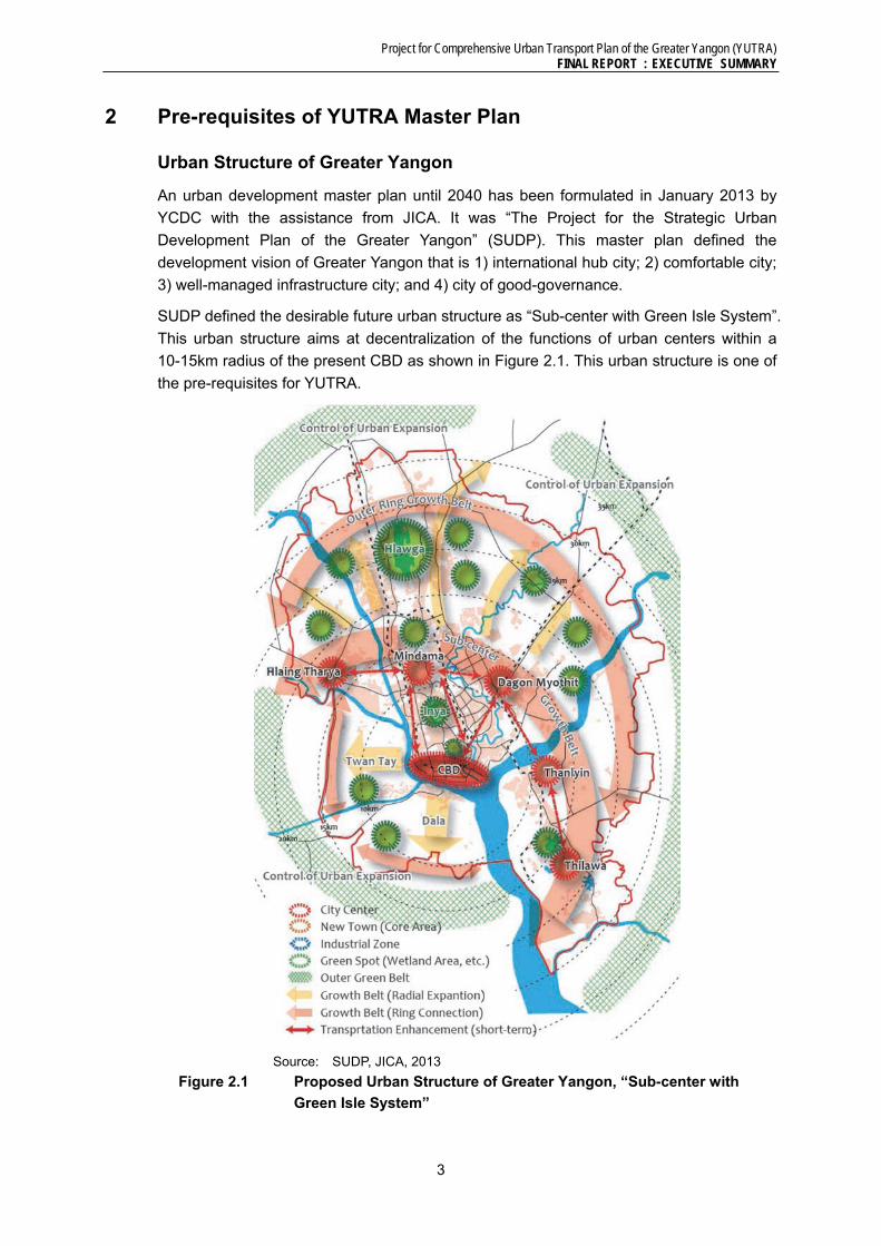
2 Pre-requisites of YUTRA Master Plan
Urban Structure of Greater Yangon
An urban development master plan until 2040 has been formulated in January 2013 by
YCDC with the assistance from JICA. It was “The Project for the Strategic Urban
Development Plan of the Greater Yangon” (SUDP). This master plan defined the
development vision of Greater Yangon that is 1) international hub city; 2) comfortable city;
3) well-managed infrastructure city; and 4) city of good-governance.
SUDP defined the desirable future urban structure as “Sub-center with Green Isle System”.
This urban structure aims at decentralization of the functions of urban centers within a
10-15km radius of the present CBD as shown in Figure 2.1. This urban structure is one of
the pre-requisites for YUTRA.
Source: SUDP, JICA, 2013
Figure 2.1 Proposed Urban Structure of Greater Yangon, “Sub-center with
Green Isle System”

Project for Comprehensive Urban Transport Plan of the Greater Yangon (YUTRA) FINAL REPORT : EXECUTIVE SUMMARY
4
Socio-Economic Framework and Future Transport Demand
Based on the past trends, future land use planned by SUDP, national framework estimated
by The Survey Program for the National Transportation Development Plan in the Republic
of the Union of Myanmar (MYT-Plan, JICA, 2013) and a series of GIS analyses, future
socio-economic framework, including nighttime/daytime population, number of workers by
industry, number of students, average household income and car ownership ratio, was
prepared by traffic zone in YUTRA1.
Travel demand estimates were made for a single urban development scenario as
stipulated by the JICA SUDP study. The estimate of travel demand is summarised in Table
2.1.
The table reflects a rapid growth in travel demand with almost constant population growth
rate of just over 2.4% per annum. The demand forecast growth in trip rate is reflective of
rapid growth in mechanised trips. The high growth in mechanised trips is caused by
increase in vehicle owning household from some 12% of the population to over 34% of all
households by 2035. The mechanised person trips are forecast to almost double from 4.9
million trips in 2013 to 9.5 million trips by 2035. The tendency of household to use the
vehicle for all trips, by all members of the household, once a vehicle is available. This is a
common phenomenon in the developing countries, where purchase of a vehicle is major
step towards ‘status’ in the society, and then its maximum use is inevitable as there is
various restraints (parking availability/charges, road user charges, etc.).
Table 2.1 Growth in Total Travel by All Modes, Person Trips (‘000)
Description 2013 2018 2025 2035
Walk 4,778 5,238 6,072 7,403
Bicycle 1,472 1,661 1,981 2,704
Mechanized 4,935 5,862 7,185 9,477
% of mechanized 44.1% 45.9% 47.2% 48.4%
Total Trips 11,185 12,761 15,238 19,584
Population 5,716 6,437 7,616 9,712
Trip Rate (No. of Trips/person/day) 1.96 1.98 2.00 2.02
Source: YUTRA Project Team
The next stage in the demand forecast process is to distribute the estimated trip ends
between origin and destinations. The resulting trip distribution patterns are illustrated by
the desire-line diagrams for base and forecast years in Figure 2.2. It is evident that the
demand for travel from the new town centers spread around the central core of the Yangon
City would grow considerably.
Travel demand to and from areas outside the YUTRA area (External Trips) was estimated exogenously, and added to the above described estimated demand. The forecast external travel demand was then compared with the MYT-Plan, and controlled to the MYT-Plan travel demand to/ from Yangon and those pass through YUTRA area by private and public mode also for the goods vehicles.
1 156 zones in the study area. See Chapter 3, YUTRA Final Report Vol I.

Project for Comprehensive Urban Transport Plan of the Greater Yangon (YUTRA) FINAL REPORT : EXECUTIVE SUMMARY
5
Source: YUTRA Project Team
Figure 2.2 Current and Forecast Trip Distribution Patters in YUTRA Areas
Table 2.2 summarises the total travel demand in the study area by mode of travel and by commercial vehicles. In 2035, total travel demand is twice as high as 2013. Especially that of Car & Van increases rapidly in 4.3 times as high. On the other hand, the number of bicycle and motorcycle trips decreases between 2013 and 2018. It is because passengers would use public transport more for long travel instead of two-wheelers as the road network being developed.
Table 2.2 Total Travel Demand in YUTRA Study Area
Source: YUTRA Project Team
Total Trips 2013 2018 2025 20352013-2018
2018-2025
2025-2035
2013-2018
2018-2025
2025-2035
Bicycle 598,500 422,900 504,200 688,900 -29.3 19.2 36.6 -6.7 2.5 3.2
Motorcycle 304,500 208,200 246,100 320,300 -31.6 18.2 30.2 -7.3 2.4 2.7
Car & Van 628,400 1,201,300 1,771,300 2,728,000 91.2 47.4 54.0 13.8 5.7 4.4
Taxi 595,000 756,200 909,200 1,173,100 27.1 20.2 29.0 4.9 2.7 2.6
Bus / Train/ Ferry 3,065,900 3,915,400 4,560,400 5,672,600 27.7 16.5 24.4 5.0 2.2 2.2
Total Person Trips 5,192,300 6,504,000 7,991,200 10,582,900 25.3 22.9 32.4 4.6 3.0 2.8
% by Public (Taxi, Bus, Ferry & Train)
70.5 71.8 68.4 64.7
Goods Vehicle PCU 110,900 151,200 205,200 301,600 36.3 35.7 47.0 6.4 4.5 3.9
Summary of Trip Totals by Mode (Inter-zonal) % Growth % Growth p.a.

Project for Comprehensive Urban Transport Plan of the Greater Yangon (YUTRA) FINAL REPORT : EXECUTIVE SUMMARY
6
Budget Envelop
Various international institutions projected long-term economic growth for Myanmar,
subject to major reforms in macro-economic systems. The following growth scenarios
were formulated:
(i) Scenario 1: High Growth - This scenario is based on McKinsey forecast an
average GDP growth of 7.7% per annum with seven economic sectors driving
national economic development. Myanmar Government also proposes this
scenario under the approved first five-year national development plan for
FY2011/12 to 2015/16.
(ii) Scenario 2: Medium Growth - In this scenario, the annual GDP growth rate will be
about 7% as estimated by IMF and based on the ADB forecast of 7%-8% growth in
its report entitled “Myanmar in Transition”.
(iii) Scenario 3: Low Growth - This scenario is based on the IMF’s debt sustainability
analysis of Myanmar in 2013. In the IMF analysis, annual GDP growth rates from
2014 to 2031 are set at 6.0%.
After estimating the public investment and transport sector allocation for the entire
Myanmar, transport sector budget envelope was estimated. For FY2011/12 to FY2012/13,
Yangon Region’s economic contribution was about 22% of the country’s GDP. In the
Interim Report (2013) of the MYT-Plan, the GRDP estimates of Yangon Region are: 25%
in the medium-term and 30% in the long-term.
On this basis, the Greater Yangon transport budget envelopes are assumed to be equal to
the GRDP estimates. Table 2.3 presents the expected budget allocation for Greater
Yangon transport requirements. The estimated budget envelope limits the total cost
of all projects proposed by YUTRA. Plans that greatly exceed the budget
envelope is judged unrealistic.
Table 2.3 Greater Yangon Transport Sector Budget Envelopes
(US$ Billion at 2013 Prices)
Fiscal Year Greater Yangon Transport Investment High
(McKinsey) Medium (ADB)
Low (IMF)
FY2014-2017 2.748 2.702 2.637 FY2018-2025 8.675 8.234 7.656 FY2026-2035 21.314 19.048 16.252
Source: YUTRA Project Team
3 YUTRA Overall Transport Development Strategy
Future Yangon should be livable as well as globally competitive and attractive for
industries, leading Myanmar’s international trade, and the transport sector must be
designed to make this a possibility. The overall goal of urban transport is the following:
“Ensure mobility and accessibility to urban services that are vital for the people and the
society, by providing a transport system characterized by safety, amenity, and equity and

Project for Comprehensive Urban Transport Plan of the Greater Yangon (YUTRA) FINAL REPORT : EXECUTIVE SUMMARY
7
sustained by an efficient public transport system”.
A combination of supply-type and demand-type strategies is required to maintain the
present advantage of high modal share of public transport of more than 60%. YUTRA has
identified a series of transport development strategies as stated below in Table 3.1. The
main focuses or features of the Master Plan exist on the following points:
1. Strengthening of Public Transport: development of sustainable public transport
system, taking advantage of the present high share of public transport trips.
2. Improvement of Regional Competitiveness of the City: Construction of efficient
transport system that supports 10-million multi-core hub city.
3. Realization of Well-managed Environment-friendly City: introduction of innovative
institutional/operational schemes that enables world-class transport integration with
living environment.
4. Adoption of Immediate Congestion Mitigation Measures: implementation of less
expensive measures against traffic congestion that brings quick outcome.
In YUTRA, the following eight objectives were established with identified transport
development strategies. The inter-relationship between these objectives and the identified
strategies is illustrated in Figure 3.1.
Table 3.1 Identified transport development strategies
A. Promotion of Social Understanding about Urban Transport Problems and Issues
A1. Conduct of consecutive transport campaigns; A2. Expansion of transport education; A3. Strengthening of transport studies; A4. Information disclosure.
B. Effective Management of Urban Growth and Development
B1. Policy coordination within the Greater Yangon area; B2. Authorization of City and Transport Master Plans; B3. Development of hierarchical road network and road
classifications to guide design (and parking provision); B4. Promotion of integrated urban and transport development,
particularly Transit-Oriented Development (TOD). C. Promotion and
Development of Attractive Public Transport
C1. Development of a hierarchal mass transit system; C2. Early introduction of an integrated public transport system
(BRT) in the effort to maintain public transport share; C3. Upgrading the present rail system; C4. Development and improvement of bus transport system,
including reform of management systems and the business model;
C5. Promotion of public transport use and expansion of services.
D. Efficient Traffic Control and Management
D1. Establishment of comprehensive traffic management system balanced with better facilities for essential NMT modes such as cycling and walking;
D2. Strengthening of traffic regulation, enforcement and management;
D3. Management of freight transport; D4. Establishment of parking policy and controls; D5. Development of well-coordinated traffic control system.
E. Effective Transport Demand Management
E1. Integrating urban development and transport (TOD); E2. Providing efficient public transport alternatives;

Project for Comprehensive Urban Transport Plan of the Greater Yangon (YUTRA) FINAL REPORT : EXECUTIVE SUMMARY
8
(TDM) E2. Regulating motorized vehicle access and proper charging of road use and parking.
F. Comprehensive Development of Transport Space and Environment
F1. Improvement of a safe transport environment for pedestrians and cyclists;
F2. Redistribution of transport space and improvement of traffic environment in the city centre;
F3. Establishment of township transport development strategy.
G. Enhancement of Traffic Safety
G1. Establishment of traffic safety audit system; G2. Elimination of traffic accident black spots; G3. Improvement of licensing and vehicle inspection system; G4. Strengthening of traffic enforcement system; G5. Strengthening of first aid response system.
H. Strengthening of Transport Sector Administrative and Management Capacities
H1. Reform of transport- related organizations; H2. Promotion of private sector participation; H3. Strengthening of planning and management capacity; H4. Securing of development funds.
Source: YUTRA Project Team
Source: YUTRA Project Team
Figure 3.1 Main Features and Strategies of YUTRA Master Plan

Project for Comprehensive Urban Transport Plan of the Greater Yangon (YUTRA) FINAL REPORT : EXECUTIVE SUMMARY
9
4 MASTER PLAN 2035
Strengthening of Public Transport
To cope with the forecast future traffic demand, YUTRA proposes the introduction of public
transport network that integrates Myanmar Railway lines, proposed Urban Mass Rapid
Transit (UMRT) lines, medium capacity transit such as Bus Rapid Transit (BRT) and the
conventional bus. The advantage of mass transit such as high capacity, high operating
speed and low environmental load should be maximized. The target modal share is over
60 % out of which 20% or more should be shouldered by mass transit such as UMRT,
Myanma Railway and BRT.
BRT: In order to maintain the present high share of public transport (about 61 % except for
walk), BRT should be developed and introduced at an early stage. The network of existing
buses should be reviewed and rationalized. The number of planned BRT routes is 11 and
the total route length and road length is 244.9 km and 127.9 km, respectively. BRT network
and image are shown in Figure 4.1 and Figure 4.2.
Source: YUTRA Project Team
Figure 4.1 Proposed BRT routs (Master Plan)
Source: YUTRA Project Team
Figure 4.2 Image of BRT
Myanmar Railway: Stations, tracks, trains and operation of the existing Myanmar
Railway (MR) urban sections should be modernized in the short term to improve travel
speed, safety and comfort. The effect will be immediate because the area alongside the
railway is already urbanized with a high population density. Moreover the project cost is
inexpensive due to the use of existing assets. Transit Oriented Development (TOD) should
be pursued for the integrated development of the railway, station and related areas so that
the station area becomes attractive socially and commercially.
For short-term (2013-2018), it is planned to enhance transport capacity of V shape line
connecting Danyingone station with Ywa Tar Gyi station via Yangon Central station by
improving Yangon Circular Railway Western Half and Yangon-Mandalay Line. In addition,
yard redevelopment projects along these lines will be conducted in parallel in order to
increase railway user and enhance ability to attract customers. Furthermore, relocation
and integration of existing depots and workshops, which is required in connection with
yard development, will be implemented simultaneously.

Project for Comprehensive Urban Transport Plan of the Greater Yangon (YUTRA) FINAL REPORT : EXECUTIVE SUMMARY
10
For middle-term (2018-2025), it is planned to improve the remaining sections of the
existing lines (Yangon Circular Railway Eastern Half, Yangon-Pyay line suburban section,
Thilawa access line), and to conduct projects for yard redevelopment and land
development along these lines in parallel in order to fulfill further increasing railway user
and enhancing ability to attract customers. Expansion of the new integrated depot and
workshop will be implemented simultaneously in connection with yard development.
For Long-term (2025-2035), it is planned to electrify and partially elevate existing lines
which were improved as first step in short or middle term, in order to fulfill further transport
capacity enhancement and speed-up, and reducing operation cost.
UMRT: UMRT Line1 which is named as North-South Line connecting CBD with Yangon
International Airport via Yangon Central station and Mindama sub-center will be installed
as first metro in Yangon. In order to minimize initial cost, it is planned underground section
is minimized as much as possible, and elevated section is applied maximally. The
construction of UMRT1 should be completed in the middle-term (2025). In long-term,
UMRT Line2 is installed as East-West axis with 26.0km length.
Proposed project location maps for short-, middle-, and long-term are shown in Figure 4.3.
As to the conventional bus system, service improvement projects should be implemented
in the short-term, including bus network rerouting, service enhancement, development of
terminals and transfer stations, and prioritization of bus traffic, in order to solve the present
problems.
Source: YUTRA Project Team
Figure 4.3 Proposed Project Networks for Short-, Middle-, and Long-term
Improvement of Regional Competitiveness of the City
Yangon, one of the major metropolises in the Southeast Asia, must compete with other
cities such as Bangkok, Jakarta and Manila, and needs to build a unique position socially
and economically. Thus Yangon must grow as a multi-core city that has regional hub
functions satisfying global standards in terms of transport infrastructure and services.
Road: Road infrastructure should be developed to meet the increase of future traffic

Project for Comprehensive Urban Transport Plan of the Greater Yangon (YUTRA) FINAL REPORT : EXECUTIVE SUMMARY
11
demand. Construction and improvement of arterial roads is essential. Urban expressway
should be constructed strategically.
YUTRA master plan should pursue the following targets; average volume/capacity ratio is
less than 0.5 in 2035 (about 0.3 at present), average travel speed is more than 20 kph in
2035 (about 30 kph at present), and is fully equipped with facilities to improve mobility,
accessibility, comfort and safety.
In the short-term (2013-2018), road network planning aims to promote distribution of urban
functions to the north and the east, and to improve accessibility to/from the Thilawa
industrial area, as well as to detour the truck routes from the CBD. In the middle-term
(2018-2025), YUTRA aims to support urban development toward the north and the east, to
accelerate development of sub-centers such as Thilawa, Dagon Myothit, Hlaing, and
Tharaya, and to extend arterial roads to the new town centers such as Hlegu, Hmawbi,
and East Dagon. In the long-term (2025-2035), expansion of urban functions to the west
and the south and extension of the arterial road network to new town centers including
Thanlyin, Dala, Twanty and Htantabinare is proposed. (See Figure 4.4)
Expressway: Construction of a north-south section of the Inner Ring Road (expressway),
where traffic demand is large, is planned in the middle-term. Also the eastern half of the
Outer Ring Road (expressway) is planned in the middle-term to form the national
north-south freight corridor by improving the access to/from Thilawa. The Inner Ring Road
will be completed in the long-term with its connector to the west. (See Figure 4.5 and
Figure 4.6)
Source: YUTRA Project Team Figure 4.4 Arterial Road Network by Target Year
Source: YUTRA Project Team Figure 4.5 Expressway Network (Ultimate)

Project for Comprehensive Urban Transport Plan of the Greater Yangon (YUTRA) FINAL REPORT : EXECUTIVE SUMMARY
12
Source: YUTRA Project Team
Figure 4.6 Image of Inner Ring Road (Expressway)
TOD: Transit Oriented Development (TOD) should be implemented near major railway
stations taking advantage of the existing property of the government including Myanmar
Railway. TOD projects aim to improve the convenience and comfort of public transport
users and to promote people to use public transport more, as well as to enhance land use
efficiency (see Figure 4.7). TOD has a great economic potential and is expected to yield a
large profit as a potential financial source also for transport development. Both Union and
Yangon Region Government should identify candidate sites such as Yangon Central
Station and promote TOD projects.
Source: YUTRA Project Team Figure 4.7 Image of TOD at the Yangon Central Station
Optimization of Management
YUTRA has proposed management projects in the field of traffic management, traffic
demand management (TDM), education and institutional improvement. Their objective is
to promote the use of public transport by restraining the use of private modes such as
Project for Comprehensive Urban Transport Plan of the Greater Yangon (YUTRA) FINAL REPORT : EXECUTIVE SUMMARY
13
passenger cars. The final target is to construct a public transport oriented society.
Yangon CBD Traffic Congestion Mitigation Project: Objective of the project is to
mitigate traffic congestion with comprehensive measures including physical improvement,
management enhancement and public relations activities. Project components are;
modernization of the signal system, removal of on-street parking from congested road
sections, provision of sufficient number of off-road parking spaces to less-congested
sections , introduction of parking fee charging system (including parking meter), removal of
street vendors from sidewalk, development of hawker centers, and improvement of
pedestrian environment, provision of bus-bays and taxi-bays, and implementation of
Mobility Management and transport Demand Management (TDM measures).
Major Roads Traffic Congestion Mitigation Project: This project tackles the existing
congestion problems on the main roads with comprehensive measures to provide a
smooth and safe traffic flows. Project components are; installation and upgrading of traffic
signal control system, improvement of intersection geometries, installation of road signs,
pavement marking, installation of traffic monitoring system, provision of pedestrian bridges,
and development of bus interchanges/stops.
Yangon Parking Development Project: Parking development and control is generally
difficult to implement because it incurs disputes among stakeholders due to its complex
implications with people’s daily behavior. YUTRA proposes as the first step to collect
various data and to formulate a Parking Master Plan. The data should cover present
parking use, parking demand and laws/regulations. Plan will include sites for new public
parking development, technical guideline, basic design, cost, operation/maintenance and
legal/institutional arrangements. The second step is the implementation of this plan.
Traffic Safety: Currently, there is no proper organizational setup for the comprehensive
traffic safety intervention. Only traffic police is playing the role through ad-hoc enforcement
activities. The first step is to formulate a 5-year traffic safety program. This five-year
program aims (1) to develop an institution for the comprehensive traffic safety activities
including establishment of Traffic Safety Committee, and (2) to implement a series of traffic
safety activities. The second step includes development of traffic accidents database,
implementation of traffic safety projects and capacity development of related organizations
including the Traffic Safety Committee.
Capacity Development on Traffic Planning and Management: Traffic management
policy is one of the significant urban transport policies to enhance the efficiency of road
network system and to control traffic demand. However, there is no specialized
organization responsible for the traffic management in Yangon. This project aims to
establish 'Traffic Planning and Management Unit' under Engineering Department of YCDC
and to enhance their knowledge and implementation capabilities (This unit is assumed to
be a part of the proposed YUTA later). Furthermore, comprehensive traffic database on
traffic volume, vehicle registration and so on should be developed in order to grasp and
analyze traffic condition changing every moment.
BRT Agency (BRTA): BRT will shoulder an important role to maintain the present high
modal share of public transport in the future. YUTRA proposes to establish a BRT Agency
(BRTA) that will be responsible for planning and managing the BRT network. BRTA

Project for Comprehensive Urban Transport Plan of the Greater Yangon (YUTRA) FINAL REPORT : EXECUTIVE SUMMARY
14
requires a number of new human resources from inside/ outside of Myanmar Government.
Yangon Urban Transport Authority (YUTA):The purpose of establishing YUTA is to
provide such a strategic policymaking umbrella to improve coordination of urban
development and transport and to improve planning within urban transport itself. YUTA
could be an agency that can take various technical/ financial supports from international
donors. It is essential to support the establishment of YUTA by providing a regulatory
authority under the Urban Transport Department of Ministry of Railway Transportation
(MORT) that make a decision on the planning regarding YUTA and ensure the budget for
YUTA, etc.
5 Project Cost and Evaluation
Project Cost
The total amount of all proposed projects’ cost is about 24.8 billion USD as of 2013. It
includes the cost that private sector can pay in Public Private Partnership (PPP) scheme.
Thus, the cost to the Myanmar Government is estimated to about 16.3 billion USD or about
2/3 of the total amount as shown in Table 5.1.
On the other hand, the cost does not include their original maintenance cost such as
required investment to infrastructures in local areas or the cost of rolling stocks. Assumed
that those cost accounts for 60% of the transport sector’s budget, the Myanmar
Government can bear only 60 to 80 % of the cost of Master Plan. (See Table 5.2)
For this reason, the Myanmar government needs to find a new source of revenue
aggressively. The most potential fund sources is surplus revenues from on-/off-street
parking operation and urban expressways, and profit of TOD together with effective use of
unused government lands, and traffic impact assessment fees.
Project Evaluation
Economic Evaluation: The range of EIRRs for the BRT projects were high, 15% to 31%.
Railway projects also recorded enough level of EIRRs, which were 13-19% for Yangon
Circular Railways projects, 12-13% for UMRT projects, 15% over for the suburban line
projects. Quite high EIRRs were recorded for many of road development projects, and the
overall EIRR of this sector was 27%. Especially, the EIRRs of a new bridge construction
project and improvement of arterial road project were higher than 30%.
Environmental Evaluation:Among the five project types (Road, BRT, Bus, Railway and
Traffic Management), railway and traffic management projects have higher scores, while
road projects are lower scores. This is mostly due to contribution of lower scores by criteria
of air pollution and global warming, which are lower values of rating for road project.

Project for Comprehensive Urban Transport Plan of the Greater Yangon (YUTRA) FINAL REPORT : EXECUTIVE SUMMARY
15
Table 5.1 Investment Requirement for Major Master Plan Projects
Sector Category
Estimated Cost (USD Mill.)
Cost to Government (USD Mill.)
Short-term 2014-2018
Med-term 2019-2025
Long-term 2026-2035
% to Capital
Short-term 2014-2018
Med-term 2019-2025
Long-term 2026-2035
Public Transport
MR Lines Upgrading and Capacity Development
629 1,874 2,778 100 629 1,874 2,778
UMRT Development
0 2,253 3,423 100 0 2,253 3,423
TOD/Depot Relocation
4,026 2,684 0 0 0 0 0
BRT Development
472 0 0 55 212 0 0
Bus Transport 108 0 0 - 78 0 0Sub-Total 5,235 6,811 6,201 - 919 4,127 6,201
Road
Arterial Roads and Bridges
253 1,516 1,049 100 253 1,516 1,049
Expressways 0 1,591 1,700 30 0 477 510Traffic Control/ITS, etc.
33 26 26 - 15 26 26
Sub-Total 286 3,133 2,776 - 268 2,019 1,585
Traffic Manage
ment
Congestion Management
157 0 0 - 17 0 0
Traffic Safety 22 0 0 - 20 0 0Sub-Total 179 0 0 - 37 0 0
Freight Transport
Truck Terminal 0 150 0 0 150 0Sub-Total 0 150 0 - 0 150 0
TOTAL 5,700 10,094 8,977 - 1,224 6,296 7,786Source: YUTRA Project Team
Table 5.2 Investment Requirement vs. Fund Availability
Item Amount (USD Bill.)
Short-term
2014-2018
Med-term
2019-2025
Long-term
2026-2035
Total for MP
Period
(1) Investment Requirement for Master Plan (Cost to Government)
1.2 6.3 7.8 15.3
(2) Budget Envelope (Low-High Case) a. Transport Sector Total b. 40% of Transport Sector Total (excluding
cost for maintenance, secondary road and other local transport facility development, and vehicles, etc.)
2.6-2.7
1.05-1.10
7.7-8.7
3.1-3.5
16.3-21.3
6.5-8.5
26.5-32.7
10.6-13.1
Source: YUTRA Project Team
6 RECOMMENDATIONS
1) Authorize and get this master plan approved by the concerned agencies of both Union
and Region government, and disseminate its contents to all stakeholders.
2) Setup Yangon Urban Transport Authority (YUTA) to make decisions on various
transport projects. Allocate implementation responsibilities by project clearly to
government agencies. The proposed YUTA will oversee and monitor the
implementation of these projects. The establishment of YUTA is crucial for Yangon to
have the basis to absorb various types of technical and financial assistance from

Project for Comprehensive Urban Transport Plan of the Greater Yangon (YUTRA) FINAL REPORT : EXECUTIVE SUMMARY
16
donor organizations.
3) Raise funding capability of the government by seeking various additional revenue
sources and optimising current revenue sources under the institutional arrangements
of the government. The most feasible fund source seems to exist in the TOD (Transit
Oriented Development). Since the Government has a number of vast unused land lots
in strategic places in Yangon, this could be a good seed for launching “urban cum
transport” development projects where cross-subsidy can be expected from urban
development (business/commercial/residential) to public transport development.
Some of other initiatives that could be expanded further in Yangon could include the
revenue from the proposed parking development and restriction.
4) Take necessary actions as soon as possible to launch the short-term projects
proposed in the master plan. Particularly for those projects that needs feasibility study
or prior coordination among relevant organizations, initiatives from the Myanmar
government to donor or other related organizations should be exerted immediately.
5) Regarding the proposed BRTs, future patronage will change depending on the
development progress of the proposed UMRTs or MR lines. In this case, the affected
BRT should adjust its operation. Its disused road space could be reconverted to
carriageway for other vehicles, or more preferably, the space could be converted to
green promenade for pedestrians and cyclists taking into account the future vision of
Yangon.
6) In this master plan, the toll rate for expressway was assumed to be the same as the
current level of Yangon-Mandalay expressway, and the fare of Myanmar Railway lines,
UMRTs and BRTs was set at the current level as well. Although the rate was assumed
to increase in the future in proportion to per capita GDP, it is still very low compared to
the international level and the level cannot be raised easily due to the sensitive
elasticity of demand against toll/fare rate. This is one of the reasons of the poor
financial performance revealed in Section 6.3 of this report. Considering the
promotion of private sector participation and the possible magnitude of public subsidy,
however, the toll/fare rate should be carefully looked into in the feasibility study.
7) This master plan assumes that “normal” situation will continue for a long period of time
(20 years or more). If abnormal situation occurs, such as long financial panic and war,
this master plan cannot be used and will lose its validity. On the contrary, this master
plan could be updated periodically if normal situation continues and a series of traffic
surveys are conducted again (except for the person-trip survey, in principle). The
conclusion and methodology of the master plan could be handed over to the future
with periodical updating (basically every 5 years).

Project for Comprehensive Urban Transport Plan of the Greater Yangon (YUTRA) FINAL REPORT : SUMMARY
1-1
1 INTRODUCTION
1.1 Study Background and Objectives
Yangon City, with a population of about 5.1 million as of 2011, is the largest economic center
of the nation, and experiences rapid urbanization and motorization as the nation’s economic
growth. The current rapid urbanization and motorization put more and more pressure on
the existing transport infrastructure in Yangon City and its surrounding areas. The
deteriorating urban transport situation has become a serious concern socially, politically
and environmentally.
Under these circumstances, JICA conducted a fact-finding survey in March 2012 and
reviewed present conditions of Yangon city and its surrounding areas. This survey
suggested the need of a comprehensive urban development plan of the Greater Yangon,
which covers not only Yangon City but also adjoining townships affected by the current
urbanization. Based on this finding, Yangon Region Government and JICA agreed to launch
a project named “The Greater Yangon Urban Development Programme” in May 2012.
Under the framework of this Programme, “The project for Strategic Urban Development
Plan of the Greater Yangon (SUDP)” started in August 2012 focusing mainly on the urban
development and land use aspects of the Yangon City. As the next step following this project,
Yangon Region Government and JICA agreed in September 2012 to start this project
named “The Project for Comprehensive Urban Transport Plan of the Greater Yangon
(YUTRA)” to prepare a comprehensive urban transport plan in line with the above-
mentioned strategic urban development plan, so as to provide efficient, safe, comfortable
and environmentally friendly transport services to the people in the Greater Yangon, in order
to contribute to its balanced, inclusive and sustainable growth.
1.2 Study Objectives
The objective of this project is to ensure mobility and accessibility to urban services for the
Greater Yangon’s people and society by an efficient and sustainable public transport system
and road network. For this objective, this project aims to formulate an urban transport
master plan for Greater Yangon up to the year 2035 (the long-term target year of “The
Project for the Strategic Urban Development plan of the Greater Yangon” was 2040, but its
project identification was up to 2035) as well as to conduct pre-feasibility studies for
identified priority projects. Capacity development for Myanmar counterpart staff was done
during the course of the project.
The outputs of the Project are:
(1) A comprehensive urban transport plan of the Greater Yangon, which includes a
long term plan until 2035, a mid-term plan until 2025, and a short-term action
plan until 2018;
(2) Pre-Feasibility Study for the prioritized project;
(3) Lessons from implementation of the pilot project;
(4) Technology transfer to Myanmar counterparts through the Project;
In this Project, the prioritized project mentioned above was “The Feasibility Study for the
Project for Construction of New Thaketa Bridge”. This was selected from the short-term

Project for Comprehensive Urban Transport Plan of the Greater Yangon (YUTRA) FINAL REPORT : SUMMARY
1-2
projects identified by SUDP due to its urgent needs for reconstruction of the obsolete bridge.
The pilot project was identified as intersection improvement at the “8-mile Intersection”. This
location was selected from a number of congested intersections after traffic surveys and
analyses.
1.3 Study Area
The target site of the Project is the Greater Yangon including Yangon City and a part of
adjacent six townships (Thalyin, Hmawbi, Helgu, Htantabin, Twantay and Kyauktan). The
total area is about 1,500 km2 and the total population is about 5.7 million as of 2013. The
Study Area is presented in Figure 1.3.1.
Source: YUTRA Project Team
Figure 1.3.1 YUTRA Study Area
Project for Comprehensive Urban Transport Plan of the Greater Yangon (YUTRA) FINAL REPORT : SUMMARY
1-3
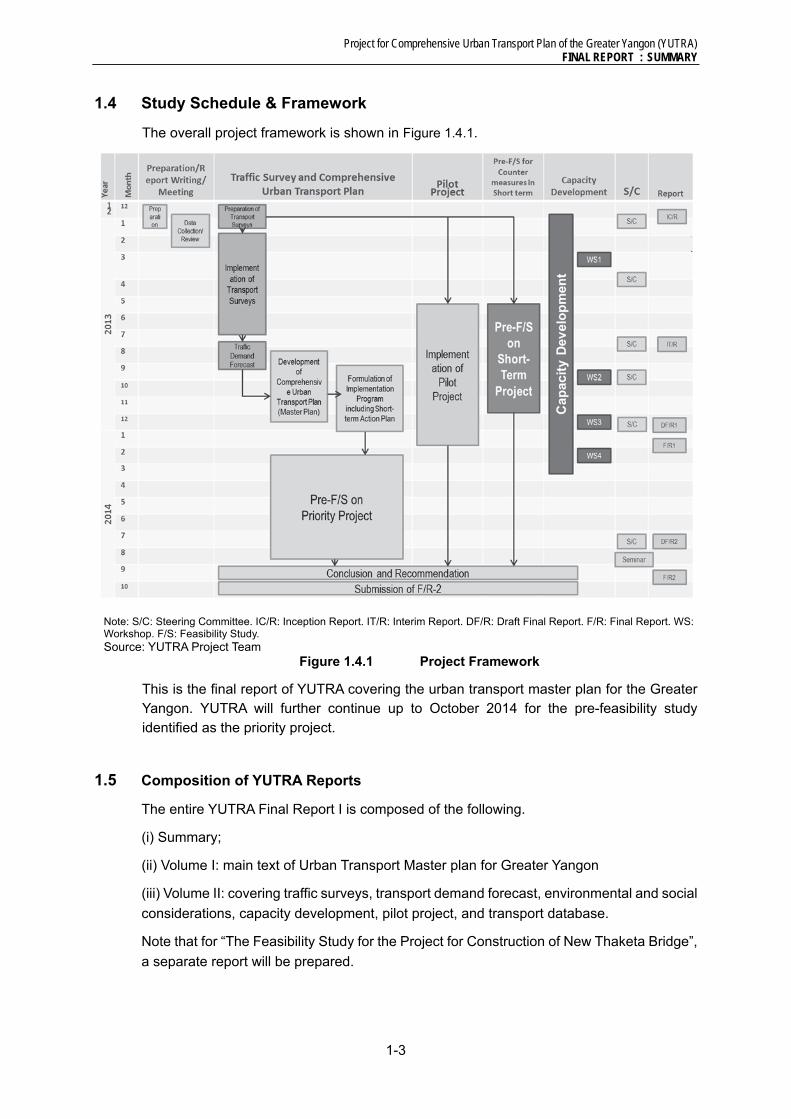
1.4 Study Schedule & Framework
The overall project framework is shown in Figure 1.4.1.
Note: S/C: Steering Committee. IC/R: Inception Report. IT/R: Interim Report. DF/R: Draft Final Report. F/R: Final Report. WS: Workshop. F/S: Feasibility Study. Source: YUTRA Project Team
Figure 1.4.1 Project Framework
This is the final report of YUTRA covering the urban transport master plan for the Greater Yangon. YUTRA will further continue up to October 2014 for the pre-feasibility study identified as the priority project.
1.5 Composition of YUTRA Reports
The entire YUTRA Final Report I is composed of the following.
(i) Summary;
(ii) Volume I: main text of Urban Transport Master plan for Greater Yangon
(iii) Volume II: covering traffic surveys, transport demand forecast, environmental and social
considerations, capacity development, pilot project, and transport database.
Note that for “The Feasibility Study for the Project for Construction of New Thaketa Bridge”,
a separate report will be prepared.

Project for Comprehensive Urban Transport Plan of the Greater Yangon (YUTRA) FINAL REPORT : SUMMARY
1-4
1.6 Project Organization
Figure 1.6.1 presents the project organization of YUTRA. The Joint Project Team is a
combination of Myanmar Working Group (counterpart staff) and JICA Project Team.
Figure 1.6.1 Project Organization of YUTRA
GOM GOJ
JICAYangon Region Government
Program Coordinating Committee
Steering Committee
Joint Project Team
Working Group (Counterpart Staff) from Myanmar Side
JICA Project Team

Project for Comprehensive Urban Transport Plan of the Greater Yangon (YUTRA) FINAL REPORT : SUMMARY
2-1
2 CURRENT TRANSPORT SITUATION, PROBLEMS AND ISSUES
2.1 General
Urban growth is mainly observed on the north direction from the CBD because Yangon is
surrounded by the river on three sides until 1980s, but after 1990s, the urbanization is
extended to east-west axis also. Industrial area has been mixed in the residential area, but
they have been relocated to the east and north, and west of the Hlaing River after 1990s.
Population in YCDC is 5.1 million and average annual growth rate in YCDC is 2.6%.
Population density in the CBD is very high, 36,500 persons/km2. About half of the residents
is working (Refer to Table 2.1.1)
Table 2.1.1 Implementation Schedule of Public Transport Projects
Township
Population Density(000 pers./ km2)
Area (km2)
No. of Workers
1998 2011 Annual Growth’98-‘11
Total Workers
% to Total Pop.
CBD 255,685 252,391 -0.10% 36.5 6.9 118,297 46.9%Inner City 689,081 778,156 0.94% 15.7 49.4 559,800 71.9%Outer City 598,436 596,426 -0.03% 17.4 34.2 265,464 44.5%Old Suburb 1,386,581 1,803,129 2.31% 5.2 345.1 1,048,538 58.2%New Suburb 687,098 1,642,030 6.93% 4.1 404.9 575735 35.1%YCDC Total 3,691,941 5,142,128 2.58% 6.2 829.0 2,611,977 50.8%Periphery Total N.A. 430,114 - 0.6 706.8 N.A. -Study Area Total N.A. 5,572,242 - 3.6 1,534.9 N.A. -
Source: SUDP, JICA (2013)
So far, since the per capita GDP is still low and import of foreign cars has been regulated
by the government, car ownership rate in Myanmar, has been kept low. However, to
facilitate the renewing of the old vehicle, deregulation is performed from September 2011.
Then, new vehicle registration is rapidly increasing in Yangon (refer to Figure 2.1.1).
Source: Road Transport Administration Department, As of July 4, 2013
Figure 2.1.1 Registered Motor Vehicles by Type in Yangon Region
0
50000
100000
150000
200000
250000
300000
350000
400000
No.
of R
egis
tere
d M
otor
Veh
icle
s
Passenger* Truck (Light Duty) Truck (Heavy Duty) Bus
Other Two Wheeler Three Wheeler Trawlergi

Project for Comprehensive Urban Transport Plan of the Greater Yangon (YUTRA) FINAL REPORT : SUMMARY
2-2
2.2 Main Transport Components
Road
Current Road Network
The Greater Yangon is connected with the neighbouring countries of GMS (The Greater Mekong Subregion) and BIMSTEC (Bay of Bengal Initiative for Multi-Sectoral Technical and Economic Cooperation) through the Asian Highways (AH). Besides, the Yangon-Naypyitaw-Mandalay Expressway (586.2 km) became open in 2009, with 2 lanes per direction (total four (4) lanes) and the speed limit is at 100 km/hour. At present, no heavy trucks are allowed to use the expressway.
Road Length and Surface Conditions
Total road length in Myanmar is 148,690 km. In Yangon region, road length under MOC is 980 km, and under YCDC is 3,928 km. Figure 2.2.1 show the road length in Myanmar by responsible authority and by type of road surface. 54% of roads under control of MOC are still unpaved. On the other hand, 76% of roads under control of YCDC is paved.
(Roads administered by MOC) (Roads administered by YCDC)
Source: YUTRA Project Team, Department of Public Works, MOC, reported in 2012
Figure 2.2.1 Surface Condition of Roads under MOC and YCDC
Railway
Current Railway Network
Myanmar has total 5,878.16km railway network currently. Regarding the Study area, the
network is composed of 8 lines (148.3km, 80 stations), which are 3 main lines (total 95.9km
of Yangon Circular Railway, and urban sections of Yangon-Mandalay Main Line and
Yangon-Pyay Main Line) and 5 branch lines (52.4km) including 1 exclusively freight line
(9.9km). All three main lines except a part of Yangon-Pyay Main Line (86.3km) are double-
tracked. All branch lines are in single track. No lines are electrified.
All railway operation and management in Myanmar is conducted by Myanmar Railways
(MR) which is under the umbrella of Ministry of Rail Transportation (MORT). Railway in
the Study area is controlled by Division 7 in Lower Myanmar Administration of MR.
The average daily passenger number of Yangon Circular Railway and the Suburban Lines
is 90,620 pax/day in FY2011 and the daily number of operated train in the lines is 200
Concrete2%
Bituminous44%
Gravel15%
Metalled14%
Earth Road22%
Donkey3%
Paved:46%(Bituminous
/Concrete)
Unpaved:
54%Concrete32%
Bituminous44%
Gravel0.3%
Metalled12%
Earth Road12%
Unpaved:
24% Paved:76%(Bituminous
/Concrete)
Project for Comprehensive Urban Transport Plan of the Greater Yangon (YUTRA) FINAL REPORT : SUMMARY
2-3
trains/day. The fare for Yangon Circular Railway and the Suburban Lines is 100Kyat
(approx. USD 0.1) for 2 riding ticket bought at ticket window at getting-on station. The fares
was raised 20 Kyats into 100 kyats at November, 2011.
Main Issues
The current MR lines in the Study area is in poor operation service and low transport
capacity due to deteriorated infrastructures and lack of maintenance, etc., although there
is some demand that people want to use railway more. The maximum speed is
approximately 25 to 30km/hr even comparatively well maintained sections (Yangon-
Mandalay Main Line and Yangon-Pyay Main Line) in the Study area. Branch lines are in
poor condition and the speed is quite slow with approximately 5 – 10km/hr.
The peak hour is 7:00 to 9:00 in the morning (peak ratio: 11%) and 17:00 to 18:00 in the
evening (peak ratio: 17%). Four trains/hour (15 minutes interval) are operated in the peak
hour. 42% and 36% of railway passengers use railway for returning home and for working
respectively. Main means to access station is walking (72% of all) due to poor feeder service.
It is required to conduct continuous urban railway development including feeder service
enhancement.
Traffic Management and Safety
Current Traffic Situation
Traffic situation in the urban area in Yangon has deteriorated due to the rapid motorization
and insufficient signal operation among others. Cause of the congestion in CBD is more
complex including on-street parking, illegal parking, street vendors, too many buses on
duplicated bus lines, disordered bus parallel-parking queues which sometimes occupy even
two lanes around the major bus stops, in addition to the rapid motorization and insufficient
signal operation. On the other hand, in the outside of CBD, chaotic traffic situation can be
observed in major intersections due to the concentrated traffic flows on the limited road
network as well as insufficient signal operation.
Usage of Two-wheel vehicles is prohibited in the urban area, and NMV (non-motorized
vehicle) are limited to the CBD, and truck routes are designated to mitigate traffic
congestions in the urban areas. However, strict vehicle import regulation was eased in 2011
so that number of motorcars has increased rapidly in these days.
Main Issues
Lack of off-street public parking causes demand of on-street parking increase particularly
in CBD and major commercial area outside of CBD. Moreover many of vehicle owners do
not have sufficient space for their garage, thus they have no choice to park on the street.
Traffic accident has been a social issue in Yangon. The number of total accident generally
increased from 2008. Many accidents mainly involved buses and pedestrians. Particularly,
accident related to buses per 10,000 vehicles shows an extremely high number (i.e., 697.5
in 2011) due to their operation system to pick up/drop passengers on the road side, fast
driving speed and overloading passenger, etc. Traffic accidents in suburban area are
involving two wheel vehicles mainly lack of safety consciousness of the drivers.
Traffic signal is installed at the most major intersections but as mentioned above the

Project for Comprehensive Urban Transport Plan of the Greater Yangon (YUTRA) FINAL REPORT : SUMMARY
2-4
function is outdated. While pavement marking and road sings are almost properly installed,
the rainy season lasting for a long period and insufficient street sweeping deteriorate
pavement marking, which difficult to mention it is well-maintained condition. Safe crossing
with pedestrian signal or pedestrian bridge are very limited forcing people to cross in the
gaps of busy traffic flows with high accident risk.
Source: YUTRA Project Team
Figure 2.2.2 Congested
Intersections and Road Section
Source: YUTRA Project Team based on the data from Traffic Police
Figure 2.2.3 No. of Injured
Accidents per 10,000 vehicles
Public Transport Services
Existing Situations
Buses can be considered as the main workhorse of public transportation in Yangon Region.
Within Yangon City limits, it is illegal to drive trishaws, bicycles, and motorcycles. The bus
transport, therefore, would continue to remain as the main mode of public transportation
despite the facts that its level of service is not very satisfactory.
Currently bus services are provided through a multiplicity of mechanisms by a mix of public
and private sector operators. Generally, it can be categorized as 3 main groups in the
provision of bus services in Yangon Region. These are:
Private bus companies: The private bus companies are large-scale bus operators who
provide bus services with their own vehicles, drivers and conductors. At present, there
are two private bus companies in Yangon.
Individual private bus owners managed by Bus Supervisory Committees (BSC): BSCs
are non-government organizations. The committees do not engage themselves in any
bus service supply of their own vehicles rather they monitor and supervise bus
operation and individual bus operators. They employ dispatchers, route supervisory
staff and office staff. Their revenue comes mainly from the commission fee paid by
94.88
697.46
45.98
52.83
28.90
0.00 200.00 400.00 600.00 800.00
Taxi
Bus
Own Car
Container Car
Others

Project for Comprehensive Urban Transport Plan of the Greater Yangon (YUTRA) FINAL REPORT : SUMMARY
2-5
individual bus operators. Currently there are six BSCs in Yangon Region.
Bus Line Committees (BLC): BLCs are also non-government organizations and similar
function with Bus Supervisory Committees. There are 10 bus lines committees in
Yangon Region. There are total 18 BLCs and all are under the supervision of Yangon
Region Central Supervisory Committee for Motor Vehicles and Vessels (locally known
as Ma-hta-tha-Central).
Figure 2.2.4 shows existing and proposed bus terminal planned by DHSHD, MOC. The
location of proposed bus terminals is considered connection with future ring road. The
connection with railway network is also important. Detailed plan with a view to railway
network planned by YUTRA is required.
Source: DHSHD
Figure 2.2.4 Existing and Proposed Bus Terminals
Main Issues
Even though bus transport has a predominant share in people’s travel, levels of service are
not sufficient enough in terms of reliability of operation, comfort and safety. And bus related
facilities such as bus stop shelter, and seating facilities are also in poor conditions. Nearly
half of the commuters stated long waiting time and on-board crowding (SUDP, JICA, 2012).
Bus fare level is strictly regulated by the Yangon Region Government. The present bus fare
in Yangon is at lower levels for benefit of people. However, bus operators must follow this
government policy. Consequently, in order to maximize revenue from bus operation,
uncomfortable, unreliable and unsafe travel is resulted.
A poorly planned system results in bus route overlapping; add to traffic congestion as well
as on-road competition among the operators. The supply of buses does not keep up with

Project for Comprehensive Urban Transport Plan of the Greater Yangon (YUTRA) FINAL REPORT : SUMMARY
2-6
demand which leads to overcrowded on buses because of poor management of the fleets,
lower maintenance standard, vehicle wear out due to poor road condition, lack of supply of
spare parts and inadequate funds are available for fleet replacement.
Water Transport
Current Conditions
The main navigable inland waterways in Myanmar are composed of Ayeyarwady, Chindwin, Kaladan and Thanlwin systems, and these total network distance is 6,650 km. There are seven main inland waterway routes in the Study Area, namely Yangon River, Bago River, Hlaing River, Panhlaing River, Twante Canal, Pazundaung Creek and Khanaungto Creek. Inland waterway is the most fundamental transport mode in Myanmar.
IWT operates passenger ferry boats to/from CBD in the Yangon and plies five ferry routes, of which Pansodan Jetty-Dala Port Jetty Route is the main line to cross the Yangon River, and around 30,000 passengers (one-way) use ferry boats daily. The Study Team conducted passenger OD survey to obtain the number of ferry and small boat passengers across rivers and the trip information. As a result of OD survey, around 66,000 persons a day (one-way) use ferry or small boat, of which around 41,000 persons travel between Siekkan Township and Dala Township.
Issues
Water transport has following issues, and urgent measures or master plan to be solved is required, 1) Plying ships are generally inferior, improper hull form and without proper safety equipment, 2) Navigational facilities are inadequate, and 3) Jetty is decrepit due to inadequate maintenance. In line with the increase in traffic volume, bridges across main rivers will be constructed in the future. Water bus/taxi connecting with waterfront development areas, river cruising for sightseeing and prosperous cargo transport in Ayeyarwady Water System is expected in the future.
Goods Transport
Current Conditions
Routes (roads) for container trailers, log trucks and heavy trucks are designated by the
Yangon Region Government. Many of trucks take Aung Zaya Bridge because it is more
close and convenient to access to the industrial park located in the west bank of Yangon
River. The trucks access to Tanlyin and Thilawa take mainly Dagon Bridge. Originally
Tanlyin Bridge is developed for the rail access and Dagon Bridge is used as function of
truck route. Highway No.3 is used for the trucks going to Bago direction. On the other hand,
passenger cars and busses are taking Highway No.1 (Pyay Road) to access to Expressway
and roads to Bago Direction.
Major freight-related traffic generators in the study area include industrial zones,
commercial centres, traditional markets, ports, inland container depots (ICD), truck
terminals and freight rail stations. Cargo throughput and traffic movement are analysed
based on the statistics and direct interviews.
Main Issues
Problem and planning issue for major freight generators in the study area are summarized
in Table 2.2.1 from the viewpoint of its traffic impact on the road network and the

Project for Comprehensive Urban Transport Plan of the Greater Yangon (YUTRA) FINAL REPORT : SUMMARY
2-7
surrounding land use.
Table 2.2.1 Traffic Impact assessment of Major Freight Generator
Activity Type Assessment
Industrial Zones Major cargo movement is observed between AWP and the Hlaing Tharyar industrial area. The traffic volume between the two areas may not be so significant according to the statistics from Myanmar Port Authority.
Commercial Centres
The number of large-scale commercial centres is very limited as of today. Some areas such as New Junction Square and Dagon Centre area (Myaynigone intersection) are congested by various traffic including buses, private cars, pedestrians, etc. A special traffic study is recommended for such particular congestion areas. There are several large-scale urban regeneration project proposals. It is recommended to conduct a comprehensive traffic impact assessment study on such proposals.
Traditional Markets
The number of traditional market is rather large, but their impacts in terms of traffic have not been identified as yet. It is recommended to carry out a traffic generation survey on some selected (sampled) traditional markets to understand their service coverage and access modes of transport.
Container to/from Ports / ICD in Yangon
About 380 thousand TEU of containers was handled at the ports in Yangon in 2011. Assuming all the container cargo are 20ft and carried by one container trailer, this figure is roughly translated into an average of 1,000 container truck traffic per day. Actually this figure is not so significant in terms of traffic volume, but the existing number of container truck heads might be not enough for efficient cargo movement in Yangon. Actually the number of containers carried by Container Trucks Association is less than 400 units per day in average.
YCDC Truck Terminal
About 1,000 truck long-distance traffic (general cargo) is generated to/from the YCDC truck terminal near Bayint Naung bridge. This amount of traffic is not so significant in terms of traffic impact to the surrounding roads. However, the roads to the terminal (Bayint Naung road and bridge) look congested. One of the reasons could be “aged truck vehicles” of which performance is very low (low speed, etc.). Another reason might be “mixed traffic” of various types of vehicles including trucks, truck trailers, pick-up trucks, buses, cars, and non-motorised modes of transport.
Freight Rail Station
The largest cargo handling station is Sat San station which handles about 700t of general cargo per day. Assuming all of this cargo is transported by medium truck (5t), the number of truck traffic is estimated 140 trips per day. This figure is quite small in terms of traffic impact to the surrounding roads.
Source: YUTRA Project Team (2013)
National Transport
Current conditions
The study area is the main base of domestic transport network as well as the international
gateway. Major national transport system located in Yangon is: Yangon ports, Yangon
International Airport, Hanthawady International Airport (out of the Study Area), Yangon
Central Station, highway bus/truck terminal and Yangon-Madalay Expressway.
Planning Issues
In the Study Area, there are some projects which are to be developed as part of national
transport system in terms of budget allocation. Corresponding planning issues are
summarized in Table 2.2.2.
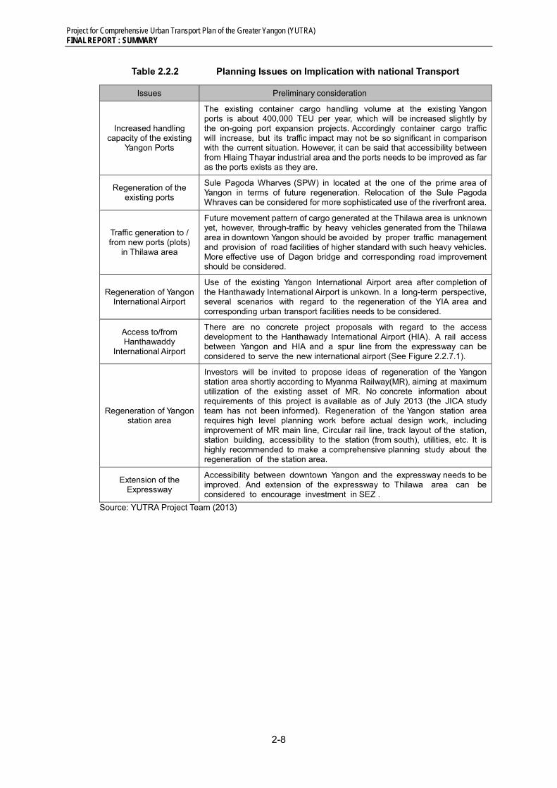
Project for Comprehensive Urban Transport Plan of the Greater Yangon (YUTRA) FINAL REPORT : SUMMARY
2-8
Table 2.2.2 Planning Issues on Implication with national Transport
Issues Preliminary consideration
Increased handling capacity of the existing
Yangon Ports
The existing container cargo handling volume at the existing Yangon ports is about 400,000 TEU per year, which will be increased slightly by the on-going port expansion projects. Accordingly container cargo traffic will increase, but its traffic impact may not be so significant in comparison with the current situation. However, it can be said that accessibility between from Hlaing Thayar industrial area and the ports needs to be improved as far as the ports exists as they are.
Regeneration of the existing ports
Sule Pagoda Wharves (SPW) in located at the one of the prime area of Yangon in terms of future regeneration. Relocation of the Sule Pagoda Whraves can be considered for more sophisticated use of the riverfront area.
Traffic generation to / from new ports (plots)
in Thilawa area
Future movement pattern of cargo generated at the Thilawa area is unknown yet, however, through-traffic by heavy vehicles generated from the Thilawa area in downtown Yangon should be avoided by proper traffic management and provision of road facilities of higher standard with such heavy vehicles. More effective use of Dagon bridge and corresponding road improvement should be considered.
Regeneration of Yangon International Airport
Use of the existing Yangon International Airport area after completion of the Hanthawady International Airport is unkown. In a long-term perspective, several scenarios with regard to the regeneration of the YIA area and corresponding urban transport facilities needs to be considered.
Access to/from Hanthawaddy
International Airport
There are no concrete project proposals with regard to the access development to the Hanthawady International Airport (HIA). A rail access between Yangon and HIA and a spur line from the expressway can be considered to serve the new international airport (See Figure 2.2.7.1).
Regeneration of Yangon station area
Investors will be invited to propose ideas of regeneration of the Yangon station area shortly according to Myanma Railway(MR), aiming at maximum utilization of the existing asset of MR. No concrete information about requirements of this project is available as of July 2013 (the JICA study team has not been informed). Regeneration of the Yangon station area requires high level planning work before actual design work, including improvement of MR main line, Circular rail line, track layout of the station, station building, accessibility to the station (from south), utilities, etc. It is highly recommended to make a comprehensive planning study about the regeneration of the station area.
Extension of the Expressway
Accessibility between downtown Yangon and the expressway needs to be improved. And extension of the expressway to Thilawa area can be considered to encourage investment in SEZ .
Source: YUTRA Project Team (2013)

Project for Comprehensive Urban Transport Plan of the Greater Yangon (YUTRA) FINAL REPORT : SUMMARY
2-9
2.3 Transport Demand Characteristics
YUTRA conducted 11 traffic/ transportation surveys to grasp the traffic flow in the greater
Yangon. The person trip survey, one of the surveys, targeted the travel dailies of 11,330
households in the study area. Approximately 11 million trips are made in weekday in 2013
as shown in Table 2.3.1. Walking accounts for relatively high ratio compared with the other
modes, which is about 4.78 million trips or 42% of the total trips.
Modal shares is summarized in Figure 2.3.1. Excluding walking, bus has the largest share
at 49.4 %, followed by bicycle (22.5 %), car/van (8.1%), taxi (7.7 %), motorcycle (7.2 %),
etc. Rail accounts for only 1.1 %. The combined share of public transport (bus, taxi, railway
and water ferry) is 60.7 % (“excluding walking”).
Table 2.3.1 Number of Person Trips in the Study Area by Mode, 2013
Source: YUTRA Person Trip Survey
Source: YUTRA Person Trip Survey
Figure 2.3.1 Modal Share, 2013
Mode Groups The number
of Trips (Trips /day)
Modal Share by Each Mode (%) Modal Share by Group (%)
For all Trips
Excluding Walk
Excluding Non-
Motorized Mode
For all Trips
Excluding Walk
Excluding Non-
Motorized Mode
Walk Walk 4,777,672 42.2 - - 42.2 - - Bicycle Bicycle 1,471,790 13.0 22.5 - 13.0 22.5 -
Motorcycle Motorcycle 471,386 4.2 7.2 9.3 4.2 7.2 9.3 Car
Car/Van 440,759 3.9 6.7 8.7
4.7 8.1 10.5 Van 88,885 0.8 1.4 1.8 Taxi Taxi 501,689 4.4 7.7 9.9 4.4 7.7 9.9
Sc / Co Bus
Bus
603,674 5.3 9.2 11.9
28.5 49.4 63.8 Passenger Truck 390,923 3.5 6.0 7.7
Small-Bus 377,662 3.3 5.8 7.5 Large-Bus 1,856,273 16.4 28.4 36.7
Pick-up
Truck
63,619 0.6 1.0 1.3
0.8 1.3 1.7 Medium-Truck 13,963 0.1 0.2 0.3 Large-Truck 5,544 0.0 0.1 0.1
Trailer 5,073 0.0 0.1 0.1 Railway Railway 71,215 0.6 1.1 1.4 0.6 1.1 1.4
Water Ferry Water Ferry 160,200 1.4 2.5 3.2 1.4 2.5 3.2 Others Others 12,858 0.1 0.2 0.3 0.1 0.2 0.3
Total 11,313,185 100 100 100 100 100 100

Project for Comprehensive Urban Transport Plan of the Greater Yangon (YUTRA) FINAL REPORT : SUMMARY
2-10
2.4 Environmental Conditions and Issues
In this chapter, environmental conditions and issues are summarized for 1) environmental
policy and legislation and 2) social and natural environment. The descriptions in 2) are
mostly based on the results of the Project for Strategic Urban Development programme
(SUDP), JICA (2013).
Environmental Policy and Legislation
Laws and regulations relevant to urban transport environment
Major laws and regulations for transportation are the Road Transport and Inland Water
Transport Law 1963 and Motor Vehicles Law 1964.
The Motor Vehicles Law 1963 covers the registration of motor vehicles, license of owning
motor vehicles, insurance of motor vehicles, driving license, control of traffic speed, and
offences and penalties for violation. In addition, Motor Vehicle Rules 1989 include
registration of motor vehicles, vehicle maintenance, driving license, driving training school,
terms and conditions of hired motor vehicles, and traffic rules for vehicles, pedestrians and
cyclists. In addition, City of Yangon Development Law regulates usage of vehicles as well
as construction and maintenance of roads and bridges. However, regulation of vehicle
exhaust emissions and inspection system is not established until now.
Land acquisition and resettlement
According to the State Constitution (2008) the state is the ultimate owner of all lands. All
private land tenure rights are essentially “usufruct”, which means that individuals and other
entities may use land but cannot own it, and tenure rights vary depending on the type of
land involved.
Definition of land are poorly defined in the legal framework and type of land can be classified
into the following eleven categories; (i) Freehold Land, (ii) Grant Land, (iii) Agricultural Land,
(iv) Garden Land, (v) Grazing Land, (vi) Cultivatable Land, Fallow Land and Waste Land,
(vii) Forest Land, (viii) Town Land, (ix) Village Land, (x) Cantonment, and (xi) Monastery.
The Land Acquisition Act 1894 promulgated in the British Colonial Era is even now the core
law for land acquisition and resettlement in Myanmar. The results of comparison between
the JICA Guidelines/the World Bank’s safeguard policies and Myanmar legislation on land
acquisition and involuntary resettlement indicate several gaps between them. For example,
neither the avoidance and minimization of involuntary resettlement and loss of livelihood
nor the requirement of preparation of Resettlement Action Plan is stated in any law. For the
compensation only market value of the land is considered. No law is identified on the
participation of project Affected Persons (PAPs) in public consultation in the land acquisition
and resettlement procedures.
Social and Natural Environment
Land use
Urbanization tends to have expanded northwards and eastwards rather than southwards
and westwards. As of 2012 the dominant land use type is agricultural area, which occupies
about 51% of total area, followed by urbanized area, which consists of 22% of the built-up
area and 9% of under-developing area.

Project for Comprehensive Urban Transport Plan of the Greater Yangon (YUTRA) FINAL REPORT : SUMMARY
2-11
The Protection of Wildlife, Wild Plants and Conservation of Natural Area Law was enacted
in 1994. There are at present 40 protected areas in Myanmar including wildlife and bird
sanctuaries, national parks, and nature reserves. Among them Hlawga Park is only one
designated protected area and has an area of 2,342 ha which is managed strictly as
Watershed Protection Forest in Greater Yangon.
Air pollution
Air pollution and noise are major concerns due to the increasing number of vehicles as well
as the traffic congestion. The polluted level is unknown because no monitoring data on air
pollution is available, but there is a high possibility of serious environmental issues caused
by air pollution. Therefore, establishment of air quality monitoring system is urgently
required as well as introduction of vehicle exhaust emission inspection system.
Solid waste problems
Numbers of scrapped vehicles are thought to be increasing, as the government introduced
a program in 2011 to enable car owners to replace their old vehicles with newer models.
Used vehicles and motor oils are typical industrial wastes relevant to urban transport, which
are required of proper disposal and recycling for environmental conservation, although laws
and regulations of industrial wastes are not established at present in Myanmar.
2.5 Public Sector Planning and Budgeting Systems
National Planning Framework
Figure 2.5.1 illustrates the National Planning Framework in Myanmar following the drafting
of the Framework for Economic and Social Reforms, five-year National Plan from Fiscal
Year 2011-2012 to 2015-2016, and envisaged long-term National Comprehensive
Development Plan. Key institutions for national planning and budgeting are: National
Parliament, Financial Commission, Planning Commission, National Economic and Social
Advisory Council, Ministry of Finance and Ministry of National Planning and Economic
Development, etc.
Source: Infrastructure in Myanmar, KPMG, 2013
Figure 2.5.1 Myanmar National Planning Framework

Project for Comprehensive Urban Transport Plan of the Greater Yangon (YUTRA) FINAL REPORT : SUMMARY
2-12
Financing of Transport Projects
Table 2.5.1 indicates the recent changes in financing indicators, including Gross Fixed
Capital Formation (GFCF) in the transport sector (Column 5), proportion to the total national
GFCF (Column 6). The double-digit ratios of Transport GFCF to total GFCF for FY2004/05
to FY2005/06 reflected the major construction works for the transfer of the capital to Nay
Pyi Taw. Preliminary estimates based on the budget allocation under Union Budget Law
FY2012-13 indicated that the ratio of Transport GFCF to Total GFCF could be between 8
to 10%, depending on the utilization of the capital.
Average investment levels on infrastructures and the transport sector in Myanmar were
about 8% of GDP and 1% of GDP, respectively. This low investment ratio to GDP is
comparable to the spending trends on road, railway and inland transport in advanced OECD
countries at 0.85% of GDP, where transport capital assets had been well established for
decades.
Table 2.5.1 Proportion of GFCF in the Transport Sector to Total
(Unit: MMK Billion)
Fiscal Year (0)
Nominal GDP (1)
Total Fixed Capital
Formation (2)
Gov’t Expenditure
(3)
Gov’t Capital Expenditure
(4)
Fixed Capital Formation in the
Transport Sector (5)
Transport to Total GFCF(5)/(2) (%)
2004-05 9,078.9 1,207.5 1,693.0 733.5 154.3 12.82005-06 12,286.8 1,867.6 2,353.9 906.5 269.3 14.42006-07 16,852.8 2,359.4 3,693.5 1,274.0 177.7 7.52007-08 23,336.1 3,710.4 4,901.5 1,890.0 255.9 6.92008-09 29,233.3 5,057.4 5,314.9 2,033.6 244.3 4.82009-10 33,894.0 7,151.6 6,260.6 2,840.8 381.7 5.32010-11 39,846.7 10,081.2 7,506.9 3,575.3 352.3 3.5
Source: Myanmar Statistical Yearbooks 2010 and 2011, Central Statistical Organization
2.6 Transport Sector Institutions and Administration
Overview
In light of the inauguration of the new Government in March 2011, institutional structure and
administrative system in both central and regional governments have undertaken gradual
reforms. Therefore, roles and responsibilities as well as coordination mechanism among
the relevant agencies in the transport sector has not been clearly defined yet.
Currently, transport related responsibilities are shared between various ministries at union
level as well as city development committees, and state-owned transport enterprises at
regional level. Administrative organizations under the regional transport minister are not the
organizations owned by the regional Government. They are acting as regional offices of the
relevant union ministries. In fact, they are under double control, i.e. they have to get order
from their own vertical administrative system, meanwhile they have to report to the regional
minister.
Among the government agencies overseeing the transport sector, Ministry of Rail
Transportation (MORT), Ministry of Transport (MOT), and Ministry of Construction (MOC)
play pivotal roles.
Project for Comprehensive Urban Transport Plan of the Greater Yangon (YUTRA) FINAL REPORT : SUMMARY
2-13
Institutional and Administrative Issues
Recognizing that transport sector is under the responsibilities of several ministries and
agencies of both central government and regional government, there is no single agency
with clear oversight of the sector. Despite this multiplicity of agencies, the unclear and
illogical division of responsibilities among them. The most essential points to note from
institution and administrative system are as follows.
Lack of clarity in defining roles and responsibilities for each ministry and other
government agencies
Lack of transparency and coordination among agencies in transport sector
development and service delivery
No clear lines of responsibility, for example, how do supervisory and reporting
procedures take place between the government agencies
No clear budgeting mechanisms
Yangon Region Security and Smooth Transport Supervisory Committee and Yangon
Region Traffic Rules Enforcement Supervisory Committee have been established.
Nevertheless, it is not clear at what level this committee operates, or whether it meets
regularly.
Monopolistic control in some transport services, for example railway transportation
Shortage of trained personnel able to fulfill the demands of government administration
and operating the transport services due to Myanmar’s long period of isolation since
the 1980s and lack of international expertise, experience, and investment.
Project for Comprehensive Urban Transport Plan of the Greater Yangon (YUTRA) FINAL REPORT : SUMMARY
3-1
3 TRANSPORT DEMAND CONTEXT
3.1 Urban Development Scenario
A master plan of urban development with the target year at 2040 was adopted by YCDC in
January 2013. It was “The Project for the Strategic Urban Development Plan of the Greater
Yangon” (SUDP) supported by JICA. This master plan defined the development vision of
Greater Yangon which can be summarized into four main points: 1) international hub city;
2) comfortable city; 3) well-managed infrastructure city; and 4) city of good-governance.
SUDP defined the desirable urban structure as “Sub-center with Green Isle System
(Decentralized Urban Pattern)”. This urban structure aims at decentralization of the
functions of urban center. A few sub-centers will be created at areas within 10-15 km radius
from the CBD as presented in Figure 3.1.1. Future land use of mid-term (2025) and long-
term (2040) was planned by SUDP on the basis of land suitability analyses as shown in
Figure 3.1.2. YUTRA will follow the urban structure in SUDP.
Source: SUDP, JICA, 2013
Figure 3.1.1 Proposed Urban Structure of Greater Yangon, “Sub-center with
Green Isle System”

Project for Comprehensive Urban Transport Plan of the Greater Yangon (YUTRA) FINAL REPORT : SUMMARY
3-2
2025 2040
Source: SUDP, JICA, 2013 Figure 3.1.2 Future Land Use Maps
3.2 Socio-Economic Framework and Future Transport Demand
Socio-economic Framework
Based on past trends, future land use planned by SUDP, national framework estimated by
The Survey Program for the National Transportation Development Plan in the Republic of
the Union of Myanmar (MYT-Plan, JICA, 2013) and a series of GIS analyses, future socio-
economic framework was prepared by YUTRA. This covers the following indicators by
traffic zone:
Population (night-time and day-time)
Employment by sector (night-time and day-time)
No. of students (night-time and day-time)
Household income
Ratio of car-owning households
The following table summarizes the socio-economic framework for the Greater Yangon
estimated by YUTRA.

Project for Comprehensive Urban Transport Plan of the Greater Yangon (YUTRA) FINAL REPORT : SUMMARY
3-3
Table 3.2.1 Summary Socio-economic Framework for Greater Yangon
2013 2018 2025 2035
Annual Growth Rate
2013-2018
2018- 2025
2025- 2035
Average 2013-2035
Night-time Population
('000)
Workers
Primary 58 58 58 58 0.0% 0.0% 0.0% 0.0%
Secondary 219 263 350 562 3.7% 4.2% 4.8% 4.4%
Tertiary 2,263 2,601 3,214 4,470 2.8% 3.1% 3.4% 3.1%
Total Workers
2,540 2,921 3,622 5,089 2.8% 3.1% 3.5% 3.2%
Student at Residence 1,164 1,303 1,532 1,938 2.3% 2.3% 2.4% 2.3%
Others 2,013 2,212 2,462 2,685 1.9% 1.5% 0.9% 1.3%
Total Night-time Population 5,716 6,437 7,615 9,712 2.4% 2.4% 2.5% 2.4%
Day-time Population
('000)
Employment
Primary 58 58 58 58 0.0% 0.0% 0.0% 0.0%
Secondary 244 289 378 595 3.4% 3.9% 4.6% 4.1%
Tertiary 2,263 2,610 3,242 4,547 2.9% 3.1% 3.4% 3.2%
Total Employment
2,565 2,956 3,678 5,200 2.9% 3.2% 3.5% 3.3%
Student at School places 1,164 1,303 1,532 1,938 2.3% 2.3% 2.4% 2.3%
Others 2,013 2,212 2,462 2,685 1.9% 1.5% 0.9% 1.3%
Total Day-time Population 5,741 6,472 7,672 9,823 2.4% 2.5% 2.5% 2.5%
Household Income ('000 Kyat/month) 240.6 340.5 522.2 954.7 7.2% 6.3% 6.2% 6.5%
Household Car Ownership Ratio (%) 11.6 16.8 23.2 32.3 7.8% 4.7% 3.4% 4.8%
Source: YUTRA Project Team
Transport Demand Forecast
Base year travel demand analysis and the development of travel demand forecast models
have been developed and described in detail in Volume II, Chapter 2 of this report. This
section presents the travel demand forecast for the YUTRA study area for the Master plan
development horizon years of 2016 (short term), 2025 (medium term) and 2035 (long term).
Travel demand estimates were made for a single urban development scenario as stipulated
by the JICA SUDP study. The estimate of travel demand for the three years is summarised
in the table below. It compares the growth in demand for each of the forecast years.
The table reflects a rapid growth in travel demand with almost constant population growth
rate of just over 2.4% per annum. The demand forecast growth in trip rate is reflective of
rapid growth in mechanised trips. The high growth in mechanised trips is caused by
increase in vehicle owning household from some 12% of the population to over 34% of all
households by 2035. The pace of growth is rather rapid in earlier years than later due to
higher growth in car ownership in earlier years.
The mechanised person trips are forecast to almost double from 4.9 million trips in 2013 to
9.5 million trips by 2035. The share of walk trips and by bicycle would also grow steadily,
albeit at slower pace as the vehicle ownership grows. The tendency of household to use
the vehicle for all trips, by all members of the household, once a vehicle is available This is
a common phenomenon in the developing countries, where purchase of a vehicle is major
step towards ‘status’ in the society, and then its maximum use is inevitable as there is limited
or restraint (parking availability/ charges, no road user charges).
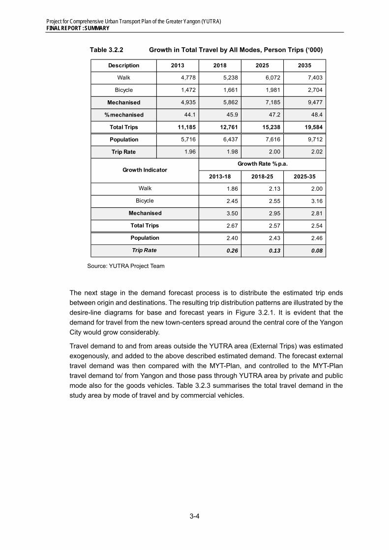
Project for Comprehensive Urban Transport Plan of the Greater Yangon (YUTRA) FINAL REPORT : SUMMARY
3-4
Table 3.2.2 Growth in Total Travel by All Modes, Person Trips (‘000)
Source: YUTRA Project Team
The next stage in the demand forecast process is to distribute the estimated trip ends
between origin and destinations. The resulting trip distribution patterns are illustrated by the
desire-line diagrams for base and forecast years in Figure 3.2.1. It is evident that the
demand for travel from the new town-centers spread around the central core of the Yangon
City would grow considerably.
Travel demand to and from areas outside the YUTRA area (External Trips) was estimated
exogenously, and added to the above described estimated demand. The forecast external
travel demand was then compared with the MYT-Plan, and controlled to the MYT-Plan
travel demand to/ from Yangon and those pass through YUTRA area by private and public
mode also for the goods vehicles. Table 3.2.3 summarises the total travel demand in the
study area by mode of travel and by commercial vehicles.
Description 2013 2018 2025 2035
Walk 4,778 5,238 6,072 7,403
Bicycle 1,472 1,661 1,981 2,704
Mechanised 4,935 5,862 7,185 9,477
% mechanised 44.1 45.9 47.2 48.4
Total Trips 11,185 12,761 15,238 19,584
Population 5,716 6,437 7,616 9,712
Trip Rate 1.96 1.98 2.00 2.02
2013-18 2018-25 2025-35
1.86 2.13 2.00
2.45 2.55 3.16
3.50 2.95 2.81
2.67 2.57 2.54
2.40 2.43 2.46
0.26 0.13 0.08 Trip Rate
Growth Rate % p.a.Growth Indicator
Walk
Bicycle
Mechanised
Total Trips
Population

Project for Comprehensive Urban Transport Plan of the Greater Yangon (YUTRA) FINAL REPORT : SUMMARY
3-5
Source: YUTRA Project Team
Figure 3.2.1 Current and Forecast Trip Distribution Patters in YUTRA Areas
Table 3.2.3 Total Travel Demand in YUTRA Study Area
Source: YUTRA Project Team
Total Trips 2013 2018 2025 20352013-2018
2018-2025
2025-2035
2013-2018
2018-2025
2025-2035
Bicycle 598,500 422,900 504,200 688,900 -29.3 19.2 36.6 -6.7 2.5 3.2
Motorcycle 304,500 208,200 246,100 320,300 -31.6 18.2 30.2 -7.3 2.4 2.7
Car & Van 628,400 1,201,300 1,771,300 2,728,000 91.2 47.4 54.0 13.8 5.7 4.4
Taxi 595,000 756,200 909,200 1,173,100 27.1 20.2 29.0 4.9 2.7 2.6
Bus / Train/ Ferry 3,065,900 3,915,400 4,560,400 5,672,600 27.7 16.5 24.4 5.0 2.2 2.2
Total Person Trips 5,192,300 6,504,000 7,991,200 10,582,900 25.3 22.9 32.4 4.6 3.0 2.8
% by Public (Taxi, Bus, Ferry & Train)
70.5 71.8 68.4 64.7
Goods Vehicle PCU 110,900 151,200 205,200 301,600 36.3 35.7 47.0 6.4 4.5 3.9
Summary of Trip Totals by Mode (Inter-zonal) % Growth % Growth p.a.

Project for Comprehensive Urban Transport Plan of the Greater Yangon (YUTRA) FINAL REPORT : SUMMARY
3-6
Figure 3.2.2 shows the current traffic volumes on the current road network in 2013 with the
V/C ratios are illustrated by colour. The figure shows that there are relatively limited number
of road sections which are above capacity. This network also reflects the impact of current
rampant on-street parking, which is the main reason of congestion in the CBD area. Outside
the CBD area some key links are at near capacity (blue links with V/C Ratio between
0.,75~1.0). Some bottle necks are also illustrated by the brown colour links.
Source: YUTRA Project Team
Figure 3.2.2 2013 Assigned Traffic Volume on Current Transport Network
Figure 3.2.3 shows the traffic volumes on the current road network in 2035 with the V/C
ratios illustrated by colour. This shows so-called “Do-Nothing” situation in 2035. The figure
clearly illustrates that if the current transport infrastructure is not improved congestion would
worsen. The most severe impact would be the rapidly growing urban areas to the west and
south of Yangon river, where V/C ratio exceeds 2.0 on arterial roads in the area. Congestion
on the bridges from the west and from Bago area would be operating over the capacity
most of the day. This illustrates the immediate need for addition Yangon and Bago river
crossings.
The impact on the road network by 2035 under the stress of increase in total PCU to
2.3million would be unthinkable if the city is to grow and the transport infrastructure remains
at the current 2013 level. The figure shows the projected 2035 traffic volume and illustrates
the likely V/C Ratios on the network. It can be seen that on most of the network V/C ratio
exceeds 1.0, and the brown, red and black colours show the intensity of the poor level of
service. In fact the red and black colours imply the need for more doubling the current road
capacity and an efficient mass transit system by 2035.
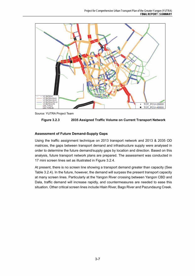
Project for Comprehensive Urban Transport Plan of the Greater Yangon (YUTRA) FINAL REPORT : SUMMARY
3-7
Source: YUTRA Project Team
Figure 3.2.3 2035 Assigned Traffic Volume on Current Transport Network
Assessment of Future Demand-Supply Gaps
Using the traffic assignment technique on 2013 transport network and 2013 & 2035 OD
matrices, the gaps between transport demand and infrastructure supply were analysed in
order to determine the future demand/supply gaps by location and direction. Based on this
analysis, future transport network plans are prepared. The assessment was conducted in
17 mini screen lines set as illustrated in Figure 3.2.4.
At present, there is no screen line showing a transport demand greater than capacity (See
Table 3.2.4). In the future, however, the demand will surpass the present transport capacity
at many screen lines. Particularly at the Yangon River crossing between Yangon CBD and
Dala, traffic demand will increase rapidly, and countermeasures are needed to ease this
situation. Other critical screen lines include Hlain River, Bago River and Pazundaung Creek.
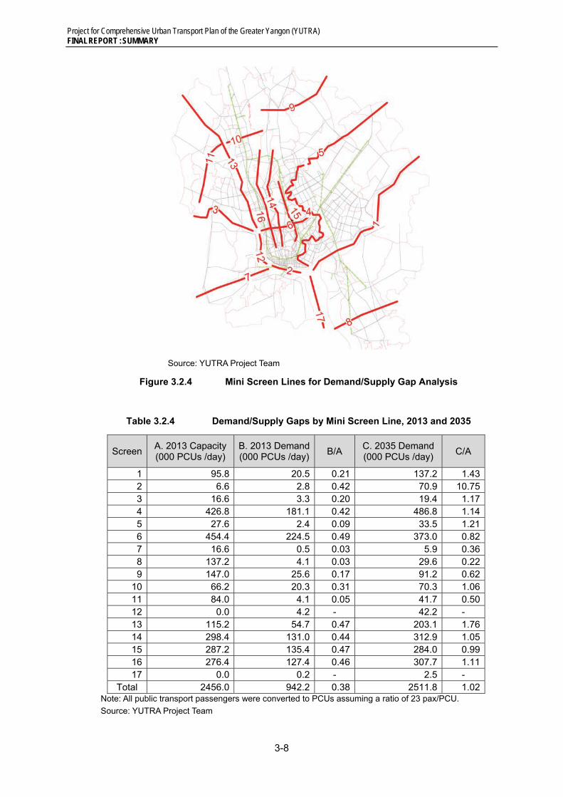
Project for Comprehensive Urban Transport Plan of the Greater Yangon (YUTRA) FINAL REPORT : SUMMARY
3-8
Source: YUTRA Project Team
Figure 3.2.4 Mini Screen Lines for Demand/Supply Gap Analysis
Table 3.2.4 Demand/Supply Gaps by Mini Screen Line, 2013 and 2035
Screen A. 2013 Capacity (000 PCUs /day)
B. 2013 Demand(000 PCUs /day)
B/A C. 2035 Demand (000 PCUs /day)
C/A
1 95.8 20.5 0.21 137.2 1.43 2 6.6 2.8 0.42 70.9 10.75 3 16.6 3.3 0.20 19.4 1.17 4 426.8 181.1 0.42 486.8 1.14 5 27.6 2.4 0.09 33.5 1.21 6 454.4 224.5 0.49 373.0 0.82 7 16.6 0.5 0.03 5.9 0.36 8 137.2 4.1 0.03 29.6 0.22 9 147.0 25.6 0.17 91.2 0.62
10 66.2 20.3 0.31 70.3 1.06 11 84.0 4.1 0.05 41.7 0.50 12 0.0 4.2 - 42.2 - 13 115.2 54.7 0.47 203.1 1.76 14 298.4 131.0 0.44 312.9 1.05 15 287.2 135.4 0.47 284.0 0.99 16 276.4 127.4 0.46 307.7 1.11 17 0.0 0.2 - 2.5 -
Total 2456.0 942.2 0.38 2511.8 1.02 Note: All public transport passengers were converted to PCUs assuming a ratio of 23 pax/PCU.
Source: YUTRA Project Team

Project for Comprehensive Urban Transport Plan of the Greater Yangon (YUTRA) FINAL REPORT : SUMMARY
4-1
4 TRANSPORT DEVELOPMENT STRATEGY
4.1 Overall Transport Policy
Current Urban Development Policy
The biggest constraint is funding. Hence, it must turn more and more to the private sector
– especially in the provision of transport services.
Yangon’s public transport is fortunate to have a high modal share presently. This advantage
should be maintained or strengthened even further against the pressure of motorization.
A third constraint is weak institutional capability to cope with urban and transport challenges.
One way to overcome the lack of funds is to improve government’s ability to harmonize land
use with transport development. This entails expertise and processes that are also scarce
in the public sector.
New Policy Directions
A key feature of this new direction is greater reliance on the private sector in the building of
transport infrastructure and operation of major transport functions, which is consistent with
the national policy towards a market-based economy. Myanmar is already moving towards
this end, but this will require various policy reforms and public sector practices.
For passenger transport services, the public sector also needs to increase its management
role, while maintaining its regulatory role, in the delivery and outcome of transport services.
This will require building skills and capacity in management; relying less on regulations
alone to reach objectives and taking a more commercial approach to managing the
structures of service delivery.
For city expansion, better urban controls are needed to preserve the ROW (specifically,
alignment and width) for future roads, rather than just planning neat and elegant
arrangement of land uses per-se. Designated ROWs will provide a clear signal to the
private sector on where future growth shall be. Tax and other incentives can be used to
encourage this kind of developments outside the CBD, rather than relying on the traditional
instruments of administrative controls (such as grant or denial of building permits).
Inter-city and interagency collaboration will become increasingly necessary, as the urban
development spreads outside traditional city boundaries thus requiring more coordinated
and integrated transport solutions. A metropolitan-type of institution should be discussed
and the need of an Urban Transport Authority seriously studied (see Chapter 4.8).
Aside from economic and technical viability, transport projects need to be planned for
sustainability (maintained, operated, and supported with funds over its life), minimum
dislocation, and environmental soundness.
YUTRA Overall Transport Development Strategy
Yangon of the future should be livable as well as globally competitive and attractive for
industries, leading Myanmar’s international trade, and the transport sector must be
designed to make this a possibility. The overall goal of urban transport is the following:
“Ensure mobility and accessibility to urban services that are vital for the people and the

Project for Comprehensive Urban Transport Plan of the Greater Yangon (YUTRA) FINAL REPORT : SUMMARY
4-2
society, by providing a transport system characterized by safety, amenity, and equity and
sustained by an efficient public transport system”
A combination of supply-type and demand-type strategies is required to maintain the
present advantage of high modal share of more than 60%. YUTRA has identified a series
of transport development strategies as stated above. The main focuses or features of the
Master Plan exist on the following points:
1. Strengthening of Public Transport: development of sustainable public transport
system, taking advantage of the present high share of public transport trips.
2. Improvement of Regional Competitiveness of the City: Construction of Efficient
Transport System that supports 10-million multi-core hub city.
3. Realization of Well-managed Environment-friendly City: introduction of innovative
institutional/operational schemes that enables world-class transport integration with
living environment.
4. Adoption of Immediate Congestion Mitigation Measures: implementation of less
expensive measures against traffic congestion that brings quick outcome.
In YUTRA, the following eight objectives were established with identified transport
development strategies.
A. Promotion of Social Understanding about Urban Transport Problems and Issues
A1. Conduct of consecutive transport campaigns;
A2. Expansion of transport education;
A3. Strengthening of transport studies;
A4. Information disclosure.
B. Effective Management of Urban Growth and Development
B1. Policy coordination within the Greater Yangon area;
B2. Authorization of City and Transport Master Plans;
B3. Development of hierarchical road network and road classifications to guide design (and parking provision);
B4. Promotion of integrated urban and transport development, particularly Transit-Oriented Development (TOD).
C. Promotion and Development of Attractive Public Transport
C1. Development of a hierarchal mass transit system;
C2. Early introduction of an integrated public transport system (BRT) in the effort to maintain public transport share;
C3. Upgrading the present rail system;
C4. Development and improvement of bus transport system, including reform of management systems and the business model;
C5. Promotion of public transport use and expansion of services.
D. Efficient Traffic Control and Management
D1. Establishment of comprehensive traffic management system balanced with better facilities for essential NMT modes such as cycling and walking;
Project for Comprehensive Urban Transport Plan of the Greater Yangon (YUTRA) FINAL REPORT : SUMMARY
4-3
D2. Strengthening of traffic regulation, enforcement and management;
D3. Management of freight transport;
D4. Establishment of parking policy and controls;
D5. Development of well-coordinated traffic control system.
E. Effective Transport Demand Management (TDM)
E1. Integrating urban development and transport (TOD);
E2. Providing efficient public transport alternatives;
E2. Regulating motorized vehicle access and proper charging of road use and parking.
F. Comprehensive Development of Transport Space and Environment
F1. Improvement of a safe transport environment for pedestrians and cyclists;
F2. Redistribution of transport space and improvement of traffic environment in the city centre;
F3. Establishment of township transport development strategy.
G. Enhancement of Traffic Safety
G1. Establishment of traffic safety audit system;
G2. Elimination of traffic accident black spots;
G3. Improvement of licensing and vehicle inspection system;
G4. Strengthening of traffic enforcement system;
G5. Strengthening of first aid response system.
H. Strengthening of Transport Sector Administrative and Management Capacities
H1. Reform of transport- related organizations;
H2. Promotion of private sector participation;
H3. Strengthening of planning and management capacity;
H4. Securing of development funds.
The inter-relationship between these focuses and the identified strategies is illustrated
below:

Project for Comprehensive Urban Transport Plan of the Greater Yangon (YUTRA) FINAL REPORT : SUMMARY
4-4
Source: YUTRA Project Team
Figure 4.1.1 Main Features and Strategies of YUTRA Master Plan
4.2 Budget Envelop
Various international institutions projected rapid, long-term economic growth for Myanmar,
subject to major reforms in macro-economic systems. The following growth scenarios were
formulated:
(i) Scenario 1: High Growth - This scenario is based on McKinsey forecast an
average GDP growth of 7.7% per annum with seven economic sectors driving
national economic development. Myanmar Government also proposes this
scenario under the approved first five-year national development plan for
FY2011/12 to 2015/16.
(ii) Scenario 2: Medium Growth - In this scenario, the annual GDP growth rate will
increase to 7% as estimated by IMF and based on the lower figure in the 7%-8%
growth forecasts of ADB in its report entitled “Myanmar in Transition”.
(iii) Scenario 3: Low Growth - This scenario is based on the IMF’s debt sustainability
analysis of Myanmar in 2013. In the IMF analysis, annual GDP growth rates from
2014 to 2031 are set at 6.0%.
GDP forecasts under the three growth scenarios is shown below.

Project for Comprehensive Urban Transport Plan of the Greater Yangon (YUTRA) FINAL REPORT : SUMMARY
4-5
Source: YUTRA Project Team
Figure 4.2.1 Myanmar GDP Forecasts by Growth Scenarios
In estimating the transport funding envelope for Greater Yangon, the key principle in
allocating Myanmar’s resources is to invest in areas with the greatest potential to contribute
to economic outputs.
After estimating the public investment and transport sector allocation for the entire Myanmar,
transport sector budget envelope was estimated. For FY2011/12 to FY2012/13, Yangon
Region’s economic contribution is about 22% of the country’s GDP. The Interim Report
(2013) of the JICA Survey Program for the National Transport Development Plan (MYT-
Plan), the GRDP estimates of Yangon Region are: 25% in the medium-term and 30% in the
long-term. On this basis, the Greater Yangon transport budget envelopes are assumed to
be equal to the GRDP estimates. Table 4.2.1 presents the expected budget allocation for
Greater Yangon transport requirements.
Table 4.2.1 Greater Yangon Transport Sector Budget Envelopes
(US$ Billion at 2013 Prices)
Fiscal Year Greater Yangon Transport Investment
High (McKinsey)
Medium (ADB)
Low (IMF)
FY2014-2017 2.748 2.702 2.637
FY2018-2025 8.675 8.234 7.656
FY2026-2035 21.314 19.048 16.252
Source: YUTRA Project Team
4.3 Land Use and Transport Integration
Strategic Urban Development Plan
The Project for the Strategic Urban Development Plan for the Greater Yangon (2013, JICA)
(hereinafter called as SUDP) provides fundamental ideas of the future land use in the
Greater Yangon area (Yangon and the surrounding areas). SUDP proposes a multi centric

Project for Comprehensive Urban Transport Plan of the Greater Yangon (YUTRA) FINAL REPORT : SUMMARY
4-6
and balanced development pattern as the major spatial structure of the Greater Yangon,
which is expected to reduce excessive traffic concentration to/from the existing downtown
area (see Chapter 3). SUDP recommends “Sub-centres with Green Isle System”
development pattern (decentralized urban functions) as the most preferred option.
“Sub-centres with Green Isle System”
The recommended Sub-Centres with Green Isle System by SUDP forms a hierarchical
urban structure, that is, CBD is the centre of the city, surrounded by sub-centres on the
circumference of 10 – 15 km radius from CBD, and new town centres are located
outskirts of sub-centres.
- Removal and transfer of some major urban functions in the existing downtown areas
(CBD) to newly designated sub-centres and new town centres.
- Promotion of corridor development (called “sub-centre growth belt”) between newly
identified sub-centres
- Urbanization shall be limited within the designated outer ring road (ORR), while the
urbanization within the ORR shall be encouraged.
- New sub-centres shall be developed on the circumference of around 10 – 15 km
radius from CBD. Such sub-centres are Hlaing Tharya, Mindama, Dagon Myothit,
Thanlyin, and Thilawa.
- Designated conservation areas: Hlawga protected area, and Inya Lake
- Development of “North – South Green Axis” using the existing conservation areas.
- Removal and transfer of some major urban functions in the existing downtown areas
(CBD) to newly designated sub-centres and new town centres.
Hierarchical Centre System
- Primary Centre: Central Business District (CBD)
- Secondary Centres: Secondary CBD (Sub-centre) : Mindama, Thilawa, Bago
Riverside, Dagon Myothit, Hlaing Tharya
- Tertiary Centres: New Town Core Area in sub-urban area: Hlegu, Hmawbi, East
Dagon, Thanlyin, Dala, Twanty, and Htanttabin
Corresponding Transport Network
This pattern of centre distribution suggests a corresponding network in a hierarchical
manner as follows. This hierarchical network (or links) indicates necessary feature of
transport facilities served along each link in terms of capacity, speed, and modes.
- Link A: CBD – Sub-centre Link
- Link B: Link between Sub-centres
- Link C: Sub-centre – New Town Core area Link
- Link D: Link between New Town Core areas
Transit services should be provided for every link connecting centres, and such transit
services shall also be provided in a hierarchical manner, which is supported by a

Project for Comprehensive Urban Transport Plan of the Greater Yangon (YUTRA) FINAL REPORT : SUMMARY
4-7
hierarchical rail and road network. UMRT is generally recommended to connect CBD
and surrounding sub-centres, while extension of such high order public transport
system to surrounding town centres and strategic destinations such as the airport and
the port area in Yangon should be carefully considered from a demand point of view.
Evaluation of the existing network
Roads, railway, bus and ferry are evaluated to examine how the current transport network
system would work in the future links between the proposed sub-centres in SUDP.
Source: YUTRA Project Team
Figure 4.3.1 SUDP Hierarchical Centre System and Corresponding Links

Project for Comprehensive Urban Transport Plan of the Greater Yangon (YUTRA) FINAL REPORT : SUMMARY
4-8
Current Network System
Link A: CBD – Sub-Centre Link
Table 4.3.1 summarizes link characteristics as of year 2013 in term of road capacity
and available modes.
Table 4.3.1 CBD – Sub-centre Links, 2013
Source: YUTRA Project Team
Link B: Link between Sub-Centres
Only road network will work comparing the other transport networks. This is because
the network connecting Link B should across rivers such as Yangon River or Bago
River. The evaluation must depend on the capacity of bridges.
Table 4.3.2 Link between Sub-centres, 2013
Source: YUTRA Project Team
Link C: Link between Sub-Centre and New Town Area
The existing national (union) highway network is available for Link C1 (NH 4), C3 (NH2),
and C5 (NH6). There is no land transport connection nor water transport service for
Link C6: NTC Dala and SC Thilawa SEZ at present. In general road connectivity in the
suburban area, where these sub-centre – town centre links are expected, is very limited.
RoadNo of
Lanes perdirection
MyanmaRailway
WaterTransport
Major Road Links
A1 SC-Mindama 〇 12 × × Pyay RdKaba Aye Pagoda Rd.
A2 SC-Dagon Myothit 〇 4 〇 × No.2 Main Rd
A3 SC-Bago Riverside 〇 4 × × Yadanar Rd
A4 SC-Thilawa SEZ 〇 2 △ × Kyaik Khouk Pagoda Rd
A5 NTC-Dala × 0 × 〇 NA
A6 NTC-Twantay △ 4 × × No.5 Main RdTwantay Main Rd
A7 SC-Hlaingtharyar 〇 4 × × No.5 Main Rd
Note: 〇: available, △: availabale,but limited, ×: not available
CBD - Subcenter Link
CBD
Link Link between
Available Direct Network, 2013
RoadNo ofLanes
MyanmaRailway
WaterTransport
Major Road Links
B1 SC-Hlaingtharyar SC-Mindama 〇 6 × × Lanthit Rd
B2 SC-Mindama SC-Dagon Myothit 〇 4 × × Pin Lon RdThanthumar Rd
B3 SC-Dagon Myothit SC-Bago Riverside 〇 4 × × Ayer Wun Rd
B4 SC-Bago Riverside SC-Thilawa SEZ 〇 6 △ × Dagon bridgeThanlyin bridge
Note: 〇: available, △: availabale,but limited, ×: not available
Link Link between
Available Direct Network, 2013
Link BetweenSub-cebters

Project for Comprehensive Urban Transport Plan of the Greater Yangon (YUTRA) FINAL REPORT : SUMMARY
4-9
Table 4.3.3 Link between Sub-centre and Town Centre, 2013
Source: YUTRA Project Team
Link D: Link between New Town Areas
Links between new town centres form a ring surrounding the future (planned)
urbanized area of the Greater Yangon as informed by SUDP. The existing connectivity
between the proposed town centre locations are generally very weak.
Table 4.3.4 Link between Town Centres, 2013
Source: YUTRA Project Team
Demand Analysis
Assuming 60% of the total passenger demand of each link is carried by public modes of
transport, a likely public mode of transport is indicated. If a 60% of a link volume exceeds
10,000 passenger per peak-hour per direction, a form of mass transit is suggested, while
such demand is below 10,000 but above 6,000 passenger per peak-hour per direction, a
transit system of medium carrying capacity such as BRT/LRT is suggested.
RoadNo of
Lanes perdirection
MyanmaRailway
WaterTransport
Major Road Links
C1 NTC-Hmawbi SC-Mindama 〇 2 〇 × No.4 Main Rd
〇 6 × × Pyay Rd
C2 NTC-Hlegu SC-Dagon Myothit △ 4 × × Min Yae Kyaw Swar Rd
C3 NTC-East Dagon SC-Dagon Myothit 〇 4 〇 × No.2. Main Rd
C4 NTC-Thanlyin SC-Bago Riverside 〇 4 × × Yangon Thilawar Rd
C5 NTC-Thanlyin SC-Thilawa SEZ 〇 4 × × No.6 Main Rd
C6 NTC-Dala SC-Thilawa SEZ × 0 × × -
C7 NTC-Twantay SC-Hlaingtharyar △ 2 × × Twantay Main Rd
C8 NTC-Htantabin SC-Hlaingtharyar △ 4 × × Amauk Pine University Rd
Note: 〇: available, △: availabale,but limited, ×: not available
Link Link between
Available Direct Network, 2013
Sub-centerand New Town
Link
Corridor inbetween C1 and C2
RoadNo of
Lanes perdirection
MyanmaRailway
WaterTransport
Major Road Links
D1 NTC-Hmawbi NTC-Hlegu △ 4 × × No.7 Main Rd
D2 NTC-Hlegu NTC-East Dagon △ 4 × × No.7 Main Rd
D3 NTC-East Dagon NTC-Thanlyin × 0 × △ -
D4 NTC-Dala NTC-Twantay × 0 × △ -
D5 NTC-Htantabin NTC-Hmawbi △ 2 × × No.4 Main Rd
Note: 〇: available, △: availabale,but limited, ×: not available
Available Direct Network, 2013
Link BetweenNew Towns
Link Link between

Project for Comprehensive Urban Transport Plan of the Greater Yangon (YUTRA) FINAL REPORT : SUMMARY
4-10
The link analysis informs the area which needs a higher order transit system. A triangular
area formed by three centres, namely CBD, SC Mindama and SC-Bago Riverside needs
such higher order transit system already in 2013. The area that needs high-order transit
system will be extended to cover a wider area including proposed sub-centres and some
town centres as shown in Figure 4.3.2. This shape of service coverage indicates a few
number of high-order transit lines of radial direction.
It is highly recommended that the red shaded area shown in Figure 4.3.2, including CBD,
the four proposed sub-centres and the three proposed town centres namely Hmawbi, Dala,
and Thilawa SEZ are served by a form of mass transit system.
These centres should be directly connected by mass transit systems including the improved
MR lines (the Yangon circular lines, part of the Yangon – Mandalay line, and the Thanlyin
line) and new mass transit system.
2013 2035
Source: YUTRA Project Team
Figure 4.3.2 Area needs high-order transit service in 2013 and in 2035
Assuming the remaining 40% of the total demand is assumed to be carried by private mode
of transport, namely passenger cars, the link between CBD and SC Dala requires 6 lanes
or more. The link analysis suggests that additional 10 lanes or more road crossing the creek
will be required by 2035. The link between SC Dagon Myothit and SC Mindama requires 6
lanes or more, CBD and SC Dagon Myothit and SC Bago Riverside also require additional
6 lanes in total. (See Figure 4.3.3)
It is recommend to increase the capacity of public modes of transport of this link. Therefore
an extension of the UMRT network to Dala area is highly recommended in order to support
the planned development in this area.

Project for Comprehensive Urban Transport Plan of the Greater Yangon (YUTRA) FINAL REPORT : SUMMARY
4-11
Source: YUTRA Project Team
Figure 4.3.3 Suggested road capacity increase between the centres
4.4 Public Transport
From the features mentioned above such as high transport capacity, high travel speed,
environmental friendly, etc., and high demand in the future, we propose to apply public
transport with good combination among railway and middle capacity transit (mainly BRT)
positively.
[B1] Policy coordination within the Greater Yangon area
[B2] Authorization of City and Transport Master Plans
[B4] Promotion of integrated urban and transport development, particularly Transit-Oriented
Development (TOD)
[C1] Development of a hierarchal mass transit system
[C2] Early introduction of an integrated public transport system (BRT) in the effort to
maintain public transport share
[C3] Upgrading the present rail system
[C4] Development and improvement of bus transport system, including reform of
management systems and the business model
[C5] Promotion of public transport use and expansion of services
[E1] Integrating urban development and transport (TOD)

Project for Comprehensive Urban Transport Plan of the Greater Yangon (YUTRA) FINAL REPORT : SUMMARY
4-12
Urban Railway Development
The following basic principles were established for urban railway development in YUTRA.
Conformity with Urban Master Plan/ National Transport Master Plan (related to
Strategy No. B1, B2, and E1)
- Public transport network composed of railway and BRT shall fit with layout of urban
development plan / land use plan / future urban function plan prepared by Urban
Master Plan (SUDP) in 2012.
- To consider the railway network plan prepared by SUDP as a conceptual plan.
- To keep conformity with the railway plan of the National Transport Development
Plan (MYT-Plan).
Total Coordination among Public Transport Mode (related to Strategy No. B4, C1, and
E1)
- To fulfill required function by total public transport network including not only railway
network but also BRT network in order to save initial cost. Required trips to be
shouldered by public transport shall be shared by both railway and BRT networks
Railway Utilization Promotion (related to Strategy No.C5)
- To conduct integrated development of railway line with the station plaza / wayside
in order to realize synergy effect
- To have railway/UMRT lines radiating out from CBD as main axes, and connecting
East-West line as sub-axis.
Realistic Development Planning (related to Strategy No.C2 and C3)
- In order to save initial cost, to endeavor a) existing railway utilization, b) in case of
UMRT, installation of at-grade/elevated section as much as possible, and c) active
use of BRT with relatively lower cost per km.
- Regarding existing railway modernization, to give high priority to current population
density area.
- To consider utilization of actual vacant land lots for depot, workshop, transport hub,
etc. in order to establish a practical plan.
- To consider who will be an implementation, operation, management body for UMRT
project in order to succeed in the UMRT project.
Even if the railway network is completed, it will not function in case of no related facilities.
It is essential to establish feeder service from/to station and station plaza as transfer facility
in order to act railway properly, in addition to expanding railway network and modernizing
the railway itself. In order to fulfil the ideal railway service, the following countermeasures
should be conducted.
a) Improvement and expansion of railway network
b) Improvement of station function as transport hub (station and station plaza): to improve transfer function at railway station, and to enhance integration between railway and the other public transportation like buses, etc. (see “after improved” in the figure below)

Project for Comprehensive Urban Transport Plan of the Greater Yangon (YUTRA) FINAL REPORT : SUMMARY
4-13
Furthermore, in order to realize abovementioned “b)”, redevelopment of the current station
yard is essential. In case of implementing yard development, it is necessary to relocate
the current depots and workshops in MR yard to any substitute yard. The northwest area
of Ywa Tar Gyi station along Yangon-Mandalay line is a strong candidate for substitute land.
Railway freight transport plan should be adjusted to a freight transport plan prepared by
MYT-Plan.
It is required that the railway infrastructure layout plan for 2035 should be fulfilled based on
step-wise development plan which is to fulfil the short-term, middle-term, and long-term
target shapes step-by-step. The step-wise development plan is prepared based on the
following principles.
Short-term projects shall have high maturity status.
To give first priority to existing line improvement in terms of cost aspect.
First UMRT installation should be planned in consideration of feasible timing in order
to avoid being dream.
To realize development scenario which has good harmonization of the implementation
timing between railway infrastructure project and the related project such as station
plaza development, land development along railway with depot/workshop relocation.
To fulfill the scenario that development benefit from railway yard redevelopment can
be allocated to the next railway infrastructure project.
To apply Step Development effectively which means to conduct electrification, grade
separation, etc. on step-by-step basis regarding existing line modernization.
BRT and Conventional Bus Services
The decision to build a BRT in Yangon must take into account the opportunities, as well as
managing the risks and constraints. The opportunities are:
A present benefit is a high dependency on bus transport and low car ownership in
Yangon. It will easier to maintain this (with decisive steps) than at a later time win back
public transport modal share.
Yangon has well-developed arterial roads sufficient to accommodate BRT
(preliminary surveys indicate BRT can be accommodated within existing road widths).
The above opportunities indicate that BRT is a feasible concept terms of society attitudes,
travel choice and the physical space requirements. The risks and constraints are:
Managing power outages (signalling etc.) that affect control systems.
Managing bus priority at intersections (balancing bus flow with other traffic)
Preserving integrity of bus lanes (reducing interference)
Three main design objectives need to be upheld for a successful BRT. BRT requires a
higher level of management to ensure it operates efficiently.
Build a quality mass transit system - to attract passenger. This will include:
Service the main travel demand corridors and provide a fully integrated network
Project for Comprehensive Urban Transport Plan of the Greater Yangon (YUTRA) FINAL REPORT : SUMMARY
4-14
Commercial management, sustainable business models and maintain commercial
speeds
Even after UMRTs and BRTs are developed, the role of conventional bus services are
important. It is not only because the patronage for conventional bus services will remain at
least the current level, or most likely will gradually increase towards the future, but also the
present poor levels of service should be upgraded. Enhancement of the quality of bus and
other public transport services is not an end in itself. It is a prerequisite to look for any
general improvement of the traffic and transport situation in the whole Yangon Region.
4.5 Road Network Development
The overall road development strategy is naturally to ensure people with good mobility,
accessibility, comfort and safety of road transport. Although it is difficult to show quantitative
targets regarding the quality of road and road transport, this YUTRA master plan should
pursue the following targets:
Average volume/capacity ratio: less than 0.5 in 2035 (about 0.3 at present)
Average travel speed: more than 20 kph in 2035 (about 30 kph at present)
Equipped with facilities to improve mobility, accessibility, comfort and safety
Although these targets seem too modest, the situation is still far better than other metropolis
in South-east Asia, and it is a well-known fact that road development cannot solve traffic
congestion inducing more traffic to roads. In reality, there is no enough space to
accommodate new roads in the central area of Yangon.
The city consists of several areas which have different characteristics. The road
development strategy is identified for the following each specific area.
Road Development Strategy for CBD Area
- 1) Improvement of public transport system
- 2) Establishment of parking policy and control
- 3) Improvement of traffic signals and introduction of ITS
- 4) Detachment of port related traffic from public traffic
- 5) Introduction of appropriate Traffic Demand Management Systems
- 6) Improvement of pedestrian facilities
Road Development Strategy for Urban Developed Area
- 1) Improvement of public transport system
- 2) Widening of the existing arterial roads to maximize its road capacity
- 3) Introduction of the double deck roads to enlarge the road capacity
- 7) Improvement of traffic signals and introduction of ITS
- 4) Improvement of pedestrian facilities
- 5) Relocation of logistic terminals to suburb areas
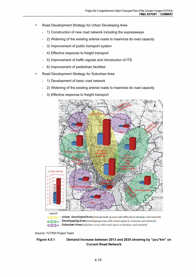
Project for Comprehensive Urban Transport Plan of the Greater Yangon (YUTRA) FINAL REPORT : SUMMARY
4-15
Road Development Strategy for Urban Developing Area
- 1) Construction of new road network including the expressways
- 2) Widening of the existing arterial roads to maximize its road capacity
- 3) Improvement of public transport system
- 4) Effective response to freight transport
- 5) Improvement of traffic signals and introduction of ITS
- 6) Improvement of pedestrian facilities
Road Development Strategy for Suburban Area
- 1) Development of basic road network
- 2) Widening of the existing arterial roads to maximize its road capacity
- 3) Effective response to freight transport
Source: YUTRA Project Team
Figure 4.5.1 Demand Increase between 2013 and 2035 showing by “pcu*km” on
Current Road Network
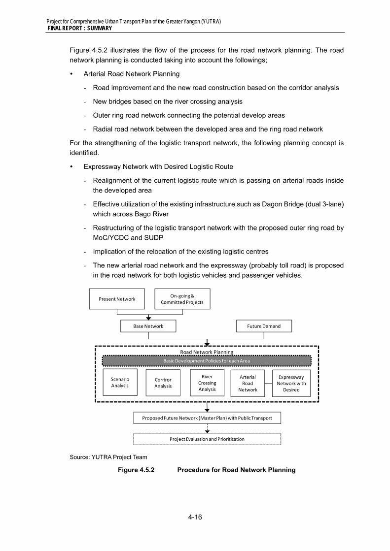
Project for Comprehensive Urban Transport Plan of the Greater Yangon (YUTRA) FINAL REPORT : SUMMARY
4-16
Figure 4.5.2 illustrates the flow of the process for the road network planning. The road
network planning is conducted taking into account the followings;
Arterial Road Network Planning
- Road improvement and the new road construction based on the corridor analysis
- New bridges based on the river crossing analysis
- Outer ring road network connecting the potential develop areas
- Radial road network between the developed area and the ring road network
For the strengthening of the logistic transport network, the following planning concept is
identified.
Expressway Network with Desired Logistic Route
- Realignment of the current logistic route which is passing on arterial roads inside
the developed area
- Effective utilization of the existing infrastructure such as Dagon Bridge (dual 3-lane)
which across Bago River
- Restructuring of the logistic transport network with the proposed outer ring road by
MoC/YCDC and SUDP
- Implication of the relocation of the existing logistic centres
- The new arterial road network and the expressway (probably toll road) is proposed
in the road network for both logistic vehicles and passenger vehicles.
Source: YUTRA Project Team
Figure 4.5.2 Procedure for Road Network Planning
Road Network Planning
Present NetworkOn‐going &
Committed Projects
Base Network Future Demand
ScenarioAnalysis
CorrirorAnalysis
River CrossingAnalysis
Proposed Future Network (MasterPlan) with Public Transport
Project Evaluation and Prioritization
Basic Development Policies for each Area
Expressway Networkwith
Desired
Arterial Road
Network
Project for Comprehensive Urban Transport Plan of the Greater Yangon (YUTRA) FINAL REPORT : SUMMARY
4-17
4.6 Traffic management and Safety
Parking Development Strategies
In order of mitigate traffic congestions due to vehicles parked along the curb, most of the
cities control on-street parking particularly on main streets and promote the development
of off-street public parking facilities. And also they establish appropriate rules and
regulations on mandatory parking facility including garage. Nowadays global climate and
environmental viewpoint changed to control parking demand so as to promote modal shift
from private mode to public mode of transport system. On the other hand, rapid cutting
down number of the parking spaces would affect peoples’ daily activities and may induce
messy distractions, subsequently the new parking polices would be given up. Therefore the
parking policies have to be implemented carefully in coordination with development of off-
street parking facilities and public transport improvement as well as coordination with
communities. Without improvement of public transport system, discussion of park and ride
facilities would be meaningless. Accordingly, YUTRA proposes phased parking policies and
strategies for the urban centre in Yangon.
First Phase (arrangement of usages of existing facilities)
- Relocation of parking spaces
- Charge parking fees and control parking duration in the major business/commercial
districts
Second Phase (Development of Off-street Parking Facilities)
- Development of off-street parking facilities and removal of on-street parking
- Development of parking facilities for enhancing Park & Ride
- Strengthening obligated parking facilities
Third Phase (Reduce Parking Demand)
- Based on the public transport system development, parking facilities both on-street
and off-street should be reduced and converted to urban environment space
- Relocate facilities/ businesses which depend on automobile such as warehouse,
wholesale and transport business, etc., from urban center to suburbs.
In order to implement the policies mentioned above, several related rules and regulations
and organizational setup will be required, such as Parking Laws, Garage Law, Parking Fee
and Parking Development Fund. Now the new charging system shall be redeveloped and
save as a fund for new public parking development.
Traffic Safety Improvement Strategies
Traffic accident has become one of social issues, particularly pedestrian and bus related
traffic accidents. Therefore development goal proposed by SUDP, and also by YUTRA, is
to reduce accident rate on bus into 1 /10 of the existing extremely high accident rate
(749/10,000buses). In order to achieve the goal, YUTRA proposes the following basic
strategies.
1) Covering the three elements of Person, Vehicle and Road Traffic Environment, the
following eight (8) areas should be focused for implementation:

Project for Comprehensive Urban Transport Plan of the Greater Yangon (YUTRA) FINAL REPORT : SUMMARY
4-18
2) Promotion of comprehensive traffic safety measures for both accident prevention and
post-accident measures
3) Establishment of necessary institutions and database for sustainable traffic safety
development
4) Focus on peoples’ behaviour culture in the traffic society.
5) Sustainable human and financial resource development.
6) Introduction of practical reasonable advanced technology balanced with investments
on human resource development.
4.7 Freight Transport and Tourism Development
The role existing Yangon Port will remain for the time being in line with the increasing
demand of international and general cargo. Whilst, Thilawa area is suitable for industrial
activities including SEZ, port and logistic industries. Accordingly the role of international
gateway will be shifted from the existing Yangon Main Ports to the Thilawa Port. In order to
make the Thilawa Port fully functioning as the country’s gateway, corresponding land
transport systems should also be improved in parallel. With regard to the future goods
movement management, a conceptual plan is prepared.
New Truck Route designation with missing link development
Transfer and expansion of truck terminal
Extension of the Expressway to Thilawa with new MR ICD and Truck Terminal,
The existing truck routes passing through the highly urbanized areas in Yangon needs to
be removed and new truck routes should be designated in line with SUDP.
It is not practical to remove the truck route along the Yangon River because accessibility
to/ from the existing Yangon ports should be maintained for the time being. While, the truck
route running along Thanthumar Road can be removed, and a new truck route can be
developed, passing though East Dagon township, connecting Main Road No. 3 in the west,
Main Road No. 2 and the Dagon Bridge.
The existing expressway needs to be extended to reach Thilawa SEZ. Trucks are not
allowed to use the expressway as of today. It is highly recommended that such high-order
road facility should be used effectively for goods movement. In addition, using the vacant
land owned by Myanma Railway in East Dagon Township, a new truck terminal and a
highway bus terminal can be developed jointly with MR’s Inland Container Depot (ICD) and
other rail facilities. (See Figure 4.7.1)

Project for Comprehensive Urban Transport Plan of the Greater Yangon (YUTRA) FINAL REPORT : SUMMARY
4-19
Source: YUTRA Project Team
Figure 4.7.1 Extension of the Expressway and New Truck Terminal & MR ICD
4.8 Institutional Reform and Strengthening
Establishment of “Yangon Urban Transport Authority (YUTA)”
As it was identified in Chapter 2 analysing current situation and issues of urban transport
management system, in order to meet the increasing challenges of managing urban
transport effectively, urban transport must be managed as a single ‘function’ and not as an
array of responsibilities under different departments at present. The purpose of
establishing YUTA is to provide such a strategic policymaking umbrella to improve
coordination of urban development and transport and to improve planning within urban
transport itself.
The functions of the authority should be stated in the new regulation as follows:
(i) formulate a general transportation and action plans to develop and provide integrated
transport services;
(ii) strengthen urban public transport services;
(iii) develop and improve infrastructure and facilities that support the urban public transport
services;
(iv) implement traffic demand management (TDM);
(v) support transit-oriented development (TOD);
(vi) monitor and evaluate the implementation of the transportation master plan and

Project for Comprehensive Urban Transport Plan of the Greater Yangon (YUTRA) FINAL REPORT : SUMMARY
4-20
programs to develop integrated transport services in the region;
(vii) budget for the implementation of the master plan and programs;
(viii) manage the wealth of the nation; and
(ix) supervise the overall implementation of the tasks under the authorization of the YUTA.
Upon establishment of YUTA, it needs to be institutionalized by law by the union
government. For this purpose, it is essential to support the establishment of YUTA by
providing a regulatory authority under the Urban Transport Department of Ministry of
Railway and Transportation (MORT). YUTA is composed of staff to be hired from the outside
according to a special expertise and dispatched staff from the relevant existing institutions.
It is assumed that the size of the organization will be more than 50 staff.
Procedure period of 1-2 years is required for the establishment of YUTA. It is proposed in
Chapter 6 (Master Plan) for the institutional setup for carrying out the short-term measures
to be carried out before the YUTA will be established, particularly for the measures of traffic
management and traffic safety.
Development of BRT Management Agency
For a BRT system three distinct institutional levels are proposed, with each level having a
defined role and responsibility, with accountability and respective risks assigned at each
level. The proposed YUTA (political level) manages the strategic policy direction, while at
the mid-level; the proposed system manager (the BRT Agency) manages the business of
public transport. At the level below is the bus operations performed under contract.
The BRT Agency will be responsible for planning and managing the network, and is
primarily responsible for customer service delivery, with specific responsibilities to:
(i) Generate patronage/build revenue/manage efficiency
(ii) Plan routes, control and monitor service delivery
(iii) Manage BRT infrastructure
(iv) Be responsible for customer service delivery and complaints
(v) Ensure financial performance
(vi) Manage fare policy and collection
(vii) Manage and enforce bus operator contracts
(viii) Manage community relations and the marketing and promotion of the system
BRT Management Agency is composed of the staff dispatched from YUTA and own staff
and the size of the organization is assumed to be around 50 staff.
The BRT Management Agency should be a corporate and autonomous entity such as public
corporation or state-owned enterprise.
In the implementation phase of the UMRT project, it is also essential to establish a
management agency for urban railway called to as the MRTA under the YUTA like the BRTA
and it will perform centrally on construction, operation and management of UMRT.

Project for Comprehensive Urban Transport Plan of the Greater Yangon (YUTRA) FINAL REPORT : SUMMARY
4-21
Operator Licensing and Contract
The BRT Agency will contract Bus Operating Companies (BOC) to provide services to the
BRT system on a performance-based contract (paid per mile which defines the terms of the
contract (duration, level of service and service standard requirements). The BOC can be
either private or public entities as the contract structure is equally effective in setting the
‘rules of the game’ either type of entity.
With a ‘smart card’ electronic ticketing system, central fare collection and revenue
disbursement on a per passenger basis is easily managed.
Possible Technical Assistance for the Development of YUTA and BRT Agency
Considering the current inefficient and complicated institutional system for urban transport
development and management and inadequate experience and capacity, it is definitely
necessary to receive a technical assistance by international community in order to
effectively establish the YUTA and BRT Management Agency and to develop their capacity.
Objectives of this technical assistance project includes mainly as follows:
(i) Assistance with setting up YUTA
(ii) Build the essential function and capability of YUTA, being responsible for urban
transport as a whole; and public transport in particular
(iii) Training of personnel, and transferring skills and technology.
Assistance can also be considered for establishing the organisation and functions of the
SOE which will serve as the BRT Management Agency.

Project for Comprehensive Urban Transport Plan of the Greater Yangon (YUTRA) FINAL REPORT : SUMMARY
5-1
5 ONGOING AND PROPOSED PROJECTS
On-going Projects
This section provides an outline of all major on-going projects in Yangon Region by various
transport related agencies.
Roads & Bridges (Engineering Department), YCDC is currently upgrading some major
roads to the concrete ones under local funding.
Yangon has constructed flyovers at Hledan, Shwe Gone Tine and Bayint Naung
junctions. Hledan finished in April, while Shwe Gone Tine flyover finished in December
of this year. Bayint Naung flyover includes two bridges crossing each other and finished
in November.
No. (2) Bayint Naung Bridge spanning Hlaing River which is parallel with the existing
Bayint Naung Bridge is under construction by Public Works, Ministry of Construction.
The construction was started on 2012 and expected to be finished on mid-2014.
Recently, Myanmar Government (mainly MORT, instructed by President) keen to
implement BRT system in Yangon. A BRT technical support committee has been
formed by Yangon Region Government on 25 July, 2013, with 14 members from YCDC,
transport-related organizations and bus lines committee. Yangon Region Government
has requested the BRT technical support committee to prepare implementation plan
for BRT. The committee has a regular meeting almost every week.
YCDC and traffic police have designated tow-away zones on 37 roads in Yangon. The
authority has started taking action against the offending motorists in line with the YCDC
vehicle regulations and fines and 64 cars have been towed until 14 November, 2013.
Yangon circular railway has been equipped with a new train on 1 November 2013. The
new train has 6 carriages with room for up to 648 passengers and tickets cost 300
kyats each. It circles round the city four times. Currently JICA study team, collaboration
with MR, MORT is conducting “Technical Assistant for Railway Safety and Service
Improvement Project” to establish improvement plan of operation for enhancement of
safety and service. Since Yangon Circular Railway signal system is quite old and has
many problems such as frequent malfunction with no changing signal colour due to
fail-safe system worked by shirt-circuited track circuit by water-soaked track in every
rainy season. In order to eliminate the problems, appropriate safety facilities such as
OCC, electronic interlocking device, etc., will be installed as urgent countermeasure
by JICA grant aid. Therefore, JICA study team, cooperation with MR, currently studying
in order to decide the scope of grant aid for railway safety facilities.
JICA study team, collaboration with IWT and MPA, is currently conducting “The Project
for Upgrading Ferry Boats in Yangon City” to improve safety by replacing the existing
aged boats by 3 new ferries for Yangon-Dala ferry service. Construction of 3 ferry boats
in Japan will be completed in October 2014. Ferry boats will be transported to Yangon
and handed over to IWT in October 2014. The estimated maximum project cost is JPY 1,168,000,000.
Moreover, JICA study team, cooperation with MPA, is also conducting “The Urgent
Project for Comprehensive Urban Transport Plan of the Greater Yangon (YUTRA) FINAL REPORT : SUMMARY
5-2
Project for Rehabilitation of Yangon Port and Main Inland Water Transport in the Union
of Myanmar” to make recovery plans of the Yangon port facilities, dockyard facilities
and navigation system. The project area shall cover Yangon port and four major routes
of inland water transport ways, operated by IWT in Delta Area. As a pilot project, re-
construction of Dala Jetty is planned by JICA support.
Japanese private companies concluded an agreement on 10 September 2013 with
Ministry of Transport, on the “Project for Improvement of Nationwide Airport Safety and
Security” to improve aviation safety at Myanmar’s international and major airports
(Yangon, Mandalay, Nyaung-U, Heho, Thandwe and Dawei). The project will be
implemented with 1.233 billion yen by JICA Grant Aids.
Projects Proposed/Planned by Various Agencies
This section outlines numerous transport related projects, which have been
proposed/planned by various transport related agencies.
Public Works, Ministry of Construction has planned to upgrade road infrastructure on
Thanlyin-Thilawa Road, East Dagon-No. (2) Main Road, Thilawa-East Dagon Road,
and Yangon-Mandalay New Expresses way, in cooperation with international agencies
by Grant Aids or loans.
Moreover, there are also 6 new bridge construction programs proposed by Public
Works, MOC. These are Thaketa Bridge No. (2), Bago River Bridge, Wartayar Bridge,
Aye ywar Bridge, Korea-Myanmar Friendship Dala Bridge, Thilawa – Thakhut Yangon
River Bridge.
Yangon Region Government is planning to construct a flyover at the Myaynigone
Intersection. The project is estimated to cost around Kyats 17 billion and the money is
expected to come from Yangon’s regional government budget of next fiscal year as
well as from international agencies to cover some expenses.
Road Transport (RT), MORT has offered tender to local and foreign companies to
operate public transport services as a joint venture with the department. The selected
local companies; Forever Green Right Services Co., Ltd. and San Yaung Ni Co., Ltd.;
in joint venture with RT, has submitted the proposal for their project at Myanmar
Investment Commission (MIC), awaiting the approval to start the project. The project
includes construction of bus terminals, vehicles maintenance and passengers’
transportation.
YCDC has planned to implement parking areas in Yangon, but it depends on ground
conditions and budget availability. Furthermore, according to YCDC, Yangon
authorities are planning to build a multi-storey car parking in downtown area in a land
plot owned by YCDC. However, it did not disclose the details of the construction plan.
Yangon-Mandalay railway will be upgraded and modernized. .
MPA is planning to build 7 new wharves which will be located in Ahlone forestry
compound and Thein Phyu shipyard. It is expected to handle about 85% of the import
and export cargo coming into Myanmar. Myanmar Economic Corporation (MEC) will
build the new wharves in Ahlone forestry compound. In addition, there are Yangon port
Project for Comprehensive Urban Transport Plan of the Greater Yangon (YUTRA) FINAL REPORT : SUMMARY
5-3
development projects, such as Expansion of Botahtaung Foreshore, Upgrading
Lanmadaw Foreshore Area, Upgrading Sule Pagoda Wharves Area, and Upgrading
Nanthidar Jetty, which are either planned or scheduled to be started in the near future.
Myanmar is set to build a new international airport, to be called Hanthawaddy
International Airport, which is located in Bago Region. It covers an area of 3,912
hectares which will be 9 times larger than existing Yangon International Airport and will
be capable of handling at least 12 million passengers per year.
South Korea Incheon Airport Consortium won the tender for building Hanthawaddy
International Airport. The estimated project cost is about USD 1.5 billion. The airport
will be developed under BOT agreement. Construction will be started on 2014 and is
expected to be completed by the end of 2017, and start operating by the beginning of
2018. The airport will remain under Incheon’s ownership until 2067, at which time
control of the airport will be transferred to the Myanmar government. Yangon is now
Myanmar’s financial hub. However, the country hopes to create a second commercial
hub around the Hanthawaddy International Airport, and possibly build a high-speed
train network connecting the two cities. At the moment, it is just a proposal and the
detailed plan has not yet been made whether the Hanthawaddy-Yangon link would
comprise rail as well as road, or how the proposed connection would dovetail with
existing road and rail connections into Yangon.
A consortium led by Asia Worldof Myanmar, won tender for upgrading existing Yangon
International Airport. The existing Yangon International Airport is capable of handling
2.7 million passengers a year and an extension is planned to bring 6 million passengers
by 2017. The estimated cost is USD 150-170 million.
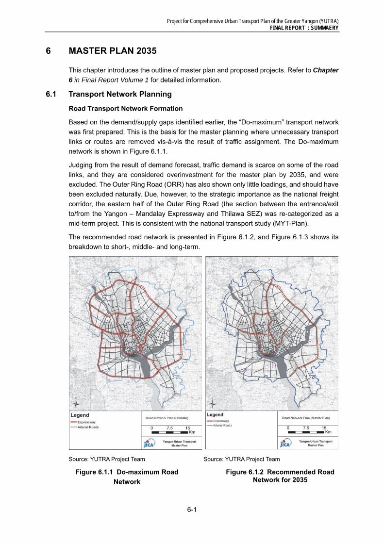
Project for Comprehensive Urban Transport Plan of the Greater Yangon (YUTRA) FINAL REPORT : SUMMAERY
6-1
6 MASTER PLAN 2035
This chapter introduces the outline of master plan and proposed projects. Refer to Chapter
6 in Final Report Volume 1 for detailed information.
6.1 Transport Network Planning
Road Transport Network Formation
Based on the demand/supply gaps identified earlier, the “Do-maximum” transport network
was first prepared. This is the basis for the master planning where unnecessary transport
links or routes are removed vis-à-vis the result of traffic assignment. The Do-maximum
network is shown in Figure 6.1.1.
Judging from the result of demand forecast, traffic demand is scarce on some of the road
links, and they are considered overinvestment for the master plan by 2035, and were
excluded. The Outer Ring Road (ORR) has also shown only little loadings, and should have
been excluded naturally. Due, however, to the strategic importance as the national freight
corridor, the eastern half of the Outer Ring Road (the section between the entrance/exit
to/from the Yangon – Mandalay Expressway and Thilawa SEZ) was re-categorized as a
mid-term project. This is consistent with the national transport study (MYT-Plan).
The recommended road network is presented in Figure 6.1.2, and Figure 6.1.3 shows its
breakdown to short-, middle- and long-term.
Source: YUTRA Project Team
Figure 6.1.1 Do-maximum Road
Network
Source: YUTRA Project Team
Figure 6.1.2 Recommended Road Network for 2035
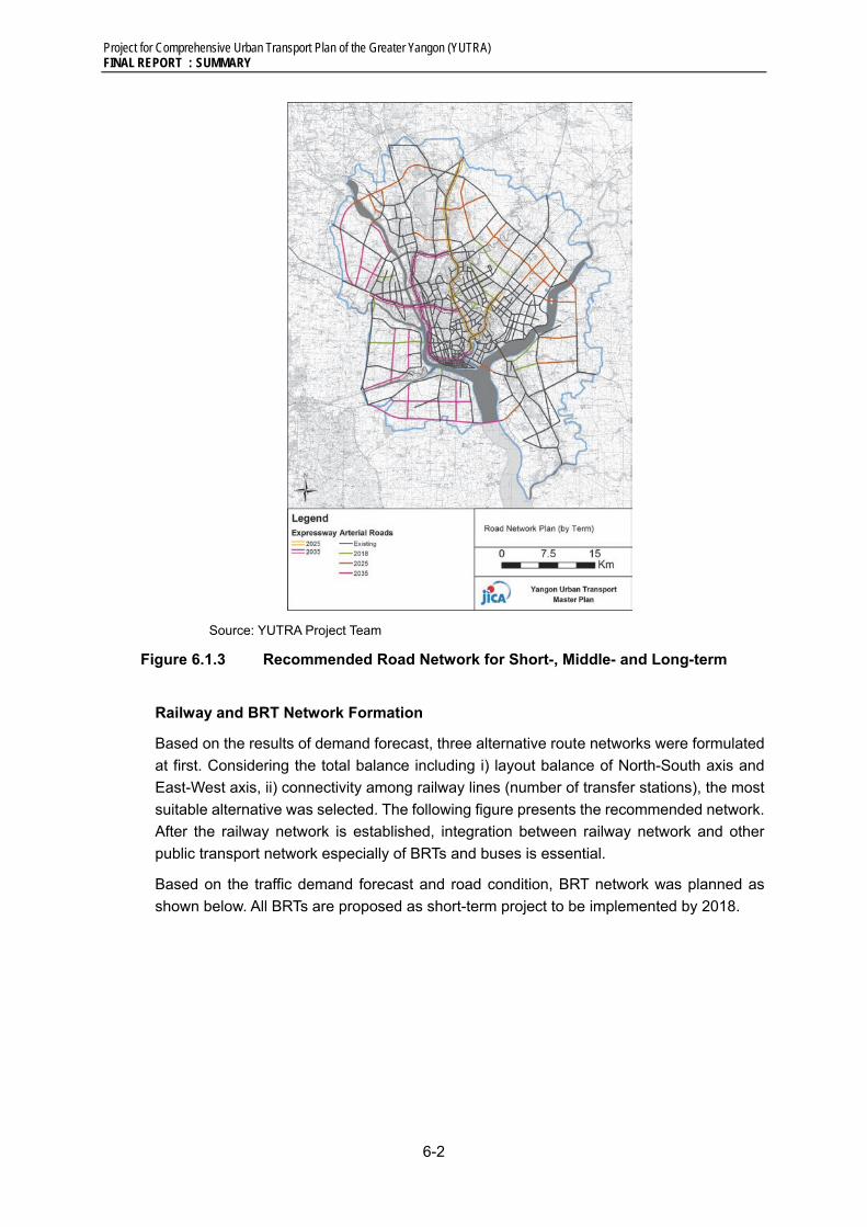
Project for Comprehensive Urban Transport Plan of the Greater Yangon (YUTRA) FINAL REPORT : SUMMARY
6-2
Source: YUTRA Project Team
Figure 6.1.3 Recommended Road Network for Short-, Middle- and Long-term
Railway and BRT Network Formation
Based on the results of demand forecast, three alternative route networks were formulated
at first. Considering the total balance including i) layout balance of North-South axis and
East-West axis, ii) connectivity among railway lines (number of transfer stations), the most
suitable alternative was selected. The following figure presents the recommended network.
After the railway network is established, integration between railway network and other
public transport network especially of BRTs and buses is essential.
Based on the traffic demand forecast and road condition, BRT network was planned as
shown below. All BRTs are proposed as short-term project to be implemented by 2018.

Project for Comprehensive Urban Transport Plan of the Greater Yangon (YUTRA) FINAL REPORT : SUMMAERY
6-3
Source: JICA Project Team
Figure 6.1.4 Recommended Railway Network for Short-, Middle- and Long-term
Source: YUTRA Project Team
Figure 6.1.5 Recommended BRT Routes
Transport Network Assessment
Figure 6.1.6 and Figure 6.1.7 show the result of traffic assignment for 2013 and 2035,
respectively.
Table 6.1.1 summarises the transport network performance for 2013, 2018, 2025 and 2035.
Even after implementing all the proposed projects, road network performance will
deteriorate gradually towards 2035. The largest advantage of this master plan is the
increasing share of mass transit (Myanmar Railway, UMRT and BRT). The overall share of
public transport will decrease significantly, however, will remain relatively high against the

Project for Comprehensive Urban Transport Plan of the Greater Yangon (YUTRA) FINAL REPORT : SUMMARY
6-4
pressure of rapid motorization.
Table 6.1.1 Transport Network Performance
Indicator 2013 2018 2025 2035
Average volume/ capacity ratio (road) 0.27 0.35 0.34 0.42
Average travel speed (kph, road) 30 22 28 24
Public transport share in terms of pax-km (%) 74 65 63 58
Mass transit share in terms of pax-km (%) 1 12 21 22 Source: YUTRA Project Team
Source: YUTRA Project Team
Figure 6.1.6 Assigned Traffic Volume, 2013
Source: YUTRA Project Team
Figure 6.1.7 Assigned Traffic Volume, 2035
6.2 Major Master Plan Projects
1) Urban Railway Projects
Urban Railway Projects are composed of three types of projects, i) Urban Sections of
Existing Myanmar Railway, ii) Urban Railway, and iii) Transit Oriented Development (TOD).
In order to enhance the project effect, these projects should be collaborated intimately
Road Myanmar Railway
Road and Expressway
Myanmar Railway , UMRT and BRT

Project for Comprehensive Urban Transport Plan of the Greater Yangon (YUTRA) FINAL REPORT : SUMMAERY
6-5
Urban Sections of Existing Myanmar Railway
Improvement and modernization of urban sections of the existing MR lines becomes a basis
of railway development in Yangon city. Improvement and modernization of urban sections
of the existing MR lines has some merits such as i) immediate effectivity due to passing
many developed areas with high population density, ii) relatively low initial cost due to
existing infrastructure utilization (therefore, the implementation is easy relatively for
Myanmar government, which need huge budget for many infrastructure rehabilitation.), and
iii) no or little land acquisition and resettlement is required due to locating inside MR yard,
etc.
In order to fulfill effective modernization for the existing railway, step-development will be
applied as below.
Elevated and Electrified as 2ndStep Electrified as 2ndStep (no elevated)
Source: YUTRA Project Team (2013)
Figure 6.2.1 Step-Development for Existing Railway Lines
Urban Railway
Judging from the future population increase with increasing the number of trip, it is essential
to install Urban Mass Rapid Transit (UMRT) with high speed, high frequency, and high
transport capacity, in addition to the existing railway modernization. On the other hand,
the installation timing should be set properly due to requiring huge cost for both initial
construction and operation and maintenance. The installation timing is decided based on
the actual example of relation between UMRT opening year and GRDP in Asian major cities.
Two UMRT lines are proposed.

Project for Comprehensive Urban Transport Plan of the Greater Yangon (YUTRA) FINAL REPORT : SUMMARY
6-6
Transit Oriented Development (TOD)
The key to be succeeded in railway project is to enhance ability to attract potential
passengers by developing stations as business/commercial center and transport hub by
yard redevelopment, land development along railway, transport hub function enhancement,
feeder function enhancement, etc. In other word, it is important to conduct TOD projects,
which means citizens can access everywhere in the city by public transport (mainly railway)
and walking and station becomes attractive in terms of commercial and economical aspect,
in harmonized with railway projects spatially and timely.
The Study plans to develop railway yards and high potential vacant lots along the urban
sections of the existing lines in harmonized with its improvement / modernization timely.
Four yards (Yangon Central station yard, Malwagone depot and workshop yard, Insein
workshop yard, and Kyeemyindaing station yard) have high development potential due to
large area. Especially, it is expected that Yangon Central station yard located at the center
of CBD will be developed early due to current high interest from several private developers.
However, in case of private oriented development, there is a possibility to be insufficient
public facilities required as basic station function to fulfil TOD such as transfer facility,
pedestrian deck, impediment removal design, seamless flow line design, effective station
plaza, emergency facility, etc., because private developer is apt to be development to
require short-term gain. Therefore, it is important that Myanmar government side makes
regulation for development from a leading position and takes appropriate right and
responsibility.
In addition, it is important to create virtuous cycle by reflowing the huge development
benefits from TOD towards railway upgrades, new construction, renewals, etc. in order to
realize further service level improvement
Furthermore, in order to conduct yard redevelopment project, it is required to relocate the
current function such stabling and maintaining rolling stocks, etc. to somewhere in advance.
The relocation work should be conducted by using development benefit obtained from
private developer, because it is recognized as a part of redevelopment project.
Source: YUTRA Project Team (2013) Figure 6.2.2 Schematic Figure of Relocation of Existing Depots and Workshops
to New Integrated Depot/Workshop

Project for Comprehensive Urban Transport Plan of the Greater Yangon (YUTRA) FINAL REPORT : SUMMAERY
6-7
Implementation Schedule
The chronological correlation diagram among proposed railway projects and proposed TOD
projects including yard redevelopment projects is shown in the figure below. The study
prepares a scenario to enhance reciprocal development effects among all projects.
Source: YUTRA Project Team (2013)
Figure 6.2.3 Chronological Correlation Diagram among Railway Projects and TOD/Land
Redevelopment Project
The location maps of the proposed projects for short-term, middle-term and long-term are

Project for Comprehensive Urban Transport Plan of the Greater Yangon (YUTRA) FINAL REPORT : SUMMARY
6-8
shown in the following three figures respectively.
For short-term, it is planned to enhance transport capacity of V shape line connecting
Danyingone station with Ywa Tar Gyi station via Yangon Central station by improving
Yangon Circular Railway Western Half and Yangon-Mandalay Line. In addition, yard
redevelopment projects along these lines will be conducted in parallel in order to increase
railway user and enhance ability to attract customers. Furthermore, relocation and
integration of existing depots and workshops, which is required in connection with yard
development, will be implemented simultaneously.
Source: YUTRA Project Team (2013)
Figure 6.2.4 Proposed Project Location Map for Short-term
For middle-term, it is planned to improve the remaining sections of the existing lines
(Yangon Circular Railway Eastern Half, Yangon-Pyay line suburban section, Thilawa
access line), and to conduct projects for yard redevelopment and land development along
these lines in parallel in order to fulfill further increasing railway user and enhancing ability

Project for Comprehensive Urban Transport Plan of the Greater Yangon (YUTRA) FINAL REPORT : SUMMAERY
6-9
to attract customers. Expansion of the new integrated depot and workshop will be
implemented simultaneously in connection with yard development.
Furthermore, UMRT Line1 which is named as North-South Line connecting CBD with Yangon International Airport via Yangon Central station and Mindama sub-center will be installed as first metro in Yangon. In order to minimize initial cost, it is planed underground section is minimized as much as possible, and elevated section is applied maximally. In addition, it is emphasized that it is essential to establish an implementation and operation body for UMRT exclusively in order to succeed in UMRT projects, judging from examples of other countries. The study is proposing to establish YUTA as organization for managing urban transport in Yangon. Therefore, it is proposed to establish an UMRT implementation and operation body, for example “UMRTA (UMRT Authority)”, under the umbrella of YUTA prior to UMRT project commencement.
Source: YUTRA Project Team (2013)
Figure 6.2.5 Proposed Project Location Map for Middle-term

Project for Comprehensive Urban Transport Plan of the Greater Yangon (YUTRA) FINAL REPORT : SUMMARY
6-10
For Long-term, it is planned to electrify and partially elevate existing lines which were
improved as first step in short or middle term, in order to fulfill further transport capacity
enhancement and speed-up, and reducing operation cost. Regarding UMRT, extension
of UMRT Line 1 and new construction of additional line will be implemented in order to
expand railway network.
Source: YUTRA Project Team (2013)
Figure 6.2.6 Proposed Project Location Map for Long-term
List of abovementioned projects with the implementation schedule for all terms is shown in
the table below.

Proj
ect f
or C
ompr
ehen
sive
Urb
an T
rans
port
Plan
of t
he G
reat
er Y
ango
n (Y
UTR
A)
FIN
AL
REP
OR
T : S
UM
MA
ERY
6-11
Tab
le 6
.2.1
O
vera
ll P
roje
ct L
ist
(1/3
)
RL
-1U
rge
nt
TA
for
the
Inte
gra
tion
of R
ail
Tra
ns
po
rtIm
pro
vem
en
t an
d S
tatio
n A
rea
Urb
an
De
velo
pm
en
t in
Ya
ng
on
(E
nh
an
cin
g T
ran
sit
Ori
en
ted
De
velo
pm
en
t)
Urg
ent
RL
-2U
rge
nt
TA
for
Co
mm
ute
r S
erv
ice
Le
vel E
nh
an
cem
en
tin
Gre
ate
r Y
an
go
nU
rgen
t
RL
-3U
rge
nt
Ra
ilwa
y C
en
tra
l Co
ntr
ol C
en
ter
Sys
tem
Ins
talla
tion
(T
he
stu
dy
is o
ng
oin
g b
y JI
CA
)U
rgen
t
RL
-4U
rge
nt
TA
for
Ra
ilwa
y S
afe
ty a
nd
Se
rvic
eIm
pro
vem
en
t(O
ng
oin
g b
y JI
CA
)
Urg
ent
RL
-5R
ela
ted
to Y
CR
We
ste
rn h
alf
De
velo
pm
en
t
Ya
ng
on
Cir
cula
r R
ailw
ay
Imp
rove
me
nt (
No
n-
ele
ctri
fied
)P
ha
se
1: W
es
tern
Ha
lf L
oo
p
Sho
rt-
term
RL
-6R
ela
ted
to Y
CR
We
ste
rn h
alf
De
velo
pm
en
t
TO
D E
nh
an
cem
en
t Pro
ject
alo
ng
Ya
ng
on
Cir
cula
r R
ailw
ay
We
ste
rn H
alf
Sho
rt-
term
RL
-7R
ela
ted
to Y
CR
We
ste
rn h
alf
De
velo
pm
en
t
Ya
ng
on
Ce
ntr
al S
tatio
n R
ed
eve
lop
me
nt
Pro
ject
Sho
rt-
term
RL
-8R
ela
ted
to Y
CR
We
ste
rn h
alf
De
velo
pm
en
t
Ne
w In
teg
rate
d D
ep
ot a
nd
Wo
rks
ho
pC
on
str
uct
ion
Pro
ject
(In
teg
ratio
n a
nd
Re
loca
tion
of C
urr
en
t De
po
ts a
nd
Wo
rks
ho
ps
to Y
an
go
n S
ub
urb
an
Are
a)
:Ph
as
e1
Sho
rt-
term
RL
-9R
ela
ted
to Y
CR
We
ste
rn h
alf
De
velo
pm
en
t
Kye
e M
yin
Da
ing
Sta
tion
Ya
rdR
ed
eve
lop
me
nt P
roje
ctM
iddl
e-te
rm
RL
-10
Re
late
d to
YC
RW
es
tern
ha
lfD
eve
lop
me
nt
Ins
ein
Wo
rks
ho
p A
rea
Re
de
velo
pm
en
tP
roje
ctM
iddl
e-te
rm
No.
Cat
egor
yPr
ojec
t Nam
eS
tatu
s20
1320
1420
1520
1620
1720
1820
1920
2020
2120
2220
2320
2420
2520
2620
2720
2820
2920
3020
3120
3220
3320
3420
3520
3620
3720
3820
3920
40
- E
sta
blis
h r
ed
eve
lop
me
nt r
ule
/sta
nd
ard
for
railw
ay
lan
d in
wh
ich
ma
ny
pri
vate
de
velo
pe
rs w
ill b
e in
tere
ste
d b
y u
sin
g P
PP
sch
em
e, e
tc.
- T
o p
rep
are
pla
n a
nd
ne
ces
sa
ry d
ocu
me
nts
for
Ya
ng
on
R.S
. an
d M
alw
ag
on
e W
.S.
relo
catio
n/r
ed
eve
lop
me
nt,
an
d r
ailw
ay
infr
as
tru
ctu
re d
eve
lop
me
nt b
y u
sin
g th
ed
eve
lop
me
nt b
en
efit
(in
c. p
rep
ari
ng
de
ma
rca
tion
be
twe
en
pu
blic
an
d p
riva
te,
sta
nd
ard
co
ntr
act
do
cum
en
t, s
tan
da
rd te
nd
er
do
cum
en
t/TO
R)
(1)
Su
pp
ort
to e
sta
blis
h a
n e
ffect
ive
tra
in o
pe
ratio
n p
lan
an
d d
iag
ram
for
com
mu
ter,
(2)
es
tab
lish
ing
"C
om
mu
ter
Se
rvic
e Im
pro
vem
en
t De
pt."
an
d th
e c
ap
aci
ty b
uild
ing
,a
nd
(3)
Te
chn
ica
l As
sis
tan
ce fo
r th
e e
xis
ting
pa
ss
en
ge
r w
ag
on
inte
rio
r u
pg
rad
e w
ork
for
com
mu
ter.
Th
e s
tud
y is
on
go
ing
by
JIC
A a
s p
ote
ntia
l gra
nt p
roje
ct.
- O
ng
oin
g b
y JI
CA
TA
- T
ech
nic
al t
ran
sfe
r fo
r tr
ack
ma
inte
na
nce
ski
ll b
y u
sin
g Y
an
go
n-M
an
da
lay
su
bu
rba
nlin
e.
- T
ech
nic
al s
tan
da
rd P
rep
ara
tion
.
- Im
pro
vem
en
t as
co
mm
ute
r lin
e fo
r a
pp
. 21
km b
etw
ee
n Y
an
go
n R
.S. a
nd
Da
nyi
ng
on
e R
.S.
- S
cop
e is
imp
rove
me
nt o
f civ
il, tr
ack
, exi
stin
g d
ep
ot/w
ork
sh
op
, mo
de
rniz
atio
n o
fs
ign
al.&
tele
com
, sta
tion
, au
tom
atic
leve
l cro
ss
ing
, DE
MU
pro
cure
me
nt.
- co
nd
uct
ed
as
ad
diti
on
al p
roje
ct o
f Ya
ng
on
Cir
cula
r R
ailw
ay
Imp
rove
me
nt P
ha
se
1:
We
ste
rn H
alf
Lo
op
- p
rovi
de
sta
tion
pla
za w
ith b
us
sto
p/te
rmin
al a
t Kye
em
yin
da
ing
R.S
., In
se
in R
.S.,
an
d D
an
yin
go
ne
R.S
.
- a
ss
um
ed
as
PP
P p
roje
ct-
At f
irs
t, th
e d
ep
ot f
un
ctio
n in
the
ya
rd is
re
loca
ted
, an
d th
e s
tatio
n y
ard
isre
de
velo
pe
d a
s tr
an
sp
ort
hu
b a
nd
bu
sin
es
s/e
con
om
ic c
en
ter.
- D
eve
lop
er
is o
blig
ed
to in
sta
ll th
e fo
llow
ing
infr
as
tru
ctu
res
by
the
de
velo
pm
en
tb
en
efit
; RL
-8: N
ew
De
po
t an
d W
ork
sh
op
Pro
ject
Ph
as
e1
.
- a
ss
um
ed
as
PP
P.
- R
elo
catio
n o
f cu
rre
nt d
ep
ot f
orc
ed
by
"RL
-7 Y
an
go
n C
en
tra
l Sta
tion
Re
de
velo
pm
en
tP
roje
ct".
Th
e p
roje
ct c
os
t sh
ou
ld b
e b
orn
by
RL
-7's
de
velo
pm
en
t pro
fit.
- P
rop
os
ed
site
is th
e n
ort
he
rn s
ide
of Y
wa
tar
Gyi
R.S
. wh
ich
is o
wn
ed
by
MR
.
- a
ss
um
ed
as
PP
P.
- A
t fir
st,
the
de
po
t fu
nct
ion
in th
e y
ard
is r
elo
cate
d, a
nd
the
sta
tion
ya
rd is
red
eve
lop
ed
as
tra
ns
po
rt h
ub
an
d b
us
ine
ss
/eco
no
mic
ce
nte
r.-
De
velo
pe
r is
ob
lige
d to
ins
tall
the
follo
win
g in
fra
str
uct
ure
s b
y th
e d
eve
lop
me
nt
be
ne
fit; R
L-1
1: N
ew
De
po
t an
d W
ork
sh
op
Pro
ject
Ph
as
e3
.
- a
ss
um
ed
as
PP
P.
- A
t fir
st,
the
wo
rks
ho
p fu
nct
ion
in th
e y
ard
is r
elo
cate
d, a
nd
the
ya
rd is
re
de
velo
pe
da
s tr
an
sp
ort
hu
b a
nd
bu
sin
es
s/e
con
om
ic c
en
ter.
- D
eve
lop
er
is o
blig
ed
to in
sta
ll th
e fo
llow
ing
infr
as
tru
ctu
res
by
the
de
velo
pm
en
tb
en
efit
; RL
-11
: Ne
w D
ep
ot a
nd
Wo
rks
ho
p P
roje
ct P
ha
se
3.
Rem
arks
Impl
emen
tatio
n S
ched
ule
< L
egen
d>
: F
/S, S
tud
y p
erio
d:
Gen
eral
pro
ced
ure
per
iod
: C
ons
ulta
nt e
mp
loym
ent
per
id:
Des
ign
and
Ten
der
do
cum
ent p
rep
arat
ion
per
iod
:Te
nder
pro
ced
ure
: C
ons
truc
tion,
Pro
cure
men
t:
Co
mm
ence
men
t o
f O
per
atio
n:
Tech
nica
l A
ssis
tanc
e (T
A)

Proj
ect f
or C
ompr
ehen
sive
Urb
an T
rans
port
Plan
of t
he G
reat
er Y
ango
n (Y
UTR
A)
FIN
AL
REP
OR
T : S
UM
MA
RY
6-12
Tab
le 6
.2.2
O
vera
ll P
roje
ct L
ist
(2/3
)
RL
-11
Re
late
d to
YC
RW
es
tern
ha
lfD
eve
lop
me
nt
Ne
w In
teg
rate
d D
ep
ot a
nd
Wo
rks
ho
pC
on
str
uct
ion
Pro
ject
(In
teg
ratio
n a
nd
Re
loca
tion
of C
urr
en
t De
po
ts a
nd
Wo
rks
ho
ps
to Y
an
go
n S
ub
urb
an
Are
a)
:Ph
as
e3
Mid
dle-
term
RL
-12
Re
late
d to
YC
RW
es
tern
ha
lfD
eve
lop
me
nt
Ele
ctri
fied
an
d E
leva
ted
Pro
ject
for
Ya
ng
on
Cir
cula
r R
ailw
ay
We
ste
rn H
alf
Long
-te
rm
RL
-13
Re
late
d to
Ya
ng
on
-Ma
nd
ala
yL
ine
De
velo
pm
en
t
Ya
ng
on
-Ma
nd
ala
y L
ine
Imp
rove
me
nt:
Ph
as
e1
(P
art
ial o
pe
ratio
n)
Sho
rt-
term
RL
-14
Re
late
d to
Ya
ng
on
-Ma
nd
ala
yL
ine
De
velo
pm
en
t
Ma
lwa
go
ne
De
po
t/Wo
rks
ho
p A
rea
Re
de
velo
pm
en
t Pro
ject
(in
clu
din
g T
rack
Imp
rove
me
nt b
etw
ee
n Y
an
go
n C
en
tra
lS
tatio
n a
nd
Ma
lwa
go
ne
Sta
tion
)
Sho
rt-
term
RL
-15
Re
late
d to
Ya
ng
on
-Ma
nd
ala
yL
ine
De
velo
pm
en
t
Ne
w In
teg
rate
d D
ep
ot a
nd
Wo
rks
ho
pC
on
str
uct
ion
Pro
ject
(In
teg
ratio
n a
nd
Re
loca
tion
of C
urr
en
t De
po
ts a
nd
Wo
rks
ho
ps
to Y
an
go
n S
ub
urb
an
Are
a)
:Ph
as
e2
Sho
rt-
term
RL
-16
Re
late
d to
Ya
ng
on
-Ma
nd
ala
yL
ine
De
velo
pm
en
t
To
e K
yau
ng
Ga
lay
Sta
tion
De
velo
pm
en
tP
roje
ctS
hort
-te
rm
RL
-17
Re
late
d to
Ya
ng
on
-Ma
nd
ala
yL
ine
De
velo
pm
en
t
Ya
ng
on
-Ma
nd
ala
y S
ub
urb
an
Lin
eE
lect
irifi
catio
nLo
ng-
term
RL
-18
Re
late
d to
YC
RE
as
tern
ha
lfD
eve
lop
me
nt
Ya
ng
on
Cir
cula
r R
ailw
ay
Imp
rove
me
nt (
No
n-
ele
ctri
fied
)P
ha
se
2: E
as
tern
Ha
lf L
oo
p
Mid
dle-
term
RL
-19
Re
late
d to
YC
RE
as
tern
ha
lfD
eve
lop
me
nt
Ra
ilwa
y L
an
d R
ed
eve
lop
me
nt P
roje
ct a
lon
gY
an
go
n C
ircu
lar
Ra
ilwa
y E
as
tern
-ha
lfM
iddl
e-te
rm
RL
-20
Re
late
d to
YC
RE
as
tern
ha
lfD
eve
lop
me
nt
Ele
ctri
fica
tion
of Y
an
go
n C
ircu
lar
Ra
ilwa
yE
as
tern
Ha
lfLo
ng-
term
No.
Cat
egor
yPr
ojec
t Nam
eS
tatu
s20
1320
1420
1520
1620
1720
1820
1920
2020
2120
2220
2320
2420
2520
2620
2720
2820
2920
3020
3120
3220
3320
3420
3520
3620
3720
3820
3920
40
- a
ss
um
ed
as
PP
P.
- R
elo
catio
n o
f cu
rre
nt d
ep
ot f
orc
ed
by
"RL
-9 K
yee
Myi
n D
ain
g S
tatio
n Y
ard
Re
de
velo
pm
en
t Pro
ject
" a
nd
"R
L-1
0 In
se
in W
ork
sh
op
Are
a R
ed
eve
lop
me
nt P
roje
ct".
Th
e p
roje
ct c
os
t sh
ou
ld b
e b
orn
by
RL
-9 a
nd
RL
-10
's d
eve
lop
me
nt b
en
efit
.-
Pro
po
se
d s
ite is
the
no
rth
ern
sid
e o
f Yw
a ta
r G
yi R
.S. w
hic
h is
ow
ne
d b
y M
R.
- E
lect
rifie
d e
leva
ted
ra
ilwa
y to
be
co
ns
tru
cte
d a
bo
ve th
e a
t-g
rad
e Y
CR
. B
eca
us
e o
fth
is, p
urp
os
e o
f at-
gra
de
lin
e to
be
ch
an
ge
d fo
r m
idd
le-l
on
g d
ista
nce
tra
in/fr
eig
ht
tra
in.
- T
he
pro
ject
sh
ou
ld b
e c
on
du
cte
d b
y m
axi
mu
m u
sin
g o
f th
e d
eve
lop
me
nt b
en
efit
fro
m R
L-9
Kye
em
yin
da
ing
Re
de
velo
pm
en
t an
d R
L-1
0 In
se
in R
ed
eve
lop
me
nt.
- In
fra
str
uct
ure
imp
rove
me
nt w
ill b
e c
on
du
cte
d b
y Ja
pa
ne
se
Lo
an
.-
Infr
as
tru
ctu
re im
pro
vem
en
t is
as
no
n-e
lect
rifie
d a
nd
the
targ
et s
ect
ion
is b
etw
ee
nY
an
go
n C
en
tra
l Sta
tion
an
d T
ou
ng
oo
R.S
. H
ow
eve
r, r
eg
ard
ing
Th
e s
ect
ion
be
twe
en
Ya
ng
on
Ce
ntr
al S
tatio
n to
Ma
lwa
go
ne
R.S
, civ
il a
nd
tra
ck a
re n
ot i
ncl
ud
ed
.-
Ad
diti
on
al D
EM
U p
rocu
rem
en
t is
es
tima
ted
as
co
mm
ute
r tr
ain
.
- a
ss
um
ed
as
PP
P.
- A
t fir
st,
the
wo
rks
ho
p fu
nct
ion
in th
e y
ard
is r
elo
cate
d, a
nd
the
ya
rd is
re
de
velo
pe
da
s tr
an
sp
ort
hu
b a
nd
bu
sin
es
s/e
con
om
ic c
en
ter.
- D
eve
lop
er
is o
blig
ed
to im
pro
ve c
ivil/
tra
ck b
etw
ee
n Y
an
go
n C
en
tra
l Sta
tion
an
dM
alw
ag
on
e R
.S. a
nd
ins
tall
the
follo
win
g in
fra
str
uct
ure
s b
y th
e d
eve
lop
me
nt b
en
efit
;R
L-1
5: N
ew
De
po
t an
d W
ork
sh
op
Pro
ject
Ph
as
e2
.
- a
ss
um
ed
as
PP
P.
- R
elo
catio
n o
f cu
rre
nt d
ep
ot f
orc
ed
by
"RL
-14
Ma
lwa
go
ne
Wo
rks
ho
pR
ed
eve
lop
me
nt P
roje
ct".
Th
e p
roje
ct c
os
t sh
ou
ld b
e b
orn
by
RL
-14
's d
eve
lop
me
nt
be
ne
fit.
- P
rop
os
ed
site
is th
e n
ort
he
rn s
ide
of Y
wa
tar
Gyi
R.S
. wh
ich
is o
wn
ed
by
MR
.
- a
ss
um
ed
as
PP
P.
- S
tatio
n a
rea
re
de
velo
pm
en
t an
d e
nh
an
cem
en
t of t
ran
sp
ort
hu
b fu
nct
ion
- E
lect
rific
atio
n b
etw
ee
n Y
an
go
n C
en
tra
l Sta
tion
an
d L
ed
au
ng
an
R.S
.
- T
he
pro
ject
sh
ou
ld b
e c
on
du
cte
d b
y m
axi
mu
m u
sin
g o
f th
e d
eve
lop
me
nt b
en
efit
fro
m "
RL
-14
Ma
lwa
go
ne
Wo
rks
ho
p R
ed
eve
lop
me
nt"
.
- a
ss
um
ed
as
PP
P.
- to
en
ha
nce
tra
ns
po
rt h
ub
fun
ctio
n a
nd
de
velo
p s
tatio
n p
laza
of t
he
ma
in s
tatio
ns
(Min
ga
lard
on
R.S
., Y
eg
u R
.S.,
etc
.) a
lon
g Y
CR
Ea
ste
rn h
alf.
- to
be
co
nd
uct
ed
as
ad
diti
on
al p
roje
ct o
f RL
-18
: YC
R Im
pro
vem
en
t Ph
as
e2
: Ea
ste
rnH
alf.
Rem
arks
Impl
emen
tatio
n S
ched
ule

Proj
ect f
or C
ompr
ehen
sive
Urb
an T
rans
port
Plan
of t
he G
reat
er Y
ango
n (Y
UTR
A)
FIN
AL
REP
OR
T : S
UM
MA
ERY
6-13
Tab
le 6
.2.3
O
vera
ll P
roje
ct L
ist
(3/3
)
S
ourc
e: Y
UT
RA
Pro
ject
Tea
m (
2013
)
RL
-21
Re
late
d to
Ya
ng
on
-Pya
y L
ine
De
velo
pm
en
t
Ya
ng
on
-Pya
y S
ub
urb
an
Lin
e Im
pro
vem
en
ta
nd
Do
ub
le-t
rack
ing
(b
etw
ee
n D
an
yin
go
ne
R.S
an
d H
ma
wb
i R.S
)
Mid
dle-
term
RL
-22
Re
late
d to
Ya
ng
on
-Pya
y L
ine
De
velo
pm
en
tH
law
ga
Sta
tion
De
velo
pm
en
tM
iddl
e-te
rm
RL
-23
Re
late
d to
Ya
ng
on
-Pya
y L
ine
De
velo
pm
en
tY
an
go
n-P
yay
Su
bu
rba
n L
ine
Ele
ctir
ifica
tion
Long
-te
rm
RL
-24
Re
late
d to
Th
ilaw
a A
cce
ss
Th
ilaw
a A
cce
ss
Lin
e Im
pro
vem
en
t an
dD
ou
ble
-tra
ckin
g (
for
Co
mm
ute
r a
nd
Fre
igh
t)M
iddl
e-te
rm
RL
-25
Re
late
d to
Th
ilaw
a A
cce
ss
Th
ilaw
a N
ew
Co
nta
ine
r R
ailw
ay
Sta
tion
De
velo
pm
en
t Pro
ject
Mid
dle-
term
RL
-26
Re
late
d to
Th
ilaw
a A
cce
ss
Th
ilaw
a A
cce
ss
Lin
e E
lect
rific
atio
nLo
ng-
term
RL
-27
UM
RT
UM
RT
Lin
e1
Co
ns
tru
ctio
n P
roje
ct(N
ort
h-S
ou
th L
ine
)M
iddl
e-te
rm
RL
-28
UM
RT
UM
RT
Lin
e1
Ext
en
sio
n P
roje
ct(N
ort
h-S
ou
th L
ine
Ext
en
sio
n)
Long
-te
rm
RL
-29
UM
RT
UM
RT
Lin
e2
Co
ns
tru
ctio
n P
roje
ct(E
as
t-W
es
t Lin
e)
Long
-te
rm
No.
Cat
egor
yPr
ojec
t Nam
eS
tatu
s20
1320
1420
1520
1620
1720
1820
1920
2020
2120
2220
2320
2420
2520
2620
2720
2820
2920
3020
3120
3220
3320
3420
3520
3620
3720
3820
3920
40
as
su
me
d a
s P
PP
.
- D
ou
ble
-tra
ckin
g th
e e
xis
ting
Th
ilaw
a b
ran
ch li
ne
- R
eg
ard
ing
acr
os
s B
ag
o r
ive
r, B
ag
o b
rid
ge
wh
ich
will
be
co
ns
tru
cte
d n
ew
ly is
to b
ero
ad
-cu
m-r
ailw
ay
bri
dg
e.
- C
on
tain
er
tra
in w
ill p
as
s B
ag
o b
rid
ge
, no
t exi
stin
g b
rid
ge
, du
e to
the
lim
itatio
n o
fco
ns
tru
ctio
n g
au
ge
.
- A
dd
itio
na
l pro
ject
of "
RL
-24
: Th
ilaw
a a
cce
ss
lin
e im
pro
vem
en
t".
- T
he
sta
tion
is fo
r co
nta
ine
r a
nd
bu
lk c
arg
e h
an
dlin
g fr
om
/to T
hila
wa
po
rt a
nd
SE
Z.
- M
RT
lin
e li
nki
ng
Su
le P
ag
od
a, w
ith Y
an
go
n In
tl. A
irp
ort
via
Ya
ng
on
Ce
ntr
al S
tatio
n,
Min
da
ma
su
bce
nte
r a
lon
g m
ain
ly K
ab
ar
Aye
Pa
go
da
Rd
.-
Le
ng
th 2
1.8
km (
UG
:10
.5km
, EV
:11
.3km
)
- E
xte
ns
ion
pro
ject
for
RL
-27
: UM
RT
lin
e1
to D
ala
.-
6km
ext
en
sio
n.
(UG
: 3.7
km, E
V: 2
.3km
)
- M
RT
lin
e li
nki
ng
with
Hla
ing
Th
aya
su
b-c
en
ter,
Min
da
ma
su
b-c
en
ter,
an
d D
ag
on
Myo
thit
su
b-c
en
ter.
- L
en
gth
: 26
km (
UG
: 13
km, E
V: 1
3km
)Rem
arks
Impl
emen
tatio
n S
ched
ule

Project for Comprehensive Urban Transport Plan of the Greater Yangon (YUTRA) FINAL REPORT : SUMMARY
6-14
Rough Construction and Procurement Cost Estimate (MR, UMRT and TOD)
The rough cost estimate result for construction and procurement work related to railway is
shown in the table below. The cost is estimated based on the unit cost per km, per ha, etc.
calculated based on the actual project data, related documents, etc. The cost is for initial
construction and procurement cost only and does not include the other costs such as
engineering service cost, land acquisition and resettlement cost, price escalation, tax, etc.
Table 6.2.4 Rough Construction and Procurement Cost Estimate (MR, UMRT and TOD)
Source: YUTRA Project Team (2013)
RL-1 UrgentTA for the Integration of Rail Transport Improvement and StationArea Urban Development in Yangon (Enhancing Transit OrientedDevelopment)
Urgent
RL-2 Urgent TA for Commuter Service Level Enhancement in Greater Yangon Urgent
RL-3 UrgentRailway Central Control Center System Installation (The study isongoing by JICA)
Urgent
RL-4 UrgentTA for Railway Safety and Service Improvement(Ongoing by JICA)
Urgent
RL-5Related to YCR
Western halfDevelopment
Yangon Circular Railway Improvement (Non-electrified)Phase1: Western Half Loop
Short-term
RL-6Related to YCR
Western halfDevelopment
TOD Enhancement Project along Yangon Circular Railway WesternHalf
Short-term
RL-7Related to YCR
Western halfDevelopment
Yangon Central Station Redevelopment Project Short-term
RL-8Related to YCR
Western halfDevelopment
New Integrated Depot and Workshop Construction Project(Integration and Relocation of Current Depots and Workshops toYangon Suburban Area) :Phase1
Short-term
RL-9Related to YCR
Western halfDevelopment
Kyee Myin Daing Station Yard Redevelopment ProjectMiddle-
term
RL-10Related to YCR
Western halfDevelopment
Insein Workshop Area Redevelopment ProjectMiddle-
term
RL-11Related to YCR
Western halfDevelopment
New Integrated Depot and Workshop Construction Project(Integration and Relocation of Current Depots and Workshops toYangon Suburban Area) :Phase3
Middle-term
RL-12Related to YCR
Western halfDevelopment
Electrified and Elevated Project for Yangon Circular RailwayWestern Half
Long-term
RL-13Related to Yangon-
Mandalay LineDevelopment
Yangon-Mandalay Line Improvement: Phase1 (Partial operation) Short-term
RL-14Related to Yangon-
Mandalay LineDevelopment
Malwagone Depot/Workshop Area Redevelopment Project (includingTrack Improvement between Yangon Central Station and MalwagoneStation)
Short-term
RL-15Related to Yangon-
Mandalay LineDevelopment
New Integrated Depot and Workshop Construction Project(Integration and Relocation of Current Depots and Workshops toYangon Suburban Area) :Phase2
Short-term
RL-16Related to Yangon-
Mandalay LineDevelopment
Toe Kyaung Galay Station Development Project Short-term
RL-17Related to Yangon-
Mandalay LineDevelopment
Yangon-Mandalay Suburban Line Electirification Long-term
RL-18Related to YCR
Eastern halfDevelopment
Yangon Circular Railway Improvement (Non-electrified)Phase2: Eastern Half Loop
Middle-term
RL-19Related to YCR
Eastern halfDevelopment
Railway Land Redevelopment Project along Yangon CircularRailway Eastern-half
Middle-term
RL-20Related to YCR
Eastern halfDevelopment
Electrification of Yangon Circular Railway Eastern Half Long-term
RL-21Related to Yangon-
Pyay LineDevelopment
Yangon-Pyay Suburban Line Improvement and Double-tracking(between Danyingone R.S and Hmawbi R.S)
Middle-term
RL-22Related to Yangon-
Pyay LineDevelopment
Hlawga Station DevelopmentMiddle-
term
RL-23Related to Yangon-
Pyay LineDevelopment
Yangon-Pyay Suburban Line Electirification Long-term
RL-24Related to Thilawa
AccessThilawa Access Line Improvement and Double-tracking (forCommuter and Freight)
Middle-term
RL-25Related to Thilawa
AccessThilawa New Container Railway Station Development Project
Middle-term
RL-26Related to Thilawa
AccessThilawa Access Line Electrification Long-term
RL-27 UMRTUMRT Line1 Construction Project(North-South Line)
Middle-term
RL-28 UMRTUMRT Line1 Extension Project(North-South Line Extension)
Long-term
RL-29 UMRTUMRT Line2 Construction Project(East-West Line)
Long-term
No. Category Project Name StatusRailway TOD Others
Short-term Middle-term Long-term Short-term Middle-term Long-term Short-term Middle-term Long-term
1
2
-
-
485 485
6 6
704 704
64 64
220 220
1,144 1,144
104 104
1,260 1,260
144 144
2,684 2,684
244 244
220 220
425 425
568 568
1,100 1,100
398 398
500 500
220 220
302 302
766 766
40 40
393 393
2,253 2,253
693 693
2,730 2,730
sum 629 4,087 6,201 3,614 2,684 0 412 40 0sub-total 10,917 6,298 452
total 17,667
ConstructionCost (USD

Project for Comprehensive Urban Transport Plan of the Greater Yangon (YUTRA) FINAL REPORT : SUMMARY
6-15
2) Other Mass Transit Systems including BRT
BRT network for Yangon and Construction Stage
There are 11 BRT routes, however, some of them have overlapping sections and the
corridors for construction can be categorized as shown in Figure 6.2.7. The build stages
are designed to create an early and effective impact to maximise the opportunity for
motorists to use BRT during its early stages and prior to the full network being complete.
Source: YUTRA Project Team
Figure 6.2.7 BRT Corridors for Construction
Implementation Schedule and Cost Estimation
Table 6.2.5 and Figure 6.2.8 show the phases of construction and length of busway
construction required for each stage.
Table 6.2.5 BRT Route and Construction Length (per phase)
Corridor Construction (Km) BRT Route Length (Km) Project
Cost (USD Mill.)
Phase 1A
Blue Line 22.4 BRT 1 (Red) 24.6
153 Green Line 27.5 BRT 2 (Blue) 22.5
BRT 3 (L/Green) 25.0
Subtotal 49.9 Subtotal 72.1
Phase 1B
Orange Line Section North 8.5 BRT 4 (Light Blue) 18.7
139 Orange Line Section South 11.4 BRT 5 (Orange) 22.7
Red Line 11.2 BRT 6 (Pink) 25.6
Subtotal 31.1 Subtotal 67.0

Project for Comprehensive Urban Transport Plan of the Greater Yangon (YUTRA) FINAL REPORT : SUMMARY
6-16
Corridor Construction (Km) BRT Route Length (Km) Project
Cost (USD Mill.)
Phase 2A
Purple Line 20.3 BRT 7 (Dark Green) 19.5
111 Brown Line 9.7 BRT 8 (Aqua Blue) 20.3
BRT 9 (Brown) 21.4
Subtotal 30.0 Subtotal 61.2
Phase 2B
Grey Line 16.9 BRT 10A (Yellow) 23.5
69 BRT 10B (Purple) 21.1
Subtotal 16.9 Subtotal 44.6
TOTAL 127.9 TOTAL 244.9 472
Source: YUTRA Project Team
Source: YUTRA Project Team
Figure 6.2.8 BRT Implementation Schedule by Phase
Conventional Bus
Poorly planned current bus system resulted in bus route overlapping, worsening traffic
congestion, and reducing the capacity of public bus transport system. Therefore,
restructuring of bus network is required to improve the efficiency of bus operation. This
restructuring, however, should be done according to the following principles:
1. A new business model that enables investment on clean and efficient fleet and other modern facilities should be introduced.
2. Rerouting of buses should be conducted as MRTs and BRTs are constructed. Conventional bus should shift step-wise from trunk services to feeder services. In this case, major railway/BRT stations or terminals should provide buses with

Project for Comprehensive Urban Transport Plan of the Greater Yangon (YUTRA) FINAL REPORT : SUMMARY
6-17
enough space for the convenience of transferring passengers.
This is, in one word, a systematic and coordinated approach as the entire public transport
system of Yangon. Bus operation is required to change gradually as BRTs and urban
railways start operation. This change will be represented by major two movements; 1)
modernization of fleet and passenger facilities including bus stops and terminals, and 2)
shift from trunk service to feeder service.
In the light of the above, the following project is proposed. The total cost of this project is
about US$ 108 million. Refer to the project profile in the Appendix of this report for details.
Project Title: Improvement of Existing Public Bus Transport Services in Yangon Region
- Restructuring of bus network
- Modernization of bus services
- Development of bus terminals and interchanges
- Prioritization of urban bus transport
3) Road Development Projects
Arterial Road/ Expressway Network Plan
According to the results of traffic demand forecast analysis, arterial road/ expressway
network plans in the ultimate stage are shown as Figure 6.2.9 and Figure 6.2.10.
Source: YUTRA Project Team
Figure 6.2.9 Arterial Road Network
Plan (Ultimate)
Source: YUTRA Project Team
Figure 6.2.10 Expressway Network Plan
(Ultimate)

Project for Comprehensive Urban Transport Plan of the Greater Yangon (YUTRA) FINAL REPORT : SUMMARY
6-18
Typical cross section of Inner Ring Expressway are designed as follows:
Inner Ring Expressway can be constructed above existing major arterial roads in
developed area as elevated viaducts with 4 lanes. Width of traffic lane of existing
arterial road shall be narrowed from 3.6 m to 3.0 m, and pier of viaduct is located
medium strip.
North section of Inner Ring Expressway can be constructed as embankment.
Image of Inner Ring Expressway (Wai Za
Yan Tar Road)
Route Alignment of Inner Ring Expressway
Source: YUTRA Project Team
Figure 6.2.11 Typical Cross Section and Image of Inner Ring Expressway
Road Development Projects for Each Target Year
The target year for the short, middle and long term plans are 2018, 2025, and 2035
respectively. Each objective is listed below and highlighted in Figure 6.2.12 to Figure 6.2.14.
As reference, road development projects after long term are shown in Figure 6.2.15.
Short Term Projects (2013-2018)
- Connectivity with national transport
- Decentralization to northern and eastern area to accelerate the development of
Mindama, Thilawa and Bago Riverside sub-senter.
- Connectivity to Thilawa SEZ
- Diversion of truck route

Project for Comprehensive Urban Transport Plan of the Greater Yangon (YUTRA) FINAL REPORT : SUMMARY
6-19
Source: YUTRA Project Team Figure 6.2.12 Short Term Projects (2018)
Source: YUTRA Project Team Figure 6.2.13 Middle Term Projects (2025)
Source: YUTRA Project Team Figure 6.2.14 Long Term Projects (2035)
Source: YUTRA Project Team Figure 6.2.15 Road Development Projects
(after 2035) <Reference>

Project for Comprehensive Urban Transport Plan of the Greater Yangon (YUTRA) FINAL REPORT : SUMMARY
6-20
Middle Term Projects (2018-2025)
- Decentralization to northen and eastern area to accelerate the development of
Thilawa, Dagon Myothit and Hlaing Tharaya sub-senter.
- Extension to road network to Hlegu, Hmawbi and East Dagon New Town Cores.
- Build north-south Urban Expressway axis.
- Build Outer Ring Expressway to connect national transport to Thilawa SEZ.
Long Term Projects (2025-2035)
- Development of western and southern area.
- Extension to road network to Thanlyin, Dala, Twanty and Htantabin New Town Core.
- Closing of Inner Ring Expressway and outer ring arterial road.
Implementation Schedule
Implementation schedule for each road development project in short, middle and long term
plans are shown in Table 6.2.6.
Table 6.2.6 Implementation Schedule of Road Development Projects
Source: YUTRA Project Team
Rough Cost Estimates
Rough construction cost estimates for each road development project in short, middle and
long term plans are shown in Table 6.2.7.
2013 2014 2015 2016 2017 2018 2019 2020 2021 2022 2023 2024 2025 2026 2027 2028 2029 2030 2031 2032 2033 2034 2035 2036 2037
North Radial
East Radial
West Radial
Inner Ring
Outer Ring
E-W Link
Outer Ring Road
New construction
Widening
Project
ITS
Expressway
Arterial Road
Traffic Control
Phase 1- 4
Phase 1- 5
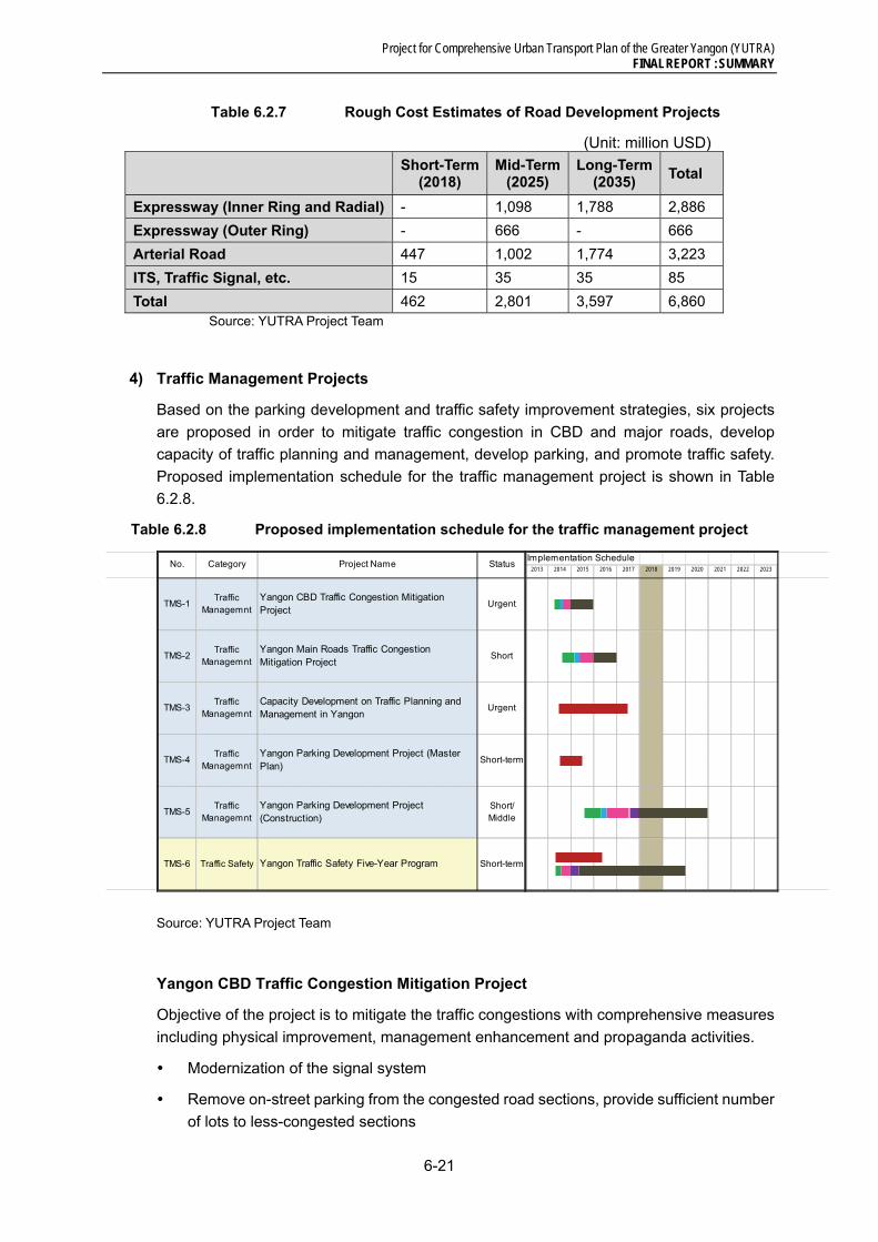
Project for Comprehensive Urban Transport Plan of the Greater Yangon (YUTRA) FINAL REPORT : SUMMARY
6-21
Table 6.2.7 Rough Cost Estimates of Road Development Projects
(Unit: million USD)
Short-Term
(2018) Mid-Term
(2025) Long-Term
(2035) Total
Expressway (Inner Ring and Radial) - 1,098 1,788 2,886
Expressway (Outer Ring) - 666 - 666
Arterial Road 447 1,002 1,774 3,223
ITS, Traffic Signal, etc. 15 35 35 85
Total 462 2,801 3,597 6,860 Source: YUTRA Project Team
4) Traffic Management Projects
Based on the parking development and traffic safety improvement strategies, six projects
are proposed in order to mitigate traffic congestion in CBD and major roads, develop
capacity of traffic planning and management, develop parking, and promote traffic safety.
Proposed implementation schedule for the traffic management project is shown in Table
6.2.8.
Table 6.2.8 Proposed implementation schedule for the traffic management project
Source: YUTRA Project Team
Yangon CBD Traffic Congestion Mitigation Project
Objective of the project is to mitigate the traffic congestions with comprehensive measures
including physical improvement, management enhancement and propaganda activities.
Modernization of the signal system
Remove on-street parking from the congested road sections, provide sufficient number
of lots to less-congested sections
TMS-1Traffic
ManagemntYangon CBD Traffic Congestion MitigationProject
Urgent
TMS-2Traffic
ManagemntYangon Main Roads Traffic CongestionMitigation Project
Short
TMS-3Traffic
ManagemntCapacity Development on Traffic Planning andManagement in Yangon
Urgent
TMS-4Traffic
ManagemntYangon Parking Development Project (MasterPlan)
Short-term
TMS-5Traffic
ManagemntYangon Parking Development Project(Construction)
Short/Middle
TMS-6 Traffic Safety Yangon Traffic Safety Five-Year Program Short-term
No. Category Project Name StatusImplementation Schedule
2013 2014 2015 2016 2017 2018 2019 2020 2021 2022 2023

Project for Comprehensive Urban Transport Plan of the Greater Yangon (YUTRA) FINAL REPORT : SUMMARY
6-22
Parking Fee charging system (including parking meter)
Remove street vendors from foot path and develop a Hawker Centre, and improve
pedestrian environment
Provision of bus-bays and taxi-bays
Implementation of Mobility Management Measures (TDM measures)
Proposed Implementation Period: from April 2014 to Dec 2015, Implementing Agency:
YCDC
Major Roads Traffic Congestion Mitigation Project
This project is aiming to tackle the existing congestion problems on the main roads with
areal and comprehensive measures so as to provide a smooth and safe traffic flows.
installation and upgrading traffic signal control system
improvement of intersection geometrics, installation of Road signs and pavement
marking
installation of Traffic monitoring system
provision of pedestrian bridges
development of bus interchanges and improvement of bus stops, etc.
Proposed Implementation Period: July 2014 to Dec 2016, Implementing Agency:
YCDC
Capacity Development on Traffic Planning and Management
Traffic management policy is one of the significant urban transport policies to enhance the
efficiency of road network system and to control traffic demand. However, there is no
specialized organization responsible for the traffic management in Yangon. This project is
aiming to establish 'Traffic Planning and Management Unit' under Engineering Department
of YCDC and to enhance their knowledge and implementation capabilities. Furthermore,
comprehensive traffic database which unifies traffic volume, car registration number and so
on should be developed in order to grasp and analysis traffic condition changing every
moment and apply more appropriate traffic management policy.
training on traffic engineering and management
Development of traffic database
implementation of pilot projects
development of rules and regulation related to the traffic demand management
training in Japan and third countries
seminar and workshop
Proposed Implementation Period: from August 2014 to July 2017, Implementing
Agency: YCDC
Yangon Parking Development Project (Master Plan)
Traffic congestion mitigation projects (TMS-1 and -2) will include countermeasures to

Project for Comprehensive Urban Transport Plan of the Greater Yangon (YUTRA) FINAL REPORT : SUMMARY
6-23
reduce on-street parking problems causing traffic congestions. The Parking Master Plan
will make clear numerous issues on the parking, what kind of parking policies will be
required to meet comprehensive urban transport policies as well as urban development
polices including TOD (Transit Oriented Development).
Survey on parking situation and estimation of parking demand
Establishment of laws and regulations as well as technical guidelines
Public parking development plans (Identification of candidate location, basic design,
cost estimation, etc.)
Examination of public parking operation, enforcement for illegal parking
Financial and economic evaluation, and funding
Organizational set up for the parking facilities operation and maintenance
Proposed Implementation Period: from August 2014 to March 2015, Implementing
Agency: YCDC
Yangon Parking Development Project (Construction)
This project aims to construct off-street public parking facilities proposed in the Master Plan
above. The proposed Park & Ride parking facilities which will be established at major transit
terminals will be planed and constructed in the respective public transit project. Then this
project will focus on the public parking located in the CBD area. Due to the limited land
availability in the CBD, the location of the parking shall be carefully selected including
examination of the availability of underground spaces. In the first stage of the project,
feasibility study will be carried out prior to the construction of the public parking facilities.
to carry out Feasibility Study for the proposed public parking including environmental
assessment
to prepare detail design and tender document
to supervise the construction
Proposed Implementation Period: from April 2015 to Dec 2020, Implementing Agency:
YCDC
Yangon Traffic Safety Five-Year Program
Currently, there is no proper organizational setup for the comprehensive traffic safety
intervention; just traffic police are playing major roles through ad-hoc enforcement activities.
This five-year program is aiming (1) to develop institution for the comprehensive traffic
safety activities including establishment of Traffic Safety Committee and (2) to implement a
series of traffic safety activities.
preparation of traffic safety projects for five years including 3Es (Engineering,
Enforcement and Education)
Establishment of Traffic Safety Committee
Development of Traffic Accident Database
implementation of the traffic safety projects

Project for Comprehensive Urban Transport Plan of the Greater Yangon (YUTRA) FINAL REPORT : SUMMARY
6-24
Capacity Development for Traffic Police Force, traffic safety committee and other
stakeholder involved in traffic safety activities
Proposed Implementation Period: from April 2014 to Dec 2019, Implementing Agency:
YCDC
Recommendation
1. Commitment on “Creation of Human and Environmental Friendly Traffic Society in
Yangon” shall be made as a principle among the stakeholders in Yangon, accordingly
importance of the public transport system and traffic demand management will be
confirmed.
2. To mitigate traffic congestions in CBD and at major intersections outside of CBD will
be urgent issues. Among the various causes of the congestions, insufficient traffic
signal operation shall be updated in prior to the introduction of the grade-separation
structure. In CBD, not only upgrading signal system, but also they have to tackle with
parking problems and street vendors. Thus comprehensive traffic management
measures will be indispensable in CBD.
3. Based on the experiences in other countries including Japan, during the initial stages
of motorization, large number of traffic accident is happened due to the rapid changes
of traffic environment. Now, Government of Yangon shall introduce comprehensive
traffic safety policies focusing on the current issues; pedestrian safety, strengthening
safety driving on commercial vehicles including buses in urban area, and accidents of
two-wheel vehicles in suburban areas in Yangon.
4. Currently usage of two wheel vehicles in the urban area is prohibited, so that public
passenger bus transport is the most popular transport means among Yangon Citizen
in spite of discomfort of the existing public bus transport services. However, it is
important to maintain the behavioral habit depending on public transport system in
Yangon. Therefore the prohibition of two wheel vehicles should be continued and in
addition new traffic demand management including Parking Control Policy should be
introduced in order to control rapid motorization in Yangon.
5. For the comprehensive traffic management and traffic safety policy development,
innovation of government system and organization as well as human resource
development shall be considered to prime importance, particularly establishment of
“Traffic Planning and Management Unit” and “Yangon Traffic Safety Committee”. And
also in order to ensure the sustainability on the traffic management and safety, it is
recommended to formulate a system of continuous 5-Year Plan development strategy
and necessary reliable management system and fund resources for the
implementation shall be institutionalized.
5) Freight Transport and Tourism Project
New MR ICD and Relocation of Highway Truck Terminal
The candidate area for the MR ICD and other associated facilities is located at about 20 km
east along the Main Road No. 2, near the intersection with the Main Road No.7. Referring
to the Lat Krabang ICD (80 ha) in Thailand, of which design capacity is around 1.5 million

Project for Comprehensive Urban Transport Plan of the Greater Yangon (YUTRA) FINAL REPORT : SUMMARY
6-25
TEU (see Figure 6.2.16), an indicative size of the ICD at East Dagon can be about 100 ~
150 ha in the initial stage. At the same time the existing highway truck terminal at Bayint
Naung can be relocated to the MR ICD’s neighbour, and a new highway bus terminal which
serve the residents in the East Dagon Township and surrounding areas can also be
developed near the intersection of main road No. 2 and No. 7.
The development of new MR ICD should happen in line with the expansion of the Thilawa
port and associated road
improvement. The extension of the
expressway to Thilawa and the
improvement of the MR freight
related facilities are the keys for the
success of this ICD development. It
should be noted that the existing
Yangon – Mandalay railway will be
improved by 2023, so the
development opportunity of MR ICD
will be around this time.
Source: YUTRA Project Team
Figure 6.2.16 Lat Krabang ICD, Thailand
New Highway Truck Routes
Yangon regional government designates routes (roads) for container trailers, log trucks and
other heavy trucks. Container trucks using the road paralleling Strand Road and Bayint
Naung road will remain because they need to serve the existing Yangon ports. While the
eastern truck route running north to south from the main road No.(3), passing through the
Mingalardon Industrial Park, and further down to south along Thanthumar road can be
removed after completion of the upgrading work of main road No. 7.
The missing link section between the main road No. 3 (near Mingalardon Garden City) and
the main road No. 2 (at the East Dagon Industrial area) will be widened by 2018. The link
from the East Dagon to the Dagon Bridge will also be improved by 2020.
Relocation of the existing truck terminal to the MR ICD site can be made in line with this
road improvement schedule.
New Highway Bus Terminal
MR has a site of 7.8 km2 in East Dagon. It is natural that new highway bus terminal should
be built there for the convinience of residents in North Dagon and East Dagon. (Refer Figure
4.7.1)
6.3 Evaluation of Major Master Plan Projects
Economic and Financial Evaluation
Economic evaluation was conducted only for the projects whose economic benefits were
calculative among the Major MP projects of Public Transport and Road Development Sector.
In addition, the projects which can earn the cash revenue were evaluated its financial
Project for Comprehensive Urban Transport Plan of the Greater Yangon (YUTRA) FINAL REPORT : SUMMARY
6-26
feasibility. As preconditions for the economic evaluation; i. Project evaluation period was
set at 30years after year 2014, ii. Project life period was set at 30years for Public Transport
projects, while 50years for Road projects, iii. Standard conversion factor to economic price
was 0.85, and iv. 10% of social discount rate was applied. For the financial evaluation,
current fare setting was applied for calculation.
The EIRR of the overall MP projects was 20.2%, and thereby, the economic feasibility for
conducting the overall MP projects was confirmed. The evaluation results for each sector
were summarized as follows:
Public Transport Sector: As a whole, EIRRs for the BRT projects were high. The range
of EIRRs for BRT projects were from 15% for BRT-1A to 31% for BRT-2B projects. In
addition, railway projects also recorded enough level of EIRRs, which were 13-19% for
Yangon Circular Railways projects, 12-13% for UMRT projects, 15% over for the
suburban line projects. On the other hand, FIRRs for the most of the target projects
were very low or not available to be calculated.
Road Development Sector: Quite high EIRRs were recorded for many of road
development projects, and the overall EIRR of this sector was 27%. Especially, the
EIRRs of a new bridge construction project and improvement of arterial road project
were higher than 30%. As for the financial evaluation results for the target three
projects, two projects recorded 12% of FIRR, whereas FIRR of the rest one was only
1%.
Environmental Evaluation
Regarding selecting criteria in terms of environment following four criteria are desirable to
comply with JICA Guidelines for Environmental and Social Considerations, regardless of
extent of contribution to overall evaluation.
(i) Social Environment - Occurrence of land acquisition and resettlement
(ii) Natural Environment - Cutting/removal of trees and vegetation
(iii) Environmental Pollution - Emission of air pollutants (NOx and dust)
(iv) Global Warming - Emission of greenhouse gases (CO2)
Through the environmental evaluation 67 candidate projects are classified into three ranks,
A, B and C. Out of them, Rank A projects having the first priority are 23 (34.3 %), Rank B
projects having the second priority are 26 (38.8 %) and Rank C projects having the third
priority are 18 (26.9%).
Among five project types, railway and traffic management projects have higher scores,
while road projects are lower scores. This is mostly due to contribution lower scores by
criteria of air pollution and global warming, which are lower values of rating.
These rank data is compiled with other evaluation factor and subject to comprehensive
evaluation by using multi-criteria-analysis.
Environmental and Social Considerations in Planning and Implementation of
Prioritized Projects
In this Sub-section at first identify roughly anticipated negative impacts due to five type
candidate transport projects as a whole and possible mitigation measures against the

Project for Comprehensive Urban Transport Plan of the Greater Yangon (YUTRA) FINAL REPORT : SUMMARY
6-27
impacts are examined. Then suggestions and recommendations for project plans in general
and to major environmental items are described in terms of environmental and social
aspects.
Identifying Anticipated Impacts due to Candidate Projects and Examining Possible
Mitigation Measures
- Environmental impacts are identified assuming activities due to five types projects
(Roads, BRT, Bus Transport, Railway and Traffic Management) for cases with more
serious negative impacts.
- Baseline survey should be done to make further understanding of existing
environment and the effects expected to be caused by the project activities.
Possible mitigation measures to avoid, minimize and/or eliminate negative impacts as well
as monitoring measures are proposed.
Overall Suggestions and Recommendations – In general
- Comply with both Legislation of Myanmar Government and JICA Guidelines for
Environmental and Social Considerations
- Public participation and information disclosure
- Comparison of Alternative Project Plans
- Formulation of Environmental Management Plan including Monitoring
Overall Suggestions and Recommendations – Social Environment
- Land acquisition and Resettlement Issues
- Special Concerns with Cultural and Religious Facilities
- Avoid a Split of Community
- The Poor, Indigenous or Ethnic people
- Working Conditions
- Infectious Diseases such as HIV/AIDS
- Measures against disaster/hazards
Overall Suggestions and Recommendations – Natural Environment and Environmental
Pollution
- Topographical and Geological Conditions
- Protected Areas
- Flora, Fauna and Ecosystem
- Global Warming/climate change
- Air pollution

Project for Comprehensive Urban Transport Plan of the Greater Yangon (YUTRA) FINAL REPORT : SUMMARY
7-1
7 Implementation Program
7.1 Schedule and Investment Plan
The proposed major master plan projects are categorized into three (3) implementation
stages as described in Chapter 6. Based on this implementation schedule, overall
investment requirement for each stage are summarized in Table 7.1.1 and compared with
the available future fund estimated in Chapter 4 as shown in Table 7.1.2.
Table 7.1.1 Investment Requirement for Major Master Plan Projects
Sector Category
Estimated Cost (USD Mill.)
Cost to Government (USD Mill.)
Short-term 2014-2018
Med-term 2019-2025
Long-term 2026-2035
% to Capital
Short-term 2014-2018
Med-term 2019-2025
Long-term 2026-2035
Public Transport
MR Lines Upgrading and Capacity Development
629 1,874 2,778 100 629 1,874 2,778
UMRT Development
0 2,253 3,423 100 0 2,253 3,423
TOD/Depot Relocation
4,026 2,684 0 0 0 0 0
BRT Development
472 0 0 55 212 0 0
Bus Transport
108 0 0 - 78 0 0
Sub-Total 5,235 6,811 6,201 - 919 4,127 6,201
Road
Arterial Roads and Bridges
253 1,516 1,049 100 253 1,516 1,049
Expressways 0 1,591 1,700 30 0 477 510Traffic Control/ITS, etc.
33 26 26 - 15 26 26
Sub-Total 286 3,133 2,776 - 268 2,019 1,585
Traffic Management
Congestion Management
157 0 0 - 17 0 0
Traffic Safety 22 0 0 - 20 0 0Sub-Total 179 0 0 - 37 0 0
Freight Transport
Truck Terminal
0 150 0 0 150 0
Sub-Total 0 150 0 - 0 150 0TOTAL 5,700 10,094 8,977 - 1,224 6,296 7,786
Source: YUTRA Project Team
Table 7.1.2 Investment Requirement vs. Fund Availability
Item Amount (USD Bill.)
Short-term
2014-2018
Med-term
2019-2025
Long-term
2026-2035
Total for MP
Period
(1) Investment Requirement for Master Plan (Cost to Government)
1.2 6.3 7.8 15.3
(2) Budget Envelope (Low-High Case) a. Transport Sector Total b. 40% of Transport Sector Total (excluding cost for
maintenance, secondary road and other local transport facility development, and vehicles, etc.)
2.6-2.7
1.05-1.10
7.7-8.7
3.1-3.5
16.3-21.3
6.5-8.5
26.5-32.7
10.6-13.1
Source: YUTRA Project Team

Project for Comprehensive Urban Transport Plan of the Greater Yangon (YUTRA) FINAL REPORT : SUMMARY
7-2
As shown in the table above, available fund for transport sector is not enough to cover the
required cost, particularly in the short-/med-term. Therefore, it is necessary to consider the
potential fund sources such as surplus revenues from on-/off-street parking operation and
urban expressways, and profit of TOD together with effective use of unused government
lands.
7.2 Potential Funding Source for TOD Project
Use of transit oriented development (capture of TOD values) together with effective use of
unused lands owned by the Government (by several ministries) in the Yangon area was
discussed further as one of the possible measures in financing the urban transport master
plan project for Yangon Region. In addition, traffic impact assessment (TIA) was also
recommended to consider not only minimizing the traffic impact but also securing the
necessary transport facilities and services for the large scale urban development.
7.3 Potential Implementation Mechanism
This section tries to discuss one of the possible measures in financing the urban transport infrastructure development in Yangon. Use of transit oriented development (capture of TOD values) together with effective use of unused lands owned by the Government (by several ministries) in the Yangon area is a focus of this discussion. (See Figure 7.3.1)
Land values in Yangon
Lands of higher values in Yangon are observed in the area between Inya Lake and Kandawgyi Lake, and the lands along the major roads such as Pyay road and Kabr Aye Pagoda road. The land prices in Dala is almost one tenth or less of the prices in the downtown Yangon area even through the distance between the two places is close.
In general major determinates of land values other than the size of land parcel in Yangon include.:
accessibility to major roads
distance from CBD
surrounding environment such as park, green, and accessibility to waterfront, and
availability of clean water and power
It seems that “accessibility to public transport services” is not working as a determinant of land value at present. That is, the lands near the existing transit nodes are undervalued in the current real estate market.
Value Capture
Implementing the proposed transportation plans by YUTRA requires substantial investments in improving the existing road facilities, new infrastructures such as MRT and BRT, and regeneration of transit nodes such as the Yangon station area.
Such public sector commitments in the form of master plan will stimulate private sector investments especially in those TOD centres. Those economic activities by the private sector will result in increase of land values or land rents, especially in the proposed TOD canters and surrounding areas. In principle, such additionally increased values should belong to the value creator, that is, the public sector. Hence, those surplus should be captured by the tax authority in the course of real estate transaction, and reinvested to

Project for Comprehensive Urban Transport Plan of the Greater Yangon (YUTRA) FINAL REPORT : SUMMARY
7-3
further improvement of the public transport in the city.
As seen in the exiting land values spatially, lands near the transit nodes (rail stations) are not properly valued by the current real estate market. This situation will be changed significantly by the proposed MRT development. It is highly recommended that the tax authority should pay special attention to those areas in the course of development, and collect tax on value surplus generated from the infrastructure development.
Unused Government Lands
There are many large land parcels owned by the public sector including Ministry of Construction (MOC), Ministry of Rail Transportation (MORT), Ministry of Transport (MOT), Ministry of Defence MOD), YCDC, etc in Yangon.
Some potential use of unused land owned by the Government are considered as follows:
(i) Myanma Railway Land in East Dagon Township
YUTRA recommends development of MR ICD, Depot and Workshop, Truck Terminal and Highway Bus Terminal in this area. The existing YCDC truck terminal at Bayint Naung can be relocated to this area after completion of the proposed extension of the expressway (to Thilawa) and missing link (passing near Ywathargyi). A new highway bus terminal can also be developed which serves residents in the proposed new town centre East Dagon and surrounding areas.
(ii) Myanma Railway Land – Yangon and Insein Station area
The rail section between Insein station and Yangon station of the Yangon Circular rail is the most busy section in terms of passenger and train operation. A higher priority is given to the improvement of this section by YUTRA, accordingly there will be a great opportunity in terms of regeneration of the station areas of this section. Especially two terminus stations of this section, namely Insein and Yangon station are the focus in the short-term.
(iii) Newly created transit nodes
The proposed two YUTRA MRT lines cross at the area near the MR Yegu rail station. There is a large land parcel owned by Ministry of Defence close to this potential TOD centres, namely Okkala in Mayangone Township. SUDP does not indicate this is a potential TOD centre, but eventually this place will have a great opportunity for investors after completion of the proposed MRT.

Project for Comprehensive Urban Transport Plan of the Greater Yangon (YUTRA) FINAL REPORT : SUMMARY
7-4
Source: YUTRA Project Team
Figure 7.3.1. Government lands

Project for Comprehensive Urban Transport Plan of the Greater Yangon (YUTRA) FINAL REPORT : SUMMARY
7-5
7.4 Schedule of Institutional Reforms
The schedule for establishing the proposed YUTA and BRT Management Agency and
supporting technical assistance are planned as shown in Table 7.3.1.
Table 7.3.1 Implementation Schedule of Institutional Reform and Strengthening
Activities Agency 2013 2014 2015 2016 2017 2018
Urban Development Plan for Grater Yangon is formulated
YRG ▲
Urban Transport Master Plan for Grater Yangon is formulated
YRG ▲
Yangon Urban Transport Authority (YUTA)
Institutional Design of YUTA YRG
Urban Transport and Passenger Service Act UG/YRG ▲
Decision by Union/Region Government UG/YRG ▲
Establishment of YUTA YRG ▲
Start Operation and Management YUTA
BRT Agency
Institutional Design of BRTA YUTA
Feasibility Study YUTA
Establishment BRTA YUTA ▲
Detailed Design, Construction, Procurement BRTA
Start Operation and Management BRTA
Capacity Development Program for YUTA and BRT Management Agency (TA under ODA)
Preparation DA/YRG
Agreement of TA DA/YUTA ▲
Procurement of Consultants DA
Implementation DA/YUTA Source: YUTRA Project Team UG: Union Government, YRG: Region Government, YUTA: Yangon Urban Transport Authority, BRTA: BRT Agency, DA: Donor Agencies
Project for Comprehensive Urban Transport Plan of the Greater Yangon (YUTRA) FINAL REPORT : SUMMARY
8-1
8 CONCLUSION AND RECOMMENDATIONS
8.1 Conclusion
Challenge to Sustainable Urban Transport Development
The urban transport situation in the Greater Yangon has not yet reached the level that many
other large urban areas in Southeast Asia suffer from. People can still move relatively freely
but the time will soon come when, if the current trend continues, the current urban transport
problem will grow to a level which the society can hardly manage. However, in
guaranteeing a sustainable urban transport envisioned by government authorities and the
people, the transport sector must not be dealt with independently of other sectors. Rather,
urban transport planning must be part of an integrated approach, intertwined with urban
planning and economic development. For this reason, it is vital to enhance people’s
understanding of the importance of the urban transport sector in guiding the future direction
of the development of the metropolis. Yangon’s competitiveness and livability of in the future
depend on actions taken – or not taken – today.
Shared Vision, Common Agenda
With so many governmental bodies, organizations, and individuals involved in the transport
planning process, implementation is facilitated when there is unanimity and consistency of
actions – especially between union, regional and city governments. This can only occur
when all, or most, of them share a common vision about Yangon. A Master Plan articulates
that vision in various ways.
A Master Plan involves several trade-offs and choices which are essentially political
processes. There will be competition from other sectors for the funds and resources
required to implement the plan. Resolving these competing requirements will be a major
task, which can only be handled at the political level, guided by technical information. The
implementation of schemes and proposals will also require an assessment to be made of
the political implications and priorities. The aim of the political processes is to produce a
consensus on the plan and its components.
Sector Constraints
The biggest constraint is funding. There is simply no way for Yangon to buy itself out of its
existing and emerging problems. Hence, it must turn more and more to the private sector –
especially in the provision of transport services, rather than for the government to assume
sole responsibilities. Even if the city has unlimited resources, it cannot continuously expand
the provision of roads without destroying the fabric of the city nor overcoming ROW
obstacles in an expeditious manner. Besides, as apparent from other cities, adding more
roads only leads to a vicious cycle of more cars and more congestion.
Getting more commuters on public transport is a must; however, to rapid motorization, this
has become a challenging issue. Unlike many developing cities which struggle against the
erosion of a high share of public transport, Yangon’s public transport is fortunate to have a
high modal share presently. This advantage should be maintained or strengthened even
further, requiring Government involvement.
A third constraint is weak institutional capability to cope with urban and transport challenges

Project for Comprehensive Urban Transport Plan of the Greater Yangon (YUTRA) FINAL REPORT : SUMMARY
8-2
under an uncertain and changing policy environment. One way to overcome the lack of
funds is to improve government’s ability to harmonize land use with transport development.
This, however, entails expertise and processes that are also scarce in the public sector.
Strategies
YUTRA has proposed the overall goal of urban transport as follows:
“Ensure mobility and accessibility to urban services that are vital for the people and the
society, by providing a transport system characterized by safety, amenity, and equity and
sustained by an efficient public transport system”
A combination of supply-type and demand-type strategies is required to maintain the
present advantage of high modal share of more than 65%. The overall goal has been
developed into eight specific objectives and strategies, as follows:
A. Promotion of Social Understanding about Urban Transport Problems and Issues
B. Effective Management of Urban Growth and Development
C. Promotion and Development of Attractive Public Transport
D. Efficient Traffic Control and Management
E. Effective Transport Demand Management (TDM)
F. Comprehensive Development of Transport Space and Environment
G. Enhancement of Traffic Safety
H. Strengthening of Transport Sector Administrative and Management Capacities
Master Plan
The number of projects proposed in YUTRA is summarized in Table 8.1.1.
Table 8.1.1 Proposed Master Plan Projects
Plan Period Project Type No. of Projects Total Cost (US$ million)
Short-term
Public Transport 17 919
Road 6 268
Traffic Management 6 37
Freight Transport, etc. - -
Sub Total 29 1,224
Mid-term
Public Transport 10 4,127
Road 11 1,699
Traffic Management - -
Freight Transport, etc. 2 150
Sub Total 23 5,677
Long-term
Public Transport 7 6,201
Road 10 1,905
Traffic Management - -
Freight Transport, etc. - -
Sub Total 17 9,423
Total 69 16,324 Note: “Total cost” is cost to the Government only. Excludes contribution of the private sector. Source: YUTRA Project Team The public available fund can cover only roughly 60-80% of the total cost (to the
Project for Comprehensive Urban Transport Plan of the Greater Yangon (YUTRA) FINAL REPORT : SUMMARY
8-3
Government) shown above, and additional fund source should be developed.
8.2 Recommendations
The recommendation from YUTRA to the Yangon Region Government is naturally to realize
the projects proposed in this master plan. Although every project is an integral part of the
proposed master plan, the most essential are; A. Parking development and control (short-
term), B BRT development (short-term), C. Improvement of existing MR lines (short- to
long-term), D. UMRT development (middle- to long- term), and E. Inner Ring Road
development (middle- to long- term).
Other related recommendations are:
1) Authorize and get this master plan approved by the concerned agencies of both
Union and Region government, and disseminate its contents to all stakeholders.
2) Setup Yangon Urban Transport Authority (YUTA) to make decisions on various
transport projects. Allocate implementation responsibilities by project clearly to
government agencies. The proposed YUTA will oversee and monitor the
implementation of these projects. The establishment of YUTA is crucial for Yangon to
have the basis to absorb various types of technical and financial assistance from
donor organizations.
3) Raise funding capability of the government by seeking various additional revenue
sources and optimising current revenue sources under the institutional arrangements
of the government. The most feasible fund source seems to exist in the TOD (Transit
Oriented Development). Since the Government has a number of vast unused land
lots in strategic places in Yangon, this could be a good seed for launching “urban cum
transport” development projects where cross-subsidy can be expected from urban
development (business/commercial/residential) to public transport development.
Some of other initiatives that could be expanded further in Yangon could include the
revenue from the proposed parking development and restriction.
4) Take necessary actions as soon as possible to launch the short-term projects
proposed in the master plan. Particularly for those projects that needs feasibility study
or prior coordination among relevant organizations, initiatives from the Myanmar
government to donor or other related organizations should be exerted immediately.
5) Regarding the proposed BRTs, future patronage will change depending on the
development progress of the proposed UMRTs or MR lines. In this case, the affected
BRT should adjust its operation. Its disused road space could be reconverted to
carriageway for other vehicles, or more preferably, the space could be converted to
green promenade for pedestrians and cyclists taking into account the future vision of
Yangon.
6) In this master plan, the toll rate for expressway was assumed to be the same as the
current level of Yangon-Mandalay expressway, and the fare of Myanmar Railway
lines, UMRTs and BRTs was set at the current level as well. Although the rate was
assumed to increase in the future in proportion to per capita GDP, it is still very low
compared to the international level and the level cannot be raised easily due to the
sensitive elasticity of demand against toll/fare rate. This is one of the reasons of the

Project for Comprehensive Urban Transport Plan of the Greater Yangon (YUTRA) FINAL REPORT : SUMMARY
8-4
poor financial performance revealed in Section 6.3 of this report. Considering the
promotion of private sector participation and the possible magnitude of public subsidy,
however, the toll/fare rate should be carefully looked into in the feasibility study.
7) This master plan assumes that “normal” situation will continue for a long period of
time (20 years or more). If abnormal situation occurs, such as long financial panic
and war, this master plan cannot be used and will lose its validity. On the contrary,
this master plan could be updated periodically if normal situation continues and a
series of traffic surveys are conducted again (except for the person-trip survey, in
principle). The conclusion and methodology of the master plan could be handed over
to the future with periodical updating (basically every 5 years).


