Welcome to tonight’s Public Meeting for the Route 322, Potters Mills Gap Transportation Project The Pennsylvania Department of Transportation (PennDOT) Engineering District 2, in cooperation with the Federal Highway Administration (FHWA), is pleased to welcome you to a Public Meeting to discuss the Route 322, Potters Mills Gap Transportation Project, located in Potter Township, Centre County. The purpose of the meeting is to introduce the project, discuss the purpose and need, present the development of potential solutions, identify the next steps for the project and gather your feedback. The meeting is organized as an Open House with five informational stations to enable you to view the project information at your convenience. The displays are organized as noted on the back of this handout. A brief project summary presentation is being offered at 6:00 p.m. and again at 7:00 p.m. Project team members and PennDOT officials will be available throughout the evening to explain project details and gather public input. PennDOT encourages you to provide comments to project team members and/or complete and return the meeting comment form by depositing it in the box provided at Station 5. Comment forms will also be accepted by mail until July 31, 2013. POTTERS MILLS GAP Transportation Project 322 July 2013 Project Overview PennDOT, Engineering District 2, is pursuing the Potters Mills Gap Transportation Project to evaluate safety improvements to a 3.75-mile long section of Route 322 in Potter Township, Centre County. (See Project Limit Map.) The project area begins west of the Route 322/Route 144 intersection at Potters Mills and extends east to the Centre County/Mifflin County line. This project falls within an area locally known as “Potters Mills Gap” in the Tussey Ridge formation. “The Gap” is formed by Triester and Kohler Moun- tains. Route 322 travels through the gap and is straddled by Rothrock and Bald Eagle State Forests. The purpose of the project is to improve Route 322 through the project area to address safety concerns, reduce congestion, and alleviate access issues. This two-lane section of Route 322 is known for motorist delays due to truck traffic negotiating steep grades and the absence of alternate routes during incident-related road closures. The Route 322/Route 144 intersection also exhibits a crash history in excess of the statewide average, despite a number of safety improvements previously undertaken by PennDOT to improve safety and traffic flow. The improvements to date include the addition of signing, turning lanes, flattened slopes and other targeted improvements to address localized safety and mobility needs. Please visit Station 2 for more details regarding previous Route 322 improvements and a listing of specific project needs for the Potters Mills Gap project. Western terminus: Approximately 3,000 feet west of the Route 322 / Route 144 intersection Eastern terminus: Centre/Mifflin County line Not to scale Project Purpose The purpose of the Potters Mills Gap Project is to improve Route 322 through the project area and to meet traffic and local needs, while providing a transportation facility that: • improves safety, • reduces congestion, and • alleviates access concerns.
Transcript
Welcome to tonight’s Public Meeting for the Route 322, Potters Mills Gap Transportation ProjectThe Pennsylvania Department of Transportation (PennDOT) Engineering District 2, in cooperation with the Federal Highway Administration (FHWA), is pleased to welcome you to a Public Meeting to discuss the Route 322, Potters Mills Gap Transportation Project, located in Potter Township, Centre County. The purpose of the meeting is to introduce the project, discuss the purpose and need, present the development of potential solutions, identify the next steps for the project and gather your feedback.
The meeting is organized as an Open House with five informational stations to enable you to view the project information at your convenience. The displays are organized as noted on the back of this handout.
A brief project summary presentation is being offered at 6:00 p.m. and again at 7:00 p.m. Project team members and PennDOT officials will be available throughout the evening to explain project details and gather public input. PennDOT encourages you to provide comments to project team members and/or complete and return the meeting comment form by depositing it in the box provided at Station 5. Comment forms will also be accepted by mail until July 31, 2013.
POTTERS MILLS GAPTr a n s p o r t a t i o n P r o j e c t
322 July 2013
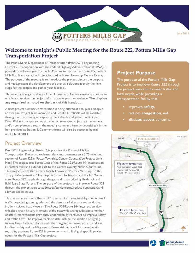
Project OverviewPennDOT, Engineering District 2, is pursuing the Potters Mills Gap Transportation Project to evaluate safety improvements to a 3.75-mile long section of Route 322 in Potter Township, Centre County. (See Project Limit Map.) The project area begins west of the Route 322/Route 144 intersection at Potters Mills and extends east to the Centre County/Mifflin County line. This project falls within an area locally known as “Potters Mills Gap” in the Tussey Ridge formation. “The Gap” is formed by Triester and Kohler Moun-tains. Route 322 travels through the gap and is straddled by Rothrock and Bald Eagle State Forests. The purpose of the project is to improve Route 322 through the project area to address safety concerns, reduce congestion, and alleviate access issues.
This two-lane section of Route 322 is known for motorist delays due to truck traffic negotiating steep grades and the absence of alternate routes during incident-related road closures. The Route 322/Route 144 intersection also exhibits a crash history in excess of the statewide average, despite a number of safety improvements previously undertaken by PennDOT to improve safety and traffic flow. The improvements to date include the addition of signing, turning lanes, flattened slopes and other targeted improvements to address localized safety and mobility needs. Please visit Station 2 for more details regarding previous Route 322 improvements and a listing of specific project needs for the Potters Mills Gap project.
Western terminus: Approximately 3,000 feet west of the Route 322 / Route 144 intersection
Eastern terminus: Centre/Mifflin County line
Not to scale
Project PurposeThe purpose of the Potters Mills Gap Project is to improve Route 322 through the project area and to meet traffic and local needs, while providing a transportation facility that:
• improves safety,
• reduces congestion, and
• alleviates access concerns.
An analysis of the project area was initiated early this year to evaluate the existing conditions of the Route 322 corridor and identify the Project Needs. Based on the analysis, conceptual solutions were developed to address the identified problems. Regular meetings were held by the Project Team (FHWA, PennDOT District 2, PennDOT Central Office, and consultants) to review traffic data, environmental survey/analysis results, and potential improvement options. As a result of these studies, improvement concepts were developed for the Sand Mountain intersection area and the Route 322/Route 144 intersection, as well as, concepts for a connector road between Potters Mills and Sand Mountain Road. (See starting concept mapping located at Station 4.)
These conceptual solutions were reviewed thoroughly by the project team and an alternative that would address the project purpose and needs while minimizing effects on natural, cultural and socioeconomic resources – the Potters Mills Alternative – was ultimately developed. (See Potters Mills Alternative mapping below and at Station 4.) The conceptual solutions and the resulting Potters Mills Alternative were presented to environmental resource agencies in June 2013. The project mapping along with a project overview was shared with the emergency management personnel and school officials to receive input on project area concerns and current issues with emergency response. Today’s Public Meeting and Public Official’s Briefing provide an additional opportunity for input.
The Potters Mills Alternative provides a full interchange at the western project limit near Potters Mills west of the Route 322/Route 144 intersection. It also provides a full interchange at the eastern project limit at Sand Mountain Road. To serve local traffic needs, a connector road is provided from Potters Mills to Sand Mountain Road. The full interchanges at both the eastern and western termini allow the connector road to be designed using local road standards, reducing the footprint of the connector road, minimizing impacts to sensitive resources through the gap area, and reducing the number of residential acquisitions for the project.
As part of the Potters Mills Alternative, the Route 322 four-lane limited access facility is extended from its current end at Decker Valley Road to the new interchange area west of the Route 322/Route 144 intersection. The new four-lane section is partially off-alignment, but was designed to stay as close to the existing Route 322 alignment as possible to minimize impacts. A four-lane roadway through this area provides the needed truck passing lanes so smaller passenger vehicles can safely pass slower moving vehicles. The western end of the four-lane roadway would be at a point in the Route 322 alignment
where the grade and horizontal geometry is such that all vehicles (trucks and passenger cars alike) should be able to travel at the same speed. The need to alleviate congestion caused by slow moving vehicles and to improve safety by eliminating unsafe passing attempts would be met.
The proposed four-lane Route 322 extension also eliminates the at-grade intersection of Decker Valley Road with the four-lane section of Route 322. Decker Valley Road would be connected to the new two lane local road that is to be provided between Potters Mills (Route 144) and Sand Mountain Road. At Sand Mountain Road, a full interchange will be provided, eliminating the at-grade intersection of Sand Mountain Road with the four-lane section of Route 322.
Elimination of the at-grade intersections with the four-lane facility addresses the safety need related to driver expectations and unexpected left turns on a controlled access facility. The connector road between Potters Mills and Sand Mountain Road addresses the need for an alternate route in the event of an incident on the four-lane section of Route 322.
Potters Mills Alternative
Project Development
Page 2 Page 3
POTTERS MILLS GAPTr a n s p o r t a t i o n P r o j e c t
322
Open House AreaSTATION 1: REGISTRATION AREA Upon arrival, please sign-in to record your attendance at the meeting and receive a meeting handout and comment form.
STATION 2: PROJECT INTRODUCTIONThis area includes summary information about the project including, project area limits/location, Route 322 safetyimprovements completed to date, and the purpose and need of the Potters Mills Gap project.
STATION 3: EXISTING CONDITIONS Information presented at this station includes a review of existing environmental features and identifies potential historic resources in the project area. Anyone with knowledge of historic resources and other environmental features in the project area is encouraged to visit this station to talk with the Project Team.
STATION 4: PROJECT DEVELOPMENT This station provides details regarding the process for developing transportation improvement concepts and identifying a recommended alternative. Mapping of conceptual solutions is available along with an analysis of current and future traffic conditions and a project schedule.
STATION 5: COMMENT AREAThis area is available for you to complete your comment form and return it in the drop box provided. The Project Team will review all feedback received for consideration in project development. If you prefer, you may return your comment form by mail (deadline is July 31, 2013) to the return address indicated on the comment form.
For more information contact:Mr. Steven L. Fantechi, Project Manager Pennsylvania Department of Transportation, Engineering District 2-01924-30 Daisy Street Extension - PO Box 342 | Clearfield, Pennsylvania 16830 | Phone: 814-765-0677
Next StepsFollowing the Public Meeting, the project team will continue engineering and environmental studies to refine the Potters MillsAlternative. Details of the project development process will be included in the project’s Environmental Assessment, anticipated for Fall/Winter 2013/2014. The next step will be to provide the environmental document to FHWA for review and approval to make the document available to the public. FHWA will not be able to approve the environmental document for availability until construction funding is secured and the project is included in the Centre County Metropolitan Planning Organization’s (CCMPO) Long Range Transportation Plan (LRTP) and Transportation Improvement Program (TIP).
The Route 322, Potters Mills Gap Transportation Project is currently funded for preliminary engineering and environmentaldocumentation. The environmental approval, final design, right-of-way acquisition and construction of the project are contingent upon passage of a transportation bill to increase funding for transportation improvements.