PROJECT: ROAD DEVELOPMENT AND TRANSPORT FACILITATION PROGRAMME WITHIN THE MANO RIVER UNION COUNTRY: COTE D’IVOIRE, GUINEA, AND LIBERIA SUMMARY ENVIRONMENTAL AND SOCIAL IMPACT ASSESSMENT (ESIA) Project Team Team Leader J. N. ILBOUDO, Transport Engineer OITC.1 5012 J.B. AGUMA, Transport Economist OITC.1 1956 Team Members J. P.M. KALALA, Chief Socio-Economist OITC.1 3561 N. KULEMEKA, Chief Socio-Economist SARC/ONEC.3 8452 L. M. KINANE, Environmentalist ONEC.3 2933 E. NDINYA, Environmentalist SARC/ONEC.3 1541 P. TAMBAH, Infrastructure Engineer LRFO/OITC.1 7072 Malick Soumare, Procurement Specialist ORPF.1/ LRFO M. H. SANON, Socio-Economist ONEC-3 Mose Mabe-Koofhethile, Procurement Specialist ORPF.1/ SNFO Sector Division Manager Jean Kizito KABANGUKA OITC1 2143 Sector Director Amadou OUMAROU OITC 3075 Regional Director Franck Joseph PERRAULT ORWA 4046 Director, Regional Integration and Trade Janvier K. LITSE ONRI 4047 AFRICAN DEVELOPMENT BANK GROUP
Transcript
PROJECT: ROAD DEVELOPMENT AND TRANSPORT FACILITATI ON
PROGRAMME WITHIN THE MANO RIVER UNION COUNTRY: COTE D’IVOIRE, GUINEA, AND LIBERIA
SUMMARY ENVIRONMENTAL AND SOCIAL IMPACT ASSESSMENT (ESIA)
Project Team
Team Leader J. N. ILBOUDO, Transport Engineer OITC.1 5012 J.B. AGUMA, Transport Economist OITC.1 1956
Team Members
J. P.M. KALALA , Chief Socio-Economist OITC.1 3561 N. KULEMEKA, Chief Socio-Economist SARC/ONEC.3 8452 L. M. KINANE, Environmentalist ONEC.3 2933
E. NDINYA, Environmentalist SARC/ONEC.3 1541
P. TAMBAH, Infrastructure Engineer LRFO/OITC.1
7072
Malick Soumare, Procurement Specialist ORPF.1/ LRFO M. H. SANON, Socio-Economist ONEC-3 Mose Mabe-Koofhethile, Procurement Specialist
ORPF.1/ SNFO
Sector Division Manager Jean Kizito KABANGUKA OITC1 2143
Sector Director Amadou OUMAROU OITC 3075 Regional Director Franck Joseph PERRAULT ORWA 4046 Director, Regional Integration and Trade Janvier K. LITSE ONRI 4047
AFRICAN DEVELOPMENT BANK GROUP
2
SUMMARY ENVIRONMENTAL AND SOCIAL IMPACT ASSESSMENT
Project Name : Road Development and Transport Facilitation Programme Within the Mano River Union
Project No.: P-Z1-DB0-103
Countries: Côte d’Ivoire, Guinea and Liberia Department: OITC Division: OITC-1
Introduction This document is a Summary of the Environmental and Social Impact Assessment (ESIA) of the Ivorian section of the Road Development and Transport Facilitation Programme within the Mano River Union. The summary has been prepared in accordance with the guidelines and procedures for environmental and social assessment of the African Development Bank (AfDB) for Category 1 projects, as well as with the policies in force in Guinea. The project description and rationale are presented first, followed by the applicable legal and institutional framework in Guinea. A brief description of the key environmental conditions of the project area is presented for each section, in terms of its physical, biological and human components, and the variants and alternatives are compared in terms of technical, economic, environmental and social feasibility, including the concerns of the population. Then the most significant positive and negative impacts on the biophysical and human (socio-economic) environments are presented. This is followed by a presentation of proposed improvement and mitigation measures to increase the benefits and/or prevent, minimize, mitigate or offset adverse impacts, as well as the monitoring programme. The public consultations held and additional project-related initiatives are presented. Lastly, climate change concerns and adaptation and mitigation measures are identified. 1. Project Description and Rationale Côte d'Ivoire, Liberia, Sierra Leone and Guinea form one of the three key fragile zones on the African continent. Unfortunately, due to the state of the roads, these regions are isolated, thus contributing to making them pockets of poverty and a breeding ground for all kinds of trafficking and armed gangs, as well as a source of destabilization of countries within the region. In addition to focusing on road infrastructure that contributes to promoting peace and strengthening security, the programme will also address obstacles to the free movement of people and goods. It will thus help to unleash the development potential in each country, foster free movement of people and goods, and regional integration of the countries, while bridging the region and the rest of ECOWAS. The project’s overall goal is to support economic recovery in the post-conflict region of the Mano River Union by improving its road infrastructure and promoting intra-Community trade. Its specific objectives are to: (i) improve transport conditions on the various project roads and thus reduce transport costs; (ii) remove obstacles to the free movement of people and goods between the three countries; and (iii) improve the living conditions of population of the project area. The project roads are included in the development programmes of the 3 countries (PND 2012-2015 for CI; PRSP III (2013-2016) for Guinea, and PRSP II (2012-2017) for Liberia) and PACITR of ECOWAS which mainly seeks to develop and pave the missing links of
3
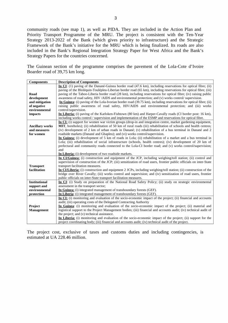
community roads (see map 1), as well as PIDA. They are included in the Action Plan and Priority Transport Programme of the MRU. The project is consistent with the Ten-Year Strategy 2013-2022 of the Bank (which gives priority to infrastructure) and the Strategic Framework of the Bank’s initiative for the MRU which is being finalized. Its roads are also included in the Bank‘s Regional Integration Strategy Paper for West Africa and the Bank‘s Strategy Papers for the countries concerned. The Guinean section of the programme comprises the pavement of the Lola-Cote d’Ivoire Boarder road of 39,75 km long.
Components Description of Components Road development and mitigation of negative environmental impacts
In CI : (1) paving of the Danané-Guinea border road (47.6 km), including reservations for optical fibre; (ii) paving of the Bloléquin-Toulépleu-Liberian border road (65 km), including reservations for optical fibre; (iii) paving of the Taboo-Liberia border road (28 km), including reservations for optical fibre; (iv) raising public awareness of road safety, HIV /AIDS and environmental protection; and (v) works control/ supervision. In Guinea: (i) paving of the Lola-Ivorian border road (39.75 km), including reservations for optical fibre; (ii) raising public awareness of road safety, HIV/AIDS and environmental protection; and (iii) works control/supervision. In Liberia: (i) paving of the Karloken-Fishtown (80 km) and Harper-Cavally roads (CI border post: 16 km), including works control / supervision and implementation of the ESMP and reservations for optical fibre.
Ancillary works and measures for women
In CI : (i) support for women war victim groups (drop-in and integration centre, market gardening equipment, MIT , boreholes); (ii) rehabilitation of 50 km of rural roads (iii) rehabilitation of schools and health centres; (iv) development of 2 km of urban roads in Danané; (v) rehabilitation of a bus terminal in Danané and 2 roadside markets (Danané and Gbapleu); and (vi) works control/supervision. In Guinea: (i) development of 5 km of roads in Lola; (ii) rehabilitation of a market and a bus terminal in Lola; (iii) rehabilitation of social infrastructure (schools, health centres); (iv) development of 20 km of prefectural and community roads connected to the Lola-CI border road; and (v) works control/supervision; and In Liberia: (i) development of two roadside markets.
Transport facilitation
In CI/Guinea: (i) construction and equipment of the JCP, including weighing/toll station; (ii) control and supervision of construction of the JCP; (iii) sensitization of road users, frontier public officials on inter-State transport facilitation measures. In CI/Liberia: (i) construction and equipment 2 JCPs, including weighing/toll station; (ii) construction of the bridge over River Cavally; (iii) works control and supervision; and (iv) sensitization of road users, frontier public officials on inter-State transport facilitation measures.
Institutional support and environmental protection
In CI : (i) Study on preparation of the National Road Safety Policy; (ii) study on strategic environmental assessment in the transport sector; In Guinea: (i) integrated management of transboundary forests (GEF). In Liberia : (i) integrated management of transboundary forests (GEF).
Project Management
In CI : (i) monitoring and evaluation of the socio-economic impact of the project; (ii) financial and accounts audit; (iii) operating costs of the Delegated Contracting Authority In Guinea: (i) monitoring and evaluation of the socio-economic impact of the project; (ii) material and logistical support to the Project Management bodies; (iii) financial and accounts audit; (iv) technical audit of the project; and (v) technical assistance. In Liberia: (i) monitoring and evaluation of the socio-economic impact of the project; (ii) support for the project coordinating body; (iii) financial and accounts audit; (iv) technical audit of the project.
The project cost, exclusive of taxes and customs duties and including contingencies, is estimated at UA 228.46 million.
2. Policy, Legal and Administrative Framework 2.1 Laws and Regulations Any development and asphalting of roads is subject to the orders No. 045 / PRG / 87 and No. 022 / PRG / 89 on the Code of Environmental Protection. This law consists of all the definitions and general principles for the preservation of the environment in the Republic of Guinea. The other most relevant legislation in relation to the context of this study are:
• Decree No. 199 / PRG /soc /89 of 8 November 1989 governing the impact studies; • Act / 99/013/AN of 22 June 1999 adopting and promulgating the Law on Forestry
Code; • The Act/97/038/AN of 9 December 1997 adopting and enacting the Code of protection
of wildlife and hunting regulations; • Ordonance O / 92/019 / PRG / soc / 92 of 30 March 1992 concerning land code; • The Act / 94/005 / CTRN 14 February 1994 on the Water Code; • Law No. / 020 / AN / 1997 of 19 June 1997 on the Code of Public Health.
2.2 Institutional framework At the institutional level, the Ministry of Public Works is the Contracting Authority. The Ministry of Environment and Sustainable Development has is, among other things, the protection of the environment against all forms of degradation. The conduct of the ESIA is under the responsibility of the Ministry of Environment through the Guinean Bureau of Studies and Environmental Evaluation (BGEEE). The Ministry of Decentralization and Local Development, the Ministry of Urban Development and Housing, the Ministry of Agriculture, etc. will play important roles in the implementation of the Environmental and Social Management Plan (ESMP). 2.3 For the African Development Bank (AfDB) The main safeguard policies of the African Development Bank (AfDB) for the project are: (i) AfDB environmental policy (2004); (ii) the Bank’s policy on Involuntary Resettlement (2003); (iii) the Bank’s gender policy (2001); (iv) the Consolidated Engagement Framework with civil society (2012); (v) the Policy on Disclosure and Access to Information (2012); (vi) the Bank’s policy on integrated water resources management (2000); (vii) the manual on stakeholder consultation and participation in Bank operations (2001); (viii) the Bank's poverty reduction policy (2001); (ix) the Bank’s policy on population and implementation strategy (2002); (x) the Bank’s environmental and social assessment procedures for public sector operations (2001).
2
3. Description of the project environment The project’s direct impact area comprises the right-of-way and the space close enough to be affected by the project’s direct impacts. In the present case, this space extends about 500 m on either side of the axis of the present earth road; in most cases, the new paved road mostly follows the current alignment with a 20m right-of-way. The direct impact area also includes the villages and their inhabitants. The indirect impact area is the area that, though remote, will be impacted by specific aspects of the project. This area covers the space that spans about 2 km to 10 km as the case may be, on either side of the road axis of the current earth road. It is in this area that most of the quarry and borrow sites, etc. are located. 3.1 Biophysical Environment 3.1.1 Physical Environment Climate The climate of Forest Guinea is sub-equatorial and characterized by a long rainy season (7-8 months). The average annual rainfall ranges from 1750 mm to 2500 mm depending on latitude and altitude. The average annual temperature is 24 ° C. Topography and Geology Forest Guinea is a mountainous region with an average altitude of between 600-800 meters. The highest peaks do not exceed 2,000 meters (Nimba 1,752 m). Its rugged terrain is made up of a series of high hills separated by depressions of varying size, where we meet the lowlands and alluvial plains along streams slopes. Geology The geological base of the Guinea forest is essentially a core of igneous rock in granites and metamorphic rocks (gneiss, quartzite, schist) Precambrian. There are also some other igneous intrusions of the Mesozoic era (post-Huronian granite and kimberlite). The batholiths are large deposits of iron ore encountered in Nimba and Simandou Mountains. Among the soil and hill bordering lowlands are also encountered, depending on the degree of ferrallitisation and importance of plant cover, ferruginous soils and brown forest soils. The floodplain soils belong to the class of poorly evolved soils and soil subclass unsophisticated contribution. Hydrography The drainage system of the Forest Guinea is very dense. The major rivers have their sources in the Guinean ridge. The main rivers are: Diani, the Makona, Bafing, the Lofa Niandan the Cavally the Beya and Oulé. All these rivers are characterized by a more regular flow than other regions (due to the short dry season), the frequency of rapids and waterfalls interspersed with bays of alluvium mainly composed of sand and rarely clay. Regarding the Lola District, the drainage system is favoured by the configuration of the terrain and humid climate, consisting of basins or Youkoun Cavally that drain the northern part of the district, the Gouan the north and Mani part lying to the extreme Southwest. 3.1.2 Biological Environment Flora Forest Guinea is the most natural woodland area of the country with massive wet rainforests (massive Ziama and Diécké). In terms of vegetation cover in the region, there are four major floristic classes: dense primary forests, secondary forests, mesophilic forests and thickets and
3
fallow. Besides these four classes there are the flora of the plains, lowlands and reforested. Forest reserves in this area covers a total size of 287 913 hectares of which the largest are the Ziama forest (112,300 hectares) and Diécké forest (64,000 hectares). Gazetted forests in general are an ideal habitat for all animal species (especially vulnerable and endangered species) compared to cultivated areas.
Wildlife Forest Guinea has the largest rich wildlife of West Africa. According to surveys conducted by the Forest Resources Project Management (PROGERFOR) from 1991 to 1994 in the forests of Ziama and Diécké (except fish), there are 547 vertebrate species in the region. For mammals only, 124 species are numbered in the forest Ziama and 52 others in the forest Diécké. Nearly 50% of bird species in Guinea are represented in these forests; 54 species of reptiles have been recorded, including 41 species of snakes, 10 species of lizards, two species of turtles, 1 species of crocodiles and 30 species of amphibians.
3.2 Human and socio-economic environment 3.2.1 Population The project runs through a part of the Lola District in Guinea Forest Region N'Zérékoré, in southern Guinea. The Lola urban area that is Lola center and eight (8) sub-prefectures corresponding to eight (8) rural municipalities that are Bossou, Foumbadou, Guéasso, Gama-Béréma, Kokota, Laine, and N'Zoo Tounkarata. Lola Prefecture had about 214,237 inhabitants in 2010. The population of the Lola District is characterized by a sex ratio of 94 males per 100 females. 3.2.2 Sacred and / or cultural sites of importance to the people All along the route of the road present earth, most villages have sacred sites that consist of forests/trees, rivers, as well as cemeteries. All the sacred sites have not been fully identified as part of the environmental and social assessment. The Bank therefore requested that the exhaustive list of sacred is submitted. This is part of the Environmental and Social Action Plan (ESAP) in annex. 3.2.3 Key socio-economic activities in the project area Over 80% people’s occupation in the Lola District is agricultural activities (agriculture, hunting, and logging). Women are more present in agricultural activities than men. This observation also applies to trade related activities where the proportion of women is more than double of that of men. In all other industries the predominance of men is quite noticeable. People are also involved into breeding of cattle, sheep, goats, pigs and poultry. Fishing is practiced at small scale by women and children, each with small nets (trap) and line. The Lola district has no industry. There was a sawmill at Piné which is now closed for several years. In the field of timber, the province currently has industrial logging carried out by companies for which concessions were granted. However, there are three mining companies that were recently established in Lola. These are the Mining Company of Guinea Fer for Iron, the English West Africa Exploration Company for iron, and finally, Sama Resources Guinea for Nickel and Graphite.
4
3.2.4 Access to basic socioeconomic infrastructures
• Electricity: The Electricity Company of Guinea (EDG) is not represented at Lola. However, this city has a power supply through two private operators. Power is supplied only during the morning 10:00 to 4:00 p.m. and the night 7:00 p.m. to 11:00 p.m. Thus, the city of Lola is one, if not best served by electric in the N'Zérékoré Region. Some proponents of hotels, restaurants or shops have generators operating with diesel. In Lola, the hurricane lamp is the main mode (47%) used by households for lighting. Candles and torches are also used as a light source.
• Education: Lola has 137 primary schools with a total of 646 classrooms. The prefecture also has 4 private schools, a Franco-Arab private school and four private religious schools. It has 11 college and only one high school, which is very insufficient for anyone coming out of college.
• Health : As health facilities, Lola has, a 40-bed hospital, nine health centers all integrated PEV-SSP-ME, 22 health posts built into the PEV-SSP-ME and 13 health posts not belonging to the PEV-SSP-ME. The district hospital is the reference health facility but does not currently have a refrigerator (the three existing one do not work), no electricity for sample preservation, and sterilization of certain tools, no running water, and no X-ray service.
• Potable Water: the needs for drinking water remain high, both in rural and urban areas. The reason for this situation is the lack of infrastructure for abstraction, transport and distribution of drinking water. In rural areas, lack of modern water points in the sub-prefectures is also recorded. Thus, traditional wells are the most common source of drinking water supply to households, both in rural and in urban areas.
4. Project Alternatives Since the project involves the rehabilitation of an existing road, the possible variants are quite limited. In most cases, the road will as much as possible follow the existing alignment. Sections generally have at least three alternatives and several variants. Alternatives concern “without project” and “with project” options under two alternatives regarding the structural design of the road. As for variants, they concern right-of-way dimensions. For economic, social and environmental reasons, the variant chosen for the three sections is to as much as possible follow the route of each current earth road, while minimizing the need for expropriation. 5. Potential impacts, and mitigation and improvement measures 5.1 Direct negative impacts 5.1.1 Site Preparation and Construction Phase Biophysical Environment
• Impact on air quality: Clearing and earthworks, construction of the road and the movement of vehicles on the road works will generate dust and gaseous emissions, including carbon dioxide, carbon monoxide, etc. Dust and gas emissions may also be the source of a possible reduction in atmospheric visibility caused by heavy dust clouds and the possible formation of photochemical fog
5
following reactions due mainly to the presence of hydrocarbon mixture and nitrogen oxides. Such pollution may also cause respiratory diseases for the most vulnerable people. However, during the rainy season, it is largely limited on all three sections thanks to wet deposits.
• Impacts on the soils: Machinery movements contribute to soil compaction, leading to waterproofing and loss of fertility. The work is also likely to cause new types of soil erosion and destabilization (landslide). Soils rendered bare may be seriously affected by surface erosion if nothing is done. The impact of operation of borrow pits on the soil will be locally sensitive, as good quality gravel materials are generally located on the summits of interfluves with poor soils and low organic fractions. Rehabilitation of such areas is difficult, and the loss of vegetation cover will mean degradation by erosion. This impact applies to all the three sections. In addition to their infertility and visual impact, the soils in disposal areas are exposed to gully erosion. This impact affects all the three sections.
• Risk of physical and chemical pollution of soil and water: Surface water,
groundwater and lowlands located in direct and indirect project impact areas can be accidentally polluted due to equipment use and maintenance, hydrocarbons use and the installation of the mixing station during construction, especially in the rainy season. Indeed, the worksite sludge could, as a result of diversion, flow into the project area water bodies and lowlands.
• Impact on water quantity: Water is available in the affected regions. The
worksite water needs will not affect the overall and daily water demand of the population. There will be no risk of water scarcity or competition with human consumption.
• Impacts on wildlife: The opening of road construction worksites could
increase pressure on wildlife that could continue after the completion of the new access infrastructure. Habitats (thickets, forest area, large trees for birds) could be affected by borrow pit activities. While short-term pressure on wildlife is not significant, it is to be feared that in the long term, the new paved road could change the habits of the people who could switch from subsistence hunting to commercial hunting to supply urban centres, and thereby result in increased poaching.
• Impacts on flora: Clearances of the right way for the road as well as opening up access road contribute to the reduction of vegetation cover in the direct area of influence. It is estimated that at least 2-5 hectares of vegetation cover will be cleared as part of the works. Opening of borrow pits for gravel or sand, creating deviations during excavation and installation, are potential causes of degradation of the vegetation in the short term.
Human Environment
Expropriation: Property will be affected during right-of-way clearance and will affect about 202 people in villages alongside the road. This negative impact includes: (i) partial of total loss of 121 houses; (ii) potential disturbance of 184 commercial activities; (iii) loss of a public facility; (iv) damage on crops during the construction works. The list of project affected people and their socioeconomic characteristics will be updated in line with the ESAP in annex.
Disruption of population mobility and noise pollution: Road construction works, when crossing villages, will temporarily affect the life of local inhabitants, whose homes and
6
businesses are sometimes located extremely close to the work area. The works will thus disrupt mobility and access to homes. Furthermore, noise pollution characterizes work of this nature. However, the volume of noise will be low during the day, as studies have revealed the existence of noise in the initial state of the environment due to activities.
Impacts on human health: The main risk is the exposure of workers and locals to STI/ HIV/AIDS, malaria and respiratory diseases. Furthermore, the precarious nature of health facilities in the area exacerbates this situation. The prevalence of malaria in the area also poses a significant risk to site personnel. Given the context, handling of bush meat, various contacts could increase the risks of contamination and propagation of the Ebola virus. For the site personnel and the public, the site as a whole will be a source of accidents, due to the mobility of equipment and vehicles, and also the handling of dangerous objects and products.
Risk of conflict: The temporary presence of construction company personnel in the area is likely to cause a cultural mix that could cause conflicts. These conflicts may be the result of several factors: (i) non-compliance with customs and practices prevailing in their new environment, especially as the study found that on all the three sections there are sacred and cultural sites; (ii) lack of communication and sensitization campaigns; (iii) non-compliance with compensation procedures for destroyed property and non-consultation of the local population prior to the expropriation procedures, opening of deviations, etc. Risk of destruction of sacred and/or cultural sites of importance to the people: Sacred places exist in different villages on the three sections. If they are not well identified and taken into account in project design and implementation, there are risks they will be desecrated or even destroyed. This could be a major factor of blockage of the project by the people. 5.1.2 Operational Phase
• Impacts on wildlife: The most significant impacts of the operational phase of the three road sections on wildlife include: (i) risk of accidents with wild animals and domestic animals (small and large ruminants) crossing or using the road; (ii) risk of increased poaching due to the improvement of traffic conditions on the three road sections.
• Impacts on flora: During the operation of the road, several effects on flora
may occur such as: (i) increase in illegal logging; (ii) opening of tracks perpendicular to the road, which will contribute to the destruction of the existing cover and to increased access to initially less accessible areas. Lastly, the road will increase human pressure on forest resources, particularly for fuel wood, timber, etc. needs.
• Overall biodiversity impacts: The road will foster the development of
transport and tourism in the area. This means waste production in all areas bordering the road and possible degradation of certain sensitive ecosystems through increased accessibility causing disruption of wildlife populations and declining biodiversity. Regarding specific impacts on the Nimba reserve, they are indirect as the road does not directly affect the said reserve. However, the indirect impacts are likely to affect this fragile ecosystem. Such impacts are pollution by waste that will be generated by a sharp increase in visitors, poaching and illegal logging.
• Impacts on water resources: Wear through friction of brake linings and
relatively high levels of heavy metals such as copper, nickel, chromium and lead. These inorganic materials will flow over time into the main streams.
• Impacts on the air: Improved road conditions will generate more traffic,
which implies an increase of the same scale as the number of emission sources, namely vehicles. Furthermore, the construction of the road will increase average traffic speeds, resulting in more fluid traffic and emission ratios generally lower than those with current speeds (ratios of atmospheric emission are generally inversely proportional to the speed of movement).
• Impacts on the soil: The impacts of the road project in its operational phase on
soils are limited to erosion risk, which is to be considered as an impact (destruction of environment by gullying, clogging, possible loosening of vegetation) as well as a major constraint on sustainability of the roads constructed.
5.2 Direct and indirect positive impacts The positive impacts of this road are clear. However, the main positive impacts expected from the project can be summarized as follows: (i) contribution towards improving security, social cohesion and peace in the areas affected by the project; (ii) improved transportation of goods and people; (iii) internal opening-up and improved accessibility to basic socioeconomic infrastructure for the populations of the three road sections; (iv) creation of direct and indirect jobs during the phases of construction, operation and maintenance of the road; (v) enhancement of the tourism potential, including ecotourism, in the project area; (vi) improvement of the living conditions of vulnerable populations using the road and connected tracks, and related works for the benefit of the population; (vii) reduced risk of landslides and erosion by strengthening and monitoring of slopes; (viii) added value of land due to improved accessibility; (ix) improved safety around schools along the road; (xi) improved access to the project area by the forestry and wildlife control services; and (xii) dust elimination compared to the initial state of the roads in the dry season. 5.4 Cumulative Impacts 5.4.1 Negative Impacts The various development projects in the region will, during the construction and operational phases, foster the movement of people in search of jobs or other economic activity and increased movements of raw materials; this will result in an increase in traffic on the road. Furthermore, these projects will increase anthropogenic pressures on natural resources and profound change in the environment. Mining companies that are settling in the project area will have a negative impact cumulative impact on workers’ health mainly related to HIV/AIDS. 5.4.2 Positive Impacts Revitalization and redeployment of socio-economic activities, particularly in processing, transport and distribution, services and ecotourism, are possible given the potential of the areas concerned. Given the expected trade volumes due to the roads, people will have access to a wider variety of products. Overall living conditions of the affected population and others will be improved. 5.4 Environmental and Social Measures
8
Site Preparation Phase
• Selection and engagement of contractors: Environmental and social clauses will be included in the bidding documents. The company carrying out the works will establish a quality assurance plan (QAP), as well as pledge to comply with the environmental protection clauses.
• Fair, equitable and prior compensation of people affected by the project for
the property identified in the Resettlement Plan. • Engagement of Contractor: It will be recommended that each contractor for
each lot submit to the approval of the environmentalist of the Control Bureau, a site environmental protection plan (SEPP) and a site environmental management plan (SEMP) within 60 days of notification of the contract. These documents will, at least, contain: (i) the organization chart of staff assigned to the environmental and social management, with an indication of the environmental and social officer of the project; (ii) a description of methods to reduce impacts on the biophysical and socio-economic environment; (iii) the management and rehabilitation plan for borrow pits and quarries, including the management of explosives; (iv) the water resources management plan; (v) management plan for erosion, drainage and sedimentation; (v) installation plan for the worksite camp, indicating storage areas and equipment locations; (vi) the solid and liquid waste management plan; (vii) all measures to protect the site and the implementation programme; (viii) the location and general site plan to scale; (vii) a description of avoidance and reduction methods of pollution, fires and road accidents; (viii) health infrastructure and population’s access in emergency situations; (ix) worksite regulations on environmental protection and security including the sensitization for protection against the Ebola virus ; (x) the emergency response plan; (xi) plan for the protection and enhancement of sacred and/or cultural sites; and (xii) the estimated site development plan at project completion and handover of facilities to local people.
Construction Phase
• Air Quality Protection Measures: The contractor for each lot will take appropriate measures to protect areas near the site roadways, shoulders and sidewalks from contamination by dust, debris, sludge or materials from the works. The contractor’s PPES contains all these measures, and will be approved by the supervising office and National Directorate of Infrastructures (DNI) of Ministry of Public Works before works start-up, and monitored by them during construction.
• Protection of soil structure and borrow and quarry sites: There are plans for
erosion control measures, such as slope re-vegetation, roadside tree planting and drainage of stormwater that could cause soil erosion by runoff. In quarry and deposit sites, the operator is required to install and maintain erosion control facilities, backfilling and/or reforest all degraded land. Other measures and precautions will be taken: (i) an authorization required for the opening and operation of quarries and borrow pits (temporary and permanent) in accordance with national legislation is necessary; sites must lie at distances prescribed by national legislation. Choose locations where excavation works will have the least impact on the environment and reduce the number of sites by choosing quarries or sites which provide the largest volumes of materials. Site restoration should be done in a participatory manner with the people.
9
• Protection of water resources and soils: The protection of surface water,
groundwater and soil against pollution will be primarily by prohibition of any spill or discharge of wastewater, sludge, slurries, oil, pollutants of any kind in wells, boreholes, water bodies, rivers, natural streams, ditches, or on the ground. Furthermore, the worksite camp will be provided with proper facilities (septic tanks, pumps adequate fuel, etc.).
• Wildlife and flora conservation measures: Actions will be taken at three
levels. On the site: (i) Control staff and sensitize them to the problem of poaching and prevention of the spread of the Ebola virus by prohibiting the consumption of bush meat on the worksite camp; (ii) supply the worksite camp canteen with fish or local livestock as a source of protein; (iii) install physical speed bumps, signs in areas of wildlife crossings. There are also plans to: (i) prohibit wild sawmilling and ensure supply of only wood from certified logging companies for the works; (ii) install the worksite camp only in already degraded or low-impact areas; (iii) preserve large diameter trees when they present no hindrance to the work. This is of paramount importance, especially as some of the said trees are cultural symbols for the people; and (iv) completely restore destroyed habitats and establish a nursery at the commencement of works. Planting will take place prior to the acceptance of the works. At the community level, specific themes, knowledge in the area of protected species and environmental protection in general will be part of the sensitization to be conducted by an NGO specialized in environmental protection and biodiversity issues. At the institutional level, it is envisaged through the GEF resources to contribute to trans-boundary forest management mainly between Cote d’Ivoire and Guinea.
Human environment The main steps can be summarized as follows:
• Compensation: Monitoring of the Resettlement Action Plan implementation and the functioning of the dispute settlement committee. Since the submission of evidence of compensation is a condition precedent to commencement of works, it is important to ensure optimal implementation of the CRP.
• Preventive measures for human health: Specialized NGOs will preferably be
responsible for prevention (every 3 months); this task may also be entrusted to the health districts of the region on each road section. It will train local facilitators, who will take turns to educate both site staff as well as road users and project area dwellers.
• Preventive measures for human safety: To ensure the safety of its workers,
the local population and road users, the company is required to take appropriate measures to prevent any risks of accidents: road, fire, explosion, improper handling of construction equipment, etc. All recommendations for the preservation of human safety during construction works focus on signs, control of access, sensitization, fire prevention and ancillary works.
• Protection and enhancement of sacred and/or cultural sites of importance
for the population: The protection and enhancement plan for sacred sites and/or of cultural importance for the population will help to better manage the risk associated with the desecration and destruction of such sites. This plan will
10
identify in detail all sites along the road. For each of them, an analysis of the direct and indirect implications should be made and, where necessary, make recommendations on the route at the sites threatened with destruction and that cannot be relocated. Together with the people, each site must be suitably protected if necessary with adequate signs. For each segment, the company carrying out the work will sensitize all site personnel on the need to respect the customs and traditions associated with these sites and avoid desecrating them. The protection and enhancement plan for sacred and / or cultural sites will be submitted to the Bank prior to the signing of the company’s contract.
Operational phase of the road
• Fauna and flora conservation measures: Installation of awareness panels, warning signs and speed limits in limited visibility, heavy traffic and animal passage areas. Also, the conduct of the strategic environmental and social assessment will better define these impacts based on past and current experiences to correct errors and failures and replicate successes in biodiversity management in road projects in Guinea in general.
• Road safety measures: Special attention is accorded to works at town and village crossings which are dangerous for both road users and residents (signalling, speed bumps, 2 m wide sidewalks, widened shoulders, parking lanes at all villages, protection at schools, etc.).
6. Environmental Risk Management 6.1 Risk Analysis In the construction phase, the environmental risk for the three road sections concerns mainly spillage of oil, bituminous products, explosives and other substances used in road construction, or uncontrolled discharge of waste products. Fire remains the major risk likely to cause enormous damage. The possible origins of a fire on the site are varied and include: short circuit in electrical installations, human negligence such as forgetting a cigarette butt, collision between two vehicles, illicit siphoning of fuel by workers, etc. Given the context, the risk of contamination and spread of the Ebola virus is also important. Workers being easily exposed to bush meat and various contacts are vulnerable. In the operational phase of the road, the environmental risk mainly concerns spillage of oil and other chemicals during transportation. Traffic accidents are largely responsible for these spillages and are the cause of many casualties. Furthermore, with increased heavy vehicle traffic, particularly tankers, the risk of accidents due to carelessness of the rural population and/or drivers is to be feared. 6.2 Safety Measures To reduce the risk of accidents and their effects, the following measures must be implemented by the contractor: build fences around the different worksite camps and regulate access prior to commencement of work; put in place markings and signs on various project sites to reduce traffic accidents; provide the workers with personal suitable protective gear (safety shoes, helmets, dust and noise masks, gloves, fall arrest harnesses, etc.); constant supervision of handling of hazardous substances; store hazardous substances in sealed containers in secure storage areas, sheltered from the elements. Keep storage areas locked and control the inventory of such substances; observe the speed limits which are: 20 km/h on work and quarry sites; 35 km/ h on temporary deviations; 80 km/h in open country and 40 km/h in urban areas; erect barriers to prevent the public and non-staff accessing worksites; establish instructions for vehicular traffic within the project site and on the road under construction; design and build the construction site, transportation, loading, unloading and materials storage facilities so as
11
not to compromise safety; sufficiently light the site and its surroundings to prevent any risk of injury and facilitate the intervention of safety teams; maintain the road clean and non-slippery at all times through appropriate means (sanding or salting, etc..), scaffolding, passages, bridges, platforms, stairs, etc.; prepare heating and lighting installations, as well as depots of flammable or explosive substances to prevent the danger of fire, explosion and asphyxiation; prohibit smoking in parking lots and on the premises where flammable or explosive substances are kept or used; carry out work on bridges and hydraulic structures during low water periods if possible; and avoid working on market days in towns that have a weekly market. Regarding the risks of contamination and spread of Ebola virus, the following measures should be taken (at minimum): (i) monitor and educate staff poaching problems and risks related to Ebola; (ii) prohibit the consumption of bush meat on the works camps. In the operational phase: ensure maintenance of signs in settled areas and animal crossing zones; involve the police to prevent roadway invasion by traders at centres that have markets; and sensitize the local population on the risks associated with handling flammable products 6.3 Emergency Response Plan (ERP) The emergency response plan specifies procedures for handling unexpected and sudden situations. Its objective is to limit the consequences of emergencies and to that end, prevent fatalities and injuries, reduce damage to construction equipment, and accelerate the resumption of normal activity. During the construction phase, the Contractor will establish an emergency response plan that will take into account: the formal commitment of the Construction Manager to the safety of its employees; sensitization and training on compliance with safety requirements of all workers; formation and training of a safety team ready to respond at any time; equipment of the construction site with safety products and devices (mini-pharmacy, fire extinguishers, etc.); signature of an emergency response contract with hospitals and local firefighting services; providing all workers with a health emergency telephone number; and carrying out periodic exercises/simulations to implement the contingency plan to ensure appropriate management of emergency situations. During the operational phase of the road, emergency management will be provided by regional or general hospitals in the project area, firefighters, police, etc. The concession holder will be responsible for the JCP in accordance with the laws in the countries concerned. 7. Environmental and Social Monitoring Programme It is worth noting that the implementation of environmental and social measures recommended in the ESMP will not be effective if these measures are not reflected in the contract of the contractor in charge of the construction work. The Ministry of Public Works which is the Contracting Authority, is primarily responsible for ensuring the implementation of environmental and social measures recommended in the ESMP by incorporating them into the Contractor’s contract. The Bank will verify the effective inclusion of environmental and social clauses in the bidding documents and the Contractor’s contract. The Contractor is responsible for effectively and efficiently applying environmental requirements under its contract. To be operational, it must have within it an “environmental respondent" who, after listing the most sensitive environmental constraints on the site, will be responsible for ensuring compliance with the technical environmental clauses, incorporate environmental monitoring in the site logbook and serve as an interlocutor with the Contracting Authority’s Control Bureau on environmental and social issues
12
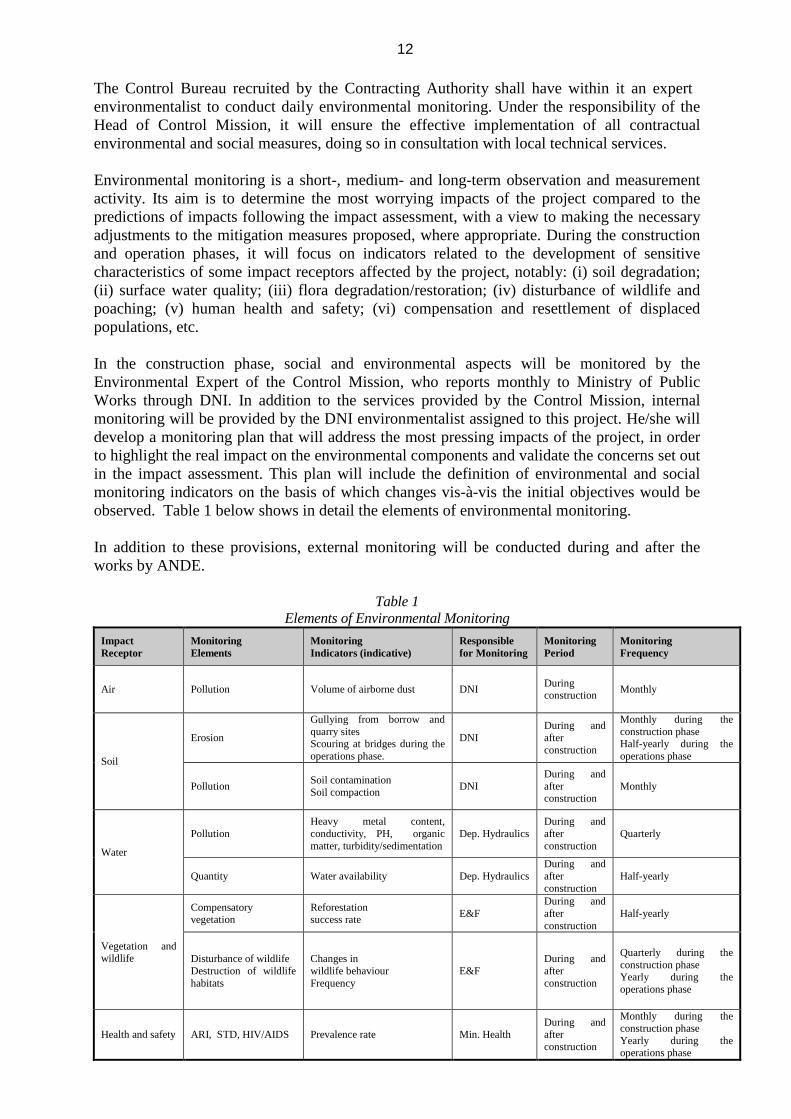
The Control Bureau recruited by the Contracting Authority shall have within it an expert environmentalist to conduct daily environmental monitoring. Under the responsibility of the Head of Control Mission, it will ensure the effective implementation of all contractual environmental and social measures, doing so in consultation with local technical services. Environmental monitoring is a short-, medium- and long-term observation and measurement activity. Its aim is to determine the most worrying impacts of the project compared to the predictions of impacts following the impact assessment, with a view to making the necessary adjustments to the mitigation measures proposed, where appropriate. During the construction and operation phases, it will focus on indicators related to the development of sensitive characteristics of some impact receptors affected by the project, notably: (i) soil degradation; (ii) surface water quality; (iii) flora degradation/restoration; (iv) disturbance of wildlife and poaching; (v) human health and safety; (vi) compensation and resettlement of displaced populations, etc. In the construction phase, social and environmental aspects will be monitored by the Environmental Expert of the Control Mission, who reports monthly to Ministry of Public Works through DNI. In addition to the services provided by the Control Mission, internal monitoring will be provided by the DNI environmentalist assigned to this project. He/she will develop a monitoring plan that will address the most pressing impacts of the project, in order to highlight the real impact on the environmental components and validate the concerns set out in the impact assessment. This plan will include the definition of environmental and social monitoring indicators on the basis of which changes vis-à-vis the initial objectives would be observed. Table 1 below shows in detail the elements of environmental monitoring. In addition to these provisions, external monitoring will be conducted during and after the works by ANDE.
Table 1 Elements of Environmental Monitoring
Impact Receptor
Monitoring Elements
Monitoring Indicators (indicative)
Responsible for Monitoring
Monitoring Period
Monitoring Frequency
Air Pollution Volume of airborne dust DNI During construction
Monthly
Soil
Erosion
Gullying from borrow and quarry sites Scouring at bridges during the operations phase.
DNI During and after construction
Monthly during the construction phase Half-yearly during the operations phase
Pollution Soil contamination Soil compaction
DNI During and after construction
Monthly
Water
Pollution Heavy metal content, conductivity, PH, organic matter, turbidity/sedimentation
Dep. Hydraulics During and after construction
Quarterly
Quantity Water availability Dep. Hydraulics During and after construction
Half-yearly
Vegetation and wildlife
Compensatory vegetation
Reforestation success rate
E&F During and after construction
Half-yearly
Disturbance of wildlife Destruction of wildlife habitats
Changes in wildlife behaviour Frequency
E&F During and after construction
Quarterly during the construction phase Yearly during the operations phase
Health and safety ARI, STD, HIV/AIDS Prevalence rate Min. Health During and after construction
Monthly during the construction phase Yearly during the operations phase
13
Health and safety Accident
Number of accidents during the construction phase
Min. Health During construction
Monthly
Number of accidents during the operations phase
Min. Health During construction
Monthly
Indemnities and Compensation for lost property
Destruction of public and private buildings
Statement of compensation of people affected by the works
Lola District During and after construction
Monthly during the construction phase and yearly during the operations phase
Employment Job creation Improved income
Number of jobs created Average income in communes concerned by the project.
DNI During and after construction
Monthly for employment Yearly for average income
8. Cost Estimate The cost of all the environmental and social measures, including provision for resettlement and ancillary works is 3,369 million d’euros.
Table 2 ESMP Cost Details
MESURES PRECONISEES Montant en Euro
Phases installation et travaux Checking of choices of areas intended for use by the contractor 7,634 Initial assessment of critical sections (before works) by an independent consultant 7,634
Air quality protection measures 7,634
Water and soil protection measures 22,901
Flora and fauna protection and biodiversity management measures 10,687
Sensitization to environmental protection, road safety and protection against STDs / HIV 45,802
Sacred and cultural sites protection/enhancement measures 7,634
Human health protection and road safety measures 22,901 Management and rehabilitation borrow / deposit sites 12,214 Provision for further assessments / surveys on the environmental and social aspects 7,634 Preparation and implementation of a communication plan 4,580
Ancilliary works 2,290,076
Provision for the implementation of the resetlement action plan 224,071
Appui institutionnel Support for tranboundary forest Management 687,023
Monitoring of the implementation of the ESMP
Monitoring of the implementation of the ESMP 15,267
TOTAL GENERAL 3,369,109
14
9. Public Consultations and Information Dissemination The Environmental and Social Impact Assessment (ESIA) for the three sections was conducted based on a methodological participatory approach involving the project beneficiaries on whom the project is likely to have negative and beneficial effects. This participatory process was initiated to ensure clarity, transparency and rigour. Its objectives were to: (i) ensure the consistency of action of each project stakeholder; (ii) foster the involvement of the local population in the project; (iii) create a climate of trust and cooperation, and to defuse potential conflicts through an objective approach. To this effect, an information and a consultation were organized at Lola District on February 24, 2014. The consultants held working sessions with authorities and technical structures of government, roadside communities, business operators, women and youth associations, etc. in the course of which direct contacts were established to discuss the project and define the conditions for participation during the conduct of field surveys. In total, over 50 people participated in these consultations. At these consultations, there was notable willingness of partners to support the project. However, the consultations advocated that consideration be given to grievances expressed by the locals, especially with regard to the use of local labour to perform menial tasks, opening of access roads and compensation of people directly affected by the project. During the preparation mission conducted by the Bank and DNI, public information and consultation sessions were also organized to present all the stakeholders directly involved in this project (objectives and activities planned under the project, gathering opinions and concerns with respect to said project). These consultations helped to define the activities to be adopted as regards ancillary works. The public survey has not yet been conducted. The survey will be undertaken this year (2014) before the project is submitted to the AfDB Board of Directors for approval. Conduct of the survey will be a Bank requirement, to be implemented as part of the action plan. The survey involves making available to the public for consultation and comments, the report of the Environmental Impact Assessment under the supervision of a Survey Commissioner (Commissaire Enquêteur) appointed by municipal order and tasked with gathering comments from the public. The public survey is initiated by the BGEEE. There are plans to prepare a communication plan on the project. This plan will involve the main project stakeholders (the population, central and local authorities, NGOs, etc.) in all project phases, notably site installation, construction and maintenance. Hence, this plan will cover the implementation of the ESMP with special focus on issues related to biodiversity management, site environmental protection, inconvenience management, etc. Budgetary provisions have been made for implementing the plan. On approval by the Bank, the summaries are posted on the AfDB website 120 days before the date of project presentation to the Board of Directors. 10. Additional Initiatives Under the project, there is provision for initiatives to improve the socio-economic impacts of the project. Through the participatory approach, the following activities were retained for the Ivorian component of the project:
15
• Rehabilitation of 5 km road in Lola; • Rehabilitation of the market and the road station in Lola • Rehabilitation of social infrastructures (schools, health centres); • Rehabilitation of 20 km feeder linked to the Lola-Cote d’Ivoire boarder.
These activities are estimated to cost 2, 2 million euro. 11. Conclusion The environmental and social impact assessment conducted on all three road sections shows that the project would have potential negative impacts on the biophysical, biological and human environments. However, these potential negative impacts can be identified and mitigated within reasonable limits, or sometimes offset by the appropriate corrective measures proposed in the ESMP. There are no major environmental and social changes that may justify the non-implementation of the project. Given the sensitivity of some cultural sites, it is important that the implementation of the ESMP be strictly monitored by all stakeholders.
16
12. References and contacts
a. BNETD. 2014. Rapport de l’EIES de la section de route Lola-frontière Cote d’Ivoire, avril 2014 p.
For further information, please contact:
1. Ilboudo Jean-Noel, Transport Division 1, E-mail: [email protected] 2. Modeste KINANE, Environment and Climate Change Division, E-mail:
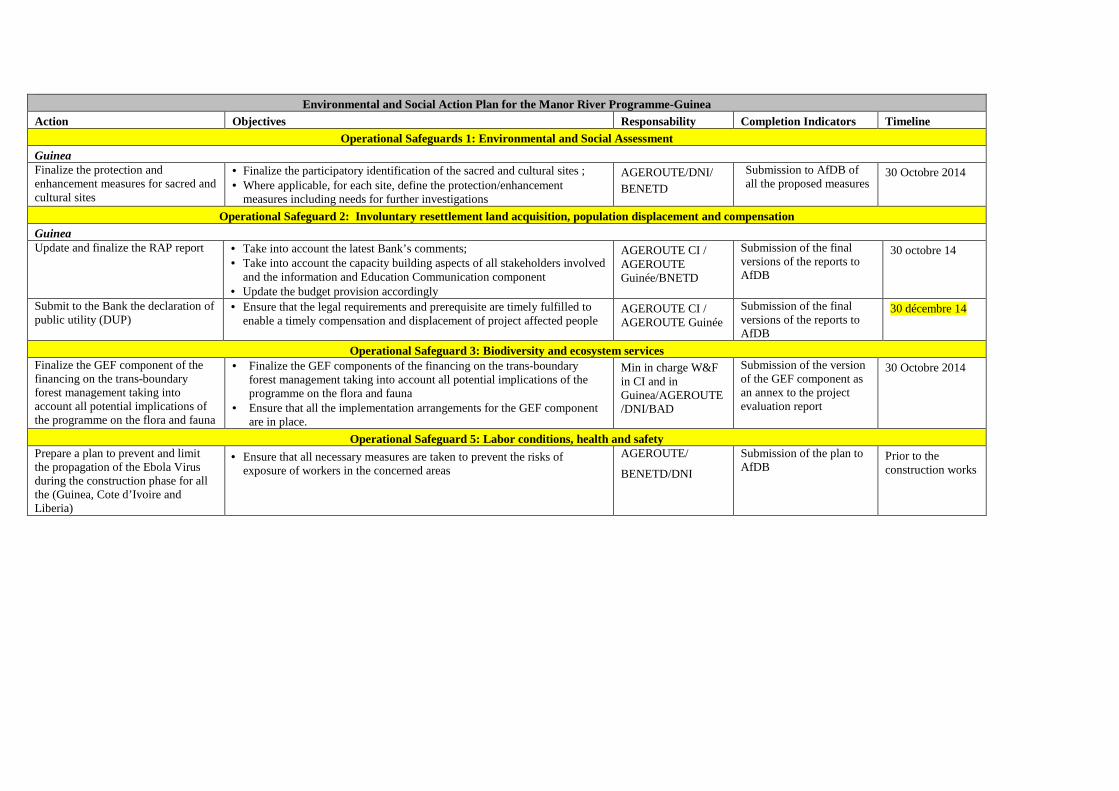
Environmental and Social Action Plan for the Manor River Programme-Guinea Action Objectives Responsability Completion Indicators Timeline
Operational Safeguards 1: Environmental and Social Assessment Guinea Finalize the protection and enhancement measures for sacred and cultural sites
• Finalize the participatory identification of the sacred and cultural sites ; • Where applicable, for each site, define the protection/enhancement
measures including needs for further investigations
AGEROUTE/DNI/ BENETD
Submission to AfDB of all the proposed measures
30 Octobre 2014
Operational Safeguard 2: Involuntary resettlement land acquisition, population displacement and compensation Guinea Update and finalize the RAP report • Take into account the latest Bank’s comments;
• Take into account the capacity building aspects of all stakeholders involved and the information and Education Communication component
• Update the budget provision accordingly
AGEROUTE CI / AGEROUTE Guinée/BNETD
Submission of the final versions of the reports to AfDB
30 octobre 14
Submit to the Bank the declaration of public utility (DUP)
• Ensure that the legal requirements and prerequisite are timely fulfilled to enable a timely compensation and displacement of project affected people
AGEROUTE CI / AGEROUTE Guinée
Submission of the final versions of the reports to AfDB
30 décembre 14
Operational Safeguard 3: Biodiversity and ecosystem services Finalize the GEF component of the financing on the trans-boundary forest management taking into account all potential implications of the programme on the flora and fauna
• Finalize the GEF components of the financing on the trans-boundary forest management taking into account all potential implications of the programme on the flora and fauna
• Ensure that all the implementation arrangements for the GEF component are in place.
Min in charge W&F in CI and in Guinea/AGEROUTE/DNI/BAD
Submission of the version of the GEF component as an annex to the project evaluation report
30 Octobre 2014
Operational Safeguard 5: Labor conditions, health and safety Prepare a plan to prevent and limit the propagation of the Ebola Virus during the construction phase for all the (Guinea, Cote d’Ivoire and Liberia)
• Ensure that all necessary measures are taken to prevent the risks of exposure of workers in the concerned areas
AGEROUTE/
BENETD/DNI
Submission of the plan to AfDB
Prior to the construction works
2
PROJECT: MULTINATIONAL COTE D’IVOIRE/GUINEA/LIBERIA : ROAD DEVELOPMENT AND TRANSPORT FACILITATION WITHIN THE M ANO RIVER UNION PROGRAMME COUNTRIES: COTE D’IVOIRE, GUINEA, LIBERIA
FRAMEWORK RESETTLEMENT ACTION PLAN (FRAP) SUMMARY
Project’s Team
Head of Team J. N. ILBOUDO, Transport Engineer OITC.1 5012 J.B. AGUMA, Transport Economist OITC.1 1956
Project’s Team members
J. P.M. KALALA , Chief Socio-economist OITC.1 3561 N. KULEMEKA, Chief Socio-economist SARC/ONEC.3 8452 L. M. KINANE, Environmentalist ONEC.3 2933
E.NDINYA, Environmentalist ONEC.3 1541
P. H. SANON, Social Safeguards Expert ONEC.3 5828
P.TAMBAH, Infrastructure Engineer LRFO/OITC.1
7072
M. SOUMARE, Procurement Spcecialist ORPF.1/ LRFO M. MABE -KOOFHETHILE , Procurement Spcecialist ORPF.1/ SNFO
Sector Division Manager Jean Kizito KABANGUKA OITC1 2143
Sector Director Amadou OUMAROU OITC 3075 Regional Director Franck Joseph PERRAULT ORWA 4046 Regional Integration and Trade Director Janvier K. LITSE ONRI 4047
AFRICAN DEVELOPMENT BANK GROUP
2
SUMMARY OF THE FRAMEWORK RESETTLEMENT ACTION PLAN ( FRAP) Project title : Road Development and Transport Facilitation Programme Within the Mano River Union
Project No.: P-Z1-DB0-103
Countries : Cote d’Ivoire, Guinée, Libéria
Department : OITC
Division: OITC-1
INTRODUCTION At the request of the Ivorian, Guinean and Liberian governments the African Development Bank resolved to support the implementation of the road development and transport facilitation programme within the Mano River Union relating to the rehabilitation and paving of the Danané-Lola, Harper-Tabou and Bloléquin-Toulépleu-Liberia Border road sections linking South-East in Guinea and the East in Liberia to the South-West in Côte d’Ivoire. From an environmental and social standpoint, the project falls under category 1, given the nature of the works, its size and scope as well as its potential direct and indirect effects. The implementation of the project of the rehabilitation and paving of the Danané-Lola, Harper-Tabou and Bloléquin-Toulépleu-Liberia Border road sections requires the expropriation, for public utility, of buildings, land, crops and trees in the right-of-way of the road. The project will have impact on subsistence means of people in the road premises. In accordance with the Bank’s policy on involuntary resettlement the Government of Guinea has to prepare a Resettlement Action Plan (RAP) for the project affected persons (PAP). Its objectives are: (i) to minimize, as much as possible, involuntary resettlement, (ii) to avoid to the extent possible the destruction of property and (iii) to compensate PAPs for the loss of residential land, agricultural land, buildings, equipment and income. The framework RAP is summarized in the present document. It defines the principles and implementation modalities for implementing the compensation and resettlement actions of affected people and provides a budget and an indicative timetable for its implementation. 1. PROGRAMME DESCRIPTION AND JUSTIFICATION – DESCRI PTION OF PROGRAMME AREA AND AREA OF INFLUENCE
1.1 Programme description and justification
Like the Great Lakes region and the Horn of Africa, Cote d’Ivoire, Liberia and Sierra Leone are found in one of the three fragile zones on the continent. These three countries are characterized by (i) economic isolation; (ii) inequalities and exclusion of specific social groups like women and young people; (iii) harsh climates and conflicts deriving from the control of resources; (iv) rapid urbanization which may appear to be an opportunity but which constitute the underlying factor of social conflicts; and (v) the non-respect for regional approaches in resolving problems. To this end, the development program for the 3 countries (PND 2012-2015 for CI ; PRSP III 2013-2016 for Guinea and PRSP II 2012-2017 for Liberia) provides incentives for the rebuilding and paving of the Danané-Lola, Harper-Tabou and Bloléquin-Toulepleu -Liberia border roads linking the southeast of Guinea and the eastern part of Liberia to the southwest of Cote d’Ivoire. These are alternate routes from the Trans-coastal Lagos-Abidjan-Dakar corridor, considered the most important in West Africa. The general objective of the project is to support post-conflict economic recovery in the Mano River Union (MRU) region through the improvement of road infrastructure and the promotion of intra-community trade. The specific objectives are: (i) improve transport conditions on various routes covered by the project to reduce transport costs; (ii) remove obstacles to the free movement of people and goods among the three countries; and (iii) improve the living conditions of people within the project zone. The major results expected are: (a) improvement of transport conditions on the different
3
highways and at border crossings; (b) improvement of living conditions in the ZIP; and (c) decrease transport costs. The project’s overall goal is to support economic recovery in the post-conflict region of the Mano River Union by improving its road infrastructure and promoting intra-Community trade. Its specific objectives are to: (i) improve transport conditions on the various project roads and thus reduce transport costs; (ii) remove obstacles to the free movement of people and goods between the three countries; and (iii) improve the living conditions of population of the project area. The Guinean section of the programme covers the 39.75 km long Lola-CI Border road, including reservations for optical fiber. The project’s components are described below:
Components Description of Components Road development and mitigation of negative environmental impacts
In CI : (1) paving of the Danané-Guinea border road (47.6 km), including reservations for optical fibre; (ii) paving of the Bloléquin-Toulépleu-Liberian border road (65 km), including reservations for optical fibre; (iii) paving of the Taboo-Liberia border road (28 km), including reservations for optical fibre; (iv) raising public awareness of road safety, HIV /AIDS and environmental protection; and (v) works control/ supervision. In Guinea: (i) paving of the Lola-Ivorian border road (39.75 km), including reservations for optical fibre; (ii) raising public awareness of road safety, HIV/AIDS and environmental protection; and (iii) works control/supervision. In Liberia : (i) paving of the Karloken-Fishtown (80 km) and Harper-Cavally roads (CI border post: 16 km), including works control / supervision and implementation of the ESMP and reservations for optical fibre.
Ancillary works and measures for women
In CI : (i) support for women war victim groups (drop-in and integration centre, market gardening equipment, MIT, boreholes); (ii) rehabilitation of 50 km of rural roads (iii) rehabilitation of schools and health centres; (iv) development of 2 km of urban roads in Danané; (v) rehabilitation of a bus terminal in Danané and 2 roadside markets (Danané and Gbapleu); and (vi) works control/supervision. In Guinea: (i) development of 5 km of roads in Lola; (ii) rehabilitation of a market and a bus terminal in Lola; (iii) rehabilitation of social infrastructure (schools, health centres); (iv) development of 20 km of prefectural and community roads connected to the Lola-CI border road; and (v) works control/supervision; and In Liberia : (i) development of two roadside markets.
Transport facilitation
In CI/Guinea: (i) construction and equipment of the JCP, including weighing/toll station; (ii) control and supervision of construction of the JCP; (iii) sensitization of road users, frontier public officials on inter-State transport facilitation measures. In CI/Liberia : (i) construction and equipment 2 JCPs, including weighing/toll station; (ii) construction of the bridge over River Cavally; (iii) works control and supervision; and (iv) sensitization of road users, frontier public officials on inter-State transport facilitation measures
Institutional support and environmental protection
In CI : (i) Study on preparation of the National Road Safety Policy; (ii) study on strategic environmental assessment in the transport sector; In Guinea: (i) integrated management of transboundary forests (GEF). In Liberia : (i) integrated management of transboundary forests (GEF)
Project Management
In CI: (i) monitoring and evaluation of the socio-economic impact of the project; (ii) financial and accounts audit; (iii) operating costs of the Delegated Contracting Authority In Guinea: (i) monitoring and evaluation of the socio-economic impact of the project; (ii) material and logistical support to the Project Management bodies; (iii) financial and accounts audit; (iv) technical audit of the project; and (v) technical assistance. In Liberia: (i) monitoring and evaluation of the socio-economic impact of the project; (ii) support for the project coordinating body; (iii) financial and accounts audit; (iv) technical audit of the project.
Source : PCN The total project cost, exclusive of taxes and customs duties and including contingencies is estimated at UA 228.46 million.
1.2 Main features of the project’s direct and extended influence area
In Guinea, the project’s area is located in the Lola Department which is part of the N’Zérékoré Region.
The area covers 6,688 km2 (around 10.5% of the N’Zérékoré Region) and bounded in the East by Côte d’Ivoire and in the West by Liberia. Areas crossing the project are under the authority of N’Eoo and Centre Lola sub-prefectures.
The population in Lola Prefecture is rural in majority. Out of 134,326 people registered during 1996 Census (RGPGH), 92% live in rural areas. However, the proportion of the rural population has decreased in 1996, compared to 1983 (94.6%). The gender ratio in Lola Prefecture corresponds to an average of 94 men against 100 women. The region is populated in majority by Kônô, Kpellè and Konianké people.
4
Lola has huge agricultural potentials which development is impeded by its isolation.
2. POTENTIAL IMPACTS
As the potential impacts on the human and natural environment are thoroughly covered in the Environmental and Social Impact Assessment (ESIA),, this section will only expand on impacts on the human environment, in terms of expropriation during the clearing of the right-of-the-way and to minimize disturbances that may result from the works. Particular attention is given to vulnerable people to ensure they they are spared from a more precarious condition..
The rehabilitation and asphalting of the Lola (Guinea) –Côte d’Ivoire border road requires the clearing of a 20m right-of-the way along the road alignment; which entails the displacement and resettlement of the project affected people.
2.1 Impact sources The main activity likely to result in physical and/or economic displacements relates to the clearing of the right-of-the way (carriage way and service road, sidewalks, hydraulic drainage channels, crossing works…), construction of feeder roads, site facilities (concrete plants, bitumen plants, borrowing sites and quarries, sifting plants, hydrocarbons storage facilities, deposits of construction materials…) and Contractor’s site camp.
Assets exposed to displacement impacts include: buildings, trees and other precarious/temporary settlements (shops, pens, etc.).
2.2 Positive impacts
Project’s positive impacts include: � Regional integration due to the link between Côte d’Ivoire and Liberia allowing for a better
free movement of people from both countries through their road networks ; � Link between production and consuming areas ; � Direct and indirect job creation ; � Creation and/or improvement of trade related activities; � Improvement of transport conditions; � Improvement of life conditions in villages covered by the project.
2.3 Negative impacts
Negative impacts on the biophysical environment will result essentially from soil degradation, use of surface and ground waters, logging, clearing and deforestation of the right-of-ways, threats on microclimate due to paving activities. Multiple mitigation measures of these impacts are included in the ESIA. The main negative impact along the 3 road relates to involuntary displacement or the loss of assets and economic activities of at least 202 persons spread over the villages alongside the road. This impact involves: � Total or partial loss of 121 buildings; � Potential disruption in 184 economic activities; � Loss of 1 public facility; � Destruction of crops during the works.
To mitigate this impact, an inventory and evaluation of losses were undertaken to compensate of the affected people and to facilitate their resettlement.
2.4 Potential risks and disaster related to resettlement
The following potential risks have been identified: � Risks of accidents and thefts during the moving of PAPs; � Risks of conflicts;
5
� Risks of exposure to diseases and spreading of HIV/AIDS ; � Risk of profanation of sacred sites and objects or disruption in worshiping rituals; � Thrust on the quietude, security and health in relation with noise pollution caused by
electromagnetic fields effects and disruptions in radio frequencies.
These risks are to be handled with appropriate measures. 3. ORGANIZATIONAL RESPONSIBILITY The supervision of the involuntary resettlement is ensured by a Committee under the responsibility of the Ministry of Public Works and Transport, through the Directorate of Infrastructures as Contracting Authority of the project. The Committee comprises : 1 representative of the DNI; 1 representative of the department directorate of construction; 1 representative of the department directorate of agriculture; 1 representative of the sub-prefecture; 5 PAPs’ representatives (1 for each category); 1 representative of the BGEEE. The Committee will be charged with: ensuring that a due compensation process is followed; ensuring that eligibility criteria are observed; making sure vulnerable people are not disadvantaged; drawing up the records of payment of compensation. . The compensation process will be carried out based on the following steps: - Identification of the affected people with its ID or the trustee; - Individual compensation upon checking of the identity card; - Any affected person shall present a copy of his identity card to the Compensation Committee
before being compensated; - The duration of the compensation should not exceed 5 working days for each locality; - The compensation payment period should be be widely disseminated across the various sites.
Complains are to be submitted to the Committee whose membership and missions have been defined above. Persons submitting complaints have to file them within the compensation payment period. The complaints received should be communicated to the Sub-Prefect for consideration. Where appropriate, the complainant may refer to the Court. In the absence of identity card, testimonies from resident populations can suffice to proceed for the payment of compensations to the affected people. Such testimonies should, however, be confirmed by the Chief of the concerned village.
4. COMMUNITY PARTICIPATION
4.1 Public consultation Public consultation represents an important step in the successful implementation of the resettlement process. Since the withdrawal of assets for public purpose is a State action with an impact on the people’s welfare, it is mandatory that project’s affected people be fully informed about the intentions of the public authorities. That is the aim of the land survey and the act of public utility statement notified to the interested persons, whether owners or not. Consultation strategy adopted for this project includes the following steps:
Step 1: Stakeholders, all actors involved in the project or affected people have been identified, located and met in view of informing them about the project, on the one hand and, to collect their viewpoints on the other hand. Such investigations are carried out within the framework of identification missions undertaken in each project’s areas and aimed at making contacts. State entities, professional organizations, NGOs are informed and called upon.
6
Step 2: At this stage, public consultations are extended to local stakeholders are held. During these consultations, the project is presented (rational) as well as its objectives, planned activities through the selected components and targeted outcomes, intervention and implementation strategy, collect views, concerns and suggestions made during the discussions held after the presentation of the Project..
Step 3: It consists in the brief of the RAP and ESIA reports. On the concerned project’s sites, feedback sessions are organized by the DNI with the participation of all actors that have been consulted during at Step 2.
The present report is based on public proceedings held by the surveyors in the villages to validate the information collected. Some of the meetings are chaired by the sub-prefects and others by the village Chiefs, etc. Some reports were prepared to substantially record all discussions.. People living in the crossing areas of the road have shown their interest for the project during the public consultations. They reaffirmed their commitment to, and support for, the all the planned project activities. However, they expressed the wish to see a number of ancillary developments to the road project carried out to boost the socio-economic development of communities along the road. Public consultation will continue during the implementation phase of the project. Reports of meetings conducted by the team of surveyors will serve to feed the discussions during public consultations. Finally, the participatory approach was also put forward by the African Development Bank, during the preparation mission and is planned for the appraisal mission ahead, if the situation allows site visits. 4.2 Briefing of project’s affected people During the census of project affected people, the PAPs were informed about the project’s potential impacts. The modalities for the clearance of the right-of-the ways were presented. During the implementation of the resettlement, information, sensitization and mobilization of PAPs will be ensured. 5. INTEGRATION WITH HOST COMMUNITIES As part of this project, residents and activities will be relocated within the same villages. There is no plan to displace people from one village to another or from one community to another. A few households and activities located along the road will be relocated internally. 6. SOCIOECONOMIC STUDIES 6.1 Characteristics of Project Affected Persons The surveys carried out by BNETD allowed to identify a total of at least 634 people. These households are mostly led by men. The socio-demographic and socio-economic characteristics of the PAPs should be provided as part of the update of the resettlement plans prior to the compensation process. This comes under the Environmental and Social Action Plan to be implemented according to the schedule below. 6.2 PAPs and Land Tenure People affected by the project are either buildings owners and/or agricultural land, or tenants. 7. LEGAL FRAMEWORK, INCLUDING MECHANISMS FOR CONFLICTS RESOLUTION
AND APPEALS The legal framework for the preparation and implementation of the FRAMEWORK Resettlement Plan (RP) takes into account on the one hand the legal provisions of Guinea and on the other hand the requirements of the AfDB's involuntary displacement policy.
7
7.1 National Regulatory Framework The project shall enforce Guinean laws. The applicable requirements relating to land tenure and expropriation, are as follow: • Constitution - 19th April, 2010; • Mining Code -9th September, 2011; • Land Tenure Code – 30th March, 1992; • Local Communities Code – 15th May, 2006. Other regulations include provisions that may impact on the project’s operations, as: • The Civil Code; • The Code on the protection and the development of the environment; • The Code pastoral; • The forestry Code. The Law n° L/99/013/AN relating to the land tenure code and the Civil Code constitute the legal basis for the management of both private and State-owned land in the Republic of Guinea. Main official land tenure actors as regards to this legal framework are the following: � Public entities: According to the Land Tenure Code (CDF), land property granted to public entities
covers land and real property belonging to the State, the local authorities and public institutions, which are either in the public or the private domain.
� Private individuals : according to the Law, the following are recognized as owners and, therefore, entitled to legal and judiciary protection: i) persons holding a land title; ii) occupants holding a land certificate, a residence or occupancy permit, in force under the previous land tenure Law; iii) occupants demonstrating a peaceful, individual, continuous and bona fide occupancy.
Moreover, the Land tenure Code states that ‘traditional owners’ may be considered as de facto occupants and then, could effectively claim for the status of long term land occupants, provided their useful occupancy (land development for common use) is validated through a public investigation. This set of laws and regulations has been reinforced by the Decree n°/2001/037/PRG/SGG relating to the land tenure policy in rural areas which eventually reconciled the legal provisions with positive traditional practices and helped to facilitate the acceptability of land tenure legislation and reinforce its impact on rural community by putting at its disposal such an important development tool. As far as expropriation and compensation are concerned, articles 54, 55 and 56 of the CFD deals with ownership restriction cases. This includes: - Expropriation for public utility reasons; - Private ownership regulations with the aim of urbanization an rural land management; - Establishment of servitude of public interest. - The regime of expropriation on basis of public utility is applied in return for fair and prior
compensation, by way of gentlemen’s agreement or default judgment. The expropriation process is undertaken in three phases: administrative (investigation; declaration of public interest; administrative deed of transferability; notification; tenants and real rights holders…); gentlemen’s agreement and (iii) judiciary procedure where required.
8
7.2 Current Regulatory Framework in Guinea
The African Development Bank’s involuntary resettlement Policy is equally being applied within the framework of the projects it supports. The preparation of the resettlement action plan is a condition for the Bank’s participation in development projects when such projects lead to an involuntary displacement of populations.
The African Development Bank’s involuntary resettlement Policy aims at mitigating to a large extent the effects of resettlement and setting up a viable economy and society.
The main objectives pursued by the Bank’s voluntary resettlement Policy include: - Avoid as much as possible involontary displacement of populations or, in the case this is
unavoidable, to mitigate to minimize its consequences through any other feasible alternative. - Pay a particular attention to socio-cultural aspects as land cultural or religious value, vulnerability
of affected people or availability of replacement properties, especially in the case of loss of assets to be replaced resulting in important and tangible impacts.In the case of a great nulber of people or of an important portion of the population likely to be displaced or to suffer from damages that are difficult to assess and compensate, it is advisable to seriously envisage abandonning the project.
- Take measures to provide displaced people with a relocation assistance, preferably within the framework of the project in view of improving their living conditions, their ability to make a living and their output levels.
- Provide Bank’s staff and borrowers with explicit guidance about involontary displacement of populations with the view of reducing the negativetransfer and resettelement impacts and setting up a viable economy and society.
- Set up a mechanism allowing for the follow-up of resettelement programmes covered by the Bank’s operations and solve problems on a gradual basis so as to prevent ill-prepared or ill-implemented resettlement action plans.
7.3 Process for Handling Complaints and Conflicts As usual in the case of this type of activity, conflicts may arise during the compensation process. Many complaints can be recorded. In practice, complaints and conflicts that arise during the implementation of the compensation programme include the following : - Errors in property identification and assessment of assets, usage areas, etc.; - Disagreement over land boundaries either between the affected person and the expropriation
agency or between two neighbours; - Conflict over property ownership (two or more affected persons/villages claiming ownership of the
same property); - Disagreement on the assessment of a plot of land or other property; - Inheritance, divorce and other family issues, resulting in conflicts between heirs or members of the
same family, over the ownership or partial ownership of a given property; - Disagreement on resettlement measures, for example, the location in the resttelemnt area, the type
of compensation or proposed housing or the characteristics of the resettlement plot or the quality of the new use areas.
Project’s affected populations are informed about the mechanism put in place to handle complaints and conflicts. Thus, if any individual or community feels unfavourably treated by the Compensation Plan or its execution, the latter may opt for either procedure below: : � Submit one’s complaint to the field coordinator on the team responsible for carrying out the
compensation who will also serve as complaints manager on matters relating to compensation. One of the tasks of the coordinator will include registering and managing the complaints related to the project. Should the complaint fail to be handled satisfactorily by the project staff within 30 days upon registration, or within 15 days whenever complaints relate directly to economic or farming issues, then the plaintiff may refer the complaint to the Sub-prefecture or City Council authorities.
9
� Refer to the Complaints Committee at the City Council or Sub-prefecture to look into the complaints that are not yet handled by the project implementing bodies in a timely manner. This committee shall consist of the Sub-prefect who will chair it, the Mayor of the town or his representative, the Chairman of the General Council or his representative, the field coordinator of the team implementing the involuntary resettlement under the project, the village chief or a representative of every village whose populations were affected by the project. The role of this committee is to register any complaint from any affected party, to review it in order to find solutions, make recommendations and follow up with the proper implementation of the solutions to address such complaints.
The courts of justice may register complaints, review the relevant proceedings and give the rulings they deem appropriate. This may include an order to pay compensation, or work stoppage. This mechanism coupled with clearly showcased bodies, timelines and schedules will be outlined in a paper to be submitted to the persons affected. The said mechanism should provide for legal remedies. However, out-of-court settlement of claims will be seen as the best means of redress. 8. INSTITUTIONAL FRAMEWORK
8.1 Institutional Responsibility
The Project’s implementation falls under the responsibility of the Ministry of Public Works and Transport, through the National Directorate of Infrastructures (DNI) is the Contracting Authority. In view of the Guinea institutional setup on involuntary resettlement, management of resettlement is the responsibility of the following institutions: � The Ministry of public works: the Ministry is in charge of the implementation and follow-up of the
national policy in matters relating to construction. As such and in liaison with different ministerial departments, it has the mandate and the responsibility for actions in the field of roads and bridges. It is important to associate the Programming and Evaluation ministerial department to compensation programmed actions as well as Prefecture officials in charge of feeder roads in Lola.
� The Ministry of Urbanization, Housing and construction: in charge of urban planning, this ministry is responsible of expropriation for public utility.
� The Ministry in charge of Economy and Finance: the General Directorate of Budget and Finance
which is in charge of budget implementation will ensure the availability of resources necessary for the compensation of affected eligible people.
� The Ministry in charge of Environment, Waters and Forests: this Ministry is in charge of the environment policy. Roads and Communication Construction works can have an impact on permanent forest estate under the responsibility of the Ministry. In this case, the Prefectural Directorate in charge of Waters and Forests will arbitrate.
� The Ministry of Interior: through the prefectural entities and decentralized structures, this Ministry will ensure that commitments made by the sponsor towards the populations in the matters of compensation are fulfilled. If required, the Prefects and Sub-prefects will preside over the compensation committees.
� The Ministry in charge of Agriculture: the Ministry in charge of Agriculture is in charge of rural development. As such, it is charged with rural land management, implementation of the land tenure Code in liaison with the Ministry of Environment, Waters and Forests. This Ministry is also in charge of elaborating and implementing the land register. The Agriculture Prefectural Directorate of Lola will undertake the evaluation of the precise crops compensation costs.
� The Ministry in charge of Cities and Land Management: this Ministry is charge with elaborating and implementing urban plans. It sets and ensures the application of construction scale. As such, the City and Land management Prefectural Directorate of Lola is responsible for evaluating the precise compensation costs for buildings affected by the project.
� The expropriation Commission: this national Commission is in charge of evaluating the affected assets and persons. The Commission participates actively in the compensation payment procedure.
10
The following table describes the responsibility of each entity:
Institutional actors Responsibilities
Ministry of Economic Infrastructures - Validation of the implementation provisions
- Appeal to the Ministry of Cities
- Appeal to the Ministry of Agriculture
- Appeal to the Ministry of Interior The Ministry of Urbanization, Housing and construction
- Manages and coordinates resettlement operations;
- Sets up the expropriation committee that its chairs;
- Produces the Declaration of Public Utility;
PASP (Port of San Pedro) - Recruitment of an expert or a firm for the implementation of the compensation plan
Ministry of Economy and Finance - Securing of financing for the compensation and resettlement and other Ministry of Interior
- Through the prefectural entities and decentralized structures, ensure that commitments made by the sponsor towards the populations in the matters of compensation are fulfilled.
Expropriation Commission - Evaluation of affected assets and persons
Village Land management Committee - Village chieftainship
- Recording of complaints recording
- Processing of complaints
8.2 Project Affected Persons (PAPs) These are the people affected as a result of the project location. Such persons should be closely associated with all the stages of the resettlement process. 9. ELIGIBILITY
9.1 Eligibility Criteria for Project Affected Persons Those eligible shall be any man and woman adversely affected by the implementation of the project and being settled right into the highway right-of-way. By definition, a person is said to be negatively affected by a given project, whenever that person loses his income sources, rights of ownership and of use or other rights on a building, a piece of land or other real or personal property, in whole or in part, permanently or temporarily, on account of the said project. As one summarizes the requirements of the Guinean law and of the Bank, such people can be likened to those who:
• possess legal rights in respect of lands, including customary and traditional rights; • do not have legal rights in respect of lands when the census was done but they enjoy a
recognized property right to use such lands and to lay claims; • Occupy lands, although having no legal right over them.
People so affected will be entitled to indemnification and compensation, that is to say, they will benefit from measures to mitigate that damage. Such measures may be in the form of indemnification or compensation, based on the occupancy status of the affected area, renovation, relocation allowance and disturbance allowance.
11
Those also eligible for compensation shall be the formally recognized heirs of deceased people at the time elapsing between the time of the census of property and the distribution of allowances and compensations.
9.2 Eligibility Date The people affected by the Project activities in respect of its various components should receive compensation computed as of a date called date of eligibility for entitlement to compensation.
In the specific context of the road development project, the deadline is set as of the day of signing the minutes of the meetings on information validation to be held in the locations concerned, at the exact delineation of the road alignment to be asphalted.
10. VALUATION OF, AND COMPENSATION FOR LOSSES Under the terms of the African Development Bank’s (AfDB) policy on involuntary resettlement, the evaluation method is a full replacement cost or valuation method of assets that helps ascertain the adequate amount used to compensate for losses and cover transaction costs, given that depreciation is not taken into account. All lands lost by lawful or customary homeowners will be compensated in cash at market prices or in kind by way of another parcel of land of the same size in the host site or within acceptable travel distances, depending on the agreement of the owners. To evaluate the cost of compensation, surveys were conducted with the people whose constructions, businesses, and crops were affected. These people gave the amount of compensation they expected from the developer. Such amounts will be compared with the results of valuations and will be increased on a case by case basis through additional compensation to facilitate their movement. The validation of these survey data will be done in the villages concerned in the course of public work sessions chaired by village chiefs. The minutes issued at the end of these meetings will be signed by the persons in attendance of the sessions validating the survey data. The value of buildings was estimated by experts from the Ministry of urbanization, Housing and construction.. The unit prices for compensation for crops will be estimated on the basis of the compensation scale jointly set up by the Ministry of Agriculture and that of Waters and Forests The compensation procedure for commercial and craft activities, was established this time round on the basis of the average profit observed over three (3) months. The head of each business will receive three (3) months of his average monthly profit, standing for the minimum time required for the trader to restore his business. Added to this, is a relocation allowance and the reimbursement of the investment amount in relation the building. This applies to homeowners. It is to be noted that people involved in commercial activities as employees will receive three times their monthly salary. However and taking into account the local context and the market conditions, proposals made by the populations during the socio-economic investigations in the concerned villages will be considered. Some excited or poorly-informed people suggested ridiculous figures in terms of compensation. To avoid frustrating some already-affected populations, project staff should harmonize their approach compensation-wise. 11. IDENTIFICATION OF ALTERNATIVE SITES, SELECTION OF R ESETTLEMENT SITE(S), SITE PREPARATION AND RELOCATION Under this project, affected persons will be resettled in their own villages. No resettlement site will be created or prepared. 12. SHELTER, INFRASTRUCTURE AND SOCIAL SERVICES PAPs will not need to be relocated to a specific site. Therefore, measures in this regard are unnecessary. Public buildings affected will be reconstructed. 13. ENVIRONMENTAL PROTECTION
12
Environmental protection will be carried out in accordance with the Environmental and Social Management Plan (ESMP) contained in the environmental and social impact assessment. 14. IMPLEMENTATION SCHEDULE The general planning of the implementation of the various stages of the resettlement includes an implementation by section. Considering the preparation stage of the present document, the following schedule is shown, starting from August 2014: .
MAIN ACTIVITES MONTHS 1 2 3 4 5 6 7 8 9 10 11 12
Provision of additional information in line with the Bank’s requirements
Validation and dissemination of the RAP report Information and awareness campaigns targeting affected persons
Declaration of public interest Establishment of the complaints settlement committee Establishment of the follow-up and evaluation committee Land ownership survey Report of the Committee Receipt and settlement of disputes Negotiation and payment of compensation to affected persons
Vacation of right-of-way Monitoring and evaluation Reporting
15. COSTS AND BUDGET
15.1 FRP Cost
The overall cost for the implementation of the RAP is estimated at GNF 2 100 635 198 equivalent to EUR 224 071. This cost is broken down as follows:
N° Item Cost (GNF)
1 Compensation of affected persons 1 410 604 950
2 Unit operational costs 150 000 000
3 External Monitoring-Evaluation (Consultant or NGO)
200 000 000
4 Technical assistance – Capacity building – Consultant
240 000 000
5 Social support - IEC - Consultant 150 000 000
Sub total 2 000 604 950
6 Contingencies + 5% 100 030 248
Total 2 100 635 198
13
15.2 Financing plan
Institution Amount (in GNF)
Government of Guinea 2 100 635 198
16. MONITORING AND EVALUATION
Resettlement Action Plan Monitoring
Monitoring the implementation of the resettlement plan helps to make a comparative analysis between forecasts and achievements. Its performance depends on a one-off collection of reliable information (about the recipients of compensation, other expenses or additional work to be planned and roadblocks that may arise) and the compensation committee. The overall goal is to ensure that all affected people will be compensated within a very short timeframe and without adverse impact. Monitoring deals with many issues: - Economic and social monitoring of affected people; - Monitoring of vulnerable people; - Monitoring the system dedicated to deal with complaints and disputes.
It is planned to establish a local monitoring and evaluation committee comprising: decentralized official authorities; other decentralized authorities (Municipalities, President of the Regional Council, Traditional authorities (District, Village Chiefs…), Representatives of affected people; NGOs; any other person which competence is acknowledged for the monitoring and evaluation (expert from the consulting firm which carried out the ESIA). Public involvement in this process should be encouraged. Performance indicators to measure the progress of resettlement and compensation should be used. It is expected that a research consultancy firm or a benchmark NGO may also be involved to give a helping hand. Specifically, monitoring and evaluation should ensure that:
• Predefined compensations have been granted; • resettlement is done as agreed; • support for vulnerable groups is maintained in a suitable way; • review of all complaints is done and deliberations made known; • the time schedule for the implementation of the PR is abided by; • Resettlement does not cause as much negative effects or such impact is well under control.
This will include ensuring that the PAP integrated well into their host populations and their standard of living has not grown worse.
The following considerations will be taken into account to work out the indicators: Involvement; Negotiation and compensation; moving and resettlement process; Solving all legitimate grievances; Satisfaction of PAP. An NGO or a consulting firm will be recruited on the basis of ToRs to support the monitoring and evaluation mechanism.
Evaluation
The evaluation aims to ascertain the operations that yielded the desired impact or which created the conditions conductive to achieve the expected results. The objectives included:
- Overall evaluation of performance compliance with the objectives and methods set out in the policy framework for compensation;
- Assessment of performance compliance with national laws and regulations, and with the policy of the African Development Bank (AfDB) on involuntary resettlement;
- Evaluation of the procedures implemented for compensation;
14
- Evaluation of the adequacy of compensation. The evaluations will be conducted immediately after the completion of resettlement, halfway through the project and at the end of the project. This will be done by consultants selected on the basis of objective criteria. 17. References and contacts The summary has been elaborated based on the following documents:
- Plan abrégé de réinstallation des populations affectes par le projet d’aménagement et de bitumage de la route Lola (Guinée) – Frontière de Côte d’Ivoire – Rapport provisoire, Aout 2014 – BNETD
For further information, please contact: 3. Ilboudo Jean-Noel, Transport Division (OITC1), Email : [email protected]
4. M. Pierre Hassan SANON, Environment and Climate Change Division (ONEC3), Email :