4
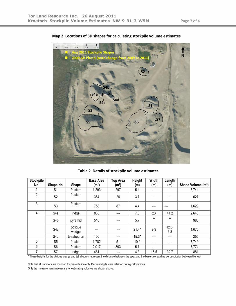
Tor Land Resource Inc. 26 August 2011 Kroetsch Stockpile Volume Estimates NW-9-31-3-W5M Page 1 of 4 Project Stockpile Volume Estimates Ritchie Brothers – Darcy Kroetsch’s Stockpiles Date August 26, 2011 Objective Estimate the volume of six gravel stockpiles at the gravel pit in the LLD below. A seventh gravel stockpile was measured at the request of the owner of the material, Darcy Kroetsch. Evaluator H.D. Budney P.Geol. LLD NW-9-31-3-W5M Site Visit On August 17 and 23rd, 2011, Tor Land Resource Inc. was on site and took measurements necessary for estimating the volume of gravel stockpiles. Mr. Kroetsch was on site on August 17 and indicated the stockpiles to be measured. The weather conditions on both days were favourable. During the site visit on August 17th, gravel was being hauled from Stockpiles 5 and 6 (Map 1); on August 23 rd , from Stockpile 6. Methodology The bases of the piles were tracked by GPS. As necessary, waypoint locations were taken to define the shape or combination of shapes that formed each stockpile. Heights of the materials were measured with a rangefinder. For the cases where an irregular surface was observed (i.e., multiple peaks), measurements of peaks and valleys were recorded and averaged to one height. Slopes of the stockpiles were measured using the rangefinder. Two methods were used: 1) measuring the slope (inclination) directly with the rangefinder and 2) calculating the slope based on a horizontal and vertical distance. When compared, these two methods resulted in slopes varying up to approximately 5 degrees, resulting in minimal variation in the volume. The material type was estimated visually in the pit, and correlated with the owner descriptions. In estimating the volumes, each stockpile is conceptualized as either a single or combination of three-dimensional shapes. Measurements were taken to describe the shape(s) of each pile in three dimensions. The volume of each stockpile is estimated by calculating the volume of the shape(s). Field Equipment Garmin GPSmap 60CSx; Laser Technology Inc. TruPulse 200 rangefinder Field Results Seven stockpiles were measured (Map 1 and Table 1). These seven stockpiles are conceptualized as ten shapes for volume estimates (Map 2 and Table 2).


![Use of Strategic National Stockpile [SNS] Ventilators in ...LP-10 Volume Ventilator with Pressure Limit Volume ventilator (A/C or SIMV) Volume is measured with spirometer (no LED readout)](https://static.documents.pub/doc/80x56/6088c6e3abcc6311107191c8/use-of-strategic-national-stockpile-sns-ventilators-in-lp-10-volume-ventilator.jpg)


