PROJECT SUMMARY Overview: Page A Atmospheric flow in complex terrain has received increased attention in recent years because of its numerous applications, including air pollution, contaminant dispersion, aviation, Alpine warfare and wind energy harvesting. While past research has mainly focused on and improved upon weather prediction at the mesoscale (resolution on the order of km), wind energy and dispersion applications demand improved accuracy of predictions at the microscale (tens to hundreds of meters). To this end, ERANET+, a European Union (EU) funding instrument, has granted a consortium of EU scientists a megaproject to provide the wind energy sector with more detailed wind resource mapping capabilities. This is to be accomplished through the creation and publication of a new digital EU wind atlas (NEWA) based on the development of improved models for wind energy physics and forecasting. Embedded in the ERANET+ project is a comprehensive field campaign dubbed "Perdigao" in 2016-17, which will collect a reference data set at unprecedented spatial resolutions, characterizing both the mean and turbulent wind fields in a natural setting. Augmenting the basic measurement and modeling capabilities of EU scientists with those from the US investigators will add considerable value to the ERANET+ project while allowing US investigators to pursue scientific endeavors of their choosing. This proposal seeks funding for a cadre of US scientists to conduct preparatory work for possible participation in Perdigao. The PIs already visited the Perdigao field site, a community workshop was held to identify prospective science issues, and networking with EU scientists has begun. The proposed activities include a scientific workshop and a field visit to the Perdigao site for confirmed US participants. These activities will further enhance EU-US collaboration and help finalize field deployment strategies. Intellectual Merit : A major goal of the ERANET+ project is to quantify errors of wind resource models against benchmark datasets. The US participation will complement this activity by identifying physical and numerical weaknesses of models and developing new knowledge and methods to overcome such deficiencies. This SPO will assemble a group of experts to delve into critical knowledge gaps that plague the fidelity of microscale models and plan Perdigao activities to address thereof. Recent technological breakthroughs (Windscanner triple-Lidar systems for 3D wind vector measurments) and the availability of a suite of tower-based instruments and remote sensors will enable Perdigao researchers to investigate multi-scale processes down to the microscale. The workshop will attempt to optimize Perdigao instrument deployment for best science outcomes, namely, improved wind energy physics, development of new model-usable parameterizations and high-fidelity microscale simulations and forecasting. Broader Impacts : The expected outcome of the parent (EU) project is the development of a unique high-resolution database at ~ 500-meter horizontal and ~ 10-meter vertical resolutions for benchmarking microscale models for wind resource assessment. The goal is to reduce the prediction of Annual Energy Production (AEP) error, which is unacceptably large at present, by an order of magnitude. Improved models will help develop reliable wind-energy development strategies, thus contributing to better global energy policies as well as renewable energy prospecting. The US aims to provide 30% of its electricity via wind energy by 2030. The students of the project will be aptly trained for leadership positions in wind engineering industry and academia, and the timing of field study suits both graduate and undergraduate student participation in Perdigao. International cooperation as well as exposure to the EU wind energy industry and cutting edge technologies will allow US students to engage in global energy partnerships and widen professional horizons. The application areas of Perdigao basic research will extend way beyond wind energy. The comprehensive database to be developed and maintained by the Lower Atmospheric Observing Facility of NCAR and EU will be a unique resource to meteorologists and engineers alike for decades to come.
Transcript
PROJECT SUMMARY
Overview:
Page A
Atmospheric flow in complex terrain has received increased attention in recent years becauseof its numerous applications, including air pollution, contaminant dispersion, aviation, Alpinewarfare and wind energy harvesting. While past research has mainly focused on and improvedupon weather prediction at the mesoscale (resolution on the order of km), wind energy anddispersion applications demand improved accuracy of predictions at the microscale (tens tohundreds of meters). To this end, ERANET+, a European Union (EU) funding instrument, has granteda consortium of EU scientists a megaproject to provide the wind energy sector with more detailedwind resource mapping capabilities. This is to be accomplished through the creation and publicationof a new digital EU wind atlas (NEWA) based on the development of improved models for windenergy physics and forecasting. Embedded in the ERANET+ project is a comprehensive field campaign dubbed "Perdigao" in 2016-17,which will collect a reference data set at unprecedented spatial resolutions, characterizingboth the mean and turbulent wind fields in a natural setting. Augmenting the basic measurementand modeling capabilities of EU scientists with those from the US investigators will add considerablevalue to the ERANET+ project while allowing US investigators to pursue scientific endeavorsof their choosing. This proposal seeks funding for a cadre of US scientists to conduct preparatory work for possibleparticipation in Perdigao. The PIs already visited the Perdigao field site, a community workshopwas held to identify prospective science issues, and networking with EU scientists has begun.The proposed activities include a scientific workshop and a field visit to the Perdigao sitefor confirmed US participants. These activities will further enhance EU-US collaboration andhelp finalize field deployment strategies.
Intellectual Merit :A major goal of the ERANET+ project is to quantify errors of wind resource models againstbenchmark datasets. The US participation will complement this activity by identifying physicaland numerical weaknesses of models and developing new knowledge and methods to overcome suchdeficiencies. This SPO will assemble a group of experts to delve into critical knowledge gaps that plaguethe fidelity of microscale models and plan Perdigao activities to address thereof. Recenttechnological breakthroughs (Windscanner triple-Lidar systems for 3D wind vector measurments)and the availability of a suite of tower-based instruments and remote sensors will enablePerdigao researchers to investigate multi-scale processes down to the microscale. The workshopwill attempt to optimize Perdigao instrument deployment for best science outcomes, namely,improved wind energy physics, development of new model-usable parameterizations and high-fidelitymicroscale simulations and forecasting.
Broader Impacts :The expected outcome of the parent (EU) project is the development of a unique high-resolutiondatabase at ~ 500-meter horizontal and ~ 10-meter vertical resolutions for benchmarking microscalemodels for wind resource assessment. The goal is to reduce the prediction of Annual EnergyProduction (AEP) error, which is unacceptably large at present, by an order of magnitude.Improved models will help develop reliable wind-energy development strategies, thus contributingto better global energy policies as well as renewable energy prospecting. The US aims to provide30% of its electricity via wind energy by 2030. The students of the project will be aptly trained for leadership positions in wind engineeringindustry and academia, and the timing of field study suits both graduate and undergraduatestudent participation in Perdigao. International cooperation as well as exposure to the EUwind energy industry and cutting edge technologies will allow US students to engage in globalenergy partnerships and widen professional horizons. The application areas of Perdigao basicresearch will extend way beyond wind energy. The comprehensive database to be developed andmaintained by the Lower Atmospheric Observing Facility of NCAR and EU will be a unique resourceto meteorologists and engineers alike for decades to come.
TABLE OF CONTENTSFor font size and page formatting specifications, see GPG section II.B.2.
Total No. of Page No.*Pages (Optional)*
Cover Sheet for Proposal to the National Science Foundation
Project Summary (not to exceed 1 page)
Table of Contents
Project Description (Including Results from Prior
NSF Support) (not to exceed 15 pages) (Exceed only if allowed by aspecific program announcement/solicitation or if approved inadvance by the appropriate NSF Assistant Director or designee)
References Cited
Biographical Sketches (Not to exceed 2 pages each)
Budget (Plus up to 3 pages of budget justification)
Current and Pending Support
Facilities, Equipment and Other Resources
Special Information/Supplementary Documents(Data Management Plan, Mentoring Plan and Other Supplementary Documents)
Appendix (List below. )
(Include only if allowed by a specific program announcement/solicitation or if approved in advance by the appropriate NSFAssistant Director or designee)
Appendix Items:
*Proposers may select any numbering mechanism for the proposal. The entire proposal however, must be paginated.Complete both columns only if the proposal is numbered consecutively.
1
1
15
7
4
4
5
3
13
d-1
D. Project Description D.1 Introduction and Motivation
Complex-terrain meteorology spans numerous application areas, including wind energy harvesting (Banta et al. 2013), air pollution in urban basins (Fernando & Weil 2010), aviation (Politovich et al. 2011), Alpine warfare (Winters et al. 2001), and firefighting (Holden & Jolly 2011). Of particular importance is the planetary boundary layer (PBL) where most of the anthropogenic activities take place and topographic processes pronouncedly alter the flow. Winds in complex topography (mountainous terrain) embody much wider space-time scales than on flat terrain, wherein non-linearity of the flow is more pronounced and the predictability more difficult. The state-of-the-science of mountain meteorology has been reviewed by Fernando (2010) and in a series of papers in Chow et al. (2013), complementing earlier excellent monographs of Blumen (1990), Baines (1998) and Whiteman (2000). Unlike the canonical flat terrain boundary layer, where large-scale pressure (synoptic effects) and thermal gradients drive the flow, the complex terrain PBL ingrains the additional influence of slope and valley flows (thermal circulation) due to heating and cooling of the ground over the diurnal cycle (Fernando et al. 2001).
Typically, the frequency content of wind variability in complex terrain peaks at synoptic scales, but a secondary peak also appears in the wind spectrum at ~ 12 hour periods where the thermal circulation reverses from daytime upslope (anabatic) and upvalley flow to nighttime downslope (katabatic) and downvalley flow, and vice versa. During the daytime intense convection period, variability at the scales of tens of meters and minutes is significant, representing the scales of convection cells (Kaimal & Finnigan 1994). Superimposed therein is the turbulence produced by shear and thermal forcing in the atmospheric surface layer. While quiescent, low-synoptic periods are important in air pollution studies, and hence have been a topic of intense study (Zardi & Whiteman 2013), energetic synoptic conditions with high frequency content are of great interest in other application areas. Characteristics of such flows include high turbulence levels due to shear layers, flow separation from topography (Helmis et al. 1995), presence of dividing streamlines (Hunt 1980), gustiness, flow-flow and flow-topography collisions (Retallack et al. 2006), and flow meandering and intense low-level jets (Banta et al. 2002). Ensuing unsteady effects are unwelcomed in wind turbine siting, aviation and forest fire control. For example, ‘gustiness’ of winds (expressed by the gust factor, or the ratio of gust wind speed to hourly mean wind speed) is closely related to turbulence, and it is a critical design parameter specifying the mechanical lifetime of wind turbines (Fragoulis 1997; Wieringa 1973). One of the greatest challenges of wind energy vis-à-vis conventionally generated electricity is the dependence of former on the ‘volatility’ of winds (Giebel 2011), particularly on two time scale windows, one determining turbine control (from milliseconds to tens of seconds) and the other on the integration of wind power to the electric grid (minutes to weeks). Both of these windows need attention, as scales of several minutes or less are not usually monitored and are less predictable.
This proposal alludes to a unique and unprecedented opportunity to study complex terrain flows at the microscale (seconds to hours in time and up to a few hundred meters in space) by participating in a European project to develop a wind atlas for Europe, a component of which calls for fundamental scientific research. The long term goal of the overall project is to provide improved capabilities for wind energy prospecting (in Europe), and the present proposal concerns the participation of US groups to study flow regimes and scales that have received little attention hitherto - microscale mountain meteorology. The energy cascading through mesoscales is also of interest.
In addition to knowledge creation, the proposed work will provide a platform for improvement of wind energy prospecting. Wind energy is recognized to be a clean, renewable energy source that can reduce the dependence on fossil fuels, which are not only facing depletion but also at the center of climate change debate (Leung & Yang 2013). According to the latest Global Wind Report (GWEC 2014), the total global wind power installation at the end of 2013 was 318 GW. It is growing at a rate of about 20% (Sørensen 2011), with different nations taking the lead at different times. Germany led wind energy production until 2007, with the US surging ahead in 2008, to be overtaken by China in 2010 (Premalatha et al. 2014). Wind resource characterization is central to all aspects of wind energy production, from identification of suitable
d-2
sites to assessment of economic viability of wind farms to the design and management of wind turbines (Schreck et al. 2008; McElroy et al. 2009; Shaw et al. 2009; Sørensen 2011). The energy available in the winds varies as the cube of wind speed, and hence the variability of wind speed, both in space and time and over a range of scales, critically affects energy harvesting. Various empirical and semi-empirical formulae exist to predict wind variability based on the site and time of the day, which provide operational guidance (EDSU 1985; Walmsley et al. 1989; Mann 1994, 1998; IEC 2005; Woebbeking 2007). The prediction of high frequency wind variability in complex terrain, nevertheless, has been a vexing challenge for PBL studies, let alone in wind engineering (Burton et al. 2011).
Wind resources are sensitively determined by local scales, and hence by physical geography such as land use and land cover and topographic features that modify not only the synoptic influence but also local turbulence (Singh et al. 2006; Clifton et al. 2013). Winds on top of the hills are much stronger than in the lee side of the hills, and on the scale of a wind turbine, nearby obstacles and local vegetation also matter (Burton et al. 2011). It is at this microscale that the predictability of winds is poor and the variability is random. In fact, for many areas of economic interest, the wind climatology has been already mapped using mesoscale models and assimilated meteorological data, nonetheless, the predictions of available wind energy to turbines have been stymied by errors introduced by space-time variability at small scales (Palma et al. 2008; Liu et al. 2011; Mahoney et al. 2012; Delle Monache et al. 2013; Carvalho et al. 2014). Accurate wind forecasting is also crucial for power optimization (Lei et al. 2009), environmental impact assessment (Dai et al. 2015), and load balancing (Giebel 2011).
Earlier investigations on complex terrain meteorology have focused largely on quiescent periods, with application to air pollution. Conversely, studies with synoptic influence have been centered on the linear theory for neutrally stratified flow by Jackson & Hunt (1975) and Hunt et al. (1988) for low slopes ( 17o; Walmsley & Taylor 1996), with wind energy and dispersion applications (Belcher & Hunt 1998). Erstwhile field works have concerned flow over escarpments (Jensen & Peterson 1978), terrain with inhomogeneous roughness (Sacré 1979) and low slopes with wind turbines (Högström et al. 1988; Helmis et al. 1995). The significant role that turbines play in adjusting heat, mass and momentum exchanges in the surface layer is now well documented, but lacks detailed understanding (Zhou et al. 2012; Rajewski et al. 2014). Jackson & Hunt’s (1975) work has been extended to three-dimensional flow by Mason & Sykes (1979). Nonetheless, linear theories have been the backbone of many commercial numerical codes, for example, MS3DJH, MSFD, WAsP and ADMS (Taylor et al. 1983; Walmsley et al. 1986; Troen et al. 1989; Carruthers 2007; Carruthers et al. 2011; Heist et al. 2013).
Recent work has clearly pointed to the importance of microscale modeling of complex terrain flows in wind energy applications (Palma et al. 2008; Liu et al. 2011; Carvalho et al. 2014) by illustrating that errors in using mesoscale models for wind prospecting can reach 100%! In recognition, the European Union (EU) has recently granted a ~ €13M megaproject under the sixth framework ERANET+ -- a program that requires financial contributions from at least six EU nations, with the European Commission contributing one third of the total. The successful project of our European partners, ERANET+: New European Wind Atlas (NEWA), is contributed by a consortium of eight countries (Section J) to develop a data bank of European wind climate. The NEWA outcomes will include an EU wind climate database and provide hourly variables at each grid point (with accuracy over 10%). Through a combination of measurements and modeling, it will produce maps of wind data at several heights and at horizontal resolution down to 100 meters, covering EU member states and their exclusive economic zones. Existing models will be improved as well as coupling thereof (“model chain”). Uncertainty estimates for models and model chains will be published. Analysis will be performed for short-term forecasting predictability.
The NEWA will also have information on regional wind resource assessment, wind variability and local siting of turbines - including guidelines and computational procedures for the effects of shelter from buildings and other obstacles, effects of varying surface roughness and for the influence of hills and mountains on the wind climate and wind power resources. The goal is to reduce the AEP (Annual Energy Production) estimation error from the current level of 40-50% to 3-10%. The consortium coordinator is Dr.
d-3
Eric Björklund (Danish Energy Authority, DEA), and the Principal Investigator is Professor Jakob Mann (Technical University of Denmark, DTU). The project start date is May 01, 2015, and deliverables include an electronic Atlas, dynamical downscaling methodologies and open source models validated through previous as well as new field data.
The most noted existing dataset on synoptic flow over a hill is based on the Askervein Hill field experiment (Taylor & Teunissen 1983), and the ERANET+ database is expected to be a significant augmentation of Askervein. There will be several field campaigns over the project period of five years, in mountains (see below), forested hills (Kassel in Germany), offshore (northern Europe), large changes in surface characteristics (Alaiz mountain, Spain) and cold climates (high altitude ridges in Turkey). The mountain-terrain field study within ERANET+ is to be conducted in 2016-2017 in central Portugal, within the Vale Cobrão near the town of Perdigão, located northeast of Porto. Given the closeness to its namesake city, the campaign has been dubbed Perdigão (Portuguese for “Partridge”).
The US investigators led by the PIs have been invited to participate in the Perdigão campaign, with their own science plans and financial resources. A preliminary meeting with Europeans was held in July 2013, followed by a Scientific Program Overview (SPO) and Experimental Design Overview (EDO) proposals to NSF in January 2014, which were declined due to programmatic reasons (Section D.4, Table 2). The NSF reviews were affirmatively positive. During September 4-6, a visit to the Perdigão experimental site by the PIs and Dr. Steve Oncley was funded by Fundação Luso-Americana para o Desenvolvimento (FLAD). Given their interest in participating in Perdigão, the US Army Research Office (ARO) funded a workshop at University of Notre Dame during September 25-26, 2014, on “Microscale Modeling of Complex Terrain Flows” with focus on Perdigão science plans, instrumentation and logistics. Armed with robust science plans and certainty of the status of the EU Project, the US team is now in a sound position to seek participation in Perdigão experiment, and hence this revised proposal. This proposal seeks to formalize US participation in Perdigão, undergirded by NCAR/EOL facilities. Funding is requested for travel to a workshop at a location near Perdigão, followed by a site visit, as well as for domestic planning meetings.
D.2 Current State of Knowledge During February 1-2, 2010, with the support of Army Research Office, a meeting was hosted by the PI
Fernando in Tempe, Arizona to identify critical scientific barriers for weather prediction in mountainous terrain, which led to the development of the Mountain Terrain Atmospheric Modeling and Observations (MATERHORN) Program (2011-2016), a Multidisciplinary University Research Initiative (MURI) of the Office of Naval Research (www.nd.edu/~dynamics/materhorn). Three large field experiments have already been completed under this program (Fernando & Pardyjak 2013; Fernando et al. 2015), the data of which are being analyzed by numerous groups. In designing the experiments, the knowledge gained from prior studies was evaluated so that the new data can address overarching current issues. The complexity of mountain-terrain flows and programmatic constraints, however, required MATERHORN to be narrowed down to a particular set of problems – mesoscale processes and modeling. The microscales were not addressed, although their practical importance was emphasized. To this end, Perdigão offers a sophisticated research platform, and underlying critical science issues are identified in Section D.3. A brief review of multi-scale processes in complex terrain meteorology is provided below.
Figure 1 summarizes various flow and boundary-layer types in a valley located between two long (normal to the paper) mountains that disturb the flow in free atmosphere. The figure was drawn based on the reviews of Blumen (1990), Whiteman (2000), Fernando (2010), and Chow et al. (2013) and knowledge gained from recent complex-terrain field campaigns (e.g., Doran et al. 2002; Grubisic et al. 2008; Politovich et al. 2011; Price et al. 2011; Fernando & Pardyjak 2013; Fernando et al. 2013). The scales are denoted according to the classification of Orlanski (1975). Mountains of height less than 600 m are typically defined as hills (Barry 2008). When the approach flow is stably stratified at night (in blue), the wake of the leading mountain consists of lee waves, rotors and separated vortices and coherent structures penetrating in to the
d-4
valley carrying momentum, whilst under weak synoptic conditions a downslope (katabatic) flow defines a shallow mountain atmosphere. Convergence of downslope (Vds) flows in the valley forms a stably stratified cold pool, signifying the valley atmosphere, which in this case encompasses the stable boundary layer near the ground. The combined influence of mountain wakes and valley spreads to the mountain-valley atmosphere, which transitions to free air though a layer signified by perturbed (synoptic) flow by the mountains. The disturbed layer by the mountains and valley collectively defines the complex terrain atmospheric boundary layer. Depending on the terrain and variability of the land cover, different microclimates are possible. Conversely, during daytime convection (in red), a convective boundary layer develops deep, and the upslope flow (Vus) and its separation and formation of cumulus clouds are typical features under weak synoptic conditions. The separation of synoptic flow at the ridge sheds energetic vortices into the mountain-valley atmosphere, creating unsteady flow.
km), global; ) - macro- (2-10)x103 km synoptic; ) - meso- - (2-20)x102 km regional downvalley; ) - meso- (2-20)x10 km, local down valley;
) - meso- (2-20) km, local downslope or locally distorted regional (R)/canopy (C) flow;
) - micro- (0.2-2) km, local flow interactions and collisions;
) - micro- (20-200) m, instabilities; ) - micro- (<20 m), turbulence and eddies down to Kolmogorov scales . MC - microclimates
As mentioned, the current understanding of mean flow past hills is mainly grounded on the works of Jackson & Hunt (1975), Hunt et al. (1988) and extensions. The theory applies to neutrally stratified flow over low hills, and formally assumes small perturbations to the approach flow caused by a hill. The outer layer is assumed inviscid, and turbulent transport processes are dynamically significant only within an ‘inner layer’ theoretically determined by the roughness height and characteristic mountain width , irrespective of the mountain height . The assumptions leading to linearized equations of Jackson & Hunt (1975) are sometimes unheeded in applications, for which justifications are provided based on scaling and dynamical arguments (Hunt 1980; Britter et al. 1981; Mason & King 1985).
Taylor et al. (1987) reviewed ‘low hill’ experiments, and classified them based on key variables in the framework of Jackson & Hunt (1975). The emphasis was on the mean profiles of streamwise velocity and turbulence intensity, whereas insights gained on the modification of turbulence structures by orography were sparse. Figure 2 extends the Taylor et al. (1987) diagram to include more recent studies relevant to the Perdigão (double hill) experiment, some of which are listed in Table 1 (experiments without emphasis on synoptic effects are omitted for brevity). Some studies have suggested that winds upstream can be predicted using a composite ‘regional roughness length’ based on the topography and the surface roughness (Tieleman 1992). At the heights of importance to wind turbines, the flow can be treated as ‘rapidly distorted’ as in Jackson & Hunt (1975), in that the variation of mean winds occurs more rapidly than that of turbulent intensity. Thus, the effect of hills can be treated as irrotational fluctuations caused by the distortion of mean flow by the hill, and hence the normalized turbulence intensity decreases as flow accelerates past a hill
d-5
(Schlez 2000). Although such assumptions appear intuitive, the processes associated with flow distortions are not that straightforward and involve intercomponent energy transfer from the longitudinal to the lateral components and corresponding shifts in the spectrum (Petersen et al. 2013).
Figure 2: Past field experiments on flow over hills classified according to key parameters, versus . Here is the height of the hill, the half width up to and is the roughness height. The
original diagram of Taylor et al. (1987) has been modified to include relevant and recent experiments. From the original paper: BM – Black mountain, WE – Worms Embankment; AC – Ailsa Craig; NH – Nyland Hill; BK – Brent Knoll; PZ – Pouzauges Hill; and SV – Sirhowey Valley. New inclusions: Perdigão, MATERHORN (two sites, Small Peak SP and Granite Mountain GM; Fernando & Pardyjak 2013), hill Tighvein, Isle of Arran (Vosper et al. 2002), Black Combe mountain in Cumbria (Vosper & Mobbs 1997); Cinder Cone Butte, Idaho (Snyder et al. 1980), Coopers Ridge, Australia (Coppin et al. 1994) and Steptoe Butte, Washington (Ryan et al. 1984).
Table 1: Field experiment studies relevant to Perdigão experiment in chronological order (Some are not included in Figure 2 because of the unavailability of accurate parameters). Perdigao is a double hill.
Time-frames Field Experiments 1979-1986 Brent Knoll, Pouzauges Hill, Black Mountain, Ailsa Craig, Kettles Hill, Askervein
Hill, Steptoe Butte, Bungendore Ridge, Sirhowy Valley, Blashaval, Cooper’s Ridge and Nyland Hill
2002-2003 Tighvein, Gaudergrat 2004, 2006
Owens Valley (California, USA), Sierra Rotors Project (SRP), followed by Terrain-induced Rotor Experiment (T-REX)
2007-2008 Bolund Hill (Denmark) 2010 Benakanahalli Hill (Karnataka, India) 2012-2013 MATERHORN (Dugway Proving Grounds, Utah)
Because of strong spatial acceleration of winds in certain areas, complex terrain offers attractive locations for wind turbine siting. Conversely, the bane is the difficulty of wind prediction in such areas, given the space-time variability of the wind field and its sensitivity to non-stationary thermal forcing (Carvalho et al. 2014). Figure 1 depicts the sheer complexity of flow, including flow separation, collisions
d-6
between flows, Coand effect, secondary flows, convergence/divergence, internal and lee waves, roughness effects, unsteadiness, stratification, land use and directional shear. While the previous experimental efforts have contributed immensely to our understanding (Doran et al. 2002; Grubuisic et al. 2008), there is a demonstrated need for more high-resolution data at the microscale, in particular for wind energy applications (Lopes et al. 2007; Ayotte et al. 2010; Sullivan et al. 2010; Liu et al. 2011; Churchfield et al. 2012). As discussed below, mesoscale models are grossly insufficient to estimate the AEP in the wind turbine industry, given high spatial gradients in topography and hence in wind fields.
Figure 3a: Mesoscale modeling (5.12 km resolution) output of the wind energy (magnitude in color) for the installation of five 2MW turbines (shown by green dots).
Figure 3b: Same as in (a), but with a microscale model with 20 m resolution nested with the mesoscale model in (a).
Figure 3 illustrates wind calculations for siting of five 2 MW turbines in complex terrain performed using mesoscale and microscale models (Palma et al. 2008). The AEP calculated by the mesoscale modeling is 39 GWh whereas by the microscale modeling is 55 GWh! Such disparity is unacceptable in the design process, emphasizing the importance of information delivery at high resolution. Microscale models, nonetheless, are still nascent and in need of improvements, especially by accounting for stratification, topography and background turbulence. In the wind sector, the practice hitherto has been to extrapolate, using simple (often linearized) models, the tower measurements taken elsewhere in the landscape to identify potential wind turbine locations (Ayotte et al. 2001). Clearly this is not a viable practice in the long haul.
To develop or improve micrometeorological models, the need for high-resolution data cannot be overemphasized (Palma et al. 2008). So far, the field emphasis has been on mesoscale data, for both model validation and process studies (Doran et al. 2002). As mentioned, in the early 1980’s one of the most well-known experiments was conducted by an international group of experts at Askervein Hill in the UK, characterized by smooth and low slope (< 20o), few irregularities, and uniform roughness (Taylor & Teunissen 1983). The flow was clean, in that flow separation, reattachment and recirculation were absent or only intermittent. The mean flow measurements therein have been used extensively to validate linearized models such as Jackson & Hunt (1975). Linearized models performed well upstream of the hill and not so well downstream, but the project was sufficiently successful (Mann 2000) for developing and validating computationally fast commercial codes for wind resource estimation (Troen et al. 1989; Corbett et al. 2008). Wind tunnel experiments, however, show that linearized models overestimate the wind speeds over the ridge of steep mountains (Ayotte & Hughes 2004). The problem is particularly acute in situations where turbines are on the top of steep ridges with sub-ridges pointing away from the main ridge; they experience extremely large fluctuations in wind speed and direction (Berg et al. 2011). Kindred deficiencies have spurred the development of non-linear models such as Reynolds-averaged Navier-Stokes solvers (RANS) and large-eddy simulations (LES). In all, the Askervein experiment continues to serve well for comparison
d-7
with non-linear models (Castro et al. 2003; Lopes et al. 2007; Chow & Street 2009; Golaz et al. 2009; Bechmann & Sørensen 2010; Berg et al. 2011), but comparisons have not been performed at sufficiently high spatial resolution or with data from steep terrain representative of wind farm locations. D.3 Science Goals
The review of literature and discussions in the recent (Sep. 25-26, 2014) workshop at Notre Dame led to identification of a myriad of research needs. These were prioritized and narrowed down to five science foci based on near-term importance, consistency with the European research agenda and availability of resources. For each focus area, a set of hypotheses were developed and approaches to test them at Perdigao are outlined below. The general experimental plan in D.4 allows investigations on these topics, and suitable augmentation of instrumentation by funded groups is expected (Section I). Modelers will use existing numerical tools and improvements thereof to simulate Perdigão flows at the microscale. Working with observationalists, they will elucidate new physics and help interpret observations. This SPO covers only the Perdigão experiment, whilst numerical studies will be articulated in individual grant proposals.
Experimental foci
1. Multi-scale flow interactions in complex terrainHypotheses: Local circulation in the valley represents complex interactions between thermal circulation, regional flow and synoptic forcing, and thus local flow is highly variable in space and time, depending on the strengths of each contributor and interactions thereof. Turbulence and mixing in the valley (and hence eddy coefficients) are also highly variable over a range of scales.
Approach: (a) Characterize synoptic, regional and mesoscales, including forcing such as pressure gradients and sea surface temperature (site is ~ 100 km from the coast), (b) Measure local conditions and their evolution at selected sites (i.e., flow collision, interaction and flow distortion hotspots, identified intuitively or long-term monitoring) at high space-time resolution, including turbulence and fluxes, (c) Identify processes and phenomena - shear instabilities, internal waves, slope flows, flow collisions - at locations in (b) via scanning Lidars, IR imaging, remote and in-situ sensing, and relate their appearance to local conditions (e.g., dimensionless parameters), (d) Delineate physical mechanisms and interactions thereof, identify their space-time variability and parameterize relevant property fluxes, (e) Demarcate appearance of various flow regimes as functions of (suitably scaled) property footprints.
Implications: Strong interactions of synoptic and thermally/mechanically induced flows occur at micro- or smaller scales (Sturman et al. 2003; Fernando et al. 2015), but their flux footprints are unknown. Careful multi-scale observations are invaluable for improving microscale models (Landberg et al. 2003; Liu et al. 2011).
2. Influence of terrain heterogeneity Hypotheses: While the assumption of an idealized two-dimensional valley within two parallel ridges, as in Perdigão (Section D.4), is a reasonable first step in modeling, the natural variability of topography and land use can greatly modify the flow within the valley and over the ridges. In particular, the presence of a simple “Gap’ in one ridge can generate secondary circulation, jetting, interacting shear layers and cross-slope flows that modify the flow and turbulence over a certain spatial extent – which is determined by the overall topography, topographic anomalies (gaps), approach flow and flow stability.
Approach: (a) Characterize the approach flow, background stability and orography of the gaps, (b) Verify Jackson & Hunt (1975) framework for low slope angles (i.e. < ~ 0.1) and no gap areas of the fore mountain at neutral stability, and explain discrepancies, (c) Map 3D velocity and turbulence fields in the vicinity of the gap and away from it at high resolution, identify and explain the differences, (d) Measure the pressure field, local circulation, separated flow, flow structures, secondary circulation and turbulence at selected locations at high space-time resolution, (e) Measure coherent structures at the ridge shear layers and gap-separated flows and estimate related momentum transports, (f) Identify the lengthscales of flow distortions, both vertical and horizontal, at the gap and away from it, (g) Quantify internal wave radiation
d-8
under stable conditions and upslope flow separation under unstable conditions at gap area and away from it as a function of flow and stratification parameters, (h) Study how the results of (a)-(f) depend on atmospheric stability (stable, unstable and neutral),
Implications: Topographic inhomogeneities of microscales are known to substantially modify both thermally and synoptically driven flows (Rotach & Zardi 2007), which cannot be captured by mesoscale models. The spatial extent and magnitude of this modification as well as possible unsteady phenomena such vortex shedding is of importance in wind turbine siting and operations (Fesquet et al. 2009).
3. Transitions and diurnal cycleHypotheses: The morning and evening transitions under low synoptic conditions in a nominally two-dimensional narrow valley are different from that on a (idealized) long slope abutting a valley. For long slopes, the evening transition arguably is dominated by front formation, shadow fronts and slab-like flows (Nadeau et al. 2011; Fernando et al. 2013), but in narrow valleys the flow is affected by recirculation cells, valley circulation and solar-insolation asymmetry on mutually facing slopes. The morning transition on a long slope includes intrusion formation, shaving phenomena and flow separation (Princevac & Fernando 2008), but again the case of a narrow valley is dynamically different. The kinetic energy budgets and turbulent mixing during transition also are different from the long slope case. Three-dimensionality introduced by gaps and topographic anomalies are expected to modify the transition mechanism in their vicinity.
Approach: (a) Quantify 3D wind variability with continuous measurements at representative sites with high space-time resolution (Windscanner systems; see Section D.4), (b) Observe surface temperature evolution using high-resolution IR imagery, (c) Measure vertical profiles and transects of kinetic energy to estimate the advection and turbulence transport terms, (d) Deploy Unmanned Aerial Vehicles (UAVs) and tethered lifting systems (TLS) for whole flow field mapping, (e) Monitor mixed-layer depth in the valley and on the slopes, (f) Identify morning and evening transition mechanisms using IR imaging, distributed temperature measurement systems (DTS) and scanning LIDARS.
Implications: Accurate understanding of the coupling between surface flow and overlying atmosphere is needed for the models and model chains used for environmental prediction (Gopalakrishnan et al. 2000). High-resolution field data over diurnal cycles that focus on the effects of topographic inhomogeneities are non-existent, for which Perdigão can make an impactful contribution.
4. Impacts of surface inhomogeneityHypotheses: Gradients of surface moisture, thermodynamic properties and roughness as well as slope discontinuities lead to 3D microcirculation, hydraulic adjustments and flow separation even when the slope and valley are nominally 2D. Such adjustments are significant when relevant local forcing is sufficiently strong. The local parameters determining microcirculation include in-situ land use/cover and surface properties (e.g., albedo, emissivity, hydraulic and thermal conductivity, roughness length, soil moisture), which broadly affect the surface energy budget. 3D flows so introduced lead to complex flow patterns (e.g. directional and horizontal shear; Fernando et al. 2001; Poggi et al. 2008).
Approach: (a) Collect high-resolution land-cover data just before the Perdigão campaign to characterize elevation and vegetative canopy (e.g., topo-lidar, aerial photographs), (b) Site instruments at suitable (limited number of) locations with high spatial resolution for energy budget; some optimization will be necessary, (c) Conduct katabatic flow experiments in areas of different land cover and identify the differences of mean and turbulent flow properties, (d) Monitor flow adjustment regions at land-cover and slope-transition locations and map vertical variation of flow, (e) Identify spatial coherence of flow and scalar fields, (f) explain novel observations and conduct theoretical analyses.
Implications: Often, models assign a land use type based on the most covered land-use type within the computation grid, neglecting heterogeneities within. This approach needs a fundamental rethink. To this end, validation of existing land surface-atmosphere models with high-resolution data is imperative.
d-9
Performance of models at surface discontinuities (e.g., slope, land use) needs evaluation (Jiménez & Dudhia 2012; Rasouli & Hangan 2013; Castro et al. 2014), which most likely will call for model improvements.
5. Flow-turbine interactions and wake flowsHypothesis: Coherent structures generated in a turbine wake can be effective momentum transfer mechanisms, depending on the background atmospheric stability. When a wind turbine is on a ridge, these wake structures can penetrate the valley and produce gusts and elevated turbulent kinetic energy regions that are non-stationary. Coherent structures may modify thermal circulation and land-surface thermodynamics, at least locally. Modification of pressure field by a turbine wake may affect flow separation on mountain slopes and valleys. (The presence of a single wind turbine on a mountain ridge at the Perdigão site (Section D.4) will help test this hypothesis).
Approach: (a) Investigate wake meander in horizontal and vertical directions using LIDARS, UAVs, and TLS, (b) Quantify TKE budgets in the wake and in the regions impacted by the wake, (c) Identify coherent-structure strikes on the topography via pressure fluctuations, and vertical momentum transfer from aloft by coherent structures, (d) Monitor interactions between coherent structures from the turbine and separated shear layers, and determine locations and mechanisms of interactions. (e) Conduct above studies for differing stability conditions.
Implications: There is increasing evidence that wind turbines wake regions can alter local flow (Rhodes & Lundquist 2013; Fitch et al. 2013; Rajewski et al. 2013), climatology (Zhou et al. 2012) and ecosystem health (Leung & Yang 2012; Premalatha et al. 2014; Dai et al. 2015). Yet wind energy is considered as one of the most environmentally clean energy resources. About 15-20% of the proposed wind power plants are not built because of the environmental concerns (IEA 2005), and wind wake impacts on the surface layer need to be accurately quantified if objective environmental impact assessments (EIA) are to be made. Thus, quantification of turbine influence on surrounding turbulence, energy budget, water vapor and CO2 fluxes is imperative. Simultaneously collected turbulence data on crucial locations of wind turbine siting (upstream, top and lee of a hill) are non-existent, and must be collected at heights useful for surface-layer and wind turbine studies.
Modeling foci Some of the important modeling issues related to Perdigão are: (a) Mechanisms by which small-scale,
near-wall behavior affects large-scale motions over complex terrain (i.e., suitability of wall models and Monin-Obukhov theory; appropriate local averaging; inclusion of slope effects, stratification, spatial heterogeneity, roughness, vegetation, pressure gradients), (b) Optimal sensor placement strategies for microscale data assimilation over complex terrain (how many and what types? what siting strategies? sensor fusion and integration of data into models), (c) Coupling of models, especially two-way nesting (parameterizations for multi-scale interactions, nesting techniques, turbulence closures, land-surface model initialization), (d) Simulation of flow structures (coherent structures and their interactions with topography), (e) Inclusion of atmospheric stability in micro-scale models, including the appropriate level of complexity (micro-scale model simulations over large regions, proper representation of rapidly varying topographies in micro-scale models, studies on spectral representation of topography), (f) Representation of hill-induced shadowing heterogeneities (Dudhia terrain shadowing is used in WRF, but the absence of small-scale heterogeneities may pose errors; Can simple flux scaling laws be derived for land-use and shadow heterogeneities, say by using some modified roughness and thermal length scales?), (g) Downscaling of mesoscale models with a LES or RANS models (ensuring spin up of microscale model congruent with the output of the coarse model; see Muñoz-Esparza et al. 2014).
D.4 The Perdigão Field Study – Roadmap of European Scientists As stated in D.1, the ERANET+ project for developing a European Wind Atlas involves a number of
specialized field campaigns. In a workshop held in January 2011, the European Energy Research Alliance (EERA) announced that the primary land-based experiment would be in complex terrain, with emphasis on
d-10
extensive measurements up to the height of modern turbines (~ 150 m above the peaks). The prospective site should pose challenges for wind resource/load estimations, be representative of real wind farms and display major characteristics of complex sites, i.e., steep slopes and flow separation. A moderate level of complexity was sought to bridge the gap with previous studies. Earlier experiments have studied a single hill (e.g., Askervein) or an isolated escarpment (Bolund, Denmark; Bechmann et al. 2011), so after consideration of five different proposals from EU countries the workshop selected a double-ridge in central Portugal (Figures 4a,b), near the town of Perdigão.
Figure 4a: The topography of Perdigão. Note the long two hill system with mild complexity. WT- wind turbine. Met mast is marked.
Figure 4b: The Perdigão site, looking SE from the turbine site, from the turbine location (note the newly laid power lines)
The advantages of this site are as follows:
(i) As evident from Figure 2, it offers a parameter range not covered in previous studies, ( ~ 103 with < 0.6), except in the Cinder Cone Butte experiment where the focus was on flow visualization of a dividing stream line (Snyder et al. 1980).
(ii) Although natural, it has only a mild complexity and is amenable for fundamental studies with easier interpretation of results. The topography is quasi-two dimensional, dominant winds are perpendicular to the ridges running SE - NW (Figure 5a), turbulence is nearly uniform in all horizontal directions (Figure 5b) and the site has only a few land cover types (Figure 4b).
(iii) Two parallel ridges is one of the best formations that nature can offer to mimic a sequence of periodic hills; the results will be valuable for numerical modelers who seek periodic boundary conditions and/or two-dimensional simulations.
(iv) Accessibility to all sides of the topography for instrument siting, with the lee flow of the first hill impinging on the second hill and vice versa. In between the hills is the valley flow; this can be a benchmark case for studies on the interaction of flow aloft with a valley flow and gap flows.
(v) A meteorological mast has been operational at the site for several years, and a single wind turbine (Enercon 2MW/82m diameter) is already operational on one of the ridges (Figure 4a).
The preferred measurement height of EU scientists is 50-300m, which is the typical sweeping range of turbine rotors. Such heights are reachable using remote sensors and tall (200 m) towers. In addition, the deployment of Windscanner Triple Lidar systems will allow flow details to an unprecedented resolution. Winsdcanners are novel remote sensing technology developed by an EU consortium for probing the atmosphere, with unique applications to nominally inaccessible locations such as the coastal marine boundary layer, highly complex terrain and wind turbine wakes (Vasiljevi et al. 2013; Vasiljevi 2014). The system is based on cutting-edge wind Doppler Lidar technology, wherein each Lidar of the triumvirate measures the line-of-sight component of the wind. Controllable integrated steering of Lidar beams as well as their focus position by a master computer allow measurements within a hemispherical cone in a three-dimensional continuum of points, with a full top angle of ~ 180o and probe volume from ~ 60 m out to 6-9
d-11
km distance (size of the probe volume is dependent on the optics). Three line-of-site velocities so measured enable retrieval of the full wind velocity vector, without making any assumptions on the flow as required in single or dual- Lidar deployments. The instrument is able to produce detailed, full-scale, time-varying, three-dimensional maps of wind velocities, turbulence levels and Reynolds stresses, covering horizontal areas of tens of square kilometers (resolution ~ 150m), heights up to ~ 1km and a myriad of measurement surfaces including ‘mobile’ virtual towers. Measurement uncertainties are lower than those achieved by down-scaled wind tunnel testing or computer modeling. DTU will provide seven wind-scanner systems (21 LIDARS!) for the experiment – a remarkable asset.
Figure 5a: Wind rose for Perdigão (Jan 2002–Dec 2004) based on a local 10 m met mast.
Figure 5b: Turbulent intensities for wind data shown in Figure 5a.
Table 2: Major US Science Community Activities Related to the Perdigão Experiment Activity Information/ Invitees/Attendees OutcomeInitial meeting with Europeans, July 19, 2013 at Notre Dame
Unanimous decision to participate in the Perdigão experiment
January 15, 2014 SPO/EDO Submitted Declined, pending decisions from EU and NSF CentNet funding
Perdigão site visit by US and EU PIs, September 4-6, 2014
Steve Oncley (NCAR), Joseph Fernando (Notre Dame), Julie Lundquist (U. Colorado), Gordon Videen (Army Research Labs), ~ 10 participants from the EU team led by Jose Palma (U. Porto) http://www3.nd.edu/~dynamics/perdiga/Agenda_P_Visit.pdf
Site visit, discussed science issues and logistics, met with the Vila Velha de Ródão City Mayor
Agenda and presentations: http://www3.nd.edu/~dynamics/perdigao/
Experimental design, science goals, confirmed instrument availability and EU support.
The experimental plan calls for some towers to be operated long term. Additional towers will operate during 2016-17, and a campaign with intensive operational periods (IOPs) is planned for 2017. In addition to traditional wind-energy relevant parameters such as wind profiles and turbulence, the experiment is to provide temperature gradients, turbulent fluxes of heat and humidity, all of which play a role in atmospheric stability that drastically affects flow at the height of large turbines. Extensive surface pressure measurements over the terrain are planned, allowing studies on how microscale and mesoscale flow models should be coupled. The sheer size of the experiment called for international scientific collaboration.
The EU project leaders invited the PIs and NCAR to explore the possibility of US institutions participating in the experiment. Pursuant to this invitation, a suite of activities followed (Table 2). The
d-12
consensus of the US scientific community was unanimous, in that the community could greatly benefit from participation in Perdigão. Consensus science issues to be pursued were listed in D.3
Figure 6: Elevation and slope description of five Perdigão transects identified for intensive instrument deployment based on pre-project modeling. Here is the ‘inner layer depth’ of Jackson & Hunt (1975).
D.5 Instrumentation Plan to Address Science Goals The goal of the Perdigão experiment is to obtain data, with resolutions 500m to 1km in the horizontal
and 10 to 100m in the vertical in selected regions and with coarser resolution elsewhere in the domain. VENTOS microscale modeling by the University of Porto shows that, in spite of nominally 2D topography, Perdigão flow can be highly 3D in some areas with regions of low and high winds, probably with some recirculation and high turbulence regions that should be carefully captured in the field campaign. Based on this modeling, during the initial planning of field deployments, five transects (A,B,C,D,E in Figure 6) across the valley were selected for intense instrumentation deployment, considering interesting physical processes and phenomena elicited by the simulations. This was the basis of deployment in the previous SPO/EDO. After a decision by the wind industry to install a high tension power line in the Southeast (Figure 4b), physical access to A and B was restricted and hence the plan needed revision for this SPO/EDO.
Considering science goals (Section D.3), confirmed instrumentation (Section I) and regulatory limitations, the deployment plan was revised from that of Figure 6, and the proposed layout based on the Notre Dame meeting outcome is shown in Figure 7. We perceive that only a limited number of issues in D.3 are tenable in the final program due to limitation of funds, and thus the proposed layout is designed to be sufficiently nimble for revision. Note that Figure 7 shows only the LAOF/EOL and European provided instruments, which adequately cover the area to achieve overall science goals. This is to be augmented by investigator-provided instrumentation after NSF funding decisions are made on individual projects. A view from the turbine location is shown in Figure 8, illustrating different but limited land use types.
At this juncture, the unique advantages of the seven Windscanner systems (Section I) should be reiterated. This technology offers wind and turbulence measurements with a spatial resolution of 40-100 m. Included in Figure 9 are the long range (WSL; 6-8 km) and short range (WSS; 1.5 km) systems to cover the entire region, including beam penetration to inaccessible areas (e.g., power-lines). Inflow and outflow to the valley from both predominant wind directions are well populated with towers and Windscanners. Figure 9 shows possible locations of Windscanners. Additional instrumentation such as SODARS/RASS will be added based on funded projects. Since LIDARS cannot measure fluxes of heat, moisture, etc., an array of surface flux systems will be used, augmented by the NCAR DIAL LIDAR (water vapor), along the wind turbine section. Further discussions on measurements are given in the Experimental Design Overview (EDO) document submitted to LAOF.
d-13
Figure 7: Layout of towers for Perdigão, coded by the tower height. The 18 towers with surface energy balance instrumentation are indicated in red (SEB). All 20m towers would have turbulence sensors at 2, 10, and 20m. The 60m towers would be instrumented at 2, 10, 20, 40, 60m, and 100m towers would also have instrumentation at 80 and 100m. The locations of the wind turbine (WT), ‘gap’ of interest in the NE ridge, and town of Foz do Cobrão are shown. See Figure 9 for further details.
Figure 8: A north-west look from the turbine location. Gap – G, which is also evident in Figures 7 and 9. Diverse land cover/land use types can be seen, allowing investigations on their effects on the micrometeorological flows.
Figure 9: Instrumentation layout in eight along valley transects in Fig. 7a. The numerals have the same meaning. Short (WSS) and long (WSL) Wind scanners are numbered, with each system having three LIDARS. TLR – new transmission line. WSL4 and WSL2 – for approach/wake flows of the valley. Green lines - sites for slope experiments (different land use types, away from turbine wake).
D.6 Proposed Work This proposal seeks nominal funding to conduct planning activities for US scientists to participate in
the Perdigão field campaign and numerical studies. The field program anticipates the following schedule:
d-14
July 01, 2015: Initial monitoring by University of Porto begins, with limited instrumentation March 2016: Investigator meeting (US and European) in the town of Vila Velha de Ródão, a city in the proximity of the field site September 2016: Visit of PIs to Porto and the field site for further planning. December 15, 2016: NEWA operations begin, with towers and Windscanner deployments. NCAR will add flux towers and profilers. May 01-June 15, 2017: NSF/EU funded IOPs begin with full instrumentation. This period offers the best range of stability and climatological conditions as well as minimal conflicts with US academic schedules.
The proposed work under this SPO is as follows:
a) Conduct a workshop in the town of Vila Velha de Ródão: We propose to hold a two-day workshop in March 2016 for further discussions on Perdigão science issues and strengthening collaboration. About ten US participants will be invited, and all NSF-funded investigators are expected to attend. Fine tuning of instrumentation sites and logistics for the operational period December 15, 2016 – June 30, 2017 will be high on the agenda. Discussions are expected to lead to further collaborative work between EU and US scientists. A half day visit to the experimental site is planned. Some funding will be allocated to other interested parties (e.g., ARL and NOAA) and invited speakers. The deliverables include: (i) a brief meeting report for the EOS newsletter and (iii) a report for public circulation (posted on the website).
b) Meetings between PIs and LAOF: Several visits of the PI to Colorado are expected, to meet with co-PI, LAOF personnel and visiting EU investigators to NCAR.
c) A Second Perdigao Visit: The PIs and NCAR Coordinator Steve Oncley will make a second visit to Oporto for finalizing plans.
D.7. Intellectual Merits Over the last few decades, a number of field experiments have been performed on atmospheric flow
over nominally isolated hills. Perhaps the most referenced of all is the Askervein Hill experiment, the simplicity and idealized nature (i.e., a nearly two-dimensional isolated hill with horizontally homogeneous land cover and a predominant wind direction broadside to the hill) of which has contributed to its fame as the most influential data set to date. It has become the standard, against which most theories and modeling efforts base their skill. Much progress has been made since Askervein Hill, one of the most significant advancements lies in novel measurement technologies such as improved sonic anemometry, hot-wire combos, scanning Doppler LIDARS and Windscanners. Using combined intellectual and the state-of-the-art measurement resources of EU and US scientists, Perdigão promises to provide a more extensive, high-resolution, data set to complement, or perhaps replace, the Askervein Hill data as the benchmark. Perdigão will greatly enhance our knowledge on complex terrain flow physics and advance our ability to scientifically understand and characterize errors associated with application of linearized models in steep terrain and their impact on wind resource assessment.
D.8 Broad Impacts The project has numerous direct societal benefits. It contributes to efficient harvesting of one of the
cleanest, cost effective and renewable energy sources. To achieve energy independence, the US is seeking to provide 20% of its electricity by winds by the year 2030 (US DOE 2008; Shaw et al. 2009), for which a difficult challenge is the accurate mapping of wind resources (Lindenberg 2009). The associated Annual Energy Production (AEP) prediction errors are currently too large, and an increase of model resolution into the realm of microscale models is necessary. Errors of less than 1 ms-1 in estimating the annual wind resource for a typical wind farm can translate into many millions of dollars in annual revenues (Marquis et al. 2011). Perdigão is one of the first experiments with focus on improving microscale models for wind applications. The international collaboration will expose US PIs and students to global leading-edge technologies, for example, the new European Windscanner technology. If this SPO is successful, ensuing research proposals will request graduate student training, thus contributing to the development of a diverse,
d-15
globally competitive workforce in an area of national need. Several undergraduate students will also be hired as research assistants. Given the involvement of turbine manufacturers at Perdigão, the students will have direct contact with technology purveyors. The project will encapsulate diversity at all levels, from investigators to undergraduates. As in the past, in the context of this SPO the PI will seek support from the SLATT energy fellowship program for undergraduate research of the Notre Dame Energy Center. We have already identified a prospective student from an underrepresented group within STEM. As demonstrated by the Askervein study, data sets of the ilk of Perdigão will remain extremely useful for decades to come, so archiving and documentation of data and metadata will be an essential component of the project.
D.9 Results of Prior NSF Support NSF award number - AGS 0934592; Amount - $774,986; Period - 9/01/2009-31/08/2013 Title - CMG: Multiscale Modeling of Urban Atmospheres in a Changing Climate (PI: Alex Mahalov; Co PIs – Fernando, Wenbo Tang and Huei-Ping Huang) Intellectual Merits: Canonical mesoscale models have been long known for ill specification of urban land use and related physics, which lead to difficulties of accurately capturing characteristic urban phenomena such as the urban heat island. This project developed and implemented, in the MM5v3.7 mesoscale modeling system, seven new urban categories and related dynamics. Improved boundary-layer physics were included via theoretical analysis of flow through building clusters (Zajic et al. 2015), flow transitions (Nadeau et al. 2011) and eddy diffusivity parameterizations (Monti et al. 2014). Anthropogenic heat flux from buildings and roadways as well as waterways were included, thus increasing model sophistication considerably (Park et al. 2014). Field experiments (Zajic et al. 2011, 2015; Dallman et al. 2013) as well as controlled laboratory (Fernando et al. 2010) studies were employed to the extent possible in delineating new physics. The new urbanized MM5 modeling system was evaluated against the canonical (un-urbanized) MM5, and impressive improvements were noted with regard to wind speed, temperature and momentum flux (Park et al. 2014). The improvement in the momentum flux, however, was marginal. In addition, a nested modeling system was developed to downscale IPCC (Assessment 4) climate model output to an urban microscale model (EnviMET) via Advanced Research Version of WRF. This modeling system was evaluated for current climate by a month-long urban field experiment in Chicago (Conry et al. 2015). Broader Impacts: The project in part supported three students (i) Ann Dallman (PhD 2013, now at Sandia National Laboratory), Seoyeon Park (PhD 2013, Kepco Nuclear Graduate School, Korea), and Patrick Conry (PhD candidate; NDSEG Fellow). It led to collaboration with the City of Chicago, which funded climate downscaling work. The city uses project results to mitigate UHI and introduce cooling and energy efficiency strategies. The work was vividly highlighted by the Public Broadcasting Service at primetime - How to Build a Cooler City, PBS NEWSHOUR, http://bit.ly/ChicagoCoping, October 9, 2012. Journal Publications: Fernando & Weil (2010), Fernando (2010), Fernando et al. (2010), Nadeau et al. (2010), Baklanov et al. (2011), Zajic et al. (2011, 2015), Lee & Fernando (2013), Dallman et al. (2013), Monti et al. (2014), Park et al. (2014), Conry et al. (2015), Leo et al. (2015). Products: The data from the Chicago and Phoenix field studies are available for public use. NSF award number - IIP-1332147; Amount - $225,000; Period - 01/07/2013-30/06/2014 Title - STTR Phase I: Physics-based models of wind variability (PI: Mark Handschy; Co PI – Lundquist) Intellectual Merit: This collaborative project between Enduring Energy, the University of Colorado, and Carnegie Mellon University, focused on transcending the empirical approaches typically used to characterize wind-power variability and developing instead robust statistical variability models, allowing results from one place or one time to be extended with known confidence to new locations and situations. The project supported one graduate student and one post-doc. Journal Publications: St. Martin et al. (2015). Broader Impacts: This STTR supported a female graduate student, Clara St. Martin.
e-1
E. Bibliography
Ayotte, K.W, and Hughes, D.E., 2004: Observations of boundary-layer wind-tunnel flow over isolated ridges of varying steepness and roughness, Boundary-Layer Meteor., 112(3): 525–556;DOI:10.1023/B:BOUN.0000030663.13477.51.
Ayotte, K.K., Davy, R.J., and Coppin, P.A., 2001: A simple temporal and spatial analysis of flow in complex terrain in the context of wind energy modeling, Boundary-Layer Meteor., 98(2): 275–295; DOI:10.1023/A:1026583021740.
Ayotte, K.W, Sullivan, P.P., and Patton, E.G., 2010: LES and wind tunnel modelling over hills of varying steepness and roughness, In: 5th Inter. Symp. Comp. Wind Eng., Chapel Hill, NC; ftp://205.166.33.100/pub/cwe2010/Files/Papers/093_Ayotte.pdf.
Baines, P.G., 1998: Topographic Effects in Stratified Flows, Cambridge University Press, 482 pp;ISBN:0-521-62923-3.
Baklanov, A. A., Grisogono, B., Bornstein, R., Mahrt, L., Zilitinkevich, S.S., Taylor, P., Larsen, S.E.,Rotach, M.W., and Fernando, H.J.S., 2011: The nature, theory, and modeling of atmospheric planetary boundary layers, Bull. Amer. Meteor. Soc., 92(2): 123-128; DOI:10.1175/2010BAMS2797.1.
Banta, R. M., Pichugina, Y.L., Kelley, N.D., Hardesty, R.M., and Brewer, W.A., 2013: Wind energy meteorology: Insight into wind properties in the turbine-rotor layer of the atmosphere from high-resolution Doppler Lidar, Bull. Amer. Meteor. Soc., 94(6): 883-902; DOI:10.1175/BAMS-D-11-00057.1.
Banta, R.M., Newsom, R.K., Lundquist, J.K., Pichugina, Y.L., Coulter, R.L., and Mahrt, L., 2002: Nocturnal low-level jet characteristics over Kansas during CASES-99, Boundary-Layer Meteor.,105(2): 221-252; DOI:10.1023/A:1019992330866.
Bechmann, A., and Sørensen, N.N., 2010: Hybrid RANS/LES method for wind flow over complex terrain, Wind Energy, 13(1):36–50; DOI:10.1002/we.346.
Bechman, A., Sørensen, N.N., Berg, J., Mann, J., and Réthoré, P.E., 2011: The Bolund Experiment, Part II: blind comparison of microscale flow models, Boundary-Layer Meteor., 141(2):245–271;DOI:10.1007/ s10546-011-9637-x.
Belcher, S.E., and Hunt, J.C.R., 1998: Turbulent flow over hills and waves, Ann. Rev. Fluid Mech., 30(1):507-538; DOI:10.1146/annurev.fluid.30.1.507.
Berg, J., Mann, J., Bechmann, A., Courtney M.S., and Jørgensen, H.E., 2011: The Bolund experiment, Part I: flow over a steep, three-dimensional hill, Boundary-Layer Meteor., 141(2):219–243;DOI:10.1007/ s10546-011-9636-y.
Blumen, W., (Editor) 1990: Atmospheric Processes Over Complex Terrain, Meteorological Monographs, American Meteorol. Soc., 23(45), Boston, U.S.A; ISBN:1878220012.
Britter, R.E., Hunt, J.C.R., and Richards, K.J., 1981: Air flow over a two-dimensional hill: studies of velocity speed-up, roughness effects and turbulence, Q. J. Roy Meteor. Soc., 107(451):91–110;DOI:10.1002/qj.49710745106.
Burton, T., Jenkins, N., Sharpe, D., and Bossanyi, E., 2011: Wind Energy Handbook, John Wiley & Sons,2nd Edition, 780 pp; ISBN:978-0-470-69975-1.
Carruthers, D., 2007: Atmospheric dispersion and air pollution meteorology, In: Handbook of Atmospheric Science: Principles and Applications (eds C.N. Hewitt and A. V. Jackson), Blackwell Science Ltd, Malden, MA, USA; DOI:10.1002/9780470999318.ch10.
Carruthers, D.J., Seaton, M.D., McHugh, C.A., Sheng, X., Solazzo, E., and Vanvyve, E., 2011: Comparison of the complex terrain algorithms incorporated into two commonly used local-scale air pollution dispersion models (ADMS and AERMOD) using a hybrid model, J. Air Waste Manag.Assoc., 61(11), 1227-1235; DOI:10.1080/10473289.2011.609750.
e-2
Carvalho, D., Rocha, A., Gómez-Gesteira, M., and Silva Santos, C., 2014: WRF wind simulation and wind energy production estimates forced by different reanalyses: Comparison with observed data for Portugal, Applied Energy, 117, 116-126.
Castro, F.A., Palma, J.M.L.M., and Lopes, A.S., 2003: Simulation of the Askervein Flow. Part 1: Reynolds Averaged Navier–Stokes Equations (k Turbulence Model), Boundary-Layer Meteor.,107(3), 501-530; DOI:10.1023/A:1022818327584.
Castro, F.A., Silva Santos, C., and Lopes da Costa, J.C., 2014: One-way mesoscale-microscale coupling for the simulation of atmospheric flows over complex terrain, Wind Energy; DOI:10/1002/we.1758.
Chow, F.K., and Street, R.L., 2009: Evaluation of turbulence closure models for large-eddy simulation over complex terrain: flow over Askervein Hill, J. Appl. Meteor. Climatol., 48(5), 1050-1065;DOI:10.1175/2008JAMC1862.1.
Chow, F.K., de Wekker, S.F., and Snyder, B.J. (Eds.), 2013: Mountain Weather Research and Forecasting: Recent Progress and Current Challenges, Springer Atm. Sciences Series, 750 pp;ISBN:978-94-007-4098-3.
Churchfield, M.J., Lee, S., Moriarty, P.J., Martinez, L.A., Leonardi, S., Vijayakumar, G., and Brasseur, J. G., 2012: A large-eddy simulation of wind-plant aerodynamics, In: Proceedings of 50th AIAA Aerospace Sciences Meeting including the New Horizons Forum and Aerospace Exposition pp. 09-12; DOI:10.2514/6.2012-537.
Clifton, A., Daniels, M. H., and Lehning, M., 2013: Effect of winds in a mountain pass on turbine performance, Wind Energy; DOI:10.1002/we.1650.
Conry, P., Sharma, A., Potosnak, M., Leo, L., Bensman, E., Hellmann, J. and Fernando, H.J.S., 2015: Chicago’s heat island and climate change: Bridging the scales via dynamical downscaling, J. Appl.Meteor (under minor revision).
Coppin, P.A., Bradley, E.F., and Finnigan, J. J., 1994: Measurements of flow over an elongated ridge and its thermal stability dependence: the mean field, Boundary-Layer Meteor., 69(1-2), 173-199;DOI:s10.1007/BF00713302.
Corbett, J. F., Ott, S., and Landberg, L., 2008: A mixed spectral-integration model for neutral mean wind flow over hills. Boundary-Layer Meteor., 128(2), 229-254; DOI:10.1007/s10546-008-9284-z.
Dai, K., Bergot, A., Chao, L., Xiang, W-N., and Huang, Z., 2015: Environmental issues associated withwind energy –A review. Renew. Energy, 75, 911-921.
Dallman, A., Di Sabatino, S., and Fernando, H. J. S., 2013: Flow and turbulence in an industrial/suburban roughness canopy, J. Environ. Fluid Mech., 13 (3), 279-307, 2013; DOI:10.1007/s10652-013-9274-7.
Delle Monache, L., Eckel, F. A., Rife, D. L., Nagarajan, B., and Searight, K., 2013: Probabilistic weather prediction with an analog ensemble, Mon. Wea. Rev., 141(10), 3498-3516; DOI:10.1175/MWR-D-12-00281.1.
Doran, J. C., Fast, J. D., and Horel, J., 2002: The VTMX 2000 campaign, Bull. Amer. Meteor. Soc., 83(4), 537-551; DOI:10.1175/1520-0477(2002)083<0537:TVC>2.3.CO;2.
EDSU 1985: Characteristic of atmospheric turbulence near the ground. Part II: Single point data for strong winds (neutral atmosphere, ESDU 85020 (Amended 1993), Engineering Science Data Unit, London.
Fernando, H.J.S., 2010: Fluid dynamics of urban atmospheres in complex terrain, Annu. Rev. Fluid Mech., 42, 365-389; DOI:10.1146/annurev-fluid-121108-145459.
Fernando, H.J.S., and Weil, J. C., 2010: Whither the stable boundary layer? A shift in the Research Agenda, Bull. Amer. Meteor. Soc., 91(11), 1475-1484; DOI:10.1175/2010BAMS2770.1.
Fernando, H.J.S., and Pardyjak, E. R., 2013: Field studies delve into the intricacies of mountain weather, Eos Trans. AGU, 94(36); DOI:10.1002/2013EO360001.
Fernando, H.J.S., Verhoef, B., Di Sabatino, S., Leo, L. and Park, S., 2013: The Phoenix evening transitionflow experiment (TRANSFLEX), Boundary-Layer Meteor., 147:443–468, 2013. DOI10.1007/s10546-012-9795-5.
Fernando, H. J. S., Lee, S. M., Anderson, J., Princevac, M., Pardyjak, E., and Grossman-Clarke, S., 2001: Urban fluid mechanics: air circulation and contaminant dispersion in cities, J. Environ. Fluid Mech.,
e-3
1(1), 107-164; DOI:10.1023/A:1011504001479.Fernando, H.J.S., Zajic, D., Di Sabatino, S., Dimitrova, R., Hedquist, B., and Dallman, A., 2010: Flow,
turbulence, and pollutant dispersion in urban atmospheres, Phys. Fluids, 22(5), 051301-051301;DOI:10.1063/1.3407662.
Fernando, H. J. S., Pardyjak, E.S, Di Sabatino, S, Chow, F.K., DeWekker, S.F.J., Hoch, S.W., Hacker,J., Pace, J., 2015: et al., BAMS, Under Revision.
Fesquet, C, Dupont, S, Drobinski, P, Dubos, T, and Barthlott, C., 2009: Impact of terrain heterogeneity on coherent structure properties: numerical approach, Boundary-layer Meteor., 133 (1),, 71-92.
Fitch, A. C., Lundquist, J. K., and Olson, J. B., 2013: Mesoscale Influences of Wind Farms Throughout a Diurnal Cycle, Mon. Wea. Rev., 141(7), 2173-2198; DOI:10.1175/MWR-D-12-00185.1.
Fragoulis, A. N., 1997: The complex terrain wind environment and its effects on the power output and loading of wind turbines, Paper at the 1997 ASME Wind Energy Symposium. .
Giebel, G., Brownsword, R., Kariniotakis, G., Denhard, M., and Draxl, C., 2011: The state-of-the-art inshort-term prediction of wind power: A literature overview, 2nd Edition. ANEMOS. plus, .
., Doyle ,J. D., Kuettner, J., Mobbs, S., Smith, R. B., Whiteman, C. D., Czyzyk, S., Vosper, S., Weissmann, M., Haimov, S., De Wekker, S. F. J., and Chow, F. K., 2008: The Terrain-Induced Rotor Experiment: An overview of the field campaign and some highlights of special observations, Bull. Amer. Meteor. Soc, 89(10), 1513-1533; DOI:10.1175/2008BAMS2487.1.
Global Wind Energy Council (GWEC), Brussels, Belgium, 2014. Available from: http://www.gwec.net/wp-content/uploads/2014/04/GWEC-Global-Wind-Report_9-April-2014.pdf.
Golaz, J.-C., Doyle, J.D., and Wang, S., 2009: One-way nested large-eddy simulation over the Askervein Hill, J. Adv. Model. Earth Syst., 1(6) doi:10.3894/JAMES.2009.1.6.
Gomes, F., Lopes, J.C., Palma, J.L., and Ribeiro, L.F., 2014: WindS@UP: The e-Science Platform for WindScanner.eu, J. Phys.: Conf. Ser. 524 012006; DOI:10.1088/1742-6596/524/1/012006.)
Gopalakrishnan, S.G., Roy, S.B., and Avissar, R., 2000: An evaluation of the scale at which topographical features affect the convective boundary layer using large eddy simulations, J. Atmos. Sci., 57, 334–351.
Heist, D., Isakov, V., Perry, S., Snyder, M., Venkatram, A., Hood, C., Stocker, J., Carruthers, D., Arunachalam, S., and Owen, R.C., 2013: Estimating near-road pollutant dispersion: A model inter-comparison, Transportation Research Part D: Transport and Environment, 25, 93-105;DOI:10.1016/j.trd.2013.09.003.
Helmis, C.G., Papadopoulos, K.H., Asimakopoulos, D.N., Papageorgas, P.G., and Loilemes, A.T., 1995:An experimental study of the near-wake structure of a wind turbine operating over complex terrain,Solar Energy, 54.6, 413-428; DOI:10:1016/0038-092X(95)00009-G..
Holden, Z.A., and Jolly, W.M., 2011: Modeling topographic influences on fuel moisture and fire danger in complex terrain to improve wildland fire management decision support, Forest Eco. Management,262(12), 2133-2141.
Högström, U., Asimakopoulos, D.N., Kambezidis, Helmis, C.G., and Smedman, A, 1988: A field study of the wake behind a 2 MW wind turbine, Atmos. Environ., 22(4), 803-820.
Hunt, J.C.R., 1980: Wind over hills, in: Wyngaard, JC (ed) , Workshop on the Planetary Boundary Layer, Amer. Meteorol. Soc., Boston, pp. 107-144.
Hunt, J.C.R., Leibovich, S., and Richards, K. J., 1988: Turbulent shear flows over low hills, Q. J. Roy Meteor. Soc., 114(484), 1435-1470; DOI:10.1002/qj.49711448405.IEC 2005: Wind turbines – Part 1: design requirements, International Standards 61499-1 Edition 3, International Electrotechnical Commission.
IEA (International Energy Agency), 2005: Variability of windpower and other renewables: Management options and strategies, International Energy Agency, Paris.
IEC 2005: Wind turbines – Part 1: design requirements, International Standards 61499-1 Edition 3, International Electrotechnical Commission.
Jackson, P.S., and Hunt, J.C.R., 1975: Turbulent wind flow over a low hill, Q. J. Roy Meteor. Soc., 101(430), 929-955; DOI:10.1002/qj.49710143015.
e-4
Jensen, N. O., and Peterson, E. W., 1978: On the escarpment wind profile, Q. J. Roy Meteor. Soc., 104(441), 719-728; DOI:10.1002/qj.49710444113.
Jiménez, P.A., and Dudhia, J., 2012: Improving the representation of resolved and unresolved topographic effects on surface wind in the WRF model, J. Appl. Meteor. Climato., 51(2), 300-316.
Kaimal, J.C., and Finnigan, J.J, 1994: Atmospheric boundary layer flows, Oxford University Press,Oxford, ISBN:9780195062397.
Lee, S. M., and Fernando, H. J. S., 2013: Dispersion of an urban photochemical plume in Phoenix metropolitan area, Atmos. Environ., 80, 152-160; DOI:10.1016/j.atmosenv.2013.07.066.
Lei, M., Luan, S., Chuanwen, J., Honglin, L., and Yang, Z., 2009: A review on the forecasting of wind speed and generated power, Renew. Sustain. Energy Rev.,13(4), 915-920.
Leo, L., Fernando, H.J.S, and Di Sabatino, S., 2015: Flow in complex terrain with coastal and urban influence, J. Environ. Fluid Mech.; DOI:10.1007/s10652-013-9327-y. In Press.
Leung, D.Y.C., and Yang, Y., 2013: Wind energy development and its environmental impact: A review, Renew.and Sustain. Energy Rev., 16(1), 1031-1039.
Lindenberg, S., ed., 2009: 20% Wind Energy By 2030: Increasing Wind Energy’ s Contribution to US Electricity Supply, DIANE Publishing.
Liu, Y., Warner, T., Liu, Y.,Vincent, C., Wu, W., Mahoney, B., Swerdlin, S., Parks, K., and Boehnert, J.. 2011: Simultaneous nested modeling from the synoptic scale to the LES scale for wind energy applications, J. Wind Engrg., and Industrial Aero., 99(4 ), 308-319.
Lopes, A.S., Palma, J.M L.M., and Castro, F.A., 2007: Simulation of the Askervein flow. Part 2: Large-eddy simulations, Boundary-Layer Meteor., 125(1), 85-108; DOI:10.1007/s10546-007-9195-4.
Mahoney, W.P., Parks, K., Wiener, G., Liu, Y., Myers, W.L., Sun, J., and Haupt, S. E., 2012: A wind power forecasting system to optimize grid integration, IEEE Trans. Sust. Energy, 3, 670-682;ISSN:1949-3029.
Mann, J., 1994: The spatial structure of neutral atmospheric surface-layer turbulence, J. Fluid Mech.,273(1), 141-168; DOI:10.1017/S0022112094001886.
Mann, J., 1998: Wind field simulation, J. Prob. Eng. Mech., 13(4), 269-282;DOI:http://dx.doi.org/10.1016/S0266-8920(97)00036-2.
Mann, J., 2000: The spectral velocity tensor in moderately complex terrain, J. Wind Eng. Industrial Aero.,88(2), 153-169; DOI:http://dx.doi.org/10.1016/S0167-6105(00)00046-5.
Mason, P. J., and King, J. C., 1985: Measurements and predictions of flow and turbulence over an isolated hill of moderate slope, Q. J. Roy Meteor. Soc., 111(468), 617-640.DOI:10.1002/qj.49711146818.
Mason, P. J., and Sykes, R. I., 1979: Flow over an isolated hill of moderate slope, Q. J. Roy Meteor. Soc.,105(444), 383-395; DOI:10.1002/qj.49710544405.
McElroy, M. B., Lu, X., Nielsen, C. P., and Wang, Y., 2009: Potential for wind-generated electricity in China, Science, 325(5946), 1378-1380; DOI:10.1126/science.1175706.
Monti, P., Fernando, H.J.S and Princevac, M., 2014: Turbulence in katabatic currents: Waves and small-scale processes, J. Environ. Fluid Mech. 4. 14, 431–450; DOI:10.1007/s10652-014-9348-1, 2014.
Marquis, M., Wilczak, J., Ahlstrom, M., Sharp, J., Stern, A., Smith, J.C., and Calvert, S., 2011: Forecasting the Wind to Reach Significant Penetration Levels of Wind Energy. Bull. Amer. Meteor. Soc., 92, 1159–1171. doi: http://dx.doi.org/10.1175/2011BAMS3033.1
Muñoz-Esparza, D. B., Mirocha, J., and van Beeck, J., 2014: Bridging the Transition from Mesoscale to Microscale Turbulence in Numerical Weather Prediction Models." Boundary-Layer Meteor.,153(3), 409-440.
Nadeau, D.F., Pardyjak, E., Higgins, C.W., Fernando, H.J.S., Parlange, M.B., 2011: A simple model for the afternoon and early evening decay of convective turbulence over different land surfaces,Boundary-Layer Meteor., 141, 301-325.
e-5
Orlanski, I., 1975: A rational subdivision of scales for atmospheric processes, Bull. Amer. Meteor. Soc.,56, 527-530.
Palma, J.M.L.M., Castro, F.A., Ribeiro, L.F., Rodrigues, A.H., Pinto, A.P., 2008: Linear and nonlinear models in wind resource assessment and wind turbine micro-siting in complex terrain, J. Wind Eng. Industrial Aero., 96(12), 2308-2326; DOI:.http://dx.doi.org/10.1016/j.jweia.2008.03.012.
Petersen, E. L., Troen, I., Jørgensen, H.E., and Mann, J., 2013: Are local wind power resources well estimated? Environ. Res. Letters, 8(1), 011005; DOI:http://DOI:10.1088/1748-9326/8/1/011005.
Poggi, D., Katul, G. G., Finnigan, J. J., and Belcher, S. E., 2008: Analytical models for the mean flow inside dense canopies on gentle hilly terrain, Q. J. Roy Meteor. Soc., 134(634), 1095-1112;DOI:10.1002/qj.276.
Politovich, M. K., Goodrich, R. K., Morse, C. S., Yates, A., Barron, R., Cohn, S. A., 2011: The Juneau terrain-induced turbulence alert system, Bull. Amer. Meteor. Soc., 92(3), 299-313;DOI:http://dx.DOI:org/10.1175/2010BAMS3024.1.
Premalatha, M., Abbasi, T., and Abbasi, S.A., 2014: Wind energy: Increasing deployment, rising environmental concerns, Renew. Sustain. Energy Rev., 31, 270-288.
Princevac, M., and Fernando, H.J.S., 2008: Morning break-up of cold pools in complex terrain, J. Fluid Mech., 616, 99–109.
Park, S.Y., Fernando, H.J.S. and Yoon, S.C., 2014: Simulation of flow and turbulence in the Phoenix area using a modified urbanized mesoscale model, Meteoro. Applications, 21, 948–962.
Price, J. D., Vosper, S., Brown, A., Ross, A., Clark, P., Davies, F., Horlacher, V., Claxton, B., McGregor, J. R., Hoare, J. S., Jemmett-Smith, and B. Sheridan, P., 2011: COLPEX: Field and numerical studies over a region of small hills, Bull. Amer. Meteor. Soc., 92(12), 1636-1650.DOI:http://dx.doi.org/10.1175/2011BAMS3032.1.
Rajewski, D. A., Takle, E. S., Lundquist, J. K., Oncley, S., Prueger, J. H., Horst, T. W., ... andDoorenbos, R. K., 2013: Crop Wind Energy Experiment (CWEX): Observations of surface-layer, boundary layer, and mesoscale interactions with a wind farm, Bull. Amer. Meteor. Soc., 94(5), 655-672.
Rajewski, D., Takle, E.S., Lundquist, J.K., Prueger, J.H., Pfeiffer, R., Hatfield, J.L., Spoth, K.K., and Doorenbos, R.K. 2014: Changes in fluxes of heat, H2O, and CO2 caused by a large wind farm. Agricultural & Forest Meteorology 194, 175-187.
Rasouli, A, and Hangan, H., 2013: Microscale computational fluid dynamics simulation for wind mapping over complex topographic terrains, J. Solar Ener. Eng., 135(4): 041005.
Retallack, C., Calhoun, R., Fernando, H.J.S., Rayner, K., Stuart, A., Sutton, J, and Hibberd, M.F., 2006:Flow and pollution transport during Wagerup 2006: a case study, Meteor. Applications 17(3), 269-278.
Rhodes, M.E., and Lundquist, J.K., 2013: The Effect of wind turbine wakes on summertime midwestatmospheric wind profiles. Boundary-Layer Meteor., 149, 85-103. doi:10.1007/s10546-013-9834-x
Rotach, M.W., and Zardi, D., 2007: On the boundary-layer structure over highly complex terrain: Key findings from MAP, Q. J. Royal Meteor. Soc., 133(625), 937-948.
Ryan, W., Lamb, B., and Robinson, E., 1984: An atmospheric tracer investigation of transport and diffusion around a large isolated hill, Atmos. Environ., 18(10), 2003-2021.DOI:http://dx.doi.org/10.1016/0004-6981(84)90186-0.
Sacré C., 1979: Experimental-study of the air-flow over a hill in the atmospheric boundary-layer, Boundary- Layer Meteorol., 17(3), 381–401; DOI:10.1007/BF00117926.
Schlez, W., 2000: Voltage fluctuations caused by groups of wind turbines, Ph.D. thesis, Loughborough University, Leicestershire, U.K.
Schreck, S., Lundquist, J., and Shaw, W., 2008: US Department of energy workshop report: research needs for wind resource characterization, National Renewable Energy Laboratory technical report NREL/TP-500-43521, 116 pp; http://www.nrel.gov/docs/fy08osti/43521.pdf.
Shaw, W. J., Lundquist, J. K., and Schreck, S. J., 2009: Research needs for wind resource characterization. Bull. Amer. Meteor. Soc., 90(4), 535-538; DOI:10.1175/2008BAMS2729.1.
e-6
Singh, S., Bhatti, T. S., and Kothari, D. P., 2006: A review of wind-resource-assessment technology, J. Energy Engrg., 132(1), 8-14; ISSN (online):1943-7897.
Snyder, W.H., Lawson, R.E., Thompson, R.S., and Holzworth, G.C., 1980: Observations of flow around Cinder Cone Butte, Idaho. Environ. Prot. Agcy. Rep., EPA-600/7-80-150, Res. Tri. Pk., NC.
Sørensen, J.N., 2011: Aerodynamic aspects of wind energy conversion, Ann. Rev. Fluid Mech., 43, 427-448.
St. Martin, C., Handschy, M.A., and Lundquist, J.K., 2015: Reducing wind power variability by quantifying geographic diversity length scales. In review at Environ. Res. Lett.
Sturman, P., Bradley, S., Drummond, P., Grant, K., Gudiksen, P, Kossmann, M., McGowan, H.A.,Oliphant, A, Owens, I.F., Powell, S., Spronken-Smith, R. , and Zawar-Reza, P., 2003: The Lake Tekapo Experiment (LTEX): An investigation of atmospheric boundary layer processes in complex terrain, Bull. Amer. Meteor. Soc., 84, 371–380.
Sullivan, P.P., Patton, E.G., and Ayotte, K.W.., 2010: Turbulent flow over and around sinusoidal bumps, hills, gaps and craters derived from large eddy simulations, In: 19th Conference on Boundary Layer and Turbulence, Keystone, CO, American Meteorological Society; Paper 1B.5;https://ams.confex.com/ams/pdfpapers/172662.pdf.
Taylor, P.A., and Teunissen, H.W., 1983: ASKERVEIN 82: Report on the September/October 1982 Experiment to Study Boundary-Layer Flow Over Askervein, South Uist. Research Report MSRB-83-8, Atmos. Environ. Service, Downsview, Ontario, Canada.
Taylor, P. A., Walmsley, J. L., and Salmon, J. R., 1983: A simple model of neutrally stratified boundary-layer flow over real terrain incorporating wavenumber-dependent scaling, Boundary-Layer Meteor.,26(2), 169-189; DOI:10.1007/BF00121541.
Taylor, P. A., Mason, P. J., and Bradley, E. F., 1987: Boundary-layer flow over low hills, Boundary-Layer Meteor., 39(1-2), 107-132; DOI:10.1007/BF00121870.
Tieleman, H. W., 1992: Wind characteristics in the surface layer over heterogeneous terrain, J. Wind Engrg. Industrial Aero., 41(1), 329-340; DOI:http://dx.doi.org/10.1016/0167-6105(92)90427-C.
Troen, I. E., Lundtang L.P., and Petersen, E., 1989: European wind atlas, Risø National Laboratory, Roskilde, 656 pp.; ISBN:87-550-1482-8.
US DOE (US Department of Energy), 2008: 20% wind energy by 2030: Increasing wind energy’s contribution to US electricity supply, Washington, DC, (Publication DOE/GO-102008-2568).
Vasiljevi , N. et al., 2013: The long-range WindScanner system – how to synchronously intersect multiple laser beams European Wind Energy Association (EWEA). European Wind Energy Conference, Exhibition 2013, Vienna, 04 Feb 2013
Vasiljevi , N., 2014: A time-space synchronization of coherent Doppler scanning lidars for 3D measurements of wind velocity fields. Ph.D. thesis, DTU Wind Energy PhD-0027 (EN).
Vosper, S. B., and Mobbs, S. D., 1997: Measurement of the pressure field on a mountain, Q. J. Roy.Meteor. Soc., 123(537), 129-144; DOI:10.1002/qj.49712353705.
Vosper, S. B., Mobbs, S. D., and Gardiner, B. A., 2002: Measurements of the near-surface flow over a hill, Q. J. Roy Meteor. Soc., 128(585), 2257-2280; DOI:10.1256/qj.01.11.
Walmsley, J. L., and Taylor, P. A., 1996: Boundary-layer flow over topography: impacts of the Askervein study, Boundary-Layer Meteor., 78(3-4), 291-320; DOI:10.1007/BF00120939.
Walmsley, J. L., Taylor, P. A., and Keith, T., 1986: A simple model of neutrally stratified boundary-layer flow over complex terrain with surface roughness modulations (MS3DJH/3R), Boundary-Layer Meteor., 36(1-2), 157-186; DOI:10.1007/BF00117466.
Walmsley, J. L., Taylor, P. A., and Salmon, J. R., 1989: Simple guidelines for estimating wind speed variations due to small-scale topographic features—an update, Climatol. Bull., 23(1), 3-14;http://scmo.ca/CB/cb230101.pdf.
Whiteman, C.D., 2000: Mountain meteorology: fundamentals and applications, Oxford University Press.355 pp; ISBN:0195132718.
Wieringa, J., 1973: Gust factors over open water and built-up country, Boundary-Layer Meteor., 3(4), 424-441; DOI:10.1007/BF01034986.
e-7
Winters, H.A., Galloway Jr, G.E., Reynolds, W.J., and Rhyne, D.W., 2001: Battling the Elements: Weather and Terrain in the Conduct of War, The Johns Hopkins University Press, 226 pp.
Woebbeking, M., 2007: IEC WT 01–Development of the second edition and innovations in certification of wind turbines, In Proceedings, European Wind Energy Conference, Milano.
Zardi, D., and Whiteman, C.D., 2013: Diurnal mountain wind systems. Chapter 2 in Mountain Weather Research and Forecasting (Eds. F.K. Chow, S.F.J. DeWekker, and B. Snyder). Springer, Berlin, 35-119.
Zajic, D., Fernando, H. J. S., Calhoun, R., Princevac, M., Brown, M. J., and Pardyjak, E. R., 2011: Flow and turbulence in an urban canyon, J. Appl. Meteor. Climatol., 50(1), 203-223;DOI:http://dx.doi.org/10.1175/2010JAMC2525.1.
Zajic, D., Fernando, H.J.S., Brown, M. J., and Pardyjak, E. R., 2015: On flows in simulated urban canopies, J. Environ. Fluid Mech., 1-29; DOI:10.1007/s10652-013-9311-6.
Zhou, L., Tian, Y., Roy, S.B., Thorncroft, C., Bosart, L.F., and Hu, Y., 2012: Impacts of wind farms on land surface temperature. Nature Climate Change 2(7), 539-543.
Biographical Sketch: Harindra Joseph S. Fernando 311D Cushing Hall of Engineering Notre Dame, IN 46556 www.nd.edu/~dynamics
(a) Professional Preparation University of Sri Lanka, Moratuwa Mechanical Engineering B.Sc. (Eng.) Hons., 1979 Johns Hopkins University, Baltimore
(b) Appointments 2010- Wayne and Diana Murdy Professor of Engineering and Geosciences, University of Notre Dame 1992-2009 Professor, Department of Mechanical and Aerospace Engineering, Arizona State
University (Also 1994 - 2009, Director, Center for Environmental Fluid Dynamics; Professor, School of Sustainability 2008-2009)
1988-1992 Associate Professor, Department of Mechanical and Aerospace Engineering, Arizona State University
1990 Senior Visitor, Department of Applied Mathematics and Theoretical Physics, University of Cambridge, England
1984-1988 Assistant Professor, Department of Mechanical and Aerospace Engineering, Arizona State University
1983-84 Post-Doctoral Fellow, Division of Engineering and Applied Sciences, California Institute of Technology
1983 Post-Doctoral Fellow, Department of Earth and Planetary Sciences, the Johns Hopkins University
(c) Products (i) Five most closely related products:
Fernando, H.J.S., Verhoef, B., Di Sabatino, S., Leo, L. and Park, S., The Phoenix Evening Transition Flow Experiment (TRANSFLEX), Boundary Layer Meteorology, 147:443–468, DOI 10.1007/s10546-012-9795-5, 2013.
Dallman, A., DiSabatino, S. and Fernando, H.J.S., Flow and Turbulence in an Industrial/Suburban Roughness Canopy, Journal of Environmental Fluid Mechanics, 13 (3), 279-307, 2013.
Shi, C., Fernando, H.J.S. and Hyde, P., CMAQ Predictions of Tropospheric Ozone in the US Southwest: Influence of Lateral Boundary and Synoptic Conditions, Science of the Total Environment, 416, 374–384, 2012.
Fernando, H.J.S. and Weil, J., An Essay: Whither the SBL? - A Shift in the Research Agenda, Bulletin of the American Meteorological Society (BAMS), 91(11), 1475-1484. doi: 10.1175/2010BAMS2770.1, 2010.
Fernando, H.J.S. Fluid Dynamics of Urban Atmospheres in Complex Terrain, Annual Reviews of Fluid Mechanics, 42, 365-389, 2010.
(ii) Five other significant products:
Fernando, H.J.S. (Ed.) Handbook of Environmental Fluid Mechanics, Volume 1: Overview and Fundamentals (600 pages) and Volume 2: Systems, Pollution, Modeling and Measurments (557 pages), CRC Press, Taylor and Francis Group), 2012.
Fernando, H.J.S., Mammarella, M.C., Grandoni, G., Fedele, P., DiMarco, R., Dimitrova, R. and Hyde, P., Forecasting PM10 in Metropolitan Areas: Efficacy of Neural Networks, Environmental Pollution, 163, 62-67, 2012.
Nadeau, D.F., Pardyjak, E., Higgins C.W., Fernando, H.J.S and Parlange, M.B., A Simple Model for the Afternoon and Early Evening Decay of Convective Turbulence Over Different Land Surfaces, Boundary Layer Meteorology, 141, 301-325, 2011.
Fernando, H.J.S., Zajic, D., Di Sabatino, S., Dimitrova, R., Hedquist, B., and Dallman, A., Flow, Turbulence and Pollutant Dispersion in Urban Atmospheres, Physics of Fluids, 22, 051301-19, 2010
Ovenden, N., Shaffer, S. and Fernando, H.J.S., Determining the Impact of Meteorological Conditions on Noise Propagation Away from Freeway Corridors, Journal of the Acoustic Society of America, 126 (1), 25-35, 2009.
(d) Synergistic Activities
Since 1998, I have led several atmospheric field experiments for the Arizona Department of Environmental Quality (ADEQ), National Science Foundation and the Department of Defense. One of the on-going projects is a large multi-investigator study to investigate mountain winds, waves and turbulence, for which I am the Principal Investigator. It supports about thirty researchers (www.nd.edu/~dynamics/matehorn), and has completed three large field campaigns (2012, 2013, 2015; Fernando & Pardyjak, 94 (36), 3 Sep. 2013).
I am the Principal Scientist of the ONR Departmental Research Initiative: Air Sea Interactions in Northern Indian Ocean (ASIRI). Two very successful comprehensive field campaign were completed (November 10- December 27, 2013; July 1-27, 2014) using a myriad of ship (US R/V Roger Revelle and Sri Lankan R/V Samudhrika) and autonomous (glider) platforms (www.nd.edu/~asiri). I am also helping to expand the project to multiple countries in the Indian Ocean.
Since 1988, I have received NSF/REU funding to support undergraduate research, and have supervised more than 75 REU students. I have been a participant of NSF-sponsored Western Alliance to Expand Student Opportunities (WAESO), through which I have attracted minority students to involve in research, and in the NSF-funded Women in Engineering program (1998-2009).
I have served or am serving on numerous national and international committees, some examples are the NSF Graduate Fellowship (1996-1999), CAREER (1994, 1999) and Oceanography (1997, 2006) panels, Scientific Committee for Ocean Research (SCOR) Working Group on Double Diffusion (Co-Chair, 1999), AMS Committee on Air Pollution (2000-2003) and DOE CBR National Security Review Panel (2002).
I serve on the editorial boards of Theoretical and Computational Fluid Dynamics (Editor, 1997- ), Advances in Fluid Mechanics (Associate Editor, 2000- ), IAHR Journal of Hydro Environmental Research (Associate Editor, 2007-2014), Physics of Fluids (2013-2016) and am the Editor-in-Chief of the Journal of Environmental Fluid Dynamics (2012-).
(e) Collaborators & Other Affiliations (i) Collaborators (past 48 months) B. Cushman-Roisin (Dartmouth), S. DeWekker (Uni. Virginia), S. DiSabatino
(Salento), J. Hacker (NPS/NCAR), J.C.R. Hunt (UC London), Fotini Katopodes-Chow (Berkeley), E. Kit (Tel Aviv), J. Lee (Hong Kong), A. Mahalov (Arizona State), N. Ovenden (UCL), E. Pardyjak (Uni. Utah).
Total number 11 (ii) Graduate and Post-Doctoral Advisors: Professor R.R. Long (Advisor) and Professor E. J. List (Post-Doctoral) Total number 2 (iii) PhD Students (all): I.P.D. De Silva (Chulalangkorn University, Thailand), CY Ching (Career Corporation), Q.
Lin (business), Y. Xu (IBM), S. Fonseka (Lockheed Martin), E.J. Strang (Tokyo Electric), Andjelka Srdic (SAS), R. Kristic (Raytheon), S. Smirnov (Texas Tech), F. Testik (Clemson), M. Princevac (Univ. California, Riverside), E. Pardyjak (Univ. Utah), D. Zajic (US Army), S. Balasubramanian (IIT, Bombay), S. Pol (Texas Tech), Z. Zhao (South Dakota S. Uni.), Ann Dallman (Sandia National Labs), Chris Hocut (ARL), Chinmoy Nath (Northwestern) (Total number of PhDs since 1985 - 19; MS - 37)
(iv) Post-Doctoral Fellows (completed past 60 months): Yu-Jin Choi (Seoul Urban Development Authority), J.J. Kim (Seoul National U.), C. Shi (Urban Meteorological Institute, Hefei, China), D. Liberzon (Technion, Israel), Jesus Panella (U. Girona), Charles Rettallack (Industry), Laura Leo (Notre Dame), Qiang Zhang (current) (Total Number of Post Docs since 1985 – 25)
Julie K. LundquistAssistant Professor, Dept. of Atmospheric and Oceanic Sciences
Fellow, Renewable and Sustainable Energy Institute
Professional Preparation Trinity University, San Antonio, TX Physics, English B.A. 1995University of Colorado at Boulder, Colorado Astrophysical, Planetary, and
Atmospheric ScienceM.S. 1997Ph.D. 2001
Lawrence Livermore National Laboratory,Livermore, CA
Energy and Environment 2002-2004
Appointments2010-Present University of Colorado at Boulder, Boulder, CO, Dept. of Atmospheric and Oceanic
Sciences Assistant Professor; Renewable and Sustainable Energy Institute Fellow2010-present National Renewable Energy Laboratory, Golden, CO, Joint Appointment with CU-
Boulder, Research Scientist2004-2010 Lawrence Livermore National Laboratory, Livermore, CA, Physics & Life Sciences
Directorate, Atmospheric, Earth, and Energy Department, Physicist2002-2004 Lawrence Livermore National Laboratory, Livermore, CA, Energy & Environment
Directorate, Postdoctoral researcher2001-2002 University of Colorado at Boulder, Boulder, CO, Program in Atmospheric and Oceanic
Sciences, Research Associate1995-2000 University of Colorado at Boulder, Boulder, CO, Program in Atmospheric and Oceanic
Sciences, Graduate Student Research Associate1999 Field Research: CASES-99, Wichita, KS, CASES-99 Field Program, Research Scientist1997 Field Research: CASES-97, Wichita, KS, CASES-97 Field Program, Deputy Field
Coordinator1994 National Center for Atmospheric Research, Boulder, CO, High Altitude Observatory,
Summer Undergraduate Visitor
5 Selected Products most closely related to this proposal
1. Lundquist, J. K., M. Churchfield, S. Lee, and A. Clifton. 2014. Quantifying error of remote sensing observations of wind turbine wakes using computational fluid dynamics. Atmos. Meas. Tech. Discuss.7, 9317-9350, http://www.atmos-meas-tech-discuss.net/7/9317/2014/ doi:10.5194/amtd-7-9317-2014
2. 41. Lundquist, J. K. and L. Bariteau. 2014. Dissipation of turbulence in the wake of a wind turbine. Boundary-Layer Meteorology DOI 10.1007/s10546-014-9978-3.
3. Aitken, M. L., and J. K. Lundquist. 2014. Utility-scale wind turbine wake characterization using nacelle-based long-range scanning lidar. J. Atmos. Ocean. Tech. 31, 1529-1539.
4. Mirocha, J., B. Kosovic, M. Aitken, and J. K. Lundquist. 2014. Implementation of a generalized actuator disk wind turbine model into WRF for large-eddy simulation applications. J. Renewable Sustainable Energy 6, 013104 (2014); http://dx.doi.org/10.1063/1.4861061
5. Mirocha, J. D., J. K. Lundquist, and B. Kosovic. 2010. Implementation of nonlinear subfilter turbulence stress models for large-eddy simulations in the Advanced Research WRF Model. Monthly Weather Review 138, 4212-4228.
5 Other Selected Products (complete list at http://atoc.colorado.edu/~jlundqui/cv.html)1. Fitch, A., J. B. Olson, and J. K. Lundquist. 2013. Representation of wind farms in climate models.
Journal of Climate, 26, 6439-6458. 2. Clifton, A., and J. K. Lundquist. 2012. Data clustering reveals climate impacts on local wind
phenomena. J. Applied Meteorol. and Climatol. 51, 1547-1557. 10.1088/1748-9326/7/3/034035.3. Friedrich, K. J. K. Lundquist, E. Kalina, M. Aitken, and R. Marshall. 2012. Stability and Turbulence in
the Atmospheric Boundary Layer: An Intercomparison of Remote Sensing and Tower Observations. Geophys. Res. Lett., 39, 3, L03801, doi:10.1029/2011GL050413
4. Lundquist, J.K. 2003. Intermittent and elliptical inertial oscillations in the atmospheric boundary layer. Journal of the Atmospheric Sciences 60 (21), 2661-2673.
3 January 2015 2 Biographical Sketch
5. Banta, R.; Newsom, R.; Lundquist, J.K.; Pichugina, Y.; et al.. 2002. Nocturnal low-level jet characteristics over Kansas during CASES-99. Boundary-Layer Meteorology 105 (2), 221-252.
Synergistic Activities1. Defined, won funding for, and led scientific research in atmospheric boundary layer modeling and
model validation with field data for applications in renewable energy, transport/dispersion modeling, and urban meteorology at LLNL and CU-Boulder; total awards managed: $8M since 2005.
2. Built bridges with wind energy industry to enable sharing of proprietary data with academic groups; this access to data has enabled research discerning the role of atmospheric stability in wind turbine productivity, wind turbine wake behavior (TWICS experiment), and turbine-crop interactions (CWEX experiment). Several of these collaborations resulted in media interviews, including Colorado Public Radio, North American Windpower, and the San Francisco Chronicle. These bridge-building efforts were recognized with the Women of Wind Energy’s “Rising Star” award in May 2013.
3. Presented numerous invited lectures in industry, academic, and national laboratory venues, includingthe American Wind Energy Association’s Wind Resource and Project Energy Assessment Workshop(2010, 2011, 2012), “Observational Needs for Wind Resource Assessment and Forecasting” at the AMS Boundary Layers and Turbulence Meeting’s Short Course on Wind Energy, 2010; “Harvesting the Wind” at the Los Alamos National Laboratory’s Frontiers in Geosciences Seminar Series.
4. Organized Dept. of Energy “Wind Resource Characterization” and multiple American Meteorological Society (AMS) conferences (2009-2014) and American Geophysical Union (AGU) sessions (“Wind Power Meteorology” 2008, 2009, 2010); member of the AMS Renewable Energy Subcommittee 2011-2013 and co-chair 2012-2013, AMS Boundary Layers and Turbulence Committee Chair 2013;AMS Urban Board (2008-2010).
5. Developed new graduate/undergraduate course at Univ. Colorado Boulder: ATOC 4500: Wind Power Meteorology (Spr ‘12, ‘13, ‘14); taught other graduate and undergraduate courses including ATOC 1050: Severe and Hazardous Weather (Fall ‘12, ‘13, ‘14)
Collaborators and Co-EditorsM. Aitken (EPA), C. Archer (U Delaware), V. Banakh (Russian Academy of Sciences), R. Banta (NOAA), L. Bariteau (NOAA), I. Barstad (U Norway Bergen), R. Barthelmie (Cornell), W. Brewer (NOAA), F. K. Chow (UC Berkeley), M. Churchfield (NREL), A. Clifton (NREL), B. Colle (SUNY), L. Delle Monache (NCAR), R. Doorenbos (Iowa State U), C. Draxl (NREL), J. Dudhia (NCAR), M. Dvorak (U California Berkeley), A. Fitch (NCAR), P. Fleming (NREL), K. Friedrich (U Colorado Boulder), A. K. Gupta (U Norway Bergen), M. Handschy (Enduring Energy/U Colorado Boulder), J. Hatfield (USDA), X.-M. Hu (U Oklahoma), T. Horst (NCAR), D. Jager (NREL), E. Kalina (U Colorado Boulder), N. Kelley (retired NREL), L. Kilcher (NREL), P. M. Klein (U Oklahoma), B. Kosovic (NCAR), M. Lackner (U Massachusetts), S. Lee (NREL), K.A. Lundquist (LLNL), N. Marjanovic (U California Berkeley), R. Maxwell (Colorado School of Mines), J. Michalakes (NOAA), J. Mirocha (LLNL), J. Olson (NOAA), S. Oncley (NCAR), R. Pfeiffer (USDA), Y. Pichugina (NOAA), J. Prueger (USDA), S. I. Purdy (Iowa State U), Y. Qi (U Oklahoma), D. Rajewski (Iowa State U), M. E. Rhodes (U Colorado Boulder), S. Schreck (NREL), I. Smalikho (Russian Academy of Sciences), K. Spoth (Iowa State U), G. S. Takle (Iowa State U), B. Vanderwende (U Colorado Boulder), S. Wharton (LLNL), F. Zhang (U Oklahoma), M. Xue (U Oklahoma),Total count = 55Graduate Advisors and Postdoctoral Sponsors (2)William Blumen (Doctoral Advisor), University of Colorado at Boulder (deceased)Gayle Sugiyama (Postdoctoral research supervisor), Lawrence Livermore National LaboratoryThesis Advisor (9) and Postgraduate-Scholar Sponsor (3)Thesis Advisor: Katherine A. Lundquist (LLNL, 2006-2010), Matthew Aitken (CU, 2010-2014), Brian Vanderwende (CU, 2010-present), Clara St. Martin (CU, 2012-present), Rochelle Worsnop (CU, 2012-present), Paul Quelet (CU, 2013-present), Joseph C.-Y. Lee (2014-present); Anna Fitch, PhD co-supervisor (2011-2012) at University of Bergen; Ken Tay, PhD co-supervisor (2013-present) at Nanyang Technological University; Postgraduate-Scholar Sponsor: Jeff Mirocha (LLNL, 2005-2007), Sonia Wharton, (LLNL, 2008-2010), Andrew Clifton (NREL 2011)
1
Section I: Facilities, Equipment, and Other Resources
A confirmed list of equipment to be available for Perdigão is given below, including the cost estimate provided by the facility manager at EOL/NCAR for LAOF participation. Note that additional instrumentation may be available through EU and US participants through new acquisitions.
Table I.1: Perdigão Preliminary Cost Estimates
Facility or Service (EOL/NCAR) Estimated Cost Funding SourceISFS (Integrated Surface Flux System) 477K NSF Deployment PoolISS (Integrated Sounding System; 915 or 449 MHz wind profilers with RASS and radiosonde launching capability)
414K NSF Deployment Pool
Subtotal 891K
Water Vapor Lidar 71K NSF SpecialSpecial funds (Project Management, SA support etc.)
170K NSF Special
Subtotal 241K
TOTAL (Deployment Pool & Special) 1,132,000
Table I.2: Tower-based instrumentation potentially available from Perdigão participants; NCAR requires NSF approval
Measurements Quantity Institution CommentsSurface Energy Balance
Univ. OklahomaUniv. Notre DameU.S. Army Research Lab.
Range: 6kmRange: 6kmRange: 1500m (total of 7 triple lidars from EU with a total of 21 lidars)Possible triple with Notre Dame
SODAR1 SODAR/RASS 2 SODAR1 SODAR/RASS
NCAR/EOL Univ. OklahomaUniv. Notre Dame
Profiling Radiometer
2 AERI/Microwave 1 Radiometrics 1 Radiometrics
Univ. OklahomaUniv. Notre DameUniv. Colorado
Ceilometer 1 Vaisala Univ. Notre DameDTS 1 U.S. Army Research Lab.
(Distributed temperature measurement system)
3
Table I.4: Airborne systems potentially available from Perdigão participants.
Type Quantity Institution Comments1m wingspan UAV 4m wingspan UAVUAS fleet
113+
Univ. ColoradoUniv. Notre DameUniv. Porto, Portugal
Fine-scale turbulenceTurbulence, including fine-scalePTU, possibly wind
Tethersonde 1 TLS111 TLS
Univ. ColoradoCornell Univ.Univ. Notre DameU.S. Army Research Lab.
Fine-scale turbulenceMeteorology
Radiosondes 1
1
NCAR/EOL (ISS)
Univ. Notre Dame
Part of wind profiling system, Vaisala system. 126 sondes requested. (NCAR requires NSF approval)InterMet system
Digital Surface Mapping
1 Joanneum Research, Austria
Using lidar, Photogrammetry, Radargrammetry and Interferometry
1
Data Management Plan:
To avoid duplication of effort, the participants have requested that NCAR/EOL acquire the data from all tower-based sensors. EOL has extensive experience with most, if not all, of the sensors that the other groups would provide. All of these data would be archived in the standard NIDAS format and distributed to the PI team in NetCDF.
The European WindScanner Consortium will also provide data archiving and real-time display for Perdigão. The architecture of a new database for LIDAR and tower mounted instrumentation has been recently finished under this Consortium, which incorporates the latest standards in e-science and data-object-based identification. This database has been developed to host the Windscanner and other LIDAR data and can accommodate data from the other (e.g. in-situ) measurement systems that would be deployed for Perdigão (see: Gomes et al. 2014). These data will be made available to EOL immediately.
Sharing of at least a subset of the data in real-time will be crucial to operations planning. Since these products will utilize data from different groups, using instruments from different manufacturers, the data exchange (also required for post-processing) will be greatly facilitated by the use of a common data format such as NetCDF. A common format also will help in producing data products from a variety of sources, such as distance-height presentations of all of the profiling LIDARs. Final decision on the data format and modus operandi of data exchange await the first meeting of the international participants, in March 2016. The European Perdigão organizers, however, strongly favor open access, to facilitate use of these data by the international community. This sentiment is shared by the US participants.
A comprehensive database would be maintained by EOL/NCAR, which has been the norm in past complex projects involving LAOF.
To test the functionality of the database, existing data and previously not publicly released data from the Bolund (flow over a small escarpment), Falster (flow over a forest edge) and other experiments will be uploaded and made available for the partners, and soon thereafter to the general public.
j-1
J. Special Information and Documentation
This section contains information on European particpation (Tables J1 and J2), the data management plan, information on prospective projects of the US participants (pages j-3 to j-10), a letter of collaboration from the co-PI Professor Julie Lundquist (page j-11) and support letters (pages j-12 and j-13). The participants section contains summary of projects to be proposed by University of Notre Dame, University of Colorado (Boulder), Cornell University, University of California (Berkeley), University of Oklahoma, University of Utah, University of California (Riverside) and Boise State University.
European Participation
Table J1: European national participants in ERANet+ Wind Resources program
Country Participant OrganizationDenmark Danish Energy Authority (DEA; Coordinator)Belgium—Flemish Region Department of Economy, Science, and Innovation (of the Flemish
Government) (EWI)Belgium—Walloon Region Service public de Wallonie (SPW)Germany Federal Ministry for the Environment, Nature Conservation, and
Nuclear Safety (BMU)Latvia Latvijas Zinatnu Akademija (LAS)Portugal Fundação para a Ciência e Tecnologia (FCT)Spain Ministry of Economy and Competitiveness (MINECO)Sweden Energimyndigheten (SWEA)Turkey Scientific and Research Council of Turkey (TUBITAK)
Table J.2: NEWA funding contributions and proposed expenditures by country. (The expenditures are larger, due to the EU contribution.)
Country National Contribution (in €) Proposed Expenditure (in €)Denmark 2.000,000 3,537,583Belgium—Flemish Region 500,000 1,035,432Belgium—Walloon Region 350,000 719,260Germany 1,500,000 2,237,648Latvia 700,000 1,044,728Portugal 500,000 746,269Spain 1,500,000 2,238,806Sweden 1,000,000 1,549,381Turkey 750,000 1,271,391
j-2
Project Name - Perdigão: Multi-Scale Flow Interactions in Complex Terrain
PI - Harindra Joseph Fernando (Wayne and Diana Murdy Professor of Engineering and Geosciences, Department of Civil & Environmental Engineering and Earth Sciences, University of Notre Dame).
Research Goals – Complex-terrain flow studies have many important application areas, including air pollution, aviation and wind energy prospecting. Such flows encompass a range of scales, from macro-to micro- , the former characterizing terrain-modified synoptic flow whilst the latter paring down to energy-dissipating (Kolmogorov) scales. In the recent (2012, 2013) MATERHORN complex-terrain field campaigns, we observed some new types of flow interactions across spatial scales (Fernando & Pardyjak, 2013, EOS, 94 (36)), which include collisions/mergers between valley and slope flows, penetration of separated flows into valley atmosphere, and distortion of stably stratified flow by the terrain. Unsteadiness, spasmodic turbulence events and energy transfer between space-time scales are characteristics of these events, which have important repercussions. The placement of localized dense instrumentation clusters in MATERHORN was intended for different purposes, and hence was barely suitable for detailed studies of the above phenomena, but high-resolution distributed array of European instrumentation at Perdigão compounded with the possibility of deploying additional US instrumentation offer opportunities for intensive studies of the above (and possibly new) phenomena. The two-dimensionality of the twin-mountains at Perdigão allows further studies on upstream influence, flow distortion, separation at the hilltop and morning transition in a natural, yet almost idealized setting. 3D variation to the topography such as gaps and varying valley width, however, can complicate the flow. We plan to deploy a suite of instrumentation discussed in Section I.2 to study flow collisions and gap studies.
The research questions to address include: (i) Does the nominally two-dimensionality of the valley create slope/valley flow collisions different from those of 3D valleys wherein the events are spatially and temporally intermittent? What are the fluxes and turbulence associated with collisions and how can they be parameterized in meso- and micro-scale models? (ii) What mechanisms determine the interaction of thermally driven flows with overlying synoptic flow? (iii) How does the separated flow at the mountaintop penetrate in to the valley (e.g. separated flow), and how does it affect the mountain located behind? (iv) Unlike in 3D cases, under strongly stable conditions, a dividing streamline is absent in 2D flows, and hence may lead to upstream blocking. How far upwind does the blocked region persist, and what determines its scale? How does the presence of gaps change such upstream influence (v) The 2D topography allows investigations of the morning transition from down- to upslope-flow and the breakdown of cold air in the valley in an idealized setting, allowing investigations on the mechanism proposed by Whiteman (J. Appl. Met., 21, 1982) and Princevac & Fernando (J. Fluid Mech, 216, 2008). Are these models realistic and under what conditions do they work?Role in the Overall Program – The Notre Dame Group will mainly focus on flow dynamics in the complex terrain boundary layer, in particular the interaction of flows of different scales as well as synoptic flow interactions with the two-mountain system under neutral and stratified flow conditions. This will complement individual flow, turbulence, waves, radiative and plant-canopy processes in complex-terrain as well as microscale modeling and Large Eddy Simulation (LES) studies to be conducted by other US participants. The approximate two dimensionality of the flow is expected to have marked differences with 3D natural flows, but the idealized nature of flow in Perdigão offers unique opportunities for working synergistically with numerical and laboratory modelers. Europeans will mainly focus on developing a wind Atlas, micro-scale modeling and flow in upper part of the boundary layer. Expected Sponsor – NSF (Negotiations are underway with ARL on additional LiDAR deployments)Cost Estimate (Research and Field Support) – Field support: Equipment shipping and handling -$20K; travel support (2 people, 7 weeks, per Diem and airfare) - $28K; Material and supplies – $15K; equipment charges (LiDAR, service) – $20K. Research Support (Years 1-3): Salaries + benefits (years 1-3, PI and Grad student) - $ 180K; Publications – 8K; Other travel – 12K. Overhead - $ 147Total for 3 Years - $430,000
j-3
Project Name - Perdigão: Boundary-Layer Dynamics and Turbulence Dissipation in Complex Terrain
PI - Julie K. Lundquist (Assistant Professor, Department of Atmospheric & Oceanic Sciences, University of Colorado at Boulder (CU-Boulder); Fellow, Renewable & Sustainable Energy Institute), Katja Friedrich (Assistant Professor, Department of Atmospheric & Oceanic Sciences, CU-Boulder), Dale Lawrence (Professor, Aerospace Engineering Sciences, CU-Boulder))
Research Goals – This field campaign will collect detailed data critical for improving atmospheric simulation models for applications in air pollution, aviation meteorology and wind energy production. The high density of European instrumentation at Perdigão, extended by additional US instrumentation proposed here, offers opportunities for intensive studies of flow and turbulence in complex terrain.
Embedded in the larger context of questions on flow in complex terrain, we plan to focus on: i) documenting and understanding the diurnal cycles of wind, turbulence, turbulence dissipation rate, and atmospheric stability at the Perdigão double-hill site and ii) how this daily cycle in atmospheric stability affects the evolution of wind speed and turbulence at turbine altitudes and the resulting evolution of wind turbine loads and wind turbine wakes in complex terrain. We plan to compare these observations to simulations with mesoscale WRF, the large-eddy simulation (LES) mode of WRF (Mirocha, Lundquist, and Kosovic Mon Weath Rev 138 2010), and WRF-LES with an actuator disk model for representing a wind turbine and its wake (Mirocha, Lundquist, et al. J Renew Sust Energy 6 2014 and Aitken, Lundquist et al. J Renew Sust Energy in review, 2014).
Role in the Overall Program – The CU-Boulder team plans to deploy instruments to collect both routine and intensive sets of observations. On a routine basis, 2 Doppler wind LiDARs would quantify winds and turbulence between 40m and 220m above the surface while a microwave radiometer would provide temperature and humidity profiles between the surface and 10 km. We propose that these routine measurements to be supplemented with intensive observations from a tethered lifting system (TLS), which observes winds, temperature, humidity, and turbulence dissipation rate between the surface and 1-2km, and unmanned aerial systems (UASs) instrumented for mean winds, temperature, and humidity observations as well as for turbulent dissipation rate estimations. Optimal siting will be determined in coordination with other project partners, from Europe and the US. The CU-Boulder instrumentation will be operated at the Perdigão site by PI Lundquist, co-PI Lawrence, a technician and 2 graduate students.
The team has extensive experience with in situ and remote sensing of the atmospheric boundary layer: all the instruments proposed above have been used by PI Lundquist and Co-I’s Friedrich and Lawrence in detailed flow studies either within a 300MW wind farms in the US (LiDARs, radiometer; see Rajewski, Lundquist et al. Bull Amer Meteor Soc 94 2013; Rhodes and Lundquist Bound-Layer Meteor 149 2013) or in observational campaigns at the Dept. of Energy’s National Wind Technology Center (tethered lifting system, UASs, LiDARs, radiometer; see Friedrich et al. Geophys Res Lett 39 2012 ; Aitken et al., J Atmos Ocean Tech in press 2014; Lundquist and Bariteau, Bound-Layer Meteor in review 2014). All instruments, including the in situ instrumentation (TLS and UAS) have software developed for transmitting data in real-time during data collection to enable optimization of the observational campaigns. The LiDAR systems have collected important data quantifying inhomogeneous flow such as that in wind turbine wakes (Rhodes and Lundquist Bound-Layer Meteor 149 2013), and that experience will be critical in interpreting lidar measurements in the complex terrain of Perdigão.
Expected Sponsor – NSF
Cost Estimate (Research and Field Support) – Field support: $214 K (includes transportation, carnet, and operation costs for lidars, radiometer, UAS, and TLS facilities, salaries for PI (1m) and co-PI (1m), technician (3m), and 2 grad students (3m) to cover time in the field and during set-up/take-down periods, plus indirect costs). Research Support (Years 1-2): Salaries + benefits + tuition waivers (years 1-2, PI and 1 Grad student) - $ 103K; Publications – 9K; Travel – 9K. Overhead - $71 – Total 186K (2 years). Total for 3 Years - $400,000
j-4
Project Name - Perdigão: Wind Energy Meteorology and Turbine WakesCoPIs - Rebecca J. Barthelmie, Croll Fellow and Professor of Mechanical Engineering and Sara C. Pryor, Professor of Earth and Atmospheric Sciences, Cornell University.Research Goals – Improved understanding of the mean and fluctuating components of the flow across and within wind farm arrays and across the swept area of wind turbine rotors is critical to improved wind power plant design and operation. The New European Wind Atlas project with which we will collaborate will generate high-resolution analyses of wind and flow regimes over Europe and more specifically will lead to new insights into flow and wake behavior in complex and inhomogeneous terrain that has universal application. The Cornell group anticipates deploying the instrumentation described below during their participation in the planned Perdigão field experiment and will run targeted WRF simulations to support data analysis. The contribution will be focused on and two key research questions. (i) To what degree are wind and turbulence profiles through the heights relevant to wind energy ‘non-ideal’ relative to theoretical predictions made by invoking similarity theory (or derivatives thereof)? (ii) Can the meandering component of wind-turbine wake expansion be quantified and differentiated from diffusive expansion (with a specific focus on wake behavior in complex terrain) using scanning lidar to track wake characteristics downstream? (Barthelmie and Pryor, 2013: Appl Energ, 104, 834-844. Barthelmie, Hansen and Pryor, 2013: P IEEE, 101, 1010-1019.).Pulse scanning lidar (Galion)
1Wind speed (ws), direction (wd), turbulence intensity (TI). Details = f(operating mode). Vertical range ~1000 m horizontal range 1-4 km
Continuous wave vertically-pointing Doppler lidars (ZephIR 150 and 300)
2 ws, wd, TI. Vertical range 40-200 m (5 or 10 heights)
Gill WindMaster Pro 3-D sonics 3 u, v, w, T at 20 HzAnasphere tethersonde 1 Profiles ws, wd, T, RH to 1 kmOther: TSI CPC3788, 3025, FMPS3091, APS3321, Licor
Fluxes of other scalars (particles, CO2, H2O), particle size distribution (relevant to lidar retrievals)
Role in the Overall Program – Measurements and modeling of fluxes, wind profiles and wakes. The team from Cornell University has many years of fieldwork experience with scalar flux measurements and remote sensing and in situ measurements observations at wind farms (in the context of resource and wake studies; e.g. Barthelmie et al., 2014: doi: 10.1175/BAMS-D-12-00111.1). Rebecca Barthelmie previously held positions at DTU-Risø in Denmark, where she ran the offshore wind measurement network. She is author of ~110 journal papers and is co-chief editor of the journal Wind Energy. She led the wind turbine wake workpackage of the EU UPWind project, and currently leads the ‘3D Wind’ project funded by the Department of Energy which is focused on use of remote sensing technology to describe flow in complex environments and a NSF project that is focused on measurement strategies to quantify wind characteristics and wakes for large wind farms. Sara Pryor has published ~120 journal articles, and is editor of the Journal of Geophysical Research: Atmospheres. She has extensive experience with scalar flux measurements in inhomogeneous environments (Pryor et al., 2011: Atmos Chem Phys, 11 1641-1657) and is currently lead on an NSF project focused on wind resource and extreme wind characterization (Pryor and Barthelmie, 2013: In Climate Vulnerability: Understanding and Addressing Threats to Essential Resources, Academic Press; Pryor et al., 2011: Atmos Chem Phys, 11 1641-1657). Both Barthelmie and Pryor have long-standing collaborations with a number of the European groups involved in the European Wind Atlas initiative and the planned Perdigão experiment. Expected Sponsor - NSF Anticipated cost of participation in a 4 weeks field experiment in Portugal and related modeling & data analysis Costs for experiment: Shipping equipment + carnet: $22,000. Salaries+fringe: $125,000. Travel for PI’s +graduate students: $16,000. IDC: $118,000. Graduate student support (salary, tuition, health) = $98,000. Total for two years - $347,000
j-5
Project name - Perdigão: Improved turbulence closure models and the immersed boundary method for LES of flow over complex terrain
PI - Fotini Katopodes Chow (Associate Professor, Civil and Environmental Engineering, University of California, Berkeley)
Research Goals - Improved turbulence closure models and representation of terrain are crucial areas of need for large-eddy simulations over complex terrain, with profound impacts for wind energy applications. Previous work by the PI on Askervein Hill indicated that the choice of turbulence model was critical for accurately predicting wind speedup, turbulence intensity, and separation over the hill (Chow & Street, JAM, 48, 2009). Previous work also showed that numerical errors due to terrain-following coordinate systems are non-negligible for moderate or steep slopes. The immersed boundary method (IBM) was implemented into WRF to mitigate such errors, which enabled enable simulation over very steep slopes (Lundquist et al., MWR, 140, 2012). In this approach, the model topography is “immersed” within a Cartesian grid, and interpolation techniques are used to enforce boundary conditions on the immersed surface. The IBM approach has the ability to represent complex mountainous terrain (e.g. Granite Mountain, Utah) with ~10 m resolution even when terrain slopes approach 90 degrees (which cannot be handled using traditional WRF coordinates). Current work with the MATERHORN project is extending WRF-IBM to handle Monin-Obukhov theory for the surface momentum fluxes.
The Perdigão field site includes steeper, more complex terrain than Askervein, and with dense instrumentation it will provide an excellent test bed for developing turbulence closure models and gridding techniques. The proposed work will focus on further development and testing of the immersed boundary method, incorporating real lateral boundary forcing, improved turbulence models and surface roughness effects, including tall vegetation. We propose to:
(1) Incorporate real lateral boundary conditions and improved surface roughness with WRF-IBM by leveraging ongoing work, also in collaboration with LLNL. We will include vegetation effects and study the role of surface roughness on flow separation and turbulent structures. We will develop a nesting procedure that will allow WRF-IBM simulations to be nested within WRF simulations, to enable mesoscale to microscale nesting. This requires development of new coupling strategies to address grid discontinuities when transitioning from terrain-following to IBM coordinates.
(2) To couple WRF-IBM with the dynamic reconstruction turbulence closure models previous found to perform well in the Askervein Hill study (and numerous other studies). We will simulate as fine as 10 m resolution for short time periods, to investigate turbulent structures that can affect wind turbine performance. We will investigate stably-stratified turbulence, extending previous work over rolling hills in the CASES-99 field campaign, which found evidence of gravity waves, intermittently stable flow, and demonstrated the critical role of topography, even in mildly complex terrain (Zhou & Chow, JAS, 70,2014).
Role in the Overall ProgramThe UC Berkeley group will focus on LES model development (immersed boundary method and turbulence models) and simulation of specific flow events (e.g. intermittent turbulence) to complement detailed field experiments. Other modeling groups will focus on developing multi-GPU accelerated methods, a wind map and micro-scale modeling. We will leverage Dr. Katherine Lundquist’s LLNL-supported research on numerical modeling efforts.
Expected Sponsor: NSFCost Estimate (Research and Field Support): – Research Support (Years 1-3): Salaries + benefits (PI and grad student) - $90K; Publications/Travel – $10K. Total for 3 years ~ $300,000
j-6
Project Name - Perdigão: Stability Effects on the Boundary-layer Structure in Complex Terrain
PIs - Petra Klein (Associate Professor and Edith Kinney Gaylord Presidential Professor, School of Meteorology, University of Oklahoma), David Turner (Physical Scientist, Forecast Research and Development Division, National Severe Storms Laboratory, Norman, OK)
Research Goals – Complex-terrain flow studies have many important application areas, including air pollution, aviation and wind energy production. The high-resolution distributed array of European instrumentation at Perdigão, along with the prospect of additional US instrumentation being deployed,offers unprecedented opportunities for intensive studies of flow and turbulence structure in complex terrain. The collected data sets are expected to advance the scientific understanding and forecasting tools for application areas with broad impacts.
Within the larger scope of research questions raised in SPO/EDO, we plan to focus, in particular, on: (i) what dynamical processes determine the diurnal variation of wind, temperature, and humidity profiles at the Perdigão site? (ii) how the flow and turbulence structure within the valley is altered by atmospheric stability and synoptic scale conditions?, and (iii) how these findings influence the siting and performance of wind turbines in complex terrain. The collected data will be compared against data sets collected in previous single-mountain experiments as well as 3D terrain and model outputs of WRF and LES runs.
Role in the Overall Program – We propose to deploy the mobile ground-based remote sensing thermodynamic profiling facility CLAMPS (OU/NSSL), which consists of three advanced remote sensors: (a) a Halo Photonics Doppler lidar for measuring the horizontal winds in the boundary layer up to cloud base; (b) a multi-channel microwave radiometer (MWR) for providing thermodynamic profiles during non-precipitating weather conditions; and (c) an AERI infrared spectrometer that also provides thermodynamic profile information (at higher vertical resolution than the MWR). We will be able to provide profiles of temperature, water vapor, and winds in the atmospheric boundary layer at better than 5-minute temporal resolution. This high temporal resolution will allow us to study in-depth the transition of the flow and turbulence structure in the morning and evening. The lidar will be operated using different scanning strategies to get both mean flow and turbulence data. The optimal siting and choice of scanning strategies will be determined in coordination with other project partners from Europe and the US. The AERI and MWR will provide important information about atmospheric stability within the valley. The CLAMPS facility will be operated at the Perdigão site by PI Klein, a technician and a graduate student. The scientific analysis will additionally be supported by Co-PI Turner, who will test and apply different retrieval algorithms for the AERI and MWR data sets.
CLAMPS is currently developed as part of an NSF MRI grant. All instruments have been purchased and tested. The instruments are currently being integrated into a trailer, which can be pulled by a pick-up truck. The system can be operated using a generator or wall-outlet. In the summer of 2015, CLAMPS will be operated by the PIs during the PECAN experiment. The team has extensive experience in in-situ and remote sensing of the atmospheric boundary layer and the PI currently also collaborates on a funded research project with Lawrence Livermore, which focuses on the suitability of lidar observations for wind energy studies.
Expected Sponsor – NSF (D. Turner’s effort will be supported through NOAA)
Cost Estimate (Research and Field Support) – Field support: $235 K (includes transportation and operation costs for CLAMPS facility, salaries for PI (2 mo.), technician (3 mo.), and 2 grad students (3mo.) to cover time in the field and during set-up/take-down periods, plus indirect costs). Research Support (Years 1-2): Salaries + benefits + tuition waivers (years 1-2, PI and 1 Grad student) - $ 87K; Publications – 6K; Travel – 9K; Network connections – 2K. Overhead - $ 50 – Total 154K (2 years). Total for 2 years: $389,000
j-7
Project Name - Perdigão: Evening transition and turbulent flux characterization in mountainous terrain
PI - Eric R. Pardyjak, Professor, Mechanical Engineering, University of Utah
Research Goal - The primary goal of this project is to better understand turbulence processes in mountainous terrain, particularly during the evening transition when the atmospheric boundary layer is highly non-stationary. This transition period is particularly critical as it leads to the set-up of the nocturnal boundary layer and the potential decoupling of winds from the surface. The Perdigão site, while idealistic and approximately 2D nominally, it has sufficient complexity to exhibit a series of dominant events during evening transition, depending on levels of synoptic flow influence. We will quantify fluxes of momentum, heat, moisture and CO2 with the goal of developing a baseline understanding of pre-wind farm fluxes over the undulating terrain of Perdigão. Further, we will address the challenges and uncertainty in those measurements. In particular, trace-gas flux measurements in complex terrain should be interpreted with caution given the breakdown of assumptions associated with heterogeneity and stationarity, amongst others (e.g. Feigenwinter et al., Agr. Forest Met.,148, 2008; Aubinet et al., Ecol. App., 18, 2012). We will work to utilize the best existing technologies and theories to quantify fluxes, but we will also attempt to develop improved understanding of the methodologies. Finally, we will use the datasets to investigate improved turbulence flux parameterizations for mesoscale models.
Role in the Overall Program - Pardyjak and his students will deploy equipment during the field experiments with measurements focusing on near surface turbulence processes. Our group has extensive experience in making turbulence measurements in mountainous terrain. We will use this expertise to help in the experimental planning as well as conducting the experiments. We will deploy two 20m eddy-flux towers with infrared gas analyzers for continuous measurements of momentum, heat, moisture and CO2fluxes at a single height, as well as sonic anemometers, thermocouples and low speed humidity sensors at four additional levels to characterize flow near the surface. These stations will be set up as full surface energy budget stations with radiation measurements. In addition, the stations will include soil property sensors to better understand the role of the ground heat/moisture fluxes and energy/moisture storage in the soil. During the intensive observational campaigns, we will deploy two scintillometry systems in the study region to capture the spatially averaged sensible heat fluxes over distances ranging from ~500m-2km. These distances are closer to typical grid resolutions for mesoscale weather predictions. Finally, we will deploy approximately ten LEMS (low-cost energy budget measurement stations) throughout the region. These solar powered stations, developed at the University of Utah EFD lab, are easily deployed in mountainous terrain. They monitor incoming solar radiation, air temperature, relative humidity, surface temperature, soil temperature and soil moisture. With relatively large numbers, they help provide an understanding of spatially varying variables. We will use the datasets to better understand the physics ofsurface layer fluxes during transition and develop new parameterizations.
Expected Sponsor – NSF
Cost Estimate (Research and Field Support) - Field support: Equipment maintenance + Shipping + travel + lodging: $31K. Research Support (Years 1-3): Salaries + benefits (years 1-3, PI and Grad student) - $ 122.5K; Non-field Supplies: $600; Publications – 5K; Travel – 5K. Overhead - $80.4.Total for 3 years - $244,500
j-8
Project Name - Perdigão: Surface Energy Balance, Turbulence and Internal Waves in Complex Terrain
PI: - Marko Princevac (Associate Professor, Department of Mechanical Engineering, University of California, Riverside)
Research Goals – Slope flows in complex terrain are receiving increased attention due to their relatively recently acknowledged importance in air pollution transport and potential for wind energy production. Models have been developed to describe their intensity (mean wind speed), vertical structure (depth and layered structure governed by different physics), and turbulence and mixing. These models include: Princevac et al. (JFM, 533, 2005; JAS, 65, 2008) for downslope flows, Princevac and Fernando (JFM,616, 2008) for morning break up of nocturnal stable cold pools, Princevac and Fernando (Phys. Fluids,19(10), 2007) for initiation of upslope flows and Hunt at al. (JAS, 60, 2003) for fully developed upslope flows and evening transition. Although these models describe the complete diurnal cycle of slope flows, the needed inputs are not commonly available from readily available field observations or from common meteorological stations. For example, to calculate the upslope mean velocity as per Hunt et al. (2003) one needs the convective velocity scale which follows from the sensible heat flux. Further, although the models for flow intermittency on simple slopes are developed, it is not clear how this intermittency is affected by realistic interactions of multiple slope flows, valley and synoptic flows and irregular terrain features, slope discontinuities, and heating non-uniformities due to the terrain shading and land use effects.
We will address the following research questions: (i) How does the complex topography affect the slope flow intermittency? (ii) What are the effects of slope discontinuities and non-uniformities in heating/cooling on the slope flow structure (mean velocity, turbulence and flow depth)? (iii) Under which conditions the up/downslope flows are detrained from the surface? (iv) Can the ratios of four radiation components (incoming and outgoing long and short radiation) be a good representation of the land use? If so, can the sensible and latent heat fluxes be modeled using only a few components of radiation data at a specific site?
We plan to deploy towers instrumented with sonic anemometers for detailed turbulence measurements and radiometers, hygrometers and soil heat-flux plates for detailed energy balance measurements.
Role in the Overall Program – The UCR group will focus on the intermittence of and wave-like features embedded in slope flows (e.g., Princevac et al., JAS, 65, 2008), which can have adverse effects on wind turbine efficiency. If the slope flow period/frequency for a specific site is known in advance, one may be able to optimize the turbine and take advantage of wind pulsations. With this in mind, a special attention will be given to the internal wave phenomena in complex terrain under the framework outlined in Monti et al., Env. Fluid Mech., 14, 2014). Data from sonic anemometers will be filtered and FFT is performed to delineate dominant frequencies at each measurement site. These frequencies will be analyzed with respect to local slope, local stability parameters (Richardson number/Obukhov length) and turbulence parameters such as friction velocity, turbulent kinetic energy (TKE) and non-dimensional rms velocities. Next we will focus on the near surface energy balance. We will build models for sensible and latent fluxes based on measured radiation components. Out work will complement those of the other investigators, in that the focus will be on waves and surface energy balance.
Expected Sponsor – NSF
Cost Estimate (Research and Field Support) – Field support: $10K per year. Research Support:Salaries + benefits for Graduate student - $40K and PI – $12K per year. Overhead - $33K per year Total for 3 years - $285,000
j-9
Project Name - Perdigão: Multi-scale High Resolution Study of Thermally-Driven Winds over Arbitrarily Complex Terrain
PI: - Inanc Senocak, Associate Professor, Boise State University
Research Goal – Complex terrain flows are characterized by very high Reynolds numbers with a rough boundary layer and different stratification regimes. The linear theory of Jackson and Hunt helps explain flows over low hills. A fundamental understanding of complex terrain flows is missing, which forces numerical modelers to apply theory from flat terrain flows to complex terrain, and mostly under neutral stratification, which can be inadequate. Because high Reynolds number computations are under resolved in the vicinity of a rough surface, numerical treatment of the surface and turbulence parameterizations benefits directly from the availability of a theory of winds over complex terrain. Therefore the goal is to better understand the influence of thermal stability and vegetation cover turbulence over complex terrain using very fine resolutions. Numerical simulations will be used to seek answers to the following science questions: i) What are the mechanisms by which near-wall turbulence is created anisotropically over complex terrain? Do these mechanisms persist in the slope-roughness space? ii) How do turbulent length scales vary in the leeward and windward side of the terrain as a function of stratification levels? iii) What are the effective terms (in the leeward and windward side of the terrain) and the role of higher order moments in the turbulent kinetic energy budget?
Role in the Overall Program –Senocak will deploy a micro-scale model (GIN3D in-house model) and a mesoscale model (WRF) in a multi-scale fashion to provide a very-high resolution test-bed model that will help achieve one of the chief scientific goals of the Perdigão project, which is to improve the numerical models and parameterizations used in complex terrain wind applications. GIN3D is a multi-GPU parallel large-eddy simulation wind solver for complex terrain. It is based on a buoyancy-driven incompressible formulation and an immersed boundary method for arbitrarily complex terrain. Each code will be executed at resolutions that are best fit for the underlying parameterizations. Lateral boundary conditions over complex terrain will be formulated to admit mesoscale wind and turbulence information such that the energy cascade can be sustained within the micro-scale model without resorting to expensive recycling approaches. Senocak will also simulate (within GIN3D) the single wind turbine in the Perdigão area using an actuator line wake model to investigate the performance of a wind turbine in complex terrain environment, and its potential impact on the surface fluxes of heat and moisture in the wake.
Senocak’s research on complex terrain flows has been funded by an NSF CAREER grant from the Energy for Sustainability Program, a collaborative grant from the Algorithms for Threat Detection Program, and most recently through the Sustainable Software Infrastructure Program at NSF. Although the immersed boundary method (IBM) is highly flexible for complex geometry at moderate Reynolds numbers, it fails to predict the correct turbulent stresses when used in conjunction with a turbulence model for high Reynolds number flows. In a turbulent channel flow simulation, the issue manifests itself as a severe log-layer velocity mismatch. Therefore a particular research focus of Senocak has been to improve the calculation of turbulent stresses at an arbitrarily complex terrain by coupling the IBM to the subgrid-scale model. The Perdigão Project will provide Senocak with the high-resolution information to further refine the calculation turbulent stresses within an immersed boundary formulation under different stability regimes. This work will complement and cross-fertilize with Tina Chow’s work to include an IBM within the WRF model.
Expected Sponsor – National Science FoundationCost Estimate (Research and Field Support) - Budget will support a graduate student and one-month of Senocak’s time for each year. Budget includes travel for one conference presentation per year for the PI and the graduate student. Total for 3 years - $232,000
j-10
Department of Atmospheric and Oceanic Sciences
December 29, 2014 University of Colorado at Boulder
Boulder, CO 80309-0311
Prof. Harindra Joseph Fernando Civil and Environmental Engineering and Earth Sciences University of Notre Dame, Notre Dame, IN 46556 Dear Prof. Fernando,
I am writing to confirm my enthusiastic participation and collaboration in the “Scientific Program Overview (SPO) for ERANET+: Perdigão Field Experiment” proposal that you are submitting to the National Science Foundation as PI with myself as co-PI. Our European colleagues, under the auspices of the New European Wind Atlas (NEWA) project, are making considerable investments in the Perdigão field experiment. Our proposal seeks funding to support the activities of US investigators to extend those measurements to explore fundamental questions in atmospheric flow in complex terrain. By leveraging substantial European investment in the Perdigão experiment for wind energy applications, our efforts and those of other US investigators will result in unprecedented insights. Building on two planning meetings in the US (2013 and 2014) as well as a site visit to Perdigão in September of 2014, we are requesting funding to carry out field measurements and modeling studies based on a spring/summer 2017 Perdigão deployment. As co-I for the American component of Perdigao, I bring experience in organizing, designing, and executing boundary layer field experiments (CASES-97, CASES-99, JU2003), including wind energy experiments (TWICS-2011, CWEX-11, TODS, and CWEX-13). My research group and I utilize Doppler lidars for wind and turbulence profiling, a tethered lifting system for detailed airborne turbulence measurements, a microwave radiometer for temperature/moisture profiling, and unmanned aerial systems. We collaborate extensively with national laboratories and other universities, as well as wind energy industry partners and instrument developers. Beyond our experimental toolkit, we use mesoscale and large-eddy simulations to explore boundary-layer dynamics and to assess the effects of wind energy development on local environments. I fully intend to submit a full proposal to NSF in the near future for my graduate students and I to participate in the important 2016-2017 Perdigão field experiment. Kind Regards,
Prof. Julie K. Lundquist Dept. of Atmospheric and Oceanic Sciences Fellow, Renewable and Sustainable Energy Institute University of Colorado at Boulder [email protected] http://atoc.colorado.edu/~jlundqui voice: 303/492-8932


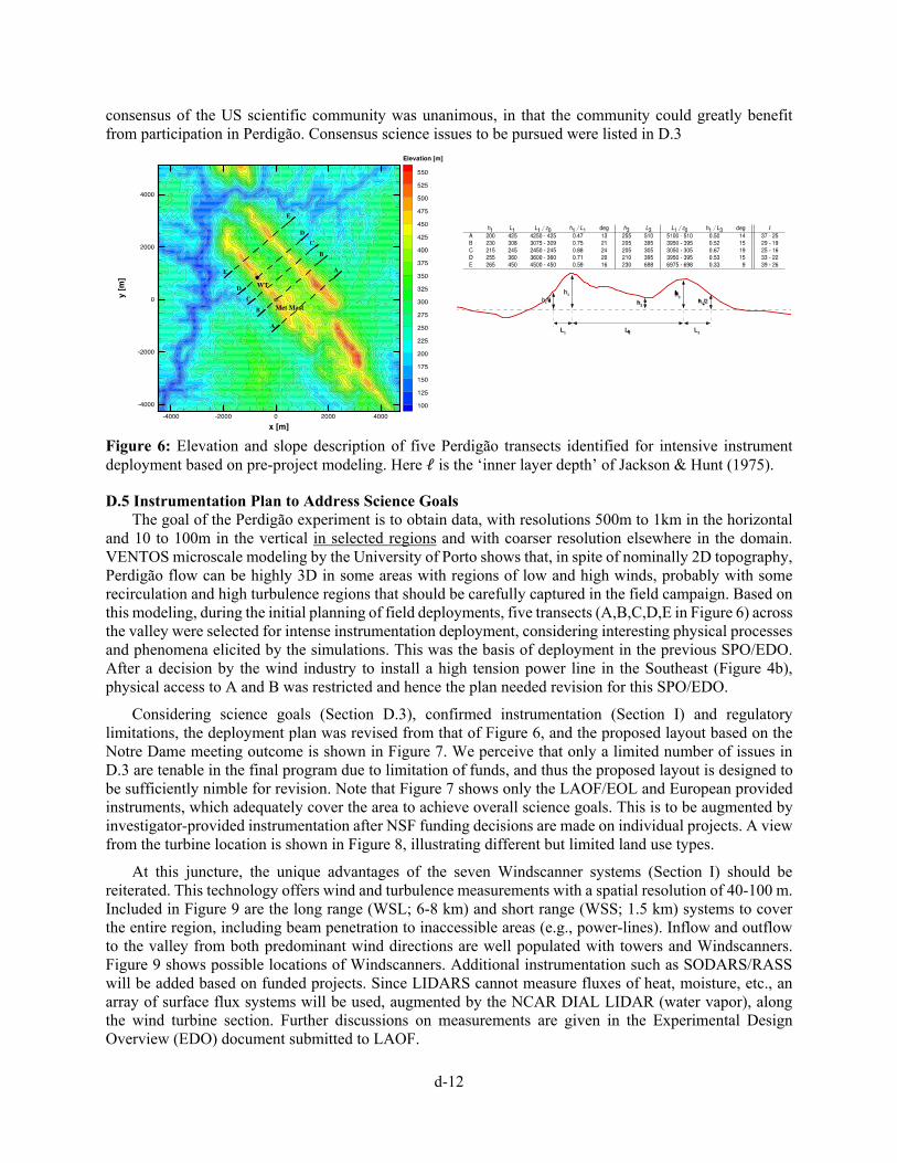


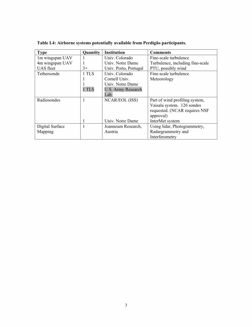


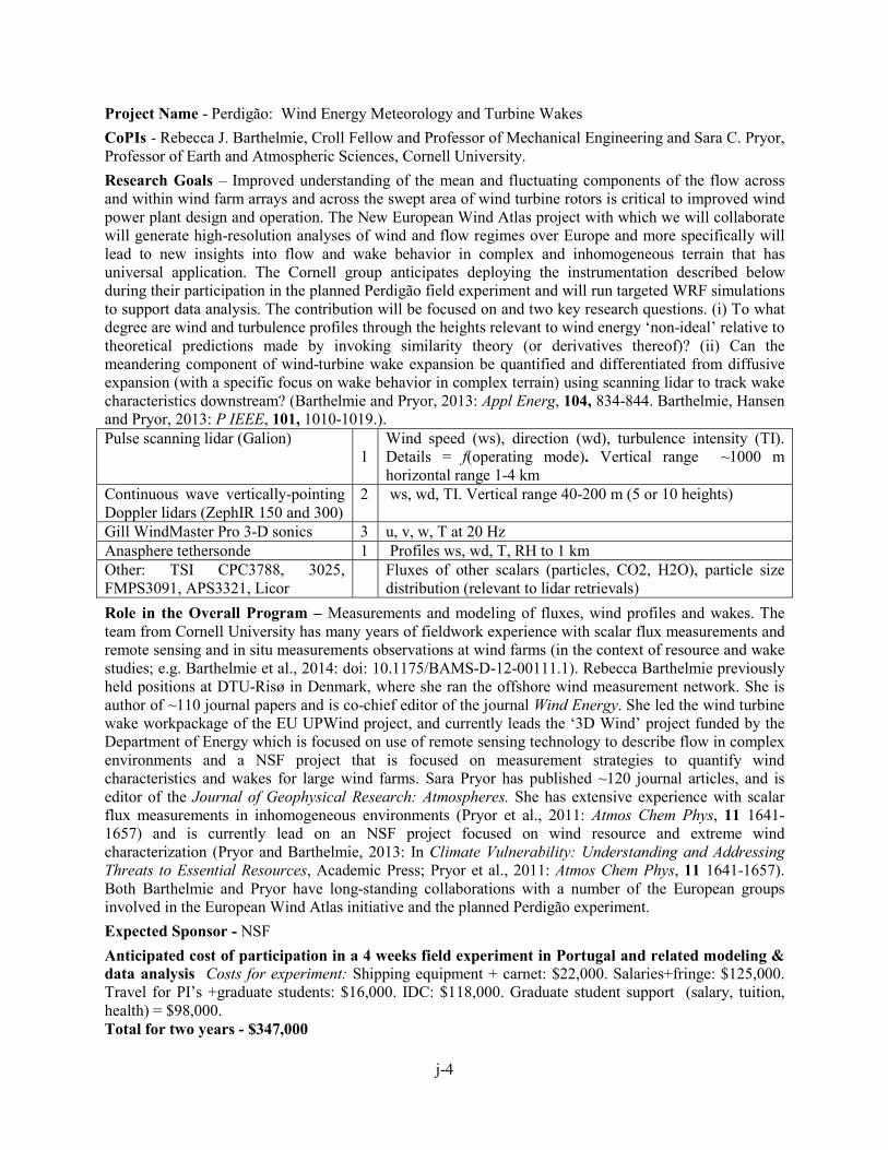


![[MS-SPO]: SharePoint Protocols Overview](https://static.documents.pub/doc/80x56/61d5863cc24e1516954fdcf9/ms-spo-sharepoint-protocols-overview.jpg)
![interoperability.blob.core.windows.netMS-SPO... · Web view[MS-SPO]: SharePoint Protocols Overview. Intellectual Property Rights Notice for Open Specifications Documentation. Technical](https://static.documents.pub/doc/80x56/5d58775788c9931f1d8b4b26/ms-spo-web-viewms-spo-sharepoint-protocols-overview-intellectual-property.jpg)


![Introduction - interoperability.blob.core.windows.net... · Web view[MS-SPO]: SharePoint Protocols Overview. This overview describes the SharePoint Protocols. This overview is intended](https://static.documents.pub/doc/80x56/5d016fd188c99394038ca8ed/introduction-web-viewms-spo-sharepoint-protocols-overview-this-overview.jpg)


