Prototype EnviroSecurity Assessments Great Lakes Region of Africa Part 1: Case Study The Hague Brussels Washington DC Promoting Environmental Security and Poverty Alleviation in Virunga-Bwindi, Great Lakes Africa Version 1 • October 2005 Jeanna Hyde Hecker
Transcript
Prototype EnviroSecurity Assessments
Great Lakes Region of AfricaPart 1: Case Study
The HagueBrussels
Washington DC
Promoting Environmental Securityand Poverty Alleviation inVirunga-Bwindi, Great Lakes Africa
Version 1 • October 2005
Jeanna Hyde Hecker
Institute for Environmental Security | Great Lakes Region of Africa: Case Study
2
Promoting Environmental Security and Poverty Alleviation in Virunga-Bwindi,Great Lakes AfricaJeanna Hyde Hecker, EnviroSense
Except where indicated otherwise, reproduction of material from this publication is authorised for educationaland other non-commercial purposes without prior permission from the copyright holder provided the sourceis fully acknowledged. Reproduction for sale or other commercial purposes is not authorised without writtenpermission.
Printed in Belgium on environmentally friendly and recycled paper
Project TeamProject Manager: Wouter J. Veening, IES • Senior Consultant: Leendert Jonker, IES • Administrator /Editor: Ronald A. Kingham, IES • Researcher: Jeanna Hyde Hecker, EnviroSense • Legal Advisor: SergeBronkhorst, BILS • Scientific Advisor: Niels Wielaard, SarVision • Cartographer: Philippe Rekacewicz,UNEP GRID-Arendal • Research Assistants: Sjoerd de Gijzel, Eric van de Giessen, Frederik J.W. vanOudenhoven
Project Partners
This project is coordinated by the Institute for Environmental Security with the following partners:Borneo Orangutan Survival Foundation (BOS), IndonesiaBronkhorst International Law Services (BILS), The NetherlandsEnviroSense, The NetherlandsFundación Gaia Amazonas, ColombiaInternational Gorilla Conservation Programme, Rwanda, Uganda and the DRCSarVision, The NetherlandsUNEP / GRID-Arendal, Norway
EnviroSense
Additional research and materials provided by:Amsterdam International Law Clinic, The NetherlandsConsolidación Amazónica – Colombia (COAMA)EuroCampus Institute, The NetherlandsInstituto de Investigaciones Biológicas Alexander von Humboldt, Colombia
The project is supported by The Netherlands Ministry of Foreign Affairs
Institute for Environmental Security | Great Lakes Region of Africa: Case Study
3
Promoting Environmental Security
and Poverty Alleviation in
Virunga-Bwindi, Great Lakes Africa
Case Study by
Jeanna Hyde Hecker, EnviroSense
Commissioned by the Institute for Environmental Security
Institute for Environmental Security | Great Lakes Region of Africa: Case Study
4
Table of Contents1 Introduction .......................................................................................................................52 Background .......................................................................................................................6
2.1 Location .....................................................................................................................62.2 Volcanics and fertile soils ...........................................................................................62.3 Lakes..........................................................................................................................62.4 Water tower................................................................................................................72.5 Climate.......................................................................................................................82.6 Flora...........................................................................................................................82.7 Fauna .........................................................................................................................82.8 Region rich in Biodiversity and Endemism .................................................................82.9 Densest African population.........................................................................................9
3 Study Areas Description and Importance............................................................................93.1 DRC: Virunga National Park ....................................................................................10
3.1.1 Description..........................................................................................................103.2 Rwanda: Volcanoes National Park............................................................................10
3.3 Uganda: Mgahinga Gorilla National Park and Bwindi Impenetrable National Park....123.3.1 Socioeconomic....................................................................................................123.3.2 Description: Mgahinga Gorilla National Park ......................................................123.3.3 Description: Bwindi Impenetrable National Park .................................................133.3.4 Hydrology...........................................................................................................13
4 Analysis of situation ........................................................................................................134.1 Overview of Problems ..............................................................................................13
4.1.1 Sustainable use of resources not a tradition..........................................................134.1.2 Political and ethnic differences within the population ..........................................144.1.3 IDP and Refugees................................................................................................164.1.4 Post Traumatic Stress Disorder............................................................................164.1.5 Environmental Destruction..................................................................................174.1.6 High population growth rate and high population density.....................................194.1.7 People farming & exploiting parks for survival....................................................194.1.8 Poverty ...............................................................................................................204.1.9 Political Status on environmental conservation ....................................................204.1.10 Foreign Aid..................................................................................................20
4.2 Problem Linkages.....................................................................................................214.3 Stakeholders .............................................................................................................23
4.4 Conflicts...................................................................................................................265 Attention Areas for Mitigation .........................................................................................266 Recommendations ...........................................................................................................287 Conclusion ......................................................................................................................348 References .......................................................................................................................349 Acronyms ........................................................................................................................3610 Acknowledgements..........................................................................................................37
1 Introduction
Environmental security is the availability of environmental services for man and nature.The availability is reduced when there is environmental destruction. Environmentaldestruction leads to scarcity and scarcity triggers conflict which can develop intoviolence. Thus, environmental security is vital to human security and well being.Conflict or violence can also be caused by the availability of abundant rather than scarceenvironmental goods or natural resources. The situation could also be reversed in that,for reasons other than scarcity or abundance of environmental services and goods there isconflict or violence. This conflict or violence can then lead to environmental destruction- as wars often do - and as a result there is scarcity which results in conflict and the cyclecontinues.
The study area lies in the Albertine Rift in the countries of the Democratic Republic ofCongo (DRC), Rwanda and Uganda. The focus is on the four protected areas, VirungaNational Park (ViNP); Volcanoes National Park (VNP); and, Mgahinga Gorilla NationalPark (MGNP) and Bwindi Impenetrable Forest National Park (BINP), respectively, aswell as the surrounding areas. Together this area including the four parks is oftenreferred to as the Virunga-Bwindi region. This study area was selected because it is anecologically unique and globally important ecosystem. It has high levels of floral andfaunal endemism, biodiversity and species richness. It is mountainous and acts as one ofthe headwater catchment systems for the overlapping Great Lakes region. It is comprisedof afromontane vegetation which is habitat to the last populations of mountain gorilla onearth. These gorillas, a flagship species, attract tourism and conservation revenues intothe area. Three of the parks also present the opportunity for peace building among thethree nations as the parks lie adjacent to each other along the three countries’international boundaries. Together they are overlapped by one ecoregion and can bemanaged effectively only if they are treated as one seamless unit. The multipleimportance of the region have led conservation organizations to rate the montane forestsof the Albertine rift as highest priority for conservation in Africa (Hamilton, 1996, citedin Lanjouw et al., 2004).
While the area may seem greatly endowed with wonders and opportunities there are justas well manifold difficulties. The region has one of the densest populations and ispredominantly subsistence agriculture. People are poor and traditionally, they do notpractice sustainable use of the natural resources. In certain areas people have beenknown to resent the protected areas. In addition, the region has a past of civil unrest andpolitical instability. The genocide of 1994, for instance, has resulted in a new Rwandathat aims at zero tolerance for corruption and an unrelenting determination to make itselfthe example of Central Africa. The effects of violence, however, still remain. Internallydisplaced people (IDP’s) and refugees who were settled in the protected areas causedwidespread destruction still seen today in, for instance, the former Gishwati ForestReserve now dereserved as it has lost about one half its forests. Also, losing so manylives meant losing many professionals and other members necessary to fulfil the roles ofthe society.
Institute for Environmental Security | Great Lakes Region of Africa: Case Study
6
This study area demonstrates the situation of having conflict and violence - motivated notonly by the abundance of environmental goods but also by other factors later discussed.Environmental destruction resulting from conflict is propagated by high populationgrowth rates and the choice of land use leading to scarcity of environmental services andgoods. This in turn, can lead to more conflict and violence if not addressed.
The study attempts to describe the problems in the area and identify causal relationshipsamong them in order to generate a comprehensive understanding of the situation. Beforerecommendations are made stakeholders are identified and an analysis of areas formitigation is carried out.
2 Background
To understand the importance of the Virunga-Bwindi region, the biophysical and socialaspects of the greater environment, the Albertine Rift, is described.
2.1 Location
The Albertine Rift, a part of the Great Rift Valley, extends along the five countries of theDemocratic Republic of Congo (DRC), Uganda, Rwanda, Burundi and Tanzania.
2.2 Volcanics and fertile soils
According to Blom and Bowie (2001), the Albertine Rift was formed from uplifted Pre-Cambrian basement rocks and recent volcanic activity. The rift is made up of mountainchains originating on the Lendu Plateau in northern Uganda and DRC (Bober et al., 2001,cited in Blom & Bowie, 2001); the Ruwenzori Mountains of southern Uganda and easternDRC; and, some isolated massifs on the shores of Lake Tanganyika. The highest peak inthe region, 5110m, is in the Ruwenzori Mountains. Associated volcanic activities whichresulted in the overflow of volcanic materials give rise to the characteristically rich fertilesoils.
2.3 Lakes
The lakes in the rift were formed from continental movement which created cracks in theearth’s crust (Blom & Bowie, 2001; UNEP, 2004). The rift lakes are Lake Albert, LakeEdward, Lake Kivu, and Lake Tanganyika. There are other lakes in the East African RiftValley, namely Lake Turkana, Lake Victoria and Lake Malawi. Lakes Tanganyika, LakeVictoria and Lake Malawi are known as the Great Lakes of Africa (UNEP, 2004). Theyplay a vital role in the maintenance of life and biodiversity in the region. Lake Edward,for instance, is one of the world’s most productive and along with the other lakes theirfisheries provide one of the main sources of revenue for the surrounding communities(Plumptre, 2003). Fundamentally, lakes also contribute water to the atmosphere throughevaporation. This water eventually is precipitated from the atmosphere not only over the
Institute for Environmental Security | Great Lakes Region of Africa: Case Study
7
lakes, but also in other areas that may not have nearby water sources thus, continuing thehydrological cycle.
2.4 Water tower
Mountains are known as headwater catchment systems, that is, rivers originate fromthem. In humid areas up to 60% while in semi-arid and arid areas up to 95% of the freshwater in watersheds are captured by mountains (Mountains of the World: Water Towersfor the 21st Century, 1998). This occurs in spite of the proportionally smaller areacovered by the mountains compared to the rest of the lowland watershed area. This ispossible, however, as rainfall increases with altitude, (from 5 mm/100 m to 750 mm/100m elevation, depending on the climatic zone and maximum amount obtained between1500 and 4000 m altitude) (Mountains of the World: Water Towers for the 21st Century,1998).
The same characteristics which enable mountains to provide invaluable services tohuman and nature make them vulnerable or give rise to vulnerable characteristics. Highaltitudes, large amounts of rainfall and often steep slopes are the conditions whichpromote soil erosion. One natural measure that reduces soil erosion rates in thesevulnerable areas, however, is vegetation cover. The afromontane forests not onlydampen the impact of rainfall onto the soil but their root systems hold the soil togetherand in place, preventing soil erosion and land slides. The afromontane vegetation coveralso reduces evaporation rates by providing shade to the bare earth. As these forests arefound in the higher altitudes there is a low transpiration rate. This combination of higheraltitudes, more rainfall amounts and lower transpiration rates in the mountains produce asurplus of fresh water which can be used in the lowland areas where a negative waterbalance is generated (Mountains of the World: Water Towers for the 21st Century, 1998).
Mountain catchments are also important in the role they play as upstream locations.Whatever occurs upstream will have an effect downstream. Kagera river basin whichcovers all of Rwanda provides 7% of the influent water to Lake Victoria, the secondlargest lake in the world. Lake Victoria in turn provides water to the wider Nile basin(UNEP, 2004), which covers about 3 million km2 in ten African countries (Kameri-Mbote, 2004), which drains into the Mediterranean. According to UNEP (2004), it isbelieved that in the late 1980’s (UNEP, 2004), water hyacinths invaded Lake Victoria viathe Kagera River (Twongo, 1996 cited in UNEP, 2004), spreading to about 3 ha per day.As a result the invasion and proliferation of water hyacinth in the Lake had led to reducedoxygen levels and, consequently, to reduced floral and faunal diversity. The presence ofthe water hyacinths have also disrupted fishing activities, transportation and threatenedthe operations of lake shore installations such as hydroelectric power plants (Twongo1996, Kudhongania et al. 1996, cited in UNEP, 2004).
Institute for Environmental Security | Great Lakes Region of Africa: Case Study
8
2.5 Climate
Although the rift lies in the tropics of Africa, the climate can be varying anduncharacteristically tropical due to the region’s geology. The higher mountainousregions experience temperate climates and average rainfall between 1,200 to 2,200 mmper year (Blom & Bowie, 2001).
2.6 Flora
The ecoregion is dominated by montane rainforest (White, 1983, cited in Blom & Bowie,2001), with marginal fringes of the Guineo-Congolian rainforest on the lower slopes(down from 500-800m) in the west and forest/savannah habitats in the east running alongUganda, Rwanda and Burundi (Blom & Bowie, 2001).
2.7 Fauna
The area contains 52% of all bird species and 39% of all mammal species on the Africancontinent (Plumptre, 2003). The last population of mountain gorillas (Gorilla beringeiberingei) , formerly named Gorilla gorilla beringei (Lanjouw et al., 2004), is also foundhere. With approximately 700 individuals remaining they are classified as an endangeredspecies. Mountain gorillas have managed to attract global attention and this has directand indirect benefits for their protection. Income from donors and tourism has been usedfor their habitat protection as well as community projects to reduce communityoverexploitation of the habitat.
2.8 Region rich in Biodiversity and Endemism
The Albertine Rift Mountains ecoregion is considered the most vertebrate species richregion in Africa (Plumptre, 2003) with “exceptional faunal and moderate floralendemism” (Blom & Bowie, 2001). These invaluable ecological characteristics can beattributed mainly to two reasons. Firstly, it is believed that the Albertine Rift mountains,acted as a glacial refugium for flora and fauna during the Pleistocene Period (Kalpers,2001; Lanjouw et al., 2004). Secondly, the altitudinal variations give rise to variousnatural habitats (Blom & Bowie, 2001) and hence also to numerous transition zones.
Species richness Endemic species Threatened speciesMammalsBirdsReptilesAmphibiansButterfliesFishPlants
4021,061175118
5,793
34411634117366 +567
3525216
40
Table 1. The total number of species, number of endemic species, and threatened species for the five taxain the Albertine Rift (Plumptre, 2003).
Institute for Environmental Security | Great Lakes Region of Africa: Case Study
9
2.9 Densest African population
(Lanjouw et al., 2004)
The areas surrounding the afromontane and medium altitude forests shared by Rwanda,Uganda and DRC are densely populated, with countrywide per capita rural populationdensities averaging 300 persons per km2 (IGCP, 1997). These population densitiesincrease around protected areas in the region due to the rich natural resources and soil.For example, in Rwanda, population densities around VNP exceed 400 persons per km2,and in some rural areas attain 820 people per km2 (Waller, 1996). Population estimatesfor those living adjacent to protected areas in the regions are: 675,000 around ViNP-south (DRC); 8,700 around MGNP, 93,000 around the BINP (Uganda); and 134,000around the PNV (Rwanda), bringing the total population living around the program areato 910, 700 (IGCP, 1997). With an average regional population growth rate of over threepercent, the total population living around protected areas in the area will grow to wellover one million in less than three years (IGCP, 1996).
3 Study Areas Description and Importance
Due to the conservation value and presence of the world’s last mountain gorillapopulations, two “forest blocks” of the Albertine Rift were selected for this study. Oneforest block, although being one ecological unit, is intersected by internationalboundaries of three countries: DRC, Rwanda and Uganda, consequently, there are threedifferent national parks. These three parks, Virunga National Park, Volcanoes NationalPark and Mgahinga Gorilla National Park, respectively, lie on the Virunga Massif andcollectively are called the Virunga Volcanoes Region (VVR) or the VirungaConservation Area (VCA). The second forest block lies about 30km north of the VCA inUganda, and is the Bwindi Impenetrable Forest National Park.
Political status on environmental conservation
(Lanjouw et al., 2004)In the three countries, political support for sustainable environmental management, aswell as conservation of the afromontane habitat, has strengthened over the years. Theconsciousness that resources are limited, and that human livelihoods are interlinked withenvironment has increased. This has been due, in part, to examples of unsustainable useand the impact it has had on soil, water and farmer’s ability to grow food crops. Inaddition, the realisation that natural resources can be of economic value (e.g. in tourism)has also strengthened the national governments’ support for conservation. Thisconsciousness has greatly facilitated the work of the protected area authorities, andconservation organisations struggling to protect important natural areas and wildlife.
Institute for Environmental Security | Great Lakes Region of Africa: Case Study
10
Virungas
The VCA in total is approximately 450 km2, with altitudinal variations of around 2300 mto the 4511 m tall Karisimbi Volcano (Kalpers, 2001). The climate is cool, humid withhigh levels of annual rainfall (Lanjouw et al., 2004).
3.1 DRC: Virunga National Park
3.1.1 Description
Virunga National Park in DRC, was established in 1925, designated as a World HeritageSite in 1979 and as a World Heritage Site in Danger in 1994. It encompasses aremarkable variety of ecosystems: high altitude forests and mountainous habitats, low-altitude forests, lava fields, plains and savannas, lakes and wetlands. These ecosystemsharbour exceptional biological diversity. The park was initially created to protect themountain gorilla but today it also shelters a small population of eastern lowland gorillas(Gorilla beringei graueri) and many endemic species of plants and animals.
ViNP covers 8,000 km2, and its administrative subdivision includes sectors in the south -Mikeno and Nyamulagira, Rumangabo station; centre - Rwindi station; east - Lulimbistation; and, north - Mutsora station (Kalpers, 1996).
The Mikeno sector is the portion of ViNP that forms the Congolese component of theVirunga Massif and the dormant volcanoes; and, is thus contiguous to VNP (Rwanda)and MGNP (Uganda). Mikeno is the largest component of the Virunga Volcanoes, bothin terms of biodiversity and of surface area (approximately 250 km2, or more than halfthe total area of the Virunga Massif). It contains also the largest area of afromontaneforest. It is the only component to have conserved its lower reaches, which play animportant role in the seasonal movements of a number of animal species: buffalos,elephants and, especially, gorillas (Kalpers, 2001).
Until the recent crisis in the region, the Mikeno sector of the park was the primary sourceof income for the protected area authorities, generating funds through tourism for theprotection of all the parks in the country. Most of the funds came from tourists visitingthe five groups of habituated gorillas in their natural habitat (Lanjouw et al., 2004).
3.2 Rwanda: Volcanoes National Park
3.2.1 Description
(Kalpers, 2001)Volcanoes National Park (VNP) covers approximately 160 km2 and represents theRwandan component of the Virunga Volcanoes (Butynski, Kalina, 1998).
Institute for Environmental Security | Great Lakes Region of Africa: Case Study
11
In relation to the initial size of the forest, between 1958 and 1979 VNP lostapproximately 55 percent of its natural habitat, mainly as a result of the demand for landfor growing pyrethrum (Harroy, 1981 in Bouché, 1998)(Bouché, 1998). When tourismproved to be a boost to the local economy and a source of hard currency (WWF, IUCN,1985), the steady shrinking of VNP’s surface area stopped. But this new influx of cashcame too late to prevent the loss of an important portion of the Rwandan Virungas. Bythe time Rwanda discovered ecotourism, the lowest vegetative zone (below 2,500 meters),the Neoboutonia zone that is so important to such animals as gorillas, had alreadydisappeared almost entirely. VNP is located in the most densely populated region ofRwanda and, like these regions, is confronted with the most extreme demographicpressure in all of Africa.
3.2.2 Hydrology
The park has a certain number of permanent lakes, for instance, Bisoke, Ngezi, Mararobut no permanent river, although torrents run all the year except at the height of the dryseason (Office Rwandais Du Tourisme et des Parcs Nationaux, 2004). Marshes occupycertain saddles between the volcanoes. The vegetation cover and porous basementvolcanic material play a very important role in the regulation of water. Water run-offoccurs mainly underground and small springs are found in the immediate vicinity andespecially at the edge of lava fields located up to 15 km within the park boundaries(Office Rwandais Du Tourisme et des Parcs Nationaux, 2004). It has been estimated thatalthough VNP is only approximately 0.5% the land surface area of Rwanda, it contributesabout 10% of the entire water catchment function for Rwanda (Weber, 1979 cited inPlumptre & Williamson, 2001).
3.2.3 Population
According to the General Census of the Population and Habitat (RPGH) August 30, 2002census, Ruhengeri and Gisenyi are the most inhabited provinces in the country ofRwanda with respectively 885 309 and 853 985 inhabitants (Office Rwandais DuTourisme et des Parcs Nationaux, 2004).
District/Ville Population (RGPH, 1991) Population (RGPH, 2002)BuhomaBukambaKinigiMutoboVille de RuhengeriMutura
80 16988 17755 24481 62153 467-
89 210118 46662 79895 92271 511112 934
Total 550 841Table 2. Population changes in the districts surrounding the PNV (Office Rwandais Du Tourisme et desParcs Nationaux, 2004).
Institute for Environmental Security | Great Lakes Region of Africa: Case Study
Total/Average 550 841 955.8 772.3 643.1 758.8Table 3. Population densities according to the total surface and the inhabitable surface land area (OfficeRwandais Du Tourisme et des Parcs Nationaux, 2004).
According to a socioeconomic study undertaken jointly by CARE International, PICGand WCS (2003) the majority of the populations located around the mountain forests ofUganda, Rwanda and DRC are very young (less than 20) and the percentage of women ishigher than that of the men (Office Rwandais Du Tourisme et des Parcs Nationaux,2004).
3.3 Uganda: Mgahinga Gorilla National Park and Bwindi Impenetrable NationalPark
3.3.1 Socioeconomic
In relative terms, it appears that people living around Bwindi, Echuya and Mgahinga arewealthier than those surveyed in Rwanda and DRC. They own more goods such asradios, bicycles and motorbikes, they own more land and livestock, they can afford tinroofs and they can afford to send more children to secondary school. This differencemay be, in part, a result of the political conflicts that have occurred over the past 10years in Rwanda and more recently in eastern DRC. Uganda’s conflicts finished in themid 1980s and the country has been relatively stable in this region since then (Plumptre,2004).
3.3.2 Description: Mgahinga Gorilla National Park
Mgahinga Gorilla National Park (MGNP), in Uganda, is the smallest component of theVirunga Volcanoes (34 km2) and the part that suffered the most before 1991. Intensehuman activity in such a small area has turned MGNP into the least biodiversecomponent of the Virunga Volcanoes. It entirely lacks a Neoboutonia zone (Werikhe,1991). Since 1951, MGNP has undergone several modifications in status and size,culminating, in 1991, in its classification as a national park (Butynski, Kalina, 1993;Uganda National Parks, 1996) (Kalpers, 2001).
Institute for Environmental Security | Great Lakes Region of Africa: Case Study
13
3.3.3 Description: Bwindi Impenetrable National Park
Bwindi Impenetrable Forest National Park (BINP) in Uganda acquired the status ofNational Park also in 1991. BINP, like ViNP in DRC, is also designated as a WorldHeritage Site in Danger (Lanjouw et al., 2004).
The geologic setting of Bwindi Impenetrable National Park (BINP) is completelydifferent from that of the Virunga Volcanoes area. Bwindi is extremely rugged, …and therocks are generally of low permeability and transmit water mainly through large faultstructures. As a consequence infiltration is limited, aquifers are limited, and much of therainfall runs off in streams. Bwindi has a comparatively dense stream network withperennial streams present within and near the boundaries of the park. As such, intrusioninto the park by people gathering water is much less of a problem than in the VirungaVolcanoes region.
BINP is a major water catchment area and the source of many rivers that flow north,west and south. The major rivers drain into Lake Edward… BINP is therefore critical tothe hydrological balance of the region. The area has experienced a long history ofintensive logging, encroachment for agriculture, mining, poaching, fishing and wild fires.Although fishing is banned in BINP rivers, illegal fishing still takes place and the fishfauna remains relatively unknown.
4 Analysis of situation4.1 Overview of Problems
In the literature and from a team visit to Rwanda and the VCA there were a number ofproblems prevalent in the region. Problems were linked to traditions, population size,economy, land use and governance all of which lead to environmental destruction. Belowis a description and context of each of the main problems identified.
4.1.1 Sustainable use of resources not a tradition
The Albertine rift was once covered by afromontane forests but with growing populationpressure much of the region was deforested. The Virungas and Bwindi are few of theforested areas still remaining. These areas, even prior to the armed conflicts of the1990’s, were experiencing other environmental threats such as lack of alternatives forfuelwood (IGCP, 1996, cited in Kalpers, 2001); feeble environmental legislation; weakinstitutional mechanisms; inappropriate agricultural practices; the degradation of theenvironment inside protected areas, posing a threat to biodiversity; and, inadequateapproaches to environmental education and awareness-raising (Kalpers, 2001). In the
Institute for Environmental Security | Great Lakes Region of Africa: Case Study
14
Virunga massif one of the lower altitude vegetation type, preferred by the mountaingorilla was almost completely cleared in both Uganda and Rwanda (Kalpers, 2001).
According to Kalpers (2001), the DRC side of the VCA - the Virunga National Park(ViNP), was already experiencing problems before the 1991 armed conflicts. Thecountry was having a socioeconomic and political crisis for a number of years. There theparastatal agency, Institut Zaïrois pour la Conservation de la Nature (ICZN) (now InstitutCongolais pour la Conservation de la Nature, ICCN), responsible for park managementand conservation was lacking the technical and logistical resources necessary to enforcepark rules. Without the ICZN presence in the field the populations living adjacent to thepark hunted, cut wood and bamboo, and fished in and around Lake Edward (Kalpers,2001). All these activities while traditional were illegal (as they were exploiting theresources of the national park). Adding to the problems in the area, military groups basedin the area were extorting the local people. In September 1991 heightened socio-politicaltensions drove away most of the biodiversity conservation development projects (Kalpers,2001).
Human pressure on the protected areas of Rwanda were already high even before the war(Kanyamibwa, 1998). The VNP area is located in the most densely populated region ofthe country and according to Kalpers (2001), models developed in 1991 predicted thatover the following 20 years, protected areas would decrease significantly and there wouldbe a loss of biodiversity.
In Uganda, people living near the MGNP had resentment toward the park even as farback as the 1950’s. They felt the land could be used as farm lands instead of a protectedarea. Similar to the other two protected areas, there was great human pressure on theMGNP. People living adjacent to the park exploited it for wood and bamboo, agriculturalland, poaching of animals, apiculture and medicinal plants (Kalpers, 2001). In addition tothe high population density adjacent to the park, park management was ineffective.Before 1991 the park was both a game reserve and forest reserve with two separateadministrative bodies. Between 1951 and 1991 local people encroached on and farmedabout 9 km2 of park land giving it back to the government only when the park’s statuswas changed to national park and negotiations began. Initiatives have been carried out inattempt to improve the local attitude toward the park. Income from tourism has been themost effective (Kalpers, 2001).
4.1.2 Political and ethnic differences within the population
DRC
Sparsely populated in relation to its area, DRC is home to a vast potential of naturalresources and mineral wealth. Nevertheless, DRC is one of the poorest countries in theworld, with per capita annual income of about $98 in 2003. This is the result of years ofmismanagement, corruption, and war (Bureau of African Affairs, 2005a).
Many commentators have remarked that conflict in DRC has been partly driven by thetrade in natural resources. The UN Expert Panel reports on the illegal exploitation of
Institute for Environmental Security | Great Lakes Region of Africa: Case Study
15
natural resources in DRC in April and November , and in May and October , all came tothe clear conclusion that greed over DRC’s natural resources has played a significantrole in prolonging the conflict (Global Witness, 2004). The first Panel report stated:
“The conflict in the Democratic Republic of the Congo has become mainly aboutaccess, control and trade of five key mineral resources: coltan, diamonds, copper,cobalt and gold. The wealth of the country is appealing and hard to resist in thecontext of lawlessness and the weakness of the central authority (UN SecurityCouncil, Report of the Panel of Experts, 2001, cited in Global Witness, 2004).
“While this is true, it is important to place the plunder of the DRC’s naturalresources in historical, economic, political and social context. Particularly innortheast DRC, the economics of conflict are intertwined with tribal and ethnichatred, disputes over access to land, profound social disintegration, highunemployment and poverty, as well as the involvement of different foreign rebelgroups and armies from Burundi, Rwanda and Uganda. As such, it is moreaccurate to describe the violence in eastern DRC as being motivated by a mixtureof security and economic anxiety (Vlassenroot, K. and H. Romkema, 2002, citedin Global Witness, 2004).
Rwanda
Ethnic and political differences within the population can be viewed as one factorcontributing to the problems in Rwanda. According to Kanyamibwa (1998), ethnicdivisions occurred before and during the colonial period with serious fighting startingafter the 1959 revolution. It was in October 1990, however, when the first large scalefighting occurred (Kanyamibwa, 1998). From April to July 1994, was the Rwandan 100days genocide, which is considered one of the largest human tragedies of the 20th century(Kanyamibwa, 1998).
As a result of the ethnic and political clashes over the years Rwanda and neighbouringcountries have suffered in many ways some perhaps more measurable than others. Whilebattles before the 1990’s are believed to have less impact on the environment due to thelow impact weaponry used it is believed that more environmental destruction were doneafter that time with bombs and machine guns and other weapons used in the 1990’s(Kanyamibwa, 1998). Regarding the genocide, however, more of the environmentaldestruction occurred after the war than during (Kalpers, 2001). Many were killedwhether professionals of conservation fields, teachers, parents or children thatparticipated in the civil structure of daily life. Many have been internally displaced orbecame refugees in neighbouring countries relying on the natural resources of protectedarea ecosystems for their survival. As a result there was environmental destruction –deforestation, soil erosion, wildlife exploitation and water pollution, at a large scale.
Institute for Environmental Security | Great Lakes Region of Africa: Case Study
16
Rebel Activities
Still today there are rebel groups in DRC that rely on the resources of the ViNP and use itas a cover to cross the border illegally into Rwanda. The presence, movements or attacksby rebel groups contribute to the environmental destruction and make it unsafe for parkguards to protect the park (Lanjouw et al., 2004). In addition, rebel activities or threatsmake the parks less attractive for tourism.
Uganda
Uganda's economy has great potential. Endowed with significant natural resources,including ample fertile land, regular rainfall, and mineral deposits, it appeared poisedfor rapid economic growth and development at independence. However, chronic politicalinstability and erratic economic management produced a record of persistent economicdecline that left Uganda among the world's poorest and least-developed countries(Bureau of African Affairs, 2005b).
Since assuming power, the government dominated by the political grouping created byMuseveni and his followers, the National Resistance Movement (NRM or the"Movement"), has largely put an end to the human rights abuses of earlier governments,initiated substantial economic liberalization and general press freedom, and institutedeconomic reforms in accord with the International Monetary Fund (IMF), World Bank,and donor governments (Bureau of African Affairs, 2005b).
4.1.3 IDP and Refugees
After the genocide approximately 2 million people fled Rwanda to neighbouringcountries, in what was considered historically the largest movement of people over a fewdays time (Kalpers, 2001). By the end of 1994 there were about 720,000 refugees fromRwanda in about 5 refugee sites near the VNP. All the refugees fled to this region ofDRC with hope to find water, food and firewood in the park’s forest (Kalpers, 2001).The refugees demand on the park was so much that in December 1994 WHC classifiedthe park as world heritage site in danger (UNESCO, 1995 cited in Kalpers, 2001).
In Uganda, the vicious and cult-like Lord's Resistance Army (LRA) continues to murderand kidnap civilians, however, in the north and east. Although the LRA does not threatenthe stability of the government, LRA violence has displaced 1.4 million people andcreated a humanitarian crisis (Bureau of African Affairs, 2005b).
4.1.4 Post Traumatic Stress Disorder
People who are victims of or have loved ones who are victims or even perpetrators oftraumatic events such as violence that accompany civil wars or genocides can experiencePost Traumatic Stress Disorder (PTSD). Problems associated with PTSD are, for
Institute for Environmental Security | Great Lakes Region of Africa: Case Study
17
instance, biological – fatigue, exhaustion, startled response; emotional – anxiety, grief,depression, numbing, fear; cognitive – flashbacks; behavioural – substance abuse,aggression toward others; social and their psychological consequences – poverty, no jobsor way to support oneself; and, spiritual – loss of meaning and hope (http://www.heal-reconcile-rwanda.org/lec_trau.htm).
The sense of vulnerability and the perception of the world and other people as dangerousincrease the likelihood that, without corrective experiences, former victims will becomeperpetrators. They are likely to be especially sensitive to new threat. When conflict withanother group arises, it may be more difficult for them to take the perspective of the otherand consider the other’s needs. In response to new threat or conflict, they may strike out,believing that they need to defend themselves, even when violent self–defense is notnecessary, in the process becoming perpetrators (Staub, 1998; Staub&Pearlman, 2001).This self–protective violence seems especially likely when former victims live with andare surrounded by the group at whose hands they suffered such extreme violence andwhen there is not yet the sense that justice has been done (Staub, Pearlman, Gubin, &Hagengimana, 2005).
There is work being done to facilitate recovery from PTSD for instance by the NationalUnity and Reconciliation Commission. The commission first approached differentgroups of people to find out what they needed to achieve reconciliation (Staub et al.,2005).
4.1.5 Environmental Destruction
Deforest
Aid agencies tried to provide for the refugees in DRC but the basic essentials they did notsupply, the refugees obtained from the ViNP. Refugees turned to the park for firewood,for construction material and for commercial needs. It has been recorded (Languy, 1995,cited in Kalpers, 2001), that on some days up to 80,000 people would enter the park andmanage to cut about 1,000 tons of wood daily (Kalpers, 2001).
Refugee camp sites with security or park protection programs suffered less impact thanthose without. In the Katale and Kahindo areas, deforestation levels were low and it hasbeen attributed to park protection programs which aid agencies had implemented whenthe camp site was established (Kalpers, 2001). In the Mugunga and Lac Vert areas therewas major deforestation. One main reason for the large extents of deforestation is thatpeople here started selling wood and charcoal to Goma (Languy, 1995 cited in Kalpers,2001). With no security forces here to stop this, the business grew and deforestationincreased for the second year of refugee residence (Kalpers, 2001).
Recently, in May to June 2004 it was reported that approximately 15 km2 of bamboo andother vegetation types that make up the habitat of the mountain gorilla as well as endemicwildlife species, were cleared. This deforestation occurred in the Mikeno Sector of theViNP. According to Muir (2004) the Rwanda authorities declared that the land was
Institute for Environmental Security | Great Lakes Region of Africa: Case Study
18
cleared for security reasons – to prevent the rebels from hiding in the forest. While thelocal chiefs in the community claimed that finally the land would benefit the people. Thecleared land has been used for farmland as well as for hunting by an estimated 6,000,mainly Rwandan, people (Muir, 2004).
Soil erosion
Soil erosion is already at a critical level in south-western Uganda, north-westernRwanda and eastern DR Congo. The intensity of land-use in this fertile part of the regionled to all forests outside of the national parks and forest reserves to be cleared foragriculture, and people are cultivating their crops on hills of more than 10% slope(Waller, 1996). Soil erosion is an enormous problem in these mountainous regions and inRwanda; an estimated 11 tons of soil are lost per hectare per year through erosion(Waller, 1996) . When, for example, an Internally Displaced Persons camp wasestablished in the Gishwati Forest Reserve in Rwanda after the war in 1994, thedeforestation that resulted for the cultivation of crops caused entire slopes to be washedaway (ORTPN, pers. comm.). The Gishwati Forest Reserve is no longer consideredviable for agriculture, due to erosion (Lanjouw et al., 2004).
Wildlife exploitation
Poaching intensified in the southern sections of ViNP during the 2 years the refugeessettled there (Biswas, Tortajada-Quiroz, 1996, cited in Kalpers, 2001). There weremainly two groups of poachers, locals and refugees; and, ex-soldiers staying in therefugee camps. Ex-soldiers usually did not give the catch to the refugee camps ratherthey sold it to the local Congolese communities that could afford it. Congolese soldiersbecame very much involved in the poaching scene by establishing a system of supply andmarketing of poached animals. Armed groups passing through areas also poached.During this period four gorillas were killed and while it is not believed that the poachingevent is directly related to the refugees’ presence, it is viewed as a result of the chaos andinsecurity prevalent at the time (GTZ, 2000 cited in Kalpers, 2001).
In addition, to poaching there was also the risk of disease transmission from humans ordomesticated animals to wild animals. As gorillas are closely related to humans they aresusceptible to many human diseases such as tuberculosis, influenza, hepatitis, scabies,and polio (Homsy, 1999, cited in Kalpers, 2001). Domestic animals such as cows, goats,and sheep can also transmit diseases such as foot and mouth disease and bovinetuberculosis to wild ungulates. These wild animals were put at risk when the refugeesand cattle fled via the Virunga Volcanoes, staying there for a few weeks, enroute to DRC(Kalpers, 2001).
Water resource
When the Rugezi swamp is dried out by agricultural activities it does not supply enoughwater to the Bulera and Ruhondo lakes where the hydropower plants are installed ("Dr.Rose Mukankomeje, Personal Communication,18 July, 2005,"; "Gaspard Ndagijimana,Personal Communication,13 July, 2005,"). Once there is a reduction in the water supply
Institute for Environmental Security | Great Lakes Region of Africa: Case Study
19
this affects the ability of the hydropower plants to provide electricity to the region. InRwanda, 94% (1997 estimate) electricity comes from hydropower (Small-Scale HydroTask Force). Kigali, for instance, experiences sporadic blackouts and some that lastthroughout the day. According to Dr. Rose Mukankomeje, the Director General of theRwanda Environment Management Authority (Pers. Comm, 18 July, 2005), the quickestsolution they could come up with for the blackouts was to purchase expensive petrolgenerators as backup for electricity generation when the hydropower plants failed. Whilethey were aware that this was a backward step in terms of environmental pollution theyhad no other immediate choices. Such conditions make it difficult for Rwanda to achieveits goal such as to become the IT hub of the region, to attract other business investors forwhom electricity would be a necessity or to benefit from multilateral funds paid forconservation of the environment.
Impact on economy: less tourism
Both the presence of enormous numbers of refugees and the region’s unrest seriouslylowered the volume of tourism during the entire crisis. But tourist visits to observegorillas never really stopped. Modest numbers of tourists came to watch the gorillas atJomba, a ranger outpost near the Ugandan border inside Zaire, later DRC, and anexcellent point of entry for tourists into ViNP (Kalpers, 2001).
4.1.6 High population growth rate and high population density
(Lanjouw et al., 2004)The areas surrounding the afromontane and medium altitude forests shared by Rwanda,Uganda and DRC are densely populated, with countrywide per capita rural populationdensities averaging 300 persons per km2 (IGCP, 1997). These population densitiesincrease around protected areas in the region due to the rich natural resources and soil.For example, in Rwanda, population densities around VNP exceed 400 persons per km2,and in some rural areas attain 820 people per km2 (Waller, 1996). Population estimatesfor those living adjacent to protected areas in the regions are: 675,000 around ViNP-south (DRC); 8,700 around MGNP, 93,000 around the BINP (Uganda); and 134,000around the PNV (Rwanda), bringing the total population living around the program areato 910, 700 (IGCP, 1997). With an average regional population growth rate of over threepercent, the total population living around protected areas in the area will grow to wellover one million in less than three years (IGCP, 1996).
4.1.7 People farming & exploiting parks for survival
(Lanjouw et al., 2004)Over 90 percent of the populations surrounding the region’s protected areas practicesubsistence level agriculture, and many access the protected areas to complement theirfood and livelihood production strategies (IGCP 1996). The national parks do not havebuffer zones between the local communities and the parks’ resource base. Detailed
Institute for Environmental Security | Great Lakes Region of Africa: Case Study
20
information regarding practices, behaviours and attitudes of various local communitieswith regards to protected area resources do not currently exist.
Protected Area Authorities in the region, however, often cite that local communities relyon and regularly exploit the protected areas’ resources for: water, wood for fuel andconstruction, bamboo, animals, plants for food and medicinal purposes, and bee-keeping(Bensted-Smith, Infield et al. 1995).
4.1.8 Poverty
Poverty can be defined in many ways, for instance, in terms of income, success inattaining capabilities, or participation opportunities (Lok-Dessallien). In a joint study byCARE, IGCP, WCS certain indicators were measured for 3,907 households (22,812people) within a distance of 10km from the Virunga- Bwindi protected areas. Theseindicators are age structure, household size and composition, property and assets (fields,house construction material, livestock, material possessions), crops and cooking fuel(constraints for farming), education, employment, health facilities (Plumptre, 2004).
In relative terms, it appears that people living around Bwindi, Echuya and Mgahinga arewealthier than those surveyed in Rwanda and DRC. They own more goods such asradios, bicycles and motorbikes, they own more land and livestock, they can afford tinroofs and they can afford to send more children to secondary school. This difference maybe, in part, a result of the political conflicts that have occurred over the past 10 years inRwanda and more recently in eastern DRC. Uganda’s conflicts finished in the mid 1980sand the country has been relatively stable in this region since then (Plumptre, 2004).
4.1.9 Political Status on environmental conservation
All three countries have a growing understanding and appreciation for the importance ofenvironmental conservation. They realize environmental health is linked to human wellbeing and that environmental services or goods can generate revenues through, forinstance, tourism (Lanjouw et al., 2004). While the three countries have embarked on aprocess of obtaining transboundary management of the VCA at the highest levels, thisstate of having the three parks managed virtually as one has not been completed as yet.Having this transboundary management implemented will ensure greater protection andoptimally coordinated environmentally conscious activities for revenue generation.
4.1.10 Foreign Aid
Donors such as the United Nations High Commissioner for Refugees (UNHCR), UnitedNations International Children’s Education Fund (UNICEF), and World Food Programhave focused efforts, especially in the aftermath of the 1994 war, most commonly onsocial issues such as health care, and education. These are undoubtedly issues that needattention but these organizations have no mandate to focus on environmental issues or to
Institute for Environmental Security | Great Lakes Region of Africa: Case Study
21
address long term concerns (Kalpers and Lanjouw 1999 cited in Lanjouw et al., 2004).While many of these humanitarian organizations have supported environmental concernsdue to the recognizable link between environment and human welfare, their support havenot been long term (Lanjouw et al., 2004).
4.2 Problem Linkages
The problems in the region are manifold and complex. The problem linkage describedhere and demonstrated in Figure 1., is a simplified version of the situation and it aims atgiving a clear understanding through cause and effect relationships. There might be otherfactors not included here that may lead to some of the problems listed or depending onthe reader’s interest a different core problem could be identified which could also lead toa rearrangement of the problems. The linkages are based on a literature review of relateddocuments and input from the local counterparts. They are used in further analysis ofwhat the region needs.
As the IES’ objective is to promote environmental security it recognizes the core problemin the study area as environmental destruction. That includes, for instance, cutting oftrees to be used as firewood or as building material, clearing forests for agriculturalactivities and hunting wildlife in the national parks.
Primary causes of environmental destruction in the region are traditions and a tendencytoward tribalism as opposed to nationalism. While traditions are primary causes they canalso lead directly to environmental destruction. One of the traditions referred to in thiscase is the unsustainable use of natural resources. Other traditions are, for instance,family size and the vocation of the majority of people – subsistence farming. So manypeople are farmers because that is what they know to do. Until they are provided with theopportunity to do something other than farming or to learn untraditional but better waysof farming in the existing conditions, there will continue to be demands for more land andconsequently, more environmental degradation.
Together traditions and tribalism determine what type of governance or guidance ispresent in the country. Governance includes different parameters such as knowledge indifferent fields; the duration or period of governing as experience and wisdom is gainedover time; available finance; and, how equally opportunities are distributed country wide.Without technical knowledge, for instance, what else can be planted or how canagricultural practices be improved, or without sufficient funds, it is not possible to payagricultural extension officers to go out and teach farmers effective methods or to supplythe poor with drinking water much less install irrigation systems. As a result, people arefarming the traditional way at a time where there are more people and less fertile soils.Low farm yields keep 90% of the population near the parks in poverty. As poverty isoften linked with high population growth rates, this has been fitted in at this level of theproblem tree. It is presumed that even if it is traditional to have large family sizes ifpeople are not in poverty and can afford such things as education, the family sizes andgrowth rate of the population will decline. On the other hand, if people are able to
Institute for Environmental Security | Great Lakes Region of Africa: Case Study
22
generate sufficient income to afford education and to provide for their families all yearround without major difficulties no matter the family size then perhaps reducing thefamily size is not an issue. There are many countries with as large a population densityas the countries in this case study, the main difference is that the density exists in citieswhere people do other jobs besides farming, and have access to education, health care,and other basic necessities.
The more people there are as traditional farmers the more demand there will be foragricultural land. In the region, perhaps more so for Rwanda, the farm size per family hasalready been reduced beyond practicality due to the great demand. More people on alimited area lead to an increased population density and together with limited yields and adependence on the national parks to supplement their diets further environmentaldestruction becomes inevitable.
This lack of good governance or guidance in the form of not being able to provideirrigation alternatives, not educating sufficient farming communities or not effectivelyenforcing the law on destruction of wetlands, leads to unsustainable use of naturalwetlands for agriculture. Once there is a reduction in the water supply this affects theability of the hydropower plants to provide electricity to the region. In Rwanda, 94%(1997 estimate) of electricity comes from hydropower (Small-Scale Hydro Task Force).To mitigate the unreliability of the hydropower plant the government resorted to usingpetrol generators. This is a backward step in terms of environmental conservation.
Inadequate governance in addition, can result in rebel group formulation and activities.Rebel activities have caused civil unrest, political instability, and one of the mostinhumane catastrophic events in the history of humankind, the genocide of 1994. As aresult there were thousands of IDP’s and refugees settled in protected areas one of which,Gishwati Forest Reserve, had to be dereserved after there was approximately two-thirdsof the forest cleared. Also, as is often the case after such violence, there are many peoplethat must recognize and learn to deal with post traumatic stress disorder.
Due to the loss of thousands of lives just over 10 years ago and the IDP’s and refugeessituation there is a pressing need for trained professionals in various fields, such asconservation and environmental protection; and, research and implementation ofalternative ideas to agriculture. Without trained professionals it is difficult for the regionto uphold laws and conventions which they have ratified and agreed to whether atnational, regional or international levels. Also, these countries in some cases are alreadybreaking agreements due to the environmental destruction that currently exist. This canlead to conflicts at different scales, and loss of opportunity for acquiring funds frominternational donors. These are funds which could be used to protect the environmentand alleviate poverty. Other effects of environmental destruction are the destruction ofmountain gorilla habitat thus leading to less tourism revenues. Together, less tourismrevenues, less opportunities to receive international funds and no hydropower leads tomore poverty and the cycle of environmental destruction, poverty and potential violencecontinues.
Institute for Environmental Security | Great Lakes Region of Africa: Case Study
Type of Governance / Guidance: knowledge experience timefinance opportunity distribution
Lack of human resource tofulfill socioeconomic &environmental needs
Information loss &infrastructure destruction
Tourism revenuesdecrease
Gorilla and wildlifehabitat destruction
Traditions:family size unsustainable use of NR
agrarian culture
High PopulationGrowth Rate
Poverty
Post traumatic population:helplessness
hopelessness distrust
IncreasingPopulation Density
Unable to enforce national, regional,inernational laws/conventions
IDP's andRefugees
Genocide(1994)
Water over utilization &/orabstraction from natural wetlands
No Hydropower = Noelectricity generation
Lack of adaptedalternatives to
agriculture
VCA not managed as oneecosystem at highest
administrative levels of 3 countries
Less funds/ possibilities forCDM etc. thru int'l mechanism
Figure 1. Problem tree (cycle) showing cause and effect relationships among the problemsidentified in the region
4.3 Stakeholders
4.3.1 Stakeholder Identification
In order to address the problems appropriately it is important to have an understanding ofeach group’s concerns. As there are many different stakeholders in the region, in someinstances categories were developed to make consideration of as many stakeholdergroups feasible for this study.
Institute for Environmental Security | Great Lakes Region of Africa: Case Study
24
1. Protected area and wildlife authorities in the region
a) Office Rwandais du Tourisme et des Parcs Nationaux (ORTPN)
The Office Rwandais du Tourisme et des Parcs Nationaux (ORTPN) was created in 1973as the national authority managing Rwanda's parks and tourism sector….With the recentrestructuring, ORTPN’s parent Ministry shifted ….to two new supervising ministries: thenew Ministry of Commerce, Industry and Tourism and the Ministry of Land,Reinstallation and Environment (MINETER). Aside from this administrative supervision,the ORTPN remains a parastatal organisation and therefore financially and legallyautonomous from its parent Ministries. The ORTPN is represented in each park by aPark Warden (Conservateur) and his staff (Lanjouw et al., 2004). Recent, restructuringaimed at improving ORTPN’s functions ended 2004 ("Raphael Rurangwa, PersonalCommunication,14 July, 2005,").
b.) Institut Congolais pour la Conservation de la Nature (ICCN): Democratic Republic ofCongo
The ICCN is the custodian of DR Congo’s protected areas. The ICCN is a parastatalbody having a relative degree of financial and legal autonomy, but it comes under theoverall responsibility of the Ministry of Land Tenure, Environment, Conservation ofNature, Fisheries and Forests (Ministère des Affaires Foncières, Environnement,Conservation de la Nature, Pêche et Forêts)
Throughout the crisis, the Institut Congolais pour la Conservation de la Nature (ICCN)has continued to monitor the park, although certain areas have been restricted due to thesecurity risks associated with the presence of armed groups moving through the forest,and associated insecurity in the region (Lanjouw et al., 2004).
c.) Uganda Wildlife Authority
…The parastatal Uganda Wildlife Authority (UWA), started operations in August 1996.UWA falls under the Ministry of Tourism, Trade and Industry. As in Rwanda, each of thetwo parks is managed by a Chief Park Warden (Lanjouw et al., 2004).
2. Communities surrounding protected areas
Previously described in section 2.9.
3. Military and civil authorities in the region
The park authorities in all three countries work closely with the local civil and militaryauthorities. The authorities at the different administrative levels (parish/cellule,district/prefecture and commune) work with the Wardens and guards, and manyextension and sensitization activities have been jointly implemented (Lanjouw et al., 2004).
Institute for Environmental Security | Great Lakes Region of Africa: Case Study
25
4. Programs, NGO’s
a.) The International Gorilla Conservation Programme (IGCP)
The IGCP has been working in the Virunga-Bwindi region in Central Africa since 1991.The program is a coalition of the African Wildlife Foundation (AWF), Fauna and FloraInternational (FFI), and World Wide Fund for Nature (WWF). Prior to the arrival ofIGCP, the four parks were managed as separate entities by the national protected areaauthorities. Yet the Virunga ecological unit spans the borders of the three countries, andthe threats to the ecosystem come from all sides of the border (Lanjouw et al., 2004).
4.3.2 Stakeholders Interests
Stakeholders Interests1. Park Authoritiesa. ORTPN (Rwanda)
Responsible for law enforcement, protection and surveillance,research and monitoring, education and extension work,tourism, management and administration.The majority of the revenues that accrue to ORTPN come from mountain gorillatourism in the PNV(Lanjouw et al., 2004).
b. UWA (Uganda)
To safeguard protected areas and biodiversity of Uganda;To increase both participation in and derived benefits of local communities fromprotected areas and wildlife;To develop national based tourism;To co-ordinate activities with the National Environmental Management Agency(NEMA) (Lanjouw et al., 2004).
c. ICCN (DRC)
Responsible for park management related activities:Tourism, Community Conservation, Law Enforcement, Protection andSurveillance, Research and Monitoring, administration and management (Lanjouw etal., 2004)
2. Local Communities Over 90 percent practice subsistence level agriculture: need land for crops; wantsuccessful harvestsTo complement their food and livelihood production strategies with resources withinparks: wood for fuel and construction; water; hunting; plants for food and medicine(Lanjouw et al., 2004)
3. Poachers To hunt animalsTo capture young animals (baby gorillas) for trade on black market (Lanjouw et al.,2004)
4.NationalGovernment
To have peace and stability in countryTo develop Kigali as “Chicago of Africa”(CNN broadcast… )To protect environment
-poverty reduction, infrastructure development, privatization of government-ownedassets, expansion of the export base, and liberalization of trade(Bureau of AfricanAffairs, 2005b)
5. Local Government6. Military to protect the park wardens and guards and to train them
(along with the protected area authorities) to patrol and protect the insecure borderareas of the park (Lanjouw et al., 2004).
Institute for Environmental Security | Great Lakes Region of Africa: Case Study
26
7. Rebels To be able to live off natural resourcesTo rebel against governments … … power struggles
8. Programs and NGO’s e.g.a. IGCP Conservation of mountain gorillas and regional afromontane forests in Rwanda, the
Democratic Republic of Congo, and Uganda.b. WCS To improve conservation in biologically rich region, and train institutes to improve
monitoring and capacity for researchc. CARE Poverty Reductiond. DFGFI To conserve gorillas and their habitats in Africa through anti-poaching, regular
monitoring, research, education and support of local communities9. Multilateral Donorsa. Dutch
b. US Government Various: conservation, poverty reductionc. GTZ Various: conservation, poverty reductiond. Swiss Various: conservation, poverty reduction10. Global Community To protect biodiversity and unique ecosystem
To protect gorillas (and perhaps even visit them)To discourage environmental changes or destruction in the region that could propagateoutward and compound the situation
4.4 Conflicts
From the stakeholder interests table a few conflict situations are visible. Thegovernments, park authorities, environmental organizations and the global communitywant to protect the parks and their ecosystems but local communities, poachers and rebelswant to use the resources from the parks for their livelihood. Also the government ofRwanda needs water to provide people with electricity from hydropower but farmers useit for agriculture. The result is sporadic blackouts due to inadequate functioning ofhydropower plants. Conflicts exist between rebel groups and the governments and thelocal communities.
5 Attention Areas for Mitigation
Based on the problem linkages some problems are selected for attention. These problemsare selected because they can be mitigated within a relatively short term to giveimprovement for the long term, they are identified and supported by local contacts andthey match the objectives/priorities of the IES and the Dutch government.
1. Traditions:
Whilst it is not our main goal to interfere in the traditions of the people in the region werecognize that some actions and beliefs crucial to the problems faced stem fromtraditions, for instance, hunting wildlife whether outside or inside protected areas. Thereare ongoing efforts geared toward educating people living near to and dependent on the
Institute for Environmental Security | Great Lakes Region of Africa: Case Study
27
NP’s on how to live sustainably with the parks. This education needs to continue andincorporate more of the people who use park resources.
2. Alternatives to agriculture:
The communities in the area are predominantly agrarian. This is also a tradition and it isnecessary to provide education on what other forms of livelihood are possible. Educationalone is insufficient; however, opportunities must also be made available for farmingcommunities to adopt agricultural activities.
3. Intensification and diversification of agriculture:
At the moment there is also a limited number of crops that are grown and often onlyduring the rainy season when water is naturally more available. While these crops mayprovide the basic caloric intake for people they are not sufficient as locals are foundhunting, or extracting resources from the parks to supplement their diets or livelihood.Agricultural intensification refers to the application of chemicals in order to increase theyield per area of agricultural land. It includes also the collection of rain water andinstallation of irrigation systems to make it possible to generate crop yields during dryseasons and thus enable farmers to produce for commercial purposes and not onlysubsistence. Methods for intensification and diversification will need to be researched,tested, planned, applied and monitored.
4. Energy:
There is a conflict over the water resources. The same water that is used for agricultureand human consumption by local communities is needed to generate hydropower. Thepossibility of replenishing the adequacy of the hydropower plants in Rwanda should beresearched. As hydropower is often viewed as an environmentally safe way of obtainingenergy and as the hydropower plants of Rwanda have proven successful in the past thepossibility of storing more water should be sought after. Other alternatives for energysuch as methane from Lake Kivu should be researched. Alternatives are especiallyimportant as it has been speculated that the problem of water shortage for hydropowercould stem also from local climate change. Research carried out by a team from theUnited States Forest Service (USFS) under the request of the IGCP, have donepreliminary research on water needs in the region and made recommendations for nextsteps. Such recommendations can be reviewed and adopted to fit the attention areasidentified here especially regarding 3. and 4.
5. Governance:
As a positive outcome of the past turmoil, the people and the present administration ofRwanda have made quite an impression on the rest of the world by demonstrating hardwork, dedication, and zero tolerance for corruption at all levels. There are still areas thatneed attention though. For the prevention of environmental destruction and povertyalleviation there needs to be assistance with financing and training on sustainable
Institute for Environmental Security | Great Lakes Region of Africa: Case Study
28
development. Government or non government staffs who are trained in order to carry outtheir work can in turn train others in the communities where applicable. Once educationand alternatives are set in place for local communities there will be need for moreconsistent law enforcement for park protection in order to reinforce the importancebehind environmental conservation.
6. VCA higher level management:
As management of the park is necessary at the higher levels, efforts of collaborationshould be encouraged. Local incentives to achieve this are, for instance, the increasedand reliable income that can be generated from a more synchronized management or theknowledge that the parks’ protection goes beyond vegetation and wildlife protection tolong term benefits for the region such as soil conservation in a region of predominantlyfarmers.
7. IDP’s and refugees:
IDP’s, like other communities need to be provided with the capacity that allows them tolive sustainable lives.
8. Rebels:
Their ongoing threats of invasion and attacks, or solely movements through the nationalparks are preventing the stability of the region. It retards tourism growth and destroys theenvironment.
9. Monitoring:
There needs to be monitoring of land use, land cover changes, health and status of thegorilla habitat, and environmental conditions such as soil erosion and water availability.
10. Foreign aid:
There needs to be funds dedicated to long term environmental programs. The linkbetween environment and human welfare has been recognized in the three countries andthey have taken measures to support this such as ratifying environmental relatedconventions but without funds or capacity they cannot implement ("Dr. RoseMukankomeje, Personal Communication,18 July, 2005,"; "Gaspard Ndagijimana,Personal Communication,13 July, 2005,").
6 RecommendationsThe recommendations are based on the understanding of the problem linkages and theareas, thus needing attention. Attention areas that are considered priority have beenarranged into categorical order and are listed below.
In order to mitigate environmental destruction enforcing the law and charging peoplealone is futile. Law enforcement needs to be accompanied by alternatives and education
Institute for Environmental Security | Great Lakes Region of Africa: Case Study
29
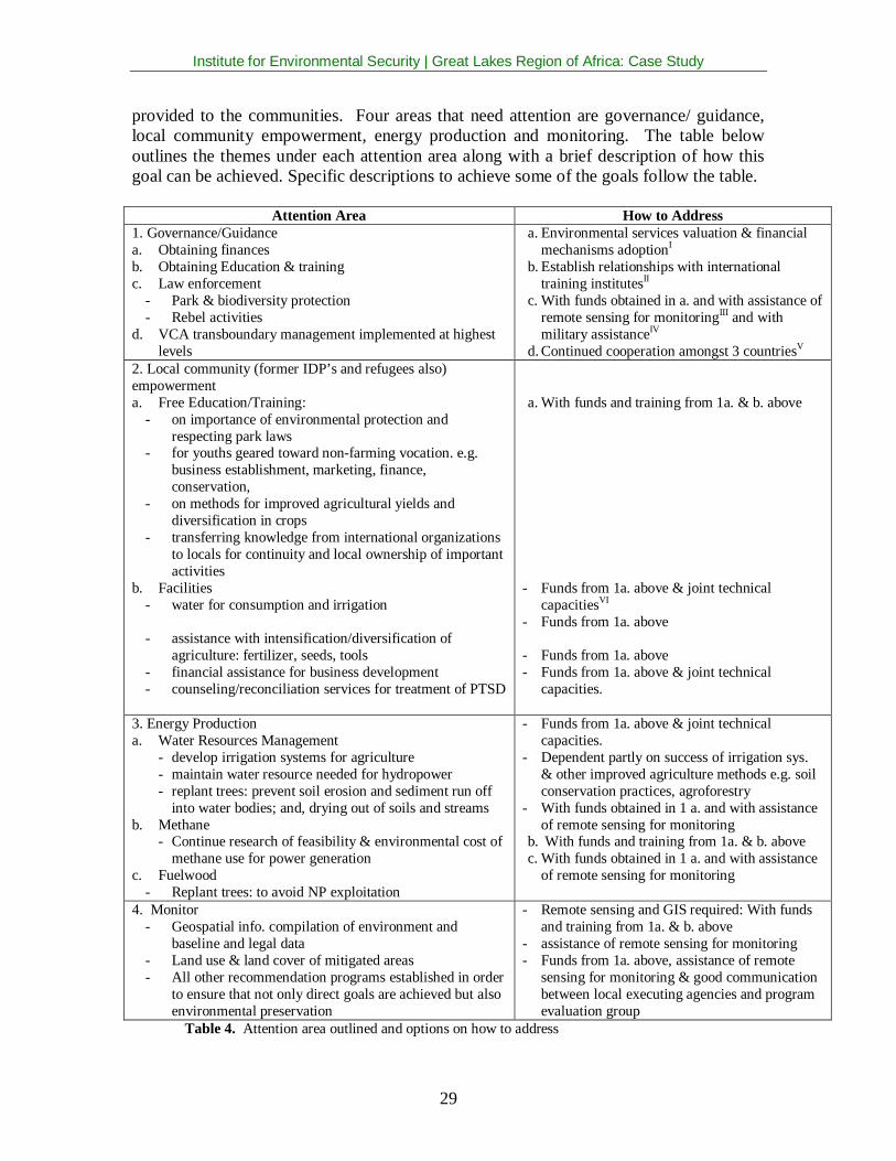
provided to the communities. Four areas that need attention are governance/ guidance,local community empowerment, energy production and monitoring. The table belowoutlines the themes under each attention area along with a brief description of how thisgoal can be achieved. Specific descriptions to achieve some of the goals follow the table.
Attention Area How to Address1. Governance/Guidancea. Obtaining financesb. Obtaining Education & trainingc. Law enforcement
- Park & biodiversity protection- Rebel activities
d. VCA transboundary management implemented at highestlevels
a. Environmental services valuation & financialmechanisms adoptionI
b. Establish relationships with internationaltraining institutesII
c. With funds obtained in a. and with assistance ofremote sensing for monitoringIII and withmilitary assistanceIV
d. Continued cooperation amongst 3 countriesV
2. Local community (former IDP’s and refugees also)empowermenta. Free Education/Training:
- on importance of environmental protection andrespecting park laws
- on methods for improved agricultural yields anddiversification in crops
- transferring knowledge from international organizationsto locals for continuity and local ownership of importantactivities
b. Facilities- water for consumption and irrigation
- assistance with intensification/diversification ofagriculture: fertilizer, seeds, tools
- financial assistance for business development- counseling/reconciliation services for treatment of PTSD
a. With funds and training from 1a. & b. above
- Funds from 1a. above & joint technicalcapacitiesVI
- Funds from 1a. above
- Funds from 1a. above- Funds from 1a. above & joint technical
capacities.
3. Energy Productiona. Water Resources Management
- develop irrigation systems for agriculture- maintain water resource needed for hydropower- replant trees: prevent soil erosion and sediment run off
into water bodies; and, drying out of soils and streamsb. Methane
- Continue research of feasibility & environmental cost ofmethane use for power generation
c. Fuelwood- Replant trees: to avoid NP exploitation
- Funds from 1a. above & joint technicalcapacities.
- Dependent partly on success of irrigation sys.& other improved agriculture methods e.g. soilconservation practices, agroforestry
- With funds obtained in 1 a. and with assistanceof remote sensing for monitoring
b. With funds and training from 1a. & b. abovec. With funds obtained in 1 a. and with assistance
of remote sensing for monitoring
4. Monitor- Geospatial info. compilation of environment and
baseline and legal data- Land use & land cover of mitigated areas- All other recommendation programs established in order
to ensure that not only direct goals are achieved but alsoenvironmental preservation
- Remote sensing and GIS required: With fundsand training from 1a. & b. above
- assistance of remote sensing for monitoring- Funds from 1a. above, assistance of remote
sensing for monitoring & good communicationbetween local executing agencies and programevaluation group
Table 4. Attention area outlined and options on how to address
Institute for Environmental Security | Great Lakes Region of Africa: Case Study
30
I. Environmental services valuation & financial mechanisms adaptation
1. For the region to receive funds through environmental related conventions there needsto be first investigations carried out to determine the ecological, hydrological, social, andeconomical value of the environmental services and goods to the wider region and theglobal community. In early 2005, through assistance from USAID a United States ForestService team carried out a preliminary analysis of the hydrology in the region. Theyfound that Bwindi was major headwater catchment area and was critical to thehydrological balance of the region. Such discoveries can prove vital for theenvironmental security of Bwindi. Unlike the Virungas, the communities in Bwindi donot enter the park for water but they do exploit the other resources there. If the regiondependent on Bwindi for other resources could benefit from conservation, thecommunities could be provided with alternatives and sustainable means of living. Forthese reasons, analyses such as that of the USDA Forest Service and of the GlobalEnvironment Facility (GEF) -funded Global International Waters Assessment should becontinued, also with special attention to the relevance for the Nile Basin Initiative.
2. The values of environmental services and goods as well as the threats in the regionshould be laid down on maps as produced for the UNEP/UNDP/OSCE program onenvironment and security in Central Asia, the Caucasus and South-East Europe so as togive policy-makers and donors at the various levels, a direct and integrated view of theissues to be addressed. (See map produced for this case-study.)
3. On or in association with the maps the pertinent international legal regimes should beidentified, or compiled from existing research, so as to define the responsibilities,obligations and rights of the various actors in and relevant for the region. It isrecommended strongly to take the responsibilities and obligations of the countries in theVirunga-Bwindi region under the international environmental conventions seriously andwork together as Parties to these binding law agreements. There is also great need inthese countries to be treated as equal partners and not just as receivers of aid.
4. Whatever the exact legal arrangement, adequate financing for long term monitoringand management is an absolute requirement for the Virunga-Bwindi region to besuccessful as a peace park, as habitat for unique biodiversity and possibly as a “watertower” for the surrounding regions. Contributing to regional peace, to the protection ofglobally unique biodiversity and to the protection of a strategic regional watershed,warrants long term funding from regional and global sources. It is thereforerecommended to investigate the effectiveness of the Mgahinga and Bwindi ImpenetrableForest Conservation Trust Fund (MBIFCT) and dependent on the outcome either adopt itor find an alternative to address the needs of the Rwandan and DRC components. Theidea is to increase the amount of the endowment accordingly, to such a level that it canbuffer drops in income from tourism. MBIFCT was set up to finance the globalbiodiversity benefit as defined by the GEF. To the geographically extended Trust Fundcould be added the hydrological component, mentioned above (I1.), which could generate
Institute for Environmental Security | Great Lakes Region of Africa: Case Study
31
funding under the International Waters window of the GEF. An initial GEF grant can ofcourse leverage other sources of funding.
5. The format of the fund could be that of the multi-donor trust fund as already proposedfor the peat swamp forest projects in Indonesia and for the Amazon programme of theDutch embassy in Colombia. To the endowment could be added a sinking fundcomponent and a revolving fund component. The sinking component could f.e. finance aprogramme of training and capacity enhancement for the park management and fordevelopment of economic alternatives for the neighbouring communities. The revolvingcomponent could be used to give credits to starting businesses under f.e. the IGCPEnterprise Programme, to be paid back if the business is successful. The fund also couldbe the vehicle for the revenue sharing mechanism, as is being set up by the Rwanda’sORTPN to transfer a certain percentage of the income generated by the parks to thesurrounding communities.
6. In order to maintain the Virunga Volcanoes park complex as a peace park and toprovide sustainable livelihoods for the surrounding populations as a whole –especially indensely populated Rwanda – the highest priority has to be given to generate sources ofincome and employment outside the subsistence agriculture in which 90% of thepopulation near the parks is working. If one would look at small to medium industriesand to the ICT sector, energy (in the form of electricity) is an absolute requirement. Herethere is a dilemma for a country like Rwanda, where water used for hydropower isdiverted towards agriculture, thus increasing the need to use “dirty diesel” to produceelectricity. This is exactly the opposite of what should be done to make the country earnincome from producing carbon credits under the Clean Development Mechanism of theKyoto Protocol. Building on existing (UNIDO/GEF) initiatives the Dutch developmentcooperation through its bilateral and multilateral channels should strongly support aClean energy strategy for the countries sharing the Virunga Massive, including creatingoptions for CDM projects. Reforestation to prevent erosion and sedimentation of waterbodies suitable for hydropower could at the same time qualify for the CDM. The DutchCDM office at the ministry of VROM should be consulted to see whether now or in thefuture the obligatory Dutch greenhouse gas emission reductions via the CDM could berealized f.e. through energy and/or forestry projects in Rwanda.
II. Establish relationships with international training institutes
1. During the visit to the Virunga-Bwindi region, Dr. Rose Mukankomeje, the DirectorGeneral of the Rwanda Environment Management Authority (Pers. Comm, 18 July,2005) stated that Rwanda needs assistance with improving their technical capacity andgave the example of lacking training in the execution of environmental impactassessments. It seems also that it is difficult for the region to obtain foreign consultantsin technical fields because of the reputation the region has in terms of violence andinstability ("Gaspard Ndagijimana, Personal Communication,13 July, 2005,"). Inaddition, regarding 3b. from Table 4. above, a special role could be played by themethane gas from Lake Kivu, Rwanda. Considering the risks associated with exploitingthis gas, a thorough EIA of any project to indeed exploit this gas has to be conducted.
Institute for Environmental Security | Great Lakes Region of Africa: Case Study
32
There are many training institutes world wide focusing on different fields. In theNetherlands, for instance, the Dutch EIA Commission, which specializes inenvironmental impact assessments, can be very helpful to assist the Rwandan authoritiesin preparing the necessary EIA’s. Contacts have already been established, after the visitof the IES team to Rwanda in July 2005, between the Rwanda EnvironmentalManagement Authority and the Dutch EIA Commission but would undoubtedly, need tobe extended and strengthened.
Another example of training institutes is the International Institute for Geo-InformationScience and Earth Observation (ITC) of the Netherlands which specializes in training andapplying of GIS and RS to a number of fields. The ITC currently has an ongoing projectwith the National University of Rwanda in Butare to develop the university’s capacity totrain and carry out research in the field of Geographic Information Science (GIS) andRemote Sensing (RS) applied to rural sector transformation and poverty reduction. Suchjoint programs should be supported to help meet the technical needs in the region.
III. With funds obtained in a. and with assistance of remote sensing for monitoring
1. As a component of ensuring environmental security monitoring is essential. Both themonitoring of biophysical and man made aspects of the region as well as monitoring ofthe administration and effectiveness of projects is important. Regarding the former, werecommend the implementation of a permanent monitoring system aimed at detectingland use and land cover changes with systematic ground truthing by local authorities andcounterparts such as IGCP should be set up. There should be periodic reporting of thismonitoring, f.e. on the occasion and for the benefit of the quarterly tripartite meetings ofthe park authorities to discuss the joint management of the parks. Of course the results ofthe monitoring should also be made available to the governments and all other relevantdecision-makers in order to allow them to take adequate action in time for environmentalprotection as well as maintaining the conditions necessary for the contracts to beformulated with donors. It is proposed that SarVision with its unique radar methodologyand Synoptics because of its involvement in BEGo, take the lead in setting up thismonitoring system from the remote sensing side.
2. A crucial part of monitoring is being able to compare new findings with the past orwith other types of data, thus the use of geographical information system (GIS)technology is also essential. Other data types can include cadastral boundaries, land usezoning plans, and maps of land suitability assessment. Included in setting up themonitoring system which includes the remote sensing and GIS components there shouldbe modules for training based upon a needs assessment, for the (local) authorities andcounterparts. (Refer to II above.)
Institute for Environmental Security | Great Lakes Region of Africa: Case Study
33
IV. Military assistance
1. Considering the fact that one of the major threats to the ecological integrity of theVirunga Massive still is the instability on the Congolese side, it is recommended – if thisis not yet already arranged –to establish (informal) channels of communication withMONUC to prevent invasions of the parks or using them as shelter and to strengthen parkprotection if needed. (See recent recommendations by International Crisis Group toMONUC).
V. Continued cooperation among the three VCA countries
1. The key element of the management of the Virunga Massive as a peace park is formedby the quarterly meetings of the rangers and ( park ) authorities as facilitated by theIGCP. As is suggested at III.1. above, these tripartite consultations may benefit fromupdated monitoring reports. Also one may think of upgrading the Trilateral Memorandumof understanding between the three park authorities to a “Legal Framework for aTransboundary Area”, as is proposed in the report by IES Legal Advisor SergeBronkhorst The Virunga Volcanoes and the Bwindi Impenetrable National Park: Co-operation in the management of shared natural resources and the concept ofTransboundary Protected Areas”. This would imply a binding treaty between the threestates. While this should be considered a desirable end goal to legally “cement” thenecessary cooperation, the steps towards such an arrangement should be very carefullyplanned and built upon concrete progress of the on-going consultations between the threepark authorities. By the end of the IES project, in October 2005, the IGCP reported thatthe three nations signed a Tripartite Declaration (14th October, 2005) that declaresamongst other things to target the establishment of a strategic transboundarycollaborative management system that enables sustainable conservation of the CentralAlbertine Rift biodiversity for long-term socio-economic development. A five yearstrategic plan is completed and a management plan for the Virunga-Bwindi region isunderway ("Annette Lanjouw, Personal Communication, 20 October, 2005,").
VI. Funds from 1a. above & joint technical capacities.
1. A joint capacity is similar to 2. above except the local experts would be workingalongside foreign experts of the same field to build infrastructure in rural areas. Thebenefits would be a transfer of modern expertise at the same time as infrastructuredevelopment.
Institute for Environmental Security | Great Lakes Region of Africa: Case Study
34
7 Conclusion
The challenge now for these countries is to alleviate poverty; compliment traditionalforms of livelihood with sustainable alternatives; raise park management to the next levelby establishing transboundary collaboration at the higher levels of administration in the 3countries; explore and develop clean and safe alternative sources of energy in addition tohydroelectricity; assist families with education for children; provide equal opportunitiesto all; install basic facilities in communities, for instance, access to water, sanitation,health care, schools and electricity. To accomplish all of the above there are a few areasmore foundational where the international community can assist. These countries havesigned and ratified all the major environmental related conventions; and, they haverecognized the crucial role environmental conservation plays in the rest of the economyand the improvement of civil society. What the countries need first is that potential andcurrent donors also recognize the importance of long term environmental conservationand start funding those needs.
There are organizations presently addressing many of the problems we have identified aspriority. While there needs to be investigation on how much is planned and what is therealready funds allocated for, it is clear that these priority problems need more attention ormore long term support.
8 References
Annette Lanjouw, Personal Communication, 20 October, 2005. Nairobi.Blom, A., & Bowie, R. (2001). Albertine Rift Montane Forests (AT0101). World Wildlife
Fund. Retrieved 22 July, 2004, from the World Wide Web:www.worldwildlife.org/wildworld/profiles/terrestrial/at/at0101_full.html
Bureau of African Affairs. (2005a). Background Note: Democratic Republic of theCongo. U. S. Department of State. Retrieved 11 August, 2005, from the WorldWide Web: http://www.state.gov/r/pa/ei/bgn/2823.htm
Bureau of African Affairs. (2005b). Background Note: Uganda. U. S. Department ofState. Retrieved 11 August, 2005, from the World Wide Web:http://www.state.gov/r/pa/ei/bgn/2963.htm
Dr. Rose Mukankomeje, Personal Communication,18 July, 2005. Kigali.Gaspard Ndagijimana, Personal Communication,13 July, 2005. Kigali.Global Witness. (2004). Same Old Story A background study on natural resources in the
Democratic Republic of Congo (Electronically (PDF)). Washington D.C.: GlobalWitness Publishing Inc.
Gurrieri, J., Gritzner, J., & Chaveas, M. (2005). USDA Forest Service TechnicalAssistance Trip Virunga – Bwindi Region: Republic of Rwanda, Republic ofUganda, Democratic Republic of Congo In Support to the International GorillaConservation Programme in Analyzing the Region’s Watersheds for WaterSupplies to Local Communities: USDA Forest Service.
Kalpers, J. (2001). Volcanoes under Siege: Impact of a Decade of Armed Conflict in theVirungas. Washington, D.C.: Biodiversity Support Program.
Institute for Environmental Security | Great Lakes Region of Africa: Case Study
35
Kameri-Mbote, P. (2004). Stakeholder Participation and Transboundary Waters: The NileBasin Initiative, Understanding Environment, Conflict and Cooperation (pp. 36-37). Nairobi: UNEP and Woodrow Wilson International Center for Scholars.
Kanyamibwa, S. (1998). Impact of war on conservation: Rwandan environment andwildlife in agony. Biodiversity and Conservation, 7, 1399-1406.
Lanjouw, A., Kayitare, A., Rainer, H., Rutagarama, E., Sivha, M., Asuma, S., & Kalpers,J. (2004). Transboundary Natural Resource Management A Case Study byInternational Gorilla Conservation Programme in the Virunga-Bwindi Region.
Lok-Dessallien, R. Review of Poverty Concepts and Indicators, SEPED Series onPoverty Reduction (pp. 21): UNEP.
Mountains of the World: Water Towers for the 21st Century. (The Commission onSustainable Development (CSD) and its 1998 Spring Session on "Strategicapproaches to Freshwater Management")(1998). Berne: Mountain Agenda.
Muir, R. (2004). DRC Crisis in PNVi: Encroachment of Mikeno Sector: Virunga NationalPark Conservation Programme for the Frankfurt Zoological Society.
Office Rwandais Du Tourisme et des Parcs Nationaux. (2004). Parc National desVolcans Plan d’Aménagement et de Gestion 2005-2009 (Draft).
Plumptre, A. J., Behangana, M., Ndomba, E., Davenport, T., Kahindo, C., Kityo, R.,Ssegawa, P., Eilu, G., Nkuutu, D. and Owiunji, I. (2003). The Biodiversity of theAlbertine Rift (Albertine Rift Technical Reports Volume 3): World ConservationSociety.
Plumptre, A. J., Kayitare, A., Rainer, H., Gray, M., Munanura, I., Barakabuye, N.,Asuma, S., Sivha, M., and Namara, A. (2004). The Socio-economic Status ofPeople Living Near Protected Areas in the Central Albertine Rift (Albertine RiftTechnical Reports Volume 4): IGCP, WCS, CARE.
October, 2005, from the World Wide Web: http://www.small-hydro.com/index.cfm?Fuseaction=countries.country&Country_ID=130
Staub, E., Pearlman, L. A., Gubin, A., & Hagengimana, A. (2005). Healing,Reconciliation, Forgiving and the Prevention of Violence After Genocide or MassKilling: An Intervention and its Experimental Evaulation in Rwanda. Journal ofSocial and Clinical Psychology, 24(3), 297-334.
UNEP. (2004). Odada, E.O., Olago, D., Kulindwa, K.A.A., Bugenyi, F., West, K., Ntiba,M., Wandiga, S. and J. Karimumuryango Global International Waters AssessmentEast African Rift Valley Lakes, GIWA Regional assessment 47 [Electronically(PDF)]. University of Kalmar, Kalmar, Sweden. Retrieved, from the World WideWeb: http://www.giwa.net/publications/r47.phtml
Bwindi Impenetrable National ParkCentral African Regional Program for the EnvironmentClean Development MechanismDian Fossey Gorilla Fund InternationalDemocratic Republic of CongoEnvironmental Impact AssessmentFauna and Flora InternationalGlobal Environment FacilityGeographical Information System/ScienceGesellschaft für Technische ZusammenarbeitInstitut Congolais pour la Conservation de la NatureInstitute for Environmental SecurityInternational Gorilla Conservation ProgrammeInternational Institute for Geo-Information Science and Earth ObservationThe World Conservation UnionInstitut Zaïrois pour la Conservation de la NatureMgahinga and Bwindi Impenetrable Forest Conservation Trust FundMgahinga Gorilla National ParkMinistry of Environment and TourismMinistry of Land, Reinstallation and EnvironmentUnited Nations Mission in the Democratic Republic of Congo (Mission desNations Unies en République Démocratique du Congo)Non Governmental OrganizationOffice Rwandais du Tourisme et des Parcs NationauxOrganization for Security and Co-operation in EuropeVirunga National ParkVolcanoes National ParkUnited Nations Environment ProgrammeUnited Nations Development ProgrammeUnited Nations Educational, Scientific and Cultural OrganisationUnited Nations High Commissioner for RefugeesUnited Nations Children’s FundUnited Nations Industrial Development OrganizationUnited States Agency for International DevelopmentUnited States Department of AgricultureUganda Wildlife AuthorityVirunga Conservation AreaNetherlands Ministry of Housing, Spatial Planning and the Environment(Ministerie van Volkshuisvesting, Ruimtelijke Ordening en Milieubeheer)Wildlife Conservation SocietyWorld Food Program (UN)World Wide Fund for Nature (in the USA: World Wildlife Fund)
Institute for Environmental Security | Great Lakes Region of Africa: Case Study
37
10 Acknowledgements
We would like to thank everyone that contributed to this publication, whether through providinginformation, spatial data, experiences, ideas and/or carrying out logistical arrangements duringthe IES visit to the case study area.
Alexis Byamana
Anecto Kayitare
Annette Lanjouw
Aphrodis Mbonyintwali
Eugene Rutagarama
Fidéle Ruzigandekwe
Gaspard Ndagijimana
Joseph Ngango
Maryke Gray
Moise Benimana
Mwine Mark David
Raphael Rurangwa
Dr. Rose Mukankomeje
Viateur Ngiruwonsanga
Principal Technical Advisor, Helpage, Rwanda
Policy Advisor, International Gorilla Conservation Programme, Nairobi, Kenya
International Technical Advisor, International Gorilla Conservation Programme, Nairobi,Kenya
Project Manager, PADEPP Care, Rwanda
Director, International Gorilla Conservation Programme, Nairobi, Kenya
Executive Director, Rwandan Agency of Conservation/RWA, ORTPN, Kigali, Rwanda
Advisor, Rural Economic Transformation, Royal Netherlands Embassy, Kigali, Rwanda
Finance Officer, International Gorilla Conservation Programme
Regional Monitoring Officer, International Gorilla Conservation Programme
Logistics, International Gorilla Conservation Programme
Regional Enterprise Officer, International Gorilla Conservation Programme
Programme Officer, International Gorilla Conservation Programme
Director General, Rwanda Environment Management Authority, Kigali, Rwanda
Coordinator, SIG/HIMO, Rwanda
Cover map by Philippe Rekacewicz.
Cover photos by Jeanna Hyde Hecker
Institute for Environmental Security | Great Lakes Region of Africa: Case Study
38
Institute for Environmental Security | Great Lakes Region of Africa: Case Study
39
Institute for Environmental Security | Great Lakes Region of Africa: Case Study
40
IES EnviroSecurity Assessments
A major proportion of the world’s ecosystems and the services they perform forsociety and nature is being degraded or used unsustainably. This process affectshuman wellbeing in several ways. The growing scarcity of natural resourcescreates a growing risk for human and political conflicts and hinders sustainabledevelopment and the poverty alleviation that depends on it. Situations involvingresource abundance can also be related to serious environmental degradation,increased community health risks, crime and corruption, threats to human rightsand violent conflicts – in short, to a decrease of security.
The overall objective of IES EnviroSecurity Assessments is to secure the naturalresource livelihood basis on the local, regional and international level. IESpursues this objective along the following mutually related lines: (1) theconservation of ecosystems and their related services, (2) the implementation ofthe international legal order, (3) the provision of economic incentives formaintenance of ecosystem services, and (4) empowerment of relevant actorsand dissemination of results.
About the Institute
The Institute for Environmental Security (IES) is an international non-profitnon-governmental organisation established in 2002 in The Hague, TheNetherlands with liaison offices in Brussels and Washington, D.C.
The Institute's mission is: "To advance global environmental security bypromoting the maintenance of the regenerative capacity of life-supporting eco-systems."
Our multidisciplinary work programme - Horizon 21 - integrates the fields ofscience, diplomacy, law, finance and education and is designed to provide policy-makers with a methodology to tackle environmental security risks in time, in orderto safeguard essential conditions for sustainable development.Key objectives of the Horizon 21 programme are:
• Science: Create enhanced decision tools for foreign policy makers,donors and their target groups on regional, national and local levels;
• Diplomacy: Promote effective linkages between environment, securityand sustainable development policies.
• Law & Governance: Contribute to the development of a more effectivesystem of international law and governance;
• Finance: Introduce new and innovative financial mechanisms for themaintenance of the globe's life supporting ecosystems; and
• Education: Build the environmental knowledge capital of people andorganisations.
Our mission and programme should be seen in the context of promotinginternational sustainable development goals and as a contribution toward long-term poverty alleviation.
Institute for Environmental SecurityAnna Paulownastraat 103
2518 BC The Hague, The NetherlandsTel +32 70 365 2299 • Fax +31 70 365 1948