A copy of this report can be obtained by download from: www.geology.gov.yk.caor by emailing: [email protected]
In referring to this publication, please use the following citation: McKillop, R., Turner, D., Johnston, K., and Bond, J., 2013. Property-scale classification of surficial geology for soil geochemical sampling in the unglaciated Klondike Plateau, west-central Yukon. Yukon Geological Survey, Open File 2013-15, 85 p., including appendices.
Cover photo: An example of how ‘landform-soil type’ (LST) classification in the Dawson Range distinguishes slopes with different implications for the collection and interpretation of soil geochemical data.
AbStrAct
Recent mineral discoveries made by soil geochemical sampling along ridges and spurs prompted an increase in exploration in the unglaciated Klondike Plateau of west-central Yukon. Extensive and detailed soil sampling campaigns were extended across hillsides and into valleys, where eolian deposits, periglacial processes, and mass movements complicate the collection and interpretation of geochemical data. In support of exploration efforts, property-scale (1:20 000) surficial geology mapping was completed for several exploration projects to provide more detailed insight than is available in regional-scale (1:50 000) mapping. The culmination of this mapping work is the identification of 12 ‘landform-soil types’ (LSTs) that exhibit recognizable and repetitive patterns in the field and in aerial photographs. The suitability of each LST for different soil geochemical sampling methods and interpretation strategies depends on its soil depth, permafrost depth, surface organic thickness, loess thickness, transport distance, and type of geochemical anomaly. Conventional hand auger sampling is well suited to LSTs with residual or colluvial soils with deep or no permafrost (i.e., LSTs 1, 2, 10, 11, and 12). Power auger sampling is best suited to loess-rich colluvial soils with shallow permafrost (i.e., LSTs 3, 4, and 5), although resulting geochemical signatures may be affected by unmineralized rock fragments pulverized during augering. Reverse circulation or rotary air blast drilling, or deep-penetrating geochemical methods, may be necessary in areas of thick organics or transported cover (i.e., LSTs 6, 7, 8 and 9). The LST classification is applied retrospectively to the Coffee Gold Project to explain soil anomalies that represent geochemical dilution by loess, colluvial dispersion, and halos overlying bedrock mineralization. Application of the LST classification to the Snowcap Project reveals similarities and differences in geochemical data derived from samples collected with a mattock, hand auger, and power auger, in relationship to different LSTs.
Regional Applicability .................................................................................................... 66SuMMARY ......................................................................................................................................... 66FuTuRE WORK .............................................................................................................................. 67ACKnOWLEDGMEnTS .................................................................................................................. 67REFEREnCES ............................................................................................................................ 67APPEnDIX A ............................................................................................................................ 73
YGS Open File 2013-15 Property-scale classification of surficial geology, unglaciated Klondike Plateau 1
IntrOductIOn
Background
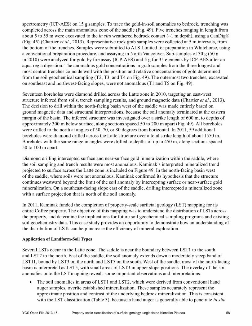
In the large regions of western and northern Yukon that remained unglaciated throughout the Pleistocene (Fig. 1), a mantle of weathered bedrock and residual soil1 covers much of the landscape. Exploration teams have taken advantage of the widespread residual soils by incorporating soil geochemical sampling into their exploration programs. Several recent gold discoveries in the unglaciated region of Yukon are primarily attributed to soil geochemical sampling. While soil sampling is generally an effective exploration method on ridges and spurs, where most discoveries have been made, widespread eolian deposits, periglacial processes, and mass movements complicate both the collection and interpretation of geochemical data from hillsides and valleys (Bond and Lipovsky, 2011). Recent work on several exploration projects in the unglaciated Klondike Plateau underscores the importance of understanding the types and distribution of surficial material and shallow permafrost for effective soil geochemical sampling.
An initial understanding of the surficial material covering a property can be gained through a review of surficial geology maps, which represent the distribution of different surficial material, landforms, and geomorphological processes. Such maps are currently available for approximately three-quarters of Yukon, mainly at scales of 1:50 000 to 1:250 000, including most of the Klondike Plateau (Fig. 2). Regional-scale (≤1:50 000) surficial geology maps are important tools to use when planning reconnaissance exploration and making generalized interpretations of collected data, but their utility to detailed exploration and site-specific interpretation is limited. Property-scale (≥1:20 000) surficial geology mapping is more valuable to the design of detailed soil sampling grids and the interpretation of soil geochemistry data. However, property-scale mapping is rarely available or completed for exploration programs.
An alternate means of understanding property-scale surficial geology is to recognize diagnostic surface characteristics of distinct landforms and soils in the field. Exploration teams that familiarize themselves with the primary landforms and soils, and their implications for soil geochemical sampling, will be able to more effectively design their sampling programs and interpret the resulting geochemical data. This report provides a catalogue of 12 ‘landform-soil types’ (LSTs) within the unglaciated Klondike Plateau. understanding these LSTs will assist field crews in recognizing the suitability of areas for different soil sampling methods, and in identifying the implications of different LSTs for the interpretation of soil geochemistry data. Two case studies from the Coffee and Snowcap properties illustrate how the LST classification applies to mineral exploration in the Dawson Range.
Rationale and Objectives
A recent increase in the intensity of exploration within the Dawson Range and surrounding Klondike Plateau, in west-central Yukon, spurred interest in better understanding the surficial geology of the region. From 2007 to 2012, the Yukon Geological Survey (YGS) completed 1:50 000-scale surficial geology mapping within the Stevenson Ridge map area (nTS 115J) of the Dawson Range. Over roughly this same period, 1:20 000-scale surficial geology mapping was completed for several exploration projects in the same general area. This project represents a synthesis of insight gained through both mapping programs.
1 In this report, the term ‘soil’ is used in its most general sense to refer to unconsolidated material overlying bedrock that is subject to physical and chemical weathering and geomorphological processes.
YGS Open File 2013-15 Property-scale classification of surficial geology, unglaciated Klondike Plateau 2
!
Yukon
RiverRive
r
Whi
te
Pelly
River
RiverSt
ewar
t
K L O N D I K E
P L A T E A U
!
!
Legend
Glacial Limits
±1:2 000 000
0 25 50
Km
Klondike Plateau Ecoregion
Pre-Reid (ca. 3 Ma)
136°0'0"W
136°0'0"W
137°0'0"W
137°0'0"W
138°0'0"W
138°0'0"W
139°0'0"W
139°0'0"W
140°0'0"W
140°0'0"W
141°0'0"W
141°0'0"W142°0'0"W65°0'0"N
64°0
'0"N
64°0'0"N63
°0'0
"N63°0'0"N
62°0
'0"N
62°0'0"N
Dawson
ALA
KSA
YUK
ON
Don
jek
River
Property-Scale Mapping
McConnell (ca. 22 ka)
D A W S O N
R A N G E
Dawson
Whitehorse
Gladstone and Reid (50 - 200 ka)
Based on air photo interpretation and field workBased on air photo interpretation
LS
WF
SCCF
CN BT
Figure 1. Klondike Plateau location map, in relation to Yukon glacial limits modified from Duk-Rodkin (1999), showing property-scale (1:20 000) mapping coverage: LS = Lone Star, WF = Wolf, SC = Snowcap, CF = Coffee, CN = Casino and BT = Betty. Ecoregion boundary modified from Yukon Ecoregions Working Group (2004) by Soil Landscapes of Canada Working Group (2013).
YGS Open File 2013-15 Property-scale classification of surficial geology, unglaciated Klondike Plateau 3
The objective of this report is to help increase the effectiveness and efficiency of soil geochemical sampling in the unglaciated Klondike Plateau. Following an overview of the setting and methods, we address three main research questions:
1. What property-scale LSTs can be distinguished within the unglaciated Klondike Plateau, and how are they recognized?
2. What are the implications of the LSTs for soil geochemical sampling?
3. How can the classification of LSTs be applied to mineral exploration projects to optimize the collection and interpretation of soil geochemistry data?
In addition to supporting mineral exploration, the information presented in this report is applicable to ecological land classification studies, archaeological assessments, and land management projects in west-central Yukon.
Figure 2. Surficial geology mapping coverage in west-central Yukon.
YGS Open File 2013-15 Property-scale classification of surficial geology, unglaciated Klondike Plateau 4
SettInG
Study Area
The study area for this project is within the Klondike Plateau Ecoregion (Yukon Ecoregions Working Group, 2004; Soil Landscapes of Canada Working Group, 2013), the limits of which incorporate the boundaries and characteristics of the Klondike Plateau physiographic region (Bostock, 1948; Mathews, 1986) and Yukon’s glacial limits (Fig. 1; Duk-Rodkin, 1999). We focus on a 1600 km2 area of the northern Dawson Range, where detailed surficial geology mapping was completed to encompass four contiguous exploration projects: Snowcap, Coffee, Casino and Betty (Fig. 3).
Figure 3. Surficial geology field investigation sites within and surrounding the 1600 km2 study area in the northern Dawson Range, for which property-scale (1:20 000) mapping was completed for the Snowcap, Coffee, Casino, and Betty properties. Case studies described in the text are identified: Latte zone and Denali zone. Major streams referenced in the text are labeled. Landsat 7 imagery provided by the Government of Yukon.
YGS Open File 2013-15 Property-scale classification of surficial geology, unglaciated Klondike Plateau 5
Physiography, Drainage and Climate
The Klondike Plateau is a Tertiary-age upland that has undergone variable uplift and stream dissection, resulting in rounded summits and ridges, and deep, V-shaped valleys (Fig. 4; Mathews, 1986). Accordant hill crests represent an approximation of the former plateau surface. The higher and more rugged terrain of the Dawson Range reflects enhanced erosion following locally greater uplift. Most valley sides exhibit convex profiles, with concave terrain restricted to localized bench or gully features and valley bottoms filled with material derived from upslope erosion. Elevations range from just over 2000 m above sea level (asl) at the summit of Apex Mountain in the Dawson Range, to less than 300 m asl where the Yukon River flows into Alaska, downstream of Dawson. Local relief is generally between 450 and 700 m (Yukon Ecoregions Working Group, 2004).
Several major rivers have incised deeply into the plateau surface. The Donjek River flows into the White River, which enters the Yukon River just upstream of its confluence with the Stewart River (Fig. 1). Other rivers include the nisling, Klotassin, Ladue, Sixty Mile, Indian, and Fortymile rivers. Some valley reaches of the rivers and major tributaries are more entrenched than others, depending on their proximity to the Yukon River (Bond and Lipovsky, 2011). Reaches in close proximity to the Yukon River commonly contain stream-cut bedrock terraces along one or both sides of the valley, most likely formed by accelerated degradation (down-cutting) initiated by the reversal of the Yukon River from a south to north-flowing drainage during the late Pliocene to early Pleistocene (Tempelman-Kluit, 1980; Jackson et al., 2008). Some headwater tributaries also exhibit anomalously steep toe slopes that may correspond to this base level change. The scarcity of lakes is attributed to the dominantly fluvial origin of the landscape and the absence of glacial scouring.
Figure 4. Typical unglaciated landscape of the Klondike Plateau in the late summer. Note the V-shaped valleys and rounded summits and ridges.
YGS Open File 2013-15 Property-scale classification of surficial geology, unglaciated Klondike Plateau 6
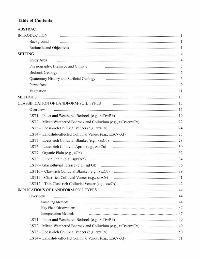
The climate of the Klondike Plateau is continental; summers are warm and short, and winters are long and cold. Mean annual temperature is near -5oC, with mean January temperatures of -23 to -32oC and mean July temperatures of 10 to 15oC (Yukon Ecoregions Working Group, 2004). Strong thermal inversions are common from December to February, in association with prolonged atmospheric stability (Williams, 1995). During this period, valley bottom temperatures can be tens of degrees Celsius lower than surrounding higher-elevation areas. Mean annual precipitation ranges from about 300 to 500 mm, giving the region a semi-arid classification, with a gradual increase in precipitation from the southeast to the northwest (Yukon Ecoregions Working Group, 2004). The wettest period is in the summer, when most precipitation falls as rain during convective rain showers and thunderstorms.
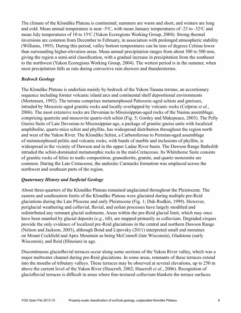
Bedrock Geology
The Klondike Plateau is underlain mainly by bedrock of the Yukon-Tanana terrane, an accretionary sequence including former volcanic island arcs and continental shelf depositional environments (Mortensen, 1992). The terrane comprises metamorphosed Paleozoic-aged schists and gneisses, intruded by Mesozoic-aged granitic rocks and locally overlapped by volcanic rocks (Colpron et al., 2006). The most extensive rocks are Devonian to Mississippian-aged rocks of the nasina assemblage, comprising quartzite and muscovite quartz-rich schist (Fig. 5; Gordey and Makepeace, 2003). The Pelly Gneiss Suite of Late Devonian to Mississippian age, a package of granitic gneiss units with localized amphibolite, quartz-mica schist and phyllite, has widespread distribution throughout the region north and west of the Yukon River. The Klondike Schist, a Carboniferous to Permian-aged assemblage of metamorphosed pelitic and volcanic rocks, with bands of marble and inclusions of phyllite, is widespread in the vicinity of Dawson and in the upper Ladue River basin. The Dawson Range Batholith intruded the schist-dominated metamorphic rocks in the mid-Cretaceous. Its Whitehorse Suite consists of granitic rocks of felsic to mafic composition; granodiorite, granite, and quartz monzonite are common. During the Late Cretaceous, the andesitic Carmacks formation was emplaced across the northwest and southeast parts of the region.
Quaternary History and Surficial Geology
About three-quarters of the Klondike Plateau remained unglaciated throughout the Pleistocene. The eastern and southeastern limits of the Klondike Plateau were glaciated during multiple pre-Reid glaciations during the Late Pliocene and early Pleistocene (Fig. 1; Duk-Rodkin, 1999). However, periglacial weathering and colluvial, fluvial, and eolian processes have largely modified and redistributed any remnant glacial sediments. Areas within the pre-Reid glacial limit, which may once have been mantled by glacial deposits (e.g., till), are mapped primarily as colluvium. Degraded cirques provide the only evidence of localized pre-Reid glaciations in the central and northern Dawson Range (nelson and Jackson, 2003), although Bond and Lipovsky (2011) interpreted small end moraines on Mount Cockfield and Apex Mountain as being McConnell (late Wisconsin), Gladstone (early Wisconsin), and Reid (Illinoian) in age.
Discontinuous glaciofluvial terraces occur along some sections of the Yukon River valley, which was a major meltwater channel during pre-Reid glaciations. In some areas, remnants of these terraces extend into the mouths of tributary valleys. These terraces may be observed at several elevations, up to 250 m above the current level of the Yukon River (Huscroft, 2002; Huscroft et al., 2006). Recognition of glaciofluvial terraces is difficult in areas where fine-textured colluvium blankets the terrace surfaces.
YGS Open File 2013-15 Property-scale classification of surficial geology, unglaciated Klondike Plateau 7
DMPW PELLY GNEISS SUITE - SW: felsicto intermediate granitic rocks
DMN NASINA: graphitic quartzite and muscovite quartz-rich schist
PCH HYLAND: coarse turbiditic clastics,limestone and fine clastics
PPN NISLING: mica quartz feldspar schist
1:1 400 0000 10 205
Km
Dawson
Yukon
River
Figure 5. Bedrock geology of the Klondike Plateau Ecoregion (boundary from Soil Landscapes of Canada Working Group, 2013), simplified from Gordey and Makepeace (2003). Hatched areas show property-scale mapping completed as part of this project.
YGS Open File 2013-15 Property-scale classification of surficial geology, unglaciated Klondike Plateau 8
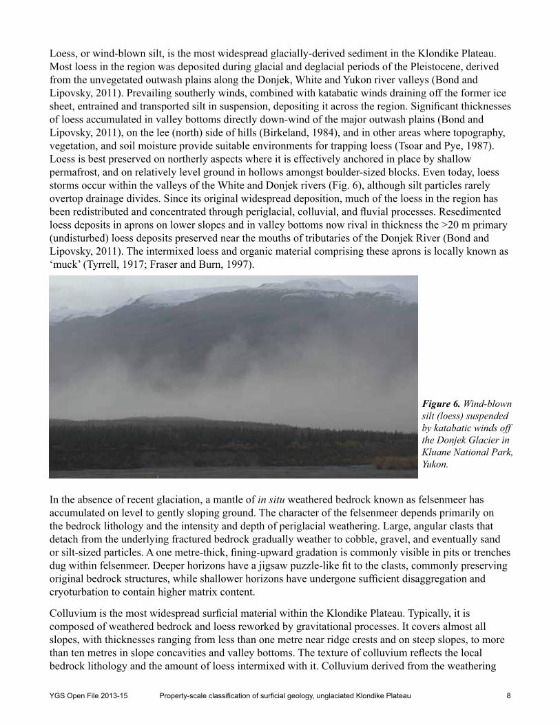
Loess, or wind-blown silt, is the most widespread glacially-derived sediment in the Klondike Plateau. Most loess in the region was deposited during glacial and deglacial periods of the Pleistocene, derived from the unvegetated outwash plains along the Donjek, White and Yukon river valleys (Bond and Lipovsky, 2011). Prevailing southerly winds, combined with katabatic winds draining off the former ice sheet, entrained and transported silt in suspension, depositing it across the region. Significant thicknesses of loess accumulated in valley bottoms directly down-wind of the major outwash plains (Bond and Lipovsky, 2011), on the lee (north) side of hills (Birkeland, 1984), and in other areas where topography, vegetation, and soil moisture provide suitable environments for trapping loess (Tsoar and Pye, 1987). Loess is best preserved on northerly aspects where it is effectively anchored in place by shallow permafrost, and on relatively level ground in hollows amongst boulder-sized blocks. Even today, loess storms occur within the valleys of the White and Donjek rivers (Fig. 6), although silt particles rarely overtop drainage divides. Since its original widespread deposition, much of the loess in the region has been redistributed and concentrated through periglacial, colluvial, and fluvial processes. Resedimented loess deposits in aprons on lower slopes and in valley bottoms now rival in thickness the >20 m primary (undisturbed) loess deposits preserved near the mouths of tributaries of the Donjek River (Bond and Lipovsky, 2011). The intermixed loess and organic material comprising these aprons is locally known as ‘muck’ (Tyrrell, 1917; Fraser and Burn, 1997).
In the absence of recent glaciation, a mantle of in situ weathered bedrock known as felsenmeer has accumulated on level to gently sloping ground. The character of the felsenmeer depends primarily on the bedrock lithology and the intensity and depth of periglacial weathering. Large, angular clasts that detach from the underlying fractured bedrock gradually weather to cobble, gravel, and eventually sand or silt-sized particles. A one metre-thick, fining-upward gradation is commonly visible in pits or trenches dug within felsenmeer. Deeper horizons have a jigsaw puzzle-like fit to the clasts, commonly preserving original bedrock structures, while shallower horizons have undergone sufficient disaggregation and cryoturbation to contain higher matrix content.
Colluvium is the most widespread surficial material within the Klondike Plateau. Typically, it is composed of weathered bedrock and loess reworked by gravitational processes. It covers almost all slopes, with thicknesses ranging from less than one metre near ridge crests and on steep slopes, to more than ten metres in slope concavities and valley bottoms. The texture of colluvium reflects the local bedrock lithology and the amount of loess intermixed with it. Colluvium derived from the weathering
Figure 6. Wind-blown silt (loess) suspended by katabatic winds off the Donjek Glacier in Kluane National Park, Yukon.
YGS Open File 2013-15 Property-scale classification of surficial geology, unglaciated Klondike Plateau 9
and entrainment of granitic rocks tends to be blocky to pebbly, with a silty-sand matrix; colluvium derived from schist and gneiss is generally finer grained, comprising cobble-sized angular fragments and a more silt-rich matrix (Schaetzl and Anderson, 2005). Loess commonly occurs as a veneer or is intermixed with bedrock-derived colluvium. Colluviation occurs mainly through soil creep, solifluction, and landsliding, the relative importance of each depending on slope steepness and permafrost distribution.
Fluvial deposits occupy valley bottoms throughout the region. Channel bed and bank material ranges from cobbles and boulders in headwater streams, confined within narrow, V-shaped valleys, to sandy gravel in meandering lower reaches. Floodplains are typically absent in headwater reaches, but are hundreds of metres wide along the lower reaches of major tributaries. Stable areas of floodplains may be overlain by loess, and interbedded with, or overlain by, organic material. Oxbows, representing abandoned channel positions, are distinguished by sedge-dominated vegetation.
Organic deposits are common throughout the Klondike Plateau. On well drained, forested slopes free of permafrost, organic deposits are relatively thin (<15 cm) and composed predominantly of fibrous woody forest litter. On slopes with shallow permafrost and in depressions with poor drainage, poorly to moderately decomposed peaty organic material is commonly 30 to 40 cm thick and may exceed 100 cm. The type and thickness of organic material is closely associated with permafrost distribution.
Two volcanic eruptions, from either Mt. Churchill or under the Klutlan Glacier in the Wrangell Mountains in Alaska, deposited a layer of tephra across large parts of eastern Alaska, southern and central Yukon, and southwestern northwest Territories (Richter et al., 1995; Lerbekmo, 2008). The first eruption occurred approximately 1900 14C years BP and deposited a lobe of White River Ash across western Yukon; the second eruption, which occurred about 1250 14C years BP, deposited White River Ash from Alaska, across southern Yukon and into the northwest Territories (Clague et al., 1995; Robinson, 2001). The thickness of the tephra decreases away from the source, with measurements of 2 to 10 cm commonly observed in upper soil horizons in the Klondike Plateau (Fig. 7; e.g., Hart and Jober, 1997). The presence or absence of this undisturbed tephra in soil pits provides an indication of a site’s stability.
Permafrost
The Klondike Plateau is within the zone of extensive discontinuous permafrost, in which 50 to 90% of the ground is underlain by permafrost (Heginbottom, 1995). Recent permafrost modelling completed by Bonnaventure et al. (2012) for southern Yukon and northern British Columbia indicates that the distribution of permafrost within the region exhibits characteristics of both subarctic and mountain permafrost. They postulate that permafrost is most prevalent in valley bottoms and on northern aspects, emphasizing the significance of surface lapse rates on mountain slopes and thermal inversions in valleys in winter. At a more local scale, permafrost distribution is related to slope aspect, angle and shape, soil texture and moisture, and the thickness and type of organic cover (Williams, 1995; Williams and Burn, 1996). Permafrost is most common on north-facing slopes with thick organic cover and in fine-textured colluvial aprons extending into valley bottoms (Bond and Lipovsky, 2011). Steep, well drained, south-facing slopes are invariably permafrost-free.
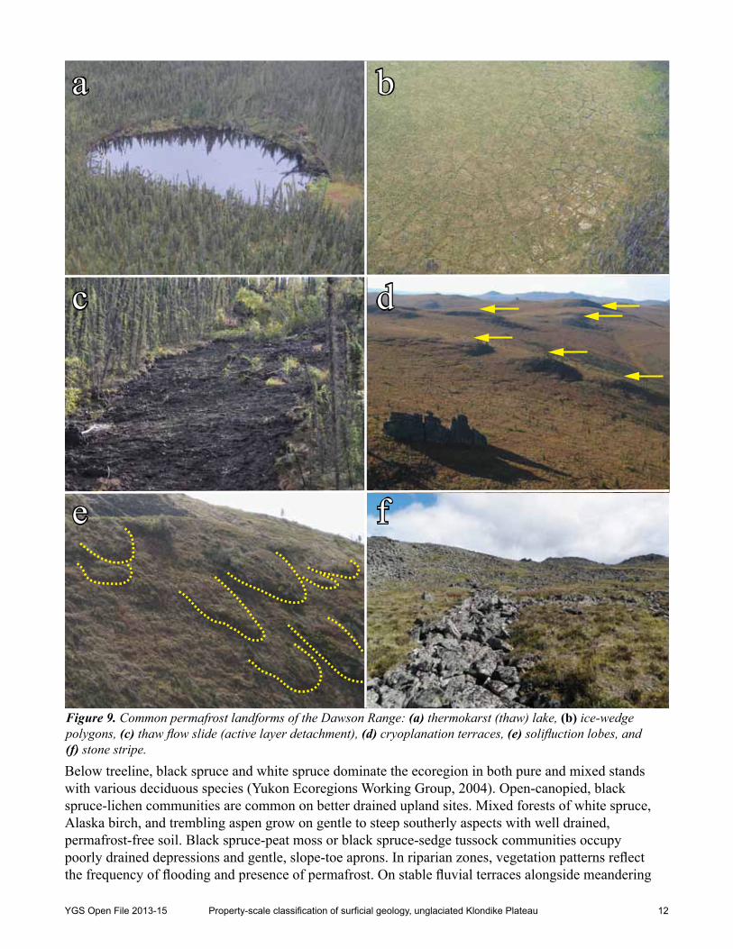
A variety of landforms indicates the presence of permafrost within the Klondike Plateau. Open-system pingos are widely distributed throughout the region, commonly in slope-toe settings of small drainages where groundwater discharges to surface through discontinuities in the permafrost table (Hughes, 1969; Bond and Lipovsky, 2011). Most are collapsed and distinguished based on ramparts encircling a small pond (Fig. 8a). An impressive example of an intact pingo formed in weathered quartzite bedrock was
YGS Open File 2013-15 Property-scale classification of surficial geology, unglaciated Klondike Plateau 10
observed in a headwater drainage east of Coffee Creek (Fig. 8b). Other indicators of permafrost in valley settings include thermo-erosion gullies and thermokarst (thaw) ponds (Fig. 9a), as well as ice wedge polygons on flat ground (Fig. 9b). Scars from thaw flow slides initiated by active-layer detachments are common on steep, north-facing slopes (Fig. 9c; Coates, 2008). In alpine settings, cryoplanation terraces (Fig. 9d), solifluction lobes (Fig. 9e), stone stripes (Fig. 9f), slopewash runnels, and frost (mud) boils are also common.
Certain vegetation communities are also reasonable predictors of permafrost presence or absence, although some are more reliable than others. Stands of trembling aspen (Populus tremuloides), which require relatively warm air temperature and well drained soils (MacKinnon et al., 1999), are restricted to permafrost-free ground (Zoltai and Pettapiece, 1973; Williams, 1995). In general, deciduous trees root more deeply than coniferous trees, and are unable to grow in thin active layers where soils are permanently wet or saturated. Thus, dense stands of Alaska birch (Betula neoalaskana) with or without aspen are also typically free of permafrost. Mixed forests of birch and white spruce (Picea glauca) or black spruce (Picea mariana) are more commonly permafrost-free, but a few birch trees may survive above a thin active layer (Zoltai and Pettapiece, 1973). Mixed forests are therefore not reliable predictors of permafrost presence or absence. The association of mixed white and black spruce and permafrost depends on the thickness of the moss understory. Black spruce is tolerant of cool, saturated soils and commonly grows in areas underlain by permafrost. A sparse, stunted canopy of black spruce with thick moss cover or sedge tussocks is a reliable indicator of shallow permafrost.
Figure 7. White River Ash (~7 cm) exposed in a soil pit dug into regolith (weathered bedrock) on a ridge crest. Soil pit is approximately 40 cm deep, including surface organics.
woody forest litter
tephra
loess
loess-enriched regolith
regolith
YGS Open File 2013-15 Property-scale classification of surficial geology, unglaciated Klondike Plateau 11
Active layer thickness (i.e., depth to permafrost table) varies spatially and temporally. Over the course of a summer season, active layers thaw and thicken. End-of-summer active layer thicknesses of up to about 200 cm are reported for the region (Yukon Ecoregions Working Group, 2004; Bond and Lipovsky, 2011). In general, sites with thicker insulating organic cover and lower solar insolation have thin active layers (i.e., shallow permafrost). Sites with thin or no organic cover have the thickest active layers (i.e., deepest permafrost). Areas with thick organic cover and variable moisture contents exhibit the greatest spatial variability in active layer thickness (Smith et al., 2009).
Permafrost thicknesses within the Klondike Plateau are highly variable. Thicknesses of 60 to 85 m have been reported from the Dawson area and valley bottoms in the nearby Klondike goldfields (McConnell, 1905; Brown, 1967; Milner, 1976; EBA, 1977, 1978). Bond and Lipovsky (2011) measured minimum permafrost thicknesses of 12 m in a Sonora Gulch placer excavation, 7 m in a cut-bank on a tributary of the Donjek River, and 9 m in a cut-bank along Home Creek. A fresh road cut along the west side of the Britannia Creek valley exposed more than 8 m of permafrost with massive ice bodies (Fig. 10).
The ice content of permafrost is highly variable across the region and within a given slope. Enlarging thaw lakes in loess-rich valley bottom deposits provide evidence of locally high ice contents, perhaps as high as 50% by volume (Bond and Lipovsky, 2011). Segregated ice in the form of thin seams and lenses are more common on slopes with permafrost, representing estimated volumetric ice contents of less than 20%. Pore ice is nearly always visible within permafrost in the study area.
Vegetation
The Klondike Plateau Ecoregion comprises ecosystems ranging from boreal forest and wetlands in valleys to alpine tundra on ridge crests (Yukon Ecoregions Working Group, 2004). Treeline ranges from about 1000 m in the northern part of the ecoregion to 1200 m in the southern part. Below treeline, the pattern of vegetation is closely linked to aspect and the distribution of permafrost, due to different thermal and moisture tolerances of different species (Fig. 11; Williams, 1995).
On the highest summits and ridges, only crustose lichens growing on rocks survive the harsh climate. These areas are otherwise unvegetated. Lichens, mosses and a variety of alpine plants grow at slightly lower elevations where soil is thicker and finer grained. A few dwarf willows (Salix spp.) may be scattered across more poorly drained areas, whereas mountain avens (Dryas spp.) dominate well drained sites.
a b
Figure 8. Typical pingos of the Dawson Range: (a) collapsed pingo with ramparts accentuated by low-angle winter sunlight, and (b) intact pingo formed within weathered quartzite bedrock.
YGS Open File 2013-15 Property-scale classification of surficial geology, unglaciated Klondike Plateau 12
Below treeline, black spruce and white spruce dominate the ecoregion in both pure and mixed stands with various deciduous species (Yukon Ecoregions Working Group, 2004). Open-canopied, black spruce-lichen communities are common on better drained upland sites. Mixed forests of white spruce, Alaska birch, and trembling aspen grow on gentle to steep southerly aspects with well drained, permafrost-free soil. Black spruce-peat moss or black spruce-sedge tussock communities occupy poorly drained depressions and gentle, slope-toe aprons. In riparian zones, vegetation patterns reflect the frequency of flooding and presence of permafrost. On stable fluvial terraces alongside meandering
Figure 9. Common permafrost landforms of the Dawson Range: (a) thermokarst (thaw) lake, (b) ice-wedge polygons, (c) thaw flow slide (active layer detachment), (d) cryoplanation terraces, (e) solifluction lobes, and (f) stone stripe.
a b
c d
e f
YGS Open File 2013-15 Property-scale classification of surficial geology, unglaciated Klondike Plateau 13
streams, white spruce-feathermoss communities are common and permafrost is absent or at depth. In areas of more recent flooding, balsam poplar (Populus balsamifera) mixed with white spruce is common and permafrost is generally absent. Willow, alder (Alnus spp.), and balsam poplar dominate riparian areas subject to frequent flooding. Soils in these areas are permafrost-free. Irregular species composition and stand structure around Dawson may reflect regrowth since the Yukon gold rush (naldrett, 1981).
Forest fire is an important part of the ecosystem in the Klondike Plateau Ecoregion, which includes the area with the highest frequency of lightning strikes in Yukon (Yukon Ecoregions Working Group, 2004). On southerly slopes, surface organics are thin or absent, removed by fire, and are commonly mixed with charcoal. Many forests are a mosaic of seral stands predominating over mature stands. Following a forest fire, mixtures of Alaska birch and trembling aspen are the first to recolonize the slopes.
MethOdS
The descriptions, interpretations, and classifications presented in this report are based on insight gained through a review of available regional-scale (≤1:50 000) surficial geology mapping and reports pertinent to the Klondike Plateau, stereoscopic interpretation of large-scale (≥1:20 000) aerial photographs for surficial geology mapping at six exploration projects (Fig. 1), and analysis of first-hand field observations and select exploration data from the Dawson Range study area (Fig. 3). Available regional-
Figure 10. Fresh road cut into permafrost on east-facing valley side of lower Britannia Creek. Note thick, mossy surface organic layer and massive ice bodies.
thick surface organics
massive ice
~8 m
YGS Open File 2013-15 Property-scale classification of surficial geology, unglaciated Klondike Plateau 14
scale surficial geology mapping published by the YGS and Geological Survey of Canada (GSC), ranging in scale from 1:50 000 to 1:250 000, documents the distribution of surficial material across the Klondike Plateau (Fig. 2). Observations recorded by field crews between 2007 and 2010, during field work in support of surficial geology mapping of the Stevenson Ridge map area (nTS 115J), provide additional information (Fig. 3).
Property-scale (≥1:20 000) terrain mapping was completed based on stereoscopic interpretation of aerial photographs either purchased from the national Air Photo Library or acquired from private suppliers specifically in support of the exploration project. Mapping was completed at a larger scale and incorporated inferences of permafrost condition, resulting in approximately 15 times as many polygons compared to the number in existing 1:50 000-scale mapping. Table 1 lists the company involved for each project, the scale and year of production of aerial photographs, and the timing of the field investigation. Mapping was completed in accordance with the YGS’ adaptation of the Terrain Classification System for British Columbia (Howes and Kenk, 1997). Terrain units (polygons) as well as important linear and point features were delineated using a PurVIEW/ArcGISTM softcopy photo-interpretation system.
Field investigations were conducted within four of the six properties (Table 1, Fig. 1), in order to ground truth aerial photograph interpretations and collect additional information that cannot be determined remotely. Field observations and photographs from previous soil sampling programs were consulted in cases where first-hand observations could not be made. Landforms, soils, and permafrost were assessed
Figure 11. Pattern of vegetation below treeline reflecting aspect and permafrost distribution.
poorly drained, mossy slope underlain by near-surface permafrost
rapidly drained, open grassy slope without permafrost
moderately well drained, mixed forest without shallow permafrost
nS
W
e
YGS Open File 2013-15 Property-scale classification of surficial geology, unglaciated Klondike Plateau 15
in detail at 444 sites throughout the Dawson Range properties (Fig. 3). Key information on surficial geology (e.g., surficial material, texture, surface expression, geomorphological process, drainage class), topography (e.g., slope position, shape, angle, aspect), and permafrost (e.g., depth, ice content, processes, landforms) was recorded.
Soil characteristics were examined in hand-dug pits down to weathered bedrock, permafrost, or coarse fragments (~30-100 cm deep). Deeper exposures were examined in stream cut-banks or within slope failures wherever possible. A hand auger was used to investigate areas with thick, fine-grained, or organic horizons. The presence of loess within a given soil was interpreted based on the percentage of silt (with consideration for the weathering products of local bedrock), the textural contrast with the underlying horizon, and morphological characteristics. The depth to permafrost was recorded below ground surface based on visual observation and probing. In order to facilitate comparison of permafrost depths at sites investigated on different dates, in different years, all depths were standardized to July 31 by applying a typical thaw rate for the area of 0.46 cm/day, which was the average rate of thaw from early June to mid-August, 1982 (Burn, 1986). This approach is consistent with that used by Williams (1995), who acknowledges Burn’s (1986) observation that only about 10 cm of thaw occurred between July 31 and late September (when active layer depth is at a maximum). Also, July 31 is in the middle of the periods of field investigation for this project.
Organic and mineral horizons, colour, texture, moisture, and nutrient regime were recorded based on the Field Manual for Describing Terrestrial Ecosystems (BC Ministry of Forests and Range and BC Ministry of Environment, 2010). Additionally, vegetation (e.g., species composition, stand structure, canopy closure, seral stage, disturbance history) was documented in consultation with a terrestrial biologist at all field sites within a 600 km2 area encompassing the Casino Project (Fig. 3).
General observations were noted on field maps and georeferenced with a hand-held GPS during ground traverses and helicopter reconnaissance flights. Final mapping was revised and updated based on field data, where available. Observations and results from soil geochemical sampling made available by Kaminak Gold Corporation, Ethos Gold Corp., Independence Gold Corp., and Klondike Gold Corp., in support of this project, were reviewed in conjunction with available trenching, rock grab sampling, and drilling records to assess the relationship of the soil geochemistry to underlying bedrock mineralization.
clASSIFIcAtIOn OF lAndFOrM-SOIl tYPeS
Overview
Bond and Lipovsky (2011) proposed a surficial geology landscape model to summarize the distribution of surficial materials within the northern Dawson Range and highlight their implications for exploration geochemistry. The model characterizes surficial materials, landforms, and permafrost conditions
company Project Aerial Photography Field Investigation
Western Copper and Gold Corp Casino 1:20 000 (2009) March & July-August 2010Kaminak Gold Corp Coffee 1:20 000 (2011) August 2011Ethos Gold Corp Betty 1:20 000 (2011) August 2011Ethos Gold Corp Wolf 1:20 000 (2011) -Independence Gold Corp Snowcap 1:20 000 (2011) June 2012
Klondike Gold Corp Lone Star 1:15 000 (1996) -
Table 1. Property-scale mapping in the Klondike Plateau.
YGS Open File 2013-15 Property-scale classification of surficial geology, unglaciated Klondike Plateau 16
according to five general landscape positions: summits and ridge tops, upper slopes, mid-slopes, lower slope colluvial aprons, and valley bottoms (their Figure 9). This division is useful for planning reconnaissance exploration in settings with typical morphologies and sediment distributions. At a property-scale, however, there is commonly considerable variability in surficial material, landforms, and permafrost within a given landscape position. Slope shape has also been identified as an important factor governing soil morphology in the unglaciated terrain of central Alaska, irrespective of landscape position (Swanson, 1996). Exploration teams would therefore benefit from a tool for readily determining the limits of a particular landform-soil class within which they are planning soil geochemical sampling or interpreting results.
This report builds on Bond and Lipovsky’s (2011) model by identifying and describing 12 LSTs that exhibit recognizable and repetitive patterns in the field and in aerial photographs. The distinction of LSTs is based on comparative analysis of field data, aerial photograph interpretation, and literature review. Summary plots of key field data from the 444 detailed sites within the main Dawson Range study area have been grouped according to LST (Appendix A). The plots reveal important similarities and differences among LSTs. Summarized field site data are provided for elevation, aspect, slope position, slope shape, slope gradient, drainage class, seepage, type of surface organics, thickness of surface organics, loess presence, tephra presence, permafrost presence, and permafrost depth. A summary of the relative areal distribution of each LST, typical terrain units, and proportion of field sites within each LST is shown in Table 2. Although the LSTs are not dependent on general landscape positions, some are more common in certain positions than in others. Specific diagnostic characteristics of each LST are provided below to assist future mapping projects and on-site recognition by field crews.Table 2. ‘Landform-soil types’ (LSTs) within the Dawson Range study area1. Examples of typical terrain units are labeled according to the Terrain Classification System for British Columbia (Howes and Kenk, 1997).
lSt no. name examples of typical
terrain unitsAreal distribution
(%)Proportion of detailed
Field Sites (%)
1 intact and weathered bedrock xsDv/Rh 8%2 13%
2 mixed weathered bedrock and colluvium xsDv/xzsCv 7% 6%
Notes:1 interpreted as representative of greater Klondike Plateau Ecoregion (refer to Regional Applicability section)2 may be under-represented because not emphasized in bioterrain mapping of area surrounding the Casino Project3 may be under-represented because commonly covered by a veneer, blanket or apron of colluvium
YGS Open File 2013-15 Property-scale classification of surficial geology, unglaciated Klondike Plateau 17
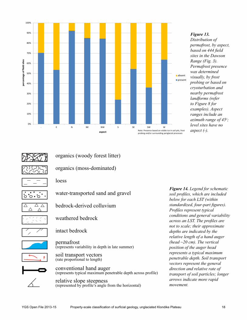
In order to illustrate a common sequence and distribution of LSTs, Figure 12 shows an idealized valley cross section of a typical major tributary of the Yukon River within the unglaciated Klondike Plateau. The sequence of LSTs shown on this figure is not consistent among all valleys, and rarely are all 12 LSTs present within a particular valley. Furthermore, the representation of permafrost underlying northerly aspects and not southerly aspects is an oversimplification. In fact, our observations corroborate the findings of Williams (1995) that aspect does not fully explain the distribution of permafrost (Fig. 13). What is important, though, is an appreciation for the general differences in slope geometry, surficial material thickness, and permafrost depth that distinguish each LST.
The LSTs are described below in the general north (left) to south (right) order presented in Figure 12. A four-part figure accompanies each LST description to show typical photographs from aerial, ground, and soil pit perspectives, as well as a schematic soil profile. Figure 14 defines the symbology used in the schematic soil profiles. Implications of each LST for the collection and interpretation of soil geochemistry data are discussed separately in the next section.
Figure 12. Schematic cross section of a major tributary of the Yukon River, showing an idealized north (left) to south (right) sequence of ‘landform-soil types’ (LSTs), numbered 1 to 12 across the top. Note that the order of LSTs is variable, and rarely do all occur in a single valley. Vertically exaggerated for illustrative purposes and not to scale. Based on Figure 9 of Bond and Lipovsky (2011).
Bedrockoutcrop
GLACIOFLUVIALTERRACE
ConcaveSlope-break
Permafrost table depressedbelow creek
INTACT BEDROCK
COLLUVIUM(CLAST-RICH)
WEATHEREDBEDROCK
COLLUVIUM(LOESS-RICH)
P E R M A F R O S T FLUVIALDEPOSITS
ORGANICS
121110987654321
Southerly AspectValley BottomNortherly Aspect
YGS Open File 2013-15 Property-scale classification of surficial geology, unglaciated Klondike Plateau 18
0%
10%
20%
30%
40%
50%
60%
70%
80%
90%
100%
- E N NE NW S SE SW W
perc
enta
ge o
f fiel
d si
tes
aspect
absent
present
Note: Presence based on visible ice in soil pits, frost probing and/or surrounding periglacial processes
Figure 13. Distribution of permafrost, by aspect, based on 444 field sites in the Dawson Range (Fig. 3). Permafrost presence was determined visually, by frost probing or based on cryoturbation and nearby permafrost landforms (refer to Figure 8 for examples). Aspect ranges include an azimuth range of 45o; level sites have no aspect (-).
organics (woody forest litter)
organics (moss-dominated)
loess
water-transported sand and gravel
bedrock-derived colluvium
weathered bedrock
intact bedrock
permafrost
soil transport vectors
conventional hand auger
(represents variability in depth in late summer)
(rate proportional to length)
(represents typical maximum penetrable depth across profile)
relative slope steepness(represented by profile’s angle from the horizontal)
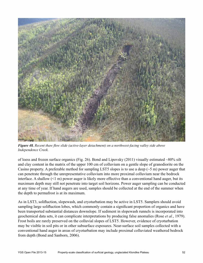
Figure 14. Legend for schematic soil profiles, which are included below for each LST (within standardized, four-part figures). Profiles represent typical conditions and general variability across an LST. The profiles are not to scale; their approximate depths are indicated by the relative length of a hand auger (head ~20 cm). The vertical position of the auger head represents a typical maximum penetrable depth. Soil transport vectors represent the general direction and relative rate of transport of soil particles; longer arrows indicate more rapid movement.
YGS Open File 2013-15 Property-scale classification of surficial geology, unglaciated Klondike Plateau 19
LST1 – Intact and Weathered Bedrock (e.g., xsDv/Rh)2
Intact and weathered bedrock (LST1) represents approximately 8% of the Dawson Range study area (Table 2, Fig. 15). LST1 is found extensively on summits, ridges, and spurs distributed throughout the area, although small areas of LST1 occur on isolated hills in some valley settings. LST1 typically occupies crest and upper slope positions, with convex slope profiles and variable aspect and steepness. The outer, downslope limits of LST1 are commonly defined by a subtle, yet abrupt concave break-in-slope separating the comparatively steep, fractured outcrops of LST1 from the surrounding smoother and gentler colluvial slopes (Fig. 16).
The character of landforms and soils within LST1 depends on local bedrock lithology and micro-topography. Summits and ridges underlain by intrusive bedrock (e.g., granodiorite) are commonly punctuated by tors, castellated towers of bedrock that are erosional remnants of a former plateau surface. Tors commonly occur in clusters, surrounded by a halo of angular, weathered blocks (Fig. 17). The soil derived from the in situ weathering of these blocks forms a pebbly to coarse sandy material known as grus, with low silt content (Schaetzl and Anderson, 2005; Dampier et al., 2011). Areas that are underlain by finer grained schist and gneiss rarely form tors, as they are more susceptible to physical and chemical weathering. Local relief tends to be lower in areas of schist and gneiss, where featureless rounded ridges are common. The resulting residual soils tend to weather from angular, elongated clasts into micaceous silty sand to sandy silt, with traces of clay (Schaetzl and Anderson, 2005).2 Based on the Terrain Classification System for British Columbia (Howes and Kenk, 1997).
500 m
NLST 1
Figure 15. Typical representations of LST1: (a) aerial photograph, (b) ground perspective, (c) soil pit and (d) schematic soil profile. Trowel in soil pit is 30 cm long.
a b
c d
YGS Open File 2013-15 Property-scale classification of surficial geology, unglaciated Klondike Plateau 20
Figure 17. Tors composed of granodiorite, surrounded by a ‘halo’ of felsenmeer and talus.
lSt2
lSt1
lSt1
YGS Open File 2013-15 Property-scale classification of surficial geology, unglaciated Klondike Plateau 21
Felsenmeer is generally more widespread than intact bedrock outcrop in LST1. On level ground and in hollows, loess is commonly trapped amongst blocks. The persistence of loess in these hilltop settings is likely made possible by the underlying highly fractured and permeable weathered bedrock. Such conditions allow surface water to drain relatively easily beneath the surface loess, inhibiting the further aggradation of permafrost. Some of the loess is transported into deeper regolith3 as evidenced by silt coatings on clasts at depth.
Periglacial processes exhibit the greatest influence on landforms and soils in areas of LST1. The intensity of freeze-thaw processes is particularly severe in alpine settings. Cryoturbation is common where soils have a significant amount of silt or clay, whether from in situ weathering of schistose bedrock or from loess. Distorted soil horizons and surface vegetation patterns provide evidence of relict and active cryoturbation, both of which have similar effects on soils. Cryoturbation mixes soils vertically, effectively buoying regolith from depth toward surface and drawing surface loess and regolith to depth. Frost boils are a surface manifestation of this cryoturbation. Frost boils are widespread and even visible in high-resolution aerial photographs on level and gently sloping ground in alpine areas (Fig. 18).
3 In this paper, the term ‘regolith’ is used synonymously with weathered bedrock.
100 m
N
Figure 18. Frost boils from three perspectives: (a) vertical aerial photograph, (b) oblique aerial photograph and (c) ground. Yellow circles define individual frost boils on (a), (b) and (c). Lichen-dominated centre of frost boil in (c) is about 3 m across.
a b
c
YGS Open File 2013-15 Property-scale classification of surficial geology, unglaciated Klondike Plateau 22
Permafrost is assumed to underlie nearly all areas of LST1, especially in alpine settings, although it is generally at sufficient depth within stony regolith that it may not be encountered during soil sampling. Its presence is inferred based on surface geomorphological evidence, such as stone stripes and nets, cryoplanation terraces, and large frost boils, as well as the observations made by Côté (2002) of permafrost distribution in central Yukon. On gentle ground with fine-grained soils in blocky areas, permafrost was commonly encountered. Soil drainage ranges from rapid on outcrops to poor in hollows underlain by permafrost.
Vegetation cover in areas of LST1 is discontinuous (typically less than 40%) and felsenmeer and exposed bedrock are widespread. Vegetation is able to establish in rock crevices and depressions among blocks, where finer grained sediments have accumulated. In alpine settings of LST1, by far the most common, vegetation is dominated by a variety of lichens and small alpine plants including mountain avens and dwarf willow (AECOM, 2011). In the less common LST1 areas below treeline, species composition is similar to that of surrounding areas, although there may be greater evidence of stress from thinner, droughtier soils in areas of outcrop. Stunted Alaska birch and trembling aspen tend to grow on lower elevation outcrops.
LST2 – Mixed Weathered Bedrock and Colluvium (e.g., xsDv/xzsCv)
Mixed weathered bedrock and colluvium (LST2) represents approximately 7% of the Dawson Range study area (Table 2, Fig. 19). LST2 is predominant immediately below summit areas, on the shoulders of major ridges, and along spurs. Most occurrences of LST2 are in crest and upper slope positions, with convex slope profiles and variable aspect and steepness. Where it is downslope of LST1, comparatively gentler areas of LST2 are commonly defined by a concave slope-break (Fig. 16). narrow bands of LST2 also exist near the toes of some valley sides, where a conspicuous bedrock-controlled, convex slope-break has formed in response to rapid stream bed degradation.
Gentle slopes of LST2, particularly in areas underlain by intrusive bedrock, are commonly punctuated by subdued, bedrock-controlled steps formed by differential erosion. These ‘knickpoints’ may be recognized by conspicuous patches of boulder-sized felsenmeer, in addition to a slight slope-break (Fig. 20). Intact bedrock is close to surface. Over time, material originating from these knickpoints is transported downslope by a combination of soil creep and solifluction. In some cases, vegetation patterns reveal the smooth, sinuous path the colluvium has traveled around the knickpoints through colluvial and periglacial processes. In areas underlain by schistose or gneissic bedrock, the soils tend to have smaller clasts and a finer grained matrix and knickpoints are rare.
Only small areas of residual soils may be found in LST2, in the immediate vicinity of the knickpoints described above. A jigsaw puzzle-like arrangement of clasts is indicative of in situ weathered bedrock. Although most soils have been displaced from source and may be overlain by, or intermixed with, loess, total thicknesses rarely exceed one metre.
Permafrost commonly underlies areas of LST2, especially in alpine settings, although it may be at sufficient depth within weathered bedrock that it would not be detected with manual methods of investigation. Its presence is inferred from observations of ponded water perched on underlying permafrost visible on aerial photographs and during helicopter reconnaissance flights. Soils are well drained in areas of felsenmeer to poorly drained in finer grained colluvial soils underlain by permafrost.
Vegetation patterns in LST2 reflect the distribution of felsenmeer. Within patches of boulder-sized blocks, rock lichens and mosses are dominant. Willow species and a few other dwarf shrubs are
YGS Open File 2013-15 Property-scale classification of surficial geology, unglaciated Klondike Plateau 23
restricted to depressions among boulders with loess-rich colluvium (AECOM, 2011). Along the crests of lower elevation spurs, where periglacial processes are less active, vegetation may be difficult to distinguish from forests growing on adjacent slopes. The ground may be shrub-dominated in areas where bedrock is shallowest or where blocky material inhibits the establishment of tree roots.
500 m
N
LST 2
a b
c d
Figure 19. Typical representations of LST2: (a) aerial photograph, (b) ground perspective, (c) soil pit, and (d) schematic soil profile. Soil pit is about 30 cm deep.
Figure 20. Bedrock-controlled ‘knickpoints’ of mostly in situ weathered bedrock, in LST2, with colluvial talus downslope.
YGS Open File 2013-15 Property-scale classification of surficial geology, unglaciated Klondike Plateau 24
LST3 – Loess-rich Colluvial Veneer (e.g., xzsCv)
Loess-rich colluvial veneers (LST3) are the most common LST, representing about 30% of the study area (Table 2, Fig. 21). LST3 most commonly occurs in upper slope positions with convex slopes or in mid slope positions with straight slopes. LST3 exhibits the greatest range in slope steepness, from negligible slope on alpine benches to convex rolls on valley sides that locally exceed 45o (Appendix A). Although LST3 occurs on all aspects, it is slightly more common on northerly aspects than on southerly aspects.
Slopes of LST3 follow underlying bedrock topography. They are generally smooth, but may have isolated knickpoints or other irregularities in areas of shallow or exposed bedrock. Soil profiles are rarely more than one metre deep. Profiles typically include weathered bedrock at depth with progressively greater amount of colluvium toward surface, which in terms of provenance reflects increasing displacement from source, toward surface (Bond and Sanborn, 2006). Intermixed with the bedrock-derived colluvium is loess, which generally decreases in concentration with depth.
Periglacial processes increase the rate of colluviation within alpine areas of LST3. Soil creep, solifluction, and slopewash transport material within the active layer downslope. In some locations, conspicuous solifluction lobes indicate downslope displacement of coherent masses. Excavations into the fronts of solifluction lobes revealed the process described by Kinnard (2003) whereby frontal
500 m
N
LST 3
Figure 21. Typical representations of LST3: (a) aerial photograph, (b) ground perspective, (c) soil pit, and (d) schematic soil profile. Trowel in soil pit is 30 cm long.
a b
c d
YGS Open File 2013-15 Property-scale classification of surficial geology, unglaciated Klondike Plateau 25
movement occurs by soils ‘rolling over’ and entraining the surface organic layer (Fig. 22). More rapid movement usually occurs at the surface within solifluction lobes, but cases of greater movement at depth have been reported from vegetated lobes in the Ruby Range (Price, 1991). In areas of moderate to steep LST3, landslides are another process responsible for transporting material downslope.
Permafrost is nearly continuous within LST3, but at depths ranging from about 15 cm to more than 75 cm. This is the largest observed range in permafrost depth in the study area. Areas of shallowest permafrost are typically enriched in loess near the surface and insulated by a thick moss cover, whereas the areas of deeper permafrost are generally dominated by coarser grained, bedrock-derived colluvium with lichens at surface. Soils are moderately well to poorly drained, depending on the silt content and depth to permafrost.
Vegetation in alpine areas of LST3 is dominated by mosses, lichens, dwarf birch (Betula glandulosa), and various willow species (AECOM, 2011). A variety of low shrubs with berries also comprises an important portion of the ground cover. Below treeline, vegetation within LST3 may be more diverse. Subalpine areas of LST3 may still be dominated by mosses, lichens, and dwarf birch, but sparse stands of stunted black spruce are common. At mid to low elevations, the tree canopy becomes taller and denser. Black spruce commonly still dominates the tree species, but it may be mixed with white spruce, Alaska birch, and water birch (Betula occidentalis).
Landslide-affected colluvial veneers (LST4) represent approximately 4% of the Dawson Range study area (Table 2, Fig. 23). LST4 slopes are most common in mid elevation to subalpine drainages. LST4 is the only LST observed exclusively on northerly aspects, principally on north-facing slopes (337.5 to 022.5o) (Appendix A). All areas of LST4 are underlain by relatively shallow (<1 m) permafrost. They exhibit dominantly convex slope profiles in upper to lower slope positions. LST4 has the highest mean slope steepness of the LSTs that are underlain by permafrost (i.e., nearly 20o).
Figure 22. Excavation into partly thawed front of moss-covered solifluction lobe, showing the incorporation of organic material into the soil profile. Trowel is 30 cm long and pointing downslope.
a b
YGS Open File 2013-15 Property-scale classification of surficial geology, unglaciated Klondike Plateau 26
Like LST3, LST4 exhibits thin (<1 m), loess-rich colluvial soils that follow underlying bedrock topography. LST4 slopes are distinguished from LST3 slopes by the prevalence of landslides. This is evident from conspicuous, downslope-oriented ‘stripes’ of deciduous trees growing on a valley side otherwise dominated by sparse, stunted black spruce with a thick, mossy understory (Fig. 24). These stripes generally have a uniform width or a narrow, upslope-pointing fan shape. Both of these vegetation patterns delineate the boundaries of recent (<100 years) landslide paths, based on the approximate age of deciduous trees. Some of the paths have accumulated a boulder lag, due to preferential winnowing of fine-grained material by surface runoff.
All landslides observed in this project and reported in the literature from nearby sites (e.g., Lipovsky et al., 2006; Coates, 2008) likely resulted from an ‘active-layer detachment’, whereby the active layer slid (or flowed) downslope on the permafrost table or on an ice-rich horizon above the permafrost table. According to Coates (2008), most of these slides initiate near convex slope-breaks on slopes as gentle as 12o. The shallow landslides strip the insulating organic cover from the surface, exposing the active layer to increased solar radiation, causing it to deepen. Pioneer species of deciduous trees take advantage of the locally deeper permafrost table and eventually form a conspicuous stripe on the valley side. Recurrent shallow landslides result in slope-parallel stratigraphy, which is visible in the sidewalls of failures and in thermo-erosion gullies that have incised some former landslide paths (Fig. 23c,d). Colluvium layers, some of which are dominated by loess, alternate with discontinuous layers of organic material (Smith et al., 2009). During the first portion of the recovery period, minor slope failures and upslope regression continue, increasing the amount of sediment and organic matter delivered to lower slope positions. Burn and Friele (1989) monitored the evolution of such slope failures using historical
500 m
N
LST 4
Figure 23. Typical representations of LST4: (a) aerial photograph, (b) ground perspective, (c) soil pit, and (d) schematic soil profile. Note the buried organic horizons (dark bands) in the soil pit (c). Trowel in soil pit is 30 cm long.
a b
c d
YGS Open File 2013-15 Property-scale classification of surficial geology, unglaciated Klondike Plateau 27
aerial photographs and field reconnaissance, and determined that permafrost was not re-established until several decades after the original event. Coates (2008) suggested that this type of event occurred thousands of times during the Pleistocene and is responsible for some of the valley side morphology within the Dawson Range. Depending on the frequency of landsliding in a particular area, the surface expression of the failures (stripes) may not be present. Smith et al. (2009) dated buried peat and charcoal from similar settings near Dawson, producing eight ages between 350 and 3700 14C years BP, suggesting that paleo-landsliding may have contributed to the evolution of the soils, despite the lack of surface stripes on the slope today.
Soil drainage within LST4 contrasts sharply between the main moss-covered slope and the treed landslide paths. On the main slope, where permafrost is commonly shallow, soils are imperfectly to poorly drained. Permafrost extended into the surface organic layer in nearly one-quarter of LST4 sites investigated, and it contained more segregated ice (discrete lenses) than any other LST. Immediately adjacent to the landslide path, within the deciduous stripe, soils are moderately well to imperfectly drained above a depressed permafrost table. Small springs that discharge sediment-laden groundwater through conduits in the permafrost are commonly observed in lower slope positions (Fig. 25). Such ‘sand springs’ are responsible for depositing thin veneers of sand across the ground surface. Some also contribute to thermo-fluvial erosion.
Figure 24. Linear to fan-shaped ‘stripes’ of deciduous trees on a moderately steep, north-facing slope underlain by permafrost and otherwise dominated by an open canopy of stunted black spruce with a mossy understory. The upslope limit of the stripes represents the headscarp of a thaw flow slide (active-layer detachment), which may have retrogressed upslope since the original landslide.
YGS Open File 2013-15 Property-scale classification of surficial geology, unglaciated Klondike Plateau 28
Vegetation on slopes of LST4 comprises mosses, including peat moss (Sphagnum spp.), with lesser amounts of lichens, dwarf shrubs, and stunted black spruce (AECOM, 2011). Pioneer species such as alder, Alaska birch, and some balsam poplar dominate recent landslide paths, where surface runoff is concentrated. Over time, deciduous trees are outcompeted by black spruce and mossy understory. If the frequency of landsliding is sufficient, the thermal regime of the slope will be altered and the ecosystem will adapt to the new thermal and moisture regimes.
LST5 – Loess-rich Colluvial Blanket (e.g., xzsCb)
Loess-rich colluvial blankets (LST5) represent approximately 9% of the study area (Table 2, Fig. 26). They are distributed relatively evenly throughout the area, mainly in upper to mid slope positions. Although LST5 occurs on all aspects, it is most commonly on gentle to moderate, northerly slopes. Slopes of LST5 can be convex, straight, or concave.
Areas of LST5 are distinguished from areas of LST3 and LST4 by the depth of their soils. Although the soils within LST5 generally follow underlying bedrock topography, they are more than one metre deep and may be in the order of 10 m deep in longitudinal concavities on gentle slopes. LST5 has a distinctly smooth surface expression, without abrupt breaks-in-slope or gullies (Fig. 27). A typical soil profile consists of a weathered bedrock layer at depth, grading into colluvium with an increasingly high displacement from source toward the surface. Loess is common at the surface and is generally intermixed within the upper portion of colluvium, as a result of cryoturbation and localized settling of fine-grained particles to greater depths within the active layer.
The typical variety of colluvial and periglacial processes described previously (i.e., soil creep, solifluction) influences the formation and character of LST5. Slopes that exhibit a ‘lineated’, flow-like appearance also experience mass transfer through slopewash (Figs. 26b and 27). The lines discernible in the vegetation patterns are runnels, shallow runoff channels most active during the spring snowmelt (Zoltai and Pettapiece, 1973). Within these runnels, which may also occur in other LSTs underlain by permafrost, sediment has been washed downslope by meltwater. Landsliding occurs as well, but not as frequently as in the steeper LST4. Much of the LST5 soil profile is frozen, with permafrost depths
Figure 25. Sand and silt deposited immediately downslope of a spring where subsurface water discharges to surface. Such sites are common in lower slope positions of LST3, LST4 and LST5.
YGS Open File 2013-15 Property-scale classification of surficial geology, unglaciated Klondike Plateau 29
500 m
N
LST 5
Figure 26. Typical representations of LST5: (a) aerial photograph, (b) ground perspective, (c) soil pit, and (d) schematic soil profile. Soil pit is about 70 cm deep, including surface organics.
Figure 27. Smooth slopes of LST5 in late summer. Note the slopewash runnels defined by the linear pattern of mostly willows (yellow-green) on an otherwise mossy slope with dwarf birch (red-brown). Sediment within runnels may have been transported hundreds of metres downslope.
a b
c d
YGS Open File 2013-15 Property-scale classification of surficial geology, unglaciated Klondike Plateau 30
ranging from about 20 to 80 cm. Permafrost extends into the surface organic layer in some areas. Soils are nearly always imperfectly to poorly drained in LST5, due to shallow permafrost and loess-rich soils inhibiting infiltration and throughflow.
Only vegetation that is tolerant of permanently wet to saturated soil conditions grows within LST5. Dominant ground cover species include mosses, with lesser amounts of lichen growing on the slightly elevated surfaces of hummocks. Trees, if present, are generally stunted black spruce with an open canopy. In areas of more rapid downslope soil movement, the trunks may be teetering or contorted (Fig. 28).
LST6 – Loess-rich Colluvial Apron (e.g., zsxCa)
Loess-rich colluvial aprons (LST6) only represent about 6% of the study area (Table 2, Fig. 29), but they are a unique and important feature of the unglaciated region. LST6 is scattered throughout the study area across a wide range of elevations, but is largest and most widespread at lower elevations in the Dip Creek valley and near the mouths of the major tributaries of the Yukon River. LST6 has a straight or concave profile and occurs on all aspects, predominantly in toe slope positions. Commonly demarcating the upper limit of LST6 is a conspicuous concave slope-break or inflection point, which commonly coincides with an abrupt change in soil drainage and vegetation (Fig. 30). In cross section, LST6 is a wedge, with the thickest portion in the valley bottom and thinner material upslope.
LST6 areas have been mapped and well described by Huscroft (2002) as “colluvial eolian complexes”, owing to their complex sedimentology and origin. LST6 is an aggradational landform, built up over time through the delivery of sediments from upslope by minor incremental and episodic colluvial and fluvial additions. The aprons have been described in considerable detail by researchers working in the Klondike goldfields surrounding Dawson (e.g., Fraser, 1995; Fraser and Burn, 1997). First described as ‘muck’ deposits in the early 1900s (Tyrell, 1917), these aprons consist of primary and redeposited loess, fluvial and slopewash sediments, bedrock-derived colluvium, and organic material. Fraser (1995) and Fraser and Burn (1997) identified two major stratigraphic units in aprons in the Klondike goldfields: 1) a silt-dominant lower unit of mainly late Pleistocene age, and 2) an overlying organic unit of Holocene age. Landslides that delivered sediment and woody debris from upper valley sides into valley bottoms within the past decade confirm that they are still active (Fig. 31).
Figure 28. Sparse, stunted black spruce with contorted (foreground) or tilted (background) trunks, indicative of active soil creep or solifluction.
YGS Open File 2013-15 Property-scale classification of surficial geology, unglaciated Klondike Plateau 31
Figure 29. Typical representations of LST6: (a) aerial photograph, (b) ground perspective, (c) soil pit, and (d) schematic soil profile. Soil pit, with buried or cryoturbated organics in bottom of pit, is about 65 cm deep.
Figure 30. Valley bottom loess-enriched colluvial apron (LST6) grading into a fluvial plain (LST8). Note the conspicuous concave slope-break and vegetation change that separates LST6 from LSTs upslope.
500 m
N
LST 6
LST 6
a b
c d
lSt8
lSt6
lSt3
lSt6
lSt6 lSt11
slope-break
straight or concave
convex
YGS Open File 2013-15 Property-scale classification of surficial geology, unglaciated Klondike Plateau 32
The sedimentology of LST6 is highly variable, depending primarily on steepness and upslope drainage area. The slope of the aprons is an indicator of their internal composition. For example, in the broad valley through which Dip Creek meanders, long colluvial aprons line the base of the subdued mountains along the south side of the valley. Below the organic cover, the soils in this area are dominated by silt and clay washed from the slopes and drainages above. In narrow headwater tributaries, LST6 exhibits more sedimentological evidence of soil creep and landsliding. Isolated lenses of cobbly, bedrock-derived colluvium are common.
Aggradation of permafrost within the aprons generally kept pace with the deposition and accumulation of loess during the late Pleistocene (Fraser, 1995). A thick cover of mosses with high insulating value has enabled the permafrost to persist at shallow depths, including massive ice bodies, even during the relatively
warm Holocene. Deeper permafrost has persisted in the Klondike goldfields since >700 ka BP, through periods warmer than at present (Froese et al., 2008). Surface organics in LST6 are some of the thickest of any LST, and they may extend beneath the permafrost table. Soil drainage is imperfect to very poor, due to shallow permafrost, loess-rich soil, and gentle gradients.
Vegetation in LST6 is almost always distinct from that of the LST immediately above. A thick cover of mosses with areas of lichen is typical, with a sparse to dense canopy of stunted black spruce. Patches of willow are common.
LST7 – Organic Plain (e.g., eOp)
Organic plains (LST7), defined by their flat surface and infilling of shallow depressions, only represent about 1% of the study area (Table 2, Fig. 32). They are most common on terraces alongside the Yukon River and in the back portions of the floodplains of some of its larger tributaries, such as Dip Creek.
Figure 31. Partly overgrown thaw flow slide (active-layer detachment) that transported sediment and organic debris hundreds of metres downslope onto a slope-toe apron (LST6).
YGS Open File 2013-15 Property-scale classification of surficial geology, unglaciated Klondike Plateau 33
LST7 is similar to LST6, with a thick organic cover and shallow permafrost. At approximately one-quarter of LST7 sites visited, the permafrost table was within the surface organics (Appendix A). Beneath the organic layer are fine-grained flood deposits, or primary or redeposited loess, typically overlying fluvial sand and gravel.
The edges of organic plains may be subject to colluviation from hill slopes above. Otherwise, organic plains are only subject to fluvial and periglacial processes. Major flood events may spread into wetland areas, depositing a thin film of silt and clay that infiltrates the fibers of the organic material. More frequently, meander migration can gradually erode an otherwise stable organic plain. Conspicuous geometric patterns expressed in some wetlands reflect the configuration of underlying ice wedge polygons (Fig. 9b). Permafrost thawing is common in areas of natural (e.g., tree windthrow) or anthropogenic (e.g., vehicle tracking) ground disturbance, where the insulating organic cover is compacted or removed. numerous thermokarst ponds and gullies have formed in areas of ice-rich permafrost where the ground was disturbed (Fig. 9a).
Permafrost is believed to underlie all wetlands characterized as LST7. It was encountered in more than 60% of the sites visited and is inferred to be present at depth in the others. LST7 has the shallowest permafrost (on average ~32 cm) and the narrowest range in depth (~15 cm) to the bottom of the active layer of any LST. Drainage is consistently poor to very poor, due to the shallow permafrost and topographic position.
500 m
N
LST 7
Figure 32. Typical representations of LST7: (a) aerial photograph, (b) ground perspective, (c) soil pit, and (d) schematic soil profile. Soil pit, with permafrost in organics on pit bottom, is about 25 cm deep.
a b
c d
YGS Open File 2013-15 Property-scale classification of surficial geology, unglaciated Klondike Plateau 34
Most areas of LST7 are treeless, except for a few stunted black spruce growing on better-drained hummocks or along the tops of stream banks. The type of vegetation covering the ground relates to the drainage and nutrient conditions. Areas of relatively stagnant groundwater are dominated by red-stemmed feathermoss (Pleurozium schreberi), step moss (Hylocomium splendens), and peat moss, which effectively insulate near-surface permafrost. Tussocks of sheathed cotton-grass (Eriophorum vaginatum) grow in areas of slightly greater throughflow and slightly deeper permafrost (Fig. 33) (AECOM, 2011).
LST8 – Fluvial Plain (e.g., sgzFAp)
Fluvial plains (LST8), also known as alluvial plains, represent about 3% of the study area (Table 2, Fig. 34). This term is used in a general sense to encompass all fluvial landforms, including active channels, floodplains, terraces, and fans. LST8 exhibits negligible slope with variable or no aspect. The Yukon River has the widest and most continuous fluvial plain within the region, but narrower, discontinuous fluvial plains also occur in association with its tributaries. In general, the width and continuity of fluvial plains increases proportionally with stream order (Strahler, 1952).
The characteristics of LST8 transition from headwater reaches to main branches. In headwater reaches within V-shaped valleys (i.e., first to second-order streams), stream bed and bank material is generally subangular to subrounded gravel to boulders, and floodplains may or may not exist. Particularly angular
Figure 33. Tussocks of sheathed cotton-grass with meltwater perched on permafrost at the edge of an organic plain (LST7).
YGS Open File 2013-15 Property-scale classification of surficial geology, unglaciated Klondike Plateau 35
cobbles and boulders may be colluvial lag deposits. Along streams of intermediate size (i.e., second to third-order streams), subrounded to rounded gravel forms the bed of the meandering channel, and banks may include sand and silt deposited during flood events. Floodplains are narrow and discontinuous. Along the largest meandering watercourses (i.e., third to fourth-order streams), bed material consists of rounded to well-rounded gravel and sand, and bank exposures indicate that the wide, continuous floodplains are composed of sand, silt, and possibly organics.
Fluvial terraces commonly perched on bedrock terraces adjacent to some of the larger tributaries are a testament to the marked degradation that occurred during the Pleistocene (Bond and Lipovsky, 2011). The highest terraces occur in the lower reaches of the major tributaries of the Yukon River, such as Britannia Creek, Coffee Creek, and Independence Creek (Fig. 35). Most of these terraces are blanketed in loess and colluvium, making their recognition in the field challenging. However, the sharp break-in-slope formed by the terrace scarp is unmistakable in aerial photographs. The stream-deposited sediment in these fluvial terraces is generally a mixture of sand and rounded gravel.
Fluvial fans exist at the mouths of moderate to large tributaries, where they are less confined and channel gradients decrease abruptly. They have slightly steeper gradients than regular fluvial plains and terraces, so they contain coarser grained sand and gravel and less silt. Clasts may be subangular at the apices of the fans of small, steep drainages, due to the relatively short transport distance and duration.
500 m
N
LST 8
Figure 34. Typical representations of LST8: (a) aerial photograph, (b) ground perspective, (c) soil pit, and (d) schematic soil profile. Trowel in soil pit, which reveals multiple flood events and buried organics, is 30 cm long.
a b
c d
YGS Open File 2013-15 Property-scale classification of surficial geology, unglaciated Klondike Plateau 36
Most LST8 environments are subject to meander migration through progressive bank erosion or avulsion. numerous oxbows alongside meandering streams indicate periods of instability; some enlarge through thermokarst processes. Areas of the floodplain farther from the active channel may be sufficiently stable that organic material can accumulate at the surface. unless buried by flood sediments, these organics thicken and promote the growth of underlying permafrost. The depth to permafrost varies spatially and temporally within LST8 as a function of organic matter thickness and proximity to permanently flowing streams. Frequently flooded sites are permafrost-free, because an appreciable organic layer is unable to accumulate in areas prone to erosion and sedimentation. Sites with an intermediate flooding regime typically have no permafrost, or deep permafrost below the rooting zone of riparian vegetation. Stable terraces accumulate enough organics, which act as an insulator, that permafrost commonly aggrades (Viereck, 1973; Zoltai and Pettapiece, 1973).
Soils within LST8 are well drained in areas of active fluvial processes to very poorly drained in oxbows close to the groundwater table. As a result, vegetation is also highly variable across fluvial plains. The riparian strip closest to the channel is commonly sufficiently well drained for shrubs or trees to grow. Willow species are abundant, and balsam poplar and tall white spruce occupy relatively stable sites. An abrupt change in vegetation from a tall, dense canopy of trees to stunted or no trees commonly signifies the edge of shallow permafrost.
LST9 – Glaciofluvial Terrace (e.g., sgFGt)
Glaciofluvial terraces (LST9) are rare within the unglaciated Klondike Plateau, representing <1% of the study area (Table 2, Fig. 36). They occur mainly above the modern Yukon River, which was filled to varying elevations with a braided meltwater river through most of the Pleistocene glaciations. The meltwater also spilled into the lower reaches of major tributaries, depositing sand and gravel near their mouths. Glaciofluvial terraces are distinguished from fluvial terraces based on their landscape position, thickness, and the inclusion of well-rounded cobbles with lithologies foreign to the local watershed.
Figure 35. Convex slope-break at the top of a terrace scarp formed by fluvial down-cutting along lower Coffee Creek valley during the late Pliocene to early Pleistocene. The bedrock terraces are capped by fluvial deposits (LST8), which are commonly overlain by upslope colluvium (LST6).
lSt8
lSt6
lSt3
lSt6
lSt11
terrace scarp
lSt8
lSt7lSt8
lSt8
lSt12
lSt3
YGS Open File 2013-15 Property-scale classification of surficial geology, unglaciated Klondike Plateau 37
LST9 can be identified both in aerial photographs and during helicopter fly-overs. In response to its flow reversal, the Yukon River has undergone significant degradation (Tempelman-Kluit, 1980; Jackson et al., 2008). Glaciofluvial sand and gravel overlies some of the rock benches alongside the modern river. In some areas, colluviation from upslope areas and along the terrace scarp has made the terrace forms almost unrecognizable (Fig. 36b). The conspicuous slope-break and linearity in vegetation patterns are the key diagnostic characteristics. Investigation of a glaciofluvial terrace perched on a bedrock ridge about 220 m above the current level of the Yukon River, near the mouth of Isaac Creek (Fig. 37), showed that the terrace comprises sand and well-rounded gravel, with thicknesses in excess of several tens of metres.
Broader glaciofluvial terraces parallel the Yukon River at lower elevations. The Coffee Creek airstrip is built on a terrace less than 10 m above the modern river level. Its coarse sand and gravel base is overlain by a discontinuous veneer of fine-grained flood deposits and loess (Fig. 38). Although glaciofluvial terraces tend to be well drained, permafrost was encountered during gravel extraction at a depth of about 5 m.
Large glaciofluvial terraces, not covered by colluvium, support mature vegetation communities including white spruce, black spruce, and Alaska birch. The understory is dominated by thin step moss and prickly rose (Rosa acicularis) (AECOM, 2011). Surface organics are derived from the decomposition of woody forest litter, rather than peat mosses.
500 m
N
LST 9
Figure 36. Typical representations of LST9: (a) aerial photograph, (b) ground perspective, (c) soil pit, and (d) schematic soil profile. Soil pit is about 50 cm deep.
a b
c d
terrace scarp
YGS Open File 2013-15 Property-scale classification of surficial geology, unglaciated Klondike Plateau 38
x
Figure 37. Glaciofluvial terrace (dashed line) on a ridge about 220 m above the Yukon River, with sand and rounded gravel excavated from its surface (inset soil pit from the site marked by the “x”).
Figure 38. Gravel pit excavated into a glaciofluvial terrace on which the Coffee Creek airstrip is located. Note the small puddles perched on permafrost at the bottom of the pit.
lSt9
Isaac creek
Yukon river
disturbed loess and organics
glaciofluvial sand and gravel
fine-grained flood deposits
covered
thawing permafrost on pit bottom
~5 m
YGS Open File 2013-15 Property-scale classification of surficial geology, unglaciated Klondike Plateau 39
Clast-rich colluvial blankets (LST10) represent only about 3% of the study area (Table 2, Fig. 39). They are scattered across the Dawson Range and occur mostly in mid to lower slope positions on southerly aspects. LST10 is straight to concave in profile, with an observed steepness range of about 15 to 25o.
The smooth, straight to concave profile characteristic of LST10 enables more colluvium to accumulate than on the convex slopes of LST11. Resulting soil thicknesses exceed one metre, although usually to a maximum thickness of only a few metres. Bedrock-derived colluvium is dominated by angular clasts and a sandy to silty-sand matrix, and is overlain in some areas by a thin veneer of loess (<20 cm). The loess cap is typically undisturbed at surface, but is shallowly intermixed through downward migration during infiltration of rainwater and snowmelt.
Soil creep and sheetwash transport material downslope, resulting in a crude stratification in the soil (Figs. 39c and 40). Material at depth, close to the bedrock surface, has been transported considerably less distance than material near surface, which rafts downslope above the entrainment zone (Fig. 41). Lithological stratification may be pronounced on slopes underlain by more than one type of bedrock (Bond and Sanborn, 2006). Soils in areas of LST10 are permafrost-free, moderately to well drained, and generally capped by woody forest litter. Charcoal may occur within the upper horizons, providing evidence of forest fires.
500 m
NLST 10
Figure 39. Typical representations of LST10: (a) aerial photograph, (b) ground perspective, (c) soil pit, and (d) schematic soil profile. Trowel in soil pit, which reveals a buried organic layer, is 30 cm long.
a b
c d
YGS Open File 2013-15 Property-scale classification of surficial geology, unglaciated Klondike Plateau 40
bedrock
colluvium
rafting zone
entrainment zone
weathered bedrock
Figure 40. Crudely stratified colluvium exposed in a gully on a permafrost-free slope of LST10. Note the buried organic horizons, above which material has been ‘rafted’ from upslope. Hand auger is about 1.2 m long.
Figure 41. Schematic representation of the main processes transporting colluvium down a permafrost-free slope (based on field observations, Figure 9.2 of Rose et al. (1979) and Figure 17 of Bond and Sanborn (2006)). Fragments of in situ weathered bedrock become entrained by soil creep and are increasingly displacedfrom their source as they are buoyed upward through dispersive pressure and seasonal frost heave. At some height above the bedrock surface, sediments may not be sourced through entrainment of local bedrock but are ‘rafted’ from upslope. More resistant lithologies, such as quartz clasts, may persist within the rafting zone for a greater distance. A hand auger (~1.2 m) is drawn for approximate scale and to highlight the importance of collecting soil samples as deeply within the entrainment zone as possible on permafrost-free colluvial slopes in order to sample material locally derived as oppose to colluvium transported some unknown distance downslope. This schematic also illustrates how lithological stratification develops in a colluvial soil profile. The arrows represent the trajectory and relative rate of transport of soil particles.
buried organic horizons
YGS Open File 2013-15 Property-scale classification of surficial geology, unglaciated Klondike Plateau 41
Healthy, mature forests typically grow on LST10. The tree canopy is generally tall, dense, and relatively uniform in species composition, reflecting the consistent textural, moisture, and nutrient conditions. Stands of white spruce, mixed white and black spruce, or trembling aspen are common. The understory consists of thin step moss or bluejoint reedgrass (Calamagrostis canadensis) (AECOM, 2011).
LST11 – Clast-rich Colluvial Veneer (e.g., xszCv)
Clast-rich colluvial veneers (LST11) are widespread within the Dawson Range, occurring at all elevations and representing approximately 21% of the study area (Table 2, Fig. 42). LST11 is most common in mid slope positions with an average steepness of more than 20o. LST11 occurs on all aspects but is more commonly found on south and southwest-facing, convex or straight slopes.
LST11 is distinguished from LST10 by its thinner colluvium, which is partly a function of its convex slope geometry, and from LST3 by its absence of permafrost within loess-enriched soils. On LST11 slopes, less than one metre of colluvium overlies weathered or intact bedrock. Small outcrops are common, particularly at convex slope-breaks. Angular clasts of local bedrock weather into finer grained particles that get entrained by soil creep into progressively shallower horizons, with progressively greater displacement from source. At about half of the sites visited, a thin veneer of loess tops the colluvial soil. Where it is undisturbed, its thickness is generally <25 cm, although it may be intermixed in the upper half metre of colluvium.
500 m
N
LST 11
Figure 42. Typical representations of LST11: (a) aerial photograph, (b) ground perspective, (c) soil pit, and (d) schematic soil profile. Trowel in soil pit is 30 cm long.
a b
c d
YGS Open File 2013-15 Property-scale classification of surficial geology, unglaciated Klondike Plateau 42
As in LST10, soil creep and sheetwash are the principal mechanisms transporting material in LST11 downslope. The same entrainment and rafting process described above for LST10 and illustrated in Figure 41 occurs in LST11; the difference, however, is that the ‘rafting zone’ in LST11 is thinner and easily penetrated by a hand auger. Soils in LST11 are generally moderately to rapidly drained, free of permafrost, and capped by woody forest litter.
The pattern of vegetation exhibited by LST11 is less uniform than that of LST10. Deciduous trees, mainly trembling aspen, are more common than coniferous species, due to droughty soils. White spruce and black spruce may be mixed. The understory is dominated by small drought-tolerant shrubs (e.g., common bearberry (Arctostaphylos uva-ursi)), bluejoint reedgrass or thin step moss (AECOM, 2011). Patchiness in the vegetation pattern, as visible in aerial photographs or observed during helicopter fly-overs, commonly indicates the presence of bedrock outcrops. Stunted trembling aspens may grow in these areas with outcrop.
Thin clast-rich colluvial veneers (LST12) are distinct but somewhat uncommon, representing only about 1% of the study area (Table 2, Fig. 43). LST12 is distinguished from LST11 based on the thinness of its colluvial soils and commonness of bedrock outcrops. Areas of LST12 are generally small, limited to single hill faces or portions of slopes. LST12 is more dependent on aspect and slope than other LSTs, with nearly all occurrences on steep (~30o average), south-facing slopes where annual solar insolation is at a maximum (Appendix A). LST12 occurs mainly on convex to straight, upper to mid slopes, which shed water (and sediment) rapidly.
500 m
N
LST 12
a b
c d
Figure 43. Typical representations of LST12: (a) aerial photograph, (b) ground perspective, (c) soil pit, and (d) schematic soil profile. Trowel in soil pit is 30 cm long and extends slightly above ground surface.
YGS Open File 2013-15 Property-scale classification of surficial geology, unglaciated Klondike Plateau 43
The soil depth of LST12 varies slightly in association with bedrock surface topography, with an average of about 0.2 m. The thin colluvial soil, which may be intermixed with loess, is easily penetrated with a hand auger to the underlying regolith. Sanborn (2010) detailed the characteristics of the soils that develop in these distinct settings.
Colluvial processes are active in LST12. In addition to the common soil creep, more rapid mass movements, including snow avalanches and rock fall, frequently transport material downslope (Fig. 44). Localized sheetwash is common, aided by incomplete vegetative ground cover, as is sliding of clasts down exposed, saturated soils during intense rainfall. Soils are rapidly drained, due to the underlying slope steepness and shallow depth to bedrock.
LST12 stands out prominently in aerial photographs and in the field because of its unique vegetation (Fig. 43a,b). Portions of these slopes are treeless, and may appear unvegetated. Purple reedgrass (Calamagrostis purpurascens), common bearberry, and juniper (Juniperus communis) typically dominate the ground cover (AECOM, 2011). Trembling aspens grow where the soils are sufficiently thick and fine grained for roots to establish; stunted variants are common in the areas of shallowest bedrock and most droughty soils.
Figure 44. Recent rock fall deposit against a young trembling aspen (Populus tremuloides) growing below a bedrock outcrop on a steep slope of LST12. Note the small patches of exposed soil to the right of the rock.
YGS Open File 2013-15 Property-scale classification of surficial geology, unglaciated Klondike Plateau 44
IMPlIcAtIOnS OF lAndFOrM-SOIl tYPeS
Overview
The 12-class, property-scale classification of LSTs developed in support of soil geochemical sampling in the unglaciated Klondike Plateau is analogous, in purpose, to the five-level, regional-scale classification of “drift exploration potential” developed by Proudfoot et al. (1995) in support of drift prospecting in glaciated terrain in British Columbia. Just as their matrix shows the relationship between five drift exploration potential categories and the factors that influence their utility for drift prospecting, an LST matrix has been developed to highlight the relationship between the 12 LSTs and the principal factors that affect their suitability for different soil geochemical sampling methods and interpretation strategies (Table 3). The key factors are total soil depth, permafrost depth, surface organic thickness, loess thickness, transport distance, and type of geochemical anomaly4. Relevant sampling methods, key field observations, and important data interpretation concepts are briefly described prior to discussing the implications of these factors for soil geochemical sampling within each of the 12 LSTs.
Sampling Methods
numerous methods are available for soil geochemical sampling in the unglaciated Klondike Plateau. The most practical sampling methods are lightweight, portable, relatively inexpensive, and effective in permafrost (Veillette and nixon, 1980). We briefly describe seven sampling methods that, together, facilitate exploration across all 12 LSTs:
1. rock grab sampling5 – the collection of one or more fragments of rock from intact or weathered bedrock, or from surface ‘float’ (e.g., a talus slope), for subsequent laboratory analysis of its geochemistry. Rock grab samples may or may not be representative of the overall grade of mineralization, depending on the basis of their selection, and their results should be interpreted separately from those of soil samples. Grab samples may be preferable in particularly rocky terrain, where finer grained soils are rare or unlikely to be representative of bedrock mineralization. Grab sampling should be considered a reasonable alternative to power augering in areas of particularly stony ground where the auger bit may bind.
2. conventional hand auger sampling – the collection of a soil sample within a Dutch auger head at the end of a 1.2 m-long steel shaft. A hand auger is light, portable, and commonly collapsible, but cannot penetrate permafrost or soils with a coarse-grained fragment content (gravel and larger) of more than about 25%. Where soils are thin (<30 cm), or if examination of soil stratigraphy is important, a shovel or mattock may be used instead of an auger with similar efficiency and limitations.
3. Shallow (~1 m) power auger sampling – the collection of a soil and/or rock sample from depths of up to about 1 m using a human-portable auger powered by a diesel motor, weighing approximately 20 kg. Augers penetrate frozen soil and/or rock, although binding may occur in clast-supported soils. Samples, which may include pulverized rock fragments, are collected in 4 to 8 minutes by experienced auger operators.
4 In this report, the term ‘anomaly’ (or anomalous) refers to an area where soil or rock has significantly higher elemental concentrations (e.g., gold) than surrounding soil or rock. It is not statistically defined but rather interpreted based on distribution of elemental concentrations in soils within a study site.5 Although rock sampling is not “soil sampling”, it is included in our description of sampling methods because it is commonly conducted in combination with soil sampling. Results from both media are complementary and, therefore, interpreted comparatively.
YGS Open File 2013-15 Property-scale classification of surficial geology, unglaciated Klondike Plateau 45
4. deep (~5 m) power auger sampling – the collection of soil or rock chip samples from depths up to 5 m using a human-portable, tripod-mounted auger powered by a diesel motor, weighing approximately 30 kg. Augers penetrate frozen soil and/or rock, although binding occurs occasionally in particularly clast-rich soils. Samples, which may include pulverized rock fragments, can be collected in less than 1 hour by experienced auger operators.
5. trenching with excavator – the excavation of a linear depression in soil and/or weathered bedrock using a mechanical excavator, for the purposes of collecting soil samples or rock grab samples for geochemical analysis. Lightweight, helicopter-portable excavators are fuel-efficient, field-repairable, and capable of operating effectively on moderately steep slopes. Excavators permit the examination of soil and regolith stratigraphy (including loess-rich horizons) within 2-3 m of the ground surface, although they cannot penetrate intact bedrock or ice-rich permafrost (Fig. 45).
Table 3. LST summary characteristics with implications for sampling and interpretation.
lSt no. lSt name Soil
thickness Permafrost depth1 Organic thickness2
loess thickness3
transport distance4
Anomaly type5
1 Intact and Weathered Bedrock <1 m Shallow to deep (alpine);
absent (below treeline)Absent to moderate
Absent to thick <10 m Superjacent
2Mixed Weathered Bedrock and Colluvium
<1 mDeep (xsDv) to shallow (xzsCv) (alpine); absent to deep (below treeline)
Moderate to absent
Absent to moderate
<10 m (xsDv); 10s of m (xzsCv)
Lateral to superjacent
3 Loess-rich Colluvial Veneer <1 m
Shallow to near-surface (alpine); shallow to deep (below treeline)
Moderate to thick
Thin to thick 10s to ~100 m Lateral
4 Landslide-affected Colluvial Veneer <1 m near-surface to shallow Moderate to
thickThin to thick
10s to 100s of m
Displaced or lateral
5 Loess-rich Colluvial Blanket 1-5 m Shallow to near-surface Moderate to
thickModerate to thick
10s to 100s of m
Lateral or displaced
6 Loess-rich Colluvial Apron 5-20 m Shallow to near-surface Thick to
moderate Thick 10s to 1000s of m Displaced
7 Organic Plain 1-10 m near-surface to shallow Thick to moderate
Absent to moderate n/a (organics) Displaced
8 Fluvial Plain 1-10 m Absent to shallow Moderate to absent
Absent to moderate
100s to 1000s of m Displaced
9 Glaciofluvial Terrace 5-50 m Absent or deep Thin to
moderateThin to thick
1000s to 10 000s of m Displaced
10 Clast-rich Colluvial Blanket 1-3 m Absent Thin to
moderate Thin 10s to ~100 m Lateral
11 Clast-rich Colluvial Veneer <1 m Absent Thin Thin 0 to 10s of m Lateral to
superjacent
12 Thin Clast-rich Colluvial Veneer <0.2 m Absent Thin to absent Thin <10 m Superjacent
to lateral
Notes:Implications based on conventional soil geochemical analyses, not deep-penetrating soil geochemical methods (e.g., enzyme leach, MMI, etc.)1 Permafrost – near-surface: <40 cm; shallow: 40-100 cm; deep: >100 cm2 Organic thickness – thin: <15 cm; moderate: 15-40 cm; thick: >40 cm3 Loess thickness – thin: <25 cm; moderate: 25-50 cm; thick: >50 cm4 Based on sample collected using a conventional hand auger5 Based on Hawkes and Webb (1962) and Levinson (1974) – superjacent: soil anomaly more or less directly over the bedrock source, commonly forming a halo; lateral: soil anomaly shifted or dispersed to one side and mainly underlain by barren bedrock; displaced: soil anomaly completely separated from its bedrock source.
YGS Open File 2013-15 Property-scale classification of surficial geology, unglaciated Klondike Plateau 46
6. reverse circulation (rc) or rotary air blast (rAb) drilling – drilling techniques that use pressurized air (or water) to drive the sample medium (soil or bedrock chips) to surface, where an aggregate sample is collected in a bag. RC and RAB drilling are less expensive than diamond (core) drilling and may be the most practical means of conducting exploration in areas with thick cover (>5 m) of wind or water-transported material. This drilling equipment can be transported to site by truck or flown in by helicopter. Given that RC and RAB drilling are more expensive than the other sampling methods, they are suitable for exploration projects more advanced than a reconnaissance scale, or for targeted follow-up investigation.
7. deep-penetrating geochemical methods – the collection of near-surface soil samples (e.g., Ah horizon) followed by laboratory analysis (e.g., selective leach extractions) aimed at detecting an indirect signature of deeply (10s to 100s of metres) buried mineralized bedrock through ionic transfer to surface. A variety of methods exist (Rose et al., 1979; Cameron et al., 2004; Aspandiar et al., 2008), some of which are proprietary and purportedly independent of changes in material properties (e.g., soil type, permafrost, etc.). until more Yukon-based data are available to validate the predictive success of such approaches, they are best used in combination with an orientation survey to extend sampling from areas of known bedrock mineralization.
The most appropriate sampling method for a given LST depends on program objectives (e.g., reconnaissance exploration, follow-up sampling, or drill targeting) and consideration of the complexity of data interpretation following sample collection using different sampling and analytical methods.
Figure 45. Trench excavation on a northeast-facing slope on the Coffee Property using a CanDig® Mini Excavator.
YGS Open File 2013-15 Property-scale classification of surficial geology, unglaciated Klondike Plateau 47
Key Field Observations
Accurate, meaningful field observations should be recorded at all sampling sites in order to effectively interpret soil geochemistry data. An example of a form used to record landform-soil field data in the unglaciated Klondike Plateau during field reconnaissance for property-scale surficial geology mapping is provided in Figure 46. The form is divided into three main sections: Site Identification, Site Description, and Terrain Description. Basic information on location and soil samples (if applicable) is recorded in the Site Identification section. It is important to record the names (or initials) of the note taker, in part so that any individual biases can be detected and addressed. In the Site Description section, important observations include slope position and surface shape, in addition to the commonly recorded aspect and steepness. Slope position and surface shape provide insight into potential soil provenance and transport distance. Dominant vegetation species, density, and growth characteristics (e.g., stunted) should be recorded. The Terrain Description section includes information on local geomorphology (i.e., surficial material, texture, surface expression, and geomorphological process(es)), clast characteristics (i.e., abundance (%), shape, and lithologies), and permafrost conditions (i.e., depth, ice type, and features). Arguably the most important part of the field sheet is the open section at the bottom reserved for sketches of the soil profile and site context. A good field sketch of a soil profile can be more valuable than a photograph, on its own, because it forces the note taker to highlight the most relevant sedimentological or stratigraphic characteristics. Standard symbology should be used for different material textures, for consistency among sites. Any evidence of cryoturbation (e.g., contorted horizons) should be sketched, given its influence on vertical soil transport. A field-based interpretation of the LST encompassing the site should be recorded in the lower-right corner. Finally, photographs should be taken from consistent perspectives at each site, such as soil pit face and ground context (ideally including the soil pit), with their numbers recorded on the field sheet. Any distinct geomorphological features should also be documented with photographs (e.g., solifluction lobes, slopewash runnels).
Interpretation Methods
Consideration of the LST within which soil samples have been collected can aid the interpretation of geochemistry data. Where possible, soil geochemistry can be overlaid on regional or property-scale surficial geology mapping in order to gain insight into irregularities in anomaly patterns. Consideration should be given to the type and shape of anomalies in relationship to local topography, and to the variability in the thickness of colluvium from which samples were collected. A soil anomaly with a shape and trend that show little or no correlation with topographic features, yet is consistent with geological expectations, is more likely to be ‘superjacent’ (more or less directly over the bedrock source) (Hawkes and Webb, 1962). Lateral anomalies, which are shifted and dispersed to one side of the bedrock source, usually show a close relationship to slope geometry (Hawkes and Webb, 1962). Displaced soil anomalies occur where soils get completely separated from their bedrock origin, for example as a result of landsliding.
Another common approach is to normalize the geochemical data based on subsets of the overall data, in an attempt to eliminate or reduce bias introduced by establishing single anomalous thresholds for different sample media (Rose et al., 1979). For example, soil geochemistry data can be grouped and normalized by LST, with their implications considered separately. This is particularly useful in cases where soil samples have been collected from different absolute and relative depths on colluvial slopes.
YGS Open File 2013-15 Property-scale classification of surficial geology, unglaciated Klondike Plateau 48
Landform-Soil Field Sheet
Site Identification
Site No. Project No. Date Sample No. Sample Depth:
Figure 46. Example of a field data form used in landform-soil reconnaissance surveys in the unglaciated Klondike Plateau.
YGS Open File 2013-15 Property-scale classification of surficial geology, unglaciated Klondike Plateau 49
LST1 – Intact and Weathered Bedrock (e.g., xsDv/Rh)
Intact and weathered bedrock (LST1) is generally well suited to geochemical sampling using a conventional hand auger (or spade, in areas of particularly shallow soils). Several recent mineral discoveries in the Klondike Plateau have been made following hand auger sampling within LST1 along ridges and spurs. Sampling crews should be prepared to collect rock grab samples instead of soil samples due to the inherently rocky surface of LST1 (Fig. 15). Most soils in LST1 have undergone limited to no transport (<10 m) from their bedrock source. Soil anomalies therefore are commonly superjacent, forming a halo directly over underlying bedrock mineralization. These anomalies are reliable indicators of both the position and relative concentration of bedrock mineralization. Effective sampling of LST1 in alpine areas is generally feasible from early to late summer.
Explorationists should be aware of how to overcome several challenges to sample collection and interpretation within LST1. First, samplers should avoid collecting soil samples from hollows among blocky felsenmeer, where relatively undisturbed loess is commonly trapped. Silt encountered at sites underlain by intrusive bedrock, especially in close proximity to tors, is likely loess. To avoid sampling the soil horizon with a high loess content, and therefore diluted in elemental concentration compared to underlying bedrock, Bond and Lipovsky (2011) recommended sampling soils deeper than 10 to 20 cm in relatively flat areas, and deeper than 30 cm in cryoturbated areas, where loess may be drawn deeper into the soil. Second, the usual absence of shallow permafrost, or at least the variability in its depth, should allow soil samples to be collected from deeper horizons where the material is more representative of the underlying bedrock. Shallow permafrost beneath anomalously thick moss cover can be avoided by augering through lichen-covered surfaces. Third, samplers should be careful to avoid inadvertently sampling deeply into weathered bedrock, which is commonly penetrable with a conventional hand auger and difficult to distinguish from overlying soils (Fig. 47). Easily excavated weathered bedrock, equally common in settings with and without permafrost, generally crumbles into uniform pebble to sand-sized particles. Target minerals are commonly concentrated in the more homogenized lower soil horizons, whereas their distribution within underlying regolith depends on the heterogeneity of mineralization in bedrock (Hart and Jober, 1997). Fourth, collecting samples from frost boils, where weathered bedrock from depth has been buoyed to surface, is recommended in areas where thick organics, loess cover and shallow permafrost may otherwise inhibit penetration into representative soils (Rose et al., 1979).
LST2 – Mixed Weathered Bedrock and Colluvium (e.g., xsDv/xzsCv)
Mixed weathered bedrock and colluvium (LST2) is generally well suited to geochemical sampling using a conventional hand auger or, in areas of bouldery felsenmeer, rock grab sampling (Fig. 19). Shallow (<1 m) power augering may be required in poorly drained areas with shallow permafrost. The key to interpreting samples collected from LST2 is distinguishing colluvial soils from residual soils that are at, or close to, their bedrock source. Samples collected on or immediately downslope of bedrock-controlled ‘knickpoints’ have likely undergone minimal (<10 m) displacement from their source (Fig. 20). Such areas may exhibit superjacent anomalies and should be targeted wherever possible. Samples collected from smooth slopes between knickpoints have likely been transported downslope, with decreasing displacement from source with depth. Soil anomalies may reflect this lateral (downslope) displacement from these knickpoints. Sampling of LST2 is most effective from early to late summer.
Sampling in LST2 poses several challenges. In areas where colluvium is present, loess may be preserved relatively undisturbed at the surface or mixed in the upper soil horizons by cryoturbation and solifluction. Soil samples should be collected from depths greater than 50 cm in order to reduce the
YGS Open File 2013-15 Property-scale classification of surficial geology, unglaciated Klondike Plateau 50
degree of enrichment by loess. This approach also targets colluvium closer to bedrock and therefore closer to potential mineralized sources. On slopes with permafrost, samplers should preferentially target lichen-covered patches, where soils tend to be better drained and comprise more bedrock-derived colluvium than in mossy areas. Along slope toes over-steepened by fluvial down-cutting, small exposures of weathered bedrock may provide effective sampling media.
LST3 – Loess-rich Colluvial Veneer (e.g., xzsCv)
Loess-rich colluvial veneers (LST3) exhibit significant variability in permafrost depth and loess thickness, yielding a variety of sampling implications. Even on a single slope, conditions may be well suited to conventional hand auger sampling in some areas and better suited to shallow (<1 m)
Figure 47. Soil pit easily excavated 50 cm into weathered bedrock with a standard spade. Note the thin cap of loess near surface and the uniformly pebbly to sandy texture of the weathered, micaceous schist bedrock.
organics
loess veneer
loess-enriched regolith
regolith (weathered bedrock)
YGS Open File 2013-15 Property-scale classification of surficial geology, unglaciated Klondike Plateau 51
power auger sampling in others. While sample collection in alpine areas is generally possible using a conventional hand auger, interpretation of the results may be slightly more complicated than if samples had been collected using a shallow (<1 m) power auger. A hand auger is only able to penetrate soil horizons above the permafrost table, which in some cases may be strongly enriched in loess (Fig. 21). Also, the transport distance of bedrock-derived colluvium is greatest near surface, although cryoturbation and solifluction can complicate this pattern (Bond and Lipovsky, 2011). Sampling with a hand auger is more effective on moderate to steep LST3 slopes below treeline, where some of the loess has been washed into valley bottoms and permafrost tends to be deeper. Sampling LST3 with a hand auger is most effective in mid to late summer.
A conventional hand auger should not be used to sample slopes with obvious solifluction lobes, which provide direct evidence of downslope transport up to hundreds of millimetres per year (Matsuoka, 2001). A shallow (<1 m) power auger could be used to penetrate through the thinner tread, in behind the lobe front, in an effort to reach more proximal colluvium. Sampling sediment within slopewash runnels on long, smooth slopes should be avoided, unless in association with a reconnaissance stream sediment sampling program. Former landslide scars should also be avoided, due to the uncertainty regarding the upslope source of surface materials. Power auger sampling can be conducted at any time of year.
Landslide-affected colluvial veneers (LST4) pose challenges for both the collection and interpretation of soil samples. Although the thickness of the soils in these areas is generally one metre or less, consistently shallow permafrost that commonly extends into the surface organics limits the effectiveness of conventional hand auger sampling. Even if mineral soil is penetrated with a hand auger, it is usually mixed with loess. A shallow (<1 m) power auger would enable samplers to penetrate through frozen organics and loess-rich horizons into underlying proximal colluvium or weathered bedrock. Sampling can be completed at any time of year using a power auger, although end of summer sampling will ensure that the sample can be extracted from the maximum depth possible.
The history of landsliding within LST4 makes the interpretation of its soil geochemistry data challenging, as soil anomalies may be completely disrupted, displaced or buried (Rose et al., 1979). Crude slope-parallel stratification and interbedded organic layers within the colluvium represent episodic colluviation (e.g., landsliding or solifluction) and burial of surface organics (Fig. 23). Some active layer detachments transport material hundreds of metres downslope (Fig. 48; Lipovsky et al., 2006; Coates, 2008), and subsequent thaw slurries accentuate the downslope mixing. Samples collected from upper horizons deposited by landsliding may yield a ‘false positive’, with displaced soil anomalies not representing underlying bedrock mineralization. Basal layers of colluvium should be sampled, wherever possible, in order to more effectively trace a bedrock source upslope.
One exception to the generalization that LST4 is poorly suited to geochemical sampling is that some former landslide paths concentrate enough surface runoff that they incise the surrounding slope, forming thermo-erosion gullies. In some cases, proximal colluvium or even underlying weathered bedrock may be exposed in gully sidewalls and headscarps. Rock grab sampling could be appropriate in such cases.
LST5 – Loess-rich Colluvial Blanket (e.g., xzsCb)
Loess-rich colluvial blankets (LST5) are generally poorly suited to conventional hand auger sampling, because soil horizons representative of underlying or nearby (upslope) bedrock mineralization can rarely be reached with a 1.2 m-long auger. near-surface colluvium commonly contains a significant proportion
YGS Open File 2013-15 Property-scale classification of surficial geology, unglaciated Klondike Plateau 52
of loess and frozen surface organics (Fig. 26). Bond and Lipovsky (2011) visually estimated ~80% silt and clay content in the matrix of the upper 100 cm of colluvium on a gentle slope of granodiorite on the Casino property. A preferable method for sampling LST5 slopes is to use a deep (~5 m) power auger that can penetrate through the unrepresentative colluvium into more proximal colluvium near the bedrock interface. A shallow (<1 m) power auger is likely more effective than a conventional hand auger, but its maximum depth may still not penetrate into target soil horizons. Power auger sampling can be conducted at any time of year. If hand augers are used, samples should be collected at the end of the summer when the depth to permafrost is at its maximum.
As in LST3, solifluction, slopewash, and cryoturbation may be active in LST5. Samplers should avoid sampling large solifluction lobes, which commonly contain a significant proportion of organics and have been transported substantial distances downslope. If sediment in slopewash runnels is incorporated into geochemical data sets, it can complicate interpretations by producing false anomalies (Rose et al., 1979). Frost boils are rarely preserved on the colluvial slopes of LST5. However, evidence of cryoturbation may be visible in soil pits or in other subsurface exposures. near-surface soil samples collected with a conventional hand auger in areas of cryoturbation may include proximal colluviated weathered bedrock from depth (Bond and Sanborn, 2006).
Figure 48. Recent thaw flow slide (active-layer detachment) on a northwest-facing valley side above Independence Creek.
YGS Open File 2013-15 Property-scale classification of surficial geology, unglaciated Klondike Plateau 53
LST6 – Loess-rich Colluvial Apron (e.g., zsxCa)
Loess-rich colluvial aprons (LST6) are poorly suited to conventional exploration geochemistry sampling methods (Bond and Lipovsky, 2011). They are a constructional landform, composed of materials transported from the upslope drainage through a combination of colluvial, slopewash, and fluvial processes (Fig. 29). Any underlying residual soil anomalies are effectively concealed by this transported material (Rose et al., 1979, their Figure 9.5; Hart and Jober, 1997). Conventional geochemical sampling of near-surface soils in LST6 may yield a ‘false negative’, with underlying mineralization remaining undetected. At best, displaced soil anomalies within LST6 are indicative of upslope bedrock mineralization, much like a stream sediment sample.
The utility of LST6 for conventional exploration geochemistry is further reduced by its high loess and organic content. Especially in gentle valley bottom aprons, primary and resedimented loess is prevalent and can be >30 m thick. In Wisconsin, Kennedy (1956) was unable to detect known zinc mineralization in bedrock by sampling overlying soils comprising only 3 m of Pleistocene loess. Soil anomalies identified along the apex of LST6 aprons may be break-in-slope anomalies produced where groundwater within unfrozen hillslopes discharges to surface at the interface with frozen apron soils.
Appropriate methods for soil geochemical sampling across LST6 depend on apron thickness, inferred from its gradient and the angle between the underlying bedrock surface and the hillslope immediately above. Exploration through relatively thin (i.e., ~5 m) aprons, which commonly occur along the bottom of V-shaped headwater valleys, may be accomplished by collecting a sample of underlying weathered bedrock using a deep (~5 m) power auger. In broad valley bottoms, or at the base of particularly active slopes, LST6 aprons may reach thicknesses in the order of 20 m or more (Bond and Lipovsky, 2011). A geotechnical test hole drilled on a gentle apron in the Dip Creek valley, at the site of a proposed airstrip, penetrated about 30 m of loess-dominated colluvial material rich in organics and ice bodies, without encountering bedrock. Exploration through such thick aprons requires a drilling method capable of penetrating permafrost and lenses of cobbles or boulders, such as RC or RAB drilling. RC and RAB drilling programs can be completed at any time of year. Exploration teams familiar with deep-penetrating geochemical methods may wish to conduct orientation surveys and, if successful, consider such methods for extending anomalies across thick aprons. Mid to late summer sampling would be required, in order to allow time for the upper active layer to thaw.
LST7 – Organic Plain (e.g., eOp)
Organic plains (LST7) are poorly suited to conventional exploration geochemistry. They have thick organic cover, commonly extending below the permafrost table, and are usually underlain by fluvial deposits or loess-rich slopewash or colluvial material (Fig. 32). Soil geochemical sampling across LST7 generally requires one of the methods describe above for LST6. Deep (~5 m) power augering, or RC or RAB drilling, can be completed at any time of year to extract a sample from underlying weathered bedrock. Alternatively, a deep-penetrating geochemical survey could be conducted during the mid to late summer.
LST8 – Fluvial Plain (e.g., sgzFAp)
Fluvial plains (LST8) are poorly suited to conventional soil exploration geochemistry, due to the long transport distances of their sediments by flowing water (Fig. 34). Samples collected from thick mantles of permafrost-rich, organic material overlying some fluvial deposits are equally as poor at representing underlying bedrock mineralization. Sampling crews should learn to recognize fluvial landforms in unobvious locations. Stream-cut bedrock terraces in the lower reaches of major tributaries that flow
YGS Open File 2013-15 Property-scale classification of surficial geology, unglaciated Klondike Plateau 54
directly into the Yukon River are commonly capped by fluvial gravel, which may be partly covered by loess or colluvium (Fig. 35). In unglaciated environments, rounded clasts are diagnostic of fluvial deposits.
The same sampling approaches recommended above for LST6 and LST7 are also appropriate for LST8. Deep (~5 m) power augering, or RC or RAB drilling, can be used at any time of year. Deep-penetrating geochemical methods can be employed in mid to late summer.
LST9 – Glaciofluvial Terrace (e.g., sgFGt)
Glaciofluvial terraces (LST9) are poorly suited to conventional soil exploration geochemistry. Their sediments are a second derivative of glacial deposits (Shilts, 1993) and have been transported significant distances from their bedrock source. However, glaciofluvial terraces are rare within the unglaciated Klondike Plateau. The challenge for samplers and those responsible for designing exploration programs is to recognize and avoid sampling glaciofluvial terraces using conventional exploration geochemistry techniques. Ethos Gold Corp. avoided sampling a glaciofluvial terrace on its Betty property, shown in Figure 37, based on its diagnostic characteristics of LST9 (Peter Tallman, personal communication, 2012).
Glaciofluvial terraces are generally more than several metres thick, so RC or RAB drilling, or deep-penetrating geochemical methods, are the only appropriate sampling methods (Fig. 36). Drilling could be accomplished at any time of year. Deep-penetrating geochemical methods may be possible from late spring to early fall, depending on the site conditions.
Clast-rich colluvial blankets (LST10) are generally well suited to conventional hand auger sampling, but samplers and those responsible for the interpretation of the resulting soil geochemistry data should be aware of important limitations. The horizons penetrable with a hand auger may have undergone considerable transport from the bedrock source, depending on the depth and slope position of the sample. Soil samples may be collected from zones of distal colluvium high in the entrainment zone, or even from the rafting zone (Figs. 39c,d and 41) (Rose et al., 1979, their Figure 9.2); Bond and Sanborn (2006) cautioned that near-surface colluvium may be sourced as much as 100 m upslope from the sampling site. The percentage of clasts generally limits the depth of penetration by a hand auger on permafrost-free slopes. Particular attention should be given to distinct lithologies exposed in the walls of downslope-oriented trenches that can be used as marker horizons (Bond and Sanborn, 2006). Furthermore, these distinct lithologies provide clues into variations in the upslope bedrock and their geochemical signatures.
The distance a colluvial soil sample has been transported depends on its slope position. Samples collected from mid to lower slopes are more difficult to trace back to their bedrock source than those collected near the ridge crest above. Sampling soils from multiple depths at several locations upslope of an anomaly is recommended for tracing an anomaly to its bedrock source in LST10 (Levinson, 1974; Rose et al., 1979, their Figure 13.15).
The thin veneer (<15 cm) of undisturbed or retransported loess that commonly caps the soil profile in LST10 is easily penetrated with a hand auger. This horizon should be avoided by samplers in order to limit potential geochemical dilution of bedrock-derived colluvium. Sampling of LST10 is effective from late spring through early fall.
YGS Open File 2013-15 Property-scale classification of surficial geology, unglaciated Klondike Plateau 55
LST11 – Clast-rich Colluvial Veneer (e.g., xszCv)
Clast-rich colluvial veneers (LST11) are well suited to conventional hand auger sampling. unlike on LST10 slopes, a hand auger is generally able to penetrate the relatively thin (<1 m), permafrost-free proximal colluvium and reach the entrainment zone or even weathered bedrock (Fig. 42c,d). A sample collected with a hand auger in LST11 has likely been displaced no more than about 10 m from its upslope bedrock source (Bond and Sanborn, 2006). Samplers should be alert to abrupt or transitional changes in the manner of auger rotation and the appearance and grain size distribution of penetrated materials. uniformity of these properties may signify inadvertent penetration into weathered bedrock, which has an analogous geochemical signature to rock grab samples and is not directly comparable to nearby soil samples. For consistency, and to take advantage of the homogenizing effect of soils, samples should be collected from the lowermost horizon above the highly weathered bedrock.
The thin veneer (<25 cm) of relatively undisturbed loess that commonly caps the soil profile is easily penetrated with a hand auger and should be avoided by samplers in order to limit potential geochemical dilution of bedrock-derived colluvium. Sampling of LST11 is effective from late spring through early fall.
Thin clast-rich colluvial veneers (LST12) are ideally suited to conventional hand auger sampling. The thin, permafrost-free soils allow easy penetration through the full soil profile (Fig. 43c,d). For the same reasons described above for LST11, samplers should be careful to sample the proximal colluvium immediately above the transition into highly weathered bedrock. Soil anomalies identified based on samples from LST12 are generally superjacent and representative of underlying bedrock mineralization.
Freeze-thaw cycles in spring and fall disaggregate soil exposed among patchy vegetation and promote intermixing with remnant loess. Therefore, there may be a slight dilution effect that needs to be accounted for during data interpretation. However, loess concentration in the lowermost horizon above the bedrock contact is usually minimal. Sampling of LST12 can be conducted from mid spring to mid fall.
APPlIcAtIOn OF lAndFOrM-SOIl tYPeS
Identifying the different LSTs within a property can increase the efficiency of soil geochemical sampling and the effectiveness of data interpretation. The following two case studies use property-scale surficial geology mapping of exploration projects in the Dawson Range to highlight the usefulness of this application. LST classification of the Latte zone of the Coffee Gold Project illustrates the use of LST-based interpretations of soil anomalies in an area with inferred gold mineralization (Chartier et al., 2013). Application of the LST classification to the Denali zone on the YCS property of the Snowcap Project, where extensive soil geochemical sampling has been completed, provides an opportunity to compare different sampling methods and suggest appropriate follow-up investigations.
Latte Zone, Coffee Gold Project
Overview
The Coffee Gold Project, 100% owned by Kaminak Gold Corporation (Kaminak), is located in the northern Dawson Range, approximately 130 km south of Dawson (Figs. 1 and 3). Year-round access to the Coffee property is by fixed wing aircraft or helicopter, with river access possible in summer by barge along the Yukon River. The project comprises 3021 contiguous claims, covering a total area of
YGS Open File 2013-15 Property-scale classification of surficial geology, unglaciated Klondike Plateau 56
approximately 600 km2. The original prospects for the project were identified through soil geochemical sampling. Since 2009, Kaminak has conducted airborne and ground geophysical surveys, soil geochemical sampling, trenching, and RC and diamond drilling on the property. Sixteen gold discoveries have been drilled to date, all of which were initially identified from geochemical soil anomalies. Kaminak recently released a nI 43-101 mineral resource estimate of ~3.2 million ounces of gold, with numerous mineralized zones open in one or more directions (Chartier et al., 2013). The mineralized Latte zone is the subject of this case study.
bedrock Geology
The Coffee property is located within the Yukon-Tanana terrane, which encompasses most of the Klondike Plateau (refer to Bedrock Geology section above). The property geology includes an augen gneiss-mafic schist sequence, positioned in the northeastern corner of the property; a package of biotite-feldspar schist, felsic rocks, metagabbro, talc schist and metacarbonate, forming a 2 km-wide, northwest-trending belt through the central to northern portion of the property; and a Mid to Late Cretaceous granite, occupying the southern two-thirds of the property (Wainwright et al., 2011). Lineaments, faults and shear zones are common structural elements. Fault zones display brecciation, fracturing, sulphide veining, and alteration of primary minerals (Wainwright et al., 2011). Mineralization in the Latte zone begins at surface and is concentrated within a moderately to steeply dipping, east-west-trending shear zone that strikes obliquely for at least 1550 m across the host biotite-feldspar-quartz schist, mafic metavolcanic, and augen gneiss package (Chartier et al., 2013).
Setting
The physiography of the Coffee property is typical of unglaciated terrain. Rounded summits and ridges are dominated by weathered bedrock. upper to lower valley sides are covered in bedrock-derived colluvium that is locally rich in loess. Valley bottoms are V-shaped in headwater tributaries and are broad and flat along lower reaches where fluvial deposits, resedimented loess and colluvium have accumulated. Organic material covers much of the property and is thickest in poorly drained areas underlain by permafrost. Vegetation ranges from lichens and mosses in alpine areas to mixed stands of black spruce, white spruce, Alaska birch, and trembling aspen on valley sides below treeline. Sparse, stunted black spruce is typically the only tree species able to tolerate the permanently wet soils found on mossy slopes and in valley bottoms underlain by permafrost.
The Latte zone extends across a broad, subalpine saddle separating two gentle, rounded ridges (Fig. 49). Thin (<1 m) soils have developed in these crest settings through in situ weathering and minor colluviation. Soils within the northern basin, west of the saddle, are relatively thick (~1-5 m) and contain shallow permafrost. East of the saddle, a central band of permafrost-free colluvium separates northeast and southeast-facing colluvial slopes underlain by permafrost.
exploration
Soil geochemical sampling along ridges and spurs using a conventional hand auger initially revealed anomalous concentrations of gold in the Latte zone (Chartier et al., 2013). Follow-up hand auger sampling at 50 m intervals along lines with 100 m spacing confirmed and expanded the linear soil geochemical anomaly onto the uppermost slopes descending from the saddle (Fig. 49). Soil samples were typically collected from depths of 60 to 70 cm and placed in pre-marked bags. Sites were recorded with a hand-held GPS and samples were submitted to Acme Analytical Laboratories Ltd. in Vancouver, British Columbia for analysis. The samples were sieved to 80-mesh (<0.178 mm) and analyzed for a suite of 36 elements using aqua regia digestion followed by inductively coupled plasma-atomic emission
YGS Open File 2013-15 Property-scale classification of surficial geology, unglaciated Klondike Plateau 57
!.!. !.!.!.
!.!.
!.!.!.!.!.
!.!.!.
!.!.
!.!.
!.
!.!.
!.
!.
!.
!.!.!.
!.!. !.
!.
!.
!.!.
!.
!.
!.
!.
!.
!.
!.
!.
!.
!.
!.
!.
!.
!. !.
!.
!.
!.!.
!.
!. !. !.!.
!.
!.
!.
!.!.
!.
!.
!.
!.
!.
!.
!.
!.!.
!.
!.!.
!.
!.
!.
!.
!.!.
!.
!.
!.
!.!.!.
!.
!.!.
!.!.
!.!.
!.
!.!.
!.!.!.!.
!.!.!.!.!.!.!.
!.!.!.!.!.!.
!.!.!.!.
!.!.!.!.
!.!.!.!.!.!.!.
3
Latte North
LatteT1 T2 T3 T4 T5
Latte Zone
1200
1100
1100
1000
1000
900
1100
1000
110011
3 3
2
2
2
2
33
33
5
51
5
11
Legend
±1:10 000
Landform - Soil Type5
Drill collar!.
Trench resultsT1
m
0 100 200
Contour (10 m interval)
Mineralized trend projected to surface
Conventional hand auger sample site
Gol
d co
ncen
tratio
ns (p
pb) f
or
soil
cont
ours
and
tren
ch s
ampl
es
0
25
50
100
500 ppb
Figure 49. Results of conventional hand auger sampling, trenching and drilling at the Latte zone of the Coffee Gold Project, in the northern Dawson Range. Note the patterns in soil anomalies in relationship to the distribution of LSTs. The Latte zone soil anomaly in the saddle, within LST1 and LST2, was confirmed by trenching (T2, T3, and T4) and drilling. The extension of the anomaly westward into LST5 and eastward into LST11 is partly controlled by downslope colluvial dispersion (green arrow indicates downslope-narrowing of anomaly discussed in the text). Soil samples collected from the north-facing basin of LST5 were generally not anomalous, due to enrichment by loess and organics overlying permafrost, although drilling identified surface and near-surface mineralization in bedrock.
YGS Open File 2013-15 Property-scale classification of surficial geology, unglaciated Klondike Plateau 58
spectrometry (ICP-AES) on 15 g samples. To trace the gold-in-soil anomalies to bedrock, trenching was completed across the main anomalous zone of the saddle (Fig. 49). Five trenches ranging in length from about 5 to 55 m were excavated to the in situ weathered bedrock contact (~1 m depth), using a CanDig® (Fig. 45) (Chartier et al., 2013). Representative rock grab samples were collected at 5 m intervals, from the bottom of the trenches. Samples were submitted to ALS Limited for preparation in Whitehorse, using a conventional preparation procedure, and assaying in north Vancouver. Sub-samples of 30 g (50 g in 2010) were analyzed for gold by fire assay (ICP-AES) and 5 g for 35 elements by ICP-AES after an aqua regia digestion. The anomalous gold concentrations in grab samples from the three longest and most central trenches coincide well with the position and relative concentrations of gold determined from the soil geochemical sampling (T2, T3, and T4 on Fig. 49). The outermost two trenches, excavated on southeast and northwest-facing slopes, were not anomalous (T1 and T5 on Fig. 49).
Seventeen boreholes were diamond drilled across the Latte zone in 2010, targeting an east-west structure inferred from soils, trench sampling results, and ground magnetic data (Chartier et al., 2013). The decision to drill within the north-facing basin west of the saddle was made entirely based on ground magnetic data and structural interpretations, because the soil anomaly terminated at the eastern margin of the basin. The inferred structure was investigated over a strike length of 600 m, to depths of approximately 300 m below surface, along sections spaced 50 to 200 m apart (Fig. 49). All boreholes were drilled to the north at angles of 50, 70, or 80 degrees from horizontal. In 2011, 59 additional boreholes were diamond drilled across the Latte structure over a total strike length of about 1550 m. Boreholes with the same range in angles were drilled to depths of up to 450 m, along sections spaced 50 to 100 m apart.
Diamond drilling intercepted surface and near-surface gold mineralization within the saddle, where the soil sampling and trench results were most anomalous. Kaminak’s interpreted mineralized trend projected to surface across the Latte zone is included on Figure 49. In the north-facing basin west of the saddle, where soils were not anomalous, Kaminak confirmed its hypothesis that the structure continues westward beyond the limit of the soil anomaly by intercepting surface or near-surface gold mineralization. On a southeast-facing slope east of the saddle, drilling intercepted a mineralized zone with a surface projection that is north of the soil anomaly.
In 2011, Kaminak funded the completion of property-scale surficial geology (LST) mapping for its entire Coffee property. The objective of this mapping was to understand the distribution of LSTs across the property, and determine the implications for future soil geochemical sampling programs and existing soil geochemistry data. This case study provides an opportunity to demonstrate how an understanding of the distribution of LSTs can help increase the efficiency of mineral exploration.
Application of landform-Soil types
Several LSTs occur in the Latte zone. The saddle is near the boundary between LST1 to the south and LST2 to the north. East of the saddle, the soil anomaly extends down a moderately steep band of LST11, bound by LST3 on the north and LST5 on the south. West of the saddle, most of the north-facing basin is interpreted as LST5, with small areas of LST3 in upper slope positions. The overlay of the soil anomalies onto the LST mapping reveals some important observations and interpretations:
• The soil anomalies in areas of LST1 and LST2, which were derived from conventional hand auger samples, overlie established mineralization. These samples accurately represent the approximate position and contrast of the underlying bedrock mineralization. This is consistent with the LST classification (Table 3), because a hand auger is generally able to penetrate in situ
YGS Open File 2013-15 Property-scale classification of surficial geology, unglaciated Klondike Plateau 59
weathered bedrock in areas of LST1 and LST2, avoiding isolated areas of shallow permafrost and thick loess.
• The soil anomalies defining the Latte zone, and the neighbouring Latte north zone (Fig. 49), are distinct (sharp-edged) within areas of LST1 and LST2 and probably less distinct in areas of LST3. The anomalies are less distinct and narrower where they extend into LST5. This short extension of the anomalies into LST5 is interpreted to reflect hand auger sampling of mineralized material rafted downslope from LST1 and LST2. Similar patterns were observed in neighbouring properties. Although the LST5 samples are not anomalous, drilling in the same area intercepted surface and near-surface gold mineralization in the underlying bedrock. This absence or muting of geochemical signatures in soils collected from LST5 using a conventional hand auger is expected. Detailed follow-up investigation confirmed that the slope is underlain by shallow permafrost, which in some cases extends into the surface organics, and that loess and organic material are prevalent in the upper soil horizons from which the original soil samples were collected. A conventional hand auger is unable to consistently penetrate through the loess-rich horizons and permafrost into the deeper, bedrock-derived colluvial soils or in situ weathered bedrock. Both loess and organics dilute the resulting geochemical signal in soil samples. A power auger capable of penetrating up to 5 m would be a more appropriate tool for soil sampling in areas of LST5.
• The eastern limit of the Latte zone anomaly narrows downslope on a southeast-facing slope into a concave draw. This elongate and downslope-narrowing pattern is interpreted as a colluvial dispersion train. Mineralized soils originating closer to the saddle, where bedrock mineralization is at surface, may have been displaced from their bedrock source by soil creep. The gradual divergence of the soil anomaly within this draw from Kaminak’s interpreted surface projection of the mineralized trend supports this interpretation.
• The assay results for the central three trenches (T2, T3, and T4) within the saddle (LST1 and LST2) coincide well with the soil anomalies (Fig. 49). The assay results of the western trench (T1), which is on an LST5 slope, do not correlate to the overlying soil anomaly. This suggests the soil anomaly is being dispersed downslope. Although it provides a false positive of mineralization in the underlying bedrock, such colluvial dispersion trains can be traced upslope to their bedrock source through multi-depth, follow-up sampling.
The above case study illustrates how an understanding of the distribution of LSTs can be used to plan efficient soil geochemical sampling programs by highlighting where conventional hand auger sampling is effective and where other methods are more appropriate. Also, the LST classification was successful in identifying areas where anomalous geochemical signatures represent underlying mineralized bedrock, and where they represent signatures that have been diluted or displaced.
Denali Zone, YCS Property, Snowcap Project
Overview
The Snowcap Project, owned by Independence Gold Corp. (Independence Gold), is located in the northern Dawson Range and is contiguous with the western end of Kaminak’s Coffee Gold Project (Figs. 1 and 3). The Snowcap Project comprises five properties (Solo, YCS, Solitude, Boulevard, and Tiger), representing 1716 claims and covering a total area of about 359 km2. Access to the project area is by helicopter or fixed-wing aircraft. The Denali zone, within the YCS property, was identified by early stage reconnaissance soil geochemical sampling in 2010. Follow-up exploration including prospecting,
YGS Open File 2013-15 Property-scale classification of surficial geology, unglaciated Klondike Plateau 60
geological mapping, soil geochemical sampling, and airborne geophysics has defined the current 700 m-long outline of the Denali zone. Subsequent property-scale surficial geology (LST) mapping of the Snowcap Project provides a useful case study to evaluate the applicability of this classification to an early-phase exploration project.
bedrock Geology
The Snowcap Project is underlain by metamorphic rocks of the Yukon-Tanana terrane, consisting of a package of dominantly Permian schists intruded to the north and south by the mid-Cretaceous granitic rocks of the Coffee Creek pluton and Dawson Range Batholith, respectively. The fabric of the schist package strikes west-northwest (~280-290o) and dips moderately to steeply to the southwest. The schist package comprises a variety of rock types, including quartz-mica-biotite schist, mica-quartz-feldspar and hornblende-feldspar-biotite gneisses, quartz monzonite, and inclusions of harzburgite ultramafics. Gold mineralization is hosted in quartz carbonate veins with sericite-altered envelopes crosscutting biotite-chlorite schist and lesser chlorite-biotite schist. The mineralization is controlled in part by a southwest-dipping, planar fault structure.
Setting
The general setting of the Snowcap Project is similar to that described above in the Coffee Gold Project, with a few exceptions. Loess is slightly thicker and more extensive across the Snowcap Project than within the Coffee Gold Project due to the proximity to the source sediment in the White River valley (glaciofluvial sediments). Also, recent forest fires across much of the northern part of the project area have exposed permafrost to increased thaw and contributed to more widespread landsliding.
The Denali zone geochemical anomaly within the YCS property was identified on a rounded ridge near treeline. This area consists of shrubby, sparsely treed slopes descending gently to the south, east and west, and a mostly treeless, moss-covered moderate slope to the north. Weathered bedrock dominates the ridge crest; colluvial soils with different levels of loess enrichment mantle the surrounding slopes.
exploration
The YCS property was explored from 2010 to 2012 using a variety of methods of soil geochemical sampling, limited selected rock sampling, and trenching (Fig. 50). The ranges of gold concentrations in soils of the Denali zone are depicted as percentiles in Figure 50. Percentiles were calculated from the full Snowcap Project data set of nearly 20 000 soil samples.
Reconnaissance soil geochemical sampling was completed in July and August, 2010. Soil samples were collected at 100 m intervals along lines spaced 500 m apart (squares in Figure 50). A mattock and shovel were used to collect these samples from depths ranging from 20 to 50 cm. A few point anomalies were identified on the southerly shoulder of the main rounded ridge. no significant values were obtained by sampling with a mattock and shovel from the north-facing basin north of the eastern trench (T2).
In late July of 2011, Kryotek Arctic Innovation Inc. (Kryotek) collected infill soil samples at 100 m square intervals, within an irregularly shaped grid encompassing the point anomalies identified in 2010 (triangles in Figure 50). Kryotek used its proprietary shallow (<1 m) power auger, which is capable of penetrating frozen soil and rock, to collect samples from a consistent depth of about 85 cm. At three locations, samples were collected at multiple depths (<240 cm) using a tripod-mounted power auger capable of penetrating up to 5 m through frozen or rocky ground (M1, M2 and M3). The point anomalies
YGS Open File 2013-15 Property-scale classification of surficial geology, unglaciated Klondike Plateau 61
Figure 50. Results of limited trenching (T1 and T2) and extensive soil geochemical sampling using a mattock (squares), shallow (0.85 m) power auger (triangles) and conventional hand auger (circles) at the Denali zone in the YCS property of the Snowcap Project, in the northern Dawson Range. Note the patterns in soil anomalies in relationship to the distribution of LSTs. All three sampling methods identified anomalies in ridge crest and shoulder settings (e.g., LST1 and LST2), where soils are thinnest. Greater variability in gold-in-soil concentrations is apparent on slopes with thicker organic cover, more extensive loess, and shallower permafrost (e.g., LST3 and LST5). Three sites of multi-depth (<240 cm) power auger sampling (M1, M2 and M3) and two shallow (0.85 m) power auger samples (K1 and K2) are referred to in the text.
YGS Open File 2013-15 Property-scale classification of surficial geology, unglaciated Klondike Plateau 62
first identified in 2010 using a mattock and shovel were confirmed by Kryotek’s power auger sampling, and new point anomalies were identified on the upper south-facing slope and within the north-facing basin. At two of the sites where multi-depth sampling identified mineralization (M1 and M2), the gold concentrations were highest in the residual soil and uppermost weathered bedrock, where more homogenization has occurred. The concentrations dropped abruptly in the deeper fractured or intact bedrock.
In order to further define the limits of the anomalous zones, Independence Gold conducted infill hand auger sampling in mid July 2012 across the same area previously sampled (circles in Figure 50). Samples were collected across a square grid at 25 m intervals from depths of 15 to 70 cm. The previously identified anomalous zones were confirmed and expanded. Gold (and arsenic) concentrations were similar or slightly higher to concentrations returned from the samples collected by Kryotek.
The 2010 and 2011 samples were analyzed in Whitehorse or Vancouver by ALS Limited. Samples were approximately 500 g in size and were sieved to 80-mesh (<0.178 mm). Samples were analyzed for a suite of 52 elements using aqua regia digestion followed by inductively coupled plasma-mass spectrometry (ICP-MS), with a 30 g sub-sample analyzed for gold by fire assay with an atomic absorption finish. In 2012, soil samples were sent to SGS Minerals in Vancouver for analysis of 34 elements using aqua regia digestion followed by ICP-AES with a 30 g sub-sample being analyzed for gold by fire assay with an atomic absorption finish.
Selected rock samples were collected from surface float material, and rock chip samples were collected from two trenches excavated within the soil anomaly near the crest of the rounded ridge in late September 2012 (Fig. 50). A 140 m-long trench revealed significant mineralization at one end from 0 to 10 m (T2). A second 100 m-long trench in the same anomalous area (300 m to the southwest) exhibited no significant mineralization (T1). Rock samples were also sent to SGS minerals in Vancouver for analysis of 34 elements using aqua regia digestion followed by ICP-AES with a 30 g sub-sample being analyzed for gold by fire assay with an atomic absorption finish.
In 2012, Independence Gold funded the completion of property-scale surficial geology (LST) mapping for its entire 359 km2 Snowcap Project. Independence Gold used this mapping during the summer field program to refine its sampling design based on the distribution of different LSTs within some priority areas. For example, sampling was not completed across loess-rich colluvial aprons (LST6), given the poor geochemical relationship between the soils and the underlying bedrock. Sampling methods were adjusted in LSTs that typically exhibit shallow permafrost or felsenmeer. A review of the soil geochemistry results within the Denali zone of the YCS property provides an opportunity to compare the results obtained through different sampling methods and to identify and relate patterns in soil anomalies to the distribution of LSTs.
Insight from landform-Soil types
Several LSTs were identified within the Denali zone of the YCS property (Fig. 50). The central, east-west-oriented ridge was mapped as LST1, reflecting the dominance of weathered bedrock and small outcrops of intact bedrock. The south, east, and west slopes descending from this crest are mapped as LST3, with thin colluvial soils and permafrost depths of about 30 cm to more than one metre. A narrow, rounded spur mapped as LST2 descends northward from the main ridge, separating two north-facing basins of LST5.
YGS Open File 2013-15 Property-scale classification of surficial geology, unglaciated Klondike Plateau 63
Drilling has not yet been completed to confirm the relationship between the surface anomalies and potential bedrock mineralization. However, a review of the results of the soil geochemical sampling and trenching in conjunction with the mapped distribution of LSTs leads to the following interpretations:
• comparison of sampling methods – Three sampling methods were used to collect soil samples on the YCS property: a mattock, a conventional hand auger, and a power auger. All three of these methods identified similar gold concentrations in ridge crest (LST1) and southerly shoulder (LST3) settings. This is likely because the thinness of the soils and the sufficient permafrost depth allows samples to be collected from residual soils not overly enriched in loess, regardless of the tool. In addition, cryoturbation is most vigorous in these crest and upper slope settings, homogenizing gold concentrations throughout the soil profile. Rose et al. (1979) reported elevated levels of metals in surface horizons due to frost churning, noting a reduced importance of sample depth in strongly cryoturbated soils. The inconsistency of gold-in-soil concentrations using different sampling methods is more apparent at mid-slope sites that have greater stratigraphic variability with thicker organic cover, deeper colluvium, and shallower permafrost (i.e., LST3, LST5). At sites where samples were collected with all three methods, mattock samples consistently had lower gold values than hand auger and power auger samples. Irrespective of slope position, gold-in-soil concentrations in power auger samples were similar to, or lower than, those in hand auger samples (Fig. 51). This discrepancy may be due to the inclusion of unmineralized pulverized rocks in the power auger samples, which might have diluted the gold concentrations. Similarly, Bond (2011) assayed soil and constituent rock fragments in colluvium on the Lone Star property (Fig. 1), revealing that the gold concentrations in rocks were typically about half of the concentrations in soils. Those results emphasized the necessity of interpreting data sets from different sampling media separately.
• Zonation of anomalous soils – The zonation of anomalous soil geochemical results within the Denali zone may simply reflect differences in bedrock mineralization, with the bedrock on southerly aspects being more prospective than that on the main ridge system. Deeper weathering within exposed or shallow bedrock on the ridges may also have caused greater leaching of mineralization than has occurred on adjacent slopes buried by colluvium. Alternatively, the zonation may potentially correlate to the distribution of different LSTs. The highest gold concentrations were obtained from soil sampled on the upper, south-facing LST3 slope directly south of the central ridge (Fig. 50). Trenching confirmed that there is mineralization in weathered bedrock in this area. The upper limit of this anomalous zone is abrupt, coinciding with the southern boundary of the LST1 ridge to the north. This abrupt reduction in gold-in-soil concentrations from LST3 to LST1 may be partly a result of contrasting sample media. Conventional hand auger sampling is generally able to penetrate well into sandy weathered bedrock fragments in LST1, but not necessarily in the adjacent LST3, where target minerals may be concentrated in soil horizons. Lower gold concentrations in weathered bedrock (LST1) may be a result of multiple factors: soluble gold compounds being more readily removed from the better drained soils; less availability of organic material to which gold can adsorb; and gold concentrations tending to be higher in silt and clay size fractions compared to sandy material (Boyle, 1979). Levinson (1974) reported a systematic downslope increase in copper content in soil samples, linking this to a transition from sandy material with low adsorptive capacity on the upper slope, to silt and clay with higher adsorptive capacity on the lower slope. Exploration teams should be aware that the geochemistry of soil samples collected along ridges and spurs during reconnaissance exploration may be muted if weathered bedrock has been sampled instead of the finer grained component of residual soils.
YGS Open File 2013-15 Property-scale classification of surficial geology, unglaciated Klondike Plateau 64
• colluvial dispersion trains – Soil anomaly patterns on both the southern and northern slopes of the central ridge are interpreted as colluvial dispersion trains, with near-surface soils being transported the greatest distance from source. In the southwestern area, shallow (85 cm) power augering collected two highly anomalous samples, one approximately 140 m downslope from the other (K1 and K2). The upslope sample (K1) represents the 98th percentile class and the downslope sample (K2) represents the 75th percentile class. Hand augering confirmed the 98th percentile-class sample and identified a downslope-narrowing dispersal train extending beyond the 75th percentile-class sample. The transition from higher gold concentrations in soil samples upslope of moderate concentrations potentially reflects ‘rafting’ and gradual downslope dilution of gold concentrations. In the eastern of the two north-facing basins, there is a pronounced linear anomaly that weakens and narrows downslope into the middle of the basin (Fig. 50). The downslope-narrowing shape of the anomaly mimics a downslope concentration of slopewash runnels. This indicates that the gold concentrations in the soil samples are following the pattern of surface runoff and colluvial transport. Therefore, soil samples collected from such basins may actually reflect stream sediment geochemistry. Sampling colluvial basins, which may not be typically recognized as a sampling site for stream sediment geochemistry, may be a cost-effective method for reconnaissance exploration.
Figure 51. Comparison of gold-in-soil concentrations from hand auger and power auger samples from the Denali zone (YCS Property) of the Snowcap Project. Gold concentrations in hand auger soil samples were almost always higher than, or equal to, concentrations in power auger samples, likely due to the unavoidable inclusion of pulverized, unmineralized rock fragments in power auger samples, which diluted gold concentrations.
0%
10%
20%
30%
40%
50%
60%
70%
Higher Same Lower
perc
enta
ge o
f han
d au
ger s
ampl
es
relative gold concentration
Note: Comparison based on hand auger and power auger (0.85 m) samples collected within 0 to 10 m of each other from 45 sites within a 100 m-square interval grid.
YGS Open File 2013-15 Property-scale classification of surficial geology, unglaciated Klondike Plateau 65
• Sampling grid design – It is important to consider slope shape and the direction of soil transport in addition to structural trends when designing sampling grids (Kauranne et al., 1992). Downslope anomalies are typically linear, particularly on straight slopes lacking cross-slope convexity or concavity, so sampling lines should be spaced more widely in the direction of soil transport if square-interval grids are not economically feasible (Fig. 52). The higher contrast, linear anomalies in the Denali zone may not have been identified if cross-slope samples had been widely spaced. Offsetting the sampling sites between adjacent lines is also recommended, similar to till sampling programs (e.g., Levson, 2001), so that maximum coverage is achieved. The smallest dispersion train illustrated in Figure 52a would not have been detected had the sampling lines not been offset. Figure 52a also illustrates how even single point anomalies can be significant. On convex slopes (Fig. 52b), soil anomalies originating from a point may diverge and diffuse downslope. This pattern may explain the downslope-widening anomaly on the LST2 spur north of the main ridge (Fig. 50). Figure 52c illustrates the downslope concentration of anomalous soils described in the bullet above.
500 m
550 m
600 m
a. Straight b. Convex c. Concave
Figure 52. Schematic representation of colluvial dispersion on slopes with different cross-slope shapes based on field observations: (a) straight, (b) convex and (c) concave. Dashed lines are topographic contours with a 10 m interval, black dots are soil sample locations, and coloured polygons are soil geochemical anomalies with mineral concentrations decreasing from high (red) to low (yellow). Note that widely spaced, along-contour sampling lines form a cost-effective sampling pattern on colluvial slopes. An offset sampling interval between adjacent lines reduces the likelihood of missing narrow dispersion trains. On straight slopes (a), colluvial dispersion is commonly linear, forming a classic ‘train’; mineral concentrations commonly decrease uniformly downslope. On convex slopes (b), colluvial dispersion commonly exhibits a fan shape; mineral concentrations may decrease more rapidly through lateral diffusion and geochemical dilution. On concave slopes (c), colluvial dispersion is commonly funneled, narrowing downslope; mineral concentrations may decrease more gradually due to the downslope convergence of multiple sources.
YGS Open File 2013-15 Property-scale classification of surficial geology, unglaciated Klondike Plateau 66
Regional Applicability
The descriptions and implications of the 12 LSTs identified in this report are based on detailed aerial photograph interpretation and field investigations within the Dawson Range. However, these LSTs are likely representative of conditions across the entire Klondike Plateau Ecoregion (Fig. 1; Soil Landscapes of Canada Working Group, 2013) for the following reasons. First, virtually all of the Klondike Plateau Ecoregion originated as an accretionary sequence of schist and gneiss locally intruded by granitic rocks (Fig. 5; Gordey and Makepeace, 2003). Therefore, residual soils have developed on similar geological units and exhibit similar textures, drainage characteristics, and susceptibility to geomorphological processes. Second, most of this region has remained unglaciated, or was glaciated in the Late Pliocene to early Pleistocene by local montane ice. The upland glaciated slopes have been so heavily weathered and eroded that almost no glacial deposits remain (Bond and Lipovsky, 2010). now dominated by colluvium, weathered bedrock, and a discontinuous loess cover, these slopes can be considered unglaciated for soil geochemical sampling purposes (Bond and Lipovsky, 2010). Third, the Klondike Plateau Ecoregion has a relatively uniform topographic relief and character, consistent with its nearly coincident characterization as the Klondike Plateau physiographic region (Bostock, 1948; Mathews, 1986). Fourth, the region is entirely within the zone of widespread discontinuous permafrost (Hegginbottom, 1995), with a relatively uniform range in active layer thicknesses (Williams, 1995; Yukon Ecoregions Working Group, 2004). The most extensive permafrost cover is in broad valley bottoms (Bonnaventure et al., 2012). Consequently, the mapping of LSTs across the Klondike Plateau using the 12 zones herein described should be conducted in conjunction with soil sampling programs to allow a proper interpretation of geochemical data.
SuMMArY
Surficial geology mapping provides a foundation for developing effective soil geochemical sampling programs within the unglaciated Klondike Plateau. Regional-scale mapping allows an understanding of the general distribution of intact and weathered bedrock, colluvium, fluvial and glaciofluvial deposits, and organic material. Prospectors and exploration geologists can take advantage of this information for planning reconnaissance exploration and making generalized interpretations of available data. An understanding of the property-scale distribution of landforms and soils must be considered, however, when designing detailed sampling programs and making site-specific interpretations.
Property-scale surficial geology mapping recently completed within the Dawson Range provides a basis for classifying 12 distinct LSTs. These LSTs are recognizable across the Klondike Plateau and have important implications for soil geochemical sampling. Key factors that determine the sampling methods and data interpretation strategies best suited to each LST include total soil depth, permafrost depth, surface organic thickness, loess thickness, transport distance, and type of anomaly.
The application of the LST classification to mineral exploration is demonstrated through two case studies within the Dawson Range. Retrospective analysis of the mineralized Latte zone of the Coffee Gold Project explains irregularities in soil anomaly patterns and how to best optimize follow-up investigations. Application of the LST classification to the Denali zone on the YCS property of the Snowcap Project compares the results of different sampling methods within different LSTs.
YGS Open File 2013-15 Property-scale classification of surficial geology, unglaciated Klondike Plateau 67
Future WOrK
The focus of this project was to classify distinct LSTs within the unglaciated Klondike Plateau in support of mineral exploration. Two follow-up studies beyond the scope of this project are recommended:
1. An assessment of the feasibility of predicting the distribution of LSTs in areas without property-scale surficial geology mapping, based on publicly available spatial data. Pertinent sources of information covering most or all of southern Yukon include a territory-wide digital elevation model (DEM), Bonnaventure et al.’s (2012) permafrost probability modelling, and the Yukon Geological Survey’s geodatabase compilation of available regional-scale surficial geology mapping. By integrating these data sets, is it possible to predict the distribution of some or all of the 12 LSTs with sufficient accuracy to be useful for the design of detailed soil geochemical sampling? Conventional mapping based on aerial photograph interpretation could be used, in combination with field checks, to validate the resulting model.
4. A study on mineral dispersion on slopes by colluvial processes (cf. Bond and Sanborn, 2006). Colluvial dispersion trains are represented in both case studies described above, with significant implications for drill targeting. Research assessing whether variations in colluvial transport correspond to different LSTs, and comparing dispersion processes on slopes with and without permafrost, would be valuable to future geochemical exploration in the Klondike Plateau.
AcKnOWledGMentS
This project would not have been possible without the invaluable support provided by Dave Pawliuk (Independence Gold Corp.), Tim Smith (Kaminak Gold Corporation), Jesse Duke (Western Copper and Gold Corporation), Iain Mitchell (Klondike Gold Corp.), and Peter Tallman (Ethos Gold Corp.), who shared their properties’ exploration data and property-scale surficial geology mapping. Reviews completed by Alain Plouffe and Sarah Laxton improved the quality of this paper. We would like to thank Panya Lipovsky and Kristen Kennedy for their assistance in developing this project, and Rosie Cobbett for assisting with figures. We appreciate the insight provided by Jim Coates, Shawn Ryan, Scott Casselman, Dennis Arne, Dave Heberlein, and Karen McKenna at various stages of project development. The early phases of work within the Dawson Range were made possible by AECOM and its excellent field assistants: Kirsten Brown, Jason Cole, Chad Davey, Sandra Babiuk, and James Kamstra. Field assistants provided by Selkirk First nation were helpful and inspirational. Finally, thank you to all the airplane and helicopter pilots and field camp staff who ensured our time in the Dawson Range was both safe and enjoyable.
reFerenceS
AECOM, 2011. Casino Ecosite Descriptions – DRAFT. Report submitted to Western Copper Corporation, February 2011, 43 p.
Aspandiar, M.F., Anand, R.R., and Gray, D.J., 2008. Geochemical dispersion mechanisms through transported cover: implications for mineral exploration in Australia. CRC LEME Restricted Report 230, 84 p. (Reissued as Open File Report 246, CRC LEME, Perth, 2008).
BC Ministry of Forests and Range and BC Ministry of Environment, 2010. Field Manual for Describing Terrestrial Ecosystems 2nd Edition. Research Branch, BC Ministry of Forests and Range and Resources Inventory Branch, BC Ministry of Environment, Victoria, 266 p.
YGS Open File 2013-15 Property-scale classification of surficial geology, unglaciated Klondike Plateau 68
Birkeland, P.W., 1984. Soils and Geomorphology. Oxford university Press, new York, 372 p.
Bond, J.D., 2011. An overview of Yukon surficial geology and its application to mineral exploration. Oral presentation, Dawson Rocks, Yukon Geological Survey, August 10, 2011.
Bond, J.D. and Lipovsky, P.S., 2010. Pre-Reid surficial geology investigations in southwest McQuesten map area (115P). In: Yukon Exploration and Geology 2009, K.E. MacFarlane, L.H. Weston and L.R. Blackburn (eds.), Yukon Geological Survey, p. 103-117.
Bond, J.D. and Lipovsky, P.S., 2011. Surficial geology, soils and permafrost of the northern Dawson Range. In: Yukon Exploration and Geology 2010, K.E. MacFarlane, L.H. Weston and C. Relf (eds.), Yukon Geological Survey, p. 19-32.
Bond, J.D. and Sanborn, P.T., 2006. Morphology and geochemistry of soils formed on colluviated weathered bedrock: Case studies from unglaciated upland slopes in west-central Yukon. Yukon Geological Survey, Open File 2006-19, 70 p.
Bonnaventure, P.P., Lewkowicz, A.G., Kremer, M., and Sawada, M.C., 2012. A permafrost probability model for the southern Yukon and northern British Columbia, Canada. Permafrost and Periglacial Processes, vol. 23, p. 52-68.
Bostock, H.S., 1948. Physiography of the Canadian Cordillera, with special reference to the area north of the fifty-fifth parallel. Geological Survey of Canada, Memoir 247, 106 p.
Boyle, R.W., 1979. The Geochemistry of Gold and its Deposits (together with a chapter on geochemical prospecting for the element). Geological Survey of Canada, Bulletin 280, 584 p.
Brown, R.J.E., 1967. Permafrost investigations in British Columbia and Yukon Territory. national Research Council of Canada, Division of Building Research, Technical Paper 253.
Burn, C. R., 1986. On the origin of aggradational ice in permafrost. unpublished PhD thesis, Carleton university, Ottawa, Canada, 222 p.
Burn, C.R. and Friele, P.A., 1989. Geomorphology, vegetation succession, soil characteristics and permafrost in retrogressive thaw slumps near Mayo, Yukon Territory. Arctic, vol. 42, no. 1, p. 31-40.
Cameron, E.M., Hamilton, S.M., Leybourne, M.I., Hall, G.E.M., and McClenaghan, M.B., 2004. Finding deeply buried deposits using geochemistry. Geochemistry: Exploration, Environment, Analysis, vol. 4, p. 7-32.
Chartier, D., Couture, J-F., Sim, R., and Starkey, J., 2013. Mineral Resource Evaluation, Coffee Gold Project, Yukon, Canada. Report submitted to Kaminak Gold Corporation by SRK Consulting (Canada) Inc., Sim Geological Inc. and Starkey & Associates Inc., January, 2013, 203 p.
Clague, J.J., Evans, S.G., Rampton, V.n., and Woodsworth, G.J., 1995. Improved age estimates for the White River and Bridge River tephras, western Canada. Canadian Journal of Earth Sciences, vol. 32, p. 1172-1179.
Coates, J., 2008. The impact of forest fire on permafrost slopes, Klondike area, Yukon Territory. unpublished MSc thesis, university of Ottawa, Ontario, Canada, 208 p.
YGS Open File 2013-15 Property-scale classification of surficial geology, unglaciated Klondike Plateau 69
Colpron, M., nelson, J.L., and Murphy, D.C., 2006. A tectonostratigraphic framework for the pericratonic terranes of the northern Cordillera. In: Paleozoic Evolution and Metallogeny of Pericratonic Terranes at the Ancient Pacific Margin of north America, M. Colpron and J.L. nelson (eds.), Geological Association of Canada, Special Paper 45, p. 1-23.
Côté, M.M., 2002. The influence of elevation and aspect on permafrost distribution in central Yukon Territory. unpublished MA thesis, Carleton university, Ottawa, Canada, 148 p.
Dampier, L., Sanborn, P., Smith, S., Bond, J., and Clague, J.J., 2011. Genesis of upland soils, Lewes Plateau, central Yukon. Part 2: Soils formed in weathered granitic bedrock. Canadian Journal of Soil Science, vol. 91, no. 4, p. 579-594.
Duk-Rodkin, A., 1999. Glacial limits map of Yukon Territory. Geological Survey of Canada Open File 3694; Exploration and Geological Services Division, Yukon Region, Indian and northern Affairs Canada, Geoscience Map 1999-2, scale 1:1 000 000.
EBA Engineering Consultants Ltd., 1977. Geotechnical investigations for utilities design, Dawson City, Yukon. Report submitted to Stanley Associates Engineering Ltd., Whitehorse, Yukon, 28 p.
EBA Engineering Consultants Ltd., 1978. utilities geotechnical design, Dawson City, Yukon. Report submitted to Stanley Associates Engineering Ltd., Whitehorse, Yukon.
Fraser, T., 1995. On the nature and origin of muck deposits, Klondike District, Yukon Territory. MA thesis, Carleton university, Ottawa, Canada.
Fraser, T.A. and Burn, C.R., 1997. On the nature and origin of “muck” deposits, Klondike area, Yukon Territory. Canadian Journal of Earth Sciences, vol. 34, p. 1333-1344.
Froese, D.G., Westgate, J.A., Reyes, A.V., Enkin, R.J., and Preece, S.J., 2008. Ancient permafrost and a future, warmer arctic. Science, vol. 321, p. 1648.
Gordey, S.P. and Makepeace, A.J. (compilers), 2003. Yukon digital geology, version 2.0. Geological Survey of Canada Open File 1749, and Yukon Geological Survey Open File 2003-9(D), 2 CD-ROMS.
Hart, C.J.R. and Jober, S.A., 1997. Soil geochemistry above deeply weathered porphyry deposits in unglaciated terrain, Dawson Range, central Yukon. In: Yukon Geology and Exploration 1996, Exploration and Geological Services Division, Yukon Region, Indian and northern Affairs Canada, p. 107-121.
Hawkes, H.E. and Webb, J.S., 1962. Geochemistry in Mineral Exploration. Harper & Row, new York, 415 p.
Heginbottom, J.A., 1995. Canada Permafrost. national Atlas Information Service, Geomatics Canada and Terrain Sciences Division, Geological Survey of Canada, 1:7 500 000 scale.
Howes, D.E. and Kenk, E., 1997. Terrain Classification System for British Columbia (Version 2). Province of British Columbia, Resource Inventory Branch, Ministry of Environment, Lands and Parks; Recreational Fisheries Branch, Ministry of Environment; and Surveys and Resources Mapping Branch, Ministry of Crown Lands, 102 p.
YGS Open File 2013-15 Property-scale classification of surficial geology, unglaciated Klondike Plateau 70
Hughes, O.L., 1969. Distribution of open-system pingos in central Yukon Territory with respect to glacial limits. Geological Survey of Canada, Paper 69, 34 p.
Huscroft, C.A., 2002, Late Cenozoic history of the Yukon River valley, Fort Selkirk to the Stevenson Ridge map area (115 I/13, 14 & J/13, 14, 15). unpublished MSc thesis, Simon Fraser university, Vancouver, Canada, 111 p + appendices.
Huscroft, C.A., Ward, B.C., Jackson, L.E., Jr., and Tarnocai, C.E., 2006. Investigation of high-level glaciofluvial terraces and re-evaluation of the established soil stratigraphy for Early and Middle Pleistocene surfaces, central Yukon, Canada. Boreas, vol. 35, p. 96-105.
Jackson, L.E., Huscroft, C.A., Ward B.C., and Villeneuve, M., 2008. Age of volcanism of the Wolverine Volcanic Centre, west-central Yukon Territory, Canada and its implications for the history of Yukon River. Eos Trans. AGu, 89(53) Fall Meet. Suppl., San Francisco, CA, December 15-19, 2008, abstract V41D-2110.
Kauranne, K., Salminen, R., and Eriksson, K., 1992. Regolith Exploration Geochemistry in Arctic and Temperate Terrains. Elsevier, Amsterdam, 443 p.
Kennedy, V.C., 1956. Geochemical studies in the southwestern Wisconsin lead-zinc area. u.S. Geological Survey Bulletin 1000-E, p. 187-223.
Kinnard, C., 2003. Development of solifluction lobes, Kluane Range, Yukon Territory. unpublished MSc thesis, university of Ottawa, Ottawa, Canada, 231 p.
Lerbekmo, J.F., 2008. The White River Ash: largest Holocene Plinian tephra. Canadian Journal of Earth Sciences, vol. 45, p. 693-700.
Levinson, A.A., 1974. Introduction to Exploration Geochemistry. Applied Publishing Ltd., Wilmette, Illinois, 924 p.
Levson, V.M. 2001. Regional till geochemical surveys in the Canadian Cordillera: sample media, methods and anomaly evaluation. In: Drift Exploration in Glaciated Terrain. M.B. McClenaghan, P.T. Bobrowsky, G.E.M. Hall and S.J. Cook (eds), 2001. Geological Society, London, Special Publication 185, p. 45-68.
Lipovsky, P.S., Coates, J., Lewkowicz, A.G., and Trochim, E., 2006. Active-layer detachments following the summer 2004 forest fires near Dawson City, Yukon. In: Yukon Exploration and Geology 2005. D.S. Emond, G.D. Bradshaw, L.L. Lewis, and L.H. Weston (eds.), 2006. Yukon Geological Survey, p. 175-194.
MacKinnon, A., Pojar, J., and Coupé, R., 1999. Plants of northern British Columbia, 2nd edition. BC Ministry of Forests and Lone Pine Publishing, Vancouver, 352 p.
Mathews, W.H., 1986. Physiography of the Canadian Cordillera. Geological Survey of Canada, Map 1701A, 1:5 000 000 scale.
Matsuoka, n., 2001. Solifluction rates, processes and landforms: a global review. Earth-Science Reviews, vol. 55, p. 107-134.
YGS Open File 2013-15 Property-scale classification of surficial geology, unglaciated Klondike Plateau 71
McConnell, R.G., 1905. Report on the Klondike goldfields. In: Annual report of the Geological Survey of Canada, vol. 14, p. 1-71.
Milner, M. W., 1976. Geomorphology of the Klondike Placer Goldfields. Final Report, Contract OSV 5-0047, Department of Indian Affairs and northern Development.
Mortensen, J.K., 1992. Pre-mid-Mesozoic tectonic evolution of the Yukon-Tanana Terrane, Yukon and Alaska. Tectonics, vol. 11, p. 836-853.
naldrett, D.L., 1981. Aspects of the surficial geology and permafrost conditions, Klondike goldfields and Dawson City, Yukon Territory. unpublished MSc thesis, university of Ottawa, Ottawa, Canada, 150 p.
nelson, F.E.n. and Jackson, L.E., Jr., 2003. Cirque forms and alpine glaciation during the Pleistocene, west-central Yukon. In: Yukon Exploration and Geology 2002, D.S. Emond and L.L. Lewis (eds.), Exploration and Geological Services Division, Yukon Region, Indian and northern Affairs Canada, p. 183-198.
Price, L.W., 1991. Subsurface movement of solifluction slopes in the Ruby Range, Yukon Territory, Canada – a 20-year study. Arctic and Alpine Research, vol. 23, no. 2, p. 200-205.
Proudfoot, D.n., Bobrowsky, P.T., and Meldrum, D.G., 1995. Drift exploration potential maps derived from terrain geology maps. In: Drift Exploration in the Canadian Cordillera, P.T. Bobrowsky, S.J. Sibbick, J.M. newell, and P.F. Matysek (eds.), British Columbia Ministry of Energy, Mines and Petroleum Resources, Paper 1995-2, p. 23-31.
Richter, D.H., Preece, S.J., McGimsey, R.G., and Westgate, J.A., 1995. Mount Churchill, Alaska: Source of the late Holocene White River Ash. Canadian Journal of Earth Sciences, vol. 32, p. 741-748.
Robinson, S.D., 2001. Extending the late Holocene White River Ash distribution, northwestern Canada. Arctic, vol. 54, 157-161.
Rose, A.W., Hawkes, H.E., and Webb, J.S., 1979. Geochemistry in Mineral Exploration. Academic Press, London, 657 p.
Sanborn, P., 2010. Topographically controlled grassland soils in the Boreal Cordillera ecozone, northwestern Canada. Canadian Journal of Earth Sciences, vol. 90, p. 89-101.
Schaetzl, R.J. and Anderson, S., 2005. Soils: Genesis and Geomorphology. Cambridge university Press, Cambridge, 817 p.
Shilts, W., 1993. Geological Survey of Canada’s contributions to understanding the composition of glacial sediments. Canadian Journal of Earth Sciences, vol. 30, p. 333-353.
Smith, C.A.S., Sanborn, P.T., Bond, J.D., and Frank, G., 2009. Genesis of Turbic Cryosols on north-facing slopes in a dissected, unglaciated landscape, west-central Yukon Territory. Canadian Journal of Soil Science, vol. 89, p. 611-622.
Soil Landscapes of Canada Working Group, 2013. Soil Landscapes of Canada Version 4.0 – draft Yukon portion. CryoGeographic Consulting and Yukon Ecosystem Working Group, Agriculture and Agri-Food Canada, digital map and database at 1:1 000 000 scale.
YGS Open File 2013-15 Property-scale classification of surficial geology, unglaciated Klondike Plateau 72
Strahler, A.n., 1952. Hypsometric (area-altitude) analysis of erosional topography. Geological Society of American Bulletin, vol. 63, p. 1117-1142.
Swanson, D.K., 1996. Soil geomorphology on bedrock and colluvial terrain with permafrost in central Alaska, uSA. Geoderma, vol. 71, p. 157-172.
Tempelman-Kluit, D., 1980. Evolution of physiography and drainage in southern Yukon. Canadian Journal of Earth Sciences, vol. 17, p. 1189-1203.
Tsoar, H. and Pye, K., 1987. Dust transport and the question of desert loess formation. Sedimentology, vol. 30, p. 139-153.
Tyrrell, J. B., 1917. Frozen muck in the Klondike District. Transcriptions of the Royal Society of Canada, sect. 4, 39-46.
Veillette, J.J. and nixon, F.M., 1980. Portable drilling equipment for shallow permafrost sampling. Geological Survey of Canada, Paper 79-21, 35 p.
Viereck, L.A., 1973. Ecological effects of river flooding and forest fires on permafrost in the taiga of Alaska. Proceedings, Second International Conference on Permafrost, national Academy of Science, Washington, D.C., p. 60-67.
Wainwright, A.J., Simmons, A.T., Finnigan, C.S., Smith, T.R., and Carpenter, R.L., 2011. Geology of new gold discoveries in the Coffee Creek area, White Gold District, west-central Yukon. In: Yukon Exploration and Geology 2010, K.E. MacFarlane, L.H. Weston, and C. Relf (eds.), Yukon Geological Survey, p. 233-247.
Williams, D. J., 1995. Predicting the location of permafrost in central Yukon Territory. unpublished MA thesis, Carleton university, Ottawa, Canada, 136 p.
Williams, J. and Burn, C.R., 1996. Surficial characteristics associated with the occurrence of permafrost near Mayo, central Yukon Territory, Canada. Permafrost and Periglacial Processes., vol. 7, p.193-206.
Yukon Ecoregions Working Group, 2004. Klondike Plateau. In: Ecoregions of the Yukon Territory: Biophysical properties of Yukon landscapes, C.A.S. Smith, J.C. Meikle and C.F. Roots (eds.), Agriculture and Agri-Food Canada, PARC Technical Bulletin no. 04-01, Summerland, BC, p. 159-168.
Zoltai, S.C. and Pettapiece, W.W., 1973. Studies of vegetation, landform and permafrost in the Mackenzie Valley: Terrain, vegetation and permafrost relationships in the northern part of the Mackenzie Valley and northern Yukon. Report submitted to Environmental-Social Program northern Pipelines, 105 p.
YGS Open File 2013-15 Property-scale classification of surficial geology, unglaciated Klondike Plateau 73
0
500
1000
1500
2000
2500
12
34
56
78
910
1112
Elevation (m) of Field Sites
Land
form
-Soi
l Typ
e
Elev
atio
n
Mean
APPendIx A
YGS Open File 2013-15 Property-scale classification of surficial geology, unglaciated Klondike Plateau 74
0%10%
20%
30%
40%
50%
60%
70%
80%
90%
12
34
56
78
910
1112
Percentage of Field Sites
Land
form
-Soi
l Typ
e
Aspe
ct
N NE
E SE S SW W NW
-
YGS Open File 2013-15 Property-scale classification of surficial geology, unglaciated Klondike Plateau 75
0%10%
20%
30%
40%
50%
60%
70%
80%
90%
100%
12
34
56
78
910
1112
Percentage of Field Sites
Land
form
-Soi
l Typ
e
Slop
e Po
sitio
n
Crest
Upp
er
Mid
Lower
Toe
Level
Gully
Depressio
n
YGS Open File 2013-15 Property-scale classification of surficial geology, unglaciated Klondike Plateau 76
0%10%
20%
30%
40%
50%
60%
70%
80%
12
34
56
78
910
1112
Percentage of Field Sites
Land
form
-Soi
l Typ
e
Slop
e Sh
ape
Conv
ex
Straight
Concave
YGS Open File 2013-15 Property-scale classification of surficial geology, unglaciated Klondike Plateau 77
0102030405060
12
34
56
78
910
1112
Slope Gradient (degrees)
Land
form
-Soi
l Typ
e
Slop
e G
radi
ent
Mean
YGS Open File 2013-15 Property-scale classification of surficial geology, unglaciated Klondike Plateau 78
0%10%
20%
30%
40%
50%
60%
70%
80%
90%
12
34
56
78
910
1112
Percentage of Field Sites
Land
form
-Soi
l Typ
e
Drai
nage
Cla
ss
Very
rapi
d
Rapi
d
Wel
l
Mod
erat
ely
wel
l
Impe
rfec
t
Poor
Very
poo
r
Clas
sific
atio
n fr
om B
C M
inist
ry o
f For
ests
and
Ra
nge
and
BC M
inist
ry
of E
nviro
nmen
t (20
10)
YGS Open File 2013-15 Property-scale classification of surficial geology, unglaciated Klondike Plateau 79
0%10%
20%
30%
40%
50%
60%
70%
80%
90%
100%
12
34
56
78
910
1112
Percentage of Field Sites
Land
form
-Soi
l Typ
e
Seep
age*
*Bas
ed o
n se
epag
e po
olin
g in
soil
pit
YGS Open File 2013-15 Property-scale classification of surficial geology, unglaciated Klondike Plateau 80
0%10%
20%
30%
40%
50%
60%
70%
80%
90%
100%
12
34
56
78
910
1112
Percentage of Field Sites
Land
form
-Soi
l Typ
e
Type
of S
urfa
ce O
rgan
ics
Woo
dy o
rgan
ics (
LFH)
Mos
sy o
rgan
ics (
O)
Non
e
YGS Open File 2013-15 Property-scale classification of surficial geology, unglaciated Klondike Plateau 81
0%5%10%
15%
20%
25%
30%
01020304050607080
12
34
56
78
910
1112
Percentage of Sites with Permafrost in Organics (i.e., thickness underestimated)
Thickness of Surface Organics (cm)
Land
form
-Soi
l Typ
e
Thic
knes
s of S
urfa
ce O
rgan
ics
Mea
n O
rgan
ic T
hick
ness
Perc
enta
ge S
ites U
nder
estim
ated
due
to P
erm
afro
st
YGS Open File 2013-15 Property-scale classification of surficial geology, unglaciated Klondike Plateau 82
0%10%
20%
30%
40%
50%
60%
70%
80%
90%
100%
12
34
56
78
910
1112
Percentage of Field Sites
Land
form
-Soi
l Typ
e
Loes
s Pre
senc
e*
*Bas
ed o
n m
orph
olog
ical
cha
ract
erist
ics,
text
ural
con
tras
t be
twee
n ho
rizon
s and
loca
l bed
rock
lith
olog
y
Not
e: L
oess
typi
cally
pre
sent
as u
ndist
urbe
d su
rfac
e ve
neer
in L
ST10
, LST
11 a
nd L
ST12
YGS Open File 2013-15 Property-scale classification of surficial geology, unglaciated Klondike Plateau 83
0%5%10%
15%
20%
25%
12
34
56
78
910
1112
Percentage of Field Sites
Land
form
-Soi
l Typ
e
Teph
ra P
rese
nce*
*Bas
ed o
n co
lour
, tex
ture
, mor
phol
ogy,
stra
tigra
phic
po
sitio
n an
d th
ickn
ess >
2 cm
YGS Open File 2013-15 Property-scale classification of surficial geology, unglaciated Klondike Plateau 84
0%10%
20%
30%
40%
50%
60%
70%
80%
90%
100%
12
34
56
78
910
1112
Percentage of Field Sites
Land
form
-Soi
l Typ
e
Perm
afro
st P
rese
nce
Pres
ent
(enc
ount
ered
)
Susp
ecte
d (n
oten
coun
tere
d)
Abse
nt (n
oten
coun
tere
d)
Not
e:
Perm
afro
st "s
uspe
cted
" ba
sed
on c
ryot
urba
tion
and
surr
ound
ing
perig
laci
al
proc
esse
s, b
ut c
omm
only
no
t enc
ount
ered
bec
ause
so
il pi
t dep
th li
mite
d by
co
arse
frag
men
t con
tent
YGS Open File 2013-15 Property-scale classification of surficial geology, unglaciated Klondike Plateau 85