PROPOSED HOUSING PROJECT ON PORTION 1 AND THE REMAINDER OF THE FARM SIMS 462 (169 Ha) AND PORTION 1 OF THE FARM UITKOMS 463 (112 Ha), KATHU: FEASIBILITY-STAGE GEOTECHNICAL INVESTIGATIONS VGI3944 Compiled by: VGIconsult Projects P.O. BOX 604 FOURWAYS 2055 TEL : (011) 469 0854 FAX : (011) 469 0961 FAX : 0866892847 e-mail: [email protected]
Transcript
PROPOSED HOUSING PROJECT ON PORTION 1 AND THE REMAINDER OF THE FARM SIMS 462 (169 Ha) AND PORTION 1 OF THE FARM UITKOMS 463 (112 Ha), KATHU: FEASIBILITY-STAGE GEOTECHNICAL INVESTIGATIONS
D.B. Buttrick Ph. D. (Eng. Geol.), MSAIEG, Pr. Sci. Nat. ; A.A. Gerber B. Eng., Pr. Eng. ASB: N.Y.G. Trollip M. Sc. (Eng. & Env.), Pr. Sci. Nat., AMSAIEG ; I. Kleinhans M. Sc. (Eng. & Env.), Pr. Sci. Nat.
PROPOSED HOUSING PROJECT ON PORTION 1 AND THE REMAINDER OF THE FARM SIMS 462 (169 Ha) AND PORTION 1 OF THE FARM UITKOMS 463 (112 Ha), KATHU: FEASIBILITY-STAGE GEOTECHNICAL INVESTIGATIONS
SUMMARY
This report presents the results of a Feasibility Stage geotechnical investigation commissioned on Portion 1 of the Remainder of Sims 462 and Portion 1 of Uitkoms 463 on the outskirts of the town of Kathu, in the Northern Cape.
This investigation comprised the excavation, profiling and sampling of 38 test pits, and the review of existing mine data in terms of the potential for dolomite related instability.
Existing information indicates that the Sims site is underlain by very thick (57-117m) Kalahari Group material (calcrete, clay, pebble layers), overlying Gamagara Formation shale to 121->234m). No known/confirmed faults are indicated to transect the site. Most of the Sims site is located within the area significantly impacted by groundwater abstraction. The current groundwater elevation range is 1080m AMSL to 1120m AMSL, i.e. 80m to 120m below the OWL. The site is not judged to be on dolomite land.
Existing information indicates that the Uitkoms site is underlain by Banded Iron Formation at shallow (10m or less) and to great depth (in excess of 142m). The site is located in the area not impacted by large scale groundwater abstraction. The site is not judged to be on dolomite land.
The proposed development can be described in terms of two (provisional) primary soil zones of similar foundation conditions, namely:
Soil Zones Designation Description
12[(H/C-C1/S-
S1)R3]
All the soil layers (i.e. the colluvium, ferruginous pebble marker, pedogenic are of low expansiveness) (H).
The colluvium and pedogenic layers comprise low density, collapsible and compressible material (C1/S1), to depths less than 0.5m. Minor to moderate settlement may be anticipated if these materials are placed under load and/or if the moisture content increases.
Refusal occurred with a TLB at depths less than 1.5m (R3).
Soil Zones Designation Description
2 2[(H/C2/S1-S2)R3]
All the soil layers (i.e. the colluvium, ferruginous pebble marker, pedogenic are of low expansiveness) (H).
The colluvium and pedogenic layers comprise low density collapsible and compressible materials to depths greater than 0.5m (C2/S2). Moderate settlement may be anticipated if these materials are placed under load and/or if the moisture content increases.
Refusal occurred with a TLB at depths less than 1.5m (R3).
The result of the Consolidation test has not been released by the Soils Laboratory at the time of going to print. The zonation and designations are based on all other laboratory results and experience.
Recommendations are also provided in terms of excavatability, trench sidewall stability, pipe bedding material and compaction characteristics, corrosivity, road construction, and groundwater conditions.
PROPOSED HOUSING PROJECT ON PORTION 1 AND THE REMAINDER OF THE FARM SIMS 462 (169 Ha) AND PORTION 1 OF THE FARM UITKOMS 463 (112 Ha), KATHU: FEASIBILITY-STAGE GEOTECHNICAL INVESTIGATIONS
2. TERMS OF REFERENCE ...................................................................................................................... 1
3. SCOPE OF WORK ................................................................................................................................ 1
4. AVAILABLE INFORMATION ................................................................................................................ 2
4.1. Topographic Data.......................................................................................................................... 24.2. Geological Information .................................................................................................................. 24.3. Industry Standards and Publications ............................................................................................. 24.4. Geohydrological Data and Reports ............................................................................................... 34.5. Existing Data and Reports ............................................................................................................ 3
5. DESCRIPTION OF THE STUDY AREA ................................................................................................ 3
5.1. Locality .......................................................................................................................................... 35.2. Site Description ............................................................................................................................. 3
6. PROCEDURES USED IN THIS STUDY ................................................................................................ 3
6.1. Assimilation of Available Data ....................................................................................................... 36.2. Map Production (Projection, Co-ordinate System and Datum) ..................................................... 36.3. Test Pits ........................................................................................................................................ 46.4. Boreholes ...................................................................................................................................... 46.5. Soil Sampling and Testing ............................................................................................................ 46.6. Geotechnical Near-surface Soils Classification ............................................................................ 56.7. Potential Erosion and Piping (Dispersive Soils) ............................................................................ 66.8. Potential Aggressiveness of Interparticulated Groundwater ......................................................... 66.9. Earthworks Classifications for Service Trenches .......................................................................... 66.10. Re-usability of Spoil ...................................................................................................................... 66.11. Seismic Hazard ............................................................................................................................. 76.12. Dolomite Land ............................................................................................................................... 7
7.1. Regional Geological Setting .......................................................................................................... 87.4. Site Specific Geology .................................................................................................................. 107.5. Past Sinkholes and Subsidences ................................................................................................ 117.6. Near-surface Soils....................................................................................................................... 11
8.1. Regional and Site-specific Geohydrology ................................................................................... 128.2. Original Groundwater Level vs. Current Groundwater Level ...................................................... 13
9. NEAR SURFACE GEOTECHNICAL EVALUATION ........................................................................... 14
9.1. Engineering Properties and Material Characteristics .................................................................. 149.2. Natural Slope Stability and Erosion ............................................................................................. 159.3. Sidewall Stability in Excavations ................................................................................................. 159.4. Earthworks Classifications for Service Trenches (R) .................................................................. 159.5. Seismic Activity ........................................................................................................................... 169.6. Materials for Road Construction Purposes (TRH14) ................................................................... 169.7. Re-Usability of Spoil: Bedding Material and Earthworks ............................................................. 169.8. Drainage ..................................................................................................................................... 16
10.1. General ....................................................................................................................................... 1610.2. Near Surface Soils Assessment .................................................................................................. 17
12. GENERAL ............................................................................................................................................ 21
12.1. Verification Process .................................................................................................................... 2112.2. Third Party Reviews .................................................................................................................... 22
PROPOSED HOUSING PROJECT ON PORTION 1 AND THE REMAINDER OF THE FARM SIMS 462 (169 Ha) AND PORTION 1 OF THE FARM UITKOMS 463 (112 Ha), KATHU: FEASIBILITY-STAGE GEOTECHNICAL INVESTIGATIONS
TABLE OF CONTENTS CONTINUED
TABLES
SUMMARISED BOREHOLE INFORMATION AND INHERENT SUSCEPTIBILITY CHARACTERISATION
TABLE 1
SUMMARISED TEST PIT POROFILES TABLE 2
SUMMARISED LABORATORY TEST RESULTS TABLE 3
FIGURES
LOCALITY WITH TOPOGRAPHIC SHEET LEGEND (1A) FIGURE 1
SITE LAYOUT FIGURE 2
REGIONAL GEOLOGY WITH GEOLOGY LEGEND (3A) FIGURE 3
REGIONAL GEOHYDROLOGY FIGURE 4
DRAWINGS
BOREHOLE -, TEST PIT POSITIONS AND SOILS ZONATION VGI3944/1
SCHEMATIC GEOLOGICAL CROSS SECTIONS VGI3944/2
APPENDICES
BOREHOLE PROFILES APPENDIX 1
TEST PIT PROFILES APPENDIX 2
LABORATORY TEST RESULTS APPENDIX 3
1
1. INTRODUCTION
This report presents the results of a Feasibility Stage geotechnical investigation commissioned on Portion 1 of the Remainder of Sims 462 and Portion 1 of Uitkoms 463 on the outskirts of the town of Kathu, in the Northern Cape.
This investigation comprised the excavation, profiling and sampling of test pits, and the review of existing mine data in terms of the potential for dolomite related instability.
This report documents, the terms of reference, location and description of the site, data used, geotechnical conditions and recommendations on the way forward.
2. TERMS OF REFERENCE
VGIconsult is appointed by MacroPlan to undertake a Feasibility Stage Geotechnical Investigation, as set out in proposal number VGI3944P, dated 2 August 2015.
3. SCOPE OF WORK
It was indicated that an Environmental Assessment is underway and that the relevant Department has requested the following: “A geo-technical assessment must be included as a specialist assessment. The assessment will provide information related to the soil types, soil potential, soil stability, subsoil structure, suitability of the area to support the proposed structures and recommendation for foundations”.
For housing projects compliance must ultimately be achieved with NHBRC Home Building Manual (1999). Township development is to comply with SANS 634 (2012) and if located on dolomite land, compliance is also to be achieved with SANS 1936 (2012).
The proposed land use is indicated as follows:
PORTION 1 OF THE FARM UITKOMS 463
Zoning Description Land Units Total Area (m2) Avg. %
RES I Single Home 163 152261.3 934.1 14
RES II Group Housing 1 21413.7 21413.7 2
OPEN I Park 2 14029.8 7014.9 1
OPEN II Recreation 1 738018.7 738018.7 66
OPEN III Conservation 3 119976.1 39992.0 11
INST II Worship 1 8213.2 8213.2 1
TRANS I Public Street 1 65746.6 65746.6 6
Total 1119659.4
PORTION 1 AND THE REMAINDER OF THE FARM SIMS 462
Zoning Description Land Units Total Area (m2) Avg. %
RES I Single Home 538 351362.0 653.1 20.8
RES II Group Housing 851 389334.0 457.5 23.1
RES III Flats 4 40376.6 10094.2 2.4
BUS I Commercial 6 62141.0 10356.8 3.7
OPEN I Park 29 258905.0 8927.8 15.3
INST II Worship 6 25103.9 4184.0 1.5
INST I Education 2 69843.8 34921.9 4.1
2
PORTION 1 AND THE REMAINDER OF THE FARM SIMS 462
Zoning Description Land Units Total Area (m2) Avg. %
AUTH Municipal Use 2 3940.2 1970.1 0.2
TRANS II Public Street 1 488011.5 488011.5 28.9
Total 1689018.0
4. AVAILABLE INFORMATION
Information sources include:
4.1. Topographic Data
o Topographic Map, 1: 50 000 Scale Series: issued by the Chief Directorate: Surveys and Mapping, Department of Land Affairs:
4.2. Geological Information
o Geological Map, 1: 250 000 Scale Series: issued by the Geological Survey of South Africa (Council for Geoscience):
Sheet Name Reference Kuruman 2722
o The Geology of South Africa: by MR Johnson, CR Anhaeusser, RJ Thomas, 2006.
4.3. Industry Standards and Publications
o South African National Standard SANS 1936-1/2/3/4: 2012, Edition 1 (ISBN 978-0-626-27840-3).
o South African National Standard SANS 633: 2012, Soil profiling and rotary percussion borehole logging on dolomite land in Southern Africa for engineering purposes.
o South African National Standard SANS 634: 2012, Geotechnical investigations for township development.
o Environmental Earth Sciences, Springer-Verlag: “A Performance Based Approach to Dolomite Risk Management” by D Buttrick, N Trollip, R Watermeyer, N Pieterse, A Gerber, Volume 64, Issue 4, p1127 to p1138, dated 2011.
o Journal of the South African Institution of Civil Engineering: "Proposed Method for Dolomite Land Hazard and Risk Assessment in South Africa" by Buttrick, Van Schalkwyk, Kleywegt and Watermeyer, Volume 43, Number 2, dated 2001.
o Annals of the Geological Survey of South Africa: “Subsurface subsidences and sinkholes caused by lowering of the dolomitic water-table on the Far West Rand Gold Field of South Africa” by RJ Kleywegt and DR Pike, Volume 16, p77 to p105, dated 1982.
o Site Investigation Code of Practice SAICE Geotechnical Division, January 2010.
o TRH14, Guidelines for Road Construction Material. Committee of State Road Authorities, Pretoria South Africa, dated 1985.
Sheet Name ReferenceKathu 2723 CA
3
o South African National Standard SANS 10160-4: 2011, Seismic Actions and General Requirements for Buildings, Edition 1.1 (ISBN 978-0-626-26421-4).
o NHBRC Home Building Manual, dated 1999.
4.4. Geohydrological Data and Reports
o Groundwater information is made available by the Department of Water Affairs through the National Groundwater Information System (NGIS) which offers read-only access to data from:
National Groundwater Archive (NGA);
Water Management System (WMS); and
Hydstra [http://www.dwa.gov.za/chart/]).
o Report “Geohydrology Guideline Development: Implementation of Dolomite Guideline – Phase 1, Activities 19 & 28: Desktop development of a Dolomite Hydrogeological Compartment Map and explanation booklet”, by Martin Holland of Water Geosciences Consulting & Frans Wiegmans of Golder Associates, Project Number 14/14/5/2, dated November 2009.
4.5. Existing Data and Reports
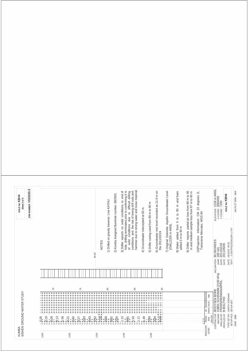
o VGIconsult report “Sishen Iron Ore Company: Regional Dolomite Stability Investigation for Risk Management Purposes”, Report Number VGI3193.3, dated 31 July 2012
o Kumba Iron Ore (Sishen Mine) Exploration Borehole Database.
5. DESCRIPTION OF THE STUDY AREA
5.1. Locality
The locality of the sites within the region is displayed in the attached Figure 1. The Sims site flanks the western edge of Kathu town and comprises 169ha. The Uitkoms site flanks the eastern edge of the town and comprises 112ha.
5.2. Site Description
The sites, as seen in aerial photographic coverage, are presented in the attached Figure 2. The Sims site falls gently from west to east from 1210m AMSL to 1205m AMSL at 0.2º. The Uitkoms site is relatively flat and at an elevation of 1230m AMSL.
6. PROCEDURES USED IN THIS STUDY
6.1. Assimilation of Available Data
Data collected from Kumba, the VGIconsult database together with available geological and geohydrological data are first assimilated.
6.2. Map Production (Projection, Co-ordinate System and Datum)
All the drawings in this report are produced using a Geographic Information System (GIS). The projection information of the figures and drawings in this report listed below:
Projection surface: Mercator (cylinder)Projection orientation: Transverse aspectDatum or reference ellipsoid: World Geodetic System 84
4
Central Meridian: In degrees (23 for this study)False easting and northing: Zero degreesScale factor: 1
The drawings and figures are co-ordinated in metres latitude (7 digit value) and longitude (5 or 6 digit value).
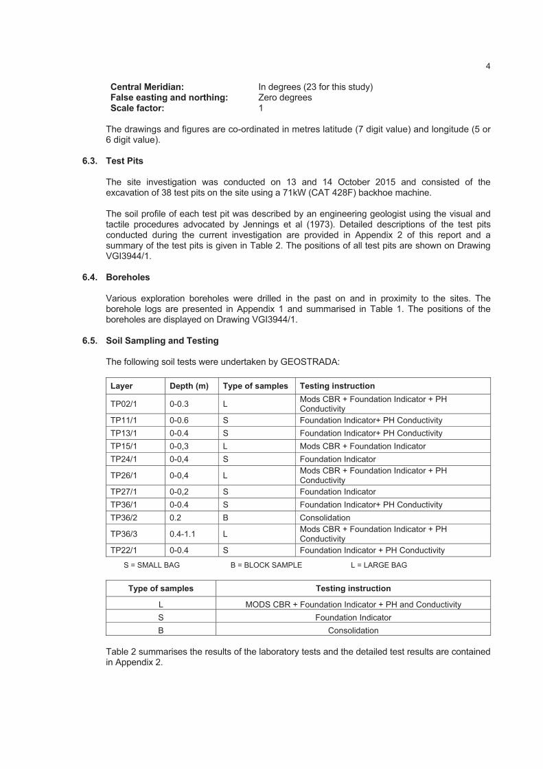
6.3. Test Pits
The site investigation was conducted on 13 and 14 October 2015 and consisted of the excavation of 38 test pits on the site using a 71kW (CAT 428F) backhoe machine.
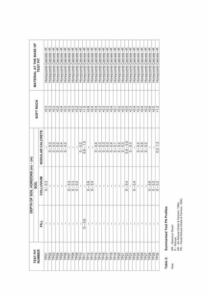
The soil profile of each test pit was described by an engineering geologist using the visual and tactile procedures advocated by Jennings et al (1973). Detailed descriptions of the test pits conducted during the current investigation are provided in Appendix 2 of this report and a summary of the test pits is given in Table 2. The positions of all test pits are shown on Drawing VGI3944/1.
6.4. Boreholes
Various exploration boreholes were drilled in the past on and in proximity to the sites. The borehole logs are presented in Appendix 1 and summarised in Table 1. The positions of the boreholes are displayed on Drawing VGI3944/1.
6.5. Soil Sampling and Testing
The following soil tests were undertaken by GEOSTRADA:
Layer Depth (m) Type of samples Testing instruction
TP02/1 0-0.3 L Mods CBR + Foundation Indicator + PH Conductivity
TP11/1 0-0.6 S Foundation Indicator+ PH Conductivity
TP13/1 0-0.4 S Foundation Indicator+ PH Conductivity
TP15/1 0-0,3 L Mods CBR + Foundation Indicator
TP24/1 0-0,4 S Foundation Indicator
TP26/1 0-0,4 L Mods CBR + Foundation Indicator + PH Conductivity
TP27/1 0-0,2 S Foundation Indicator
TP36/1 0-0.4 S Foundation Indicator+ PH Conductivity
TP36/2 0.2 B Consolidation
TP36/3 0.4-1.1 L Mods CBR + Foundation Indicator + PH Conductivity
TP22/1 0-0.4 S Foundation Indicator + PH Conductivity
S = SMALL BAG B = BLOCK SAMPLE L = LARGE BAG
Type of samples Testing instruction
L MODS CBR + Foundation Indicator + PH and Conductivity
S Foundation Indicator
B Consolidation
Table 2 summarises the results of the laboratory tests and the detailed test results are contained in Appendix 2.
For the purposes of this report the broad geotechnical definitions are defined in terms of several ‘geotechnical category designations’ (with additions) below: -
Category Definition Potential Land Use Based on Geotechnical Assumptions and Subject to Detailed Geotechnical Investigations
1 Most suitable Potentially most suitable for any type of development including residential, commercial and light (dry) industrial.
2 Intermediate Potentially suitable for any type of development including residential, commercial and light (dry) industrial, with precautionary and remedial measures.
3Least
favourable
Potentially only suitable for non-residential uses such as commercial and light (dry) industrial development with stringent precautionary and remedial measures.
Various combinations of Categories 1, 2 and/or 3 may be appropriate:
o The prefix describes the primary Category or the predominant characterisation of the zone and the suffix describes the characterisation of anticipated pockets or small sub-areas within the zone. As an example, a designation of Land Development Categories 1(2) indicates that the zone predominantly displays Category 1 conditions with smaller sub-areas of Category 2.
o A designation of Categories 2-3 indicates that the conditions in the zone range from Category 2 to Category 3 and are currently not distinguishable. The first designation (in this case Category 2) is anticipated to represent the predominant geotechnical conditions in the zone.
Geotechnical Category and Designation
Geotechnical Characteristics
Active soils (heave/shrink) Expected range of total movement at surface:
H < 7.5 mm H1 7.5 – 15 mm H2 15 – 30 mm H3 > 30 mm
Collapsible soils Expected range of total movement at surface:
C < 5 mm C1 5 – 10 mm C2 > 10 mm
Compressible soils Expected range of total movement at surface:
S < 5 mm S1 5 -15 mm S2 > 15 mm
Inundated Areas Wet areas, drainage line, seepage zone
W
T Steep Slope (>15 degrees)
P Dolomitic Areas
EAbandoned borrow areas, dump rock, waste pits and uncontrolled fill.
R Rock
R1 Rock outcrop
R2 Rock scattered outcrop
R3 Rock sub outcrop (surface to minus 1.5 m)
6
6.7. Potential Erosion and Piping (Dispersive Soils)
Sodium-based clay minerals are susceptible to erosion or piping in the in situ soil profile. The electrical conductivity (EC) of the soil paste provides an indicator of the salinity and potential dispersive behaviour.
6.8. Potential Aggressiveness of Interparticulated Groundwater
According to industry guidelines pH and electrical conductivity (EC) should be measured in selected samples. pH is a measure of the acidity of the soil based on its hydrogen ion concentration and is mathematically defined as the negative logarithm of the hydrogen ion concentration, or pH = -log[H+].
The pH of a material ranges on a logarithmic scale from 1-14, where pH 1-6 are acidic, pH 7 is neutral, and pH 8-14 are basic. Lower pH corresponds with higher [H+], while higher pH is associated with lower [H+].
Electrical conductivity (EC) is the ability of the material to conduct electrical current through it. EC is measured in Siemens per unit area (e.g. Siemens per metre). The higher the dissolved material in soil sample, the higher the EC of the soil. The electrical conductivity of soils varies depending on the amount of moisture held by soil particles. Sands have a low conductivity, silts have a medium conductivity, and clays have a high conductivity. Consequently, EC correlates strongly to soil particle size and texture.
Soil resistivity is a function of soil moisture and the concentrations of ionic soluble salts and is considered to be most comprehensive indicator of a soil’s corrosivity. Typically, the lower the resistivity, the higher will be the corrosivity as indicated in the following Table:
Soil Resistivity (Ohm/m) Corrosivity Rating
> 200 Essentially non-corrosive
100 to 200 Mildly corrosive
50 to 100 Moderately corrosive
30 to 50 Corrosive
10 to 30 Highly corrosive
< 10 Extremely corrosive
6.9. Earthworks Classifications for Service Trenches
The ease of excavation is a critical financial factor when installing underground services and placement of foundations. The excavatability of material can be grouped into the following three categories according to SABS 1200D:
o Soft excavation (Class A) requires mechanical equipment o Intermediate excavation (Class B) requires ripping equipment o Hard rock excavation (Class C) requires blasting or pneumatic rock breaking equipment
6.10. Re-usability of Spoil
Material excavated from the pipe trench may be re-used as fill material if it meets the requirements of SABS 1200LB, as follows:
Selected Granular Fill Selected Fill Backfill
Granular
Non-cohesive
0,6mm to 19mm particle size
Free-draining
Compactibility factor <0,4
Plasticity Index (PI) < 6
No lumps or stones >30mm diameter
No vegetation
Little or no organic material
Stones >150mm in diameter
Less than 10% of rocks >50mm in diameter
No large clay lumps
7
6.11. Seismic Hazard
The seismicity of Southern Africa is typically that of an intra-plate region. The natural seismic regime of a region of this type is characterized by a low-level activity by world standards, with earthquakes randomly distributed in space and time. In South Africa the only part which does not display the characteristics of an intra-plate region is the possible continuation of the East African rift system in the north-eastern region of the country.
The boundaries of the African Plate are conspicuously outlined by a narrow earthquake belt following the Mid-Atlantic and Mid-Indian oceanic ridges. Most of the natural activity around Southern Africa occurs along these features. Tremors resulting from the deep-mining operations in the gold fields of Gauteng, North West and Free State Provinces, form the bulk of the seismic events recorded by the regional network of seismological stations. The depth of these tremors has been fixed at 2 km below the surface.
The level of amplification induced in structures by seismic events is primarily influenced by the nature and magnitude of the seismic impulse, e.g. magnitude and epicentre of an earthquake, but also by the dynamic stiffness properties of the rock mass and regolith and of the particular structures.
In accordance with SANS 10160 (2012) structures in seismic zones shall, as a minimum, be designed and constructed to resist the effects of seismic ground motions. This standard provides strategies and rules for the design of buildings subject to earthquake actions primarily to safeguard against major catastrophic structural failures and loss of life, not to prevent damage or to maintain function. Figure 1 of SANS 10160-4 presents the seismic zones of South Africa. Two zones are identified, namely: a) Zone I: Natural seismic activity and b) Zone II: Regions of mining-induced and natural seismic activity.
SANS 10160-4, Table 3 presents classes of buildings relevant to seismic hazard:
ImportanceClass
Buildings Importance Factor ( i)
I Buildings of minor importance for public safety, e.g. agricultural buildings etc.
0.8
II Ordinary buildings, not belonging to the other categories 1.0
III Buildings for which seismic resistance is of importance in view of the consequences associated with collapse, e.g. schools, assembly halls, cultural institutions etc.
1.2
IV Buildings for which integrity during earthquakes is of vital importance for protection e.g. hospitals, fire stations, power plants etc.
1.4
Note:
The numbering of importance classes differ from those in the Eurocode where from the definitions were taken.
Buildings of Importance Class I, II and III in Zone II need only comply with clause 5 and with the minimum requirements for structural and non-structural components and with the requirements for ties, continuity and anchorage, all as detailed in clause 9.
Buildings of Importance Class IV in Zone II shall be treated as buildings located in Zone 1.
6.12. Dolomite Land
Land underlain by dolomite or limestone residuum or bedrock (or both), within the Malmani Subgroup and Campbell Rand Subgroup, typically at depths of no more than:
a) 60m in areas where no de-watering has taken place and the local authority has jurisdiction, is monitoring and has control over the groundwater levels in the areas under consideration; or
b) 100m in areas where de-watering has taken place or where the local authority has no jurisdiction or control over groundwater levels.
8
Where dolomite land occurs a Dolomite Area Designation is to be assigned in accordance with SANS 1936 Part 2 (2012).
The definitions of the Dolomite Area Designations, as defined in SANS 1936 Part 1 (2012), are as follows:
DDesignation
Description
D1 No precautionary measures are required.
D2General precautionary measures, in accordance with the requirements of SANS 1936-3, that are intended to prevent the concentrated ingress of water into the ground, are required.
D3Precautionary measures in addition to those pertaining to the prevention of concentrated ingress of water into the ground, in accordance with the relevant requirements of SANS 1936-3, are required.
D4 Additional site-specific precautionary measures are required.*
*Section 4.3.4 states the following specific measures for D4 areas: a) site characterization, analysis and design, specification of precautionary measures, supervision
of implementation and formulation of dolomite risk management plan shall be undertaken by a Competence Level 4 geo-professional;
b) the foundation design and design of the structure, precautionary measures and dolomite risk management plan shall specifically address and effectively mitigate the dolomite risks (should read hazard) present on the site;
c) the site characterization, foundation design and design of the structure, precautionary measures and dolomite risk management requirements shall be reviewed and approved by an independent Competence Level 4 geo-professional and, where relevant, by a structural engineer with a similar level of competence; and
d) all aspects of the development proposal shall be reviewed and approved by the local authority who may request a further review by an authority-designated Competence Level 4 peer if required.
The new NHBRC Home Building Manual has been gazetted and is to be published in October 2015. The definition is as follows:
Table 11: Dolomite area designations
D Designation Description
D1 No precautionary measures are required.
D2Precautionary measures and dolomite risk management are required to maintain a tolerable hazard rating.
D3Precautionary measures and dolomite risk management in addition to that described for dolomite area designation D2 are required to achieve a tolerable hazard rating.
D4Precautionary measures and dolomite risk management in addition to that described for D3 rarely enables a tolerable hazard rating to be achieved.
7. GEOLOGY
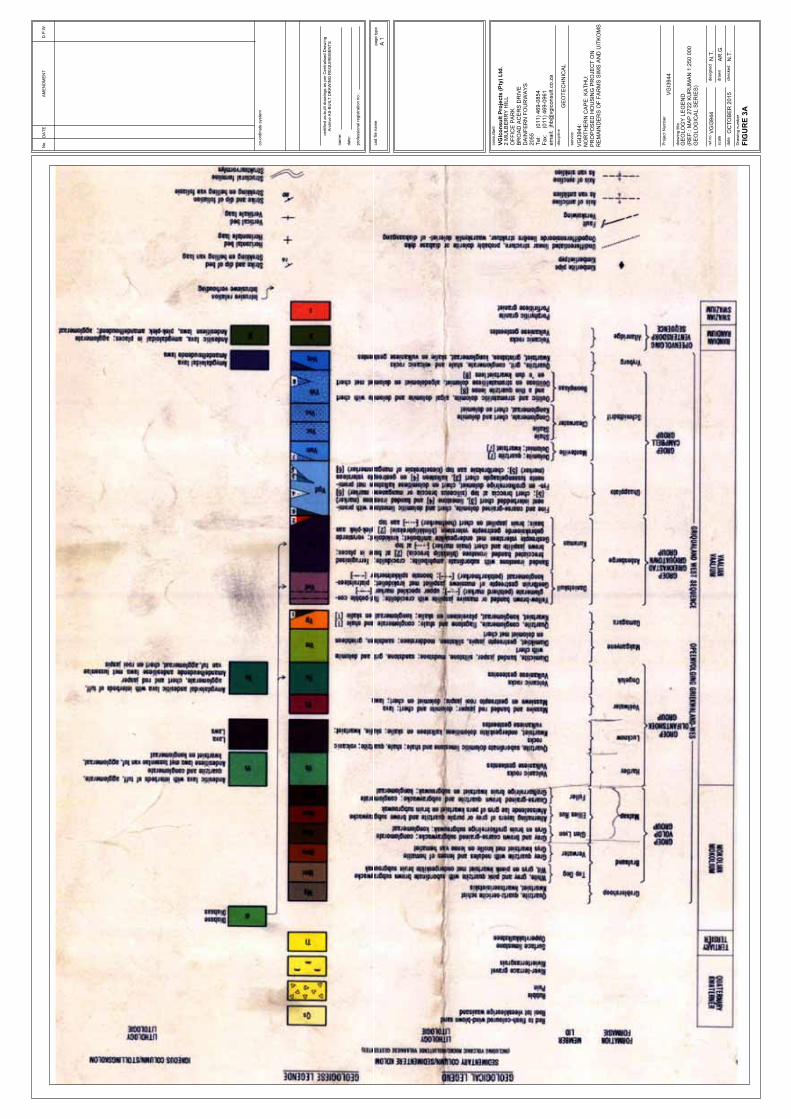
7.1. Regional Geological Setting
According to the 1:250 000 scale geological map (refer to Figure 3) the Sims site is located on Tertiary age surface limestone (Tl) and Uitkoms is located on Quaternary age sand (Qs).
The Sishen Iron Ore Mine (including the town of Kathu) is situated on the Maremane Dome. The Dome consists of carbonate rocks (predominantly stromatolitic and crinkle laminated dolomite and limestone) of the Campbell Rand Subgroup, Ghaap Group, Transvaal Supergroup.
9
Only the eastern half of the dome is exposed with dolomite outcropping to the south-east of Sishen. Chert breccia of the Ghaap Group, as well as ferruginised brecciated banded ironstone (BIF) of the Asbestos Hills Subgroup, Ghaap Group overlie the Campbell Rand Subgroup.
To the west of the Sishen Mine the Campbell Rand Subgroup is overlain along an angular unconformity by conglomerate, shale and quartzite of the Gamagara Formation,Olifantshoek Supergroup. Further to the west Makganyene Formation diamictite and Ongeluk Formation andesitic lava of the Postmasburg Group of the Transvaal Supergroup are thrust over the Gamagara Formation along a north-south striking, westerly dipping, low-angle thrust fault.
Thin, diabase dykes with north-south and northeast orientations, have intruded the stratigraphic sequence. Some of the dykes are postulated to form impervious barriers and compartmentalise the groundwater.
A buried glacial valley, filled with Dwyka tillite and mudstones has been identified during past reconnaissance drilling. The valley is located between the mine area and Kathu. It has a typical north-south orientation, with a north-west orientation between Dibeng and the mine pit.
Kalahari Group material lie unconformably on lavas, shales and quartzites of the Olifantshoek Supergroup and dolomite/Banded Iron Formation of the Ghaap Group. Two main lithologies can be distinguished, namely basal gravels, assigned to the Wessels Formation, and overlying calcareous clays of the Budin Formation.
The various lithological units anticipated in the project area are as follows:
Lithostratigraphic Unit Lithology
Kalahari Group -Cenozoic Era (i.e. including Tertiary and Quaternary deposits):
Gordonia Formation (Quaternary) Windblown sand
Lonely Formation (Quaternary) Surface limestone (loosely consolidated low density diatomaceous limestone) formed in shallow freshwater lakes)
Obobogorop Formation (Quaternary) Gravel (derived from Dwyka Formation)
Mokalanen Formation (at boundary between Quaternary/Tertiary)
Calcrete (forming a sandy limestone or conglomerate with calcareous matrix)
Eden Formation (Tertiary) Sandstone, siltstone poorly sorted gravel
Limestone, dolomite, chert, subordinate shale, ooilite and weathering soil derivatives
7.2. Structural Geology
o Sishen Iron Ore Mine is situated in the northern extent of the Maremane Dome area.
o The N-S and E-W trending interference folding that formed the dome dictates a shallow northwards plunge of major fold axes.
o A large number of north/south-trending normal faults are present with variable (<100m) displacements related mainly to the first passive margin-rifting event, and were subsequently reactivated.
o Numerous normal faults displacing stratigraphic units in fault-bounded shale filled basins are also present.
7.3. Local Geology: Kathu area
o A general overview of the geology indicates that the Kalahari Group deposits are relatively extensive in plan and in depth.
o A Karoo age valley (in-filled with shale-rich deposits) has been reported by various authors.
o Dolomite rock is confirmed in 32 of the 76 boreholes drilled in and near to Kathu. Of this set 13 intercept dolomite within 100m of ground surface. Of this set only 3 intercept dolomite bedrock at 60m or shallower.
o Dolomite rock is overlain by chert/chert breccia of the Wolhaarkop Formation in sub-areas. The Formation is relatively thin. In sub-areas the dolomite is overlain by Banded Iron Formation and/or shale of the Gamagara Formation.
Although various boreholes indicate that Kathu is largely not located on dolomite land, attention is drawn to the presence of faults and other structures which transect the subsurface profile. Sinkholes have been observed on such features south-east of the mine pit. In 2012 it was therefore determined that dolomite risk management be applied to the formalised portion of Kathu Town.
7.4. Site Specific Geology
7.4.1. Sims Site
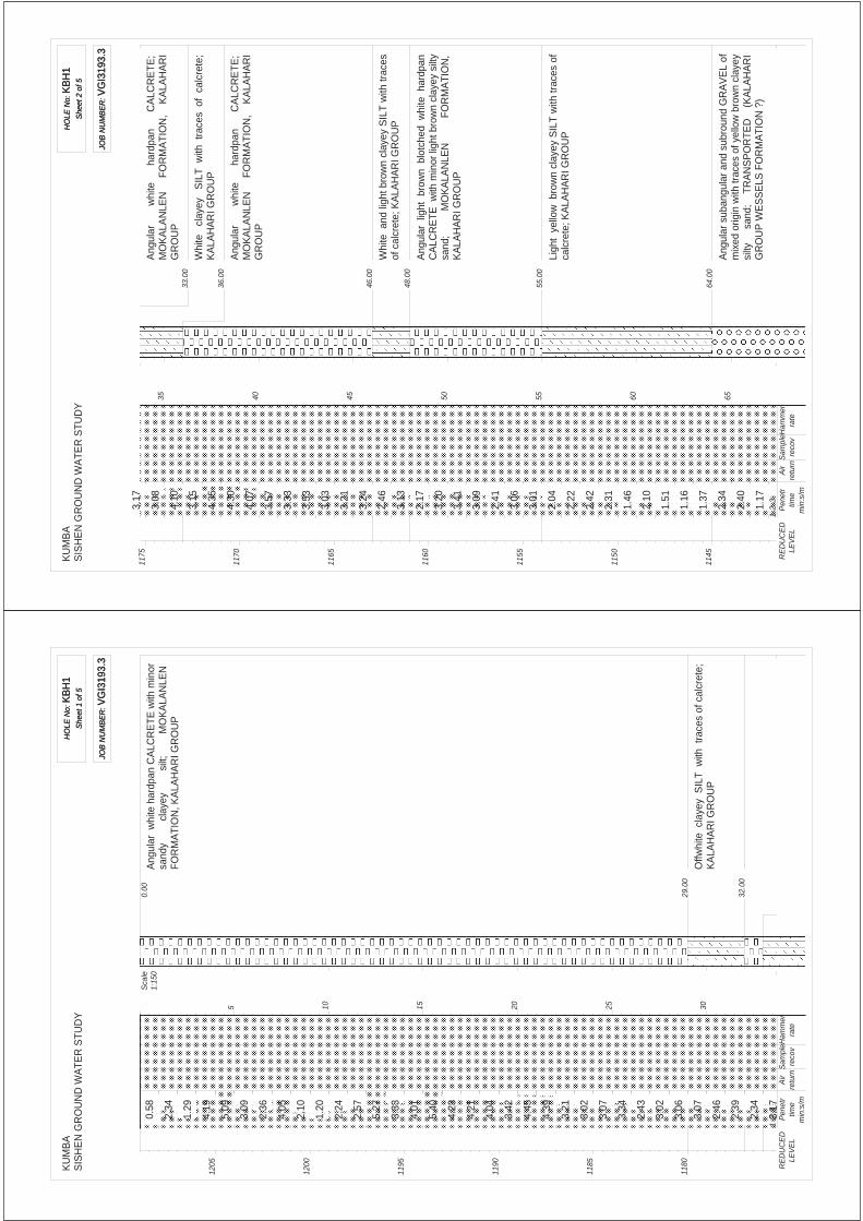
According to Sishen Iron Ore Mine data five boreholes were drilled on the site and an additional two boreholes on/near to the site boundary.
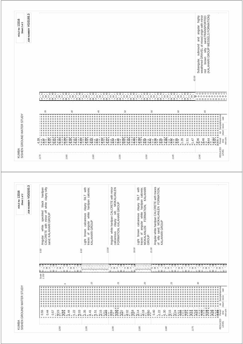
This site is blanketed by 57m to 117m thick Kalahari Group material comprising calcrete, clay and pebbles. The calcrete is 19m to 64m in thickness. The Kalahari deposits are underlain by shale and siltstone of the Gamagara Formation to very great depth (121m to in excess of 234m.
11
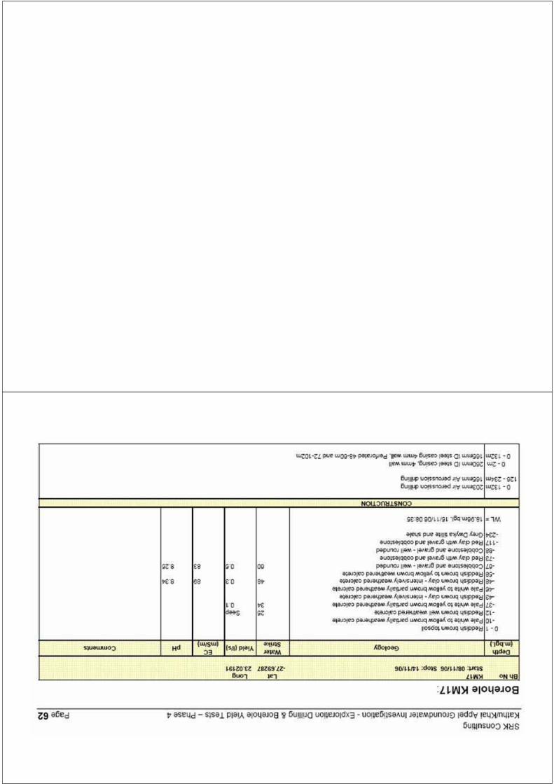
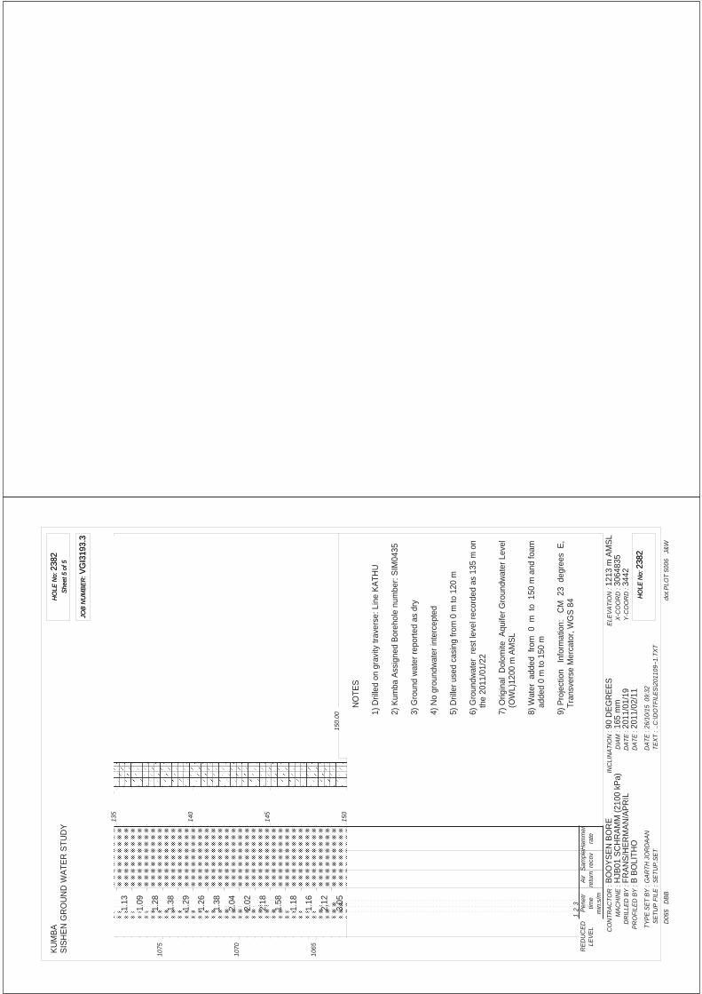
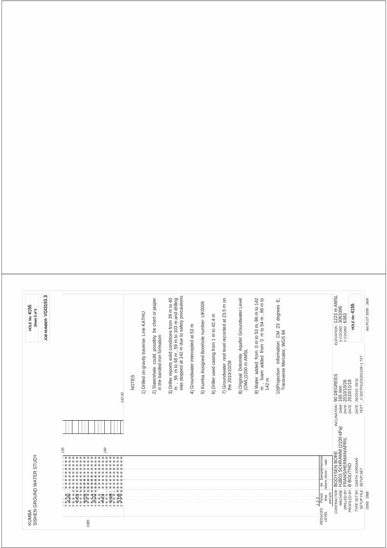
Borehole KM17 is described to intercept Karoo age shale, but considering the borehole logs of the Mine database in the area, this material may in fact be of the Gamagara Formation. Locally the Gamagara shales are underlain by chert breccia of the Wolhaarkop Formation. In Borehole KU1E the chert breccia is overlain by Banded Iron Formation. Exploration Borehole SW410E intercepts a cavity at very great depth below the Kalahari Group. The anticipated Formation is Gamagara Group shale or BIF/Wolhaarkop breccia. The reason for cavity formation during the drilling process is unknown. Only one of the seven boreholes (Borehole SIM430E) intercepted dolomite rock. The depth to dolomite is 121m.
According to the Sishen Mine structural data set no faults transect the site.
As this site is predominantly located in the area of significant impact of groundwater drawdown (refer to Section 8.2) the 100m depth to dolomite rock cut off applies. Notwithstanding this, dolomite rock is greater than 121m, and as no major faults of significance are indicated to transect the site, the site is not judged to be on dolomite land.
7.4.2. Uitkoms Site
According to Sishen Iron Ore Mine data a single borehole was drilled on the site but the mine database has no log for this exploration hole. Six boreholes were drilled in proximity to site. A gravity survey was commissioned for the already formalised portion of Kathu town which indicates a major gravity high flanking the western side of the site. Drilling data indicates that this gravity high probably extends over, onto the Uitkoms site, in particular in the area of proposed housing. The entire northern portion of the development is to remain as open parkland. Boreholes immediately west and south of the site indicate Banded Iron Formation at shallow depth (0m to 10m) to depths in excess of 142m. The BIF is overlain by Kalahari Group deposits. Borehole KBH04 intercepts 36m of Kalahari deposits mantling BIF to at least 90m depth.
According to the Sishen Mine structural data set no faults transect the site.
As this site is predominantly located in the area not impacted by groundwater drawdown (refer to Section 8.2) the 60m depth to dolomite rock cut off could apply. In the interest of dolomite risk management, and as it cannot be stated with certainty that this situation would prevail in perpetuity the 100m cut off is considered. Notwithstanding this, dolomite rock is anticipated at depths in excess of 142m, and as no major faults of significance are indicated to transect the site, the site is not judged to be on dolomite land.
7.5. Past Sinkholes and Subsidences
The CGS sinkhole database indicates no record of sinkholes on or in close proximity to the Sims or Uitkoms sites.
7.6. Near-surface Soils
An 8.45 Ton, 71Kw Backhoe Machine (CAT 428F) capable of excavating to 3.2m depth was hired to study the near-surface conditions.
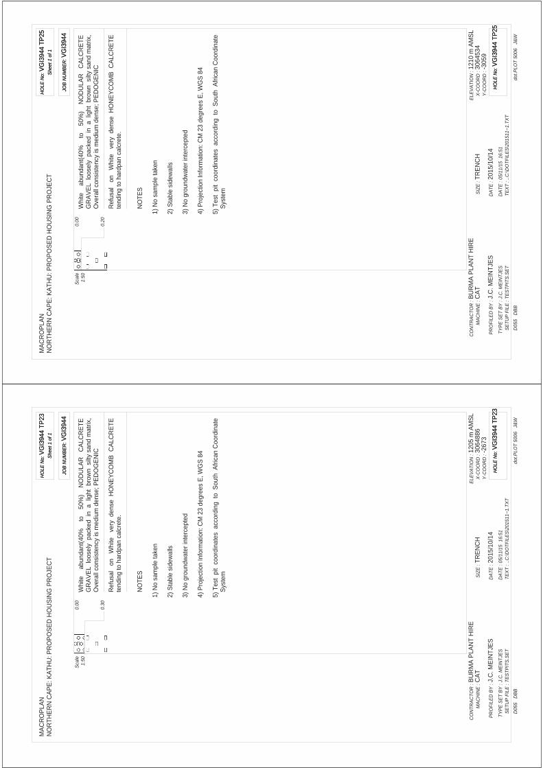
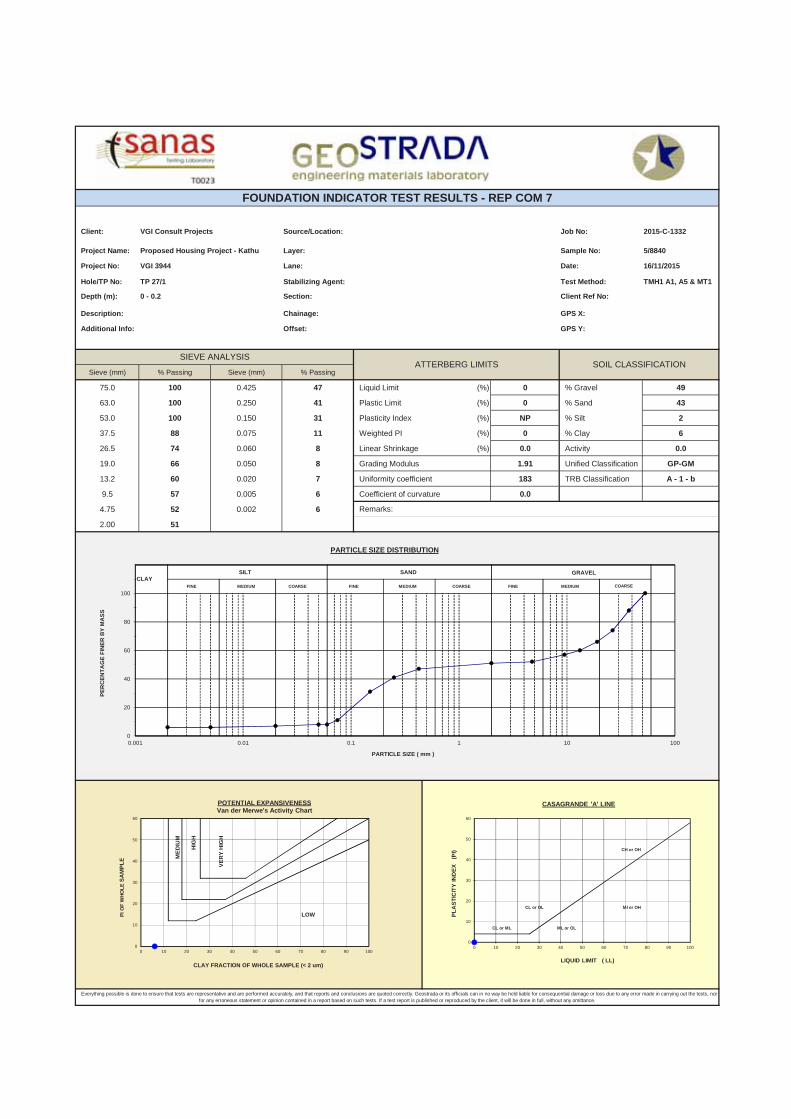
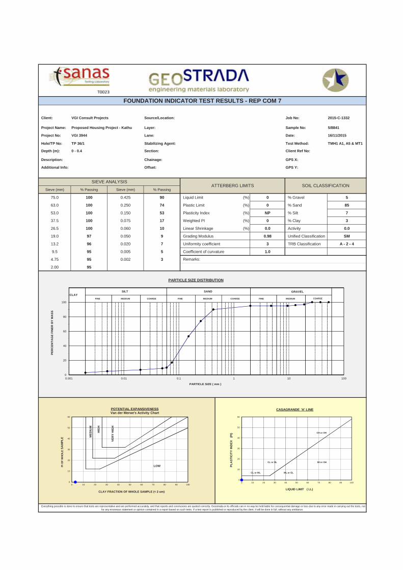
The materials studied vary in thickness and geotechnical properties. The typical soil profile encountered in test pits excavated in this study can be summarized as follows (Refer to Table 2 and Drawing VGI3944/1):
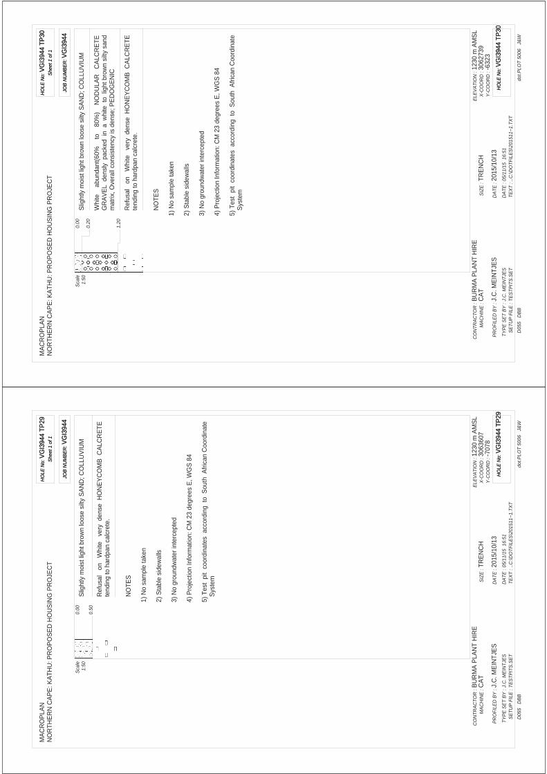
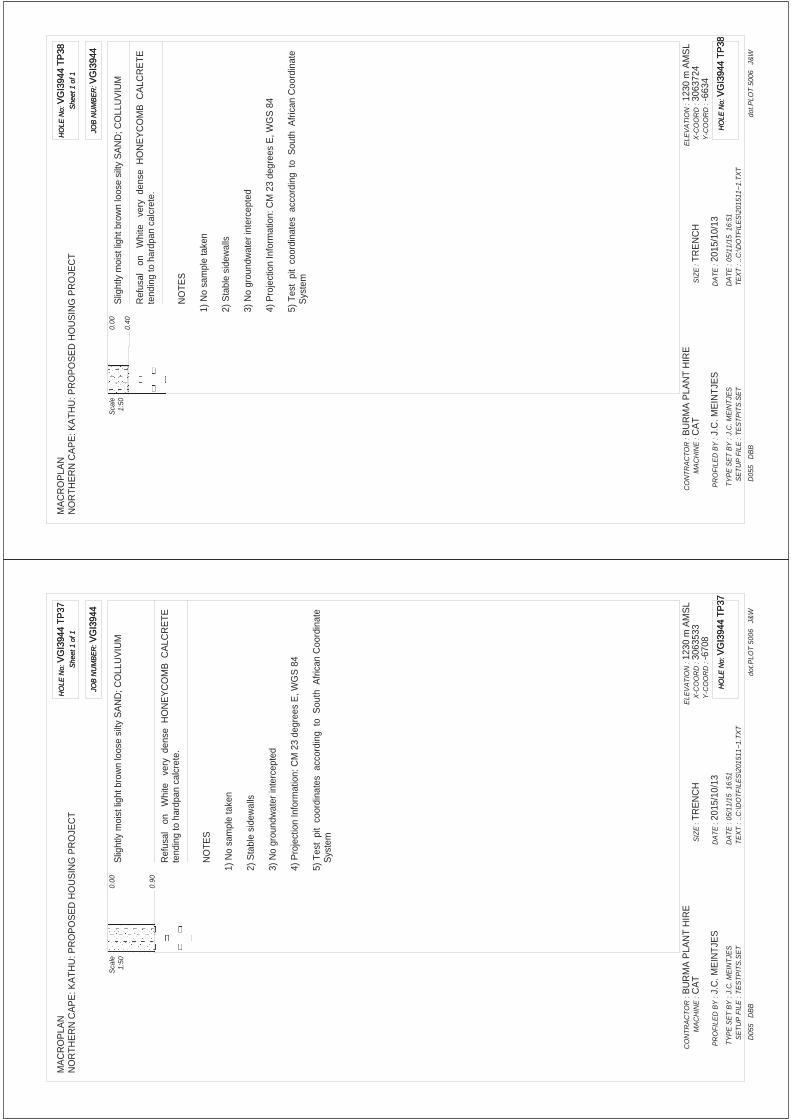
A layer of colluvium comprising loose silty sand (with exception of TP 36 which has a medium dense consistency), encountered in all the test pits from ground surface to a depth of 0.8m.
An isolated fill layer comprising of mixed gravels, loosely packed in a silty sand matrix, with overall medium dense consistency.
12
This layer is situated at TP 11 from ground surface to a depth of 0.6m.
Nodular calcrete (pedogenic) layers were encountered below the colluvium as follows:
A layer comprising 20% to 30% nodular calcrete loosely packed in a silty sand matrix with an overall medium dense consistency. This layer is observed in test pits TP22 and TP32 between depths of 0.2m to 0.5m.
A layer comprising 40% to 50% nodular calcrete loosely packed in a silty sand matrix with an overall medium dense consistency. This layer is observed in majority of test pits between depths of 0m to 1,0m.
A layer comprising 60% to 80% nodular calcrete densely packed in a silty sand matrix with an overall dense consistency. This layer is observed in test pits TP30 and TP36 between depths of 0,2m to 1,2m.
The nodular calcrete is underlain by very dense honeycomb calcrete tending to hardpan calcrete from a minimum depth of 0,1m and a maximum depth of 1,2m.
Refusal of the TLB occurred at a depth of 0.1m to 1.2m on very dense honeycomb calcrete tending to hardpan calcrete in all the test pits.
No seepage or groundwater was observed.
8. GEOHYDROLOGY
8.1. Regional and Site-specific Geohydrology
Refer to Figure 4 for pertinent groundwater information.
8.1.1. Quaternary Catchment Area
According to the country wide Quaternary Catchment data the stand is located in Catchment D73A.
8.1.2. Groundwater Management Area (WMA)
According to the country wide Water Management Areas data the sites are located in WMA 10: Lower Vaal.
8.1.3. Dolomite Groundwater Management Area (GMA)
According to the Water Geosciences Consulting Dolomite Hydrogeological Compartment Map1 (2009) the stand is located in the Prieska Sub-Basin Dolomite GMA.
8.1.4. Dolomite Groundwater Management/Resource Units
According to the Water Geosciences Consulting Dolomite Hydrogeological Compartment Map (2009) the sites are not located within designated Dolomite Groundwater Management- or Resource Units.
1 The map represents the subdivision of the dolomitic surface outcrop of the Ghaap Plateau and the Gauteng/North
West dolomites. The major delineation is represented by the dolomitic Groundwater Management Areas (GMA). The names of these GMA’s typically correspond closely to the common known dolomitic compartments as established in the late 1980’s by the DWA. However, the delineation does not necessarily represent a dolomite compartment or unit.
13
8.2. Original Groundwater Level vs. Current Groundwater Level
Several geohydrological investigations have been conducted in the region since the early 1970s. The information was analysed in 2009 by the SIOM appointed geohydrologist Mr. R Meyer in order to formulate a conceptual geohydrological model of the mining area and the immediate surrounding areas.
During 2008 a total of 10 874 005 m3 of groundwater was abstracted from the SIOM. This was accomplished from three well fields located in the southern mining pit, the northern pit and the so-called western boreholes from which 8 386 600 m3, 1 602 085 m3 and 885 320 m3 were abstracted respectively during 2008. From the two other well fields, referred to as the Kathu and Khai-Appel well fields, supplying the town, country club, game farm adjoining Kathu and the farming requirements of Ferroland, 1 699 366 m3 and 873 680 m3 were abstracted respectively. The total volume of ground water abstraction during 2008 from these sources amounts to 13 447 051 m3.
In 2012 the changes in the groundwater levels experienced in the greater Kathu region was studied by Meyer in order to prepare an OWL (original groundwater level) contour map as well as CWL (current water level) contour map. Although regular water level monitoring was concentrated in the area immediately surrounding the mining areas, regional hydro-censuses were conducted in 1970-1972 and again in 1994. Sporadic water level measurements were also taken in selected areas since 1970, with the focus being close to the mining area, the alluvial aquifer associated with the non-perennial Gamagara River and the farms around the larger areas around the mine development. The exceptional recharge period between 1973/74 and 1975/76 warrants the choice of pre-1974 water levels as baseline groundwater level. The hydro-census data of the early 1970’s is therefore viewed as the groundwater level baseline (OWL) for the regional area around Sishen/Kathu and most of the information used to construct the pre-1974 water level maps are derived from this census, although a few older water levels records were also used.
Very little pre-1974 water level information could be found for the town of Kathu. In addition, many of the older boreholes in the area were drilled as water supply boreholes, and did not necessarily penetrate the Kalahari Group formation with associated groundwater levels presenting conditions in the primary aquifer.
Across the town of Kathu the OWL (original groundwater level elevation) varies by about 10m, from 1200m to 1210m AMSL. Based on current piezometric and groundwater level information, three water level conditions have been identified by Meyer:
1. Areas where the groundwater conditions have not yet been impacted by the large scale groundwater abstraction.
2. A triangular shaped area between the Kathu and Sekgame dykes where groundwater conditions have been partially impacted by groundwater abstraction activities.
This condition is present below the north eastern part of the original town development and to the south of the golf course.
3. An area in the southern and south-western portion where groundwater conditions have been significantly impacted by the groundwater abstraction.
The Uitkoms site is located in the area not impacted by large scale groundwater abstraction.
Most of the Sims site is located within the area significantly impacted by groundwater abstraction. The current groundwater elevation range is 1080m AMSL to 1120m AMSL, i.e. 80m to 120m below the OWL.
14
9. NEAR SURFACE GEOTECHNICAL EVALUATION
The geotechnical evaluation of the near surface soil horizons and their properties on the site are based on the interpretation of the geology, the soil profiles and the laboratory test results:
9.1. Engineering Properties and Material Characteristics
9.1.1. Activity (swelling/shrinking) or Expansive Potential of soils within 1.2m from natural ground level
The foundation indicator test results indicate that all the soil layers have a low potential expansiveness (<7.5mm).
9.1.2. Potentially Collapsible Soils within 1.2m from natural ground level
The colluvium, comprising loose silty sand and extending to an anticipated maximum depth of 0.9m, is potentially highly collapsible. The medium dense nodular calcrete, as well as the fill, has a moderate collapse potential. The colluvial/pedogenic horizon is of greater thickness (> 0.5m) in Soils Zone 2 necessitating a C2 designation.
9.1.3. Potentially Compressible Soils within 1.2m from natural ground level
The colluvium is highly compressible and extends to an anticipated maximum depth of 0.9m. The medium dense nodular calcrete and fill is potentially moderately compressible. The colluvial/pedogenic horizon is of greater thickness (> 0.5m) in Soils Zone 2 necessitating a S2 designation.
9.1.4. Potential Aggressiveness of Interparticulated Groundwater
Our assessment of the pH- and resistivity values is as follows:
Test Pit No.
Sample Depth Material origin pH: natural soil Descriptor:natural soil
TP02/1 0-0.3 Calcrete 7.30 Pedogenic
TP11/1 0-0.6 Fill 7.89 Fill
TP13/1 0-0.4 Transported 7.80 Colluvium
TP26/1 0-0,4 Calcrete 7.92 Pedogenic
TP36/1 0-0.4 Transported 8.03 Colluvium
TP36/3 0.4-1.1 Calcrete 8.35 Pedogenic
TP22/1 0-0.4 Transported 7.44 Colluvium
The samples submitted for pH testing revealed that all the soil layers (fill, colluvium and calcrete) are neutral to alkaline, with a pH value of 7.30 to 8.35.
It is therefore foreseen that no real potential exists for an aggressive environment towards steel within the subsurface profile.
9.1.5. Potential Erosion and Piping (Dispersive Soils)2
Sodium-based clay minerals are susceptible to erosion or piping in the in situ soil profile. The electrical conductivity of the soil paste provides an indicator of the salinity and potential dispersive behaviour.
2 when soil types are subjected to a hydraulic gradient
15
The conductivity results are provided in the tables at the end of the report. Our assessment of these values follows:
Test Pit No.
Sample Depth
Soil Origin Conductivity
(S.m) Dispersive
charactersitics1
TP02/1 0-0.3 Calcrete 0.163 None
TP11/1 0-0.6 Fill 0.139 None
TP13/1 0-0.4 Transported 0.071 None
TP26/1 0-0,4 Calcrete 0.1133 None
TP36/1 0-0.4 Transported 0.142 None
TP36/3 0.4-1.1 Calcrete 0.154 None
TP22/1 0-0.4 Transported 0.154 None 1Conductivities in excess of 0.5 S.m. may be associated with dispersive characteristics in soil units
9.1.6. Seepage
A perched water table was not intercepted in the test pits. A perched groundwater table is however anticipated on the soil/rock contact at a depth of 0.1m and 1.2m below ground surface during the rainy season.
9.2. Natural Slope Stability and Erosion
The general flat slope (less than 6 degrees) over the site will not present slope stability problems or a hazard to structures placed on this area.
However, the fine nature of many, if not most of the soil units encountered during investigations is such that after removal of natural soil cover they present a potential erosion problem during periods of heavy rains and also dust removal by high winds of the dry season.
9.3. Sidewall Stability in Excavations
Seepage of groundwater into open works (here related to a perched water table on the soil/rock interface during the rainy season) may induce sidewall instability.
9.4. Earthworks Classifications for Service Trenches (R)
It has been assumed that an excavator will be used to excavate trenches for services rather than a TLB, since an excavator will be able to excavate harder materials more readily than a TLB.
For example, an excavator would be able to excavate further/deeper into soft rock material whereas a TLB would experience refusal. Based on this assumption, the three excavatability categories of materials identified from test pits, to a depth of 3,0m according to SABS 1200D can be made:
Soft Excavation (Class A): All soil layers encountered to an anticipated maximum depth of 1.2m in profile.
Intermediate Excavation (Class B): Soft rock conditions at depth of between 0.1m to 1.2 were encountered honeycomb calcrete tending to hardpan calcrete.
Hard rock Excavation (Class C): No hard rock conditions were encountered.
Refusal of the excavator occurred at a depth of 0.1m to 1.2m on honeycomb calcrete tending to hardpan calcrete rock. Excavatability problems are therefore anticipated with the use of a TLB for the placing of subsurface services from a depth of 0.1m to 1.0m.
16
9.5. Seismic Activity
In terms of SANS 10160 (2012) and the seismic hazard map contained therein the site is not located in a Seismic Hazard Zone.
9.6. Materials for Road Construction Purposes (TRH14)
Test Pit No.
Sample Depth Soil Origin MDD OMC COLTO
Classification
TP02/1 0-0.3 Calcrete 2016 7.6 G5
TP15/1 0-0,3 Calcrete 1824 10.8 G5
TP26/1 0-0,4 Calcrete 1880 7.4 G5
TP36/3 0.4-1.1 Calcrete 1880 9.7 G6
o G5 quality materials are suitable for the use for base layer, and G6 quality material are suitable for sub base in road construction. However G6 quality material can be improved to G5 quality by adding 20% to 30% gravels.
9.7. Re-Usability of Spoil: Bedding Material and Earthworks3
o Selected Granular Bedding – i.e. naturally occurring non-cohesive, free draining, singularly graded gravel-soils between 0.6mm and 19.0mm particle size are not available on this site and will need to be imported.
o Selected Fill – the laboratory tests results confirm that natural soils with a PI less than 6% and/or a stones content of <30mm are not available on this site.
o General Backfill – materials recovered from trench excavation works may be considered for general backfill purposes after removal or reduction of all the larger cobble and boulder size fractions.
o The selected calcrete materials, G5 and G6 quality materials are suitable for the construction of earth mattresses.
9.8. Drainage
A complete stormwater system that provides for drainage as well as the provision of drainage to control runoff from major stormwater events will need to be constructed on the site, according to Municipal specifications.
10. CONCLUSIONS
10.1. General
This investigation comprised the excavation, profiling and sampling of 38 test pits across the two proposed sites and the studying of existing, relevant Sishen Iron Ore Mine data.
Existing information indicates that the Sims site is underlain by very thick (57-117m) Kalahari Group material (calcrete, clay, pebble layers), overlying Gamagara Formation shale to 121->234m). No known/confirmed faults are indicated to transect the site. Most of the Sims site is located within the area significantly impacted by groundwater abstraction. The current groundwater elevation range is 1080m AMSL to 1120m AMSL, i.e. 80m to 120m below the OWL. The site is not judged to be on dolomite land.
3 SANS 1200 DB: 1983 & LB: 1989
TABLES
SUMMARISED BOREHOLE INFORMATION AND INHERENT SUSCEPTIBILITY CHARACTERISATION
TABLE 1
17
Existing information indicates that the Uitkoms site is underlain by Banded Iron Formation at shallow (10m or less) and to great depth (in excess of 142m). The site is located in the area not impacted by large scale groundwater abstraction. The site is not judged to be on dolomite land.
10.2. Near Surface Soils Assessment
It follows from the test pits and laboratory test results that the sites can be described in terms of two soil zones of similar foundation conditions, namely:
Soil Zones Designation
1 2[(H/C-C1/S-S1)R3]
2 2[(H/C2/S1-S2)R3]
10.2.1. Soil Zone 1: 2([H/C-C1/S-S1)R3]
All the soil layers (i.e. the colluvium, ferruginous pebble marker, pedogenic are of low expansiveness (H). The colluvium and pedogenic layers comprise low density, collapsible and compressible material (C-C1/S-S1), to depths less than 0.5m. Settlement of up to 15mm may be anticipated if these materials are placed under load and/or if the moisture content increases. Refusal occurred with a TLB at depths less than 1.5m (R3).
10.2.2. Soil Zone 2: 2[(H/C2/S1-S2)R3] All the soil layers (i.e. the colluvium, ferruginous pebble marker, pedogenic are of low expansiveness (H). The colluvium and pedogenic layers comprise low density collapsible and compressible materials to depths greater than 0.5m (C2/S1-S2). Major settlement (>15mm) may be anticipated if these materials are placed under load and/or if the moisture content increases. Refusal occurred with a TLB at depths less than 1.5m (R3).
11. RECOMMENDATIONS
11.1. Foundation Design Requirements
The loose colluvial layer and medium dense nodular calcrete encountered in majority of the Test Pits from natural ground level to an anticipated maximum depth of 0.9m are not suitable for the founding. Refusal of the TLB was encountered at a depth of 0.1m and 1.2m on honeycomb tending to hardpan calcrete (pedogenic) in all the test pits.
18
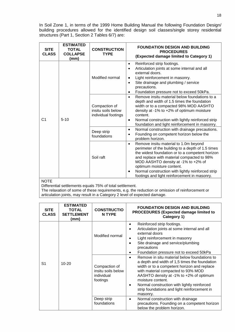
In Soil Zone 1, in terms of the 1999 Home Building Manual the following Foundation Design/ building procedures allowed for the identified design soil classes/single storey residential structures (Part 1, Section 2 Tables 6/7) are:
SITE CLASS
ESTIMATED TOTAL
COLLAPSE (mm)
CONSTRUCTION TYPE
FOUNDATION DESIGN AND BUILDING PROCEDURES
(Expected damage limited to Category 1)
C1 5-10
Modified normal
Reinforced strip footings.
Articulation joints at some internal and all external doors.
Light reinforcement in masonry.
Site drainage and plumbing / service precautions.
Foundation pressure not to exceed 50kPa.
Compaction of insitu soils below individual footings
Remove insitu material below foundations to a depth and width of 1.5 times the foundation width or to a compacted 98% MOD AASHTO density at -1% to +2% of optimum moisture content.
Normal construction with lightly reinforced strip foundation and light reinforcement in masonry.
Deep strip foundations
Normal construction with drainage precautions.
Founding on competent horizon below the problem horizon.
Soil raft
Remove insitu material to 1.0m beyond perimeter of the building to a depth of 1.5 times the widest foundation or to a competent horizon and replace with material compacted to 98% MOD AASHTO density at -1% to +2% of optimum moisture content.
Normal construction with lightly reinforced strip footings and light reinforcement in masonry.
NOTE Differential settlements equals 75% of total settlement. The relaxation of some of these requirements, e.g. the reduction or omission of reinforcement or articulation joints, may result in a Category 2 level of expected damage.
SITE CLASS
ESTIMATED TOTAL
SETTLEMENT (mm)
CONSTRUCTION TYPE
FOUNDATION DESIGN AND BUILDING PROCEDURES (Expected damage limited to
Category 1)
S1
10-20
Modified normal
Reinforced strip footings.
Articulation joints at some internal and all external doors
Light reinforcement in masonry
Site drainage and service/plumbing precautions
Foundation pressure not to exceed 50kPa
Compaction of insitu soils below individual footings
Remove in situ material below foundations to a depth and width of 1,5 times the foundation width or to a competent horizon and replace with material compacted to 93% MOD AASHTO density at -1% to +2% of optimum moisture content.
Normal construction with lightly reinforced strip foundations and light reinforcement in masonry.
Deep strip foundations
Normal construction with drainage precautions. Founding on a competent horizon below the problem horizon.
19
SITE CLASS
ESTIMATED TOTAL
SETTLEMENT (mm)
CONSTRUCTION TYPE
FOUNDATION DESIGN AND BUILDING PROCEDURES (Expected damage limited to
Category 1)
Soil Raft
Remove insitu material to 1,0m beyond perimeter of building to a depth of 1,5m times the widest foundation or to a competent horizon and replace with material compacted to 93% MOD AASHTO density at -1% to + 2% of optimum moisture content.
Normal construction with lightly reinforced strip footings and light reinforcement in masonry.
NOTE 1) Differential settlement equals 50% of total settlement. 2) The relaxation of some of these requirements, e.g. the reduction or omission of reinforcement or
articulation joints, may result in a Category 2 level of expected damage. 3) Account must be taken of sloping sites when differential fill heights may lead to greater differential
settlements. 4) Settlements induced by loads imposed by deep filling beneath surface beds may necessitate the
adoption of a construction type appropriate to a more severe site class.
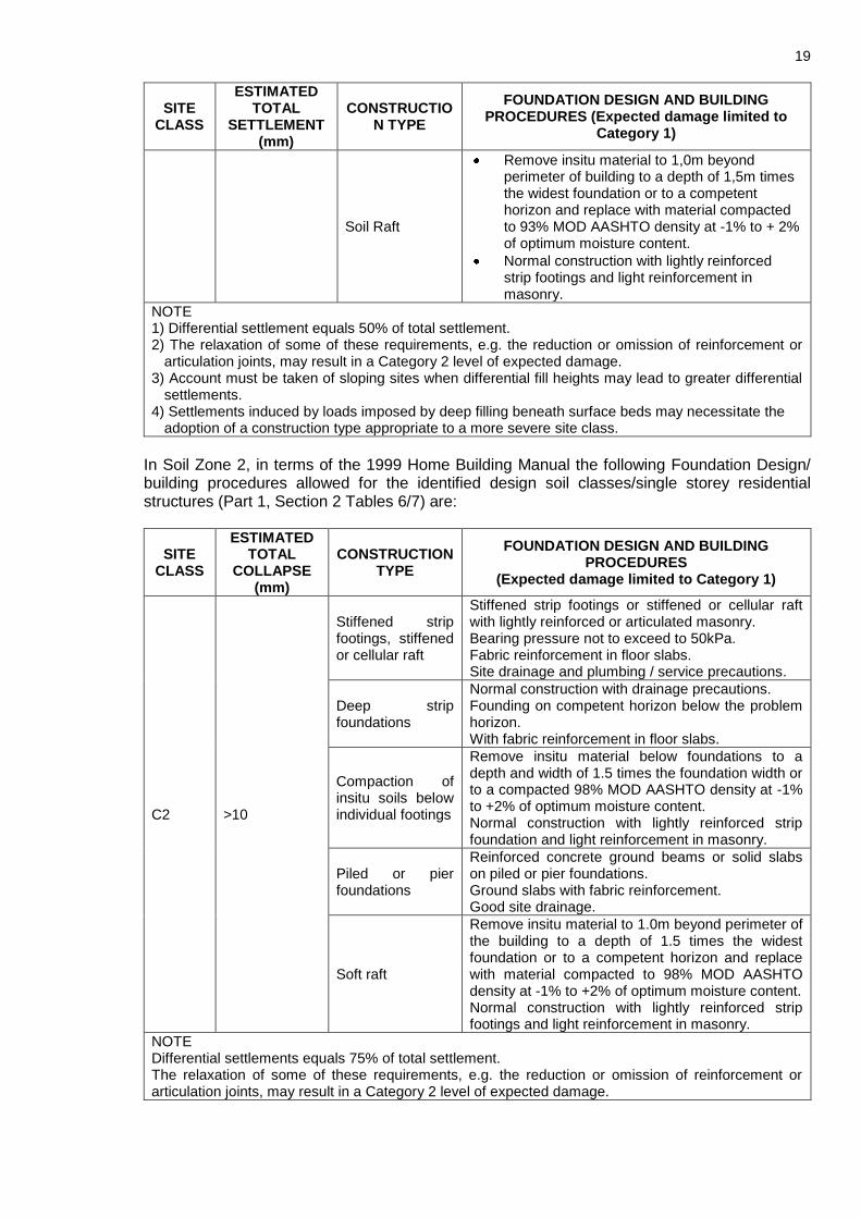
In Soil Zone 2, in terms of the 1999 Home Building Manual the following Foundation Design/ building procedures allowed for the identified design soil classes/single storey residential structures (Part 1, Section 2 Tables 6/7) are:
SITE CLASS
ESTIMATED TOTAL
COLLAPSE (mm)
CONSTRUCTION TYPE
FOUNDATION DESIGN AND BUILDING PROCEDURES
(Expected damage limited to Category 1)
C2 >10
Stiffened strip footings, stiffened or cellular raft
Stiffened strip footings or stiffened or cellular raft with lightly reinforced or articulated masonry. Bearing pressure not to exceed to 50kPa. Fabric reinforcement in floor slabs. Site drainage and plumbing / service precautions.
Deep strip foundations
Normal construction with drainage precautions. Founding on competent horizon below the problem horizon. With fabric reinforcement in floor slabs.
Compaction of insitu soils below individual footings
Remove insitu material below foundations to a depth and width of 1.5 times the foundation width or to a compacted 98% MOD AASHTO density at -1% to +2% of optimum moisture content. Normal construction with lightly reinforced strip foundation and light reinforcement in masonry.
Piled or pier foundations
Reinforced concrete ground beams or solid slabs on piled or pier foundations. Ground slabs with fabric reinforcement. Good site drainage.
Soft raft
Remove insitu material to 1.0m beyond perimeter of the building to a depth of 1.5 times the widest foundation or to a competent horizon and replace with material compacted to 98% MOD AASHTO density at -1% to +2% of optimum moisture content. Normal construction with lightly reinforced strip footings and light reinforcement in masonry.
NOTE Differential settlements equals 75% of total settlement. The relaxation of some of these requirements, e.g. the reduction or omission of reinforcement or articulation joints, may result in a Category 2 level of expected damage.
20
SITE CLASS
ESTIMATED TOTAL
SETTLEMENT (mm)
CONSTRUCTION TYPE
FOUNDATION DESIGN AND BUILDING PROCEDURES
(Expected damage limited to Category 1)
S2 >20
Stiffened strip footings, stiffened
Stiffened strip footings or stiffened or cellular raft with lightly reinforced or articulated masonry. Bearing pressure not to exceed to 50kPa. Mesh reinforcement in floor slabs. Site drainage and service/plumbing precautions.
Deep strip foundations
As for S1 but with mesh reinforcement in floor slabs
Compaction of in situ soils below individual footings
Remove in situ material below foundations to a depth and width of 1,5 times the foundation width or to a competent horizon and replace with material compacted to 93% MOD AASHTO density at -1% to +2% of optimum moisture content. Normal construction with lightly reinforced strip foundations and light reinforcement in masonry.
Piled or pier foundation
Reinforced concrete ground beams or solid slabs on piled or pier foundations. Ground slabs with fabric reinforcement. Ground site drainage.
Soil raft
Remove insitu material to 1,0m beyond perimeter of building to a depth of 1,5m times the widest foundation or to a competent horizon and replace with material compacted to 93% MOD AASHTO density at -1% to + 2% of optimum moisture content. Normal construction with lightly reinforced strip footings and light reinforcement in masonry.
NOTE 1) Differential settlement equals 50% of total settlement. 2) The relaxation of some of these requirements, e.g. the reduction or omission of reinforcement or
articulation joints, may result in a Category 2 level of expected damage. 3) Account must be taken of sloping sites when differential fill heights may lead to greater differential
settlements. 4) Settlements induced by loads imposed by deep filling beneath surface beds may necessitate the
adoption of a construction type appropriate to a more severe site class.
Where very dense honeycomb tending to hardpan calcrete is encountered within the standard footing depth, the structure can be placed directly on this material. Where such material is not encountered within the standard footing depth, an engineered soil mattress should be constructed (on the very dense honeycomb tending to hardpan calcrete) to the required founding level as follows:
1) Remove all excavatable material (with an excavator) to a maximum depth of between 0.1m to 1.0m in the footprint area of the structure and up to 1m beyond the edge of the proposed foundation area.
2) Rip and compact the excavated floor area to 95% of Modified AASHTO maximum dry density at optimum moisture content.
3) Backfill in maximum 150mm thick layers with imported G5-quality material; each layer is to be compacted to at least 98% of Modified AASHTO maximum dry density at optimum moisture content.
4) This should also include the (minimum) 150mm freeboard, i.e. top of floor slab to top of natural ground level, as required by the NHBRC Guidelines.
11.2. Excavatability
It should be noted that if a backactor will be used for the excavation of services, excavatability problems may be experienced in both Soil Zones 1 and 2 from 0.1m depth (which is within the general excavation depth for services [1.5m]) due to the presence of shallow calcrete.
21
11.3. Trench Sidewall Stability
In the event that there is uncertainly with respect to shoring requirements in trenches deeper than 1m, a competent person should be consulted. All excavation slopes must be inspected by a competent person during construction to assess stability and recommended stabilizing measures, where required.
11.4. Pipe Bedding Material and Backfill and Compaction Characteristics
o The materials tested in this investigation do not comply with the SABS 1200LB criteria for selected granular fill or selected fill. Selected granular fill and/or selected fill is not available on this site and will need to be imported.
o Selected Granular Bedding – i.e. naturally occurring non-cohesive, free draining, singularly
graded gravel-soils between 0.6mm and 19.0mm particle size are not available on this site and will need to be imported.
o Selected Fill – the laboratory tests results confirm that natural soils with a PI less than 6%
and/or a stones content of <30mm are not available on this site and will need to be imported.
o General Backfill – materials recovered from trench excavation works may be considered
for general backfill purposes after removal or reduction of all the larger cobble and boulder size fractions.
o The selected calcrete materials, G5 and G6 quality materials are suitable for the
construction of earth mattresses 11.5. Corrosivity
The selection of materials to be used for wet services placed below ground surface should take cognisance of a possible corrosive nature of the environment.
11.6. Road Construction
Calcrete classifying as G5 quality materials is suitable for the use for base layer. G6 quality material is suitable for sub base in road construction. However G6 quality material can be improved to G5 quality by adding 20% to 30% gravels.
11.7. Groundwater Conditions
No seepage was indicated in the test pits excavated. However the soil/rock interface may give rise to water seepage during wet season. Water runoff into open works may also occur during excavation and construction work, particularly in the wet season due natural slope. A pump should therefore be available during such work. Structures could be impacted on by „rising damp‟. Special attention to membrane/dampcourse measures is required (for example, the use of „waterproof‟ concretes in slab/raft foundation designs).
22
12. GENERAL
12.1. Verification Process
The findings in this report are based upon our interpretation of the data recovered during these investigations.
While every effort has been made, within the limits of the project budget, time and present-day insight, to determine overall ground conditions on this site, poorer sub-areas may have been missed. For this reason, it is recommended that a competent specialist is always invited to inspect open works on this site in order to further confirm the findings described in this report.
12.2. Third Party Reviews
If this report is reviewed by third parties, it should be noted that dolomite hazard assessment and management is an empirical science and consequently such parties may formulate opinions concerning the findings, conclusions and recommendations of this investigation at variance with those contained in this report. This fact should be borne in mind when costs are incurred on this project prior to receipt of the comments of these parties. VGIconsult Projects Pty Ltd, its members
and personnel cannot be held responsible for these divergent views or consequential damages.1
13.2 52 0.020 3 Uniformity coefficient 300 TRB Classification A - 1 - b
9.5 50 0.005 1 Coefficient of curvature 0.0
4.75 49 0.002 1
2.00 48
6.0
Everything possible is done to ensure that tests are representative and are performed accurately, and that reports and conclusions are quoted correctly. Geostrada or its officials can in no way be held liable for consequential damage or loss due to any error made in carrying out the tests, nor for any erroneous statement or opinion contained in a report based on such tests. If a test report is published or reproduced by the client, it will be done in full, without any omittance.
Everything possible is done to ensure that tests are representative and are performed accurately, and that reports and conclusions are quoted correctly. Geostrada or its officials can in no way be held liable for consequential damage or loss due to any error made in carrying out the tests, nor for any erroneous statement or opinion contained in a report based on such tests. If a test report is published or reproduced by the client, it will be done in full, without any omittance.
Remarks:
CLAYSILT SAND
COARSEFINE MEDIUM COARSE FINE MEDIUM COARSE FINE MEDIUM
GRAVEL
0
20
40
60
80
100
120
0.001 0.01 0.1 1 10 100
PE
RC
EN
TA
GE
FIN
ER
BY
MA
SS
PARTICLE SIZE ( mm )
PARTICLE SIZE DISTRIBUTION
ME
DIU
M
HIG
H
VE
RY
HIG
H
LOW
0
10
20
30
40
50
60
0 10 20 30 40 50 60 70 80 90 100
PI O
F W
HO
LE
SA
MP
LE
CLAY FRACTION OF WHOLE SAMPLE (< 2 um)
POTENTIAL EXPANSIVENESSVan der Merwe's Activity Chart
Everything possible is done to ensure that tests are representative and are performed accurately, and that reports and conclusions are quoted correctly. Geostrada or its officials can in no way be held liable for consequential damage or loss due to any error made in carrying out the tests, nor for any erroneous statement or opinion contained in a report based on such tests. If a test report is published or reproduced by the client, it will be done in full, without any omittance.
Everything possible is done to ensure that tests are representative and are performed accurately, and that reports and conclusions are quoted correctly. Geostrada or its officials can in no way be held liable for consequential damage or loss due to any error made in carrying out the tests, nor for any erroneous statement or opinion contained in a report based on such tests. If a test report is published or reproduced by the client, it will be done in full, without any omittance.
Remarks:
CLAYSILT SAND
COARSEFINE MEDIUM COARSE FINE MEDIUM COARSE FINE MEDIUM
GRAVEL
0
20
40
60
80
100
120
0.001 0.01 0.1 1 10 100
PE
RC
EN
TA
GE
FIN
ER
BY
MA
SS
PARTICLE SIZE ( mm )
PARTICLE SIZE DISTRIBUTION
ME
DIU
M
HIG
H
VE
RY
HIG
H
LOW
0
10
20
30
40
50
60
0 10 20 30 40 50 60 70 80 90 100
PI O
F W
HO
LE
SA
MP
LE
CLAY FRACTION OF WHOLE SAMPLE (< 2 um)
POTENTIAL EXPANSIVENESSVan der Merwe's Activity Chart
Everything possible is done to ensure that tests are representative and are performed accurately, and that reports and conclusions are quoted correctly. Geostrada or its officials can in no way be held liable for consequential damage or loss due to any error made in carrying out the tests, nor for any erroneous statement or opinion contained in a report based on such tests. If a test report is published or reproduced by the client, it will be done in full, without any omittance.
Everything possible is done to ensure that tests are representative and are performed accurately, and that reports and conclusions are quoted correctly. Geostrada or its officials can in no way be held liable for consequential damage or loss due to any error made in carrying out the tests, nor for any erroneous statement or opinion contained in a report based on such tests. If a test report is published or reproduced by the client, it will be done in full, without any omittance.
Everything possible is done to ensure that tests are representative and are performed accurately, and that reports and conclusions are quoted correctly. Geostrada or its officials can in no way be held liable for consequential damage or loss due to any error made in carrying out the tests, nor for any erroneous statement or opinion contained in a report based on such tests. If a test report is published or reproduced by the client, it will be done in full, without any omittance.
Remarks:
CLAYSILT SAND
COARSEFINE MEDIUM COARSE FINE MEDIUM COARSE FINE MEDIUM
GRAVEL
0
20
40
60
80
100
120
0.001 0.01 0.1 1 10 100
PE
RC
EN
TA
GE
FIN
ER
BY
MA
SS
PARTICLE SIZE ( mm )
PARTICLE SIZE DISTRIBUTION
ME
DIU
M
HIG
H
VE
RY
HIG
H
LOW
0
10
20
30
40
50
60
0 10 20 30 40 50 60 70 80 90 100
PI O
F W
HO
LE
SA
MP
LE
CLAY FRACTION OF WHOLE SAMPLE (< 2 um)
POTENTIAL EXPANSIVENESSVan der Merwe's Activity Chart