103
Provisional West Sussex Transport Plan 2011 –2026 July 2010

Provisional West Sussex TransportPlan 2011 –2026
July 2010

PART 2 - IMPLEMENTATION PLAN
1
CONTACTS & OBTAINING INFORMATION
1 2
Contacts & Obtaining Information The Local Transport Plan (LTP3), including the Sustainability Appraisal (SA), together with more information about our strategies and projects, can be viewed on our website at: www.westsussex.gov.uk/ltp In order to improve public access to our highways and transport service we have redesigned and improved our internet site. This will allow people to:
• Obtain information on all forms of transport, including walking and cycling
• Obtain information about public transport times • Report highway related defects • Participate in consultations • View all transport policy documents • Follow links to other useful web sites
The LTP3 may also be viewed at all West Sussex libraries and County Council and Help Points. Alternatively, we can send you an electronic copy. Please note that the majority of West Sussex libraries now have internet access available at low cost. For further information please call: 01243 642105 Or email: [email protected] Or write to:
Infrastructure West Sussex County Council
Northleigh Tower Street Chichester
West Sussex PO19 1RH
If you require this document or supporting documents in another format or would like to discuss transport policy issues in general please contact us using the number or addresses shown above.
Kieran Stigant Executive Director - Communities
PART 2 - IMPLEMENTATION PLAN
2
FOREWARD
2 3
Foreword
It gives me great pleasure to present to you, the provisional version of our third Local
Transport Plan for West Sussex, for 2011 to 2026. Our previous Plans have covered the
years consecutively from 2001 to 2011 and I am pleased to report that we have
achieved much of what we hoped to within this period.
During this time we have been recognised as a ‘Centre of Excellence’ for transport
delivery and been awarded ‘pathfinder’ status for our work; which has seen the number
of those killed or seriously injured on roads fall whilst the number of people using
public transport has greatly increased, supported by the highly successful introduction
of our 3in1 Concessionary Fare Scheme, and the exemplary Crawley Fastway.
The previous Plans are sound foundations on which to build and develop our new Plan.
However, with funding limited, we face a real challenge if we are to continue offering
the very high level of service expected within the County. With this in mind, I have
taken the decision to change the format of the Local Transport Plan and present you
with a document, which aligns closely with the other major strategies such as the West
Sussex Sustainable Community Strategy, which will result in a much more strategic
and joined up approach to transport planning.
The Plan is developed around five key goals relating to transport:
• Supporting Economic Competitiveness
• Tackling Climate Change
• Promoting Accessibility
• Delivering Health, Safety and Security
• Improving Quality of Life
All of these, link closely to the national goals for transport, and are objectives of both
the Sustainable Community Strategy and the County Strategy.
It is hoped that what we have presented you with, demonstrates how we intend to
develop and maintain our road and transport networks whilst remaining efficient and
sympathetic to the limited resources we have available. The final version of this Plan
will be the result of extensive consultation with our stakeholders and the public,
therefore, I heartily encourage you to get involved and have your say.
Lionel Barnard
Deputy Leader with Portfolio Responsibility for Highways and Transport
and
I therefore

PART 2 - IMPLEMENTATION PLAN
3
CONTENTS
3
Contents
Contacts & Obtaining Information 1Foreword 2Contents 3Glossary of terms 4Introduction 5 Purpose of the Plan 5 The Promise 5 Structure and Framework of the West Sussex Transport Plan 6Part 1 - Long Term Strategy 7Our Strategic Goals 7Wider Policy Context 9National Policy Context 9 Delivering a Sustainable Transport System 9 TrafficManagementAct 9 ActiveTravel 10Regional Context 10Local Context 10 TheSustainableCommunityStrategy 10 LocalAreaAgreement 10 LocalDevelopmentFrameworks 11 WestSussexCountyStrategy 11 WestSussexEconomicStrategy 11 WestSussexEnvironmentStrategy 11 WestSussexStrategicCommunitySafetyPartnership 12 WestSussexRuralStrategy 12 StrategyfortheWestSussexLandscape 12 WestSussexRightsofWayImprovementPlan 12 WestSussexCulturalStrategy 12 InvolvingourCommunitiesandtheRoleofTransportinWestSussex 12 LocalTravelSurveys 13 TravelAttitudes 13 PartnershipWorking 13Sub Areas, Transport networks and Strategic Places 16 CoastalWestSussex 16 GatwickDiamond 18 RuralWestSussex 20 TheStrategicRoadNetwork 21 StrategicRailNetwork 22 StrategicPlaces–InfrastructurePlans 22 CommunityAccessPlanning(CAP) 23 TransportAssetManagementPlan(TAMP) 23Transport Workstreams 25 DevelopingOptions 28Delivering our Strategic Goals 29 TacklingClimateChange 29 SupportingEconomicGrowth 34 PromotingEqualityofOpportunity 40 BetterSafety,SecurityandHealth 45 ImprovingQualityofLife 51Local Transport Plan Investment Packages 57 The Options 57Part 2 – Implementation Plan 61

PART 2 - IMPLEMENTATION PLAN
4
CONTENTS LocalTransportImplementationPlans 61 LocalTransportImplementationPlan–Countywide 62 Local Transport Implementation Plan - Bognor Regis 66 Local Transport Implementation Plan - Burgess Hill 69 LocalTransportImplementationPlan-Chichester 72 Local Transport Implementation Plan - Crawley 76 LocalTransportImplementationPlan-EastGrinstead 80 LocalTransportImplementationPlan-HaywardsHeath 83 LocalTransportImplementationPlan-Horsham 86 LocalTransportImplementationPlan-Littlehampton 89 LocalTransportImplementationPlan-Shoreham 92 Local Transport Implementation Plan - Worthing 96Monitoring 100
4
6
Glossary of terms AONB – Area of Outstanding Natural Beauty AQAP – Air Quality Action Plan AQMA – Air Quality Management Area BOAT – Byway Open to All Traffic CAFWS - Countryside Access Forum for West Sussex CAP – Community Access Planning CCTV – Closed Circuit Television CO – Carbon Monoxide CO2 – Carbon Dioxide DaSTS – Delivering a Sustainable Transport System DDA – Disability Discrimination Act DfT – Department for Transport EU – European Union GIP – Green Infrastructure Planning GVA – Gross Value Added LAA – Local Area Agreement LDF – Local Development Framework LTP3 – Local Transport Plan 3 LTP2 – Local Transport Plan 2 VMS – Variable Message Sign MOVA – Microprocessor Optimised Vehicle Actuation NCN – National Cycle Network NO2 – Nitrogen Dioxide PM10 – Particulate Matter PPG – Planning Policy Guidance notes PPS – Planning Policy Statements PRoW – Public Rights of Way PTW – Powered Two Wheeler RoWIP – Rights of Ways Improvement Plan RTPI – Real Time Passenger Information RUS – Route Utilisation Strategy SA – Sustainability Appraisal SRN – Strategic Route Network TAMP – Transport Asset Management Plan

PART 2 - IMPLEMENTATION PLAN
5
INTRODUCTION
5 7
Introduction
Purpose of the Plan
1.1. This is the third Local Transport Plan (LTP) for West Sussex. The first two
West Sussex Local Transport Plans have provided a foundation on which to
build better access, transport networks and systems for West Sussex
residents and businesses. This third Plan aims to build upon progress to date
and seeks to meet key objectives, which reflect the following priorities:
• promoting economic growth
• delivering sustainability
• improving accessibility
• improving safety, health and security
• reducing pollution
• reducing congestion
• improving quality of life
• promoting healthy activities
1.2. The Plan reflects the Council’s desire to deliver sustainable improvements in
economic performance, social inclusion, and quality of life. It is therefore
looking to:
• set transport in its wider context, reflecting economic, environmental
and social concerns
• set locally relevant targets
• achieve key outcomes within specified timescales
• demonstrate good value for money
• establish a framework for monitoring and managing performance
The Promise
1.3. We have made a promise to all of our customers that we will work in
partnership with them in order to make the most of where we live and work.
The promise is: 'With you, for you, making the most of West Sussex'
1.4. The promise is based on two consultations that were carried out in 2008,
which highlighted what our customers wanted and expected from us. Three
things in particular stood out: place, advice and guidance, and leadership.
• People really like the local area as a place to live but also gave us clear
indications of how we can help improve life in West Sussex.
• People want more information so they can help themselves make the
most of their lives in the County. So we will focus on providing
information, advice and guidance, as well as providing services,
assistance and support to people where it's most needed.
• We need to be clear about our leadership responsibilities for services,
whether provided directly, through partners or third parties. We will
work closely with partners and influence third parties to make sure they
deliver agreed levels of quality and are accountable for what they do.
1.5. We also have a clear commitment to ensure that services deliver the most
appropriate combination of quality, value and choice to all residents.
1.6. These aspirations have strongly influenced the development of this Plan and
will continue to direct how we improve access within and across the County.

PART 2 - IMPLEMENTATION PLAN
6
INTRODUCTION
6 8
Structure and Framework of the West Sussex Transport Plan 1.7. Our Transport Plan is divided into two parts; Part 1, the Long-Term Strategy
element and Part 2, the Implementation Plan.
1.8. Part 1 sets out our vision for transport in West Sussex and our longer-term strategy for the next 15 years. It discusses the issues, opportunities and options available, value for money considerations and the key outcomes we are seeking to achieve. Part 1 also outlines how the asset is maintained and how the users of the network will influence the decisions being made.
1.9. Part 2 of the Plan sets out how the Plan will be implemented, identifying what infrastructure is required to enable the vision to become reality in both the short and long-term.

PART 1 - LONG TERM STRATEGY
7
9
Part 1 - Long Term Strategy
2.1. This Plan sets out our transport vision, goals and objectives for West Sussex
to 2026 and summarises how we intend to meet them.
Our overall vision is to achieve efficient, safe and less congested transport
networks, which contribute towards:
a more competitive and thriving economy, reductions in emissions
improved access to services, jobs and housing, especially for those in
need
improved quality of life for all those who live and work within our beautiful
and unique County
2.2. Transport demand is derived from the need to access services, achieve
economic prosperity and to carry out leisure activities. We recognise that
transport has an important role to play in achieving a wide range of social,
economic and environmental objectives.
Our Strategic Goals
2.3. Our strategic goals, set by the Department for Transport (DfT), allow us to
make contributions to these wider objectives.
• Support Economic Growth (Competitiveness and Productivity)
• Reducing Carbon Emissions (Climate Change)
• Promote Equality of Opportunity (Social Equity)
• Better Safety, Security and Health
• Improve Quality of Life and a Healthy Natural Environment (Quality of
Life)
2.4. To achieve these goals we will use a variety of interventions and projects.
These will be developed by building on the successes of first two Local
Transport Plans and by listening to our customers.
2.5. To aid the process of prioritisation, we have developed 5 packages of options
that will help us to focus investment over the lifetime of LTP3. The packages
will emphasise measures and interventions that support each of the strategic
goals. These will be discussed in more detail later in this document.

PART 1 - LONG TERM STRATEGY
8
10
NATIONAL POLICY Eddington Report, Stern Review, King Review,
Planning Policy Statements, Delivering a Sustainable Transport System
REGIONAL POLICY South Downs Management Plan, AONB Management
Plans,
West Sussex County Council Plans County Strategy, Infrastructure Plan
Local Transport Plan, Minerals & Waste Plan, Rights of Way Improvement Plan
Local Development Frameworks
Local Community Strategies
Delivery Plans Transport Asset Management Plan
Community Access Planning Infrastructure Plans
Supporting Workstreams e.g. School travel initiatives, Development
management, Cycling Infrastructure & promotion, Safety engineering, Air quality management
Delivery Mechanism Integrated Works Programme
Business Plans
National
Regional
West Sussex Statutory (Strategic
Partnerships)
West Sussex County Council Statutory
Local Statutory Districts / Boroughs
/ Local Strategic Partnership
West Sussex County Council
Business
EUROPEAN POLICY Noise, Air Quality, Carbon Reduction, Environment,
Heritage International
Local Area Agreement, Sustainable Community Strategy 'Working together for a better West Sussex'
Figure 1 – Overview of the wider policy hierarchy

PART 1 - LONG TERM STRATEGY
9 11
Wider Policy Context 2.6. The West Sussex Sustainable Community Strategy and the County Strategy
provide a solid foundation on which LTP3 will build to ensure that our Transport Plan is integrated with wider objectives set out for the County.
2.7. Figure 1 illustrates how the different elements of the Transport Plan fit within the wider policy context.
2.8. Set out below is a summary of national, regional and local policy documents which we have drawn upon to help formulate our transport vision and objectives.
National Policy Context Delivering a Sustainable Transport System 2.9. Delivering a Sustainable Transport System, was published by the DfT in
2008, in response to the Eddington Study and the Stern Review. Delivering a Sustainable Transport System puts forward how key objectives will be achieved at a national level, tackling not only our immediate problems, but also shaping our transport system to meet the longer-term challenges that are critical for our prosperity and way of life.
Traffic Management Act 2.10. The Traffic Management Act was introduced in 2004 to tackle congestion and
disruption on the road network. The Act gives authorities additional tools to better manage parking policies, moving traffic enforcement and the coordination of street works. The Traffic Management Act also provides us with the opportunity to help deliver some of the national goals for transport. We will use it to focus on the following:
• better management of road works • better operating environment for buses • more effective enforcement • demonstrating and checking that all that can be done is being done to
effectively manage traffic • measuring progress
Planning Policy Statements and Guidance 2.11. Planning Policy Guidance Notes (PPGs) and their replacement Planning Policy
Statements (PPSs) are prepared by Government to provide guidance on planning policy and the operation of the planning system. They also outline the links between planning and other policies which influence development and land use.
2.12. There are a large number of PPGs and PPSs, but the two which have most influence over LTP3 are PPS3 (Housing) and PPG13 (Transport). PPS3 underpins the Government’s strategic housing objectives and supports the goal that ‘everyone has the opportunity to live in decent home, which they can afford, in a community where they want to live’. PPG13 sets out the Government’s objectives of integrating planning and transport at all levels and looks to promote more sustainable transport choices for both carrying people and moving freight.

PART 1 - LONG TERM STRATEGY
10 12
Active Travel 2.13. The Department of Health and Department for Transport have jointly
published a new Active Travel Strategy. The strategy highlights plans to put walking and cycling at the heart of local transport and public health strategies over the next decade. The guiding principles for the strategy are that walking and cycling should be everyday ways of getting around – not just for their own sake but also because of what they can do to improve public health, tackle congestion, reduce carbon emissions and improve the local environment. The Local Transport Plan takes on board the challenges this sets.
Regional Context 2.14. The new Government has indicated that it will “rapidly abolish Regional
Spatial Strategies and return decision-making powers on housing and planning to local councils”. Due to the timing of this announcement, the implications of this decision are not fully understood at the time of preparing LTP3. In due course, LTP3 will need to have regard for any policies which replace the role of the South East Plan, South East England Regional Transport Strategy and the South East England Regional Economic Strategy.
Local Context 2.15. There are a number of local strategies which transport policies and plans
must complement to deliver our vision for West Sussex and achieve the objectives in this Plan.
The Sustainable Community Strategy 2.16. The Sustainable Community Strategy has been prepared by the County’s
Local Strategic Partnership. It has identified a set of goals and actions that the partnership - representing residential, business, statutory and voluntary interests of the County - wish to promote. The Sustainable Communities Strategy acts as an umbrella for all other local strategies. The four key themes of the strategy are:
• A Better Place to Live • Opportunity for All • Better Health for All • Staying and Feeling Safe
Local Area Agreement 2.17. A key delivery mechanism for the Community Strategy is our Local Area
Agreement (LAA). A LAA is a contract between national government and the West Sussex Strategic Partnership to deliver a balance of national priorities together with the priorities of local people. West Sussex has had an LAA since April 2006. West Sussex County Council leads on the development of the LAA for the County of West Sussex, but all public services in West Sussex are involved, as well as voluntary organisations, private companies and users of local services.
2.18. The LAA sets out priorities for West Sussex over the next 3 years as agreed. The third LAA for West Sussex (2011-2014) is currently being developed and will be monitored via a set of three year targets. A full ‘Refresh’ of the LAA

PART 1 - LONG TERM STRATEGY
11 13
was completed at the end of March 2009. Based on these views and the analysis of the County’s needs, partners’ collective priorities for the LAA are:
• to level up the life outcomes and experiences for those in rural and deprived communities in housing, crime, health and employment
• to increase the sustainable accessibility of jobs, education and essential services to all, particularly in rural areas and for those in deprived communities
• to improve the health, educational attainment and access to activities of children and younger people in all communities
Local Development Frameworks 2.19. Local Development Frameworks (LDFs) guide development and place-shaping
and how these relate to communities. We are working with our Districts and Borough Councils to develop their Core Strategies and supporting LDF documents.
2.20. The LDFs fine tune national guidance in the light of local needs, priorities and opportunities and the LTP3 aims to support the intentions of the LDFs through a long term Strategy and short term Implementation Plan.
2.21. We have also reflected the priorities of the Regional Economic Strategy in our Economic Strategy, which, in turn, have been formulated to fully integrate transport issues. These have been developed through the West Sussex Economic Partnership.
West Sussex County Strategy 2.22. The County Strategy presents a long-term and wide-ranging vision for all our
services. In order to deliver this vision we have pledged to ‘deliver better services at a fair cost, by working even harder to make the most of resources’. This will be achieved by a focus on four key themes which will be given resources and priority over the coming years.
• Keeping West Sussex Working • Keeping West Sussex Caring, Learning and Active • Keeping West Sussex Sustainable • Keeping West Sussex Safe
West Sussex Economic Strategy 2.23. Transport is essential for a successful economic strategy, so our Economic
Strategy is aimed at:
• achieving a viable rural economy • recognising the importance of Gatwick particularly to the north east of
the County • regenerating the economy of coastal communities as
West Sussex Environment Strategy 2.24. The strategy focuses on the goal of living within environmental limits, and
the need to maintain, manage and enhance environmental assets to ensure that the quality of life of future generations is not adversely compromised. It also includes responding to the impact of climate change resulting from man made greenhouse gas emissions, by both mitigating the impact of further changes, and adapting to those changes that are occurring now and others that are likely to occur in the future.

PART 1 - LONG TERM STRATEGY
12 14
West Sussex Strategic Community Safety Partnership 2.25. The partnership has close links to our transport objectives and we are
working on a range of complementary projects including road safety schemes, speed reduction projects and personal safety measures. As well as a highway asset management role, our work with partner organisations to tackle antisocial behaviour such as fly tipping and graffiti also helps to tackle fear of crime and improve community safety.
West Sussex Rural Strategy 2.26. Our Rural Strategy outlines a series of 17 key objectives, which have been
developed around three key themes for the growth and development of rural areas:
• Economic and Social Regeneration – aiming to create and maintain a thriving rural economy, contributing fully to the prosperity of the County and wider South East region.
• Social Justice for All – aiming to create and maintain vibrant and sustainable rural communities
• Enhancing the Value of our Countryside – aiming to maintain a high quality rural environment that is accessible to all.
Strategy for the West Sussex Landscape 2.27. This strategy seeks to protect and enhance the landscape of West Sussex as
an asset for future generations. To enable this, we have prepared landscape management guidelines for each of the 42 identified landscape character areas in West Sussex.
2.28. We have a duty to recognise biodiversity as an integral part of sustainable development and preparing transport strategies and proposals. Integrating biodiversity into local transport planning and embedding green infrastructure planning to reflect the importance of habitat connectivity will help to achieve this.
West Sussex Rights of Way Improvement Plan 2.29. The Rights of Way Improvement Plan (RoWIP) is a strategic document that is
required to contain our assessment of:
• the extent to which the rights of way network meets the present and likely future needs of users
• the opportunities provided by local rights of way for exercise and other forms of open-air recreation
• the accessibility of local rights of way to blind and partially sighted persons and others with mobility difficulties
2.30. The RoWIP also contains a statement of the action proposed to take for the management of local rights of way and for securing an improved network of routes.
West Sussex Cultural Strategy 2.31. The strategy is a wide-ranging document that aims to ensure that access to
heritage and community facilities is maintained. The strategy is not solely concerned with local government services, but for the whole of West Sussex.
Involving our Communities and the Role of Transport in West Sussex 2.32. The accompanying Equalities Impact Assessment (included within the
Sustainability Appraisal document) draws on an extensive range of evidence

PART 1 - LONG TERM STRATEGY
13 15
to demonstrate that LTP3 needs to be aligned with the needs and views of all groups who have an interest in the transport system of West Sussex.
2.33. The Plan draws on the outcomes of initial consultation undertaken with key stakeholders, whilst the main public consultation will further help to align LTP3 with the needs and views of all.
2.34. The initial consultation helped to inform the development of this Provisional Transport Plan by ranking the importance of the national goals for transport in terms of their relevance to West Sussex. More detail of the results of the initial consultation are included under the relevant Strategic Goal later in this section.
Local Travel Surveys 2.35. One of the key tools that we have used to gather evidence, monitor travel
behaviour and perceptions of highway infrastructure and public transport across West Sussex throughout the first two Local Transport Plans has been the household travel survey. Whilst this is being replaced by the National Highways and Transport Network Public Satisfaction Survey in 2010 - which will provide an improved way of comparing performance against other local authorities across England - the household travel survey still provides an important evidence base for the LTP3.
2.36. A key message from previous surveys includes the importance of the car as a mode of transport for many people across West Sussex, particularly in rural areas. The important role of public transport as a means of accessibility for those people who do not have access to their own car and its role as an attractive alternative for daily commuting, is also demonstrated. Public transport therefore has a critical role in helping to reduce road traffic congestion.
Travel Attitudes 2.37. The different roles of the transport system are neatly summarised in travel
attitude analysis undertaken from the 2008 household travel survey. This analysis found amongst a large proportion of car users, recognition that they would like to reduce car use in order to help the environment, but they were constrained by a lack of practical alternatives.
2.38. This indicates potential to further encourage people to switch to more sustainable modes of travel than single occupancy car use where there are practical alternatives, and has implications for a number of the transport objectives set out in LTP3.
2.39. The experiences and attitudes of our communities will be captured and understood through the Community Access Planning process in order to support the continued development of our policies and the delivery of our Implementation Plans.
Partnership Working 2.40. Partnership working is critical to the development and delivery of this Plan, at
both strategic and local levels. We continue to work closely with our District and Borough Councils, as demonstrated through the joint work being undertaken in the development of their LDFs. We enjoy a good working relationship with the Highways Agency, Gatwick Airport, Network Rail, and bus and rail operators.

PART 1 - LONG TERM STRATEGY
14 16
2.41. The table below demonstrates some of the areas where we are successfully working with our partners and what we are working to achieve.
Partnership Description of work British Horse Society Working to develop new schemes and links around the
County, as well as the continued promotion of safety and education.
Coastal West Sussex Partnership
Coordinated regeneration of Coastal West Sussex bringing together local authorities and business interests
Countryside Access Forum for West Sussex (CAFWS)
CAFWS is an independent, advisory body operating on a statutory basis. It aims to improve countryside access for all across the County.
Gatwick Diamond Initiative A sub-regional strategy which supports economic growth in the Gatwick Diamond.
Healthcare Partnerships In West Sussex, local authorities and health services work together to ensure that information and services are well co-ordinated and that people have access to healthcare services.
Household Travel Survey/ National Highways and Transport Network Public Satisfaction Survey
These national surveys are designed to measure a range of transport indicators and travel trends of West Sussex residents, and enable comparison and shaping of best practise across local authorities.
Local Strategic Partnerships Local Strategic Partnerships are partnerships comprising representatives from the public, private, community and voluntary sector, who work together to address issues that are important to the local community as set out in the Sustainable Community Strategy.
Public Service Board The Public Service Board is the countywide Local Strategic Partnership. It has set up a Public Service Board Executive to oversee the Local Area Agreement (LAA).
Quality Bus Partnerships Voluntary partnerships between local authorities and bus operators to develop improvements to either specific bus services (700) or on an area-wide basis (Worthing and Chichester).
Road Rail Partnership Group Long term planning to address issues arising from interaction between the road and rail networks.
Shoreham Harbour Growth Point
Development and delivery of a Joint Area Action Plan for Shoreham Harbour.
South Downs National Park The South Downs National Park Authority is the lead organisation responsible for promoting the National Park, working in partnership with other organisations such as local authorities, parish councils, voluntary and community groups as well as farmers, land managers and volunteers.
Sussex Community Rail Partnership
Working with the rail industry to promote rail travel and focus on rail station access improvements in rural areas.
Sussex Safer Roads Assisting in the coordination of road safety education,

PART 1 - LONG TERM STRATEGY
15 17
Partnership and enforcement activities to achieve safer roads across Sussex.
West Sussex Cycle Forum A forum comprised of a number of cycling groups, sustainable access groups and individuals with the aim of promoting cycling as a form of transport and pressing for improved road safety for non-motorised users.
West Sussex Economic Partnership
A partnership to ensure that business interests are considered in the development of plans and policies which affect them.

PART 1 - LONG TERM STRATEGY
16 18
Sub Areas, Transport Networks and Strategic Places 3.15. In this Plan, we have reflected local characteristics and those of the wider
region. Firstly we considered the three key economic areas that make up the County:
• Coastal West Sussex • Gatwick Diamond • Rural Areas
3.16. We then considered the strategic transport networks for each area, and
finally we considered local issues and the delivery for each of the strategic plan objectives.
3.17. We have identified a vision for each of the sub-areas and the key actions we will undertake in order to achieve them. These reflect both national policy and local needs as identified through our work at a local level. Infrastructure Plans, which link to the statutory development plans for the County and focus on our major towns, will be the mechanism to develop and coordinate local solutions.
Coastal West Sussex 3.18. The coastal strip of West Sussex which includes the towns of Bognor Regis,
Arundel, Littlehampton, Shoreham and Worthing, and the City of Chichester. The area adjoins the South Downs and has a high quality landscape but is also characterised by the loss of the traditional seaside resort role, concentrations of deprivation, high proportion of elderly people, congestion, and a lack of high quality employment sites.
3.19. A number of specific strategic challenges facing the West Sussex coast have been identified by drawing on the five national goals for transport, the challenges identified in development planning documents, reviews of existing evidence and consultation with stakeholders. The challenges are to ensure that the transport network:
supports planned growth, including regeneration, increases in economic prosperity and the creation of jobs increases connectivity both within the study area and to the wider region delivers approaches that offer health benefits and improve quality of life contributes towards national targets for the reduction of carbon dioxide (CO2) emissions supports the provision of high quality urban environments without detriment to the rural environment
3.20. Related to the strategic challenges, there are transport specific challenges,
which are to:
improve the reliability of journey times encourage modal shift to sustainable transport modes and reduce reliance on the car improve the availability, choice and quality of public transport
3.7 Much of our coastal area is in need of economic regeneration, including
Shoreham which is recognised as a Growth Point, which is a government designation given to locations to support the delivery of new infrastructure for

PART 1 - LONG TERM STRATEGY
17 19
regeneration and housing growth. Shoreham Harbour is recognised as a unique regeneration opportunity within the Sussex Coast sub-region which has the potential to make a significant contribution to economic growth, regeneration and housing ambitions of a wider area. Regeneration proposals are to provide a high quality mixed-use sustainable neighbourhood which will take in parts of Shoreham, Southwick and Portslade and focus around a consolidated and modernised Port.
3.8 The aspiration is for an 'exemplar sustainable' development that will comprise
of a mix of residential, employment, community, education, leisure and ancillary retail development to support the regeneration objectives of increasing housing and employment opportunities and skills in the area. Providing a sustainable transport strategy to increase use of public transport and raising the environmental quality of the wider area along the A259 corridor will be key objectives of the proposals. Proposals will be subject to detailed testing and community consultation as the Area Action Plan is prepared.
3.9 The agreed vision for the future of Littlehampton Harbour ensures the
continued existence and development of the port for commercial and recreational uses. It also aims to improve the links between the town and the harbour from both economic and environmental perspectives.
3.10 The West Sussex Coast DaSTS study identifies that the response to addressing the strategic challenges for the coast needs to come from a range of policy areas including transport, housing, economic development, skills and health. Transport alone cannot address these strategic challenges for the West Sussex coastal area. The impact of planned development and regeneration on the West Sussex coast means that the chosen transport response to the area’s challenges will, in all likelihood, need to come from a range of areas including transport policy, transport management and investment in transport infrastructure.
3.11 We consider that investing in strategic road or rail infrastructure is key to delivering our vision for the West Sussex coast, and will therefore work with all levels of government to secure improvements to the A27 and south coast rail line which support these aspirations. We also recognise that the form of these improvements will need to have regard to each of the national goals for transport, deliverability and affordability constraints.
3.12 The Department for Transport, Highways Agency, Network Rail and the District and Borough Councils will be key partners in this process of addressing these strategic challenges.
3.13 We will also accommodate strategic development areas along the coastal area in line with the statutory development plan documents. This development will influence, and be required to contribute to or provide solutions and address, the strategic challenges in this area.
Our vision for Coastal West Sussex for 2026 is for a vibrant, accessible and economically buoyant area.
3.14 Through a range of plans and partnerships with we will deliver this vision by
achieving the following:

PART 1 - LONG TERM STRATEGY
18 20
• an improved, less congested and more reliable road network. The focus here will be on current bottlenecks on the A27 around Arundel, Chichester and Worthing
• improvements to the National Cycle Network (NCN2) and South Coast Cycle Route
• development of coherent town cycle networks in the major towns • an enhanced A259, and access to it, capable of complementing the A27
by serving local business areas and providing access to towns • good access into vibrant town and neighbourhood centres and to railway
stations • delivery of strategic development areas supported by associated
infrastructure to ensure that strategic and local impacts are mitigated • strategic park and ride schemes for larger urban centres and a bus-
based scheme to complement access into Brighton and Hove from the eastern part of our coastal areas
• well connected towns served by a high quality public transport system, with high frequency services and high quality passenger information and facilities
• enhanced rail access and good interchange facilities • better access to Shoreham Harbour to aid economic regeneration
Gatwick Diamond 3.21. The Gatwick Diamond plays an important role in supporting the national and
regional economy and in the future aims to develop into a world-class, internationally recognised business location. The area covers the A23 corridor from Redhill (in Surrey) to Brighton, and includes the West Sussex towns of Crawley, Horsham, East Grinstead, Haywards Heath and Burgess Hill.
3.22. The Gatwick Diamond economy is growing and has a low rate of unemployment. Gatwick Airport is the key economic driver in the area. However, whilst the economy has always been more buoyant than elsewhere in the County, the Gatwick Diamond economy is not expected to grow as quickly in the next 10 years as it has in the last decade. Nevertheless, the area is still expected to be a net importer of labour, attracting employees seeking the higher paid jobs that are available in the Gatwick Diamond from a wide area.
3.23. Specific strategic challenges facing the Gatwick Diamond have also been identified by drawing on the five national goals for transport, the challenges identified in development planning documents, reviews of existing evidence and consultation with stakeholders. The challenges believed to face the area in meeting its aspirations for the future are:
the need to deliver planned growth while maintaining the area’s character and quality of life high economic and job growth reliance of the Crawley area on an airport approaching employment capacity a tight labour market and an increasing gap between jobs and available workers future constraints on capacity for access to hubs and key services poor rail connectivity between Gatwick and the Thames Valley and areas north, east and west an ageing population

PART 1 - LONG TERM STRATEGY
19
21
3.24. Related to the strategic challenges, there are also a series of transport
specific challenges:
growing congestion on the strategic road network exacerbating unreliability in journey times and affecting the competitiveness and quality of life of the area further road traffic leading to increased noise and emissions with resulting health and environmental issues
3.25. The Gatwick Diamond DaSTS study concludes, similarly to that for the West
Sussex Coast, that these challenges will not be addressed through transport intervention alone. Central to ensuring the challenges are met is the provision of a skilled workforce, located in the Gatwick Diamond, which meets the needs of business in the area and reduces the need for employees to travel to the area for work. Achieving the full growth potential of the Gatwick Diamond is unlikely to be achieved through transport management alone and investment is required in road and rail networks which will allow this potential to be realised.
3.26. Our longer-term transport strategy will focus on delivering sustainable transport in Crawley and the other strategic locations, increasing connectivity and improving access to employment opportunities and services.
3.27. Our policy position with regard to Gatwick Airport remains unchanged in as much as it supports a one runway, two terminal arrangement, which is also consistent with current national transport policy. The airport has direct impacts on the local area by contributing to noise and air pollution and through the travel behaviour of passengers accessing the airport. The Gatwick Airport Surface Access Strategy includes a target to increase the proportion of passengers using public transport to access the airport to 40% when passenger numbers reach 40 million passengers per annum.
3.28. Major development is currently proposed in the Gatwick Diamond. This will provide opportunities to improve infrastructure and integration between different modes of transport in this area. Opportunities to extend the Crawley Fastway will be explored as will improvements for rail passengers using the Brighton Mainline and Arun Valley Line. Development will influence, and be expected to contribute to, the delivery of transport solutions and address the strategic challenges in the area.
3.29. Our longer-term vision also highlights the need to work in partnership to deliver these improvements.
Our vision for the Gatwick Diamond is for an area with sustainable economic prosperity, good access between and into the main towns and attractions, but where access by car into the towns is progressively managed to reduce congestion.
3.30. We will deliver this by achieving the following:
• an enhanced rail service along the Brighton – London Line which takes advantage of major investment in the Thameslink programme and greater utilisation and enhancement of the Arun Valley Line
• development of town cycle networks in the major towns

PART 1 - LONG TERM STRATEGY
20 22
• dealing with growth in travel demand to Gatwick Airport through the targets contained within the Gatwick Airport Surface Access Strategy
• good access into vibrant town and neighbourhood centres and to railway stations
• public transport interchange improvements at Crawley, East Grinstead, Gatwick Airport, Horsham and Three Bridges stations
• delivery of strategic development areas and associated infrastructure to ensure that the impacts of development are mitigated
• improvements at key road junctions to improve capacity and journey time reliability
• focus on public transport access to Gatwick Airport, particularly through bus use and rail links
Rural West Sussex 3.31. Many of our rural areas are historically wealthy but are affected by the
changing agricultural economy and have pockets of deprivation and limited or no access to public transport. The gap between rich and poor is therefore often greater in rural areas than in urban ones, and is a gap that is also growing. Our market towns and smaller rural communities play an important local role in terms of providing vital services, which we want to try to maintain in order to achieve our accessibility objectives.
3.32. Our rural areas extend into the coastal towns and Gatwick Diamond. Although during the Plan period, less housing and job growth is anticipated in our rural areas, nevertheless there are challenges which will need to be faced in these areas.
3.33. The lack of public sector funds is likely to put pressure on funding which supports bus services in rural areas. Changes to the way that bus services are subsidised by Government through operator grants is also likely to affect rural bus services during the Plan period. Our approach to tackling these issues is to look for more community-led solutions through Community Access Planning. We will also work to ensure that community transport initiatives are better coordinated and are supporting the creation of a community transport social enterprise that will support all willing community transport organisations in the County.
3.34. The creation of the South Downs National Park is expected to attract additional visitors to the area which will need to be managed and the impact of additional traffic will need to be reduced. We will do this through working closely with the South Downs National Park Authority and ensuring through Community Access Planning that improving access to services also benefits visitors to the National Park. This will include looking at the role of all modes of transport, including the public rights of way network.
The vision for rural areas is for an economically stable, self-supporting area with good access to the main urban areas where traffic is controlled and managed.
3.35. We will deliver this by achieving the following:
• a transport network and transport improvements that respect rural needs, the rural landscape and rural character
• a safer transport network in rural areas

PART 1 - LONG TERM STRATEGY
21 23
• identifying issues and developing affordable solutions through Community Access Planning
• improvements that address the concerns of, and which are supported by local people identified through Community Access Planning
• well maintained roads • appropriate public and co-ordinated community transport that provides
access to essential services • a network that takes account of accessibility issues, social inclusion and
travel choices • supporting local services and access to services through innovation
The Strategic Road Network 3.36. It is important that strategic roads are able to provide a good level of service
not only to benefit our economy but also to help avoid use of less suitable roads with higher accident risks and where there may be existing congestion and environmental problems.
3.37. All roads in West Sussex are categorised depending on the role that they fulfil. The highest level category is the County Strategic Road Network (SRN), which interlinks the 10 major towns and is intended to attract the majority of medium or long-distance travel as well as freight movements. National and County Council road signing is also designed to support this role. A SRN route is expected to cater for:
• longer distance traffic • traffic passing completely through the County without stopping • traffic travelling between the main urban centres in the County • traffic from urban centres to more distant places outside West Sussex • the main heavy goods vehicle flows
3.38. There is a need to ensure that the identified SRN meets the needs of the
County. A poor level of service on the SRN would lead to increasing use of more hazardous routes and “rat running” as well as damage to the wider economy of the County and region due to delays and congestion. The core of this network (A27, A23, A264, A24 and A259) is under pressure in some places and our strategy for the SRN therefore includes the following:
• developing options identified by the DaSTS study for West Sussex Coast
to support economic growth in the area by dealing with congestion problems along the A27 (Worthing, Arundel and Chichester) in conjunction with the Highways Agency
• developing improvements to key sections and junctions along the A259 • delivery of a Highways Agency scheme on the A23 between Handcross
and Warninglid to address safety issues • identifying further possible schemes to improve strategic travel between
Brighton and London to be identified by the Gatwick Diamond DaSTS study
• A24 improvements between Horsham and Capel and Ashington and Southwater to address high casualty rates
• ensuring that development proposals deliver appropriate improvements to the SRN
PART 1 - LONG TERM STRATEGY
22 24
• new access links onto these routes should have no detrimental impact on the overall level of service or safety provided by these routes
Strategic Rail Network 3.39. West Sussex is well served by rail connections with rail forming the backbone
of the public transport network. The connections provided to London, the Gatwick Diamond, the coastal corridor, and across rural West Sussex play a key role in economic development and promoting accessibility.
3.40. The Network Rail Route Utilisation Strategies (RUSs) are setting the strategic framework for investment in the rail network. Capacity constraints are a major issue facing the railway, particularly on peak time services to and from London. A range of measures are being highlighted by these strategies to increase capacity, in particular by running additional and longer trains to make best use of any remaining train paths.
3.41. Indeed the Thameslink programme (expected to be completed by 2015) will increase capacity into and across central London between destinations north and south of the Capital, including to and from West Sussex. Despite these proposed measures, the need for additional capacity is likely to remain to be an issue, and major interventions are likely to be required.
3.42. We will continue to work with partners including Southern (the main passenger rail franchise holder until 2015) and the other rail operators, Network Rail (the infrastructure provider), District, Borough and neighbouring local authorities, Passenger Focus and the Sussex Community Rail Partnership, to highlight strategic rail issues and work on priorities for improvement to rail services and station facilities to make the best use of resources that are available.
Strategic Places – Infrastructure Plans 3.43. The Strategic Places have been identified as towns where we and our
partners are working to deliver changes across a range of services. We will work to provide better services, closer to communities and individuals with greater efficiency. We will continue to make the whole of West Sussex a better place to live for everyone, in line with the core themes of the Sustainable Community Strategy.
3.44. Achieving this means acting positively to ensure that the needs of residents and businesses are met, and that services and facilities are retained and improved. It means protecting and enhancing the high quality of the environment, making prudent use of natural resources, achieving social progress, and maintaining the economic and social well-being of communities, including their safety.
3.45. Information relating to policy objectives, service requirements and place-making is being collected for the identified Strategic Places to create Infrastructure Plans to inform decision makers and officers in relation to activities in these places. This will also ensure coordination across different public services and with development plans for each Strategic Place. The identified Strategic Places in West Sussex are:
• Bognor Regis • Burgess Hill

PART 1 - LONG TERM STRATEGY
23 25
• Chichester • Crawley • East Grinstead • Haywards Heath • Horsham • Littlehampton • Shoreham • Worthing
Community Access Planning (CAP) 3.46. Community Access Planning (CAP) is a people centred approach, which is
inspired by experiences and a range of expertise. The approach will provide the rationale and evidence for identifying the need for services and infrastructure.
3.47. At the heart of CAP is the customer, both as a consumer and shaper of public assets. With this in mind, CAP aims to understand community access expectations and needs, by identifying the root causes of real issues. This will be done by building insight into how people live their lives, and understanding their stories.
3.48. CAP follows a ‘Total Place’ approach, which seeks to consolidate partners’ understanding of their shared customers to enable a more coherent and cost effective approach based on customer need. It has been demonstrated how focusing on customer need when redesigning services provides scope for efficiency savings as well as service improvement. This has the ultimate aim of delivering ‘Best for Least’ across the County.
3.49. CAP will provide the rationale and evidence to drive transformational initiatives so that they truly reflect user and customer requirements. It can help deliver both process efficiencies (doing things better) and allocative efficiencies (doing things differently) to deliver West Sussex County Council’s ‘Promise’.
Transport Asset Management Plan (TAMP) 3.50. We have adopted the principles of asset management to the way we deliver
our highways and transportation functions. Consequently, LTP3 strategies are developed to assist this approach.
3.51. The TAMP approach will identify the best maintenance practices to minimise whole-life costs of the assets and at the same time meet as far as is possible the levels of service demanded by our customers within the available funding.
3.52. The data requirements for the production of the TAMP are complex. The assets include:
• bridges • carriageways • cycle ways • drainage • footways • highway structures • public rights of way; (footpaths, bridleways, restricted byways, and
byways open to all traffic (BOATS)) • safety fences

PART 1 - LONG TERM STRATEGY
24 26
• soft landscaping • street furniture • street-lighting • street trees • traffic signals • traffic signs
3.53. The TAMP is also part of the Council’s wider work on place-based asset
management and reflects inputs from many sources, including the Strategic Places Infrastructure Plans.

PART 1 - LONG TERM STRATEGY
25 27
Transport Workstreams 3.54. A number of transport initiatives and measures are available and will be
delivered if they are supported locally, deliver wider objectives and can be funded. Our strategy for achieving the strategic goals which is detailed in the following section will use these transport workstreams.
Workstream Main activities Air Quality Management
• Air quality management and raising awareness of air quality related issues through linking with Travelwise
• Implementing measures which lead to traffic reduction and improvements in air quality
Business Travel Planning
• Promoting of travel to work initiatives for individuals or groups of businesses to reduce congestion, CO2 emissions and promoting healthy lifestyles
Community Initiatives
• Working with the Sussex Community Rail Partnership • Encouraging community involvement in initiatives such as
Transition Towns and the Greening campaign Community Transport Co-ordination & Publicity
• Community transport solutions to ensure people are able to gain access to services
• Investigating demand-responsive transport options • Investigating opportunities to integrate community and
public transport provision Cycling Infrastructure & Promotion
• Making cycling more attractive and safer by providing facilities for cyclists
• Promoting cycling through a range of initiatives linked closely to Travelwise and School Travel Planning
• Working with partners to help integrate cycling with other modes of transport such as at rail stations
• Ensuring that new developments are accessible and include facilities for cyclists
Development Management
• Providing a chargeable pre-application advice service which offers advice on County Council service needs including highways and transport
• Delivering infrastructure associated with development and secured through Section 106 and Section 278 agreements
• Responding to planning applications • Road adoption • Green Infrastructure Planning
Enforcement and Speed Management
• Route management schemes for speed and casualty reduction
• Speed limit reviews Freight Management • Exploring ways of reducing the impact of freight movement
through partnerships with hauliers and retailers • Promoting and managing use of the best routes by HGVs • Providing highway measures to reduce the impact of HGVs
Green Infrastructure Planning
• Taking opportunities to improve Green Infrastructure, which will increase biodiversity
• Encouraging use of sustainable transport • Integrating sustainable drainage schemes (SUDS),
transport corridor planting schemes, habitat connectivity • Preparation of Green Infrastructure Planning (GIP)
guidelines
28
• Providing advice on GIP Intelligent Transport Systems
• Urban traffic management & control systems • Variable message signing • Bus priority systems
Landscape Character Management
• Preparing landscape character guidelines • Providing advice on landscape character
Noise Management • Raising awareness of noise related issues through linking with Travelwise
• Implementing measures which lead to traffic reduction and improvements in noise levels
Parking Management • Introducing civil parking enforcement across the County to manage traffic effectively and safely
• Blue badge scheme for disabled people • Introducing of loading and waiting restrictions to manage
the network effectively and safely • Introducing, or extending existing, controlled parking
zones in our towns and villages Passenger Transport Concessionary Fares
• Schemes which reduce the costs of using public transport such as the 3 in 1 scheme for young people in West Sussex or the national concessionary scheme for older and disabled people
Pedestrian Improvements
• Making walking more attractive and safer by improving infrastructure in accordance with local needs and promote the health benefits of walking through partnership work
• Designing Safer Routes to School improvements and School Safety Zones which incorporate advisory 20mph speed restrictions
• Promoting road user safety through education, training and publicity
• Encouraging the development of Travel Plans with broader emphasis on community involvement, health accessibility and the inclusion of commuters
• Promoting and influencing communities through Travelwise and Travel Planning approaches
• Ensuring that new developments are accessible and have high quality walking routes
Personalised Travel Planning
• Promoting sustainable modes of transport through personalised travel information and marketing
Public Transport Infrastructure & Information
• Public transport payment solutions • Public transport priority infrastructure • Public transport waiting & interchange infrastructure
including timetables • Real time information systems
Rights of Way Improvement Plan
• Improving access to the countryside using the Public Rights of Way network by maintaining and delivering improvements to the network, in order to meet the need of a wide range of users, including; walkers, cyclists, equestrians and those with mobility problems
Road Safety Education, Training and Publicity
• Driver training schemes; including Young Drivers, Powered Two Wheelers, Speed Awareness and Older Driver training
• Pedestrian and cyclist skills training for young people,

PART 1 - LONG TERM STRATEGY
26
28
• Providing advice on GIP
Intelligent Transport
Systems
• Urban traffic management & control systems
• Variable message signing
• Bus priority systems
Landscape Character
Management
• Preparing landscape character guidelines
• Providing advice on landscape character
Noise Management • Raising awareness of noise related issues through linking
with Travelwise
• Implementing measures which lead to traffic reduction and
improvements in noise levels
Parking Management • Introducing civil parking enforcement across the County to
manage traffic effectively and safely
• Effective blue badge scheme for disabled people
• Introducing of loading and waiting restrictions to manage
the network effectively and safely
• Introducing, or extending existing, controlled parking
zones in our towns and villages
Passenger Transport
Concessionary Fares
• Schemes which reduce the costs of using public transport
such as the 3 in 1 scheme for young people in West Sussex
or the national concessionary scheme for older and
disabled people
Pedestrian
Improvements
• Making walking more attractive and safer by improving
infrastructure in accordance with local needs and promote
the health benefits of walking through partnership work
• Designing Safer Routes to School improvements and
School Safety Zones which incorporate advisory 20mph
speed restrictions
• Promoting road user safety through education, training and
publicity
• Encouraging the development of Travel Plans with broader
emphasis on community involvement, health accessibility
and the inclusion of commuters
• Promoting and influencing communities through Travelwise
and Travel Planning approaches
• Ensuring that new developments are accessible and have
high quality walking routes
Personalised Travel
Planning
• Promoting sustainable modes of transport through
personalised travel information and marketing
Public Transport
Infrastructure &
Information
• Public transport payment solutions
• Public transport priority infrastructure
• Public transport waiting & interchange infrastructure
including timetables
• Real time information systems
Rights of Way
Improvement Plan
• Improving access to the countryside using the Public Rights
of Way network by maintaining and delivering
improvements to the network, in order to meet the need of
a wide range of users, including; walkers, cyclists,
equestrians and those with mobility problems
Road Safety
Education, Training
and Publicity
• Driver training schemes; including Young Drivers, Powered
Two Wheelers, Speed Awareness and Older Driver training
• Pedestrian and cyclist skills training for young people,

PART 1 - LONG TERM STRATEGY
27 29
including Footsteps, and Bikeability • Protection of vulnerable road users, such as Equestrians
and cyclists. Providing information on training and liaising with group representatives
Road Safety Maintenance
• Carriageway repairs, resurfacing and surfacing dressing • Footway and cycleway surfacing • Sign maintenance and visibility clearance • Street light repairs and improvement schemes • Traffic signal maintenance and improvement schemes
Safety Engineering • Targeting casualty reduction at single sites, routes or areas which have an above average records
• Monitoring progress of local casualty reduction activities • Accident remedial schemes • Continue focusing efforts on locations where speed is
causing community severance • Traffic management and calming • Traffic signals and pedestrian crossings • Route safety schemes, including mixed priority routes • Safer routes to school and School Safety Zones
School Travel Initiatives
• Making walking and cycling more attractive and safer by improving infrastructure in accordance with local needs and promote the health benefits of walking and cycling, through partnership work
• Designing Safer Routes to School improvements and School Safety Zones which incorporate advisory 20mph speed restrictions
• Promoting road user safety through education, training and publicity and linking this to school travel planning
• Encouraging schools to continue the development of their School Travel Plans with broader emphasis on community involvement, health accessibility and the inclusion of commuter travel for school staff
• Promoting the introduction of School Travel Plans in schools that do not already have one
• Promoting and influencing parents, pupils and school communities through the Travelwise and School Travel Planning approaches
• Ensuring that new educational developments are accessible by cycling, walking and public transport
• Supporting the 14-19 agenda through the school travel planning process
• Continuing to encourage links to ‘Healthy Schools’, ‘Eco Schools’, ‘Every Child Matters’ and ‘Building Schools for the Future’
Town Centre and Village Enhancements (TC&VE)
• Improving and promoting local accessibility, vitality and the environment
• Promoting and enhancing the local community facilities by considering local signing
• Promoting social inclusion and environmental objectives in a sustainable way
Travelwise • Informing people of their travel options

PART 1 - LONG TERM STRATEGY
28 30
• Promoting sustainable travel behaviour and raising awareness of environmental and health issues related to transport through a range of initiatives and activities such as Bike Week
• Supporting the promotion and work of Travel Plans • Securing Travel Plans through the planning process for new
employment and residential sites • Continuing development of the West Sussex County
Council Travel Plan and a range of associated initiatives
Developing Options 3.55. All of the initiatives and measures listed above would help us to achieve our
vision for transport in West Sussex. However, we must carefully consider the desired outcomes, the cost and deliverability of projects.
3.56. We have compiled a number of options based on the national goals for transport as set out in Delivering a Sustainable Transport System. The options show where priority could be placed in future spending decisions and we are seeking feedback through consultation on whether any, or a combination of, the options is preferred.
3.57. The following section outlines our strategic goals and our proposed approach to tackling each of these goals using a range of the transport workstreams. We have also summarised our intended approach to each mode of transport which will form some part of our approach to tackling each strategic goal.
29
including Footsteps, and Bikeability • Protection of vulnerable road users, such as Equestrians
and cyclists. Providing information on training and liaising with group representatives
Road Safety Maintenance
• Carriageway repairs, resurfacing and surfacing dressing • Footway and cycleway surfacing • Sign maintenance and visibility clearance • Street light repairs and improvement schemes • Traffic signal maintenance and improvement schemes
Safety Engineering • Targeting casualty reduction at single sites, routes or areas which have an above average records
• Monitoring progress of local casualty reduction activities • Accident remedial schemes • Continue focusing efforts on locations where speed is
causing community severance • Traffic management and calming • Traffic signals and pedestrian crossings • Route safety schemes, including mixed priority routes • Safer routes to school and School Safety Zones
School Travel Initiatives
• Making walking and cycling more attractive and safer by improving infrastructure in accordance with local needs and promote the health benefits of walking and cycling, through partnership work
• Designing Safer Routes to School improvements and School Safety Zones which incorporate advisory 20mph speed restrictions
• Promoting road user safety through education, training and publicity and linking this to school travel planning
• Encouraging schools to continue the development of their School Travel Plans with broader emphasis on community involvement, health accessibility and the inclusion of commuter travel for school staff
• Promoting the introduction of School Travel Plans in schools that do not already have one
• Promoting and influencing parents, pupils and school communities through the Travelwise and School Travel Planning approaches
• Ensuring that new educational developments are accessible by cycling, walking and public transport
• Supporting the 14-19 agenda through the school travel planning process
• Continuing to encourage links to ‘Healthy Schools’, ‘Eco Schools’, ‘Every Child Matters’ and ‘Building Schools for the Future’
Town Centre and Village Enhancements (TC&VE)
• Improving and promoting local accessibility, vitality and the environment
• Promoting and enhancing the local community facilities by considering local signing
• Promoting social inclusion and environmental objectives in a sustainable way
Travelwise • Informing people of their travel options
PART 1 - LONG TERM STRATEGY
29 31
Delivering our Strategic Goals Tackling Climate Change ”Reduce transport’s emissions of carbon dioxide and other greenhouse gases, with the
desired outcome of tackling climate change”. Introduction 4.1. Climate change is the greatest challenge facing the global environment
today. Rising global temperatures will bring major changes to weather patterns, including the frequency and intensity of extreme weather, as well as rising sea levels. It will affect all aspects of life including the way we travel.
4.2. We take the responsibility of tackling climate change very seriously and have signed two major declarations committing us to this:
• the Nottingham Declaration on Climate Change • the Assembly of European Regions, ‘Declaration on Energy Efficiency
and Renewable Energy Sources’ 4.3. We are also one of only 45 authorities within the country to have signed up
to phase five of the Carbon Trust’s Local Authority Carbon Management Programme, and are involved in the Government’s CRC Energy Efficiency Scheme.
4.4. We also need to respond to the national targets set out in the Climate Change Act, which requires a cut in greenhouse gas emissions of 80% by 2050 and 34% by 2020, based on 1990 levels. As transport will need to contribute approximately 30% of this target, this Plan needs to be able to reflect how we will play our part in achieving these reductions.
4.5. In West Sussex, vehicle emissions are one of the largest contributors to emission of greenhouse gases. In 2007, a total of 1771 Kt CO2 was emitted from the roads and transport sector within West Sussex. The challenge for us as a transport authority is how we tackle emissions whilst delivering economic growth and prosperity in the County.
4.6. 42% of our respondents to our 2008 annual Household Travel Survey stated that they would be prepared to make fewer journeys to help the environment. However, encouraging behavioural change to reflect this will not be straight forward, as 65% also stated that they feel there are no practical alternatives.
4.7. There is a close synergy between climate change and air quality. Therefore, reduction in greenhouse gas emissions is also likely to have a positive impact on air quality in terms of air pollutants and dust.
Consultation Response 4.8. During our initial LTP consultation, under the “tackling climate change”
objective, our stakeholders ranked ‘Reducing unnecessary trips’ and ‘Reducing the need to travel’ as the top two priorities. This will underpin our LTP3 approach to tackling climate change in West Sussex.
4.9. Stakeholders also identified potential obstacles to achieving this strategic goal which include: continuing traffic growth and congestion, even without increases from development which could lead to increased CO2 emissions;

PART 1 - LONG TERM STRATEGY
30 32
the need to build provision for use of more sustainable modes of transport; the need to provide transport services which meet peoples’ needs; and the need to encourage more local trips.
Our Approach 4.10. Our overall strategy has been informed by the national goals for transport,
taking into account the views of local stakeholders and evidence about the physical environment and the communities in West Sussex. The strategy is intended to tackle the challenges posed by climate change in West Sussex, reducing our own carbon emissions and ensuring that the correct measures are in place to assist communities and businesses to mitigate against, and adapt to these challenges.
4.11. Our approach to reducing our own carbon emissions from transport is coordinated through the West Sussex County Council Staff Travel Plan which outlines a range of initiatives including a staff minibus, staff car parking charges, provision of pool cars, season ticket loans, the Cycle 2 Work scheme, Bike Week and many more. Through these initiatives we also aim to continue to show communities and businesses how to effectively tackle climate change and deliver measurable change which benefits us all.
4.12. Reducing the need to travel at all by ensuring that services are available and accessible locally, without the need for motorised transport will be a central part of our approach to development management. This will include seeking to ensure that places of work, education, leisure and food retail opportunities are located close together in new development which will also contribute to achieving our strategic goal of promoting equality of opportunity.
4.13. Part of our strategy includes reducing the number of short distance trips which are made by private car, particularly in our urban areas where suitable alternatives are often available. We will do this through our approaches to walking, cycling and public transport which will use Travelwise initiatives to encourage the use of existing facilities, particularly for walking and cycling, and by supporting behavioural change programmes such as School Travel Planning. At the same time we recognise that existing services and facilities do not always meet the needs of communities and businesses.
4.14. Therefore we have prepared an Implementation Plan which shows how we intend to invest in walking and cycling facilities in addition to park and ride and other public transport facilities which will be introduced where they offer value for money. We will also ensure, through Community Access Planning, that communities are involved in finding solutions through contributing to the design of facilities and services, or suggesting alternative solutions.

PART 1 - LONG TERM STRATEGY
31 33
4.15. We recognise that public transport, walking and cycling will not be convenient
for every journey, particularly in a predominantly rural county like West
Sussex. Our strategy will therefore, also support the use of cleaner fuelled
vehicles by installing and promote charging points for electric vehicles at
locations around the County, particularly where their use would be beneficial
for several objectives (such as in Air Quality Management Areas).
4.16. Our approach to network management will also ensure that unnecessary
emissions are minimised through use of Intelligent Transport Systems. On-
street car parking in town centre areas will also continue to be managed to
ensure that the cost of parking on-street, along with effective enforcement,
does not encourage car use for short trips and maintains the vitality of our
urban areas.
4.17. The effects of climate change mean that the transport network will need to
be adapted to protect our communities from the worst effects of severe
weather events, such as flooding, heat waves and high winds. We will do this
by looking at how County Council services could be affected by climate
change and ensuring that we continue to be flexible enough to meet the
changing conditions. By introducing a proactive maintenance system
coordinated in our TAMP, we will lessen the impact of severe weather events
that a changing climate will bring and maintain roads, footways and
cycleways to a good standard.
4.18. With the newly adopted National Park stretching through a large part of our
county, it is likely that we will start to see an increase in the number of cars
on the rural roads due to an increase in the number of visitors to the area.
Cycling in West Sussex - Summary
Cycling is one of the most sustainable transport modes and offers tremendous
potential for improving our society’s health, economic efficiency and mobility in
addition to helping us to tackle climate change. Maintaining or increasing the levels
of cycling in West Sussex is therefore very important to the County Council and will
contribute to each of our strategic goals. We aim to do this by:
• making cycling more attractive and safer through the substantial completion
of the networks in our major towns
• working specifically with schools on school travel planning initiatives which
increase the number of pupils who cycle to school
• maintaining cycle facilities to a good standard
• promoting cycling as a safe way of travelling through the West Sussex County
Council Staff Travel Plan and supporting national awareness events such as
Bike Week
• developing schemes in inter-urban and rural areas where value for money can
be demonstrated or through the Rights of Way Improvement Plan
• running campaigns to raise awareness of improvements and the benefits of
cycling
• building partnerships with health providers to promote the health benefits of
cycling
• ensuring that new employment and residential developments promote cycling
through travel plans, are accessible by bicycle and provide adequate cycle
storage

PART 1 - LONG TERM STRATEGY
32 34
This could potentially have a negative impact upon our climate change targets. We will work closely with the South Downs National Park Authority to look at innovative ways of encouraging people to access the National Park using the public transport system. For example, by encouraging people to leave their cars in towns such as Midhurst or Chichester, and using a bus which will take them right to the heart of the National Park, or by working with the Arun Valley Community Rail Partnership to promote access by rail. A well managed joint working approach will reduce and lessen any impact that an increase in visitors may have upon our climate change targets.
Possible Conflicts 4.19. The proposed approach may lead to potential conflicts with other strategic
goals. At this stage we have sought to identify these potential conflicts so that they can be mitigated as the Plan develops. The potential conflicts identified as a result of our intended approach to climate change include:
• measures which discourage car use will affect our community differently, particularly the disadvantaged and rural communities for whom car use is often the only viable mode of transport (equality of opportunity goal)
• reducing emissions from transport has the potential to impact on businesses (economic growth goal)
Climate Change Objectives 4.20. To deliver our strategy we have developed the following LTP3 objectives
which will be delivered through a range of workstreams through the Plan period.
Objective Supporting Workstreams 1. Reduce unnecessary trips by motorised
vehicles and encourage the use of more sustainable modes of transport
Community Initiatives Cycling Infrastructure & Promotion Development Management Pedestrian Improvements Public Transport Infrastructure & Information Rights of Way Improvement Plan School Travel Initiatives Travelwise Travel Planning
2. Reduce the need to travel by providing services locally (health, food, training etc)
Community Access Planning Community Initiatives Development Management
3. Reduce the need to travel by seeking to ensure that new developments, places of work, facilities and services are located close together (through the planning system)
Development Management
4. Maximise re-use and recycling of materials in construction
Cross-cutting – All construction programmes
5. Adapt infrastructure to take account of a Transport Asset

PART 1 - LONG TERM STRATEGY
33 35
changing climate Management 6. Support new low emission fuels, infrastructure
and technologies Air Quality Management
7. Support West Sussex employers to mitigate and adapt to the impacts of a changing climate
Travelwise Business Travel Planning Freight Management
8. Encourage West Sussex community members to work with existing groups to instil positive changes in travelling behaviour beyond converted groups
Business Travel Planning Community Initiatives Personalised Travel Planning Rights of Way Improvement Plan Travelwise

PART 1 - LONG TERM STRATEGY
34 36
Supporting Economic Growth “Support national economic competitiveness and growth, by delivering reliable and
efficient transport networks.” Introduction 4.21. The Eddington Transport Study found that a comprehensive and high
performing transport system is an important enabler of sustained economic prosperity and the success of wealth generating urban areas. If left unchecked, congestion in England alone would cost an extra £22billion in lost time by 2025.
4.22. Accidents on our roads cause disruption which has a direct impact on businesses and communities. Since 2001, the number of people killed or seriously injured in West Sussex has fallen by 24%, at a time when traffic levels have grown nationally by 9%. Continuing to reduce disruption from accidents will therefore need to form part of our approach to supporting economic growth.
4.23. Within West Sussex we have a relatively buoyant economy; with estimated Gross Value Added (a measure of the contribution to the economy) of £13,844 per head (in 2003) which compares favourably to the national average of £13,048 but is lower than the South East regional average of £14,293.
4.24. The Gatwick Diamond is recognised as one of the best performing sub-regional economies within the South East, which is reflected in an estimated GVA per head of £23,000 in Crawley and 34% growth in the economy from 2001 to 2007. The economy of the Gatwick Diamond is associated with growth and success of Gatwick Airport where passenger numbers are currently expected to grow to 40mppa during the lifetime of the Plan.
4.25. At the same time, the economy of the coastal West Sussex sub-region performs below the regional average with estimated GVA per head in both Arun and Adur of around £8,500, reflecting the need for economic regeneration in this sub-region.
4.26. West Sussex is predominantly a rural county and our approach to economic growth also needs to support the rural economy and provide rural communities with access to employment. It should recognise that many people in these communities live in rural areas and commute to towns and cities for higher paid employment. Rural areas also suffer from poor broadband access meaning that alternative ways of securing goods and services are sometimes not available.
4.27. Tourism is an important component of the West Sussex economy and transport has an important role to play in facilitating visitor access to and within West Sussex. In 2007, visitor spend in West Sussex was worth £1.6 billion to the local economy. We play host to a number of nationally important events such as the Goodwood Festival of Speed, and the Hickstead Derby. As well being the home to a vast number of visitor attractions, we recognise that these are not only events and places in which people attend and visit, but also attractions which create jobs and boost the local economy. The creation of the South Downs National Park is expected to increase the number visitors to the area, and particularly to rural areas, which will make this an increasingly important sector during the Plan period.

PART 1 - LONG TERM STRATEGY
35 37
Consultation Responses 4.28. During our initial consultation, under the “supporting the local economy”
objective, stakeholders ranked ‘Improvements to the West Sussex Coast and A27’ highest overall. Placing restrictions on the number of vehicles entering towns was ranked last, except by representatives of the bus and rail operators who conversely ranked this as the second highest priority. These responses have been used to develop our approach to the goal of Economic Growth.
4.29. Recognising the role that transport plays in supporting the economy of West Sussex, stakeholders also stated the importance of providing access to labour markets across the County by different modes of transport, limiting and managing congestion to ensure journey time reliability, and enabling the economy of West Sussex to function properly. Related to this, rush hour congestion has been consistently recognised as a moderate or severe problem by approximately 80% of respondents within the annual Household Travel Survey. Sustainable economic growth is likely to mean the expansion of wealth generating town centres, and stakeholders recognise that transport improvements will be required to support this growth and also contribute to the appearance and attractiveness of the area.
Our Approach 4.30. If we are to achieve our vision and increase competitiveness and growth
within the County to meet local needs, then we must ensure that the transport systems we have in place are capable of supporting our aspirations for West Sussex. We will work together in partnership with other local authorities and bodies such as the Highways Agency, Network Rail, and the bus and rail operators to prepare Infrastructure Plans. These will help to deliver a sustainable, efficient and reliable transport network that; makes best use of available funding, locks in the benefits of improvements and contributes to our approach to freight management. This will include helping to deliver major network improvements including the A23 (Handcross – Warninglid), A24 (Ashington – Southwater), A27 (Chichester, Worthing and Arundel) and the bus-based Coastal Transport System (Worthing – Brighton & Hove) when funding becomes available to deliver them.

PART 1 - LONG TERM STRATEGY
36 38
4.31. 33% of respondents to the 2009 Household Travel Survey recorded a lack of new roads as a moderate or severe problem. Whilst we recognise that improvements are needed to the network in some areas, we also understand that the opportunities to build new transport infrastructure in the future will be limited. The existing transport network in the County provides the basis upon which economic growth in West Sussex will be built. So a priority for us will be to effectively and efficiently maintain the existing transport system.
4.32. The recent severe weather winters and impacts on road surface conditions is reflected in responses to the Household Travel Survey. Whilst 42% of respondents reported that roads are maintained ‘reasonably or very well’ in 2006, this figure dropped to 26% in 2009, a figure collected just before the worst of early 2010 weather. This evidence supports the priority focus for maintenance of the road network.
4.33. Central to the Transport Asset Management Plan (TAMP) is the need to ensure the safety of users of the transport system and we will do this by combining engineering, education and enforcement to effectively address identified safety issues and we will prioritise those schemes which are likely to deliver the biggest outcomes.
4.34. In order to support economic growth in the county, it will be important to support areas and businesses which already underpin the local economy such as Gatwick Airport. To do this we will build on the success of the Crawley Fastway scheme and support initiatives which assist in achieving targets outlined in the Gatwick Airport Surface Access Strategy (2007). This includes increasing the proportion of passengers travelling to the airport by public transport to 40% when passenger numbers reach 40 million passenger per
Freight movement in West Sussex - Summary
Throughout West Sussex, the majority of freight movements are likely to remain road based. The efficient and safe movement of freight through and around the county is of key importance in supporting the West Sussex economy and is something that we will continue to support. We will do this by:
• continuing to support the use of the County Strategic Route Network (SRN)
and Lorry Route Network as the key routes for long distance lorry movements • promoting our Advisory Lorry Route Map with hauliers, in order to minimise
the use of other local routes, except where they need to be used for local access
• supporting ways to reduce freight movements by better logistics and information, including providing real time information from our traffic management centre, and promoting the use of return-load internet websites
• supporting practical measures to benefit hauliers, businesses and reduce congestion and improve air quality in towns including better freight unloading facilities, loading bays, yellow lines auditing, and more relevant car parking enforcement
• continuing to protect and improve lorry parking and other goods driver facilities and programme highway improvements to reduce problems for larger vehicles at the local and area wide level
• ensuring that lorry routes are identified, as appropriate, for construction traffic associated with new development
39
annum and continuing to increase the proportion of staff travelling to work by local buses.
4.35. Recognising the importance to the economy of tourism, we will work closely alongside the organisers of major events and the South Downs National Park Authority to ensure that as little disruption as possible is caused on the road network. This will be supported by our approach to public transport, walking and cycling which will encourage use of sustainable modes of transport whilst also contributing to our other strategic goals.
4.36. Increasingly, engineering solutions to safety issues will be more difficult to achieve and they are less likely to achieve such significant reductions in the casualty rate. Our approach to network management will reflect this and use appropriate engineering measures to tackle locations where this will lead to a reduction in road casualties, reducing the impact that accidents have on businesses and communities. Solutions to safety issues on the transport network will increasingly come from education. Management of Occupational Road Risk will remain a high priority for us with both casualty reduction and sustainable use of transport being addressed using information and training to business drivers via the Company Operators Safer Transport Scheme.
4.37. Our approach to network management will meet the needs of businesses and customers in the way we manage on-street parking by maintaining the vitality of town and village centres. This will include ensuring the availability of short term spaces and by reducing delays caused by parking. We will do this by continuing to use Controlled Parking Zones alongside effective enforcement and by providing an appropriate amount of parking in new developments.
4.38. We will also aim to offer people a choice about how they travel to their desired destination, in the quickest time possible by investing in walking, cycling and public transport infrastructure where there are clear economic
Air travel in West Sussex - Summary Air travel plays an increasing role in our lives and provides access to international destinations for leisure and business purposes. Gatwick Airport is the second largest UK airport which has a significant impact on the local economy by attracting visitors and businesses to the county. The airport has direct impacts on the local area by contributing to noise and air pollution and through the travel behaviour of passengers accessing the airport. Through LTP3 we aim to minimise the impact of the airport by:
• continuing to support growth at Gatwick Airport on a one runway, two terminal arrangement
• working with Gatwick Airport Ltd to develop plans to mitigate any further growth in passenger numbers at the airport beyond the currently planned 40 million passengers per annum
• working to achieve targets set out in the Gatwick Airport Surface Access Strategy through a range of initiatives
• working with Network Rail and Gatwick Airport Ltd to improve Gatwick Airport Station

PART 1 - LONG TERM STRATEGY
37
39
annum and continuing to increase the proportion of staff travelling to work by local buses.
4.35. Recognising the importance to the economy of tourism, we will work closely alongside the organisers of major events and the South Downs National Park Authority to ensure that as little disruption as possible is caused on the road network. This will be supported by our approach to public transport, walking and cycling which will encourage use of sustainable modes of transport whilst also contributing to our other strategic goals.
4.36. Increasingly, engineering solutions to safety issues will be more difficult to achieve and they are less likely to achieve such significant reductions in the casualty rate. Our approach to network management will reflect this and use appropriate engineering measures to tackle locations where this will lead to a reduction in road casualties, reducing the impact that accidents have on businesses and communities. Solutions to safety issues on the transport network will increasingly come from education. Management of Occupational Road Risk will remain a high priority for us with both casualty reduction and sustainable use of transport being addressed using information and training to business drivers via the Company Operators Safer Transport Scheme.
4.37. Our approach to network management will meet the needs of businesses and customers in the way we manage on-street parking by maintaining the vitality of town and village centres. This will include ensuring the availability of short term spaces and by reducing delays caused by parking. We will do this by continuing to use Controlled Parking Zones alongside effective enforcement and by providing an appropriate amount of parking in new developments.
4.38. We will also aim to offer people a choice about how they travel to their desired destination, in the quickest time possible by investing in walking, cycling and public transport infrastructure where there are clear economic
Air travel in West Sussex - Summary Air travel plays an increasing role in our lives and provides access to international destinations for leisure and business purposes. Gatwick Airport is the second largest UK airport which has a significant impact on the local economy by attracting visitors and businesses to the county. The airport has direct impacts on the local area by contributing to noise and air pollution and through the travel behaviour of passengers accessing the airport. Through LTP3 we aim to minimise the impact of the airport by:
• continuing to support growth at Gatwick Airport on a one runway, two terminal arrangement
• working with Gatwick Airport Ltd to develop plans to mitigate any further growth in passenger numbers at the airport beyond the currently planned 40 million passengers per annum
• working to achieve targets set out in the Gatwick Airport Surface Access Strategy through a range of initiatives
• working with Network Rail and Gatwick Airport Ltd to improve Gatwick Airport Station

PART 1 - LONG TERM STRATEGY
38 40
benefits from doing so. We will also encourage use of rail services and improve facilities which allow travellers to change between modes of transport. Through Community Access Planning we will work with our communities to ensure that new facilities and services meet customer needs.
4.39. Our approach to development management will ensure that new employment and residential developments are located close to, and with good access to rail stations which will support economic growth and also contribute to achieving our strategic goal of providing equality of opportunity. New development will also need to be accessible by bus, walking and cycling which will help to ensure access to employment opportunities and help achieve our strategic goal of economic growth.
4.40. Motorcycles or Powered Two Wheelers (PTWs) can make a contribution to reducing congestion and in some circumstances can offer a more sustainable choice than other motor vehicles. In addition to these considerations there are times when using a small PTW might be the only transport option available. Encouraging appropriate use of PTW could open up opportunities for employment that might otherwise be denied however crashes involving PTWs currently account for 27% of all KSI collisions. Our approach to PTWs therefore reflects both these considerations and is presented as part of our approach to the strategic goal of providing better safety, security and health.
Possible Conflicts
Rail travel in West Sussex - Summary Rail services across West Sussex support economic growth and benefit accessibility by improving connectivity and access for business, employees and visitors across the county. By providing an attractive alternative to car travel, use of rail services also contributes to reducing road congestion, which benefits the environment through improved air quality. We will continue to work with partners to promote and make the best use of our rail services. We will aim to do this by:
• liaising with the rail industry on strategic rail service issues and priorities • working closely with the rail industry to improve rail station interchange
facilities at key locations, including Gatwick Airport station and the Strategic Places
• working closely with the rail industry to deliver Station Travel Plan initiatives to improve access to stations by sustainable means and manage the impacts of car access around stations
• continuing to develop and maintain the West Sussex County Council Staff Travel Plan to a high standard and working with partners to develop staff travel plans
• working with district and borough planning authorities to ensure that new developments are located close to or with good sustainable transport links to the rail network.
• working with Community Rail Partnerships and station partnership adopters to improve small station facilities and access at more rural locations
• working with the West Sussex Road Rail Partnership Group to improve safety at road and pedestrian level crossings while not causing significant delays, congestion or increases in emissions.

PART 1 - LONG TERM STRATEGY
39 41
4.41. The proposed approach may lead to potential conflicts with other strategic goals. At this stage we have sought to identify these potential conflicts so that they can be mitigated as the Plan develops. The potential conflicts identified as a result of our intended approach to economic growth include:
• encouraging more movements of people could increase CO2 and congestion unless sustainable options are in place
• encouraging the use of PTW’s may cause an increase in accidents involving PTW’s despite the use of education, training and publicity to mitigate this
Economic Growth Objectives 4.42. To deliver our approach we have developed the following LTP3 objectives
which will be delivered through a range of workstreams through the Plan period.
Objective Supporting Workstreams 1 Maintain or improve the reliability of
journey times on key local routes Development Management Freight Management Intelligent Transport Systems Network Management Parking Management Partnership Working Road Safety Education, Training & Publicity
2 Improve connectivity and access to local labour markets and key centres
Cycling Infrastructure & Promotion Development Management Intelligent Transport Systems Parking Management Partnership Working Public Transport Infrastructure & Information Rights of Way Improvement Plan School Travel Initiatives Travelwise
3 Deliver transport improvements to support and facilitate sustainable growth
Community Initiatives Cycling Infrastructure & Promotion Development Management Intelligent Transport Systems Pedestrian Improvements Public Transport Infrastructure & Information Rights of Way Improvement Plan Travelwise
4 Ensure local transport networks are resistant and adaptable to shocks and impacts including climate change
Development Management Rights of Way Improvement Plan Transport Asset Management
40
benefits from doing so. We will also encourage use of rail services and improve facilities which allow travellers to change between modes of transport. Through Community Access Planning we will work with our communities to ensure that new facilities and services meet customer needs.
4.39. Our approach to development management will ensure that new employment and residential developments are located close to, and with good access to rail stations which will support economic growth and also contribute to achieving our strategic goal of providing equality of opportunity. New development will also need to be accessible by bus, walking and cycling which will help to ensure access to employment opportunities and help achieve our strategic goal of economic growth.
4.40. Motorcycles or Powered Two Wheelers (PTWs) can make a contribution to reducing congestion and in some circumstances can offer a more sustainable choice than other motor vehicles. In addition to these considerations there are times when using a small PTW might be the only transport option available. Encouraging appropriate use of PTW could open up opportunities for employment that might otherwise be denied however crashes involving PTWs currently account for 27% of all KSI collisions. Our approach to PTWs therefore reflects both these considerations and is presented as part of our approach to the strategic goal of providing better safety, security and health.
Possible Conflicts
Rail travel in West Sussex - Summary Rail services across West Sussex support economic growth and benefit accessibility by improving connectivity and access for business, employees and visitors across the county. By providing an attractive alternative to car travel, use of rail services also contributes to reducing road congestion, which benefits the environment through improved air quality. We will continue to work with partners to promote and make the best use of our rail services. We will aim to do this by:
• liaising with the rail industry on strategic rail service issues and priorities • working closely with the rail industry to improve rail station interchange
facilities at key locations, including Gatwick Airport station and the Strategic Places
• working closely with the rail industry to deliver Station Travel Plan initiatives to improve access to stations by sustainable means and manage the impacts of car access around stations
• continuing to develop and maintain the West Sussex County Council Staff Travel Plan to a high standard and working with partners to develop staff travel plans
• working with district and borough planning authorities to ensure that new developments are located close to or with good sustainable transport links to the rail network.
• working with Community Rail Partnerships and station partnership adopters to improve small station facilities and access at more rural locations
• working with the West Sussex Road Rail Partnership Group to improve safety at road and pedestrian level crossings while not causing significant delays, congestion or increases in emissions.

PART 1 - LONG TERM STRATEGY
40 42
Promoting Equality of Opportunity “Promote greater equality of opportunity for all citizens, with the desired outcome of
achieving a fairer society.” Introduction 4.43. Accessibility is a key factor in promoting equality of opportunity and a fairer
society. Accessibility is about connecting people to the things they need. The 2003 Social Exclusion Unit national report "Making the Connections" developed the concept of Accessibility Planning. At the centre of this lies the examination of the links between social exclusion and the ease of access to key services. Four key service themes were identified as having the greatest impact on life opportunities - jobs, healthcare, learning and food shops.
4.44. Whilst West Sussex has one of the healthiest and most affluent populations in England, these benefits are not evenly distributed across the population. 8 West Sussex wards fall within the 20% most deprived wards in England, whilst 22 wards fall within the 30% most deprived. The Index of Multiple Deprivation on which this ranking is based combines a number of indicators chosen to cover a range of economic, social and housing issues. Accessibility to services can be an issue that impacts on deprivation, particularly for rural areas across West Sussex.
4.45. 24% of respondents to the 2009 Household Travel Survey reported access to employment opportunities as a moderate or severe problem, followed by 23% of respondents reporting the same for access to health. Also 14% of respondents reported access to education (bearing in mind the survey is targeted at respondents aged 18 and over) and 6% reported access to food as a moderate or severe problem.
Access to education 4.46. Affordability and availability of public transport services are key concerns for
young people in West Sussex. These issues received frequent mention in the recent 2009 Youth Cabinet Elections survey.
4.47. Just over 38,000 children and young people (aged 5-19) living in West Sussex in full time education currently have a 3in1 Card which entitles bearers to reduced fares on public buses.
4.48. Issues identified within our 2006 Accessibility Strategy for West Sussex, and which continue to be relevant, include the cost of public transport for young people. In addition to our statutory duties to provide transport to schools, there is a need to widen access to education and training for our students up to the age of 19 years. There is also a need to widen access to schools, colleges and leisure facilities at all times to support extended school activities and opportunities. Finally, better accessibility will help promote a culture of public transport use that gives young people more independence.
Access to healthcare 4.49. Modelling has shown that 87% of the West Sussex population can potentially
access one of the 8 main hospitals in and around the County within 60 minutes by public transport and walking on a weekday between 10am-12noon. Equivalent analysis shows that 95% of the population has access to a GP surgery within 30 minutes. In terms of the Household Travel Survey, in 2009 64% of respondents reported that they could access main A&E
43
hospitals within 30 minutes, whilst 96% reported access within 60 minutes. 97% of respondents reported access to a GP surgery within 30 minutes.
4.50. Access to healthcare services from rural areas of the County is a particular concern and finding cost effective initiatives to provide transport and/or decentralising local service provision to tackle these problems is a key issue.
Access to fresh healthy food
4.51. The need to promote access to good quality, locally accessible, and locally sourced food is important for a number of reasons. These include improving health, promoting the local economy and reducing the environmental impact associated with food miles. This is recognised in initiatives such as Taste West Sussex and community-led schemes to re-establish local village stores in rural areas.
4.52. As throughout the country, there has been a reduction of services in rural parts of West Sussex in recent years, particularly shops and post offices. This is strongly linked to the increasing mobility of many people, and the increasing centralisation of services in the larger villages and towns. However, this is likely to have lead to difficulties for some people who rely on local shops for accessing food and other services, because they do not have easy access to a means of transport, so the provision of local shops selling good quality food is important.
Access to employment 4.53. Figures supplied by the Office of National Statistics suggest 13,635 people
were unemployed in West Sussex in 2009. Whilst the labour market operates efficiently for most (unemployment in West Sussex is low at around 3%), there is a growing group of long term unemployed for whom accessibility may be an important constraint.
Consultation Response 4.54. During our initial consultation with stakeholders, under the “improving
accessibility” objective, ‘bus and rail facility and service improvements’ was ranked as the highest priority by almost all groups who responded and this will form a central part of our approach to providing greater equality of opportunity. ‘Information provision’ was ranked 6th overall, except by the ‘Bus and Rail Operators’ and the ‘Government, Statutory, Local Authorities, & Health & Service Providers’ who ranked this 2nd and 3rd respectively.
4.55. Stakeholders also told us that access from areas of deprivation need to be addressed, specifically by providing opportunities to access employment, healthcare and recreational facilities particularly by those from disadvantaged groups. Our stakeholders believe this should include enhancing walking and cycling facilities, making public transport better and more affordable, and making best use of community transport. All of these measures would help social barriers to be tackled.
Our Approach 4.56. Our approach to tackling our Equality of Opportunity goal will build on the
objectives set out by our Accessibility Strategy which focuses on access to the four core areas of education, health, food and employment. Greatest attention is paid to education and health, because responses to our household travel survey indicate that these areas are considered to be more of a problem in West Sussex.

PART 1 - LONG TERM STRATEGY
41
43
hospitals within 30 minutes, whilst 96% reported access within 60 minutes. 97% of respondents reported access to a GP surgery within 30 minutes.
4.50. Access to healthcare services from rural areas of the County is a particular concern and finding cost effective initiatives to provide transport and/or decentralising local service provision to tackle these problems is a key issue.
Access to fresh healthy food
4.51. The need to promote access to good quality, locally accessible, and locally sourced food is important for a number of reasons. These include improving health, promoting the local economy and reducing the environmental impact associated with food miles. This is recognised in initiatives such as Taste West Sussex and community-led schemes to re-establish local village stores in rural areas.
4.52. As throughout the country, there has been a reduction of services in rural parts of West Sussex in recent years, particularly shops and post offices. This is strongly linked to the increasing mobility of many people, and the increasing centralisation of services in the larger villages and towns. However, this is likely to have lead to difficulties for some people who rely on local shops for accessing food and other services, because they do not have easy access to a means of transport, so the provision of local shops selling good quality food is important.
Access to employment 4.53. Figures supplied by the Office of National Statistics suggest 13,635 people
were unemployed in West Sussex in 2009. Whilst the labour market operates efficiently for most (unemployment in West Sussex is low at around 3%), there is a growing group of long term unemployed for whom accessibility may be an important constraint.
Consultation Response 4.54. During our initial consultation with stakeholders, under the “improving
accessibility” objective, ‘bus and rail facility and service improvements’ was ranked as the highest priority by almost all groups who responded and this will form a central part of our approach to providing greater equality of opportunity. ‘Information provision’ was ranked 6th overall, except by the ‘Bus and Rail Operators’ and the ‘Government, Statutory, Local Authorities, & Health & Service Providers’ who ranked this 2nd and 3rd respectively.
4.55. Stakeholders also told us that access from areas of deprivation need to be addressed, specifically by providing opportunities to access employment, healthcare and recreational facilities particularly by those from disadvantaged groups. Our stakeholders believe this should include enhancing walking and cycling facilities, making public transport better and more affordable, and making best use of community transport. All of these measures would help social barriers to be tackled.
Our Approach 4.56. Our approach to tackling our Equality of Opportunity goal will build on the
objectives set out by our Accessibility Strategy which focuses on access to the four core areas of education, health, food and employment. Greatest attention is paid to education and health, because responses to our household travel survey indicate that these areas are considered to be more of a problem in West Sussex.

PART 1 - LONG TERM STRATEGY
42 44
4.57. We will continue to identify problem areas by using survey approaches and accessibility mapping techniques where appropriate. We will also work in partnership with service providers and stakeholders to set priorities and ensure through Infrastructure Planning, that accessibility is a central consideration when planning local services. Our approach to development management will reduce the need to travel by ensuring that services are available and accessible locally. This will include seeking to ensure that places of work, education, leisure and food retail opportunities are located close together in new development which will also contribute to achieving our strategic goal of tackling climate change.
4.58. Through Community Access Planning we will develop practical and cost effective solutions to providing transport services which consider the needs of the whole community including those with special access needs. This could include use of more sustainable modes of transport, providing locally accessible services (e.g. mobile shops and libraries), or through modifying existing infrastructure such as bus stops and transport services to suit special access needs.
4.59. There will continue to be a focus on facilitating improvements that enable disadvantaged people to access employment opportunities, key services, social networks and goods through our approach to bus passenger transport. This will include supporting evening, weekend and rural bus services where this offers value for money, together with concessionary fares schemes and better coordination of community transport services. We will also seek to take advantage of changes to the way that concessionary fares schemes are managed to develop more integrated ticketing arrangements with bus operators and make greater use of smart card technology as this is introduced.
4.60. Linking to our strategic goal of economic growth, through partnership working such as the Gatwick Diamond Initiative and the Coastal West Sussex Partnership, we will also investigate areas which have difficulty recruiting and retaining staff and identify ways to further enable unemployed people to overcome problems accessing employment.

PART 1 - LONG TERM STRATEGY
43 45
4.61. Through the use of Bikeability training, and by working with schools, businesses and individuals to develop effective Travel Plans, we believe cycling can offer accessibility and mobility for individuals. We will continue to work with schools and young people in order to improve safety and integrate cycling with other transport modes to reduce potential conflict and provide independence for young people. Our approach to School Travel Planning and Safer Routes to School will help to improve accessibility for school communities and to offer improved travel choice.
Possible Conflicts 4.62. In tackling these issues, we will also be helping to meet several other goals,
including improving the economy. However, unless managed properly, there
Bus passenger transport in West Sussex - Summary Bus services play a key role in promoting accessibility across the county, and can also play a key role in reducing road congestion and healthy living by providing an alternative to car travel. The bus network in West Sussex is largely a commercially operated network this is expected to continue during the Plan period. Through our range of functions we will support and encourage the bus network to grow and improve in a financially sustainable way. We aim to do this by:
supporting evening, weekend and rural bus services where this represents good value for money supporting and administering concessionary fares schemes reducing delays to buses through network improvements providing bus stops and hardstandings working with bus operators to identify opportunities to enhance the bus network by introducing new services and vehicle fleets encouraging bus use through travel planning and Travelwise promotional activities continuing to develop and maintain to the West Sussex County Council Staff Travel Plan to a high standard and working with partners to develop staff travel plans developing and implementing, jointly with Brighton & Hove City Council, the bus-based Coastal Transport System ensuring that commercial and residential development is located to support and improve bus networks and that bus use is promoted through travel plans
Community transport plays an important role in promoting social inclusion, equality of opportunities and quality of life. In West Sussex community transport will be encouraged to perform an important role in providing access to health and social care facilities. We will aim to do this by:
assisting in the facilitation of a coordinated approach to community transport operations across the county working with organisations to develop innovative and efficient ways of delivering and marketing community transport services making best use of vehicle fleets, volunteers and available resources taking a countywide approach but make rural areas our priority because of the lack of alternatives in some areas

PART 1 - LONG TERM STRATEGY
44 46
may be adverse impacts on environmental indicators with more movement of people, unless sustainable options are in place.
Equality of Opportunity Objectives 4.63. To deliver our approach we have developed the following LTP3 objectives
which will be delivered through a range of workstreams through the Plan period.
Objective Supporting workstreams 1 Enable disadvantaged people to
access employment opportunities, key services, social networks and goods
Community Access Planning Community Transport Co-ordination & Publicity Cycling Infrastructure & Promotion Intelligent Transport Systems Parking Management Public Transport Infrastructure & Information Public Transport Concessionary Fares Road Safety Education, Training and Publicity Road Safety Engineering Rights of Way Improvement Plan Town Centre and Village Enhancements Travelwise
2 Encourage local delivery of services so that people have to travel less
Development Management Intelligent Transport Systems Parking Management Partnership Working with Service Providers School Travel Initiatives Town Centre and Village Enhancements

PART 1 - LONG TERM STRATEGY
45 47
Better Safety, Security and Health “Contribute to better safety, security and health and longer life expectancy by reducing
the risk of death, injury and illness arising from transport, and by promoting travel modes that are beneficial to health”.
Introduction 4.64. Since 2001 the number of people killed or seriously injured in West Sussex
has fallen by 24%, at a time when traffic levels nationally have grown by 9%. The DfT’s draft road safety strategy for 2010-2020 ‘A Safer Way: Consultation on Making Britain’s Roads the Safest in the World’ was published in April 2009. The document sets out proposals for the Government’s next road safety strategy which will run for a period of 20 years. As a mid-term objective, the DfT proposes that, by 2020 and compared to the baseline of the 2004-2008 average, national targets should be:
• 33% reduction in the number of people killed or seriously injured • 50% reduction in the number of children and young people killed or
seriously injured
4.65. In 2009, 27% of household travel survey respondents recognised safety of driving on West Sussex roads as a moderate or severe problem, whilst 46% and 37% of respondents respectively reported lack of safe cycle and walking routes as moderate or severe problems. Effectively addressing road safety problems will therefore contribute to achieving our other strategic goals.
4.66. Crime and fear of crime on the transport system can also have a major effect on people’s willingness to travel and their ability to access the jobs and key services that they need. Tackling this has been shown to improve public transport patronage. Generally perceptions of safety of travelling on public transport are good although 13% of respondents to the 2009 household travel survey reported safety of waiting for public transport as a moderate or severe problem, whilst safety of travelling on public transport was reported in the same way by 11% of respondents. Personal security is important in enabling people to feel comfortable about walking, cycling, and when using taxis or private hire vehicles. Effectively addressing crime and fear of crime around transport can, therefore, not only improve accessibility, promote public transport use and contribute to reducing congestion, but also can benefit the local economy, especially the night time economy, by making people more willing to travel.
4.67. Transport itself can have a significant impact on the health of local communities. According to a recent study by the Parliamentary Environmental Audit Committee, poor air quality brings about 35,000 to 50,000, premature deaths per year. The report also found that air pollution could shorten the lives of the most vulnerable by up to nine years (possibly nearly 10). The effects are worse than those of passive smoking, obesity and the reduction in the average lifespan due to road traffic accidents.
4.68. A number of influential reports have demonstrated how transport policies can help reduce health inequalities. Improving access to healthcare, particularly for those from deprived groups and areas, can make a significant contribution to healthy communities by ensuring that appointments are not missed and that medical help is sought at an early opportunity.

PART 1 - LONG TERM STRATEGY
46 48
4.69. Life expectancy for men and women in West Sussex is generally high but there is variation between different parts of the County and there are indications that these inequalities are widening. Our approach to safety, security and health needs to ensure that transport does not contribute to these inequalities in the future.
4.70. Air Quality Management Areas have now been declared in Chichester, Shoreham and Worthing, and Air Quality Action Plans are either now in place or are in preparation to help tackle the problems which are associated with exceeding emissions standards for NO2. There are a number of other areas in West Sussex which fail to meet emissions standards. It is therefore likely, that a number of new Air Quality Management Areas will be declared during the life of this Plan.
Consultation Response 4.71. Under the “ensuring better safety, security and health” objective, our
stakeholders responded to our initial consultation by saying that prevention of accidents was viewed as a high priority, with using engineering measures to reduce accidents being ranked as the top priority, followed by educational measures for vulnerable groups. Reducing vehicle pollution was ranked 5th.
4.72. A number of potential issues were also raised during our initial consultation including the effects of continuing traffic growth trends which will exacerbate health and road safety perception issues; poor quality public realm leading to concerns for personal safety and security in such locations; the effect of winter maintenance levels on safety of the network and levels of car ownership acting as a barrier to more active travel behaviour.
4.73. Suggested ways of tackling this goal included encouraging active travel by enhancing pedestrian and cyclist provision, removing the ‘barrier effect’ of roads and routes into and within town centres, and developing more safe, unobstructed and lit routes and improved path maintenance.
Our Approach Road safety 4.74. Our road safety strategy addresses the main challenges identified by the DfT
which, in the main, reflect the findings of our own casualty review. The proposed DfT strategy encourages a reasoned and systematic approach to introducing 20mph speed limits or zones on residential streets and reducing rural roads’ speed limits to 50mph where there is a casualty reduction benefit in doing so. As part of our commitment to become more customer-focused as an organisation, our speed limit policy also allows County Local Committees (CLC’s), to decide whether a speed limit in a village should be reduced from 40mph to 30mph.
4.75. Road safety and casualty reduction are achieved by addressing what is commonly referred to as the ‘Three Es’, that is, Engineering, Enforcement and ETP (Education, Training and Publicity) and our intention will be to prioritise and continue programmes of work within these areas (in the case of Engineering and ETP) and to partner with those responsible for enforcement (Sussex Police and the Sussex Safer Roads Partnership) to achieve the goals set by the DfT.
4.76. Considerable investment has been made in this area during the first two Local Transport Plans and as a result engineering solutions to safety issues

PART 1 - LONG TERM STRATEGY
47 49
will become increasingly difficult to achieve in the future. As part of our
broader approach to network management, we will focus on delivering
outcomes and will therefore prioritise those engineering solutions which are
likely to have the greatest casualty reduction benefits. This will include
managing on-street parking and maintaining roads, footways and cycleways
to a good standard which improves the safety of our roads for all road users.
Education, training and publicity
4.77. Our focus for road safety training during the Plan period will change from
simple skills training to place more emphasis on equipping people with the
right skills and knowledge to travel safely. Many schools in West Sussex have
implemented practical training schemes such as child cyclist training and
'Footsteps' the child pedestrian training scheme, to support their School
Travel Plan and other elements of the Safer Routes to School programme.
Network management in West Sussex - Summary
Management of the highway network is a statutory duty and contributes in some
way to each of our strategic goals. As traffic on the local road network continues to
grow, it will be increasingly important that the network is managed to ensure
efficient use of the network by reducing delays and improving safety for all road
users. Monitoring the transport network will be important to allow effective
management and will also allow the co-ordinated dissemination of reliable ‘real time’
travel and traffic information to the public. We will manage the network effectively
by:
• maintaining roads, footways and cycleways to agreed standards
• maintaining a good level of service on the County Strategic Road Network to
attract the majority of long distance and freight traffic
• using engineering measures where appropriate to tackle locations with a poor
casualty record and reduce road casualties
• providing measures to assist pedestrians and other road users and to reduce
road casualties
• maintaining speed limits in line with the County Council speed limit policy
• monitoring the transport network and using this information to; improve the
supply of real time information for public transport users; give information
about traffic problems, delays and air pollution to motorists through variable
message signs
• giving bus and emergency service vehicles priority at signalised junctions and
in particular supporting the delivery of a Coastal Transport System, initially
between Brighton and Worthing
• co-ordinating traffic signals to manage traffic flows effectively, improve the
reliability of journey times and air quality
• detecting and managing highway incidents
• ensuring the new employment and residential development mitigates its
impact on the highway network and ensure an appropriate level of car parking
is provided at residential developments
• promoting our car share website through the West Sussex County Council
Staff Travel Plan
• manage on-street parking spaces and charges to maintain economic vitality
and improve enforcement of on-street parking in line with the County Council integrated parking strategy

PART 1 - LONG TERM STRATEGY
48 50
Pedestrian training will continue to be a major part of our road safety work, providing a solid foundation for children’s travel.
4.78. To promote road safety we will work, as appropriate, in partnership with Sussex Police and Crime and Disorder Partnerships to improve the driving skills of young drivers. These young drivers are identified as being at risk following their involvement in antisocial driving offences, and they need to address specific behavioural issues in order to prevent further offences and reduce the potential for crashes and injury.
4.79. Through the work of School Travel Planning advisors, we will seek to encourage considerate and safe parking outside of schools at drop off and pick up times, and will work locally to discourage unsafe or poor driver behaviour. School travel initiatives including School Safety Zones will help to support this approach.
4.80. We will also continue to work with other vulnerable road users such as riders of powered two-wheelers, cyclists, older road users and equestrians to address specific issues through education, training and publicity and linked to engineering solutions where these are being implemented.
Equestrianism in West Sussex - Summary In a largely rural county such as West Sussex which includes nationally recognised facilities such as the All England Showjumping Ground at Hickstead, horses form a significant group of vulnerable road users. We will therefore consider the needs of equestrians by:
ensuring that equestrian needs are reflected wherever possible in highway and maintenance schemes providing specific equestrian facilities where need can be demonstrated managing and improving Public Rights of Way for equestrian users through our Rights of Way Improvement Plan

PART 1 - LONG TERM STRATEGY
49 51
Crime 4.81. Improved personal safety for the travelling public is pioneered through Crime
and Disorder Reduction Partnerships. Through this process we have jointly identified and delivered schemes and projects to improve personal and road safety. These include use of CCTV and improved lighting and relocated/improved taxi ranks and bus waiting facilities. We have Beacon Council status for our Community Safety work.
4.82. We have also worked with the rail operator Southern throughout the previous Local Transport Plan to improve personal safety at rail stations across West Sussex through joint investment in improved waiting shelters and CCTV. This work will continue throughout LTP3 with Southern’s commitment to provide live 24-hour monitored CCTV, and customer information systems on all stations across the Southern franchise.
4.83. The West Sussex Youth Cabinet provides dialogue between the bus operators, District and Borough Councils, the County Council and school children in West Sussex. Safety issues on school transport have been discussed and pilot schemes for bus prefects are proving successful.
Health 4.84. LTP3 seeks to limit the adverse effects of transport on health by addressing
air quality problems which result in the declaration of air quality management areas. Air quality problems will be addressed through air quality action plans which tackle the local issues, making use of engineering, monitoring and publicity which also help achieve our strategic goal of improving quality of life.
4.85. Increased levels of physical activity are proven to have positive consequences for personal health. 73% of respondents to the 2008 household travel survey reported that they ‘like to walk and/or cycle as it is better for (their) health’. We will continue to work with partners to promote and encourage more walking and cycling. The school travel initiatives
Motorcycling (powered two-wheelers (PTWs)) - Summary PTWs can make a positive contribution in reducing the level of congestion on roads and they can also play an important role in improving access to services, particularly for young people who live in rural areas. However, it is recognised that they are not suitable for everyone, particularly the very young and disabled, and there can be issues in terms of emissions for some machines with larger engines, noise and their limited carrying capacity. There is also a higher accident risk associated with PTWs, particularly with use of larger machines. We will continue to support the important role that PTWs play and improve the safety of motorcycling. We aim to do this by:
• having regard for motorcyclists needs and safety in the maintenance and design of the road network and parking facilities
• supporting the inclusion of facilities (e.g. secure storage for protective clothing) for PTWs in new developments, and at transport interchanges such as rail stations
• running campaigns to raise awareness of PTWs amongst all road users • organising motorcycle safety days with the police and motorcycle groups • working with the police and other local authorities to deliver Bikesafe courses
52
programme provides the infrastructure to enable children to make a long-term commitment to walking and cycling.
4.86. We also support the Healthy Schools initiative through the development of School Travel Plans and events such as Walk to School which further encourage school children to take part in regular healthy activities. We will also work in partnership with West Sussex NHS to deliver a health promotion project targeted at areas where levels of obesity are high.
4.87. Our Rights of Way Improvement Plan is integrated into this Plan, but probably most visibly within the role it plays in helping to increase the level of physical activity throughout the County. Public rights of way are used as part of everyday life for both recreation and commuting needs. To encourage greater use of public rights of way these will continue to be maintained to a high standard and promoted. Opportunities to improve the public rights of way network to create safe routes for both leisure and commuter journeys, which minimise the need to cross and use busy roads will be included in our Implementation Plan.
Safety, Security and Health Objectives
4.88. To deliver our approach we have developed the following LTP3 objectives which will be delivered through a range of workstreams through the Plan period.
Objective Supporting workstreams 1. Reduce the risk of death or injury
due to transport incidents Community Initiatives Cycling Infrastructure & Promotion Development Management Enforcement & Speed Management Safety Engineering Parking Management Pedestrian Improvements Rights of Way Improvement Plan Road Safety Education, Training & Publicity School Travel Initiatives Transport Asset Management
2. Encourage and enable physically active travel
Cycling Infrastructure & Promotion Pedestrian Improvements Rights of Way Improvement Plan School Travel Initiatives Travel Planning
3. Reduce the negative impacts of transport on public health
Air Quality Management Noise Management Road Safety Maintenance Safety Engineering
4. Reduce crime, fear of crime and anti-social behaviour on the transport network
Community Initiatives Community Transport Co-ordination & Publicity General Streetscene Improvements (graffiti removal and tackling fly tipping) Intelligent Transport Systems

PART 1 - LONG TERM STRATEGY
50
52
programme provides the infrastructure to enable children to make a long-term commitment to walking and cycling.
4.86. We also support the Healthy Schools initiative through the development of School Travel Plans and events such as Walk to School which further encourage school children to take part in regular healthy activities. We will also work in partnership with West Sussex NHS to deliver a health promotion project targeted at areas where levels of obesity are high.
4.87. Our Rights of Way Improvement Plan is integrated into this Plan, but probably most visibly within the role it plays in helping to increase the level of physical activity throughout the County. Public rights of way are used as part of everyday life for both recreation and commuting needs. To encourage greater use of public rights of way these will continue to be maintained to a high standard and promoted. Opportunities to improve the public rights of way network to create safe routes for both leisure and commuter journeys, which minimise the need to cross and use busy roads will be included in our Implementation Plan.
Safety, Security and Health Objectives
4.88. To deliver our approach we have developed the following LTP3 objectives which will be delivered through a range of workstreams through the Plan period.
Objective Supporting workstreams 1. Reduce the risk of death or injury
due to transport incidents Community Initiatives Cycling Infrastructure & Promotion Development Management Enforcement & Speed Management Safety Engineering Parking Management Pedestrian Improvements Rights of Way Improvement Plan Road Safety Education, Training & Publicity School Travel Initiatives Transport Asset Management
2. Encourage and enable physically active travel
Cycling Infrastructure & Promotion Pedestrian Improvements Rights of Way Improvement Plan School Travel Initiatives Travel Planning
3. Reduce the negative impacts of transport on public health
Air Quality Management Noise Management Road Safety Maintenance Safety Engineering
4. Reduce crime, fear of crime and anti-social behaviour on the transport network
Community Initiatives Community Transport Co-ordination & Publicity General Streetscene Improvements (graffiti removal and tackling fly tipping) Intelligent Transport Systems
53
Partnership Working Public Transport Infrastructure & Information Transport Asset Management

PART 1 - LONG TERM STRATEGY
51 54
Improving Quality of Life “Improve quality of life for transport users and non-transport users, and to promote a
healthy natural environment.” Introduction 4.89. Quality of life is a broad ranging subject that highlights the important role
that the natural and built environment plays in our lives, both when we are using the transport system and when we are not.
4.90. As well as the physically damaging impacts that transport infrastructure can have on the natural environment, transport infrastructure can also have damaging impacts on society by creating physical and mental barriers which affect social cohesion by separating communities. Use of the transport system can also affect quality of life by generating noise which affects those who live nearby. Under the Environmental Noise Directive, we now have a duty to develop a Noise Action Plan in order to strategically address noise issues.
4.91. The importance and value of the environment, and the need to use and manage it wisely, has a very high profile at international, national and local levels. In the UK over 70% of air pollutant emissions for all main gaseous pollutants combined are produced by road traffic. The highest is around 90% for carbon monoxide (CO), 47% for oxides of nitrogen (primarily NO2) and 39% for particulates (PM10). Poor air quality brings forward 35,000 to 50,000 deaths a year.
4.92. West Sussex has a rich and varied environment. Biodiversity, landscape and character make it a very desirable place in which to live, learn, work and visit. The County is characterised by beautiful and tranquil landscapes, villages, market towns, and larger attractive urban centres, which make equally important contributions to the quality of life of local communities, and as destinations for visitors.
4.93. There are a significant number of environmental designated sites within the County, including 3 Special Protection Areas, 7 Special Areas of Conservation and 78 Sites of Special Scientific Interest. Woodlands and forests account for about 19% of the land area. Most of the rich farmland is arable or improved grassland and the best agricultural land is on the coastal plain.
4.94. Additionally the new South Downs National Park came into being on 1st April, 2010, with the main purpose of further conserving and enhancing the area. It is anticipated that the designation will have an impact on the local economy, but the additional visitors may place extra demands on the area.
4.95. The historic environment of West Sussex is made up of a combination of nationally and locally designated sites. Nationally designated sites contribute to a rich and diverse historic environment in West Sussex, with almost double the national average of sites per square kilometre.
4.96. Nationally Designated Sites:
• Scheduled Ancient Monuments 353 • Listed Buildings 7474 • Registered Parks and Gardens 33 • Conservation Areas 221 • Protected Wreck Sites 2

PART 1 - LONG TERM STRATEGY
52
55
4.97. West Sussex Historic Environment Records:
• Monuments 7965 • Finds (objects or collections of objects) 5249 • Events (mostly archaeological and survey work) 938 • Sources 8726
4.98. The air quality in West Sussex is generally good, although there are a few
hotspots of poorer quality, with a number of AQMAs declared: 2 in Shoreham, 3 in Chichester, 1 in Worthing. These poor air quality hotspots are primarily due to road traffic, although this is exacerbated by the height or density of surrounding buildings. There are further hotspots elsewhere in the County, and a number of these are likely to be declared as AQMAs during the life of the Plan.
4.99. Ozone levels in the county are amongst the highest recorded in the UK, because of the relatively sunny and warm weather conditions prevailing in the region. In Sussex, health standards are usually exceeded for ozone on 30-40 days in summer each year.
Consultation Response 4.100. During our initial consultation, under the “Quality of Life” objective, ‘fostering
healthy communities by ensuring that the necessary infrastructure is in place’ was ranked first by stakeholders, except for the bus and rail operators who ranked ‘tackling crime and fear of crime’ as the highest priority. In addition stakeholders mentioned the need to improve the public realm in town centres, overcome accessibility issues and address factors which affect the journey experience such as congestion, waiting environments, levels of maintenance, information and coordination between services.
Our Approach 4.101. We already do a great deal to improve the quality of life of our residents.
Through this Plan, however, we will seek opportunities to secure quality of life improvements as an integral part of our Implementation Plan. We tackle quality of life in a number of different ways.
Noise 4.102. Our approach is to seek good health and quality of life through noise action
plans which manage noise in the context of sustainable development. The aim of the noise action plans is to use the strategic noise maps produced by Government to identify important areas and to determine what further measures might be taken to better manage and reduce the noise impact at those locations. It is intended that measures to mitigate noise problems will be identified and agreed at a local level. In addition, the noise action plans for agglomerations must include measures that protect quiet open spaces.
Natural environment 4.103. The South Downs National Park has replaced the previous South Downs Area
of Outstanding Natural beauty designation for this area. Chichester Harbour AONB and High Weald AONB together with the National Park make up over 50% (100,000ha) of West Sussex. Transport planning plays an important role in the management of these areas due to the impact of transport on landscape character, air, noise and light pollution, parking, safety, accessibility and sustainable communities.

PART 1 - LONG TERM STRATEGY
53 56
4.104. 33% of respondents to the 2009 household travel survey reported the impact of transport on the local and natural environment as a moderate or severe problem. Furthermore, 24% of respondents identified the same levels of problem with the impacts of transport on local historic buildings and heritage, whilst 21% reported this in terms of the impacts of road signs on local historic character. We will therefore work closely with the National Park authority and the AONB units to manage the impact of visitors to these areas.
4.105. Green infrastructure is an integral and essential component of sustainable communities and is identified as a priority in both the Sustainable Community Strategy and as a cross-cutting policy in statutory development plans. There are a number of opportunities for improvements to green infrastructure which will increase biodiversity and allow use of green transport including: integration of sustainable drainage schemes, transport corridor planting schemes, and the connectivity of habitats. These opportunities will also aid in combating the effects of urban heat islands and to enhance ecosystems and will be pursued through our approaches to cycling, walking and development management.
Historic landscape 4.106. We will seek to conserve the historic landscape of the county and will take all
opportunities to ensure that policies and schemes within the Implementation Plan mitigate adverse effects on the landscape and where possible seek to introduce transport measures which improve landscape quality.
Air quality 4.107. Poor air quality forecasts are broadcast via several methods, including
telephone (land & mobile) as part of the “airAlert” service provided through Sussex Air and Kings College ERG. Any person with an existing medical condition or children at school (airAlert-4-Schools) can ask for this free service. “airAlert” allows a person to plan ahead, take appropriate medication with them, and decide how to travel or exercise. Air quality forecasts are also available via the West Sussex website or directly from Sussex Air as is monitoring data for a range of pollutants across the County.
4.108. Where Air Quality Management Areas have been declared we have integrated Air Quality Action Plans into our Infrastructure Plans and we will ensure that new employment and residential development contributes to the delivery of these Action Plans. This will include using a wide range of initiatives including promotion, engineering, and supporting the use of cleaner fuels and more efficient use of fuels whilst continuing to monitor and manage air quality issues.
4.109. Speed management, speed reduction schemes (such as School Safety Zones), and work with the police to enforce and encourage higher driving standards, together with other projects such as “Make the Commitment” and the use of Speed Indicator Devices will encourage all drivers to slow down and ultimately reduce environmental impact.
PART 1 - LONG TERM STRATEGY
54 57
Improving Quality of Life Objectives 4.110. To deliver our approach we have developed the following LTP3 objectives
which will be delivered through a range of workstreams through the Plan period.
Walking in West Sussex - Summary Walking is a major means of transport, particularly for the younger and older members of our communities, and is used by most people for some part of every journey. It is an inherently low cost, pollution free and above all, healthy method of travelling which means it contributes to all of our strategic goals. Our overall strategy is to encourage more people to walk more often by creating an environment in which walking is safe, convenient and enjoyable. We aim to do this by:
• making walking more attractive for short trips • improving the accessibility of local services, and rail stations, bus stations and
stops • working specifically with schools on school travel planning initiatives which
increase the number of pupils who walk to school • continuing to develop and maintain the West Sussex County Council Staff
Travel Plan to a high standard and working with partners to develop staff travel plans
• developing pedestrian routes that are more pleasant and safer, and in rural areas specifically, using parallel rights of way as alternatives to walking on roads
• promoting and supporting national awareness events such as national and international walk to school week
• ensuring that new employment and residential developments promote walking through travel plans and are accessible by walking
Through the Rights of Way Improvement Plan we will also:
• maintain the existing rights of way network to a high standard (seeking constant improvement)
• recognise the need to balance access with the interests of those who live and work in the countryside and the management of important habitats
• improve path links so that the countryside is accessible directly from where people live, work and visit, to provide circular routes, and to link between communities
• improve links to create safe routes for both leisure, commuter and other journeys, by minimising the need to cross and use busy roads
• provide a path network that enables appropriate access, without barriers, for as many people and different types of users as possible
• promote countryside access opportunities to all sections of the community to enable people to confidently use and enjoy the countryside responsibly

PART 1 - LONG TERM STRATEGY
55
58
Objective Supporting workstreams 1 Improve the built and natural environment Air Quality Management
Community Access Planning Development Management Green Infrastructure Plan Landscape Character Management Noise Management Parking Management Rights of Way Improvement Plan
2 Enhance community cohesion through improved connections
Community Transport Co-ordination & Promotion Cycling infrastructure & Promotion Development Management Pedestrian Improvements Rights of Way Improvement Plan School Travel Initiatives Town Centre and Village Enhancements Transport Asset Management Parking Management
3 Minimise the negative impacts of transport on the built and natural environment
Air Quality Management Cycling Infrastructure & Promotion Enforcement & Speed Management Freight Management Pedestrian Improvements Rights of Way Improvement Plan
4 Improve the journey experience for all transport users
Community Access Planning School Travel Initiatives Parking Management Public Transport Infrastructure & Information Rights of Way Improvement Plan Town Centre & Village Enhancements Transport Asset Management
5 Instil a sense of pride by improving the “Streetscape” of West Sussex.
Community Initiatives Town Centre & Village Enhancements Transport Asset Management
6 Foster healthy communities by ensuring the necessary infrastructure is in place.
Community Transport Co-ordination & Publicity Development Management Transport Asset Management
7 Work with local businesses to develop sustainable and prosperous areas.
Business Travel Planning Community Access Planning Parking Management

PART 1 - LONG TERM STRATEGY
56 59
Public Transport Infrastructure & Information
8 Ensure that noise does not impact on the wider environment.
Freight Management Noise Management
9 Improve access to the South Downs National Park
Cycling Infrastructure & Promotion Network Management Noise Management Parking Management Pedestrian Improvements Public Transport Infrastructure & Information Rights of Way Improvement Plan

PART 1 - LONG TERM STRATEGY
57 60
Local Transport Plan Investment Packages 5.1. In considering various options for our overall transport strategy we have
drawn on different studies including:
• strategic assessment of options for our previous Transport Plans • sub-regional modelling and assessment in relation to the Gatwick
Diamond and West Sussex Coast DaSTS studies 5.2. Having considered the options which have been tested through the above
work, along with new national and regional policy and weighing this up against the main issues raised through our stakeholder consultation we have developed a vision for transport in 2026.
The Options 5.3. Rather than looking at the every possible package of options (which would
include an option of major projects), we have put together five possible investment packages that draw on a wide range of interventions and represent possible approaches to investment during the Plan period. Each investment package has been prepared to place emphasis on achieving a different strategic goal. These packages, which are described briefly below are also shown in the following table.
5.4. When considering the merits of the different packages, it should be remembered that the same level of funding will be available for all packages. Of course, this will vary over time, so it is important to understand that the table highlights the emphasis each package will place on various elements, rather than the actual level of funding that will be made available.
Climate Change Mitigation & Adaptation Package 5.5. This package places emphasis on promoting measures that will either
significantly reduce the County’s contribution to climate change or enable adaptation to its impacts. The main emphasis of this option would be in promoting sustainable transport options and ensuring resilience of the transport system in the face of increasingly severe weather events.
Economic Growth Package 5.6. The aim of this package of measures is to place additional emphasis on
schemes that will have a significant positive impact on economic growth in the County. The main emphasis of this option will be for additional maintenance, and consideration for freight movements.
Accessibility Package 5.7. This package places emphasis on schemes that generally improve access to
services in both towns and rural areas. There is likely to be an emphasis on delivering an innovative approach to providing services.
Safety Security and Health Package 5.8. This package places an emphasis on intervention schemes that address
safety issues and will improve the County’s transport infrastructure. This is above and beyond our statutory requirements as a highway authority. In addition to improvements in infrastructure, the provision of education and training and publicity aimed at key target groups will help make West Sussex roads significantly safer.
Quality of Life Package
61
5.9. This package places emphasis on schemes that enhance the natural environment and heritage of the County.

PART 1 - LONG TERM STRATEGY
58
62
Them
e of
inve
stm
ent
pac
kage
>
Clim
ate
Chan
ge
Eco
nom
y Acc
essi
bili
ty
Saf
ety
Qual
ity
of
Life
D
escr
iption >
Pr
om
ote
sc
hem
es t
hat
w
ill e
ither
si
gnific
antly
impro
ve t
he
impac
t on
clim
ate
chan
ge
or
enab
le
adap
tation t
o its
im
pac
ts
Plac
e ad
ditio
nal
em
phas
is o
n
schem
es t
hat
w
ill h
ave
a si
gnific
ant
posi
tive
im
pac
t on t
he
econom
y.
Plac
e an
em
phas
is o
n
schem
es t
hat
gen
eral
ly
impro
ve a
cces
s to
ser
vice
s in
both
tow
ns
and
rura
l ar
eas
Prom
ote
sc
hem
es t
hat
w
ill f
urt
her
ad
dre
ss s
afet
y is
sues
Prom
ote
sc
hem
es t
hat
hav
e a
signific
ant
impac
t on
Qual
ity
of
Life
in
dic
ators
Mai
nte
nan
ce in lin
e w
ith T
raffic
Man
agem
ent
Act
Provi
sion o
f Sch
ool Tra
nsp
ort
Road
Saf
ety
in lin
e w
ith T
raff
ic M
anag
emen
t Act
Statutory
Duties
Air Q
ual
ity
Man
agem
ent
A
dd
itio
nal
Main
ten
an
ce
Inve
st f
urt
her
in b
oth
rea
ctiv
e an
d p
roac
tive
m
ainte
nan
ce p
reve
nting t
he
det
erio
ration o
f th
e as
set.
Low
H
igh
Low
H
igh
Low
Ro
ad
Safe
ty P
rom
oti
on
Conduct
road
saf
ety
awar
enes
s ca
mpai
gns
&
educa
tion.
Low
M
ediu
m
Low
H
igh
Med
ium
Pro
mo
tio
n o
f S
ust
ain
ab
le T
ran
spo
rt
To incl
ude
schem
es t
o p
rom
ote
the
use
of
wal
king,
cycl
ing,
impro
ved journ
ey p
lannin
g a
nd
info
rmat
ion p
rovi
sion.
Hig
h
Med
ium
H
igh
Med
ium
M
ediu
m
Pro
vis
ion
of
Tra
nsp
ort
In
frast
ruct
ure
Im
pro
ve a
ll tr
ansp
ort
infr
astr
uct
ure
. O
pport
unitie
s sh
ould
be
sought
to p
rovi
de
infr
astr
uct
ure
to e
nco
ura
ge
modal
shift.
Med
ium
M
ediu
m
Hig
h
Hig
h
Low
Pu
bli
c Tra
nsp
ort
Pro
vis
ion
Im
pro
ve r
ura
l, u
rban
and inte
r-urb
an b
us
cove
rage
and lin
ks t
o th
e w
ider
net
work
Lo
w
Med
ium
H
igh
Med
ium
M
ediu
m
Fre
igh
t M
an
ag
em
en
t In
vest
in a
ran
ge
of
options
that
will
im
pro
ve t
he
move
men
t of
frei
ght.
M
ediu
m
Med
ium
M
ediu
m
Low
Lo
w
Revie
w P
ark
ing
Pro
vis
ion
To incl
ude
allo
cation o
f sp
aces
, Pa
rk &
Rid
e an
d
par
king f
ee r
evie
w
Med
ium
M
ediu
m
Med
ium
Lo
w
Low
Possible transport spending priorities
En
vir
on
men
t an
d H
eri
tag
e
Imple
men
t sc
hem
es t
hat
hav
e a
spec
ific
ben
efit
to t
he
envi
ronm
ent.
E.g
. N
ois
e ac
tion p
lans
Hig
h
Low
M
ediu
m
Low
H
igh

PART 1 - LONG TERM STRATEGY
59
Priorities given to different transport initiatives
Low – will be given a low priority relative to areas of work which are given medium or high priority. Medium – will be given a medium priority High – will be given the highest priority when deciding how and where to direct available funding
5.10. Thistableshowsfivepotentialapproachestoprioritisingspendingontransport.Each approach uses a combination of low medium and high priorities to prioritise spending in a way which supports the overall theme for the approach (e.g.climatechange).
5.11. TheCountyCouncilhasanumberofstatutorydutieswhichitisrequiredtodoby law. These duties will be carried out in all scenarios and it is expected that sufficientfundingwillbeavailabletofulfilthesedutiesregardlessoftheprioritywhich is given to other initiatives.
5.12. AtthetimeofpreparingLTP3thereisconsiderableuncertaintyoverthelevels of funding which will be available during the Plan period to implement initiatives. It is assumed that levels of funding will be identical regardless of whichapproachischosen.AtthisstageindevelopingLTP3weareseekingthough a full public consultation exercise feedback on these potential approacheswhichwilltheninfluencethepreferredapproach.
5.13. TheSustainabilityAppraisalwhichaccompaniesthisdocumentexplainsthewiderange of issues which are, or could be affected by this Plan. The Sustainability Appraisalwillidentifywheremitigationisrequiredtoensurethattheimpactof the Plan is acceptable. To do this we have developed a series of strategic sustainability objectives, against which the Plan can be assessed. The table belowshowstheresultsoftheinitialappraisalconductedonthefiveoptions,showing where the impact is positive, negative, neutral or dependent upon the chosen mitigation.

PART 1 - LONG TERM STRATEGY
60
64
Assessm
ent
of
LTP3 I
nvestm
ent
Packages
Str
ate
gic
Obje
ctives
Social and cultural infrastructure and
engagement
Improve efficiency in land use
Manage coastal protection and flood
risk
Reduce air pollution
Mitigate and adapt to climate change
Conserve and enhance biodiversity
Develop Green Infrastructure
Improve efficiency of transport &
communication infrastructure
Support the provision of local goods,
services and employment
Reduce waste generation and disposal
Maintain and improve the water
quality
Increase energy efficiency
Ensure the opportunity to live in
sustainably constructed housing
Raise educational achievement levels
Create and sustain vibrant
communities
Ensure high and stable levels of
employment
Sustain economic growth and
competitiveness
Increase the vitality of town centres
Foster the development of higher
value added economic activities
Enhance the skills base of local people
Improve the health and reduce
inequalities
Reduce poverty and social exclusion
Improve accessibility to all services
and facilities
To reduce crime and fear of crime
Clim
ate
Change A
dapta
tion &
Mitig
ation P
ackage
?
+
+
+
+
+
+
+
+
?
?
?
?
Econom
ic G
row
th P
ackage
+
?
-
-
+
+
?
-
?
+
+
+
+
+
+
+
+
Accessib
ility P
ackage
+
?
?
+
+
+
+
+
+
+
+
+
+
Safe
ty S
ecuri
ty &
Health
Package
+
+
+
+
+
+
+
+
+
?
+
+
+
+
Quality
of
Life P
ackage
+
+
+
+
+
+
?
+
+
+
+
+
+
+
?
+
KEY:
Positiv
e I
mpact
+
Negative I
mpact
-
Positiv
e o
r negative (
dependin
g
on m
itig
ation a
ction)
?
No O
bvio
us I
mpact
/ N
eutr
al

PART 2 - IMPLEMENTATION PLAN
61
65
Part 2 – Implementation Plan Local Transport Implementation Plan 6.1. The Local Transport Implementation Plan focuses on the identified Strategic
Places in West Sussex and the area outside the Strategic Places which includes smaller towns and villages. The list of measures provides details of the schemes being considered for implementation over the Plan period and is accompanied by a map for each Strategic Place.
6.2. The Implementation Plan has been prepared to link closely with development plans, ensuring that new development makes a positive contribution to each place. The Implementation Plan covers short-term measures for implementation during the first 5 years of the Plan (2011-2016), and indicates longer-term considerations for each place.
6.3. Delivery of all of the schemes included within the Implementation Plan is dependent on securing sufficient funds to supplement County Council spending. This is expected to include funding from developers which will be used to fund schemes listed in this Implementation Plan and also to add schemes which mitigate development and meet the objectives of LTP3. The Implementation Plan will not be delivered within 5 years if sufficient funding is not secured to deliver it.
6.4. Other schemes will be identified and prioritised by the County Local Committees during the Plan period which will be added to the Implementation Plan as and when they arise.
6.5. Public consultation will be carried out for most schemes in the Implementation Plan as part of the design process and in advance of implementation, particularly where the scheme would affect local communities.
6.6. We would like your feedback on the content of the Implementation Plan before they are finalised.

PART 2 - IMPLEMENTATION PLAN
62 66
Local Transport Implementation Plan – Countywide The Countywide Implementation Plan covers the area outside the strategic places (major towns) which includes the main inter-urban corridors, small towns and villages across the county. The following measures are expected to be implemented during the Plan period. Public consultation will be carried out for most schemes as part of the design process, in advance of implementation, particularly where the scheme has the potential to affect local communities. Air Quality/Climate Change management - Use of technology, information and monitoring to improve air quality in Air Quality Management Areas Air Quality Management Areas (AQMAs) are designated where EU and national air quality objectives are currently exceeded and Air Quality Action Plans (AQAPs) are prepared to tackle the problems. New AQAPs will be required for the expected AQMA in Storrington and other likely AQMAs in Pulborough, Cowfold and Stonepound Crossroads, Hassocks. Measures which have been identified to tackle air quality issues include:
• 20 electric vehicle charging points to be installed across West Sussex • Variable message signs at Washington roundabout to direct traffic
(including freight) away from Storrington village centre as well as fixed lorry signing
• Traffic signal optimisation to reduce vehicle emissions • School travel plans • Cycling and walking network improvements • Real time information screens at bus stops • Bus service improvements (e.g. frequency, routes, destinations, rail
connections) • Travelwise travel awareness campaign (in conjunction with other
measures) • Cleaner buses and taxis • Review of speed limits • Using air quality and traffic data to raise public awareness (e.g. airAlert
scheme) Cycling Infrastructure and Promotion - Construction and promotion of new cycle facilities to increase levels of cycling
• Midhurst – Stedham cycle route • Dial Post – Shipley cycle route
Parking Management - Managing on-street parking to provide somewhere for people to park and reduce delays
• Review of on-street parking charges Pedestrian Improvements - Construction of new facilities which make walking easier and safer

PART 2 - IMPLEMENTATION PLAN
63 67
• Hassocks crossing, Nyton Road (Aldingbourne), Salthill Road (Fishbourne), Lower St (Fittleworth), Ford Lane (Ford), Bohemia Hollow (Harting) [+cycle facility], Springfarm Road (Lynchmere), Drayton Lane (Oving), Haslingebourne Lane (Petworth), B2145 (Selsey), Slaugham Lane (Slaugham), Horsham Road (Steyning), Rock Road (Thakeham), Barnham Lane (Walberton), Lake Lane (Walberton), Storrington Road (Washington), Bilsham Road (Yapton), A281/190 (Hangers Wood to Parkminster)
Public Transport Infrastructure and Information - Construction of new facilities and initiatives which reduce delays to public transport, make it easier and more comfortable for people to use
Bus: • Countywide provision of new bus stop poles and hardstandings resulting
from changes to the bus network, raise all kerbs at bus stops to become compliant with the Disability and Discrimination Act (DDA) and upgrade existing bus waiting facilities to include poles, timetable cases and flags
• Bus shelter grants programme • Revenue support for bus services • Coordination of community transport operators through a Community
Transport Social Enterprise Rail:
• Liaise with Southern and Network Rail over plans for measures to improve car parking facilities and to reduce the pressures of station car parking across the County
• Support Sussex Community Rail Partnership, Southern and Network Rail to identify and work to deliver, where there is an identified need, station access improvements, including additional cycle shelters and waiting facilities
• Southern are implementing Station Travel Plans at Horsham, Crawley, Three Bridges, East Grinstead, Haywards Heath, Burgess Hill, Worthing and Chichester and the County Council are working closely with Southern in identifying and implementing resultant improvement measures to improve station access
• Southern are committed to introducing CCTV and Customer Information Systems live electronic timetable information at all stations throughout their franchise to 2015
• Southern also introducing station gating, which will improve security at medium and larger stations across West Sussex throughout their franchise
• B2116 Hassocks Rail Station – implementation of enhanced infrastructure (joint project with Southern) and station access improvements to Hassocks station including links to Keymer Road bus stops and cycle links to Burgess Hill and South Downs Way
• Woodhorn crossing (nr Oving, Chichester) – closure of automatic half-barrier rail crossing and signing enhancements for diversionary route
Rights of Way Improvement Plan - Improving access to the countryside by improving the Public Rights of Way network

PART 2 - IMPLEMENTATION PLAN
64 68
• Pocket Park (FP 3500) – Resurfacing of existing footpaths, removing stream culvert and new footbridge
• Provision of coastal footpath in accordance with Marine and Coastal Act 2009 (MCA)
• Opportunities to upgrade footpaths to bridleways through development, to be investigated and delivered where practical
• Develop and adopt a strategic view of car-parking within and outside the National Park
• Improve path facility (usually width, status and surfacing issues) to enhance access to schools and local services
• Support provision of low-cost accommodation along South Downs Way for trail users
• Provision of bridleways or restricted byways along former, now dismantled railway lines
• Provision of bridleways along the dis-used Wey and Arun Canal • Realignment of Downs Link bridleway close to Christ’s Hospital • Provision of bridleway as part of Downs Link promoted route linking
Itchingfield – Christ’s Hospital railway station • Provision of bridleway linking Warnham Brick Works with Mayes Lane &
Northlands Road, Warnham • Provision of bridleway(s) linking Ashington – Storrington - Thakeham • Provision of bridleway(s) linking Shipley – Dial Post • Provision of bridleway(s) linking Cowfold – Downs Link bridleway • Provision of bridleway as part of Downs Link south of St. Botolph’s Bridge
through to Shoreham • Enhancement of Downs Link bridleway through the District • Reinstatement of footpath between Faygate and Wimlands Lane • Provision of cycle route into / out of Billingshurst • Provision of Pegasus road crossing of A264 as part of West of Bewbush
proposed development • Upgrade footpaths 1327, 1338, 1345, 1368, 1371, 1372, 1394, 1436,
1464, 1470, 1644, 1645, 1906, 1907, 1908, 1921, 2635, 2636, 2637, 2638 to bridleway status
• Provision of Pegasus crossing for Downs Link users of A281 south of Bramber
• Provision of a safe link for the Downs Link through Partridge Green • Safety improvement for Downs Link users crossing A281 east of
Rudgwick • Provision of footpath at The Hyde, Handcross to link bridleway and B2110
footway • Provision of footpath linking Horsham with Warnham Station
Road Safety Maintenance - Repair and replacement of road surfaces, signing, signals lighting, footways and cycleways
• Street Lighting Improvement Programme (Private Finance Initiative) Safety Engineering - Construction of new facilities to reduce casualties from road accidents
Crossing Facilities • A264 Copthorne (Common Road near Golf Club)

PART 2 - IMPLEMENTATION PLAN
65 69
Junction Improvements: • A24 Dial Post Junction • A24 Ashington – Southwater
Trunk road improvements: • A23 Handcross – Warninglid (Highways Agency scheme)
School Travel Initiatives – Construction of new facilities and initiatives which encourag walking, cycling, public transport use and car sharing on the journey to school
Safer Routes to School Projects: • Warden Park School (Cuckfield) • St Augustines (Lindfield) • Turner’s Hill CofE Primary School (Turners Hill) • Arundel CE Primary School • St Andrews CofE Primary School (Nuthurst) • Southbourne Junior School • Stedham Primary School • March C.E. Primary School (Westhamptnett) • London Road (Albourne playing field)
School Safety Zones: • Blackthorns Community School (Lindfield) • Handcross Primary School • West Wittering Parochial School • March C.E. Primary School • Fishbourne Primary School
Town Centre & Village Enhancements - Improving the town and village environment and access to local community facilities
• Hurstpierpoint / Sayers Common • High St (Arundel) • Station Road (Billingshurst) • Slinfold Village • Church Hill/Market Square, Midhurst Town Centre

PART 2 - IMPLEMENTATION PLAN
66 70
Local Transport Implementation Plan - Bognor Regis Bognor Regis suffers from poor connectivity by road and rail which discourages businesses from investing and contributes to poor economic performance relative to the rest of West Sussex and the wider region. Significant seafront and town centre regeneration is planned, together with expansion of the University of Chichester campus and Butlins Resort. During the Plan period, the Bognor Regis Relief Road will be delivered providing opportunities to improve routes in the town where traffic levels are expected to reduce. Additional development is also expected during the plan period which will be required to contribute to improving the transport network in the town and support the regeneration of the area. Short-term initiatives (2011-2016) for implementation Cycling Infrastructure & Promotion - Construction and promotion of new cycle facilities to increase levels of cycling
• Rowan Way • Complete final section of Barnham to Felpham cycle route • Cycle Routes within ‘Site 6’ development internal layout • North Bersted Street (developer funded) • Cycle lanes on Bognor Regis Relief Road (developer funded) • A29 cycle link (developer funded)
Development Management - Management of infrastructure which is delivered to support new development
• Bognor Regis Relief Road - Western Section - Felpham Local Plan Site 6 Development (developer funded - under construction)
• Bognor Regis Relief Road - Eastern Section - Felpham Local Plan Site 6 Development (developer funded – under construction)
Enforcement & Speed Management - Management of traffic speeds to reduce casualties from road accidents
• Safety Led Scheme Aldwick Road - Precise Scheme extent to be determined (potentially between Hawthorn Road and Nyewood Lane)
Parking Management - Managing on-street parking to provide somewhere for people to park and reduce delays
• Parking Strategy Aim - Introduction of Civil Parking Enforcement • Parking Strategy Aim - Controlled Parking Zone Extensions – Review
Public Transport Infrastructure & Information - Construction of new facilities and initiatives which reduce delays to public transport, make it easier and more comfortable for people to use
• Undertake study in relation to further stages of Coastal Transport System • Bus gate facility linking Westmoreland Drive to Felpham ‘Site 6’
development

PART 2 - IMPLEMENTATION PLAN
67 71
Rights of Way Improvement Plan - Improving access to the countryside by improving the Public Rights of Way network
• Support to National Cycle Network route 2 (NCN2) through the District Safety Engineering - Construction of new facilities to reduce casualties from road accidents
Junction Improvements: • Comet Corner A259 (Funded by developer contributions from Site 6) • Linden Road/Longford Road – Addition of pedestrian facilities, complete
refurbishment and introduction of MOVA control Traffic Management
• Traffic Management Scheme Felpham - Precise scheme extent to be determined. (Initial focus placed on local roads adjacent to A259. Once Relief Road complete then subsequent schemes can deliver improvements on the existing A259 once it is downgraded). Funded by developer contributions from Site 6.
• Traffic Management Scheme Bersted - Precise scheme extent to be determined. Funded by developer contributions from Site 6.
• Town Centre Traffic Management Plan – (feasibility work underway) School Travel Initiatives - Construction of new facilities and initiatives which encourage walking, cycling, public transport use and car sharing on the journey to school
School Safety Zone • School Safety Zone - Bognor Regis Nursery School
Safer Routes to School • Safer Routes to Schools Project - Rose Green Infant School (Phase 1 of 2) • Safer Routes to Schools Project - Bishop Tuffnell Infants and Junior
Schools Long term plans (post 2016) for Bognor Regis Development of Local Plan Policy Site 6 will continue to deliver on the commitment to provide the Bognor Regis Relief Road. The introduction of measures on the main routes on the transport network are to tackle issues associated with congestion, accessibility and safety, and where appropriate are to be supportive of the Coastal Transport System. A series of proposals will be developed with the aim of improving traffic movements in and around the town centre and to provide a framework on which to assess town centre regeneration development. The most significant change to movement in the town, will occur with the introduction of the Bognor Regis Relief Road (BRRR) associated with Local Plan Policy Site 6 Development. The BRRR will take on the Principal Road classification and will become the A259. A range of other schemes including pedestrian crossing facilities, cycle routes and improving bus stop facilities will take place as funding opportunities arise. New development and public spending programmes will contribute towards a package of sustainable transport measures to benefit the town and that meet both area-wide demands as well as addressing more localised interests.

PART 2 - IMPLEMENTATION PLAN
68

PART 2 - IMPLEMENTATION PLAN
69 73
Local Transport Implementation Plan - Burgess Hill
Burgess Hill is situated on the Brighton Main Line and therefore serves as a commuter town whilst also attracting people to the four business parks in the town. Like most urban areas Burgess Hill experiences peak period congestion and safety issues associated with current patterns of travel behaviour which are dominated by the private car. In the future additional new housing will increase the population of the town and the impact of this growth will need to be mitigated. Therefore the implementation plan focuses on measures that will support growth and encourage a change in travel behaviour of existing residents and visitors to the town. Short-term initiatives (2011-2016) for Burgess Hill Community Access Planning - The Community Access Planning concept/model is being explored to establish its suitability for use in Burgess Hill. If the decision is taken to proceed specific measures and priorities for implementation will be developed through a community engagement process. Cycling Infrastructure & Promotion - Construction of new routes and associated public realm improvements as proposed in the Burgess Hill Green Circle Network. The network, which has strong local support including the County/District/Town Councils, comprises proposed cycle/pedestrian routes linking green spaces and providing sustainable access to key services and amenities. Parking Management - Managing on-street parking to provide somewhere for people to park and reduce delays
• Parking Strategy Aim – Introduction of a Controlled Parking Zone for the centre of Burgess Hill and consideration of potential extensions
Public Transport Infrastructure & Information - Construction of new facilities and initiatives which reduce delays to public transport, make it easier and more comfortable for people to use
Rail: • Burgess Hill and Wivelsfield Stations – joint funding with Southern to be
allocated between improvements to passenger waiting provision, transport information systems and interchange facilities
Rights of Way Improvement Plan - Improving access to the countryside by improving the Public Rights of Way network
• Provision of bridleway(s) linking Burgess Hill – Hassocks – South Downs, with a spur to Hurstpierpoint
• Provision of bridleway(s) linking Burgess Hill – Haywards Heath • Provision of bridleway(s) from / to Bolnore linking to existing bridleways
southwest of Haywards Heath • Support work of the Burgess Hill Green Circle Working Group to increase
and enhance recreational access in and around Burgess Hill Safety Engineering - Construction of new facilities to reduce casualties from road accidents

PART 2 - IMPLEMENTATION PLAN
70
74
Congestion Relief Schemes / Junction Improvements:
• Folders Lane with Keymer Road • Folders Lane with Kings Way • Isaacs Lane with Fairbridge Way • Isaacs Lane with Marchants Way • Junction Road with Cants Lane • Valebridge Road with Janes Lane
Crossing Facilities: • London Road near Chanctonbury Road – new puffin crossing
Traffic Management: • A273 Isaacs Lane – specialist surfacing programme • B2036 / Queen Elizabeth Avenue – pedestrian / cycle improvements • B2113 Burgess Hill Station – pedestrian / cycle improvements
Long term plans (post 2016) for Burgess Hill An area travel planning approach will be essential in Burgess Hill if large scale development is to be delivered effectively, and is most likely to be needed from 2015 onwards. Development master-planning will need to include reducing the need to travel and provision of attractive sustainable transport alternatives to the car as key principles. Significant developer-funded upgrades to the local highway network will nevertheless be required to accommodate the increases in vehicular traffic that development would generate. Further detailed transport modelling will be essential to confirm the specific improvements required but these are likely to include safety-led schemes as well as measures to minimise congestion and delays and deter use of unsuitable routes.

PART 2 - IMPLEMENTATION PLAN
71

PART 2 - IMPLEMENTATION PLAN
72 76
Local Transport Implementation Plan - Chichester
The City of Chichester is an economically buoyant centre for business and the public sector which offers higher and further education opportunities that attract people from a wide area along the coast and the rural hinterland. The attraction of the city contributes in part to its transport problems. During the plan period, new development in the city has the potential to exacerbate these problems. Plans to improve the A27 will be supported by a package of measures which will improve public transport, walking and cycling facilities in the city with the aims of reducing traffic in the city; increasing use of public transport; providing opportunities for commuters to interchange with public transport; and reducing delays to public transport. The implementation plan for Chichester includes measures which are being considered as part of this package and will be subject to further local consultation prior to implementation. Short-term (2011-2016) initiatives for Chichester Air Quality/Climate Change management - Use of technology, information and monitoring to improve air quality in Air Quality Management Areas
• School travel planning • A27 CCTV/3G congestion monitoring linked to our Traffic Information
Control Centre (Highways Agency funded) • Investigation of a community car club • Electric vehicle charging points
Business Travel Planning - Initiatives for individuals or groups of businesses to reduce congestion, CO2 emissions and promote healthy lifestyles
• Area-wide travel planning for businesses to support traffic reduction and air quality objectives
Cycling Infrastructure & Promotion - Construction and promotion of new cycle facilities to increase levels of cycling
• Barnfield Drive, Bradshaw Road, Southdown Close, Swanfield Drive and Park Link
• College Lane, Bishop Otter Campus to Spitalfield Lane • Oaklands Way • Southbank (signed route to link with the canal towpath route) • Summersdale Lane, College Lane, Wellington Road and The Broadway
Enforcement & Speed Management - Management of traffic speeds to reduce casualties from road accidents
• Route Safety scheme - Sidlesham to Stockbridge • Fishbourne Road East route safety scheme • A286 Broyle Road route safety scheme (linked to nearby development)
Parking Management - Managing on-street parking to provide somewhere for people to park and reduce delays
• Introduction of Civil Parking Enforcement (CPE)

PART 2 - IMPLEMENTATION PLAN
73 77
• Controlled Parking Zone (CPZ) extensions - review • Introduction of Variable Message Signs (VMS) at Cattle Market, Avenue-
de-Chartres, and Westgate Sports Centre, Festival Theatre • Park and ride sites close to the A27
Public Transport Infrastructure & Information - Construction of new facilities and initiatives which reduce delays to public transport, make it easier and more comfortable for people to use
Bus: • Public transport waiting facilities improvements including installation of
Real Time Information at selected, high volume bus stops • Bus priority measures to support the introduction of park and ride • Measures identified through the area-wide Bus Quality Partnership
Rail: • Chichester Station Interchange Phase 2 – remodelling of the station car
park, bus stops and cycle facilities, potential new access point from Avenue de Chartres.
Rights of Way Improvement Plan - Improving access to the countryside by improving the Public Rights of Way network
• Provision of bridleways and cycle routes on the Manhood Peninsula, the latter particularly to assist with management of Chichester Harbour
• Provision of bridleways as part of the Medmerry Coastal Realignment Scheme, and to include routes identified by the Environment Agency, particularly bridleway links with Selsey and Pagham Harbour Local Nature Reserve
• Provision of bridleways along the dis-used Wey and Arun Canal • Provision of bridleway off Vinnetrow Road, Chichester to bridleway
2792/1 • Upgrade footpaths 785 and 787 to bridleway status
Safety Engineering - Construction of new facilities to reduce casualties from road accidents
Crossing Facilities: • Kingsham Road near Chichester High School for Boys • Orchard Street near Northgate – pelican refurbishment (convert to puffin
style) • Orchard Street near Westgate – pelican refurbishment (convert to puffin
style) • Oaklands Way – new Toucan (pedestrian and cyclist) Crossing • Fishbourne Road East – closure of existing rail crossing and creation of
new pedestrian and cycle overbridge (funded by Network Rail). Traffic Management:
• A285 Westhampnett Road roundabout entrance to Sainsburys • Spitalfield Lane junction with A285 Westhampnett Road/St. Pancras • Spitalfield Lane junction with College Lane • A259 Cathedral Way entrance to Tesco
Traffic Calming: • Manor Road

PART 2 - IMPLEMENTATION PLAN
74 78
Trunk Road Improvements: • A27 junction improvements (Highways Agency scheme subject to
availability of central Government funding)
School Travel Initiatives - Initiatives which encourage walking, cycling, public transport use and car sharing on the journey to school
• Safer Routes to Schools Project – Chichester High School (on school site)
Long term plans (post 2016) for Chichester The timing of implementation of the package of improvements to Chichester linked to improvements to the A27 is subject to the availability of central Government funding. The scheme is currently planned to start in 2014/15 but this is based on levels of public sector investment which are not likely to be achievable. There is therefore potential that elements of this Implementation Plan will need to be delivered later than currently planned.

PART 2 - IMPLEMENTATION PLAN
75

PART 2 - IMPLEMENTATION PLAN
76 80
Local Transport Implementation Plan - Crawley Crawley is the largest town in West Sussex and provides, along with Gatwick Airport, a hub for employment and economic activity which is a major contributor to the regional economy. The town is also expected to grow further during the plan period as the North East Sector and other developments are progressed. Travel patterns in the town have changed during the LTP2 period as the Fastway scheme was completed and substantial improvements were made to the bus network in the town, leading to a significant rise in bus patronage. The town has a good walking and cycling network but opportunities to interchange between modes of transport will require further improvement in the future. New development will be required to integrate into the existing transport network and deliver enhancements to the infrastructure to enable long term sustainable travel behaviour during the plan period. Short-term (2011-2016) initiatives for Crawley Cycling Infrastructure & Promotion - Construction and promotion of new cycle facilities to increase levels of cycling
• Broadfield - Pease Pottage / Tolgate Hill / Broadfield Stadium • Broadfield - Netley Close over the A264 • Ifield - Ifield Community College to The Dingle • Langley Green - London Road • Langley Green - A23 London Road to Fleming Way via County Oak • Manor Royal - Napier Way / Maxwell Way / Harwood Close / Crawley
Avenue / The Larches / Steers Lane / Copthorne Lane • Northgate - Northgate Avenue to Three Bridges Road • Pound Hill – Tesco’s / Hazelwick School / St Mary’s Drive • Southgate - Hawth Avenue to squareabout • Southgate - High Street from Springfield Road to Haslett Avenue • Three Bridges - Cycle enhancement scheme • Three Bridges - Crawley Lane / Worth Road / Worth Park Avenue to
Station Hill / Haslett Ave to Three Bridges Station Enforcement & Speed Management - Management of traffic speeds to reduce casualties from road accidents
• A23 Gossops Green to Northgate – Route safety scheme • A23 Northgate to Gatwick – Route safety scheme • A23 Gatwick to County Border – Route safety scheme • Grattons Drive Safety Zone between Home Close and north of Pembroke
Road – Route safety scheme • Martyrs Avenue / Stagelands traffic calming – Route safety scheme • St Catherine’s Road / Somerville Drive traffic calming between Balliol
Close and Selwyn Close – Route safety scheme • Worth Road traffic calming – Route safety scheme
Parking Management - Managing on-street parking to provide somewhere for people to park and reduce delays
• Parking Strategy Aim – Introduction of a Controlled Parking Zone for Pound Hill, Worth and Three Bridges
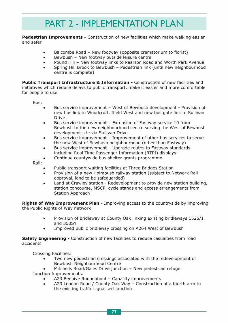
PART 2 - IMPLEMENTATION PLAN
77
81
Pedestrian Improvements - Construction of new facilities which make walking easier and safer
• Balcombe Road – New footway (opposite crematorium to florist) • Bewbush – New footway outside leisure centre • Pound Hill – New footway links to Pearson Road and Worth Park Avenue. • Spring Hill Brook to Bewbush – Pedestrian link (until new neighbourhood
centre is complete)
Public Transport Infrastructure & Information - Construction of new facilities and initiatives which reduce delays to public transport, make it easier and more comfortable for people to use
Bus: • Bus service improvement – West of Bewbush development - Provision of
new bus link to Woodcroft, Ifield West and new bus gate link to Sullivan Drive
• Bus service improvement – Extension of Fastway service 10 from Bewbush to the new neighbourhood centre serving the West of Bewbush development site via Sullivan Drive
• Bus service improvement – Improvement of other bus services to serve the new West of Bewbush neighbourhood (other than Fastway)
• Bus service improvement – Upgrade routes to Fastway standards including Real Time Passenger Information (RTPI) displays
• Continue countywide bus shelter grants programme Rail:
• Public transport waiting facilities at Three Bridges Station • Provision of a new Holmbush railway station (subject to Network Rail
approval, land to be safeguarded) • Land at Crawley station - Redevelopment to provide new station building,
station concourse, MSCP, cycle stands and access arrangements from Station Approach
Rights of Way Improvement Plan - Improving access to the countryside by improving the Public Rights of Way network
• Provision of bridleway at County Oak linking existing bridleways 1525/1 and 350SY
• Improved public bridleway crossing on A264 West of Bewbush
Safety Engineering - Construction of new facilities to reduce casualties from road accidents
Crossing Facilities: • Two new pedestrian crossings associated with the redevelopment of
Bewbush Neighbourhood Centre • Mitchells Road/Gales Drive junction – New pedestrian refuge
Junction Improvements: • A23 Beehive Roundabout – Capacity improvements • A23 London Road / County Oak Way – Construction of a fourth arm to
the existing traffic signalised junction

PART 2 - IMPLEMENTATION PLAN
78 82
• A264 Crawley Road – Temporary traffic signalised junction to serve West of Bewbush development
• A264 Crawley Road – New junction to serve West of Bewbush development (incorporating a new access to Holmbush Potteries Industrial Estate)
• A264 / A2220, Sullivan Drive Roundabout – Junction Improvement • A23, Cheals roundabout – Traffic signalisation of roundabout to include
controlled fire appliance access onto the A23 Brighton Road and a left in / left out access onto the A2220 Horsham Road
• Horsham Road junction with Old Horsham Road – mini-roundabout • M23 Junction 11 - A financial contribution to improve junction • M23 Junction 9 Roundabout – Capacity improvements • M23 Junction 9A Roundabout – Capacity improvements • A23 North Terminal Roundabout – Capacity improvements • Perimeter Road East / A23 London Road – Traffic signal junction and link
road • North East Sector – Junction improvements at M23 Junction 10 and along
Balcombe Road, Steers Lane, Radford Road and Crawley Avenue Traffic Management & Calming:
• Langley Parade – Changes to traffic circulation and car parking to aid pedestrian safety
Street Lighting: • Street lighting scheme along Balcombe Avenue and Crawley Avenue in
association with the North East Sector development Streetscene Improvements:
• Manor Royal Industrial Estate – Road signing and public realm improvements to promote economic growth
School Travel Initiatives - Initiatives which encourage walking, cycling, public transport use and car sharing on the journey to school
School Safety Zones:
• Our Lady Queen of Heaven Catholic School • St Margaret’s Church of England School
Long term plans (post 2016) for Crawley Many of the long term plans for Crawley will be delivered by the Strategic Location developments at North East Sector and West of Bewbush as part of a phased approach to delivering infrastructure and services. This is due to the length of time it will take to build the number of houses. Other schemes will be delivered as and when funding becomes available or by the development of smaller sites as and when they come forward.

PART 2 - IMPLEMENTATION PLAN
79

PART 2 - IMPLEMENTATION PLAN
80 84
Local Transport Implementation Plan - East Grinstead
Like most urban areas East Grinstead experiences short term congestion and safety issues associated with current patterns of travel behaviour which are dominated by the private car. In the future some additional housing will be built and the impact of this growth will need to be mitigated. Therefore the implementation plan focuses on measures that will support growth and encourage a change in travel behaviour of existing residents and visitors to the town. Short-term (2011-2016) initiatives for East Grinstead Cycling Infrastructure & Promotion – New cycling infrastructure will be identified to support new development as part of the planning application process and will be implemented as funds permit Enforcement & Speed Management - Management of traffic speeds to reduce casualties from road accidents
• A22 London Road – route safety scheme including a reduction in speed limit from 40mph to 30mph, provision of yellow boxes, coloured surfacing and signage improvements
• A264 Moat Road – Holtye Road – route safety scheme including signage and surfacing
• B2110 Hazelden Crossroads – reduction in speed limit from 60mph to 40mph, surfacing, signage amendments and extension to the double white line system
Parking Management - Managing on-street parking to provide somewhere for people to park and reduce delays
• Parking Strategy Aim – Controlled Parking Zone (CPZ) extensions & review
Public Transport Infrastructure & Information - Construction of new facilities and initiatives which reduce delays to public transport, make it easier and more comfortable for people to use
Bus: • Bus priority at traffic signals in East Grinstead • Bus priority signals – re-phasing of traffic lights to provide priority for
buses at junctions on bus routes in East Grinstead • Real Time Passenger Information (RTPI) screens at 20 bus stops in East
Grinstead Rail:
• East Grinstead Station redevelopment in coordination with the National Station Improvements Programme (NSIP) – replacement of station building and improvement to rail / bus interchange
Rights of Way Improvement Plan - Improving access to the countryside by improving the Public Rights of Way network

PART 2 - IMPLEMENTATION PLAN
81 85
• Provision of bridleway(s) linking Worth Way – Turners Hill – Kingscote – Weirwood Reservoir – East Grinstead
• Provision of bridleway linking bridleways 6bEG and 19EG • Provision of footpath to connect footpaths 12WH with 21aWH • Provision of footpaths and bridleways around Whilletts Bridge and Stone
Hill Rocks to minimise use of West Hoathly Road Safety Engineering - Construction of new facilities to reduce casualties from road accidents
Crossing Facilities: • Imberhorne Lane near school – New puffin crossing • London Road near Lingfield Road – Refurbishment of existing pelican
crossing including a puffin conversion Junction Improvements(subject to detailed design and funding):
• A22 London Road with A22 Station Road • A22 London Road with A264 Copthorne Road • A22 London Road with A264 Moat Road • A22 London Road with Imberhorne Lane • A22 London Road with Lingfield Road
School Travel Initiatives - Initiatives which encourage walking, cycling, public transport use and car sharing on the journey to school
School Safety Zone: • St Peter’s Catholic Primary School (Crossways Avenue)
Long-term plans (post 2016) for East Grinstead For many years an A22/A264 relief road was seen as an essential part of the solution to East Grinstead’s transport problems in the medium/long term. However it has become increasingly clear that such a road is undeliverable and that the limited effectiveness of other forms of transport mitigation is a significant constraint on the amount of future development that can be accommodated in the town. Future transport strategy in East Grinstead will now focus on promotion of sustainable travel (through improvements to infrastructure, passenger information and public transport services) and optimisation of the existing highway network through improvements aimed at addressing safety and congestion issues. All potential sources of funding will be explored but it is likely that strategy implementation will be closely linked to the timing of development.

PART 2 - IMPLEMENTATION PLAN
82 85
• Provision of bridleway(s) linking Worth Way – Turners Hill – Kingscote – Weirwood Reservoir – East Grinstead
• Provision of bridleway linking bridleways 6bEG and 19EG • Provision of footpath to connect footpaths 12WH with 21aWH • Provision of footpaths and bridleways around Whilletts Bridge and Stone
Hill Rocks to minimise use of West Hoathly Road Safety Engineering - Construction of new facilities to reduce casualties from road accidents
Crossing Facilities: • Imberhorne Lane near school – New puffin crossing • London Road near Lingfield Road – Refurbishment of existing pelican
crossing including a puffin conversion Junction Improvements(subject to detailed design and funding):
• A22 London Road with A22 Station Road • A22 London Road with A264 Copthorne Road • A22 London Road with A264 Moat Road • A22 London Road with Imberhorne Lane • A22 London Road with Lingfield Road
School Travel Initiatives - Initiatives which encourage walking, cycling, public transport use and car sharing on the journey to school
School Safety Zone: • St Peter’s Catholic Primary School (Crossways Avenue)
Long-term plans (post 2016) for East Grinstead For many years an A22/A264 relief road was seen as an essential part of the solution to East Grinstead’s transport problems in the medium/long term. However it has become increasingly clear that such a road is undeliverable and that the limited effectiveness of other forms of transport mitigation is a significant constraint on the amount of future development that can be accommodated in the town. Future transport strategy in East Grinstead will now focus on promotion of sustainable travel (through improvements to infrastructure, passenger information and public transport services) and optimisation of the existing highway network through improvements aimed at addressing safety and congestion issues. All potential sources of funding will be explored but it is likely that strategy implementation will be closely linked to the timing of development.

PART 2 - IMPLEMENTATION PLAN
83
87
Local Transport Implementation Plan - Haywards Heath Haywards Heath suffers from peak time town centre congestion and travel patterns which are dominated by car travel. The bus network in the town is limited due to the size of the town and the dispersed nature of settlements in the surrounding rural area. There is significant scope to improve facilities in Haywards Heath for walking, cycling and public transport interchange by investing in new infrastructure and promoting sustainable travel modes. Additional development which is expected in the town will be expected to contribute to these facilities and complete the Haywards Heath Relief Road which will reduce town centre traffic levels and enable road space to be reallocated to walking, cycling and public transport. The implementation plan which has been prepared for Haywards Heath includes some of the measures which are being considered to do this. Short-term (2011-2016) initiatives for Haywards Heath
Cycling Infrastructure & Promotion - Construction and promotion of new cycle facilities to increase levels of cycling
• Further work is required into the feasibility of the proposed cycle network • The network will need to support new development and funding will be
secured through the planning application process to deliver it Enforcement & Speed Management - Management of traffic speeds to reduce casualties from road accidents
• A272 (Phase 4) between junction with Pickwell Lane and junction with A23 – reduction in speed limit from National to 50mph
Parking Management - Managing on-street parking to provide somewhere for people to park and reduce delays
• Parking Strategy Scheme – Waiting restrictions in Haywards Heath and Lindfield
Public Transport Infrastructure & Information - Construction of new facilities and initiatives which reduce delays to public transport, make it easier and more comfortable for people to use
Rail: • Haywards Heath Station improvement - Cycle shelter to accommodate
300 bicycles and 100 motorcycles (joint funding with Southern and Network Rail)
• Haywards Heath Station redevelopment – linked to delivery of Town Centre Masterplan
Rights of Way Improvement Plan - Improving access to the countryside by improving the Public Rights of Way network
• Provision of bridleway(s) linking Haywards Heath - Burgess Hill

PART 2 - IMPLEMENTATION PLAN
84 88
• Provision of bridleway(s) from / to Bolnore linking to existing bridleways southwest of Haywards Heath
• Provision of bridleways in and around Freshfield Brickworks, Horsted Keynes
• Provision of bridleway(s) east of Haywards Heath to Scaynes Hill and into East Sussex
• Provision of footpath to safely connect between footpaths 13bBal and 17Bal
Safety Engineering - Construction of new facilities to reduce casualties from road accidents
• A273 Isaacs Lane – specialist surfacing programme School Travel Initiatives - Initiatives which encourage walking, cycling, public transport use and car sharing on the journey to school
School Safety Zones: • Blackthorns Community Primary School and Oathall Community College
(Appledore Gardens) • Lindfield Community Primary School
Town Centre & Village Enhancements - Improving the town and village environment and access to local community facilities
• A272 Urban Enhancement Scheme – South Road, The Broadway and Wivelsfield Road (dependent on delivery of the Haywards Heath Relief Road, which is linked to timescales of development and available funding)
• South Road – streetscene improvements (dependent on delivery of the Haywards Heath Relief Road, which is linked to timescales of development and available funding)
Long-term plans (post 2016) for Haywards Heath The desired traffic reduction in South Road and provision of significant future development elsewhere in the town is dependent upon completion of the A272 Haywards Heath Relief Road. Part of this new road has been provided by the initial stages of the Bolnore development but construction of the remaining sections of the road is on hold because the developments providing the funding have been delayed by the recession. At present the relief road appears unlikely to be completed before 2016 but efforts to find a solution to the funding issue are continuing. Many longer-term schemes including pedestrianisation / pedestrian enhancements, improved cycle links and controlled parking are intended to improve access to town centre retail, services and amenities. Such schemes would also complement planned town centre revitalisation projects but are unable to proceed sooner because of delays to completion of the relief road.

PART 2 - IMPLEMENTATION PLAN
85

PART 2 - IMPLEMENTATION PLAN
86 90
Local Transport Implementation Plan - Horsham The historic market town of Horsham is home to over 40,000 people and offers employment and services to local people and attracts people from the wider district. Horsham is well connected by rail to London and destinations to the South via the Arun Valley line. Levels of car ownership in Horsham District are high but the bus network also plays an important role in providing people with access to services in the town. Walking, cycling and public transport will be expected to play an important role in serving the needs of Horsham in the future. In the plan period, substantial new development is expected in Horsham which will need to be well connected to existing infrastructure and will be expected to contribute towards improvements to existing infrastructure and encouraging more sustainable travel patterns in the future. Short-term (2011-2016) initiatives for Horsham
Parking Management - Managing on-street parking to provide somewhere for people to park and reduce delays
• Parking Strategy Aim – Controlled Parking Zone (CPZ) extension review
Pedestrian Improvements - Construction of new facilities which make walking easier and safer
• Brighton Road – Footway enhancements and kerb adjustments • East Street – Pedestrian improvement scheme • Horsham to Crawley – Public Rights of Way (PROW) improvement
scheme • A24, North of Farthings Hill grade separated junction – New
Cycle/Pedestrian footbridge across the A24 (developer funded) • A24, South of Farthings Hill grade separated junction – New
Cycle/Pedestrian footbridge across the A24 (developer funded) • Footway reconstruction in co-ordination with street lighting PFI contract
at Parkfield, Blatchford Road, Bunting Close, Butlers Road, Honeywood Road, The Ridgeway and Copper Place
Public Transport Infrastructure & Information - Construction of new facilities and initiatives which reduce delays to public transport, make it easier and more comfortable for people to use
Bus: • Creation of new bus service between the West of Horsham development,
Horsham town centre, the railway station and the hospital Rail:
• Horsham Station Forecourt Improvements in co-ordination with the National Stations Improvements Programme – To provide better bus access, cycle parking and improve pedestrian safety, and improve the station building
Rights of Way Improvement Plan - Improving access to the countryside by improving the Public Rights of Way network
• Provision of bridleway linking Horsham with Warnham
91
• Provision of bridleway linking Warnham Brick Works with Mayes Lane & Northlands Road, Warnham
• Provision of bridleway routes within West of Horsham proposed development, linking Hills Farm Lane with Parthings Road and also into Broadbridge Heath to connect with the Downs Link bridleway, also upgrading Old Wickhurst Lane
• Provision of bridleway(s) as part of Horsham – Crawley cycle route • Realignment of Downs Link bridleway close to Christ’s Hospital
Safety Engineering - Construction of new facilities to reduce casualties from road accidents
Crossing Facilities: • Worthing Road near Blackbridge Lane
Junction Improvements: • Hills Farm Lane / Guildford Road – Junction improvement to include new
toucan crossing • North Parade / Wimblehurst Road – Junction Improvement • A24, Land South of Broadbridge Heath – Provision of new grade-
separated junction • A24, Warnham Road and Dorking Road roundabouts - Junction
improvements • A264/Langhurstwood Road – Junction Improvement
Network improvements: • A24 – new temporary construction access to serve West of Horsham
development • Land South of Broadbridge Heath – Provision of new East/West link road
from A24 to A281 • Hills Farm Lane North – New vehicular access to serve first phase of the
West of Horsham development Traffic Management & Calming:
• Old Guildford Road/Billingshurst Road – New traffic calming measures in Broadbridge Heath to deter short cutting.
School Travel Initiatives - Initiatives which encourage walking, cycling, public transport use and car sharing on the journey to school
School Safety Zones: • Leechpool Primary School, Harwood Road – Creation of puffin crossing • North Heath Community Primary School, Erica Way • St Robert Southwell Catholic Primary School, Lambs Farm Road
Safer Routes to School Projects: • Kings Road roundabout • St Robert Southwell School, Lambs Farm Road • Safer Routes to Schools Travel Plan & School Safety Zone – West of
Horsham development Long-term plans (post 2016) for Horsham Many of the long term implementation schemes for Horsham will be delivered by the West of Horsham development as part of a phased approach to delivering infrastructure and services. This is due to the time it will take to deliver the planned number of houses.

PART 2 - IMPLEMENTATION PLAN
87
91
• Provision of bridleway linking Warnham Brick Works with Mayes Lane & Northlands Road, Warnham
• Provision of bridleway routes within West of Horsham proposed development, linking Hills Farm Lane with Parthings Road and also into Broadbridge Heath to connect with the Downs Link bridleway, also upgrading Old Wickhurst Lane
• Provision of bridleway(s) as part of Horsham – Crawley cycle route • Realignment of Downs Link bridleway close to Christ’s Hospital
Safety Engineering - Construction of new facilities to reduce casualties from road accidents
Crossing Facilities: • Worthing Road near Blackbridge Lane
Junction Improvements: • Hills Farm Lane / Guildford Road – Junction improvement to include new
toucan crossing • North Parade / Wimblehurst Road – Junction Improvement • A24, Land South of Broadbridge Heath – Provision of new grade-
separated junction • A24, Warnham Road and Dorking Road roundabouts - Junction
improvements • A264/Langhurstwood Road – Junction Improvement
Network improvements: • A24 – new temporary construction access to serve West of Horsham
development • Land South of Broadbridge Heath – Provision of new East/West link road
from A24 to A281 • Hills Farm Lane North – New vehicular access to serve first phase of the
West of Horsham development Traffic Management & Calming:
• Old Guildford Road/Billingshurst Road – New traffic calming measures in Broadbridge Heath to deter short cutting.
School Travel Initiatives - Initiatives which encourage walking, cycling, public transport use and car sharing on the journey to school
School Safety Zones: • Leechpool Primary School, Harwood Road – Creation of puffin crossing • North Heath Community Primary School, Erica Way • St Robert Southwell Catholic Primary School, Lambs Farm Road
Safer Routes to School Projects: • Kings Road roundabout • St Robert Southwell School, Lambs Farm Road • Safer Routes to Schools Travel Plan & School Safety Zone – West of
Horsham development Long-term plans (post 2016) for Horsham Many of the long term implementation schemes for Horsham will be delivered by the West of Horsham development as part of a phased approach to delivering infrastructure and services. This is due to the time it will take to deliver the planned number of houses.
92
Other schemes will be delivered by the County Council as and when funding becomes available or by the development of smaller sites as and when they come forward.

PART 2 - IMPLEMENTATION PLAN
88
91
• Provision of bridleway linking Warnham Brick Works with Mayes Lane & Northlands Road, Warnham
• Provision of bridleway routes within West of Horsham proposed development, linking Hills Farm Lane with Parthings Road and also into Broadbridge Heath to connect with the Downs Link bridleway, also upgrading Old Wickhurst Lane
• Provision of bridleway(s) as part of Horsham – Crawley cycle route • Realignment of Downs Link bridleway close to Christ’s Hospital
Safety Engineering - Construction of new facilities to reduce casualties from road accidents
Crossing Facilities: • Worthing Road near Blackbridge Lane
Junction Improvements: • Hills Farm Lane / Guildford Road – Junction improvement to include new
toucan crossing • North Parade / Wimblehurst Road – Junction Improvement • A24, Land South of Broadbridge Heath – Provision of new grade-
separated junction • A24, Warnham Road and Dorking Road roundabouts - Junction
improvements • A264/Langhurstwood Road – Junction Improvement
Network improvements: • A24 – new temporary construction access to serve West of Horsham
development • Land South of Broadbridge Heath – Provision of new East/West link road
from A24 to A281 • Hills Farm Lane North – New vehicular access to serve first phase of the
West of Horsham development Traffic Management & Calming:
• Old Guildford Road/Billingshurst Road – New traffic calming measures in Broadbridge Heath to deter short cutting.
School Travel Initiatives - Initiatives which encourage walking, cycling, public transport use and car sharing on the journey to school
School Safety Zones: • Leechpool Primary School, Harwood Road – Creation of puffin crossing • North Heath Community Primary School, Erica Way • St Robert Southwell Catholic Primary School, Lambs Farm Road
Safer Routes to School Projects: • Kings Road roundabout • St Robert Southwell School, Lambs Farm Road • Safer Routes to Schools Travel Plan & School Safety Zone – West of
Horsham development Long-term plans (post 2016) for Horsham Many of the long term implementation schemes for Horsham will be delivered by the West of Horsham development as part of a phased approach to delivering infrastructure and services. This is due to the time it will take to deliver the planned number of houses.
92
Other schemes will be delivered by the County Council as and when funding becomes available or by the development of smaller sites as and when they come forward.

PART 2 - IMPLEMENTATION PLAN
89 94
Local Transport Implementation Plan - Littlehampton
Littlehampton, together with Rustington, East Preston, Kingston and Angmering make up a large urban area East of the river Arun. The focus for Littlehampton town centre is one of regeneration and new development is expected in the town to support this objective. Access to Littlehampton from the West and East is generally good. From the north access via the A284 and Wick level crossing suffers from delays, which together with issues associated with the A27 around Arundel contributes to poor connectivity. New development will be required to integrate into the existing transport network and deliver enhancements to the infrastructure to provide a stimulus for regeneration, improve connectivity and encourage long term sustainable travel behaviour during the plan period. Short-term (2011-2016) initiatives for Littlehampton
Cycling Infrastructure & Promotion - Construction and promotion of new cycle facilities to increase levels of cycling
• A259 Highdown Drive to Wick Roundabout then parallel to A259 Joyce Close – footway / cycleway
• A259 – shared use footway / cycleway extension from Joyce Close to Eldon Way
Enforcement & Speed Management - Management of traffic speeds to reduce casualties from road accidents
• A259 Rustington Bypass west of Mill Lane – route safety scheme – Crash Barriers – (Casualty saving justification reviewed annually)
• South Terrace Parking Management - Managing on-street parking to provide somewhere for people to park and reduce delays
• Parking Strategy Aim – Introduction of Civil Parking Enforcement (CPE) • Implementation of a Controlled Parking Zone (CPZ) • Parking Management Initiatives – town centre
Public Transport Infrastructure & Information - Construction of new facilities and initiatives which reduce delays to public transport, make it easier and more comfortable for people to use
Bus: • Real Time Information at Littlehampton bus station (Anchor Springs)
Safety Engineering - Construction of new facilities to reduce casualties from road accidents
Crossing Facilities: • Station Road, East Preston – Pedestrian refuge island
Traffic Management schemes: • Pier Road Improvement Scheme

PART 2 - IMPLEMENTATION PLAN
90 95
School Travel Initiatives - Initiatives which encourage walking, cycling, public transport use and car sharing on the journey to school
School Safety Zones: • Angmering Secondary School (Station Road) • Arun Vale Infants (York Road) • Connaught Junior School (Connaught Road) • East Preston Infants School and East Preston Juniors School • St Catherines C of E Primary School (Highdown Drive) • St Margarets CE Primary School (Arundel Road) • St Wilfreds Catholic Primary School (Arundel Road)
Safer Routes to School Projects: • East Preston Level Crossing • For school generated traffic from Site 7 Toddington Lane development
(Littlehampton School and Lyminster School) Long-term plans (post 2016) for Littlehampton The introduction of measures on the main routes on the transport network are to tackle issues associated with congestion, accessibility and safety, and where appropriate are to be supportive of possible future extensions to the Coastal Transport System major scheme. Highways and transport proposals are to recognise wider development proposals identified in a range of local strategies, indicating how such schemes can be progressed and delivered. A range of schemes including pedestrians crossing facilities, cycle routes and improvements to bus stop facilities are to be provided as funding opportunities arise. Both new development and public spending programmes are to contribute towards a package of sustainable transport measures benefiting the town and are supportive of both schemes that meet area-wide demands as well as addressing more localised interests.

PART 2 - IMPLEMENTATION PLAN
91

PART 2 - IMPLEMENTATION PLAN
92 97
Local Transport Implementation Plan - Shoreham The town of Shoreham is part of a designated Growth Point which includes parts of Southwick, Fishersgate and Portslade and is expected to see substantial development during the plan period as plans to regenerate the town and harbour are realised. The town has strong links with Brighton & Hove in the east and experiences low levels of car ownership and high bus patronage compared to the other West Sussex coastal towns. In order to realise the regeneration aspirations for the area, there is a need to encourage a further shift in travel choices resulting in more walking, cycling and public transport use. The implementation plan for Shoreham is intended to facilitate this, and new development will be expected to encourage more sustainable travel patterns in the future. Short-term (2011-2016) initiatives for Shoreham Air quality/Climate change management - Use of technology, information and monitoring to improve air quality in Air Quality Management Areas
Key aspects of Shoreham AQAP for the two AQMAs on A259 High St. and A270 junction with Upper Kingston Lane, Southwick are:
• Continued monitoring of Air Quality Management Areas and actions to secure air quality improvements and develop a Low Emissions Strategy
• Promote rail use (includes CIF measures) • Continue with encouragement of cleaner & new technology buses • Travelwise travel awareness work • School Travel Plans – local prioritisation – continuing work • Business/’Green’ travel plans – continuing work • Car share service (using WSCC scheme) • Low emission zone and land use planning to improve air quality • On going air quality monitoring and public information to help reduce health
impacts through ‘airAlert’ and ‘airAlert-4-Schools’. • Cleaner Taxis (Adur) • Adur Travel Plan • Other initiatives under other headings will also be used to support air
quality objectives Cycling Infrastructure & Promotion - Construction and promotion of new cycle facilities to increase levels of cycling
• Shoreham Airport • South Coast Cycle Route – Kings Walk to Beach Road • National Cycle Network (NCN)- Increase and extend links to schools where
possible Intelligent Transport Systems - Use of new technology to provide better information to drivers and public transport users
• Travel Information Variable Message Sign at Norfolk Bridge to provide local air quality and alternative route information
• Real Time Passenger Information (RTPI) sign showing bus information at Southland’s Hospital, Holmbush Shopping Centre, Shoreham, Southwick and Fishersgate rail stations

PART 2 - IMPLEMENTATION PLAN
93 98
• Introduction of RTPI at bus stops along A259 from Shoreham High Street to County Border
Parking Management - Managing on-street parking to provide somewhere for people to park and reduce delays
• Introduction of a Controlled Parking Zone (CPZ)
Pedestrian Improvements - Construction of new facilities which make walking easier and safer
• Connect 2 project – pedestrian bridge replacement for cyclists and pedestrians over the River Adur. To include improvements at Shoreham Beach and East Street to link to provide cycle network continuity
• St Mary’s Road Public Transport Infrastructure & Information - Construction of new facilities and initiatives which reduce delays to public transport, make it easier and more comfortable for people to use
Bus: • Installation of bus lanes / priority and bus stop improvements / new stops
as part of A259 junction improvements at the following junctions: A259 junction with Eastern Avenue, A259 junction with Kingston Avenue, A259 junction with Station Road, A259 junction with The Gardens and Garden Road
• Coastal Transport System (CTS) (Bus based rapid transport system) – feasibility designs continue to be progressed in conjunction with Brighton & Hove City Council
Rail: • Shoreham-by-Sea station access improvements – forecourt works to
improve access to the station, taxi rank extension, bus stop improvements, cycle facilities and bus RTPI screens
• Southwick station access improvements – remodelling Station Road to provide new drop off area and short term parking, environmental works, on-platform waiting facilities, cycle parking and bus RTPI screens
• Fishersgate station access improvements – signage for cycle and pedestrian routes, cycle parking and on-platform waiting facilities
Rights of Way Improvement Plan - Improving access to the countryside by improving the Public Rights of Way network
• Improve provision of Downs Link bridleway by surface improvements north from Old Shoreham Toll Bridge and extension south to Ropetackle
Safety Engineering - Construction of new facilities to reduce casualties from road accidents
Crossing Facilities: • Brighton Road near garage – puffin refurbishment • High Street near East Street – toucan conversion • High Street near Ship Street – puffin refurbishment

PART 2 - IMPLEMENTATION PLAN
94 98
• Introduction of RTPI at bus stops along A259 from Shoreham High Street to County Border
Parking Management - Managing on-street parking to provide somewhere for people to park and reduce delays
• Introduction of a Controlled Parking Zone (CPZ)
Pedestrian Improvements - Construction of new facilities which make walking easier and safer
• Connect 2 project – pedestrian bridge replacement for cyclists and pedestrians over the River Adur. To include improvements at Shoreham Beach and East Street to link to provide cycle network continuity
• St Mary’s Road Public Transport Infrastructure & Information - Construction of new facilities and initiatives which reduce delays to public transport, make it easier and more comfortable for people to use
Bus: • Installation of bus lanes / priority and bus stop improvements / new stops
as part of A259 junction improvements at the following junctions: A259 junction with Eastern Avenue, A259 junction with Kingston Avenue, A259 junction with Station Road, A259 junction with The Gardens and Garden Road
• Coastal Transport System (CTS) (Bus based rapid transport system) – feasibility designs continue to be progressed in conjunction with Brighton & Hove City Council
Rail: • Shoreham-by-Sea station access improvements – forecourt works to
improve access to the station, taxi rank extension, bus stop improvements, cycle facilities and bus RTPI screens
• Southwick station access improvements – remodelling Station Road to provide new drop off area and short term parking, environmental works, on-platform waiting facilities, cycle parking and bus RTPI screens
• Fishersgate station access improvements – signage for cycle and pedestrian routes, cycle parking and on-platform waiting facilities
Rights of Way Improvement Plan - Improving access to the countryside by improving the Public Rights of Way network
• Improve provision of Downs Link bridleway by surface improvements north from Old Shoreham Toll Bridge and extension south to Ropetackle
Safety Engineering - Construction of new facilities to reduce casualties from road accidents
Crossing Facilities: • Brighton Road near garage – puffin refurbishment • High Street near East Street – toucan conversion • High Street near Ship Street – puffin refurbishment
99
• Old Shoreham Road near Lower Drive – pelican refurbishment • Old Shoreham Road near Park Way – pelican refurbishment • Southwick Street near Southdown Road – pelican refurbishment
Traffic Signals: • A259 junction improvements to include the installation of MOVA control
system, pedestrian and cycling facilities at the following 4 junctions: A259 junction with Eastern Avenue, A259 junction with Kingston Avenue, A259 junction with Station Road, A259 junction with The Gardens and Garden Road,
• Eastern Avenue / Middle Road – traffic signals upgrade • Old Shoreham Road / Mile Oak Road - traffic signals upgrade • Old Shoreham Road / Ropetackle – traffic signals upgrade
School Travel Initiatives - Initiatives which encourage walking, cycling, public transport use and car sharing on the journey to school
• St Nicolas & St Mary Primary School, Eastern Avenue - improvement to improve/upgrade existing pedestrian facilities.
• Holmbush First and Herons Dale Schools, Hawkins Crescent • Swiss Gardens Primary School, Swiss Gardens • St. Peter's Catholic Primary School, Middle Road
Town Centre & Village Enhancements - Improving the town and village environment and access to local community facilities
• East Street – pedestrianisation and cycling improvements • Streetscene improvements to the town centre shopping centre
Long-term plans (post 2016) for Shoreham A Coastal Transport System major scheme is being developed for the area and will be delivered in the short term subject to the availability of funding from central Government. It is envisaged that this will provide a frequent bus based transport system along the A259 to Brighton and Worthing. Improvements would be made to the highway to maximise bus priority so that this service will provide a high quality alternative to car commuting. Options for the Coastal Transport System, along with other transport strategies, will be subject to detailed testing to ensure that the optimal package of transport improvements are secured for the area. Regeneration at Shoreham Harbour will realise an opportunity to provide much needed employment and high quality homes in a sustainable way. The delivery of development in this area will require innovative transport solutions to encourage optimal walking, cycling and public transport use. These measures will build upon the benefits realised by the improvement works outlined in the short-term implementation plan.

PART 2 - IMPLEMENTATION PLAN
95

PART 2 - IMPLEMENTATION PLAN
96 101
Local Transport Implementation Plan - Worthing Worthing adjoins the new South Downs National Park at its northern boundary. It is also a town in need of town centre regeneration in order to improve public spaces, leisure and retail opportunities which will attract visitors to the town and reduce the number of people who travel to other towns for shopping and leisure purposes. Due to the constraint on expansion to the North, new development is expected in the town centre which will help to deliver this aim. The A27 remains a significant bottleneck on the strategic road network which makes journey times unreliable for local and through traffic. Substantial investment for improvements to the A27 is not expected during the period to 2016. This implementation plan therefore aims to encourage walking, cycling and public transport use, particularly for short journeys. This will enable regeneration and provide the basis needed for investment in the A27. Short-term initiatives (2011-2016) for Worthing Air quality/Climate change management - Use of technology, information and monitoring to improve air quality in Air Quality Management Areas (A24/A27 Grove Lodge junction)
• CCTV/3G congestion cameras • Traffic Signal Optimisation • Business Travel Plans - part of wider Travelwise travel awareness as
proposed for Chichester AQAP that affects A27 in that area • School Travel Plans • Public transport (bus) infrastructure • Rail use promotion • Park & Ride (long term) • Cycling and walking infrastructure to aid shift from car use. (Some cycle
infrastructure on A24 under construction) • Electric vehicle recharging posts & parking bays
Cycling Infrastructure & Promotion - Construction and promotion of new cycle facilities to increase levels of cycling
• Goring seafront (part of NCN2) • Goring to Durrington to Broadwater cycle route • Littlehampton Road to East Worthing cycle route • Town Centre to Findon cycle route
Enforcement and Speed Management - Management of traffic speeds to reduce casualties from road accidents
Casualty Reduction Scheme: • Mill Road – traffic management scheme to achieve casualty reduction • Heene Road - traffic management scheme to achieve casualty reduction
Parking Management - Managing on-street parking to provide somewhere for people to park and reduce delays

PART 2 - IMPLEMENTATION PLAN
97 102
• Parking Strategy Aim – Controlled Parking Zone (CPZ) extensions - review
Public Transport Infrastructure & Information - Construction of new facilities and initiatives which reduce delays to public transport, make it easier and more comfortable for people to use
Bus: • Coastal Transport System (bus-based rapid transport scheme) –designs
being developed in conjunction with Brighton & Hove City Council as part of a bid for major scheme funding
Rail: • Goring-by-Sea – investigation of closure of rail level crossing near to
station and enhancement of station access Safety Engineering - Construction of new facilities to reduce casualties from road accidents
Crossing Facilities: • Broadwater Road near Westbourne Avenue
Traffic Calming: • Heene Road • Columbia Drive – traffic calming / traffic management
Junction Improvements: • Titnore Lane junction with Littlehampton Road/Goring Street • Titnore Lane junction with new West Durrington development • Junction improvement on Tesco Link road at West Durrington
School Travel Initiatives - Initiatives which encourage walking, cycling, public transport use and car sharing on the journey to school
School Safety Zones: • Chatsmore Catholic High School • Chesswood Middle School and Davison High School • Durrington First and Middle / Durrington High and English Martyrs • Hawthorns First School and Laurels First School (Durrington) • Lyndhurst First School • Springfield First School and St Andrews High School • West Park C.E. First and Middle School
Safer Routes to School Projects: • Littlehampton Road near the Boulevard • The Orchard and Field Place Schools (Marlborough Road)
Rights of Way Improvement Plan - Improving access to the countryside by improving the Public Rights of Way network
• Support Highways Agency proposal to install bridleway bridge or underpass for non-motorised user access West of Worthing close to Castle Goring
• Create bridleways West of Durrington to provide safe links between Highdown Hill, Castle Goring and proposed Highways Agency bridge, and National Park

PART 2 - IMPLEMENTATION PLAN
98 102
• Parking Strategy Aim – Controlled Parking Zone (CPZ) extensions - review
Public Transport Infrastructure & Information - Construction of new facilities and initiatives which reduce delays to public transport, make it easier and more comfortable for people to use
Bus: • Coastal Transport System (bus-based rapid transport scheme) –designs
being developed in conjunction with Brighton & Hove City Council as part of a bid for major scheme funding
Rail: • Goring-by-Sea – investigation of closure of rail level crossing near to
station and enhancement of station access Safety Engineering - Construction of new facilities to reduce casualties from road accidents
Crossing Facilities: • Broadwater Road near Westbourne Avenue
Traffic Calming: • Heene Road • Columbia Drive – traffic calming / traffic management
Junction Improvements: • Titnore Lane junction with Littlehampton Road/Goring Street • Titnore Lane junction with new West Durrington development • Junction improvement on Tesco Link road at West Durrington
School Travel Initiatives - Initiatives which encourage walking, cycling, public transport use and car sharing on the journey to school
School Safety Zones: • Chatsmore Catholic High School • Chesswood Middle School and Davison High School • Durrington First and Middle / Durrington High and English Martyrs • Hawthorns First School and Laurels First School (Durrington) • Lyndhurst First School • Springfield First School and St Andrews High School • West Park C.E. First and Middle School
Safer Routes to School Projects: • Littlehampton Road near the Boulevard • The Orchard and Field Place Schools (Marlborough Road)
Rights of Way Improvement Plan - Improving access to the countryside by improving the Public Rights of Way network
• Support Highways Agency proposal to install bridleway bridge or underpass for non-motorised user access West of Worthing close to Castle Goring
• Create bridleways West of Durrington to provide safe links between Highdown Hill, Castle Goring and proposed Highways Agency bridge, and National Park
103
Long-term plans (post 2016) for Worthing In the long term we expect to develop and implement a package of transport measures with the Highways Agency to support regeneration of the town and the wider coastal West Sussex sub-region. This is likely to involve measures such as park and ride, demand management measures such as bus priority, walking and cycling improvements and other changes to the local road network which will support improvements to the A27 from Worthing to Lancing.

PART 2 - IMPLEMENTATION PLAN
99

PART 2 - IMPLEMENTATION PLAN
100
Monitoring
7.1. ThefollowingtableprovidesinformationontherangeofstatutorytransportmeasuresthatneedtobemonitoredaspartoftheWestSussexLocalAreaAgreement(LAA)andaspartoftheDepartmentofCommunitiesandLocalGovernment(DCLG)NationalIndicatorset.Informationisalsoprovidedonthosemeasuresindirectlyrelatedtotransport,boththosewithintheLAA,andthosewhich are part of the wider DCLG National Indicator set.
7.2. ThetablealsoprovidesanindicationofasmallnumberofadditionallocalindicatorswhichitisbelieveditwillbeimportanttomonitoraspartofLTP3.
7.3. WestSussexwillbesettingtargetswhenadecisiononanynewLAAisagreedfor2011,henceatthisstagenospecifictargetscanbesettobeincludedinthisLocalTransportPlan.Notallofthenon-LAANationalIndicatorswillhavespecifictargetsset,buttheywillallbemonitored.SpecifictargetlevelsfortheLAAandlocalindicatorswilldependonlevelsofagreedLAAfunding,aswellasresponsestotheLTP3consultation,specificallyontheemphasisofDaSTSgoalimplementation measures.
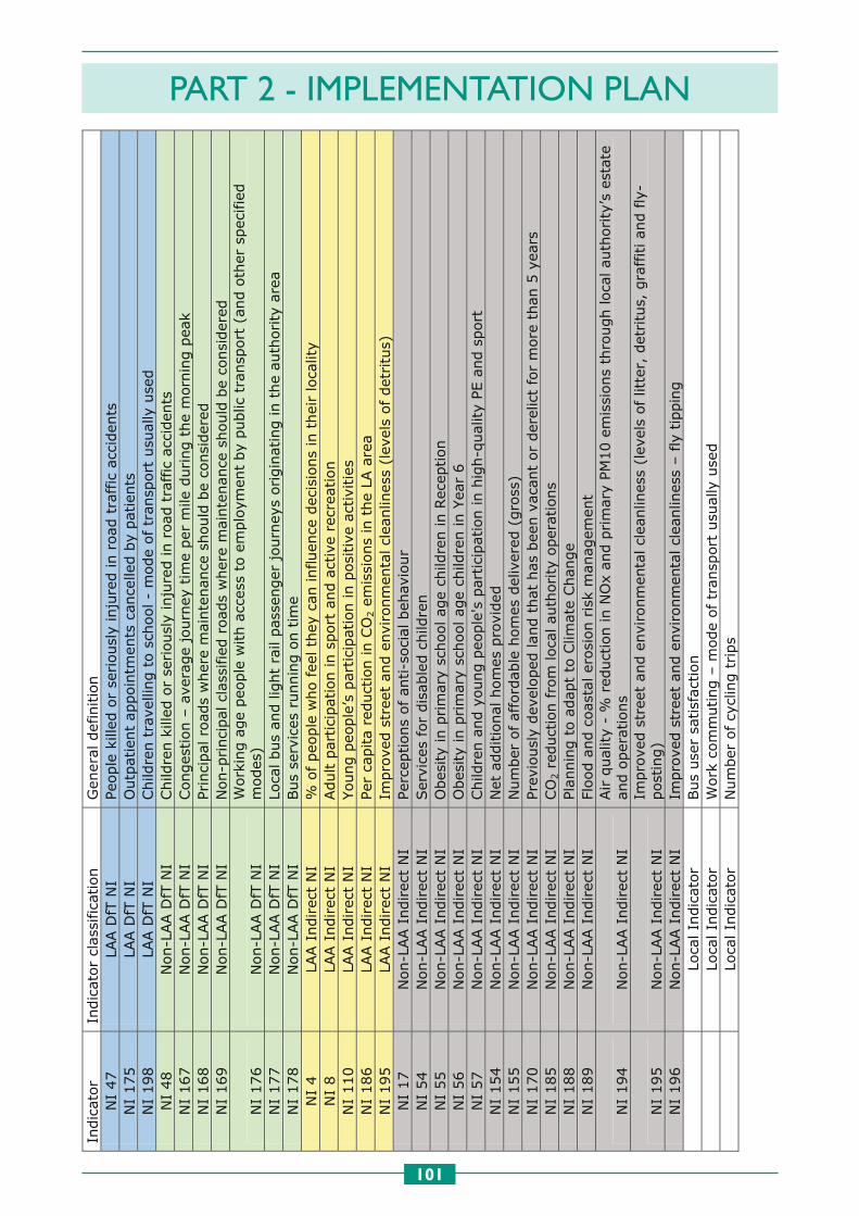
PART 2 - IMPLEMENTATION PLAN
101
106
Indic
ator
Indic
ator
clas
sifica
tion
Gen
eral
def
initio
n
NI
47
LAA D
fT N
I Pe
ople
kill
ed o
r se
riousl
y in
jure
d in r
oad
tra
ffic
acc
iden
ts
NI
175
LAA D
fT N
I O
utp
atie
nt
appoin
tmen
ts c
ance
lled b
y pat
ients
N
I 198
LAA D
fT N
I Child
ren t
rave
lling t
o s
chool -
mode
of
tran
sport
usu
ally
use
d
NI
48
Non-L
AA D
fT N
I Child
ren k
illed
or
seriousl
y in
jure
d in r
oad
tra
ffic
acc
iden
ts
NI
167
Non-L
AA D
fT N
I Conges
tion –
ave
rage
journ
ey t
ime
per
mile
during t
he
mor
nin
g p
eak
NI
168
Non-L
AA D
fT N
I Princi
pal
road
s w
her
e m
ainte
nan
ce s
hould
be
consi
der
ed
NI
169
Non-L
AA D
fT N
I N
on-p
rinci
pal
cla
ssifie
d r
oad
s w
her
e m
ainte
nan
ce s
hould
be
consi
der
ed
NI
176
Non-L
AA D
fT N
I W
ork
ing a
ge
peo
ple
with a
cces
s to
em
plo
ymen
t by
public
tra
nsp
ort
(an
d o
ther
spec
ifie
d
modes
) N
I 177
Non-L
AA D
fT N
I Lo
cal bus
and lig
ht
rail
pas
senger
journ
eys
origin
atin
g in t
he
auth
ority
are
a N
I 178
Non-L
AA D
fT N
I Bus
serv
ices
runnin
g o
n t
ime
NI
4
LAA I
ndirec
t N
I %
of peo
ple
who f
eel th
ey c
an influ
ence
dec
isio
ns
in t
hei
r lo
calit
y N
I 8
LAA I
ndirec
t N
I Adult p
artici
pat
ion in s
port
and a
ctiv
e re
crea
tion
NI
110
LAA I
ndirec
t N
I Young p
eople
’s p
artici
pat
ion in p
osi
tive
act
ivitie
s N
I 186
LAA I
ndirec
t N
I Pe
r ca
pita
reduct
ion in C
O2 e
mis
sions
in t
he
LA a
rea
NI
195
LAA I
ndirec
t N
I Im
pro
ved s
tree
t an
d e
nvi
ronm
enta
l cl
eanlin
ess
(lev
els
of
det
ritu
s)
NI
17
Non-L
AA I
ndirec
t N
I Pe
rcep
tions
of
anti-s
oci
al b
ehav
iour
NI
54
Non-L
AA I
ndirec
t N
I Ser
vice
s fo
r dis
able
d c
hild
ren
NI
55
Non-L
AA I
ndirec
t N
I O
bes
ity
in p
rim
ary
school ag
e ch
ildre
n in R
ecep
tion
NI
56
Non-L
AA I
ndirec
t N
I O
bes
ity
in p
rim
ary
school ag
e ch
ildre
n in Y
ear
6
NI
57
Non-L
AA I
ndirec
t N
I Child
ren a
nd y
oung p
eople
's p
artici
pat
ion in h
igh-q
ual
ity
PE a
nd s
port
N
I 154
Non-L
AA I
ndirec
t N
I N
et a
dditio
nal
hom
es p
rovi
ded
N
I 155
Non-L
AA I
ndirec
t N
I N
um
ber
of af
ford
able
hom
es d
eliv
ered
(gro
ss)
NI
170
Non-L
AA I
ndirec
t N
I Pre
viousl
y dev
eloped
land t
hat
has
bee
n v
acan
t or
der
elic
t fo
r m
ore
than
5 y
ears
N
I 185
Non-L
AA I
ndirec
t N
I CO
2 r
educt
ion f
rom
loca
l au
thority
oper
atio
ns
NI
188
Non-L
AA I
ndirec
t N
I Pl
annin
g t
o ad
apt
to C
limat
e Chan
ge
NI
189
Non-L
AA I
ndirec
t N
I Fl
ood a
nd c
oas
tal er
osi
on r
isk
man
agem
ent
NI
194
Non-L
AA I
ndirec
t N
I Air q
ual
ity
- %
red
uct
ion in N
Ox
and p
rim
ary
PM10 e
mis
sions
thro
ugh loca
l au
thority
’s e
stat
e an
d o
per
atio
ns
NI
195
Non-L
AA I
ndirec
t N
I Im
pro
ved s
tree
t an
d e
nvi
ronm
enta
l cl
eanlin
ess
(lev
els
of
litte
r, d
etritu
s, g
raffiti an
d f
ly-
post
ing)
NI
196
Non-L
AA I
ndirec
t N
I Im
pro
ved s
tree
t an
d e
nvi
ronm
enta
l cl
eanlin
ess
– f
ly t
ippin
g
Lo
cal In
dic
ator
Bus
use
r sa
tisf
action
Lo
cal In
dic
ator
Work
com
muting –
mode
of
tran
spor
t usu
ally
use
d
Lo
cal In
dic
ator
Num
ber
of cy
clin
g t
rips

Designed by Central Graphic Design, WSCC County Hall, Chichester, PO19 7HAJuly 2010 WS482


