E505 VOL. 29 Government of Uttar Pradesh Public Works Department * Lucknow, India * ENVIRONMENTAL * IMPACT ASSESSMENT * REPORT * August2006 * Ghaghara Bridge at Chellarighat on * Sitapur-Bahraich Road and a Ghaghara Bridge at Kamariaghat on Kft uGorakhpur-Shahganj Road 0 0m * ~ ~Gh jly1 t Jha - , , / . --- ~tBallia * Funding Agency: *Operations Research Group Pvt. Ltd. The World Bank . Public Disclosure Authorized Public Disclosure Authorized Public Disclosure Authorized Public Disclosure Authorized Public Disclosure Authorized Public Disclosure Authorized Public Disclosure Authorized Public Disclosure Authorized
Transcript
E505VOL. 29
Government of Uttar PradeshPublic Works Department
* Lucknow, India
* ENVIRONMENTAL* IMPACT ASSESSMENT* REPORT
* August2006
* Ghaghara Bridge at Chellarighat on* Sitapur-Bahraich Road anda Ghaghara Bridge at Kamariaghat on
Kft uGorakhpur-Shahganj Road
0
0m
* ~ ~Gh jly1 t
Jha - , , / . --- ~tBallia
* Funding Agency:
*Operations Research Group Pvt. Ltd. The World Bank
.
Pub
lic D
iscl
osur
e A
utho
rized
Pub
lic D
iscl
osur
e A
utho
rized
Pub
lic D
iscl
osur
e A
utho
rized
Pub
lic D
iscl
osur
e A
utho
rized
Pub
lic D
iscl
osur
e A
utho
rized
Pub
lic D
iscl
osur
e A
utho
rized
Pub
lic D
iscl
osur
e A
utho
rized
Pub
lic D
iscl
osur
e A
utho
rized
009000000000
0
000*0
0000000000000000
Environment Impact Assessment Operations Research Group
ENVIRONMENTAL ASSESSMENT (BRIDGES ON GHAGHARA RIVER ATCHELLARIGHAT AND KAMARIAGHAT)
EXECUTIVE SUMMARY
1 THE UTTAR PRADESH STATE ROADS 11 PROJECT
The Uttar Pradesh State Roads Project is financed under the World Bank loan number4114-IN. The Uttar Pradesh Public Works Department, as the executing agency, representedthe Government of India in terms of liaison and co-ordination with the World Bank. TheProject preparation was performed by a consortium of consultants consisting ofDHV Consultants BV as lead consultant, Halcrow and Partners, Operations ResearchGroup, Development Consultants Ltd., and MDP Consultants Pvt. Ltd. Project preparationactivity was over on appraisal of project by the World Bank and sanction of loan;subsequently Phase I implementation has started.
The Feasibility Study project followed on earlier work done under the Uttar Pradesh StateRoads Strategic Option Study (SOS), where a list of 2,655 km candidate roads forupgrading was generated. This study was based on regional approach to road planningcontexts to support regional socio-economic development policies. Under the feasibility
l study, environmental screening of 18 finally selected project roads was carried out and theenvironmental sensitivity of each road vis-a-vis proposed road improvement was assessed.Based on favourable economic assessment of highway, project costs, social andenvironment parameters, four routes constituting a length of 374 km have been taken up inPhase I and seven routes have been taken up in Phase II. The length undertaken in Phase IIupgradation is 590.74 km including four bypasses. Under major maintenance project roadlength of 808 km has been taken up in Phase I and 1800 km in Phase II.
Figure 1 presents the roads selected in Phase I and 11 for upgradation and majormaintenance works.
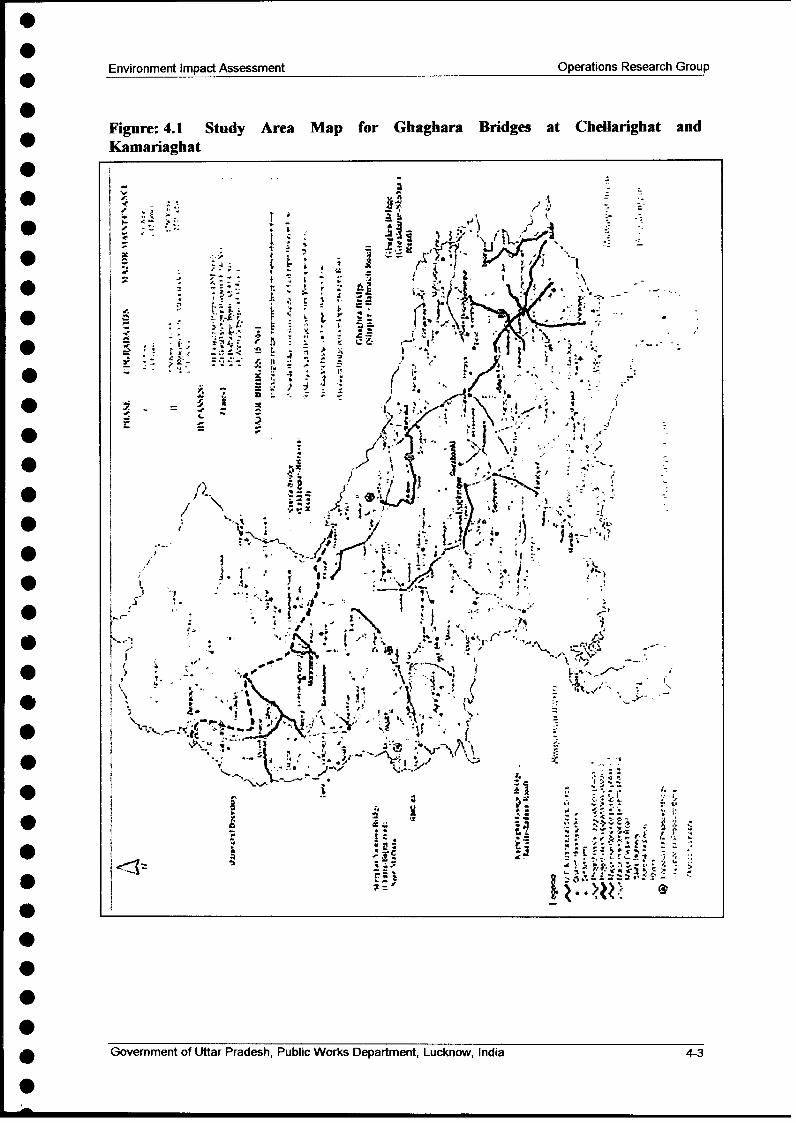
In order to upgrade and provide full connectivity on two phase II upgradation routes Sitapurto Bahraich and Gorakhpur to Shahganj one bridge on each route has been planned onGhaghara river. These both project routes cross Ghaghara river. These locations of thesetwo bridges are Chellarighat on Sitapur- Bahraich route and Kamariaghat on Gorakhakpur- Shahganj route. The location of these bridges has been given in Figure-1. Followingsubsections present summary of environmental assessment and environmental managementplan of both the bridges. It may be mentioned that environmental assessment has beencompleted as per World Bank Operative Directive 4.04, and Guidelines of Ministry ofEnvironment and Forest (MoEF), New Delhi for EIA / EMP of rail and highway projects.
2 PROJECT DESCRIPTIONK
The bridge planned at Kamariaghat is 945 m in length. The approach lengths towardsGorakhpur side is 7485 m and towards Shahganj; side is 440 m. The river dischargeconsidered for bridge design is 21000 cumecs. In order to avoid soil erosion around bridgeand at high embankment stretches left guide bund, right guide bund, and protection worksaround abutments have been worked out. The bridge location has been finalised based onhydraulic model study conducted by IIT, Kanpur. The protection works are also part of thestudy.
Government of Uttar Pradesh, Public Works Department, Lucknow, India i
Environment Impact Assessment Operations Research Group
Figure 1: Roads selected in Phase I and II for upgradation and major maintenanceworks.
*f
l ., = - .- j4','
C£
/ 'Z ; !L i'
.61
I0 1, .. ,9kir~9>' ...........
s,-S^!,fi j, I; ,.,. /2
Government of Llltar Pradesh, Public Works Department, Lucknow, India
Environment Impact Assessment Operations Research Group
The bridge at Chellarighat on Sitapur - Bahraich upgradation route will be 840 m in length.The river flow considered the design 14000 cumecs. The approaches are 4810 and 580 mtowards Sitapur and Bahraich side respectively. For this bridge also hydraulic model studyhas been done by IIT, Kanpur for proper location of bridge and protection work design. Theprotection work include left and right guide bunds, protection around piers and highembankments.
3 POLICIES, LEGAL AND ADIIIINISTRATIVE FRAMEWORK
The project being financed by the World Bank, follows OP 4.01 Operational Guidelines,January 1999 and the various state and Government of India environmental legislation andguidelines.
Following acts and notifications form the basis of EJA/EMP reports:
Forest Conservation Act, 1981
. National Forest Policy, 1988
* Wild Life Protection Act, 1972. Environmental (Protection) Act, 1986* Air and Water (Pollution Control) Acts, 1981 and 1977* Control of Noise Under Environment Protection Act, 1986, Schedule III.* The Environmental Impact Notification, MoEF, 1994
l . The Environmental Guidelines, Procedures and updates on Environmental Assessmentand Resettlement vide OD 4.01 and OD 4.30 and 4.20.
* Public Liabilities and Insurance Act, 1991* Vehicle Registration Act, 1998
Indian Motor Vehicles Act (for control of air and noise pollution). Ancient Monuments, Archaeological Sites and Remains Act, 1958* Land Acquisition Act, 1984 and 1989
Institutional settings in the environment context in India are:
* Ministry of Environment and Forests, (MoEF), New Delhi. Regional Office of MoEF, Lucknow* Central Pollution Control Board. Department of Environment and Forests, Govt. of Uttar Pradesh
Both the bridges will not require environmental clearance from MoEF. However,permission has to be obtained from forest department / district magistrate for cutting of treesfrom planned approaches. The contractors will also require obtaining No ObjectionCertificate (NOC) from UP Pollution Control Board for establishment of constructioncamps.
Government of Uttar Pradesh, Public Works Department, Lucknow, India
Environment Impact Assessment Operations Research Group
4 NIETHODOLOGY OF ENVIRONMENTAL ASSESSMENT
Methodology adopted for completion of the EIA study of bridges is as follows:
* Scoping workshop organisation with various stake holders at the beginning of projectpreparation activities;
* Reconnaissance survey was taken up to collect baseline information in devised formats;* Analysis of collected data was carried out;
X0 Documentation of baseline conditions was done by doing on site environmentalmonitoring;
* Analysis and assessment of various alternatives was taken up;* Identification and assessment of various impacts was done;* Formulation of mitigation, and avoidance measures was done for identified impacts;* Integration of environmental impacts in design "Mainstreaming the environmental
component" has been done;* Community consultations were carried out; and* Preparation of standalone environmental management plans (EMPs), for both the
bridges, has been done.
5 EXISTING ENVIRONNIENTAL SCENARIO
Environmental Conditions
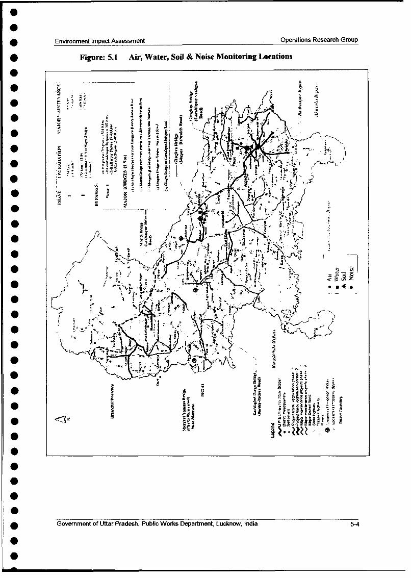
Baseline studies involved assessment of possible removal of trees, in the plannedapproaches of bridges, fauna and flora, in study area of respective bridges land use, impactson cultural properties and historic structures and on ambient air, noise and water quality,aquatic ecological data of river reach in project area. Details of trees in bridge approaches isgiven below in Table: 1.
Table 1: Details of trees in Bridge approaches
* SI No. Bridge No. of TreesI Kamariaghat 77
' ChellariLhat Nil
* There are no cultural properties within the approaches of bridges.
* Other features in study area (with in radius of 7 km from bridge site) are villages, wells,hand pumps, rivers and streams and few irrigation canals;
i * Landuse of study area consists of agricultural fields, and rural settlements etc.;
* Aquatic ecology data collected reveals that aquatic flora and fauna is better atChellarighat in comparison to Kamariaghat. This is due to the fact that Kamariaghat islocated in the downstream and the river reach and between Chellarighat andKamariaghat receives discharges from many towns and habitations located near thebank.
Government of Uttar Pradesh, Public Works Department, Lucknow, India iv
Environment Impact Assessment Operations Research Group
Ambient Air Quality, Noise Levels, Water Quality and Soil Quality
Samples for air, noise, water and soil were taken based on locations representative ofenvironmental characteristics for bridge locations as per MoEF procedures and wereanalysed as per specified procedures. The data was compared against the CPCB standards.The following key observations are made based on the baseline conditions
* All parameters monitored for air quality are well within CPCB limits at both the bridgesites.
* Day time and Night time noise levels are well within the CPCB limits.
* The river water is not polluted at bridge locations but requires conventional treatment tomake it suitable for drinking.
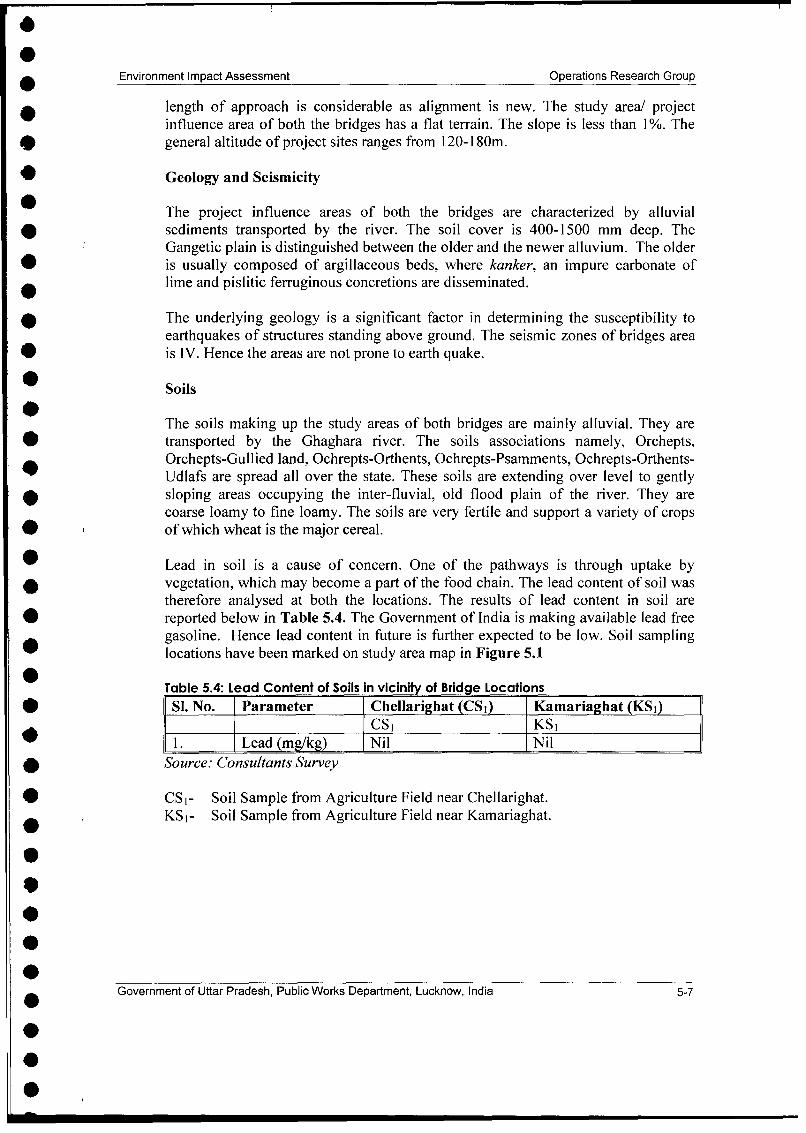
* The soils in the study area of both bridges are not polluted. These are fertile in nature.There is no presence of heavy metals in the soils.
Proximity of Bridges to Environmentally Sensitive Targets
None of the bridges planned are close to any ecologically sensitive areas such as Wild LifeSanctuaries, National Parks, Biosphere reserves, Bird Sanctuary and Zoological Parksnotified by the State Government.
6 PUBLIC CONSlULTATIONS AND INFORMIATION DISCLOSURE
Since bridges are part of UPSRP 11 and will be implemented during phase 11. Henceconsultation for these bridges were taken up during phase II consultations. Publicconsultations have taken place at local, district, State and institutional levels.
At local level discussions with affected persons and their leaders were held. At district levelconcerned departments, NGOs and local leaders were invited to give reactions topresentations by the PWD and PCC Consultants. At State levels suggestions and views wereobtained from NGO's, various departments of GOUP and Central government andconcerned citizens. Issues raised, suggestions of PAPs and RoW design, mitigations takenup and in corporated in design have been summarised in Tables 2 and 3. Table 4 presentsissues raised and discussed in state level consultations.
Table - 2: Location wise Representations of Public Concerns at Local Levelconsultants and their mitigation efforts
Name of the IssuesRaised SuggestionsofPAPs Nlitigation lMeasures'Village s R S Design approachGhaghara Bridge at Chellarighat
Reusapur . Encroachment * The bridge approaches . Relocation of PAPs(Left Bank) . Relocation of PAPs are to be newly will be done in
. Land acquisition and constructed. There is consultation with themmode of compensation no encroachment on and in the vicinity
. Safety proposed approaches . Compensation will be
Government of Uttar Pradesh, Public Works Department, Lucknow, India
Environment Impact Assessment Operations Research Group
Name of the Issues Raised Suggestions of PAPs Mitigation NleasuresEillage Design approach
* . Pollution to Ghaghara * Land acquisition made as per R&Rriver during construction should be minimised policyNeed for bridge and compensation . Safety provisions such
* . Cross drainage should be paid at as reduced speed signs,market rate speed breakers etc.
* * Safety is of paramount built into the designimportance necessary . Construction will besafety provisions carried out during the
* should be made. lean season flow.* * To minimise pollution . Bridge design
problems the completed, location* construction should identified and
be done during construction will start* November-May very soon.
month . Necessary crossBridge construction drainage structures
* should be started planned.earliest possible aslocals feel hardships
* during monsoon.* Cross drainage should
planned on few* channels that
approach will cross.Ramuwapur * Encroachment * Business * Encroachers and(Left Bank) * Relocation of business establishment if any squatters to be dealt
establishments in the proposed with as per R&R0 * Land acquisition & approaches should policy. There are no
compensation mode not be relocated encroachers and- instead approach may squatters in the** Heavy traffic movement be modified proposed approaches.* Air and Noise pollution * Alignment should be * Compensation will be
* * Public utility services changed to avoid paid as per R&R* Pollution to River private land policy.
should be done to the ratio of 2 trees for* reduce air and noise every tree to be cut* pollution impact. * Bridges construction
* Bridge construction shall be constructed in* should be done in lean seasons.
lean season flow * Private landacquisition has been
* avoided.
Government of Uttar Pradesh, Public Works Department, Lucknow, India vi
Environment Impact Assessment Operations Research Group
*Name of the Issues Raised Suggestions of PAPs Nlitigation Mleasures /Village Design approachBhagwanpur * Encroachment * PAPs are willing to be * Compensation to be(Right Bank) * Water logging and move out in case paid on per R&R
drainage compensation is paid policy* Air and Noise pollution at market value * Additional culverts* Income restoration * Design should take and drains be planned
option care of proper cross for proper cross* Community building drainage and road drainage and water
and shrines getting level be increased for logging problemand shrines getting abatement of water * Compensatory treeaffected logging problem plantation planned
* Widening option * Employment during * Dovetailing of income
construction is not a restoration schemepermanent solution. planned on RAPPermanent documentemployment shouldbe created for PAPs
Kamariaghat BridgeKamaria * Encroachment * Encroachers should be * Encroachers to be dealtVillage (Right * Safety given compensation with as per R&RBank) * Mode of compensation for shifting/relocation policy
Relocation of business* Compensation in cash * Compensation will beestablishments and at market rate paid as per R&R
* Pollution in the River * Pollution in River policyduring construction should be minimised * There are no
encroachers in theplanned approaches ofbridge.
* Construction will bel carried out during
lean flow seasonsShankarpur * Encroachment * Registration of PAPs * Dovetailing of poverty(Left Bank) * Income restoration with government alleviation schemes as
options poverty alleviation detailed out in RAP.* Mode of compensation programme * Compensation to be* Heavy traffic movement Compensation paid as per R&R
.Shrines getting affected preferably in cash and policy* Employment during at market rate * Detailed bank
* osmployent dNecessary safety protection measuresconstruction provisions should be designed by IIT
* Left side bridge made to prevent soil Kanpur.approach is bigger and erosion.requires considerableland acquisition
Government of Uttar Pradesh, Public Works Department, Lucknow, India vii
Environment Impact Assessment Operations Research Group
Table - 3: Location wise Representations of Public Concerns and Hearings atDistrict Level Consultations and their Incorporation in Project Design
Location Public Concerns/Hearings Incorporation in Design
0 Bahraich * DM enquired when the * Consultants replied that as soon asconstruction work will start design is finalized
* Proper measures to be adopted * Suggestions accepted. Accordinglyfor protection of environment construction will be restrictedduring construction otherwise during lean season flow. Workersthan may be pollution in the camp will be located at least 1.0river km away from river. Workers will
* Present Pontoon bridge at be instructed not hunt wild life.chellarighat should not be * The pontoon bridge will be kept ondisturbed till construction is functioning.over * Air quality predictions done and air
* Proper measures to be pollutants level not likely toincorporated in design to increase till 2028.mitigate effects of airpollutants in future years due torise in traffic.
Sitapur * Construction workers' camp * The construction workers' campshould be located fairly away will be located at least I km awayfrom habitations such as from habitation and in downwindRamuwapur, Reusapur and directions.Bhagwanpur. * The construction camp will be
* One participant wanted to know located at least 1 km for riverprobable location of channel and habitation.construction camp. * The project director replied that IIT
* The DM Bahraich enquired how Kanpur has done model study andappropriate location of bridge has recommended proposed bridgehas been decided location.
* CDO enquired about new * The new alignment fromalignment from Shankarpur to Shankarpur to river is part ofriverfront and Kamariaghat to bridge approach and this is astart of Budhanpur bypass. straight alignment.
0
Government of Uttar Pradesh, Public Works Department, Lucknow, India vi
Environment Impact Assessment Operations Research Group
Location Public ConcernsfHearings Incorporation in Design
Gorakhpur * One participant wanted to know * The project director replied thathow project road continuity for new alignment is planned and aGorakhpur -Shahganj will be bridge has been proposed atmet from Shankarpur to Kamariaghat.Kamariaghat * Environmental expert replied that
* One participant raised the measured levels of air and noiseconcerns of increased air are well will being the limits. Inpollution and noise pollution in operation phase levels are notthe vicinity of new alignment going increases due to mitigationof bridge and approaches. measures.
Table - 4: State Level Consultations (Held at Lucknow on February 11, 2002)
Issue Raised Suggestion of Participants Incorporation in Design
l Encroachmen * Encroachers will come back * PWD will work closely witht once road construction is revenue department to restrict
over. Compensation to encroachment. Encroachers andencroachers will set squatters will receive assistanceprecedence. Gram Panchayat and not compensation for land.be involved in control ofencroachment of ROW
Loss of trees * Less trees, specially giant * Compensatory and supplementaryones, will cause change in tree plantation planned three rowsmeteorology and increased of trees are planned. PAPs willair and noise pollution. own last row of trees.
Safety * Road safety is a major * Road safety concerns addressed inconcern on all project route EA. These include safetyas improved road will lead to signages, speed limits,more operative speeds. improvement of sharp curves and
intersections, etc.
People's * Community participation is * Community will be involved atparticipation essential for the every stage even for maintenance
sustainability of the project. roads and drains.
i Government of Uttar Pradesh, Public Works Department, Lucknow, India ix
Environment Impact Assessment Operations Research Group
Issue Raised Suggestion of Participants Incorporation in DesignHigh * Has analysis and cost * Major bridges planned. Properembankment estimate for high approaches have been designed.stretches embankments been done or At most of locations new bridge
not a project route are locations are about 200 mcrossing many major rivers? upstream or down stream
depending upon suitability.Necessary land acquisition will bedone for the approaches. Thebridge locations have beendecided based on hydraulic model
*1 study.
Note: No specific issue related to proposed bridges was raised at State Level consultation.
Peoples reactions were also sought during environmental monitoring. The reactions ofpublic and suggestions are summarised in Table 5 below:
Table 5: Public Concerns / Reactions During Environmental Monitoring
SI. Location of Environmental Public Concerns / Issues 1 Incorporation in ProjectNo. Monitoring Raised DesignA Chellarighat Bridge1. Reusapur 1. At time of installation 1. The environmental
(Present Number of people of respirable dust monitoring team8-10, Residents of Reusapur) samplers (RDS) for replied that it is
AAQ monitoring locals being done forenquired for what bridge planned atpurpose environmental Chellarighat.monitoring wasconducted.
2. The locals enquired for 2. The team repliedreasons for delayed that modelling studyconstruction. results were
3. Some participants 3. The team repliedenquired about nature that they can notand extent of answer this questioncompensation. as details of
compensation to bepaid are not knownto them.
Government of Uttar Pradesh, Public Works Department, Lucknow, India x
0
Environment Impact Assessment Operations Research Group
2. Ramuwapur * The public enquired * The team replied that(Present number of about left approach pillars have been putParticipants = 06, Residents alignment in agriculture fields.of Ramuwapur) These are along
centreline. There willbe acquisition of
l about 30m land onother side of thesepillars.
* The public enquired * The team replied thatwhether bridge will be exact width is nottwo lane or four lane known to them but it
will be more than 15wide bridge.
* The people were of * The team replied thatopinion that bridge bridge constructionconstruction should be will be started verystarted immediately. soon.
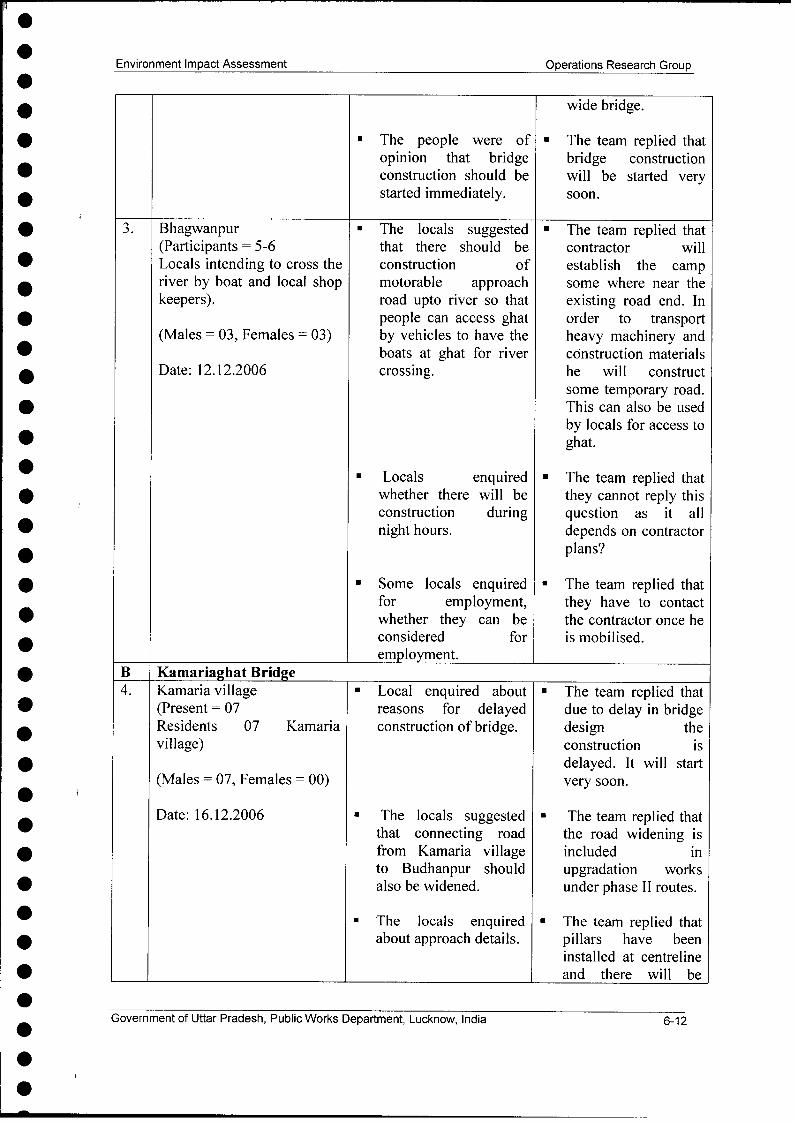
3. Bhagwanpur * The locals suggested * The team replied that(Participants= 5-6 that there should be contractor willLocals intending to cross the construction of establish the campriver by boat and local shop motorable approach some where near thekeepers). road upto river so that existing road end. In
people can access ghat order to transportby vehicles to have the heavy machinery andboats at ghat for river construction materialscrossing. contractor will
construct sometemporary road. Thiscan also be used bylocals for access to
* Locals enquired ghat.whether there will be * The team replied thatconstruction during they cannot reply this
l night hours. question as it alldepends on contractorplans?
* Some locals enquiredfor employment, * The team replied thatwhether they can be they have to contactconsidered for the contractor once heemployment. is mobilised.
Government of Uttar Pradesh, Public Works Department, Lucknow, India xi
0
Environment Impact Assessment Operations Research Group
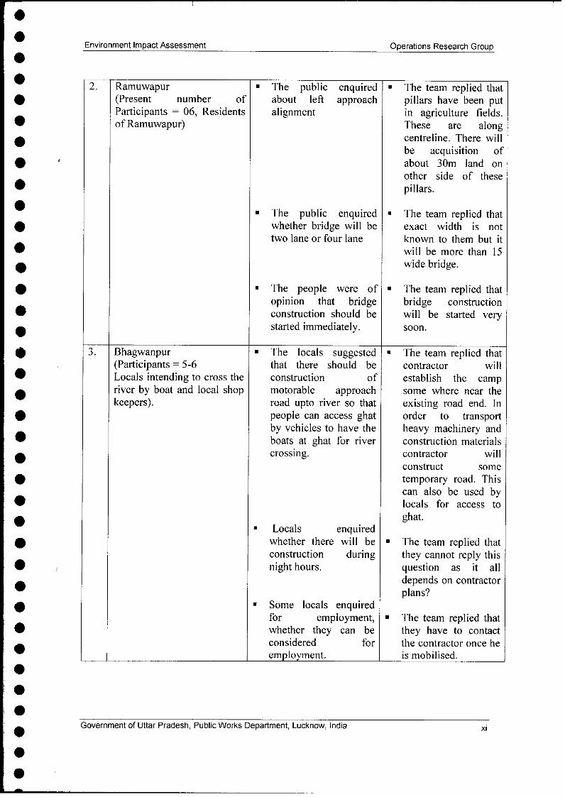
B Kamariaghat Bridge4. Kamaria village Local enquired about * The team replied that
(Present = 07 reasons for delayed due to delay in bridgeResidents 07 Kamaria construction of bridge. design thevillage) construction is
delayed. It will startvery soon.
* The locals suggested * The team replied thatthat connecting road the road widening isfrom Kamaria village included into Budhanpur should upgradation worksalso be widened. under phase 11 routes.
* The locals enquired The team replied thatabout approach details. pillars have been
installed at centrelineand there will beacquisition of 20-30mland on either side ofthis.
The locals suggested * The team replied that* that there is water PWD will provide
logging in considerable enough information toportion / length along the contractor at theleft bank. The time of mobilisation.contractor shouldestablish camp keepingin mined this aspect.
7 ANALYSIS OF ALTERNATIVES
The alternatives were explored for bridge locations and their approaches. The bridgelocations have been designed after carrying out hydraulic model study. This study has beenperformed by IIT, Kanpur. The study recommends optimum bridge length and protectionmeasures.
The approaches have been designed to minimise land acquisition and have been joined withthe upgradation route straightly as far as possible.
8 ASSESSMENT OF IMPACTS
Impacts due to construction of bridges have been assessed on meteorology, environment,ground and surface water resources, flooding, soils, topography, natural resources, ambientnoise levels, flora, fauna, human use values (land acquisition, loss of private properties),
Government of Uttar Pradesh, Public Works Department, Lucknow, India xii
Environment Impact Assessment Operations Research Group.
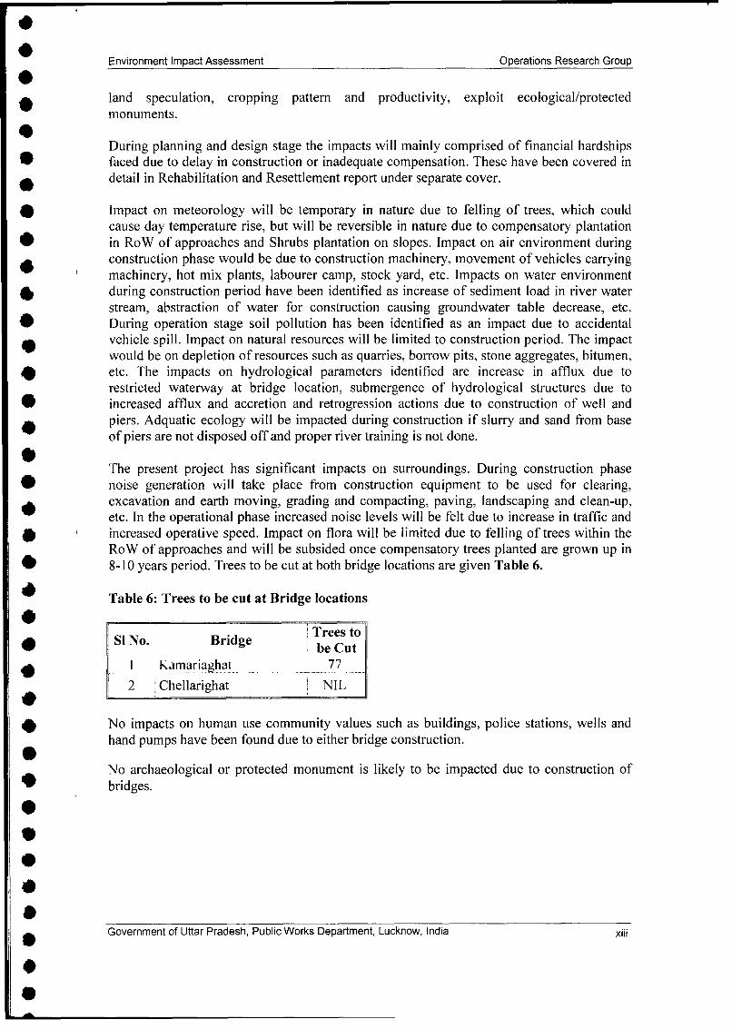
land speculation, cropping pattern and productivity, exploit ecological/protectedmonuments.
During planning and design stage the impacts will mainly comprised of financial hardships* faced due to delay in construction or inadequate compensation. These have been covered in
detail in Rehabilitation and Resettlement report under separate cover.
Impact on meteorology will be temporary in nature due to felling of trees, which couldcause day temperature rise, but will be reversible in nature due to compensatory plantation
0 in RoW of approaches and Shrubs plantation on slopes. Impact on air environment duringconstruction phase would be due to construction machinery, movement of vehicles carryingmachinery, hot mix plants, labourer camp, stock yard, etc. Impacts on water environment40 during construction period have been identified as increase of sediment load in river waterstream, abstraction of water for construction causing groundwater table decrease, etc.
* During operation stage soil pollution has been identified as an impact due to accidental* vehicle spill. Impact on natural resources will be limited to construction period. The impact
would be on depletion of resources such as quarries, borrow pits, stone aggregates, bitumen,etc. The impacts on hydrological parameters identified are increase in afflux due torestricted waterway at bridge location, submergence of hydrological structures due to
* increased afflux and accretion and retrogression actions due to construction of well andpiers. Adquatic ecology will be impacted during construction if slurry and sand from baseof piers are not disposed off and proper river training is not done.
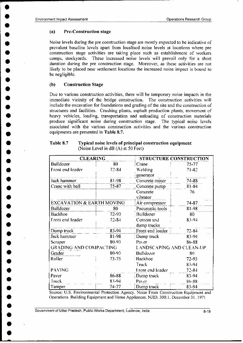
The present project has significant impacts on surroundings. During construction phasenoise generation will take place from construction equipment to be used for clearing,excavation and earth moving, grading and compacting, paving, landscaping and clean-up,etc. In the operational phase increased noise levels will be felt due to increase in traffic and
* C increased operative speed. Impact on flora will be limited due to felling of trees within theRoW of approaches and will be subsided once compensatory trees planted are grown up in
* 8-10 years period. Trees to be cut at both bridge locations are given Table 6.
Table 6: Trees to be cut at Bridge locations
Trees to* Si No. Bridge be Cut
I Kamariaohat 77
| 2 Chellarighat NIL
No impacts on human use community values such as buildings, police stations, wells andhand pumps have been found due to either bridge construction.
No archaeological or protected monument is likely to be impacted due to construction of* bridges.
Government of Uttar Pradesh, Public Works Department, Lucknow, India xiii
.
Environment Impact Assessment Operations Research Group
No impact on cultural properties such as temples graveyard and Mazar, mosque and statutehas been found due to bridge construction at both the locations.
Impact on Air, Noise, Water and Soil Quality
* Air pollution impacts especially on account of SPM/RSPM levels are not significant andwith the projected traffic they will increase marginally.
Noise levels will increase at bridge locations as these are located in relatively calmareas.
. Water at both the locations of bridge is not fit to drink without conventional treatment.
* Soils in respective study areas are not contaminated with pollutants and lead.
Impacts on air, noise, water and soil quality due to projected traffic increase upto 2028are:
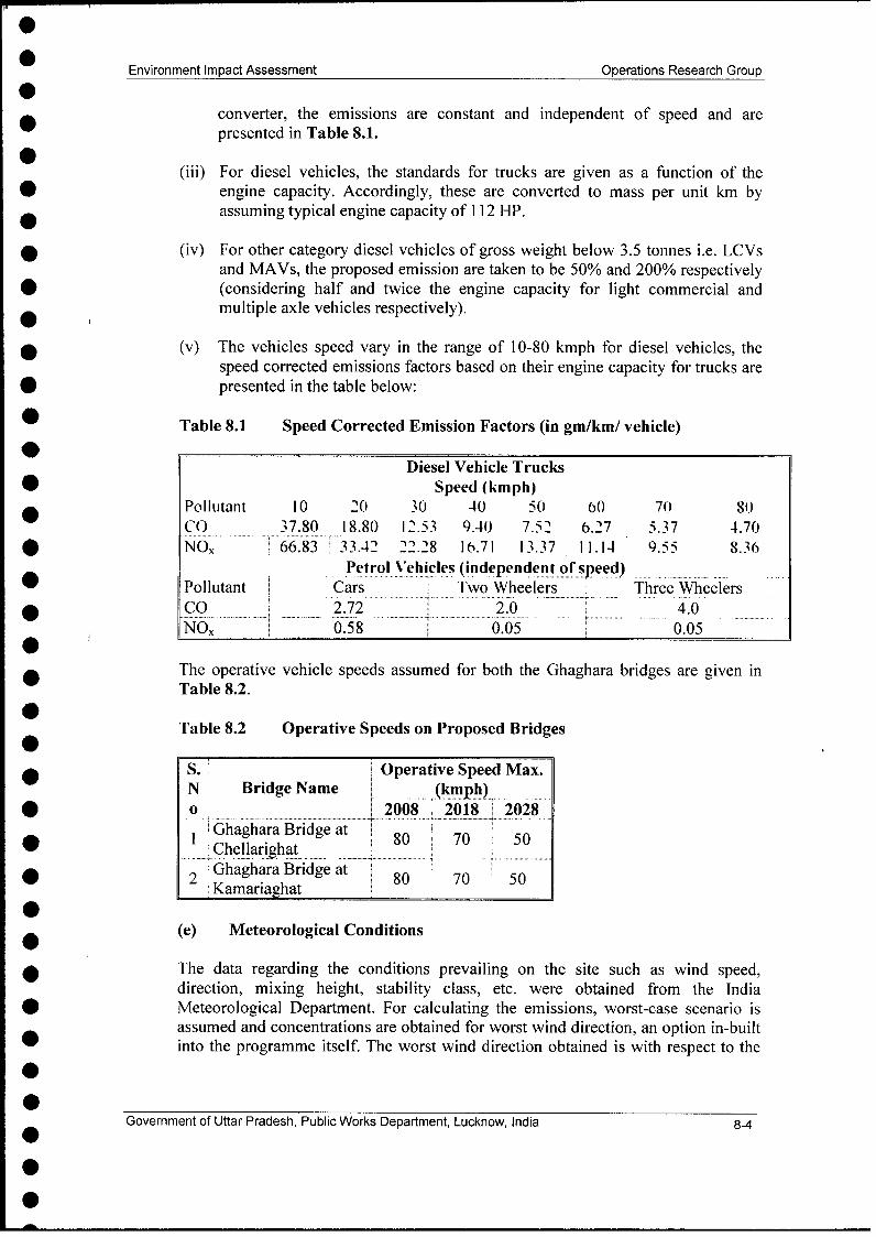
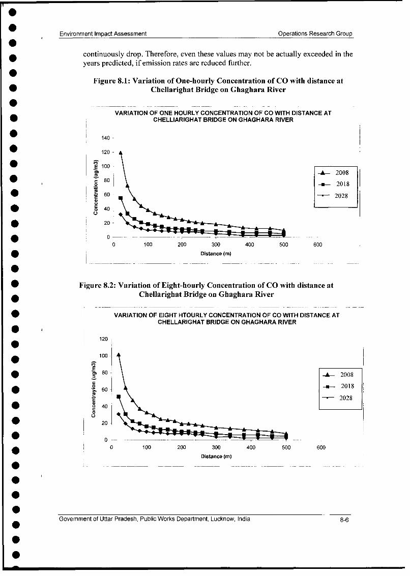
Air quality predictions have been carried out using CALINE-3 model and finally predictedvalues have been compared with existing Ambient Air quality standards. The results showthat the values of gaseous pollutant (CO & NOx) will not exceed the specified standards tillthe end of project life i.e. 2028.
The noise level predictions have been carried out for post project scenario, using FHWAmodel, and it has been concluded that noise levels will exceed the standards because of highbackground level.
The lead levels in ambient air and soil will decrease in future years due to availability oflead free gasoline.
The SPM concentrations in respective study areas of bridges will increase marginally due toincrease in traffic.
9 MITIG ATION, AN OIDANCE AND ENHANCEMENT MEASURES
The development of mitigation as well as avoidance of adverse impacts of proposed bridgedesign has been an iterative process. There has been continued interaction between thedesign and environment teams to arrive at measures acceptable to both sides. The avoidanceand mitigation measures have been summarised in the following Table 7:
Table 7: Mitigation measures for identified impacts
S, Impact Avoidance/mitigation/ enhancement measuresN o . ................. .. .. ... ... . .................... . ......... .. ..I Meteorological * Compensatory afforestation, Plantation in median of
parameters approaches, plantation of shrubs on slopes, grass turfing, etc.2 Soil * Avoidance of borrow areas in agriculture/productive lands
Utilisation of topsoil for filling of tree pits, * Soil erosion in slopes will be prevented by turfing them with
grass and shrubs
Government of Uttar Pradesh, Public Works Department, Lucknow, India xiv
Environment Impact Assessment Operations Research Group
* Stone gabions for embankment slopes sleeper than 1:23 Quarries * Contractor to procure materials from UPPWD approved
quarries identifiedl * All trucks carrying materials to be covered with tarpaulin
4 Contamination of * Fuel storage and refuelling sites will be kept away froml soil from fuel active channels of both the rivers. These activities will be
and lubricant taken up in construction yard. This will be located at 500 mdistance. These will be located at 500 m from active river
l channel.Oil interceptors will be installed at wash down and refullingareas.
5 Contamination of * Construction wastes to be dumped in selected pits developedsoil from on unfertile landconstruction * Non-bituminous waste to be dumped in borrow pits and thosewastes and are to be covered with top soil.quarry materials
; \Vater resources * Coniracior %%ill obtaiii necessar\ appro\al for %\aierwithdrawal from river / ground.
l * No constructions material will be stored in river bed.7 WN'ater quali\ * AIl %\aste froii construction site %\ill be disposed as per
degradation SPCB norm.l * Vehicles and equipment will be properly maintained.
* Oil cum sedimentation traps and silt fencing arrangementsl will be provided at bridge construction sites. Two oil cum
sedimentation traps on each bank are planned.8 Air quality * All vehicles, equipment and machinery used for construction
will be regularly maintained to ensure pollution levelconform to UPPCB norms.
* Pollution control equipment (Cyclone / scrubber) will bel -installed at the stack of hot mix plant,
* Regular spray of water at earthworks, temporary haulage willbe ensured.
l * All vehicles carrying construction material to be covered withtarpaulin
l -* In the post construction period regular monitoring planned.9) Noise le\ el * Plant and equipilieiln used for construction %\ill smrictll
conform to CPCB noise standards.* Workers to be provided with ear plugs* Noise monitoring planned in post construction phase.
10 Flora * Loss of trees is being compensated in accordance to theprinciples laid out in forest (conservation) Act, 1980
I I Faunia * No major impact on fauna is anticipated due t- brid2ei construction.* All sign boards giving cautions barricades for diverting
traffic will be as per MoRTH specifications.
Government of Uttar Pradesh, Public Works Department, Lucknow, India xv
Environment Impact Assessment Operations Research Group
| 12 Hydrology * The afflux at both locations is limited to less than 2.0m. Thiswill avoid flooding, impacts on hydrological structures inupstream and downstream and minimum impact on aquaticecology.
13 Aquatic Ecology * Impact on aquatic ecology will be limited duringconstruction. This will be minimised through proper rivertraining and scheduling construction during lean flow.
Landscape Strategy
The landscaping will be done to improve visual quality and slope stabilisation at approachesof bridges.
Standalone Environmental Management and Action Plan (EMAPs)
Standalone environmental management plans have been prepared for each bridge for threestages viz. Design (pre-construction), construction and operational stage. The environmentalmanagement plans contain mitigation, avoidance, enhancement measures as discussed inprevious sections. The individual environmental management plan will become part oftender document. Besides the mitigation, enhancement and avoidance measures the EMAPshave also identified responsible organisation for implementation. Reporting system formatshave been provided in EMPs for monitoring and evaluation during implementation.
Environmental Monitoring and Implementation Plans
Environmental monitoring plans have been prepared as part of EMP to monitor theimplementation and performance of mitigatory measures, monitoring frequencies andparameters have been suggested separately for construction and operation period. Activitywise implementation schedules have been prepared.
Environmental Management Cost
An indicative estimate of the cost component involved in mitigation of impacts, monitoringand evaluation of various components in pre-construction, construction and operationperiod has been worked out. Bridge-wise EMP budget for both locations is given below inTable 8.
The total EMP budget including contingencies is fNR 18.50 lacs for Kamariaghat Bridgeand INR 16.0 lacs for Chellarighat Bridge.
Government of Uttar Pradesh, Public Works Department, Lucknow, India xvi
Environment Impact Assessment Operations Research Group
10 IMPLEMENTATION ARRANGENIENTS
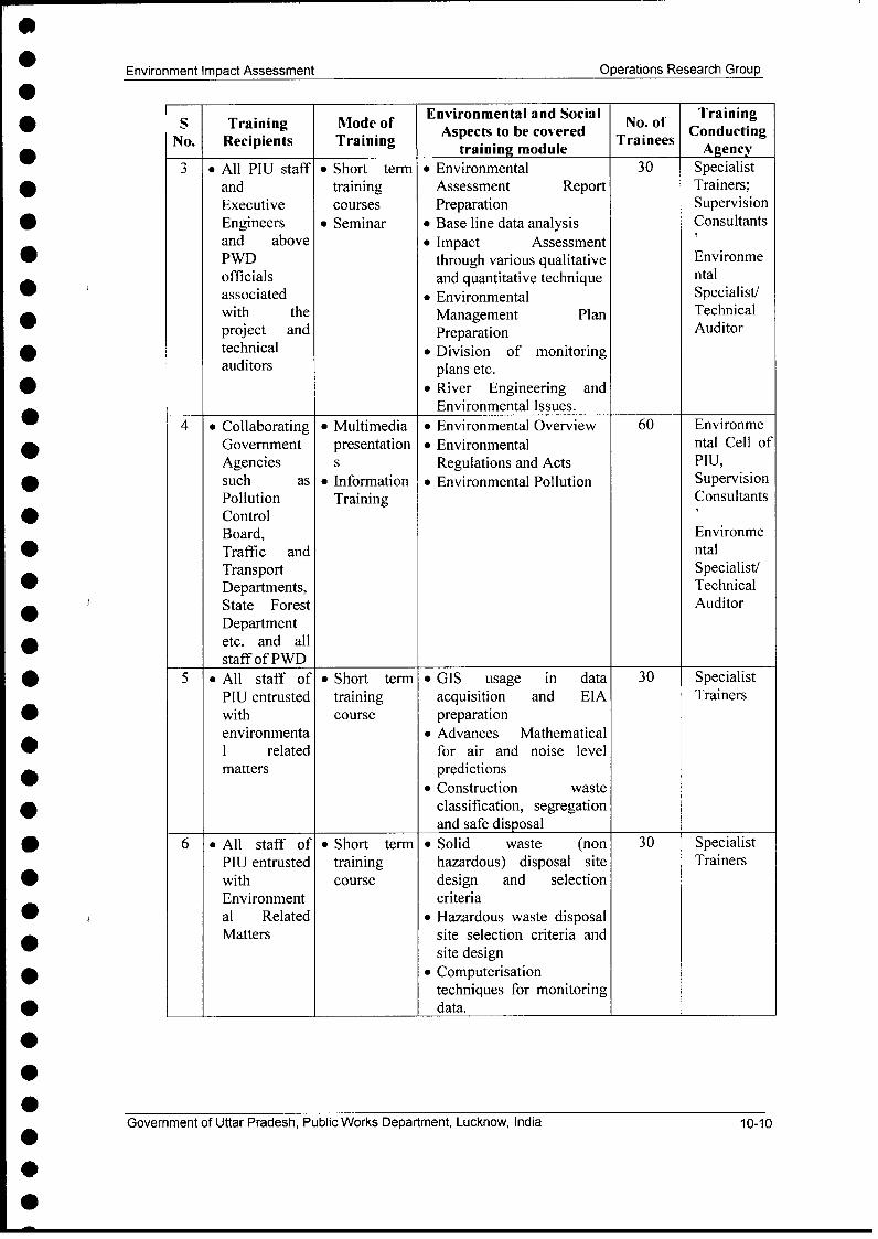
The implementation arrangements and training needs have been covered as part of EIA.Since both the bridges are planned on upgradation corridors, therefore, it has been decidedthat construction will be supervised by the supervision consultants appointed for therespective bridge packages. These respective supervision consultants will act as engineers.The contractor of respective bridges will report to supervision consultants. The NGO, willimplement RAP. The implementation arrangement has been given in Figure - 2. Thesupervision consultants will have environmental specialist in their team. The environmentalspecialist will be available for entire duration of bridge construction activity.Training needs have been identified for various recipients, which include PWD staff,NGOs, Supervision Consultants, and Technical Auditors Contractors to be associated withthe implementation. The technical aspects to be covered for each identified recipient andmode of training and agency (ies) who will conduct training have been identified. Thetraining on environmental issues related to bridge construction has been included in Phase IItraining. This training will be organized once supervision consultants, technical auditors andall contractors are mobilized. The budget for training has been included in phase II EMPbudgets.
0
GoenetoSta rds,Pbi ok eatet uko,Idaxi
Environment Impact Assessment Operations Research Group
1.1 The Uttar Pradesh State Roads Project (UPSRP-II) And 1-1Major Bridges
1.2 Brief Description of UPSRP II and Major Bridges 1-I1.3 Features of Major Bridges 1-21.4 Environmental Assessment of the Project 1-2
1.4.1 Environmental Impact Assessment and 1-2Management Plans
1.5 Structure of the EIA Report 1-2
2.0 Project Description 2-12.1 UPSRP-II 2-1
2.1.1 Upgradation Works 2-12.2 Major features of Bridges 2-22.3 Overview of the Impacts of the Bridges 2-3
3.0 Policy, Legal and Administrative Framework 3-13.1 Institutional Setting for the Project 3-1
3.1.1 Uttar Pradesh Public Works Department 3-1(UPPWD)
3.1.2 Project Implementation Unit 3-13.2 Institutional Setting In The Environmental Context 3-2
3.2.1 Ministry of Environment and Forests 3-23.2.2 Regional Office of the MoEF, Lucknow 3-23.2.3 Central Pollution Control Board (CPCB) 3-23.2.4 Department of Forests, Government of Uttar 3-2
Pradesh3.2.5 Uttar Pradesh Pollution Control Board 3-2
3.3 Legal Framework 3-33.3.1 The Forests (Conservation) Act, 1980 3-33.3.2 The Environment (Protection) Act, 1986 and the 3-5
Environmental Impact Assessment Notification,1994
3.3.3 The Wildlife (Protection) Act, 1972 3-53.3.4 The Water and Air (Prevention and Control of 3-5
Pollution) Acts3.3.5 The Motor Vehicles Act, 1988 3-53.3.6 The Ancient Monuments And Archaeological 3-5
Sites and Remains Act, 19583.4 State Level Legislation and Other Acts 3-7
3.5 Clearance Requirements of the Proposed Bridges 3-73.5.1 Up State Clearance Requirements 3-73.5.2 National Clearances 3-73.5.3 World Bank Requirements 3-7
4.1.1 Scoping 4-14.1.2 Reconnaissance Visits 4-14.1.3 Assembly and Analysis of Data from Secondary 4-1
Sources4.1.4 Documentation of Baseline Conditions 4-24.1.5 Assessment of Alternatives 4-24.1.6 Assessment of Potential Impacts 4-24.1.7 Integration of Environmental Impact in the 4-2
5.1.1 Climate 5-15.1.2 Temperature 5-15.1.3 Wind 5-15.1.4 Rainfall 5-1
5.2 Natural and Biophysical Environment 5-25.2.1 Air 5-25.2.2 Water: Hydrology and Drainage 5-55.2.3 Land 5-65.2.4 Noise 5-95.2.5 Flora 5-115.2.6 Fauna 5-125.2.7 Human Use Values 5-12
5.3 Cultural Properties 5-125.3.1 Protected Monuments and Properties of 5-12
6.0 Public Consultation and Information Disclosures 6-16.1 Consultation Process Adopted in UPSRP II 6-16.2 Objectives 6-16.3 Methodology adopted for Public Consultations 6-1
6.3.1 Stages and Levels of Consultation 6-16.3.2 Tools for Consultation 6-2
6.4 Issues Raised and Community Perception 6-46.5 Addressal of Issues 6-5
l 6.6 Fresh Consultations During Environmental Monitoring 6.116.7 Continued Participation 6-13
6.7.1 Information Disclosure 6-136.7.2 Community Participation 6-13
7.0 Analysis of Alternatives in UPSRP 7-17.1 Route Alternatives through Strategic Options Study 7-17.2 "With" and "Without" Project Scenario 7-1
7.2.1 UP State Road Project II (UPSRP II) 7-17.2.2 With and Without Bridges Planned on Ghaghara 7-2
7.3 Finalization of Approaches 7-37.3.1 Approaches of Chellarighat Bridge 7-37.3.2 Approaches of Kamariaghat 7-3
7.4 Locations of Proposed Bridges 7-3
8.0 Assessment of Impacts 8-18.1 Background 8-18.2 Meteorological Parameters 8-18.3 Natural and Biophysical Environment 8-1
8.3.1 Air 8-18.3.2 Water Resources 8-98.3.3 Impacts on Hydrology of Rivers 8-128.3.4 Land 8-138.3.5 Seismicity 8-138.3.6 Loss of productive soil 8-138.3.7 Soil Erosion 8-148.3.8 Compaction of soil 8-148.3.9 Contamination of Soil 8-15
8.3.15 Human Use Values 8-268.4 Archaeological/Protected Monuments and Other Cultural 8-26
Properties8.4.1 Other Cultural Properties 8-26
9.0 Mitigation, Avoidance and Enhancement Measures 9-19.1 Approach to Mitigation Measures 9-19.2 Avoidance and Mitigation Measures 9-2
9.2.1 Meteorological Parameters 9-29.2.2 Air Quality 9-29.2.3 Mitigation Measures for Rivers and Other Surface 9-3
Water Sources9.2.4 Drainage 9-49.2.5 Prevention of Water Quality Degradation in River 9-59.2.6 Relocation of other water supply sources 9-69.2.7 River Hydrology 9-69.2.8 Soil 9-79.2.9 Soil Erosion 9-8
9.2.10 Borrowing of Earth 9-389.2.11 Quarries 9-419.2.12 Contamination of soil from fuel and lubricants 9-429.2.13 Contamination of soil from Construction wastes 9-42
and quarry materials9.2.14 Procedure for Selection of Sites for Construction 9-43
9.4 Emergency Response Procedure 9-479.4.1 Introduction 9-479.4.2 Types of Emergency /Disaster at Bridge 9-47
Construction Site9.4.3 Identification of Accidental Areas at Site 9-489.4.4 Emergency Preventive Measures 9-489.4.5 Level of Accidents 9-489.4.6 Critical Targets During Emergency 9-499.2.7 Site Emergency Control Room 9-499.4.8 Safety Officer 9-509.4.9 Managing Emergency (Control Plan) 9-50
9.4.10 Rules and Responsibilities of Emergency Team 9-51
9.4.11 Outside Organisation Involved in Control of 9-51Disaster
9.4.12 Emergency Control Procedure 9-529.4.13 Emergency Exit and Escape Routes 9-569.4.14 Training on Emergency Aspects 9-56
10.0 Implementation Arrangements 10-110.1 Preamble 10-110.2 Mandate of the UPPWD 10-110.3 Exiting Institutional Arrangements 10-1
10.3.1 Chief Engineer (World bank) and the Project 10-2Implementation Unit (PIU)
10.4 Need for Further Strengthening 10-310.5 Proposed Set-up For Bridge Construction 10-3
10.5.1 Project Implementation Unit (PIU) 10-310.5.2 Implementation Arrangement for Bridge Project 10-410.5.3 Construction Supervision Consultants 10-410.5.4 Contractors 10-410.5.5 Technical Auditors 10-410.5.6 Other Agencies 10-510.5.7 Facilities for the Environmental Cell 10-6
10.6 Environmental Reporting System 10-610.7 Procurement of NGOS and Other Agencies 10-810.8 Training 10-8
I
List of Tables0* Table No. Description Page No.
Table 2.1 Cross-section options for the upgradation works in UPSRP- 2-111
* Table 2.2 Major Features of Ghaghara Bridge at Chellarighat on 2-2* Sitapur - Bahraich Upgradation Route
Table 2.3 Major Features of Ghaghara Bridge at Kamariaghat on 2-2Gorakhpur - Shahganj Upgradation Route
* Table 5.1 National Ambient Air quality Standards (CPCB, 1997) 5-2
* Table 5.2 Air quality at selected locations around Ghaghara Bridges at 5-3Chellarighat and Kamariaghat
Table 5.3 Water Quality Results of Ghaghara River at Proposed 5-5* Bridge Locations
* Table 5.4 Lead Content of Soils in vicinity of Bridge Locations 5-7
* Table 5.5 Quarries identified for bridge construction 5-8
* Table 5.6 National Ambient noise level standards 5-11
Figure 8.1 Variation of One-hourly Concentration of CO with distance 8-6at Chellarighat Bridge on Ghaghara River
Figure 8.2 Variation of Eight-hourly Concentration of CO with distance 8-6at Chellarighat Bridge on Ghaghara River
Figure 8.3 Variation of 24 hourly Concentration of NOx with distance 8-7at Chellarighat Bridge on Ghaghara River
Figure 8.4 Variation of One-hourly Concentration of CO with distance 8-7at Ghaghara Bridge on Kamariaghat
Figure 8.5 Variation of Eight-hourly Concentration of CO with distance 8-8at Kamariaghat Bridge on Ghaghara River
Figure 8.6 Variation of 24-hourly Concentration of NOx with distance 8-8at Ghaghara Bridge on Kamariaghat
Figure 8.7 Graphical Plot of the Maximum Leq, Lday and Lnight 8-21Variation with distance from the Centerline for ChellarighatBridge on Ghaghara River
Figure 8.8 Graphical Plot of the Maximum Leq, Lday and Lnight 8-21Variation with distance from the Centerline for ChellarighatBridge on Ghaghara River
Figure 8.9 Graphical Plot of the Maximum Leq, Lday and Lnight 8-22Variation with distance from the Centerline for ChellarighatBridge on Ghaghara River
* Figure 8.10 Graphical Plot of the Maximum Leq, Lday and Lnight 8-22Variation with distance from the Centerline for KamariaghatBridge on Ghaghara River
'Figure 8.11 Graphical Plot of the Maximum Leq, Lday and Lnight 8-23Variation with distance from the Centerline for KamariaghatBridge on Ghaghara River
Figure 8.12 Graphical Plot of the Maximum Leq, Lday and Lnight 8-23Variation with distance from the Centerline for KamariaghatBridge on Ghaghara River
Figure 9.1 Combined Sedimentation and Oil/Grease 9-4
Figure 9.2 Design of Silt fencing arrangement 9-5
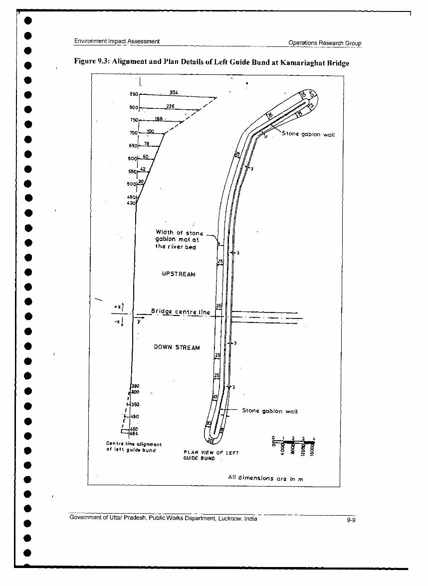
Figure 9.3 Alignment and Plan Details of Left Guide Bund at 9-9Kamariaghat Bridge
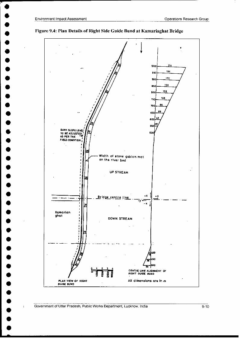
Figure 9.4 Plan Details of Right Side Guide Bund at Kamariaghat 9-10Bridge
Figure 9.5 Site Plan - Ghaghara River at Kamariaghat Showing Details 9-l 1of Bridge Centre Line and Guide Bund Alignments atKamariaghat Bridge
Figure 9.6 Details of Left Side Abutment Pier and Protection Works at 9-14Kamariaghat Bridge
Figure 9.7 Details of Right Side Abutment Pier and Protection Works at 9-15Kamariaghat Bridge
Figure 9.8 Protection work for Left Side Guide Bund at Kamariaghat 9-16Bridge
Figure 9.9 Details of Stone Gabion provided at Upstream End of Left 9-17l Guide Bund at Kamariaghat Bridge
Figure 9.10 Details of Stone Gabion provided at the Downstream End of 9-18Left Guide Bund at Kamariaghat Bridge
Figure 9.11 Protection works for Right Side Guide Bund at Kamariaghat 9-19Bridge
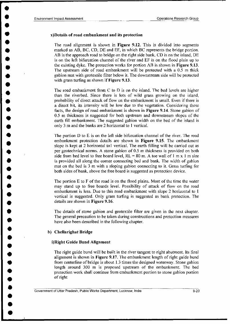
Figure 9.12 Alignment of Road Along with Bridge Location Across 9-21River Ghaghara at Kamariaghat
Figure 9.13 Details of Road Embankment for Approach Road A to B at 9-22Kamariaghat Bridge
Figure 9.14 Details of Road Embankment in the Island Portion C to D at 9-23Kamariaghat Bridge
Figure 9.15 Protection Works for Road Alignment on Left Side 9-24Bifurcation Channel D to E at Kamariaghat Bridge
Figure 9.16 Details of Road Embankment for Portion (EF) on Flood 9-25Plain upto Dyke at Kamariaghat Bridge
Figure 9.17 Plan Details of Right Guide Bund at Chellarighat Bridge 9-26
Figure 9.18 Plan Details of Left Guide Bund at Chellarighat Bridge 9-28
Figure 9.19 Protection Work for Right Guide Bund at Chellarighat 9-30Bridge
Figure 9.20 Embankment Protection Work for Right Abutment at 9-31Chellarighat Bridge
Figure 9.21 Protection Works for Left Guide Bund at Chellarighat Bridge 9-32
Figure 9.22 Embankment Protection Works for Left Abutment at 9-33Chellarighat Bridge
Figure 9.23 Stone Gabion Wall provided at Upstream of Right Guide 9-34Bund: Section Across 'AA' as shown in Figure 9.17(Chellarighat Bridge)
Figure 9.24 Stone Gabion Wall provided for the Left Bank Protection: 9-36Section Across 'BB' as shown in Figure 9.18 (ChellarighatBridge)
Figure 9.25 Stone Gabion Wall provided for Downstream of Left Guide 9-37Bund: Section Across 'CC' as shown in Figure 9.18(Chellarighat Bridge)
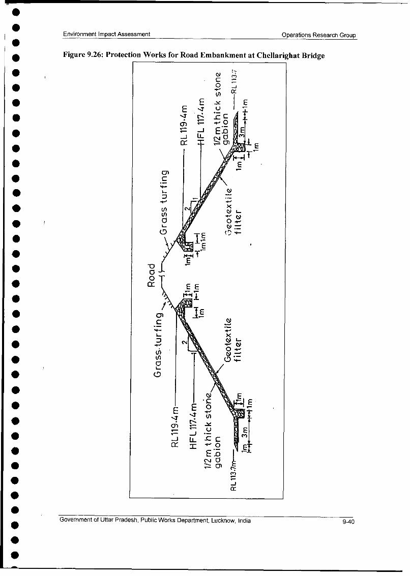
Figure 9.26 Protection Works for Road Embankment at Chellarighat 9-40Bridge
Figure 9.27 General Coordination Among Key Personal (During 9-53Construction)
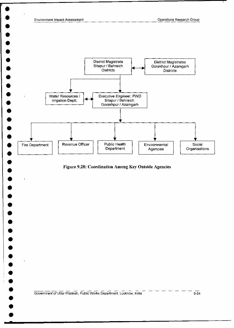
Figure 9.28 Coordination Among Key Outside Agencies 9-54
List of Annexure
Annexure No. Title
Annexure No. 1 Gazette Notification of Ministry of Environment and Forest
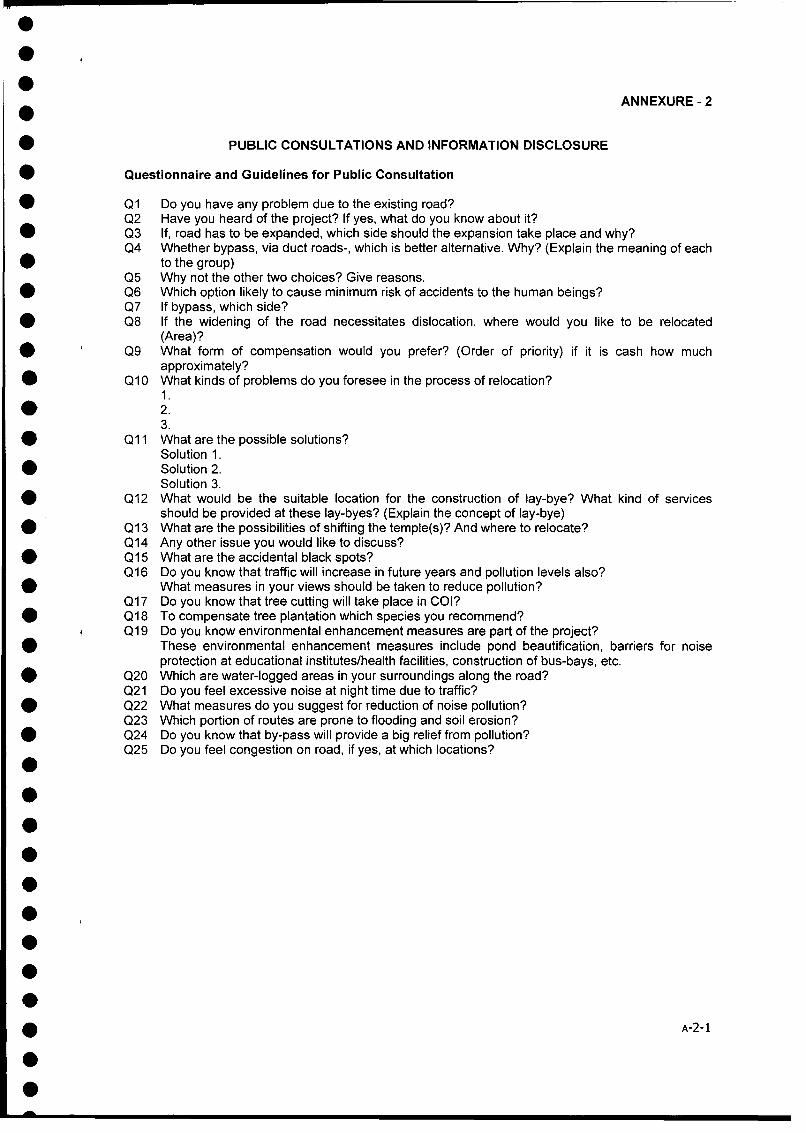
Annexure No. 2 Public Consultations and Information Disclosure
0000
00
0
*
00
0000
0
0 INTRODUCTION0
0
0
000
0
00000
Environment Impact Assessment Operations Research Group
1.0 INTRODUCTION
1.1 The Uttar Pradesh State Roads Project (UPSRP-II) And Major Bridges
This chapter describes the project background and the need for the project. The UttarPradesh State Road Project II aims to improve road network of State throughupgradation and major maintenance of state roads. The state roads selected in theproject comprise of Ordinary District Roads (ODRs), Major District Roads (MDRs)and State Highways (SHs). In addition to improvement of road network five bridgeshave been planned on major rivers of the state. Out of these five bridges two havebeen planned on Ghaghara river on routes selected for upgradation and two onroutes selected for major maintenance and one on Sharda river. The bridges plannedon maintenance routes are at Shergarh Ghat on Yamuna river and Kachhla Ghat onGanga river. The environmental assessment study for the entire UPSRP - TI exceptthe major bridges planned was taken up as part of project preparation throughProject coordinating consultants (PCC). The project preparation activity was over inthe year 2002.The Environmental assessment process of Ganga and Yamuna hasalso been completed and final documents of EA and EMP have been submitted tothe World Bank. The present volume covers environmental assessment study for two
i bridges planned on Ghaghara river at Chellarighat near Reusapur in Sitapur districtand at Kamariaghat in Azamgarh district. In this chapter the setting in terms of thepreparation of EA for the project and the EA process adopted for the proposedbridges has been discussed. The last section presents the outline of the variouschapters of this report.
1.2 Brief Description of UPSRP II and Major Bridges
The Uttar Pradesh State Roads Project II preparation is completed and the project isbeing implemented by the Public Works Department, Uttar Pradesh with financialassistance under the World Bank Loan number 4114-IN. The UPPWD has carriedout the project preparation through "Project Co-ordinating Consultants"(PCC)appointed for the project. The project preparation activities commenced inSeptember 1999 and these project preparation activities were over in the year 2002.
The PCC's mandate was to conduct a detailed feasibility study of 2655 km (whichincluded 3 corridors identified subsequently after the SOS) using principles that notonly took into consideration the economic impact of the improvement of the roadnetwork, but also the impact due to rehabilitation of the roads on the environmentaland social settings. This study was carried out to establish a road investmentprogramme for a subset of these roads that are to be upgraded. A regional approachto road network planning was adopted in order to place road improvement projectsin the context of regional development policies.
Based on the outputs of the economic, engineering, environmental and socialanalysis of the network, the UPSRP-I1 proposed to carry out upgradation of 1000 kmand major maintenance of 2500 km of State Roads. The project has been dividedinto two phases for ease of implementation. Phase I includes 374 km roads forupgradation to 7m wide pavement with hard and soft shoulders and 807 km of roadsfor major maintenance where treatment will depend upon the existing pavementconditions and land availability. The detailed environmental assessment has already
Government of Uttar Pradesh, Public Works Department, Lucknow, India 1-1
Environment Impact Assessment Operations Research Group
been completed for Phase I and this phase is presently under implementation. Theenvironmental assessment study for phase 11 has also been completed and submittedto the World Bank. The five major bridges have been planned to improve routeconnectivity further. The present environmental assessment study is aimed for twomajor bridges proposed on Ghaghara river. Out of these one bridge is planned atChellarighat in Sitapur district and other one at Kamariaghat in Azamgarh district.The Chellarighat bridge is proposed to be located on Sitapur - Bahraich route andKamariaghat on Gorakhpur - Shahganj route. Both of these are Phase II upgradationroutes. These bridges are essential to provide connectivity of both parts ofupgradation routes. Figurel.1 shows location of these bridges.
1.3 Features of Major Bridges
Both the bridges planned will have four laned and approaches will also be fourlaned. The bridge locations have been decided based on hydraulic model studyconducted by IIT Kanpur. The bridge at Chellarighat willl be 840 m long withapproach lengths of 580 m towards Bahraich and 4810 m towards Bahraich side.
The bridge at Kamariaghat will be 945 m in length and its approach length towardsGorkhpur will be 7485 m and towards Shahganj 440 m.
1.4 Environmental Assessment of the Project
The Ghaghara river is a major river of the state. The construction of major bridgesmay cause adverse environmental impacts on river water quality and its ecosystem ifproper mitigatory measures are not adopted during construction. The purpose ofenvironmental assessment of these bridges is to identify adverse environmentalimpacts and to prepare environmental management plan to abate the adverse andnegative impacts identified during the process.
1.4.1 Environmental Impact Assessment and Management Plans
The detailed designs of bridges and their approaches have been closely co-ordinatedwith the preparation of the Environmental Impact Assessment (EIA). The EIApreparation led to the identification of potential environmental hotspots and theirfeasible remedial measures (including avoidance, mitigation and enhancements)which were made part of Environmental Management Plan (EMP). Separate EMPshave been prepared for each bridge.
1.5 Structure of the EIA Report
The report is organised into remaining 9 chapters as follows:
Chapter 2 describes technical features of bridges from environment prospective.
Chapter 3 discusses the Policy, Legal and Administrative Framework withinwhich the bridges are planned to set up. The major stakeholder departments of theState and Central Governments with their specific roles are described here and theapplicable Acts and Laws are described. The chapter ends with a section on theclearance requirements at various
Government of Uttar Pradesh, Public Works Department, Lucknow, India 1-2
I
Environment Impact Assessment Operations Research Group
Figure 1.1 Locations of Proposed Bridges on Ghaghara at Chellarighat andKamariaghat
7- T t i- .. .(, ........ f f i % | j r \ / -' "
7 ', , , a?4 -" .';
r, , In - - -t ,,,X .~
r~ .. ;% , ,< 1
)x , r 'S 1 ;
3 *4 4) i * ' ) i
* / '' A i.,--.X .. ti,, -
;I ;s - @ 'S si--' 0" '1 H- ds
I- fd* 14 tS < I -<zl§ztg48
| It -r-413@ -~
* -Q Kstr S,>
- *V
Government of UJttar Pradesh, Public Works Departmernt, Lucknow, India 1-3
Environment Impact Assessment Operations Research Group
levels and their current status. An overview of impacts of major bridges, mainlybenefits, is given in the last section.
Chapter 4 details out the Methodology adopted for the EIA. Descriptions areprovided for survey procedures, modelling methods and environmental designs.Chapter 5 describes the Existing Environmental Scenario in detail. The sectionson Meteorological baseline, components of the biophysical and naturalenvironments, cultural properties in the study area of bridges and quality of life addup to give a comprehensive picture of the existing environment around the proposed
* locations of bridges.
Chapter 6 gives an overview of the Community Consultation carried out duringthe project preparation stage. It also provides an insight into the processes involved,its importance to project design and methods adopted to document the entireexercise.
Chapter 7 gives Analysis of alternatives considered for locations of bridges andalignments of approaches
Chapter 8 on the Assessment of Impacts determines the extent of the impacts ofthe bridge construction activity on the existing environment. The focus of the sectionis on the adverse impacts. The impacts have been detailed in the same sequence asdescribed in Chapter 5 for ease of understanding.
Chapter 9 entitled Mitigation, Avoidance and Enhancement Measures forms the! basis of the generation of coherent, comprehensive and concise EMPs for the
bridges.
Chapter 10 reviews the existing Implementation Arrangements and suggestsfurther institutional strengthening for ease of implementation of the environmentalcomponent of the project. It goes on to describe the set-up required, a reportingsystem and training needs to ensure that the environmental expertise required for theeffective implementation of EA provisions is internalised at the UPPWD. Reportends with references and annexes.
Government of Uttar Pradesh, Public Works Department, Lucknow, India 1-4
000
00000
0
00000* hptr0
PRJCTapDeSrIPIO0
00000000000000
Environment Impact Assessment Operations Research Group
2.0 PROJECT DESCRIPTION
This chapter on project description focuses on the description of the salient featuresof the bridges in terms, of lengths of bridges and approaches and salient features ofbridge design. Finally, a discussion on the overall benefits / impacts perceived due tothe project in general and bridges in particular are presented in the last section.
2.1 UPSRP-11
The UPSRP-II, which is being implemented with World Bank assistance, has twomajor components: upgradation and major maintenance. While the former involvessubstantial earthworks to incorporate the widened pavement and shoulders, the latteressentially is restricted to the existing formation. The UPSRP-II proposes to upgrade1000 km of roads and carrying out major maintenance of 2500 km of roads spreadall over UP. The roads pass mainly through plain areas, most through the Indo-Gangetic plains, which covers about 70% of the state. They consist of StateHighways (SHs), Major District Roads (MDRs) and other district roads (ODRs).The proposed treatment will create State Highways with 7 m blacktop irrespective ofthe present condition of the road. Upgradation will include provision of hard andsoft shoulders in addition to the 7 m wide pavement.
Five major bridges have also been planned as part of phase 11 programme. Out ofthese five major bridges two are planned on Ghaghara river and one each onYamuna, Ganga and Sharda. The locations of Phase II routes and proposed fivemajor bridges have been shown in Figure 1.1 in the previous chapter.
2.1.1 Upgradation Works
As per design of upgradation works, the major engineering activities proposed alongthe project roads is the widening of the existing road (carriage way width varyingfrom 3.75m to 7.Om including shoulder width) to 7.0 m with 1.5m hard shouldersand 1.0 m soft shoulder on either side.
The various cross-section options that have been worked out for the upgradationworks as part of Phase 11 are presented in the Table 2.1 below:
Table 2.1: Cross-section options for the upgradation works in UPSRP-II
Option Carriagewav Shoulder W idth Niedian Formation WidthWidth Hard Soft Width
Shoulder ShoulderWI 6.0m (2.0.3m) I.i Ill I Ill I 1 InW2 7.Om (2x3.5m) - 2.5 m 12 mW3 7.Om (2x3.5m) 1.5 m I m 12 mW4 2m x 7.25m 1.5 m 1 m Varies Varies
Government of Uttar Pradesh, Public Works Department, Lucknow, India 2-1
Environment Impact Assessment Operations Research Group
2.2 Major features of Bridges
* The major features of Ghaghara bridges have been described in Tables 2.2 and 2.3.
Table 2.2: Major Features of Ghaghara Bridge at Chellarighat onSitapur - Bahraich Upgradation Route
Total length of Bridge 840 m
Discharge 14000 cumecs (Peak)
Abutments 02
Spans 20
No. of Total Spans 20
No. of Navigational Spans 02
Spans Spacing C/C bearing 45 m (Non Navigational)
d Spans Spacing C/C bearing 50 m (Navigational)
Wearing Coat 25 m Mastic + 40 mm BC
Pre stressing Steel 19 T 13 Low Reloxation Steel (IS: 14268, 1995)
Grade of Concrete
Superstructure & Crash barrier M 40
Road Kerb & Footpath M 25
Approach Lengths
Approach Length Toward, Sitapur 580 m
Approach Length Toward, Bahraich 4810 m
Table 2.3: Major Features of Ghaghara Bridge at Kamariaghat onGorakhpur - Shahganj Upgradation Route
Total length of Bridge 945 m
Discharge 21000 cumecs
Abutments 02
Spans 20
Number of Navigational Spans 02
Span Spacing C/C bearing 45 m (Non Navigational)
| Span Spacing C/C bearing 50 m (Navigational)
| Wearing Coat 25 m Mastic + 40 mm BC
| Pre stressing Steel 19 T 13 Low Reloxation Steel (IS: 14268, 1995)
Government of Uttar Pradesh, Public Works Department, Lucknow, India 2-2
Environment Impact Assessment Operations Research Group
Grade of Concrete
| Superstructure & Crash barrier M 40
Road Kerb & Footpath M 25
Approach Lengths
Approach Length Towards, Gorakhpur 7485 m
Approach Length Towards, Shahganj 440 m
2.3 Overview of the Impacts of the Bridges
The proposed Ghaghara bridge at Chellarighat will provide much neededconnectivity to vast rural areas in Sitapur and Bahraich district. The proposedbridge will accelerate traffic growth on Sitapur-Bahariach route. This route will actas a good bypass to Lucknow for the traffic moving to and from Bahraich. Thisbridge will bring prosperity in the study areas.
The bridge on Ghaghara river at Kamariaghat will provide much neededconnectivity to vast Rural areas of Akabarpur, Gorakhpur, Azamgarh districts. Theconnectivity will accelerate good economic growth in the region and farmers willhave quick access for their produce to the market. The other grow avenues will alsoopen up.
The direct and measurable benefits of the UPSRP II rise from the Vehicle OperatingCosts and Travel time costs. The other direct benefits include improved access;access of local produce to regional markets & industrial products to the vastuntapped rural markets, better access to health and education facilities. Constructionrelated jobs would be created during the implementation stage of the proposedbridges. There will be an increase in the safety and comfort of the road users -whether pedestrian or vehicle-user. In fact, poverty alleviation has been one of themain objectives of the project, which has led to selection of several roads in easternUttar Pradesh for upgradation.
Indirect benefits of the project include the better business opportunities andincreased competitiveness within the area. Increased mobility of the population willmean far more integration of the region in economic, social and political terms asone entity.
There will also be adverse impacts of the proposed bridges related to the strife in thelocal population, increased strain on environmentally sensitive receptors,consumption of (non-renewable) resources, increased pollution loads duringconstruction period, etc. Indirect adverse impact would include the increased ribbondevelopment of settlements, risk of accidents of increased severity, unregulatedaccess to previously secluded areas, etc. These adverse impacts are the focus of thesubsequent chapters, since project justification would have highlighted inconsiderable detail the benefits of the project.
Government of Uttar Pradesh, Public Works Department, Lucknow, India 2-3
SS
0SSS
SSSS
S1
0
* POLICY, LEGAL AND ADMINISTRATIVE* FRAMEWORKS
0
SSSSSSSSSS
Environment Impact Assessment Operations Research Group
03.0 POLICY, LEGAL AND ADMINISTRATIVE FRAMEWORK
This chapter presents a review of the existing institutions and legislation relevant tobridge projects at the National and State levels. Regulations concerning procedures
* and requirements that may directly concern the project, the capacity of theconcerned institutions and their ability to successfully implement the EnvironmentalManagement Measures have been addressed in this chapter. Also, this chapterpresents the various issues related with the framework in place for environmentalclearance of highway projects with reference to the central government, stategovernment of UP and requirements of the World Bank.
3.1 Institutional Setting for the Project
An understanding of the institutional setting of the UPSRP-II will help ensure its* smooth implementation. The identification of the major stakeholders, their* respective roles and analysis of the policy and legislation that govern their
functioning are necessary to understand and appreciate their contribution to thesuccessful completion of the project.
* The Uttar Pradesh Public Works Department (UPPWD), the project proponent of theUPSRP-II, is responsible for the overall project, including the project preparationand implementation. Though the primary responsibility is vested with the PWD,
* there are several institutional players with varying degrees of responsibilities, whichis presented in the following sections.
3.1.1 Uttar Pradesh Public Works Department (UPPWD)
The Uttar Pradesh Public Works Department is a massive organisation having about1500 engineers on its payroll and staff strength of around 65,000. The Engineer-in-
* Chief is the head of the organisation, which has 23 chief engineers and a chiefarchitect to assist him carry out the works for 180,000 km of roads in the state. OneChief Engineer is exclusively in-charge of externally funded projects.
03.1.2 Project Implementation Unit
A Project Implementation Unit assists the Chief Engineer (World Bank) to ensurethe smooth implementation of the project. The PIU consists of 2 Executive Engineer
* and 8 Assistant Engineers. Out of them one EE and two assistant engineers areassigned to look after the Environmental aspects and the other looks after the issues
* related with Resettlement and Rehabilitation. They constitute the key officials of theenvironmental cell and are responsible for monitoring the activities of the various
* contractors, Supervision Consultants, etc. hired by the UPPWD to assist in the* implementation of the Phase 1.
0
0
0000 Government of Uttar Pradesh, Public Works Department, Lucknow, India 3-1
0
0
Environment Impact Assessment Operations Research Group
3.2 Institutional Setting in the Environmental Context
3.2.1 Ministry of Environment and Forests
A separate Ministry of Environment and Forests functions with a cabinet ministerand minister of state along with several secretaries, each assigned to a specificdepartment within the ministry. The primary responsibility for administration andimplementation of the Government of India's policy with respect to environmentalmanagement, conservation, ecologically sustainable development and pollutioncontrol rests with the Ministry. The MoEF is supported by the Central PollutionControl Board (for industrial pollution control), Wildlife Board of India (forconservation of wildlife) and other such autonomous bodies.
3.2.2 Regional Office of the MoEF, Lucknow
The MoEF has several regional offices around the country for carrying out itsmandate locally. For this project, the Regional Office is in Lucknow.
3.2.3 Central Pollution Control Board (CPCB)
The Central Pollution Control Board is mostly as an advisor to the CentralGovernment and the State Pollution Control Boards. Its responsibilities relevant tobridges and UPSRP II include inter alia the following:
* Plan and implement water and air pollution programs;* Advise the Central Government on water and air pollution programs;0 Set air and water quality standards; and* Co-ordinate the State Pollution Control Boards.
3.2.4 Department of Forests, Government of Uttar Pradesh
The department of Forests, GoUP is responsible for the management andadministration of the forest resources in the state. Realising the importance toincrease the forest cover in the state, the GoUP has carried out various afforestationschemes. Also, the roadside plantations along the entire state have been designatedas protected forests. The State Forest Department is also in-charge of themaintenance of roadside plantation. Its Social Forestry section will be responsiblefor the implementation of the compensatory afforestation programme in lieu of treescut during the construction of approaches.
3.2.5 Uttar Pradesh Pollution Control Board
The Uttar Pradesh Pollution Control Board (UPPCB) will be the government agencyresponsible for ensuring the compliance with the relevant standards related todischarges into the environment. The following activities of the UPPCB will berelevant to the project:
* Planning and executing state-level air and water quality initiatives;Advising state governments on air, water and industry issues;
* Establishing standards based on National Minimum Standards;
Government of Uttar Pradesh, Public Works Department, Lucknow, India 3-2
Environment Impact Assessment Operations Research Group
* Enforcing and monitoring of all activities within the State under the Air Act, theWater act, the Cess Act, etc.;
* Issuing No-objection Certificates (NOC) for industrial development, defined insuch a way as to include road projects like UPSRP-II.
3.3 Legal Framework
The Indian Constitution makes environmental protection an explicit duty for everycitizen by the inclusion of the following passage:
"It shall be the duty of every citizen of India to protect and improve theenvironment, including forests, lakes, rivers, wildlife and to have compassion forliving creatures." In addition, Government of India has laid out various policyguidelines; acts and regulations pertaining to the sustenance of environment andthese have been explained in the following sub-sections.
3.3.1 The Forest (Conservation) Act, 1980
The Forest (Conservation) Act, 1980 pertains to the cases of diversion of forest areaand felling of roadside plantation. Depending on the size of the tract to be cleared,clearance are applied for at the following levels of government:
* If the area of forests to be cleared or diverted exceeds 20ha (or, 10ha in hillyarea) then prior permission of Central Government is required;
* If the area of forest to be cleared or diverted is between 5 to 20ha, the RegionalOffice of Chief Conservator of Forests is empowered to approve;
* If the area of forest to be cleared or diverted is below or equal to 5ha, the StateGovernment can give permission; and
* If the area to be clear-felled has a forest density of more than 40%, permission toundertake any work is needed from the Central Government, irrespective of thearea to be cleared.
Box 3.1: Applicability of the Forest (Conservation) Act, 1980
Roadside Strip Plantation
In 1986 when MoEF enacted the Environment Protection Act. Ihe entire linear strelches of roadside plantations along the-iignways were declared as protected forest in certain Slates. Uttar Pradesh being one of Ihese Although Ihe land is undershe conlrol o0 the highways department. due to its protected status clearance is required to cut roadside Irees Appiicabd,ly othe provisions of the Forest (Conservation) Act 1980 to the linear (ro3d or canal sidet plantations was modifiea oy a
nolification from the Gol, MoEF dated 18 February 1998 The new notification recognizes that the spirit behinul the Forest;Conservalion) Act was conservation of natural forests, and not strip plantations In the case of the notified to be protected,oads,de plantations the clearance now may be given by the concerned Regional Offices of the MoEF. irrespective of thearea of plantalion lost While issuing the approval in place of normal provision for compensatory afforestation the RegionalOffices wilt stipulate a condition that for every tree cut at least two trees should be planted It the concerned Regional Officedoes not accord the decision within 30 days of the receipt of fully compleled apptication, the proponent agency may proceed.vih Ihe widening/expansion under intimation to the Stale Forest Department and MoEF
Forest Land
Restrictions and clearance procedure proposed in the Forest (Conservation) Act applies wholly to the natural forest areas.even in case the prolecLea/designaled forest area does not have any vegelalton cover.
0
Government of Uttar Pradesh, Public Works Department, Lucknow, India 3-3
Environment Impact Assessment Operations Research Group
Figure 3.1 Flowchart showing various steps involved in examination of casesreceived under Forest Conservation Act and Clearance Act
| APPLICATION OF USER AGENCY TO D F 0
SCRUTINY OF APPLICATION lIDENTIFICATION OF NON-FORESTPREPARATION OF FORMAL PROPOSAL LAND
CONSERVATOR OF FOREST
| SCRUTINY, RECOMMENDATION
NODAL OFFICER
SCRUTINY, REMARK, RECOMMENDATION OFPRINCIPLE CCF
STATE GOVERNMENT (FOREST DEPARTMENT)
* SCRUTINY, REMARKS, RECOMMENDATION
RCCF (PROPOSAL UPTO 20 Ha.) MoEF (PROPOSAL ABOVE 20 HECTARES) SITE INSPECTION FOR
> G = ; F -PROPOSALS ABOVE 40 Ha OFEXAMINATIONSTLAND
EXAMINATION AND FINAL DECISION FOR CASES UPTO 5 Ha FOREST- LAND EXCEPT THOSE OF MINING AND ENCROACHMENT ADVISORY0 COMMITTEE
EXAMINATION AND PUTTING BEFORE STATE ADVISORY GROUP RECOMMENDATION OFFOR PROPOSALS OTHER THAN THOSE MENTIONED ABOVE ADVISORY COMMITTEE
STATE ADVISORY GROUP MoEF
|MEETING RECOMMENDATIONS MoEF * FINAL DECISION ISSUE OF FIRSTSTAGE APPROVAL
| ISSUE OF ORDERS BY MONITORING STATE GOVERNMENT 4STATE GOVERNMENT RN
STATE GOVERNMENT'sRCCF COMPLIANCE REPORT
STATE GOVT.
Government of Uttar Pradesh, Public Works Department, Lucknow, India 3-4
Environment Impact Assessment Operations Research Group
3.3.2 The Environment (Protection) Act, 1986 and the Environmental ImpactAssessment Notification, 1994
The Environmental (Protection) Act, 1986 is the umbrella legislation providing forthe protection of environment in the country. This Act provided for the Environment(Protection) Rules, which were formulated in 1986, The Environmental ImpactAssessment Notification, 1994 and the Amendment thereto (April 1997). As per theAmendment, no formal environmental clearance from the ministry is required forhighway widening, strengthening projects if they do not cut across or pass throughenvironmentally sensitive areas as reserved forests, wildlife sanctuaries, biospherereserves etc. Also, the bypasses are to be treated as separate projects and require anEIA only if each one costs more than INR 1000 million. (Annex 1). Under 'TheEnvironment (Protection) Act', 1986, the developmental project requires clearancesfrom the State Pollution Control Board and Ministry of Environment and Forests,New Delhi. The procedure for obtaining environmental clearance has been depictedin Figure 3.2.
3.3.3 The Wildlife (Protection) Act, 1972
The Wildlife Protection Act has allowed the government to establish a number ofNational Parks and Sanctuaries over the past 25 years, to protect and conserve theflora and fauna of the state.
3.3.4 The Water and Air (Prevention and Control of Pollution) Acts
The Water (Prevention and Control of Pollution) Act, 1974 resulted in theestablishment of the Central and State level Pollution Control Boards whoseresponsibilities include managing water quality and effluent standards, as well asmonitoring water quality, prosecuting offenders and issuing licenses for constructionand operation of certain facilities. The SPCB is empowered to set air qualitystandards and monitor and prosecute offenders under The Air (Prevention andControl of Pollution) Act, 1981.
3.3.5 The Motor Vehicles Act, 1988
In 1988, the Indian Motor Vehicles Act empowered the State Transport Authority(usually the Road Transport Office) to enforce standards for vehicular pollution andprevention control. The authority also checks emission standards of registeredvehicles, collects road taxes, and issues licenses.
3.3.6 The Ancient Monuments and Archaeological Sites and Remains Act, 1958
According to this Act, area within the radii of 100m and 300m from the "protectedproperty" are designated as "protected area" and "controlled area" respectively. Nodevelopment activity (including building, mining, excavating, blasting) is permittedin the "protected area" and development activities likely to damage the protectedproperty are not permitted in the "controlled area" without prior permission of theArchaeological Survey of India (ASI) if the site/remains/ monuments are protectedby ASI or the State Directorate of Archaeology, if these are protected by the State.
Government of Uttar Pradesh, Public Works Department, Lucknow, India 3-5
Environment Impact Assessment Operations Research Group
None of the bridges under study are-close to any declared protectedarchaeological monument.
Figure 3.2: Flow chart for obtaining Environmental Clearance
SCOPING BY|| INVESTOR |INVES
SUBMITS PROJECTQUESTIONNAIRE SUBMISSION OF THETO CONCERNED PROJECT TO THE MIN. OF
SPCB ENV. & FORESTS ALONGWITH ALL DOCUMENTS
, ,LISTED AT PART I OF THEHAND BOOK
REVIEW BY SPCBEl
YES +IS THE INITIAL SCRUTINY BY
ENVIRONMENTAL STAFF OF MIN. OF ENV. &MANAGEMENT PLAN FORESTS
SATISFACTORY
+ NO
CAN ISSUES BE NO REJECT REVIEW BYRESOLVED ENVIRONMENTAL
APPRAISAL COMMITTEE PROJECT* YES OF MoEF SITE
HAS PUBLIC HEARING BEEN NOCARRIED OUT SUCCESSFULLY
TO INCO IN PROJECT IS PROVIDEDRPORATE VIEWS, INFORMATION EAC MEMBERS
SUGGESTIONS AND ADEQUATE UNEAK SITEOBJECTIONS OF PUBLIC YES UNDERTAKE SITE
YES IViSIE, YE T 1ES l* SPCB ISSUES APPLY ALSO TO CCF
l NC | | IN CASE FOREST|lv'LAND ISIINVOLVEDS CSITEP
v . T I IACCEPTABLEI| DOE TH YES NO ll l l| PROJECT FALL NO
UNDER SCHEDULEll..Il - IOF EIA ll PREPARE |NOTIFICATION COMPREHENSIVE INVESTOR
EIA OR ANY ADVISED TOIFSPECIFIC STUDY LOOK FOR
SUGGESTED BY ALTERNATIVE|APPLY TO STATE ||APPLY TO UNION | THE COMMITTEE SI ATERNTV
* DEPARTMENT OF MIN. OF ENV. &|ENVIRONMENT ||FORESTS IN |
l FOR PRESCRIBED|ENVIRONMENTAL ||QUESTIONNAIRE|
CLEARANCE I
NO CAN ISSUES BE IS THE PROJECT YE RECOMMENDED
REOLE ACETAL BY EASC
|REJECT _I I
l lENVIRONMENTAL CLEARANCE ISSUED BY MIN.OF ENV. & FORESTS ALONGWITH STIPULATIONS
Government of Uttar Pradesh, Public Works Department, Lucknow, India 3-6
I
Environment Impact Assessment Operations Research Group
3.4 State Level Legislation and Other Acts
No specific state-level legislation relevant to the environmental clearancerequirements, other than those mentioned above are required for construction ofbridges over river Ghaghara.
The Forest Protection (Conservation) Act 1980 has been amended to includeRoadside Plantations as protected forest. Under this, the PWD has to obtainclearance from the Forest Department for cutting the trees.
However, clearance will be required for setting up hot-mix plants, batching plants,etc., under the Air (Prevention and Control of Pollution) Act of 1981 and the Water(Prevention and Control of Pollution) Act of 1974. Clearance from the StateDepartment of Mining is required for establishing new quarries. Clearance from theState Ground Water Boards/Authorities is required for establishment of new tube-wells/bore-holes, etc.
In addition, with respect to hygiene and health, during the construction period, theprovisions as laid down in the Factories Act, 1948 and the Building and OtherConstruction Workers (Regulation of Employment and Conditions of Service) Act,1996 would apply.
With limited possibility, the provisions of the Hazardous Wastes (Management andHandling) Rules, 1989 and the Chemical Accidents (Emergency Planning,Preparedness and Response) Rules, 1996 would also apply during the constructionand the operation periods.
3.5 Clearance Requirements of The Proposed Bridges
3.5.1 Up State Clearance Requirements
No objection certificate will be required from UPPCB. There will be requirement toobtain clearance from forest department to cut the trees in the approaches.
But, individual contractors may apply for the consents from the UPPCB to establishHot-mix plants and labour camps under Air, Water and Environment (Protection)Acts, described above.
3.5.2 National Clearances
There is no requirement of environmental clearance from MoEF as cost of eachbridge is less than INR 1000 millions.
3.5.3 World Bank Requirements
The entire UPSRP II has been classified by the World Bank as a "category A"project. Therefore conformance with the requirements of the EA process as definedin the Bank Operational Policy on Environmental Assessment (OP 4.01) and thevarious Safeguard Policies must be obtained from an independent reviewer. For
Government of Uttar Pradesh, Public Works Department, Lucknow, India 3-7
0
Environment Impact Assessment Operations Research Group
Phase I and Phase 11 environmental assessment an independent reviewer wasappointed and all comments and suggestions of independent reviewer and WorldBank appraisal missions were incorporated in the respective EA reports. The formatsof chapters suggested for EA and EMPs in Phase I and Phase 11 have also beenfollowed in the present EA and EMP preparation of bridges. The presentenvironmental assessment is part of EA Phase 11.
i
Goeneto0KrPaeh ulcWrsDprmn,Lcnw ni -
'I
*
0000
000000* hpe-0
MEHDLG000Chpe-4
0
0MEHDLG0000000
00000
Environment Impact Assessment Operations Research Group
4.0 METHODOLOGY
The environmental assessment in this project employed an iterative approach inwhich potential environmental issues have been examined in successive levels ofdetails and specificity at each step in the process. This chapter presents themethodology adopted for the EA preparation for the bridges. This also describes, asa natural corollary, the mainstreaming of the environmental considerations in thisproject.
4.1 Environmental Assessment
The environmental impact assessment procedure proceeded simultaneously withdetailed design and finalisation of location of bridges and approaches. The bridgeengineer, environmental specialist, highway designer, hydrologist, simultaneouslyvisited the bridge locations. The findings of the assessment visit gave importantfeedback to the design team, especially in terms of the location of the bridges andapproaches. Since IIT Kanpur was performing hydraulic model studies for optimumbridge location and protection works, environmental expert visited sites along withIIT team also. It helped modify the designs at locations where impacts had to beavoided and incorporate mitigation measures wherever the impacts wereunavoidable due to other constraints. The stepwise methodology adopted for the EAis as follows:
4.1.1 Scoping
The scope of the assessment for this study was determined by the Terms ofReference of the Consultants, the statutory requirements for the area of influencerequired by the Ministry of Environment & Forests and consultations with experts.In addition, a scoping workshop was organised at the beginning, beforeenvironmental assessment study of Phase I routes. In this workshop variousstakeholders were invited to share their intimate knowledge of the study area andprovide feed back so that the focus would be on valued ecosystem components(VECs) considered important. Further the experience gained during Phase I andPhase II study, suggestions of the World Bank missions and review consultants werealso taken into consideration during the EA preparation of bridges. District levelworkshops have also been conducted at DM's office to apprise about the bridges.
4.1.2 Reconnaissance Visits
After finalisation of bridge location reconnaissance survey of study area (7.0 kmradius around bridge locations) were undertaken.
4.1.3 Assembly and Analysis of Data from Secondary Sources
Supplementary information was collected from Survey of India toposheet, censushandbooks and other government publications as well as reports prepared for otherprojects in Uttar Pradesh. Standard statistical techniques were used for analysis ofthe socio-economic data, the tree count, etc. Qualitative analysis was done for moredescriptive data.
Government of Uttar Pradesh, Public Works Department, Lucknow, India 4-1
Environment Impact Assessment Operations Research Group
4.1.4 Documentation of Baseline Conditions
The documentation of the baseline conditions was completed for a 7 km radius areaaround the proposed locations of bridges. This was done to satisfy the MoEFrequirements. Primary surveys were carried out for determination of ambient airquality, water quality, soil quality and noise levels. A tree count in approaches wasalso undertaken. The study area maps for respective bridges have been given inFigure 4.1.
4.1.5 Assessment of Alternatives
Alternatives were continuously assessed throughout the process. A more formalassessment was also undertaken as a part of the environmental assessment process,including the assessment of the "No Action". Alternative as is customarily includedas a part of the formal assessment methodologies to ensure that it has been givenproper consideration.
4.1.6 Assessment of Potential Impacts
Potential significant impacts were identified on the basis of analytical review ofbaseline data; review of land uses and environmental factors; analytical review ofthe socio-economic conditions within the study area and review of assessment ofpotential impacts as identified by EA studies of Phase I and Phase 11.
4.1.7 Integration of Environmental Impacts in the Design Process: "Mainstreaming theEnvironmental Component"
The design and decision-making process integrated environmental, resettlement andrehabilitation issues and prompted the early identification of appropriate actions.Such actions included, for example, shifts in approach alignments based onawareness of the locations of cultural resources, and biological resources such assignificant areas of trees and habitations.
l 4.1.8 Identified Mitigation and Enhancement Measures
Positive actions to not only avoid adverse impacts, but to capitalize on opportunitiesto correct environmental degradation or improve environmental conditions weredetermined.
4.1.9 Community Consultations
Extensive consultations were held at various stages of the project. A chapter in thepresent volume numbered six details out the methods, approaches and outcomes ofthe consultations held. The issues raised by the communities and the variousstakeholders were incorporated in the design and construction/operation plan of theproject highway. Since the requirement of public hearings has been waived forhighway projects, the consultations held are more in line with World Bankrequirements.
0Government of Uttar Pradesh, Public Works Department, Lucknow, India 4-2
Environment Impact Assessment Operations Research Group
Figure: 4.1 Study Area Map for Ghaghara Bridges at Chellarighat andKamariaghat
0u7- -
e ., , *-*2 - j" ,
^ ~ ~ ~ T - 2 - -L , (I- i ;
f ,'tt 1g - I *S 'S t
*?
14 '*3*f
0 3 6
.-, i; L> -;! .9 t
I4 t
Z Y
Government of Uttar Pradesh, Public Works Department, Lucknow, India 4-3
Environment Impact Assessment Operations Research Group
4.1.10 Preparation of the Environmental Management Plans
Environmental management plans have been prepared for each bridge separately aspart of the Environmental Assessment. Responsibilities have been assigned for thevarious actions identified to limit the adverse impacts of the planned bridges andbudget allocations have been made for the funds required for mitigation as well asenhancement measures.
4.2 Finalising the environmental assessment
Environmental assessment has been completed based on input received from WorldBank Mission, reviewers and other interaction held with the bank during Phase I andPhase 11. In addition, the field visits of EA team provided valuable inputs into thecompletion of the EA. The baseline environmental setting, the potential impacts andthe plausible mitigation measures have been supplemented based on the field visits.
4.2.1 Incorporation of Documented Baseline Conditions
Documented baseline data (primary and secondary) has been incorporated in thereport under the chapter titled as "Existing Environmental Scenario"
4.2.2 Impact Assessment and Modelling
Impact assessment was carried out for the baseline environmental quality, which hasbeen established in the study area. Certain impacts which were not consideredduring previous stages were also included.
4.2.3 Mitigation Measures
Appropriate mitigation measures have been chalked out for individual bridges.
4.2.4 Stand Alone Environmental Management Plans
Since the EMPs are to become a part of the contract documents, they must containall the information that may be required for the successful implementation of themitigation and/or enhancement measures envisaged as part of the assessment. TheEMP for each bridge has been prepared and mitigation and enhancement measureshave been given along with a clear demarcation of responsibilities of the variousinstitutions responsible. Monitoring systems have been established to ensure ease offollow-up activities.
4.2.5 Environmental Budget
The budgetary provisions for implementing various environmental measures havebeen rationalised for both the bridges. The unit costs have been taken in consultationwith design team at prevailing markets rates.
Government of Uttar Pradesh, Public Works Department, Lucknow, India 4-4
*I
* Chapter -5
* EXISTING ENVIRONMENTAL
s SCENARIO
r
0
0
000
00*.0'
Environment Impact Assessment Operations Research Group
5.0 EXISTING ENVIRONMENTAL SCENARIO
This chapter assesses the nature, type and dimensions of the study area and describesthe relevant physical and biological environmental components around the bridgelocations. The database on the environmental components relevant to decisionsabout project location, design and operation have been assembled from varioussecondary sources and primary surveys. Further, these have been supplemented bythe field visits carried out during the EIA study.
5.1 Meteorological Baseline
The study of meteorological and micro meteorological parameters is significant in abridge project as these parameters regulate transport and diffusion of pollutantsreleased into the atmosphere.
5.1.1 Climate
The climate of Uttar Pradesh is mainly sub-tropical with the hilly region of Teraihaving more temperate characteristics. The proposed bridges are located in thehumid sub-tropical region with marked monsoon effects. The summers aregenerally hot and dry, while cold weather prevails in winters. Due to largevariations in temperature and rainfall, the climate has a characteristic seasonality.The climate is distinguished by three distinct seasons:
* Hot Summer (from April to June),* Warm humid Rainy season (from July to September), and* Cold winter (from November to February).
October and March constitute the transitional months between rainy, winter andl summer seasons respectively.
5.1.2 Temperature
The temperature in the regions of bridges varies from extreme high temperatures upto 47°C in summers to as low as 4°C in winter. The annual average temperature isaround 270C in both the regions of state where the bridges are proposed to belocated.
5.1.3 Wind
The regions where both the bridges are planned to be located lie in the plains ofUttar Pradesh which have light to moderate winds. Hot winds, locally called 'loo'blow from the west during the summer. However, the wind speeds are quite lowthough there is the occasional storm. The average wind speed is in the range of 4-5km/h.
l 5.1.4 Rainfall
The rainfall in the region is almost exclusively due to the northeast monsoon. Therainfall increases from west to east but decreases north to south. The average rainfallat bridge sites is around 1000 mm.
Government of Uttar Pradesh, Public Works Department, Lucknow, India 5-1
Environment Impact Assessment Operations Research Group
5.2 Natural and Biophysical Environment
Accurate determination of baseline conditions of natural and biophysicalenvironmental components in surroundings of bridges locations is vital for robustimpact assessment. The components of the environment for which the informationhas been collected are described in the following subsections.
5.2.1 Air
Degradation of ambient air quality is the most commonly identified adverse impacton the natural and bio-physical environment along roads on which these bridges arelocated.
National Ambient Air Quality Standards (NAAQS)
The permissible air quality standards for particulate and gaseous pollutants arepresented in Table 5.1 as laid down by the CPCB.
Table 5.1: National Ambient Air Quality Standards (CPCB, 1997)
Concentration in Ambient airTime Weighlid (lg/M3)_____
Pollutant Average Rural ardIndustrial Residentia Sensitih'
24 hr** 1.5 1.00 0.75Carbon monoxide 8 hr 5.0 2.0 1.0mg/m'3 1 hr 10.0 4.0 2.0* Annual Arithmetic mean of minimum 104 measurement in a year taken for aweek 24 hourly at uniform interval.*** 24 hourly/8 hourly values should meet 98 percent of the time in a yearSource: Central Pollution Control Board (1997) National Ambient Air QualityMonitoring Series, NAQMS/a/1996-97.
No standards have been promulgated for HC yet.
Government of Uttar Pradesh, Public Works Department, Lucknow, India 5-2
Environment Impact Assessment Operations Research Group
Ambient Air Quality in study areas:
a * Respirable dust samplers in conjunction with Mylar bags/bladders were used tocollect samples of ambient air near the proposed bridge locations.
a * Two locations were selected at each bridge site. The locations of these ambientair quality monitoring stations are shown in Figure 5.1
* One location was selected close to left bank and one location close to right bank.* These locations are the nearest habitation to the river.
* Composite samples were prepared using three 8-hr samples collected at each* location. The samples were analysed for pollutants of interest (CO, NO,, SO 2 , Pb,
HC, SPM and RPM) using the appropriate method prescribed by Bureau of Indian* Standards (BIS) and Central Pollution Control Board (CPCB). Air quality sampling* locations and results obtained (maximum value) at each locations are given in the
table below:
.Table 5.2: Air Quality at selected locations Around Ghaghara Bridges at
* Chellarighat and Kamariagat
Air Quality Parameter..... .......... ................ ..................... . ........ ....... . . ....... ....* Reading SPM RPM SO2 NO,, CO HC Pb('Ig/r 3) ( .. gr 3) (tg/gn3) '(g/r 3) (ppm) (Itg/m 3)
* Survey Station (SS): Reusapur (Location Near Left Bank)I1 169 '(.S N162 .).50 ,D ND
03 154 55;0 6.3 12.0 0.5 0.6 ND* ND: Not Detected v -Means Value exceeding the limit
Source: Consultant 's Survey
* As can be seen from the table above, all parameters of air quality except SPM arewell within CPCB limits for rural and residential category. SPM has been found to
* be higher then specified limits in one sample at one of the Chellarighat bridgea approach. This value has been shaded. Both the bridge locations are not accessible to
traffic. The ambient air quality was, therefore, measured at the nearest accessible* locations on both the banks. At bridge location if ambient air quality is measured the
values of all parameters are likely to be lower.
Government of Uttar Pradesh, Public Works Department, Lucknow, India 5-3
Environment Impact Assessment Operations Research Group
Goenmn of Uta Prdeh Puli Work Deprtmnt Luknw rni 5
* * H / ~ .4
1 1
4.,X
1 ,
Governmen of Utta Prdeh PulcWrsDprmnt/uko,Ida5
Environment Impact Assessment Operations Research Group
5.2.2 Water: Hydrology and Drainage
The proposed locations of bridges are at present not accessible to vehicular traffic.Both the bridges will require a considerable length of approaches. These approacheswill be constructed partly in flood plains and partly in agriculture field close to floodplains of river. At the locations of bridges no tributary or drains are meeting theriver. There are no canals that will crisscross approaches of bridges at both thelocations. In case of Chellarighat bridge there are some local streams that leftapproach will have to cross.
Water Quality
Water quality is a concern for the surface water sources and the groundwatersources. In the context of bridges surface water sources specially river water nearbridge location was considered of more relevant and accordingly water samples havebeen drawn from the proposed bridge locations. This was done to ascertain the waterquality of Ghaghara river at both the locations. The water quality and applicablestandards are summarized in the Table 5.3. It is clear from Table 5.3 that Ghagharariver water is not polluted at proposed bridge locations. Most of the parameters arewithin the limits. The water quality at Chellarighat is better than Kamariaghatbecause Chellarighat being in upstream has lesser human pollutional discharges. Thepresence of coliform is an indication of algal growth. River water requires treatmentto make it amenable for drinking. High values of suspended solids have beenobtained as sample has been collected from ghat section under influence of humanactivity. The locations being used for crossing the river. These human activitiescause deposited sand / silt in suspended form and this has preately come in watersamples collected.
Table 5.3: Water Quality Results of Ghaghara River at Proposed Bridge Locations
S.N% Parameter Chellar Kamari Standards IS 10500Ghat Ghat
3 Turbidity (NTU) 14 16 104 pH 7.4 7.6 6.5 to 8.5 6.5 to 8.55 Total dissolved solids(mg/l) 349 374 1500 5006 Total Suspended solids(mg/l) 80.3 100.4 - -
7 Oil and grease(mg/l) Nil Nil - Absent8 Total residual Chlorine as c12 Nil Nil - 0.2
| 9 Ammonical nitrogen(mg/l) Nil Nil - -
10 Total Kjeldahl Nitrogen (mg/I) 2.3 1.9 -
1 Free Ammonia as NH3(mg/1) Nil Nil -
12 Dissolved oxygen (mg/1) 6.1 4.5 -
Government of Uttar Pradesh, Public Works Department, Lucknow, India 5-5
0
Environment Impact Assessment Operations Research Group
S.N 1 Parameter Chellar Kamari Standards IS 10500Ghat Ghat
IJnit C, K,
13 BOD for 5 da! s at 20 Cz nl, I I I I.0) I -0
14 COD (mg/i) 26.0 32 - -
15 Chloride as Cl (mg/i) 110.3 117 - -
16 Cynide as CN (mg/i) Nil Nil - -
17 Fluoride as F (mg/i) 0.6 0.2 - -
18 Total Iron as Fe (mg/l) 0.4 0.3 - -
19 Dissolved phosphates as P Nil Nil
20 Sulphates as S04 (mg/l) 42.0 49 - -
21 Phenolic compounds Nil Nil - -
asC6H50H mg/l)
22 Calcium as Ca (mg/l) 19.7 26 - -
23 Magnesium as Mg (mg/I) 11.1 12.4 - -
24 % Sodium (mg/I 14.1 18 - -
25 Acidity as CaCO3 (mg/I) Nil Nil - -
l 26 Alkalinity as CaCO3 (mg/l) 65 17 - -
27 Sodium as Na (mg/I) 15.0 15 - -
28 Potassium as K (mg/l) 1.1 1.9 - -
29 Total hardness CaCO3 (mg/l) 92.4 118.4 - -
30 Magnesium as Mg (mg/l) BDL BDL - -
31 Nitrate as NO3 (mg/l) 10 14 - -
32 Total Coliform count per ml 22 10.4 l(MPN)
33 Plate count per ml (MPN) Nil Nil -
34 Particle size distribution <-850 <-850 -
(Micron) for suspended solids
Source: Consultant's Survey
Ci- Sample at Chellarighat (Proposed Bridge Location)K1- Sample at Kamariaghat (K,) at Proposed Bridge LocationBDL- Below Detection LimitNTU- Neplhelometric Turbidity UnitsMPN- Most Probable Number
The water sampling locations have been marked on study area map in Figure 5.1
5.2.3 Land
The land around proposed locations of bridges is basically flood plains of rivers. Theapproaches partly are in riverbed and partly in agriculture field. At Kamariaghat
Government of Uttar Pradesh, Public Works Department, Lucknow, India 5-6
Environment Impact Assessment Operations Research Group
length of approach is considerable as alignment is new. The study area/ projectinfluence area of both the bridges has a flat terrain. The slope is less than 1%. Thegeneral altitude of project sites ranges from 120-1 80m.
Geology and Seismicity
The project influence areas of both the bridges are characterized by alluvialsediments transported by the river. The soil cover is 400-1500 mm deep. TheGangetic plain is distinguished between the older and the newer alluvium. The olderis usually composed of argillaceous beds, where kanker, an impure carbonate oflime and pislitic ferruginous concretions are disseminated.
The underlying geology is a significant factor in determining the susceptibility toearthquakes of structures standing above ground. The seismic zones of bridges areais IV. Hence the areas are not prone to earth quake.
Soils
The soils making up the study areas of both bridges are mainly alluvial. They aretransported by the Ghaghara river. The soils associations namely, Orchepts,Orchepts-Gullied land, Ochrepts-Orthents, Ochrepts-Psamments, Ochrepts-Orthents-Udlafs are spread all over the state. These soils are extending over level to gentlysloping areas occupying the inter-fluvial, old flood plain of the river. They arecoarse loamy to fine loamy. The soils are very fertile and support a variety of crops
! rof which wheat is the major cereal.
Lead in soil is a cause of concern. One of the pathways is through uptake byvegetation, which may become a part of the food chain. The lead content of soil wastherefore analysed at both the locations. The results of lead content in soil arereported below in Table 5.4. The Government of India is making available lead freegasoline. Hence lead content in future is further expected to be low. Soil samplinglocations have been marked on study area map in Figure 5.1
Table 5.4: Lead Content of Soils in vicinity of Bridge LocationsSI. NO. Parameter Chellarighat (CSI) Kamariaghat (KS 1)
Cs, KS,1. Lead (mg/kg) Nil Nil
Source. Consultants Survey
CS,- Soil Sample from Agriculture Field near Chellarighat.KS,- Soil Sample from Agriculture Field near Kamariaghat.
Government of Uttar Pradesh, Pubiic Works Department, Lucknow, India 5-7
l
Environment Impact Assessment Operations Research Group
Quarries & Crushers
The UPPWD has approved several quarries for obtaining sand aggregates for theirconstruction works. Existing quarries that are already in operation with the requiredenvironmental clearances have been recommended for bridges also, and no newquarries have been proposed. The following quarries (Table 5.5) were identified forall project routes of phase I and Phase II and the same will be used for bridgeconstruction also. The availability of borrow material has been confirmed by thedesign team.
Table 5.5: Quarries identified for bridge construction
l S. No. Name of Quarry MaterialBadshahi Bag quarry Aggregate
2 2 Hardwar quarry Stone aggregates3 Lalkuan quarry Stone aggregates4 Beharigarh quarry Stone aggregatess Tanakpur quarr\ Stone aggregates6 Faiehpuir Sikri quarr\ Sand-stone aggregates7 Jhansi quarr\ Granite aggregates8 Bainda quarr\ Sand
The above identified quarries have been shown on map in Figure 5.2.
Borrow Pits
The soils to be used, as sub-grade, select sub-grade and earth works need to behauled from designated borrow areas. Similar to the identification of suitablequarries, suitable borrow areas for supply of soil to the new road formation ofapproaches will also be identified. Based on the total requirement and availability ofeach soil type, estimates of soil quantity to be obtained from each of the borrowareas will be worked out in accordance with the National Standards, recommendedby the Indian Roads Congress (IRC).
In the selection of the borrow areas, care will be taken to ensure that:
* Sufficient quantity of suitable soil is available from the borrow pit;* The borrow areas are as close to the bridge locations as possible;* The loss of productive and fertile agricultural soil is minimum; and* There is minimum loss of vegetation.
The borrow areas may be identified within a manageable lead.Government of Uttar Pradesh, Public Works Department, Lucknow, India 5-8
Environment Impact Assessment Operations Research Group
5.2.4 Noise
Noise attributed to roads depends on factors such as traffic intensity, the type andcondition of the vehicles plying on the road, acceleration/deceleration/gear changesby the vehicles depending on the level of congestion and smoothness of road surface(IRC: 104-1988). Excessively high noise levels are a concern for sensitivereceptors, i.e., hospitals, educational institutions, wildlife, etc.
National Noise Standards
The Central Pollution Control Board has specified ambient noise levels for differenti land uses for day and night times. Importance was given to the timing of exposure
and areas designated as sensitive. Table 5.6 gives the noise standards set.
Note: (1) Daytime: 6 AM to 9 P.M., Night-time 9 PM to 6 AM;(2) Silence zone is an area up to 100 m around premises as hospitals,
educational institutions and courts.Source: Central Pollution Control Board, New Delhi
Selection of Noise Level Measurement Locations
Noise level measurements have been done at nearest habitation on either bank ofriver at both the proposed locations. The results and analysis have been summarisedbelow:
Results & Analysis of Noise Monitoring
The night time noise levels were lower than the corresponding daytime measures. Avariation of more than 5 dB (A) to 10 dB (A) was observed at the monitoringlocations between the day and night time noise levels. Table 5.7 gives the valuesarrived for day and night from the measured noise levels at an interval of I minute at
various locations in the vicinity of bridges-locations.
i
Government of Uttar Pradesh, Public Works Department, Lucknow, India 5-9
Environment Impact Assessment Operations Research Group
*Figure: 5.2 Locations of Identified Quarries
0A
*4
40
4 tN71#
* ~IN, IIi if*b.~I 1 )
Goene* fUtrPaeh ulcWok eatet uko,Ida51
Environment Impact Assessment Operations Research Group
Table 5.7: Noise Levels at Proposed Bridge Locations
S Leq day Leq nightNo Survey Station (SS) (15 hourly) (9 hourl)
It is clear from the above results that day and night time noise levels are well withinthe stipulated limits at both the bridge locations. This is due to the fact that humanactivity is not much at both locations. The noise monitoring locations have beenshown in Figure 5.1 in study area map.
5.2.5 Flora
The flora in the proposed approaches is scanty. There are shrubs and grasses in theflood plain and study area. Common flora recorded in study area is described below.
(a) Trees
The most common tree species in study area are shishum (Dilbergia sissoo), jamun(Egenia jambolina), neem (Azadirachta indica), Aam (Mangifera indica), pipal(Ficus religiosa), and Mahuva (Madhuca indica). Other species recorded includeArjun (Terminalia arjuna), Imli (Tamarindus indica), Gulmohar (Delonix regia),Pakar (Ficus retura), Amaltas (Cassia fistula), etc. The newer plantation includeEucalyptus. Girthwise and species wise number of trees to be coming in approachesof bridges are given in chapter-8 on impact assessment.
(b) Shrubs
The common shrubs observed in the study area are Babul (Acacia arabica) and Kikar(Acacia nilotica). In addition Ber (Zizhypus jujuba) and Katira (Streculia urens) arealso recorded.
(c) Grasses
Some tall grasses like munj (saccahrum munja) are observed growing near the riverbanks and near natural streams and water bodies. The other grasses are sarpat andkans.
(d) Herbs
l Some of the herbs observed growing along the road are dhatura (dhatura metal),kalmegh (peristrope bicalyculata), croton (croton bonplandianum), duddhi
Government of Uttar Pradesh, Public Works Department, Lucknow, India 5-11
Environment Impact Assessment Operations Research Group
The Ghaghara river ecosystems have luxuriant growth of eichhornia, trapa, wolfia,vallisveria, nymphea, scirpus, azolla, salvinia, lemma, nelumbo, hydrilla, cyperus,etc. These aquatic plants provide habitat for insects and small fish and maintain thebalance of the ecosystem.
* 5.2.6 Fauna
There are no endangered species of fauna in the study areas of either of the bridges.There are no designated wild life havens in the study areas of bridges. None of thebridge locations are in designated wildlife havens.
5.2.7 Human Use Values
The land in the vicinity of bridge approaches is primarily used for agriculture. Threecrops are taken annually: Rabi, Kharif and Zaid. The major cereals grown in vicinityare wheat and paddy. In addition, a number of other crops: oilseeds-Mustard, andcash crop such as Sugarcane is also cultivated.
(a) Settlements
There are no settlements in the proposed bridge approaches. Nearest humansettlements close to Kamariaghat bridge are Shankarpur and Kamaria. Kamariavillage is located on the right bank whereas Shankarpur is about 7 km. In case ofChellarighat bridge the nearest human settlements are Reusapur on left bank atdistance of about 5 km and Bhagwanpur on right bank at a distance of about 1 km.
(b) Markets
There are no permanent or temporary markets within the approaches of bridges.
5.3 Cultural Properties
No cultural properties are being affected in the proposed approaches.
5.3.1 Protected Monuments and Properties of Archaeological Value
There are no protected archaeological properties or monuments within the respectivestudy areas of the bridges and along the approach alignments.
Government of Uttar Pradesh, Public Works Department, Lucknow, India 5-12
Environment Impact Assessment Operations Research Group
5.4 Resettlement issues
The details pertaining to impacted properties, household, persons, families,commercial and residential structures etc. have been covered in Chapter 8 onAssessment of Impacts.
5.5 Aquatic Ecology
Keeping in view of the impacts on aquatic ecosystems due to the bridgeconstruction, aquatic ecological aspects were studied during baseline datageneration. To establish the baseline; data of aquatic ecology was collected fromsecondary sources. The biodiversity report prepared by Tata Energy ResearchInstitute (TERI) for the UP Irrigation Department was referred. The findings of thisreport in the context of Ghaghara river have been summarized below. It may bementioned that the river reach of TERI study were not exactly bridge locations butwithin 25 - 30 km.
Plantation Assemblages
1. Ghaghara River (Chellarighat)
The species of phyto plankton and zooplankton, which have been identified, aregiven in the following Table 5.8.
Table - 5.8: Qualitative and Quantitative Representation of Plankton inGhaghara River Reach Near Chellarighat
Source: Uttar Pradesh Bio Diversity Report Prepared by Tata Energy ResearchInstitute, New Delhi for UP Irrigation Department.
2. Ghaghara River (Kamariaghat)
The species of phyto plantation and Zoo Plantation, which have been identified, inthe river reach close to Kamariaghat bridge have been summarized in Table - 5.9.
Table - 5.9: Qualitative & Quantitative Representation of Plankton inGhaghara River Reach Near Kamariaghat
Source: Uttar Pradesh Bio Diversity Report Prepared by Tata Energy ResearchInstitute, New Delhi for UP Irrigation Department.
The measure of ecological conditions in river is judged by biodiversity. Biodiversityis considered good incase the number of planktons is more. It has been found thatbridge location at Kamariaghat is in better ecological conditions.
5.6 Aquatic Fauna
The commercially important fishes found in Ghaghara river are as given below:
Rohu (Labeo rohita), Karoundh (Laveo calbasu), Bata (Labeo gonius), Bhaskar(Catla), Nain (Cirrihina mirgala), Raiya (Cirrihina Reba), Darhi (Barbus sarana),Putia (Barbus stigma), Parham (Wailagonia atta), Tengra (Mystus vitatus), Cheagna(Ophicephalaus straitus), Girani (Ochiphalaus gachma), Patra (notopetermus), Moi(Notopeternus chitala), Mangur (Clarias batraahus), Singhi (Heteropneustes fussilis),Chelwa (Chela bacaika), etc. The fresh water prawns are also found.
No commercial activity of fishing was seen closed to the proposed locations ofbridges.
5.7 Religious Congregations
There is no religious congregation at either of the bridge locations. At Chellarighatboats are used to cross-river by the locals. Close to bridge approach (upstream) localpeople come for cremation at Kamariaghat. This location is 100 m upstream ofproposed bridge location.
Government of Uttar Pradesh, Public Works Department, Lucknow, India 5-15
I
I
00
000000S00
00
* Chapter 6
* PUBLIC CONSULTATIONS AND* INFROMATIONS DISCLOSURES0000
0.
0
00
000000 ,0
Environment Impact Assessment Operations Research Group
* 6.0 PUBLIC CONSULTATIONS AND INFORMATION DISCLOSURES
* 6.1 Consultation Process Adopted in UPSRP II
* The bridges planned on Ghaghara river are part of UPSRP II project. The UPSRP IIis being implemented in two phases, namely, Phase I and Phase II. The plannedbridges are part of Phase II. Public consultation for these bridge sites were
* undertaken simultaneously with Phase II project routes consultations. Thedescription given in this chapter is, therefore, of phase I consultations. The location
* specific issues raised for bridges have also been highlighted. Since consultationdescription is given for Phase IL as a whole therefore, some contents pertain to up-gradation routes as well.
6.2 Objectives
The main objective of the consultation process was to minimise negative impacts ofthe project and to maximise the benefits of the project. Other objectives of theconsultation process was the following:
* * To promote public awareness about the proposed project especially amongst the
* potentially impacted communities/individuals;
* * To educate the potentially impacted communities/individuals about the proposed
course of action and the project alternatives;
* To solicit the views of affected communities/individuals on environmental and
0 social problems;
0 * To gather inputs from the affected communities/individuals in crucial decisions
regarding mitigation of the identified environmental and social issues;
* To stimulate community self evaluation and analysis;
* To inform Project Affected Persons (PAPs) about the entitlement framework and
* Resettlement Action Plan (RAP), and to settle their problems with mutual
* consent and to assist them during relocation and resettlement; and
* * To ensure lessening of public resistance to change by providing them a platform
40 in the decision making process.
0 6.3 Methodology adopted for Public Consultations
0 6.3.1 Stages and Levels of Consultation
* Public consultation for UPSRP Il was conducted both at screening stage as well asproject preparation stage. Consultation made at screening stage played an importantrole in scoping the level and extent of consultation to be taken in the project
0 preparation stage.
00 Government of Uttar Pradesh, Public Works Department, Lucknow, India 6-1
0
0
Environment Impact Assessment Operations Research Group
Public consultations have been held at four levels as follows:
Community level involving local living close to proposed locations of bridges andtheir representatives;
District level consultations for UPSRPII involving NGOs, CDOs, BDOs, DistrictMagistrates, revenue department and divisional PWD officials;
Institutional level consultations with State Forestry Department, State PollutionControl Board and the Ministry of Environment and Forest of the Government ofIndia; and
State level workshop where discussions on social and environmental issues weredisclosed. (More details covered in Annex 2).
6.3.2 Tools for Consultation
i Public Consultation was done using various tools including, interviews withgovernment officials, questionnaire based information with stakeholders, formalpresentation of project proposals at organised district level seminars and workshops;briefly discussed as under:
(i) Informal discussion: A reconnaissance survey at the time of screening wascarried out informally drawing people into dialogue to obtain a overview of likelyimpacts and concerns of the community. Consultation was held along several projectroads within 30 meters on a random basis covering areas where public activity wasintense and spilled over the roads, specially covering:
* Owners and visitors of roadside shops and markets;
* Owners and visitors of weekly markets including cattle markets;
* People using bus/rail facilities along the phase II project road corridor;
* Users of non-motorised vehicles frequenting markets; and
* Encroachers/squatters with temporary structures.
A checklist of questions was kept ready and responses were elicited from people andguidelines were issued to field assistants for the purpose. The questions were keptsimple for people to comprehend. The questionnaire and guidelines used in the locallevel consultation is given in Annex-2. Notes were made for the responses andviewpoints presented by the people.
(ii) Focus Group Discussions: Group Discussions (GDs) were held along selectedpoints in each of the Phase II project roads. During the GD, interaction/discussionwere held with the encroachers/squatters and general public residing along theproject roads within the existing corridor/ROW. For bridges four group discussionswere held. Table 6.1 presents the location of GDs.
Government of Uttar Pradesh, Public Works Department, Lucknow, India 6-2
Environment Impact Assessment Operations Research Group
2 Kamariaghat Bridge -Kamaria village-Shankarpur village
(iii) Presentations and seminars were conducted at District level meetings atSitapur and Bahraich for Chellarighat bridge and Gorakhpur and Azamgarh forKamariaghat bridge. The dates of these consultations are given in Table 6.2 andconsultations were held under the chairmanship of respective District Magistratesand were attended by a considerable number of participants at each district. Theparticipants were from NGO, District administration, P.W.D regional officers publicliving in the vicinity proposed bridges and project affected persons. Invitation togeneral public was given by publishing advertisements in two local newspapers (onein Hindi and one in English). At the meeting, the Project Director gave outline of
l proposed road improvements. The social expert explained resettlement andrehabilitation issues and the environmental expert outlined environmental issues,mitigation and enhancement measures. It was also conveyed to the gathering thatbridge is planned at Kamariaghat and Chellarighat during district levelmeetings.
Table 6.2: District Level Public Consultation Schedules
Sl.No. District Consultation Chairman Venue ofl Date Consultation
1. Sirapuir 22-01-)20 02 District Nlagistrate DNI Olfice2. Bahraich 22.01.2002 District Magistrate DM Office
3. Gorakhpur 17.01.2002 District Magistrate DM Office4. Azanigarhi I . I.0.200" District Nlagistrate DNI C)ffice
l At the seminars, the people voiced their concerns about compensation issues,compensation to encroachers, increased level of pollutants, road safety, waterlogging, supplementary tree plantation, etc. and the need for official procedures tobe amenable to people's requirements and fairness.
(iv) A State level workshop for entire phase II project routes and planned bridgeswas conducted with a view to know public opinion and suggestions, at Hotel Taj inLucknow on 11-02-2002. The advertisement was given in two widely circulatednewspapers in English and Hindi languages, in the State. In addition to thisinvitations were also sent to NGOs, Central Government and State Governmentorganisations, which may concern or are linked directly/indirectly for clearances ofPhase II project roads. The workshop was held on the social and environmentalissues. The workshop was inaugurated by Mr. D.N.Singh, Chief Conservator ofForests and was attended by about sixty participants. The participants were from
Government of UKtar Pradesh, Public Works Department, Lucknow, India 6-3
0Environment Impact Assessment Operations Research Group
0 NGOs, State Central Government departments and project-affected persons. In orderto familiarise the participants the deliberations were given by the following:
0Project Director Outline of ProjectPCC-Consultant Highway Design Selection methodology of project roads forSpecialist and Acting Team Leader consideration in phase II
* PCC-Consulhant - Social E\pert Social issues of project road. rehabilitatioilaction plan, eligibility criteria of project roads
* Vote of Thanks Chietf ELiwieer (\\orld Bank ProlectsI LIP
* :PWD
The photographs of the consultations held at local, District and State level are is
* given in Photo Plates 1, 2, & 3.
* Public Hearing, Schedule IV, under EIA notification of MoEF dated April 10,
0 1997
* Public hearing has been included in Environmental Impact Assessment Notification
issued in 1997, under Environment Protection Act for all development projects
* under Environment Protection Act' 1987. This is also a statutory procedure to
0 involve the public in the project and to disseminate the information. The publichearing is to be organised by State Pollution Control Board. The public hearing is
* not required for the proposed two bridges.
* 6.4 Issues raised and community perception
0 As mentioned earlier, public views on the construction site for these bridges were
* obtained during Phase II public consultation. Following paragraphs give general
perception of the public and their expectation.
.0 (a) Loss of livelihood
* PAPs, squatters/encroachers were concerned about loss of livelihood. Most of thelikely PAPs reported that their livelihood depends more on the agriculture fields
* than the highway users. Hence compensation should be paid properly.
* (b) Road safety
* Through the road safety issue is relevant to the upgradation routes and its discussion
* to the bridges under consideration at Chellarighat and Kamariaghat is not of anyimportance as approaches of bridges are new alignments. Hence the issues discussed
* have not been described.
* (c) Extent of acquisition and compensation
0People were concerned about the land requirement of the project and impact on their
* properties. People suggested for concentric widening. PAPs were also of the view
.0 Government of Uttar Pradesh, Public Works Department, Lucknow, India 6-4
00*0
Environment Impact Assessment Operations Research Group
that community should be consulted before the road designs are finalised. Cashcompensation was preferred mode by the PAPs and at market rate. Encroachers andsquatters also expect compensation under the project. Resettlement sites should beclose to the current settlement.
(d) Loss of trees due to Bridge and Approach Construction
There is loss of trees in approaches of Kamariaghat bridge but there is no loss oftrees in approaches of Chellarighat bridge. Hence issues discussed related treecutting have not been discussed.
(e) Impacts on health
Separate consultation sessions were organised to identify issues pertaining to healthdue to highway improvement specifically for Sexually Transmitted Diseases(STDs). Settlements along highways were reported to be getting exposed to suchdiseases both due to long distance highway users and labour camps. Health problemsdue to water pollution and generally poor living conditions were also reported. Fewvillagers expected that provisions should be made under the project for healthfacilities.
(f) Increased level of pollutants due to increase in traffic
People were concerned about rising pollution levels and depleting tree/green cover.Plantation was recommended as a solution. At certain locations air pollution was notfelt very high but high noise levels were felt in the night. Effective measures wereexpected in the project to arrest rising trend of pollution.
6.5 Addressal of Issues
The UPSRP It has tried its best to address all the issues raised during consultationsunder the constraints of land availability and suitability from engineering point ofview. Some of the provisions made under the project to address the issues andconcerns of the community are given in Table 6.3:
i
Goeneto0ta rds,Pbi WrsDprmn,Lcnw ni -
Environment Impact Assessment Operations Research Group
Table 6.3: Addressal of General Issues and Concerns under the project
Issue/Concern ,Addressal under the project
Loss of Livelihood :Squatters and encroachers loosing their livelihood due to the|
* fproject would be provided assistance under the RAP.
* Road SafetN Upgradation of road to internati(onal standards in itself %kouldreduce accidents. Further safety features provided such as
* |Reduced speed signages, speed breakers improved intersectiondesign, bus bays etc.
Acquisition and Land acquisition will be for approaches. All those impacted* Compensation would be compensated/assisted under the R&R policy of
IIUPSRP. Most of lengths of approaches are within the river flood* lplains and land acquisition is expected to minimum.
* l(,ss of trees Comnpensator\ afforestation R1ould be done at the ratio of t%o l
trees for each tree to be cut.
Impact on health Further study has been suggested to study the impact of* |highways on roadside community's health. Results of testing for
ambient air and water quality showed that the pollution levels* |are well within the prescribed limits of pollution control board.* 'Although plantation has been proposed to screen emissions from
lthe traffic reaching the settlement areas.
* Increased pollution Pollution levels are not crossing the preserihbed limnits o'fCPC'B.levels
ssistance to Special provisions have been made in the entitlement* vulnerable groups framework for assisting vulnerable groups to improve their* quality of life.
Utilities and basicAll the utilities to be impacted will be relocated under the* infrastructure project cost.* The construction colony built-up by the contractor with all
necessary amenities will become property of the district* administration after the completion of construction work and
will be handed over for educational and health facilities in the* settlements.
.The specific location wise issues raised and their incorporation in the design has
* been explained in Tables 6.4 to 6.6.
0
0
GS0
Government of Uttar Pradesh, Public Works Department, Lucknow, India 6-6
SS
Environment Impact Assessment Operations Research Group
Table 6.4: Location wise Representations of Public Concerns at Local Levelconsultants and their mitigation efforts
Name of ssues Raised Suggestions of litigation M1easures/the Village I o IS Design approach
* Ghaghara Bridge at ChellarighatReusapur * Encroachment * The bridge approaches * Relocation of PAPs
* (Left Bank) * Relocation of PAPs are to be newly will be done in* Land acquisition and constructed. There is consultation with them
* mode of no encroachment on and in the vicinity* compensation proposed approaches * Compensation will be
* Safety * Land acquisition made as per R&R* * Pollution to should be minimised policy* Ghaghara river and compensation * Safety provisions such
during construction should be paid at as reduced speed signs,* * Need for bridge market rate speed breakers etc.
* Cross drainage * Safety is of paramount built into the designimportance necessary * Construction will besafety provisions carried out during theshould be made. lean season flow.
* * To minimise pollution * Bridge designproblems the completed, location
* construction should be identified and* done during construction will start
November-May month very soon.* * Bridge construction * Necessary cross
should be started drainage structures* earliest possible as planned.* locals feel hardships
during monsoon.* * Cross drainage should
planned on few* channels that approach* will cross.
Ramuwapu * Encroachment * Business * Encroachers and* r (Left * Relocation of establishment if any in squatters to be dealt
Bank) business the proposed with as per R&R* establishments approaches should not policy. There are no** Land acquisition & be relocated instead encroachers and
compensation mode approach may be squatters in the* * Heavy traffic modified proposed approaches.
movement * Alignment should be * Compensation will be* * Air and Noise changed to avoid paid as per R&R* pollution private land policy.
* Public utility acquisition. * Compensatory tree* services * Adequate plantation plantation planned in
* Pollution to River should be done to the ratio of 2 trees forGhaghara reduce air and noise every tree to be cut
* pollution impact. * Bridges construction
a Government of Uttar Pradesh, Public Works Department, Lucknow, India 6-7
.
Environment Impact Assessment Operations Research Group
Name of Mlitigation MWleasures /the Village Issues Raised Suggestions of PAPs Design approach
* Bridge construction shall be constructed inshould be done in lean lean seasons.season flow * Private land
acquisition has beenavoided.
Bhagwanpu * Encroachment * PAPs are willing to be * Compensation to ber (Right * Water logging and move out in case paid on per R&RBank) drainage compensation is paid policy
* Air and Noise at market value * Additional culvertspollution * Design should take and drains be planned
* Income restoration care of proper cross for proper crossoption drainage and road drainage and water
* Community level be increased for logging probleml building and shrines abatement of water * Compensatory tree
getting affected logging problem plantation planned* Widening option * Employment during * Dovetailing of income
construction is not a restoration schemepermanent solution. planned on RAPPermanent documentemployment should becreated for PAPs
Kamariagh t BridgeKamaria * Encroachment * Encroachers should be * Encroachers to be dealtVillage * Safety given compensation with as per R&R(Right * Mode of for shifting/relocation policyBank) compensation * Compensation in cash * Compensation will be
* Relocation of and at market rate paid as per R&Rbusiness * Pollution in River policyestablishments should be minimised * There are no
* Pollution in the encroachers in theRiver during planned approaches ofconstruction bridge.
* Construction will becarried out during leanflow seasons
Shankarpur * Encroachment * Registration of PAPs * Dovetailing of poverty(Left Bank) * Income restoration with government alleviation schemes as
options poverty alleviation detailed out in RAP.* Mode of programme * Compensation to be
compensation * Compensation paid as per R&RHeavy traffic preferably in cash and policymovement at market rate * Detailed bank
* Shrines getting * Necessary safety protection measuresaffected provisions should be designed by IIT
* Employment during made to prevent soil Kanpur.construction erosion.
I * Left side bridge
Government of Uttar Pradesh, Public Works Department, Lucknow, India 6-8
Environment Impact Assessment Operations Research Group
aeIssues Raised Suggestions of PAPs itigation Nleasures /the Village Design approach
* approach is biggerand requiresconsiderable landacquisition
Table 6.5: Location wise Representations of Public Concerns and Hearingsat District Level Consultations and their Incorporation in Project Design
Location Public Concerns[Hea rings Incorporation in Design
Bahraich * DM enquired when the * Consultants replied that as soon asconstruction work will start design is finalized
l * Proper measures to be adopted * Suggestions accepted. Accordinglyfor protection of environment construction will be restrictedduring construction otherwise during lean season flow. Workersthan may be pollution in the camp will be located at least 1.0 kmriver away from river. Workers will be
* Present Pontoon bridge at instructed not hunt wild life.chellarighat should not be * The pontoon bridge will be kept ondisturbed till construction is over functioning.
* Proper measures to be * Air quality predictions done and airincorporated in design to pollutants level not likely tomitigate effects of air pollutants increase till 2028.in future years due to rise intraffic.
Sitapur * Construction workers' camp * The construction workers' campshould be located fairly away will be located at least I km away
* from habitations such as from habitation and in downwindRamuwapur, Reusapur and directions.Bhagwanpur. * The construction camp will be
* One participant wanted to know located at least 1 km for riverprobable location of construction channel and habitation.camp. * The project director replied that IIT
* The DM Bahraich enquired how Kanpur has done model study andappropriate location of bridge has recommended proposed bridgehas been decided location.
* CDO enquired about new * The new alignment fromalignment from Shankarpur to Shankarpur to river is part of bridgeriverfront and Kamariaghat to approach and this is a straightstart of Budhanpur bypass. alignment.
GlI
Government of Uttar Pradesh, Public Works Department, Lucknow, India 6-9
Environment Impact Assessment Operations Research Group
Location Public Concerns/Hearings Incorporation in Design
Gorakhpur * One participant wanted to know * The project director replied thathow project road continuity for new alignment is planned and aGorakhpur -Shahganj will be bridge has been proposed atmet from Shankarpur to Kamariaghat.Kamariaghat * Environmental expert replied thatOne participant raised the measured levels of air and noise areconcerns of increased air well will being the limits. Inpollution and noise pollution in operation phase levels are not goingthe vicinity of new alignment of increases due to mitigationbridge and approaches. measures.
Table 6.6: State Level Consultations (Held at Lucknow on February 11,2002)
Issue Raised Suggestion of Participants Incorporation in Design
Encroachment * Encroachers will come back * PWD will work closely withonce road construction is revenue department to restrictover. Compensation to encroachment. Encroachers andencroachers will set squatters will receive assistanceprecedence. Gram Panchayat and not compensation for land.be involved in control ofencroachment of ROW
Loss of trees * Less trees, specially giant * Compensatory and supplementaryones, will cause change in tree plantation planned three rowsmeteorology and increased of trees are planned. PAPs willair and noise pollution. own last row of trees.
Safety * Road safety is a major * Road safety concerns addressed inconcern on all project route EA. These include safety signages,as improved road will lead to speed limits, improvement of sharpmore operative speeds. curves and intersections, etc.
* People's * Community participation is * Community will be involved atparticipation essential for the sustainability every stage even for maintenance
of the project. roads and drains.High * Has analysis and cost * Major bridges planned. Properembankment estimate for high approaches have been designed. Atstretches embankments been done or most of locations new bridge
not a project route are locations are about 200 m upstreamcrossing many major rivers? or down stream depending upon
suitability. Necessary landacquisition will be done for theapproaches. The bridge locationshave been decided based onhydraulic model study.
Note: No specific issue related to proposed bridges was raised at State Levelconsultation.
iGovernment of Uttar Pradesh, Public Works Department, Lucknow, India 6-10
Environment Impact Assessment Operations Research Group
6.6 Fresh Consultations During Environmental Monitoring
During the environmental monitoring the reactions of local public were sought. Thesummary of these consultations and reactions is given below in Table 6.7.
Table 6.7: Public Concerns / Reactions During Environmental Monitoring
Sl. Location of Environmental Public Concerns / Issues Incorporation in ProjectNo. Monitoring Raised DesignA Chellarighat Bridge1. Reusapur 1. At time of installation 1. The environmental
(Present Number of people = of respirable dust monitoring team8-10, Residents of Reusapur) samplers (RDS) for replied that it is
AAQ monitoring locals being done for(Males = 06, Females =02) enquired for what bridge planned at
purpose environmental Chellarighat.Date: 06.12.2006 monitoring was
conducted.
2. The locals enquired for 2. The team repliedl reasons for delayed that modelling study
3. Some participants 3. The team repliedenquired about nature that they can notand extent of answer this questioncompensation. as details of
compensation to bepaid are not knownto them.
2. Ramuwapur The public enquired * The team replied that(Present number of about left approach pillars have been putParticipants = 06, Residents alignment in agriculture fields.of Ramuwapur) These are along
centreline. There will(Males = 06, Females =00) be acquisition of
about 30m land onDate: 08.12.2006 other side of these
pillars.
* The public enquired * The team replied thatwhether bridge will be exact width is nottwo lane or four lane known to them but it
will be more than 15
Government of Uttar Pradesh, Public Works Department, Lucknow, India 6-11
0}
Environment Impact Assessment Operations Research Group
wide bridge.
* The people were of * The team replied thatopinion that bridge bridge constructionconstruction should be will be started verystarted immediately. soon.
3. Bhagwanpur * The locals suggested * The team replied that(Participants = 5-6 that there should be contractor willLocals intending to cross the construction of establish the campriver by boat and local shop motorable approach some where near thekeepers). road upto river so that existing road end. In
people can access ghat order to transport(Males = 03, Females = 03) by vehicles to have the heavy machinery and
boats at ghat for river construction materialsDate: 12.12.2006 crossing. he will construct
some temporary road.This can also be usedby locals for access toghat.
* Locals enquired * The team replied thatwhether there will be they cannot reply thisconstruction during question as it allnight hours. depends on contractor
plans?
* Some locals enquired * The team replied thatfor employment, they have to contactwhether they can be the contractor once heconsidered for is mobilised.employment.
B Kamariaghat Bridge4. Kamaria village * Local enquired about * The team replied that
(Present = 07 reasons for delayed due to delay in bridgeResidents 07 Kamaria construction of bridge. design thevillage) construction is
delayed. It will start(Males = 07, Females = 00) very soon.
Date: 16.12.2006 The locals suggested * The team replied thatthat connecting road the road widening isfrom Kamaria village included into Budhanpur should upgradation worksalso be widened. under phase 11 routes.
* The locals enquired * The team replied thatabout approach details. pillars have been
installed at centrelineand there will be
Government of Uttar Pradesh, Public Works Department, Lucknow, India 6-12
0
Environment Impact Assessment Operations Research Group
acquisition of 20-30mland on either side ofthis.
* The locals suggested* The team replied thatthat there is water PWD will providelogging in considerable enough information toportion / length along the contractor at theleft bank. The time of mobilisation.
l contractor shouldestablish camp keepingin mined this aspect.
6.7 Continued Participation
The following is the plan for the continued participation of the various stakeholders,especially the project affected persons have been worked out to ensure time boundand effective achievements of the implementation of the various EA measuresproposed.
6.7.1 Information Disclosure
The EA / EMP will be disclosed at several locations, for the benefit of the interestedcommunity, and the stakeholders. These are the following components of disclosureof project information.
Public Disclosure of the summary EA Report
The EA will be disclosed and kept for public reference at the following locations:
* DM office
* Public Libraries of the districts
* Office of Chief Development Officer, and
* Libraries of selected colleges in the district.
* PWD offices in project districts
The report will also be available at World Bank Infoshop Washington DC as perWorld Bank disclosure policy. A copy will also be placed at the office of ChiefEngineer (World Bank), Lucknow and respective PWD circles and divisions.
6.7.2 Community Participation
To implement the EMP in a proper way, it is essential to provide scope of involvingcommunities and affected persons in the process. Stakeholders' participationthroughout the stages of project implementation and early operation (or the defectsliability period) will be integrated in the project.
Government of Uttar Pradesh, Public Works Department, Lucknow, India 6-13
Environment Impact Assessment Operations Research Group
In the entire UPSRP 1I project, it has been fully realized that, to redress theenvironmental issues likely to surface during construction and operational phases, aconstant communication needs to be established with the affected communities andthe road users. This has been ensured by regular progress monitoring of theconstruction and with co-operation of the NGOs. Meetings will be organized withthe project affected peoples and the various stakeholders at regular intervals at thepotential hotspot/sensitive locations before and during the construction period.During the preparation stage, consultations were held at local, district and state levelas documented above. Several additional rounds of PAP and Host communityconsultations with regard to formation of self help groups in management ofcommunity assets and roadside plantation will form part of the future consultationexercises.
I
Goeneto0KrPaeh ulcWok eatet uko,Ida61
Environment Impact Assessment Operations Research Group
Photo Plate 1
jj W
_- p., -
*q
' Iaunr'ur
G, - -d .-
I
SiLur~| P;h
: .p , -..
e. nrakhptir Unnao
*Government of Uttar Pradesh, Public Works Department, Lucknow, India 6-15
Environment Impact Assessment Operations Research Group
* Photo Plate 2
0Y0 -
0,0.* t',
* -C
*~ p.
0r
*. a
, - -
* F
0 .V.11
.. , ,,r0.,;, s tlt
Gover,mnt o Utar radeh, ublc Woks epatmen, Lcknw, Idia6-1
Environment Impact Assessment Operations Research Group
Photo Plate 3
-| ENC induguirating ifh- verl;s-hrwP
t
-- otPes W 6-17
*I I ,
-' ':_ _ __7r;ft!<!*t. l!li 4 i
Goeneto ta rds,Pbi WrsDprmn,Lcnw ni 1
Ir
0
00
00
000
000* hpe-0Chpe-70
0 ANALYSIS OF ALTERNATIVES IN0 UPSRP
000
00
00
00
0
0
0
Environment Impact Assessment Operations Research Group
7.0 ANALYSIS OF ALTERNATIVES IN UPSRP
This chapter discusses the analysis of alternatives that have been considered for thePhase II up gradation routes in general and for bridge approaches and locations inparticular. It also includes a discussion on with and without project scenario. Themethodology that has been adopted for the evaluation of the alternate routes forimprovement and the selection based on engineering, economic, environmental andsocial concerns have also been highlighted.
7.1 Route Alternatives through strategic Options Study
A Strategic Options Study (SOS) was commissioned by Uttar Pradesh Public WorksDepartment in 1996. This study generated a list of 2551 km candidate roads for upgradation and 8000 km for maintenance. The candidate routes were those satisfyingat least one criteria out of those listed below:
* Volume to capacity ratio >1* Volume to capacity ratio >0.8.* Commercial traffic 70% of fast moving traffic (in PCUs)* Volume to capacity ratio >0.50* Commercial traffic >75% of fast moving traffic (in PCUs)* Connectivity and alternative route to highly congested corridors, particularly
National Highways* Bad roads and high commercial traffic
l * Anticipated development in the region/increase in traffic/backward
7.2 "With" and "Without" Project Scenario
7.2.1 UP State Road Project II (UPSRP II)
Uttar Pradesh has not been able to develop the road infrastructure at a pace thatwould allow it to compete with other states to become a favourite destination forindustry which would have enabled rapid development of India's most populous, yetone of the least developed states. The 'with' and 'without' project scenarios areanalysed with this backdrop of requirement of reliable quality infrastructure forsustained growth of state's economy and consequent well-being of its citizens.
The UPSRP is being implemented with World Bank assistance to upgrade 1000 kmof roads and carrying out major maintenance of 2500 km of roads spread all over theUP. The second phase includes upgradation of 606.63 km of roads along with major
l maintenance of 1736.9 km. The roads pass mainly through plain areas, most throughthe Indo-Gangetic plain which covers about 70% of the state. They consist of StateHighways, Major District Roads and Other district roads. The proposed treatmentwill create State Highways with 7 m blacktop irrespective of the present condition ofthe road. The design life of the project is 15 years with periodic overlays to ensurethe riding quality for the road-users. The major maintenance envisages varioustreatments to achieve a 7 m wide pavement with hard shoulders or concrete blocks,as applicable to allow smooth flow of traffic simultaneously in both directions.
Government of Uttar Pradesh, Public Works Department, Lucknow, India 7-1
Environment Impact Assessment Operations Research Group
Providing better connectivity will ensure that goods and people from areas coveredby the road can move in and out of the areas quicker and save time. Increased tradeand commerce activity are expected. Accounting just for the savings in the VehicleOperating Costs makes the project viable. However, there would be an increase inthe vehicular pollution-air and noise, in the vicinity of the road. Some agriculturalland will have to be diverted for road use to construct bypasses at Gaura-Badshahpur, Bangarmau, Ahiraula and Budhanpur. In other settlements, somepeople will lose their properties close to the road to accommodate the proposedwidening.
If the project is not implemented, there is likelihood that the project roads willdeteriorate further. Though the UPPWD envisages a 5-6 year maintenance cycle forState Highways and 10-year cycle for Major District Roads, the actual work carriedout is usually on an ad hoc basis. Therefore, only certain roads may be maintainedregularly. There is likelihood of deterioration of the existing pavements. In theabsence of the project, the department will also find it extremely difficult to generatefunds for such a massive improvement of the road infrastructure from its ownresources. Increased air pollution, due to slow moving traffic and congestion, willfollow. Noise levels will rise due to deterioration of the pavement as well asincreased honking. Without the bypasses, the traffic would continue passing throughthe four settlements namely Bangarmau, Gaura Badshahpur, Ahiraula andBudhanpur and continue to pose a safety risk for the residents in these alreadycongested towns.
Therefore, the "with" project scenario, with its minor adverse impacts is moreacceptable than the "without" project scenario which would mean an aggravation ofthe existing problems. The potential benefits of the proposed road improvements aresubstantial and far-reaching both in terms of the geographical spread and time.Hence, it is clear that the implementation of the project will be a definite advantageto UP in order to achieve all-round development of its economy and progress for itspeople.
7.2.2 With And Without Bridges Planned on Ghaghara
The bridges planned at Ghaghara were decided by PWD in consultation with PCCconsultants. Both bridges are planned on upgradation routes planned to beimplemented in Phase II. The without bridge scenario will be a bottle neek and willhave no utility of both the upgradation routes. Further, no bridge scenario will be abig bottle neck to the motorised traffic and growth in the region.
Both the locations of bridge are planned at Ghats. These locations are being used bythe public to cross the river in non-monsoon months. The existing bridge close toChellarighat is in the downstream at about 40 km on Lucknow-Bahraich road. Thebridge upstream to Kamariaghat is at Ayodhya known as Saryu bridge anddownstream at Dohari Ghat. The distances of Saryu bridge and Doharighat bridgesfrom the proposed location of Kamariaghat are 150 and 50 km respectively. Hencelocals find it very difficult to cross and travel during monsoon months in areas closeto Kamariaghat. The "No Bridge" scenario at both the locations will be detrimentalto the growth of the region.
Government of Uttar Pradesh, Public Works Department, Lucknow, India 7-2
Environment Impact Assessment Operations Research Group
7.3 Finalization of Approaches
7.3.1 Approaches of Chellarighat Bridge
The alignment of approaches has been finalised considering local topography,optimum lengths, minimisation of acquisition of land. In case of Chellarighat theapproach on left side has been taken along the pedestrian path in use of locals. Sincethis path is on waste land / Govt. land the land acquisition was minimised.
Along the right bank the entire approach length is in flood plain of the river. Due tothis straight path from bridge has been selected upto start of Bahraich - Sitapurupgradation route.
07.3.2 Approaches of Kamariaghat
The left approach starts from Shankarpur village. In this approach for about 1.5kmapproach passes through agriculture land and alignment has been finalised avoidingone village on right side. After 1.5km length there is bund to prevent spread offlooding. From this bund to bridge location approach has been taken straight asbalance length is in flood plain of river.
In the right approach finalisation the guiding factors were Kamariaghat village andcremation ground on right side of selected approach and a school on left side. Inorder to save cremation ground and Kamaria village on left and school on right sidethe selected alignment was the only option.
7.4 Locations of Proposed Bridges
The locations of the bridges have been planned based on Hydraulic Model Studiesconducted for both the locations. These studies were conducted by the Departmentof Civil Engineering, Indian Institute of Technology, Kanpur. Based on modelstudies most suitable locations of bridges have been finalised. The model studieshave also recommended river training and bank protection measures.
lGoeneto0ta rds,Pbi WrsDprmn,Lcnw ni -
I
0000000000000
* hpe0
* SESMNTO MAT00Chpe0
ASESMN O MAT000p000000000
Environment Impact Assessment Operations Research Group
8.0 ASSESSMENT OF IMPACTS
8.1 Background
* This chapter assesses the nature, type and magnitude of the potential impacts likelyon the various relevant physical, biological and cultural environmental componentsin the study area of respective bridges. The description of the impacts on theindividual components has been structured as per the discussion in Chapter 5:Existing Environmental Scenario of this report.
The impacts of the activities proposed as part of the proposed bridge constructioncan occur during:
* Planning and Design Stage* Construction Stage* Operation Stage
8.2 Meteorological Parameters
The study areas of both the bridges are located in a sub-tropical region with markedl monsoon effects. No change in the macro-climatic setting (precipitation, temperature
and wind) is envisaged due to construction of bridges, and at the same time themicroclimate is also not likely to have significant impact due to vegetation removaland the addition of increased pavement surface due to construction of bridgeapproaches. This is because total approaches lengths are less than 580m towardsBahraich side and 4810 m towards Sitapur side for Chellarighat bridge. The bridgeapproach lengths for Kamariaghat bridge are 7485 m towards Gorakhpur side and440 m towards Shahganj side. The bridge lengths are 840m and 945m atChellarighat and Kamariaghat respectively. There are no trees in Chellarighat bridgeapproaches alignments and there are very few trees of Kamariaghat bridge approachalignments. No significant impacts on meteorological parameters are anticipated dueto construction of these bridges.
8.3 Natural and Biophysical Environment
8.3.1 Air
Air quality around the bridge locations will be adversely impacted both during theconstruction and operation stages. Construction stage impacts will be of short termand have adverse impacts on the construction workers as well as the settlementsclose to bridge locations. Operation stage impacts will not be as severe as theconstruction stage impacts and will be confined generally to a band of width rangingfrom 100 to 150m from the edge of the approaches and bridge. However, they willcontinue for the entire life of the respective bridges. The following sections presentthe impacts of the bridge construction activities on this component.
Government of Uttar Pradesh, Public Works Department, Lucknow, India 8-1
Environment Impact Assessment Operations Research Group
(a) Generation of Dust
(i) Pre Construction & Construction Stages
Generation of dust is the most likely impact during these stages due to:
* Site clearance (for bridge and approaches construction) and use of heavyvehicles and machinery etc.; and
* Procurement and transport of raw materials from sources and quarries to thebridge construction sites; the impacts will mostly be concentrated in the RoW. Itis likely that impacts due to dust generation are felt downwind of the site ratherthan on the bridge site itself.
As the study areas of both the bridge locations have a soil type with high siltcontents and the construction activities to be carried out during the dry season whenthe moisture content would be less, dust generation, particularly due to earthworkswill be significant. Dust is also likely to be generated due to the variousconstruction activities related to approach construction including:
* Stone crushing operations in the crushers at crushers site;
i * Handling and storage of aggregates in the asphalt plants;
* Concrete batching plants; and
* Asphalt mix plants due to mixing of aggregates with bitumen.
Generation of dust is a critical issue and is likely to have adverse impact on health ofworkers in quarries, borrow areas and stone crushing units. This is a direct adverseimpact, which will last almost throughout the construction period.
(ii) Operation Stage
No dust generation is envisaged during the operation stage as approaches will bepaved and there will be embankment Turfing and slope pitching as well.
(b) Generation of Exhaust Gases
(i) Pre Construction & Construction Stages
Generation of exhaust gases is likely during the pre-construction stage due tomovement of heavy machinery for clearance of the RoW for construction ofapproaches and bridges. This impact is envisaged to be insignificant during the pre-construction stage.
High levels of SO2, HC and NO, are likely from hot mix plant operations. Toxicgases are released through the heating process during bitumen production. Althoughthe impact is very localised, it can spread down wind depending on the wind speeds.The Environmental Management Plan needs to ensure that adequate measures are
Government of Uttar Pradesh, Public Works Department, Lucknow, India 8-2
0
Environment Impact Assessment Operations Research Group
taken especially for health and safety of workers. Also, the contractor should ensurethat hot mix plants, stockyards, etc are away from near localities and residentialquarters of all workers. If adequate measures are taken, impacts from generatedgases can be considered negligible. The contractor will also ensure that workerscamp, construction yard, stockyard, hot mix plant are at least 2.0 km away frombridge location and human habitations.
(ii) Operation Stage
The major impact on air quality will be due to plying of vehicles. Increase in airpollution is also identified by the public as one of the most undesirable impacts ofany road/bridge construction project. The impacts on air quality will, at any giventime depend upon traffic volume/rate of vehicular emission within the bridge stretchand prevailing meteorological conditions. Excess discharge of exhaust gases canoccur due to (i) inadequate vehicle maintenance; (ii) use of adulterated fuel invehicles and/or (iii) poor road conditions. To predict air quality in the vicinity ofroads air pollution modelling has been carried out to quantify the impactsincorporating all these variables.
(c) Modelling of Vehicular Emissions
The modelling for the bridges has been carried out using CALINE-3, a modeldeveloped by the California Transport Department. However, it has been adapted forbridges conditions by using emission factors prevalent in India and traffic volumesas predicted for the upgradation routes on which the bridges are planned. Though itcan predict concentrations up to 500 m from the centreline of the road, here theworst-case scenario is presented at 25 m from the centreline. Since SPM emissionfrom vehicles are almost negligible therefore these have not been modelled.
(d) Composite Emission factors
Composite Emission factors have been calculated for the various types of vehicleslikely to ply on the bridges. The basic information on the emission factors has beenderived from Indian Institute of Petroleum's publication: "Vehicle Emissions andControl Perspective in India". These have since been adopted by the CPCB asemission norms for vehicles from 2000 A.D. onwards. The following informationobtained from various secondary sources has provided important inputs incalculations of the emission factors:
(i) A combined standard for HC and NO, is prescribed for all petrol drivenvehicles in CPCB standards. In order to facilitate comparison with ambient airquality standards, NO, levels are required to be predicted separately. Based ondata available in the report "Vehicle Emissions and Control Perspective inIndia" prepared by IIP, a HC- NO, split of 97-3% and 60-40% has beenconsidered for 2/3 wheelers and passenger cars respectively. For petrol drivenvehicles, it is assumed that they are fitted with catalytic converters.
(ii) In order to account for variation in emission factor with speed, the guidelinespresented by WHO in their 1993 publication on Assessment of Source of Air,Water and Land Pollution was used. For vehicles fitted with catalytic
Government of Uttar Pradesh, Public Works Department, Lucknow, India 8-3
Environment Impact Assessment Operations Research Group
converter, the emissions are constant and independent of speed and arepresented in Table 8.1.
(iii) For diesel vehicles, the standards for trucks are given as a function of theengine capacity. Accordingly, these are converted to mass per unit km byassuming typical engine capacity of 112 HP.
(iv) For other category diesel vehicles of gross weight below 3.5 tonnes i.e. LCVsand MAVs, the proposed emission are taken to be 50% and 200% respectively(considering half and twice the engine capacity for light commercial andmultiple axle vehicles respectively).
(v) The vehicles speed vary in the range of 10-80 kmph for diesel vehicles, thespeed corrected emissions factors based on their engine capacity for trucks arepresented in the table below:
Table 8.1 Speed Corrected Emission Factors (in gm/km/ vehicle)
The data regarding the conditions prevailing on the site such as wind speed,direction, mixing height, stability class, etc. were obtained from the IndiaMeteorological Department. For calculating the emissions, worst-case scenario isassumed and concentrations are obtained for worst wind direction, an option in-builtinto the programme itself. The worst wind direction obtained is with respect to the
Government of Uttar Pradesh, Public Works Department, Lucknow, India 8-4
Environment Impact Assessment Operations Research Group
assumed north. A stability class of D for day-time and F for night-time with aminimum wind-speed of lm/s was used for all runs of the model.
(f) Traffic Volumes
Traffic volumes used for the model were same as those from the feasibility report.However, the traffic was suitably reclassified so that the emission factors calculatedabove could be used in the model directly.
(g) Receptors
The receptors for the model were assumed to be located at 25 m from the centrelineof the pavement. Since the traffic volumes are not too large, it was felt that theselection of just one row of receptors would suffice.
(h) Predicted Pollutant Levels
The predicted concentrations of NO, and CO are presented in the table 8.3 below.The predictions have been carried out for 2008, 2018 and 2028. The incrementalconcentrations of pollutants as a function of distance are presented in Figures 8.1 to8.6.
Table 8.3: Predicted Pollutant Levels in Study Area of Bridges
Village NOx 9.2 17 35 64 26.2 44.2 73.2 804 Shankar CO 794 23 53 107 817 847 901 4000
pur NOx 12.2 17 35 64 29.2 47.2 76.2 80
The concentrations of both NOx and CO do not exceed the specified levels of 4000[Ig/m3 and 80 ttg/M 3 at any of the receptors even at 40m from the centerline of thebridge and their approaches. This is in line with the relatively low traffic volumesprojected for the routes on which these bridges are proposed to be located.
' It should also be pointed out that the values predicted here are based on the currentnorms of the CPCB. As the requirement for more stringent norms is passed on to themanufacturers, like the adoption of EURO 1I norms, the emission rates will
Government of Uttar Pradesh, Public Works Department, Lucknow, India 8-5
Environment Impact Assessment Operations Research Group*icontinuously drop. Therefore, even these values may not be actually exceeded in theyears predicted, if emission rates are reduced further.
Figure 8.1: Variation of One-hourly Concentration of CO with distance atChellarighat Bridge on Ghaghara River
VARIATION OF ONE HOURLY CONCENTRATION OF CO WITH DISTANCE ATCHELLIARIGHAT BRIDGE ON GHAGHARA RIVER
140 -
120-
E 100-A-- 2008
M80 - 2018.2
' 60 2028
20
* 20
0 100 200 300 400 500 600
Distance (m)
Figure 8.2: Variation of Eight-hourly Concentration of CO with distance atChellarighat Bridge on Ghaghara River
VARIATION OF EIGHT HTOURLY CONCENTRATION OF CO WITH DISTANCE ATCHELLARIGHAT BRIDGE ON GHAGHARA RIVER
120
100
E> 80 \Aw- 2008
06°> 0 -u-x 2018
e 40 202804
0 0 100 200 300 400 500 600
Distance (m)
Government of Uttar Pradesh, Public Works Department, Lucknow, India 8-6
Environment Impact Assessment Operations Research Group
Figure 8.3: Variation of 24 hourly Concentration of NOx with distance at ChellarighatBridge on Ghaghara River
* K-----
VARIATION OF 24 HOURLY CONCENTRATION OF NOx WITH DISTANCE ATCHELLARIGH AT BRIDGE ON GHAGHARA RIVER
120
SI0 ~100.
E :0 -A, 2008
-U-- 2018
0440
02
0 50 100 1S0 200 250 300 350 400 450 500
Distance (m)
Figure 8.4: Variation of One -hourly Concentration of CO with distance at GhagharaBridge at Kamariaghat
VARIATION OF ONE HOURLY CONCENTRATION OF CO WITH DISTANCE ATGHAGHARA RIVER AT KAMARIAGHAT
300
* 1 250
E 200|
50 ISOr* 010 2008.210* ~ CU
} Distance (m}~1o0-
Government of Uttar Pradesh, Public Works Department, Lucknow, India 8-7
Environment Impact Assessment Operations Research Group
Figure 8.5: Variation of Eight-hourly Concentration of CO with distance at* ,Kamariaghat Bridge on Ghaghara River
* VARIATION OF EIGHT HOURLY CONCENTRATION OF CO WITH DISTANCE ATKAMARIAGHAT BRIDGE ON GHAGHARA RIVER
* 200 2
1 5 0 -A.- 2008* -U-- 2018
a) I ff10 | 0 2028
0 501
1 0 0 100 200 300 400 500 600
Distance (mi)
Figure 8.6: Variation of 24-hourly Concentration of NOx with distance on GhagharaBridge at Kamariaghat
* 4VARIATION OF 24 HOURLY CONCENTRATION OF NOX WITH DISTANCE ONGHAGHARA BRIDGE AT KAMARIAGHAT
160
140
0120120
°8100 -,A- 2008
2 801 -1- 2018
60 -- 2028
040
20
o0 C r -0 50 100 150 200 250 300 350 400 450 500
* Distance (m)
Government of Uttar Pradesh, Public Works Department, Lucknow, India 8-80.0
Environment Impact Assessment Operations Research Group
8.3.2 Water Resources
The Ghaghara River is part of Himalayan drainage system other than active riverchannel and flood plain no other water bodies are located close to the proposed
M locations. At Kamariaghat small area close to proposed bridge is in use of cremationby the locals.
Water table in study area of both the bridges is quite high due to its proximity toriverfront and the topography being plain. In the respective study areas due to highwater table wells and tube wells are mostly the sources of potable and irrigationwater. The typical impacts on water resources during the construction of bridge andits approaches are summarized in Table 8.4.
Table 8.4 Impacts on water resources due to construction activities
Impacts Due To Construction IndicatorsLoss of %%aier bodies Area of %%ater bodies affectedLoss of other %%ater suppl) sources Number of %%els affected diue to brid'ge
, and approachesA Iteration of drainage, run off, flooding Approaclhes of bridgesDepletion of Ground \Water reclharge Area rendered imper\ iOliS
ise of Water S9ippl\ lor C'onstructioin QuanllIm of'rater usedContamination from fuel and lubricants Nature and quantum of contaminatorsContamination from improper Area of camp / disposal site andsanitation and Waste Disposal in proximity to water bodies / channelsConstruction Camps
(a) Alteration of Drainage
Impacts of bridge construction, which lead to alteration of drainage, are generallydue to construction of well foundations and piers in the active channel of river. Thisrequires river and or gully training for the period during which the bridge is to beconstructed. The approaches of the bridge also acts as an impediment to natural flowand thus have impact on natural drainage or the region. Alteration of drainage canlead to soil erosion of adjacent areas, disturb local vegetation. If the period ofalteration is long, there are chances of local ecology being impaired. However, asmostly bridge and approach works are done in summers when the water levels arelow in the rivers, the impacts due to alteration of drainage can be minimizedeffectively with adequate mitigation measures and pre planned constructionschedules. As mentioned earlier, new approaches to be constructed, will alterdrainage pattern of the area if proper cross drainage structures are not planned.
(i) Pre Construction Stage
No drainage modification of surface flow of Ghaghara is envisaged during pre-construction period. Hence, no impact is envisaged.
Government of Uttar Pradesh, Public Works Department, Lucknow, India 8-9I
Environment Impact Assessment Operations Research Group
(ii) Construction Stage
Though construction along the active channel at both the locations is to be carriedout in the lean flow periods, Ghaghara is a perennial river, the construction activitieswill necessitate diversion of the waterways. This diversion of flow can significantlyharm the aquatic habitat, if any. The waterway will be constricted, increasingvelocity downstream of the bridge. This will mean increased sediment load with theflow, thereby allowing less sunlight to penetrate into the water and can reducegrowth of micro flora. The impact shall be direct but short term in nature and shalllast as long as construction continues.
Design proposes to build approaches on embankments with a minimum of 7m heightas existing ground levels of proposed approaches of both the bridges are prone toflooding. In order to ensure that the finished pavement is above the High flood leveland to prevent any impacts due to any water seepage in the pavement adequateheight has been planned. To ensure uninterrupted flow of surface water, adequatecross drainage structures needs to provided.
(iii) Operation Stage
One of the unavoidable aftermaths of road construction and bridge construction isthe increased surface run off. The addition of hard paved shoulders, whichessentially increase paved impervious surface, will cause increased surface runoffalong the roadsides. The approaches of both the rivers will be four lane. It isestimated that width of black top will be 12 m for about 5390 m at Chailari GhatBridge and 7925 m at Kamaria Ghat Bridge. Increase in surface run-off is due to thecreation of impervious surfaces that prevent the flow of water into the ground. Theincreased runoff from the bridge construction has been worked out as follows:
Increase in runoff (cu.m) = increase in runoff co-efficient due to construction *annual rainfall in the area (m) * area of the newly constructed surface.
The locations of the bridges are over alluvium with runoff coefficient of 0.35 and theblack top has a run-off coefficient 0.90. The increase in the runoff co-efficient hasbeen worked out as 0.55, i.e, the difference between the runoff co-efficient of blacktop surface and alluvial soil has been adopted as increased run-off co-efficient due tothe bridges in Table 8.5.
Table 8.5: Increased Run-off due to construction of bridges at Kamariaghatand Chellarighat
Increased-Total ApproacInraeSi. Length Rainfall Co- IncreasedNo. Brdg Lnt h (m) efficient of run-off (m3 )* (kin (in)run-off
Government of Uttar Pradesh, Public Works Department, Lucknow, India 8-10
1
Environment Impact Assessment Operations Research Group
Impacts due to surface runoff include increased soil erosion and local flooding orwater logging. The bridge design will have a quick drainage arrangement. Thisdrainage arrangement will ensure surface run off diversion to the river stream.
(b) Increased Sediment and Degradation of Water Quality
(i) Pre-construction and Construction Stage
The degradation of water quality can occur during construction stage from increasedsediment load into the river stream at bridge construction site. This may beaggravated by removal of trees and consequent increase in soil erosion. As soil inboth the study areas is alluvial type with a high silt composition, the impacts due tothe increased sediment load will be significant and need to be addressed for both thebridge locations.
Impacts of runoff laden with the sediment may be felt by down stream users thosedepend on water supply sources from the river. Increased load of fine sediment willmake the water more turbid. This may cause excessive silt deposition in the downstream. Further, if the concentrations are exceptionally high (>185 mg/I), it can harmsmaller fishes. Heavier sediment may smother the algal growth in the lower strataand would completely alter the substratum of the watercourse. Excessive sedimentloads may also disturb areas where fish lay their eggs.
Degradation of water quality is also possible due to accidental discharges intowatercourses from drainage of workers' camps and from spillage in vehicle parkingand/or fuel and lubricant storage areas.
Since the soil is alluvial and contains a large proportion of silt, percolation tounderlying aquifer will be very fast. Therefore, any pollutant discharge may quicklypercolate into the depths of the earth. Remediation of such a situation may betechnically possible but may have financially prohibitive implications.
(ii) Operation Phase
During the operation phase, there is little chance of degradation of water qualityduring normal operations. The implications of accidental discharge are potentiallydisastrous. But, it must be emphasised that the probability of such an accident isquite low.
(c) Loss of Water bodies / Groundwater sources
Study areas of both the bridges are plentiful in water resources. No water body suchas ponds, wells, hand pumps, etc. are likely to be lost due to construction of bridgesand their approaches. Similarly no ground water sources are falling within theapproaches of bridges hence no impact on ground water sources is anticipatedduring pre-construction, construction and operation phases.
Government of Uttar Pradesh, Public Works Department, Lucknow, India 8-11
0
Environment Impact Assessment Operations Research Group
(d) Floodings
i) During Pre Construction and Construction Stage
The flooding in the upstream of proposed bridge locations may occur ifproper river training is not done or the construction schedule for piers /columns and well foundation are planned during significant flow period.
ii) Operation Stage
Chances of flooding in the vicinity of proposed bridge locations are not thereas bridge design takes care or this aspect.
8.3.3 Impacts on Hydrology of Rivers
The construction of bridge will have impact on flow regime of river. The followingimpacts are identified on river hydrology:
(a) Construction Stage
Since construction of bridges is planned during lean flow season and supervisionconsultant will ensure proper river-training, impacts on hydrological parameters(afflux, hydrological structures, sedimentation and HFL) is not anticipated.
(b) Operation Stage
0 (i) Generation of Afflux
Restricted waterway due to bridge construction may cause afflux (rise of water levelin the river) in the upstream. This may cause flooding and bank erosion if properprotection measures are not undertaken.
(ii) Impacts on Existing Structures
The other major impact identified due to bridge construction is impact on theexisting structures in the river such as bridges, barrages and water intake points,drain out fall points, etc. Improper design may cause submergence of upstreambridge, barrage, backflow in out falling drains and severe water hammer ondownstream structures. At Chellarighat there is one bridge downstream at about 40km on Lucknow Bahraich road. In the upstream of Kamariaghat Bridge there isSaryu Bridge at about 100 km upstream and in down stream bridge on the river is atDoharighat at about 50 km. Impacts on downstream and upstream structures are not
* anticipated as river in the entire reach meanders in a considerable width.
(iii) Sedimentation
There may be accretion in upstream and retrogression in downstream. Both theseactions take place in initial 4-5 years after construction of structures in the river.Depth of accretion in upstream is equal to afflux caused by the structure.
Government of Uttar Pradesh, Public Works Department, Lucknow, India 8-12
Environment Impact Assessment Operations Research Group
(iv) Impact on HFL
It is an established fact that there is rise in HFL due to constriction of water bay atthe location of bridge. This rise in HFL is normally equal to afflux. The rise in HFLwill occur upstream of bridge locations. The afflux estimated through model studiesare in the range of 0.322 to 1.1 and 0.5 to 0.75 m for Chellarighat bridge andKamariaghat bridges respectively. But in the bridge design as per engineeringpractice for meandering rivers an afflux of 2.0 m has been considered.
8.3.4 Land
* Physiography
(a) Construction Stage
The impact of bridge construction on physiography is related to the terrain of thearea. It is drastically altered in case of hilly terrain or where extensive cut-and-filloperations are involved. In the present case significant filling is involved in theapproaches of both the bridges. The cutting is insignificant.
(b) Operation Stage
The approaches and bridges constructed will be new features in the respective studyareas. Hence there will be permanent impact in physiography of the area. But thisimpact will not have any adverse impacts due to proper conceptualisation andexecution of the project.
8.3.5 Seismicity
(a) Construction Stage
Both the bridges are located in stable earthquake zones IV. Construction of bridgesin these areas will have little impact on its overall earthquake potential.
(b) Operation Stage
No impact on seismicity of the region is anticipated during operation phase of theproject.
8.3.6 Loss of productive soil
(a) Pre-construction stage
Loss of productive soil, albeit during the construction stage only, is envisaged atlocations of workers' camps, stock yards, storage godowns, etc. provided these arelocated on fertile areas. The EMP can ensure that no productive areas are used forthese purposes and avoid adverse impacts. In any case, though it would be a directimpact, it would be reversible.
Government of Uttar Pradesh, Public Works Department, Lucknow, India 8-13
Environment Impact Assessment Operations Research Group
(b) Construction stage
The soils at both the locations of bridges are of alluvial type, capable of producinghigh yields, largely due to the rich soil nutrients deposited by the Ghaghara and itstributaries. Soils both within and outside the RoW of approaches may be negativelyimpacted due to the proposed bridges. The loss of productive topsoil due to bridgeconstruction is a direct adverse long-term impact. This loss would be due tooperation of borrow areas as significant filling is involved in approaches at both thelocations. Such loss would be further significant as both the bridges are located insome of the best agricultural areas of India. In addition to the above there will betemporary impact on productive soil at labour camp due to leasing of land forconstruction period.
8.3.7 Soil Erosion
(a) Construction Stage
The soil in the study area varies from sandy loam to silty clay. Therefore thepotential for erosion is low. Erosion will be exacerbated if the vegetation is notplanned on side slopes of approaches since roots are known to hold soil together.Soil erosion will be there along river banks in certain lengths in upstream anddownstream of bridge if the banks are not protected. This will however be for theduration until the embankment turfing have matured and guide bunds are properlyconstructed. In addition slope protection measures are also required at side slopes.
In order to prevent water course from contamination with construction materials, siltfencing can be provided at the end of ditches or cascade arrangements can beprovided at the end of ditches as they enter the watercourse. While the formerrequires frequent cleaning to prevent built-up, the voids in the cascade will be filledup by eroded/construction material and eventually vegetation will be establishedthere.
(b) Operation Stage
No soil erosion is envisaged when the bridge is in operation as all the slopes andembankments of the bridges and guide bunds will be stabilized through soundengineering techniques. The issue has been addressed at the design stage itself.
8.3.8 Compaction of soil
(a) Pre-Construction Stage
Compaction of soil will occur in the pre-construction stage (particularly during siteclearance stage) due to movement of heavy machinery and vehicles. Similarly,compaction will take place during setting up of construction camps and stockyards.However, this is a short duration impact. Appropriate measures need to be specifiedin the Environmental management plan to minimize the area of soil compaction.
Government of Uttar Pradesh, Public Works Department, Lucknow, India 8-14
0 Environment Impact Assessment Operations Research Group
(b) Construction Stage
* Compaction occurs beyond the carriageway and within the vegetated area of theRoW by the movement of vehicles and heavy machinery. Movement of vehicles
* during road construction is the major cause of soil compaction. This impact is directand will be maximum in the RoW. It is necessary to ensure that there is no adverseimpact of soil compaction in areas other than the RoW, where vegetation can grow
* and rain infiltration will take place.
* (c) Operation Stage
* During the operation period compaction will be restricted to the approaches* constructed. Compaction cannot be said to be an impact of the operation stage as
the pavement itself is a function of compacted base and sub base.00 8.3.9 Contamination of Soil
* (a) Pre-Construction Stage
* Contamination of soil in the pre-construction stage may be considered as a short-term residual negative impact. Soil contamination may take place due to solid waste
* contamination from the labour camp set up during pre-construction stage. This* impact is significant at locations of construction camps; stockyards, hot mix plants
etc. will come up in this stage.00 (b) Construction Stage
0 Contamination of soil during construction stage is primarily due to construction andallied activities. The sites where construction vehicles are parked and serviced are
* likely to be contaminated because of leakage or spillage of fuel and lubricants.Pollution of soil can also occur in hot-mix plants from leakage or spillage of asphalt
* or bitumen. Refuse and solid waste from labour camps can also contaminate the* soil. Contamination of soil during construction might be a major long-term residual
negative impact. Unwarranted disposal of construction spoil and debris will add to* soil contamination. This contamination is likely to be carried over to river in case of0 dumping being done near the riverbank.
* (c) Operation Stage
* During the operation stage, soil pollution due to accidental vehicle spills or leaks is alow probability but potentially disastrous to the receiving environment, should they
0 occur. These impacts can be long term and irreversible depending upon the extent0 of spill. The contamination due to deposition of heavy metals such as Lead is a
cause for concern. However, since the proportion of petrol-driven vehicles is not* large and since phasing out of Lead from petrol has become a priority. Lead from
vehicular emissions is expected to grow at a reduced rate and eventually taper off.* However, monitoring of soil quality may be continued during construction &* operation to ensure that this is indeed occurring.
0
0Government of Uttar Pradesh, Public Works Department, Lucknow, India 8-15
00
Environment Impact Assessment Operations Research Group
01
8.3.10 Consumption of Natural Resources
The proposed bridge works envisage the use of massive quantities of the earth, stoneand grit and sand along with bitumen. The Table 8.6 indicates the quantitiesrequired for each stage
Table 8.6 Materials Requirements for Chellarighat and KamariaghatBridges
Approximate quantities of major items of work...... ,.. . ................................................ - .. .... I...... . . .....
1. Bridge Earthworks Granular Sub- base BituminousNo. Sub-base and Base Work
The excavation of quarries and borrow pits used for obtaining rocks, soil andaggregate materials for bridge construction can cause direct and indirect long-termadverse impacts on the environment. The use of quarries will be limited to meet therequirement of granular sub-base and sub-base as the required quantities arenominal.
Since the existing quarries (licensed) and operational are to be used, no significantimpact on account of quarrying operations is anticipated. All these quarries arelocated far away from respective bridge sites and have all pollution controlmeasures.
Further, no new Quarry needs to be opened for the bridges, therefore, no newimpacts are likely to arise due to quarrying operations.
Though the quarry materials are to be transported over long distances to theconstruction sites, almost all the quarries identified have proper access roads,therefore, no major impacts during the haulage of materials is envisaged.
(b) Operation Stage
No environmental impacts are anticipated after completion of construction ofbridges provided quarry owners take up redevelopment plan of quarries as perclearance conditions of SPCB.
Government of Uttar Pradesh, Public Works Department, Lucknow, India 8-16
Environment Impact Assessment Operations Research Group
Borrow Pits
The total quantity earth work in bridges is 2995875 cu.m. Several borrow pits willbe identified. Design team has identified borrow pits. It has been estimated that thevolume of earth available is sufficient for the earthworks.
(a) Pre Construction Stage
An appreciable quantity of sand would be required for bridge construction and formixing with earth for embankment filling. As the planned bridges are on the majorriver of Uttar Pradesh, sand required for the construction will mostly be procuredfrom the riverbed at respective locations. None of these sites would require anypreventive environmental measures as no long lead for haulages are required. Noadditional adverse environmental impact, except those resulting from spillage duringtransportation, is expected to occur.
As the borrowing is to be carried out in accordance to the guidelines laid out in IRC-10-1961, no major adverse impacts are anticipated. Also, productive agriculturalareas will be avoided for borrowing. However, the borrow area pits, if not treatedproperly after the borrowing is complete, can form stagnant pools and pose healthhazards to prevent which redevelopment of borrow areas need to be worked out.Additionally, they can also act as breeding ground for vectors like mosquitoes justafter monsoon.
(b) Construction Stage
Cartage of the borrow materials to the construction sites is of significance, as almostall such areas are accessible through dirt tracks only and therefore, spillage andcompaction of soil along these tracks will be a significant impact. Proper protectionmeasures need to be worked out for the minimising of such impacts during thehaulage of borrow materials. Rehabilitation of borrow areas from which earth hasbeen excavated, is a potential problem which needs to be addressed. In addition tovisual blight, safety issues shall also be considered.
8.3.11 Noise
Though the level of discomfort caused by noise is subjective, there is a definiteincrease in discomfort with an increase in noise levels. Road noise depends onfactors such as traffic intensity, the type and condition of the vehicles plying on theroad, acceleration/deceleration/gear changes by the vehicles depending on the levelof congestion and smoothness of road surface (IRC: 104-1988).
The baseline noise levels monitored in the vicinity of proposed bridge locationsindicate the baseline are will within the limits at both the bridge site locations. Thus,noise is a major area of concern, especially since traffic is likely to increase in futuredue to construction of bridges.
The impacts on noise due to the project will be of significance in both theconstruction as well as the operation stages.
Government of Uttar Pradesh, Public Works Department, Lucknow, India 8-17
Environment Impact Assessment Operations Research Group
(a) Pre-Construction stage
Noise levels during the pre construction stage are mostly expected to be indicative ofprevalent baseline levels apart from localised noise levels at locations where preconstruction stage activities are taking place such as establishment of workerscamps, stockyards. These increased noise levels will prevail only for a shortduration during the pre construction stage. Moreover, as these activities are notlikely to be placed near settlement locations the increased noise impact is bound tobe negligible.
(b) Construction Stage
Due to various construction activities, there will be temporary noise impacts in theimmediate vicinity of the bridge construction. The construction activities willinclude the excavation for foundations and grading of the site and the construction ofstructures and facilities. Crushing plants, asphalt production plants, movement ofheavy vehicles, loading, transportation and unloading of construction materialsproduce significant noise during construction stage. The typical noise levelsassociated with the various construction activities and the various constructionequipments are presented in Table 8.7.
Table 8.7 Typical noise levels of principal construction equipment(Noise Level in dB (A) at 50 Feet)
CLEARING STRUCTURE CONSTRUCTIONl Bulldozer 80 Crane 75-77I Front end loader 72-84 Welding 71-82 l
l .... .generatorJack hammer 81-98 Concrete mixer 74-88l.. ..............................
l Crane with ball 75-87 Concrete pump 81-84Concrete 76
l vibratorEXCAVATION & EARTH MOVING Air compressor 74-87
Backhoe 72-93 Bulldozer 80Front end loader 72-84 Cenieni and 83-94
l ~dump trucksDump truck 83-94 Front end loader 72-84Jack hammer 81-98 Dump truck 83-94Scraper 8)-93 Paxer 86-88GRCADING AAND CO MNIPA C-TING LANDSCAPING AND CLEAN-LIP
l Grader 8(-93 Bulldozer 80Roller 73-75 Backhoe 72-93
TruLck 83-94PA\'ING Front end loader 72-84Paver 86-88 Dump truck 83-94Trtick 83-94 Paxer 86-88Tamper 74-77 Dump truck 83-94
Source: U.S. Environmental Protection Agency. Noise From Construction Equipment andOperations. Building Equipment and Home Appliances. NJID. 300.1. December 31. 1971
Government of Uttar Pradesh, Public Works Department, Lucknow, India 8-18
l
Environment Impact Assessment Operations Research Group
0
Though the noise levels presented for the various construction activities far exceed* the permissible standards, it is important to note that the construction noise is
generally intermittent and depends on the type of operation, location and function of* the equipment. Proper mitigation measures as to regulate the timings of0 construction, employing noise protection measures etc. need to be worked out.
* (c) Operation Stage
* To assess the noise levels at the various sensitive receptor locations along thecorridor, the prediction of noise levels has been made for the years 2008, 2018 and
* 2028, using the FHWA Transport Noise Model.
* The Highway Noise Model presented below is based upon calculating the hourly Leq* for all category-wise vehicles separately and then adding these logarithmically to0 obtain the overall hourly Leq as follows:
Leq (hi)Equivalent noise level at the hour (hi) for vehicle type (i)* Loei Reference mean energy level for (ith) vehicle type* Ni Number of vehicles of (ith) class passing in time (T) one Hour (I hour)
Si Average Speed of vehicles of (ith) class (kmph)* T Time duration corresponding to Ni, one hour* D Perpendicular distance in (m) from centreline of the traffic lane to observer
aX Factor relating to absorption characteristics of the ground cover betweenm roadway and observer (to be conservative, this is taken as 0 in actual
modelling, but considered qualitatively in the final analysis)0 85: Shielding factor for barrier (to be conservative, this is taken as 0 in actualm modelling, but considered qualitatively in the final analysis)
0 The combined effect of all the vehicle categories can be determined at the receptorby adding the individual values using the following equation.
0 Leq(h,total) = 1og10 10 Leq(hi/ IO)
h=i
0Reference Noise Levels
.0 ,The vehicular noise emission levels significantly vary with vehicle speed. It is
therefore necessary that speed dependency of noise emissions for various categories* of vehicles is taken into account while using the model for noise prediction due to
the roadway. In this work the speed-noise relations presented by National* Environmental Engineering Research Institute (NEERI) in their report on0 Environmental and Social Assessment Delhi - NOIDA Bridge Project have been
adopted (Table 8.8).
0
0
0Government of Uttar Pradesh, Public Works Department, Lucknow, India 8-19
00
Environment Impact Assessment Operations Research Group
Table 8.8: Speed-noise relationships for various motor vehicles
To arrive at the hourly distribution of the category-wise traffic over a day for thehorizon years the ratio of category-wise hourly traffic to the daily traffic based onthe 1999 survey data of various sections was used.
Different operative speeds have been used for different years in the design life to geta realistic picture of the noise levels. These speeds have already been presented inTable 8.2. The predicted noise levels at 40 m distance from centreline are given inTable 8.9:
Table 8.9: Predicted Noise levels during design life of Bridges
As can be seen from the above table, the noise levels exceed the permissible limits atthe start of project life. This indicates there will be phenomenal growth in trafficvolume once bridge is constructed. The above noise levels are likely to beexperienced at habitations along the route on which these bridges are planned to beconstructed. The noise sensitive receptors at these habitations may experience highnoise levels. Further, there is a continuous increase in the noise levels, which needsto be addressed as part of the proposed mitigation measures. The noise levels as afunction of distance from bridge centreline are presented in Figures 8.7 to 8.12 forthe horizon years 2008, 2018 and 2028.
Government of Uttar Pradesh, Public Works Department, Lucknow, India 8-20
Environment Impact Assessment Operations Research Group
Figure: 8.7 Graphical Plot of the Maximum Leq, Lday and Lnight Variationwith Distance from the Centerline for Chellarighat Bridge on Ghaghara River
Noise Levels, L.q (Day) and L., (Night) Variation(Chellarighat Bridge, Year 2008)
70 - -
60-
50 - - ------
X 40- 1__ __
e 430 -L-- -
30 - ----_-_---_--
02
10
0 100 200 300 400 500 600 700 00
Distnce (m)
Figure: 8.8 Graphical Plot of the Maximum Leq, Lday and Lnight Variationwith Distance from the Centerline for Chellarighat Bridge on Ghaghara River
Noise Levels, Leq (Day) and L, (Night) Variation(Chellarighat Bridge, Year 2018)
80 -- .
70 _-
60 - -- - ---
60
4050
O k- - .--Lr -.l
Z 30__ _ _ _
* ~~~20-_ __ _
0100
o 100 200 300 400 500 600 700 800
L Distance (mq
Government of Uttar Pradesh, Public Works Department, Lucknow, India 8-21
i Environment Impact Assessment Operations Research Group
Figure: 8.9 Graphical Plot of the Maximum Leq, Lday and Lnight Variationwith Distance from the Centerline for Chellarighat Bridge on Ghaghara River
Noise Levels, L., (Day) and L,q (Night) Variation(Chellarighat Bridge, Year 2028)
80
70
40
_ _ _ __30_ _ _ _ _- ---- --- ---- 3l
20
010 100 200 300 400 500 700 800
0oW-
Figure: 8.10 Graphical Plot of the Maximum Leq, Lday and Lnight Variationwith Distance from the Centerline for Kamariaghat Bridge on Ghaghara River
Noise Levels, L,q (Day) and L, (Night) Variation(Kamariaghat Bridge, Year 2008)
Goeneto fa rds, PulcWrsDprmn, Lucknow Ini,82
* ~ _
0 ...- -- - U
l
Govrnmnt f tta Prdeh, ublc ork Dearmen, Lckow,Inda -2
Environment Impact Assessment Operations Research Group
0iFigure: 8.11 Graphical Plot of the Maximum Leq, Lday and Lnight Variationwith Distance from the Centerline for Kamariaghat Bridge on Ghaghara River
Noise Levels, L,q (Day) and L.q (Night) Variation(Kamariaghat Bridge at Ghaghara River, Year 2018)
=7
z 30
20
l4
0
with Distance from the Centerline istfor KamarahtBig)nGahr ie
GW
00=0 0
0 300 _
140 -U- -L-a-
2 0 - -- - - T - T -I,
00 100 200 300 400 500 600 700 800
Distance (in)
Government of Uttar Pradesh, Public Works Department, Lucknow, India 8-23
Environment Impact Assessment Operations Research Group
8.3.12 Flora
The forest cover in UP has been reduced to a meagre 4.46% since the carving out ofUttaranchal in 2000 against a desirable level of 33%. The principal impact due tobridge construction will be due to cutting of trees from RoW of approaches. Sinceapproaches of Chellarighat are in flood plain no trees exist in the alignment of theseapproaches. The agriculture activities are taking place in left approaches. In case ofKamariaghat there will be cutting of about 77 trees in both approaches. Since landacquisition is to be done for approaches, therefore these all trees are private trees andcompensatory plantation need to be taken up.
The ecological studies have been carried out to understand the present status ofterrestrial and aquatic ecosystem of Ghaghara river and study areas at both thelocations. The information provided is based on physical surveys and secondarysources such as forest department, TERI Biodiversity Report and other publisheddata. The details of flora and fauna are given in Chapter -5. There are noendangered species of aquatic fauna at bridge sites and surroundings. This is due tothe fact that locals are crossing the river at both the locations. The construction ofbridges will have impact on aquatic system (whatever available) due to release ofsediments during laying of foundations for wells and piers and during constructionof approaches and guide bunds of proper mitigation measures are not taken.
Forest
There are no reserved forests in any of the approaches of brides and study areas ofrespective bridges.
(a) Pre Construction Stage
During the pre construction stage the most visible impact on flora will be due tocutting of trees falling in the embankment of bridge approaches. The girth wisenumber of trees to be cut have been given in Table 8.10.
Table 8.10 Number of Trees to be cut in the approaches of Chellarighat andl Kamariaghat
Name of Girth Size (in cm) wise number of treesBridge 30-60 60-90 90-180 >180 Total
Accidental cutting of trees in construction area of bridge may occur during theconstruction stage. It can also occur due to negligence from the construction crew.Therefore, it is essential that all trees that are to be felled be clearly marked. Noother trees should be cut on site. Cutting of trees for fuel by workers, especially neartheir camps is also a concern, therefore adequate training of the workers, andavailability of fuel are to be ensured by contractual obligations.
Government of Uttar Pradesh, Public Works Department, Lucknow, India 8-24
Environment Impact Assessment Operations Research Group
(c) Operation Stage
The impacts on flora during the operation stage can occur due to accidental collisionof vehicles. Though improved safety on the highway is an objective of the UPSRPproject, the increased speed will mean that collisions will be more damaging to theflora than before. Moreover, increased pollutant concentrations on roadsides (seesection 8.3.1 for details) will mean harsher conditions for the newly planted trees atslopes and approaches.
8.3.13 Fauna
(a) Construction Stage
There are no recognized wildlife havens in the vicinity of any of the proposed twobridges. Since bridges are proposed in a relatively calm areas therefore there may bedisturbance to local fauna during the construction stage. No location of specialinterest from point of view of protecting fauna have been recorded in the study areasof both the bridges. The workers should be instructed not hunt the fauna of theregion.
(b) Operation Stage
Operation Stage impacts on fauna will be due to increased vehicular speed onproject route on which these bridges are planned. The impacts of these are highernoise levels and accident during night time.
8.3.14 Impacts on Aquatic Ecology
(a) Construction Stage
The study of river ecology shows that there is presence of phytoplankton andZooplankton in the river eco system at both the locations. The construction ofbridges will have negative impacts on aquatic ecosystem at bridge sites and centerzone of active channel in upstream and downstream. The impacts will be mainlyduring construction of column and pier foundations. The silt and slurry generatedfrom base of piers will affect aquatic ecosystem, if not disposed off properly. Due todisturbance during construction activities aquatic fauna (mainly fish) will migrate tosafe zones in upstream and downstream.
(b) Operation Stage
During Stage no adverse impact of aquatic eco system of rivers is anticipated exceptaccidental spillages of hazardous and toxic materials due to vehicular accident.Chances of such occurrence are rare.
Government of Uttar Pradesh, Public Works Department, Lucknow, India 8-25
Environment Impact Assessment Operations Research Group
8.3.15 Human Use Values
(a) Land Acquisition
Land acquisition envisaged in bridge construction is as follow:
No loss of private properties except land and private trees are anticipated due toconstruction of bridges.
(c) Highway Amenity and facilities
No impacts on amenities and facilities (comprising of community building andpolice station) are anticipated due to construction of bridges.
l (d) Change in land use
The development mainly due to the UPSRP-II Project will induce a change in theland use along the corridors on which the bridges are proposed. This will be morevisible in the vicinity of proposed bridges. Change in land use will be sparked off asa result of land speculation. More pronounced land use changes will occur close toconstructed approaches of bridges.
(e) Safety
The concern for safety stems from the proposals for faster vehicular movementalong the highways on which bridges are planned to be located. Both the bridges areincluded in Phase II. Though speedy travel is one of the objectives of the project, italso increases the intensity of loss in case of an accident. The design team hasconsidered all safety features in bridge design.
8.4 Archaeological/Protected Monuments and Other Cultural Properties
No archaeological or protected monuments are located within the study areas ofrespective bridges.
8.4.1 Other Cultural Properties
No cultural properties are likely to be impacted due to construction of bridges.
Government of Uttar Pradesh, Public Works Department, Lucknow, India 8-26
Environment Impact Assessment Operations Research Group
9.0 MITIGATION, AVOIDANCE AND ENHANCEMENT MEASURES
The chapter details out the measures incorporated during the project preparationstage of planned bridges on Ghaghara river at Chellarighat and Kamariaghat toavoid and mitigate adverse impacts on the various environmental components. Thefinal section describes the management plans for the implementation of theenvironmental provisions during and after construction.
9.1 Approach to Mitigation Measures
People have long inhabited land that is now known as Uttar Pradesh over themillennia owing to the proximity to perennial rivers. Therefore, it is only logical thatthe roads being improved have a number of important components valued by peopleliving near the road as well as away from it. As has already been discussed at length
, in previous chapters, the construction of bridges in the area will have certainnegative impacts on these components, during pre-construction, construction andoperation stages of the project. Though conscious efforts have been made tominimise the impacts of environmental and social components, certain adverseimpacts have been inevitable.
The development of mitigation as well as avoidance of adverse impacts of theproposed bridge design and construction planning has been an iterative process.There has been continued interaction between the design and environmental teams toarrive at measures acceptable to both sides. The avoidance and mitigation ofnegative impacts involve reduction in magnitude of the adverse impacts duringvarious stages of the project through:
* Alterations during design, site clearance, construction and operation stages of thebridges to avoid adverse impacts; and
* Additional mitigation measures for unavoidable negative impacts on theenvironmental components.
These measures were incorporated into the various stages of the bridge constructionand operation. Based on their applicability, both general and case specific measureswere incorporated as follows:
Standard: The Standard "General Arrangement Drawings" (GADs) were arrived atafter detailed deliberations between the bridge design, Highway Design and theEnvironment and social teams.
General measures: To avoid or mitigate impacts on environmental components,general mitigation measures were identified based on the characteristic features.
The selection of the approach alignments and the designing of the approaches wereseen as a two-way process between the design and the environment teams. In-depthinvestigations on the site have been carried out so that encroachments onto the
0 environmental resources are effectively avoided, and the approach alignmentselected is the environmentally best-fit alignment alternative. The approach to arriveat various mitigation measures is an interactive exercise and interdisciplinaryinvolving expert advice from all the fields of bridge, hydrology, and highway
Government of Uttar Pradesh, Public Works Department, Lucknow, India 9-1
Environment Impact Assessment Operations Research Group
design. This was done by closely interacting with the bridge design team, highwaydesigner, hydrological model study team at IIT Kanpur, social expert and appraisingthem of environmental repercussions of the alignment in later stages of the project.The location of bridge has been decided after having hydraulic model study. Thisstudy ensures minimum length of bridge and least impact on normal river flowregime.
The avoidance of adverse impacts on river ecosystem and surrounding study areahas been the first preference of the environmental team. The environmental teamwas in constant touch with the design team and measures incorporated in the designincluding avoidance of structure.
The following sub sections detail the mitigation measures adopted to minimize theadverse impacts envisaged due to the bridges.
9.2 Avoidance and Mitigation Measures
The avoidance and mitigation measures are discussed in the same order as impactsidentified in Chapter 8 where impacts have been assessed for each of theenvironmental components. The avoidance and mitigation measures have beendiscussed in the same sequences as impacts described in Chapter 8.0.
9.2.1 Meteorological Parameters
Avoidance measures, viz. minimising of the number of trees to be cut, minimisingacquisition of the productive agricultural land, etc. for finalization of bridgeapproaches, have been worked out as part of the design finalisation. No changes inmacro and micro climatic setting (precipitation) temperature and wind is envisageddue to the bridge construction. However, compensatory plantation, landscaping /turfing proposed at slopes shall help in restoring the green cover along theapproaches of the bridges.
9.2.2 Air Quality
a) Design Stage
Based on the baseline, ambient air quality at the various locations in close vicinity ofbridge locations, prediction of the pollutant concentrations for the projected trafficdue to the bridge construction and operation was carried out using CALINE-3. Theresults indicate that the ambient air quality will not deteriorate below the standardsnow applicable, even in the horizon year 2028.
b) Construction Stage
The asphalt plants, crushers and the batching plants will be sited at least at lOOOm inthe downwind direction from the nearest human settlement and from riverbanks.This condition has been mentioned in the contact document.
All precautions to reduce the level of dust emissions from the hot mix plants,l crushers and batching plants and other sources, such as, transportation of materials
Government of Uttar Pradesh, Public Works Department, Lucknow, India 9-2
Environment Impact Assessment Operations Research Group
which includes vehicles delivering loose and fine materials like sand and fineaggregates will be taken up. Loose and fine material shall be covered while
* transportation to reduce spills. Water will be sprayed on earthworks and temporaryhaulage roads on a regular basis. These haulage roads will be earthen roads in flood
* plains to transport construction material of bridge. In no case temporary haulageroad construction will be done near active channel of river. During and aftercompaction of the sub-grade and earth, water will be sprayed at regular intervals to
* prevent dust generation. The hot mix plant will be fitted with dust extraction units.
To ensure the control of exhaust gas emissions from the various constructionactivities, the contractor shall take up the following mitigation measures:
* * An adequate cyclone, scrubber and bag filter to control emissions from the stackof hot mix plants will need to be provided in the event of the emissions
* exceeding the SPCB norms. Other potential measures include plantation around* periphery of the hot-mix plants.* To ensure the efficacy of the mitigation measures suggested, air quality
* monitoring shall be carried out at least once a season during the period the plantis in operation.
* * All vehicles, equipment and machinery used for construction will be regularlymaintained to ensure that the pollution emission levels conform to the SPCBnorms. A vehicle maintenance schedule prepared by the contractor and approved
* by the Engineer shall be adhered to.* Contractor will take necessary consent and No Objection Certificates from state
* pollution control board for location of storage yard, hot mix plant andestablishment of construction camp.
* c) Operation Stage
During operation stage of the project, vehicular emissions of critical pollutant(SPM, RSPM, CO, SO2 , NOx and Pb) will be monitored by UPPWD throughUPSPCB approved laboratory.
9.2.3 Mitigation Measures for Rivers and Other Surface Water Sources
a) Design Stage
* In order to minimise impacts on river ecosystem, the construction schedules for allconstruction activities in active channel of river at bridge locations have been
* planned in non-monsoon months having lean flow. Bridge locations have beenselected in such a way to reduce the bridge length and length of approach roads. The
* bridge length have been finalised after carrying out a hydraulic model study.
b) Construction Stage0
During the construction stage the contractor will provide silt-fencing arrangements* at both the banks. If necessity is felt by the engineer, he will also make provisions* for oil and grease separators. No construction materials will be stored in river bed
close to active channel. Combined oil cum sedimentation chambers will also be* constructed at bridge construction sites.
0Government of Uttar Pradesh, Public Works Department, Lucknow, India 9-3
0
Environment Impact Assessment Operations Research Group
The technique for the separation of oil andwater is gravity separation. Fig. 9.1 gives
design of an arrangement for combined -sediment and oil and grease separator.Enough detention time is provided forrun-off to allow silt to settle and oil/greaseto float on to the surface. Other techniquessuch as emulsification, acid cracking andbiodegradation of oil have beenconsidered but rejected because they aresuitable for high concentrations of oil and [require much greater control/ supervisionover the process. Combined .Sedimentation and oil and grease Fig. 9.1: Combined Sedimentation &separator will be provided and at washing Oil/Grease separatorramp of vehicles at construction yard.
c) Operation Stage
Future developments may adversely impact the water quality of river due toincreased traffic and population. As part of the monitoring plan, water qualitymonitoring of Ghaghara river at both the locations has been proposed. In casedegradation is noted in river water quality due to vehicular traffic, UPPWD will takeappropriate corrective measures.
9.2.4 Drainage
a) Design Stage
The proper drainage arrangements have been designed for bridge and approaches.There will be rectangular chute drains at bridge. This arrangement will carry thedrainage water to the river. Adequate cross drainage structures have been plannedon left approach at Chellarighat bridge as there are few local channels in thisapproach.
b) Construction Stage
The contractor will remove all obstructions that may cause any temporary floodingduring construction. No spoil or construction material will be stored close to theactive river channel, channels crossing the approaches of bridge and placesobstructing the natural drainage system.
The contractor will ensure that leftover earth; stone or any other constructionmaterial shall be disposed off immediately at the designated landfill site so as toavoid blocking the flow of water in the river. Silt fencing shall be provided at bridgeconstruction sites.
The silt fencing consists of geotextile (MIRAFI 140N or equal) with extremelysmall size supported by a wire-mesh mounted on a panel made up of angle frame.
Government of Uttar Pradesh, Public Works Department, Lucknow, India 9-4
Environment Impact Assessment Operations Research Group
Modules of 625 mm each are designed to allow ease of handling and construction(Fig. 9.2). It is expected that a single person will be able to drive the angles 300 mm
* into the ground by pressing from the top. The frame will be installed at the edge ofthe river channel along which construction is in progress. Silt fencing shall be
* provided whenever construction is in progress. The wire-mesh will provide0 structural stability and the 25x25x3 mm angle section will act as posts for the silt
fencing. The number of such units to* be installed can be decided at the
time of implementation.*
All necessary precautions will be* taken to construct temporary or F
* permanent devices to prevent i
inundation. Temporary drains for -* collection and disposal of runoff into ' -
natural drainage system will beconstructed. The contractor will take
* all the necessary measures to preventtemporary or permanent flooding of Fig. 9.2: Design of Silt fencing arrangement
* the work site or any adjacent area.
* c) Operation Stage
* ,The bridge design takes care of drainage arrangement from bridges and approaches* through a rectangular chute drains. The system will work fail-safe and no drainage0 problems are anticipated at bridge sites.
* 9.2.5 Prevention of Water Quality Degradation in River
* a) Construction Stage
* To avoid contamination of the river waters and other drainage channels in the* vicinity of the bridge sites, construction work will not be carried out during
monsoon season. All necessary precautions will be taken to erect temporary or* permanent devices to prevent water pollution due to increased siltation and turbidity.
Recommended mitigatory measures are silt fencing arrangement, oils cum* sedimentation trap, etc. All wastes generating from the construction site will be* disposed off as per SPCB norms, so as not to block the flow of water in the river.
The wastes will be collected, stored and taken to the disposal sites. These disposal* sites will be at a minimum distance of 500 m from riverbanks. Construction
materials will not be stored in the river bed.
0 The vehicles and equipment will be properly refuelled and maintained, so as toavoid contamination of the river water from fuel and lubricants. Oil and grease traps
0 will be provided at fuelling locations, to prevent contamination of water.
* The sewage system for construction camps will be properly designed and built, so0 that no water pollution takes place to rivers.
Government of Uttar Pradesh, Public Works Department, Lucknow, India 9-5
0
Environment Impact Assessment Operations Research Group
b) Operation Stage
Proper maintenance of the protection measures provided during construction such assilt fencing arrangements and slope protection, etc. would be ensured by theUPPWD.
9.2.6 Relocation of other water supply sources
a) Design Stage
I Conservation / Avoidance of water supply sources such as tube wells, ponds, wells,etc. have been avoided in the design of the approach alignments. No water supplysource is being impacted at either of the bridge sites.
b) Pre-construction Stage
Since design of approaches and bridges avoids impact on water supply sources,therefore, no action is warranted on this aspect during construction stage.
9.2.7 River Hydrology
a) During Construction Stage
The proper construction schedules and river training will ensure no impact onhydrological parameters such as afflux, sedimentation, HFL, etc. during constructionphase.
b) Operation Stage
i. Generation of Afflux
The water way at both the bridge sites has been designed in such a way thatafflux is not more than 2.0 m. This value of afflux has been taken per standardengineering practice for meandering rivers in North India. Though affluxcalculated through model and mathematical equations for respective bridges ismuch less than 2.0 m. In order to avoid flooding and proper channelisation ofriver flow guide bunds have been designed for both the river banks at both thebridge locations. The details of these have been covered in Section 9.2.9 underthe heading "Soil Erosion".
ii. Impacts on Existing Structures
* The existing hydrological structures in the downstream of Chellarighat bridge isbridge on river on Lucknow - Bahraich road at 40 km from proposed location. Incase of Kamariaghat the hydrological structures in upstream is Saryu bridge atAyodhya at about 100 km distance and Doharighat bridge at about 50 km. Noneof the structure is likely to be impacted due to generation of afflux. There is nohydrological structure in the upstream of Chellarighat bridge. There are nobarrages in the entire reach of Ghaghara river.
Government of Uttar Pradesh, Public Works Department, Lucknow, India 9-6
Environment Impact Assessment Operations Research Group
iii. Sedimentation
Since afflux is limited to 2 m at both the locations no significant accretion andretrogression actions are anticipated. There is considerable space due tomeandering nature of river.
(d) Impact on HFL
The design takes care that HFL level in upstream of both the bridges is not going torise more than 2 m due to meandering nature of river. This rise in HFL is notexpected to have any adverse impact on river- banks or surrounding areas andhydraulic model study has suggested bank protection measures and construction ofguide bunds around bridge.
9.2.8 Soil
Conservation of Productive Lands
a) Design Stage
The approaches of bridges have been selected to minimise acquisition of productiveagricultural lands. In case of Chellarighat bridge site right approach is totally inflood plain. In the selection of borrow areas for the earthwork, productiveagricultural areas will be avoided for the borrowing.
b) Construction Stage
Wherever unavoidable and in areas where acquisition of productive land occurs forapproaches of bridge, construction camps, construction worker's camp, materialstorage locations, borrow areas in productive lands and all areas to be permanentlycovered, the top soil will be stripped to a specified depth of 150 mm and stored instockpiles of height not exceeding 2m. The stockpiling will be done in slopes of 2:1,to reduce surface runoff and enhance percolation through the mass of stored soil.
The stored topsoil will be spread back to maintain the physico-chemical andbiological activity of the soil. The stored topsoil will be utilized for:
* Covering all disturbed areas including redevelopment of borrow areas;Filling up of tree pits, proposed as part of compensatory plantation; and
* To prevent any compaction of soil in the adjoining productive lands, themovement of construction vehicles, machinery and equipment will be restrictedwithin the RoW of approaches.
c) Operation Stage
The Construction of bridge at both locations has the potential to induce land usechanges along approaches and can result in the conversion of the existingagricultural lands to other land uses such as industrial or commercial.
Government of Uttar Pradesh, Public Works Department, Lucknow, India 9-7
Environment Impact Assessment Operations Research Group
To avoid the successive land uses around the bridges, land use regulation controlshave to be adopted. This calls for inter-agency co-ordination with local authoritiesfor implementation of development controls.
9.2.9 Soil Erosion
The problem of soil erosion is likely to be more pronounced during the constructionstage along bridge-end fills, and embankment slopes and riverbanks in upstream anddownstream of proposed bridge location. Soil erosion results in the loss of soilcover, slope stability and addition of sediment loading to river.
(a) Design Stage
The slope of the bridge approaches has been fixed at 1:2tol:3, which is fairly stableand reduces the possibilities of slope failures. To check soil erosion at slopes ofapproaches turfing with grasses and shrubs will be carried out, in accordance withthe recommended practice for treatment of embankment slopes for erosion control,IRC: 56-1974.
In order to prevent bank erosion and abutment and embankment erosion during highflood flows left guide bunds, right guide bunds and protection works for right andleft abutment piers have been designed by IIT Kanpur based on hydraulic modelstudy of river at respective locations. The details of these protection measures areelaborated in the following subsections:
a) Kamariaghat Bridge
i)Alignment details of left guide bund
The left guide bund will be built on the riverbed. The final alignment is shown inFigure 9.3. The left guide bund planned is straight up to 420 m upstream and is
i slightly curved beyond that up to 700 m. From this location onwards a stonegabion is proposed, which will be extended up to 850 m. On the downstreamside, the guide bund is kept straight up to 280 m. From this location onwards astone gabion of length 186 m is provided such that the flow gets deflectedslightly inwards.
ii)Right side bank as right guide bund
The right bank of the right side bifurcation is straight and strong. During summermonths, the flow is along this right bank. The right bank is almost vertical inmajor portion, particularly at Kamariaghat. This existing bank is proposed to bestrengthened and used as part of the right guide bund. Details of right side guidebund alignment are shown in Figures 9.4 and 9.5.
The right guide bund has straight alignment along the right side bank, 500 mupstream and 350 m downstream of bridge section. The upstream side of thebank will be strengthened for another 550 m from the upstream end of straightportion. Similarly from the downstream end a further 150 m length will bestrengthened.
Government of Uttar Pradesh, Public Works Department, Lucknow, India 9-8
Environment Impact Assessment Operations Research Group
Figure 9.3: Alignment and Plan Details of Left Guide Bund at Kamariaghat Bridge
850
800 2-__36
750 1
700 SlOne gabion wlil
0 ~6507
600 6
- 550 42
4500 2420
Width of stonegabion mat atthe river bed
03* xUPSTREAM
Bridge_ centre line0y
03DOWN STREAM
0200
350 Stone goblon wall450
440 1 2 3 4Centre line alignmentof left quid* bund PLAN VIEW OF LEFT - 2 y
GUIDE OUND
All dimensions are in m
Government of Uttar Pradesh, Public Works Department, Lucknow, India 999-
Environment Impact Assessment Operations Research Group
Figure 9.4: Plan Details of Right Side Guide Bund at Kamariaghat Bridge
SI
1000 214
I .0 2 ' 1194
// 8~50 150oo
SANK1 5LE5e'I0
0 700
650
PiEI.D THE5502TO IE AOJ . TESo
FIELD CONDITION I
I Width of stone gobion macon the river bed
UP STREAM
0l
B__ridge__c_ntre line - Y - - --ThKamoarich
m ghol DOWN STREAM
.I ,,. - 400 '
Q-1 3 4500
CENTIlE LINE ALIGNMENT OFRIOHT GUIDE BUNO
PLAN VIEW OF RIGHT All dimensions ore In moWuDE SUNO
I Government of Uttar Pradesh, Public Works Department, Lucknow, India 9-10
Environment Impact Assessment Operations Research Group
Figure 9.5: Site Plan - Ghaghara River at Kamariaghat Showing Details of BridgeCentre Line and Guide Bund Alignments at Kamariaghat Bridge
Soe gobion
* B~Fl.V C I .,*E
* ?OO
*e
EStone gabion
E000
0 30000
Government of Uttar Pradesh, Public Works Department, Lucknow, India 9-11
Environment Impact Assessment Operations Research Group
iii)Protection works for left side abutment pier
The left side abutment pier will be in the riverbed. Due to this the earthen bank* fill will be given a slope of 2 horizontal to I vertical. Stone gabion of I m
thickness is proposed up to a width of 25 m on the bed and up to 3 m height asshown in Figure 9.6. From this height of 3 m till the free board level, thethickness is reduced to 0.5 m. Immediately below the stone gabion, geotextilefilter is laid all along the bed and sloping bank. Geotextile filter will prevent the
* suction of sediment through it and permits water to seep through. It is anchoredto abutment pier using proper typing material without allowing it to decay.
* In order to protect the possible slipping of stone gabion on the slopingembankment, toe foundation step stone gabion of 2 m depth and I m width is
* proposed along the corner connecting bed and sloping portion (Figure 9.6). Tostrengthen the toe further, a foundation step is provided in form of a stone gabionwall with 5 m long, 0.1 m diameter, G.l. pipes placed at 4 m centre. A gap of
* 0.15 m between the geotextile filter and G.I. pipe pile is proposed for sand fillingwhich will prevent G.I. pipe pile from penetrating into the geotextile filter.
iv)Protection works for right side abutment pier
* Right side abutment pier will be on the right side bank. Since right bank is strongand almost vertical, the embankment slope suggested is 1.5 horizontal to I
* jvertical. All other details of bed and bank protection works are same as that ofleft side abutment pier and are shown in Figure 9.7.
* v)Protection of left side guide bund
* Left side guide bund is subjected to attack of flow from the riverside at theupstream and downstream ends. Due to this embankment slope of 2 horizontal to
* I vertical is proposed with stone gabion of I m thickness on the riverbed and up* to a height of 3 m above the bed on the bank slope. Beyond this 0.5 m thick
stone gabion is provided up to the level of free board. Above the free board,* grass turfing is suggested. Geotextile filter is proposed immediately below stone
gabion all along the bed and bank slope. Geotextile filter will be anchored on the* top as shown in Figure 9.8. The rear side of the left guide bund where water
stands or circulates is not expected to cause any danger to the bank slope. As aprecaution, 0.5 m thick stone is provided on the bed and the bank is shown in
* Figure 9.8. Geotextile filter is provided wherever the stone gabion is laid as maton bed and bank. Protection against possible slipping of stone gabion on the
* bank is proposed by a stone footing column and G.I. pipes acting as piles alld along the corner connecting river bed and bank.
d vi)Details of stone gabion wall provided in the upstream end of left guide bund
* Alignment of stone gabion wall provided at the upstream end of the left guide0 bund is shown in Figure 9.3 and Figure 9.5. The width of the bed protection is
shown in Figure 9.3. Details of cross section of stone gabion wall are shown in* Figure 9.9. The cross section is in the form of four steps. The top step is 0.5 m
0Government of Uttar Pradesh, Public Works Department, Lucknow, India 9-12
0
0S
Environment Impact Assessment Operations Research Group
wide with I m height, the second step is 1.0 m wide and I m high, the third stepis 1.5 m wide and I m high, and the fourth step is 2 m wide and I m high. Thecentre lines of all these steps will coincide. The base is made up I m thickgabion provided up to width suggested in Figure 9.3. Geotextile filter isproposed below the stone gabion as base mat. As indicated in Figure 9.9, theend of this base mat is proposed with slopping gabion boxes which gives smoothflow passage with minimum disturbance to the flow on the bed.
vii)Details of stone gabion wall in the downstream end of the left guide bund
The flow at the end of the left guide was swinging towards the left side of thebank resulting in more erosion on the left side in the downstream. In order toavoid this swing, stone gabion wall of height equal to 4 m proposed as shown inFigure 9.10.
viii)Utilization of right side bank as a right side guide bund
Right side guide bund is fairly straight near the bridge alignment. It is strong andhas an almost vertical slope. The downstream portion of right side bank nearKamariaghat is very strong. Utilization of the existing condition with slightmodification is carried out in the right side guide bund. There is almost 850 mlength of right side bank that can be considered straight as indicated in Figure9.5. Out of this length 500 m is taken for upstream side and 350 m downstreamside. Beyond this straight bank, on the upstream side the bank deviates slightlytowards the inside. On this portion, a length of 550 m is taken for strengtheningas guide bund. On the downstream side, beyond the straight portion, the bank
l projects slightly outwards. On this portion a stretch of 150 m is proposed forstrengthening. Thus a total length of 1550 m on the right bank is proposed tostrengthened and used as guide bund.
ix)Protection works for right side guide bund
The bank is kept at a slope of 1.5 horizontal to 1 vertical. A I m thick stonegabion is used all along the bed and up to 3 m height on the bank. For theremaining height on the bank, stone gabion of 0.5 m thickness is proposed.Geotextile filter is proposed behind the stone gabion mat for its full extent. Afoundation footing as toe wall of 2 m depth and 1 m wide is proposed at thecorner of the bed and the bank, connecting to the bank as shown in Figure 9.11.This is provided to support the stone gabion laid on the bank. In addition to this,G.I. pipes of diameter 0.1 m, length 5 m, are proposed at a spacing of 4 m centreto centre to act as piles to support the gabion foundation footing. The backside ofthe guide bund is provided with grass turfing. The back portion may be suitablymodified as per the existing situation in the field. If the right bank is very high,
i stone gabion protection has been planned up to the reduced level of 80 m i.e. upto the free board level. The remaining portion may be protected by grass turfing.
Government of Uttar Pradesh, Public Works Department, Lucknow, India 9-13
0
-L8 FREBAD 0 ' heks n L8
3 3CDCD
0~C :
- 0
CD CD,lRL 80m FREE BOARD 0.mtikstn LBO
gaio D CD_ RL 78m HFL_ Anchoring of -
lmthcsoe in2geotextile filter -mthick stone gabion 2 to abutment-piero) RL 75m \fS Earth fill c -ieCD Pier'-o
RL 72.Om bed level GeotextilefilterBlm S4!O KiS i
imm: 2m H 25m f| 2 me
- sand tilling step wall Well foundation
n) ~5m long,0.lm dia G.l.Pipeo) ~~~~~~placed at 4m c/c -R 34m i
X < 3m Im thick stone gabion0 RL 72.Om Earthen backfill CARL720m
CD
ofoundation Toe foundation im adfiln
o) < ~~5m log0l dia G.l. Pipe spaced o
RL 34.4m |2
234CD
3 0 8
CD - G eo exti e ;D
co -a
0 )
G) IT m
B 0
CD CD
C -
me m
RIVER SIDE BANK SIDE >
0 H.5m thick stone CRL80C0
-u 0.5m thick stone gabion CD
, tilter~~l thick sthikonete at
in Stone gErthfi embankment
otextien3Geotextile -Geotextil tCDf te filter -f
m (
3 Geotextileite fonainCDCD filter 0-25m thick sToep wonall o
sand lyer G I.pipe 10cm dia,
0
Stone gabionStn
0S T
i~n j~mDETAIL®0 2_
C D e o t x t i e 2 0 0 6 0 0 i D D OSand cushion --- ~ Te wall f ilterbetween geotexti~leliiFter and G.I.plpe Geotqxtile filter Anchoring of stone gaibion9
Te foundation step wall aind geotextile filter instone pit
DETAIL® c gCD
CD CDci
0
CD0C
Environment Impact Assessment Operations Research Group
Figure 9.9: Details of Stone Gabion provided at Upstream End of Left Guide Bund atKamariaghat Bridge
0O* 0sts
E X
*n Sci>
cn . Ec~0
*4 - ST-
a .. E
iu
o W* (a.
LUU
00
E*L*nEC
050 E -Goermet fUtarPrdeh Puli Work Deatet,Lcnw Ida9
0E
o0
Environment Impact Assessment Operations Research Group
Figure 9.10: Details of Stone Gabion provided at the Downstream End of Left GuideBund at Kamariaghat Bridge
*~ O0
*- 0
00
-
* c9 4- 0
Inn
11a .S
2E
C-C
EJ J
C5 0.C
*r
*C
Gr P ubn L o
lI i*2
El El C-1 r II
* -J -J
Government of Uttar Pradesh, Public Works Department, Lucknow, India 9-18
G) m
< I
CD CD
CD0 RIVER SIDE 0.5m thick ServicebteC stoFne gabion rQss urT .= \ , s Gresstuf'ng .e D
RL80mCL Back portion should o D
RL78m be adopted suitably o- to the existing condition (D
* Environment Impact Assessment Operations Research Group
.* x)Details of road embankment and its protection
The road alignment is shown in Figure 9.12. This is divided into segments* marked as AB, BC, CD, DE and EF, in which BC represents the bridge portion.
AB is the approach road to bridge on the right side bank, CD is on the island, DE* is on the left bifurcation channel of the river and EF is on the flood plain up to
the existing dyke. The protection works for portion AB is shown in Figure 9.13.The upstream side of road embankment will be protected with a 0.5 m thick
* gabion mat with geotextile filter below it. The downstream side will be protectedwith grass turfing as shown if Figure 9.13.
The road embankment from C to D is on the island. The bed levels are higherthan the riverbed. Since there is lots of wild grass growing on the island,
* probability of direct attack of flow on the embankment is small. Even if there isa direct hit, its intensity will be low due to the vegetation. Considering these
* facts, the design of road embankment is shown in Figure 9.14. Stone gabion of0.5 m thickness is suggested for both upstream and downstream slopes of theearth fill embankment. The suggested gabion width on the bed of the island is
* only 3 m and the banks are 2 horizontal to I vertical.
* The portion D to E is on the left side bifurcation channel of the river. The roadembankment protection details are shown in Figure 9.15. The embankmentslope is kept at 2 horizontal tol vertical. The earth filling will be carried out as
* per geotechnical norms. A stone gabion of 0.5 m thickness is provided on bothside from bed level to free board level, RL = 80 m. A toe wall of 1 m x I m size
* is provided all along the corner connecting bed and bank. The width of gabionmat on the bed is 3 m with a sloping gabion connecting to it. Grass turfing forboth sides of bank, above the free board is suggested as protection device.
The portion E to F of the road is on the flood plains. Most of the time the water* may stand up to free boards level. Possibility of attack of flow on the road
embankment is less. Due to this road embankment with slope 2 horizontal to 1* vertical is suggested. Only grass turfing is suggested as bank protection. The* details are shown in Figure 9.16.
* The details of stone gabion and geotextile filter are given in the next chapter.
The general precaution to be taken during constructions and protection measures* have also been described in the following chapter.
b) Chellarighat Bridge* Ii)Right Guide Bund Alignment
v The right guide bund will be built in the river tangent to right abutment. Its finalalignment is shown in Figure 9.17. The embankment length of right guide bund
* from centerline of bridge is about 1.3 times the designed waterway. Stone gabionlength around 300 m is proposed upstream of the embankment. The bedprotection work shall continue from embankment portion to stone gabion portion
* of right
Government of Uttar Pradesh, Public Works Department, Lucknow, India 9-20
.
Environment Impact Assessment Operations Research Group
Figure 9.12: Alignment of Road Along with Bridge Location Across River Ghagharaat Kamariaghat
0000
0E
ALCA00
Government of Uttar Pradesh, Public Works Department, Lucknow, India 9-21
0Environment Impact Assessment Operations Research Group
* Figure 9.13: Details of Road Embankment for Approach Road A to B at KamariaghatBridge
00
0 C
* CL
* L.9-
*E E* C o
EE*c-C
* EC00*N
~X
E 9-
00 4-
04- ujc
00
* E 00 -
Goenen fUta rdeh uli oksDprmet ucnw nda92
Environment Impact Assessment Operations Research Group
Figure 9.14: Details of Road Embankment in the Island Portion C to D atKamariaghat Bridge
E
X CV) A C
-7 co
C-OL
*~En
c%J
00
CL
00
0.
' El
0 c-
,oG 0c* CC1
Government of Uttar Pradesh, Public Works Department, Lucknow, India 9-23
Environment Impact Assessment Operations Research Group
Figure 9.15: Protection Works for Road Alignment on Left Side Bifurcation ChannelD to E at Kamariaghat Bridge
Li
c u Xk< 0 -
*0 E-a
ui r E
Li -U
cr: E c
E wE Lo 0
* ~En (NO
C)
J
G n ohD
0 LLL
UI)
* axL.CD
* ~09
C Ca
0 E u
E C
C-0 .- W E
L.
* 0
E
ct -iLL ~
0
.9-
U -J
* E~EI.0 (1
Government of Uttar Pradesh, Public Works Department, Lucknow, India 9-24
Environment Impact Assessment Operations Research Group
Figure 9.16: Details of Road Embankment for Portion (EF) on Flood Plain upto Dykeat Kamariaghat Bridge
00* 0
o C410 >
00cL.
< ) E
(A
LU a c
C:
*o
<t
E E l0r
cn LL
' 71
Gr Io D t,I II o |
0 -1~
~-JJ
cr
Govrmn of Uta-rds, ulWrs eatet-Lcnw ni 9-25
Environment Impact Assessment Operations Research Group
Figure 9.17: Plan Details of Right Guide Bund at Chellarighat Bridge
*E0E
v lo l cos
@ - l t.90009 c
U o s 00007 E)
.0.90
-0009 ccK.0 1 EI
L -
E @ oo0,.<
* 0w
Lfl 0
CZ 00
* w>
00
oc
009
00
4 II
*L
Government of Uftar Pradesh, Public Works Department, Lucknow, India 9-26
Environment Impact Assessment Operations Research Group
guide bund. The first 500 m length in upstream portion of the right guide bundhas straight alignment. A smooth curvature will be given to have widening of theflow passage. At a distance of 500 m it deviates from the embankment portion tostone gabion portion.
ii)Left Guide Bund Alignment
As stated earlier, the river flows along the left bank during summer months. Thebank is made up of clay mix alluvial sediment. The median size varies from0.071 to 0.096 mm. As observed during the site visit, the left bank has steepbank slope and at some places it is almost vertical. There is quite a good lengthof left bank with straight alignment both upstream and downstream of bridgealignment. Because of strong bank, it was decided to use left bank itself as theguide bund on the left abutment. The existing bank is to be strengthened further.
The design suggests follow the existing left bank alignment except 1000 mupstream and 140 m downstream. Between these limits the left bank guide bundalignment shall be straight. The other portion of the left guide bund will followthe existing left bank alignment as far as possible.
Stone gabion wall is proposed as a continuation of the downstream side of leftguide bund. The length of this stone gabion wall will be 200 m. The bed portiontowards riverside is in continuation of stone gabion mat provided to the leftembankment.
0 Stone gabion wall is proposed as a continuation of the downstream side of leftguide bund. The length of this stone gabion wall will be 200 m. The bed portiontowards riverside is in continuation of stone gabion mat provided to the leftembankment.
At a distance of 360 m downstream of the left guide bund protection, stonegabion wall is proposed which will act as a permeable spur to divert the flowaway from the left bank. This was proposed as per observation about theoccurrence of bank erosion in the model. The length of this permeable stonegabion spur is 200 m and orientation is at 300 to the left bank from thedownstream side as shown in Figure 9.18. Permeable spur is taken 10 m insidethe left bank avoid corner erosion.
iii)Protection Works for Right Side Guide Bund
Right side guide bund will be earthen fill embankment. As per the normali geotechnical procedure, the side slope of right guide bund will be kept I vertical
to 2 horizontal. This is because it is on the riverbed. A I m thick stone gabionmat will be provided on the riverbed to the width as specified in the Figure 9.17.Below the stone gabion mat non-woven geotextile filter is spread above theriverbed and below the gabion. The geotextile filter prevents sucking of the sandfrom the bed, but permits passage of water. The end of gabion will be providedwith triangular gabion mat to give smooth continuity with the riverbed andgabion met. The I m thick gabion mat will be continued along the embankmentface upto half the depth of flow to protect the corner vortex between the bed and
Government of Uttar Pradesh, Public Works Department, Lucknow, India 9-27
0
Environment Impact Assessment Operations Research Group
Figure 9.18: Plan Details of Left Guide Bund at Chellarighat Bridge
* **1
X 200-
lizz
IQ -X00V
X -~e 25 U4
s / IX-430 V-.90
liz'
E
* I9
7 o a P s u c k r e Lu o
0 -zootlot
i '>0 ) t .1OO
0oeneto ta rds,Pbi ok eatet uko,Ida92
Environment Impact Assessment Operations Research Group
embankment. At a height equal to half the depth of flow, the direction of vortexchanges. Due to this lower portion of gabion will be provided with I m thicknessand above this height, upto level of free board, the stone gabion thickness is keptas 0.5 m. Below the stone gabion all along the slope surface of embankment nonwoven geotextile filter is proposed for this complete area.
At the base, footwall of stone gabion will be provided to hold the gabion on theslope in position. To further strengthen the footwall, 10 cm diameter galvanizediron pipe of length 5 m are driven at spacing of 4 m center to center. In order toavoid the puncturing of geotextile filter by the G.I. pipes, a sand cushion of 15cm thickness is proposed for each pipe. G.I pipes act as a pile to support thegabion wall. The top of stone gabion and geotextile filter are anchored by takingthem inside the embankment and wrapping them in form of pit as shown inFigures 9.19 and 9.20. The slope above the free board of the guide bund will be
l provided with grass turfing.
The stone gabion and geotextile mat are tied to the abutment pier for the portionnear the abutment as shown in Figure 9.20. The remaining portion is anchoredto the pit as explained above. The rear side of the right guide bund embankmentwill be provided with 0.5 m thick stone gabion laid over geotextile filter. Afootwall of smaller dimension will be provided to avoid slipping of the gabionon the embankment slope. The anchoring of stone gabion and geotextile mat willbe done similar to the gabion provided on the riverside. The details of protectionworks for right guide bund are shown in Figures 9.19 to 9.20.
iv)Protection Works for Left Side Guide Bunds
The left bank is made up of clay with alluvial mix sediment. It has a fairly steepin slope. The height of the bank varies from 1.5 m to 3m. The existing left bankhas to be straightened by providing extra earthen fill embankment wherevernecessary. The slope of the left guide bund is I vertical to 1.5 horizontal. Thealignment details are shown in Figure 9.18. A stone gabion mat of 1.0 m on theriverbed and to height of half the maximum depth of flow on the slope isproposed. The remaining portion of the embankment slope will be provided with0.5 m thick stone gabion mat. The base of the stone gabion mat will be providedwith non-woven textile filter for complete surface. A footwall and galvanizediron pipes at the base of the embankment slope will be provided similar to theright guide bund. The width of stone gabion mat with geotextile filter on theriverbed will be provided as per the width indicated in the left guide bundalignment in Figure 9.18. The rear side of the embankment is planned to beprotected with geotextile filter and stone gabion from bank level to the freeboard level. The slope portion of the embankment above the free board isproposed with grass turfing. The details of protection works are shown inFigures 9.21 and 9.22.
v)Details of Stone Gabion Wall Provided in Front of Right Guide Bund
l The stone gabion wall resting on a 0.5 m thick gabion mat as shown in Figure9.23 will be provided to a length of 320 m. Its first block will be 2 m thick with aheight of 2 m. The second block will be I m thick with 1.5 m height. Totalheight
Government of Uttar Pradesh, Public Works Department, Lucknow, India 9-29
o ° -. :2
CD '..o m
3 -C1/2m thick stone
R3 iver sie R SQURIN CA
sade side CD
03 fD I
.D -.
con - 3 O ALQ
|. _ _ lm_ E O E X IL CD
t 2
lm thick stone *.12m'hIack stonel
-nRL137m RL113e7
CD Geotexti(ef fitter 0.25m thick CD
5Ql u~.0 12 3 4 5GI PiPe OCM dici, 020 00 1000
ETSTONE GABION - 5 mlong,4m clc
Sand - OEWLL1 0cushio
bewcnGE-OTEXTILE FILTER
Geotex-jile .
6.I.Pipe ~ G.I. PIPE I n-UFig.9.19: Protection Work for Right Side of Guide Bund at Chellarighat fR,;,il I-
C)
00
Environment Impact Assessment Operations Research Group
* Figure 9.20: Embankment Protection Work for Right Abutment at Chellarighat
Bridge
0
0 L. 4
* c0 0
*~ 00 V-
4- V
-1 0 0
EE
C90.U-
EE
E E 0
CL
U-,
*.L(c c 6
w-. 4
0E0
00
od
t m
3
e 3
J 3
o-
-
CC
CD Road
0
CD
En
cn
0 3c
Back side Grass turfing River side B
1U2m thick stone R O
3~~~R R L 1 1 6r m1mtik -c
,abion _ 1 stone g_bi 1 c
cn
0 GQt RL 117i mQ lm Fhc stn < e 4 '37
CD fD) 9Bank leve-
3 1400 80
/ 02mihikl
stone gip on t
tm thick s4on 2gabioni Sand layer of
co 1 2 3
0 400 800 GI Pip-e 10cm O.'5m tong
at 4m c/c ~
CD
CD
C)
lp0
CD
:3 CD
Bridge deck
Tieing of CD
C9 1/2m thick gabion RL 11 9-4 mCDgeotextite
3)uul ~ -~Li~*.CD (D
and gabion Free boar-Pier -~-. RLI17-4m (HFL)
9 04 lm thick gobionCD RL113.7m-3 . R L 113.7 m3 2mCD
Environment Impact Assessment Operations Research Group
Figure 9.23: Stone Gabion Wall provided at Upstream of Right Guide Bund: Section
Across 'AA' as shown in Figure 9.17 (Chellarighat Bridge)
E
C-Uj >
L.-
c
0. v
oU
E =
0t r , W a L I*E-0c A *
0F
00
00
Goeneto ta rds,Pbi ok eatet uko,Ida93
Environment Impact Assessment Operations Research Group
of the stone gabion wall will be 4.0 m above the riverbed level, including the 0.5m thick stone gabion mat used as base. The width of gabion mat laid on the bedis shown in Figure 9.17, which represents section across 'AA'. Non-wovengeotextile filter will be provided at base all along the width and length. This willbe wrapped inside the gabion mat at edges to a width of I m. The front andbackside of the gabion wall mat will be provided with triangular shaped gabionto avoid the edge vortices. The height of the stone gabion wall will be providednearly equal to the high flood level. Since this gabion wall is permeable,reduction in scour depth is expected because of change in flow pattern due to
l cross flow through the gabion.
vi)Details of The Stone Gabion Wall Provided Behind the Left Guide Bund atDownstream
This gabion wall will be similar to the stone gabion wall, except the backside ishaving left bank. The details of gabion wall across section 'BB' are shown inFigure 9.24. The height of the gabion will be is 5.5 m. It will have 2.5 m thick, 2m wide first block above the base mat. Above this 2.5 m thick and I m wideblock will be provided. Blocks will be resting in the gabion mat laid on the bed.The thickness of this mat will be 0.5 m. The width of the gabion mnat on the riverside is as per the dimensions in Figure 9.18. The height of the stone gabion willis taken upto 5m with provision that the left bank above this level shall not besubjected to erosion during flood. Non-woven geotextile filter is provided atbase all along the width and length. This is provided in order to avoid thesucking of sediment form the riverbed. On the riverside, at the end, I m widthtriangular gabion will be provided to give smoothness to the flow without
l causing the vortices at the edge. Geotextile filter will be wrapped inside thegabion mat to a width of I m on both sides.
vii)Stone Gabion walls as permeable spur provided for protection of left bankdownstream of the bridge
During model studies it was observed that the left bank of the river is subjectedto erosion. In order to provide safety against flow attack and possible erosion,stone gabion wall is proposed with 30 0 inclination to the bank from thedownstream side. The details of plan orientation of the gabion wall acting aspermeable spur are shown in the Figure 9.19. The details of cross section areshown in Figure 9.25.
viii)Protection Works for Road Embankment Provided on the River Bed
Most of the time road embankment will be subjected to still water action exceptduring the starting of the flood flow. In order to protect the starting flood flowimpact the stone gabion with geotextile filter will be provided till the free boardlevel. The thickness of stone gabion will be of 0.5 m. The gabion mat laid on theriver bed will be of 0.5 m thick with 5 m width spread through out roadalignment in the upstream side of the road embankment. On the downstreamside, 0.5 m thick 3 m wide stone gabion laid on geotextile filter will besufficient, this is because, there is no direct inflow impact on the downstreamside of road
Government of Uttar Pradesh, Public Works Department, Lucknow, India 9-35
Environment Impact Assessment Operations Research Group
Figure 9.24: Stone Gabion Wall provided for the Left Bank Protection: Section Across
'BB' as shown in Figure 9.18 (Chellarighat Bridge)
0-
*9 -
*
*n E
E
LO*
*~ ..
GckI1
~~0* .C)
00
Government of Uttar Pradesh, Public Works Department, Lucknow, India 9-36
IEnvironment Impact Assessment Operations Research Group
Figure 9.25: Stone Gabion Wall provided for Downstream of Left Guide Bund:
Section Across 'CC' as shown in Figure 9.18 (Chellarighat Bridge)
* E
<n
*
*7
o -
* >0
E *
uE
aL
Gem
GoermntofUta Paes, uli Wrs eprmet,Lcko,Ida93
Environment Impact Assessment Operations Research Group
embankment. The slope surface above the free board will be provided with grassturfing. The details are shown in Figure 9.26.
(b) Construction Stage
Impacts perceived in the construction stage due to soil erosion are mainly at theconstruction sites of bridges, river banks and approaches.
Severe erosion of earth slopes is usually caused by a concentration of storm waterflowing from the approaches under construction, unprotected embankments, etc.Preventing concentration of water in these critical areas is essential. Rainfall on fillslopes will cause erosion to varying degrees, depending on the intensity of rainfall,the type of soil, the degree of slope, the length of the exposed surface, the climaticexposure and the effectiveness of the vegetative or other protective cover. Benchesor terraces, enclosed drainage systems, or the mulching or covering of the soil withvarious materials may be required to reduce slope erosion. In case of bridgeconstruction soil erosion may also occur if proper river training is not done at timeof pile foundation for pier. Borrow areas close to river banks shall be avoided.Foundations of piers and wells will be constructed during lean season flow.
(c) Operation Stage
No soil erosion is anticipated in operation phase provided all slope protectionmeasures are properly maintained at steep slopes, high embankments, guide bundsdownstream and upstream on both the river banks, and approaches. Oncevegetations is grown over the slopes the erosion will be minimised.
(d) Impacts of Protection Works During Flooding
There is extreme flooding during monsoon at Ghaghara river. The impacts duringflooding will include submergence of these hydraulic structures, increase in HFLlevel in upstream and scour in the downstream. The bridge and protection worksdesign has taken care of these aspects by taking into account peak flood level in last100 years, proper channelisation of river flow in upstream and downstream of bridgethrough provisions of guide bunds. The increase in HFL has been predicted less than1.20m, and engineering design considers 2.Om afflux (rise in HFL).
Scour phenomenon has been minimised through guide bund construction andadequate width of channel downstream of bridge.
9.2.10 Borrowing of Earth
(a) Design Stage
For borrowing of earth for both the bridges, several borrow area locations have beenidentified and recommended.
Certain precautions have to be taken to restrict unauthorised borrowing by thecontractor.
Government of Uttar Pradesh, Public Works Department, Lucknow, India 9-38
Environment Impact Assessment Operations Research Group
No borrow area shall be opened without permission of the Engineer. The borrowingshall not be carried out in cultivable lands, unless and until, it shall be agreed uponby the Engineer that there is no suitable uncultivable land in the vicinity forborrowing, or there are private land owners willing to allow borrowing on theirfields. It will be ensured by the contractor that, there will be no loss of productivesoil and the requisite environmental considerations are met with.
Location of source of supply of material for embankment or sub-grade and theprocedure for excavation or transport of material shall be in compliance with theenvironmental requirements of the MoEF, MoRTH and as specified in IRC: 10-1961.
l
Goeneto0ta rds,Pbi ok eatet uko,Ida93
Environment Impact Assessment Operations Research Group
* Figure 9.26: Protection Works for Road Embankment at Chellarighat Bridge
C -
EE= 0
* -J Ef0- LL
* Ecn
* C:
* I...
.9-' 4 *
E
0
C0 E* 0)
C)
0 N-
.9E-.
* EUZ00
Goeneto ta rdeh ulcWrsDprmet0uko,Ida94
Environment Impact Assessment Operations Research Group
Redevelopment of the identified borrow areas worked out, as part of the project willbe implemented to mitigate the impacts.
(b) Construction Stage
To avoid any embankment slippages, the borrow areas will not be dug continuously.In case borrow areas other than specified are selected, the size and shape of borrowpits will be decided by the Supervision Consultant. Borrowing of earth shall becarried out at locations recommended as per IRC: 10-1961 whose salient features aredescribed below:
Non-Cultivable lands: Borrowing of earth will be carried out upto a depth of 1.0 mfrom the existing ground level. Borrowing of earth shall not be done continuously.Ridges of not less than 8m width shall be left at intervals not exceeding 300 m.Small drains shall be cut through the ridges, if necessary, to facilitate drainage.Borrow pits shall have slopes not steeper than I vertical in 4 horizontal.
Public or Private agricultural lands: Borrowing of earth shall not be carried outon productive lands. However, in the event of borrowing from productive lands,topsoil shall be preserved in stockpiles. A 150mm layer of the top soil shall bestripped off from the area designated for borrowing and it shall be stored in stockpiles in a designated area for height not exceeding 2m and side slopes not steeperthan 1:2. At such locations, the depth of borrow pits shall not exceed 45 cm and itmay be dug out to a depth of not more than 30 cm after stripping the 15 cm top soilaside.
Borrow pits on the riverside: The borrow pit should be located not less than 15mfrom the toe of the bank, distance depending on the magnitude and duration of floodto be withstood.
Precautionary measures like the covering of vehicles will be taken to avoid spillageduring transport of borrow materials. To ensure that the spills likely to result fromthe transport of borrow and quarry materials do not impact the settlements, it will beensured that the excavation and carrying of earth will be done during day time only.The unpaved surfaces used for the haulage of borrow materials will be maintainedproperly.
The contractor shall evolve site-specific redevelopment plans for each borrow arealocation, which shall be implemented after the approval of the Engineer.
9.2.11 Quarries
(a) Design Stage
As part of the project preparation process, an evaluation of all existing quarries inthe state has been carried out and the status in terms of the suitability of the quarrymaterial and their legal status assessed. A recommended list of such operationalised,licensed quarries have been provided in the baseline description.
Government of Uttar Pradesh, Public Works Department, Lucknow, India 9-41
Environment Impact Assessment Operations Research Group
.m (b) Construction Stage
0 No new quarry will be opened up, as requirement of subgrade and subbase isnominal at both the bridge locations. To offset any possibility of spillage of quarry
* materials due to transport proper precautionary measures as the covering of vehiclesm carrying materials shall be carried out.
m (c) Operation Stage
* No action from UP PWD is warranted. The SPCB will ensure compliance of
m environmental clearance and redevelopment.
* 9.2.12 Contamination of soil from fuel and lubricants
* The contamination of soil in bridge construction is possible due to usage ofm construction vehicle, their maintenance and parking at construction yard.
* (a) Construction Stage
* At bridges construction sites, the vehicles and equipment will be maintained andrefuelled in such a fashion that oil/diesel spillage does not contaminate the soil. It
* will be ensured that the fuel storage and refuelling sites are kept away from theriverbanks. At the wash down and refuelling areas, "oil interceptors" as shown inFig 9.2 shall be provided. All spills and petroleum products shall be disposed off in
* accordance to the UPSPCB Guidelines. Fuel storage and fuelling areas will be0 located at least 500 m away from riverbanks.
0 In all fuel storage and refuelling areas located on agricultural lands or productivelands, the topsoil preservation shall be carried out.
0 (b) Operation Stage
* Probability of contamination of soil being only from the road runoff, which isdirected into river through well-designed drainage system at bridges and approaches,
0 no impact on the soil during operation stage except in case of accidents, isanticipated. Since there is very little the project it self can do to prevent deposition
* of Lead along the bridge site, monitoring of soil quality shall be carried out as* recommended in the individual EMPs. If values increase dramatically, the local
health authorities should be advised of the same and all assistance should be* provided to them to reduce threat to bridge site dwellers. But consultant feel that
lead content is not going to increase as lead free Gasoline is being made available by* Government of India.
* 9.2.13 Contamination of soil from Construction wastes and quarry materials
048 (a) Design Stage
* The design ensures generation of spoils material to minimum and maximumutilisation in embankment filling.
0
00 Government of Uttar Pradesh, Public Works Department, Lucknow, India 9-42
.
Environment Impact Assessment Operations Research Group
(b) Construction Stage
It will be ensured that the fill works are carried out strictly in accordance to thedesign drawings. The spoils can be used to reclaim borrow pits and quarries, low-lying areas in barren lands and in settlements close to bridge locations. All spoilswill be disposed off and the site will be fully cleaned before handing over. Theconstruction wastes will be dumped in selected pits, developed on infertile land.These pits will be developed at least 500m from riverbanks. Non-bituminous wastesfrom construction activities will be dumped in borrow pits and covered with a layerof the conserved topsoil. Bituminous wastes if any will be disposed off in a dumpingsite approved by the Engineer. Alternatively bituminous waste may be recycled andreused in approach construction or in haul roads.
9.2.14 Procedure for Selection of Sites for Construction Camps
The contractor will identify potential sites based on requirement of land area,accessibility, distance from bridge construction site, other surface water sources,settlements, etc. Consultations facilitated by local NGO will be held on site and theperceptions/aspirations of local villagers and other stakeholders will be recorded.The contractor will then select one site based on an aggregation of all these factorsand conditions imposed upon him by the EMP (including minimum distancecriteria) and forward the same for approval by the Engineer. The Contractor willconfirm the registration of the land lease for construction duration and provideevidence of the same to the engineer for the selected site. The engineer will approve
l the site after ascertaining that the Contractor has considered the views of the localpeople as well as satisfied all conditions of the EMP. A conceptual layout for theConstruction Camp has been prepared and attached to each EMP. As part of theEMP, monitoring of the construction camp sites has also been devised andformalised.
9.2.15 Noise Levels
(a) Design Stage
At design stage a prediction of the future noise levels due to the project for 2008,2018 and 2028 have been carried out using FHWA Model. These predictionsindicate that noise levels will exceed the prescribed limits at bridge site. Nomitigation measures are warranted as there will be no continuous presence ofpeople at bridge site. The predicted levels are less than the occupational safetyand Health Association (OSHA, USA) specified a limit of 90db (A) for 8-hourexposure.
(b) Construction Stage
The plants and equipment used for construction will strictly conform to CPCB noisestandards. Vehicles and equipment used shall be fitted with exhaust silencers.During routine servicing operations, the effectiveness of exhaust silencers shall bechecked and if found to be defective shall be replaced. The noise level from anyitem of plants (measured at one metre from the edge of the equipment in free field)such as compactors, rollers, front end loaders, concrete mixers, cranes, vibrators and
Government of Uttar Pradesh, Public Works Department, Lucknow, India 9-43
l
Environment Impact Assessment Operations Research Group
saws shall not exceed 75 dB (A), as specified in the Environmental Protection Rules,1 986.
To protect construction workers from severe noise impacts, noise standards ofindustrial enterprises will be strictly enforced, and workers shall be provided withPersonal Protective Equipment (PPE) such as ear plugs and muffs.
(c) Operation Stage
It is clear from mathematical modelling carried on for noise levels that predictednoise levels will not exceed 90dB (A). Since continuous exposure to noise levels isnot expected at bridge site as road users have will have no intentions to remain forlong duration, therefore, there is no requirement of mitigatory measures. However,noise monitoring will be taken up. If high noise levels are recorded necessarymitigatory measures such as ban of horn, reduction of speed, etc. will beimplemented.
9.2.16 Flora
(a) Design Stage
To minimize the loss of trees and vegetation, clearance of only those trees will beaffected, which are within the acquired RoW of proposed bridge approaches.
The loss of trees will be compensated in accordance to the principles laid out in theForest (Conservation) Act, 1980. Trees earmarked for felling will be removed only
* with prior approval of the forest authorities / district administration. The plantationsremoved will be replaced and compensated.
(b) Construction Stage
Apart from trees earmarked for felling, no additional tree clearing within the RoWwill be carried out. No tree will be removed in the zone of construction (apart fromthose trees earmarked for felling) without the prior approval of the forest authorities/ district administration. Construction vehicles, machinery and equipment will moveor be stationed in the designated area only (RoW), to prevent damage to vegetation.While operating on temporarily acquired land for traffic detours, storage, materialhandling or any other construction related or incidental activities, it will be ensuredthat the trampling of soil and damage to naturally occurring herbs and grasses willbe avoided.
(c) Operation Stage
During operation stage UPPWD along with forest department will keep constantvigil on survival of planted tree and vegetation saplings. If there is substantialmortality, the loss shall be made up by planting fresh sapling. This is important forslope stabilisation.
Government of Uttar Pradesh, Public Works Department, Lucknow, India 9-44
Environment Impact Assessment Operations Research Group
9.2.17 Fauna
(a) Construction Stage
All construction activities will be carried out in such a fashion that damage anddisruption to fauna will be minimum. The construction workers will be giveninstructions to conserve/protect natural resources and fauna, including wild animalsand aquatics lives. No fishing will be allowed to construction workers in the riverchannels. The workers will also be instructed not to hunt wild animals.
(b) Operation Stage
No impacts on fauna in operation stage are anticipated directly due to the bridgeconstruction.
9.2.18 Accidents Involving Hazardous Materials
(a) Construction Stage
During construction stage the contractor will deploy fire extinguishers / DryChemical Powder / sand buckets in adequate numbers at construction camp. In orderto prevent accident at construction site the construction crew will be given adequatetraining by the engineer and contractor. In case hazardous or toxic material spilltakes place, the provisions of "Manufacture, Storage and Import of hazardousChemical Rules"; 1989 will be followed. The fire will be handled as per on siteemergency plan prepared.
(b) Operation Stage
Accidents involving hazardous chemicals will generally be catastrophic to theenvironment, though the probability of occurrence is low. Prevention of an accidentinvolving hazardous material is a better way of minimising the impacts. Theprovisions mandated by 'The Hazardous Wastes (Management and Handling) rules,1989' and "Manufacture Storage and import of Hazardous Chemicals Rules" 1989under the Environmental (Protection) Act, 1986 will be complied with. Vehiclesdelivering hazardous substances will be painted with appropriate warning signs.
In case of spillage, the report to relevant departments will be submitted andinstructions received from them would be followed to take up the contingencymeasures immediately. A broad guideline on site emergency plan has been given ineach EMP for the toxic spillage and fire.
9.2.19 Aquatic Ecology
v (a) During Construction
Impact on aquatic ecology will be minimized by scheduling construction works offoundation for piers and wells in lean flow period (October / November to May /June). The slurry and silt generated from base of priers will be speedily disposed off.Contamination of river water with the chemicals and other construction wastes will
Government of Uttar Pradesh, Public Works Department, Lucknow, India 9-45
0 Environment Impact Assessment Operations Research Group
be avoided. The slurry and silt once dried can be used for embankment filling inapproaches.
(b) During Operations
During operation phase no impact on aquatic ecology is anticipated.
9.2.20 Safety Measures
(a) Design Stage
The bridge design takes care of safety aspects.
(b) Construction StageiConstruction activities, machinery and vehicular movement may cause hindrance totraffic movement on state highways connecting Kamariaghat from Gorakhpur sideand from Ahiraulia side and at Chellarighat from Sitapur side and Bahraich side.The bridge construction sites and approaches are isolated and no road traffic will gotowards approaches and bridges under construction. Necessary warning signagesand barricades will be put to prevent entry of any unauthorised vehicle inconstruction site.
(c) Operation Stage
Unrestricted access to the bridge and other extraneous activities on the road is asafety hazard. Certain precautionary measures as restriction of unauthorised accesson to the bridges, banning of extraneous activities on the bridges, and sticking to thetraffic management plans will reduce the risk of accidents.
9.3 Environmental Management Plans (EMPs)
Standalone Environmental Management Plans have been prepared for each bridgeand are intended to become a part of the contract documents so that implementationof all the environmental measures can be ensured. A brief introduction to the bridgeand its context with a summary description of the bridge design specifications alongwith anticipated impacts has been added to each plan. The implementation actions,responsibilities and timeframes have been specified for each component and adverseimpact anticipated. Separate sections detail out the monitoring plan, acomprehensive monitoring system and budgetary estimates for each bridge.
9.3.1 Monitoring Plans
The purpose of the monitoring programme is to ensure that the envisaged purpose ofthe bridges are achieved and result in desired benefits to the target population. Toensure the effective implementation of the EMP, it is essential that an effective
0 monitoring programme be designed and carried out. The broad objectives are:
* To evaluate the performance of mitigation measures proposed in the EMP;* To evaluate the adequacy of Environmental Impact Assessment;
Government of Uttar Pradesh, Public Works Department, Lucknow, India 9-46
0 Environment Impact Assessment Operations Research Group
* To suggest improvements in management plan, if required;
* To enhance environmental quality; and
* * To satisfy the legal and community obligations.
* Various physical, biological and social components identified as of particular
d significance in affecting the environment at critical locations in various stages of the
project have been suggested as Performance Indicators (PIs) listed below shall be
* the focus for monitoring.
* * Air quality w.r.t SPM, RSPM and CO;
d * Water quality w.r.t DO, BOD and Coliform count;
* Noise levels around sensitive locations; and
* * Replantation success / survival rate.
* The monitoring plans during construction and operation stages have been described
d ,in detail in the respective EMP documents for each of the bridge. For each of the
environmental components, the monitoring plan specifies the parameters to be
* monitored; location of monitoring sites; frequency and duration of monitoring. The
monitoring plan also specifies the applicable standards, implementation and
supervising responsibilities.
.9.3.2 Reporting System
The Monitoring and Evaluation of the management measures envisaged are critical
activities in implementation of the Project. The rationale for a reporting system is
0 based on accountability to ensure that the measures proposed as part of the
Environmental Management Plan get implemented in the project. The reporting
* system envisaged as part of the UPSRP-II is dealt with in detail in Chapter 10.
* 9.4 Emergency Response Procedure
9.4.1 Introduction
0Emergency situations may arise at Bridge Sites, approaches, riverbanks and in active
* channels of rivers. The scenarios will be different in operation and construction
* phases. In the present section the possible emergency situations have been
identified and procedure to control have been elaborated.
00 9.4.2 Type of Emergency / Disaster At Bridge Construction Sites
0 The type of emergency /disaster possible at bridge sites during construction and
operation phases are as given below:
0* Fire
* Explosion
* Oil Spillage
* Spillage of toxic chemicals due to accidents
* * Electrocution
0Government of Uttar Pradesh, Public Works Department, Lucknow, India 9-47
000
Environment Impact Assessment Operations Research Group
* Storm /typhoon
* Falling of objects while working on super structures and foundationssimultaneously
9.4.3 Identification of Accidental Areas At Site
The areas potential to accidents are as given below:
Construction Camp - Fire, oil spillage, electrocution, BituminSpillage
Bridge Construction Site - (a) Fire/ accident due to welding at superstructures
(b) Electrocution
i Approaches - Fire, release of flammable / toxic chemicalsdue to road accidents
9.4.4 Emergency Preventive Measures
Following preventive measures will be adopted to avoid occurrence of accidents:
- The bridge and approaches design and construction are as per national andinternational codes applicable;
- Provision for adequate access ways for movement of equipment and personnelwill be kept at bridge construction site and at construction camp; and
- Minimum two numbers of escape gates at respective camp sites will bedesignated for safe passage of personnel during emergency.
9.4.5 Level of AccidentslIf there is any disaster at either of the bridge sites or at camp due to any reason, thelevel of accidents from damage point of view may vary. The level of accidentsconsidered in disaster management plan are summarised below:
Level I - Operator / Worker Level;
Level 11 - Local Community Level;
Level III - Regional / National Level, and
Level IV - International Level.
Out of the above only level I and level 11 accidents are anticipated at bridge(construction sites) and construction camp sites.
i
Government of Uttar Pradesh, Public Works Department, Lucknow, India 9-48
Environment Impact Assessment Operations Research Group
9.4.6 Critical Targets During Emergency
a) Level I Accidents
Under this level accidents will happen due to fire, oil spillage, electrocution,welding related minor accidents, etc.
This level has maximum probability of occurrence and will affect workers inclose vicinity of accidents and accidents will be controllable by operator /workers themselves.
b) Level II Accidents
Accidents of this level can occur in case of sudden release of water fromupstream barrage, fuel oil storage tank at camp on fire, sudden accidents of LPGtankers at bridge sites, etc. The probability of occurrence of this level ofaccidents is very low due to inbuilt safety devices at construction camp,machinery and equipment.
Adequate fire fighting equipment will be deployed at fuel oil storage site ofcamp as chief controller of explosive while giving licence to store flammablematerial specifies protection measures as part of licence.
9.4.7 Site Emergency Control Room
In order to control the disaster more effectively a Site Emergency Control Room(SECR) will be established at camp site. Facilities planned to be provided at SECRare given below:
- Construction Camp layout showing various material storages
- Location Map of Bridge Construction Sites
- Internal Hotline Numbers
- External Mobile Phone Numbers
- Public Address System
- List of dispensaries and registered medical practioners around camp sites
- Muster Roll of Employees
- Torch Lights
- Availability of life jackets and flotation devices such as inflatable tyre tubes, etc.for taking these to bridge construction site during emergency. Minimum 2numbers each of life jackets and inflatable tyre tubes.
Government of Uttar Pradesh, Public Works Department, Lucknow, India 9-49
Environment Impact Assessment Operations Research Group
- Phone numbers of PWD officials at Azamgarh and Gorakpur (for KamariaghatBridge) and Sitapur and Bahraich (for Chellarighat Bridge) and districtsadministration of all the districts mentioned above.
- Notepads and ball pens to record message received and instructions to be passedthrough designated persons
One room at contractor's camp will be designated as SECR. In this room allinformation explained will be displayed. There will be regular testing and updationof the On Site Emergency Plan by conducting periodic mock drills. The deficiencieswill be noted and necessary amendments will be done.
9.4.8 Safety Officer
One person of Deputy Project Manager Rank will be designated as safety officer.
9.4.9 Managing Emergency (Control Plan)
a) During Construction
Coordination among key personnel and their team for construction and operationphases has been shown Figures 9.27 and 9.28.
The emergency organisation will be headed by emergency leader called SiteMain Controller (SMC) who will be the Project Manager of the contractorexecuting the construction job. In his absence senior most person available at sitewill be emergency leader till arrival of project manager.
Besides the top official described in above rest of the employees will be dividedinto three action groups 'A', 'B' and 'C' and non-action group -'D'. Team 'A'will consist of group staff already working prior to accident at site, action 'B'will comprise group of people not affected and doing some other constructionactivity in the vicinity and action team 'C' will consist of supporting staff. Thesemainly be security personnel at camp sites. Group 'D' will consist of persons nottaking part in control of emergency. These will be staff of supervisionconsultants, outside personnel and contractor personnel not taking part incontrol.
i Team 'A' comprising staff of affected section / location will be taking up theaction in case of emergency. Team 'B' will help team 'A' by remaining in theirrespective sites ready to comply with specific instructions of SMC. Team 'C'consisting of supporting staff will help team 'A' as required and directed byteam 'B'. Group 'D' will be evacuated to safe region under supervision of team
b) During Operation
The Executive Engineers PWD Gorakhpur and Sitapur circles will prepare an onsite emergency plan based on organogram suggested. The possible accidentalscenario will be fire / explosion / spillage at bridge sites.
Government of Uttar Pradesh, Public Works Department, Lucknow, India 9-50
I
Environment Impact Assessment Operations Research Group
9.4.10 Rules and Responsibilities of Emergency Team
a) Site Main Controller (SMC)
The SMC will be project manager (construction) and he will be emergencyleader. He will assume absolute control of the site and shall be located at SECR.
b) Incident Controller (IC)
Incident Controller shall be designated safety person at site. He will go the sceneof emergency and supervise the action plan to overcome or contain theemergency. He will inform progress on control of emergency to the projectmanager.
c) Irrigation / Water Resource Department
Local office of irrigation / water resources department will inform /communicate to PWD and project manager about release of water in the river inupstream of proposed bridges.
d) Executive Engineer PWD
0 The respective Executive Engineers PWD (Gorakhpur / Azamgarh and Sitapur /Bahraich) and their office staff will closely monitor the emergency control. Incase project manager feels that help is needed from civic bodies for the controlof incident he will inform to the concerned Executive Engineer who in turn willrequest to district administration for help.
e) Emergency Security Controller
Emergency Security Controller shall be senior most security person at camp site.In case emergency occurs at bridge site the security staff will move to bridgesite. The role of security controller will be to direct outside agencies (firebrigade, police, etc.) and prevent general public to enter site of emergency.
9.4.11 Outside Organisations Involved in Control of Disaster
In the event of massive spillage of toxic, chemical flammable material from tankerat either of the bridge sites, or fuel oil or bitumen spillage at camp sites, occurrenceof severe fire at camp sites or bridge construction sites, population and property mayget affected. In such circumstances help will be taken from outside agencies. Theorganisations that shall be involved are as follows:
a) State and Local Authorities District Collectors of Azamgarh / Gorakhpurfor Kamariaghat Bridge, Sitapur andBahraich districts for Chellarighat Bridge,Revenue Divisional Officers of the abovementioned districts
Government of Uttar Pradesh, Public Works Department, Lucknow, India 9-51
I
Environment Impact Assessment Operations Research Group
b) Environmental Agencies Member Secretary UPPCB, represented byregional office environmental engineers
c) Fire Department District Fire Officers Gorakhpur, Azamgarh,Sitapur, Bahraich
d) Public Health Department : District Medical Officers Gorakhpur,Azamgarh, Sitapur, Bahraich
. Residential Medical Officer of PHCs
e) Local Community Resources : Regional Transport Officer. Divisional Engineer Telephone
9.4.12 Emergency Control Procedure
a) Spillage of Fuel / Bitumin at Camp Site
In the event of spillage of bitumen or fuel at camp sites the operator / personnoticing it will inform to project manager. The project manager will instruct theaction team 'A' who will be hotmix plant operator, WMM plant operator, etc. tocontain the spillage. The spilled material will be recovered as far as possible.The non-recoverable portions will be absorbed in sand or GSB and will bedisposed off as per provisions of Hazardous Waste (Management and Handling)Rules, 1990.
b) Spillage at Bridge Construction Site
In case spillage of bitumen / fuel oil or any other toxic material occurs at existingbridge or proposed bridge construction site, the project manager will send asuitably formed action team 'A' at site of spillage along will few truck load ofsand / GSB. He will also inform executive engineer PWD about the incident.The action team will control the spill and recover spilled material as far aspossible. The un-recovered spilled material will be absorbed in sand or GSB andwill be disposed off as per provisions of Hazardous Waste (Management andHandling) Rules, 1990.
c) Fire at Construction Camp/Bridge Site
On noticing the fire the staff member of contractor will inform project manager.He will form an action team 'A' and will send them to the site. In case fire is atcamp site the personnel of concerned section will extinguish fire with firefighting equipment locally installed. The project manager will request PWD forexternal help if he feels. Non-action staff members will be evacuated to safeplaces through pre-decided escape routes.
Government of Uttar Pradesh, Public Works Department, Lucknow, India 9-52
Environment Impact Assessment Operations Research Group
Communication Advisory Team Emergency CoordinatorTeam
* Incharge Road Works * Environmental and Safety* Manager Finance * Incharge Superstructure Officer (Desianate)and Administration Incharge Quality Assurance
Action Team 'A' Action Team 'B' Action Team 'C'
- Incharge Affected Sites - Staff and Technicians of - Staff not Involved inneighbouring Sites to Help Emergency Team
- Operators/ Technicians of Action Team 'A' Drivers, Contractor,Affected Sites Labour, etc.
Figure 9.27: General Coordination Among Key Personal (During Construction)
i0oeneto ta rds,Pbi ok eatet uko,Ida95
Environment Impact Assessment Operations Research Group
District Magistrate District MagistratesSitapur / Bahraich * Gorakhpur / Azamgarh
Districts Districts
0I
0I
Water Resources / Executive Engineer, PWDIrrigation Deptt. Sitapur/ Bahraich,
Gorakhpur / Azamgarh
Fire Department Revenue Officer Public Health Environmental S
Figure 9.28: Coordination Among Key Outside Agencies
0
0oeneto ta rds,Pbi ok eatet uko,Ida95
Environment Impact Assessment Operations Research Group
d) Cleaning of Hydraulically Operated Equipment Close to River
The contractor will submit method of statement to the engineer for cleaning ofhydraulically operated equipment at bridge site. The engineer will ensure thatmethod of statement is practicable and contains communication procedure withthe operator and cleaning person, adequate and safe arrangement to work,presence of site safety in charge at the time of cleaning, etc. The supervisionconsultant will ensure compliance of method of statement. The hydraulicfitness of equipment will be ensured by supervision consultant throughverification of hydraulic test certificate.
e) Spillages In Water Way During Construction
There are chances of spillages of construction material during construction offoundations and super structures. In the event of spillage the contractor willprevent spread in upstream and downstream by putting some barricades in theform of inflated boom and the spillage material from water surface will berecovered as far as possible. In case water is contaminated the flow fromupstream will be suitably diverted and contaminated area will be isolated. Thiswill be possible because construction on super structures and foundations isplanned during lean season. The contractor will submit a method of statement forthis scenario and supervision consultant will approve it.
f) Welding on Superstructures
The welding at superstructure will be ensured through proper scaffolding. Thewelding will be done during day-time. The use of welding shields will beensured.
g) First Aid and Medical facilities
The contractor will make arrangements of first aid boxes in adequate numbers atcamp sites and at bridge construction sites. In order to ensure timely medical aidhe will have an arrangement with local PHCs/hospitals to transfer to victims.
h) Falling of Objects While Working on Super Structure and Foundation
Falling objects may cause injuries while working simultaneously on superstructures and foundations. The contractor will ensure working at these locationswith personal protective equipment (PPE) such as safety helmets, gumboots, etc.The safety officer of contractor and supervision consultant's environmentalspecialist will ensure use of personal protective equipment.
i) Availability of Life Saving Devices
At bridge construction site availability of life saving devices such as life jacketsand floatation devices such as inflatable tubes will be ensured. These devices atleast 4-6 number each will be procured and half will be kept at SECR and half atbridge construction site. These devices will be available at construction
Government of Uttar Pradesh, Public Works Department, Lucknow, India 9-55
* Environment Impact Assessment Operations Research Group
manager's office at bridge construction site. There availability will be indicated0 by pasting posters at conspicuous places at the construction sites.
9.4.13 Emergency Exit and Escape Routes
The emergency exit or escape routes will be marked on construction camp layout* once camp is fully established. These routes will be fully explained to all personnel
during training sessions.
m 9.4.14 Training on Emergency Aspects
* The supervision consultant will organise hands on training on emergency andhazardous aspects. The contents of this training will include "possible hazards atcamp and site due to handling, storage and construction activities. Control
m Procedures, provisions of hazardous (Waste Management and Handling) Rules andManufacture Storage and Import of Hazardous Chemical Rules". The emergency
* control procedures will also form part of training.
400
Government of Uttar Pradesh, Public Works Department, Lucknow, India 9-560
T
0
00
00
0
0
0
* Chapter 100
* IMPLEMENTATION ARRANGEMENTS* FOR BRIDGES000
0
S
0000
S0
0
* Environment Impact Assessment Operations Research Group
.10.0 IMPLEMENTATION ARRANGEMENTS FOR BRIDGES
* 10.1 Preamble
* As mentioned in previous chapter the planned bridges are part of Phase II UPSRP IIproject. The implementation and construction of bridges will also be along with
* Phase II implementation. Keeping this in mind the implementation arrangementsi explained in Phase II EA have been modified for the bridges, as these are likely to
be the independent packages.
The chapter also covers the roles and responsibilities of the various institutional* players involved in the implementation of the UPSRP II project. Based on thei analysis of the existing setting, further institutional strengthening for ease of
implementation of the environmental component of the project has already been* recommended in environmental assessment of Phase I and Phase II. The present
chapter describes the set-up required to implement bridge construction, reportingsystem and training needs to ensure that the environmental expertise is internalised
i at the UPPWD for bridge related environmental issues as well.
* 10.2 Mandate of the UPPWD
* The UPPWD is responsible for the road network in Uttar Pradesh. It is charged withthe up gradation and maintenance of just over 184,000 km of roads in the state.These consist of National Highways not vested in the NHAI, State Highways, Major
* District Roads and other roads. At present, of the 112803 villages in UP, only 58565are connected by metalled roads. Therefore, there is a need for connecting the
* remaining villages to the road network too. In addition, the new road policy adoptedin 1998 envisages the renewal of 1/3 length of National Highways, 1/5 length ofState Highways, 1/6 length of Major District Roads and 1/8 length of Other Districtroads and Village Roads to be renewed every year.
* The UPPWD has extensive experience in building and maintaining roads over the* years. The UPSRP-II consisting of nearly 1000 km of up gradation and 2500 km of
major maintenance of roads with assistance from the World Bank will requirecommitment of dedicated staff and resources to ensure smooth implementation ofthis category 'A' project. The organisational set-up of the UPPWD and0 modifications required in order to meet these new challenges have been discussed indetail in environmental assessment documents of Phase I and Phase IJ.
e 10.3 Existing Institutional Arrangements
e 'The present UPPWD set-up consists of an Engineer-in-Chief who heads 23 chiefengineers, a chief architect and staff officers at the headquarters. One of the chiefengineers is responsible for World Bank assisted projects. It is under her/his office
e that the Project Implementation Unit has been set up for the Uttar Pradesh StateRoads Project-lI.
0
-
Government of Uttar Pradesh, Public Works Department, Lucknow, India 10-1
-
0
0 Environment Impact Assessment Operations Research Group
0 10.3.1 Chief Engineer (World Bank) and the Project Implementation Unit (PIU)
* The Chief Engineer (World Bank) is responsible for the successful implementationof the project. The chief Engineer (World Bank) office has Project Implementation
* Unit (PIU). The PIU has a team comprising of 2 Executive Engineer and 8 Assistantengineers dedicated to the PIU for the duration of the project. One of the assistantengineers looks after the environmental aspects while the other looks after the social
* aspects of the project. The PIU is also assisting Chief Engineer in procurement forPhase II. Phase I procurement has already been completed. Environmental set up
* PIU is given below:
Chief Engineer (World Bank)
* | Executive Engineer - 2|
. (I/C Environment) (I/C R&R) (Assistance to PD)
* 10.3.2 Project Co-ordinating Consultants
* The Project Co-ordinating Consultants were appointed to assist the PIU duringproject preparation. The Environmental and Social experts of the PCC wereresponsible for the preparation of EA as per the ToR approved by the World Bank.
* The major inputs of the PCC have been completed after appraisal of project.
* 10.3.3 Supervision Consultants
* The PIU has appointed Supervision Consultants for the implementation of phase - I* to assist the PIU during construction stage. Two supervision consultants for Phase II
shall also be appointed. The Supervision Consultants will assume the role of the* Engineer and will have the powers and responsibility for the approval of bills, etc.
normally vested with the client. These consultants will be selected through* International Competitive Bidding (ICB) as followed in phase I and it is expected
that they will have substantial capability to supervise the implementation of theenvironmental component of the project as part of their assignment. Implicitly, the
* construction supervision consultants are expected to have specialists to advice onand co-ordinate implementation of the measures developed as part of the
* Environmental Management Plans for individual routes and proposed Ghaghara* ,bridges. The supervision consultants will be appointed either independently for both
the bridges or Phase II supervision consultants appointed for respective project* routes will supervise bridge construction also.
* 10.3.4 Non-Governmental Organisations
* The provisions envisaged in the RAP shall be implemented by Non-Governmental* Organisations contracted for the purpose by the PIU. Their brief is to monitor the
GGovernment of Uttar Pradesh, Public WorKs Department, Lucknow, India 10-2
Environment Impact Assessment Operations Research Group
progress and implementation of the proposed measures. A representative of theNGO will also be a part of the District Level Committee which will decide thereplacement value of land and properties to be acquired. One representative of theNGO will also be a part of the Grievance Redressal Committee for each district. Theenvironmental responsibilities of the NGO's include the facilitation of formation ofself-help groups in villages which will supervise the cleaning of drains andmaintenance of road-side plantations. Two NGOs shall be procured for Phase -II andthey shall also assist in R&R activity concerning the proposed bridges on Ghagharariver also.
10.3.5 Technical Auditors
l For the major maintenance component, the PIU is being assisted by technicalauditors. Since the environmental concerns along maintenance corridors are few, theenvironmental expertise required for these will be limited. However, it is expectedthat the Technical Auditors, who are to be procured under National CompetitiveBidding, will have sufficient staff, albeit part-time to ensure that the provisions ofthe Environmental and Social Management Plan (ESMP) are implemented in letteras well as spirit along all the routes under major maintenance.
10.3.6 Contractors
The execution of the works will be responsibility of the contractor. It is expectedthat the environmental measures will also be implemented by the same contractorwho executes the bridge works. This will ensure that the construction of the bridgeand mitigation designs will progress smoothly and efficiently. It follows that thecontractor has enough environmental/social expertise to incorporateenvironmentally-sensitised construction practices. As executioners of the EMPs thecontractors are expected to follow the letter and spirit of the specifications. Thougheach contractor will have a set-up for executing works specified in the EMP, it isexpected that a certain portion of its staff will have enough environmental awarenessnecessary for the successful completion of the works entrusted.
10.4 Need for further Strengthening
This has been discussed in detail in Environmental Assessment documents of PhaseI and Phase 11.
10.5 Proposed Set-up for Bridge Construction
The proposed set up for project envisages strengthening the environmentalcomponent of the PIU and also ensures that sufficient staff is deployed from theother related agencies too, in order to implement the provisions of theEnvironmental Management Plan on the ground as envisaged.
10.5.1 Project Implementation Unit (PIU)
The existing capabilities and manpower of PIU and needs for strengthening havebeen covered in details in Environmental Assessment of Phase I and Phase II.
Government of Uttar Pradesh, Public Works Department, Lucknow, India 10-3
Environment Impact Assessment Operations Research Group
10.5.2 Implementation Arrangement For Bridge Project
The Implementation arrangement for bridges has been given below:
The supervision consultants will assume the powers and responsibilities of theEngineer for the UPSRP-II upgradation routes as well as planned major bridges andassist the PIU in implementation. It is expected that the supervision consultants willhave the necessary capability to supervise the implementation of the environmentalmeasures proposed in the EMPs of respective bridges. The Construction SupervisionConsultants to be selected through ICB are expected to have the in-house capacity toadvise on and supervise the implementation of the EMP. For this purpose, it isexpected that the Construction Supervision Consultants will employ a full timeEnvironmental specialist.
10.5.4 Contractors
The Contractors too will have to employ Environmental Engineer/s. The bestsituation would be the use of Civil Engineers with electives in environmentalengineering during the final year to supervise the environmental aspects. Their dutywill include the proper construction and maintenance of the facilities for the labourcamps, ensuring that proper environmental safeguards are being maintained atborrow sites and quarries from which the contractor procures material forconstruction. In addition, they will have to ensure that proper facilities are availablefor the monitoring of ambient air quality and collection of water and soil samples asprovided for in the environmental monitoring plan.
10.5.5 Technical Auditors
The technical auditors will perform similar functions as the ConstructionSupervision Consultants for major maintenance packages. However, since the
Government of Uttar Pradesh, Public Works Department, Lucknow, India 10-4
Environment Impact Assessment Operations Research Group
environmental impacts of the proposed works are limited as compared toupgradation, the involvement of environmental specialist(s) will be much less inmajor maintenance works.
10.5.6 Other Agencies
The other agencies involved in project activities include NGO procured for theimplementation of the RAP. Occasional surprise monitoring by the local UPPCBofficials may also be of advantage at hot-mix plant locations to ensure that theycomply with the relevant discharge norms. It is envisaged that one of the NGOsappointed for Phase II will also look into implementation of RAP of bridges.
The draft terms of reference for Supervision Consultant's Environmental Specialistare given below in Box 10-1.
Box 10-1: Draft Terms of Reference for Supervision Consultants' Environmental Specialist
The Uttar Pradesh State Roads Project (UPSRP-I1), financed by the World Bank, integratesenvironmental and social issues in ihe planning and design of the High%%aN. Two major bridges onGhaghara river at Chellarighat and Kamariaghat are also part of LIPSRP II. An EnvironmentalManagement Plan (EMP) has been prepared and is integrated in the technical specification andcontract documents. A separate EMP has been prepared for the respective upgradation routes onwhich these bridges are planned. The prime duty of the Environmental Specialist is to supervisethe implementation of the bridge EMP by the Contractors and to ensure that the day-to-dayconstruction activities are carried out in an environmentally sound and sustainable basis. Thescope includes de%elopment of environmental procedures and good construction practices,development and delivery of training programmes etc.
Qualifications and Experience
. A civil engineer preterably with postgraduate specialization in environmental engineering.
. 15 years of working experience related to the integration of environmental and social issues inthe design, construction and operation of transport projects. Experience in constructionnmanagenment and operational maintenance of high% a\ s is preferred.
Principal Duties
* Supervise the implementation of the EMP of bridge package.* Hold regular consultation meetings with the Assistant Engineers of the Environmental Cell in
the PIU, UPPWD.* Review the Contractors' En' iroiiniental Implementation Plans to ensure compliance with the
Environmental Nlanagement Plan (ENIP).a Organise periodic environmental training programmes and workshops for the staff of the
Contractors, Constrniction Supen ision Consultants and the Project Implementation Units(PIU).
. Develop good practices construction guidelines to assist the contractors in implementing theEMP.
a Monitor tree plantation programmes and the periodic en% ironmental monitoring (air, noise,water, etc.) programmes to ensure compliance with the State requirements and the EMP.
* Prepare and submit regular environmental monitoring and implementation progress reports.
Government of Uttar Pradesh, Public Works Department, Lucknow, India 10-5
Environment Impact Assessment Operations Research Group
10.5.7 Facilities for the Environmental Cell
Requirement of facilities for environmental cell has already been discussed inEnvironmental Assessment document Phase I and Phase II.
10.6 Environmental Reporting System
Monitoring and Evaluation are critical activities in implementation of all projects.Monitoring involves periodic checking to ascertain whether activities are goingaccording to the plans. It provides the necessary feedback for project management tokeep the program on schedule. By contrast evaluation is essentially a summing up,the end of the projects assessment of whether those activities actually achieved theirintended ends.
The reporting system will operate linearly with the contractor who is at the lowestrung of the implementation system reporting to the Supervision Consultant, who in
a turn shall report to the PWD. All reporting by the contractor and SupervisionConsultant shall be on a quarterly basis. The PWD shall be responsible for preparingtargets for each of the identified EMP activities. All subsequent reporting by thecontractor shall be monitored as per these targets set by the PWD before thecontractors move on to the site.
The compliance monitoring and the progress reports on environmental componentsmay be clubbed together and submitted to the UPPWD on monthly and quarterlybasis during construction phase. This is being followed presently for Phase 1. Theoperation stage monitoring reports may be annual or and monthly biennial, providedthe Project Environmental Completion Report shows that the implementation wassatisfactory. Otherwise, the operation stage monitoring reports will have to beprepared as specified in the said Project Environmental Completion Report.
During the implementation phase the format of progress report (Quarterly / monthly)as being followed presently for phase I will be used. It will clearly highlight whichitems of EMP could not be complied with and why? The intention of the compliance
l report is not to suppress these issues but to bring out the circumstances and reasonsfor which compliance was not possible (such as jurisdictional issues). This wouldhelp in rationalizing the implementation of the EMP during the remaining durationof implementation. Solutions for further effective implementation should also comeout as a result of the compliance monitoring reports.
Responsibilities for overseeing will rest with the Supervision Consultant's staffreporting to the PWD. Capacity to quantitatively monitor relevant ecologicalparameters would be an advantage but monitoring will primarily involve ensuringthat actions taken are in accordance with contract and specification clauses, andspecified mitigation measures as per the EMP.
Photographic records will also be established to provide useful environmentalmonitoring tools. A full record will be kept as part of normal contract monitoring.Reporting and Monitoring Systems for various stages of construction and related
I
Government of Uttar Pradesh, Public Works Department, Lucknow, India 10-6
Environment Impact Assessment Operations Research Group
activities have been proposed to ensure timely and effective implementation of theEMP.
The reporting system has been prepared for each of the stage of road constructionnamely:
* Pre construction stage* Construction Stage* Operation Stage
This reporting shall be done through:
* Reporting by the Contractor to the Supervision Consultants* Reporting by Supervision Consultants to PWD
The stage-wise reporting system is detailed out in the following Table 10.1.
Table 10.1: Stage-wise Reporting system of Technical Supervision Consultant
0 Supervision ProjectI Contractor Consultant Implementation WorldI (SC) Team in PWD Bank (WB)
I ..... .. .. .. ........ ..... .. ...................
t _
Z Eo X r.
I C)NSTRUICTION PH.ASEMonitoring'of
C constructio Before start Quarterlsie nd ofwokQuarterly QurelHalf yearlyI n site and of work :yi
constructioI ncamp ii
i Target After After.sheet for ,AsiilC2 sheetfor As Monitori Monitori Half yearly*Pollution required ngnMonitoringTarLCe
l C3 sheet for Monthly Quarterly Quarterly Half Yearlyroadside yearlyi plantation i
Targetl isheet for
C4 monitoring MnhyHalfC4 ningMonthly Monthly Quarterly a Yearly
l of cleaning .. j.yearlywater
* bodiesOPERATION PHASE
Government of Uttar Pradesh, Public Works Department, Lucknow, India 10-7
Environment Impact Assessment Operations Research Group
- Supervision Project
Contractor. Consultant Implementation World(SC) Team in PWD Bank (WB)
....... .. ... .. .. .....
L0
0.gu G a:. i ' Xsv i
- U)
Target TrcT0shet As per After
Pollution omonitorin monitori nMonitoring: g plan ng ophase
sheet for After Twice03 monitoring Quarterly . during
tof cleaning operationl water -g phase
bodies
The formats for the reporting of the various environmental issues through the
various stages of the project implementation are annexed to the individual EMPs.
0l
10.7 Procurement of NGOS and Other Agencies
10.8 Training
The training under UPSRP-11 has been devised with the objective of mainstreaming
the environmental conces s into the day-to-day functioning of the organisation.
Though there will be more intensive training for member of the staff directly
involved in the project, the training intends that the environmental awareness will
percolate through to other sections of the PWD too. Basic training on aspects such as
environmental monitoring and sampling techniques, existing legislations, etc have
already been covered as part of training programmes in Phase I. Training to PWD
officials associated with project is on going in Phase .. They now have basic
understanding of environmental issues in road construction. The phase II training
would be on advanced topics of environmental aspects. In this training some aspects
pertaining to environmental issues associated with construction of bridge projects
Government of Uttar Pradesh, Public Works Department, Lucknow, India 10-8
eniomnaioioigadsmln ehius xsiglgsain,echv
Environment Impact Assessment Operations Research Group
would be included. Keeping the above thing in mind training modules have been
suggested in Table 10.2.
The supervision consultant of bridges will organise hands on training onemergency aspects for contractor work force and PWD. The contents have beenelaborated in previous chapter.
* Table 10.2: Training Programme for UPSRP-II (Phase II)
S Training Mode Of Environmental and Social No o TrainingNo .i .aAspects to be covered .- ConductingNo. Recipients Training training module Trainees Agencv
1 * Environment * Lecture * Environmental overview 80 Specialistal staff of System * Environmental Trainers;"Environmen * Workshops Regulations and Acts Supervisiontal Cell" * Group * Environmental Consultants
* Associated Discussion management Plan INGOs of * Short term * Environmental pollution EnvironmePhase II in training associated with road ntalimplementati course projects Specialist/on and PIU * Road Projects and Technicalstaff Environmental issues Auditorsassociated * Environmentally soundwith construction managementconstruction * Bridge Construction andsupervision Environmental Issuesof Phase IIroutes
* Environmental ntalRegulations and Acts Specialist
* Environmental pollutionassociated with roadprojects
* Environmentally soundconstruction management
* * Construction schedulesvis-a-vis EnvironmentalIssues in Bridgeconstruction.
Government of Uttar Pradesh, Public Works Department, Lucknow, India 1 0-9
i
Environment Impact Assessment Operations Research Group
I n d Environmental and Social No r TrainingSi Training node of Aspects to be covered o.no Conducting
No. Recipienls Training .rin moul Trainees gec.training module A4gencN
3 * All PIU staff * Short term * Environmental 30 Specialistand training Assessment Report Trainers;Executive courses Preparation SupervisionEngineers * Seminar * Base line data analysis Consultantsand above * Impact Assessment IPWD through various qualitative Environmeofficials and quantitative technique ntalassociated * Environmental Specialist/with the Management Plan Technicalproject and Preparation Auditortechnical * Division of monitoringauditors plans etc.
* River Engineering andEnvironmental Issues.
4 * Collaborating * Multimedia * Environmental Overview 60 EnvironmeGovernment presentation * Environmental ntal Cell ofAgencies s Regulations and Acts PIU,such as * Information * Environmental Pollution SupervisionPollution Training ConsultantsControl IBoard, EnvironmeTraffic and ntalTransport Specialist/Departments, TechnicalState Forest AuditorDepartmentetc. and allstaff of PWD
5 * All staff of * Short term * GIS usage in data 30 SpecialistPIU entrusted training acquisition and EIA Trainerswith course preparationenvironmenta * Advances MathematicalI related for air and noise levelmatters predictions
* Construction wasteclassification, segregationand safe disposal
6 * All staff of * Short term * Solid waste (non 30 SpecialistPIU entrusted training hazardous) disposal site Trainerswith course design and selectionEnvironment criteria
v al Related * Hazardous waste disposalMatters site selection criteria and
site design* Computerisation
techniques for monitoringdata.
Government of Uttar Pradesh, Public Works Department, Lucknow, India 10-10
Environment Impact Assessment Operations Research Group
Environmental and Social TrainingS Training Mode of ob oee No. OfNo. Recipients Training Aspects to be covered Trainees Conducting
training module Agency7 * All staff of * Short term * Overview of 30 Specialist
entrusted training "Manufacture, Storage TrainersEnvironment course and Impact of Hazardousal Matters Chemicals Rules, 1989"
and their applicability toroad users (tankers)
* Risk Analysis andDisaster Management Plan
, (DMP) report preparationfor tanker accident.
* Vulnerability zoneestimation and mitigatoryplans for tanker accidents
8 * All PWD * Short term * Refresher training course 60 Environmentstaff course on monitoring and al cell of PIUassociated compliances of mitigation andwith measures. Supervisionsupervision * Environmental Consultantsof management plan for Environmentconstruction major bridges al Specialist /for Phase II * Earthwork, material Technicalroutes and handling in Bridge Auditor'ssupervision construction and Safe Environmentconsultant Storage of construction al SpecialistPhase II and materials.Technical
! Auditor
The total estimated costs for the training programme in Phase II is INR 6.00 lacs thishas been included in EMP of Phase II corridors.
I
Goeneto ta rds,Pbi orsDprmn,Lcnw ni 01
0100
00S0*
0S
* neur000
0
00 Anxr
0S
0S
0
*r .I& 406 LLA .s~
Jrv, . - ,, ,,, - It,. . : ai..., .'rt,
, ,j r-. I . AL
Ca*k| ;0, ;2 Li 1 t z a b w .'
I-I-I
-. 090
* S3-. 0,.r 'AN .A... S !NI . .. tANOII '.I..... N 3.
'.'?, . -,Is...: 7. .- S....'i .. A .1- - . 0r ..e .......... * - -r . . .,,1 h -.. h . '.t ta.s :. -. it
* ..-. ' 4 . . -e. , . &SLI - .f; r.
*. .i~~~~.. .n -,. .jk L L1
- . .- a .14 :j~? ±. & .1l~ * &. 4 rr v ' . :
X~~~~~ ~ ~ ~ *r g f .. ~ [ I' +. S .- *
*4 , . . - - , ~ r. ',, &..w-,. f,, LaJ4. a *t 0 .
r ~ ~ ~ ~ ~ ~ " .. -.A . !'.. 5' *- 3 ;... , E *.:..... -I *. * . B a .... S .- ' ; u
- L 4 ', 18t. f '44L 4m ... * .¶h r-! .zf' *. 2- .* I .a, g 4.0
S.(. r-1 l Ei-'IIlc n I uf ,- Uy llcauw uof Inb ILI.-%LfnilCnti 'I Idida iIt . .I .I. 1 F -V III lod Fr 1orcsoh Nof I L i lrc lYd . 'IiI I ulinu,rs v 'i 1!1)F. rir. I L1 rI r i t.F: I,. *I .-, C; .I II *
iii prohihilinnar s nihr .iiii nlr rr.VEfMl11.IFnrI *'1 .xrv c11u1un o ' ,,: Fi' Ili' .. . WIll tlVItFAiIiiCIi
t 'dr:lr'cr ra. shen C- i%vcd bhi II *-.rr'-r: r
AmwhereaS thet no4dteatwn m s- 1 i .- *4 .t ri- 50. m ' .: dati2 1JI, 4U i M.t )54 . 'O;Ii xI .i rql thCw 10h AlFril. IT)", :.I i iji- Th., :1 i 2900 ,nad S.0 I . F:
0tkt ttFS, WFiig anFd SUCIJL ' , 14 d: ' modcrn tnrl 4 , ; .. !' Irrigation F F Fl. .F. (JlI$ t LntilrF.t;i:, z' *t btflhttl:lhcvi io afctsil FLl 1 r . . I:. i 'i,' .1 r.: i'r III'.
Now. ii cwt r- ;' .: i .. L 3 , ::L C:' F L C ... F V , . .. )FFF'-
'I"L -red n-i .Fb-- ¶ ... '.... r ItO..r n,, . n -
* I .. I . *LrF. ...: 'i.
Ii.c rnilOFrit. .. '. lfr.ILI1Y.L.LJLL% ii,r I'J F. Ii' 1>C Ittrtby.aislt>id 1 s19CC is IF.iC)Yy gnFFU thdtALI 'F &.II id d tLItily.1111;8FQ; XFFL
rr 1i-L:' in I *.L.j:.' S *:d ; .i - .1 . . !.FFd.F$1C'F;v2 1 ttics C4t cii "*tbi C<'nr; e-ttPc KF<-rs'if 'Iei f
nL.r; r':...............k.....' , A
. l - r: . I d. . .. 1i F - * , I r s . II .h i t he sa id d IAl' l i l . *I I . f
TI lt .IILY:u1 Fr,.' Fs .flntt-1'a' 'ltfu ap tti s.t ;i,t -8 :: a ;^i t t t.0 l -I
; - , , ,, .,, i - ; .- : s ;. . ** k X F. r
.(n~ ~ ~ Ut laxv d atL'1;
Foot Now. - 7T1z ':. .. Notdicason u i tt af' vide ::&Iukvr & . 7 Jtncd thC 'Ah 4>aary, iFfs4 m1A
*> jx i L N3YiI R!' , ? \ | < b X. v. *v N t'3,1A 1) I' V 3.S I ON
Srft z.bej 15.99.9
0t1
I . ... . t
]~~P ,i , , lIE \'ttL ;--|31t A I 2t i rCI il . I I C: 1 '. ti J t I I ii' ' I* 1 \'' '
0 }; . . ,,CC !KA, <y);
' *1*)t ! 'CrL D% e\ L CC !' | . . II iY; I L2 .l~
i * t K) i'flt\
A-1-3
l ~
fr-00
0
0 I
0
000000000000
* Annexure - 2000000000000000
00
ANNEXURE -2
PUBLIC CONSULTATIONS AND INFORMATION DISCLOSURE
Questionnaire and Guidelines for Public Consultation
Q1 Do you have any problem due to the existing road?Q2 Have you heard of the project? If yes, what do you know about it?Q3 If, road has to be expanded, which side should the expansion take place and why?Q4 Whether bypass, via duct roads-, which is better alternative. Why? (Explain the meaning of each
to the group)Q5 Why not the other two choices? Give reasons.Q6 Which option likely to cause minimum risk of accidents to the human beings?Q7 If bypass, which side?Q8 If the widening of the road necessitates dislocation, where would you like to be relocated
(Area)?Q 09 What form of compensation would you prefer? (Order of priority) if it is cash how much
approximately?Q10 What kinds of problems do you foresee in the process of relocation?
1.2.3.
Q11 What are the possible solutions?Solution 1.Solution 2.Solution 3.
Q12 What would be the suitable location for the construction of lay-bye? What kind of servicesshould be provided at these lay-byes? (Explain the concept of lay-bye)
Q13 What are the possibilities of shifting the temple(s)? And where to relocate?Q14 Any other issue you would like to discuss?Q15 What are the accidental black spots?Q16 Do you know that traffic will increase in future years and pollution levels also?
What measures in your views should be taken to reduce pollution?Q17 Do you know that tree cutting will take place in COI?Q18 To compensate tree plantation which species you recommend?Q19 Do you know environmental enhancement measures are part of the project?
These environmental enhancement measures include pond beautification, barriers for noiseprotection at educational institutes/health facilities, construction of bus-bays, etc.
Q20 Which are water-logged areas in your surroundings along the road?Q21 Do you feel excessive noise at night time due to traffic?Q22 What measures do you suggest for reduction of noise pollution?Q23 Which portion of routes are prone to flooding and soil erosion?Q24 Do you know that by-pass will provide a big relief from pollution?Q25 Do you feel congestion on road, if yes, at which locations?
A-2-1
Guidelines followed for conducting local level consultation
(After you reach the targeted village, try and meet village leaders or opinion leaders. Inform themabout your purpose of visit and in short explain them the project. Request them to give some time tothe team from their busy schedule. Do not promise any thing to the potential PAPs even if you areprovoked. If persisted, just inform them that you are here to assess the impact and discussion withthem will guide your minimise the impacts. Given below are certain guidelines, which will help you indiscussion. Do not try to stick to this alone. In case something new comes up while discussing with thePAPs, discuss at length. This is a mere guideline and not a questionnaire.)
(A) General Information1. Name of the Route and Link2. Name of the Village/Block/District3. Landmark for identification of village4. History of the village5. Total population of the village, caste and religion wise distribution6. Population of the village within ROW, caste wise and religion wise distribution7. Major occupation followed by affected population8. Major developmental activities carried out in the village since inception
l 9. Age of the habitation along the road side10. How road side habitation developed.
[While you collect this information, prepare the groundwork for Social and Resource Mapand with the help of another group request them to help you in preparation of the maps.]
(B) Awareness about the project
[O. Issues Action Points
1 Awareness regarding the project If they are not aware, tell them in detail whatI ,project is all about.
2 Views of the PAPs with 1. Try and find out, whether people are inreference to the impacts of the favour of bypass or they are willing to giveroads up their houses.
i2. PAPs concern with regard to shrines,burial grounds, trees, etc.
.3. Concern regarding the compensation.i4. Concern of PAPs regarding roadside
. accidents (Safety Issues).3 Effective planning and 1. Whether PAPs are willing to participate in
implementation the process of identifying alternate site forrelocation/bypass, etc.
. X2. Whether PAPs should be consultedbefore drawings of the roads are finalised.
l 3. Process of Replacement of affectedcommunity properties.
4 Migrating Tribal Groups FGD with the groups if encountered on the* .project route.
(C) Tools to be UsedTools of consultation included Social Maps, Resource Maps and Group Discussions. GroupLeader will ensure that during these exercises, consultation team will only facilitate and in noway would interfere or try to influence the views of PAPs. While conducting group discussion,while one person will ask questions, other person in the group will take notes. Size of the groupshould be not more than 15.
Remember to thank the PAPs after you finish your discussion.
A-2-2
Note On Consultation With Pollution Control Board And Conservator Of Forests, U.P. 9/3/2000(Held at start of Phase I)
Along with Ms Sonia Kapoor of the World Bank and Mr Yadav (PWD), visits were made to theDepartment of Pollution Control Board & conservator of forests, U.P. The points discussed are brieflystated as under:
1. Member secretary, U.P. State Pollution Control Board mentioned that in case of the nationalhighways, a number of studies were made mandatory due to wider impact pollution (disturbanceto natural drainage, air pollution, noise etc.) and also land acquisition / resettlement. In case ofimprovements to State Highways, this may not be necessary since the negative impacts will beconsiderably less, though he shared the concern with us, they need to be instructed from theabove in writing in absence of which they continue to insist upon sampling, data presentation andmitigation measures as per normal procedures. They agreed to present their views at the scopingworkshop when the U.P. State Road Project Team would be in a position to present their outline.Time and venue will be intimated to them in due course.
2. The chief conservator of Forests, U.P., and his Dy. On World Projects discussed the forestryissues threadbare making specific points related to forestry clearances:
Within Right of Way any improvements do not involve acquisition of forest land. Hence forest landissues are not involved;
Where acquisition of land in forest areas is involved, a detailed study covering land area, soilconditions, floral characteristics and the type of bio-diversity including rare / endangered species isrequired. A detailed questionnaire is to be filled up and measures for replacement plantingincluding suitable land acquisition, plantation scheme, nursery raising, implementation, aftercare,budgeting provision with timetable for actions and undertaking to do so are required to besubmitted. A valuation of species lost is also required to be submitted;
Actual clearance of forest is done only by the forestry department through their own procedureslaid down for the purpose;
Roadside plantations are now declared forestry areas and their clearance requires approval fromthe department;
40 % canopy cover, 5 hectare in hilly area and 20 hectare in plain areas comes under forestry* purview. A booklet in Hindi giving the forestry conservation Act, 1980 (revised till October 1992)
was given to the project road team. The Conservator of forests, also, mentioned that they wouldbe pleased to attend the Scoping workshop and present their views/offer their comments, adviceon matters relating to forestry clearance. The Project Team members mentioned that prior study ofguidelines and rules can influence the study and help to identify stretches/routes with minimumforestry problems.