PUBLIC HEALTH ASSESSMENT Groundwater Contamination in West Plume B North of Valencia Road Tucson International Airport Area Superfund Site Tucson, Arizona CERCLIS #AZ0980737530 Prepared by Office of Environmental Health Environmental Health Consultation Services October 10, 2000 Under Cooperative Agreement with the Agency for Toxic Substances and Disease Registry (ATSDR)
Transcript
PUBLIC HEALTH ASSESSMENT
Groundwater Contamination in West Plume BNorth of Valencia Road
Tucson International Airport Area Superfund SiteTucson, Arizona
CERCLIS #AZ0980737530
Prepared by
Office of Environmental HealthEnvironmental Health Consultation Services
October 10, 2000
Under Cooperative Agreement with the Agency for Toxic Substances and Disease Registry (ATSDR)
Table 1: Maximum Contaminant Concentrations of the 12 Private Drinking Wells andComparison to Corresponding Maximum Contaminant Levels (MCLs). . . . . . . 10
Figure 1: Location map of the Tucson International Airport Superfund Site
Figure 2: Location of Larger Plume A and Smaller Plume B
Figure 3: Close-up of Plume B
Figure 4: Results of 1994 and 1998 Private Well Studies Conducted by Pima County
Department of Environmental Quality
Table A1: Results of Calculations for the Flood Irrigation Scenarios
Table A2-A19: Equations for Exposure Calculations for the Flood Irrigation Scenarios
ATSDR Review of Eight TIAA Health Studies Related to Trichloroethylene (TCE)
Contamination
ADHS Toxicological Profile for TCE
1
Executive Summary
This public health assessment evaluates the potential public health hazard from exposure tocontaminated groundwater in the vicinity of the Tucson International Airport. The TucsonInternational Airport Area (TIAA) superfund site consists of a main plume of contaminatedgroundwater and three smaller areas of groundwater contamination east of the main plume. Thisreport focuses on one of these areas of contamination called Plume B and evaluates the publichealth hazard posed by Plume B to residents of the area of south Tucson bounded by ValenciaRoad, Campbell Avenue, Irvington Road, and 6th Avenue.
This assessment addresses potential current and future exposures to contaminated groundwaterfrom private wells in the area of concern. Because insufficient data are available to evaluatepotential past exposures, this document does not address past exposure. This document is part ofa series of health consultations and health assessments evaluating all aspects of the TIAA site.Other areas of contamination and community concern have been or will be addressed by otherdocuments.
For this evaluation, Arizona Department of Health Services, Office of Environmental Health(ADHS), considered 24 private wells which had been identified in the study area. Five of thewells were either non-operational or were not sampled by request of the owners, leaving a totalof 19 private wells. Of the 19 private wells evaluated in this report, 12 were private drinkingwater wells and 7 were irrigation wells.
ADHS found that none of the drinking water wells exceeded appropriate comparison valueswhile three of the irrigation wells were found to exceed USEPA’s Maximum ContaminantLevels for Trichloroethylene (TCE). ADHS considered the specific use of these three wells forirrigation water and found that the TCE levels present were not of public health concern forirrigation purposes (because only incidental ingestion and contact was likely for adults orchildren who may come into contact with the water on a limited basis).
Therefore, ADHS found that the groundwater currently poses no public health hazard. However, ADHS noted that there is nothing currently in place to preclude residents from turningan irrigation well into a drinking water well or installing new drinking water wells in the area ofthe plume. ADHS also notes that the plume is still being characterized and that chemicalconcentrations in some existing wells may increase beyond current levels. Because of thesepossibilities, ADHS has concluded that a future potential public health hazard may exist.
2
1.0 Background
The United States Environmental Protection Agency (USEPA) asked the Arizona Department ofHealth Services (ADHS), Office of Environmental Health, to determine whether contaminatedgroundwater north of the Tucson International Airport Area (TIAA) has the potential to adverselyaffect human health in exposed persons. The USEPA asked that recent data contained in a 1998private well study, conducted by the Pima County Department of Environmental Quality(PCDEQ), and the 1998 monitoring well data, obtained by the Arizona Department ofEnvironmental Quality (ADEQ), be used to determine if adverse health effects would result fromthe use of private wells that have been identified near Plume B north of Valencia Blvd. Theobjective of this public health assessment is to evaluate if a public health hazard exists toresidents who use the currently identified private wells over or near Plume B.
1.1 Site Description and History
In 1981, contaminants were detected in several City of Tucson drinking water wells near theTucson International Airport. Subsequently, the Tucson International Airport Area (TIAA)Superfund Site was officially added to the National Priorities List (NPL) in 1983. Figure 1 in theAppendix shows location of the TIAA.
The TIAA site consists of one main contaminated groundwater plume with three smaller areas ofgroundwater contamination located directly eastward. The three smaller areas of groundwatercontamination will be referred to in this report by their approximate locations: one plume locatedat the Air National Guard facility, a plume associated with the Burr-Brown and West-Capfacilities, and Plume B, which is located just north of the Air National Guard facility andValencia Road (ADEQ 1998). The groundwater in Plume B has been contaminated with theindustrial solvent trichloroethylene (TCE) and chromium (ADEQ 1998). The source of the plumehas not yet been determined. Possible sources have included the Air National Guard, the formerWest-Cap facility, and General Electric. Figure 2 in the Appendix shows the location of thelarger and smaller contaminated groundwater plumes at the TIAA.
1.2 Site Visit
ADHS conducted site visits on November 18 and 19, 1998, and on January 20, 1999. Activitiesincluded visiting the West-Cap site, the Air National Guard, and the surrounding residential areanear Plume B. The following observations were made:
! The residential area of concern begins approximately one-half mile north of the AirNational Guard, and north of Valencia Blvd. There are several trailer parks, houses, oneelementary school, and a few businesses located in this area. The elementary school islocated on Drexel and is on the public water system.
! The area directly west of the residential area where Plume B is located is undeveloped
3
and has little vegetation.
In addition to site visits, ADHS also obtained information about the area from the PCDEQ,ADEQ, USEPA, and from residents who attended a community meeting on Wednesday,November 18, 1998. Additional groundwater data were obtained from the TCE library located atthe El Pueblo Clinic in South Tucson. The TCE library collects data and information that areprovided by various governmental and community sources relating to the larger TIAASuperfund Site. This information is available to the public at the TCE Library located at 101 W.Irvington, Tucson, Arizona.
1.3 Demographics, Land Use, Natural Resources
DemographicsThe area of groundwater contamination is within the TIAA Superfund Site, just north of ValenciaRoad. A residential area, which includes several trailer parks, small houses, an elementaryschool, and businesses, is located directly over the contaminated groundwater plume. TheUSEPA is continuing to install monitoring wells in the area to better define the plumeboundaries. For purposes of this health assessment, boundaries have been chosen that willinclude the residential area located directly over the plume and an area extending beyond thecurrent plume boundaries. The boundaries of the area considered for this report include ValenciaRoad to the south, Campbell Ave. to the east, Irvington Road on the north, and 6th Avenue to thewest. Figure 1 shows these boundaries in relation to the TIAA site area. Land Use and Natural ResourcesMost of the residential community obtains their drinking and irrigation water from the City ofTucson municipal water system. However, there are some residences in the study area which stilluse private wells for drinking and/or irrigation purposes.
GeologyThe upper 200 feet of sedimentary material within the area show a general coarsening trend fromeast to west. East of the Nogales Highway where the West Cap site is located, predominatelyfine-grained material is interbedded with layers and lenses of sand and gravel in a complexmanner (ADEQ/USEPA 1998).
General HydrogeologyThe regional aquifer system at the TIAA site is hydogeologically complex due to lateral andvertical lithologic changes. Three units of the regional aquifer system (the upper zone, lowerzone, and undivided regional aquifer) are present within the boundaries of the TIAA Site. Themiddle aquitard divides the regional aquifer into upper and lower zones under most of the TIAASite.
Transport and fate of groundwater contamination has been associated mainly with the upper zoneregional aquifer because the vertical extent of contamination has been limited by the presence of
4
the middle aquitard. In this area, the upper zone regional aquifer is about 70 - 100 feet thick,extending from the water table, which occurs at depths of about 85 - 100 feet bgs, to the top ofthe middle aquitard at a depth of about 175 feet bgs. As a consequence of the heterogeneous,layered geology, including lateral sedimentary facies changes, and local and regionalgroundwater pumpage, the depth to groundwater, nature of the aquifer system (unconfined versusconfined), and direction of groundwater flow vary within the area depending on location anddepth, making it difficult to characterize this groundwater plume (ADEQ 1998).
1.4 Health Outcome Data
Several health studies have been conducted over the past 15 years to determine the health effectsto residents in the TIAA area from exposures to trichloroethylene (TCE) in drinking waterAlthough these studies focus on exposures to TCE in drinking water primarily from the largerMain Plume, they are also applicable to Plume B since it also is contaminated with TCE andchromium similar to the Main Plume (ADHS 1996; ATSDR 1994). These studies are asfollows:
1. Mortality Rates on Tucson's Southside. Caldwell G. ADHS. 1986.The objective of the study was to determine if an increase in mortality rates existed incertain census tracts in Tucson, Arizona. A 12-year review of all deaths in certain censustracts suspected to have unusual levels of serious illness (as reported by the press) wascarried out in Tucson, Arizona. The number of deaths in census tracts 37, 38, and 39(contaminated water area) were compiled by cause of death, sex, and age fromcomputerized vital statistics death records.
Statistically significant excess crude mortality rates were found for the following diseaseswhen compared to annual state or county rates: influenza/pneumonia in 1977; diseases ofearly infancy in 1973, 1975, 1976, 1980 and 1981; accidents in 1976; and homicide in1978. Overall crude rates were not significantly different. No significant excess deathswere seen when compared to census tracts 24 and 25. With age-adjusted data, only 13out of 84 comparisons were statistically significant. Of these, none were considereddirectly related to the trichloroethylene contamination. When compared to census tracts24 and 25, no statistically significant mortality was apparent in census tracts 37, 38, and39. No specific tests have been done to compare census tracts. (The report concludes thatno pattern of mortality consistent with a marked increase in death is apparent andattributes the few excesses seen to behavior or chance rather than an environmentalexposure).
2. An Association of Human Congenital Cardiac Malformations and Drinking WaterContamination Goldberg SJ, Lebowitz MD, Graver EJ, Hicks S. Journal of theAmerican College of Cardiology. 1990; 16;1:155-164.
The authors state that the investigation was designed to test the hypothesis that the
5
proportion of offspring with congenital heart disease (CHD) is greater for parents whohad contact with the contaminated water in the TIAA area before and through the firsttrimester of pregnancy than for parents who never had contact with the contaminatedwater area. The hypothesis is stated as if the study is a cohort study.
This is a registry-based case-control study investigating exposure to contaminated wateramong parents of children with certain types of CHD in Tucson, Arizona. The maincontaminant was trichloroethylene, but dichloroethylene, chromium, and trace levels ofother solvents were also present in the water supply. Seven hundred and seven familieswith children diagnosed with CHD were interviewed and compared to three differentcontrol groups. The authors conclude that the data show a significant association but nocausality between parental exposure to the contaminated water and an increasedproportion of CHD.
3. Maricopa and Pima County Birth Defects Study. ADHS. 1987.
The objectives of this study were to determine if : 1) the observed differences in the birthdefect rates between Pima County (Tucson) and Maricopa County (Phoenix) were real; 2)to compare the 2 county rates to the national and state rates; and 3) to determine if therewere any unusual geographic distributions in either county.
A 5-year study of birth defects was conducted in Maricopa and Pima counties of Arizona.No consistent statistically significant differences in occurrence of birth defects was foundbetween the two counties. The trend analysis, however, did show significant differencesin the patterns of occurrence from defect to defect and between counties, but no evidenceof a consistent county differential.
Of the 21 birth defect groups, none was found to be statistically significantly elevated,when compared either internally or externally to the Metropolitan Atlanta Birth DefectsRegistry. Only 11 of 282 census tracts were found to have a statistically significant excessin one or more defect groups, when 14 might have been expected by chance alone. Onlyone of these tracts was in Pima County. These data indicate that previously reported datamay have resulted from reporting differences on birth certificates rather than realdifferences in the frequency of defects. Further surveillance and study are warranted forthose tracts and birth defect groups where excesses were observed.
4. A Comparison of Homebound Program Admission Rates in the Tucson Unified andSunnyside School Districts. K. Komatsu, ADHS. 1986.
The purpose of the study was to examine the number and type of Homebound programadmissions in the Sunnyside (close to the TCE-contaminated area) and Tucson Unified(unexposed) school districts to determine if there were significant differences whichmight be suggestive of a public health problem.
6
Results showed that: 1) Sunnyside Homebound admission rates were significantly higherfor several diagnostic categories and specific diagnoses including overall number ofcases, trauma, pregnancy, and infectious diseases. Rates for cancer, mononucleosis,Valley fever, and seizures did not differ significantly; 2) Among specific cancerdiagnoses, there were no clusters, unexpected types, or unusual patterns of distribution ineither district.
5. Historical Prospective Mortality Study of Hughes Aircraft Employees at Air ForcePlant #44. ENSR. 1990.
This report describes a cohort mortality study of 20,535 Hughes Aircraft employees. Theobserved mortality of the cohort, by cause, was compared with the expected based onU.S. mortality rates. For the entire cohort, mortality from all causes was 71.5% of thatexpected, a deficit that was statistically significant. In addition, a significantly lowermortality was found for all cancer combined, cancers of buccal cavity, pharynx, digestivesystem, larynx, female genital organs, circulatory system and several other nonmalignantdisease. Though a significant increase in asthma mortality was observed when comparedwith U. S. mortality rates, there was no increase when compared with Pima County,Arizona rates.
6. The Incidence of Childhood Leukemia and Testicular Cancer in Pima County,1970-1986. ADHS. 1990.
This incidence study was conducted in 1990 to investigate the findings of the 1986mortality study. It was designed to compare the incidence rates of childhood leukemia inthe 0-19 age group and testicular cancer in males of all ages in the TIAA to the rest ofPima County during the years from 1970 through 1986. The incidence rates forchildhood leukemia, testicular cancer, brain/CNS cancer and lymphoma, and otherchildhood cancers in the TIAA were not statistically elevated in comparison to theremainder of Pima County during the years from 1970 to 1986. The incidence rates werecomparable to rates in other states and cities participating in the National Cancer InstituteSurveillance Epidemiology End Results (SEER) Program.
7. Effects on Neurobehavioral Performance of Chronic Exposure to ChemicallyContaminated Well Water. Kilburn KH, Warshaw RH, University of SouthernCalifornia, Los Angeles, CA. 1994.
This study was designed to determine whether there were adverse health effects,specifically neurobehavioral impairment, from living within an area served by wellsknown to have been contaminated with TCE and other chemicals for 25 years.
This is a study comparing neurophysiological (NPH) and neuropsychological (NPS) testsof 170 TCE- exposed residents of Tucson with two groups of subjects who had been
7
studied for similar investigations. The NPH battery consisted of body balance, eyeclosure and blink reflex, simple and choice reaction time, and finger pad numberrecognition. The NPS battery consisted of immediate recall of stories, visual spatialmemory, intelligence, attention span, psychomotor speed, dexterity, and affective status.Exposed subjects were significantly impaired compared to referents for both NPH andNPS tests.
8. Prevalence of Symptoms of Systemic Lupus Erythematosus (SLE) and of FluorescentAntinuclear Antibodies Associated with Chronic Exposure to Trichloroethylene andother Chemicals in Well Water: Kilburn KH, Warshaw RH. Environmental Research.1992; 57:1-9.
This study was designed to determine whether there was an increased prevalence ofsystemic lupus erythematosus (SLE) in the Tucson residents group who had been exposedto TCE. Results showed that the frequencies of each of 10 Antinuclear Antibodies(ANA) symptoms were higher in "exposed" subjects than in any comparison group,except those with clinical SLE. The prevalence of subjects with four or more symptomswas double in "exposed" group women and men compared to referent women and men.
2.0 Community Health Concerns
The overall mission of ADHS and the ATSDR is to address the public health concerns of theresidents who live near hazardous waste sites, such as the TIAA. Identifying and addressingpublic health concerns of the community near a Superfund site is crucial if the public healthassessment is to satisfy its purpose of helping the public and health professionals understand thehealth risks posed by a site. This section describes the various concerns voiced by thecommunity residents who live near the TIAA site.
Groundwater contamination in southwest Tucson has been a concern of the residents living nearthe TIAA site for many years. The community is made of residents who understand the history ofthe site, the exposure scenarios, and what is happening with the remediation activities as well asthose who believe that the drinking water is still contaminated. Many residents do not trustTucson City Water, or any governmental official. Much of the fear that residents have at this siteis fueled from on-going problems created by the largest plume of contamination in the area andperceived lies told to community residents by various state, county, and city organizations andgovernmental personnel. Therefore, any news of a new plume tends to fuel the mistrust ofTucson Water and government officials.
PCDEQ conducted a private well study in 1994 and 1998 to identify the private wells in theTIAA area. During these investigations, PCDEQ employees informed all private well owners inthe TIAA including the Plume B area of the groundwater contamination. They encouragedresidents who had private wells to hook up to Tucson Water. While some residents haveswitched over to City water, a few believe that drinking water out of a contaminated private well
8
is safer than drinking the “contaminated Tucson Water” and will not hook up to city water.
According to PCDEQ, there is currently a mild level of concern among the residents living nearthe Plume B area. However, in the past, residents in southwest Tucson have expressed concernsto ATSDR about the prevalence of congenital heart disease, lupus, and, cancer in theircommunity that they associate with exposure to the contaminated groundwater. Several studieshave been conducted to address these concerns, as described previously in Section 1.4, “HealthOutcome Data.”
3.0 Environmental Contamination and Other Hazards
This section presents the environmental data on private wells in the Plume B area. Section 5.0“Public Health Implications” presents a discussion of these data and their relevance to publichealth. For reference purposes and to provide the reader with a convenient frame of reference, thedata are presented here alongside the USEPA’s maximum contaminant levels (MCLs), which arelegal standards for public drinking water supplies. The differences between MCLs and otherhealth guidelines is presented in the Comparison Values section of the Appendix.
3.1 Contamination of Private Wells
The most recent monitoring well data suggest that a groundwater plume that has beencontaminated with TCE and chromium has migrated in a northwest direction from ValenciaRoad near the AANG to Drexel Road. The total size of the contaminated groundwater plume isapproximately 2 miles long and one-half mile wide. Since Plume B is migrating in anorthwesterly direction, it has the potential to affect private drinking water wells and irrigationwells in nearby residential areas. Figure 3 in the Appendix shows the approximate extent ofPlume B.
In 1994, a private well inventory was conducted by the PCDEQ to determine the extent ofcontamination in private wells throughout the larger TIAA Superfund Site and surroundingresidential areas that might have been affected by the larger groundwater plume. This studyincluded a portion of the residential area near Plume B with the exception of the far most westernand northwestern portions. In 1998, a second follow-up private well study was conducted byPCDEQ which extended beyond the 1994 study boundaries to include the area north andnorthwest of the Plume B area (PCDEQ 1998).
ADHS selected the private wells that are currently being used in the area east of 6th Avenue andnorth of Valencia Road to be evaluated. In total, 24 private wells were identified in the area eastof 6th Avenue. Five of these wells, three of which are located near the corner of 6th Avenue andValencia, have either been shut down or were not sampled at the request of the owners, leaving atotal of 19 private wells to be evaluated in this health assessment.
9
Samples were analyzed at the USEPA Regional Laboratory in Richmond, California, usingUSEPA Method 524.2 for VOCs, and USEPA Method 200.7 for Total Chromium. TurnerLaboratories, located in Tucson, Arizona, was used to analyze the Hexavalent Chromiumsamples using Method SM 17-3500 CR (PCDEQ 1994, 1998).
In 1994, the highest concentrations of chromium and TCE were found in one well at 160.0 µg/Land 120 µg/L, respectively. This well has been shut down. In the 1998 study, the levels ofchromium and TCE ranged from non-detect to 9.9 µg/L and 50 µg/L, respectively, for the privatewells currently in operation in the Plume B area. Figure 4 in the Appendix shows the location ofthe private wells in the ADHS study area. Table 1, below, lists the private wells in the study areathat are currently used for drinking, bathing, and cooking purposes, and the highest TCE andchromium contaminant levels that have been detected from either the 1994 or 1998 private wellstudies.
Table 1: Maximum Contaminant Concentrations in the 12 Private Drinking Wells andComparison to Corresponding MCLs*.
Well ID # Present Status TCE†
MCL=5 µg/L‡Chromium
MCL=100 µg/LAbove MCL?
25 Cemetery N.D.§ N.D. NO
28 Private residence N.D. N.D. NO
29 Private residence N.D. N.D. NO
3 Private residence N.D. 2.2 NO
12 Mobile Home Park N.D. 6.3 ** NO
9 Private residence N.D. 3.0 ** NO
18 Private residence N.D. 5.6 ** NO
21 Private residence N.D. 5.8 ** NO
17 Private residence N.D. 1.2 ** NO
7 Private residence 4 ** N.D. NO
13 Mobile Home Park 3.6 5 NO
15 Private residence 3 ** 6.3 ** NO * MCLs = maximum contaminant levels; † TCE = trichloroethylene; ‡ µg/L = micrograms per liter; § N.D. = non-detect; ** Indicates an increase in contaminant level from 1994 samples to 1998 samples.
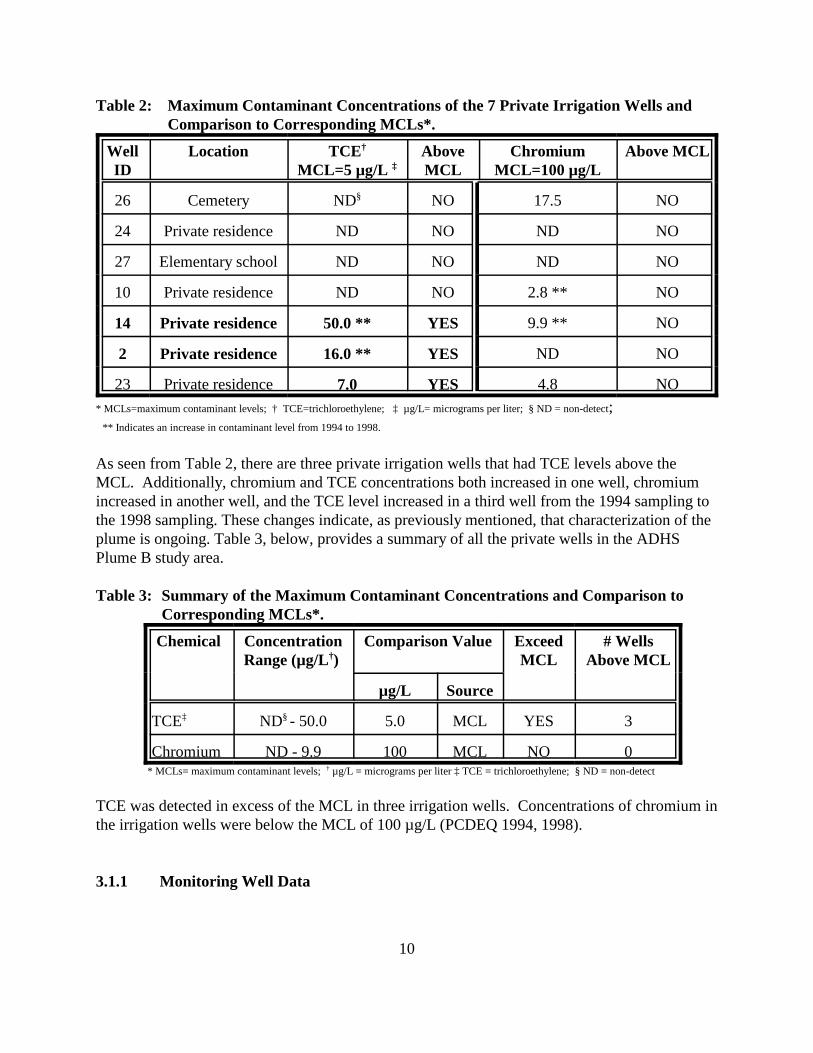
Table 2 lists the private wells that are used for irrigation purposes. The highest detected level islisted whether it was from the 1994 or 1998 private well studies.
10
Table 2: Maximum Contaminant Concentrations of the 7 Private Irrigation Wells andComparison to Corresponding MCLs*.
WellID
Location TCE†
MCL=5 µg/L ‡AboveMCL
ChromiumMCL=100 µg/L
Above MCL
26 Cemetery ND§ NO 17.5 NO
24 Private residence ND NO ND NO
27 Elementary school ND NO ND NO
10 Private residence ND NO 2.8 ** NO
14 Private residence 50.0 ** YES 9.9 ** NO
2 Private residence 16.0 ** YES ND NO
23 Private residence 7.0 YES 4.8 NO* MCLs=maximum contaminant levels; † TCE=trichloroethylene; ‡ µg/L= micrograms per liter; § ND = non-detect; ** Indicates an increase in contaminant level from 1994 to 1998.
As seen from Table 2, there are three private irrigation wells that had TCE levels above theMCL. Additionally, chromium and TCE concentrations both increased in one well, chromiumincreased in another well, and the TCE level increased in a third well from the 1994 sampling tothe 1998 sampling. These changes indicate, as previously mentioned, that characterization of theplume is ongoing. Table 3, below, provides a summary of all the private wells in the ADHSPlume B study area.
Table 3: Summary of the Maximum Contaminant Concentrations and Comparison toCorresponding MCLs*.
Chemical ConcentrationRange (µg/L†)
Comparison Value ExceedMCL
# WellsAbove MCL
µg/L Source
TCE‡ ND§ - 50.0 5.0 MCL YES 3
Chromium ND - 9.9 100 MCL NO 0 * MCLs= maximum contaminant levels; † µg/L = micrograms per liter ‡ TCE = trichloroethylene; § ND = non-detect
TCE was detected in excess of the MCL in three irrigation wells. Concentrations of chromium inthe irrigation wells were below the MCL of 100 µg/L (PCDEQ 1994, 1998).
3.1.1 Monitoring Well Data
11
In addition to the available data from private wells, ADHS located data collected from a numberof monitoring wells installed by USEPA while characterizing the extent of Plume B. Thirteenmonitoring wells have been installed and sampled between 1997 and 1999. Monitoring wellsample results available to ADHS indicate a scenario quite similar to that displayed by theprivate well data. As discussed previously, sampling data results from the 19 private wells showmost wells have TCE concentrations below the MCL of 5.0 µg/L and three of the 19 wellsexceed the MCL. The three wells that exceeded the 5.0 µg/L MCL had maximum TCEconcentrations of 7, 16, and 50 µg/L. The results of TCE analyses on the 13 monitoring wellsinstalled by USEPA show that five of the 13 wells had maximum TCE levels that exceeded theMCL (ERMWest 2000). The maximum TCE levels in these five wells ranged from 8 µg/L to 30 µg/L, very similar to the levels observed in the private wells.
ADHS has not yet thoroughly evaluated the data from these monitoring wells, however it seemsappropriate for the purposes of this document to confirm the consistency with the private welldata reviewed in this report. ADHS notes that the 13 monitoring wells are open to the aquifer atdepths ranging from about 70 to 125 feet below the ground surface. Although ADHS does nothave detailed information about the construction of the private wells, ADHS believes it is likelythat those wells would be less than 200 feet deep and would most likely be open to the aquifer atdepths ranging from about 70 feet below ground surface (roughly the depth to water in theaquifer) to the total depth of each well. In summary, the 13 monitoring wells appear to beencountering very similar portions of the aquifer as the 19 private wells, with the 13 monitoringwells providing more specific information on discrete screen-opening zones and lengths. Thechemical results of TCE concentrations also support this conclusion, with the results from the 13monitoring wells being very similar to the data from the 19 private wells. Together, this dataindicates an aquifer contaminated over a sizable area with TCE, but with only a limited numberof wells which contain more than 5 µg/L of TCE.
3.2 Physical and Other Hazards
No physical hazards that would be considered unusual were identified during the site visits. Children’s toys were seen in the streets throughout the trailer park areas. Old cars were also seenaround the neighborhoods.
4.0 Pathway Analyses
In order to determine if residents are being exposed to TCE or chromium at levels of publichealth concern in drinking or irrigation wells near the TIAA site, exposure pathways areidentified to determine if and how residents might be exposed to the contaminants. This healthassessment reviews the current and future potential pathways from the private wells in the PlumeB area. The lack of past environmental sampling data precludes evaluation of potential pastexposures.
4.1 Completed Current Exposure Pathways
12
The currently completed exposure pathway identified is residential exposure to contaminatedgroundwater by use of private wells for irrigation purposes. This includes inhalation, limitedingestion, and dermal exposures from irrigation wells.
Groundwater PathwayCurrent exposure pathways may result from people using the water from their wells either forirrigation or drinking purposes or both. Typical residential well exposures to TCE include dermaland inhalation exposures from bathing and showering, and ingestion exposures from drinkingand using water for cooking. Since the wells of concern are irrigation wells, only limited dermal,inhalation, and ingestion exposures could occur to anyone who comes in contact with thecontaminated water. This would include exposures to adults while they are watering the lawn orgardens, children playing in yards that are irrigated with contaminated private well water, oranyone who eats garden vegetables that are irrigated with contaminated water and whichaccumulate the contaminants.
Table 4 identifies the estimated population that currently is being exposed to chromium or TCEthrough the use of contaminated private irrigation wells.
Table 4: Summary of Complete Current Exposure Pathways
Type ofPrivate
Well
EXPOSURE PATHWAY ELEMENTS Time
Media Point ofExposure
Route ofExposure
ExposedPop.*
COC†
IrrigationWell
Groundwater yards,gardens
IngestionDermal
Inhalation
9Residents
TCE Current
* Pop. = population. This assumes 3 persons per residence. † COC = chemical of concern; ‡ TCE = trichloroethylene.
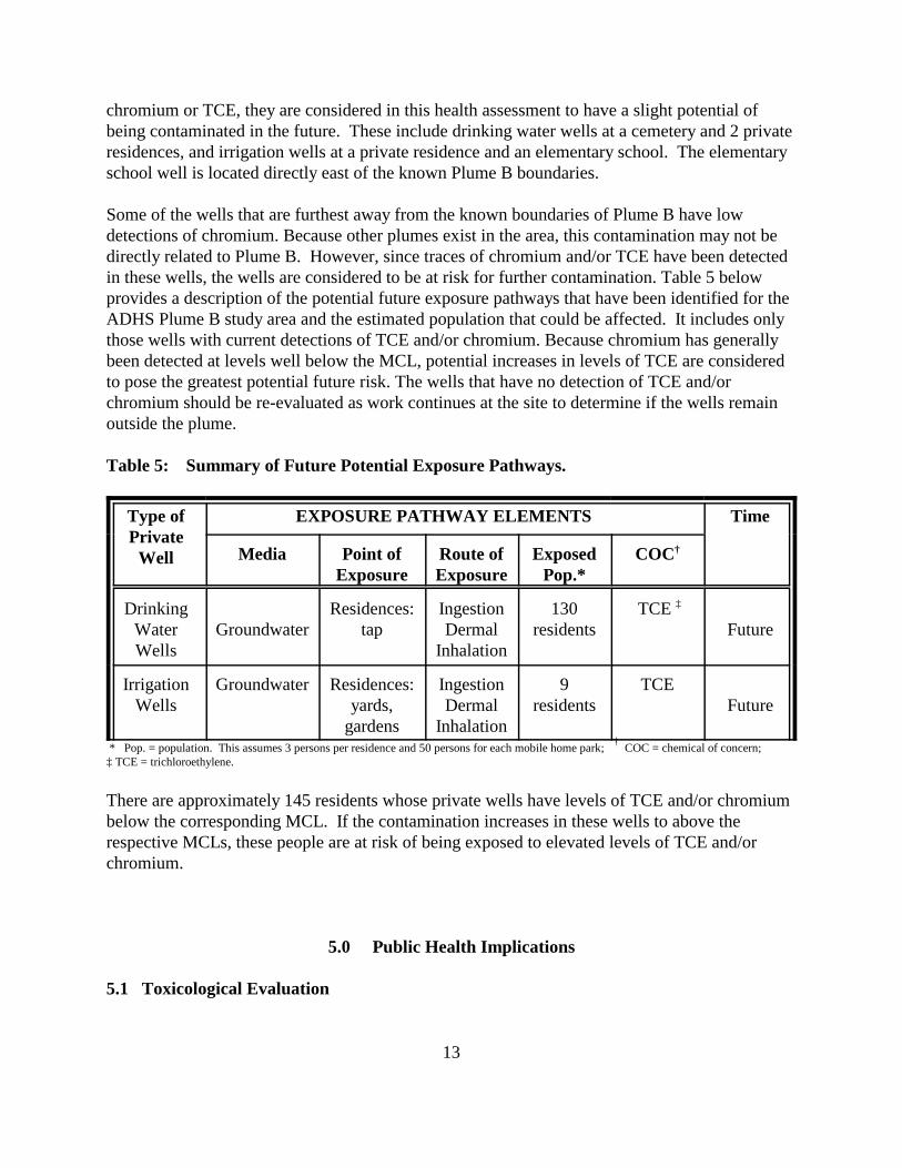
4.2 Potential Future Exposure Pathways
ADEQ is still in the process of characterizing the boundaries of the plume due to the difficulthydrology of the area. Since the plume is slowly migrating northward, and has not beencompletely delineated, it is possible that uncontaminated wells could become contaminated inthe future. In addition, exposure could occur in the future if abandoned wells are repaired andused for drinking or irrigation purposes, if a citizen decides to drill a private well in the area, or ifan irrigation well is changed into a drinking water well. Because there are currently noordinances in place in the site area to prevent this, these are all possibilities for potential futureexposure pathways to occur.
ADEQ and PCDEQ are currently investigating the area to identify additional private wells thathave been abandoned or were not previously identified in the 1998 Private Well study. There are3 private drinking water wells and 2 irrigation wells that currently have no detection ofchromium or TCE. Since these wells are close to other private wells that have detection of
13
chromium or TCE, they are considered in this health assessment to have a slight potential ofbeing contaminated in the future. These include drinking water wells at a cemetery and 2 privateresidences, and irrigation wells at a private residence and an elementary school. The elementaryschool well is located directly east of the known Plume B boundaries.
Some of the wells that are furthest away from the known boundaries of Plume B have lowdetections of chromium. Because other plumes exist in the area, this contamination may not bedirectly related to Plume B. However, since traces of chromium and/or TCE have been detectedin these wells, the wells are considered to be at risk for further contamination. Table 5 belowprovides a description of the potential future exposure pathways that have been identified for theADHS Plume B study area and the estimated population that could be affected. It includes onlythose wells with current detections of TCE and/or chromium. Because chromium has generallybeen detected at levels well below the MCL, potential increases in levels of TCE are consideredto pose the greatest potential future risk. The wells that have no detection of TCE and/orchromium should be re-evaluated as work continues at the site to determine if the wells remainoutside the plume.
Table 5: Summary of Future Potential Exposure Pathways.
Type ofPrivate
Well
EXPOSURE PATHWAY ELEMENTS Time
Media Point ofExposure
Route ofExposure
ExposedPop.*
COC†
DrinkingWaterWells
GroundwaterResidences:
tapIngestionDermal
Inhalation
130residents
TCE ‡
Future
IrrigationWells
Groundwater Residences:yards,
gardens
IngestionDermal
Inhalation
9residents
TCEFuture
* Pop. = population. This assumes 3 persons per residence and 50 persons for each mobile home park; † COC = chemical of concern; ‡ TCE = trichloroethylene.
There are approximately 145 residents whose private wells have levels of TCE and/or chromiumbelow the corresponding MCL. If the contamination increases in these wells to above therespective MCLs, these people are at risk of being exposed to elevated levels of TCE and/orchromium.
5.0 Public Health Implications
5.1 Toxicological Evaluation
14
This section reviews the potential for adverse health effects in persons exposed to specificcontaminants through current or future exposure pathways. ADHS has analyzed the exposurescenarios to determine what, if any, public health hazard exists from exposure to contaminatedgroundwater in Plume B through the use of private wells. The analysis determined that someresidents are currently being exposed to TCE and chromium through ingestion, inhalation, anddermal exposures from the use of contaminated private wells for irrigation purposes.Concentrations of chromium were found in both irrigation and drinking wells but were not abovethe chromium MCL. Three private irrigation wells had concentrations of TCE (at 50 µg/L, 16µg/L, and 7 µg/L) which are above the MCL of 5 µg/L. The highest concentration of TCE (50ug/l) was detected in a private well (rather than one of the 13 monitoring wells in the Plume Barea), so ADHS focused our evaluation on these private wells. Therefore, TCE is considered theonly chemical of concern (COC) in the ADHS study area.
5.1.1 Methods
ADHS assesses a site by evaluating the level of exposure in potential or completed pathways. Anexposure pathway is the way chemicals may enter a person’s body to cause a health effect.The evaluation includes use of comparison values, which are screening tools used withenvironmental data relevant to the exposure pathways. Comparison values are concentrations ofchemicals that can reasonably and conservatively be regarded as harmless to public health basedon the available scientific data. These comparison values are used for screening contaminants at asite to select which substances warrant more detailed evaluation by health assessors. Thedevelopment of a comparison value includes conservative exposure assumptions which typicallyresult in values much lower than those concentrations which have been observed to causeadverse health effects. If public exposure concentrations related to a site are below theappropriate comparison value, then the exposures are not of public health concern and no furtheranalysis of the pathway is conducted. However, while concentrations below the comparisonvalue are not expected to lead to any observable adverse health effect, it should not be inferredthat a concentration greater than the comparison value will necessarily lead to adverse healtheffects. Depending on site- specific environmental exposure factors (for example, duration andamount of exposure) and individual human factors (such as: personal habits, occupation, overallhealth), exposure to levels above the comparison value may or may not lead to a health effect.Therefore, ADHS’ comparison values should not be used to predict the occurrence of adversehealth effects. Further information on comparison values and a description of some of thescientific terms and related health risk terminology (such as EPA’s MCLs) is located in theAppendix section titled “Comparison Values.”
ADHS acknowledges uncertainty exists in characterizing health effects from chemicals throughvarious exposure pathways. Much of the toxicological information is based on dose-responserelationships observed, primarily, in experimental animals, and typically extrapolated from highchemical doses in small animal populations to estimate low-dose responses. There often are also differences between animals and humans in metabolic response to a chemical, and chemical toxicity values are usually developed singly and responses may differ when complex mixtures arepresent. ADHS has considered these variables in the development and application of comparison
15
values.
For the West Plume B area of the Tucson International Airport Area Superfund site, ADHS hasused Human Health Based Guidance Levels (HBGLs) as the appropriate comparison values withwhich to evaluate the available environmental data on potential exposures to TCE.
5.1.2 Comparison to HBGLs
To further evaluate the human exposures that could occur from someone using a contaminatedirrigation well, the ADHS developed and used a model that analyzes a chronic daily intake frommultiple exposure pathways when using contaminated water for irrigation purposes. The ADHScalculated Human Health-based Guidance Levels (HBGLs) as comparison values that wouldincorporate all the various exposure pathways to the contaminated water via incidental ingestionand dermal contact, and inhalation pathways under irrigation scenarios.
HBGLs are used to help evaluate the health hazard from the cumulative inhalation, ingestion, anddermal contact with contaminants in groundwater. They are calculated using a human health-based approach that is generally consistent with risk assessment methodologies recommended byATSDR, USEPA, and the ADHS. They use standard assumptions regarding daily intake ofdrinking water, air breathed, etc. when possible. Where standard assumptions were not available,the ADHS has made conservative assumptions based upon research of the particular exposurescenario and professional judgement. Equations used to quantify exposures were based upongenerally accepted methods, models, toxicity values, and assumptions developed by the USEPA. The equations and assumptions used to calculate HBGLs are conservative and well documented(ADHS 1997a). The HBGL calculations for TCE in irrigation water, along with the standardassumptions used, are presented in the Appendix (Tables A1- A19).
A residential exposure scenario for flood irrigation was calculated which consists of residentswho periodically irrigate their lawn with contaminated irrigation water or come in contact withwater that is used to maintain neighborhood parks. This exposure scenario conservativelyassumes that adults and children are exposed to the contaminated irrigation water via inhalation,ingestion, and dermal contact during periodic maintenance or play activities.
A child exposure scenario was also calculated for a child who is assumed to play in the irrigationwater for 4 hours per day, 350 days per year (COP 1998), for six years. Finally, an occupationalexposure scenario was calculated for an adult maintenance worker exposed via inhalation ofcontaminants escaping from the flood irrigation waters for the 4 hours that the water is assumedto be standing in the property. The adult maintenance worker involved in flood irrigation dutiesis assumed to have incidental ingestion, inhalation and dermal contact with the flood irrigationwater for eight hours per day, 250 days per year, for 25 years (ADHS 1997b).
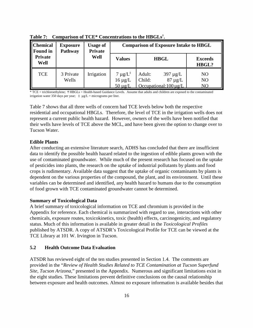
The adult and child HBGL for residential use is 397µg/L and 87µg/L, respectively. Theoccupational HBGL is 100 µg/L. As seen in Table 7, estimated exposure doses from ingestion ofcontaminated private well water are below the respective HBGL.
16
Table 7: Comparison of TCE* Concentrations to the HBGLs†.
* TCE = trichloroethylene; † HBGLs = Health-based Guidance Levels. Assume that adults and children are exposed to the contaminatedirrigation water 350 days per year; ‡ µg/L = micrograms per liter.
Table 7 shows that all three wells of concern had TCE levels below both the respective residential and occupational HBGLs. Therefore, the level of TCE in the irrigation wells does notrepresent a current public health hazard. However, owners of the wells have been notified thattheir wells have levels of TCE above the MCL, and have been given the option to change over toTucson Water.
Edible PlantsAfter conducting an extensive literature search, ADHS has concluded that there are insufficientdata to identify the possible health hazard related to the ingestion of edible plants grown with theuse of contaminated groundwater. While much of the present research has focused on the uptakeof pesticides into plants, the research on the uptake of industrial pollutants by plants and foodcrops is rudimentary. Available data suggest that the uptake of organic contaminants by plants isdependent on the various properties of the compound, the plant, and its environment. Until thesevariables can be determined and identified, any health hazard to humans due to the consumptionof food grown with TCE contaminated groundwater cannot be determined.
Summary of Toxicological DataA brief summary of toxicological information on TCE and chromium is provided in theAppendix for reference. Each chemical is summarized with regard to use, interactions with otherchemicals, exposure routes, toxicokinetics, toxic (health) effects, carcinogenicity, and regulatorystatus. Much of this information is available in greater detail in the Toxicological Profilespublished by ATSDR. A copy of ATSDR’s Toxicological Profile for TCE can be viewed at theTCE Library at 101 W. Irvington in Tucson.
5.2 Health Outcome Data Evaluation
ATSDR has reviewed eight of the ten studies presented in Section 1.4. The comments areprovided in the “Review of Health Studies Related to TCE Contamination at Tucson SuperfundSite, Tucson Arizona,” presented in the Appendix. Numerous and significant limitations exist inthe eight studies. These limitations prevent definitive conclusions on the causal relationshipbetween exposure and health outcomes. Almost no exposure information is available besides that
17
of residence in the contaminated census tract or work. This is a poor surrogate for exposure,since the contamination plume does not occupy the whole census tract. Using the tract level foranalysis rather than block level is likely to lead to exposure misclassification resulting in anunderestimation of the outcome effect. It is recommended that any further studies use block levelanalysis of morbidity and mortality data.
No statistically significant results were found for the following outcomes studied: a) homeboundprogram admission rates in the Tucson Unified and Sunnyside school districts, b) mortality ratesof Hughes aircraft employees and, c) childhood leukemia and testicular cancer incidence in PimaCounty.
In the reviewed studies, the reported results were suggestive for the following outcomes: a)congenital heart disease, b) musculoskeletal birth defects (county-year interactions) c) mortalitydue to asthma, d) neuro-behavioral performance and, e) prevalence of systemic lupuserythematosus.
Although a number of serious limitations exist in the above studies, it is recommended that theoutcomes for which results were suggestive be included in any future studies of the Tucson TCEcontamination problem when possible. It is also recommended that a trend analysis be done todetermine if the elevations in specific birth defects or other outcomes were persistent after publicwater supply sources were used.
5.3 Community Health Concerns Evaluation
Water issues have been a concern of community residents in South Tucson for many years. Thecommunity must be made more aware of the situation with the private wells in the Plume B area. For instance, managers of one mobile park were ready to fix the two private wells on the propertyand use them instead of being on Tucson Water, since it was cheaper. After speaking with them,they most likely will stay on Tucson Water. However, this indicates that other residents in thearea may be motivated to use private wells since it appears less expensive than being hooked upto Tucson Water. Previous Health Assessments
In 1988, ATSDR conducted a health assessment for the larger Main Plume at the TIAA site toaddress the community concerns. The assessment indicated that soil and groundwater in the MainPlume had been contaminated by chromium and volatile organic compounds such as TCE andDCE. The findings of the public health assessment for the Main Plume found that it is unlikelythat exposure to the concentrations of TCE detected in the Tucson public water supply wouldresult in non-carcinogenic toxicity to the liver, central nervous system or other organs.Additionally, no congenital heart disease or other teratogenic effects would be expected to resultfrom exposures to water from the public water supply.
Sampling of private wells for TCE from 1981 through 1994 identified both drinking and
18
irrigation private wells in and near the TIAA (primarily the larger groundwater plume known asthe Main Plume) with the contaminant levels ranging from non-detect to 120 µg/L. One of theprivate irrigation wells (#14) had concentrations of TCE of 49 µg/L which has subsequentlyincreased to 50 µg/L. ATSDR determined that the exposure to the TCE in irrigation well #14 wasnot a public health concern. However, some of the private drinking water wells presented ahealth concern, since the concentrations were high and durations of exposure were greater than10 years. It was also determined that the cancer risk from exposures to water from contaminatedprivate drinking water wells was slightly increased. More information on TCE is provided in theAppendix.
5.4 ATSDR’s Child Health Initiative
ADHS has prepared this public health assessment under a cooperative agreement with theAgency for Toxic Substances and Disease Registry (ATSDR). ADHS has included the followinginformation in accordance with ATSDR’s Child Health Initiative.
Sub-populations of concern are sensitive receptor populations who may be particularlysusceptible to chemical exposure. This can include infants, the elderly, or individuals withrespiratory problems, depending on the chemicals of concern and the nature of the exposures. Children are more likely to be exposed because they are shorter than adults, which means theybreathe dust, soil, and heavy vapors close to the ground which can result in higher doses ofchemical exposure per body weight. The developing body systems of children can sustainpermanent damage if toxic exposures occur during critical growth stages. Child- specific HBGLswere calculated in this health assessment to identify any health hazard that may exist for childrennear the Plume B area. The following results were found: ! The level of the TCE in the private drinking water wells was below the MCL indicating
the water to be safe to drink for children.
! The water in three of the irrigation wells was above the MCL. Further analysis wasconducted in the health assessment to determine if the detected TCE concentrations inthese wells could present a health hazard to children who might play in the irrigationwater. ADHS concludes that the level of TCE in the irrigation wells would not beconsidered a health hazard to children who would play with the water.
In summary, the concentrations of TCE detected in the monitoring, drinking, and irrigation wellsdo not pose a public health hazard to sensitive populations in the area, such as children and olderadults.
Conclusions
Given the current data, ADHS concludes that no current public health hazard exists for residentsas a result of ingestion, dermal, or inhalation exposures to the contaminated groundwater in
19
Plume B. However, potential future exposure to the groundwater contamination presents aviable public health hazard and needs to be addressed in order to prevent future humanexposures.
Private wells in the residential areas near Plume B have been impacted with TCE and chromiumfrom the contaminated groundwater plume. Twelve private drinking water wells, sevenirrigation wells, and 13 monitoring wells were included in the ADHS Plume B study area. Aquantitative analysis of exposures was conducted. Results showed the following:
1. Public drinking water supply wells in the area present no public health hazard.
2. Three private wells used for irrigation purposes were found to contain levels of TCE abovethe MCL of 5 µg/L. However, quantitative analysis shows the level of TCE is not at a level thatwould be expected to cause adverse health effects for residents through inhalation, ingestion, ordermal exposures.
3. Seven private drinking wells and 4 private irrigation wells, including some of the wellsfurthest from the Plume B boundaries, were found to have low levels of chromium. The highestlevel of chromium found was 17.5 µg/L, which is far below the screening level of 100 µg/L. Thelevel of chromium found in these wells is not at levels that would be expected to cause adversehealth effects for residents through inhalation, ingestion, or dermal exposures. The chromiumcontamination in the furthest wells may not be due to contaminated groundwater from Plume B.
4. Potential future exposure to groundwater contamination cannot be ruled out. Monitoring wellsalso show that TCE contamination is present in the aquifer at levels above public drinking waterstandards and contaminated groundwater containment has not been achieved yet. Abandonedwells have been identified in the ADHS Plume B Study Area and these could potentially be fixedand made into irrigation or drinking water wells and could be contaminated from the Plume. There are no current laws to prevent any resident from turning an irrigation well into a drinkingwell or installing new wells.
Recommendations
This public health assessment has determined that, given the data provided by the PCDEQ in the1998 private well study, no current health hazard exists to those residents whose private wellswere identified in the ADHS Plume B Study Area. However, future exposures to thecontaminated groundwater presents a viable public health hazard to the community living nearPlume B. Therefore, ADHS makes the following recommendations:
1. Further investigation is needed to identify additional private wells and their accuratelocations, particularly in the Tucson Water parcel areas. It is estimated that this will include
20
around 2000 residences. If additional private wells are found during this investigation, thosewells need to be sampled and results sent to the ADHS for further evaluation.
2. ADEQ has recently identified some abandoned wells near the Plume B area. It is importantthat a long-term management protocol be developed to address the following:
! That abandoned wells in the area are not converted into working irrigation or drinkingwater wells;
! That irrigation wells are not converted into drinking water wells and vice versawithout proper approval and knowledge by ADEQ and EPA project managers;
! That development of a comprehensive database which identifies all private wells inthe Plume B area, their use, location address, and other pertinent information wouldassist project managers from the various agencies involved.
3. As a precaution, private wells near the path of the plume should be sampled on a regular basisto see that no additional contamination occurs from possible future migration of the groundwaterplume. If any additional contamination is found in private wells as a result of futureinvestigations, an ATSDR Health Consultation should be conducted to evaluate the hazard topublic health.
4. Since the area of Plume B is not yet fully characterized, it would be beneficial to all concernedresidents in the area to be routinely informed of the status of the plume investigation and itseffect on any private wells in the area. These could be mailed to private well owners, supplied tothe TCE library, and made available to community meetings held at the El Pueblo Clinic.
Public Health Action Plan
The Public Health Action Plan (PHAP) for the Plume B Site contains a description of actionstaken, to be taken, or under consideration by ATSDR and ADHS at and near the site. Thepurpose of the PHAP is to ensure that this public health assessment not only identifies publichealth hazards, but also provides a plan of action designed to mitigate and prevent adversehuman health effects resulting from exposure to hazardous substances in the environment. ADHS and ATSDR will follow up on this plan to ensure that actions are carried out.
Actions CompletedFrom 1993 - 1995, ADHS staff conducted many workshops in Tucson to address the healthconcerns of the community. These included workshops on exposures to TCE and it’s healtheffects, lupus, cancer, environmental pollution, and other issues of concern.
From 1993 - 1995, ADHS staff conducted many physician education training seminars in Tucsonon TCE and it’s health effects, and other environmental issues that they may need to know inorder to address the concerns of their patients.
21
ADHS attended a public meeting at the Tucson UCAB (Unified Community Action Board) inFebruary 1998 to announce the public health assessment for the Plume B Site.
In January 1999, ADHS staff met with the Pima County Department of Environmental Quality(PCDEQ) to discuss the upcoming health assessment and to gather data on the private wells inthe area. Staff also went to the TCE Library to gather data on the various sites where healthassessments would be conducted. This also included attending the monthly UCAB meeting.
In March 1999, ADHS staff attended the UCAB meeting in Tucson to discuss concerns about thePlume B area. One full day was spent driving around the site, identifying the private wells in thearea, taking pictures, and talking with residents to identify their concerns.
In April 1999, ADHS met with EPA, PCDEQ, ADEQ, and other parties in San Francisco for 2days to discuss the West Cap and Plume B situation in Tucson. Plans were put in place to bettercharacterize the site, determine the source of the contamination, and further the clean up of WestCap.
In August, 1999 a teleconference was held between ADHS, PCDEQ, and ADEQ staff to discussthe Plume B site. Discussion included plans to reduce future exposures to contaminated water,prevent residents from turning abandoned wells and irrigation wells into drinking wells, anddeveloping a GIS database that can provide information for any new person that gets involved inthe site.
In September, ADHS staff attended the UCAB meeting and presented the results of the healthassessment and other health assessments being conducted on the Tucson site.
Actions Proposed
ADHS will continue to meet with the community residents at the UCAB meetings on a regularbasis to communicate the ADHS activities being conducted at the Tucson site. Specific goals areto increase the understanding of the technical aspects of the area contaminants and their fate andtransport, and to educate the community on ways to minimize their exposures to site-relatedcontaminants and physical hazards.
ADHS will continue to work with EPA, ADEQ, PCDEQ, and consulting companies to addressadditional health concerns about exposures at the Plume B Site.
22
Public Comment Period
ATSDR provided an opportunity in the final draft stage of this document for the general public tocomment on Agency findings or proposed activities. This comment period lasted from July 6,2000 through September 30, 2000. During that time no comments were received.
23
Preparers of Report
Arizona Department of Health Services, Office of Environmental HealthJan McCormick, Environmental EpidemiologistWill Humble, Chief, Office of Environmental Health, Principal Investigator
ATSDR Regional Representative
William NelsonRegional Services, Region IXOffice of the Assistant Administrator
ATSDR Technical Project Officer
Tammie McRaeDivision of Health Assessment and ConsultationSuperfund Site Assessment Branch
24
References
Arizona Department of Health Services. Baseline Human Health Risk Assessment; TucsonInternational Superfund Site. December 1, 1996.
Arizona Department of Health Services. Arizona Soil Remediation Levels. January 30, 1997a.
Arizona Department of Health Services. Baseline Human Health Risk Assessment; Sandy’s MagicTouch Cleaners. March 24, 1997b.
Arizona Department of Environmental Quality. Remedial Investigation Report. Phase II: FormerWest-Cap Property and Vicinity. Area B. Tucson International Airport Area, CERCLA Site. FileReport: OFR 98-2. June, 1998.
CH2MHILL. Soil Gas and Soil Sampling Data Report. Tucson International Airport Area FormerWest Cap Facility, Tucson, Arizona. USEPA Contract No. 68-W9-0031. May, 1996.
CH2MHILL. Well Installation and Data Report; Tucson International Airport Area for the FormerWest Cap Facility. USEPA Contract No. 68-W9-0031. January, 1998.
ERMWest. Installation Restoration Program Final Quarterly Groundwater Monitoring Report forthe November 1999 Round, 162nd Fighter Wing, Arizona Air National Guard, Tucson InternationalAirport, Tucson, Arizona. June 2000.
Pima County Department of Environmental Quality. Southside TCE Private Well Investigation forthe Tucson International Airport Area Superfund Site (TIAASS), Tucson, Arizona. November, 1994.
Pima County Department of Environmental Quality. Southside of Tucson Municipal Water QualityTesting Project. July 1995.
Pima County Department of Environmental Quality. Sampling and Analysis Plan for RoutinePrivate Well Monitoring: Southside Private Well Monitoring Program for Tucson InternationalAirport Area Superfund Site. February 1998.
Pima County Department of Environmental Quality. Southside TCE Private Well Investigation forthe Tucson International Airport Area Superfund Site (TIAASS), Tucson, Arizona. December 1998.
Trapp, S., McFarlane, C. 1995. Plant Contamination: Modeling and Simulation of OrganicChemical Processes. Lewis Publishers.
U.S. Department of Health & Human Services, Public Health Service; Agency for Toxic Substancesand Disease Registry Division of Health Assessment and Consultation. Review of Health StudiesRelated to TCE Contamination at Tucson Superfund Site, Tucson Arizona. 1994.
25
U.S. Department of Health & Human Services, Public Health Service; Agency for Toxic Substancesand Disease Registry Division of Health Assessment and Consultation, Petitioned Public HealthAssessment Update to the 1988 Public Health Assessment, Tucson International Airport, Tucson,Pima County, Arizona, Cerclis No. AZ. Draft May 20, 1996.
U.S. Department of Health and Human Services, Agency for Toxic Substances and Disease Registry.1996. Petitioned Public Health Assessment Addendum, Tucson International Airport Area, Tucson,Pima County, Arizona. November 5, 1996.
U.S. Department of Health and Human Services, Agency for Toxic Substances and Disease Registry.Toxicological Profile for Chromium. August 1997.
U.S. Department of Health and Human Services, Agency for Toxic Substances and DiseaseRegistry. Toxicological Profile for Trichloroethylene. August 1997.
U.S. Department of Health and Human Services, Agency for Toxic Substances and Disease Registry.Toxicological Profile for 1,1-Dichloroethylene. August 1997.
U.S. Department of Health and Human Services, Agency for Toxic Substances and DiseaseRegistry. Toxicological Profile for 1,1,1-Trichloroethane. August 1997.
U.S. Department of Health & Human Services, Public Health Service; Agency for Toxic Substancesand Disease Registry Division of Health Assessment and Consultation; Petitioned Public HealthAssessment Update to the 1988 Public Health Assessment, Tucson International Airport, Tucson,Pima County, Arizona. Draft March 8, 1988.
0
APPENDIX
Figure 1: Location map of the Tucson International Airport Superfund Site
Figure 2: Location of Larger Plume A and Smaller Plume B
Figure 3: Close-up Map of Plume B
Figure 4: Results of 1994 and 1998 Private Well Studies Conducted by Pima CountyDepartment of Environmental Quality
Table A1: Results of Calculations for the Flood Irrigation Scenarios
Table A2-A19: Equations for Exposure Calculations for the Flood Irrigation Scenarios
ATSDR Review of Eight TIAA Health Studies Related to Trichloroethylene (TCE) Contamination
ADHS Toxicological Profile for TCE
Comparison Values
Listed below are some of the comparison values used by ADHS to select chemicals which meritdetailed site specific evaluation. In addition, other non-ADHS values are listed which aresometimes used to provide a meaningful frame of reference for environmental chemical data.For convenience, the list also includes some of the common abbreviations used for common unitsof measure. Following the list is a brief description of each value.
CREG = Cancer Risk Evaluation Guide MRL = Minimal Risk LevelEMEG = Environmental Media Evaluation GuideRMEG = Reference Dose Media Evaluation GuideRfD = Reference DoseRfC = Reference Dose ConcentrationRBC = Risk Based ConcentrationDWEL = Drinking Water Equivalent LevelLTHA = Lifetime Health AdvisoryMCL = Maximum Contaminant LevelHBGL = Human Health Based Guidance LevelPRG = Permissible Remediation Goal (Action Level)PEL = Permissible Exposure LimitTLV = Threshold Limit Valueppm = parts per millionppb = parts per billion
1
kg = kilogram (1000 grams)mg = milligram (0.001 grams)ug = microgram (0.000001 grams)L = literm3 = cubic meter (referring to 1000 liters of air)
Cancer Risk Evaluation Guides (CREGs) are estimated contaminant concentrations expectedto cause no more than one excess cancer in one million persons exposed over a lifetime. CREGsare calculated from USEPA’s cancer slope factors or cancer potency factors using standardassumptions for exposure rates. These cancer estimates are commonly used because low-dose chemical exposure lab studies typically are not in the scientific literature and the true risk isunknown (and may be as low as zero).
Minimal Risk Levels (MRLs) are estimates of daily human exposure to a chemical (usually interms of milligrams chemical per kilogram of body weight per day) that are unlikely to beassociated with any appreciable risk of adverse noncancer effects over a specified duration ofexposure. MRLs are calculated using data from human and animal studies and are usuallyreported for one of three time frames: acute (up to 14 days exposure), intermediate (15 - 364 daysexposure), and chronic (1 year or more of exposure). MRLs are developed by the federal Agencyfor Toxic Substances and Disease Registry (ATSDR) and are published in ATSDR’sToxicological Profiles.
Environmental Media Evaluation Guides (EMEGs) are media-specific concentrations ofchemicals calculated from ATSDR minimal risk levels using standard body weight and ingestionassumptions. EMEGs may be developed for specific timeframes of exposure duration such asacute, intermediate, or chronic (see MRLs). Chemical amounts below an EMEG are consideredto be harmless to public health while amounts above an EMEG require detailed site-specificevaluation.
Reference Dose Media Evaluation Guide (RMEG) is the concentration of a contaminant in air,water, or soil that corresponds to USEPA’s RfD for that contaminant when standard assumptionsof body weight and intake rates are taken into account.
Reference Dose (RfD) is USEPA’s estimate of the daily exposure to a contaminant unlikely tocause noncarcinogenic adverse health effects. Like the ATSDR MRL, the RfD is a doseexpressed in mg/kg/day.
Reference Concentration (RfC) is a concentration of a substance in air which USEPAconsiders unlikely to cause non-cancer adverse health effects over a lifetime of exposure.
Risk-Based Concentrations (RBCs) are media-specific concentrations calculated from RfDs,RfCs, or USEPA’s Cancer Slope Factors. They represent concentrations of a contaminant that areconsidered unlikely to cause adverse health effects over a lifetime of chronic exposure.
2
Drinking Water Equivalent Levels (DWELs) are based on USEPA’s oral RfD and representcorresponding concentrations of a substance in drinking water that are estimated to havenegligible deleterious effects in humans at an intake rate of 2 liters per day for life, assuming thatdrinking water is the sole source of exposure.
Lifetime Health Advisories (LTHA) are calculated from the DWEL and represent theconcentration of a substance in drinking water estimated to have a negligible deleterious effect inhumans over a lifetime of 70 years, assuming 2 liters per day consumption for a 70 kilogramadult, and taking into account other probable sources of exposure. In the absence of chemicalspecific data, the assumed fraction of total intake from drinking water is 20%. Lifetime healthadvisories are not derived for compounds considered potentially carcinogenic for humans.
Maximum Contaminant Levels (MCLs) are legally enforcible contaminant concentrations indrinking water that USEPA deems protective of public health (considering the availability andeconomics of water treatment technology) over a 70 year lifetime at an exposure rate of 2 liters ofwater per day.
Health Based Guidance Levels (HBGLs) are calculated by ADHS to limit excess lifetimecancer risk to one-in-one million (10-6) for known human carcinogens and to one-in-one-hundred-thousand (10-5) for possible and probable human carcinogens. HBGLs are consideredindividually protective of human health, including sensitive groups, over a lifetime. Chemicalconcentrations that exceed the applicable HBGL may not necessarily represent a health hazard. Rather, when contaminant concentrations exceed the HBGL, further evaluation may be necessaryto determine whether a contaminant poses an unacceptable health hazard to humans.
Permissible Remediation Goals (PRGs), or Action Levels, are chemical- and media- specificlevels of contamination which, when exceeded, automatically trigger a regulatory response orremedial action of some kind.
Permissible Exposure Limit (PEL) is an 8-hour time-weighted average concentration of asubstance in workplace air designed by the Occupational Safety and Health Administration(OSHA) to provide that, to the extent feasible, chemical exposures in the workplace do notimpair the health or functional capacity of workers throughout their working life. The PEL maybe exceeded for brief periods, but the sum of the exposure levels averaged over 8 hours is not toexceed to PEL.
Threshold Limit Value (TLV), developed by the American Conference of GovernmentalIndustrial Hygienists (ACGIH), is “the time-weighted average concentrations for a normal 8-hourworkday and a 40-hour workweek, to which nearly all workers may be repeatedly exposed, dayafter day, without adverse effect.” Many of ACGIH’s TLVs were adopted by OSHA for use asPELs. Note that TLVs and PELs, which were designed to protect healthy workers, are usuallymuch higher than the public health based values of ATSDR and USEPA, which were designed toprotect the health of the general population, including subgroups such as the very young and theelderly.
3
Glossary
aquifer a permeable rock stratum below the earth’s surface through which groundwatermoves; generally capable of producing water for a well.
chemicals of concernchemicals whose concentrations are above the appropriate screening level.
detection limit the minimum concentrations that must be accurately and precisely measured bythe laboratory and/or specified in the quality assurance plan.
dose the amount of a contamination that is absorbed or deposited in the body of anexposed organism for an increment of time. A total dose is the sum of dosesreceived by a person from a contaminant in a given interval resulting frominteraction with all environmental media that contain the contaminant. Units ofdose and total dose are often converted to units of mass per volume ofphysiological fluid or mass of tissue.
exposure an event that occurs when there is contact at a boundary between a human being
and the environment with a contaminant for a specific concentration for aninterval of time: the units of exposure are concentration multiplied by time.
exposure pathwaythe process by which an individual is exposed to contaminants that originatefrom some source of contamination and are categorized as inhalation, dermal,and/or ingestion exposures.
latency the period between stimulus application and response onset.
parts per million a common basis of reporting water analysis. One part per million (ppm) equals1 pound per million pounds of water.
public health assessment an evaluation of relevant environmental data, health outcome data, and
community concerns associated with a site where hazardous substances havebeen released.
route of exposuremeans by which the contaminant actually enters or contacts the body, such asingestion, inhalation, dermal contact, and dermal absorption.
volatile compounds
4
compounds amenable to analysis by the purge and trap techniques. Usedsynonymously with purgable compounds.
volatilization the conversion of a liquid or solid into vapors.
LIST OF ACRONYMS AND ABBREVIATIONS
ADHS Arizona Department of Health ServicesADEQ Arizona Department of Environmental QualityAMC American Cancer SocietyATSDR Agency for Toxic Substances and Disease RegistryCOC chemical of concernHBGL Health-based Guidance LevelsMCL maximum contaminant levelMRL minimum risk levelNA not applicableND non-detectNS not sampledPCDEQ Pima County Department of Environmental Qualityppm parts per millionSLE Systemic Lupus ErythematosusTCE trichloroethyleneTIAA Tucson International Airport Area USEPA United States Environmental Protection AgencyVOCs volatile organic compoundsµg/L micrograms per liter