Public Health Assessment KERR-MCGEE CHEMICAL CORPORATION NPL SITE NAVASSA, BRUNSWICK COUNTY, NORTH CAROLINA EPA FACILITY ID: NCD980557805 Prepared by the North Carolina Department of Health and Human Services MAY 4, 2012 Prepared under a Cooperative Agreement with the U.S. DEPARTMENT OF HEALTH AND HUMAN SERVICES Agency for Toxic Substances and Disease Registry Division of Community Health Investigations Atlanta, Georgia 30333 Final Release
Transcript
Public Health Assessment
KERR-MCGEE CHEMICAL CORPORATION NPL SITE NAVASSA, BRUNSWICK COUNTY, NORTH CAROLINA
EPA FACILITY ID: NCD980557805
Prepared by the North Carolina Department of Health and Human Services
MAY 4, 2012
Prepared under a Cooperative Agreement with the U.S. DEPARTMENT OF HEALTH AND HUMAN SERVICES
Agency for Toxic Substances and Disease Registry Division of Community Health Investigations
Atlanta, Georgia 30333
Final Release
THE ATSDR PUBLIC HEALTH ASSESSMENT: A NOTE OF EXPLANATION
This Public Health Assessment was prepared by ATSDR’s Cooperative Agreement Partner pursuant to the Comprehensive Environmental Response, Compensation, and Liability Act (CERCLA or Superfund) section 104 (i)(6) (42 U.S.C. 9604 (i)(6)), and in accordance with our implementing regulations (42 C.F.R. Part 90). In preparing this document, ATSDR’s Cooperative Agreement Partner has collected relevant health data, environmental data, and community health concerns from the Environmental Protection Agency (EPA), state and local health and environmental agencies, the community, and potentially responsible parties, where appropriate. In addition, this document has previously been provided to EPA and the affected states in an initial release, as required by CERCLA section 104 (i)(6)(H) for their information and review. The revised document was released for a 60-day public comment period. Subsequent to the public comment period, ATSDR’s Cooperative Agreement Partner addressed all public comments and revised or appended the document as appropriate. The public health assessment has now been reissued. This concludes the public health assessment process for this site, unless additional information is obtained by ATSDR’s Cooperative Agreement Partner which, in the agency’s opinion, indicates a need to revise or append the conclusions previously issued. Use of trade names is for identification only and does not constitute endorsement by the U.S. Department of Health and Human Services. Additional copies of this report are available from:
National Technical Information Service, Springfield, Virginia (703) 605-6000
You May Contact ATSDR Toll Free at 1-800-CDC-INFO
or Visit our Home Page at: http://www.atsdr.cdc.gov
KERR-MCGEE CHEMICAL CORPORATION NPL SITE FINAL RELEASE
PUBLIC HEALTH ASSESSMENT
KERR-MCGEE CHEMICAL CORPORATION NPL SITE
NAVASSA, BRUNSWICK COUNTY, NORTH CAROLINA
EPA FACILITY ID: NCD980557805
Prepared by:
North Carolina Department of Health and Human Services Division of Public Health
Occupational and Environmental Epidemiology Branch
Under Cooperative Agreement with the U.S. Department of Health and Human Services
Agency for Toxic Substances and Disease Registry
.
i
Table of Contents
Acronyms ii Forward 3 Summary 4 Purpose and Health Issues 8 Background 9 Site Description & History 9 Current Site Conditions 10 Demographics 11 Site Geology and Hydrogeology 11 Site Visits 12 Discussion 13 The ATSDR Health Effects Evaluation Process 13 Review of Site Environmental Data 14 Exposure Pathway Analysis 18 Summary of Environmental Exposure Potential at the Site 19 Site Specific Exposure Conditions Used for Health Evaluations 21 Evaluation of Potential Public Health Issues 22 Health Effects of Selected Substances 25 Health Outcome Data 26 Community Health Concerns 27 Child Health Considerations 28 Uncertainties and Limitations 28 Public Comment Period 29 Conclusions 29 Recommendations 31 Public Health Action Plan 32 Contact Information 34 Report Preparation 35 References 36 Appendices
Appendix A: Figures 39 Appendix B: Demographics Data 46 Appendix C: Site Photographs 49 Appendix D: Tables 58 Appendix E: The ATSDR Health Effects Evaluation Process 65 Appendix F: Glossary 76 Appendix G: Response to Comments 91
ii
Acronyms
AF Attenuation factor ATSDR Agency for Toxic Substances and Disease Registry CDC Center for Disease Control and Prevention CF Conversion factor cm Centimeter CREG ATSDR Cancer Risk Evaluation Guide CR Contact rate CV Comparison Value DAF Dermal absorption factor DENR N.C. Department of Environment and Natural Resources DHHS N.C. Department of Health and Human Services DPH N.C. DHHS Division of Public Health DWM N.C. DENR Division of Waste Management DWQ N.C. DENR Division of Water Quality ED Exposure duration EF Exposure frequency EMEG ATSDR Environmental Media Evaluation Guide EPA U.S. Environmental Protection Agency HG Health Guideline value IRi Inhalation rate IUR Inhalation Unit Risk factor kg Kilogram L Liter LOAEL Lowest Observed Adverse Effect Level LTHA EPA’s Lifetime Health Advisory Level for drinking water MCLG EPA Maximum Contaminant Level Goal MCL EPA Maximum Contaminant Level M Meter mg Milligram μg Microgram NA Not applicable NIOSH National Institute for Occupational Safety and Health NOAEL No Observed Adverse Effect Level PAH Polycyclic aromatic hydrocarbons ppm Parts per million ppb Parts per billion RfC Reference Concentration RfD Reference Dose RMEG ATSDR Reference Dose Media Evaluation Guide SVOC Semi-volatile organic compound VOC Volatile organic compound
* These acronyms may or may not be used in this report
3
Foreword
The North Carolina Division of Public Health (N.C. DPH) Medical Evaluation and Risk Assessment Unit’s Health Assessment, Consultation and Education (HACE) program has prepared this Public Health Assessment in cooperation with the Agency for Toxic Substances and Disease Registry (ATSDR). ATSDR is part of the U.S. Department of Health and Human Services and is the principal federal public health agency responsible for the health issues related to hazardous waste. This public health assessment was prepared in accordance with the methodologies and guidelines developed by ATSDR and N.C. DPH.
The purpose of this public health assessment is to identify and prevent harmful health effects resulting from exposure to hazardous substances in the environment. Public health assessments focus on health issues associated with specific exposures that have happened in the past, are currently occurring, or are believed to be possible in the future based on current site conditions. The HACE Program evaluates sampling data collected from a hazardous waste site, determines whether exposures have occurred or could occur in the future, reports any potential harmful effects, and then recommends actions to protect public health. The findings in this report are relevant to conditions at the site during the time this public health assessment was conducted and may not be applicable if site conditions or land uses change in the future.
For additional information or questions regarding the contents of this health consultation or the MERA unit, please contact:
Medical Evaluation and Risk Assessment Unit/HACE Occupational and Environmental Epidemiology Branch N.C. Division of Public Health/DHHS 1912 Mail Service Center Raleigh, NC 27699-1912 Phone: (919) 733-5900 Fax: (919) 870-4807 e-mail at: [email protected]
4
SUMMARY
INTRODUCTION The N.C. Division of Public Health’s (DPH) top priority is to make sure the community near the Kerr-McGee Chemical Corporation - Navassa NPL site (EPA ID: NCN980557805) has the best science information available to safeguard its health. The N.C. DPH performed a comprehensive evaluation of available environmental analytical data associated with the Kerr-McGee Chemical Corporation - Navassa NPL (“Superfund”) site, located on North Navassa Road in Navassa, Brunswick County, N.C. The 300-acre site is bordered by Sturgeon Creek to the south and the Brunswick River to the east. This document includes discussion of all site environmental data reported at the time DPH’s assessment was initiated. The U.S. Environmental Protection Agency (EPA) has additional environmental investigations planned for this site. N.C. DPH’s review of that data will be provided in additional documents. The site operated as a creosote-based wood treating facility under three different owners from 1936 through 1974. Kerr-McGee Chemical Corporation purchased the facility in 1965 and ceased operations in 1974. Dried lumber was pressure treated on site with a creosote solution and stored outside to dry. There are no indications that pentachlorophenol (PCP) was used at the facility. Treated wood products included railroad ties, utility poles and pilings. Creosote storage and application, and treated and untreated wood storage took place on approximately 60 acres in the western and southern portions of the site (the “production area”). Wastewater generated during the creosote treatment process was discharged into two on-site un-lined wastewater ponds. In 1980, Kerr-McGee Chemical Corporation dismantled the site, removing all equipment, buildings and storage tanks. The site has not been in use since 1980. Approximately 45,000 cubic feet of creosote-containing material was disposed of on-site when the site was dismantled. Environmental investigations by the N.C. Department of Environment and Natural Resources (DENR) began on the site in 1988. Creosote residuals remain in the soils, groundwater and sediments on the site, and in the sediments of the adjoining wetlands and Sturgeon Creek. No samples were collected on the site until 14 to 30 years after operations ceased. These samples may not accurately represent historical exposure concentrations experienced by the local community. In meetings with the community during the site evaluations, diabetes and kidney disease were identified as the primary health concerns. The data evaluated up to this point for the site did not indicate that these health concerns can be tied to exposure from the site. However, DPH
5
still presents follow-up actions to assist the community with their health concerns and will evaluate all new data with these concerns in mind.
OVERVIEW The N.C. DPH reached six important conclusions about the Kerr-McGee Chemical Corporation - Navassa NPL site:
CONCLUSION 1 The N.C. DPH concludes that accidentally ingesting creosote contaminated surface soils or sediments currently present on the site or the adjoining Sturgeon Creek or the Brunswick River while infrequently visiting the site is not expected to harm people’s health.
BASIS FOR DECISION
The concentrations of creosote residuals identified in site soils and sediments and adjacent water bodies since 1988 were not present at levels that indicate the potential for adverse health effects to persons coming into contact with the soils or sediments on an infrequent basis, such as persons hiking or hunting on the property.
NEXT STEPS The N.C. DPH makes the following recommendations: The property owners post additional “no trespassing” signs or
“warning” signs to alert potential visitors to the chemical hazards and discourage them from accessing the site.
N.C. DPH will continue to monitor environmental data collected in association with site investigations and remediation efforts for potential health related impacts.
CONCLUSION 2 The N.C. DPH concludes that drinking water from private wells in the residential area on the west side of Navassa Road adjacent to the site is not expected to have harmed people’s health.
BASIS FOR DECISION
No site contaminants were detected in the private well samples collected in 1988 and 1995. Site investigations indicate that the groundwater under the site flows south/southeast toward Sturgeon Creek and away from the residential area on the west side of Navassa Road.
NEXT STEPS The N.C. DPH makes the following recommendations: EPA verify there are no existing private wells down gradient and
within the influence area of the site. If located, test these wells for PAHs, and semi-volatile organic compounds (SVOCs). Provide an alternative drinking water source if concentrations exceed regulatory or health-based guidelines. Provide persons using these wells with recommendations on physician follow-up.
If the wells are accessible, EPA collect samples for VOCs, PAHs and SVOCs from the now closed private wells in the 2-acre private residential area in the east central portion of the site. It is understood that this well data will provide limited information on possible past exposures.
CONCLUSION 3 The N.C. DPH concludes that accidently ingesting surface soils collected on the private residential area in the east central portion of the site is not expected to harm people’s health.
BASIS FOR DECISION
The concentrations of PAHs (polycyclic aromatic hydrocarbons) present in the surface soils collected in 2004 are below levels that would harm
6
the health of persons accidently ingesting the soils for as long as 70 years.
NEXT STEPS The N.C. DPH makes the following recommendations: N.C. DPH assist the County to inform the residents of the potential
health hazards associated with the creosote residues in the southern portion of the site and discourage people from entering the site. Continue to inform residents as additional information regarding potential public health issues becomes available.
CONCLUSION 4 The N.C. DPH cannot conclude if persons that eat fin fish or shellfish from Sturgeon Creek or Brunswick River adjacent to the site could harm people’s health.
BASIS FOR DECISION
Creosote residues (PAHs) have been found in surface soils and sediments on the site, in the adjacent wetlands, and in Sturgeon Creek. Aquatic organisms, including fin fish and shellfish, can accumulate PAHs in their tissues. Persons eating the fin fish and shellfish can be exposed to the PAHs in the fish. It has been reported that people fish for bottom feeder and upper trophic level fish (fish that eat other fish) in the area, both of which could be contaminated with high levels of PAHs. Analyzing fish tissue provides the best alternative to assessing this potential route of exposure.
NEXT STEPS The N.C. DPH makes the following recommendations: N.C. DPH assist the County to inform the residents of the potential
for fin fish and shellfish in adjacent waters to be contaminated and discourage them from eating these fish until the fish and shell fish populations have been tested.
At N.C. DPH’s recommendation: Fin fish and shell-fish sample collection in Sturgeon Creek and the
Brunswick River took place in December 2011 through the combined efforts of the U.S. EPA, N.C. DENR, N.C. Wildlife Resources Commission and N.C. DPH. This data will be evaluated to determine if persons eating fish or shellfish may be exposed to site contaminants taken up by these organisms. Additional collections may take place in 2012 as needed to fully assess fish and shellfish contamination. N.C. DPH will evaluate the fish/shellfish tissue data and work with the County to communicate any health concerns to the community.
CONCLUSION 5 The N.C. DPH cannot conclude whether persons living near the site during the years wood was treated and prior to the collection of the environmental data could have been harmed by coming into contact with creosote residuals in the air, soils, sediments, surface waters, fish or shellfish.
BASIS FOR DECISION
No environmental data was collected during the time wood was being treated on the site (treated until 1974). Limited environmental data was initially collected in 1988, 14 years after wood treating ceased.
7
Significant data was not collected until 1995 and 2004-05. This data may not represent contaminant concentrations and exposure conditions during wood treating operations and the years immediately afterward.
NEXT STEPS Because of the uncertainty regarding past exposure, and the health concerns identified by the community, the N.C. DPH makes the following recommendations: N.C. DPH will work with the County to: provide information to
local residents about the potential health hazards associated with the creosote residuals in the soils and sediments on the site and in adjacent areas; how to reduce or eliminate their exposures to these materials; and, to provide recommendations for appropriate medical follow-up if they believe they have been harmed by past exposures to site-associated materials.
N.C. DPH will work with the County to educate local health care providers about environmental health issues associated with the site.
N.C. DPH will review soil and sediment sample data collected by EPA in 2010 on the west site of North Navassa Road adjacent to the residential areas that could have been impacted by site run-off.
N.C. DPH will work with the County to provide assistance to the segment of the community affected or predisposed to diabetes and kidney disease. However, at this time, there is no indication that these health issues are related to the former wood-treating facility.
CONCLUSION 6 The N.C. DPH concludes that the accidental daily ingestion of creosote residuals (PAHs) that remain in the surface soils on the site for many years could harm people’s health if frequent exposure was occurring, such as in a re-development scenario where the land is developed for industrial or residential use without some means of preventing contact with contaminated soils and sediment.
BASIS FOR DECISION
N.C. DPH evaluated potential health affects associated with re-purposing the site under current contamination conditions for industry or as a residential area. The average concentration of PAHs remaining in surface soils in the southern portion of the site where wood was treated and stored until 1974 are still present at concentrations that could cause adverse health effects to persons that work or live on the site for 30 years or more and accidently ingest contaminated soil.
NEXT STEPS The N.C. DPH makes the following recommendations: To protect public health, the levels of creosote residuals in the soils
and sediments need to be reduced, or contact prevented, if the site will be re-developed for industrial, residential or recreational use.
FOR MORE INFORMATION
If you have concerns about your health as it relates to this site you should contact your health care provider. You can also call the N.C. Division of Public Health at (919) 707-5900, or send an e-mail to [email protected], and ask for information on the Kerr-McGee Chemical Corporation - Navassa NPL Site Public Health Assessment.
8
PURPOSE AND HEALTH ISSUES The Kerr-McGee Chemical Corporation National Priorities List (NPL) site is located on North Navassa Road near Navassa, in Brunswick County, North Carolina. The site operated as a creosote-based wood treating facility under three different owners from 1936 through 1974. Dried lumber was pressure treated with a creosote solution and stored outside to dry. Kerr-McGee Chemical Corporation (Kerr-McGee) was the last operator, purchasing the facility in 1965 [ENSR 2005]. In 1980 Kerr-McGee dismantled the site, removing all equipment, buildings and storage tanks [EPA NPL]. Until 1974, creosote storage and application took place on approximately 60 acres in the western portion of the site (the “production area”). The creosote treatment process generated wastewater that was discharged into un-lined ponds on site. When the facility was dismantled in 1980, creosote residues in the on-site wastewater and other ponds were mixed with clean soil and buried on site. The site has not been occupied since 1980. Creosote residuals have been documented in the soils and sediments throughout most of the 60-acre production area. Pools of creosote solution have been observed under the wastewater pond locations and in the groundwater moving toward the wetlands. The wetlands and sediments of Sturgeon Creek are also contaminated with creosote [EPA NPL]. There are no indications that pentachlorophenol (PCP) was used at the facility. Creosote is a mixture of hundreds to thousands of chemicals extracted at high temperatures from beechwood, the creosote bush, or coal. The major chemicals in creosote used for wood treatment are polycyclic aromatic hydrocarbons (PAHs), cresols, and phenols. Plants, animals and aquatic organisms can absorb some of the chemicals in creosote mixtures. People can be exposed by ingesting creosote contaminated soils, plants, animals, fin fish or shell fish. People can also be exposed by direct contact of their skin to creosote residuals (“free product”) or creosote contaminated soils, or breathing some components of creosote that may be in the air [PHS 2002]. The objective of the N.C. Division of Public Health’s (DPH) Public Health Assessment is to determine if the Kerr-McGee - Navassa NPL site presents a health hazard to the community. In a Public Health Assessment, concentrations of substances contaminating a site in the soil, groundwater, surface water, drinking water, air or biota are evaluated to determine if the substances may present a health hazard if persons should come into contact with the contamination. An important component of a Public Health Assessment is the determination of a person’s possibility to come into contact with any potentially harmful substances, how that contact may occur, and for how long that contact may have occurred in the past, or may occur in the future. This information is used to determine whether past, current, or future contact with the contamination may result in adverse (negative) health effects. Highly health protective methods are used throughout the Public Health Assessment process so that the potential for negative health effects associated with contacting the contaminants are identified at the most sensitive (lowest) adverse health effect levels.
9
For the Kerr-McGee - Navassa NPL site Public Health Assessment, DPH evaluated all available analytical data and site investigations gathered by other organizations and their contractors, including N.C. Department of the Environment and Natural Resources (DENR), the N.C. Department of Transportation (DOT), the U.S. Environmental Protection Agency (EPA), and the Kerr-McGee Chemical Corporation. This information included soil, sediment, groundwater, surface water, and private well water analytical data for samples collected from 1988 through 2005. EPA is currently undertaking additional environmental investigations on the site. The DPH will evaluate additional site data as it becomes available.
BACKGROUND
SITE DESCRIPTION AND HISTORY
The Kerr-McGee Chemical Corporation National Priorities List (NPL) site is located on North Navassa Road in Navassa, Brunswick County, North Carolina. The approximately 300-acre site is located in the southeast corner of Brunswick County and is bordered on the north and west by North Navassa Road, on the northwest by Rampage Boat Company [RI/FS 2006], on the east by the Brunswick River, and to the south by Sturgeon Creek (Appendix A, Figure 1) [EPA NPL]. GPS coordinates for the site are latitude 34.2472 north and longitude 77.9990 west. The site was proposed for addition to the NPL list in September 2009 and listed as final in April 2010 [EPA NPL]. The property includes a dry upland area to the north and tidal salt marshes on the south end adjacent to Brunswick River and Sturgeon Creek [HRS Cover]. The western half of the site was utilized for wood treating activities. The eastern portion of the site is heavily wooded and has not been developed except for 3 private residences located in a 2-acre parcel of land in the east central portion of the site. The residential properties are connected to North Navassa Road on the north side of the Kerr-McGee property (Appendix A, Figure 2) [ENSR 2005]. The area across Navassa Road west of the site is primarily residential [HRS Cover]. The area north of the site is dominated by large industrial areas. A railroad line runs east to west on the north side of North Navassa Road. There are additional low density residential areas to the south of the site across Sturgeon Creek. The National Priorities List (NPL) is a continuously updated list of national priorities among the known or threatened releases of hazardous substances, pollutants, or contaminants throughout the United States. This list was required under the Comprehensive Environmental Response, Compensation, and Liability Act (CERCLA), also known as “Superfund”. Superfund is administered through the U.S. Environmental Protection Agency (EPA). Superfund also authorizes the Agency for Toxic Substances and Disease Registry (ATSDR), a federal agency under the U.S. Department of Health and Human Services (U.S. DHHS), to assist in evaluating public health impacts associated with Superfund and other releases of harmful substances to the environment. In North Carolina, ATSDR investigations of NPL sites are conducted through a cooperative agreement program with the N.C. DPH, under the Health Assessment, Consultation and Education (“HACE”) program. The site operated as a creosote-based wood treating facility under three different owners from 1936 through 1974. Gulf States Creosoting Company constructed the original creosoting plant in 1936. American Creosoting purchased the facility in 1958. Kerr-McGee purchased the facility in 1965 and ceased operations in 1974. In 1980 Kerr-McGee dismantled the site, removing all equipment, buildings and storage tanks. The site has not been in use since 1980.
10
The type of creosote used on the site was produced from fractionation of coal tar (“coal tar creosote”) [HRS Cover]. Records indicate that pentachlorophenol (“PCP”) was not used on the site. Dioxin is not a co-contaminant of “coal tar” creosote [ATSDR 2002]. Dried lumber was pressure treated on site with a creosote solution and stored outside to dry. Treated wood products included railroad ties, utility poles and pilings. Creosote storage and application and treated and untreated wood storage took place on approximately 60 acres in the western portion of the site (the “production area”). Wastewater generated during the creosote treatment process was discharged into two on-site unlined wastewater ponds. The wastewater ponds were constructed by Gulf States Creosoting, and each measured approximately 125 feet by 60 feet, by 6 feet deep. The wastewater ponds were used to separate and reclaim creosote for reuse in the wood treatment process [ENSR 2005]. Four other surface impoundments were also constructed on site (fire water pond, two boiler ponds, and an evaporation pond). The water separated in the wastewater ponds was re-used as cooling water or discharged to the evaporation pond. Creosote was stored in bermed, above ground, steel tanks in the production area [HRS Cover]. The location of the surface impoundments and production area are indicated in Appendix A, Figures 2 and 3. When the facility was dismantled in 1980, creosote residues in the wastewater pond and creosote sludge from the bottom of the creosote storage tanks were mixed with clean soil and disposed of on-site. An estimated 45,000 cubic feet of creosote containing material was disposed of in the wastewater pond basin, which was then backfilled with clean soil and re-vegetated. The boiler pond water was drained and the pond backfilled. The fire pond dike was breached and drained. Equipment, buildings and tanks on the site were demolished or sold for scrap [HRS Cover, ENSR 2005]. In 1988, the N.C. Department of Environment and Natural Resources (DENR) conducted a Site Investigation (SI). The SI was followed by a N.C. DENR Site Inspection Prioritization (SIP) in 1995. In 2003, the N.C. DENR asked EPA to evaluate the site. Under an EPA enforcement agreement, Kerr-McGee completed an Expanded Site Investigation (ESI) in 2005. Kerr-McGee began a Remedial Investigation (RI) in 2006. Kerr-McGee created a company called Tronox that became independent in March 2006. Tronox assumed responsibility for the cleanup in Navassa. Tronox was unable to adequately fund its ongoing business operations or the cleanup and filed for Chapter 11 bankruptcy protection in January 2009. EPA issued a partial work takeover notice on March 8, 2010, stating that EPA would conduct some of the sampling needed to complete the RI [EPAR4 NPL]. Phase two of the Remedial Investigation was conducted in early 2008. The information from the Remedial Investigation is being used to perform a Feasibility Study, which evaluates the options for site cleanup. Once the Feasibility Study is completed, a Proposed Plan will be written which will present the cleanup strategy chosen by EPA and the rationale for the preferred remedy [EPA NPL].
CURRENT SITE CONDITIONS
The site has not been occupied since 1980. Review of site aerial photos in 1990 by N.C. DENR indicated the upland areas and the impoundment areas were becoming overgrown with trees and
11
underbrush. The foundation slab was visible in the production area in the 1990 photos [DENR 2007]. Site documents from 2009 indicate the property is still overgrown with vegetation and no permanent structures remain on the site except for remnants of the former water impoundments [HRS Cover], part of a concrete pad in the former wood treatment area, and discernable remnants of drainage swales. Creosote solution residuals have been documented in the soils and sediments throughout most of the 60-acre production area. Pools of creosote solution have collected to a depth of approximately 30 feet below the location of the former wastewater pond and in the direction of groundwater movement toward the wetlands to the south. The wetlands and sediments of Sturgeon Creek are also contaminated with creosote [EPA NPL]. The site is not fenced. Three gates were placed at vehicle access points in June 2004 (one each to the west, north and northwest sides of the site). One of the gates was not locked when N.C.DPH visited the site in August 2010. A ditch along most of Navassa Road adjacent to the site prevents vehicular access except at the gates. Site boundaries are posted with no trespassing signs, and a local caretaker reportedly maintains site security [ENSR 2005].
DEMOGRAPHICS
There were approximately 479 residents in the town of Navassa in 2000 (Census 2000 figures) [NAV 2010]. According to Census 2000 figures, about 12% of the population is White, 87% is African-American, and less than one percent is Hispanic or Native American. The poverty level is 27% compared to 12% in the state and the nation. Only 60% of the population has a high school diploma or higher. There are about 185 housing units. 172 of those are occupied, and 34 of those are occupied by renters. Seven (7) percent of the population is under 5 years of age while 14% of the population is over 65 years of age. Additional demographics information is provided in Appendix B. The Town Council of Navassa currently estimates the population of Navassa to be around 1,900 people. The growth is due in part to an increase in population, but also the annexation of the communities of Phoenix, Old Mill and Cedar Hill in 2001 (personal communication, October 2010).
SITE GEOLOGY AND HYDROGEOLOGY
The site is generally level, sloping locally south toward Sturgeon Creek and east toward the Brunswick River. The northern and western portions of the site are approximately 20 to 25 feet above mean sea level. The site is directly underlain by unconsolidated sands and loam. Runoff from the southern portion of the site is apparently toward the southern wetlands. The wetlands are partially flooded during high tide. There is a network of artificial drainage channels in the wetlands that ultimately discharge into Sturgeon Creek and Brunswick River, approximately 0.5 miles southeast of the site. The upstream portions of the channels are near the wastewater and evaporation ponds. Wetland areas on the southern and eastern perimeter are mixtures of silt and loam. Most of the soils are classified as “moderately permeable”. The geologic makeup of the North Carolina coastal region consists of a crystalline basement complex, overlain by a layered wedge of semi-consolidated sedimentary bedrock units. Overlying the sedimentary formations are more recent, unconsolidated sediment deposits. This sedimentary wedge thickens to about 10,000 feet toward the Atlantic coast, and contains the significant aquifers of the northern coastal plain. The site is underlain by intervals of fine sand, intermittent zones of silty to clayey sands, and medium to fine sands. This surficial layer is underlain by a zone of finer grain material (silty sand with silty clay, clayey sand and clay) of 5
12
to 10 feet think under the site. Groundwater in the surficial layer throughout Brunswick County is typically encountered 5 to 10 feet below the surface. Groundwater beneath the site is believed to flow east and south from the property toward the Brunswick River and Sturgeon Creek. The Peedee Formation (made up of medium sand with mica and fine shell fragments) underlies the surficial layers at depths of 38 feet at the north end of the site to 32 feet at the south end. There may be a direct connection of the groundwaters in the surficial and underlying Peedee Formation under the site. Groundwaters used as drinking supplies in Brunswick County generally come from the Castle Hayne Limestone formation. Water levels in the Castle Hayne Limestone are generally 15 to 20 feet below surface [SIP 1995, RI/FS 2006]. Investigations indicate that currently no one living in the vicinity of the site is using a private well as a source for drinking water.
SITE VISITS
N.C. DPH visited the site on August 9, 2010, accompanied by U.S. Army Corp of Engineers (USACE) staff associated with the site to assist with identification of site landmarks. N.C. DPH staff walked over much of the western and southern portions of the site. Remnants of the surface water impoundments, drainage swales, and the production area concrete pad were observed. The site is covered by thick undergrowth dominated by native woodland and wetland shrubs, plants and trees. An area of approximately 1-acre near the former untreated wood storage area was devoid of trees and dominated by high grasses. A number of locked, numbered monitoring wells were observed and were used to locate site landmarks. Any obvious evidence of persons accessing the site (other than persons involved in site investigations) appeared to be at least one to several years old. It does not appear that persons in the vicinity of the site are accessing the site with any frequency for activities such as hunting, fishing, hiking or camping. N.C. DPH did observe materials on the site near one of the vehicle access points off North Navassa Road that were remnants of past EPA sampling activities. These included several empty 55-gallon drums, pipes for monitoring well installation, and bags of bentonite. A dense growth of cattails and marsh plants covered all of the marsh and wetlands areas on the south edge of the site along Sturgeon Creek. Crabs were observed inhabiting the marsh sediments at the edge of the site and south of the impoundments area. A fish and tackle store and fishing piers were observed on Sturgeon Creek at Navassa Road which strongly suggests fishing activities in the area. Water meters were observed throughout the community. The nearby town of Leland, about 2 miles west of Navassa, appears to have experienced recent considerable growth as evidenced by a large new shopping area with shops and restaurants. See Appendix C for photographs taken during the N.C. DPH August 2010 site visit. On October 14, 2010, N.C. DPH HACE program staff met at the Navassa Town Hall with approximately 25 community members that currently live near the site, or had lived there in the past. The majority of the people were African American, lived or had lived in the 2-acre properties surrounded by the Kerr McGee site and were related to each other by blood or
13
marriage. Two Town of Navassa officials also attended the meeting. N.C. DPH answered the community’s questions about the Public Health Assessment process and the potential health effects of creosote. ATSDR’s creosote factsheet, N.C. DPH’s Cancer and the Environment factsheet, and the HACE program factsheet were provided for the community. Residents reported frequently entering the site during the period when wood was being treated, as well as after these activities ended. A number of community members had worked at the wood treating facility. Community members also noted that they frequently ate fish, shell fish and turtles from the adjacent waterways. One community member had an aerial picture of the site that showed a baseball field to the northwest of the 2-acre private residential area, and east of the wood piles. The picture was dated “1965” (Appendix D, Photo 14). The community member also pointed out an area on the same photograph that he indicated was an area where sawdust from creosote-treated wood was burned. The same community member had a second undated ground-level picture that showed smoke plumes from 2 burn piles. The burn piles were located along the east side of the piles of wood along the west side of the site. This person also indicated that the community would frequently swim in the wastewater ponds on the site.
DISCUSSION
THE ATSDR HEALTH EFFECTS EVALUATION PROCESS
This section provides a summary of the N.C. DPH and ATSDR health effects evaluation process. A more detailed discussion is provided in Appendix D. The health effects evaluation process consists of two steps: a screening analysis of environmental monitoring data and evaluation of how the community may come into contact with the identified substances (the exposure pathway analysis). At some sites, based on the results of the screening analysis and community health concerns, a more in-depth analysis is undertaken to determine possible public health implications of site-specific exposure estimates. The two step screening analysis process provides a consistent means to identify site contaminants to be evaluated more closely through the use of “comparison values” (CVs). The first step of the screening analysis is the “environmental guideline comparison” which involves comparing site contaminant concentrations to water, soil, air, or food chain comparison values derived by ATSDR from standard exposure default values. The highest concentration of a chemical found in a particular sample type (such as air, drinking water, soil) is compared to CVs to provide a highly health protective “worst-case” exposure estimate. The average concentration for chemicals found in more than one sample of a particular type is also compared to CVs to provide an average exposure estimate. An exposure dose is an estimate of the amount of a substance a person may come into contact with in the environment during a specific time period, expressed relative to body weight. The second step is the “health guideline comparison” and involves looking more closely at site-specific exposure conditions, estimating exposure doses, and comparing the exposure dose estimate to dose-based health-effect comparison values. ATSDR’s comparison values are set at levels that are highly health protective, well below levels known or anticipated to result in adverse health effects. When chemicals are found on a site at concentrations greater than the comparison values it does not mean that adverse health effects would be expected. Contaminant concentrations at or below the CV may reasonably be considered safe.
14
After completing a screening analysis, site contaminants are divided into two categories. Those not exceeding their CVs do not require further analysis. Contaminants exceeding CVs are selected for a more in-depth site-specific analysis to evaluate the likelihood of possible harmful health effects. Contaminant concentrations exceeding the appropriate CVs are further evaluated against ATSDR health guidelines. Health guidelines represent daily human exposure levels to a substance that is likely to be without appreciable risk of adverse health effects during specific exposure duration. To determine exposure dose when site-specific information is not available, N.C. DPH uses standard assumptions about typical body weights, ingestion or inhalation rates, and duration of exposure. Important factors in determining the potential for adverse health effects include the concentration of the chemical, the duration of exposure, the frequency of the exposure, the route of exposure, and the health status of those exposed. Site contaminant concentrations and site-specific exposure conditions are used to calculate highly health protective estimates of site-specific exposure doses for children and adults. These values are then compared to ATSDR health guideline values. Exposure dose estimates are also compared to data collected in animal and human health effect studies for the chemicals of concern. The health study data is generally taken from ATSDR or EPA references that summarize data from studies that have undergone extensive validation review. Comparisons are made on the basis of the exposure route (ingestion/eating, inhalation/breathing, or dermal/skin contact) and the length of the exposure. Preference is given to human study data and chemical doses or concentrations where no adverse health effects were observed. If human data or no-adverse-effect data is not available, animal data or the lowest chemical dose where adverse health effects were observed, may be used. There are limitations inherent to the public health assessment process. These include the availability of analytical data collected for a site, the type and quantity of health effect study information, and the risk estimation process itself. To overcome some of these limitations, highly health protective (i.e., “worst-case”) exposure assumptions are used to evaluate site data and interpret the potential for adverse health effects. ATSDR comparison values (CVs) and health guideline values incorporate large margins-of-safety to protect groups of the exposed population that may be particularly sensitive, such as children, the elderly, or persons with impaired immune response. Exposure concentrations are calculated using the highest and average concentrations of a chemical found in the water, soil or air on the site. Large margins-of-safety are also employed when comparing exposure concentrations to health effect study data. The assumptions, interpretations, and recommendations made throughout this public health assessment err in the direction of protecting public health.
REVIEW OF SITE ENVIRONMENTAL DATA
N.C. DPH reviewed all available relevant analytical data generated by N.C. DENR, U.S. EPA, N.C. DOT and Kerr-McGee/Tronox, or their contractors. Data sets evaluated for this Public Health Assessment include soil, sediment, groundwater, surface water and private well samples collected from 1988 to 2005. Data sets reviewed include:
1988 N.C. DENR Site Inspection (SI) 1995 N.C. DENR Site Inspection Prioritization (SIP) [SIP 1995]
15
2002 N.C. DOT Preliminary Site Assessment (PSA) for Sturgeon Creek bridge over Navassa Road replacement [DOT 2002]
2005 Screening Level Ecological Risk Assessment by ENSR for Kerr-McGee Chemical Corp. [ENSR 2005]
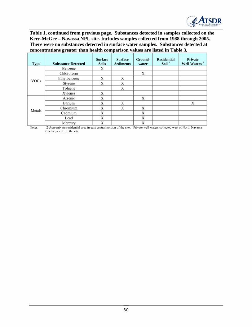
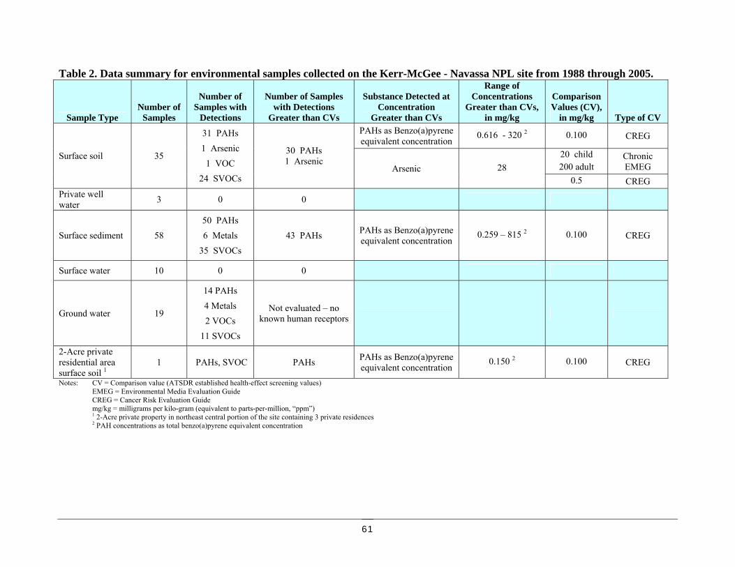
Table 1 (Appendix D) lists chemical compounds detected at concentrations greater than the analytical method reporting limit in the environmental samples collected in the these studies. Table 2 (Appendix D) summarizes the type and number of samples collected and the number of samples that had detections greater than the health-based comparison values. Table 3 (Appendix D) lists compounds detected at concentrations greater than health-effect comparison values and consequently considered in the potential for adverse health-effects evaluation. Surface soils evaluated for potential health effects on this site included those collected from 0 to 0.5 feet and 0 to 1 foot depth below ground surface (bgs). Typically, DPH considers soils only to 0.5 feet bgs for health evaluations, but because of the limited number of soils meeting this criteria in the data set for this site the deeper samples were included. 1988 N.C. DENR Site Inspection (SI) - Six samples were collected during the 1988 N.C. DENR Site Inspection (SI). These included a sub-surface soil boring (collected at 6.0 to 6.3 feet below the ground surface) taken from under the former wastewater pond, a sediment and surface water sample collected at the former boiler pond, and two off-site private well water samples. The two private well samples were located in the residential neighborhood across Navassa Road, west of the site. Samples were analyzed for volatile organic compounds (VOCs), semi-volatile organic compounds (SVOCs) and metals. VOCs are organic compounds that evaporate easily (volatile) at room temperature. SVOCs are organic compounds that also evaporate, but more slowly than VOCs. The SVOC analysis includes polycyclic aromatic hydrocarbons (PAHs). Creosote consists primarily of a mixture of many PAH compounds. Sample locations are noted on Figure 3 in Appendix A. Chemicals indicative of creosote residues were identified in the wastewater pond sub-surface soil (6.0-6.3 ft below ground surface) sample. Due to the depth at which this sample was collected it was not evaluated for potential human contact or health effects. N.C. DPH considers soil samples from the ground surface to 6 inches below ground surface of concern for human exposure under most circumstances. During collection of the wastewater pond sub-surface soil, the samplers detected creosote odors at 1 foot below the surface, visible creosote liquid residuals at 3.5 feet below the surface, and pieces of creosote at 6 feet below the surface. No contaminants were detected in the boiler pond soil (collected at 0.0 to 1.0 feet below ground surface) or surface water sample. No contaminants were detected in the private well sample nearest the site. Five VOCs were detected in the sample from the private well further from the site (approximately 1000 feet west of the site). This sample was collected from an outdoor hose. A second confirmation sample was collected from a spigot inside the house. No VOCs or SVOCs were detected in the second sample. It was determined that the VOCs detected in the initial sample were artifacts related to sample collection from an outside hose. The SI report noted surface run-off from the drainage ditches in the production and pond areas appeared to migrate toward the wetlands just east of the site [SIP 1995]. Later reports indicated that the groundwater flowed in a south to southeast direction from the Kerr-McGee property, moving in a direction opposite to that of the private wells in the area [ENSR 2005].
16
1995 N.C. DENR Site Inspection Prioritization (SIP) – One private well water, 3 soil (0.0 to 1.0 feet below the surface), 6 sediment, and 5 surface water samples were collected during the 1995 N.C. DENR Site Inspection Prioritization (SIP) study. Sample collection locations are noted in Appendix A, Figure 3. The samples were analyzed for VOCs, SVOCs (including PAHs), and metals. Three VOCs, 3 SVOCs including 2 PAHs, and 2 metals were detected in the sediment samples. All were less than health-comparison values. Two of the samples were background samples (KM-006-SD and KM-008-SD). Barium was detected in all 6 sediments at similar concentrations. Two PAHs were detected in the sediment sample collected on the south edge of the site at Sturgeon Creek (KM-003-SD). The 3 VOCs and 1 SVOC were detected in a drainage swale in the east central area of the site running toward the Brunswick River (KM-005-SD). The metal chromium was detected at a concentration less than the health comparison value in a downstream sample (KM-007-SD) collected on Sturgeon Creek, upstream of its confluence with the Brunswick River. The only detections in the 5 surface water samples, which included 2 background samples, was the metal barium in all 5 samples. All barium detections were less than health comparison values. One of the soil samples was collected beneath the location of the former evaporation pond (KM-001-SS). The second soil sample was collected along the railroad track area beneath two parallel drainage ditches located adjacent to a large cement slab in the north central portion of the property (sample KM-011-SS). Creosote odors were noted at the top of both soil sample borings. Four VOCs, 15 SVOCs, and the metals barium and chromium were detected in the soil from beneath the former evaporation pond. Thirteen of the detected SVOCs were PAH compounds. One PAH compound and arsenic and barium were detected in the soil from beneath the drainage ditches. Arsenic was the only metal detected at a concentration greater than a health comparison value. None of the VOCs were detected at concentrations greater than a health comparison values. The third surface soil was collected in duplicate as a background reference location (KM-010-SS and KM-011-SS). The only detections in the background soils were barium. VOC, SVOC and PAH compounds detected in the soils are summarized in Appendix D, Table 1. During the 1995 SIP study, the nearest private well known to still be in use was sampled. It was located 250 feet west of the Kerr-McGee property and had not been sampled previously. The metal barium was the only compound detected. 2002 N.C. DOT Preliminary Site Assessment (PSA) for Sturgeon Creek Bridge Replacement - In 2002, a contractor for the N.C. Department of Transportation (DOT) completed a Preliminary Site Assessment (PSA) in preparation for replacing the bridge on Navassa Road (SR 1435) over Sturgeon Creek. Soil and groundwater samples were collected along both sides of Navassa Road in the proposed bridge right-of-way. Samples collected on the east side of Navassa Road were within the boundaries of the Kerr-McGee – Navassa property. These included 2 soil (0-1 foot bgs) and 6 groundwater samples. Samples were analyzed for VOCs, SVOCs and metals. Thirteen PAHs and 6 metals were detected in the soils. The benzo(a)pyrene-equivalent total PAH concentrations were greater than the health comparison value for both samples (4.03 and 1.21 mg/kg). None of the soil metals were at concentrations greater than health comparison
17
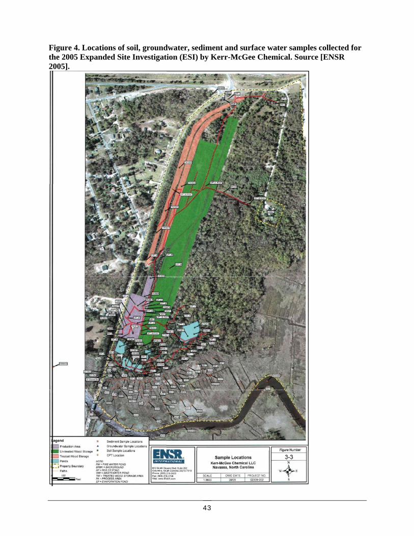
values. One VOC, one PAH and 5 metals were detected in the groundwaters. Detected substances are summarized in Appendix D, Table 1. 2005 Screening Level Ecological Risk Assessment by ENSR for Kerr-McGee Chemical Corp. - In 2004 and 2005 Kerr-McGee Chemical performed an Expanded Site Inspection (ESI), through a contractor (ENSR Corp.). Numerous surface and sub-surface soil, sediment, groundwater and surface water samples were collected to determine contaminant concentrations and migration pathways. All samples were analyzed for SVOCs (including PAHs). Sample locations are indicated in Figure 4 (Appendix A). PAHs indicative of creosote were found in the soil and groundwater in the production area and in the marsh sediments along the southern edge of the site. PAHs were not detected in the surface water taken from Sturgeon Creek. The highest groundwater PAH concentrations were found in a sample collected at the southeast corner of the former wastewater pond. Studies indicated that the groundwater in the vicinity of the production area flows south to southeast, moving from the production area toward Sturgeon Creek. Private wells that were in use in 1995 were no longer in use in 2005. Town of Navassa Public Works reported in 2005 there were no active water supply wells within the town limits. The nearest known private wells were 3 wells located approximately 3 miles west of the site. Drinking water for Brunswick County, the Town of Leland, the Town of Navassa, and the City of Wilmington is supplied by a surface water intake, located approximately 18 miles upstream of the site [ENSR 2005]. These wells and intakes are not in the direction of groundwater flow from the site and are not within an area that would be influenced by the Kerr-McGee – Navassa site. As a result of this information, and based on no known current private wells in the vicinity of the site in the direction of groundwater flow, groundwater as a drinking water source is not considered a current exposure pathway for the site. There is also no evidence of past contamination of private drinking water wells in the vicinity of the site. There is some uncertainty in this conclusion since no private well samples were collected during the time period when groundwater contamination would likely have been the highest. This likely would have been while the facility was in operation or the years soon after operations ceased. Fourteen PAH and 9 SVOC compounds were detected in 15 groundwater samples. There were no detections in 2 of the samples. There were no PAH or SVOC compounds detected in the 6 surface water samples. Fifteen PAH compounds and one other SVOC were detected in 27 surface soil samples collected in the production areas and in the areas of the former surface impoundments. At least one PAH compound was detected in each of 27 surface soil samples. There was no pentachlorophenol (“PCP”) detected. Total PAH concentrations ranged from 0.616 to 12,700 mg/kg1 (average 860 mg/kg, geometric mean 73.7 mg/kg as total PAHs). The average benzo(a)pyrene-equivalent total PAH concentration was 35.2 mg/kg. PAHs were also detected in 3 of 4 background soil samples (8.61 mg/kg average total PAH concentration, 1.08 mg/kg average benzo(a)pyrene-equivalent total PAH concentration).
1 mg/kg = milligrams contaminant per kilogram of soil, or “ppm” (parts per million)
18
The highest concentrations of PAHs in surface soils were detected in the production and impoundments area in the southern portion of the site. Figure 5 (Appendix A) maps the levels of PAHs found in surface soils collected in 2004-05. The highest concentration of benzo(a)pyrene-equivalent total PAHs was found in a soil collected in an oil-stained swale running from the eastern side of the former wastewater pond to the southeast toward the wetlands (sample “TP1”). The benzo(a)pyrene-equivalent total PAH concentration for this sample was 320 mg/kg. PAHs were detected in 48 of 52 surface sediment samples. All 17 PAH compounds analyzed were detected in at least one sediment sample. Locations and total PAH concentrations are mapped in Figure 6 (Appendix A). The surface sediment sample with the highest concentration of total PAHs (33,100 mg/kg total PAHs and 815 mg/kg benzo(a)pyrene-equivalent total PAHs) was located in the wetland area southeast of the wastewater ponds, in the direction of run-off from the site toward the wetlands (sample “SD12”). SVOCs were detected in 34 surface sediment samples, with 8 different SVOC compounds detected. There was no detection of pentachlorophenol (“PCP”) in the surface sediment samples. Nine PAH compounds and 1 SVOC were detected in a 5-part composite surface soil sample collected in the 2-acre private residential property in the east central area of the site (see Appendix D, Table 1). The total PAH concentration was 1.21 mg/kg, and the benzo(a)pyrene-equivalent total PAH concentration was 0.150 mg/kg.
EXPOSURE PATHWAY ANALYSIS
An exposure to a chemical and the possibility of adverse health effects requires persons come into contact with the chemical through:
ingestion (eating the chemical), inhalation (breathing the chemical), or dermal exposure (absorbing the chemical through the skin)
Having contact with a chemical does not necessarily result in adverse (harmful) health effects. A chemical’s ability to result in adverse health effects is influenced by a number of factors in the exposure situation, including:
how much of the chemical a person is exposed to (the dose) how long a time period a person is exposed to the chemical (the duration) how often the person is exposed (the frequency) the amount and type of damage the chemical can cause in the body (the toxicity of the
chemical) To result in adverse health effects, the chemical must be present at concentrations high enough and for long enough to cause harm. Exposures at concentrations or time periods less than these levels do not cause adverse health effects. Knowing or estimating the frequency with which people have contact with hazardous substances is essential to assessing the public health importance of these contaminants. Responses of persons to potentially harmful substances may vary with the individual or particular groups of individuals, such as children, the elderly, or persons with weakened immune
19
responses, or other chronic health issues. These susceptible populations may have different or enhanced responses as compared to most persons exposed at the same concentration to a particular chemical in the environment. Reasons for these differences may include:
genetic makeup age health status nutritional status exposure to other toxic substances (like cigarette smoke or alcohol).
These factors may limit that persons’ ability to detoxify or eliminate the harmful chemicals from their body, or may increase the effects of damage to their organs or physiological systems. Child-specific exposure situations and susceptibilities are also considered in DPH health evaluations. The exposure pathway (how people may come into contact with substances contaminating their environment) is evaluated to determine if people have come into contact with site contaminants, or if they may in the future. A completed exposure pathway is one that contains the following elements:
a source of chemical of concern (contamination), such as a hazardous waste site or contaminated industrial site,
movement (transport) of the contaminant through environmental media such as air, water, or soil,
a point of exposure where people come in contact with a contaminated medium, such as drinking water, soil in a garden, or in the air,
a route of exposure, or how people come into contact with the chemical, such as drinking contaminated well water, eating contaminated soil on homegrown vegetables, or inhaling contaminated air, and
an exposed population of persons that can come into contact with the contaminants The elements of an exposure pathway may change over time, so the time frame of potential exposure (contact) is also considered. Exposure may have happened in the past, may be taking place at the present time, or may occur in the future. A completed pathway is one in which all five pathway components exist in the selected time frame (the past, present, or future). If one of the five elements is not present, but could be at some point, the exposure is considered a potential exposure pathway. The length of the exposure period, the concentration of the contaminants at the time of exposure, and the route of exposure (skin contact, ingestion, and inhalation), are all critical elements considered in defining a particular exposure event. If one of the five elements is not present and will not occur in the future, it is considered an eliminated exposure pathway.
SUMMARY OF ENVIRONMENTAL EXPOSURE POTENTIAL AT THE SITE
The population of concern for the Kerr-McGee Navassa NPL site is those persons living in the immediate vicinity of the site that may be impacted by contaminated surface soil (soil 0 to 6 inches below ground surface), surface water, sediment, or groundwater moving off the site that is
20
used as a drinking water source. Persons that may visit the site with or without permission (“trespassers”) are also of concern, including persons using the site for recreational purposes, such as for hunting or fishing. Exposure pathways identified for the Kerr-McGee - Navassa NPL site and the status of those pathways are summarized below. Completed human exposure pathways for the Kerr-McGee – Navassa NPL site include:
1. On-site surface soils - Exposure to persons working on the site or visiting the site might occur by accidental ingestion of surface soil or inhalation of contaminated soil particles suspended in the air.
2. On-site and off-site sediments - Exposure to persons working on the site or visiting the site might occur by accidental ingestion of contaminated sediment.
Potential human exposure pathways for the site include:
1. Off-site surface soils – Currently, there is no data evaluating if surface run-off from the site has carried chemical of concern toward the residential area immediately west of the site across Navassa Road. Site information indicates that the dominant direction of surface run-off from the site is away from the residential areas to the west, and moves to the east toward Brunswick River and south toward Sturgeon Creek.
2. On-site ambient air – Free product creosote has been detected on the site during subsurface sample collection. The potential exists for persons collecting samples to be exposed during sample collecting and boring activities.
3. Off-site ambient air – The prevailing wind direction in the vicinity of the site is south [ENSR 2005]. No air samples have been collected at the site. The proportion of “fresh” creosote that will evaporate into the air is limited (1-2%) [PHS 2002]. Off-site inhalation of contaminants in the air could have been an exposure point while treated wood was dried on the site (treating ended in 1974).
4. Fin fish and shellfish – Run-off from the site toward Sturgeon Creek and the presence of PAHs in the sediments has been documented. PAHs can move from the sediment into the aquatic food chain, including fish and shellfish (bioaccumulate). Sturgeon Creek flows into the Brunswick River. Recreational and subsistence fishing occurs on these waterways [SIP 1995]. There has been no testing of the fin fish or shellfish in these waterways to determine if PAHs may be present at levels that could be a potential health hazard to persons eating the fin fish or shellfish.
Eliminated human exposure pathways for the site include:
1. On-site and off-site groundwater – Site investigations have indicated that groundwater flowing under and away from the site flows to the south southeast, away from the residential area on the west site of Navassa Road. No chemicals of concern for the site were detected in tests of 3 former private wells closest to the site, last tested in 1995. Currently no private wells or municipal water system intakes are known to exist in the vicinity of the site, or within the limits of the Town of Navassa.
2. On-site surface water – All on-site surface water impoundments have been eliminated.
3. Off-site surface water – The chemicals of concern identified for the site have been not been detected at concentrations that are of concern for ingestion or direct skin contact in the surface waters immediately adjacent to the site.
21
SITE-SPECIFIC EXPOSURE CONDITIONS USED FOR HEALTH EVALUATIONS
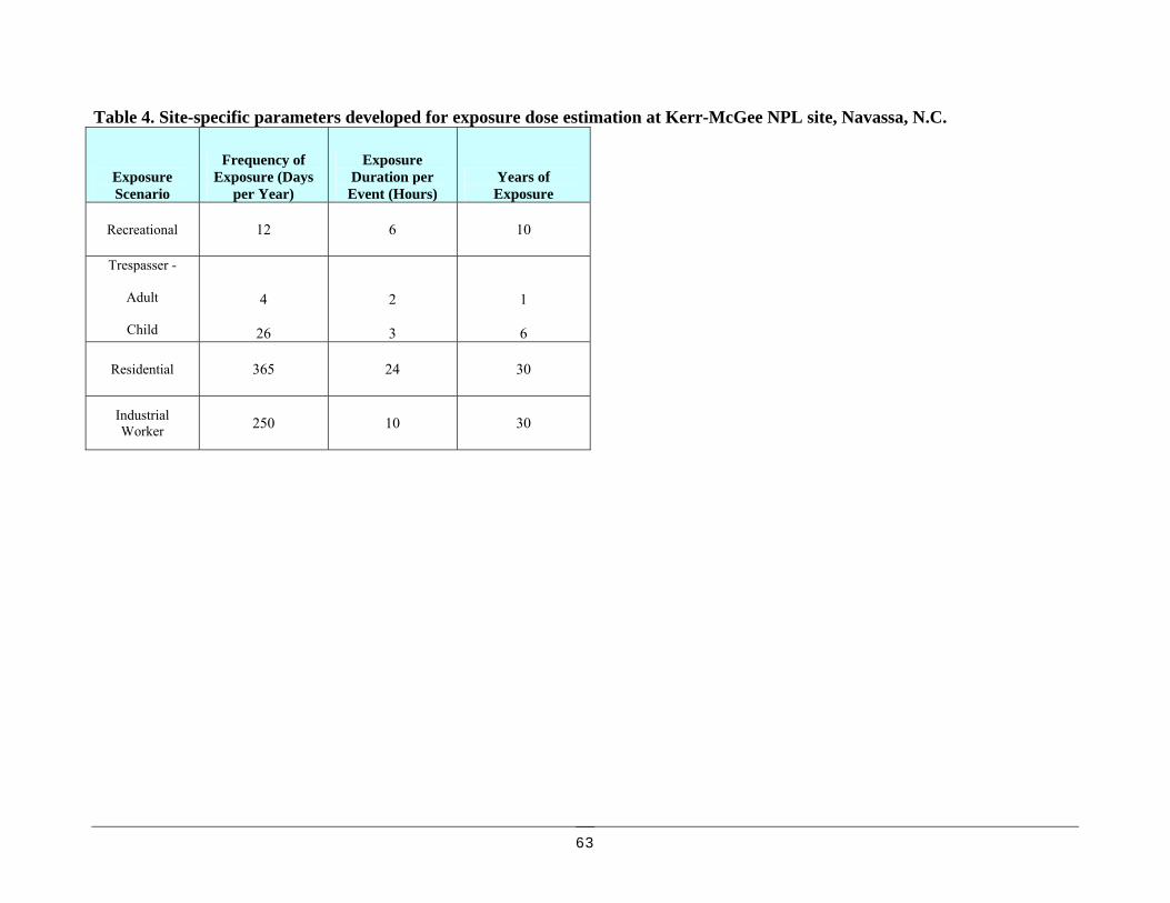
Site-specific exposure scenarios were developed to estimate how much contact persons may have with contaminated materials on the site and in the adjacent wetlands, marshes and surface waters. These included health-protective estimates of potential exposure scenarios for persons participating in recreational activities near the site (the “recreational” scenario) and for persons that may infrequently visit the site (the “trespasser” scenario). An increased frequency of child “trespassers” relative to adults was also used to provide a greater safety margin for identification of potential adverse health effects to children. Soil analytical data collected in the 2-acre private residential area in the east central portion of the site was evaluated for 30 and 70-year residential exposure situations. The soil sample analyzed from the residential area was made up of soils collected in 5 locations within the 2-acre parcel and combined for analysis. Contaminant concentrations in soils on the former wood-treating site were also evaluated for a 30-year “worker” and 30-year residential scenarios assuming no clean-up of the site from the present conditions. This was done to provide an indication of the potential for adverse health effects associated with re-purposing the site for industrial operations or as a residential area, thus providing an indication of whether additional remediation is necessary to safely occupy the site for these purposes. Site-specific parameters used for estimation of exposure doses and the evaluation of the potential for adverse health effects for these scenarios are listed in Appendix D, Table 4. Contaminants detected in soil and sediment samples collected for investigations of this NPL site were evaluated for possible adverse health effects resulting from an un-intentional ingestion (eating) exposure to the site soils or sediments, such as may occur by hand-to-mouth activity while on the site. Soil samples collected to a depth of 1 foot below ground surface were included in this evaluation as indicated previously. No air samples were available to evaluate inhalation (breathing) exposures to components of the creosote that may have been released to the air (volatilized) during drying treated wood or from the on-site wastewater treatment. There are no comparison values available to determine possible adverse health-effects associated with direct dermal (skin) contact with creosote residues in the soils or sediments. PAH compounds detected in samples collected on-site were evaluated for cancer effects by adjusting the concentrations of each individual PAH compound to the benzo(a)pyrene-equivalent concentration using toxicity equivalency factors (TEFs) developed by U.S. EPA or Nisbet and LaGoy [TEF 2002]. A theoretical increase in cancer risk was calculated by summing the TEF-adjusted concentrations for all detected PAH compounds in a sample. Additional detail on the evaluation of sample data for potential health effects associated with PAHs is provided in Appendix E. N.C. DPH evaluates cancer health effects in terms of possible theoretical increased cancer risk. In North Carolina, 1 out of every 2 men (50%) and 1 out of every 3 women (30%) (about 40% for the combined N.C. population), will be diagnosed with cancer from a variety of causes in their life-time. This is referred to as the “background cancer risk”. The term “excess cancer
22
risk” represents the risk in addition to the background cancer risk. A “one-in-a-million” excess cancer risk (1/1,000,000 or 10-6 cancer risk) means that if 1,000,000 people are exposed to the cancer-causing substance at a certain level every day of their life-time (considered 70 years), then one cancer above the background number of cancers may develop in those 1 million people. In numerical terms, the background number of cancers expected in 1 million people over their life-time is 400,000. If they are all exposed to the cancer-causing substance daily throughout their life-time, then 400,001 people may get cancer, instead of the expected 400,000. The expression of the estimated cancer risk is not a prediction that cancer will occur, it represents the highest probability of additional cancers, and merely suggests that there is a possibility. The actual risk may be much lower, or even no risk. For specific exposure situations, N.C. DPH may use exposure periods of less than a 70-year life-time to provide a more realistic estimation of the risks that are known or predicted to have occurred for a particular area. If information on the specifics of the exposure situations at a particular site is not known, then N.C. DPH will always use health protective values to estimate the maximum level of risk that we believe to be realistic.
EVALUATION OF POTENTIAL PUBLIC HEALTH ISSUES
The substances detected in environmental samples collected at the site at concentrations greater than comparison values are discussed below. The tables in Appendix D summarize the data for the chemicals detected at concentrations greater than health-effect comparison values, lists the comparison values used for data screening, and lists site-specific exposure estimates. Private Well Waters – No site contaminants were detected in the private well waters collected in 1988 and 1995 in the immediate vicinity of the site (to the west across North Navassa Road). The metal barium was detected in the private well collected in 1995, at a concentration less than health-effect comparison values. No adverse health effects are indicated for persons that used these wells as drinking water sources at that time. Site investigations indicate that the groundwater below the site flows to the south-southeast toward Sturgeon Creek. While available information does not indicate that private wells that were used in the past to the west of the site would have been impacted, there is no way to know for certain without data from that time period. N.C. DPH recommends that it be verified there are no private wells in the residential area on the south side of Sturgeon Creek. If wells are identified that have been used as drinking water sources, they should be analyzed for PAHs and SVOCs. Based on communications with local officials, private wells had been used in the past by persons living in the 2-acre private residential area in the east central portion of the site. N.C. DPH recommends sampling these wells if they are accessible for VOCs, PAHs and SVOCs. VOCs are included since VOC compounds were detected in the sediment samples collected in 1995 at location KM-005-SD which is near the residential area (Appendix A, Figure 3). Surface waters – No site contaminants have been detected in on-site surface waters collected in 1988 and 1995, or Sturgeon Creek surface water samples collected since 1995. No adverse health effects associated with direct skin contact or accidental drinking of surface waters collected since 1988 on the site or adjacent to the site are indicated.
23
The potential for on-site surface waters and the waters of Sturgeon Creek and Brunswick River to have been contaminated would have been the greatest when wood was still being treated on the site. There is no data from this period. Because of this, it is not possible to determine if adverse health effects may have been possible for persons that came into contact with Sturgeon Creek or Brunswick River waters in the immediate vicinity of the Kerr-McGee – Navassa site prior to the collection of the environmental data. Groundwater - The chemicals detected in the 2002 and 2005 groundwater samples were not evaluated for potential adverse health effects since there were no known private well users or municipal water supply intakes in the vicinity of the site when the samples were collected. Private wells located nearest to the site that were in use at the time were last sampled in 1995. No organic compounds were detected in these wells, which were west of the site and not in the direction of groundwater flow. Surface Soils - Nineteen different semi-volatile organic compounds (SVOCs), including 17 polynuclear aromatic hydrocarbon compounds (PAHs), have been detected at concentrations greater than the health-based comparison values in the site surface soil samples collected from 1988 through 2005 (Appendix D, Table 3 ). Site-specific exposure dose estimates for the surface soil sample with the highest concentration of total PAHs and benzo(a)pyrene-equivalent total PAHs (sample “TP1”, Appendix A, Figure 5, sample collected from 0-1 foot depth) was evaluated for the “trespasser” and “recreational” exposure scenarios since long-term daily contact with these soils, such as someone living on this area, is not a past or current exposure scenario. No increase in cancer rates are indicated for the accidental ingestion of the highest concentration site soil using the trespasser and recreational exposure scenarios (less than one additional cancer in 1 million exposed persons for the trespasser scenario and 2 additional cancers in 1 million exposed persons for the adult recreational exposure scenario). Soil PAH concentrations are also below the level of non-cancer adverse health effects. None of the non-PAH SVOC compounds were present at site-specific exposure dose estimate concentrations greater than health-effect levels. Adverse health effects are not indicated for persons visiting the site at these frequencies and accidently ingesting site soils. No soil samples were collected prior to 1988, including when wood was being treated on the site. Soil contamination may have been greater than indicated by the available later data. Therefore, it is not possible to evaluate if long-term exposure to the surface soils during periods prior to 1988 may have indicated a potential health hazard. Potential health risks associated with re-developing of the former production and water impoundment areas without further remediation for future industry (“worker” scenario) or residential areas (“residential” scenario) were also evaluated, using the average soil PAH contaminant concentrations. The exposure parameters for these two scenarios are also listed in Table 4 (Appendix D). Thirty years represents the upper bound time persons spend at one residence based on EPA surveys [EPA 1997]. Thirty years was also used as the employment period for the “worker” scenario. “Low” numbers of additional cancers are estimated for the worker scenario, and “moderate” numbers for the residential scenario (4 additional cancers estimated for every 100,000 “workers” exposed; 2 additional cancers estimated for every 10,000 “residents” exposed). The increased cancer risk estimate for the worker scenario is within the acceptable increased cancer risk range (less than 100 additional cancers in 1 million exposed persons). The increased cancer risk estimate for the 30-year residential scenario is above the
24
acceptable increased cancer risk range. N.C. DPH recommends a long-term target cancer risk of not more than 1 additional cancer in 1 million exposed persons. Reducing or eliminating exposures to achieve theoretical risk levels in this range should be the ultimate goal should the site be re-purposed. The benzo(a)pyrene-equivalent total PAH concentration for the soil sample collected in the 2-acre private residential area in the east central area of the site was 0.15 mg/kg, greater than the health-based comparison value for ingestion. The theoretical estimate of increased cancer risk was estimated for a 30-year daily exposure “residential” scenario. Less than one additional cancer in 1 million exposed persons is indicated. Expanding the exposure period to 70 years of daily accidental ingestion of these soils indicated “no apparent” increase in cancers (2 additional cancer estimated in 1 million exposed persons). Adverse health effects are not indicated for persons accidently ingesting the soils on the 2-acre private residential property on a daily basis. The theoretical estimates of increased cancer rates for the above surface soil data is listed in Table 5 (Appendix D). Surface Sediment – None of the sediment detections in the 1995 samples were present at concentrations greater than the health-effect comparison values. At least one PAH compound was detected at a concentration greater than the benzo(a)pyrene-equivalent health-effect comparison value in 41 of the 52 surface sediment samples collected in 2004-05. Theoretical estimates of increased cancer risk resulting from accidental ingestion of the sediment with the highest benzo(a)pyrene-equivalent total PAH concentration using the “trespasser” and “recreational” exposure scenarios were calculated. No additional cancers were indicated for the trespasser scenario (less than 1 in 1 million). Very low numbers were estimated for the recreational scenario (4 additional cancers in 1 million exposed persons). Sediment PAH concentrations are also below the level of non-cancer adverse health effects. Adverse health effects are not indicated for infrequent accidental ingestion of the sediments in the wetland areas of the site. No SVOCs other than PAHs were detected in the surface sediments collected in 2004-05 at concentrations greater than health-effect comparison values. No negative health effects are indicated for SVOC compounds detected in the sediments. Dermal contact - N.C. DPH recommends persons that may be accessing the site not come into direct skin contact with the creosote residuals that remain on the site, or with soils or sediments that have high concentrations of creosote residues (PAHs). Eye protection and gloves that are impermeable to organic compounds should be worn when handling contaminated materials. Clothing that becomes soiled with contaminated site materials should be changed daily to prevent prolonged skin contact with creosote residuals. Skin that comes into contact with creosote contamination should be washed thoroughly with soap and water as soon as possible. Fin fish and shellfish – No fin fish or shell fish tissue data has been collected for Sturgeon Creek or Brunswick River in waters adjacent and immediately downstream of the site. High concentrations of PAHs have been detected in the on-site and adjacent soils and sediments. PAHs are included in a broad class of chemicals that are considered bioaccumulative. Bioaccumulative compounds are those that may be taken up by an organism when it comes into
25
contact with a medium (such as sediment, soil, water, or a food source) contaminated by those compounds. PAHs may be taken up by aquatic organisms living in Sturgeon Creek or the Brunswick River that live in or come into direct contact with the sediment, that eat other organisms that live in or come into contact with the sediment, or organisms that take in sediment while feeding. The amount of PAHs present in the food chain of a particular water body depends on a number of characteristics that are specific to that water body, such as the concentration and specific PAH compounds present, the chemical and physical make-up of the soils and sediments, the type of organisms living in the sediment, and the type, age and size of the fish and shell fish present. N.C. DENR noted in their 1995 SIP that Sturgeon Creek and Brunswick River support sport and subsistence fishing, including bottom feeding and upper trophic level fish species [SIP 1995]. Of the fish present in the water bodies, shellfish and bottom feeder and upper trophic level fin fish species would be expected to have the greatest tendency to accumulate high levels of PAHs that may pose an exposure risk to persons eating the fish. EPA’s guidance for determining the need for fish consumption advisories recommends analyzing fish tissue for PAHs if they are found in sediments at elevated concentrations [EPA 2000]. At this site, PAHs have likely entered the aquatic food chain, and may have accumulated in shellfish or fin fish. People may be exposed to the PAHs in the fin fish or shellfish. N.C. DPH recommends the collection and tissue analysis of fin fish and shellfish species that are commonly consumed by persons fishing in the waters adjacent to the site to determine if people may be exposed to levels of PAHs that could cause adverse health effects. N.C. DPH, N.C. DENR and U.S.EPA are collaborating to collect fin fish and shellfish in Sturgeon Creek and the Brunswick River adjacent to the NPL site in December 2011. Additional collections may be required in the spring of 2012. N.C. DPH will evaluate the tissue data for health concerns and the need to issue a fish consumption advisory.
HEALTH EFFECTS OF SELECTED SUBSTANCES
Creosote - Creosote is a mixture of hundreds to thousands of chemicals extracted at high temperatures from beechwood, the creosote bush, or coal. The major chemicals in creosote used for wood treatment are polycyclic aromatic hydrocarbons (PAHs), cresols, and phenols. Plants, animals and aquatic organisms can absorb some of the chemicals in creosote. People can be exposed by ingesting creosote contaminated soils, plants, animals, fin fish and shellfish. People can also be exposed by direct skin contact with creosote residuals (“free product”) or creosote contaminated soils or breathing components of creosote that may volatilize into the air [PHS 2002]. In the past, wood creosote was used as a disinfectant, a laxative, and a cough treatment. Coal tar products are used in medicines to treat skin diseases such as psoriasis, and as animal and bird repellents, insecticides, animal dips, and fungicides. Eating food or drinking water contaminated with high levels of creosotes may cause a burning in the mouth and throat, and stomach pains. Brief direct contact with large amounts of coal tar creosote may result in a rash or severe irritation of the skin, chemical burns of the surfaces of the eyes, convulsions and mental confusion, kidney or liver problems, unconsciousness, and even death. Longer direct
26
skin contact with low levels of creosote mixtures or their vapors can result in increased light sensitivity, damage to the cornea, and skin damage. Longer exposure to creosote vapors can cause irritation of the respiratory tract [TOXFAQ 2002]. A study of long-term residents near a wood treatment plant breathing air with low levels of both pentachlorophenol (“PCP”) and creosote had significantly higher rates of cancer, respiratory, skin and neurological problems, and mucous membrane irritations. Persons in this study were exposed to burning treated wood products and elevated levels of PAHs in soils [ATSDR 2009c]. A separation of the effects that may be related to the burning of the treated wood, or effects related to PCP and not creosote, was not possible in this study. (There is no indication that PCP was used on the Kerr-McGee – Navassa site.) People taking large amounts of an herbal supplement containing creosote to treat gastrointestinal problems reported altered taste and drowsiness. Immune system effects, genetic material changes (chromosomal aberrations), and increased levels of substances in the urine indicating DNA damage were noted in persons who treated their psoriasis with direct skin applications of a preparation containing crude coal tar and exposure to UV radiation [ATSDR 2009c]. Long-term exposure to low levels of creosote, especially direct contact with the skin during wood treatment or manufacture of coal tar creosote-treated products, has resulted in skin cancer and cancer of the scrotum. Animal studies have also shown skin cancer from skin exposure to coal tar products. The International Agency for Research on Cancer (IARC) has determined that coal tar is carcinogenic to humans and that creosote is probably carcinogenic to humans. The EPA has determined that coal tar creosote is a probable human carcinogen. There is no unique exposure pathway of children to creosote. Children exposed to creosote will probably experience the same health effects seen in adults exposed to creosote. Children who played on soil contaminated with creosote had more skin rashes than children who played in uncontaminated areas. It is not known whether children differ from adults in their susceptibility to health effects from creosote. Studies in animals have shown birth defects in the young of mothers exposed to high levels of creosote during pregnancy, but it is not known whether the same effects would occur in humans. Some animal studies indicate that creosotes may cross the placenta and reach the fetus. Because chemical components (PAHs, cresol, phenols) of coal tar creosote may be stored in body fat, they may be found in breast milk and could be passed to nursing infants [TOXFAQ 2002].
HEALTH OUTCOME DATA
In addition to studying exposure and chemical-specific toxicity data as part of the public health assessment process, N.C. DPH also considers health outcome data, such as mortality and morbidity data. The following criteria are evaluated when determining if a study of health outcome data is reasonable: (1) presence of a completed human exposure pathway, (2) high enough concentrations of contaminants to result in measureable adverse health effects, (3) sufficient numbers of exposed people in the pathway for effects to be measured, and (4) a health outcome database where disease rates for the population of concern can be identified. Because
27
of the lack of site historical environmental monitoring data, the relatively small local population that may have been exposed, and the lack of health surveillance data N.C. DPH does not expect that health outcome data will be available for this site. Regardless, N.C. DPH will work with County and State agencies to identify and evaluate health outcome data that may become available for the community.
COMMUNITY HEALTH CONCERNS
The community health concerns associated with the Kerr-McGee - Navassa NPL site include:
Past groundwater impacts for persons living in close proximity to the site that in the past were using private drinking water wells
Potential health effects from past inhalation by persons living in the immediate vicinity of the site of creosote vapors escaping from drying treated wood
Potential health effects from past, present and future contact with creosote residuals on the site, including contaminated soils and sediments
Potential health effects from past, present and future eating of fin fish or shellfish caught in the vicinity of the site that may be contaminated by creosote residues in the sediments and moving into the aquatic food chain
Potential adverse health effects to persons that live on the 2-acre private residential parcel in the north central area of the site, or have lived in this area in the past
Concerns about genetic effects of the contaminants at the site, and the incidence of different types of cancer, diabetes, kidney disease, hypertension, breathing problems, and multiple aches and pains
The ability to re-develop the site for purposes that will not adversely affect persons on the property
During the October 14, 2010 public meeting in Navassa, community members provided N.C. DPH staff with a list of their health concerns. Their expressed health concerns were predominantly different types of cancer, diabetes, kidney disease, hypertension, breathing problems, and multiple aches and pains. There appear to be a high number of community members with diabetes, kidney disease and hypertension. Kidney disease is a common complication of diabetes. Hypertension is often associated with kidney disease, and can aggravate the kidney disease. Diabetes and its complications are more prevalent in some ethnic groups, including the African Americans, Native Americans, and Hispanics. It is also known that there is a genetic predisposition to developing diabetes, hypertension and kidney disease. Most of the meeting attendees were African American and related to one another. These factors suggest a strong genetic component for the diabetes and kidney disease incidence. Currently, the scientific literature does not link diabetes or kidney disease to creosote or PAH exposure. While N.C. DPH does not believe that the prevalence of diabetes and kidney disease in the community are related to the site, N.C. DPH will assist in identifying available resources to decrease the impact of these health issues on the community.
28
CHILD HEALTH CONSIDERATIONS
The ATSDR recognizes there are unique exposure risks concerning children that do not apply to adults. Children are at a greater risk than are adults to certain kinds of exposures to hazardous substances. Because they play outdoors and because they often carry food into contaminated areas, children are more likely to be exposed to contaminants in the environment. Children are shorter than adults and as a result, they are more likely to breathe more dust, soil, and heavy vapors that accumulate near the ground. They are also smaller, resulting in higher doses of chemical exposure per body weight. If toxic exposures occur during critical growth stages, the developing body systems of children can sustain permanent damage. Probably most important, however, is that children depend on adults for risk identification and risk management, housing, and access to medical care. Because of this, adults should be aware of public health risks in their community, so they can guide their children accordingly. Child-specific exposure situations and health effects are taken into account in N.C. DPH health evaluations.
UNCERTAINTIES AND LIMITATIONS
Uncertainties are inherent in the public health assessment process. These uncertainties fall into the following categories: 1) the imprecision of the risk assessment process, 2) the incompleteness of the information collected and used in the assessment, 3) present knowledge of the toxicological properties of the identified contaminants, and 4) the differences in opinion as to the implications of the information. These uncertainties can result in an over or under estimation of potential health risks. These uncertainties are addressed in public health assessments by using worst-case assumptions when estimating or interpreting health risks. The health assessment calculations and screening values also incorporate safety margins. The assumptions, interpretations, and recommendations made throughout this public health assessment err in the direction of protecting public health. Uncertainties and limitations specific to this site and the health evaluation include:
No environmental samples were collected until approximately 14 years after wood treatment on the site was ceased, and the majority of the samples used in this health evaluation were taken 30 years after operations ceased. Because of the length of time between site operations and the limited number of surface soils (0-6 inches bgs), the samples collected may not represent higher exposure concentrations that could have occurred during periods when wood was being treated. If exposure concentrations were significantly higher, the potential for adverse health effects may be underestimated.
A single 5-part composite sample was collected and analyzed for the 2-acre residential area.
No air samples were collected during wood treating operations to evaluate the potential of nearby residents to be exposed to creosote compounds released into the air during drying treated wood, from the water impoundments, or other site activities. Potential adverse health effects to nearby residents inhaling (breathing) creosote components released to the air from treated wood can not be evaluated. Site documents indicated that the predominant wind direction in the area of the site is to the south-southeast. This would indicate that persons living to the immediate south of
29
the site (across Sturgeon Creek) may have had the greatest exposure to creosote residues in the air.
The potential for site contaminants to move from sediments adjacent to the site into the aquatic food chain and to provide an exposure point to persons consuming fin fish or shellfish collected in the immediate vicinity of the site has not been evaluated.
Analytical methods to identify all components of creosote are not available. The impact of these un-identified contaminants on the health risk evaluations is unknown and may result in an underestimation of potential adverse health effects.
Analytical method detection limits were elevated in many of the site soil and sediment analyses. Some reporting limits were greater than the health-effect comparison values. This could result in an under-estimation of the potential for adverse health effects.
Toxicological properties of all the contaminants identified in the site samples are not available.
Health risk evaluations were based on the maximum and average concentrations of site contaminants. These may not be representative of past exposure conditions.
Adverse health effects that are ultimately experienced by persons exposed to environmental contaminants will be impacted by their general health, lifestyle choices and their genetic make-up. While highly health protective parameters and methods have been employed, these issues may result in particular sensitivities for some persons that are not predicted by the methods used in this evaluation.
PUBLIC COMMENT PERIOD
The Kerr-McGee Chemical Corporation – Navassa NPL Site Public Health Assessment was released as an Initial/Public Comment Release draft on May 25, 2011. Copies were made available to members of the local community, Brunswick County N.C. officials, the N.C. DENR, and the U.S. EPA. The PHA was made available on the N.C. DPH HACE program and ATSDR web sites. Copies were also provided to Leland Library in Leland, NC. A press release notice of the release of the draft PHA and comment period was distributed to local media on June 9, 2011. A 60-day public comment period was provided from May 25, 2011 through July 25, 2011. No comments were received from members of the community. Comments were received from the N.C. DENR. Copies of the comments and N.C. DPH responses are included in Appendix G. No written comments were received from members of the community. A summary of concerns and questions from members of the community expressed during the July 2011 public availability meeting that took place at the Navassa Town Hall are included in Appendix G.
CONCLUSIONS
N.C. DPH evaluated all available environmental data for the Kerr-McGee - Navassa NPL site, including private well water, soil, sediment, groundwater and surface water samples. The environmental samples evaluated included samples collected in 1988 through 2005. Sample collections concentrated in the western and southern 60-acre portion of the approximately 300-acre property was the focus of the wood-treating activities. These areas included the “production” area where lumber was treated with creosote and air dried, and the areas where the
30
waste water impoundments were located. These samples likely represent the areas where the higher concentrations of creosote residues and polycyclic aromatic hydrocarbon (PAH) compounds would be expected as compared to the remaining 200 acres. Unfortunately, these samples were collected 14 to 30 years after wood treating operations ceased on the site and may not accurately represent higher historical exposure concentrations experienced by the local community. N.C DPH concluded:
Accidentally ingesting creosote contaminated surface soils or sediments currently present on the site or adjoining Sturgeon Creek or the Brunswick River, while infrequently visiting the site is not expected to harm people’s health. The concentrations of creosote residuals identified in site soils and sediments and adjacent water bodies since 1988 were not present at levels that indicate the potential for adverse health effects to persons coming into contact with the soils or sediments on an infrequent basis, such as persons hiking or hunting on the property.
Persons drinking water from private wells in the residential area on the west side of Navassa Road adjacent to the site would not have harmed their health. No site contaminants were detected in the private well samples collected in 1988 and 1995. Site investigations indicate that the groundwater under the site flows south/southeast toward Sturgeon Creek and away from the residential area on the west side of Navassa Road.
Accidently ingesting surface soils collected on the private residential area in the east central portion of the site is not expected to harm people’s health. The concentrations of PAHs (polycyclic aromatic hydrocarbons) present in the surface soils collected in 2004 are below levels that would harm the health of persons accidently ingesting the soils for as long as 70 years.
We do not have the information to determine if eating fin fish or shellfish from Sturgeon Creek or Brunswick River adjacent to the site could harm people’s health. High levels of creosote residues (PAHs) have been found in surface soils and sediments on the site, in the adjacent wetlands, and in Sturgeon Creek. Aquatic organisms, including fin fish and shellfish, can accumulate PAHs in their tissues. Persons eating the fin fish and shellfish can be exposed to the PAHs in the fish. It has been reported that people collect crabs and turtles, and fish for bottom feeder (catfish) and middle trophic level fish (perch) in the area, all of which may take up PAHs into their tissues. Analyzing fish, crab or turtle tissue provides the best alternative for assessing potential health implications for this route of exposure.
We cannot conclude whether persons living near the site during the years the plant was operational could have been harmed by coming into contact with creosote residuals in the air, soils, sediments, surface waters, fish or shellfish. No environmental data was collected during the time wood was being treated on the site (treated until 1974). Limited environmental data was collected in 1988, 14 years after wood treating ceased. Significant data was not collected until 1995 and 2004-05. This data may not provide a representative evaluation of the exposure conditions during wood treating operations.
Accidently ingesting creosote residuals (PAHs) remaining in the surface soils on the site for persons that may work or live on the site for as long as 30 years could harm people’s
31
health. N.C. DPH evaluated potential health affects associated with re-developing the site as an industrial or residential property under current contamination conditions. The average concentration of PAHs remaining in surface soils in the southern portion of the site where wood was treated and stored until 1974 are still present at concentrations that could cause adverse health effects to persons that had frequent exposure, such as working or living on the site for 30 years or more, and accidently ingest contaminated soil or sediment.
RECOMMENDATIONS
The N.C. DPH makes the following recommendations:
The NPL site property owners post additional “no trespassing” signs or “warning” signs to alert potential visitors to the chemical hazards and discourage them from accessing the site.
N.C. DPH will continue to monitor environmental data collected in association with site investigations and remediation efforts for potential health related impacts. N.C. DPH will also recommend appropriate sampling strategies to provide best information for evaluation of potential effects to the community.
EPA should verify there are no existing private wells down gradient and within the influence area of the site. If located, test these wells for PAHs, and SVOCs. Provide an alternative drinking water source if concentrations exceed regulatory or health-based guidelines. NCDPH will provide persons using these wells with recommendations for physician follow-up.
If accessible, the EPA should collect samples for VOCs, PAHs and SVOCs from the now closed private wells in the 2-acre residential area in the east central portion of the site. It is understood that this well data will provide limited information on possible past exposures.
N.C. DPH assist the County to inform persons living in the 2-acre private residential area in the east central portion of the site, as well as others in the community, of the potential inhalation and ingestion health hazards associated with the creosote residues in the southern portion of the site and discourage their visiting these areas. We will continue to keep the community informed as new public health relevant information becomes available for the site.
N.C. DPH assist the County to inform the residents of the potential for fin fish and shellfish in adjacent waters to be contaminated and discourage them from eating these fish until the fish and shell fish populations have been tested.
Work with local or State agencies to determine if fin fish or shellfish are being caught in the area. N.C. DPH, N.C. DENR, N.C. Wildlife Resources Commission (WRC) and U.S. EPA collaborated to collect finfish and shellfish in Sturgeon Creek in December 2011. This data will be evaluated to determine if persons eating fish or shellfish may be exposed to site contaminants taken up by these organisms. Additional collections may take place in 2012 as needed to fully assess fish and shellfish contamination. N.C. DPH will evaluate the fish/shellfish tissue data and work with the County to communicate any health concerns to the community.
N.C. DPH will work with the County to: provide information to local residents about the potential health hazards associated with the creosote residuals in the soils and sediments on
32
the site and in adjacent areas; how to reduce or eliminate their exposures to these materials; and, to provide recommendations for appropriate medical follow-up if they believe they have been harmed by past exposures to site-associated materials.
N.C. DPH will assist the County to educate local health care providers about environmental health issues associated with the site.
N.C. DPH will review soil and sediment sample data collected by EPA in 2010 on the west side of North Navassa Road adjacent to the residential areas that could have been impacted by site run-off.
N.C. DPH will work with the County to provide assistance to the segment of the community whose primary health concerns are diabetes and kidney disease. The site data evaluated to date does not indicate that these health concerns can be tied o the site. However, we present follow-up actions to assist the community with their health concerns, and will evaluate all data with these concerns in mind.
To protect public health, the levels of creosote residuals in the soils and sediments need to be reduced, or contact prevented, if the site will be re-developed for industrial, residential or recreational use.
Persons coming into contact with creosote, contaminated soils or sediments should, as soon as possible, remove soiled clothing and wash areas of skin that were in contact with soiled clothing or contaminated soils or sediments.
PUBLIC HEALTH ACTION PLAN
The purpose of the Public Health Action Plan (PHAP) is to ensure that this Public Health Assessment provides a plan of action designed to mitigate or prevent potential adverse health effects.
A. Public Health Actions Completed
N.C. DPH has evaluated site information, environmental media analytical data, and health effects information to determine the potential for the health of the local community to be adversely impacted by substances identified on the Kerr-McGee - Navassa NPL site.
Kerr-McGee Chemical Corporation – Navassa NPL Site Public Health Assessment was released as an Initial/Public Comment Release draft on May 25, 2011. The document was made available to U.S. EPA, N.C. DENR, Brunswick County officials. Copies of the document were available electronically from HACE and ATSDR web sites. Hard copies of the Initial/Public Comment Release draft PHA were made available to the Leland Library in Leland, NC. A 60-day comment submission period was provided. DPH reviewed the comments and made appropriate edits the Final Release version of the Public Health Assessment.
A Kerr-McGee - Navassa NPL Site Public Health Assessment summary factsheet (July 2011) was prepared by N.C. DPH was made available to the public and government agencies. Print copies were provided at Navassa Town Hall, Leland Public Library and at the July 2011 public availability meeting. Electronic copies are also available
33
from the HACE web site. A copy of the July 2011 factsheet is provided in Appendix H.
B. Public Health Actions Planned
The Final Release Kerr-McGee Chemical Corporation – Navassa NPL Site Public Health Assessment will be available on the ATSDR and HACE web sites. Print copies can be requested through ATSDR. Hard copies will be made available to the public at locations in selected document repositories.
Fish and shell-fish sample collection in Sturgeon Creek and the Brunswick River took place in December 2011. This data will be used to assist in determining if persons eating fish or shellfish may be exposed to site contaminants taken up by these organisms. Additional collections may take place in 2012 as needed to fully assess fish and shellfish contamination. N.C. DPH will evaluate the fish/shellfish tissue data and communicate any health concerns to the community.
N.C. DPH will work with the Brunswick County Health Department and the Town of Navassa to identify the local community’s health concerns related to the site and provide information for appropriate medical follow-up through their personal care providers.
N.C. DPH staff will attend upcoming meetings organized by U.S. EPA that are intended to update the local community or Brunswick County officials on site activities or plans.
N.C. DPH will work with the County to inform the local community of the potential health hazards associated with creosote and the contaminated areas of the site. N.C. DPH will also work with the County to educate local health care providers to the potential health issues associated with creosote exposure.
A high prevalence of diabetes and kidney disease has been noted in the local community. While there is no association of these health conditions to creosote or other environmental exposures, N.C. DPH will work with the County to provide assistance to improve the health outcomes of this segment of the community.
N.C. DPH will work with EPA to facilitate collection and analysis of private well water samples from any accessible wells on the 2-acre private residential area.
N.C. DPH will monitor the status of all other recommendations made in this Public Health Assessment to protect public health and work with the appropriate agencies or groups to facilitate their completion.
N.C. DPH will provide contact information to agencies, organizations, and the public desiring additional inquiries about the site or the Public Health Assessment.
N.C. DPH will continue to monitor health, analytical data, or biological data (shell fish, fin fish) generated by Federal, State, or County agencies, or other groups, relevant to this site or potentially affected areas near the site.
N.C. DPH will work with local agencies and the N.C. Center for Health Statistics to determine if adverse health effects in the local community associated with site-related exposures can be identified.
34
CONTACT INFORMATION
Contact information for additional inquiries regarding the Kerr-McGee - Navassa NPL Site Public Health Assessment, or to contact N.C. DPH Public Health physicians: Web links: N.C. DPH HACE: www.epi.state.nc.us/epi/oee/hace/reports.html ATSDR access to the Kerr-McGee - Navassa NPL Site Public Health Assessment: www.atsdr.cdc.gov/HAC/Public Health Assessment/index.asp HACE e-mail address: [email protected] HACE telephone number: (919) 707-5900 HACE fax number: (919) 870-4807 HACE USPS mailing address:
Health Assessment, Education and Consultation Program N.C. Division of Public Health/DHHS 1912 Mail Service Center Raleigh, NC 27699-1912
35
REPORT PREPARATION This Public Health Assessment/Health Consultation for the Kerr-McGee Chemical Corporation NPL Site was prepared by the North Carolina Department of Public Health (N.C. DPH) under a cooperative agreement with the federal Agency for Toxic Substances and Disease Registry (ATSDR). It is in accordance with the approved agency methods, policies, procedures existing at the date of publication. Editorial review was completed by the cooperative agreement partner. ATSDR has reviewed this document and concurs with its findings based on the information presented. Author: Sandy Mort, MS Public Health Assessor / Toxicologist North Carolina Department of Health and Human Services (N.C. DHHS) Division of Public Health (DPH) Occupational and Environmental Epidemiology Branch (OEEB) Medical Evaluation and Risk Assessment Unit (MERA) Health Assessment, Consultation and Education Program (HACE) Reviewers: Mina Shehee, PhD, N.C. DHHS/DPH/OEEB/MERA Jesse McDaniel, MSPH, CIH, N.C. DHHS/DPH/OEEB/MERA/HACE Mercedes Hernández-Pelletier, MPH, CHES, N.C. DHHS/DPH/OEEB/ MERA/HACE Rick Langley, MD, N.C. DHHS/DPH/OEEB/MERA ATSDR Technical Project Officer: Alan Parham, MPH, REHS Cooperative Agreement Team Agency for Toxic Substances and Disease Registry (ATSDR) Division of Health Assessment and Consultation (DHAC)/CAPEB
36
REFERENCES
[ATSDR 2002]. Toxicological Profile for Wood Creosote, Coal Tar Creosote, Coal Tar, Coal Tar Pitch, and Coal Tar Pitch Volatiles. Agency for Toxic Substances and Disease Registry (ATSDR). Atlanta, GA: U.S. Department of Health and Human Services, Public Health Service. Sept. 2002. http://www.atsdr.cdc.gov/ToxProfiles/TP.asp?id=66&tid=18 [ATSDR 2005]. Public Health Assessment Guidance Manual (Update). Agency for Toxic Substances and Disease Registry (ATSDR). Atlanta, GA: U.S. Department of Health and Human Services, Public Health Service. January 2005. http://www.atsdr.cdc.gov/HAC/PHAmanual/index.html [ATSDR 2007]. Minimal risk levels (MRLs) for hazardous substances. Agency for Toxic Substances and Disease Registry (ATSDR). Atlanta, GA: U.S. Department of Health and Human Services, Public Health Service. http://www.atsdr.cdc.gov/mrls.html [ATSDR 2008 HG]. Health Guideline Comparison Values. Agency for Toxic Substances and Disease Registry (ATSDR). Atlanta, GA: U.S. Department of Health and Human Services, Public Health Service. June 2009. [ATSDR 2008 Soil]. Soil Comparison Values. Agency for Toxic Substances and Disease Registry (ATSDR). Atlanta, GA: U.S. Department of Health and Human Services, Public Health Service. June 2009. [ATSDR 2009a Air]. Air Comparison Values in µg/m3. Agency for Toxic Substances and Disease Registry (ATSDR). Atlanta, GA: U.S. Department of Health and Human Services, Public Health Service. June 2009. [ATSDR 2009b Air]. Air Comparison Values in ppb (for VOC Compounds Only). Agency for Toxic Substances and Disease Registry (ATSDR). Atlanta, GA: U.S. Department of Health and Human Services, Public Health Service. June 2009. [ATSDR 2009c]. Addendum to the Toxicological Profile for Creosote. Agency for Toxic Substances and Disease Registry (ATSDR). Atlanta, GA: U.S. Department of Health and Human Services, Public Health Service. Aug. 2009. http://www.atsdr.cdc.gov/toxprofiles/creosote_addendum.pdf?id=1072&tid=18 [ATSDR 2009 DW]. Drinking Water Comparison Values. Agency for Toxic Substances and Disease Registry (ATSDR). Atlanta, GA: U.S. Department of Health and Human Services, Public Health Service. June 2009. [DENR 2007]. Memorandum to File Kerr-McGee Chemical Corp., NCD 980 557 805, Navassa, Brunswick County, NC, Updated Analysis of NCDOT Aerial Photos. N.C. DENR. Dec. 20, 2007. In [HRS 2009] as Reference #4.
37
[DOT 2002]. Preliminary Site Assessment for Parcel #5 – Former Cumulus Broadcasting, Inc., Parcel #6 – Kerr-McGee Corporation, Bridge 1 Over Sturgeon Creek on SR 1435 (Navassa Road), Brunswick County, NC. NCDOT Project No. 8.2231301. March 2002. By Catlin Engineers and Scientists, Wilmington, N.C. In [HRS 2009] as Reference #7. [EnviroMapper]. EnviroMapper. U.S.EPA. http://www.epa.gov/emefdata/em4ef.home [ENSR 2005]. Screening Level Ecological Risk Assessment Report Kerr-McGee Chemical Corporation, Navassa, North Carolina, EPA Docket No. CER-04-2004-3782. ENSR Corporation, Raleigh, NC for Kerr-McGee Chemical, LLC. May 27, 2005. In [HRS 2009] as Reference #9. [EPA 1997]. Exposure Factors Handbook, last update August 1997. National Center for Environmental Assessment, U.S.EPA. http://www.epa.gov/ncea/efh/ [EPA 2000]. Guidance for Assessing Chemical Contaminant Data for Use in Fish Advisories. Volume 2, Risk Assessment and Fish Consumption Limits, Third Edition. 2000. EPA 823-B-00-008. USEPA Office of Water. http://www.epa.gov/fishadvisories/technical/guidance.html [EPA NPL]. U.S.EPA National Priorities List (NPL) Site Narrative for Kerr-McGee Chemical Corp – Navassa. http://www.epa.gov/superfund/sites/npl/nar1807.htm [EPA PRG]. EPA Mid-Atlantic Risk Assessment Generic Tables. http://www.epa.gov/reg3hwmd/risk/human/rb-concentration_table/Generic_Tables/index.htm [EPAR4 NPL]. U.S. EPA Region 4 Kerr-McGee Chemical Corp. NPL site summary profile. http://www.epa.gov/region4/waste/npl/nplnc/kerrmcgheenc.html [EPA SIS]. U.S. EPA Superfund Information Systems. Superfund Site Progress Profile. Kerr-McGee Chemical Corp – Navassa (EPA ID: NCD980557805). http://cfpub.epa.gov/supercpad/cursites/csitinfo.cfm?id=0403028 [HRS Cover]. U.S. EPA. Hazard Ranking System (HRS) Documentation Record Cover Sheet. Kerr-McGee Chemical Corp – Navassa. 2009. In [HRS Rec 2009]. [HRS 2009]. US.EPA Region 4. Kerr-McGee Chemical Corp. – Navassa. NCD980557805. Superfund Document Management System. Hazard Ranking System (HRS) Documentation Record, Sept. 2009. [IARC]. International Agency for Research on Cancer. http://www.iarc.fr/ [IRIS]. Integrated Risk Information System (IRIS). EPA. http://cfpub.epa.gov/ncea/iris/index.cfm [NAV 2010]. Welcome to the Town of Navassa” website. Accessed August 19, 2010. http://www.townofnavassa.org/
38
[NTP 2005]. Report on Carcinogens, 11th Edition. National Toxicology Program, US Department of Health and Human Services. January 2005. [PHS 2002]. Toxicological profile for creosote. Agency for Toxic Substances and Disease Registry (ATSDR). 2002. Atlanta, GA: U.S. Department of Health and Human Services, Public Health Service. http://www.atsdr.cdc.gov/PHS/PHS.asp?id=64&tid=18 [RI/FS 2006]. Draft Remedial Investigation/Feasibility Study Work Plan, Kerr McGee Chem Corp Site, Navassa, North Carolina. July 25, 2006. Prepared for Tronox LLC, Oklahoma City, Oklahoma. ENSR Corporation. Document No. 04020-169. [SIP 1995]. Site Inspection Prioritization (SIP), Kerr-McGee Chemical Corporation, NCD 980 557 805, Navassa, Brunswick County, North Carolina, Reference No. 03028. N.C. DENR / Div. of Solid waste Management / Superfund Section. June 1995. Included in: [HRS 2009] as Reference #6. [TEF 2002]. Toxicity equivalency factors for PAH and their applicability in shellfish pollution monitoring studies. J Environ Monit, 2002, 4, 383-388. [TOXFAQ 2002]. Creosote ToxFAQs. Agency for Toxic Substances and Disease Registry (ATSDR). 2002. Atlanta, GA: U.S. Department of Health and Human Services, Public Health Service. http://www.atsdr.cdc.gov/PHS/PHS.asp?id=64&tid=18 [TOX 2008]. Casarett and Doull’s Toxicology: The Basic Science of Poisons. Seventh edition. Editor Curtis D. Klaassen, PhD. McGraw Hill. 2008.
39
Appendix A
Figures
40
Figure 1. Location of the Kerr-McGee Chemical Corp. - Navassa NPL site, Brunswick County, NC. Source: [HRS Cover].
41
Figure 2. Location of constructed ponds on the Kerr-McGee Chemical Corp – Navassa NPL site. Source: [ENSR 2005].
42
Figure 3. Sample locations for samples collected in N.C. DENR site studies completed in 1988 and 1995 and N.C. DOT in 2001-02. Source: [ENSR 2005].
43
Figure 4. Locations of soil, groundwater, sediment and surface water samples collected for the 2005 Expanded Site Investigation (ESI) by Kerr-McGee Chemical. Source [ENSR 2005].
44
Figure 5. Concentration of total PAHs in surface soils in production and surface impoundment areas on the Kerr-McGee – Navassa NPL site for data collected for the 2005 Expanded Site Investigation report. Source: [ENSR 2005].
45
Figure 6. Concentration of total PAHs in sediments on the Kerr-McGee – Navassa NPL site for data collected for the 2005 Expanded Site Investigation report. Source: [ENSR 2005].
46
Appendix B
Demographic Data
47
Demographic Data for the Town of Navassa, Brunswick County, N.C. There were approximately 479 residents in the town of Navassa in 2000 (Census 2000 figures). However, the Town Council of Navassa estimates the population to be around 1,900 people. The growth is due in part to population growth, but also the annexation of the communities of Phoenix, Old Mill and Cedar Hill in 2001 (Town of Navassa, http://www.townofnavassa.org/, accessed 8/19/2010). According to Census 2000 figures about 12% of the population is White, 87% is African-American, and less than one percent is Hispanic or Native American. The poverty level is 27% compared to 12% in the state and the nation. Only 60% of the population has a high school diploma or higher. There are about 185 housing units, 172 of those are occupied and 34 of those are occupied by a renter. Seven (7) percent of the population is under 5 years of age while 14% of the population is over 65 years of age compared to 12% in the state and the nation. Table 1: Population data based on Census 2000 figures.
Navassa, NC North Carolina U.S. Total population 479 8,049,313 281,421,906 Percent Minority Ethnicity
White 12% 72% 75% African-American 87% 22% 12%
Hispanics 0.4% 5% 13% Asians 0% 1% 4%
American Indians 0.8% 1% 1% Individuals Below Poverty Level
27% 12% 12%
High school diploma or higher 60% 78% 80% Less than 9th grade 15% Number of housing units 185 Occupied housing units 172 Renter occupied housing unit 34 Percentage of population under 5 years of age
Photo 1. Approaching the site from the southwest on Navassa Road. View is northeast across bridge over Sturgeon Creek, looking over the marsh and wetlands on the south side of the Kerr-McGee – Navassa property. Source: N.C. DPH, August 9, 2010.
Photo 2. Facing east from bridge over Sturgeon Creek looking over southern edges of the site wetlands. Source: N.C. DPH, August 9, 2010
51
Photo 3. Facing northeast across Navassa Road looking at the western edge of the site. Source: N.C. DPH, August 9, 2010.
Photo 4. Private property – no trespassing sign posted on property adjacent to Navassa Road. Source: N.C. DPH, August 9, 2010.
52
Photo 5. Gate across vehicle access point off of Navassa Road. . Source: N.C. DPH, August 9, 2010.
Photo 6. Typical site vegetation. Source: N.C. DPH, August 9, 2010.
53
Photo 7. Typical site vegetation. Source: N.C. DPH, August 9, 2010
Photo 8. Former pathway on site. Source: N.C. DPH, August 9, 2010
54
Photo 9. Looking toward wetlands from south edge of site. Source: N.C. DPH, August 9, 2010.
Photo 10. Area of former wastewater pond. Note impoundment berm on the left. Source: N.C. DPH, August 9, 2010.
55
Photo 11. Former drainage swale in southern area of site running toward the wetlands/march area. Source: N.C. DPH, August 9, 2010
Photo 12. Area near former concrete pad in production area. Source: N.C. DPH, August 9, 2010. Source: N.C. DPH, August 9, 2010
56
Photo 13. Dirt drive off of north end of Kerr-McGee – Navassa property off of North Navassa Road to 2-acre private residential area. Source: N.C. DPH, August 9, 2010
57
Photo 14. Site areal photograph provided by a community member on October 14, 2010. Photograph was labeled “1965”. Note the location of the baseball field and the area that was identified as the location of a treated wood burn pile.
58
Appendix D
Tables
59
Table 1. Substances detected in samples collected on the Kerr-McGee – Navassa NPL site. Includes samples collected from 1988 through 2005. There were no substances detected in surface water samples. Substances detected at concentrations greater than health comparison values are listed in Table 3. Table continued on the next page.
Type Substance Detected Surface
Soils Surface
Sediments Ground-
water
Residential
Soil 1 Private
Well Waters 2
PAHs
Acenaphthene X X X Acenaphthylene X X X
Anthracene X X X Benzo(a)anthracene X X X X
Benzo(a)pyrene X X X X Benzo(b)fluoranthene X X X X Benzo(k)fluoranthene X X X X Benzo(g,h,i)perylene X X X
Chrysene X X X X Dibenzo(a,h)-anthracene X X
Fluoranthene X X X X Fluorene X X X
Indeno(1,2,3-cd)-pyrene X X 2-Methylnaphthalene X X X
Naphthalene X X X Phenanthrene X X X X
Pyrene X X X X
Other SVOCs
Benzaldehyde X Benzyl butyl phthalate X
1,1-Biphenyl X X Benzoic Acid X Dibenzofuran X X X
Carbazole X X X Bis(2-Chloroethyl)ether X
Diethylphthalate X 2,4-Dimethylphenol X X X 2,4-Dinitrotoluene X X Bis(2-Ethylhexyl)
phthalate X X
2-Methylphenol X X 4-Methylphenol X X 2-Nitrophenol X
n-Nitroso-diphenylamine X X Phenol X X
1,2,4-Trichlorobenzene X 2,4,5-Trichlorophenol X 2,4,6-Trichlorophenol X
60
Table 1, continued from previous page. Substances detected in samples collected on the Kerr-McGee – Navassa NPL site. Includes samples collected from 1988 through 2005.
There were no substances detected in surface water samples. Substances detected at concentrations greater than health comparison values are listed in Table 3.
Type Substance Detected Surface
SoilsSurface
SedimentsGround-
water
Residential
Soil 1Private
Well Waters 2
VOCs
Benzene X Chloroform X
Ethylbenzene X X Styrene X X Toluene X Xylenes X
Metals
Arsenic X X Barium X X X
Chromium X X X Cadmium X X
Lead X X Mercury X X
Notes: 1 2-Acre private residential area in east central portion of the site; 2 Private well waters collected west of North Navassa Road adjacent to the site
61
Table 2. Data summary for environmental samples collected on the Kerr-McGee - Navassa NPL site from 1988 through 2005.
Sample Type Number of
Samples
Number of Samples with
Detections
Number of Samples with Detections
Greater than CVs
Substance Detected at Concentration
Greater than CVs
Range of Concentrations
Greater than CVs, in mg/kg
Comparison Values (CV),
in mg/kg Type of CV
Surface soil 35
31 PAHs
1 Arsenic
1 VOC
24 SVOCs
30 PAHs 1 Arsenic
PAHs as Benzo(a)pyrene equivalent concentration
0.616 - 320 2 0.100 CREG
Arsenic 28
20 child 200 adult
Chronic EMEG
0.5 CREG Private well water
3 0 0
Surface sediment 58
50 PAHs
6 Metals
35 SVOCs
43 PAHs PAHs as Benzo(a)pyrene equivalent concentration
0.259 – 815 2 0.100 CREG
Surface water 10 0 0
Ground water 19
14 PAHs
4 Metals
2 VOCs
11 SVOCs
Not evaluated – no known human receptors
2-Acre private residential area surface soil 1
1 PAHs, SVOC PAHs PAHs as Benzo(a)pyrene equivalent concentration
0.150 2 0.100 CREG
Notes: CV = Comparison value (ATSDR established health-effect screening values) EMEG = Environmental Media Evaluation Guide CREG = Cancer Risk Evaluation Guide
mg/kg = milligrams per kilo-gram (equivalent to parts-per-million, “ppm”) 1 2-Acre private property in northeast central portion of the site containing 3 private residences 2 PAH concentrations as total benzo(a)pyrene equivalent concentration
62
Table 3. Substances detected in surface soils and sediments collected at the Kerr-McGee – Navassa NPL site at concentrations greater than health-based comparison values for ingestion exposures.
Contaminant Type Substance Detected
Evaporation Pond Soil – collected in
1995
Soil from East Side of
Navassa Rd – collected in
2002 1
Soils from ESI in
2004-05
Sediments from ESI in
2004-05
2-Acre Private Residential Area
Surface Soil collected in 2005-05 3
PAHs
Acenaphthene X X X
Acenaphthylene X
Anthracene X X X
Benzo(a)anthracene X X X X
Benzo(a)pyrene X X X X X
Benzo(b)fluoranthene X X X X
Benzo(k)fluoranthene X X
Benzo(g,h,i)perylene X X
Chrysene X X
Dibenzo(a,h)-anthracene X X X
Fluoranthene X X X
Fluorene X X X
Indeno(1,2,3-cd)-pyrene X X X
2-Methylnaphthalene X X X
Naphthalene X X
Phenanthrene X X X
Pyrene X X X
Other SVOCs
Dibenzofuran X
1,2,4-Trichlorobenzene X X
Carbazole X 2 Notes: PAH = polycyclic aromatic hydrocarbon
SVOC = semi-volatibe aromatic hydrocarbons ESI = Expanded Site Investigation X = detected at concentration greater than the health-effect comparison value 1 Samples collected by N.C. DOT along east side right-of-way of Navassa Road bridge over Sturgeon Creek 2 No Health-based comparison values available. 3 2-Acre private property in northeast central portion of the site containing 3 private residences
63
Table 4. Site-specific parameters developed for exposure dose estimation at Kerr-McGee NPL site, Navassa, N.C.
Exposure Scenario
Frequency of Exposure (Days
per Year)
Exposure Duration per Event (Hours)
Years of Exposure
Recreational 12 6 10
Trespasser -
Adult
Child
4
26
2
3
1
6
Residential 365 24 30
Industrial Worker
250 10 30
64
Table 5. Theoretical increased cancer risk estimates for the samples with the highest contaminant concentrations found at the Kerr-McGee – Navassa NPL site. Includes data collected from 1988 through 2005. Increased cancer risk value represents an estimate of the number of additional cancers expected over the background cancer rate, in the indicated number of exposed persons.
Sample Type, Identification, Depth
Date collected
Benzo(a)pyrene – equivalent Total
PAH Concentration (mg/kg)
30-Year Daily “Residential”
Exposure Scenario
Trespasser Exposure Scenario
Recreational Exposure Scenario -
Adult
30-Year “Industrial
Worker” Exposure Scenario
Surface soil highest concentration 01TP1AA 0-0.5 ft bgs 1
1/26/05 320 1 in 1000 persons
<1 in a million persons
2 in a million persons
2 in 10,000 persons
Average concentration of surface soil PAHs
2004 - 05 23.8 2 in 10,000
persons
<1 in a million persons
<1 in a million persons
4 in 100,000 persons
Sediment highest concentration SD12AAWIL 0-0.5 ft bgs 2
mg/kg = milligrams per kilogram (“parts per million”) ft = feet bgs = below ground surface 1 Sample location identified in Appendix A, Figure 5 2 Sample locations identified in Appendix A, Figure 6 3 2 additional cancer cases above background numbers in 1 million persons exposed daily over 70 years are estimated
65
Appendix E
The ATSDR Health Effects Evaluation Process
66
THE ATSDR HEALTH EFFECTS EVALUATION PROCESS
The ATSDR health effects evaluation process consists of two steps: a screening analysis, and at some sites, based on the results of the screening analysis and community health concerns, a more in-depth analysis to determine possible public health implications of site-specific exposure estimates. In evaluating data, ATSDR uses comparison values (CVs) to determine which chemicals to examine more closely. CVs are the contaminant concentrations found in a specific medium (soil, water, or air) and are used to select contaminants for further evaluation. CVs incorporate assumptions of daily exposure to the chemical and a standard amount of air, water and soil that someone may inhale or ingest each day. The two step screening analysis process provides a consistent means to identify site contaminants that need to be evaluated more closely through the use of “comparison values” (CVs). The first step of the screening analysis is the “environmental guideline comparison” which involves comparing site contaminant concentrations to medium-specific comparison values derived by ATSDR from standard exposure default values. The second step is the “health guideline comparison” and involves looking more closely at site-specific exposure conditions, estimating exposure doses, and comparing them to dose-based health-effect comparison values. As health-based thresholds, CVs are set at a concentration below which no known or anticipated adverse human health effects are expected to occur. CVs are not thresholds of toxicity and do not predict adverse health effects. CVs serve only as guidelines to provide an initial screen of human exposure to substances. Contaminant concentrations at or below the relevant CV may reasonably be considered safe, but it does not automatically follow that any environmental concentration that exceeds a CV would be expected to produce adverse health effects. Different CVs are developed for cancer and non-cancer health effects. Non-cancer levels are based on validated toxicological studies for a chemical, with appropriate safety factors included, and the assumption that small children (22 pounds) and adults are exposed every day. Cancer levels are the media concentrations at which there could be a one additional cancer in a one million person population (one in a million excess cancer risk for an adult) eating contaminated soil or drinking contaminated water every day for 70 years. For chemicals for which both cancer and non-cancer CVs exist, the lower level is used to be protective. Exceeding a CV does not mean that health effects will occur, just that more evaluation is needed. After completing a screening analysis, site contaminants are divided into two categories. Those not exceeding CVs usually require no further analysis, and those exceeding CVs are selected for a more in-depth analysis to evaluate the likelihood of possible harmful effects. The North Carolina Department of Public Health (N.C. DPH) uses the following screening values for public health assessments: 1. Environmental Media Evaluation Guide (EMEG): EMEGs are estimated contaminant
concentrations in water, soil or air to which humans may be exposed over specified time periods and are not expected to result in adverse non-cancer health effects. EMEGs are
67
based on ATSDR “minimum risk levels” (MRLs) and conservative (highly health protective) assumptions about exposure, such as intake rate, exposure frequency and duration, and body weight.
2. Reference Dose Media Evaluation Guides (RMEGs): RMEGs represent concentrations of
substances in water and soil to which humans may be exposed over specified time periods without experiencing non-cancer adverse health effects. The RMEG is derived from the U.S. Environmental Protection Agency’s (EPA’s) oral reference dose (RfD).
3. Cancer Risk Evaluation Guide (CREG): CREGs are estimated media-specific contaminant
concentrations that would be expected to cause no more than one additional excess cancer in one million persons exposed over a 70-year lifetime. CREGs are calculated from EPA’s cancer slope factors (CSFs) or inhalation unit risk (IUR) values.
4. Maximum Contaminant Levels (MCL): A Federal Maximum Contaminant Level (MCL) is
the regulatory limit set by EPA that establishes the maximum permissible level of a contaminant in water that is deliverable to the user of a public water system. MCLs are based on health data, also taking into account economic and technical feasibility to achieve that level. (ATSDR 2005a)
5. EPA Regional Screening Levels (RSL): "Regional Screening Levels for Chemical
Contaminants at Superfund Sites" are tables of risk-based screening levels, calculated using the latest toxicity values, default exposure assumptions and physical and chemical properties. The Regional Screening table was developed with input from EPA Regions III, VI, and IX in an effort to improve consistency and incorporate updated guidance. (http://www.epa.gov/reg3hwmd/risk/human/rb-concentration_table/index.htm)
Contaminant concentrations exceeding the appropriate CVs are further evaluated against ATSDR health guidelines. N.C. DPH also retains for further assessment contaminants that are known or suspected to be cancer-causing agents. To determine exposure dose, N.C. DHHS uses standard assumptions about body weight, ingestion or inhalation rates, and duration of exposure. Important factors in determining the potential for adverse health effects also include the concentration of the chemical, the duration of exposure, the route of exposure, and the health status of those exposed. Site contaminant concentrations and site-specific exposure conditions are used to make conservative estimates of site-specific exposure doses for children and adults that are compared to ATSDR health guidelines (HGs), generally expressed as Minimal Risk Levels (MRLs). An exposure dose (generally expressed as milligrams of chemical per kilogram of body weight per day or “mg/kg/day”) is an estimate of how much of a substance a person may come into contact based on their actions and habits. Exposure dose calculations are based on the following assumptions as outlined by the ATSDR (ATSDR 2005a): Children between the ages of 1 and 6 ingest an average of 1 liter of water per day Children weigh an average of 15 kilograms Infants weigh an average of 10 kilograms Adults ingest an average of 2 liters of water per day Adults weigh an average of 70 kilograms
68
Ingestion of contaminants present in drinking water
Exposure doses for ingestion of contaminants present in groundwater are calculated using the maximum and average detected concentrations of contaminants in milligrams per liter (mg/kg [mg/kg = ppm]). The following equation is used to estimate the exposure doses resulting from ingestion of contaminated groundwater:
EDw = C x IR x AF x EF
BW Where:
EDw = exposure dose water (mg/kg/day) C = contaminant concentration (mg/kg) IR = intake rate of contaminated medium (liters/day) AF = bioavailability factor (unitless) EF = exposure factor BW = body weight (kilograms)
Ingestion of contaminants present in soil
Exposure doses for ingestion of contaminants present in soil are calculated using the maximum and average detected concentrations of contaminants in milligrams per kilogram (mg/kg [mg/kg = ppm]). The following equation is used to estimate the exposure doses resulting from ingestion of contaminated soil:
EDs = C x IR x AF x EF
BW Where:
EDs = exposure dose soil (mg/kg/day) C = contaminant concentration (mg/kg) IR = intake rate of contaminated medium (kilograms/day) EF = exposure factor (unitless) BW = body weight (kilograms)
The exposure factor is an expression of how often and how long a person may contact a substance in the environment. The exposure factor is calculated with the following general equation:
EF = F x ED AT
Where: F = frequency of exposure (days/year) ED = exposure duration (years) AT = averaging time (ED x 365 days/year)
69
Inhalation (breathing) of contaminants present in air Inhalation is an important pathway for human exposure to contaminants that exist as atmospheric gases or are adsorbed to airborne particles or fibers. Exposure doses for breathing contaminants in air were calculated using the maximum or average detected concentrations in milligrams per cubic meter (mg/m3) or parts per billion by volume (ppbv). The following equation is used to estimate the exposure doses resulting from inhalation of contaminated air.
D = (C x IR x EF) / BW
Where: D = exposure dose (mg/kg/day) C = contaminant concentration (mg/m3) IR = intake rate (m3/day) EF = exposure factor (unitless) BW = body weight (kg)
Calculations of Contaminant Exposures During Showering
When showering in contaminated water a person may be exposed to the chemicals in the water by breathing a portion of the chemical that comes out of the water into the air (inhalation exposure), or by absorbing the chemical from the water through their skin (dermal exposure). Inhalation and dermal exposures to volatile organic compounds (VOCs) in the shower or bath may be equal to or greater than exposures from drinking the contaminated water. ATSDR uses conservative assumptions to estimate “worst case” exposures to VOCs during showering with contaminated water. The maximum concentration of VOC in the bathroom air is estimated with the following equation (Andelman 1990).
Ca = (Cw x f x Fw x t)/Va Where: Ca = bathroom air concentration (mg/m3) Cw = tap water concentration (mg/L) f = fractional volatilization rate (unitless) Fw = shower water flow rate (L/min) t = exposure time (min) Va = bathroom volume (m3) Conservative calculation parameters are assumed, including a fractional volatilization of 0.9 for chlorinated VOCs, a flow rate of 8 L/min, and a small bathroom volume of 10 m3. Conservative calculations are also made by using the maximum concentration found for each VOC in the tap water. Calculated bathroom air concentrations of VOCs can then be compared to ATSDR inhalation comparison values. Inhalation exposure dose estimates can be made using ATSDR’s inhalation dose calculations. Health guidelines represent daily human exposure to a substance that is likely to be without appreciable risk of adverse health effects during the specified exposure duration. The potential for adverse health effects exists under the representative exposure conditions if the estimated
70
site-specific exposure doses exceed the health guidelines and they are retained for further evaluation. A MRL is an estimate of daily human exposure to a substance (in milligrams per kilogram per day [mg/kg/day] for oral exposures) that is likely to be without non-cancer health effects during a specified duration of exposure. Exposures are based on the assumption a person is exposed to the maximum concentration of the contaminant with a daily occurrence. Generally, site-specific exposure doses that do not exceed screening values are dropped from further assessment. Exposure doses that exceed MRLs, or are known or suspected cancer-causing agents, are carried through to the health-effects evaluation. The health-effects evaluation includes an in-depth analysis examining and interpreting reliable substance-specific health effects data (toxicological, epidemiologic, medical, and health outcome data) related to dose-response relationships for the substance and pathways of interest. The magnitude of the public health issue may be estimated by comparing the estimated exposures to “no observed” (NOAELs) and “lowest observed” (LOAELs) adverse effect levels in animals and in humans, when available. ATSDR’s toxicological profiles serve as the primary source of the health-effects data. Other sources of toxicological data include EPA’s Integrated Risk Information System (IRIS) database, International Agency for Research on Cancer (IARC) Monographs, and the National Toxicology Program (NTP). Standard toxicology textbooks and peer-reviewed scientific journals of environmental toxicology or environmental health can also be consulted.
Polynuclear Aromatic Hydrocarbons (PAHs)
ATSDR does not provide individual comparison values (CVs) for the group of structurally related multi-carbon ring compounds known as polynuclear aromatic hydrocarbons or PAHs (PAHs my also be called “polycyclic aromatic hydrocarbons”). ATSDR does provide a CREG the PAH compound benzo(a)pyrene (BaP). BaP is the most studied of the individual chemicals of the PAH group, and is thought to be the most toxic. To evaluate potential adverse health effects associated with incidental ingestion of soil PAH concentrations, the concentrations of individual detected PAH compounds are converted to an equivalent BaP concentration and summed to provide a “BaP-equivalent” concentration for all detected PAHs. BaP-equivalent exposure dose are calculated by multiplying the concentration of individual detected PAH compounds by their “toxicity equivalency factor” (TEF), a value that relates the relative toxicity of the individual PAH compounds to the toxicity of BaP. Below is a table of TEF values used by N.C. DPH to calculated BaP-equivalent concentrations. An estimated soil ingestion BaP-equivalent exposure dose is calculated using soil exposure rates. Estimated numbers of increased cancers for the combined PAH exposure is calculated by multiplying the CREG value by the BaP-equivalent exposure dose.
TEF = = Toxicity Equivalency Factor for PAH compound, unitless Combined Cancer RiskPAHs = Summed cancer risk of all detected PAH compounds ∑PAHadj = summed TEF-adjusted concentrations of all detected PAH compounds,
Source: Toxicity equivalency factors for PAH and their applicability in shellfish pollution monitoring studies. J Environ Monit, 2002, 4, 383-388 na = not available
Cancer Health Effect Evaluations
Theoretical increased numbers of cancers are calculated for known or suspected cancer-causing contaminants using the estimated site-specific exposure dose and cancer slope factor (CSF) provided in ATSDR health guideline documents. This theoretical calculation is based on the assumption that there is no safe level of exposure to a chemical that causes cancer. However, the theoretical calculated risk is not exact and tends to overestimate the actual risk associated with exposures that may have occurred. This theoretical increased cancer risk estimate does not equal the increased number of cancer cases that will actually occur in the exposed population, but estimates a theoretical excess cancer risk expressed as the proportion of a population that may be affected by a carcinogen during a lifetime or other selected period of exposure. For example, an
estimated cancer risk of 1 x 10⁻⁴
predicts the probability of one additional cancer over the
72
background number of cancers in a population of 10,000. Qualitative assessment of the predicted increased numbers of cancers is also used and represents terminology suggested by ATSDR and N.C. DPH. The theoretical cancer risk calculation is:
Theoretical Cancer Risk = Dose x CSF
or
Theoretical Cancer Risk = Air Concentration x IUR
Where: Theoretical Cancer Risk = Expression of the cancer risk (unitless) Dose = Site-specific cancer dose (mg/kg/d) Air Concentration = Site-specific air concentration (µg/m3) CSF = Cancer Slope Factor ([mg/kg/d]-1) IUR = Inhalation Unit Risk ([µg/m3]-1) The N.C. Central Cancer Registry states: “Although much has been learned about cancer over the past couple of decades, there is still much that is not known about the causes of cancer. What we do know is that cancer is not one disease, but a group of diseases that behave similarly. We know that different types of cancers are caused by different things. For example, cigarette smoking has been implicated in causing lung cancer, some chemical exposures are associated with leukemia, and prolonged exposure to sunlight causes some types of skin cancer. Genetic research has shown that defects in certain genes result in a much higher likelihood that a person will get cancer. What is not known is how genetic factors and exposures to cancer causing agents interact. Many people do not realize how common cancers are. It is estimated that one out of every two men and one out of every three women will develop a cancer of some type during his or her lifetime. As a result, it is common to find what appear to be cancer cases clustering in neighborhoods over a period of years. This will occur in any neighborhood. As people age, their chance of getting cancer increases, and so as we look at a community, it is common to see increasing numbers of cancer cases as the people in the community age. Cancers are diseases that develop over many years. As a result, it is difficult to know when any specific cancer began to develop, and consequently, what the specific factor was which caused the cancer. Because people in our society move several times during their lives, the evaluation of clusters of cancer cases is quite challenging. One can never be certain that a specific cancer was caused by something in the community in which the person currently resides. When we investigate clusters of cancer cases, we look for several things that are clues to likely associations with exposures in the community. These are:
73
1. Groups of cases of all the same type of cancer (such as brain cancer or leukemia). Because different types of cancer are caused by different things, cases of many different types of cancer do not constitute a cluster of cases.
2. Groups of cases among children, or ones with an unusual age distribution. 3. Cases diagnosed during a relatively short time interval. Cases diagnosed over a span
of years do not constitute a cluster of cases unless there is consistency in the type of cancer.
4. Clusters of rare cancers. Because lung, breast, colon, and prostate cancers are so common, it is very difficult to find any association between them and exposures in a community.”
N.C. DPH evaluates cancer health effects in terms of possible increased cancer risk. In North Carolina, approximately 30% of women and 50% of men (about 40% combined), will be diagnosed with cancer in their life-time from a variety of causes. This is referred to as the “background cancer risk”. The term “excess cancer risk” represents the risk on top of the background cancer risk. A “one-in-a-million” excess cancer risk (1/1,000,000 or 10-6 cancer risk) means that if 1,000,000 people are exposed to the cancer-causing substance at a certain level every day of their life-time (considered 70 years), then one cancer above the background number of cancers may develop in those 1 million people. In numerical terms, the background number of cancers expected in 1 million people over their life-time in 400,000. If they are all exposed to the cancer-causing substance daily throughout their life-time, then 400,001 people may get cancer, instead of the expected 400,000. The expression of the estimated cancer risk is not a prediction that cancer will occur, it represents the upper bound estimate of the probability of additional cancers, and merely suggests that there is a possibility. The actual risk may be much lower, or even no risk. For specific exposure situations N.C. DPH may use exposure periods of less than a life-time to provide a more realistic estimation of the risks that are known or predicted to have occurred for a particular area. If information on the specifics of the exposure situations at a particular site is not known, then N.C. DPH will always use health protective values to estimate the maximum level of risk that we believe to be realistic. Estimates of Increased Number of Cancers Qualitative Assessment Categories Utilized by N.C. DPH
Estimated Number of Increased Cancers a
Qualitative Increased Risk Term
< 1/1,000,000 No Increase
< 1/100,000 Very Low
< 1/10,000 Low
< 1/1,000 Moderate
< 1/100 High
> 1/100 Very High a As number of increased cancers above typical background numbers of cancers in the stated population size. “<1/1,000,000” = less than one additional cancer in a population of 1 million persons.
74
Limitations of the Health Evaluation Process
Uncertainties are inherent in the public health assessment process. These uncertainties fall into the following categories: 1) the imprecision of the risk assessment process, 2) the incompleteness of the information collected and used in the assessment, and 3) the differences in opinion as to the implications of the information. These uncertainties are addressed in public health assessments by using worst-case assumptions when estimating or interpreting health risks. The health assessment calculations and screening values also incorporate safety margins. The assumptions, interpretations, and recommendations made throughout this public health assessment err in the direction of protecting public health.
Assessment of Chemical Interactions
To evaluate the risk for noncancerous effects in a mixture, ATSDR’s guidance manual (Guidance Manual for the Assessment of Joint Toxic Action of Chemical Mixtures, 2004) prescribes the calculation of a hazard quotient (HQ) for each chemical. The HQ is calculated using the following formula:
HQ = estimated dose ÷ applicable health guideline Generally, whenever the HQ for a chemical exceeds 1, concern for the potential hazard of the chemical increases. Individual chemicals that have HQs less than 0.1 are considered unlikely to pose a health hazard from interactions and are eliminated from further evaluation. If all of the chemicals have HQs less than 0.1, harmful health effects are unlikely, and no further assessment of the mixture is necessary. If two or more chemicals have HQs greater than 0.1, then these chemicals are to be evaluated further as outlined below. Since the HQ is greater than 1 for both adults and children the hazard index (HI) will be calculated. The HQ for each chemical then is used to determine the (HI) for the mixture of chemicals. An HI is the sum of the HQs and is calculated as follows:
HI = HQ1 + HQ2 + HQ3 +…. HQn The HI is used as a screening tool to indicate whether further evaluation is needed. If the HI is less than 1.0, significant additive or toxic interactions are highly unlikely, so no further evaluation is necessary. If the HI is greater than 1.0, then further evaluation is necessary, as described below. For chemical mixtures with an HI greater than 1.0, the estimated doses of the individual chemicals are compared with their NOAELs or comparable values. If the dose of one or more of the individual chemicals is within one order of magnitude of its respective NOAEL (0.1 x NOAEL), then potential exists for additive or interactive effects. Under such circumstances, an in-depth mixtures evaluation should proceed as described in ATSDR’s Guidance Manual for the Assessment of Joint Action of Chemical Mixtures. If the estimated doses of the individual chemicals are less than 1/10 of their respective NOAELs, then significant additive or interactive effects are unlikely, and no further evaluation is necessary.
75
Reference:
(Andelman 1990). Total Exposure of Volatile Organic Compounds in Potable Water. In: Significance and Treatment of Volatile Organic Compounds in Water Supplies, Chapter 20. Lewis Publishers, Chelsea, MI.
76
Appendix F
ATSDR Glossary
77
ATSDR Glossary
Absorption The process of taking in. For a person or animal, absorption is the process of a substance getting into the body through the eyes, skin, stomach, intestines, or lungs. Acute Occurring over a short time [compare with chronic]. Acute exposure Contact with a substance that occurs once or for only a short time (up to 14 days) [compare with intermediate duration exposure and chronic exposure]. Additive effect A biologic response to exposure to multiple substances that equals the sum of responses of all the individual substances added together [compare with antagonistic effect and synergistic effect]. Adverse health effect A change in body functions or cell structure that might lead to disease or health problems. Aerobic Requiring oxygen [compare with anaerobic]. Ambient Surrounding (for example, ambient air). Anaerobic Requiring the absence of oxygen [compare with aerobic]. Analyte A substance measured in the laboratory. A chemical for which a sample (such as water, air, or blood) is tested in a laboratory. For example, if the analyte is mercury, the laboratory test will determine the amount of mercury in the sample. Analytic epidemiologic study A study that evaluates the association between exposure to hazardous substances and disease by testing scientific hypotheses. Antagonistic effect A biologic response to exposure to multiple substances that is less than would be expected if the known effects of the individual substances were added together [compare with additive effect and synergistic effect]. Background level An average or expected amount of a substance or radioactive material in a specific environment, or typical amounts of substances that occur naturally in an environment.
78
Biodegradation Decomposition or breakdown of a substance through the action of microorganisms (such as bacteria or fungi) or other natural physical processes (such as sunlight). Biologic indicators of exposure study A study that uses (a) biomedical testing or (b) the measurement of a substance [an analyte], its metabolite, or another marker of exposure in human body fluids or tissues to confirm human exposure to a hazardous substance [also see exposure investigation]. Biologic monitoring Measuring hazardous substances in biologic materials (such as blood, hair, urine, or breath) to determine whether exposure has occurred. A blood test for lead is an example of biologic monitoring. Biologic uptake The transfer of substances from the environment to plants, animals, and humans. Biomedical testing Testing of persons to find out whether a change in a body function might have occurred because of exposure to a hazardous substance. Biota Plants and animals in an environment. Some of these plants and animals might be sources of food, clothing, or medicines for people. Body burden The total amount of a substance in the body. Some substances build up in the body because they are stored in fat or bone or because they leave the body very slowly. CAP See Community Assistance Panel. Cancer Any one of a group of diseases that occurs when cells in the body become abnormal and grow or multiply out of control. Cancer risk A theoretical risk of for getting cancer if exposed to a substance every day for 70 years (a lifetime exposure). The true risk might be lower. Carcinogen A substance that causes cancer. Case study A medical or epidemiologic evaluation of one person or a small group of people to gather information about specific health conditions and past exposures.
79
Case-control study A study that compares exposures of people who have a disease or condition (cases) with people who do not have the disease or condition (controls). Exposures that are more common among the cases may be considered as possible risk factors for the disease. CAS registry number A unique number assigned to a substance or mixture by the American Chemical Society Abstracts Service. Central nervous system The part of the nervous system that consists of the brain and the spinal cord. CERCLA [see Comprehensive Environmental Response, Compensation, and Liability Act of 1980] Chronic Occurring over a long time (more than 1 year) [compare with acute]. Chronic exposure Contact with a substance that occurs over a long time (more than 1 year) [compare with acute exposure and intermediate duration exposure]. Cluster investigation A review of an unusual number, real or perceived, of health events (for example, reports of cancer) grouped together in time and location. Cluster investigations are designed to confirm case reports; determine whether they represent an unusual disease occurrence; and, if possible, explore possible causes and contributing environmental factors. Community Assistance Panel (CAP) A group of people, from a community and from health and environmental agencies, who work with ATSDR to resolve issues and problems related to hazardous substances in the community. CAP members work with ATSDR to gather and review community health concerns, provide information on how people might have been or might now be exposed to hazardous substances, and inform ATSDR on ways to involve the community in its activities. Comparison value (CV) Calculated concentration of a substance in air, water, food, or soil that is unlikely to cause harmful (adverse) health effects in exposed people. The CV is used as a screening level during the public health assessment process. Substances found in amounts greater than their CVs might be selected for further evaluation in the public health assessment process. Completed exposure pathway [see exposure pathway]. Comprehensive Environmental Response (CERCLA) Compensation, and Liability Act of 1980 (CERCLA) CERCLA, also known as Superfund, is the federal law that concerns the removal or cleanup of hazardous substances in the environment and at hazardous waste sites. ATSDR, which was created by CERCLA, is responsible for assessing
80
health issues and supporting public health activities related to hazardous waste sites or other environmental releases of hazardous substances. Concentration The amount of a substance present in a certain amount of soil, water, air, food, blood, hair, urine, breath, or any other media. Contaminant A substance that is either present in an environment where it does not belong or is present at levels that might cause harmful (adverse) health effects. Delayed health effect A disease or injury that happens as a result of exposures that might have occurred in the past. Dermal Referring to the skin. For example, dermal absorption means passing through the skin. Dermal contact Contact with (touching) the skin [see route of exposure]. Descriptive epidemiology The study of the amount and distribution of a disease in a specified population by person, place, and time. Detection limit The lowest concentration of a chemical that can reliably be distinguished from a zero concentration. Disease prevention Measures used to prevent a disease or reduce its severity. Disease registry A system of ongoing registration of all cases of a particular disease or health condition in a defined population. DOD United States Department of Defense. DOE United States Department of Energy. Dose (for chemicals that are not radioactive) The amount of a substance to which a person is exposed over some time period. Dose is a measurement of exposure. Dose is often expressed as milligram (amount) per kilogram (a measure of body weight) per day (a measure of time) when people eat or drink contaminated water, food, or soil. In general, the greater the dose, the greater the likelihood of an effect. An “exposure dose” is how much of a substance is encountered in the environment. An “absorbed
81
dose” is the amount of a substance that actually got into the body through the eyes, skin, stomach, intestines, or lungs. Dose (for radioactive chemicals) The radiation dose is the amount of energy from radiation that is actually absorbed by the body. This is not the same as measurements of the amount of radiation in the environment. Dose-response relationship The relationship between the amount of exposure [dose] to a substance and the resulting changes in body function or health (response). Environmental media Soil, water, air, biota (plants and animals), or any other parts of the environment that can contain contaminants. Environmental media and transport mechanism Environmental media include water, air, soil, and biota (plants and animals). Transport mechanisms move contaminants from the source to points where human exposure can occur. EPA United States Environmental Protection Agency. Epidemiologic surveillance The ongoing, systematic collection, analysis, and interpretation of health data. This activity also involves timely dissemination of the data and use for public health programs. Epidemiology The study of the distribution and determinants of disease or health status in a population; the study of the occurrence and causes of health effects in humans. Exposure Contact with a substance by swallowing, breathing, or touching the skin or eyes. Exposure may be short-term [acute exposure], of intermediate duration, or long-term [chronic exposure]. Exposure assessment The process of finding out how people come into contact with a hazardous substance, how often and for how long they are in contact with the substance, and how much of the substance they are in contact with. Exposure-dose reconstruction A method of estimating the amount of people’s past exposure to hazardous substances. Computer and approximation methods are used when past information is limited, not available, or missing. Exposure investigation The collection and analysis of site-specific information and biologic tests (when appropriate) to determine whether people have been exposed to hazardous substances.
82
Exposure pathway The route a substance takes from its source (where it began) to its end point (where it ends), and how people can come into contact with (or get exposed to) it. An exposure pathway has five parts: a source of contamination (such as an abandoned business); an environmental media and transport mechanism (such as movement through groundwater); a point of exposure (such as a private well); a route of exposure (eating, drinking, breathing, or touching), and a receptor population (people potentially or actually exposed). When all five parts are present, the exposure pathway is termed a completed exposure pathway. Exposure registry A system of ongoing follow-up of people who have had documented environmental exposures. Feasibility study A study by EPA to determine the best way to clean up environmental contamination. A number of factors are considered, including health risk, costs, and what methods will work well. Geographic information system (GIS) A mapping system that uses computers to collect, store, manipulate, analyze, and display data. For example, GIS can show the concentration of a contaminant within a community in relation to points of reference such as streets and homes. Groundwater Water beneath the earth’s surface in the spaces between soil particles and between rock surfaces [compare with surface water]. Half-life (t½) The time it takes for half the original amount of a substance to disappear. In the environment, the half-life is the time it takes for half the original amount of a substance to disappear when it is changed to another chemical by bacteria, fungi, sunlight, or other chemical processes. In the human body, the half-life is the time it takes for half the original amount of the substance to disappear, either by being changed to another substance or by leaving the body. In the case of radioactive material, the half life is the amount of time necessary for one half the initial number of radioactive atoms to change or transform into another atom (that is normally not radioactive). After two half lives, 25% of the original number of radioactive atoms remains. Hazard A source of potential harm from past, current, or future exposures. Hazardous Substance Release and Health Effects Database (HazDat) The scientific and administrative database system developed by ATSDR to manage data collection, retrieval, and analysis of site-specific information on hazardous substances, community health concerns, and public health activities. Hazardous waste Potentially harmful substances that have been released or discarded into the environment.
83
Health consultation A review of available information or collection of new data to respond to a specific health question or request for information about a potential environmental hazard. Health consultations are focused on a specific exposure issue. Health consultations are therefore more limited than a public health assessment, which reviews the exposure potential of each pathway and chemical [compare with public health assessment]. Health education Programs designed with a community to help it know about health risks and how to reduce these risks. Health investigation The collection and evaluation of information about the health of community residents. This information is used to describe or count the occurrence of a disease, symptom, or clinical measure and to estimate the possible association between the occurrence and exposure to hazardous substances. Health promotion The process of enabling people to increase control over, and to improve, their health. Health statistics review The analysis of existing health information (i.e., from death certificates, birth defects registries, and cancer registries) to determine if there is excess disease in a specific population, geographic area, and time period. A health statistics review is a descriptive epidemiologic study. Indeterminate public health hazard The category used in ATSDR’s public health assessment documents when a professional judgment about the level of health hazard cannot be made because information critical to such a decision is lacking. Incidence The number of new cases of disease in a defined population over a specific time period [contrast with prevalence]. Ingestion The act of swallowing something through eating, drinking, or mouthing objects. A hazardous substance can enter the body this way [see route of exposure]. Inhalation The act of breathing. A hazardous substance can enter the body this way [see route of exposure]. Intermediate duration exposure Contact with a substance that occurs for more than 14 days and less than a year [compare with acute exposure and chronic exposure].
84
Lowest-observed-adverse-effect level (LOAEL) The lowest tested dose of a substance that has been reported to cause harmful (adverse) health effects in people or animals. Maximum Contaminant Level (MCL) The highest level of a contaminant that EPA allows in drinking water. MCLs ensure that drinking water does not pose either a short-term or long-term health risk. EPA sets MCLs at levels that are economically and technologically feasible. Some states set MCLs which are more strict than EPA's. Medical monitoring A set of medical tests and physical exams specifically designed to evaluate whether an individual’s exposure could negatively affect that person’s health. Metabolism The conversion or breakdown of a substance from one form to another by a living organism. Metabolite Any product of metabolism. mg/kg Milligram per kilogram. mg/cm2 Milligram per square centimeter (of a surface). mg/m3 Milligram per cubic meter; a measure of the concentration of a chemical in a known volume (a cubic meter) of air, soil, or water. Migration Moving from one location to another. Minimal risk level (MRL) An ATSDR estimate of daily human exposure to a hazardous substance at or below which that substance is unlikely to pose a measurable risk of harmful (adverse), noncancerous effects. MRLs are calculated for a route of exposure (inhalation or oral) over a specified time period (acute, intermediate, or chronic). MRLs should not be used as predictors of harmful (adverse) health effects [see reference dose]. Morbidity State of being ill or diseased. Morbidity is the occurrence of a disease or condition that alters health and quality of life. Mortality Death. Usually the cause (a specific disease, condition, or injury) is stated.
85
Mutagen A substance that causes mutations (genetic damage). Mutation A change (damage) to the DNA, genes, or chromosomes of living organisms. National Priorities List for Uncontrolled Hazardous Waste Sites (National Priorities List or NPL) EPA’s list of the most serious uncontrolled or abandoned hazardous waste sites in the United States. The NPL is updated on a regular basis. No apparent public health hazard A category used in ATSDR’s public health assessments for sites where human exposure to contaminated media might be occurring, might have occurred in the past, or might occur in the future, but where the exposure is not expected to cause any harmful health effects. No-observed-adverse-effect level (NOAEL) The highest tested dose of a substance that has been reported to have no harmful (adverse) health effects on people or animals. No public health hazard A category used in ATSDR’s public health assessment documents for sites where people have never and will never come into contact with harmful amounts of site-related substances. NPL [see National Priorities List for Uncontrolled Hazardous Waste Sites] Pica A craving to eat nonfood items, such as dirt, paint chips, and clay. Some children exhibit pica-related behavior. Plume A volume of a substance that moves from its source to places farther away from the source. Plumes can be described by the volume of air or water they occupy and the direction they move. For example, a plume can be a column of smoke from a chimney or a substance moving with groundwater. Point of exposure The place where someone can come into contact with a substance present in the environment [see exposure pathway]. Population A group or number of people living within a specified area or sharing similar characteristics (such as occupation or age). Potentially responsible party (PRP) A company, government, or person legally responsible for cleaning up the pollution at a hazardous waste site under Superfund. There may be more than one PRP for a particular site.
86
ppb Parts per billion. ppm Parts per million. Prevalence The number of existing disease cases in a defined population during a specific time period [contrast with incidence]. Prevalence survey The measure of the current level of disease(s) or symptoms and exposures through a questionnaire that collects self-reported information from a defined population. Prevention Actions that reduce exposure or other risks, keep people from getting sick, or keep disease from getting worse. Public comment period An opportunity for the public to comment on agency findings or proposed activities contained in draft reports or documents. The public comment period is a limited time period during which comments will be accepted. Public availability session An informal, drop-by meeting at which community members can meet one-on-one with ATSDR staff members to discuss health and site-related concerns. Public health action A list of steps to protect public health. Public health advisory A statement made by ATSDR to EPA or a state regulatory agency that a release of hazardous substances poses an immediate threat to human health. The advisory includes recommended measures to reduce exposure and reduce the threat to human health. Public health assessment (Public Health Assessment) An ATSDR document that examines hazardous substances, health outcomes, and community concerns at a hazardous waste site to determine whether people could be harmed from coming into contact with those substances. The Public Health Assessment also lists actions that need to be taken to protect public health [compare with health consultation]. Public health hazard A category used in ATSDR’s public health assessments for sites that pose a public health hazard because of long-term exposures (greater than 1 year) to sufficiently high levels of hazardous substances or radionuclides that could result in harmful health effects.
87
Public health hazard categories Public health hazard categories are statements about whether people could be harmed by conditions present at the site in the past, present, or future. One or more hazard categories might be appropriate for each site. The five public health hazard categories are no public health hazard, no apparent public health hazard, indeterminate public health hazard, public health hazard, and urgent public health hazard. Public health statement The first chapter of an ATSDR toxicological profile. The public health statement is a summary written in words that are easy to understand. The public health statement explains how people might be exposed to a specific substance and describes the known health effects of that substance. Public meeting A public forum with community members for communication about a site. RCRA [See Resource Conservation and Recovery Act (1976, 1984)] Receptor population People who could come into contact with hazardous substances [see exposure pathway]. Reference dose (RfD) An EPA estimate, with uncertainty or safety factors built in, of the daily lifetime dose of a substance that is unlikely to cause harm in humans. Registry A systematic collection of information on persons exposed to a specific substance or having specific diseases [see exposure registry and disease registry]. Remedial Investigation The CERCLA process of determining the type and extent of hazardous material contamination at a site. Resource Conservation and Recovery Act (1976, 1984) (RCRA) This Act regulates management and disposal of hazardous wastes currently generated, treated, stored, disposed of, or distributed. RFA RCRA Facility Assessment. An assessment required by RCRA to identify potential and actual releases of hazardous chemicals. RfD See reference dose Risk The probability that something will cause injury or harm. Risk reduction Actions that can decrease the likelihood that individuals, groups, or communities will experience disease or other health conditions.
88
Risk communication The exchange of information to increase understanding of health risks. Route of exposure The way people come into contact with a hazardous substance. Three routes of exposure are breathing [inhalation], eating or drinking [ingestion], or contact with the skin [dermal contact]. Safety factor [see uncertainty factor] SARA [see Superfund Amendments and Reauthorization Act] Sample A portion or piece of a whole. A selected subset of a population or subset of whatever is being studied. For example, in a study of people the sample is a number of people chosen from a larger population [see population]. An environmental sample (for example, a small amount of soil or water) might be collected to measure contamination in the environment at a specific location. Sample size The number of units chosen from a population or environment. Semi-volatile organic compound (SVOC) A group of organic compounds specified by an EPA analytical method. These compounds have boiling points higher than water and may vaporize when exposed to temperatures above room temperature. SVOCs include PAHs and phenols. Solvent A liquid capable of dissolving or dispersing another substance (for example, acetone or mineral spirits). Source of contamination The place where a hazardous substance comes from, such as a landfill, waste pond, incinerator, storage tank, or drum. A source of contamination is the first part of an exposure pathway. Special populations People who might be more sensitive or susceptible to exposure to hazardous substances because of factors such as age, occupation, sex, or behaviors (for example, cigarette smoking). Children, pregnant women, and older people are often considered special populations. Stakeholder A person, group, or community who has an interest in activities at a hazardous waste site. Statistics A branch of mathematics that deals with collecting, reviewing, summarizing, and interpreting data or information. Statistics are used to determine whether differences between study groups are meaningful.
89
Substance A chemical. Superfund Amendments and Reauthorization Act (SARA) In 1986, SARA amended CERCLA and expanded the health-related responsibilities of ATSDR. CERCLA and SARA direct ATSDR to look into the health effects from substance exposures at hazardous waste sites and to perform activities including health education, health studies, surveillance, health consultations, and toxicological profiles. Surface water Water on the surface of the earth, such as in lakes, rivers, streams, ponds, and springs [compare with groundwater]. Surveillance [see epidemiologic surveillance] Survey A systematic collection of information or data. A survey can be conducted to collect information from a group of people or from the environment. Surveys of a group of people can be conducted by telephone, by mail, or in person. Some surveys are done by interviewing a group of people [see prevalence survey]. Synergistic effect A biologic response to multiple substances where one substance worsens the effect of another substance. The combined effect of the substances acting together is greater than the sum of the effects of the substances acting by themselves [see additive effect and antagonistic effect]. Teratogen A substance that causes defects in development between conception and birth. A teratogen is a substance that causes a structural or functional birth defect. Toxic agent Chemical or physical (for example, radiation, heat, cold, microwaves) agents which, under certain circumstances of exposure, can cause harmful effects to living organisms. Toxicological profile An ATSDR document that examines, summarizes, and interprets information about a hazardous substance to determine harmful levels of exposure and associated health effects. A toxicological profile also identifies significant gaps in knowledge on the substance and describes areas where further research is needed. Toxicology The study of the harmful effects of substances on humans or animals. Tumor An abnormal mass of tissue that results from excessive cell division that is uncontrolled and progressive. Tumors perform no useful body function. Tumors can be either benign (not cancer) or malignant (cancer).
90
Uncertainty factor Mathematical adjustments for reasons of safety when knowledge is incomplete. For example, factors used in the calculation of doses that are not harmful (adverse) to people. These factors are applied to the lowest-observed-adverse-effect-level (LOAEL) or the no-observed-adverse-effect-level (NOAEL) to derive a minimal risk level (MRL). Uncertainty factors are used to account for variations in people’s sensitivity, for differences between animals and humans, and for differences between a LOAEL and a NOAEL. Scientists use uncertainty factors when they have some, but not all, the information from animal or human studies to decide whether an exposure will cause harm to people [also sometimes called a safety factor]. Urgent public health hazard A category used in ATSDR’s public health assessments for sites where short-term exposures (less than 1 year) to hazardous substances or conditions could result in harmful health effects that require rapid intervention. Volatile organic compounds (VOCs) Organic compounds that evaporate readily into the air. VOCs include substances such as benzene, toluene, methylene chloride, and methyl chloroform.
91
Appendix G
Response to Comments
92
Response to Public Comments The Kerr-McGee Chemical Corporation – Navassa NPL Site Public Health Assessment was released as an Initial/Public Comment Release draft on May 25, 2011. Copies were made available to members of the local community, Brunswick County N.C. officials, the N.C. DENR, and the U.S. EPA. The PHA was made available on the N.C. DPH HACE program and ATSDR web sites. Copies were also provided to Leland Library in Leland, NC. A press release notice of the release of the draft PHA and comment period was distributed to local media on June 9, 2011. A 60-day public comment period was provided from May 25, 2011 through July 25, 2011. No comments were received from members of the community. Comments were received from the N.C. DENR. Those comments and N.C. DPH’s response to those comments follow. Comments from N.C. DENR – Acronyms 1. Please correct the definition of the acronym “DAF” in the list of Acronyms. 2. Please correct the definition of the acronym “MCL” in the list of Acronyms. Site Description and History 3. Please define the acronym “GPS” in the third sentence of this section. Site Geology and Hydrogeology 4. Please correct the fifth sentence of the second paragraph of this section to state “This surficial
layer is underlain by a zone of finer grain material (silty sand with silty clay, clayey sand and clay) of 5 to 10 feet thick under the site.”
Summary of Environmental Exposure Potential at the Site 5. In accordance with the ninth bullet item of the section entitled “Recommendations,” please revise
the first bullet item of the third paragraph of this section to indicate that N.C. DPH will review soil and sediment sample data collected by EPA in 2010 on the west site of North Navassa Road adjacent to the residential areas that could have been impacted by site run-off.
Appendix F ATSDR Glossary 6. Please correct the cover sheet of this appendix to indicate “Appendix F – ATSDR Glossary.” N.C. DPH Response – The corrections were made as identified in items 1-4 and 6. The referenced paragraph in item 5 was modified to reflect that at the time the Public Comment draft PHA was published there was no data to assess transport of contaminant west of the site across Navassa Road. The referenced data was available to N.C. DPH well after a time that allowed it to be included in this document. The evaluation of the referenced environmental samples (and any other subsequent environmental samples) for potential public health impact will be provided in a document separate from this PHA.
93
Questions expressed by members of the community during the July 2011 public availability meeting held at the Navassa Town Hall: 7. Question: People are still concerned with the reported large number of people sick and with cancer
in the community. If their parents and grandparents were exposed to the chemicals in the past, could the damage have been passed on genetically to them?
N.C. DPH response: Adverse health effects that parents or grandparents may have suffered as a result of exposure to the contaminants coming from the site could not have been passed on to their children. 8. Question: People asked how long it will take to clean up the property. People asked why it
has taken so long to clean up the property. N.C. DPH response: Questions about the status and schedule of the site clean-up should be addressed to N.C. DENR and U.S. EPA.