PUBLIC- PRIVATE PARTNERSHIP AND COMMUNITY PARTICIPATION ON APPLICATIONS OF SPACE TECHNOLOGY FOR SOCIO-ECONOMIC DEVELOPMENT COMPILATION OF POLICIES AND PRACTICES IN SELECTED ESCAP MEMBER COUNTRIES ECONOMIC AND SOCIAL COMMISSION FOR ASIA AND THE PACIFIC
Transcript
PUBLIC- PRIVATE PARTNERSHIP AND COMMUNITY PARTICIPATION ON APPLICATIONS
OF SPACE TECHNOLOGY FOR SOCIO-ECONOMIC DEVELOPMENT
COMPILATION OF POLICIES AND PRACTICES IN SELECTED ESCAP MEMBER COUNTRIES
ECONOMIC AND SOCIAL COMMISSION FOR ASIA AND THE PACIFIC
ii
iii
PUBLIC-PRIVATE PARTNERSHIP AND COMMUNITY PARTICIPATION ON APPLICATIONS OF SPACE
TECHNOLOGY FOR SOCIO-ECONOMIC DEVELOPMENT
COMPILATION OF POLICIES AND PRACTICES IN SELECTED ESCAP MEMBER COUNTRIES
ECONOMIC AND SOCIAL COMMISSION FOR ASIA AND THE PACIFIC 2007
iv
PUBLIC-PRIVATE PARTNERSHIP AND COMMUNITY PARTICIPATION ON APPLICATIONS OF SPACE TECHNOLOGY FOR SOCIO-ECONOMIC DEVELOPMENT COMPILATION OF POLICIES AND PRACTICES IN SELECTED ESCAP MEMBER COUNTRIES This technical material may be reproduced in whole or in part for educational or non-profit purposes without special permission from the copyright holder, provided that the source is acknowledged. ESCAP would appreciate receiving a copy of any publication that uses this publication as a source. No use may be made of this technical material for resale or any other commercial purpose whatsoever without prior permission. This technical material has been issued without formal editing.
v
CONTENTS
Page
ABBREVIATIONS AND ACRONYMS ix
I. INTRODUCTION 1 II. PUBLIC-PRIVATE PARTNERSHIP AND COMMUNITY PARTICIPATION 3 PRACTICES IN SPACE-ENABLED SERVICES IN CHINA
A. THE EXPERIENCE OF PUBLIC PRIVATE PARTNERSHIPS IN SPACE 3 APPLICATIONS IN CHINA
1. Introduction 3 2. Description of PPP Financing Pattern 3 3. Analysis of the Pattern of Investment and Financing in Space Infrastructure 5 Projects Abroad
3.1 The Situation of Investment and Financing in Space Infrastructure Projects in Major Space-Faring Countries 3.2 Analysis of the Pattern of Investment and Financing in Space Infrastructure Projects in Foreign Countries
4. Public-Private Partnership Mode in Space Application Projects in China 11
5.1 Main Structure 5.2 The Advantages of the PPP Pattern 5.3 PPP Patterns that Can Be Selected
6. Conclusions 26 6.1 Wanting to Attract Capital, But Looking Down on Competition 6.2 Taking PPP Equivalent to Privatization 6.3 Lack of Rules or an Uncoordinated, Incomplete and Unreasonable System 6.4 Supervision System Has Not Been Finalized
B. EXPERIENCE AND TRENDS IN COMMUNITY E-CENTRES IN YUNNAN 29 PROVINCE OF CHINA
1. Introduction to Yunnan Province 29 2. Rapid Growth of the Communication Industry in Yunnan Province 29 2.1 Situation of the Telecommunication Industry 2.2 Advantages and Uses of Satellite Communications in Yunnan Province 3. Relevant Communication Policies in Yunnan Province 31 3.1 National Universal Service Policy 3.2 “Telephone Available to Every Village” in Yunnan Province 4. Cases 31 Case 1: Distance Education System Case 2: e-Health System Other Cases: Geographical Information Platform
vi
5. Planning for Community e-Centres in Yunnan Province 36 5.1 Policies under Formulation 5.2 Basic Principles of the Initiative 6. Considerations for Satellite Technology 37 7. Promoting Multisectoral Partnership 38
III. HARNESSING SPACE-BASED ICT PRODUCTS AND SERVICES FOR HOLISTIC 41 DEVELOPMENT: AN ASSESSMENT OF PUBLIC, PRIVATE AND COMMUNITY PARTNERSHIP PRACTICES IN INDIA
1. Context and Background 42 1.1 Major Advances: Post-Liberalization Scenario 1.2 Challenges of Equitable Development 1.3 India’s Space Assets 1.4 Institutionalization of Space Applications 2. Status and Impacts of Space-Based ICT Products and Services 43 2.1 Community e-Centres (Rural Telecentres) 2.2 Village Resource Centres 2.3 Community Training and Development 2.4 Tele-Education 2.5 Telemedicine 2.6 Emergency Communication Networks 2.7 Remote Sensing and GIS Applications 3. Public-Private Partnerships in Space-Based ICTs 54 3.1 Challenges of Social Exclusion 3.2 PPP for Space-Based ICT Products and Services 3.3 PPP in Satellite Communication-Based Services 4. Community Participation in Space-Based ICTs 59 4.1 What Works on the Ground 4.2 Sustainability 4.3 Community Participation through Partnership with Non-Governmental Organizations 4.4 Scaling Up for Mainstreaming Space-Based ICT Products and Services 5. Suggested Strategies and Guidelines 66 5.1 Recognizing the Vitality of Space-Based Information and Communication Technology for
Inclusive Growth 5.2 Creating the “Space” For PPP and Community Participation 5.3 Building a Space-Based ICT Model with People at the Base 5.4 Regional Cooperation in Capacity-Building Appendix I: Important Telecentres in India 71 Appendix II: Hardware and Software Segments of Village Resource Centres 76
IV. PUBLIC-PRIVATE PARTNERSHIP AND COMMUNITY PARTICIPATION PROGRAMME 77
IN USING SPACE-BASED PRODUCTS AND SERVICES IN THE PHILIPPINES
1. Introduction 77 2. Policy and Institutional Frameworks 78 2.1 Legal and Policy Framework 2.2 Institutional Framework and Organizational Linkages
vii
3. Current Programmes and Projects 83 3.1 Technology Infrastructure 3.2 Technology Applications 4. Implementing Strategies 96 4.1 Technology Enhancement 4.2 Greater Private Sector Involvement 4.3 Human Resource Development 4.4 Fiscal Strategies 5. Roles and Options of Stakeholders 99 6. Mechanisms for Partnership and Participation 100 6.1 Institutional Mechanisms 6.2 Financial Mechanisms 7. Lessons from Experience and Recommendations 101 7.1 On Policies and Strategies 7.2 On Distance Learning 7.3 On Telehealth 7.4 On Disaster Management 7.5 On Community Telecentres
V. ENABLING POLICIES 107 1. Public-Private Partnership for Building an ICT-Enabling Society in the Republic of Korea 2. JAXA’s Policy for Promoting Industrial Collaboration
viii
LIST OF TABLES, FIGURES AND BOXES
List of Tables Page
Table 2.1. Patterns of public-private partnerships 5 Table 2.2. Forecast need for satellite converters 12 Table 3.1 Remote sensing and GIS products and services for disaster management 53 List of Figures Figure 2.1 Multispectral image acquired by Beijing-1, resolution 32 m 17 Figure 2.2 Panchromatic image acquired by Beijing-1, resolution 4 m 17 Figure 2.3 Number of villages without telephones in China, end of 2005 19 Figure 2.4 Status of VSAT systems used by different telecommunication 19 corporations in China in 2006 Figure 2.5 Differences between PPP and privatization 22 Figure 2.6 Basic structure of PPP 22 Figure 2.7 Company structure scheme 23 Figure 2.8 DBFO structure scheme 24 Figure 2.9 Segmentation structure scheme 25 Figure 2.10 Mixed structure scheme 26 Figure 3.1 INSAT-based satcom thematic networks for public good as well as 44
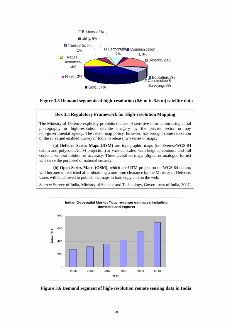
commercial services: An operational system Figure 3.2 Geo-spatial service components of village telecentres 48 Figure 3.3 Emerging convergent applications – to be disseminated through VRCs 54 Figure 3.4 Different forms of PPP 55 Figure 3.5 Demand segments of high-resolution (0.6 m to 5.6 m) satellite data 58 Figure 3.6 Demand segment of high-resolution remote sensing data in India 58 Figure 3.7 Geo-spatial industry value chain 59 Figure 3.8 Ingredients of success for ICT4D in less developed rural areas 60 Figure 3.9 Strategy to enhance community participation in delivery of space-enabled ICT 61
products and services Figure 3.10 Strategy based on PPP and community participation for development, as well as 62
dissemination of space-based ICT products and services Figure 4.1 The geographical location of the Philippines exposes it to numerous natural disasters 77 Figure 4.2 The National Telehealth Service Programme framework 92 Figure 4.3 Communication plan for natural disaster management 94 Figure 5.1 From introduction to industrialization:A policy for public-private partnership in 108
the Republic of Korea List of Boxes Box 2.1 State Enterprise, Private Enterprise and China Central Radio and TV 14
University Dedicated to Promoting Remote Education in China Box 2.2 The Successful Launch and Operation of Beijing-1 Microsatellite Contributes 16
to Public-Private Partnership Box 2.3 China’s Prestigious Tsinghua University Affiliates with High-tech 34
Companies to Deliver Education in Poor Areas Box 2.4 “City Emergency Collaboration and Social Comprehensive Services System” 39
Installed in Weifang with the Assistance of Information Technology and Public-Private Partnership
Box 3.1 India Tobacco Company’s e-Choupal Customizes Knowledge for Indian Farmers 46 Box 3.2 N-Logue: Aimed at Improving the Quality of Life of Villagers 46 Box 3.3. CIC: One-Stop Access for Authentic Information 47 Box 3.4 PPP for Expanding Telemedicine Projects in India 57 Box 3.5 Regulatory Framework for High-resolution Mapping 58
ix
ABBREVIATIONS AND ACRONYMS ADSL asymmetric digital subscriber line
APEC Asia-Pacific Economic Cooperation
APEC-EINet APEC Emerging Infections Network
CAGR compound annual growth rate
CD-ROM compact disc read-only memory
CDMA code division multiple access
CIDA Canadian International Development Agency
CSC community service centre
CSR corporate social responsibility
DSM defence series map
ECG electrocardiogram
EDP electronic data processing
EO Earth observation
ESA European Space Agency
GDP gross domestic product
GIS geographic information system
GPS Global Positioning System
GSM Global System for Mobile communications (Groupe Spécial Mobile)
ICST information, communication and space technology
ICT information and communication technology
ICT4D information and communication technology for development
IDRC International Development Research Centre
IPR intellectual property rights
ISCS Integrated Supercomputing System
ISP Internet service provider
IT information technology
HIV/AIDS human immunodeficiency virus / acquired immune deficiency syndrome
LAN local area network
MCT multipurpose community telecentre
MDG Millennium Development Goals
MPT multipurpose telecentre
NGO non-governmental organization
NRC natural resources census
NRDB natural resources database
NRR natural resources repository
x
OSM open series map
PC personal computer
PCO public calling office
PPP public-private partnership
PSTN public switched telephone network
R&D research and development
RESAP Regional Space Applications Programme for Asia and the Pacific
SEAMEO Southeast Asian Ministers of Education Organization
SEAMEO INNOTECH Southeast Asian Ministers of Education Organization Regional Centre for
Educational Innovation and Technology
SMEs small- and medium-scale enterprises (also “small and medium-sized”)
SMS Short Messaging (or Message) Service
UNESCO United Nations Educational, Scientific and Cultural Organization
USO universal service obligation
VKC village knowledge centre
VoIP Voice-over Internet Protocol
VPN virtual private network
VRC village resource centre
VSAT Very Small Aperture Terminal
WAN wireless area network
WHO World Health Organization
WSIS World Summit on the Information Society
1
I. INTRODUCTION Information, communication and space technologies (ICSTs) are increasingly being recognized as essential tools of development – tools that can empower poor people, enhance skills, increase productivity, and improve governance at all levels. Recent advances in ICST, especially space technology, are expanding the opportunities for developing countries to apply them effectively for the achievement of sustainable development, the building of the information society, and the attainment of the Millennium Development Goals (MDG).
Space technology exhibits a strategic dimension because of its capacity to gather and deliver information over very large areas. Cooperative space activities, including information sharing and joint projects, help to build confidence in the continuation of the peaceful use of space. Space technology, especially satellite broadband, has advantages in areas where optical fibre is not available or not cost-efficient. The use of hybrid broadband techniques, consisting of copper wire, optical fibre and satellites, provides unique solutions for bridging the digital divide, especially in rural and remote areas of developing countries.
The Asia-Pacific region, home to more than 60 per cent of the world’s population and about 75 per cent of the world’s poor, presents striking contrasts between continent-sized nations, city States and Pacific island nations separated by vast stretches of ocean; between some of the world’s richest and poorest nations; and between market-dominated, State-planned and mixed economies that themselves exhibit an uneven mix of agrarian, industrialized and knowledge-based service industries. In the region, the integration of space technologies with other information and communication technologies (ICTs) has made their applications more accessible and affordable, particularly in those countries where appropriate national ICST policies and an enabling environment for the promotion of the public-private partnership (PPP) supporting such activities are in place.
There is still a significant capability divide in the region, between the high-achieving ICT- and space-capable member States and the less advanced developing countries, particularly small island developing countries and remote rural areas in least developed and land-locked developing countries, and this issue needs to be addressed further. Promoting large-scale operationalization of space-based ICST applications by government and private agencies and by non-governmental organizations (NGOs) at the community level through PPP and community participation is of great significance to improve access to information and knowledge to the people living in underserved areas, such as remote rural areas and small islands.
The purpose of this compilation is to provide information and knowledge on the types of space-technology-based projects and activities conducted in rural and remote areas of some Asian countries to enrich the people living in those areas with information and knowledge – and to narrow the information and knowledge gap between urban and rural and remote areas in those countries. It also presents the role and importance of public-private partnership and community participation and requirements of relevant government policies in promoting such projects and making them sustainable.
Chapter 2 presents the experience of PPP in space applications in China. It covers mainly the PPP financing pattern, analysis of investment patterns and financing in space infrastructure projects in other countries, practices of different PPP modes in space application projects in China, and considers the way forward. Chapter 3 sets out the challenges of setting up community e-centres, and illustrates the many beneficial uses that the people of Yunnan province have made of them. Following the article on Yunnan are four brief accounts of IT in other parts of China for the purposes of education, coordination of city emergency systems, and remote sensing. Chapter 4 presents an assessment of public, private and community partnership practices in harnessing space-based ICTs for development in India. It covers principally the existing status and impact of space-based ICT products and services, as well as PPP and community participation in space-based ICT products and services in India. Finally, it suggests some strategies and guidelines based on the Indian experiences and lessons learned that may be useful for other countries. Chapter 5 presents a case study of the Philippines on public-private partnership and community participation programmes in using space-based products and services. Primarily, it discusses issues such as policy and institutional frameworks, current programmes and
2
projects, strategy implementation, roles and options of the stakeholders, mechanisms for partnership and participation in the Philippines, and lessons learned and recommendations. Chapter 6 presents two discussions of policy from the Republic of Korea and Japan. The former explains the government’s role in enabling and encouraging public-private partnerships, while the latter describes the formation of JAXA in an effort to make Japan’s space industry more competitive and application-oriented.
ESCAP expresses its appreciation to the Government of the Republic of Korea for providing financial support for this collection of articles on public-private partnership and community participation on applications of space technology, under the project “Preparation for the Third Ministerial Conference on Space Applications in Asia and the Pacific”.
3
II. PUBLIC-PRIVATE PARTNERSHIP AND COMMUNITY PARTICIPATION PRACTICES IN SPACE-ENABLED SERVICES
IN CHINA
A. THE EXPERIENCE OF PUBLIC-PRIVATE PARTNERSHIP IN SPACE APPLICATIONS IN CHINA1
Abstract This paper describes the concept and experience of public-private partnership (PPP) in the field of space applications in China. Because the partners may come to these projects with divergent motivations – profit on one hand and the provision of public services on the other – the interests of the partners is one of the most important issues that can help ensure the success of a long-term project. This paper describes general methods of investment in this area around the world. These methods are then compared to the PPP financing model in China in different fields of space applications, such as direct-broadcasting satellite, Earth observation microsatellite, rural informationization, and distance education. In conclusion, the case studies reveal that PPP can be implemented further in space applications, and some important questions and vital issues are discussed for the making of successful public-private partnerships.
1 Introduction
The partnership between governments and private enterprises in space applications areas is one of the hot topics of investment in China now. However, the underlying motivations for the individual partners may be widely divergent: one is driven by a profit motive, the other by the desire to deliver social services to the people. These joint projects are undertaken in an attempt to bring the benefits of technological efficiencies to society, taking advantage of the strengths and interests of each partner. The policy of infrastructure construction based on national finance has been prevalent for many years all over the world. But with fast economic growth, the demand for public infrastructure construction increases every day, and investment surely will aggravate the burden of national finance. Meanwhile, low efficiency and high losses are universal problems in state-owned infrastructure enterprises. There are increasingly urgent calls for private capital to join in on the construction of national infrastructure. However, the amount of direct profit from infrastructure projects often can not meet the expectations of private companies wishing to finance a project. To solve this dilemma, the public-private partnership (PPP) pattern came into being. On one hand, government can raise project profits directly through supporting measures to make project financing succeed, and on the other hand, the entry of private capital will decrease the risks of government investment and improve operating efficiency.
2. Description of PPP Financing Pattern The PPP financing pattern is a format for cooperation between the public sector and private enterprise. Through this format, each partner can get a better result than it can by acting on its own. In such a project, responsibility is not totally transferred from government to private enterprise, but is taken on by all parties. The concept behind the PPP pattern is integrated project financing. The organization format of PPP pattern is complicated. Profit-seeking enterprises, private non-profit-seeking organizations, and public non-profit-seeking organizations (the government, for example) can be included in the organization. Of course, a diversity of levels and types of profit and responsibility are inescapable in this kind of cooperation. Only the inter-cooperation system between government and private enterprise can “fuzzify” the divergence, overcome differences and seek a common ground to fulfil the project goals.
1 Jing Guifei, National Remote Sensing Centre of China, Beijing 100862, China; email
The PPP pattern will not change the appearance or the overall situation of a project, but it is a new model for the setup of organizations in a project’s life cycle. Generally speaking, there are two types of long-term investment for private enterprise. One is to provide funds for long-term investment, but not to join the construction or operation of a project; the other is to do both the investment and the construction and management of a project. The most remarkable characteristic of this format is the inter-cooperation between the country or organization of the project and the investor and operator, and their contributions to the project construction. The government department involved and the private sector company base their cooperation on a concession agreement. Unlike earlier patterns, the two parties take charge of the whole life of the project, from the confirmation and flexible research phase to the end of the course. In the early argument phase, both sides confirm the technical design and feasibility of the project, evaluate the options for project financing, and assign the risk to the most able party through an efficient risk-assignment plan. Compared with the financing patterns of public infrastructure projects using private enterprise before, the PPP financing pattern can bring about great achievements, though not without some disadvantages. First, it can be determined early on which projects would benefit from financing through this setup, and the risk-dispersing plan for the whole life-cycle of the project can be established. Second, in the PPP pattern, private enterprise can enter the project at the beginning, and the government benefits from use of the advanced technology and management experience of the private enterprise. In a normal government road construction project, for example, if the technical design plan has been determined in the early design phase, further technical innovation will be constrained during the construction phase. But in the PPP pattern, private enterprise can discuss the technical plan for the project construction with the government and plan the organization of the project, to reach a better research result. Third, in this pattern, the public sector and private enterprise can join in the construction and operation of the infrastructure, form a reciprocal long-term goal, and provide better service to society. In addition, the amount of project capital might be increased and the rate of capital debt could be reduced. Fourth, all parts of the project may be integrated to form a strategic alliance, so that the goals of the different parts can be coordinated. Fifth, a private company intending to be involved in public infrastructure projects are able to contact the government or related organization of the project early on, thus saving the bidding fees, decreasing the time of preparation, and cutting the price of the tender in the end. The public-private partnership model is a breakthrough in the manner of bringing private enterprise to public infrastructure projects. It has broad areas of application, especially in large, one-off programmes, such as prisons, roads, railways, hospitals, schools and the like. The foundation of the PPP pattern is (a) the contract, (b) the concession agreement, and (c) the ownership. With these elements in the background, the PPP pattern can accept different associations, each of which may be considered a public-private partnership. The application of the PPP pattern in various kinds of situations is shown in the following table:
5
Table 2.1 Patterns of public-private partnerships
Type of Infrastructure Project Corresponding Model
Existing facilities Service contract. Operate and maintenance contract
Facilities to be constructed Build-transfer-operate; Build-operate-transfer; Build-operate-own-transfer; Build-own-operate
PPP investment projects usually involve capital-intensive industries, in which the amount of capital of a single project is large and the operation cycle is very long. The support of the government in policy and law is an important pre-condition for the smooth operation of the project. The investing enterprise receives the operation concession from the government by tender, operates the project during the authorized period, and obtains profits by charging fees or selling products. A large number of projects in the PPP pattern have achieved great success in China and abroad, such as the Channel Tunnel, Sydney Harbour tunnel, Hong Kong central crossing tunnel, Guangdong Shajiao power station and others.
3. Analysis of the Pattern of Investment and Financing in Space Infrastructure Projects Abroad
3.1 The Situation of Investment and Financing in Space Infrastructure
Projects in Major Space-Faring Countries Every year, space-faring countries spend about US$45-50 billion in developing both space technology and systems, most of which is spent on the construction of space infrastructure. In the major space-faring countries, the trend is still to put emphasis on application satellites, which comprise 60-70 per cent of investment in space infrastructure. It is estimated that this will not change in the near future, because the increase in private investment will make up for the possible decrease of government investment. Accordingly, the investment and funds in space infrastructures construction are likely to remain steady and have a year-to-year increase over the next decade. Some governments invest their funds in space infrastructure that makes no profit, for instance, military satellites, civilian Earth observation satellites, space stations, space transportation system (such as the Shuttle) and so on. In contrast to the government investment, private investment is mainly in commercial satellite communication systems (satellite television, telephone, voice broadcasting service, broadband, information transmission at high speed for multimedia, Internet businesses and so forth) and the ground facilities. As far as the construction of navigation and location satellite systems is concerned, the expenditure is completely supported by government investment in some countries, but supported by both government and private organizations in other countries. Uniting private investment and government investment to improve the construction of space infrastructure is an innovation in the way of investing in the field of space. When government investment is limited, private capital in space infrastructure is playing a more and more important role and it can make the financing of some projects more flexible, especially large projects that governments have financial difficulties implementing. (a) United States of America In the United States of America, the government funds most space infrastructure except for commercial satellite system, which are paid for by private sector concerns.
6
In the last few years, the space budget of the United States remained at the level of US$30 billion and maintained a basic balance between military and civilian applications. Most of the budget for military space applications was spent on space infrastructure, while about half of the budget for civilian applications was used for space infrastructure. Therefore, it is estimated that the amount the United States spends every year on the construction of space infrastructures is more than US$20 billon, which is far and away more than other space-faring countries. The budget for civilian communication satellite systems remains at about US$1 billion; the budget for geo-science is steady at about US$1.4 billion; the budget for the International Space Station was reduced from US$2.5 billion in 2000 to US$1.573 billion in 2004, which hints at possibly lower investments in the future; the budget for the Shuttle remains at approximately US$3 billion. In the year 2004, the budget for space infrastructure (except for carrier rockets) accounted for half of the general budget of the National Aeronautics and Space Administration (NASA) (50.8 per cent). As estimated by the United States Department of Defence, in the next decade, it will cost US$230 billion to develop new military space equipment in order to realize the plan that the United States Air Force be gain space capabilities and be divided into 10 teams of “Aerospace Expeditionary Forces” in order to take full advantage of United States space supremacy and make the Air Force more agile, more capable and more powerful. (b) Russian Federation In the Russian Federation, the government shoulders almost all the investment in the construction of space infrastructure, while the inflow of private investment is nearly nonexistent. The Russian Space Agency said that only 18.3 billion roubles (US$650 million) was invested in 2004, while 23 billion roubles (US$820 million dollars) would be invested to develop the Russian space industry in 2006, which is an increase of 25.7 per cent. In order to maintain the original space infrastructure and build new spacecraft, the increase in investment is necessary. Because of a lack of open information, since government funding for projects is only occasionally reported, it is difficult to calculate the investment budget or funding situation for Russian space infrastructure. Some information is known about GLONASS, the investment for which has shown a growth trend. Recently, GLONASS conducted three launches, sending up three navigation satellites each, and costing a total of 4.953 billion roubles (US$158 million dollars). In 2004, funds for the International Space Station had reached 6.378 billion roubles. Recent investment in other space infrastructure includes 0.616 billion roubles for five Newsletters AM Communication satellites, 0.15 billion roubles for ship communication satellite Messenger M, 0.615 billion roubles for three Resource DK satellites, 1.5 billion roubles for Monitor A satellite and 7-6 1M satellite. In the Russian space programme, the main investment in the next phase of space infrastructure construction will be in the direction of communications and broadcasting, remote sensing, and navigation and positioning satellite systems. (c) European Union Government investment is the mainstay of funding for European space infrastructure projects, while private investment is also enthusiastic. The European Union (EU) takes the lead in space infrastructure projects using public-private cooperation in the investment and financing mode. In the five years from 2002 to 2006, the space budget of the European Space Agency (ESA) was 5.94 billion euros, out of which 5.1 billion euros was invested in space infrastructure construction, including Earth observation satellite systems, satellite communications systems, satellite navigation systems, the International Space Station and other projects. Apart from space vehicles, investment in the Earth Observation System was the biggest, followed by the space station, satellite communications systems, and the Galileo global positioning system. In the Galileo project, because the investment is from both the government and the private sector, this approach of co-financing is conducive to a division of labour. In the United Kingdom, some space infrastructure projects use this method; the government proposes the project, which is entirely funded by private sector
7
companies, and in the end the government purchases the service of the project from the private sector. In both the United States and the European Union, the construction of commercial satellite systems, which is an integral part of the space infrastructure, usually receives investment from private companies (primarily commercial communications systems and some remote sensing satellites used for business). Private investment in space infrastructure could alleviate the financial burden of the government and quicken the pace of construction. At the same time, the efficiency of constructing and operating some space projects has been improved, which makes the space industry mechanism more flexible and effective. In a word, private funds are increasingly a supplement of infrastructure funding.
3.2 Analysis of the Pattern of Investment and Financing in Space Infrastructure Projects in Foreign Countries
The investment and financing in space infrastructure abroad can be divided into three patterns: complete government investment pattern, public-private partnership investment pattern, and private investment pattern. The main space-faring countries implement different patterns of investment, depending on the characteristic of the projects. Overall, space infrastructure projects for the military and most infrastructure projects for civilians receive government investment, and space projects for civilians, that will produce profits, have both governments and private investment, while projects for commerce receive investment from the private sector. (a) Pure government investment In all the space-faring countries, complete government investment is the dominant pattern in the construction of space infrastructure projects. Space infrastructure, which concerns state security and the benefits of military, polity and diplomacy, is essential and strategic. But its construction is time-consuming and expensive, so only the national government has the capability for taking the leading role in planning and construction, and it is duty-bound to do so, while other subjects can play the supplementary roles. At present, all countries that have a space industry, except the United Kingdom, take full responsibility for the investment in infrastructure intended for the military, out of the need for complete control and security. At the same time, most space projects for civilian use are strictly government-funded, too. Case 1: France builds the Syracuse-3 military telecommunication satellite, adopting the pure government-invest mode The Syracuse-3 military telecommunication satellite project sponsored by the Government of France is intended to complete the Helios military satellite system and strengthen its military telecommunication power. The Syracuse-3 project, whose gross investment is 2.3 billion euros, includes developing and launching two Syracuse-3 satellites and constructing 540 ground receiving stations. This communication satellite system is a comprehensive complement to the Helios reconnaissance system. Coordination of the two systems will dramatically improve France’s military space infrastructure. Case 1 Comment: Military satellite projects involve privacy and state control, and, importantly, its continuous and stable service must be ensured. There will be serious risks when bringing in private capital; therefore, governments are extremely cautious in this respect; France, for instance, explicitly forbids any private funding for military space projects.
8
Case 2: The American Global Information Grid project adopts the pure government-invest mode The United States military will invest US$18 billion to launch special satellites for global communication within the next 20 years. The purpose of this action by the Department of Defence is to establish a global data and communication network. The investment involves purchasing low-cost mini-satellite terminals from the industrial community which are transportable and can be flexibly used on the road. The military’s data and communication service will be undertaken primarily by these special satellites after the completion of the Global Information Grid transfer system in 2020. The expected satellites will be able to commit the entire on-sat process and routing. The bandwidth of each satellite will be 5 Gb/s, and capable of real-time switching in the Global Information Grid. The military satellite and space infrastructure is in the process of being purchased by the Department of Defence, which is adopting the pure government-invest mode, although some business satellites will be rented from private companies according to need. Case 3: The United States Earth Observing System adopts the pure government-invest mode The Earth Observing System (EOS) is the most prominent Earth observation system. This project, a pure government-investment project, is expected to consume US$21 billion (not including EOS science projects) and to be completed in 2019, after 20 years. The purpose of the EOS programme is to build a comprehensive, enduring, global-scale system for Earth observation. EOS has been renamed the International Earth Observing System (IEOS), a cooperation programme in which ESA, Japan, the Russian Federation, Canada, Brazil and Australia have taken part so far. This programme will help in forecasting weather and monitoring global changes (such as El Niño and La Niña) and find new ways to solve problems concerning the environment, natural resources, and population. Satellites belonging to ESA, Japan and the Russian Federation, which are government-funded, are all involved in EOS. Comment on cases 2 and 3: Because the United States has a powerful market economy, private investment can be seen nearly everywhere, and most traditional (non-space) infrastructure construction accepts private investment. However, considering that the development of space infrastructure can greatly affect national security, global strategy and the country’s leadership in the world, the government must hold firm to the dominant position in space infrastructure construction. Therefore, although there are many calls to bring the private investment pattern to space projects, neither the military nor civilian space infrastructure projects permit private capital to participate, restricting it to commercial satellite systems. Case 4: Europe Global Monitoring on Environment and Security (GMES) programme in total government investment pattern The GMES programme aims to streamline the dispersed Earth-observing resources to form a comprehensive observing network that can provide operation services. This ambitious programme was formally started after a long period of negotiation. And what is more important, leaders have ascertained that the investment budget would be at least Euro 0.75 billion per year, which can ensure that the whole monitoring network, including the new space-based system, will be functioning by the year 2013. Of course, a large amount of funds from non-spaceflight departments (transportation and environment department, for example) should be allowed to enter the field of European spaceflight to avoid a shortage of funds. Both the funds from space-related departments and funds from the transportation and environment department are from the government. This programme therefore is in the pattern of complete government investment. Case comment: There is no doubt that national security and monitoring of the environment, and construction of the related space infrastructure, should be assumed by the government. Absolute government investment is the only pattern that can be chosen in space projects for security and
9
environmental monitoring, because, since no profit can be made in such operations, they do not draw the attention of private capital. (b) Public-private partnership investment pattern Public-private partnership is a modern financing model, which came into being in the construction of public infrastructure projects under the cooperation ideology of finding a “win-win” situation for all parties. In other words, it is a kind of “friendship” between government departments and private sector companies built on investment and operation, along with a format for providing public products and services. The PPP pattern of joint venture and united operation has an irreplaceable role in the efficient management of projects, rational use of funds, assurance of business quality, creation of joint ventures, solving the problem of insufficient funds, and others. It is still a new attempt by the European Union and ESA in space infrastructure construction, but it has been applied in ground infrastructure construction in some countries. Case 5: Europe builds the Galileo Global Navigation Satellite System in PPP pattern Unlike the government investment pattern in American GPS system construction, Europe built Galileo Global Navigation Satellite System in the PPP pattern, which is a significant innovation. And also because of this, drawing the attention of private investment is the most important work for EU and ESA to complete the Galileo Programme. The plan of public-private partnership in the Galileo Programme construction covers several phases. In the first phase, the government plays crucial role in risk reduction because it is not clear whether the Galileo system’s technology and performance will prove to be better or more popular than that of the Global Positioning System. In the phase of development and validation before the year 2008, Europe and ESA will provide the main funding of 550 million euros. In the second phase – the deployment phase, which will comprise about two thirds of the whole Galileo Programme – private enterprise and financial organizations will take on an important part, which means that the project will be supported mainly by private enterprise. The 2.15 billion euros needed in this phase will be used for the development of 30 satellites, ground facilities, launch of satellite, installation of equipment, and so on. Service providers, receiver (chipset) equipment manufactures, and infrastructure providers in the space and ground segments are the possible investors, which also could include banks and venture capital companies. The advantage of having public-private cooperation in the Galileo Programme is that the system construction need not be totally funded by the government. What is more important is that this is an innovative method for the construction and operation of space infrastructure projects. Case comment: In all kinds of space infrastructure construction projects, navigation satellite system projects should be the most suitable for adoption of public-private partnership in investment and financing. The reason is that, in the development and validation phase, it is necessary that the government take the initial risk, so that, in the operation phase, the low risk and the expected profits can greatly attract private capital to join the project. In the whole course of a typical project, the amount of money required is so large that it would be a heavy burden for either the government or the private sector to assume it alone. So the better pattern would be joint venture and united risk in construction but operation concession granted by the government, and profits earned by private enterprise. (c) Private finance initiative pattern In the private finance initiative (PFI) model, the government first proposes the detailed requirements of a project, and private enterprise finances construction, and then the government buys the service provided by the infrastructure from private enterprise. It is an innovative public project-financing mode, and a mode of private financing first put forward by the Government of the United Kingdom. In the PFI pattern, the funds, personnel, technology and management supplied by a private party could be used for investment, development, construction and operation of the project;
10
the government then buys the products and service from the private sector, or it may authorize the corporation to charge concession fees. In space projects using the PFI pattern, the government department acts as the planner, starter and supervisor, and private enterprise inputs funds, performs construction, and provides operation management. An advantage for the government is that the risk of space projects can be transferred to private enterprise; on the private enterprise side, organizations and persons who take the opportunity to invest in a space system have a good opportunity to earn a profit from their investment. PFI is a brave and innovative development in the field of investment and financing that has actually been used in space infrastructure projects, especially in military space infrastructure projects in the United Kingdom. Case 6: British “Skynet” 5A satellite system project in PFI pattern The British “Skynet” 5A satellite system is a military communication satellite system whose investor is not the government but Paradigm Communication Company of EADS Corporation. British Ministry of Defence proposed the plan and requirements of the project, and Paradigm Company will pay for the whole Skynet system, including satellites, ground centres, ground moving end, ship-carrying end, satellite control and management system, and the network to provide a military satellite communication service. In fact, the government need not invest in the construction of the Skynet, but only buy communication service from Paradigm. Using the PFI method, the Skynet 5A plan has already saved a great deal of money. It has been estimated that this plan has saved about 4 per cent of normal purchasing costs over its whole life span, almost 100 million pounds sterling, yet it can provide the same facilities and capacity as the Ministry of Defence itself could have provided if it had built the system. Case comment: The British Ministry of Defence, the pioneer in using private investment in a military satellite programme, opens a new way for investments in this field. The Skynet 5A plan is pushing forward smoothly and saving a large amount of funds, which indicates that investing in infrastructure for the military need not be a forbidden zone for individual capital. Certainly, it must adopt measures to control risks involving secrecy and maintain the stability of business. Otherwise, there is the possibility that heavy losses in national security may outweigh financial gains. (d) Independent private investment method The independent private investment method is one in which the individual invests in building a satellite operating corporation and decides independently on a satellite system programme to meet the need of the market (unlike the PFI method, in which the government decides on and plans the system). In the construction and operation of a commercial satellite by the private funds, an entity is needed to operate it, so the first step is to establish commercial satellite operating company to finance and operate the investment. The investment funds are collected through financial institutions, publishing corporation bonds, companies in the stock market, and other means. Some private investors with the aim of quick production will directly purchase the satellite operating company to step into this field of commercial satellite system construction and operation. Case 7: Rene Anselmo established a satellite operating company, producing the communication satellite of the Pan American Satellite series. Alfa Lyracom Space Communications is the first private company in the world to sell a global satellite communication business. In the aspect of programme financing, the funds of Alfa Lyracom Corporation were all from private investors or privately owned organizations. Rene Anselmo himself provided US$64,500,000 for the fund, and another US$15,600,000 was provided by loans from commercial banks. In August 1993, Alfa
11
Lyracom successfully collected US$400 million through an initial public offering (IPO), and the company changed its name to the Pan American Satellite Corporation. Case comment: The commercial communication satellite system and commercial remote sensing satellite system both belong to the space infrastructure that can earn profits. Governments have the right to create and fund their own for-profit space programmes, but usually they can not do them better than a private company can, because the private company may be more efficient and may provide a better service than the government can. Therefore, the construction and operation of commercial communication satellite systems and commercial remote sensing satellite systems require only that the government adopt official policies that lead and promote industry regulation. The private sector invests, develops, constructs and operates the programme, which undoubtedly will speed up the construction of space infrastructure.
4. Public-Private Partnership Mode in Space Application Projects in China Space application projects conducted by means of the PPP pattern concern primarily large national projects in China. This section of the paper describes the practice of this investment pattern in China through an analysis of the development of China’s satellites for direct broadcasting, Beijing No. 1 surveillance micro-satellite, Rural Information Construction, distance education, and other programmes. The construction of these projects and the direction of their operation are controlled by the government because of its significant policy-making role for important investments. The importance of investment private enterprise in the operation phase lies in the operation in the service domain, which has been opened up by the government. The development of this pattern largely depends on the fact that the Government of China has realized the importance of the market economy, especially its meaning for service capacity, the flexibility of corresponding strategies, and the sustainable development of the projects.
4.1 China’s Direct Broadcasting Satellite (a) The situation in China’s direct broadcast television business Satellite direct broadcast technology can transmit television programmes to users directly and receivers can easily receive programmes with a small antenna. Since the 1990s, direct broadcast television, satellite mobile communication, satellite digital audio broadcasting and other technologies have scored breakthroughs in the United States and stepped into the phase of industrialization and commercialization rapidly, and subsequently, some new, booming industries have been formed. These three technological applications have been spreading quickly around the globe, especially direct satellite broadcast television, which is developing rapidly and maturing step by step after the success of its application in business. In 1993, the Hughes Corporation first developed and constructed a commercial television satellite system based on digital video compression technology and established DirecTV Company through various financial channels to operate this satellite system. After several years, DirecTV occupied the biggest share of the direct broadcast television market in the United States and Canada; furthermore, it had marched into the markets of Mexico, Latin America and Japan. After the success achieved in the direct broadcast market by the Hughes Corporation, many major companies from the United States, Japan and Europe entered the market, and then some traditional commercial and non-commercial satellite communication companies followed the lead of Hughes, trying to gain part of the market for direct broadcast television. The advantage of satellite direct broadcasting is that only a small amount of the satellite’s capacity is utilized to broadcast hundreds of programmes to an unlimited number of families. China has a vast and complex territory in which there are many islands, mountainous areas and hard-to-reach areas, and the distribution of the population is not well-proportioned; the development of the
12
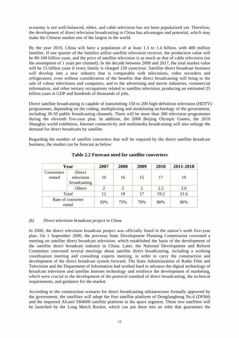
economy is not well-balanced, either, and cable television has not been popularized yet. Therefore, the development of direct television broadcasting in China has advantages and potential, which may make the Chinese market one of the largest in the world. By the year 2010, China will have a population of at least 1.3 to 1.4 billion, with 400 million families. If one quarter of the families utilize satellite television receiver, the production value will be 80-100 billion yuan, and the price of satellite television is as much as that of cable television (on the assumption of 1 yuan per channel). In the decade between 2008 and 2017, the total market value will be 15 billion yuan if every family is charged 150 yuan/year. Satellite direct broadcast business will develop into a new industry that is comparable with televisions, video recorders and refrigerators, even without consideration of the benefits that direct broadcasting will bring to the sale of colour televisions and computers, and to the advertising and movie industries, commercial information, and other tertiary occupations related to satellite television, producing an estimated 25 billion yuan in GDP and hundreds of thousands of jobs. Direct satellite broadcasting is capable of transmitting 150 to 200 high-definition television (HDTV) programmes, depending on the coding, multiplexing and modulating technology of the government, including 30-50 public broadcasting channels. There will be more than 300 television programmes during the eleventh five-year plan. In addition, the 2008 Beijing Olympic Games, the 2010 Shanghai world exhibition, Internet connectivity and multimedia broadcasting will also enlarge the demand for direct broadcasts by satellite. Regarding the number of satellite converters that will be required by the direct satellite broadcast business, the market can be forecast as below:
Table 2.2 Forecast need for satellite converters
Year 2007 2008 2009 2010 2011-2018 Direct
television broadcasting
10 16 15 17 19 Converters
rented
Others 2 2 2 2.2 2.6 Total 12 18 17 19.2 21.6
Rate of converter rental 50% 75% 70% 80% 90%
(b) Direct television broadcast project in China In 2000, the direct television broadcast project was officially listed in the nation’s tenth five-year plan. On 1 September 2000, the previous State Development Planning Commission convened a meeting on satellite direct broadcast television, which established the basis of the development of the satellite direct broadcast industry in China. Later, the National Development and Reform Committee convened several meetings about satellite direct broadcasting, including a working coordination meeting and consulting experts meeting, in order to carry the construction and development of the direct broadcast system forward. The State Administration of Radio Film and Television and the Department of Information had worked hard to advance the digital technology of broadcast television and satellite Internet technology and reinforce the development of marketing, which were crucial to the development of the protocol standard of direct broadcasting, the technical requirements, and guidance for the market. According to the construction scenario for direct broadcasting infrastructure formally approved by the government, the satellites will adopt the first satellite platform of Dongfanghong No.4 (DFH4) and the imported Alcatel SB4000 satellite platform in the space segment. These two satellites will be launched by the Long March Rocket, which can put them into an orbit that guarantees the
13
transmission of television programmes. China Satellite Communication Group Corporation signed a contract regarding the purchase of satellite Zhongxing 9 for direct broadcast with Alcatel on 21 April 2005. The project will establish a safe, stable, reliable, large-capacity, and full-coverage space transmission platform for China’s radio and television satellite direct broadcast system, forming a suite of technical systems and business operation models that are suitable for China, promoting the development of television programme content and other related industries. The construction of the space segment will enable the radio and television service to cover 98 per cent of China. Customers will be able to receive television programmes 0.45-0.6 metre antennas, which is a viable solution to the lack of access among people in rural and remote areas. The success of the project will satisfy people’s increasing needs, narrow the digital divide, promote the development of the Chinese economy, and lay the foundation for the construction of a well-off society. China will launch the Zhongxing 9 satellite as the replacement for the failed Sino-2 (Xinnuo 2). China Satellite Communication has conducted a sophisticated design for the operation, sales and service of the system so as to make a reasonable profit. The downlink beam of the satellite covers the entire country, including the South China Sea, and the country beam also covers the whole territory of China, including Hong Kong, China, Macao, and Taiwan Province of China. The G/T value of the country beam in most areas of China is ≥0dB/k. The signal power of Zhongxing 9’s country beam is between -68dBW/m² and -98dBW/m at the G/T value +3dB/K. The antenna of satellite employs round polarization technology, which is suitable for China. As the polarization direction of the ground antennas is based on the satellite antenna, it is not necessary to adjust the polarization direction but simply to aim it at the satellite to receive a good television signal. For most direct satellite users, it is inconvenient to install the equipment, aside from the technical difficulties in adjusting polarization if the linear polarization technology is employed. Even if professional technical support is provided, it is still difficult to solve problems in a short time, which is a major obstacle to direct satellite broadcast users. In the rural and remote areas particularly, where most of China’s population lives, there are many conditional obstacles that would be barriers to adjust the polarization of antennas. If round polarization technology is applied, users need only to consider the mechanical installation of the terminal equipment, and then set the correct azimuth and elevation of the antennas. This technology will benefit the promotion of broadcast satellite service and can reduce operation costs. In China, the population is dense in the eastern area and dispersed in the western regions. There is a long coastline, many islands, and tens of thousands of frontier lines where tens of millions of herders live, as well as soldiers at frontier defence outposts. There are also tens of thousands of vehicles and between 80 and 100 million transient persons in the whole country. This complex situation demonstrates that round polarization antennas should be employed for the reception of television programmes. The successful launch of direct broadcasting satellites is the result of joint efforts of the government and enterprises that invested in this project in the stages of both satellite production and launching. China Satellite Communication Group is now in charge of operating the system; the results of the operation still need further observation and practice.
14
2.1 State Enterprise, Private Enterprise and China Central Radio and TV University Dedicated to Promoting Remote Education in China2
Since the Government of China publicized its plan on constructing an institution for life-long education and put an emphasis on study, distance education has become an important programme and drawn the attention of many people. Prime Minister Wen Jiabao pointed out in a governmental working report of 2006 that it was essential to accelerate the construction of modern distance education. China Satellite Communication Corporation and TCL Group invested a great deal of money and technical equipment in the on-line distance education company of China Central Radio and TV University in order to respond to the government’s activity. As a result, they are able to make use of the seamless broadband network of China Satellite Communication Corporation and the modern information technology and international experience of TCL Group, and they have the support of the expert organizational system and abundant education resources of China Central Radio and TV University. With these advantages, the company can become an outstanding distance education provider and operator and facilitate the fast growth of Chinese distance education to a higher level. According to the agreement, China Satcom and TCL Group have offered learning tools to teaching centres of China Central Radio and TV University, distributed all over the country, to make sure that each student can have access to one electronic classroom, one teaching computer, one electronic voice mail, one multi-communication account, and one study documents database, which helps turn these teaching centres into high level e-centres. They make use of teaching methods applied in school, which is that teachers and students can communication directly, can hand out documents, and broadcast in any teaching format, such as interactive classrooms and video classrooms, to improve distance education and meet the demands of the educational market. The network technology is able to combine directed education and network education effectively. The extensive experience with serving customers and the maintenance systems all over the country supported by China Satcom will offer reliable technology supports for this new serving mode. According to estimates for Guangxi autonomous region alone, more than 7,000 stations are used to receive satellite broadcast education programmes, and more than 1,000 computer rooms have been established. Qiaotou central primary school, located in a remote mountain district, used to have a low standard of teaching, but now, after the teachers were organized to take distance education courses and joined the teaching and research activities there, the teaching level of those teachers, as well as the grades of their students, has improved markedly. The provinces of Hainan and Hebei are also speeding up construction of a modern distance education system for rural primary and middle schools. It is estimated that modern distance education will cover all of the provinces by the end of 2007. In other provinces, such as Tibet, Xinqiang autonomous regions and Qinghai province in western China, positive activities are proceeding at a rapid pace. Some places have extended distance education to projects from which people can receive benefits and projects for training about distance education and medicine, as well as the control and prevention of diseases. The contents of distance education are becoming more and more varied and abundant. It can be asserted that not only student but also the populace as a whole can gain valuable experience from the education mode in which a state-owned enterprise, private enterprise and China Central Radio and TV University have joined together to promote modern distance education in improving cultural education and raising China's scientific and technological level.
2 Dai Changda, Academy of Opto-Electronics, Chinese Academy of Sciences, Beijing, China.
15
4.2 Beijing-1 Earth Observation Microsatellite The Beijing-1 microsatellite is innovative in its development, launching and operation system and mechanism. On the premise of meeting the performance requirements, the makers used market mechanisms in organization and operation, chose cooperative units domestically and abroad from an international view, and organized the satellite’s development, launch and operation in the way that quickest and economical. Beijing-1, which has both medium-resolution and high-resolution sensors to observe the Earth, weighs 166.4 kilograms and is in orbit 686 kilometres above the Earth. The medium-resolution sensor can provide a 32-metre resolution, multi-spectral camera with a 600-km-wide swath, while the high-resolution sensor is a 4-metre ground resolution panchromatic camera with a 24 km-wide swath. The satellite has the function of side pendulum, an expected life of over five years (seven years for the propulsion system). The Beijing-1 was successfully launched at the Plesetsk satellite launching centre of the Russian Federation on 27 October 2005. The Beijing-1 satellite has advanced performance and a short development cycle, but low cost. The resolution of its 4-metre sensor is the highest among microsatellites currently used in China, and the satellite development cycle is only two years. The total cost, including the satellite and ground systems, launching and insurance is RMB 210 million yuan. The Beijing-1 microsatellite project had an efficient organizational management mode. With support from the government, the development and operation of this satellite were organized by the local government, with cooperation from multiple departments, supervised by an expert team, and led by a registered company. According to the arrangement established by the Key Project of National Science and Technology during the tenth five-year plan and the Hi-Tech Research and Development Programme of China (863 Programme), Beijing-1 micro-satellite is supported jointly by the Ministry of Science and Technology, the government of Beijing, the Ministry of Land and Resources, the State Bureau of Surveying and Mapping, and the 21st Century Aerospace Technology Co., Ltd. The organizational units of this project are the Beijing Scientific and Technology Committee and the National Remote Sensing Centre of China; the participating departments were institutions from the Ministry of Land and Resources and the State Bureau of Surveying and Mapping; and the operation and service provider for the satellite is Beijing Landview Mapping Information Technology Co., Ltd. Beijing Landview Mapping Information Technology Co. was established on 10 February 2002. The registration capital is RMB 10 million yuan. The shareholders of the company are 21st Century Aerospace Technology Co., China Aero Geophysical Survey and Remote Sensing Centre for Land and Resources (AGRS), and the National Geomantic Centre of China (NGCC). The joint-venture corporation established a modern enterprise management system. It aims to develop microsatellite technology and the application of remote sensing. It accepted the Beijing-1 project, taking charge of the vocational self-operation and data service and promoting the process of industrializing remote sensing applications in China. The company is located in Xisanqi, Haidian district, Beijing, and it covers a total area of 2,020 square metres, including computer rooms and offices. In possession of advanced equipment and autonomous task-controlled, space-Earth integrated ground system for remote-sensing satellites, the company is able to perform services such as ground tracing, receiving, pre-treatment, application treatment, product distribution and so forth. The normal functioning, good performance and stable operation of the Beijing-1 satellite systems, control system and ground system are evidence of the integration of the satellite monitoring, reception and operation processes, and it has met the expected design requirements completely. With the support of the Ministry of Science and Technology and other ministries, the images from the satellite have been used for surveying of land resources, geological research and water resource research, floods and winter wheat monitoring, and forest type reorganization, and they have also been utilized by urban planners and archaeologists.
16
2.2 The Successful Launch and Operation of Beijing-1 Microsatellite
Contributes to Public-Private Partnership3 As one of the important programmes of “Digital Beijing” and the “Olympic Science and Technology (2008) Action Plan”, the Beijing-1 microsatellite was successfully launched on 27 October 2005 from the Russian Plesetsk satellite launch site. After several months of in-orbit testing and trial operation, Beijing-1 data was applied in research on land use, geological surveys, surveys for resources in river basins, flooding, monitoring of winter wheat growing areas, forest type identification, archaeology and other vital applications. To promote the industrialization process of remote sensing data from space, this programme was supported and supervised by the Government of China, as well as by domestic and international cooperation through the public-private partnership (PPP) mode, and was effectively organized to finish the whole process: researching, launching and operation. As the project organizers, Beijing Municipal Science and Technology Commission and the National Remote Sensing Centre of China appointed the Beijing Twenty-First Century Science and Technology Development Co., Ltd., the National Geometrics Centre of China, and the China Aero Geophysical Survey and Remote Sensing Centre for Land and Resources as the owners to jointly establish Beijing Land View Mapping Information Technology Co., Ltd., which is operated by means of modern enterprise instruction and is responsible for the management and operation of the satellite. The main missions of Beijing Land View Mapping Information Technology Co. are to manage the Beijing-1 microsatellite; to receive, process, archive and distribute the Earth resources data from Beijing-1; and to offer users data and services in various media formats. There are a dozen domestic participants, including China Aero Geophysical Survey and Remote Sensing Centre for Land and Resources and Beijing Twenty-First Century Science and Technology Development Co., to name only a few. Surrey Satellite Technology Co., Ltd., in the United Kingdom of Great Britain and Northern Ireland, and the Plesetsk satellite launch site, in the Russian Federation, are the foreign partners. The research and manufacture of Beijing-1 micro satellite, which began in July of 2003, required only two years and cost in total 210 million yuan. The funds were supported by Key Technologies R&D Programme and the National High Technology Research and Development Programme of China (863 Programme). The technology was provided by the Beijing Municipal Science and Technology Commission, which established an expert group for the research and manufacture of Beijing-1. At the same time, Beijing Twenty-First Century Science and Technology Development Co. was responsible for the business operation and data sales after the successful launch. Through the market mechanism, this mode, which is different from the usual mode of state funding that supports the country‘s ground system for satellite data reception, has succeeded in achieving the goal of autonomous operation of a microsatellite and is able to promote the development of remote sensing industrialization. Beijing-1 uses 4-metre-resolution panchromatic images and 32-metre-resolution multispectral images, and the corresponding data program services and other value-added products (radiometric calibration products, geometric correction products, geometric correction products, ortho-correction products, three-dimensional images, product integration and the like). Digital images can be delivered by a variety of media products, such as CD-ROM (CD, DVD), and FTP transmission, including those through VSAT. This satellite’s current clients include central and local governments, industry management departments, research and teaching units, and other commercial users. In addition, as the fifth satellite of the Disaster Monitoring Consortium (DMC) plan, Beijing-1 will contribute to the international sharing of information, and its medium-resolution, multispectral sensors will participate in the DMC plan, which was organized by Algeria, China, Nigeria, Thailand, Turkey, the United Kingdom and Viet Nam. The development and operation of Beijing-1 microsatellite follows the typical mode of public-private partnership. The government is responsible for the survey, development and launch, while the Beijing Twenty-First Century Science and Technology Development Co. is responsible for the management, operation and control of the satellite, and it provides data products and services. This type of partnership may be considered an example of the PPP mode. The government provides financial and technical support for the programme’s development, while the company is responsible for the
3 Dai Changda, Academy of Opto-Electronics, Chinese Academy of Sciences, Beijing, China.
17
operation and maintenance, in order to ensure the continued implementation of the programme. Companies may also apply for the nation's high-tech Research and Development Programme (863 Programme) to obtain financial support. For example, the third group of the 863 Programme in 2005 – the Key Technology Research on enhancement of the overall performance of the High-Capacity Earth Observation VSAT – was applied to by Beijing Land View Mapping Information Technology Co. The remote sensing data supported by this company are used mainly for research involving areas in and around Beijing but may also be used for research in other areas of China. The products of this company have been sold to many domestic and foreign organizations, yet they would be free and provided quickly if a government is in urgent need of it or if a disaster has happened. At present, the Beijing-1 microsatellite data products are serving the State's 863 Programme, land resource surveys, coastal zone monitoring, monitoring of unexpected incidents, and other functions, and the programme has obtained a good reputation for the services it has provided.
Figure 2.1 Multispectral image acquired by Beijing-1, resolution 32 m
Figure 2.2 Panchromatic image acquired by Beijing-1, resolution 4 m
18
The guiding principles for the pricing of data are set out below. In light of domestic and international satellite remote sensing data policy, higher quality of service and product are charged at reasonable rates. The satellite provides data of different types and for specific circumstances, and the pricing policy promotes the application of Beijing-1 microsatellite in all aspects. Major products and services of the satellite include (a) archived data and (b) value-added products and services: (a) Archived data products: Data that have completed the filming process and stored in the database, and have undergone radiometric calibration and systematic geometric correction
(i) Prices for 4-metre-resolution panchromatic imaging products:
• RMB 6 yuan per sq. km.
• The price of a standard image (24 km * 24 km) is RMB 3,450 yuan
(ii) Prices for 32-metre-resolution multispectral imaging products:
• RMB 0.07 yuan per sq. km.
• The price of a standard image (300 km * 300 km) is RMB 6,300 yuan
(b) Value-added data products and services:
(i) Radiometric correction products: The data products that are corrected by radiation and arranged according to nominal location, without geometric correction.
(ii) Systematically geometric corrected products: The data products that are radiation corrected and systematically geometric corrected, and have been mapped to map projection coordinates. The geometric precision of system-corrected products lies in the precision of the forecast ephemeris data.
(iii) Accurate geometric correction products: The data product, radiation corrected and systematically geometric corrected, adopts ground control points to improve the geometric precision of products. The precision of accurate geometric correction products depends on the availability of ground control points.
(iv) Ortho-rectification products: The data product, which has been radiation corrected, systematically geometric corrected and geometric corrected accurately, is also applied to a digital elevation model (DEM) to correct disparities caused by terrain fluctuation. The geometric precision of elevation correlation products depends on availability of ground control points and the resolution of DEM data.
(v) Converged products: Integration of 4-metre panchromatic products and 32-metre multispectral products. (It is possible to obtain simultaneous data from both the 4-metre panchromatic sensor and the 32-metre multispectral sensor for the same place.)
Beijing-1 microsatellite is now running normally and providing data products and services to varied fields, such as national land and resource surveys, land use monitoring, urban construction and planning, surveying, environment and disaster monitoring, agricultural and forestry management, monitoring of major engineering projects, and the 2008 Summer Olympics Games, to name only a few.
4.3 Rural Informationization Rural informationization is one of the duties of any government, but it is impossible for rural development to depend only on government finance and private enterprise sponsors, so this presents a problem: how to bring information to rural areas in a market economy. In recent years, developed countries have implemented structural governance on information technology and discussed how to outsource the large-scale commonality service managed by the government. This cooperative mode is another example of public-private partnership, “co-construction” and “co-share”. But the rural income level can not form a strong demand for the information market, so the network can not be developed with the idea of earning large amounts of money. In the process of advancing rural informationization,
19
the operator, equipment developer, software developer, system integration trader and service supplier all undertake important obligations, but the most crucial is how to help the farmers and provide services for them.
Figure 2.3 Number of villages without telephones in China, end of 2005 Satellite communications has had great success complementing the existing terrestrial infrastructure because it is readily available and offers a reliable terrestrial-free network for secured multi-cast content distribution. Very small aperture terminals (VSATs) are most commonly used for applications in rural and remote areas. VSAT is a fixed satellite terminal that can provides interactive or one-way communication. VSATs operate with ground stations that use small dish antennas less than 3 metres in diameter for point-to-point or multiple-point communications. The budget for rural informationization in China comes mainly from telecommunication corporations. The Government of China finances some research and development issues to ensure the stability of equipment, management systems, terminals and the like. The most important support from the government is granting the right of operation of the facilities by the corporations that invest in and construct them. The enterprises can use their own business models to provide services to farmers and gain income, and it is also necessary that the government control the ceiling price of each service. In recent years, China Telecom has continued to strengthen the construction of rural communication. From 2004 till now, China Telecom has invested more than 4 billion yuan on national engineering, expanding the network of telecommunications to 20,000 administrative counties that are not connected by telephone. By a great effort, the number of China Telecom’s rural telephone users has reached nearly 70 million, which is 30 per cent beyond the number of China Telecom’s fixed phones. At the same time, China Telecom is trying hard to expand the Internet to far-reaching countries. Presently, China Telecom can provide narrowband service in all commonly fixed phone districts, and can offer broadband in over 65 per cent of the villages and towns. Now China Telecom is trying out the strategy of turning traditional network operators into general information suppliers. As the primary result, growth in China Telecom’s two new communication products, “the number know-all” and “commerce navigation”, have increased beyond 100 per cent.
Figure 2.4 Status of VSAT systems used by different
telecommunication corporations in China in 2006
Yunnan Province
Chong- qing
Shaanxi Province
Sichuan Province
Gansu Province
Guizhou Province
Qinghai Province
Xizang
20
By October of 2006, China Telecom had established more than 200 rural information service demonstration stations and more than 1,000 village information service stations. It has issued 1 million items of information through different information service stations. Meanwhile, China Telecom in each province accomplished the construction of a rural general information service in each province, integrating voice, Internet and messages, which will supply farmers with a widespread training service and four kinds of information including market information on farm products and production means, government public information, agricultural technology and yield information, and life and entertainment information, and it will provide agriculture-related organizations and enterprises all kinds of information services with the core informationization application. All the above will make the general service platform a bridge between suppliers and customers for farm products, agricultural production means and commodities; it will also promote circulation and trans-regional trade of farm products, and increase farmer’s income and group profits. Network coverage is the elementary factor of rural informationization. China Mobile has been improving the basic rural mobile network to make it easy for farmers to use the information service. From 2004 to 2005, China Mobile invested 9 billion yuan in a country-to-country expediting project to cover more than 26,000 administrative counties. In 2007, China Mobile will take on a county-to-county project in another 6,800 administrative counties. Through sufficient market analysis, China Mobile was able to come up with a unified plan for the development of rural informationization, which was defined as “county-information-expedite”. Based on rural information terminals such as mobile phones, information machines, and so forth, the business is trying to satisfy the requirements of operation, transportation, sales of agricultural products and other needs of farmers by means of wireless connections. The connecting number for county-information-expedite for the whole country is “12582”. By September 2006, the number of users of “county-information-expedite” reached 9,940,000; 82 “info-lead” rural areas and 3,700 “info-lead” villages had been established, and more than 7,000 items of rural information based on rural requirements had been issued. Farmers need the support of channels to make use of information technology. China Mobile has adopted the “self-established”, “co-established”, and commission method to strengthen construction of rural vendors and information service stations, thereby enlarging the coverage of rural service marketing networks. China Mobile put forward “one town, one station. one village, one person” to provide service to farmers as good as that in cities, which is regarded as a “one-station” or one-stop service. By September of 2006, China Mobile had established more that 3,000 service stations, and there are more 4,700 information clerks. The reasonable price is very important, so that farmers can afford the services. China Mobile adopted a favourable lead-in policy, which has reduced the rural information price effectively by enlarging the scale of its enterprises, to help the people living in rural areas get the best service tools for less money.
4.4 Distance Learning Distance learning is an experimental field for new patterns of Chinese education, allowing the entry of social forces and funds. More than 60 network institutions that the Ministry of Education approved have obtained rapid development, with the support of social funds. As an example of PPP in this area, the experience of TVU Online Distance-education Technology, Ltd. (OPENEDU), a joint venture by China Central Radio and Television University and TCL Corporation, is examined. “The profits in distance education abroad are very substantial. It can be said that distance learning is one of the biggest markets in the education industry”, commented Zhao Min, the president of OPENEDU; “The overseas educational institutions have begun to land in China”. In order to deal with external challenges, Central Radio and Television University and TVU implemented China’s national online modern distance education support services pilot project – “OPEN”. The distance education public service system proposed the unique formula “knowledge” + ability + experience = talented people”, so it brought in the foreign advanced vocational education system through academic
21
education, the introduction of examinations, professional skills training, enterprise training, career planning, and employment recommendations. Zhao Min said that in November 2000 the two parties started the TVU online company. At first, the information technology giant Lenovo competed with TCL on this project, and finally, TCL obtained the recognition of Central Radio and Television University by an investment of 30 million yuan, and then the two sides set up the company, each with 50 per cent of the shares. Central Radio and Television University can be called the world’s largest online school, with 1,000 branches, and more than 20,000 teaching sites all over the country. It is the only system in the 67 network schools approved by the Ministry of Education. Up to the fall of 2002, the National Higher TVU specialist graduates numbered more than 300 million; graduates in the continuing education, on-the-job training, and other kinds of non-qualification education programmes totalled over 35 million. As a well-known enterprise, TCL has large advantages in capital, technology, and mature experience in enterprise management, market-oriented operation and so forth. The bilateral cooperation is mutually complementary, so it will certainly bring a “one plus one is greater than two” result in a win-win mode. Zhao Min also introduced the for-profit mode of OPENEDU: not only online business-to-business (B2B), but also business-to-consumer (B2C). B2B involves selling software and teaching materials, the provision of technical support and so on, while B2C means that TVU online holds teaching support services using the teaching platform with the modern measures like satellite television, computer networking, audio and multimedia, to provide a learning environment with video, multimedia, online tutorials, and frequently-asked-question (FAQ) discussions for the students. It is reported that TCL has obtained 10 million yuan of income simply through the construction of central TVU resources. It will bring in even more profit if TCL cooperates with China Telecom to develop the personalized services of distance schooling like messages, emails, learning cards and so on.
5. The Conclusion of the PPP Pattern The public-private partnerships pattern is a mode of cooperation between public institutions and private enterprises. It is a kind of cooperation based on a specific project between government and profit-seeking and non-profit-seeking enterprises. The core of the PPP pattern is the partnership between the governmental and private enterprise organizations to complete projects regarding public facilities, public means of transportation and related service. A contract should, of course, be signed in order to determine the respective rights and obligations of the parties to ensure the successful accomplishment. Because of the different priority and available functions, the first concern in a PPP pattern project is how to balance the benefits and requirements between the governmental organizations and private ones. On the side of the government, the public benefit, the quality of, for instance, the subway project and its related services, which are the responsibility of the private organization, must be guaranteed. On the side of the creditors, they want assurance that the loan provided for the subway project will be safely paid back. From the view of the social investors, the government should provide some help and support so that a stable and reasonable reward from the project can be ensured. In a project that adopts the PPP pattern, the way to balance the benefits and requirements of the different parties depends on the specific situation in different projects. The key factor of the PPP pattern is that the risks of the project must be distributed according to the different risk management capability of governmental and private organizations, on the premise that the economic balance of the project not be damaged. Furthermore, the PPP pattern cannot be simply taken as the privatization of a public utility. The differentiation lies mainly on the degree of attachment and the status of the respective parties (see Figure 5 below). The operation of a private project depends totally on private capital. The market plays an important role, and the function of the government is very limited in it. Government investment is “passive”, whereas private investment is positive. However, in a project that adopts the PPP pattern, the government must play an important
22
role through the entire operation. Government is the investor, as well as the supervisor after the completion of the project. Here, government investment is positive, whereas private investment is passive (see Figure 5).
Figure 2.5 Differences between PPP and privatization
5.1 Main Structure The internal structure of the PPP pattern is relatively flexible. It can execute different projects by the rearrangement of its internal structure. In China, some foreign direct investment has already adopted PPP pattern in the form of concessions and co-bearing risk. The main constitution of the PPP model is shown in Figure 6. In operation, the model will vary in accordance with the situation, and every project will differ from others, although their core is the same PPP model. The practice of the PPP pattern in the subway project example will be discussed in part 2.5.3 of this section.
Figure 2.6 Basic structure of PPP
5.2 The Advantages of the PPP Pattern In the PPP mode, governmental and private organizations may learn from each other’s strong points to offset their respective weakness. The PPP mode can provide high-quality service at a very low cost. Its advantages are discussed below: (a) It will benefit the transformation of government function and reduction of the burden of finance. It can transform the governmental function and change the government from a provider of infrastructure into a “supervisor”, so that the quality of the project can be guaranteed and the burden of finance budget can be lightened.
Public Private Partnership
23
(b) It will help improve the efficiency of the project, in several ways. Saving cost: The economies of scale, creative technology and flexible procedures can help lower the cost. Sharing risk: The government and nongovernmental organizations can bear the risk together, and the risks will be clarified through the pricing process of project evaluation. Increasing income: The partnership between the public and the private organizations can help secure innovative sources of income that cannot be obtained through the traditional system. More efficiency in project implementation: Combining the processes of designing, constructing, operating and managing can help implement the project efficiently. Raising funds: Raising funds takes less time and is more efficient. In some large-scale investments, especially a large initial investment, it is better to use the PPP pattern to make an appropriate, long-term invest plan. (c) It could help improve public social welfare and the service quality of the public facilities. The nongovernmental organizations are in pursuit of profits, so they will offer qualified service to win the customers.
5.3 PPP Patterns that Can Be Selected (a) Corporation pattern In this example, the government and the social investor establish a subway company, which the government will be in charge of through negotiation, and the company will be granted the concession by the government. The investing and operation of the project is assumed by the company entity, which can raise money in the financial market and introduce special equipment providers, construction contractors and other social and technical advisors through separate contracts concerning supply, consultation, construction and so on.
Figure 2.7 Company structure scheme The advantages of this pattern are several:
(1) Social capital is attracted into the rail traffic construction area in order to decrease the financial burden of the government;
(2) Generally, the government is in the position of absolute control of the company, which marks the control of the government in public utilities concerning the public interest, like a subway;
(3) The metro company can choose equipment suppliers and construction contractors via a tender process, which is highly flexible, and easy to accord with various systems applied to balance multilateral interests;
(4) The public-private partnership makes the purchasing process more economical and effective, making it the best purchasing model, and it helps to cut the cost of construction.
24
There are also some disadvantages in this structure:
(1) The social investors assume too little risk, while the major risk is still on the government’s shoulder, which reduces the incentive for the social investors;
(2) The proprietary rights of the construction remain on the government’s balance sheet, thus having a significant influence on the government’s fiscal budget;
(3) There is a limited transfer of socially specialized techniques and skills. (b) The Designing-Building-Financing-Operating (DBFO) structure Under this structure, the government grants the franchise of designing, building, financing and operating the metro route to the social investors. This is probably the most widely seen structure of the PPP pattern in metro construction all over the world (see Figure 6). Designing, building, financing and operating a specific route or system require a long period and complex concessions. In compared with the incorporated structure, the DBFO structure is more positive in bringing the social investors into their role.
Figure 2.8 DBFO structure scheme
Advantages of this structure:
(1) Concerning the responsibility and linkup, the government sector has only to face a single object company with DBFO franchise, which will be easier for monitoring and controlling;
(2) This structure is relatively transparent and simplified;
(3) It helps with organizing and making purchases for the project;
(4) There are many examples to learn from. Disadvantages of this structure:
(1) Lack of flexibility; for example, it cannot resolve the arrangement of different franchise periods;
(2) From the angle of the financial institutions, the financing of the project company is a type of “project financing”, without any guarantee from the shareholders. Therefore, the expected revenue of the project is the only thing that could be taken as a mortgage, which is very risky, and adds more cost to the financing;
25
(3) The targets and notions of different groups of social investors may vary. For example, the construction contractor is inclined to hold a short-term view, while the operator is concerned more with the long-term outlook, so on this point, they may contradict each other.
(c) The segmented concession structure The metro’s building and operating concessions are granted to two independent corporations by the government department. In order to finish the project, they should cooperate with each other. Generally speaking, the government holds the corporation in charge of infrastructure construction. It should finish both the civil engineering and system construction. The social investors always hold the operation company of the metro. It should take charge of the metro’s maintenance and operation, and invest in the carriages and other equipment together with the construction company (see Figure 9).
Figure 2.9 Segmentation structure scheme
There are several advantages to this structure:
(1) It does not group all the elements together. Risks and incentives are carefully allocated among all the interest groups. Advantages from these specialized groups will be exerted, improving effectiveness and efficiency of the whole project;
(2) Construction and operation franchises are totally independent. They will not be influenced by one another during the execution. This modularized franchise management will benefit the determination of the basement and the expansion, which can further improve the efficiency of the operation;
(3) During the whole project, the government department maintains a close relationship with the social investors;
(4) It is highly flexible, and companies in charge of infrastructure construction or operation can be reserved to play their role in public.
Problems with this structure:
(1) The government department should assume the risk of coordination between the construction company and the operation company;
(2) It makes the purchasing and executing process more complicated;
(3) It cannot offer any solution to removing market risk from the construction part (or at least under the support of the government).
26
(d) The mixed structure This structure is a mixture of DBFO and the segmented structure, in which the government grants both the construction and operation concession to the same company. Then this company may grant the infrastructure and operation authorization to different specialized companies in further contracts (see Figure 10). It combines the advantage of the above two structures, for example, just like the DBFO structure, the government has to contact only one company, but it is more convenient for the government to control the project. Meanwhile, as in the segmented structure, it effectively allocates risk and incentive among different professional groups, but with more flexibility. However, there are also defects in this structure; for example, the government may have to offer financial support to the franchise company, while the risk from coordinating the construction and operation sectors remains, and the government has less power to control it. Additionally, this structure is seldom used in at present, and thus there is little experience to learn from.
Figure 2.10 Mixed structure scheme
6. Conclusions To some extent, public-private partnership is a test of the level of the development of the national market economy, the ruling ability of the government, and the level of the rule of law. Contrasting with practices in China and other countries, the public-private system is a new mode of operation for many government officials, private investors and consumers in China. They not only lack the necessary knowledge and experience for the business, technical, legal and policy issues and problems that public-private partnerships involve, but also have many misunderstandings of the concepts. Years of public-private cooperation tests have revealed problems in various aspects, and there are still problems that will be further exposed in future practice.
6.1 Wanting to Attract Capital, but Looking Down on Competition The primary objectives of the public-private system are to optimize the distribution of resources with the market competition mechanism and improve the public welfare. But driven by a strong economy motivation, local governments put solving the financial shortage in the first place and neglect the competition mechanism. In fact, in some aspects, such as market access and market competition, they give state-owned enterprises and foreign investors the privilege of “national treatment”, but give private capital discriminatory treatment, which make it difficult to compete fairly.
27
6.2 Taking PPP Equivalent to Privatization Public and private organizations both have a serious short-term tendency and lack the spirit of long-term cooperation. The government does not pay enough attention to the effects of implementation, coordination and supervision in the process of the privatization of public utilities; private capital or foreign investors also have serious short-term behaviour in their investing activities. In the process of privatization, the government and investors may found a conspiracy union. They sharply raise prices, sell non-compensatory land to investors to maintain these investors’ high revenue, and then put the risk and financial burden on the public, leading to a reduction in public welfare instead of an increase, which is likely to arouse strong resentment among the public. 6.3 Lack of Rules or an Uncoordinated, Incomplete and Unreasonable System of Rules At present, there is no special legislation on public utilities and infrastructure concessions in China, and no clear rules on how the concession is granted, who grants it, who is responsible for monitoring, how consumers can participate, how to resolve disputes during the concession, and other issues. The uncoordinated, incomplete and unreasonable situation still exists in policies, laws and regulations concerning public-private partnerships.
6.4 Supervision System Has Not Been Finalized There are no clearly defined duties or clear division between government departments at the same level and government units at different levels. In the process of public-private cooperation, there is a lack of predictability about which department is responsible for negotiations with investors as the representatives and whether the terms and expressions agreed by the parties are legal and effective; therefore, investors face a potentially great risk. In practice, many foreign investors have been insisting that the local governments promulgate special regulations to give the agreement legal effect, which has greatly increased the costs of negotiation. In the practice of its space applications, the Government of China plays a core role in the public-private partnership pattern. In essence, a public-private partnership transfers the construction, operation and management of public infrastructure from the traditional provider – the government department – to the private partners, partially or completely. This makes the traditional direct relationship between the government and the consumers (or tax-payers) in the public infrastructure construction area change into the complex delegated relationship between the government and private departments and tax-payers – thereby increasing its complexity considerably. The government is not only a participant in the public-private system, but also the coordinator of many interest groups. If the government (a) does not readjust its role and establish a coordinated relationship between the role players, (b) does not learn relevant knowledge and management skills, and (c) does not execute its public management functions effectively and impartially, it is impossible that such a complex public-private partnership could produce the required efficiency of resource allocation and production, and thus improve social welfare.
28
REFERENCES Pi Fan, 2006. “Research of Operation and Investment in Civil Space Industrialization”, Dual Use
Technologies and Products, No. 9, pp. 3-5.
Luo Kaiyuan, 2006. “Analysis on Investment and Financing Patterns of Foreign Facilities (Part 1)”, Aerospace China, No. 5, pp. 21-25.
Luo Kaiyuan, 2006. “Analysis on Investment and Financing Patterns of Foreign Facilities (Part 2)”, Aerospace China, No. 6, pp. 18-19.
Beijing Landview Mapping Information Technology Co., Ltd. “Introduction about Beijing-1 Micro-Satellite”, <www.blmit.com.cn/>.
Zheng Lei, 2007. “Introduction of PPP theory”, <www.chinavalue.net/>.
Zhao Cunling, 2005. “Industry opportunity and Strategy of Direct Broadcasting Satellite”, Satellite TV & IP Multimedia, No. 12, pp. 33-34.
Lv Lijin, 2005. “Technologies and Missions of Direct Broadcasting Satellite”, Satellite TV & IP Multimedia, No. 11, pp. 31-33.
Yao Lan, “Promote Satellite Data Communication Industry with Venture Capital”, World Telecommunications, Vol. 16, No. 3, pp. 24-25.
Yao Chunhua, 2005. “Consideration on the Application of VSAT in Village Coverage Project”, World Telecommunications, Vol. 19, No. 9, pp. 3-4.
Yao Chunhua, 2007. “Analysis of Applications and Development of Satellite Communications in Village Coverage Project”, Communications World Weekly, <www.cww.net.cn/>.
Yu Hui and Qin Hong, 2005. “Questions, Challenges and Perspectives of Public Private Partnerships in China”, Times of China Economy (Zhongguo Jingji Shibao), 22 September.
Wang Hao, 2004. “Structure analysis of Public Private Partnerships in Urban Transportation Projects”, China Investment, No. 7, pp. 110-113.
Ji Wenhai, “Secret of getting profit from distance education”, by TCL Corporation, <info.edu.hc360.com/HTML/001/19012.htm>.
29
B. EXPERIENCE AND TRENDS IN COMMUNITY E-CENTRES IN YUNNAN PROVINCE OF CHINA4
1. Introduction to Yunnan Province Located in south-western China and bordering Myanmar, the Lao People’s Democratic Republic and Viet Nam, Yunnan province is considered part of the Great Mekong Basin. It has a land area of 394,000 square kilometres, among which 94 per cent comprises hilly plateau areas; and basin areas account for only 6 per cent. By the end of 2006, the total population in Yunnan province was 45 million, of which the rural population constituted over 31 million. Most of the 15 million persons, from 25 ethnic minorities, are living in mountainous rural areas. At present there are 16 prefectures, 129 counties, 1,500 towns and 13,584 villages. Owing to the harsh and complex geographic conditions, many rural villages are still without telephone services, condemning them to low levels of education and medical care, and with scarce access to technological resources for improving agricultural productivity. In order to improve the under-developed telecommunication situation in the rural areas – and since there now exists supportive development in other social and economic fields – many communication projects have been implemented, which are encouraged and subsidized by the government and funded by telecom enterprises and value-added service providers.
2. Rapid Growth of the Communication Industry in Yunnan Province
2.1 Situation of the Telecommunication Industry In recent years, Yunnan’s telecommunication industry has been achieving sustainable and healthy growth. It has adopted world-level network technology, and a variety of new services have been flourishing. Once a “bottleneck” to national economic growth, the telecom industry has developed into a leading industry in Yunnan’s economy. Along with the explosive extension of telecom services in China, the previously state-owned telecom service operators have completed their reform processes and become stock companies. In Yunnan province, there has formed a competitive framework in which six basic telecom operators and over 150 value-added service operators are cooperating with one other, and huge funds have been raised for both infrastructure and service development. In 2006, telecom service revenue in the province reached 13.4 billion yuan (US$1.7 billion), a 13.1 per cent increase over the previous year, with 2.2 million new telephone subscribers, to reach a total number of 17.1 million. Amidst this increase, mobile subscribers occupied 1.7 million, bringing its total to 10.7 million. Fixed subscribers increased 0.5 million, making a total of 6.4 million. Fixed and mobile penetration rates have grown 14.5 per cent and 24.0 per cent respectively. Internet broadband users in 2006 reached nearly 1 million. Data, multimedia and other new services also have booming growth. However, such successes have been achieved mostly from the development in cities and major towns; in contrast, the telecom infrastructure and services in Yunnan province are still uneven. The information demands of the rural areas have long remained unsatisfied. Because of atrocious natural conditions, information and communication services for villages in Yunnan still have a long way to go, and in this effort, satellite communications are certain to play a more important role than before. According to statistics from the end of 2006, ground-based revenue accounts more than 99.5 per cent of the whole provincial telecom market. The low revenue figure for satcom may be partly attributed to the fact that all the satellites are operated by companies registered outside the province,
so most of their revenues are not counted in the provincial revenue, and most value-added services are also not included in the telecom revenue; nevertheless, the lack of mature commercial modes for satcom-based and universal-service-obligation oriented services remains the major challenge for increasing the low satcom revenue.
2.2 Advantages and Uses of Satellite Communications in Yunnan Province
In recent years the demand for high-speed networking, driven mainly by the rapid expansion of communications, has been growing at an exponential rate. While a wide range of wired and wireless solutions offering broadband connectivity are or will shortly be available, communication satellites are becoming an attractive solution in providing broadband connectivity to a variety of users. The wide area or global coverage of satellites enables service provision to a large number of different areas. Satellite communication helps reduce the digital divide by giving access to information and services, thus providing the remote and rural regions in Yunnan with comprehensive voice, video, data communication, and broadcasting and television services. The availability of broadband via satellite fulfils the demand for broadband because such services can be provided anywhere at anytime. With its unique characteristics, satellite communications may also provide rapidly deployable telecommunication support, including telephony, mobile, data and conference services, to emergency actions such as combating natural disasters. The possible contribution of satellite communications to social and economic development in less-developed communities in remote rural areas is well recognized by the Yunnan provincial government. Responding to the major national information and communication technology (ICT) programmes such as the “Telephone Available to Every Village” promoted by the Ministry of Information Industry, and another on “Broadcast and TV Available to Every Village” promoted by the State Administration for Radio, Film and Television, satellite communications have been widely used for providing villages in remote regions with telephone services and radio and television access, and have contributed to new development modes emphasizing social harmony in rural areas. Satellite provides users in villages in remote regions and regions, where ground cellular communication can not reach, with voice and data services through satellite communication systems, “very small aperture terminal” (VSAT) systems and other techniques. Satellite-based television transmission and community-based reception have ensured a television penetration up to 95.81 per cent for the Chinese population as a whole (by the end of 2005), and up to 92.5 per cent to Yunnan province. A dedicated satellite in Ku band for direct-to-home television and other Internet content broadcasting services is under development in China. With initial supplementary funding from the Government of China, the satellite will be operated in a mixed approach: entertainment programmes will be provided on a commercial basis, which will ensure the continuity of the follow-up satellites; and social-benefit-oriented programmes and services will be provided free of charge. At present, the telephone penetration rate of administrative villages has reached to 98 per cent in Yunnan Province. The percentage looks quite high, but a large number of villages are still without telephone services. In fact, these villages are faced with much harsher geographic conditions. Ground systems have difficulty providing such services at a reasonable cost, so, to solve this problem, satellite communication will show advantages in the near future. Furthermore, for most of the villages that have access to telephony services, the Internet is accessible only through public switched telephone network (PSTN) dial-up connections, and it looks as if asymmetric digital subscriber line (ADSL) technology may not be generally available for rural areas in the coming years. Therefore, satellite linkage is considered a cost-efficient solution supporting comprehensive information resource centres in remoter rural areas, and it may more easily bring to the people in under-serviced areas the advantages of the information society.
31
At present, 4,161 satellite stations have been built. To cover 8,161 towns and villages that have secondary and primary schools, at least 4,000 more educational satellite stations will be established in the coming years.
3. Relevant Communication Policies in Yunnan Province Both central and provincial governments have special policies to support and invest in the development of telephone and information services for remote locations and areas where ethnic minorities live.
3.1 National Universal Service Policy The Government of China has formulated a series of policies for implementation of its Universal Telecommunication Service Obligations, which means that citizens are entitled to access to public telecommunication service, no matter where they live and what their income is. The government has allocated large subsidies for the development of ICT infrastructure and services for remote areas. The policy is oriented to those economically backward areas where local residents cannot afford the high cost of communication infrastructure for connecting remote areas that have sparse population and low consuming power. With 10-years’ network development and revolutionary technical progress, the former state-owned telecom network was reformed into six telecom companies listed on the stock exchange: China Telecom, China Netcom, China Mobile, China Unicom, China Railcom and China Satcom. When they were granted permission to operate commercially for most profitable telecom services, they were also shouldered with the mandate to build fundamental telecom facilities in villages where access to telephone services is not available. Their mandated universal service areas were coordinated by the government based on their business scales and profit capability. The national programme on Telephone Available to Every Village is the main initiative of the Government China for implementation of the universal service obligation. Under this programme, the Yunnan Communications Administration is responsible for its implementation in Yunnan province.
3.2 “Telephone Available to Every Village” in Yunnan Province Under the promotion and coordination of the Yunnan Communications Administration, the Project of Telephone Available to Every Village was started formally in March 2005. Since then, the telecom enterprises have put 0.74 billion yuan (around US$95 million) to built telecom facilities in villages not connected before the project. By mid-2007, the telephone penetration rate of administrative villages has reached 98 per cent. At the same time, the Yunnan government encourages enterprises to set up community e-centres in villages where people have higher education levels so that they may have access to broader information services, to enhance the capacities of villagers for gaining better benefit from ICT applications and information services for their future development. The initial applications of the e-centres are focused on agricultural information resources for improved planning and other practices, and timely and efficient information service for managers at different levels. The government hopes to increase the level of rural administration modernization and informationization in this way.
4. Cases Because of Yunnan province’s harsh geography and transportation conditions, the central and provincial governments have invested huge resources for implementation of many development projects in recent years to promote economic and social development in its mountainous, less-developed areas. Because of the rapid development of information and communication technologies and their endlessly emerging new applications and services, planners recognize that only advanced and mainstream technologies may provide the rural ICT infrastructure with a long
32
enough technical life for long-term and affordable services, which can support various ICT needs for rural development. Technology development has made satellite communications able to provide various telecommunication services, such as telephony, interactive bi-direction Internet access, and Internet content broadcasting services, and when optical cable becomes available, terminal equipment can be easily re-deployed to other areas that need it. Considering the advantages of satellites, the geographical limitations of poorly developed villages, and their urgent need for ICT applications and services, satellite communication is considered an effective and efficient means of providing ICT infrastructure, applications and services, which may enable a leap in economic development for remote areas, by providing a comprehensive range of services in education, medicine and agricultural knowledge, as well as new applications that are under development. Case 1: Distance Education System In recent years, the Government of China enhanced its efforts for development of basic education in rural areas. It has invested a huge sum of money and formulated policies to encourage multi-source investment to build a modern long-distance education system for middle and primary schools in the countryside, and began implementation of the “Modern Long-distance Education Programme” in 2004. Under this programme, various levels of government, big companies, NGOs, communities and relevant technical supporting enterprises will jointly invest 10 billion Chinese yuan (about US$1.2 billion) to the under-developed areas of China. In addition to raising the quality of primary and secondary education through accessing primary-level teachers via satellite broadcast courseware, the programme also aims to promote the popularization of rural educational information systems in its western region. Vice-Premier Li Lanqing announced the goal in 2001 at the National Education Conference: “To turn the major schools in the countryside into nodes of a rural computer information network”. Under the strong promotion of both the central and Yunnan governments, a basic rural information network, including satellite communication and computer networks, has been established in Yunnan province. Now the network has expanded to more than 2,000 sites, covering all areas of the province, and the plan is to develop more than 4,000 sites, covering all areas of the province; there is also a plan to develop more than 4,100 sites to cover all administrative villages of the province. The establishment of rural long-distance education networks is an important component of China’s rural development strategy, and development of long-distance learning facilities is the main way to improve the education infrastructure. The network should be able to deliver high-quality education, easy access to education resources, and make ICT-related education an integral part of the nine-year compulsory education system. Governor Xu Rongkai proposed, at a meeting of leading groups on informationization in Yunnan province, “Providing computer equipment to middle and primary schools is a foundation to form local information centres progressively. Such centres will not only serve the teaching, but also be utilized for agricultural development in the countryside and for the local people to access information services”. In March 2003, the Yunnan Provincial Planning Commission approved the Project on Long-distance Education and Information Centres in Rural Regions of Yunnan Province. This project aims to coordinate the various efforts made in telephony, television and education, to create synergy in rural communities, and to develop a new financial mechanism for sustainable rural community information centres, in which seed funds from the government will attract broad investment from various social and economic bodies and from both public and private sectors. As regards the satellite communication segment, the government contracted the Yinmore Communication Technology Company for the development of satellite-based infrastructure and services. With a special fund arranged by the government for this project, the company invested in the establishment of a satellite network and its long-term services. Under such an arrangement, the company may profit from various value-added services through this network, in addition to government subsidy for the network’s normal operation in providing public-benefit oriented services and applications.
33
The information centres of villages in the network in Yunnan province may be grouped into two kinds of nodes: directly connected and LAN expanded nodes. In villages where the economy is less developed, a satellite terminal is generally connected directly to a computer and a television. In villages where economic conditions allow more consumption of information and communication services, a satellite-terminal is connected to a server that links to 20-30 computers and a projector. To ensure that all network nodes have interactive access to the Internet, the company has set up a satellite gateway and proxy, which is connected to a backbone Internet network with a bandwidth of 155 MHz, and equipped with satellite virtual private network (VPN) gateway software developed by the company. The VPN software enables both kinds of nodes to access ground telephony network and/or ADSL circuit for interactive voice and information applications and services. The software may manage all nodes in the provincial network in real time. At present, various educational resources have been integrated at the Provincial Education Resource Centre, and information has been disseminated continuously through the satellite broadcasting channel uplinked through the contracted company. Currently there are two types of programmes delivered: one is a current media programme, and the other is web data transmission. The current media programme is providing high-quality classroom courses in elementary Chinese, English and natural sciences. On the broadcasting schedule, remote schools may choose the courses they wish to receive. The Provincial Education Resource Centre also posts some courses and other information as web documentation; the remote terminals may have access to them by simply operating receiving procedures integrated into the terminals, and save images of the web site of the Provincial Education Department on local computers for local browsing. The provincial centre and other rural information centres are able to send files to many sites through high-speed satellite information channels as well as through broadcast modes. The files to be shared can be in the form of documents, courseware, software, programs or multimedia and audio-video programmes. The Yunnan Pilot Project for a Comprehensive Information Network in Rural Areas was developed after the success of the first pilot site, “Comprehensive Computer Information Network of Modern Remote Education in Rural Areas”, which was established in March 2002 with an investment of 150,000 Chinese yuan by the Yunnan Net Information Group Company. The pilot site was established in the town of Caopu in Annin county. Targeted to middle and primary schools’ needs in rural areas, the site integrated a satellite remote-education platform, a telecommunication service centre, and the Internet, and demonstrated the comprehensive capability of a satellite connectivity-based information centre for serving various applications for rural education development and other ICT services. After two years of construction, the network platform of information centres of villages in Yunnan province has already appeared. The focus in the future will be shifted from facility construction to operational applications. Present network applications are mainly on offering educational resources and educational information. In the future, they will be enhanced to provide commercial information services, agricultural and economic information services, and hygiene and cultural information services, through further development and improvement of commercialized operation modes. The government’s efforts have created the basic hardware and software facilities and technical supporting teams, all of which comprise a serious investment in long-distance education networks for rural education development. Such resources have been used to serve the development of information centres in rural communities. To further develop profitable ICT services with government-supported and development-oriented applications and services, the funds will come from multiple sources. The sustainability of these community information centres relies greatly on how these commercialized information services meet the needs of the rural people, as well as measures to reduce the access cost and increase the number of users, who may have limited consuming power for such services.
34
2.3 China’s Prestigious Tsinghua University Affiliates with High-tech Companies to
Deliver Education in Poor Areas5
Since China introduced policies for reform and for opening the country, its society and economy have developed quickly. However, many areas are still lacking in science and technology, and the education system is still undeveloped. Calling on more enterprises and institutions in developed regions to take on extensive activities in order to help the nation’s poor is one of the most important policies pointed out by the Government of China. To meet the goals of this policy, the School Education Foundation of one of China’s most prestigious universities (Tsinghua University) affiliated with state-owned and private high-tech enterprises to establish a distance education project to aid the poor in 2002. This project received donations from many domestic and foreign institutions and individuals and has established hundreds of Tsinghua Education-Aiding-the-Poor distance learning centres. Recently, it has been delivering many kinds of training courses by satellite live broadcasts and CDs to government officials, primary and middle school students, and teachers and administrators of town enterprises. Around 10,000 people have attended these training courses, which include many topics: leading capacity improvement courses, enterprise management courses, judicial officials training courses, educational economy and management courses, “3+X” exam tutorial presentations given by distinguished teachers from Beijing, ruling capacity improvement of village and township officials, English and computer training courses, applied agriculture technology, and others. Advocated and established by the government, led by a famous university, affiliated with state-owned and private enterprises, supported by institutions and individuals both in and outside of the country – it is clear from these and other results that this kind of Education-Aiding-the-Poor modern distance learning centre, with abundant capital and material support using high technology, is effective in training farmers and villagers in poor areas, creating active modern villages, and developing a new type of agriculture with high efficiency and low costs.
Case 2: e-Health System Establishment of a visual telemedicine information network to cover the country is one objective of national health development in China, particularly so that remote and less developed areas can access the human and information resources available mainly in big hospitals in central cities. In Yunnan province, is the provincial health authority is undertaking an initiative to improve medical service coverage and quality in Yunnan province by integrating medical resources over the whole province, and to optimize resource configuration and sharing through an information network. This goal is made possible by advanced information and communication technology, and supported by an expert system and relevant databases at both national and provincial levels. The system aims to provide a series of long-distance medical information and communication services, such as consultation for diagnosis, surgery, therapy, and nurses, along with personnel training and continued learning, and other management tools over the network. It makes sharing of relevant medical resource available to remote areas. In 2004, the Yunnan provincial government initiated a project to make visual telemedicine services available to every county. For its first phase of implementation, the government established a partnership with Yunnan Shanba Image Transmission Technology Company, a licensed provider of visual telemedicine services. The goal of the project in its first phase, which was completed by the end of 2005, was to enable hospitals at either prefecture or county levels (which were selected by the provincial health authority 5 Dai Changda, Academy of Opto-Electronics, Chinese Academy of Sciences, Beijing, China.
35
according to its provincial health development plan and the intentions of the hospitals) to employ visual telemedicine tools for improved medical services, such as diagnosis and consultation. These tools were also intended for doctors’ and nurses’ continued medical education, which is required by health administrative law, and for their access to relevant medical resources and services available on the network. The provincial implementation plan, which is partially subsidized by the provincial government, requests these selected hospitals and medical institutes to jointly support the project voluntarily with matching financial resources. Under the project, there is a provincial centre in the capital city of Kunming, 20 key nodes in major second-level cities of the province, connected to the provincial centre through ATM/FR (asynchronous transfer mode/frame relay), and 91 county-level remote nodes, of which 28 are equipped with type A terminals and 43 with type B, connected with the provincial centre through the frame relay. With such a configuration, data exchange and visual interaction between key node hospitals and country-level remote terminals are also achieved. The network access for most hospitals is realized through existing ground-based public communication network; in places where conditions are not met, especially in remote mountainous areas, satellite communication is used. Major facilities of both key hospital stations and country-level remote terminals of the network are provided and installed by the said company. Through the network, the remote hospitals have access to visual services of prestigious medical experts in major cities such as Kunming, Beijing and Shanghai, as major expert resources supported by both provincial and national networks. They will also be able to access, through the established network platform, some third-party service providers for other technical support and for building up their own service system and platform to achieve higher-quality medical service. The total project budget for the first phase is CNY 103.51 million: 86.94 million yuan for hardware terminals comes partially from the provincial government’s subsidy and partially from the local governments where the participating hospitals are located; 16.57 million yuan for network development is provided by the implementing company. The price ceiling for the terminals is set by the provincial government. The expenditures for other equipment and room preparation are the responsibility of the hospitals and so are not included in the project budget. The management of the established network involves the provincial and local medical administrative departments, technical supporting company and the participating hospitals. All the medical administrations involved are responsible for integrating the new services over the network into the hospitals’ management systems, and for ensuring that these services are in line with the relevant regulations and quality standards. A special management mechanism should be established in every participating hospital for communicating with patients who may benefit from these new services, collecting and analysing relevant information, coordinating the use of on-line medical resources, and organizing education and training activities that use these visual telemedicine tools. The implementing company is responsible for assisting all the medical institutions involved in the organization and coordination of medical expert resources, in providing reliable satellite bandwidth and in establishing quality standards of the services through the network. To ensure the quality of the visual telemedicine services and facilities and their effective use for medical education in all hospitals, the operation of the terminals is the responsibility of these participating hospitals. The implementing company, during the project period, has established and provided the network platform service to all the nodes, and has also provided relevant technical support for their operation, such as training; facility maintenance and upgrading; optimizing information, communication and data exchange; organizing and coordinating of expert resources; assisting development of service guidance, and other support; it has also developed value-added services. After the project, the established partnership is expected to be continued, and these services will be provided on a contract basis.
36
The implementation of the project enables 20 key city-level hospitals and 91 county-level hospitals to have access to more medical resources and to continued medical education and training, which is compulsory for every certified medical doctor. With cooperation on the network between prestigious medical experts in big cities and other experts and specialists in all the involved key hospitals in Yunnan, it will realize many real-time visual telemedicine services such as outpatient consultation, diagnosis consultation, emergency consultation, surgery consultation and real-time guidance, ward inspection consultation, medical imaging analysis, pathological analysis, endoscopic guidance and diagnosis, ECG monitoring, remote heath consultation, and more. By mid-2007, the network had provided more than 1,500 patients with high-quality telemedical diagnosis and consultation services, and around 500 distance education courses were accessed by these participating hospitals. To further develop this network, particularly for remote counties, where bandwidth provided by ground infrastructure is limited, satellite-based terminals will have a special advantage. Governments also recognize that profitability of hospitals and private platform operators and value-added service providers are the key to the sustainability of the public-benefit oriented partnership, and relevant policies are under study by both the central and provincial governments. Other Cases: Geographical Information Platform The government of Yunnan province will take Mengla county as a pilot location from March 2007 to July 2007 to set up the Mengla geographical information platform. The platform will make full use of satellite technology. After it is completed, some fundamental information, such as the locations of the nature villages and administration villages, the population, and the agriculture types will be integrated for public access on-line. It will take CNY 150,000 to build this platform in Mengla county. The Yunnan provincial government, while agreeing to provide the funds for its establishment, is encouraging some enterprises to take over its operation with value-added services, and to extend it throughout the province.
5. Planning for Community e-Centres in Yunnan Province
5.1 Policies under Formulation In order to further promote rural informationization in Yunnan province, the provincial government has established a long-term objective on development of community e-centres towards a “Digital Village”, and relevant policies are under development. During the period of 2006-2010, a pilot project on community e-centres is to be implemented. The long-term objective of the Digital Village is to establish fundamental rural information access, infrastructure and facilities for enabling farmers to use information technology for agriculture and rural development in the province, and for development of an integrated comprehensive management and service information network in rural villages, with the functions of gathering, analysing and disseminating agriculture and rural development related information, and to increase the efficiency of the government services. The network will make use of all available ICT services such as the Internet, television, telephone, broadcasting and satellite communications; it will also foster rural people’s ability to operate the community centres and will support provision of relevant information applications and services. The network will integrate various ICT tools and agricultural and rural development-oriented information web sites for easy access by rural villagers.
5.2 Basic Principles of the Initiative (a) Governments shall take the lead role in promoting related agriculture and rural development-oriented information services and ensure that they are sustainable and operational through a market-oriented approach. They shall map out schedules and policies to attract investment and to guide the development in an orderly manner. They shall coordinate and encourage cooperation and competition among
37
involved enterprises, including both public and private ones, with the aim to optimize relevant resources in order to meet the market requirement and to stimulate the growth of the market. (b) Set up technical standards for sharing, integration and inter-operation of the resources for efficient agriculture information services and applications; create synergies to avoid unnecessary duplication; and attract active involvement of relevant stakeholders to develop efficient institutional mechanisms. (c) Make use of all available technical and information resources, and encourage service providers to develop a sustainable commercial mode to provide affordable and sustainable services. Satellites are provided by many satellite operators, and the price of the service is still too high for rural areas, so this commercial mode will be developed through public-private partnership to further reduce the cost. (d) Comprehensive planning will focus on effective delivery of agriculture and rural development-oriented information services to rural people. The comprehensive planning process will involve active involvement of the rural communities, particularly the village leaders, to make the services genuinely useful to the rural people through appropriate local mobilization measures, and to help villagers and farmers to benefit from these information services. (e) Start from the counties and villages with better basic information environment, so their good examples may demonstrate the effectiveness of community e-centres in assisting rural economic and social development. Their experiences may assist the government in formulate better policies to enable the realization of community e-centres in the province, and to avoid formalism. (f) Develop villages’ information access and application facilities through coordinated implementation of relevant national and provincial ICT programmes for penetration of telephone, broadcasting, television and Internet, and ensure the safety, stability and efficient operation of information networks. The village information centres will be started from the available services, and they will gradually be developed into agriculture and village information service systems, which will cover the information services provided by provincial and county information service providers, and by main agricultural enterprises, business cooperation organizations, wholesale markets, and other entities. (g) Establish and improve the comprehensive agricultural and village information database through (a) integration of relevant information resource to reduce the cost of the database, (b) assignment of responsible persons to collect, analyse, verify, record and update the information to ensure the correctness and timeliness of the database, and (c) development of application tools to ensure the effective applications of the database. These databases will contain the information about the villages, including folk customs, government policies, laws, administration regulations, agricultural science, technologies and skills, financial opportunities, agricultural product markets, standards of agricultural products, agriculture enterprises, public heath, epidemic control and prevention, and other information. The establishment of information exchange platforms will be strengthened to accommodate different forms of information sources.
6. Considerations for Satellite Technology Because of the imbalances of development in Yunnan province, PSTN, ADSL and satellite networks will be considered. With present conditions in Yunnan province, ADSL will not be able to cover all the towns and villages. Up to now the development of digital television technology in the province is only at the level of one-way transmission, and there is still a long way to go before achieving dual broadband transmission. A satellite network combined with a ground-based dial-up system has special advantages in providing asymmetric broadband connectivity to these less serviced rural areas. Such connectivity – which takes advantage of satellites’ one-way transmission capability at multi-megabyte level, and return transmission through dial-up telephone lines – will play an important role in supporting the community e-centre project by providing affordable connectivity to areas where ground-based telephone service is available.
38
For areas without any ICT connectivity, the use of the broadband satellite IPStar is under consideration. This satellite has clear advantages in capability, function, service cost and other areas. It will provide the remote and rural regions in Yunnan with comprehensive service in voice, video, data communication and broadcasting, and television. Such services can be provided anywhere and at any time. So satellite communications have a strong capacity for building community e-centres.
7. Promoting Multisectoral Partnership In the distance education project, the government has invested large amounts, much more than enterprises have (less than 4 per cent of the total investment). The government’s responsibility is not only the main construction of the system, but also operation and maintenance. Most of the risks of the project are borne by the government. Although enterprises do not benefit directly from the investments, they have completed their own network structure and publicized their companies, so they have become better known and more influential through the implementation of the project. In the first phase of the telemedicine project, the investment from enterprises accounts for 16 per cent of the total budget. As the main investor, the government is still responsible for the construction of network terminals. On the other hand, the enterprise is responsible for constructing the transmission network and database and bearing the cost of system operation. During the construction of the project, all the terminal equipment is provided by the implementing company, with a cost limit determined by the government. When the first phase is finished, the regulations allow the company to charge a service fee to ensure the sustainability of the network. In this case, the government transfers a large part of the risk to the private sector. We can see from these cases that there are many ways that Yunnan province has created models and promoted multi-sector partnership between entrepreneurs, governments, and farmers, which may lead to reduced poverty in rural areas. In the three partnership cases, each actor plays a unique role. The company provides high-quality materials, technology and training services. Farmers input their human resources and land. The government acts as a bridge builder and coordinator between the company and farmers, facilitates the creation of public-private partnership and provides added value in their management. The private sector designs and builds infrastructure to meet the public sector’s requirement for a fixed price, so the risk of cost overruns may be transferred to the private sector. To avoid such a situation, the private company must pay special attention to increasing the efficiency of the project. In essence, there are different multi-sector partnership models in Yunnan province for providing satellite connection services, and they feature a unique Chinese style of operating, which therefore can shed lights on how to create meaningful partnerships in China. For the government sector, it is important to include market players and business sense in social projects so as to make them sustainable. For the business sector, in many cases, to cooperate with local governments is necessary for greater success. In addition, it might be valuable if a synergic strategy between the profits of the enterprise and the political goals of the government could be reached. Such a strategy would enhance the partnership and allow the partners to reach consensus more easily. To ensure the smooth implementation of the PPP management mode in China’s new rural ICT infrastructure construction, the following policy recommendations are put forward:
1. The PPP mode should be advocated and explored more in the construction of China’s rural ICT infrastructure. It is suggested that test trials be employed in relatively developed areas and town suburbs.
2. It is important to establish stimulation schemes for bringing non-governmental funds into
rural ICT infrastructure construction. It is effective to encourage more funds from private enterprises and credit providers to participate in the rural infrastructure construction through necessary and rational policies.
39
3. Related laws and regulations for bringing non-governmental funds into rural infrastructure
construction should be made as political guarantees. 4. Support should be given to enterprises involved in the PPP mode. It is necessary for the
government to supervise the construction and operation. 5. The adoption of new technology is emphasized. If there is less public-private cooperation on
technological creation, the significance of the projects will be undermined. One of the purposes of public-private cooperation is to utilize the management efficiency and new technology of private enterprises.
In conclusion, it is clear that the government should make use of satellite communication technology to build information centres in the villages and to provide information services such as Internet, electronic library, distance education, database development, video conferencing, telemedicine, broadcasting and television, public administration, produce markets and prices, and environmental information. Such services may utilize their advantages of large-scale coverage, as the cost is not related to geographical location, unlike ground-based and “wireless” services. Satellite terminals have flexible uses and are much more affordable than before. They are easy to install and easy to transport for deployment and re-deployment, and are excellent for resource sharing. Therefore, satellite services will play an important role in rural ICT infrastructure development and applications for economic and social development.
2.4 “City Emergency Collaboration and Social Comprehensive Services System”
Installed in Weifang with the Assistance of Information Technology and Public-Private Partnership6
Because of the rapid progress of city development in this century, using information technology to improve the local government’s management level and the ability to respond to emergencies and crises is becoming a critical issue for the country. After the previous Prime Minister Zhu Rongji, with staff from Ministry of Electronic Industry, visited an emergency 911 centre in the United States of America, the Government of China set up a blueprint for a City Emergency Collaboration System and planned to build this system in cities around the country. Under the support of Ministry of Information Industry and the National Development and Reform Commission, Nanning in Guangxi autonomous region became the first city to build this system. After the completion of the project’s first section in May of 2002, the system received more than six thousand calls for help each day, and now the effective area of the signal is more than 100 times larger than before. At present, Nanning has finished the construction of the project’s second section, and a new platform for non-emergency aid services is being operated. The city of Weifang, in Shandong province, is famous for the yearly International Kite Festival. Adopting the system applied in Nanning, and extending the system to include comprehensive social services, Weifang started the construction of its City Emergency Collaboration and Social Comprehensive Services System. This project started in September 2005. It is constructed by both China Satellite Communications Corporation (China Satcom) and the local government of Weifang. The government collected leaders from various departments and various experts to form a working group responsible for making a general plan and integrating resources for coordination. China Satcom works as the general system integrator, which is responsible for the construction of the communication network and system platform, and it is allied with ZTE Corporation to make ZTE’s GoTa digital trunking system. The objective of the system is that, when facing a city emergency, the resources from different departments and districts, as well as different branches of the police force, can operate together. Therefore, all calls for help can be linked to specific types of police; all the actions can be controlled together; and the response will be more rapid, so the aid services supporting the citizens will be more
6 Dai Changda, Academy of Opto-Electronics, Chinese Academy of Sciences, Beijing, China.
40
effective in order to secure the safety of their lives and property. This system makes use of satellite communication, a digital trunking system, GPS and e-map technology supported by China Satcom and related corporations. It can provide advanced, comprehensive, reliable and flexible solutions. A special feature of this system’s operation mode is that the company is the application service provider and the government pays for and makes use of the services. That means that the network is built and managed by the company and the government is charged for the services provided by the company, so it then uses these services to serve its citizens. In this way, the company’s advantage in up-to-date technology can keep the system operating well, and the government’s advantage in institutional organization will ensure the efficiency of the system, as well as its continual development. GoTa (Global open Trunking architecture), launched by ZTE, is the world’s first CDMA-based digital trunking system. Spearheading the future of digital trunking communication systems, the concept of “trunking services over public mobile networks” has many benefits, such as the sharing of channels and frequencies, utilizing the same network coverage area, sharing the network services, and low infrastructure expenditures. In terms of the system design, ZTE developed the common network approach – “trunking services over public mobile networks” – and carefully considered the various demands of mobile commercial users. By integrating multiple services (trunking dispatch services, POTS, packet data services, and Value-Added-Services such as SMS and LBS) onto a single GoTa terminal within a common public network, ZTE enables its GoTa subscribers to access a variety of wireless services. The first section of Weifang’s City Emergency Collaboration and Social Comprehensive Services System was finished on 1 January 2007. It meets the plan’s requirement and combines the technologies of direction, digital trunking system, satellite communication, GPS, e-map, and video and image transmission. Using a general management system, the emergency response for social protection, such as fire service, critical medicine aid, transport, public facilities and natural disasters, can be integrated. Citizens can dial into this system using number 110, 119 or 120, and then they can receive all the necessary aid and services provided by the appropriate departments in the system. It greatly saves time for connecting to the police, and therefore can deal with cases more effectively. In addition, when a crisis has happened, City Emergency Collaboration and Social Comprehensive Services System can quickly display information about location, surroundings, and police resource allocation in the area, as well as other relevant resource data on a screen in the control centre and police stations. According to this information, a quick response for organizing and allocating police and other resource can be achieved. At the same time, the discrete database and information resources in different departments linked by this system can be coordinated and shared, which ensures comprehension and cooperation between different departments, districts and branches of police. Government leaders and directors can conduct the operations of all the related resources from the control centre highly effectively. As the general system integrator, China Satcom makes full use of its experience and technology in system construction to guarantee the quality of this project. More importantly, China Satcom’s extensive maintenance experience can help the government to keep the system reliable and constant for years to come. As the technology develops, the system can be modified to make it the most advanced system available. This kind of long-term institution makes the sustained development of the system possible. Setting up the City Emergency Collaboration and Social Comprehensive Services System is an important strategy for increasing Weifang’s comprehensive competition level, as well as the government’s management level and competence. It can help the government to improve its ability to deal with natural disasters, emergencies and critical security incidents, providing emergency aid services to its citizens, guaranteeing people’s lives and property, as well as improving the economy and social life. According to the information provided by the Ministry of Information Industry, more than 20 cities around the country are preparing to construct this kind of City Emergency Collaboration and Social Comprehensive Services System.
41
III. HARNESSING SPACE-BASED ICT PRODUCTS AND SERVICES FOR HOLISTIC DEVELOPMENT:
AN ASSESSMENT OF PUBLIC, PRIVATE AND COMMUNITY PARTNERSHIP PRACTICES IN INDIA7
Abstract
The post-liberalization era, driven by successful public-private partnerships (PPP), witnessed a new wave of unprecedented growth in telecommunication and information technology (IT) in India. Space-based information and communication technologies (ICTs) gained further impetus with broadband technological convergence. India’s advantages of having community-centric space infrastructure viz., a thematic constellation of INSAT (satellite communication) and IRS (Earth observation) satellites enabled the country to have access to “suitable” space-based ICT products and services. These products and services considerable enhanced the overall capacity of the country, especially in communication and broadcasting, empowerment, weather services, natural resources and environment management, disaster risk reduction, and physical and social infrastructure development planning. With its extreme social, economic and cultural diversity and pluralism, India exemplifies how space-based ICT products and services could be put to use in contexts and initial conditions that are quite complex, different and challenging. The initiatives on community e-centre (space technology enabled Village Resource Centres), tele-education, telemedicine, disaster management, and remote sensing and geographical information system (GIS) applications are all tailored to trigger the holistic development in less developed and rural areas of the country. The best of space-based ICTs have brought out their inclusive character by benefiting the less developed areas. Space-based ICTs have undoubtedly gained from public-private partnership (PPP). In fact, the advances in space technology have also created considerable “space” for private industries, in technology as well as applications developments. For example, the remote sensing and GIS-based geo-spatial industry, which started primarily as small and medium-sized enterprises (SMEs) in government-supported pilot projects, is moving towards the mainstream IT domain with state-of-the-art geographic and location-based technologies. Today, the Indian geo-spatial industry has proved its competitiveness globally. PPP in satcom has brought several innovative solutions – viable and scalable entrepreneurship and business models to scale up community e-centre types of initiatives. Telemedicine is India is expanding rapidly thanks to PPP. PPP in tele-education and disaster management is on offer. The breeding of successful PPP needs policy support and institutional mechanisms, for which the credit goes to the government. There are initiatives to harmonize and scale up all rural ICT-based applications in the country to address the existing digital, income and knowledge divides. Community partnership, if added to PPP, not only brings in sustainability but also leads to “social inclusion” in the long run. There are excellent examples of space-based ICT applications in India demonstrating a paradigm shift from working “for” the community to working “with” the community; showcasing community-owned enterprises and exemplifying extraordinary development of skills in local populace, including developing fishermen / “remote sensing” scientists, and thus highlighting the various forms of community participation. The present report analyses in depth the various dimensions of PPP and community participation in space-based ICT products and services, to bring out the replicable strategies and guidelines based on India’s experience.
email <[email protected]>, Indian Space Research Organization Headquarters, Bangalore 560 094, India.
42
1. Context and Background Before drawing lessons from India’s experience in harnessing space-based ICT products and services through public-private partnership (PPP) and community participation, it is important to examine those specific contexts and backgrounds where it has really worked; where it has made an impact and been sustained beyond the project cycle. Also, it is important to take note of not-so-successful cases as well, to draw appropriate lessons. The subsequent paragraphs highlight the factors leading PPP to work for communities, especially those in less developed and disaster-prone areas. Since independence, India has witnessed major technological breakthroughs, such as the green revolution, which enhanced food production and helped the nation to achieve self-sufficiency in food; the white revolution, which improved dairy products and made India a major producer of milk; and the pink revolution, which made medicines available at low cost within the reach of the poor. The advances made by India in energy, transportation and other service and infrastructure industries, as well as high technology areas, have accelerated the growth considerably. It is important to recognize that most of these advances were primarily made in the earlier years by the agencies of the Government of India. In recent years, however, PPP has gained momentum with the advent of globalization and India’s leap in ICT applications, taking science and technology to the forefront of holistic development.
1.1 Major Advances: Post-Liberalization Scenario The liberalization of India’s economy since the early 1990s created a larger space for private sector companies to operate. It is important to highlight the fact that today, the corporate sector contributes about 75 per cent of the national gross domestic product (GDP).1, 2 There is no denying that the corporate sector brought in considerable investments and resources, advanced technological tools, and globally competitive organizational efficiency into the development processes. Among the various sectors, telecommunication and information technology (IT) registered unprecedented growth in the post-liberalization era. Teledensity in 1948 (immediately after independence) was at a low of 0.02 per cent, and by 1998, i.e. 50 years after independence, was only 1.94 per cent, registering unimpressive growth, which was due mainly to the government monopoly in the service sectors during the said period. Driven by favourable regulatory policies, increasing cost-effectiveness and larger participation of private sectors, the current status of telecom growth resulted in overall teledensity has increased to 18.74 per cent at the end of April 2007 and foreign direct investment and foreign equity of US$3.89 billion (from August 1991 to March 2007) in the telecom sector.3 Therefore, the telecom sector in India demonstrates a successful model of public-private partnership. Today, India’s competitive entry into the ICT arena, comprising the IT, IT-enabled services (ITES) and hardware sectors, has been essentially the outcome of the liberalization process. India’s IT-ITES industry has exceeded US$36 billion annual revenue in the 2005-2006 financial year, and its contribution to the national GDP has been pegged at 4.8 per cent for the same period. The Software Technology Parks India (STPI) Act, and the liberal tax policy it implements, has driven private investment in the sector. India has gained immensely from software exports, revenue generation and the creation of employment opportunities. The IT industry is thus primarily driven by the private sector.4, 5 Obviously, it also helped the space industry, comprising remote sensing, communication and navigation segments. With these advances, India is rated today as the second-fastest growing economy in the world, with a consistent average annual GDP growth rate of more than 8 per cent over the past few years.1
1.2 Challenges of Equitable Development In spite of all these achievements, India, with a population of more than 1 billion, still has major challenges on hand. More than 700 million people are living in villages, most of them engaged in agriculture, employing obsolete practices that result in lower productivity and marginal return on investment. Further, they are subjected to the vagaries of nature. Disasters such as drought and floods marginalize them every year. Added to this, more than 360 million of our people do not know how to read and write, and around 260 million live below the poverty line.1 Globalization, which has
43
provided increased opportunities in general, has also increased the disparities and widened the divide between the haves and have-nots. While the service sector, employing around 240 million people, accounts for more than 55 per cent of the GDP,1 more than 650 million people engaged in agriculture-related areas contribute less than 20 per cent of the GDP.5 All these factors result in retarding the growth of the rural economy. Such a pattern of growth cannot be expected to provide stability, nor can it be maintained on a sustainable basis. The Planning Commission of the Government of India, in its 11th Plan (2007-2011), has identified “knowledge deficit” as one of the major causes of poverty and backwardness.6, 7 During the last decade, a major change at the global level has been the emergence of a knowledge or information society. The power and importance of knowledge and information have come to be widely accepted in rural empowerment, sustainable development and expanding livelihood opportunities. The fact, however, is that rural areas have been in a relatively disadvantaged position in this “information revolution”. The knowledge society is in fact driven by technological convergence involving telecommunication, IT and space technology. The convergence of information, communication and space technologies (ICSTs) has brought in a new paradigm of development addressing the “knowledge deficit” and challenges of equitable development. The innovations in technological convergence have had a significant effect in other areas, such as health, education, governance, rural development and agriculture. Several projects and programmes have been initiated in different parts of the country with the aim of harnessing the benefits and advantages offered by ICSTs. The role of space technology particularly becomes more critical, considering the extremes of the social, economic and cultural diversities that characterize India.8, 9
1.3 India’s Space Assets India is amongst the first countries to realize the potential of space technology and its applications. India spends around 0.080 per cent of GDP as space expenditure.10 For the year 2001, India’s space budget was only 11.62 per cent of the European Space Agency’s (ESA) budget of US$3.461 billion and 2.88 per cent of NASA’s budget of US$13.954 billion.11 The Indian space programme has been quite cost-effective, especially when one looks at the benefits that have accrued to the nation in terms of communication, television broadcasting, meteorological services, disaster management, and natural resource survey and management.9 The Indian Space Research Organization (ISRO) has built the space infrastructure as a community resource to “leapfrog” in the developmental process. Today, the Indian National Satellites (INSAT), essentially acting as the conduit or carrier, and the Indian Remote Sensing (IRS) satellites, as content providers, have become the prime movers in the Indian space programme. India has established a well-integrated satellite communication (satcom) applications programme, with end-to-end capabilities. ISRO has built the INSAT family, as one of the largest domestic communications satellite constellations in the region, providing services in S-band, C-band, Extended C-band and Ku-band. Today, the INSAT system has nine operational satellites in geostationary orbit: INSAT-2E, INSAT-3A, INSAT-3B, INSAT-3C, INSAT-3E, Kalpana-1, GSAT-2, Edusat, and INSAT-4A. Presently, there are around 200 transponders available to support the variety of services – in both the public and the private domain. Satcom applications are carried out in both the “public good” and commercial domains. While the governmental role in the commercial domain is decreasing, it is on the rise in the public good domains. Satcom-based public good services include the following unique assets:
• A dedicated network/satellite for education (Edusat network); • A network for healthcare (ISRO telemedicine network); • A network for community empowerments (TDCC, JDCP, GPP, VRC network); • A dedicated, secure, virtual private network (VPN) for emergency communication for disaster
management: • A Cyclone Warning and Dissemination System (CWDS).
44
In fact, these networks have been the workhorses for most satcom applications in the public good domain (Figure 1). The INSAT capacity utilization highlights a dynamic balance between commercial and public good services through public-private partnership ensuring sustainability in the long run. India has seven operational IRS satellites in orbit, making it one of the largest constellations of remote sensing satellites for civilian applications. The unique combinations of spatial, spectral and temporal resolutions that characterize the cameras of IRS satellites take into account the information needs for natural resources, environment, infrastructure and disaster management. The thematic constellations of Resourcesat, Cartosat and Oceansat/METSAT missions, with 1-km to less than a metre spatial resolution, address the aspects related to land and water resources, large-scale mapping, and weather and climate applications. The IRS and INSAT systems, evolved with thematic emphasis, offer considerable potentials for societal benefits. Both of these constellations, with state-of-the-art sensors and communication systems, provide unique community-centric space infrastructure.12
Mobile telephony…Mobile telephony…
Close-loopBusiness Communication
(>50, 000 VSATs)
Close-loopBusiness Communication
(>50, 000 VSATs)
Tele-communication,Broadcasting
Radio Networking ..
Tele-communication,Broadcasting
Radio Networking ..
INSAT based200 transponders(9 Operational INSAT
Missions)
Tele-educationTele-education
Tele-medicineTele-medicine
Community Empowerment
(TDCC, JDCP, VRC)
Community Empowerment
(TDCC, JDCP, VRC)
Virtual Private Networks
(Emergency), CWDS
Virtual Private Networks
(Emergency), CWDS
Public BroadcastingPublic Broadcasting
Networks of Public Good Services
Commercial Domain
TDCC: Training and Development Communication JDCP: Jhabua Development Communication ProgrammeVRC: Village Resource CentreCWDS : Cyclone Warning and Dissemination Systems
Figure 3.1 INSAT-based satcom thematic networks for public good as well as commercial services: An operational system
1.4 Institutionalization of Space Applications There are institutional frameworks in place to deliver INSAT- and IRS-enabled products and services. The INSAT Coordination Committee (ICC) and National Natural Resources Management System (NNRMS) address the priorities and the gap areas identified by the user agencies and align with the advances made in the technologies and facilitate the infusion of the advanced products and services, meeting the users’ requirements. The strategy of the Indian space assets are envisaged in tune with the overall goals set by the Indian space programme: to serve as a strong enabler for social transformation, a catalyst for economic development, a tool for enhancing human resources quality, and a booster to strengthen the national strategic needs. With these objectives, the Indian space programme has made a transition over the years from the earlier general-purpose application missions to thematic series of satellites.
45
2. Status and Impacts of Space-Based
ICT Products and Services The convergence of telecom, IT and space technology did not happen in isolation. It has had a significant effect in areas such as health, education, community empowerment, governance, rural development, agriculture and others. Several projects and programmes have been initiated in different parts of the country with the aim of harnessing the benefits and advantages offered by space-based ICT products and services. To illustrate what works behind successful community-centric ICT projects and what could be the lessons to learn, some of the innovative efforts in India are analysed below in the areas of community e-centres, tele-education, telemedicine, disaster management, and remote sensing and GIS applications.
2.1 Community e-Centres (Rural Telecentres) Currently, there are around 12,000 to 13,000 telecentres spread across the country.13 Of these, 45-50 per cent are government initiatives or public-private partnerships. The remaining telecentres are “for profit”, with the most successful one being “e-Choupal”, run by a private commodities trading company, the Indian Tobacco Company (ITC) (Box I). Also two important initiatives based on rural entrepreneurs and governmental interventions are listed in Boxes IA and IB, while some of the important initiatives with regard to rural telecentres in India are highlighted in Appendix I. Most of these projects were started within the last 7-8 years. Reflecting the nation’s diversity, these initiatives differ in goals, models, operating paradigms, and geographic distribution.14 Every sector is involved – large enterprises, entrepreneurs, universities, government, and NGOs – with motives ranging from turning a commercial profit, to driving socio-economic growth, to streamlining government bureaucracy. One way to segment these projects is by looking at “who” and “why” – who started the project and for what purpose – by classifying rural telecentre projects into commercial initiatives run by large enterprises, community-oriented entrepreneurial projects, and government-led initiatives.
Commercial initiatives: Large enterprises see immediate or future opportunities in rural markets. These projects also raise a corporation’s public profile. One prominent example is ITC’s e-Choupal, which supplies market information through village kiosks to entice farmers to sell directly to ITC. Backed by large corporations, these projects tend to be independent, self-reliant, and interested in extending their core businesses.13 Many observers believe that these projects will endure in the long term, because their business base is soundly established.
Entrepreneurial initiatives: Many rural telecentres are run by community entrepreneurs, often in close partnership with NGOs and non-profit foundations. The entrepreneurs are eager to service their communities’ needs while making a profit, and the NGOs are intent on having a social impact that is economically sustainable and scalable over time. N-Logue, incubated by Indian Institute of Technology (IIT), Chennai faculty and entrepreneurs, has a similar vision.15 Most of these projects are experimenting with different services and expansion plans. One unique characteristic of this group is that they see technology as a key component of their mission.
Government initiatives: National and state governments have been increasingly focused on introducing IT to rural areas. They are driven by a desire to build IT capacity amongst their citizens, to stimulate economic growth in villages, and to streamline bureaucratic processes. Examples include Kerala’s Akshaya project, which seeks to make 100 per cent of the state’s households computer literate, and Bhoomi, in Karnataka state, which makes citizen land records accessible online and through kiosks.4 The government, of course, supplies much of the seed investment for these projects, and in many cases also subsidizes operating costs.
46
Box 3.1 India Tobacco Company’s e-Choupal Customizes Knowledge for Indian Farmers
Indian Tobacco Company’s (ITC) trail-blazing “e-Choupal” initiative is the single largest IT-based intervention by a corporate entity in rural India. This pioneering initiative, which is increasing its scale by the day, is bringing about a revolutionary paradigm transformation in the life of the Indian farmer. ITC’s e-Choupal is changing the Indian farmer into a progressive, knowledge-seeking citizen. In this age of intellectual property rights, it is enriching the farmer with knowledge and elevating him to a new order of empowerment.
ITC e-Choupal delivers real-time information and customized knowledge to Indian farmers, in the country’s native languages, to improve the farmers’ decision-making ability, thereby better aligning farm output to projected demand in Indian and world markets, securing better quality, higher productivity, and improved price discovery. The model helps the aggregation of demand by creating a virtual producer’s cooperative, in the process facilitating access to higher-quality farm inputs at lower costs for the farmer. The e-Choupal initiative also creates a direct marketing channel, eliminating wasteful intermediation and multiple handling, thus reducing transaction costs and improving logistical efficiency.
The e-Choupal project is already benefiting over 2.4 million farmers, with over 4,100 e-Choupal installations covering 21,000 villages in six states. Over the next decade, the e-Choupal network will cover over 100,000 villages, representing one sixth of rural India, and create more than 10 million e-farmers.
The e-Choupal project uniquely harmonizes the pursuit and achievement of business objectives and contributes to broader socio-economic development. The project is a convincing repudiation of the traditional antipathy between the achievement of business targets and objectives and the endeavour to create broader social and economic development. It demonstrates that by scaling up to a critical size and reach, one can create higher shareholder and economic value, while at the same time enhancing the quality of life in rural India, home to 70 per cent of India’s people.
It is important to recognize that e-Choupal networks were scaled up to cover underserved remote and rural areas using VSATs.
<www.echoupal.com/default.asp>
Box 3.2 N-Logue: Aimed at Improving the Quality of Life of Villagers
n-Logue was launched in 2001 to fulfil the need for Internet and voice services in every underserved small town and village in India. Established tinder the aegis of the Telecommunications and Computer Networks (TeNeT) Group of the Indian Institute of Technology (IIT), Madras, the company is deploying corDECT WLL technology to efficiently provide “last mile” connectivity. With its low costs and ease of maintenance, the line-of-sight technology is ideally suited for rural use.
n-Logue has developed a three-tiered business model that allows it to rapidly scale its operations. Where the fibre backbone ends, n-Logue identifies and partners with a local service provider (LSP), who assists in setting up the infrastructure that provides wireless connectivity to the surrounding villages. These LSPs find subscribers, provide services and collect payments. n-Logue provides equipment, training and support to the LSP and takes care of regulatory and connectivity issues. n-Logue, with its LSPs, then recruits and trains local entrepreneurs who set up information kiosks at the village level. The kiosks are equipped with a PC, power supply, digital camera, Internet/voice connectivity, and local language software.
More than 1,500 kiosks have already been set up, each offering a variety of different services, such as agriculture, health, education, email, photo studios, entertainment and astrology.
<www.n-logue.co.in>
47
2.2 Village Resource Centres
Over the last three decades, satellite-based communication and remote sensing technologies have demonstrated their ability to provide services related to education, healthcare, weather, land and water resources management, mitigation of impact of natural disasters, and other fields. To bring these space-based services directly to the rural population, the Village Resource Centres (VRC) project was launched in 2004 in association with NGOs, trusts and government agencies (a brief description of the VRC network is in Appendix II). VRCs provide a variety of space-based products and services such as tele-education; telemedicine; information on natural resources; interactive advisories on agriculture, fisheries, land and water resources management; livestock management; interactive vocational training for livelihood support; and many others. More than 270 VRCs have been set up in different parts of the country with active NGOs/trusts/local governments and many more are in the offing in the coming years. Over 3,000 programmes have been conducted by the VRCs so far, addressing areas as varied as agriculture/horticulture development, fisheries development, livestock development, water resources, tele-health care, awareness programmes, women’s empowerment, supplementary education, computer literacy, micro-credit, micro-finance, and skill development and vocational training for livelihood support. Over 200,000 people have used the services of VRCs.16 (a) What is so unique about Village Resource Centres? The VRCs addresses several critical gaps in existing rural telecentres. The lessons with regards to the services delivered from rural telecentres demonstrate that interactivity, i.e. live video-conferencing, has had a greater impact on social and human capital, in terms of exchange of knowledge, skill development, information democracy, and field-level advisories, than static and generic services have had. Further, rural development in India has strong elements of contextual and local dimensions, which need to be captured to leap forward with holistic development. India has several pockets of excellence, skills and local innovations, which need value addition and integration with mainstream development.
Box3.3 CIC: One-Stop Access for Authentic Information
Under the Community Information Centres (CIC) project, CICs with state-of-the-art computer communication infrastructure have been set up in 487 blocks of north-eastern states, such as Arunachal Pradech, Assam, Manipur, Meghalaya, Nlizoram, Nagaland, Tripura and Sikkim.
Each centre is well-equipped, with one server machine, five client systems, one each of a VSAT, laser printer, dot matrix printer, modem, LAN hub, television, and web camera, and two UPSs (1KVA, 2KVA). Each CIC has two CIC operators for managing the centres and providing services to the public. CIC operators in all states have been trained in the networking equipment and software applications available at their sites.
Basic services provided by CICs include IT education and training, Internet access and email, information dissemination, entertainment and news. In addition, several citizen-centric or government–to-citizen (G2C) services are being delivered from the CICs. E-suvidha is one such service, in which the CIC operator accepts applications for different services and gives probable date of delivery of the service.
A block community portal has been generated for each of the 487 CICs. The portals were generated using the eNRICH community software solution framework. The block community portal acts as a one-stop access and information delivery mechanism for communities, facilitates inter- and intra-community communication, encourages communities to be not just passive information consumers but also active information providers, and help communities develop and maintain their web site dynamically.
The project is a joint effort by the Department of Information Technology (DIT), under the Ministry of Communications and Information Technology (MCIT), the National Informatics Centre (NIC) and the state governments of north-eastern states.
<www.cic.nic.in>
48
VRCs, in association with community-based NGOs and trusts, address those deliverables which are directly related to human and social capital. Some of the uniqueness is highlighted below:
Geo-spatial democracy: Spatial information connects every citizen with his or her “geographical identity”, and natural resources to their native ecosystems, and brings in the principles of associations and co-existence in their original forms. Spatial information provides the “extra mile” to the overall information empowerment. Empowering the community through spatial information, thus, goes a long way in enabling the concept of “information empowerment”. Community-centric remote sensing and GIS applications address such gaps (Figure 2). Most of the rural telecentres deliver e-governance and entitlement-related services; geo-spatial information democracy continues to be a missing link. The forthcoming location-based services, insurance products, precision agriculture and the like need geo-spatial products, which could be delivered in terms of community-centred Earth observation products as envisaged in VRCs.
Figure 3.2 Geo-spatial service components of village telecentres
Leveraging the capacity of partner agencies: By virtue of broadband networks, VRCs have enhanced the operational capacities of partner agencies in terms of both quantity as well as quality of the services. Live and interactive services are enabled through VRCs, which have attracted larger users. For example, MSSRF VRC Thangachhimadam used to have around 125 consultations per month, which have reached more than 500 after it was graduated to ISRO-MSSRF VRC. This trend is visible for all VRCs.
Variety of Services: Truly, there is a high dynamic range of services emanating from VRCs. The variety of services is driven by both the requirements down the line and also the ability of partner agencies to dovetail their services through VRCs. For example, ISRO-AMRITA VRCs have capitalized on their strength in the areas of education and health, while ISRO-MSSRF VRCs have been drawing strength from their networking among the farmers, advisory bodies, SHGs, financial institutions etc. The variety can also be seen from some of the case studies – for instance, ISRO-MSSRF VRCs were used for expert consultation to control the spread of bird flu; ISRO-AMRITA VRCs are being put to use regularly for cardiac care and emergency consultation; and ISRO-MSSRF VRCs have been helpful in halting the rise in school drop-outs.
Power of partnership: The success of VRCs, besides the technological aspects, depends largely on the power of the partnership. The power of partnership is visible more in terms of providing the services. As VRCs are not stand-alone systems for delivering space enabled products and services, they are to be dovetailed with the ongoing initiatives of partner agencies. Among the services emanating from VRCs, space-enabled products and services are among the deliverables.
49
Enhancing skill and empowerment: The value of VRC-enabled services has been seen
more in terms of generating social capital by enhancing the skill and empowerment than in the commercial content. Some initial results and pointers, gathered through the activities of VRCs, indicate clearly how farmers’ motivation towards scientific advisories and consultations went up, and how school children became enthused – resulting in improved performance, implementation of education and healthcare programmes of the government of Kerala, and so forth. The variety of training to the diverse segments of the people, including SHG workers, micro-credit beneficiaries, elected Panchayat representatives, progressive farmers and others, has gained impetus through VRCs.
Knowledge networks and skill building at the grassroots: All VRCs are uniquely linked with an expert centres for advisories, expert consultation and knowledge dissemination – both horizontally (through farmer/villager to farmer/villager interactions) and vertically (through domain expert to villagers interactions).
Although the success rate of these telecentres has not been impressive and some of the success stories of the past could not sustain or scaled up further, early evidence however indicates that rural telecentres help impoverished villagers improve their standard of living by expanding livelihood options and empowering them with information, tools, goods, and services (such as education and healthcare). The true challenge is in finding ways to deliver this benefit broadly and consistently, while making telecentre projects economically sustainable in the long term. In other words, rural telecentres are not just about connectivity to the Internet, but about content that is accessible, about the communities that congregate online and offline, the embedded and emerging cultural attitudes, the commercial and other motives behind such activities, an attitude of cooperation and lifelong learning, and a capacity for creating and governing such information spaces.16
2.3 Community Training and Development Television in India now reaches about 90 per cent of its population through over 1,000 television transmitters linked via INSAT. The INSAT system has become a powerful tool for training and developmental education, and is used by various agencies to provide continuing education, conduct in situ training for industrial employees, social welfare personnel and Panchayat Raj (village governance) workers, among others. India continues to emphasize the use of INSAT for rural uplifting. A pilot project, Jhabua Development Communication Project (JDCP), which started in November 1996 in a tribal district of Madhya Pradesh in Central India, is now in progress to educate the tribal community on various aspects of health, hygiene, family planning, women’s’ rights, and other issues. This project has been expanded further to cover more villages and is expected to lead to a unique space-based system that will be dedicated to the development of rural society. The Training and Developmental Communication Channel (TDCC) using INSAT, which has been operational since 1995, provides a unique one-way video and two-way audio system of interactive education, where the teaching end includes a studio and uplink facility for transmitting live or recorded lectures. The participants in the classrooms located nationwide receive lectures through simple dish antennas, and have the facility to interact with lecturers using telephone lines. The Direct Receive System (DRS) network consists of more than 2,000 classrooms spread over the country. The transponders 15P and 16P of INSAT-3B carry six digital channels, which are shared by all the users. Several state governments are using the TDCC system extensively for distance education, rural development, women and children development, and Panchayat Raj and industrial training. TDCC activities are now being continued as the Gramsat Programme for the states. The present average TDCC utilization is about 25-30 days a month, with 100-110 interactive training programmes (ITPs) with more than six uplinks on air simultaneously.12 ITPs are conducted mainly in fields of education, Panchayat Raj, engineering, health, water, women and children, medical, transport, industry, forestry and fisheries. The utilization of the channel over the last three years has indicated a significant growth in terms of ITPs conducted per month, duration of usage, and number of users.
50
2.4 Tele-education Edusat, launched in September 2004, is India’s first thematic satellite dedicated exclusively to educational services. The satellite is specially configured to relay through the audio-visual medium, employing a multimedia, multi-centric system, to create interactive classrooms. Edusat has multiple regional beams covering different parts of India – five Ku-band transponders with spot beams covering northern, north-eastern, eastern, southern and western regions of the country; a Ku-band transponder with a footprint covering the Indian mainland; and six C-band transponders, whose footprints cover the entire country. Edusat is being implemented in three phases: pilot, semi-operational and operational. While the pilot phase proceeds, the semi-operational phase has been put into implementation. During the pilot phase of the project, Internet Protocol based techniques for distance learning have employed some interactive and some non-interactive satellite terminals.17 The Edusat programme has been quite diverse, ranging from literacy campaigns and primary school teaching to higher learning, from technical education to specialized teacher training, and more. A large number of interactive / Receive Only Terminal (ROT) networks are in operation, in the national beam and regional beams. This includes a unique network for the Blind Peoples Association operating in the Ku-band western regional beam, established in 10 schools for the blind in Gujarat State, in western India. Edusat has been an enabling tool to implement India’s flagship programme – Sarva Shiksha Abhiyan (Education for All). Based on DVB–RCS technology, Edusat is already providing a wide range of educational delivery modes, such as one-way television broadcasts, interactive television, video conferencing, computer conferencing, and web-based instruction. So far, nine networks in the national beam and 35 using regional beams have been implemented with more than 15,000 classrooms, out of which 2,100 are interactive classrooms. Edusat has strengthened the distance education capacity of the country by enabling effective teacher training, supplementing curricula-based teaching, enabling greater community participation, and monitoring and providing access to quality resource persons. It has provided multicasting in an interactive mode with multimedia, advanced ground technology and a modular approach. Roughly a 70 per cent reduction in the costs of distance education with the functioning of Edusat has been seen. It also enables faster downloading of data, uses open standards, and brings education-to-home (ETH) nearer.
2.5 Telemedicine Satellite communication technology, combined with information technology, provides a technological means of taking the benefits of the advances in the medical sciences to large sections of people spread out in remote and inaccessible villages. Today, the INSAT-based telemedicine network connects more than 250 remote and rural hospitals, including those in Jammu and Kashmir, the north-east region, and the Andaman and Nicobar Islands, as well as a large number of “super-specialty” hospitals in major cities. ISRO’s telemedicine network has enabled many poor rural villagers hitherto denied quality medical services to get the best of medical services available in the country. The ISRO telemedicine network is expanding to various regions in the country and has become one of the most visible and talked-about sociological applications.20 The telemedicine project is carried out based purely on PPP principles. In its execution, ISRO provides the telemedicine systems – software, hardware and communication equipment, as well as satellite bandwidth – and the private hospitals and the other concerned agencies allocate funds for their part of infrastructure, manpower and maintenance. ISRO’s telemedicine initiative is broadly divided into the following areas:
• Providing telemedicine technology and connectivity between remote or rural hospitals and “super-specialty” hospitals for tele-consultation, treatment and training of doctors and paramedics;
• Providing the technology and connectivity for Continuing Medical Education (CME) programmes between medical colleges and post-graduate medical institutions and hospitals;
51
• Providing technology and connectivity for mobile telemedicine units for rural health camps, especially in the areas of ophthalmology and community health.
With greater requirements of the different states proposing to introduce telemedicine facilities in their district hospitals, the telemedicine system configured for ISRO’s telemedicine project initially started with a “point-to-point” system between the patient end, which is a general hospital located in a district or town, and the expert doctors end, which is a specialty hospital situated in a city. Subsequently, the need for a server/browser-based telemedicine system evolved for multipoint connectivity, and the same is adopted for multipoint connectivity between remote and rural hospitals and super-specialty hospitals located in different towns and cities. Regarding the cost-effectiveness of telemedicine, an impact study conducted on 1,000 patients revealed that there was a cost saving of 81 per cent. That is, the patients spent only 19 per cent of what they would have otherwise spent in terms of expenses towards travel, stay and for treatment at hospitals in the cities. In the case of islands, the cost saving, both to the government and the patients, is enormous.17 Technology development, standards and cost-effective systems have been developed in association with various state governments, NGOs, specialty hospitals and industry. With the steady growth of tele-medicine applications, it is also envisaged to develop an exclusive “Healthsat” for meeting the health care needs of the country at large.
2.6 Emergency Communication Networks Towards setting up an emergency communication network, India has put in place a National Emergency Communications Plan envisaging a reliable National Emergency Communication Network (NECN) for efficient management of crises and disaster situations. Efforts are on to realize full NECN connectivity with national, state and district Emergency Operations Centres (EOC), as well as mobile and transportable EOCs, which can be deployed at emergency or disaster sites. The NECN will provide voice and data links between all EOCs and will support the setting-up of video conferencing facilities on demand from all sites. The selection of technologies for emergency communication equipment is made on the basis of their suitability for reliable operations in disaster and emergency situations, when communication infrastructure facilities as well as mains power supplies are interrupted. The NECN is dependent mainly on satellite-based communication facilities because mobile or transportable satellite-based communication equipment can be installed at any site within a short time, to provide (or restore) essential communication facilities with input power requirements, which can be meet by portable generators. Equipment operating in high-frequency or very-high-frequency bands, including ham radios, is also suitable for emergency communications networks. The NECN is being set up using existing government-owned networks. In the instance of the Ministry of Home Affairs, the nodal agency for disaster management, ISRO has set up an emergency communication network, connecting the National Emergency Operations Room and State Emergency Operations Rooms through the satellite-based, secure virtual private network (VPN). The VPN, during natural disasters, helps in establishing real-time network solutions for videoconferencing and data transfer at various levels.18 (a) Cyclone Warning and Dissemination System (CWDS) The INSAT-based Cyclone Warning and Dissemination System makes use of the direct-to-community broadcast capability of the INSAT system. The system enables the cyclone-warning centres located at major coastal cities such as Chennai or Vijayawada to address a particular area likely to be hit by a cyclone. Over 250 receivers have been deployed in the east coast region of India to receive cyclone warnings through INSAT. The system, after determining the likelihood of a cyclone hitting a particular place, selects an appropriate group of receivers and sends the signal and activates a siren, loud enough to be heard by the people in the neighbourhood. The siren lasts for about a minute and automatically switches off. After this, the oral warning in the local language gives the details of the likely nature of the cyclone and precautions to be observed. This procedure can be repeated as often as necessary.
52
2.7 Remote Sensing and GIS Applications With well-knit space, geo-spatial industry and end-user segments in place, remote sensing and GIS applications have made considerable impacts in the development sector, ranging from natural resources, environment, natural disaster management and infrastructure development sectors. Remote sensing data in conjunction with field data and other collateral information, appropriately integrated in GIS, have been extensively used to survey and to assess various natural resources, such as agriculture, forestry, minerals, water and marine resources. In resource surveys and management, remote sensing data is operationally used to prepare thematic maps and information on various natural resources, including groundwater, wastelands, land use / land cover, forests, coastal wetlands, potential fishery zone mapping, and environment impact assessment. Many of the above applications are carried on in tune with national priorities set forth by the Government of India and with active involvement from users. The priorities, such as (a) ensuring food security and alleviating poverty, (b) improving physical and social infrastructure, (c) building natural resources assets, (d) supporting disaster management, (e) improving services through weather and climate studies, and (f) providing health care and education, are adequately addressed by the Indian Earth Observation (EO) programme. Because the institutionalization through the National Natural Resources Management System (NNRMS) involves all the stakeholders, especially many user departments and agencies, several operational application projects are being carried out. Some of the national missions include biennial forest cover mapping by the Forest Survey of India; potential fishery zone mapping by the Department of Ocean Development; Crop Acreage Production Estimation (CAPE) and Forecasting Agricultural Output Using Space-borne, Agro-meteorological and Land Observations (FASAL), by the Department of Agriculture and Cooperation; wasteland mapping by the Ministry of Rural Development; bio-diversity information system and characterization by the Department of Bio-Technology; hydro-geomorphological mapping by the National Drinking Water Mission, under the Ministry of Rural Development; coastal zone mapping and snow and glacier mapping by the Ministry of Environment and Forest; geomorphological mapping by the Geological Survey of India; sedimentation and water-logging mapping of major reservoirs by the Central Water Commission; and the recent initiative of the National Urban Information System by the Ministry of Urban Development, to cite only a few examples, not to speak of many other funded/in-house projects at central and state government level. Besides the above, there have been enhanced activities in meteorology-related activities, cartographic applications, particularly after the formation of high-powered standing committees in these areas recently.19 Remote sensing and GIS-based products form an important component of disaster response. In India, GIS databases of the themes related to vulnerability (geographical location, administrative boundaries, status of infrastructure – rail, road, hospitals etc. – land use / land cover) are integrated with dynamic layers representing disasters (floods, drought, earthquake etc.) extracted from remote sensing satellite data to develop usable products and are then disseminated to the end-users either by satcom VPN or by electronic mail on a near-real-time basis (Table 1). These databases are also used for hazard zonation and risk assessment. (a) Natural Resources Repository India’s Earth observation programme recognizes the importance of organizing the spatial databases with GIS capabilities created through many application projects into a repository from which the users can easily access the information. Towards this, the Indian Earth observation programme is planning to set up a Natural Resources Repository (NRR) with a front-end NNRMS Portal for data and value-added services. As part of the NRR programme, NNRMS has launched an initiative for systematically generating national-level databases by conducting (a) a periodic Natural Resources Census at 1:250,000 and 1:50,000 scales, (b) large-scale mapping applications at 1:10,000 scale, (c) Disaster Management System Support integrating remote sensing, GIS and GPS along with satellite communication, (d) enhanced meteorology and oceanographic applications through improved weather and climate models and forecasting using densification of the Earth observation network,
53
both onboard satellites and on the ground, and (e) by encouraging Earth observation science applications.
Table 3.1 Remote sensing and GIS products and services for disaster management
The Natural Resources Census (NRC) under NRR carries out periodic inventory of land use and land cover. Also, bringing out large-scale maps at 1:10,000 scale, using high-resolution satellite remote sensing data as well as aerial photography, are other important area identified under the NNRMS. Geo-referencing of cadastral maps with high-resolution satellite imagery and providing GIS query options have opened up many grassroots-level applications. Creating a Natural Resources Data Base (NRDB) architecture, taking care of the horizontal and vertical networking, data formats and standards under NRR, is yet another activity taken up to reap the full benefits these organized databases can provide at various levels. The NNRMS Portal serves as the front end for the NRR, enabling the users to interact and obtain the needed data for their applications. Based on the experience gained over the years in delivering space-based services in the areas of remote sensing, GIS, GPS, telemedicine and tele-education services through the INSAT and IRS systems, ISRO is placing focus on developing convergent applications, which could be disseminated through VRCs (Figure 3). Convergent applications will lead to development of a variety of space technology-based products and services, such as tele-education; telemedicine; information on natural resources for planning and development at local level; interactive advisories on agriculture, fisheries, land and water resources management; livestock management; interactive vocational training towards alternate livelihoods; e-governance services; weather information; and other areas.19
Remote Sensing and GIS-based Deliverables
Disaster Theme
Pre-disaster During Disaster Post-disaster
Flood
Chronic flood-prone areas and flood-plain zoning
Flood inundation map, flood damage assessment
Detailed damage assessment, flood control works, river bank erosion and damages
Drought
Integrated land and water management plans (long-term plan)
Drought assessment in spatial format, damage assessment
Satellite-based monitoring input to forecast models
Impact assessment
Detailed damage assessment
Earthquake Seismic zonation Impact assessment
Sites for rehabilitation
Forest fire Delineation of forest-fire-prone areas
Monitoring of spread and direction of fire
Damage assessment
54
Figure 3.3 Emerging convergent applications – to be disseminated through VRCs
3. Public-Private Partnerships in Space-Based ICTs In India, the post-liberalization era has led to an upsurge in public-private partnerships (PPP). The underlying motivations for the individual partners may be different: one may be driven by a profit motive, the other by the desire to deliver social services to the community. Ideally, PPP combines the expertise and resources of the private partner with the social commitments and wisdom of the government. They can take several forms, but are usually viewed as a business relationship, or agreement, between two or more parties that combine private-sector capital (and sometimes public sector capital) to improve public services and the management of public sector assets (Figure 4).20, 21 Current partnerships in the ICT sector seek to define and address a development challenge. Benefits include financial resources, human capital, technology and intellectual property, market access, cutting-edge business practices, and other expertise.22 These partnerships enjoy wide support and are promoted by governments, international organizations, non-governmental organizations and other parties. While addressing the digital divide and social exclusion process, PPP in space-based ICTs is gaining ground.
Source: Seehaluck, B.K., 2006. Improving your business environment through PPP: Strategies that work. Second Global Forum on Business Incubation, Hyderabad, 9 November 2006.
Figure 3.4 Different forms of PPP
3.1 Challenges of Social Exclusion In developing countries like India, the growing concern is about social exclusion; perpetuated more so by the digital divide driven by ICT applications. The trend is that PPP-driven ICTs in the developing world have yet to benefit equitably, particularly in the rural communities, which have many historical reasons for lagging behind the urban community, particularly when it comes to ICT applications. Generally, the IT and IT-enabled services, piloted by the private sector and largely driven by profit motivation, do not address the larger issues of poverty alleviation. Kanungo23 reports that private sector participation in such projects has not demonstrated better results than previous public sector initiatives. In India as well, growth driven by the public sector has not been more equitable.7 A further concern is the sustainability of PPP-based ICT application projects in less developed rural areas. Often it is seen that if they do not prove to be profitable for the private partners, they abandon the projects midway through. Yet another issue is providing sufficient local training and capacity-building to the institutions at the grassroots level to make these projects sustainable in the long run. Thus, the major concern is to create the enabling mechanisms wherein these divergent motivations can be aligned symbiotically to ensure a win-win scenario for all the stakeholders, not just for the parties mentioned, but also for the community down the line. Some of the policies addressing social exclusion, such as the Universal Service Obligation and Corporate Social Responsibility, although they helped a great deal in taking ICTs down the line, they could not bring about the desired impacts, especially on the aspects related to social inclusion.25, 26 This is where community participation in such initiatives assumes significance. PPP and community participation in information and communication technology for development (ICT4D) projects may be the right way to deal with the social exclusion process.
3.2 PPP for Space-Based ICT Products and Services The space industry in India has primarily been a public-sector initiative with limited private-sector participation. ISRO has nurtured a symbiotic partnership with more than 500 small-, medium- and large-scale industries; it has transferred 279 technologies to industries for commercialization and undertaken 270 technical consultancies in various fields.10 The nature of partnership varies from simple
56
procurement contracts of standard items to supply of products needing significant enhancement and technical development, and establishment of launch complex and processing facilities on a turnkey basis. The annual flow of funds, as per cent of space budget, has grown from 20-25 per cent in the late 1980s to 35-40 per cent in recent years. Besides this, ISRO involved the private industry proactively in the early 1990s in the Integrated Mission for Sustainable Development (IMSD) for developing community-based watershed development action plans, and associated products and services under what is known as the “Partnership in Progress” scheme. IMSD is considered the basic launching pad for many rural community-oriented applications in the Indian space applications programme. More than 84 Mha of land in India was mapped for watershed development at 1:50,000 scale using these entrepreneurs. This enabled more than 200 entrepreneurs to get necessary exposure to remote sensing and GIS activities, enabling them to get entrenched in the geo-spatial information business of the late 1990s and early 2000s.
3.3 PPP in Satellite Communication-Based Services Satellite communication applications in India are carried out within a policy framework. Broadly, the combined impact of globalization and reforms in the telecom sector has led most of the commercial applications to move away from governmental to private domains, and has also placed focus on public-private partnership. While phenomenal improvements have been made in tele-density in the country, the rural-urban divide continues growing as ever before. The focus of the satcom policy aims to address this issue, while expanding the quality and outreach of public good services emanating from satcom applications. The satcom policy is briefly summarized as follows:
Use of INSAT capacity by non-governmental agencies: INSAT capacity will continue to be allocated to the Department of Telecommunications, Doordarshan and All India Radio through the INSAT Coordination Committee (ICC). In addition, ICC will also earmark certain INSAT capacity for non-government users. The Department of Space (DOS) will provide this additional capacity to non-government users on a commercial basis.
Establishment and operation of Indian satellites: Indian registered companies with a foreign investment not exceeding 74 per cent will be allowed to establish and operate satellite systems. Those who have got the operating license for specific services from ministries or departments are eligible to apply. An inter-ministerial committee chaired by DOS will process applications for approval. The Ministry of Communications will represent the orbit-spectrum requirements of the private Indian satellites in international forums.
Use of foreign satellites: In the interest of early introduction and expansion of services, the use of foreign satellites will be allowed in special cases until Indian satellites can provide such capacity. The concerned administrative departments will consult DOS before authorizing operations through foreign satellites.
Policy shift in support of VSAT: The changes are (a) a shift from a license regime to revenue sharing, (b) lifting the 64-Kbps barrier to the new cap at 512 Kbps, (c) making available Ku-band transponders and thereby reducing VSAT terminal cost considerably, and (d) the option to go to foreign satellites. The shift in policy resulted in a dramatic increase in VSAT use.
Satcom applications have primarily been catering to the needs of governmental agencies viz., Department of Telecommunication, Broadcasting (Doordarshan and All India Radio), Ministry of Home Affairs for disaster management, and others. The INSAT system has been supporting telecommunications, and nearly 600 telecommunication terminals are operating via INSATs. The leasing of 11 INSAT 2E transponders to Intelsat, leasing of transponders to private television companies, and VSAT service providers and commercial services of Antarix Corporation (an exclusive agency with ISRO to promote PPP) are milestones towards PPP. Further, more than 55,000 closed-user group VSATs are operating through INSAT; most of these support the commercial requirements of the private agencies. Direct-to-home (DTH) television has been expanding rapidly with PPP in the recent times. PPP is gaining ground in expanding telemedicine and tele-education. For example, a unique mobile telemedicine experiment on a public-private partnership basis has also been launched – by ISRO,
57
Phillips (India), Ltd., Apollo Hospitals and an NGO (Dhan Foundation) – in Tamil Nadu in the southern part of India, specifically to understand the commercial viability of telemedicine. Such efforts of a PPP triggered large-scale operationalization of telemedicine networks in the country (Box II). There is another interesting example of PPP towards expanding VRCs. The ISRO-AMRITA VRC Project, launched on 6 July 2005, is one-of-a-kind – a university-government-industry partnership, wherein some of the foremost multinational companies such as Hewlett-Packard, Microsoft, Intel, Cisco, Cognizant Technology Solutions, Oracle, and TCS, and financial firms like ILandFS and Dhanalakshmi Bank, have joined hands as technology and funding partners. As a part of this endeavour, 12 VRCs are in operation. The network involves tsunami-affected areas (Kollam in Kerala and Nagapattinam in Tamil Nadu), hospitals, schools, orphanages and expert centres.
Box 3.4 PPP for Expanding Telemedicine Projects in India
With 75 per cent of the Indian population living in rural areas and more than 75 per cent of the doctors practicing in urban areas, telemedicine, which is an emerging technology, appears to be the only way to bridge the rural-urban health divide. The same is true for many of the developing countries. In pursuing its objectives of using space technology for societal benefits, ISRO initiated space-based telemedicine connecting Apollo Hospital, Chennai (a private hospital), and a rural hospital at Argonda in Andhra Pradesh in November 2001. ISRO’s telemedicine network has now expanded to 230 hospitals, and 190 remote rural hospitals are connected to 40 super-hospitals in cities, as well as eight mobile vans. Around 300,000 patients are being treated annually using ISRO’s telemedicine network. ISRO telemedicine is an excellent success story of PPP for expanding telemedicine in underserved areas.
In fact, PPP is expanding further, involving health care service providers, insurance companies, equipment manufacturers and business enterprises, thus making telemedicine a viable business proposition so that the benefits can reach the rural and semi-urban population. ISRO’s telemedicine network has enabled many poor rural villagers hitherto denied quality medical services to get the best of medical services available in the country. The ISRO telemedicine network is expanding to various regions in the country and has become one of the most visible and talked-about sociological applications in the world today.
(a) PPP in Remote Sensing and GIS Applications Remote sensing and GIS applications started with traditional government agencies viz., Survey of India, Geological Survey of India, National Remote Sensing Agency (NRSA), ISRO, Soil Survey Agencies and others. The increasing demands, technological advances and policy reforms with regard to spatial data have helped the remote sensing and GIS industry, i.e. the geo-spatial industry, in India to emerge as an integral component of the Indian IT services and business process outsourcing (BPO) enterprises. Globalization has driven further India’s geo-spatial industry to be efficient, globally competitive, and export focused (Figure 5). Improvements in high-resolution satellite imagery have strengthened PPP considerably. Aerial photography is constrained by restrictive policies (Box III), while the increasing need for sub-metre satellite data for land records and utility management is creating newer grounds for PPP (Figure 6). The demands of remote sensing and GIS products from government segments are emerging from community-centred applications like disaster management, integrated land information systems, law enforcement and others. Location-based services are expected to take off in India after the spectrum auction and allocation of the 3G wireless segment. An analysis of Indian geo-spatial imagery, data, software and services market indicates that the expected growth rate at a compound annual growth rate (CAGR) of 17.57 per cent.27
Figure 3.5 Demand segments of high-resolution (0.6 m to 5.6 m) satellite data
Indian Geospatial Market Total revenue estimates including domestic and exports
0
200
400
600
800
2005 2006 2007 2008 2009 2010
Year
Mill
ion
US
$
Figure 3.6 Demand segment of high-resolution remote sensing data in India
Box 3.5 Regulatory Framework for High-resolution Mapping The Ministry of Defence explicitly prohibits the use of sensitive information using aerial photography or high-resolution satellite imagery by the private sector or any non-governmental agency. The recent map policy, however, has brought some relaxation of the rules and enabled Survey of India to release two series of maps:
(a) Defence Series Maps (DSM) are topographic maps (on Everest/WGS-84 datum and polyconic/UTM projection) at various scales, with heights, contours and full content, without dilution of accuracy. These classified maps (digital or analogue forms) will serve the purposed of national security.
(b) Open Series Maps (OSM), which are UTM projection on WGS-84 datum, will become unrestricted after obtaining a one-time clearance by the Ministry of Defence. Users will be allowed to publish the maps in hard copy and on the web.
Source: Survey of India, Ministry of Science and Technology, Government of India, 2007.
59
Figure 3.7 Geo-spatial industry value chain In remote sensing and GIS applications, there are two parts: value and service chains. While the value chain is strongly centred on the geo-spatial industry, with a much greater role for the private sector to play, the service chain is concerned more with the end-users viz., the government and the community. In the industry value chain, value is added at each stage. If the value of images and electrical signals from satellites is taken as one, the value is enhanced 10 times through data/image processing, GIS modelling, visualization and other processes. The value is in developing the “actionable products” in the formats and languages understandable to the end users. It is in fact developing a solution by enhancing the value by 20-30 times27 (Figure 7). Large-scale operational remote sensing and GIS applications led the emergence of the Indian geo-spatial industry with the domain expertise encompassing remote sensing and photogrammetry, mapping and surveying, and GIS, together with related software and value-added services in India. A strong and competitive geo-spatial industry enables providing innovative products and services, as well as solutions to the complex development problems. In fact, the central focus for PPP in remote sensing and GIS has been on the value and service chains. In India, more than 200 private geo-spatial industries, including SMEs, engaged in value and service chains have been playing key roles of intermediaries in developing remote sensing and GIS based products and services for variety of practical applications addressing the requirements of end-users.27 Most remote sensing and GIS-based national missions and major application projects have strongly been supported by these geo-spatial industries in the country. It is important to highlight that the geo-spatial industry is moving towards the mainstream IT domain with geographic and location-based technologies being embedded into databases, spreadsheets and corporate information systems. What started with pilot projects for government departments a decade and half ago is now mature, with enterprise deployments registering an unprecedented growth. Today, geo-spatial solutions provide core platforms for many critical infrastructure and development projects worldwide. Remote sensing and GIS applications in India have earned their niche and have started playing a crucial role not only in developing geo-spatial solutions in India but worldwide. Some of these geo-spatial industries that started as SMEs have turned into multinational companies.
4. Community Participation in Space-Based ICTs Worldwide, the failure rates for ICT application projects, such as rural telecentres, in less developed and rural areas have been very high. Some of the success stories in India could not be replicated or scaled up to maximize the impact. Other space-based ICT products and services, despite having considerable potential and well-demonstrated applications, have yet to operationalize fully. India’s experiences have
DATA ACQUISITION
DATA PROCESSING
DATA SOLUTIONS
Linking of attribute databases with spatial data in maps to support analysis and decision making 2- 30
Acquisition of data using satellite / aerial platforms and ground surveys Value addition (Number of times): 1
Interpretation of data by trained photo interpreters to develop digital maps 5- 10
60
demonstrated that what works on the ground is not the technology alone from the supply side but several contextual issues on the demand side.28-30 It is therefore important to examine these issues as well as scalability factors for large-scale operationalization towards holistic development.
4.1 What Works on the Ground Based on the analysis of case studies drawn from the different parts of India, carried out by the Ministry of Information Technology (MIT), on ICT applications (also those based on space applications) for rural development, certain key ingredients contributing to their success have been identified.31 The analysis revealed that technology, costs and logistics are not the only factors at work in determining the pace of adoption of ICT in rural areas. It is reported that technology plays just a 15 per cent role, against a previously estimated 60 per cent (Figure 8). Change management and process re-engineering projects, which were thought to be inconsequential ingredients, are actually found to be nearly 80 per cent of input for a successful project.
Figure 3.8 Ingredients of success for ICT4D in less developed rural areas
Wherever space-enabled ICT products and services have succeeded, their success was primarily due to “application push” rather than “technology pull”. Change management and process re-engineering become critical when new technology is integrated into the system. If, however, technology is contextual and application-centric, it is integrated and makes an impact. For example, Edusat applications are successful because they were tailored to the operational requirements, with the active participation of end-users. Tele-education was strongly supported by India’s education policy. The project was implemented in the existing institutional frameworks. The change management components and process re-engineering were focused on partnership (taking into account the role of intermediaries’ organizations viz., government agencies, NGOs and so forth) and delivery – particularly the way it suits the end-users, the language in which it is understandable, and the existing system where it is compatible. In fact, Edusat was configured taking into account all these factors. A similar view has also been reported by a study of donor-funded projects in China that has shown that technology is more than just equipment.31 If the institutional environments are not compatible with the technology, then the objectives and interests of technology sources and end-users are mismatched. This is where the issue of changes management, in terms of establishing the compatibility between technology and institutional environment, comes into being. In particular, the commercial source of technology will seek an immediate profit from the sale, but may have little interest in helping the developing country recipient make the technology work.
4.2 Sustainability In bringing together the definitions and concepts with regard to sustainability of space-enabled ICTs, it is important to clarify what is being sustained, for how long, for whose benefit and at whose cost, over what area, and measured by what criteria. Sustainability for community-centric space applications in rural and less developed parts of India, which has been historically constrained by basic developmental
Common Belief Reality
50 %35%15%15 %
25%60%
Change ManagementProcess re-engineeringTechnology
61
needs and is becoming further marginalized with advances in technology, has been understood through such perspectives and opportunity cost. Sustainability is a complex and contested concept. To many it implies persistence and the capacity of something to continue for a long time. Sustainability quite often is visualized as “investments that continue to produce a return”, where “return” is defined in its broadest sense (i.e. beyond financial considerations). The “sustainable livelihoods” framework, developed and used in slightly different forms by a number of agencies, focuses on four capital assets: financial, human, social and physical. Within this framework it is considered that sustainable systems – whether livelihoods, communities or national economies – accumulate stocks of these assets; hence, they increase the capital base over time. India’s space programme may be considered “sustaining” on this principle. Space-enabled ICT products and services may not yield revenue to cover their cost of supply, but they have proved their “vitality” in order to address the social and economic development and more so the issue of social inclusion. On the subjects of the sustainability of specific projects like rural telecentres and participatory approaches to natural resources management, there are three broad management categories: a community-owned model, an entrepreneurship model, and a government run public entity. Access, availability and affordability of space-based ICT products and services have to be achieved. Community participation imparts sustainability in the activities like rural telecentres. It is important that community themselves own such enterprises in the long run.
4.3 Community Participation through Partnership with Non-Governmental Organizations
The operating principle of ISRO has been based on a triad comprising government, industry and academia. This mutual strength and synergy has helped the space programme to scale ever-greater heights. However, taking up community-centred space applications needs yet another interface, either with the community directly or routed through community-based organizations at the grassroots to deliver the products and services (Figure 9).
Space technology, an instrument for the change, must reach to the last in societal hierarchy; NGOs, the product of participatory democracy, provide the alternate routes for such diffusion.
A directional shift in ISRO’s focus on delivery of space enabled ICT products & services
Fourth Dimension of ISRO’s Delivery Mechanisms
Figure 3.9 Strategy to enhance community participation in delivery of space-enabled ICT products and services
62
In India, the depth of volunteerism has been very high, driving community engagement in all the developmental processes. ISRO has made efforts to capitalize on these social and cultural resources. There are about 1,500 committed NGOs with vast networks reaching out to a large number of villages in less developed areas of the country. There are grassroots NGOs and NGO think tanks, which are becoming part of ISRO’s delivery mechanisms. In fact, for the implementation of Village Resource Centre projects, there are about 40 NGOs on board scaling up and expanding these activities in different parts of the country. It is important to note that the VRC programme started in October 2004 with four VRCs in association with M.S. Swaminathan Research Foundation – and it has reached more than 270 today. The expansion and scaling up have been triggered mainly by the association with NGOs, trusts and similar organizations. In this ISRO-NGO partnership, the major responsibilities of ISRO are to provide the satellite (VSAT) based communication backbone/connectivity, providing available remote sensing/GIS-based natural resources databases, providing telemedicine and tele-education facilities, and software for accessing, displaying, and querying natural resource databases and advisories. ISRO also imparts training to VRC functionaries. NGO partners provide a building (a hall and two or three rooms) for setting up the VRCs, with necessary furniture, lighting and space for the installation of the VSAT antenna. Computer systems for organizing and accessing the natural resource database for querying and other services are borne by partner NGOs. NGOs mobilizes the local potential beneficiaries, arrange for doctors (preferably from primary health centres) at VRCs for interaction with expert doctors through telemedicine facilities. Partner NGOs conduct Participatory Rural Appraisal (PRA) and Rapid Rural Appraisal to assess the priorities, perceptions, aspirations and requirements of the people. This helps in deciding on the deliverables and various advisories. Census data on population and other details are also collected and suitably integrated by partner NGOs. The information collected through PRA and the census are used to arrive at suitable agriculture/land/water resource advisories and to identify the health and education needs. Partner NGOs collect all the details on governmental schemes, pests and diseases, markets and prices, livestock and so forth from various sources to disseminate them through VRCs.
TechnologyDevelopment
ApplicationsDevelopment
ConceptualizedServices/public good
Diffusion atGrassroots
Industry/Academia
Industry/NGOs
NGOs/Government/PRIs
Industry/Academia
ISRO-Industry-Academia & NGOsPartnerships
Figure 3.10 Strategy based on PPP and community participation for development, as well as dissemination of
space-based ICT products and services With the inclusion of the fourth dimension, i.e. NGOs, ISRO has formed a strategic alliance to reach out to the community and ensure their participation in harnessing the benefits of space-enabled ICT products and services. The strategy is to realize the goals of technology as well as application development through the interface of industry and academia; to develop the acceptable products and services through the industry and NGO interface; and to deliver the products and services and adapt the technology at the grassroots through the partnership of NGO and Panchayat Raj Institutions (local government). The strategy draws on the strength of PPP for developing the technology and products, and envisages reaching down the line through community participation (Figure 10). It is envisaged that
63
the active involvement of local communities would enable the process of local ownership, and that the communities would carry forward space-based ICT products and services, the VRC deliverables, once the initial project period is over. (a) Working with the community With the advances in imaging technologies, enabling techniques and delivery systems, and the convergence of divergent technologies in the current information era, the recent emphasis of the Indian space programme is towards working with the community, moving forward from the earlier “working for the community” concept. Hence, the strategic objectives and the thrust of the Indian space programme is to sustain and strengthen further the already established services towards societal developmental applications, and the programme profile of the coming years will be to further enhance these well-established services to the community in a most effective way.19 A project is analysed below, to illustrate the notion of working with the community:
India lives in villages, particularly where there are large tracts of arid and semi-arid areas with poor farmers battling with low productivity and sub-standard living conditions. Most of these farmers depend heavily on rainfall for agricultural production and sustenance. An innovative program of participatory watershed development project (Sujala in Karanataka State in Southern part of India) is implemented in five drought prone districts covering an area of around 0.5 Mha, and benefiting more than 400,000 households. Remote sensing and GIS products have been operationally used in the Sujala project from the early stages of watershed prioritization, database and query system development to project action plan generation. The unique feature of the project is the way remote sensing, GIS and the Management Information System (MIS) are dynamically linked with the impact assessment both in terms of development of natural resources as well as socio-economic indicators. The approach of integrating these tools and techniques has been participatory through community themselves. The mid-term assessment on the impact of the Sujala Watershed Development Project carried out has indicated very encouraging trends. The average crop yields have increased by 24 per cent over the baseline. The average ground water level has increased by 3 to 5 feet. Shift to agro-forestry and horticulture, and reduction in non-arable lands has also been observed Annual household income from employment, income generating activities and improvements in agricultural productivity has increased by 30 per cent from a baseline. The “extra mile” was prototyping a system ensuring greater transparency, social mobilization, inclusive growth and capacity building at the grassroots.32
(b) Community-owned enterprises based on space-enabled ICT products and services In India, there are quite a few innovative space-based ICT enterprises at the grassroots, highlighting the diffusion of such technologies down the line. These initiatives are purely community-owned but supported by key NGOs in terms of initial investments and local capacity-building efforts. They have demonstrated sustainability even beyond the project cycle. The capacity-building within the community to integrate these activities as a part of livelihood and the risk reduction process has been the key enabling factor. Of course, these initiatives are quite limited, but efforts are on through various initiatives by government, private and community-based organizations to scale up. Case Study No. 1
This is a true story of Nallavadu, whose entire population of 3,600 was saved by a phone call. Nallavadu, along with three other villages, is involved with the M.S. Swaminathan Research Foundation’s “Information Village Research Project”, in which the Foundation’s informatics division conducts classes from Village Knowledge Centres. One of the former volunteers of this programme, Vijayakumar, who now works in Singapore, saw the tsunami warning there. He immediately phoned the village knowledge centre, setting off an instant reaction. A warning was repeatedly announced over the public address system and a siren set off. As a result, the tsunami claimed no victims there. (Source: www.hindunnet.com)
64
The story of Nallavadu illustrates just one example of an ICT-based Village Knowledge Centre (VKC) in India. The VKC is not a formal warning system, but the product of community-based, knowledge-centric infrastructure at the grassroots. Case Study No. 2
The southern parts of Pondicherry and Tamil Nadu states of India have perennially been vulnerable to coastal disasters: extreme sea weather, cyclones, storm surges and the like. Historically, poor farmers and fishermen have been living with high risks due to the livelihood compulsions. In 1998, the M.S. Swaminathan Research Foundation (MSSRF), with funding support from IDRC, set up a VKC, enabling rural families to access a basket of information using modern communication technologies. The MSSRF Value Addition Centre delivers, from web sites, daily images of predicted wave conditions in the Bay of Bengal to the local VKCs located at targeted villages of the fishing community. The sea conditions, especially the extreme events like turbulent weather, storm surges and cyclones, are of crucial importance for the safety of the fishermen. The information is so critical that it is transmitted verbally to the fishermen as they are preparing their boats early in the morning, across a public address system through loudspeakers placed on the roof of the centre. The fishermen regard the information as “life-saving” and “livelihood improvements”. Here is a typical account: Every morning at 4:30 a.m., Pannerselvan, a fisherman in the Indian village of Veerampattinam, drags his boat from the high, sandy shoreline to the water, revs up his engine and heads into the restless Bay of Bengal. As he navigates through the tricky currents, he is plagued by doubts. What will the weather be? And what about the waves, will they be high or low? And if a storm blows in, will he ever return? In the past, Pannerselvan got his answers the hard way: when the seas got angry, he got wet. But the fishermen of Veerampattinam no longer put themselves in harm's way every time they launch their boats. Four times a day, a local volunteer checks the web and broadcasts the information through a village public address system. Every evening as he sits sipping tea at a nearby stall, Pannerselvan can listen and decide whether it is safe to go fishing the next day. "When the computer says that there will be a storm”, he says, "there has always been a storm. We all believe in it”. It is important to highlight that Vijayakumar used these VRCs from Singapore to alert the villagers about the impending tsunami on 24 December 2004.33
(c) What can be learnt from VKCs33?
The VKCs exemplify how an ICT-based initiative could work on the ground, especially in support of poor fishermen living in high-risk situations. The key has been knowledge diffusion both vertically and horizontally and thus empowering the poor and marginalized to improve the livelihood support, as well as to reduce the risk considerably.
Setting-up VKCs has also been the convergence of short-term and long-term strategies for risk reduction. The use of ICT as a strategy for disaster risk reduction could trigger local innovations, and the disaster management community will have to capitalize on these innovations in order to build a disaster resilient community from the bottom.
In the form of an effective risk reduction strategy from the bottom, ICT-based interventions could lead to a movement away from a strict “command and control” model to a more devolved system of disaster risk reduction.
It is worth integrating ICT-enabled interventions for disaster risk reduction. How well a community learns from the use of, and increasing gain from access to, such systems is a function of many variables, including the opportunities to profit from greater knowledge, technological choices, change management strategies, and national, state and local priorities.
65
(d) Local capacity-building: turning fishermen into “remote sensing” scientists Local capacity–building efforts that take into account livelihood needs and the usefulness of space-based ICT products and services in addressing them, have in certain cases made a considerable impact. A case study illustrated below highlights this: Case Study No. 3
Indian National Service for Ocean Information Service (INCOIS), an agency with the Government of India had taught “illiterate” fishermen in western coast to read sea surface temperature (SST) maps. They were also trained about the strategies for using SST to locate fish. The fishermen turned into experts and could use less fuel finding fish, and had less uncertainty about their upcoming week at sea. They could optimize the fishing operations – keeping sustainability in account. They are happier, more secure, even more prosperous, by becoming “remote sensing” experts.34
(e) PPP and community participation for geo-spatial-based services Some of the community-centric geo-spatial services have created now demands for themselves among the poor and marginalized community. For such requirements, PPP and community participation are important. In India, such approach has been followed to develop community centric geo-spatial services as highlighted in the case study below: Case Study No. 4
Chhattisgarh GIS Project: Where the poor and marginalized pay for geo-spatial services Chhattisgarh State of India has about 16 million rural people living in 16 districts and 20,308 revenue villages. The poor and marginalized schedule caste and schedule tribe community comprises 44 per cent of the population. They derive livelihood opportunities from natural resources. Hence, a database of Natural Resources, Socioeconomic, Infrastructure and other collateral information was prerequisite for proper planning, implementation, impact assessment and livelihood support. To deliver natural resources centric services, Rural development, Revenue and Chhattisgarh Infotech and Biotech Promotional Society (CHiPS), an autonomous organization under the Government of Chhattisgarh, has conceived a collaborative program “Chhattisgarh GIS Project” with the objectives of generation of natural resources database for the state of Chhattisgarh at 1:50,000 scale using IRS LISS-III data, development of spatial database for road network using IRS PAN data and geo-referencing of village (cadastral) maps using high resolution IRS PAN + LISS-III data. The project is funded from the Gram panchayats through the “Basic Plan”, “Jawahar Gram Samrudhi Yojana” and other resources of panchayat (grassroots agency comprising village-level elected representatives), amounting to Rs10,000 (US$240) per village, in two financial years. In fact, US$4.8 million has been paid by community of these villages for geo-spatial services – some of them are listed below:
• Micro-level planning and implementation of developmental activities; • Parcel-level monitoring and assessment of the impact of developmental activities; • Crop identification at parcel level and water levy assessment; • Smart cards for farmers to facilitate e-governance and e-banking; • Efficient settlement of compensation claims; • Land acquisition and rehabilitation in infrastructure projects; • Precision farming; • Land value assessment; • Parcel-level soil health cards; • Crop insurance; • Community and village resource centres; • Digital Cadastral India.
66
It is important to highlight that Chattisgarh GIS project was implemented by public agencies (Regional Remote Sensing Service Centre [RRSSC], Nagpur, an agency under ISRO and CHiPS) with support from local entrepreneurs for GIS database generation and value addition, and by involving community agencies Panchayats for development of products taking into account their parcel of lands and their attributes (village cadastral etc.).9
4.4 Scaling Up for Mainstreaming Space-Based ICT Products and Services
Lessons learned from the experiences of ICT-based rural applications, telecentres and the like have driven the two major national missions. The Department of Information Technology (DIT) recently embarked on a programme under its National e-Governance Plan to establish 100,000 telecentres in different parts of the country. These are being called Community Service Centres (CSCs). Each CSC will serve five to six villages. It is envisioned that connectivity to these centres will be provided by a broadband State Wide Area Network (SWAN) and content will be provided by various public sector agencies, as well as private players. The structure is a three-tiered one, with the village-level entrepreneur (VLE) at the bottom, a services centre agency (SCA) managing a cluster of CSCs (for one or more districts), and the state designated agency (SDA) in charge of providing the requisite policy, content and other support to the SCAs.35, 36 The second one is the Mission 2007 launched jointly by more than 200 government and non-government agencies. Mobilizing the power of partnership leading to convergence and synergy between numerous programmes taken up and planned by the government, as well as by non-government agencies, Mission 2007 focuses as much on content creation and capacity–building as it does on connectivity.16 Thus, Mission 2007 has triggered a national movement for bridging the urban-rural digital divide and for ensuring knowledge connectivity in areas relevant to the day-to-day life and livelihood of rural families. It is important to highlight that space-enabled ICTs are part and parcel of these missions. The Government of India has included knowledge connectivity as an important component of Bharat Nirman, or a New Deal for Rural India.
5. Suggested Strategies and Guidelines The experiences, lessons and best practices in India have highlighted a variety of space-based ICT applications. Public-private partnership offers great opportunities for technological advancement and has worked well in ICT applications, as well, especially in a competitive market scenario. However, there is a need for a concerted strategy involving PPP and community participation, to focus these initiatives in the context of less developed rural areas, in order to ensure successful, sustainable projects and to encourage the use of ICTs for holistic development. Space-based ICT products and services have created a niche for themselves, especially in the context of taking the technologies down the line to the remote, underserved and less developed regions of the country. Community partnership not only imparts sustainability to ICT application projects but also helps in addressing “social inclusion”. There are, however, issues and challenges to face before space-based ICTs are able to work at the grassroots. An analysis of India’s achievements in these areas boils down to the following suggested strategies and guidelines:
5.1 Recognizing the Vitality of Space-Based Information and Communication Technology for Inclusive Growth
In the 19th century, in the era of the Industrial Revolution, developing countries, including India, lost the opportunity to get the advantage of “leapfrogging”. In the 21st century, in the era of the knowledge revolution, ICTs provide enormous opportunities, which should not be lost; the opportunity cost would be very high. The statement reflects the “vitality” and it has to be recognized at the highest level. Thanks go to the World Summit on the Information Society (WSIS) for creating awareness and opportunity.37 It is important to recognize the role of space technology in convergent ICT regimes. For example, in the context of electronic connectivity, satellites and fibre-optic cable play complementary roles. Fibre offers practically unlimited bandwidth but “limited geographical reach”. On the other hand, satellite
67
provides limited bandwidth, but “limitless reach”. India recognizes these complementary and supplementary roles and has in fact made efforts to mainstream space-based ICTs for development. Tele-education and telemedicine are part and parcel of education and health missions in the country. Satellite-based emergency communication on the virtual private network (VPN) is in place to support disaster preparedness. Remote sensing and GIS applications are funded and driven by the end-users. There is a clear-cut ownership and accountability to all these applications. Integration of space-based ICTs has enhanced the capacity for delivery of the services, especially those related to basic entitlements and community empowerment.
5.2 Creating the “Space” for PPP and Community Participation India has followed a well-calibrated approach to harness the benefits of globalization, which helped in bringing investment, technologies, and professional competitiveness in ICT-enabled services. Most of these are driven by application needs at various levels. Remote sensing and GIS applications, for example, have created a strong base for the geo-spatial industry, as intermediaries between space agencies / data providers and end-users down the line. India’s geo-spatial industry, engaged primarily in creating value and service chains, started as SMEs supported by government projects, is now part of India’s IT and business processes outsourcing services sector. Corporate Social Responsibility (CSR) and Universal Service Obligations (USOs) have played a very limited role especially in space-based ICTs. Community participation, however, is gaining ground. The focus is therefore placed on capacity-building at the grassroots level for absorption of technologies. Community-based organizations hold the key and in the long run it is participation that is important for sustainability.
5.3 Building a Space-Based ICT Model with People at the Base Although India has one third of the software engineers in the world, about a third of India’s rural population continues to live under sub-Saharan and African conditions. To address such inequitable conditions, India has made efforts to build broad-based coalitions of public, private and community partnerships to scale up and enhance the benefits of ICTs. Such partnerships are necessary for convergence of resources, capacity-building, and content and services. There are numerous agencies in governments, corporate, civil society organizations and donor agencies working in the rural areas. Efforts are made to stitch together an “ecosystem” of partners leading to convergence of resources. Promoting rural entrepreneurship is yet another focus for creating opportunities for ICT-driven, inclusive growth.
5.4 Regional Cooperation in Capacity-Building
Regional cooperation is a must for learning the dynamics of PPP and community participation in space-based ICTs. RESAP provides the platform but it has to be broadened and strengthened further by integrating the stakeholders from private companies and from internationally acclaimed, community-based organizations.38-41 At the country level, India has demonstrated that a broad coalition of public, private and civil-society-based organizations holds the key to change and growth.
68
REFERENCES 1. Government of India (Ministry of Finance), 2006. Economic Survey, 2005-2006. New Delhi. 2. Government of India (Planning Commission), 2001. Report of Working Group on
Telecommunication Sector for the 10th Five Year Plan. New Delhi. 3. Consultation Paper No. 7/2007, Telecom Regulatory Authority of India, Government of India,
Concept Paper on Review of license terms and conditions and capping of number of New Delhi: 12 June 2007. Mahanagar Doorsanchar Bhawan Jawahar Lal Nehru Marg, New Delhi-110002.
4. Vaidyanathan, Vivek and Sudhir Krishnaswamy, 2007. IT for Change. Global Information Society
Watch 156. 5. National Association of Software and Service Companies, 2006. Indian IT Industry: NASSCOM
Analysis (online). Available at <www.nasscom.in/upload/5216/Indian_IT_Industry_Factsheet_2006.doc>.
6. Planning Commission, 2002. Dimensions and Strategies: 10th Five Year Plan (2002-2007).
Planning Commission, Government of India, New Delhi. 7. Prahalad, C.K., 2005. The Fortune at the Bottom of the Pyramid. Wharton School Publishing, New
Jersey. 8. Kasturirangan, K., 2001. “Space: An innovative route to development”. Fourth JRD Tata Memorial
Lecture, Associated Chamber of Commerce and Industry of India, New Delhi, 31 August. 9. Jayaraman, V., Sanjay K. Srivastava, and D. Gowrisankar, 2006. “EO ethics for the poor”. 57th
International Astronautical Congress, Valencia, Spain, 28 September - 4 October. 10. Sankar, U., 2007. The Economy of India’s Space Programme: An exploratory analysis. Oxford
University Press, New Delhi 11. Euroconsult, 2002. World Market Prospects for Public Space Programs. Paris. 12. Indian Space Research Organization, 2005. Annual Report 2005-2006. Indian Space Research
Organization, Department of Space, Government of India, Bangalore, India. Available at <www.isro.gov.in/rep2007/Index.htm>. .
13. Department of Information Technology, 2005. Draft Framework for Establishment of 100,000
Common Service Centres (online). Available at <www.mit.gov.in/cscframework.doc>. 14. Toyama, Kentaro, Karishma Kiri, Maithreyi Lakshmi, Ratan Anil Nileshwar, Rama Vedashree, and
Rafael Fernandez MacGregor, 2004. Rural Kiosks in India: Report of December 2004. Microsoft Corporation, Hyderabad, India.
15. Jhunjhunwala, Ashok, 2006. “ICT and rural entrepreneurship in India”. Third Convention of
National Alliance, 28-29 July 2006. Mission 2007 Secretariat, M.S. Swaminathan Research Foundation, Chennai, India.
16. “Achieving convergence with national missions and other initiatives”. Third Convention of
National Alliance, 28-29 July 2006. Mission 2007 Secretariat, M.S. Swaminathan Research Foundation, Chennai, India.
69
17. Nair, G. Madhavan, 2007. “Societal benefits of Indian space programme”. Third Dr. Srinavasan Memorial Lecture, Vikram Sarabhai Space Centre, Thiruananthpuram, 20 July.
18. Nair, G. Madhavan, 2004. “Space for disaster management: Indian perspectives”. 55th International
Astronautical Congress, Vancouver, Canada, 4-8 October. 19. Jayaraman, V., D. Gowrisankar, and Sanjay K. Srivastava, 2006. “India’s EO pyramid for holistic
development”. 57th International Astronautical Congress, Valencia, Spain, 28 September - 4 October.
20. Seehaluck, B.K., 2006. “Improving your business environment through PPP: Strategies that work”.
Second Global Forum on Business Incubation, Hyderabad, 9 November. 21. Gerrard, M., 2001. “Public-private partnerships”, Finance and Development, September, pp. 48-51. 22. Angerer, D.J. and G. Hammerschmid, 2005. “Public-private partnership between euphoria and
disillusionment: Recent experiences from Austria and implications for countries in transformation”, Romanian Journal of Political Science, Spring/Summer 5(1): 129-159.
23. Kanungo, S., 2004. “On the emancipatory role of rural information systems”, Information
Technology and People, 17(4): 407-422. 24. Lallana, Emmanuel C., 2005. An Overview of ICT Policies and e-Strategies of Select Asian
Economies. UNDP APDIP ICT 4-D Series, 2004-2005. 25. Bhatnagar, S.C., 2003. “Access to information report: e-Government”. In Global Corruption
Report 2003, Robin Hodess, Tania Inowlocki and Toby Wolfe (eds.). Profile Books, Ltd., London, <www.globalcorruptionreport.org/>.
26. Harris, Roger, 2006. “Policies, programmes and projects for e-inclusion.” Meeting of eminent
experts in preparation for the Third Ministerial Conference on space technology applications for sustainable development in Asia and the Pacific, 2007, ESCAP, Bangkok, Thailand, 3-4 August.
27. Indian Geospatial Industry Survey 2005. Spatial Networks Pvt. Ltd., (Geospatial Today, Spatial
India), Hyderabad. 28. Currie, Willie, 2004. “e-Strategies and the World Summit on the Information Society”. Association
for Progressive Communications (APC), <http://rights.apc.org/documents/estrategies.pdf>. 29. Chacko, James, 2003. “ICT policies for poverty alleviation – Revisited”. UNDP AP DIP, Expert
Group Meeting on Government Policies and Strategies on ICT for Poverty Reduction in AP Region, Bangkok, Thailand, 27-28 November, <www.apdip.net>.
30. “ICT for poverty alleviation: necessary but insufficient”. Asia-Pacific Development Information
Programme, APDIP e-Note 6/2005. UNDP Regional Centre, Bangkok. 31. Singh, Subhir Hari, 2000. “Ways and means of bridging the gap between developed and developing
countries”. High-level panel on ICT and public administration, United Nations, New York, 25 September.
32. Ranganath, B.K., P.G. Diwakar, D. Gowrisankar, and V. Jayaraman, 2006. “Participatory
watershed development using EO inputs: A working model for poverty alleviation and improved livelihood in rural India”. 57th International Astronautical Congress, Valencia, Spain, 28 September - 4 October.
70
33. Swaminathan, M.S., 2003. “Role of ICTs in achieving Millennium Development Goals”. Policy maker workshop, M.S. Swaminathan Research Foundation, Chennai, India, 8-9 October.
34. Radhakrishnan, K., 2003. “Reaching the benefit of science and technology to society: Use of ICT in
PFZ mission”. Policy maker workshop, M.S. Swaminathan Research Foundation, Chennai, India, 8-9 October.
35. Department of Information Technology, 2006. Guidelines for implementation of the Common
Services Centres (CSC) scheme in states (online). Available at <www.mit.gov.in/cscguidelines.pdf>.
36. Department of Information Technology, 2007. Draft IT Policy (online). Available at
<www.keralaitmission.org/web/main/ITpolicy.pdf>. 37. Implementation and Follow-up to the Outcomes of WSIS: Report of Secretary General. 15 June
2006. 38. Evolving the Regional Space Applications Programme for Sustainable Development to meet
emerging ICT challenges in the region. ESCAP Intergovernmental Consultative Committee (ICC) on the Regional Space Applications Programme for Sustainable development, tenth session, Bangalore, India, 21-22 October 2004.
39. Regional Space Applications Application Programme for Sustainable Development in Asia and the
Pacific, Second phase 2000-2005. Space Technology Applications Section, ESCAP Secretariat, Bangkok, June 2001.
40. Towards a Policy Framework for Integrating Space Technology Applications for Sustainable
Development on the Information Superhighway: Study Report. Space Technology Applications Section, ESCAP Secretariat, Bangkok, 2002.
41. Jayaraman, V. and S.K. Srivastava, 2003. “Poverty mapping and monitoring using information
technology”. Ad hoc Expert Group Meeting on Poverty Mapping and Monitoring using IT, ESCAP Secretariat, Bangkok, 18-20 August.
71
Appendix I
Important Telecentres in India
Project Description Highlights
1. Akshaya - Mallappuram, Kerala
In 2001, a joint project between local bodies (gram panchayats) in rural areas, municipalities in urban areas and private entrepreneurs in Mallappuram district of Kerala was started to bridge the digital divide by providing community access to computers and the Internet. Five hundred and sixty-five Community Technology Centres (CTCs) have been implemented in the district. Akshaya operates PPPs in establishing the CTC in remote villages.
• The people’s action plan appears to be more vibrant than the technology action plan.
• Public-private partnerships
are favourable for scaling up.
2. Anand Milk Collection Centres – Anand, Gujarat
The Anand Milk Union Limited (AMUL), with more than 578,000 members, was the first cooperative dairy to be established in Gujarat. It was established in 1956, and now AMUL collects 0.8 million litres of milk from 1,003 milk societies every day. AMUL introduced an electronic automatic milk collection system in 691 milk collection centres, which reduced the time required for collecting the milk. The system weighs the milk and measures its fat content at the time of delivery to the centre, and this has enabled immediate payments to the farmer, thereby eliminating the previously opaque procedures that often left the farmer short-changed and with little recourse for query. The project has been selected for the study because the technology tool has affected a huge population of female dairy farmers socially as well as economically.
• Efficient and effective services, appropriate technology, local languages, multi-actor partnerships, and committed volunteers are some of the key success factors of this project.
3. Bhoomi - Bangalore, Karnataka
The Department of Revenue, Government of Karnataka, has computerized 20 million land ownership records of 6.7 million farmers in the state. Each record is available online from 177 taluka kiosks at a cost of Rs 15 per record. The project has been widely acclaimed as possibly the most successful ICT project for land records in the country.
• Citizens are ready to pay user charges if that results in more convenient service delivery.
4. Computer-Aided Administration of Registration Department (CARD) – Hyderabad, Andhra Pradesh
In this project, 214 registration offices have been computerized since 1998. This project provides services such as encumbrance certificates, valuation certificates, market value search, etc.
• e-Government can be implemented by training the existing staff, instead of recruiting new staff.
• Financial sustainability can
be achieved in an e-government project.
72
Project Description Highlights
5. Community Information Centres – Gantok, Sikkim
This project was started by the Department of Information Technology, Government of India with the technical support of the National Informatics Centre (NIC). This pilot started in 30 blocks of seven north-eastern states in 2001. Presently, all 487 blocks in 79 districts of the states, including Sikkim, are provided with one telecentre each. The kiosks provide e-governance, e-health, e-education and e-business opportunities.
• Without community involvement and participation, it is difficult for the government alone to alleviate poverty and provide efficient governance through the use of ICT.
6. e-Choupal – Ujjain, Madhya Pradesh
This web-based initiative of Indian Tobacco Company's international Business Division in Central India caters to soya growers for information, products and services required in soya farming. The kiosks facilitate the supply of high-quality farm inputs and purchases of soya at the doorsteps of the villagers. This project was started in 42 villages of Ujjain district and around 1,800 kiosks in Madhya Pradesh and has around 3,300 kiosks in Central India. The kiosks also handle dealerships of various commodities like Hero cycles and Eicher tractors. This feature has provided extra benefits to the villagers in terms of minimizing their travel expenses.
• e-Commerce solutions can be effectively utilized for poverty alleviation.
• ICT tools can reduce the
number of middlemen.
• This is a good example of a
financially sustainable project.
7. e-Seva – Hyderabad, Andhra Pradesh
The project was started as a pilot in the twin cities of Hyderabad and Secunderabad, and was thus called TWINS (Twin Cities Integrated Network Systems). It was started at the cost of Rs 10 million, fully funded by the government of Andhra Pradesh. The project provides registration of birth and death certificates, and vehicles and learners’ driving licenses.
• This project has a sustainable business model.
• It has been able to provide
one-stop, integrated, multi-departmental government services.
8. Fast, Reliable, Instant and Efficient Network for Disbursement of Services (FRIENDS) – Thiruvananthpuram, Kerala
This one-stop service centre uses computers to provide public services such as payments of electricity bills, examination fees, motor vehicle tax, building tax, property tax, water bills and telephone bills. This project is operational in all 15 district headquarters of the state. The services are provided on a user-charge basis and government officials operate the counters at the FRIENDS centres.
• Inter-departmental coordination can be established with government will.
• This can be termed as a first
step in providing a one-stop shop for the citizens for all government-related services.
73
Project Description Highlights
9. Gramdoot – Jaipur, Rajasthan
Aksh Optic Fibre, Ltd., is India's second largest manufacturer of optic fibre cables. The company has provided an integrated hardware and software solution for connectivity in the Gramdoot project. Gramdoot provides e-governance through broadband services to 200 gram panchayats in Jaipur district. The project also provides rural households with cable connections, on which 32 television channels are telecast. High-speed non-dial-up Internet access at 70 Kbps is available to 200 villages. Land records, prevailing market rates of agricultural commodities, Hindi e-mail facilities, application for certificates, and online grievance opportunities are also provided.
• The provision of only volume bandwidth without a business model could be a losing preposition.
• Instead of employees with fixed salaries, it is worth working on a franchise model.
10. Gyandoot – Dhar, Madhya Pradesh
This project started as a comprehensive community network in Dhar district with 40 ICT-equipped information kiosks. More than 24 public services are installed, including land records, agriculture commodity rates, grievance opportunity, and applications to government departments. These are charged to users. All the kiosks are either community financed or privately owned. Wireless in Local Loop (WILL) technology is used. This project has been operational since January 2000. It has been replicated in more than 45 districts in India.
• Rapid and participatory rural appraisal provides necessary inputs for effective implementation of a community networking project.
• Profit sharing between a community institution like the village council and a private entrepreneur has proven to be an effective relationship in a project of this nature.
11. India Agriland – Nellikuppam, Tamil Nadu
In this project, EID Parry, a 212-year-old private company, working in the field of sugar production, caters to 100,000 sugarcane growers. The company has partnered with N-Logue Communications Pvt. Ltd., in 48 kiosks and has been in operation since 2003. The project disseminates market and commercial information to farmers and provides them with direct access to their markets. Information includes crushing details of sugarcane, payments due to farmers, local news, weather forecast, information on cultivation and farming techniques, e-mail, etc. These services are provided at user charges ranging from Rs 5 to Rs 10 per service. Information kiosks also collect soil samples for testing and sell seeds, sugar, tea and candies.
• Partnerships between the business community and technology providers can result in sustainable and viable projects.
• Industries and businesses with
a rural base would benefit from creating communication channels through community networks.
74
Project Description Highlights
12. Janmitra – Jhalawar, Rajasthan
This project is a joint initiative of UNDP and the Government of India, operational since 2002. It has been implemented with the help of district administration Jhalawar, Department of Information Technology (government of Rajasthan) and RajComp, a state agency. A rural intranet provides e-governance, e-education, e-health and e-commerce services to the villagers through 30 Community Information Centres (CICs); 21 departments are connected to the server through dial-up connectivity and 13 departmental offices are on a local area network (LAN) with the server. The kiosks also function as stamp vendors, petition writers, computer education providers, and desktop publishing (DTP) providers.
• Community networks in rural areas need not necessarily be on the Internet or the World Wide Web.
• Success for a rural ICT project area depends on a needs assessment at the initiation and proper selection of villages and entrepreneurs.
13. Mahitishakti – Panchmahal, Gujarat
In this project, about 80 telecentres have been set up in Panchmahal district to cater to the information needs of villagers. The network provides more than 200 online forms of different government schemes. It also provides updated sanctions of development works from the District Rural Development Agency and the District Planning Board, along with some geographic information system (GIS) functions. The information is available in the local language (Gujarati), and the project has been operational since 2001.
• This project underlines the importance of assessment of community needs before planning a community network.
14. N-Logue Telecentres – Madurai, Tamil Nadu
N-Logue Communication Pvt. Ltd., a commercial offshoot of the Indian Institute of Technology (IIT)
• The poor rural health infrastructure in India has created a vibrant scope for the use of telemedicine to bridge the divide in the health infrastructure in urban and rural India.
• Using self-help groups in managing ICT kiosks is effective, in spite of the fact that kiosks are unable to provide enough remuneration to all the members of the group.
15. Self Employed
Women's Association (SEWA) – Ahmedabad, Gujarat
SEWA is a large primary trade union working since 1972 for women working in the informal sector. SEWA’s two main goals are full-employment and self-reliance. SEWA started using the satcom (satellite communication) programme in 1998 with its receiving terminals in nine districts and transmitting terminal in Gandhinagar. SEWA has started computer training for semi-literate female workers. Many of its milk cooperatives are using computerized milk collection software.
• This project supports needs-based projects like water campaigns, policy-related changes, microcredit, and micro-insurance. It also presents an integrated approach with ICT to facilitate the achievement of livelihood security for members.
75
Source: Empowering the Poor. UNDP-APDIP ICT4D Series UNDP2007
Project Description Highlights
16. TARAheat The project was started by Development Alternatives (with the help of 12 project partners) in four districts of north India as a business model to cater to the unserved rural markets. The project provides services like TARAbazaar (e-bazaar), TARAvan (mobile kiosks), TARAguru (e-education), TARAdhaba (cybercafe), TARAreporter (news), TARAdak (e-mail), TARAvendor (e-commerce) and TARAcard (e-greetings). This project provides connectivity to franchisee kiosks through C-band satellite, VSAT or dial-up modem, depending on the infrastructure available.
• Had there been better back-up arrangements and back-up support, the service would have been more useful.
• Backward integration is of paramount importance.
17. Vidyal Information Service Provider (VISP) – Tiruchirapalli, Tamil Nadu
Activists for Social Alternatives (ASA) have been working in five districts of Tamil Nadu in rural microfinancing since 1993. It has 2,000 women's credit and thrift groups and has 60,000 women as members. In May 2003, ASA launched VISP in six villages. The project provides services such as prices of agriculture commodities, horoscopes, rural market place, matrimonial services, educational services, grievance opportunity, government forms, etc., by using the software developed by the Drishtee Foundation. The kiosks also provide services like web-browsing, DTP, data entry job work, net-to-phone and basic computer education.
• Reductions in the cost of a kiosk increase the chances of financial feasibility of the project.
• Centres should be established initially in only those villages where there is demand.
18. Warana Wired Village – Kolhapur, Maharashtra
Seventy villages in Kolhapur and Sangli districts of Maharashtra have been linked through a wide area network (WAN) using dial-up connectivity and VSAT technology. This project aims to provide benefits to members of the sugar cooperative and the villagers. More than 12 public services, such as measuring the content of carbohydrate in sugarcane, payments due to farmers, land records, and others, have been introduced. This project was started in 1999 by the Government of India, the government of Maharashtra, and Kolhapur Sugar Cooperative on a cost-sharing basis.
• Content and software applications should be developed with the continuous involvement and feedback from the community.
• This is a good example of efforts to improve women’s and poor people’s access to information.
76
Appendix II
Hardware and Software Segments of Village Resource Centres
Satellite Communication Network for VRCs A VSAT-based communication system for a Village Resource Centre (VRC) uses TDM / TDMA access technology in STAR topology; it has been chosen with due consideration to the complementary technologies and modern hardware and software. It is cost-effective, and easy to operate and maintain at the VRC end. Working on Extended-C-band transponder of Edusat, the VRC network has a central broadband VSAT hub with antenna 6.5 m in diameter and a 400 W power amplifier, capable of supporting a forward link of 45 Mbps and a number of return links. Currently the hub is configured with 10 Mbps forward link and seven return links, and the return link is 625 Kbps. At the VRC / expert centre / specialty hospital end, the VSAT or antenna is 1.8 m in diameter, with 2 W BUC, installed with a satellite modem. Each VRC is capable of transmitting 384 Kbps of multimedia traffic. As baseline start-up configuration, each VRC is provided with 1 multimedia PC, 2 speakers, 1 amplifier, 1 cordless microphone, and 1 HandyCam with stand. This configuration is able to cater to 40-50 members as regards listening and conversation, and viewing tele-consultations and advisories on the PC screen. Software Segments for VRCs Software for VRCs, using open source tools, is specifically developed for the purpose. This software supports tele-advisory and tele-consultation in the network, apart from data collaboration activities. It also enables each expert node to multicast the advisory, and enables each of the participating VRCs to raise questions. Expert node software can enable a video return link for each VRC in such a way that all participating nodes can listen to the expert and also the questioner, along with viewing them. All transactions in the network are Internet Protocol (IP) based, and the network has built-in contemporary features for performance enhancement. Effective coding and compression technologies are used to transport IP data from one node to the other, with optimal satellite bandwidth utilization. The broadcast feature from hub-to-terminal and terminal-to-terminal is effectively used to accomplish the requirements of the VRC. At the network layer, each cluster of VRCs (VSATs) operated at the VRC end is configured as a Virtual LAN (VLAN), so that the transactions are exclusively within the respective clusters. This facility enables any given associating agency or NGO to have functional and administrative control of their VRC cluster with them. Like the VRCs, the expert centres and specialty hospitals are also capable of transmitting 384 Kbps of multimedia traffic. Each cluster of VRCs is expected to comprise a substantial number of VRCs, and a few expert centres and specialist hospital nodes. In order to optimize the bandwidth utilization, restrictions are imposed to activate one service only at any given time within each cluster of VRCs. Each VRC cluster can provide the following services with well-prepared schedules to ensure guaranteed bandwidth and good performance:
• An expert node providing tele-advisories in a broadcast mode with audio and video at 384 Kbps for a large number of VRCs. The expert node will be able to interact with any one of the participating VRCs with return video at 384 Kbps at any given time;
• Any one of the VRCs, at a scheduled time, will be able to conduct a tele-consultation with a specialist hospital and data exchange with other VRCs.
77
IV. PUBLIC-PRIVATE PARTNERSHIP AND COMMUNITY PARTICIPATION PROGRAMMES IN USING SPACE-BASED
PRODUCTS AND SERVICES IN THE PHILIPPINES8
1. Introduction The Philippines is perhaps one of the countries in the Asia-Pacific region which could most benefit from space technology applications in view of its geographical location and physiographic characteristics. The Philippines is an archipelago of around 7,100 islands comprising a total land area of approximately 300,000 square kilometres. More than 92 per cent of this land area is contained within only the 11 largest islands, so the task of linking and interconnecting all the islands with one another is indeed a major challenge. Situated some 966 kilometres off the southern coast of Asia, between latitude 4°23 and 21°25 North and between longitude 116° and 127° East, the archipelago lies in the tropics. Its numerous islands, as well as the major bodies of water which surround them, abound with natural resources and are home to a multitude of endemic species of flora and fauna, all of them subject to continuous man-made and natural activities. The geographical location of the Philippines in the path of tropical cyclones and in what geologists describe as a seismically active region makes the archipelago susceptible to all kinds of natural hazards (Figure 1). Tropical cyclones (typhoons) accompanied by strong winds and rain ravage most coastal areas of the country. On average, about 20 typhoons occur annually. The country lies in the intersection of the Eurasian, Pacific and Philippine Sea tectonic plates, forming part of the circum-Pacific “Ring of Fire”. On the average, the Philippines experiences a significantly damaging earthquake about every 18 months. Reports indicate that in the past three decades, there have been about 8,500 lives lost due to earthquakes, including 1,600 lives lost in the 1990 earthquake in Luzon. There are 220 identified volcanoes in the country, with 22 being classified as active. In June 1991, Mount Pinatubo erupted, which was considered the second largest volcanic eruption in the last century. Therefore, as a developing country that faces a multitude of challenges and vulnerabilities, the Philippines could gain optimum benefits and results from various applications of advanced technologies, such as space-based technology. Research and development and applications in space technology can play a vital role in the country’s fulfilment of its sustainable development efforts.
Source: Servando, Nathaniel C., 2007. “GEOSS related activities in the Philippines”. GEOSS AP Symposium, Tokyo, Japan, 11-12 January.
Figure 4.1 The geographical location of the Philippines
Governments worldwide are facing new conditions and challenges that call for fiscal, regulatory and institutional reforms to promote innovative behaviour, particularly among the government, the academic sector and the private sector, to support research and development as a national strategy to make science and technology more efficient and effective, to expand knowledge-based economies, and to improve the functional relationships among the key players in science and technology.
2.1 Legal and Policy Framework In the Philippines, the guiding policy of such a strategy is enshrined in the country’s 1987 Constitution, as it declares in Article XIV:
The State shall give priority to research and development, invention, innovation and their utilization; and to science and technology education, training and services. It shall support indigenous, appropriate, and self-reliant scientific and technological capabilities, and their application to the country’s productive systems and national life. The Congress may provide for incentives, including tax deductions, to encourage private participation in programs of basic and applied scientific research. Scholarships, grants-in-aid, or other forms of incentives shall be provided to deserving science students, researchers, scientists, inventors, technologists, and especially gifted citizens.
Article XIV further states, “The State shall regulate the transfer and promote the adoption of technology from all sources for the national benefit. It shall encourage the widest participation of private groups, local governments, and community-based organizations in the generation and utilization of science and technology”. As we can see, the Philippines’ fundamental law calls for putting in place the basic ingredients that would ensure the widest participation of all sectors of society in science and technology programmes and related activities for national development. All other policies related to science and technology promotion, dissemination and development emanate from these fundamental principles. During the time of President Corazon C. Aquino (1986-1992), science and technology was regarded as a means to help revive the economy and was given a big boost with the elevation of the National Science and Technology Authority (NSTA) to cabinet level in the government bureaucracy. NSTA became the Department of Science and Technology (DOST) and was mandated to “provide central direction, leadership and coordination of all scientific and technological efforts in the country” as well as to formulate science and technology (S & T) policies, programmes, and projects in support of national development priorities. This marked the mainstreaming of science and technology in the government policy-making and service delivery processes.9 Since that time, the country’s rolling five-year development plans have continuously espoused greater and varying roles of science and technology and how “science and technology resources shall be utilized by both public and private sectors to meet the objectives of economic recovery through its programmes of sustained economic growth”.10 Within this period, President Aquino’s administration enacted several policy initiatives, such as the Philippine Republic Act No. 6959 that established the Provincial Centres for Science and Technology in all provinces. President Aquino also approved the science and technology incentives for private investors under the Investment Priorities Plan. It was also during this time that the telecommunications industry was liberalized and paved the way for greater integration of information and communication technology (ICT) into the economy and society. 9 Alabastro, Estrella F., 2004. “Science and technology: Building blocks of a realistic national innovation
system for the Philippines”. Paper presented during the third UP Public Lectures on the Philippine Presidency and Administration on 27 February at the Marine Science Institute, UP Diliman, Quezon City, Philippines.
10 NEDA, 1987. Medium-Term Philippine Development Plan 1987-1992.
79
During the administration of President Fidel V. Ramos (1992-1998), the S & T development efforts focused at “enabling the Philippines to attain the status of a newly industrialized country by the year 2000”. It was during President Ramos’ administration that the Science and Technology Agenda for National Development (STAND) was launched. A few years later, STAND evolved into the National Science and Technology Plan 2002-2020 (NSTP). (a) National Information Technology Plan for the 21st century During this period, the adoption of the National Information Technology Plan for the 21st Century, or IT21, in 1997 concretized the government’s commitment to harness ICT in national development even as it recognized the vital role of ICT in the continued revitalization of the Philippine economy, the competitiveness of the local industries, the improvement in governance and the achievement of national development goals. IT21 was a large-scale scheme to build a national infrastructure to provide access to “every business, every agency of government, every school and every home” in the country. The major goal of the IT Agenda was for the country to become the knowledge centre of Asia in terms of IT education, in IT-assisted training, and in the application of information and knowledge to business, professional services, and the arts within the first decade of this century.11 In his 1997 State of the Nation address, President Ramos enunciated the goals of IT21: “[w]e should be accelerating the development of our information infrastructure. . . . If we get these things done, the distances separating our 7,100 islands will compress dramatically in the mind – as we build virtual bridges over the waters, across the air and into cyber-space”. He further stated that “telecommunications will provide the infrastructure for interconnection and networking throughout the Philippine archipelago”. Stressing that education is one of the major application areas of ICT and space technology, he exhorted everyone to “make more investments in . . . our ‘dual-training” systems, ‘remote’ educational institutions and ‘open’ universities”. Following the IT21 Agenda, President Ramos issued Administrative Order 332 in November 1997 for the development and launching of the Philippine Intranet, or RPWeb. This provided the much-needed impetus for the early realization of the Philippine Information Infrastructure (PII) as the overall network that would integrate the electronic links of government and private sectors. The RPWeb served as the country’s Intranet to attain connectivity and greater efficiencies in electronic information and data interchange among government, academia, private industry and business sectors. Under the leadership of President Joseph E. Estrada (1998-2001), government efforts at utilizing S & T were redirected to support the government’s poverty alleviation programme through the Medium-Term Plan 1999-2004 vision of a “competent and competitive science community with a social conscience”. Through Executive Order 265 in July 2000, the Government Information Systems Plan (GISP), also known as the “Philippine Government Online”, was adopted to establish an electronic bureaucracy that will provide the public with fast and easy access to government information and services in any location and at any time. With the present government, S & T has received a greater boost with President Gloria Macapagal-Arroyo’s statement that “technology is the foundation of future economic development”. This pronouncement guided the formulation of the National Science and Technology Plan 2002-2020 (NSTP). (b) National Science and Technology Plan 2002-202012 The National Science and Technology Plan provides the policy framework and directions for science and technology in the Philippines. The NSTP is a result of more than a year of extensive nationwide consultation with business and industry leaders, S & T experts, government agencies and other
11 Alabastro, op. cit. 12 Department of Science and Technology, 2002. National Science and Technology Plan 2002-2020,
<http://dostweb.dost.gov.ph/nstp.php>.
80
stakeholders. NSTP sets the vision and defines the goals for S & T over the short, medium and long term. One of the long-term priority areas is information and communication technology. The country aims to further enhance its competitive advantage in ICT and to attain world-class capabilities in this field. The specific directions of ICT development under the NSTP cover the following areas:
• e-Governance: Through access to facilities and online information, frontline services, information sharing/networking, and data banking;
• Teleservices: Through databases and decision support for urban/rural development; • Applications in health: Telemedicine, teleradiology, virtual patient records, medical expert
systems, ICT applications for the disabled and the elderly; • Applications in education: Intelligent tutoring systems, online training, digital satellite radio
services, digital terrestrial television; • Applications for the environment: Geographic information systems, global positioning
systems, remote sensing and telemetry; • Applications in agriculture: Expert systems for specific crops, land information systems, and
marketing information systems; • Applications in industry: e-Commerce applications in sales and marketing, procurement, order
management, and customer service and support; • Embedded systems design.
Several programmes identified in the NSTP underscore the strategies that encourage private sector involvement. Included are the strategies for “accelerating technology transfer and utilization” and “improving S & T in governance”. Three major technology transfer programmes have been identified, namely (a) the Small Enterprise Technology Upgrading Programme, or SETUP, (b) the Technology Incubation for Commercialization, or TECHNICOM Programme, and (c) the Technology Support Programme for e-Governance, or SUPRE-GOV. Among the three programmes, TECHNICOM recognizes the need to fasttrack the transfer and commercialization of promising research and development (R & D) results not only from the government R & D institutes and the academic sector but also from the private sector. Within the programme are its objectives to strengthen the capacity of small and medium-sized enterprises to tap or adapt promising R & D results in partnership with academic and R & D institutions, as well as increasing private sector investment and adoption of government-initiated R & D breakthroughs. SUPRE-GOV is designed to provide technology support to jumpstart e-governance in the country in line with the overall plans for ICT development in the Medium-Term Plan. Among its strategies is the establishment of links between academe, private sector, and government units for collaborative undertaking towards the widespread use of ICT in governance. (c) National Congress on Space Technology Applications and Research13 The Government of the Philippines has formulated an integrated and comprehensive medium-to-long-term programme in space technology research and applications in support of the goals of environmentally sound and sustainable development. Through the initiative of the DOST Technology Science and Technology Coordinating Council – Committee on Space Technology Applications (STCC-COSTA) and Research, the first National Congress on Space Technology Applications and Research (NC-STAR) was held in November 2005. NC-STAR served as a forum to provide the general instrument for cooperation and coordination in various space technology application initiatives at the national, regional and international levels. It also set the stage for the implementation of the various national programmes that will be drawn up in the context of the Millennium Development Goals (MDGs), Water Sector Development Strategy (WSDS), and the World Summit on the Information Society (WSIS). The policies and programmes, as well as the policies that
13 Department of Science and Technology of the Philippines, 2005. Compendium on the First National
Congress on Space Technology Applications and Research (NC-STAR), PCASTRD, Bicutan, Metro Manila, 15 November.
81
were developed through the conduct of the NC-STAR, were in support of and complementary with the precepts of the National Science and Technology Plan. Among the many achievements of the NC-STAR are the following:
• Providing a venue for the involvement of non-governmental organizations (NGOs), universities, research institutions, and the industrial and private sectors in promoting space technology applications and research;
• Providing possible funding mechanisms for space application projects and for appropriate steps in mobilizing policy-level financial and technical support from participating members, donors and financial institutions;
• Supporting the establishment or strengthening of regional cooperative mechanisms and modalities on space technology applications, by pooling resources and bringing about self-reliance in this field.
NC-STAR also laid down the guidelines for the formulation of a national policy on space technology applications and research. A road map for the space technology applications (STA) sector was drawn that aimed to generate strategies and milestone activities for the effective use of space technologies and their applications for natural resources management, disaster mitigation, and weather forecasting, as well as for communications and internetworking activities. The road map had four plans of action comprising several strategies. Whereas the plans of action and strategies did not explicitly state the involvement of the private sector, those were areas, however, that could open up many possibilities for public-private partnerships, such as the following:
• Plan of Action I: Development of expert manpower needs, curriculum and educational materials at all levels;
• Plan of Action II: Rehabilitation and improvement of Earth observation and monitoring systems;
• Plan of Action III: Networking among academic organizations and concerned agencies for data access, archive and analysis;
• Plan of Action IV: Intensification of preparation and dissemination of information understandable to the general public.
(d) Telecommunications policies In the past two decades, the government has introduced several policies to broaden access to ICT and other space technologies not only by the public but also by the academic, private industry and business sectors as well. If measured statistically, these policies created a great impact on how much information was made accessible to all sectors of society. As an example, the deregulation of the country’s telecommunications industry, which used to be monopolized by one company until the late 1980s encouraged foreign investors and suppliers to enter into partnerships with local companies. Those partnerships generated greater competition, increased investments, and the introduction and transfer of new technologies. According to reports by the National Economic and Development Authority (NEDA) and the International Labour Organization, such heightened business interest in the telecommunications sector just a few years after deregulation, from 1992 to 1999, generated an increase of more than 480 per cent in total investments. The same deregulation policy increased the landline telephone density, defined as the number of telephones per 100 people, from less than one per 100 people in 1990 to 2.01 in 1995 and to 9.12 in 1999.14 Interestingly, the telephone density started to decrease slightly beginning in 2000
14 National Economic and Development Authority (NEDA), 2001. Medium-Term Philippine Development
Plan 2001-2004. Excerpts from National Initiatives Concerning Information and Communications Technology – Philippines, <www.neda.gov.ph/ads/mtpdp/mtpdp_part1.htm>.
82
(9.05 per 100 people) to 8.7 in 2002 and then further to 7.76 in 2005,15 primarily owing to the increasing popularity of cellular or mobile phones. With deregulation and other policies such as those under the Basic Telephone Programme (BTP) launched in July 1993 through Executive Order No. 109 (EO 109), new cellular licensees were mandated to install 400,000 local exchange lines, and new gateway facilities operators to install 300,000 local exchange lines. Under the same EO 109, firms with licenses for both cellular and gateway operations were expected to roll out 700,000 lines over a three-year period. The targets set for the new licensees were met and even exceeded, although some of the licensees for both cellular and gateway operations failed to complete their targets. Nonetheless, it was reported that as of December 2000, a total of 6.9 million new telephone lines were installed through the Service Area Scheme (SAS) and provided telecommunications coverage to 92.9 per cent of the country’s 1,609 municipalities and cities. Yet, out of these new telephone lines, only 2.8 million lines have been subscribed.16 Had the other licensees met their target, the number of unsubscribed lines would have been greater. It is believed that the issue of affordability, particularly among the low-income households and the increasing use of cellular phones caused this slack in demand for phone lines. The growth of the cellular phone penetration and usage has been astounding. Consequently, cellular phone service penetrated the grassroots level, bringing about the phenomenon of “texting” (or short messaging service, SMS) in the country. Although the personal computer (PC) ratio (defined as market size as a percentage of gross domestic product [GDP]) at 0.5 is lower than in other South-East Asian countries, this has not deterred investments in the area of Internet service providers (ISPs). The increase of ISPs in the country has ushered in a tremendous growth in the number of Internet users, reported at 1.5 million by the year 2000. This growth can be partly attributed to the increase in Internet cafés and kiosks that allowed increased access by users who could not readily afford to purchase their own PCs. To secure the reforms in the telecommunications industry, Republic Act 7925 was enacted in 1995, providing a legal framework for the liberalization of this industry.
2.2 Institutional Framework and Organizational Linkages Several government agencies are mandated to oversee policy, planning, regulation and implementation of programmes and projects related to science and technology, particularly information and communications and their applications. As the lead agency, which provides central direction, leadership and coordination of all scientific and technological efforts in the country, the Department of Science and Technology “formulates S & T policies, programmes, and projects in support of national development priorities”. DOST oversees about 20 agencies attached to it and manages 16 regional offices and 78 provincial science and technology centres.17 Its agencies include the Philippine Atmospheric, Geophysical and Astronomical Administration (PAGASA), which maintains a continuous watch on environmental conditions to prepare daily weather forecasts, typhoon watches and flood outlooks; another is the Philippine Institute of Volcanology and Seismology (PHIVOLCS), which provides advisories on earthquakes, tsunamis and volcanic activity, identifies appropriate evacuation sites, and organizes disaster control groups and reaction teams. Another attached agency is the Advanced Science and Technology Institute (ASTI), which was created by virtue of Executive Order 128 on 30 January 1987. ASTI is mandated to conduct scientific research and development in the fields of information and communications technology and microelectronics.
15 Salazar, Lorraine Carlos, 2006. “Applying the Digital Opportunity Index to the Philippines”. Digital
Opportunity Forum 2006, Seoul, Republic of Korea, 31 August - 1 September. 16 NEDA, 2001, op. cit. 17 Alabastro, op. cit.
83
The need for a national information highway that is capable of electronically networking the entire country was recognized as early as 1972 when by virtue of Presidential Decree No. 1-A, or the Integrated Reorganization Act, issued by President Ferdinand Marcos, the National Computer Centre (NCC), as an executive agency, was retained under the Office of the President and mandated to integrate the electronic data processing (EDP) operations of the government by requiring online or off-line tie-up of all EDP installations. Through Executive Order No. 264, issued during the term of President Estrada, the Information Technology and Electronic Commerce (ITECC) was established with a mandate to oversee the implementation of IT21 and all its related plans. ITECC merged two existing councils, namely the National Information Technology Council (NITC) and the Electronic Commerce Promotion Council, and completed “the mechanisms of government to test the frontiers of e-governance and implement the information systems plan of government”. Through another Executive Order (E.O. No. 18) signed in May 2001 by President Arroyo, ITECC was given additional mandates to function as the primary planning and policy body on development, promotion and application of national ICT and e-commerce initiatives. The Council recognizes the important role of the private sector in the implementation of policies and programmes related to ICT; hence, its membership is composed of 10 members from government and eight members from the private sector. ITECC has five subcommittees, one of which is the Human Resources Development Committee, tasked to develop policies and programmes on e-learning, and to develop programmes on government and private sector initiatives in increasing the supply of IT skills. On 12 January 2004, the Commission on Information and Communications Technology (CICT) was created by virtue of Executive Order No. 269 issued by President Arroyo. A few months later, in July 2004, ITECC was abolished through Executive Order 334 and all its resources, budget, assets, and personnel, as well as its programmes and projects, were transferred to CICT. Hence, CICT became the primary policy, planning, coordinating, implementing, regulating, and administrative entity of the executive branch of the government that promotes, develops and regulates integrated and strategic ICT systems and reliable and cost-efficient communication facilities and services. In the area of disaster management applications, Presidential Decree 1566, issued in June 1978, provided the basis for the Philippine Disaster Management System and created the National Disaster Coordinating Council (NDCC), with membership from various national, regional and local departments and agencies. NDCC member agencies are responsible for carrying out their respective tasks and responsibilities, which include preparedness, mitigation, response and rehabilitation. The Department of National Defence chairs NDCC and convenes its members and calls on government and the private sector when the need arises.
3. Current Programmes and Projects The Government of the Philippines has embarked on several initiatives in pursuance of policies related to information and communications technologies and other space technology applications. It is seen that the success of those initiatives depends largely on effective partnerships between the government, academia and research community and private industry. One of those initiatives focuses on the need to establish the necessary technological infrastructure in the country and to accommodate the various applications that will eventually be put in place.
3.1 Technology Infrastructure In most progressive countries, national research and education networks exist and act as platforms for the development and deployment of advanced network services and applications for the “Next Generation Internet”. Similar to Internet development, the success and sustainability of these initiatives depend largely on effective partnerships and collaboration between the various sectors of society.
84
In the Philippines, the Internet consists mostly of commercial Internet service provider networks. Commercial ISPs are mainly concerned with providing solutions to their operational problems and the provisioning of standard network services. Presently, several government information networks have been initiated but are limited to providing service only within their own organizations. There are three existing Internet exchange points, but not all Philippine ISPs are interconnected through these exchanges. (a) Philippine research and education networking initiatives It is within this context that in June 2000, the Advanced Science and Technology Institute, with funding support from the Department of Science and Technology, embarked on the development of the Philippine Research, Education and Government Information Network (PREGINET).18 The task of PREGINET is to establish a nationwide broadband research and education network. It also aims to interconnect academic and research institutions as well as government agencies that require such an infrastructure for applications related to distance education, telemedicine, bio-informatics, agriculture, digital libraries, information dissemination, hazards and disaster monitoring, prediction and mitigation, e-commerce and e-governance, among others. (i) Infrastructure backbone For its infrastructure backbone requirements, PREGINET utilizes the facilities of the Telecommunications Office (TELOF) of the Department of Transportation and Communications (DOTC), as well as the facilities of private telecommunications carriers. The network consists of three levels of connectivity: the exchange points, the access points and the last-mile connections. The exchange points (XP) are located in each of the three main island groups of the archipelago: Luzon, Visayas and Mindanao. Links between these exchange points form the PREGINET backbone; they are supplemented by interconnection through a VSAT (very small aperture terminal) system. The XPs share 2 MHz of transponder bandwidth on the Agila II satellite of the Mabuhay Philippine Satellite Corporation, a private telecommunications firm.19 On the other hand, the access points (AP) are present in each region of the country and connect directly to the nearest XP. From these access points reach the last-mile connections that connect partner institutions to PREGINET. (ii) Applications Applications being supported by the network include multimedia over Internet Protocol (IP) and multimedia services, agriculture (monitoring and prediction of the environment, crop forecasting, remote sensing), distance education (distance learning, distance training, video conferencing, digital libraries), bio/medical informatics (telemedicine, genomic databanks, emergency medical response), disaster mitigation (disaster response, crisis management, remote sensing), and e-governance (network services, routing policies, web hosting of government units). (b) APAN Link Through ASTI, the Philippines became a primary member of the Asia-Pacific Advanced Network (APAN) in January 2004. APAN is an international research and education network that coordinates and promotes network technology developments and advances in network-based applications and services through global cooperation.20 The Japanese Ministry of Agriculture, Forestry and Fisheries Information Network (MAFFIN) is currently funding the APAN link. ASTI uses this link to participate in international collaborative activities such as the Access Grid and the School Over the Internet (SOI) Asia, among others.
18 Villorente, Denis F., 2001. “The Philippine Research, Education and Government Information Network”. In
Proceedings of the World Conference on Science and Technology, Manila, 13-15 September. 19 Villorente, op. cit. 20 Advanced Science and Technology Institute (ASTI), 2007a. “APAN link upgrade”,
<www.asti.dost.gov.ph>.
85
(c) Access Grid (AG) Node PREGINET launched in February 2005 the Access Grid (AG) Node in the Philippines that will provide large-scale collaborative spaces where geographically distributed sites interactively participate in group meetings, seminars, lectures, tutorials and training and engage in informative discussions and research. The AG Node at ASTI uses the 6 Mbps link to APAN to bridge the Philippine research and scientific communities into the Access Grid community.21 (d) School-over-the-Internet (SOI) Philippines The Philippines is utilizing the PREGINET network to establish a facility similar to the School-over-the-Internet Asia Project. SOI Philippines will also use satellite-based network infrastructure to facilitate research and education collaboration within the country and the neighbouring countries in the region. Initially, five partner state universities and colleges that are willing to establish a consortium among themselves, and PREGINET will spearhead the project implementation.22 The consortium members are expected to share content among themselves and conduct lecture sessions over the network. Planning sessions will be carried out to come up with a curriculum and a list of courses, as well as a schedule for the courses that they need. The SUCs will be the ones to identify the courses they want. (e) Commodity Internet link In February 2006, ASTI through PREGINET forged a strategic partnership with Innove Communications, Inc., a private sector subsidiary of Globe Telecom, to provide a 155 Mbps Commodity Internet Link. With this partnership, along with arrangements with other telecommunications providers (telcos) to provide Internet and domestic connectivity, it is expected that there will be an enhanced level of service to users and stakeholders of the network.23 Moreover, such strategic partnerships with telcos are seen to result in immediate benefits:
• Cost savings in capital expense for expansion of the network; • Cost savings in operating expense for maintenance of the network; • Nationwide technical support capability; • Improved and consistent quality of service; • Lower Internet bandwidth cost by aggregating the Internet requirements of PREGINET
partners; • Instant expansion of PREGINET by utilizing the nationwide telecommunications
infrastructure. (f) Government Emergency Telecommunications System (GETS) The Government Emergency Telecommunications System (GETS) is a government facility that was established and commissioned in January 1995, intended to serve as a means of communications to concerned government agencies during times of emergencies, calamities, and disasters. GETS is a very small aperture terminal (VSAT) based communications system comprising a hub station connected to 31 VSAT stations strategically installed in localities that are frequently affected by calamities, based on statistical records of the Office of Civil Defence (OCD).
3.2 Technology Applications (a) Agriculture: K-Agrinet An e-government funded programme aimed at developing and modernizing the Philippine agricultural and fisheries sectors is the Knowledge Networking towards Enterprising Agricultural Communities
21 ASTI, 2007a, op. cit. 22 ASTI, 2007b. “School-over-the-Internet Asia (SOI Asia): A model for the Philippines for enabling
collaborative environments through research and education networks”, <www.asti.dost.gov.ph>. 23 ASTI, 2007c. “Commodity Internet link upgrade”, <www.asti.dost.gov.ph>.
86
(K-Agrinet).24 This programme seeks to contribute to the creation of a modernized and socially equitable agriculture and fisheries sector by improving access to information and to modern and indigenous technologies through the use of ICT. The programme specifically targets the rural farmers and fisherfolk, aiming to raise their quality of life by ensuring that the agriculture and fisheries sectors are well-informed, information-driven and digitally-connected. K-AgriNet is supported by the Philippines’ Commission on Information and Communications Technology (CICT), with collaboration from four players in the agriculture sector: (a) the Development Academy of the Philippines as the lead agency/programme management office, (b) the Department of Agrarian Reform, (c) the Department of Agriculture (DA) – Philippine Rice Research Institute (PhilRice), and (d) the Department of Science and Technology – Philippine Council for Agriculture, Forestry and Natural Resources Research and Development (PCARRD). The programme has three components: (a) e-Consortia/e-Farm, (b) Open Academy for Philippine Agriculture (OPAPA), and (c) E- AGRIKultura. The e-Consortia component focuses on enhancing regional research and development management and intensifying knowledge generation and exchange, while e-Farm provides e-based farm-to-market opportunities through Farmer’s Information Technology Service (FITS) centres. OPAPA establishes “cyber-towns” or cyber-communities that link knowledge centres, local government units, farmers’ cooperatives, and markets in order to improve collaboration in the delivery of timely and appropriate information to farmers. Each cyber-town is a facility that contains computers and Internet connections that are used to train farmers and agricultural experts on the latest farming techniques developed by OPAPA in cooperation with government agricultural agencies. Presently, there are only about a dozen cyber-towns established in offices of local government units (LGUs) and some agricultural organizations, but these are expected to increase with time. OPAPA provides access to the following services to extension workers and farmers through its Pinoy Farmers’ Internet Web Portal:25
• Extension and information services: Helpful and essential agricultural information such as production guides, databases, directories, visual resources, and market guides are made available online;
• Advisory services: Problems and concerns raised by farmers are answered through available experts online, diagnostic tools, text queries, e-mail, forums, and video conferencing;
• Online learning: The programme offers online training, as well as diploma and certification programmes for those who are interested in furthering their careers in agriculture;
• Information, education and communication (IEC): Rice science and technology updates, training, and demonstrations are held to disseminate information to larger audiences.
The E-AGRIKultura component aims to establish e-community centres in selected rural areas for agrarian reform beneficiaries. Using the ICT-ware given to the established centres, farmers, fisherfolk and agribusiness entrepreneurs can access electronic information they need to improve productivity and later even to sell their produce in the market. Training and orientation seminars are also held in the centres. The private sector’s (mostly Telco’s) involvement in the project is primarily in the supply of hardware such as cell phones and computers, as well as Internet connections. (b) Distance learning The public education system in the Philippines has been beset for years with problems, particularly the lack of classrooms and school buildings, backlogs in the hiring of teachers, and difficulties with
24 Development Academy of the Philippines (DAP), 2007. K-AgriNet Programme, <k-agrinet.dap.edu.ph/arc.html>. 25 ASTI, 2007d. “Content development and adoption of the Virtual Classroom System (Vclass) for the Open
Academy for Philippine Agriculture (OPAPA)”, <www.asti.dost.gov.ph>.
87
procurement of teaching materials and textbooks. These problems are said to be reflective of the declining budget allocations for education in the past years. With about 20 million students enrolled in the 2007-2008 school year, there seems to be no abatement to the situation. Moreover, due to various factors, especially those economic in nature, it is expected that only 60 per cent of students will complete elementary school, 40 per cent will finish high school, and about 20 per cent will get to college. The high drop-out rate of schoolchildren is another problem confronting the Philippines’ Department of Education. It is in this light that the Department has embarked on various programmes to stem the further deterioration of public education in the country. (i) Department of Education’s cyber-education programme The Philippines’ Department of Education is launching a programme that aims to tap the Internet to expand its alternative learning system (ALS) programme. Although the Department has already initiated its ALS programme, aimed at providing the basic infrastructure such as computers to secondary schools nationwide (see below), it aims to further expand the programme and optimize its benefits through the use of ICT. To be funded by the government through a loan of around US$560 million, the project involves the deployment of very small aperture terminals in at least 25,000 high schools around the country. GILAS project: Under the ALS programme, the Department partnered with a private consortium in January 2005 to launch the Gearing up for Internet Literacy and Access for Students (GILAS), with the objective of providing Internet access for students and basic Internet literacy programmes in all of the 6,030 high schools throughout the country by the year 2010.26 Each high school has been provided with a minimum of 10 computers that the students may practice on. According to GILAS estimates, these 10 computers can provide 400 hours of training and learning for students. In more than two years of programme implementation, GILAS has connected 1,441 high schools to the Internet. During this period, all the public high schools in 22 cities and towns nationwide have been connected to the Internet. This includes remote and mountainous municipalities that do not even have telephone lines or have only intermittent supply of electricity. The GILAS programme tapped the academic community, primarily the University of the Philippines’ Electrical and Electronics Engineering Department (UPEEE), to install the Internet connections. In mountainous and remote areas, UPEEE students and staff put up antennas and made special devices that would receive the wireless broadband signals, and they configured the computers. (ii) University of the Philippines Open University The University of the Philippines Open University (UPOU) was established in 1995 as the fifth constituent university of the University of the Philippines (UP) System. Its goal was to enable the country’s premier university to “respond to the growing demands for quality graduate and undergraduate education even in areas which do not have a UP campus”. Students in the UPOU take the courses through their own specially designed learning packages, which utilize multimedia such as print, audio, video, computer programs and the Internet. The Online Teaching and Learning Laboratory of UPOU has produced several course materials in CD-ROM format. It also handles the online course delivery using the Integrated Virtual Learning Environment (IVLE), a courseware management system that was designed and developed by the Centre for Instructional Technology at the National University of Singapore. With its programme, the UPOU has the capacity for teacher-student and student-student interaction via face-to-face study sessions or tutorials, electronic mail, teleconferencing, video conferencing, and online tutorials.
26 Alave, Kristine L., 2007. “Batanes schools surf the web via wireless technology”,
(iii) Initiatives of regional and international organizations Several regional and international organizations have initiated programmes and projects on distance learning in the Philippines. The programmes vary in terms of approach and target audience, from students to teachers and school heads. There is, however, a certain commonality in the presence of collaborative efforts among the international organizations, government, private sector and non-government organizations. SEAMEO INNOTECH: The Southeast Asian Ministers of Education Organization Regional Centre for Educational Innovation and Technology (SEAMEO INNOTECH) is one such international organization, which undertakes capacity-building programmes and projects “to enhance capabilities of key educators to lead change through technology-oriented innovations”.27 SEAMEO INNOTECH implemented its LearnTech Project through partner institutions in the Philippines and three other countries in South-East Asia. The project includes a learning component that uses a multi-modal, flexible delivery system of print materials, video cassettes and an online version suitable for the South-East Asian context. SEAMEO INNOTECH also served as the focal agency in piloting in the country the Bridge IT-Text2Teach, an international project of the private firm Nokia. This project uses a combination of three technologies placed in the classroom: a cell phone, a media master, and a television monitor. The cell phone is used to order video clips from a designated server. The video clips are then downloaded to the media master and played on the television monitor during each lesson. For this pilot initiative, SEAMEO INNOTECH trained the teachers on how the technology could be used in the context of science lessons for the primary school level. The pilot project has since been expanded to include additional sites. SEAMEO INNOTECH has also targeted the school heads (principals) and the in-service teachers to ensure that the technology infrastructure would be in place and that the technology would be used to enhance outcomes of the teaching-learning process. The organization provides training programmes for principals as technology leaders and for in-service teachers who are not trained in ICT. UNESCO Asia-Pacific Regional Bureau: The Philippines has also been a recipient of some of UNESCO Asia-Pacific Bureau’s (APB) extensive programmes on Teacher-Training in Technology-Pedagogy Integration. 28 UNESCO APB’s training programmes are oriented towards in-service teachers at all school levels (primary, secondary and tertiary). The focus of the programme is in producing materials and modules for use in training teachers and other education professionals. The three main trends in focus content include (a) basic computer literacy without necessarily being connected to teaching and learning, (b) basic computer literacy in support of teaching and learning, and (c) integrating the use of ICT and pedagogy. UNESCO APB has also prepared a comprehensive profile of teacher training on ICT use in Asia and the Pacific. The profile indicates that these training activities may be implemented either by the government alone or in partnerships with other government agencies or organizations, the private sector and/or international community. APEC Education Foundation: The APEC Education Foundation (AEF) is a non-profit organization incorporated in 1995 by members of the Asia-Pacific Economic Cooperation (APEC) member countries.29 AEF provides grants to proposals that deal with three areas: (a) initiatives that advance cooperation and know-how among educational institutions in areas such as teacher development, distance learning and educational management training, (b) joint research and the preparation of reports
27 Cabanatan, Priscilla G., 2004. “Using ICT in the classroom: Status and prospects in Southeast Asia”. Asia-Pacific
April, <www.apec.org/apec/newsletter/apr_vol5/onlinenewsd.html>.
89
that promote education within APEC, and (c) educational exchanges and other activities that augment education. Through AEF, several universities in the Philippines have started working with local telecentres in terms of providing local technological assistance and in developing content that meets local needs. Another project in the development stage is the creation of games for cellular phones that can teach skills such as microfinance or financial accounting or even convey information and awareness about diseases such as HIV/AIDS. (iv) Knowledge Channel Public-private partnership in space technology applications need not always be initiated by the government sector. A programme in distance education was launched seven years ago by a private foundation headed by Knowledge Channel and the Philippines’ satellite broadcasting giant ABS-CBN and Skycable.30 The foundation aimed to put up a television channel with educational programmes comprising basic learning skills designed to improve the quality of education and level the learning and teaching fields. The programmes are geared toward public schools throughout the country and could be beamed via satellite through classrooms of schools that are appropriately equipped with television receivers. After the installation of the needed infrastructure, such as a satellite dish and television set, the school comes up with its own viewing programme for its students. Recipient schools may choose from different subject areas. Knowledge Channel replays the episodes so the school may decide what viewing time is convenient for each grade or year level. The foundation monitors the schools for two years after the installation of the equipment to make sure that the school recipients use the facilities properly. It is reported that since its inception in 1999, Knowledge Channel has serviced 1,719 schools in the country, with roughly 20 per cent connected via satellite and the rest through cable. The educational programme put up by Knowledge Channel is unique, with its 18 hours of continuous programming, and with the shows anchored on the Philippine Department of Education’s curriculum for both the elementary and high school levels. The foundation and the Department signed a 10-year agreement, which stipulates that mandatory viewing should be implemented in all schools installed with Knowledge Channel infrastructure. The Department previews all shows and programmes before these are shown on the television channel. Unlimited benefits: From its experience, the foundation has recognized that technology has become indispensable in levelling the teaching and learning fields in a country where achieving education goals has been a big challenge. It has been observed that the teachers, especially in remote areas of the country, learn as much from the episodes as the students. In those remote areas, where a diagnostics test conducted for teachers revealed the public school teachers’ lack of knowledge and skills, it has been observed that the teachers are as amazed as the students whenever a television set is turned on. In some schools in remote areas, enrolment rates are recorded to have gone up, with the television programmes serving as a magnet for curious children. The rates of absence in the Mindanao area have also gone down. The facilities have also served as a “babysitter” for the students, as in the case of a remote school in Sultan Mastura in Maguindanao, where there were only two teachers for a student population of 320. (c) Telehealth In the Philippines, the doctor-to-patient ratio is 1:80,000 (2005 population census), whereas the recommended ratio by the World Health Organization (WHO) is at least a ratio of 1:20,000. There are almost equal numbers of general practitioners and specialists. However, of those specialists, about 87 per cent are in urban areas, where 62 per cent of the total population resides. This imbalance is further tilted by the continuous migration of professional health workers, such as doctors and nurses, to developed countries where there are more favourable working conditions and better salaries. This
situation is exacerbated by the archipelagic nature of the country, where a lot of the smaller islands and the far-flung areas are hardly accessible by conventional means of transportation. It was in an effort to respond to these problems that the Philippine initiatives in telehealth/telemedicine started in 1993 with a Canadian International Development Agency (CIDA) project. The project was implemented at the College of Public Health in the University of the Philippines and involved a continuing education programme for physicians in the southern part of the country. In 1995, the programme was expanded through the UP Open University to become a distance education programme for health sciences, with print modules and teleconferencing as tutorial support.31 Degree programmes were offered with videoconferencing (both two-point and multi-point) as support tools. In 1998, the National Telehealth Centre of the University of the Philippines Manila (UPM-NTC) was established. Initial efforts focused on making research outputs of the faculty available on the World Wide Web. It has since evolved into developing low-cost web applications for teleradiology and teledermatology. Partnerships with other national government agencies and with private institutions are now being forged in order to develop comprehensive and sustainable programmes. A major project of UPM-NTC called “BuddyWorks”32 was launched in October 2005. The project is largely a web-based telemedicine portal to link medical and academic institutions nationwide for public telemedicine services, as well as to provide a venue for distance learning and continued education of the country’s health workers. BuddyWorks provides real-time diagnosis, in which doctors in outlying provinces send digitized data such as digital photos of X-ray plates to experts in Manila. On the other hand, experts in Manila could mentor provincial doctors remotely via voice-over-Internet Protocol (VoIP) or videoconferencing. Initially, the project is available only to government doctors but will eventually be opened up to private medical institutions to share information and medical expertise with public healthcare workers. (i) eCare Centre for persons with disabilities The APEC Digital Opportunity Centre (ADOC) office in the Philippines, in cooperation with the Commission on Information and Communications Technology (CICT) and an NGO called the Bagong Henerasyon (BH) Foundation, Inc., established in 2006 an electronic Care (eCare) Centre for persons with disabilities.33 The eCare Centre has a local area network (LAN), workstations and standard computer peripherals. The computers are provided with a high-speed Internet connection and a special type of software to help the disabled access ICT. The eCare Centre is an initiative of Chinese Taipei and will be managed by the BH Foundation. The courses to be offered for free will train parent and child teams in the use of ICT. Other institutions involved with persons with disabilities, such as the Adaptive Technology for Rehabilitation, Integration and Empowerment of the Visually Impaired (ATRIEV), the Philippine Federation for the Deaf, and the National Council for the Welfare of Disabled Persons (NCWDP), will be working closely with the Bagong Henerasyon Foundation and the local governments where the eCare Centres are located. (ii) APEC-EINet The Asia Pacific Economic Cooperation – Emerging Infections Network, or APEC-EINet,34 was launched under the auspices of APEC with a focal point agency in each member country. In the Philippines, the Philippine Council for Health Research and Development (PCHRD) is the focal point
31 Pesigan, Arturo M. and Roderico H. Ofrin, 1998. “Models of telehealth: Organizations and strategies in
delivery of services”. Presented in Seminar Series II – Health Care Delivery: Setting the Stage for the Knowledge-based Society of the 21st Century. Romanian Association for Telework and Teleactivities, <www.teleorg.org/telemedicine/index.htm>.
32 Villafania, Alexander, 2005. “UP Manila rolls out BuddyWorks”. Philippine Daily Inquirer, 13 May, <www.ehealth.ph/index2.php?option=com_content&task>.
33 NCC (National Computer Centre) Advocacy Group, 2007. “eCare Centre for PWDs inauguration”, <www.ncc.gov.ph>.
34 ASTI, 2007e. “Regional collaboration and information sharing on pandemic influenza preparedness and response using advanced networks”. Retrieved in June 2007 from <www.asti.dost.gov.ph>.
91
for this programme, which seeks to increase collaboration among academicians, policy makers, trade officials and health practitioners concerned with emerging infections in APEC member countries. Specifically, APEC-EINet aims to (a) improve public health emergency preparedness in APEC member countries, (b) reduce economic risk in these economies through enhanced collaboration across sectors in preparing for epidemic disease, (c) use advanced high-quality network technologies and applications for secure communication, collaboration and visualization, (d) continue to provide timely, reliable, and accurate disease alerts and updated distance learning materials as core activities of APEC-EINet, and (e) strengthen working relationships among sectors within and among economies. In pursuit of the above goals, APEC-EINet organized the first Virtual Symposium on Pandemic Influenza Preparedness and Response. The virtual symposium aimed to promote regional information sharing and collaboration to enhance bio-preparedness against pandemic influenza and other emergent threats. With the use of advanced networking technology, the virtual symposium enabled the conduct of simultaneous web-based information exchange, maximizing the benefits of the Internet, as well as the conduct of simultaneous communication with multiple sites, thus enabling numerous visualization options on screen. (iii) e-Nutrition A programme titled “Establishment of the Philippines’ Knowledge Centre on Food and Nutrition or “e-Nutrition for short was launched on 18 October 2006 by two government agencies, namely DOST, through ASTI, and the Food and Nutrition Research Institute (FNRI).35 The programme seeks to improve the nutritional status of the Filipino population by providing electronically accessible information on food consumption, nutrition and health status, and other essential indicators that will be useful for policy-making, monitoring, evaluation, planning, and development of nutrition-related programmes. Target beneficiaries include the general public, government agencies, local government units, non-governmental organizations, academia and researchers, as well as health and fitness institutions engaged in the advancement of food and nutrition sciences. The information can also be used as a dietary management tool to help individuals to develop a healthy weight management plan, thus demonstrating an ICT utilization that gives the most value-added improvement to the quality of people’s lives. The system that was shared to the general public includes the following features:
• Real-time processing of food intake assessments; • Dietary management tool for tabulation and graphing; • Geographic mapping of nutrition related statistics; • Customizable reports on nutrition-related statistics.
(iv) Telehealth service programme With various programmes and initiatives being carried out primarily by government agencies and organizations on telehealth and telemedicine, efforts are underway to institutionalize and coordinate project components and services through the establishment of a National Telehealth Service Programme, which aims to provide a comprehensive and integrated response to problems encountered in the provision of health and medical services in the country. The programme is initiated through an alliance of organizations in government and academia. Eventually, the alliance expects to tap private medical practitioners with the expertise and specialization in specific medical fields. The programme is illustrated in Figure 2, showing the relationships and interdependence of the programme components, namely Project Emergency Care and Coordination Services (ECCS) and Project Lifelink. The Department of Health’s FourMULA ONE (DOH-F1) project serves as the
35 Lugod, Geraldine I., 2006. “e-Nutrition kicked off”,
backbone for the implementation of the programme. The programme addresses problems in service delivery, human resource development, and governance through the involvement of stakeholders in rural health centres, the local government units, and the monitoring facilities in Multi-purpose Community Telecentres (MCT). Through the interrelationships of stakeholders as given in the framework, the programme aims to provide e-Learning, e-Healthcare, e-Monitoring and e-Advocacy.36 The ECCS serves as the operational telecentre where incoming telephone and Internet calls in the form of medical inquiry, diagnosis and emergency interest are received, collated, centralized and acted upon. The Lifelink connects the patient to the telecentre, where medical specialists are linked. This would involve the development and operation of a custom-designed scientific instrument measuring vital signs such as heart rate, electro-cardiogram (ECG), blood pressure, pulse rate and oxygen rate, among others, and transmitting those data through both the Internet and Global System for Mobile communications (GSM, originally from Groupe Spécial Mobile) network to a remote medical clinic.
Figure 4.2 The National Telehealth Service Programme framework
36 IRC Laboratory, 2007. Instituting the Philippine National Telehealth Service Programme (2007-2009),
<eee.upd.edu.ph/irc/index.php>.
Center
93
(v) Private business telemedicine applications In recent years, a partnership between two private entities, namely the global telemedicine company MDvista and the Philippine integrated Internet company PhilWeb.Com, Inc., has been forged to form PhilWeb-MDvista, Inc.37 The venture will focus on three types of web-enabled services: remote monitoring applications, professional online medical education for physicians, and online diagnostic clinics. Initially, however, two types of operations will be offered. The first will offer on-site, state-of-the-art teleradiology services, backed up by image interpretations, across the Pacific Ocean from leading university medical centres based in the United States of America. The second is an MDvista programme to offer an “A to Z” web-enabled set of services for Philippine physicians. For its part, MDvista will handle logistical support, such as scheduling appointments and arranging all travel and lodging needs, and will serve as a referral mechanism by which Philippine and Asia patients can access medical services of world-class medical institutions. PhilWeb, on the other hand, will be responsible for marketing, advertising and sales services to the new venture, as well as developing the infrastructure for transmission and reception of data. With other strategic partners, the company expects transnational telemedicine to become a common healthcare delivery system throughout Asia, with PhilWeb-MDvista being a major player in that arena. (d) Disaster management The vulnerability of the country to various types of natural hazards and disasters requires a comprehensive approach and collaboration among various sectors of society. Through the National Disaster Coordinating Council, coordination of programmes and activities of various government agencies, such as PAGASA and PHIVOLCS, as well as the private sector and NGOs, is facilitated. It is also imperative that communication flow is easy and well-coordinated. Figure 3 illustrates a communication plan involving various sectors in times of natural hazards. (i) Philippine Climate and Weather Information Network (PICWIN) The Philippine Atmospheric, Geophysical and Astronomical Services Administration initiated the PICWIN project 38 to carry out three main duties: (a) establish a dependable cellular-based telecommunication system capable of both transmitting field weather observation data to the Central Forecasting Centre, as well as receiving and processing PAGASA products and services from the Central Forecasting Centre to ensure delivery of information services to the countryside, (b) establish an integrated Supercomputing System (ISCS), and strengthen PAGASA’s wide area network (WAN) and local area network (LAN), (c) and provide an Internet-based service that allows users to obtain weather forecasts, warnings, and other information directly from PAGASA in real time. As a project component, PAGASA has also launched the Short Messaging Service (SMS) Weather Notification System to provide the public with real-time typhoon information through SMS. With this information dissemination scheme, updated weather information, especially severe weather conditions such as typhoons, is sent quickly to the heads of the local government units and their respective disaster coordinating councils so that they will be able to counteract or prepare appropriate course of actions to mitigate, if not prevent, the disastrous effects of adverse weather phenomena.
37 Market Wire, 2000. “Silicon Valley Telemedicine Company MDvista™ Inks MOU with Philippine Internet
Leader PhilWeb.com, Inc. to Build First Web-enabled US-Asia Medical Linkages”, <findarticles.com/p/articles/mi_pwwi/is_200008/ai_mark01014785>.
38 Pagador, Emily, 2006. “ASTI developed a SMS weather notification system for PAGASA”, <www.asti.dost.gov.ph/index.php?option=com_content&task=view&id=56&Itemid=27>.
94
Source: Agon, Guido C., 2005. “Philippine telecommunications for disaster and relief operation”. <bia.ict.gov.ir/utils/getFile.aspx?Idn=310>.
Figure 4.3 Communication plan for natural disaster management
(ii) Bayanihan Programme of Prevention, Mitigation, Preparedness The growing involvement of the business sector in disaster response and management is a measure of the broadening areas of pursuit of its corporate social responsibility. It is in this light that an alliance of private companies and organizations, business associations, and corporate foundations, called the Corporate Network for Disaster Reduction (CNDR), was formed to provide support to the government and to communities in times of natural disasters and calamities. As an organization, CNDR is a regular member of the Technical Working Group and Relief and Rehabilitation Committee of the National Disaster Coordinating Council of the Philippines (NDCC). CNDR implemented the Bayanihan Programme of Prevention, Mitigation, Preparedness to support initiatives in disaster management at the national and local levels. As an extension of its corporate practices, the business sector is adept at networking, alliance-building, lobbying and advocacy. In its partnership with NGOs, local government units, leagues of local governments and the NDCC, CNDR has effectively advocated improvements in disaster management policies and actions. CNDR’s Bayanihan Programme is being implemented with support from USAID and involvement of various sectors of society (government, NGOs, the business sector, academia and local communities).39
39 Lim, Alberto Aldaba, 2003. Paper presented on the role of the business sector at the International Conference
on Total Disaster Risk Management 2003, Kobe, Japan, 2-4 December 2003.
PTW
95
Following the success of its Bayanihan Programme of PMP, CNDR now advocates reducing vulnerability of livelihood on which the community depends, thus building disaster-resistant communities. CNDR also performs a public education role through the media. It has worked with national government agencies like PHIVOLCS, PAGASA and NDCC in several public awareness programmes such as the Science and Technology Caravan and various seminars on earthquake preparedness. (e) Community telecentres The convergence in information and communications technology has allowed innovation and new cost-effective means for the provision of ICT services to countless rural communities in developing nations. ICT, through multi-purpose community telecentres (MCT), has provided new opportunities for social and economic integration and has been serving as a catalyst for a synergy of development goals and business objectives. MCTs can play a vital role in bridging the digital divide and improving the welfare of rural communities. In the Philippines, several initiatives and programmes on MCTs have been providing access to isolated communities, supporting marketing and distribution channels of commodities and products, driving down transaction costs, and helping aggregate demand and buying power. The following sections discuss several of these MCT initiatives in the country, which have demonstrated greater public-private partnerships in their involvement of other community and non-government organizations. (i) Multipurpose Community Telecentre (MCT) in Philippine barangays A project titled, “Connecting People and Organizations for Rural Development through Multipurpose Community Telecentres in Selected Philippine Barangays”, aims to contribute to people’s empowerment by helping rural communities achieve self-reliance and gain access to information and means of communicating their views on development issues.40 This project is jointly funded by DOST, Canadian International Development Agency (CIDA) and the United Nations Educational, Scientific, and Cultural Organization (UNESCO) and facilitated by the Philippine Council for Health Research and Development (PCHRD). The project established pilot MCTs in four barangays (villages) in Mindanao in the southern Philippines. The project builds on the telecommunications infrastructure that has been set up by the Department of Transportation and Communication through CIDA funding. The MCT is equipped with reading materials, a television and audio-visual equipment to serve as a library. Internet connections are established to link the barangay directly to the other stakeholders, thereby providing the people access to information on education, agriculture, fisheries, health and rural enterprise development. An important component of this programme is the consultation workshops that were held in the pilot villages, with participation by municipal and barangay officials, farmers, housewives, rural health and religious workers, agricultural technologists, farmers, teachers, women’s club members and NGO representatives. The participants were divided into groups and facilitators were assigned to ensure active participation and encourage them to identify their information and communication needs on health, education, agriculture, and rural enterprise development. Essentially, the project can be considered a model for providing a major empowerment tool in order for people to have direct access to basic telecommunication services and to information through the Internet. (ii) BatanesConnect The BatanesConnect project41 was launched by an NGO in the Philippines called Initiatives of the Ivatan Foundation for Development Communications, Inc. (IFDCI), which works with the residents of the Batanes Islands, the northernmost islands of the country. Because of the remoteness and isolation of Batanes, telecommunication companies were not keen on providing infrastructure without the guarantee
40 Opeña, Merlita, 1999. Connecting People and Organizations for Rural Development: Highlights of the
Barangay Consultations, 6-7 July, CARAGA Region, Philippine Council for Health Research and Development (PCHRD), Philippines.
41 Tarrobago, Arnold, 2003. “Bringing ICT to farmers and fisherfolk of Batanes, Philippines”. ICT Education Case Study, Asian South Pacific Bureau of Adult Education.
96
of a profit. IFDCI made an agreement with two telecom providers to provide telephone lines, while IFDCI would operate, maintain and manage the public calling offices (PCOs). This created a network of PCOs all over Batanes and reduced its isolation from the mainland and the rest of the world. With this initial success, IFDCI thought of harnessing the potential of ICT in answering the communication needs of the population of Batanes and in supporting its social and economic development. Thinking of the geographic isolation and often harsh weather conditions in the islands, IFDCI came up with a wireless system operating through a main omni-directional antenna to operate a public Internet station. This gave birth to the BatanesConnect Internet Connectivity Project. The Internet centre started with 10 workstations from which the Internet can be accessed. The centre offers free e-mail access to the local community using three of the computers at the centre, charging a minimal amount of 50 pesos (a little over one US dollar) for each hour of Internet connection. The project targeted initially students, teachers and government employees as priority beneficiaries. Training is being organized for students in the local elementary, high schools and colleges. Eventually, it is hoped that other sectors of the population such as civic workers, housewives, out-of-school youths, farmers, fisherfolk and other underprivileged members of the community will be users of the centre’s facilities. Notwithstanding the benefits of ICT, cost remains an issue for many of the users of the facilities. IFDCI explains, however, that the charge for Internet access is necessary for the organization to sustain its operation of the system and facilities, since, aside from overhead costs for equipment and installation, the organization has to pay monthly charges for the satellite service. Nonetheless, the local residents of Batanes are in agreement that the operation of BatanesConnect and the entry of the Internet and e-mail have changed the face of communications and the pace of development in the islands.
4. Implementing Strategies
4.1 Technology Enhancement Strategies have been laid out in the country’s medium-term development plans specifically targeting the enhancement of ICT services and ensuring wider, faster and reliable access at low cost to information and other ICT resources. The strategies particularly address the widely varying availability of telecommunications facilities within and across the country. Among other needs, two important strategies address the need “to support interconnectivity among local networks, including the regional and global networks, and wider public access to information and services”:42
• Promotion of universal access by the public to a minimum set of communications and information services through the establishment of operational telecentres in all municipalities, and public payphones in clusters of barangays;
• Provision of broadband services in cities, identified growth centres, and priority areas. Most importantly, interconnection must ensure that no single player or interest controls access to facilities, information and services.
4.2 Greater Private Sector Involvement
The plan also puts a great deal of emphasis on encouraging “greater private sector involvement
in telecommunications infrastructure development” and on “strengthening collaboration between and among government, private sector and civil society.” This is in consonance with the government policy of ensuring an environment for ICT that will be primarily market-driven and characterized by private initiative and innovation, to which end the government has set out to encourage industry self-regulation and support private sector efforts. The government similarly encourages members of the private sector to collaborate more closely among themselves and with other stakeholders to advocate for needed policy, legal and institutional reforms for business to become more efficient and globally competitive.
42 National Economic and Development Authority (NEDA), 2001.. Medium-Term Philippine Development
Plan 2001-2004. Excerpts from National Initiatives Concerning Information and Communications Technology – Philippines, <www.neda.gov.ph/ads/mtpdp/mtpdp_part1.htm>.
97
More specifically, the following strategies focus on strengthening private sector and community involvement in ICT-based projects and development:43
(a) Provision of telecommunication facilities and services in the country, such as the replication of the Multi-purpose Telecentre (MPT) in strategic municipalities, barangays, and various forms of locally controlled community access centres, to make them one-stop shops offering a range of online services and to explore the idea of sharing ICT resources among community-based centres to bridge the digital divide between the urban and rural areas;
(b) Strengthen telecommunications infrastructure support – such as in Special Economic and Export Processing Zones and IT Zones;
(c) Determine the optimal broadband infrastructure for e-services to consider a single electronic network for the entire country and encourage private sector and civil society involvement in building this to ensure seamless interconnection between the different telecommunication carriers, and Internet and data communication providers.
The government, on the other hand, shall provide an efficient and effective business climate and the services needed for ICT to develop. Among others, it shall push for legislation for stronger protection against computer fraud, software piracy, and other forms of violations against privacy and intellectual property rights, and other cyber-related fraudulent activities. The Government of the Philippines has since enacted the Intellectual Property Law.
4.3 Human Resource Development The government, academia and the industry recognize the importance of maintaining a pool of manpower with adequate skills in ICT. The industry, for one, with its increasing dependence on networks and the Internet, needs employees with expertise in Internet, web programming and development, network engineering and administration, and data communications. However, the government and the ICT industry face major challenges, as there has been a diminishing number of qualified entrants into the sector, the continuing migration of ICT professionals for better paying jobs abroad, and the declining comparative advantage in English, coupled with declining scores in mathematics and science. To address these concerns about the foreseen lack of competent and skilled ICT professionals in the future, the government, academia and the industry have identified certain strategies that target the very basic requirements and strengthen the foundation for sustaining the availability of ICT manpower, which is education and training. (a) Education and skills training Specific medium- to long-term strategies in human resource development in the ICT sector include, among others, the following:44
(i) Focus on specific skills training and vendor-specific education through technical schools; (ii) Develop industry-academia linkages to enhance the skills of tertiary-level students and train them
through on-the-job training or internship, job placement programmes, work-study, or exchange programmes;
(iii) Set up standards for ICT educational institutions, including the review and harmonization of certification systems and accreditation programmes;
(iv) Deploy computing and networking facilities to secondary schools and pursue the PCs for Public High Schools Project;
(v) Increase national spending on primary and secondary education to improve basic education and facilities, and update the competencies of educational and training institutions with ICT-based tools and programmes, with a priority on equipping science high schools with computer and science labs, and building virtual libraries and multimedia learning centres in primary and secondary schools to improve learning, and invest in training teachers in the use of ICT-based tools;
(vi) Promote e-learning to establish high-quality distance education and learning through ICT, and develop Centres for Excellence in ICT in each region, in order to instil enthusiasm for new and emerging technologies.
43 Ibid. 44 NEDA, 2001, op. cit.
98
In terms of education, of special importance is the strategy to promote e-learning to establish high-quality distance education and learning through ICT and on the development of Centres for Excellence in ICT in each region to instil enthusiasm for new and emerging technologies. (b) Telecentre academies Towards the same goal, the Philippine CICT, in coordination with UNESCO’s telecenter.org and Intel, organized the Telecentre Content and Academy Collaboration Meeting in Makati City, Philippines, in April of 2007. The organizers advanced a model to accelerate localized content and services across multi-country telecentre initiatives. The model enables the following actions:
(i) Acceleration of a pool of localized content/services; (ii) Provision of an IPR free domain for sourcing localized content; (iii) Elimination of duplication of content/service development; (iv) Community-driven content/service prioritization.
Telecenter.org and its partners have started work towards creating telecentre academies in various places. The aim is to establish a global structure that could facilitate fund-raising, standardization and technical support, and at the same time have concrete telecentre training systems created and supported at the national and regional levels in the Philippines and India. The meeting/workshop also aimed to develop a multi-country approach to the successful enablement of the Asia-Pacific telecentre industry, especially with regard to industry education and best practice distribution through the academy strategy and accelerated provisioning of localized content-services through an eKnowledge Public Domain (eKPD) strategy. In the Philippines, CICT is tasked with spearheading the setting up of telecentre academies at the national and South-East Asian levels with the support of Telecenter.org.
4.4 Fiscal Strategies
The government has formulated fiscal strategies not only to make the private sector play the leading role in pushing ICT development forward but also to allow faster, wider and more affordable public access to ICT and the Internet. Among other tasks, it shall do the following:
(a) Enhance continuously the package of fiscal incentives to match those that are being offered by competing investment sites abroad. This shall include an evaluation of the existing tax regime and proposing tax policies on items such as stock options and capital gains, as well as the income of IT professionals and employees, to be at par with other countries. This shall also include amending the corporation code of the Philippines to allow for the setting up of corporations that enable company earnings to flow through to its investors without the burden of corporate taxes;
(b) Promote e-business and e-commerce among small and medium-sized enterprises (SMEs), and rationalize and enhance existing financing schemes so that SMEs can broaden their access to appropriate financing;
(c) Plan and set policy to evolve a private-sector-led venture capital market for technology firms, as well as increasing the flow of venture capital funds into the sector;
(d) Restructure telecommunications tariffs to cost-effective pricing – continue deregulation of retail pricing and at the same time provide the consumer several pricing options depending on usage requirements;
(e) Develop incentives for the establishment of Public Calling Offices in unserved areas and telecentres in all municipalities;
(f) Coordinate private and foreign initiatives towards the development of efficient markets for financing ICT investment;
(g) Develop and launch coordinated promotion and marketing of local companies and industry in the global market.
To support the above strategies, the government will streamline business procedures, modernize government operations, and accelerate the computerization of government frontline services and transactions. Hopefully, these would make government transactions more accessible, transparent, and cost-effective to business and consumers.
99
(a) IT zones The Philippine Government has laid out special fiscal incentives for the development of IT zones or ICT parks in the country. These ICT parks, which serve as prime sites for software, multimedia and other content development, hardware design, prototype production and incubation, computer-based support services, R & D services, and other back-office operations are offered competitive financial and tax incentives. The development of special economic zones has also encouraged the location of ICT-based manufacturing firms in those areas, further contributing to the increase in investments and the expansion of ICT development in the past years. Owing to the fiscal incentives and tax schemes offered to the special economic zones, there are now about 70 operating economic zones with almost all of them hosting ICT firms and projects. Consequently, the increase in ICT employment has spread across these zones in the regions.
5. Roles and Options of Stakeholders The various examples of programmes and projects cited above demonstrate the extent and degree of collaboration among various stakeholders in different programme/project applications using ICT and other space technologies. Those examples also demonstrate the various roles that the government, the private sector, NGOs, the community and other stakeholders could play in ICT and space technology applications in the Philippines. In numerous instances, the role of government in ICT and space technology applications has been that of enabler, lead user, and partner of the private sector. As enabler, the government has been providing the national information infrastructure as well as the policy, programme and institutional environment that encourage the growth of ICT use and the ICT sector in the country. As lead user, the government undertakes to implement leading-edge ICT applications and provide examples of “best practice” in the use of ICT for the delivery of government services. As partners of the private sector, the government implements key ICT projects for participation and implementation by business, the academic sector, the S & T community, and civil society. On the other hand, the private sector, as the primary engine of growth, is expected to play the leading role in pushing ICT development. In some of the Philippine experience, the private sector has indeed taken the initiative on some project applications and acted more out of corporate social responsibility, rather than being business-driven or being spurred by government actions. In our examples, the private sector has been a technology provider, an innovator, an advocate, educator and a source of financial investment. As technology provider, the private sector has been providing the technological support and supplying the hardware and software requirements for ICT infrastructure and applications. As an innovator, the private sector has been either at the forefront of R & D initiatives or innovating on R & D results to encourage wider use and applications of ICT and space technologies. In its advocacy for improvements in disaster management policies and actions, for example, it has partnered with NGOs, local government units and other stakeholders. As an educator, it has implemented distance learning programmes that target the underprivileged and underserved sectors of society. The most common role, which the private sector is expected to perform, of course, is that of being an investor or the source of funding.
6. Mechanisms for Partnership and Participation There are several mechanisms by which the Government of the Philippines encourages public-private sector partnership and community participation in various space technology programme applications. With the launch of the National Science and Technology Plan 2002-2020, the government has laid down not only the policies but also the institutional and financial mechanisms for greater private sector involvement in S & T and space technology applications. The principal coordinating mechanism for the implementation of NSTP is the Science and Technology Coordinating Council, which is mandated to establish mechanisms to facilitate and enhance the implementation of the plan. STCC has multisectoral membership that includes not only representatives
100
from government line agencies but also from business and industry, and academia as well. Through this set-up, STCC can easily forge partnerships and networking among different sectors through the creation of technical working groups to oversee and steer specific NSTP programmes and projects. STCC also supports the preparation of operational plans every three years in close consultation and collaboration with other government agencies, academia and the private sector. Within STCC is the STCC Committee on Space Technology Applications and Research, which is mandated to oversee the policy, planning and implementation of space technology applications projects and activities. STCC-COSTA also maintains membership from the government, academe and the private sector.
6.1 Institutional Mechanisms Perhaps it is the area of disaster management that best exemplifies the effectiveness of the institutional mechanisms that the government has laid down in terms of public-private-community collaboration. The establishment of the country’s National Disaster Coordinating Council, which includes membership of almost all government departments – such as those of National Defence, Public Works and Highways, Transportation and Communications, Social Services and Development, Agriculture, Health, Environment and Natural Resources, Finance, and Trade and Industry, as well as the Armed Forces and the Red Cross – enables the country to prepare and deal with disasters and their aftermath, including relief and rehabilitation. NDCC member agencies are given particular tasks and responsibilities, which include preparedness, mitigation, response and rehabilitation. Subcommittees have been created under NDCC to enable quick and effective responses to these four disaster management phases. NDCC has counterparts at the regional and municipal levels and closely coordinates with non-governmental organizations and the private sector. The private sector in particular is tapped to augment logistics, such as telecommunications equipment, ten-wheel trucks and aircraft. There are medical and engineering teams comprising volunteers from the government and the private sector who lend support in times of disaster. NDCC maintains a disaster preparedness plan at the national level down to the local level, with a standby fund for immediate action before, during and after a disaster. With numerous initiatives on telecentres being launched by an ever-growing number of organizations and institutions in the country, it was recognized that greater attention should be directed at how these initiatives could be harmonized and synergized, thus optimizing their benefits and increasing the number of beneficiaries. To address this need, an institutional arrangement was formed during the third Knowledge Exchange Conference held in Cebu City in central Philippines on 27-29 September 2006. The Philippine Community e-Centre Network (PHILCeCNET) was created in an effort to have a collaborative mechanism for community e-centre-related initiatives in the country. PHILCeCNET was seen to address the real absence of networking and cooperative mechanisms for organizations involved in developing, packaging and exchanging content for telecentres. Various task forces were formed in the aspects of content, capability-building, resource mobilization, connectivity, policy development, and advocacy. The network is currently drafting the Philippine CeC roadmap. The conference itself was organized by the National Computer Centre, in collaboration with the Development Academy of the Philippines, and with support by the International Development Research Centre (IDRC) of Canada.
6.2 Financial Mechanisms Through its policies and strategies, the Government of the Philippines has set forth several financial mechanisms whereby the private sector can have greater involvement in disaster management initiatives. Primarily, however, funding still comes from the government. The National Calamity Fund is intended to supplement and complement Local Calamity Funds (5 per cent of the local government’s annual income). The use of NCF is prioritized firstly for urgent relief operations and emergency repair and rehabilitation of vital public infrastructure and lifelines damaged by calamities within the budget year, and secondly for the repair, rehabilitation and reconstruction of other damaged public infrastructures. At times, part of the NCF is priority allocated to the Quick Response Fund (QRF) and distributed to different line departments. For
101
some national agencies without QRFs, 5 per cent of their total budget is allocated for emergencies, as stipulated in the Annual General Appropriations Act. QRFs are intended as standby funds for use in the immediate aftermath of a disaster. Where does fund for the NCF come from? According to Presidential Decree 477, 2 per cent of the budgetary reserve within any budget year should be allocated to the NCF. Most of the requests for NCF go to the low-income local government units, who have relatively little income and could rely only on small local calamity funds. In reality, however, appropriations to the NCF and consequently their distribution to applicant municipalities or localities have been inadequate. To augment the NCF, other sources of funding have been established and drawn upon specially, for use in responding to more severe events. The Special Rehabilitation Fund, for example, was established to fund reconstruction and rehabilitation operations following both the 1990 earthquake and the 1991 Mount Pinatubo eruption. The Property Replacement Fund was created to operate as a sinking fund for restoration of national government buildings, equipment and transport vehicles damaged by fire and national calamities. The Line Agency Standby Funds are reserved and used by some government agencies under their own budgets to stockpile on relief supplies. The Reserves Control Account comprises 5 per cent of maintenance expenditure and 5 per cent of capital outlay of each government department and is intended to meet unforeseen requirements. The Presidential Social Fund is another special fund from the Office of the President that is used to fund post-disaster operations. In addition, the Congressmen of the House of Representatives can allocate part of their yearly appropriations to fund disaster management-related projects.45 In times of disaster and upon declaration of a local or national calamity, concerned national agencies and local government units are permitted to program or reprogram funds for the repair and safety upgrading of public infrastructures and facilities and reallocations are done on an annual basis. LGUs are also mandated under Republic Act 7160 or the Local Government Code of 1991 to set aside 5 per cent of their estimated revenue from regular sources as an annual lump sum appropriation for use in relief, rehabilitation, reconstruction and other works or services in connection with calamities occurring during a budget year in the LGU or other LGUs affected by a calamity. Most of the funding mechanisms discussed above concern government funds. Whatever funds are generated by the private sector or NGOs are then appropriated and spent by these private organizations on their own programmes or activities carried out in collaboration with government agencies. It is reported that the cost of natural disasters in the country is largely borne by government and homeowners when disaster strikes. This is a result of the very low insurance penetration in the country, especially for non-life insurance. Estimates revealed that less than 10 per cent of all residential property policies cover natural risks. Records indicate that in 2000 the total number of fire policies with endorsements for catastrophic hazards was less than 50,000 – for a country with about 80 million people.46 Apparently, Philippine orientation and interest do not veer towards non-life insurance, or it may simply be that the Filipinos are not familiar with or accustomed to insuring property or equipment. Unfortunately, this is one area where the private sector could have easily fit in. Numerous types of financing schemes are available to participants in community telecentres. These could be in the form of government loans, development bank loans, grants, soft loans from multilateral development institutions, or even LGU financing schemes such as franchising. There are also some telecentres that have been established through international funding. In the Philippines, there are also means to entice private sector funding through build-operate-transfer schemes or variants of the same, wherein initial funding is borne by the private sector and recouped through fees and amortization payments during operation of the facility.
7. Lessons from Experience and Recommendations Experiences in the Philippines indicate that participation and involvement of the private sector and the communities in space technology applications have been of varying roles and levels. It has also been 45 World Bank, 2003. Enhancing Poverty Alleviation through Disaster Reduction. Washington, D.C. 46 Ibid.
102
observed that the people’s use of ICT could be influenced by factors other than the conventional determinants of cost and location. This observation could be attributed to several reasons, which the government as well as the private sector and people’s organizations should be able to address adequately.
7.1 On Policies and Strategies Information and communications technology, as well as other space technologies, have great potential as tools for development. However, there is a need for an integrated and comprehensive approach to coordinating public-private initiatives and community participation in those initiatives. The presence of policies can provide the framework for encouraging greater private sector involvement and community participation in space technology applications. Such policies should be supported with effective strategies and mechanisms that will provide greater access and an environment more conducive to their participation.
7.2 On Distance Learning The trends and experiences in the use of ICT and space technologies in distance learning are encouraging indications that this could become more widespread. However, there is not enough documentation as to their impact and effectiveness of use. So there is a need to identify other stories and to cull lessons from the many experiences, and, it is hoped, advance towards wider dissemination and sustainability. There are existing policies on the use of ICT and space technologies for education and distance learning in the country. However, there is still a need to improve on the financial and institutional capacities to translate these policies into concrete plans and programmes. The use of ICT and related technologies in education and distance learning requires funding that recipient schools and entities are not always able to afford. The partnerships of government, academia and the private sector, as well as international agencies, seem to provide a workable approach, especially in piloting initiatives and ensuring their wider dissemination.
7.3 On Telehealth There are certain issues raised with regard to telehealth, primarily dealing with the four A’s of health care, namely (a) accessibility, (b) affordability, (c) adequacy, and (d) availability. Telehealth in the Philippines, perhaps even in other countries, is still considered a very expensive endeavour simply because the equipment, infrastructure and facilities needed are still quite costly. In a lot of situations, telehealth is seen as a point-to-point solution. What is needed is to promote telehealth as a low-cost tool and to be considered a part of a broader information management fabric. Other concerns involve security and confidentiality particularly with access to computer technology. During face-to-face consultations or diagnoses, patients are more or less assured that the doctor or physician would take precautions to maintain doctor-patient confidentiality. However, with doctor-patient data and information being sent and accessed through ICT infrastructure, it becomes imperative that guidelines be formulated on data security and doctor-patient confidentiality. The quality of images that are transmitted, especially for pathology and teleradiology, is a vital factor since these images are crucial to the clinical decisions that are to be made. Current technology infrastructure and ICT capacities may still be inadequate but are greatly improving. Nonetheless, efforts should be exerted to ensure that high-quality images are transmitted fast and that standards be set in terms of the quality of data that is sent through telehealth facilities.
7.4 On Disaster Management There are policies to provide authority to local legislative bodies to declare their area under a state of emergency when needed. There is also a layered structure from the national, provincial, city/municipal down to barangay levels to initiate and coordinate activities at different levels. What is apparently lacking are comprehensive policies aimed at coordinating these efforts from the private sector and the communities and to further enhance their involvement and support. In a lot of cases, when a disaster
103
happens, all disaster coordinating council levels and other support groups, including NGOs, the private sector, and even foreign support organizations pour in all at the same time. There is no absence of participation by the private sector, NGOs or people’s organizations in these activities. On the contrary, there are enough situations where the Filipinos’ “bayanihan” spirit has spontaneously surfaced, especially in events and situations when they are most called for. What seems to be lacking is a comprehensive documentation of private sector, NGO and community participation in activities where space technology has been used. Although in some initiatives, such as in disaster-management-related activities, documentary evidence exists but is still wanting. Although it is acknowledged that these sectors provided support, it was not immediately clear what kind of support was provided and how the support was channelled to the beneficiaries. This has somehow contributed to the skewed distribution of support or non-inclusion of areas or target beneficiaries in implementation of projects. While there is a growing awareness and social responsibility of the private sector in disaster management and disaster reduction activities, it is not to be expected that the private sector will always have the resources or funds to allocate for those activities, nor should the public always count on them for voluntary efforts. It may therefore be necessary to introduce incentive measures to encourage greater and sustainable corporate involvement in disaster management activities.
7.5 On Community Telecentres ICTs are acknowledged to hold great promise in empowering previously disadvantaged groups and individuals. Conversely, it can equally reinforce existing power structures and further entrench the poor and the underprivileged in their predicaments. Worldwide, it has been established that telecentres employing ICT can play an important role in bridging the digital divide and be powerful tools in empowering societies and individuals for social and economic development. However, to realize this goal and to translate it into more concrete community action, universal access becomes an imperative. It cannot be overemphasized that information and technology applications should address and be relevant to people’s needs and conditions. Therefore, for greater and improved access to information, and to enable a more democratic diffusion of ICT and its applications, target sectors of society should be able to identify and articulate its needs, as well as be involved in the design and deployment of these technology applications. Despite various initiatives on community telecentres, there is still an apparent slowness in having those telecentres replicated in other communities or areas where they are most needed. It is therefore important that community-based ICT projects be mapped out to identify other target communities. Moreover, adequate documentation of unique and successful community telecentre projects and celebrating their achievements could encourage the establishment of other successful projects in underserved communities in the country. Despite the important role that telecentres play in improving the welfare of rural communities, the sustainability of these telecentres is a major issue. The private sector and government have yet to realize the substantial socio-economic benefits and the potential income they can generate, thus making them more open to resources and investments. The private enterprises, in particular, have yet to take full advantage of the vast opportunities in telecentres. Concrete programmes and more cohesive policies and strategies in promoting telecentres are vital.
104
REFERENCES Advanced Science and Technology Institute (ASTI), 2007a. “APAN link upgrade”. Retrieved in June
2007 from <www.asti.dost.gov.ph>. ASTI, 2007b. “School-over-the-Internet Asia (SOI Asia): A model for the Philippines for enabling
collaborative environments through research and education networks”, <www.asti.dost.gov.ph>.
ASTI, 2007c. “Commodity Internet link upgrade”, <www.asti.dost.gov.ph>. ASTI, 2007d. “Content development and adoption of the Virtual Classroom System (Vclass) for the
Open Academy for Philippine Agriculture (OPAPA)”, <www.asti.dost.gov.ph>. ASTI, 2007e. “Regional collaboration and information sharing on pandemic influenza preparedness
and response using advanced networks”. Retrieved in June 2007 from <www.asti.dost.gov.ph>.
Agon, Guido C., 2005. “Philippine telecommunications for disaster and relief operation”.
<bia.ict.gov.ir/utils/getFile.aspx?Idn=310>. Alabastro, Estrella F., 2004. “Science and technology: Building blocks of a realistic national innovation
system for the Philippines”. Paper presented during the third UP Public Lectures on the Philippine Presidency and Administration on 27 February at the Marine Science Institute, UP Diliman, Quezon City, Philippines.
Alampay, Erwin, Richard Heeks, and Peter Paul A. Soliva, 2003. Bridging the Information Divide: A
Philippine Guidebook on ICTs for Development. University of the Philippines and University of Manchester.
Alave, Kristine L., 2007. “Batanes schools surf the web via wireless technology”,
5, April, <www.apec.org/apec/newsletter/apr_vol5/onlinenewsd.html>. Cabanatan, Priscilla G., 2004. “Using ICT in the classroom: Status and prospects in Southeast Asia”,
Department of Science and Technology, 2002. National Science and Technology Plan 2002-2020,
<http://dostweb.dost.gov.ph/nstp.php>. Department of Science and Technology of the Philippines, 2005. Compendium on the First National
Congress on Space Technology Applications and Research (NC-STAR), PCASTRD, Bicutan, Metro Manila, 15 November.
Development Academy of the Philippines (DAP), 2007. K-AgriNet Programme,
<k-agrinet.dap.edu.ph/arc.html>. Gueco, C. W., D. F. Villorente, et al., 2001. “Next Generation Internet in the Philippines”. In
Proceedings of the World Conference on Science and Technology, Manila, 13-15 September. IRC Laboratory, 2007. Instituting the Philippine National Telehealth Service Programme (2007-2009),
<eee.upd.edu.ph/irc/index.php>.
105
Lim, Alberto Aldaba, 2003. Paper presented on the role of the business sector at the International Conference on Total Disaster Risk Management 2003, Kobe, Japan, 2-4 December 2003.
Lugod, Geraldine I., 2006. “e-Nutrition kicked off”,
<www.asti.dost.gov.ph/index.php?option=com_content&task=view&id=6&Itemid=27>. Market Wire, 2000. “Silicon Valley Telemedicine Company MDvista™ Inks MOU with Philippine
Internet Leader PhilWeb.com, Inc. to Build First Web-enabled US-Asia Medical Linkages”, <findarticles.com/p/articles/mi_pwwi/is_200008/ai_mark01014785>.
NCC (National Computer Centre) Advocacy Group, 2007. “eCare Centre for PWDs inauguration”,
<www.ncc.gov.ph>. National Economic and Development Authority (NEDA), 2001. Medium-Term Philippine
Development Plan 2001-2004. Excerpts from National Initiatives Concerning Information and Communications Technology – Philippines, <www.neda.gov.ph/ads/mtpdp/mtpdp_part1.htm>.
NEDA, 1987. Medium-Term Philippine Development Plan 1987-1992. Ofrin, Roderico H., 2001. “Telehealth initiatives in the University of the Philippines”. International
Telehealth Symposium, at the sixth meeting of the Regional Working Group on Satellite Communication Applications, ESCAP, Bangkok, 14-16 March.
Opeña, Merlita, 1999. Connecting People and Organizations for Rural Development: Highlights of the
Barangay Consultations, 6-7 July, CARAGA Region, Philippine Council for Health Research and Development (PCHRD), Philippines.
176. Pagador, Emily, 2006. “ASTI developed a SMS weather notification system for PAGASA”,
<www.asti.dost.gov.ph/index.php?option=com_content&task=view&id=56&Itemid=27>. Pesigan, Arturo M. and Roderico H. Ofrin, 1998. “Models of telehealth: Organizations and strategies in
delivery of services”. Paper presented in Seminar Series II – Health Care Delivery: Setting the Stage for the Knowledge-based Society of the 21st Century. Romanian Association for Telework and Teleactivities, <www.teleorg.org/telemedicine/index.htm>.
Salazar, Lorraine Carlos, 2006. “Applying the Digital Opportunity Index to the Philippines”. Digital
Opportunity Forum 2006, Seoul, Republic of Korea, 31 August - 1 September. SEAMEO INNOTECH, 2002. Progress Report on the Strategic Redirection: The LEARNTECH
Initiative. Working Document No. 3 of the 44th Governing Board Meeting, Cebu City, Philippines.
Servando, Nathaniel C., 2007. “GEOSS related activities in the Philippines”. GEOSS AP Symposium,
Tokyo, Japan, 11-12 January. Tarrobago, Arnold, 2003. “Bringing ICT to farmers and fisherfolk of Batanes, Philippines”. ICT
Education Case Study, Asian South Pacific Bureau of Adult Education. UNESCO, 2004. Report of the Experts’ Meeting on Documenting Experiences in the Use of ICT in
Education and SchoolNet Operations, Bangkok, Thailand, 7-8 July 2003. UNESCO Asia-Pacific Regional Bureau for Education, <www.unescobkk.org/fileadmin/user_upload/ict/e-books/ICTSchoolnet/ICTSchoolnet.pdf> or <www.unescobkk.org/education/ict/resources/JFT/schoolnet/julyreport/wholedoc.pdf>.
106
Villafania, Alexander, 2005. “UP Manila rolls out BuddyWorks”, Philippine Daily Inquirer, 13 May,
<www.ehealth.ph/index2.php?option=com_content&task>. Villorente, Denis F., 2001. “The Philippine Research, Education and Government Information
Network”. In Proceedings of the World Conference on Science and Technology, Manila, 13-15 September.
World Bank, 2003. Enhancing Poverty Alleviation through Disaster Reduction. Washington, D.C.
107
V. ENABLING POLICIES
1. Public-Private Partnership for Building an ICT-Enabling Society in the Republic of Korea47
When the long race of informatization began globally twenty years ago, the Republic of Korea was far behind most industrialized and advanced countries. However, the country is now in the forefront of the competitive race. Recently, the International Telecommunication Union (ITU) officially announced that the Republic of Korea was ranked top in the Digital Opportunity Index (DOI). The Institute for Management Development (IMD) says that the Republic of Korea climbed from the 27th spot in 2002 to 8th place in 2003, and finally to second place in 2004 with its superior information technology (IT) infrastructure. The strong growth exhibited by Korean information and communication technology (ICT) is attributed to the government’s strong policy for informationization and the IT mindset of the private sector. The Government of the Republic of Korea, companies and individuals all played key roles in achieving such success in the ICT sector. The government introduced competition to the telecom market and privatized Korea Telecom. At the same time, it developed technologies such as TDX, code division multiple access (CDMA) and asymmetric digital subscriber line (ADSL), and fostered related industries. Also, since 1995, the government has deployed broadband networks across the country. The companies, on the other hand, have made intensive and strategic investment in CDMA and broadband Internet, and promoted e-commerce and IT adoption by traditional industries. In several specific examples of ICT policies implemented by the Republic of Korea, the partnership between public and private – or the role of the government – can be found. Most of all, the government has concentrated on its role in developing a national strategy in the macro-view and long perspective. The government set forth the second informatization plan, called the “CYBER KOREA 21” plan, in March 1999. This plan identified core policy tasks and visions that had to be pursued until 2002 in order to build a creative 21st-century information and knowledge-based society. Consequently, in April 2002, the government established a basic plan that promoted informatization from 2002 to 2006, and which enabled the Republic of Korea to advance as a global leader in the information and knowledge-based society, called “e-KOREA VISION 2006”. In December 2003, the Participatory Government that took office announced the “Broadband IT KOREA VISION 2007” to accommodate the IT vision of the government. The plan aims to achieve US$20,000 per capita, making the Republic of Korea a global leader in the field of ICT. The plan’s goal is to innovate administrative services, enhance efficiency and transparency of the administration, strengthen national competitiveness through use of information in industry, establish a Broadband convergence Network (BcN), and create infrastructure for new IT growth engines by implementing the world’s most open and transparent e-government system. In addition, the government has been trying to create new markets or introduce new industries in which the private sector may be unwilling to plunge into because of the risk at the initial stage. In 1996, the Republic of Korea became the first country to commercialize CDMA technology, narrowing the gap in technology capabilities between domestic and foreign companies. Currently, the government is proactively pursuing the IT839 Strategy (http://www.dynamicitkorea.org/koreait_policy/koreait_policy_4444.jsp) as one of its core policies in 2005, promoting the globalization and international standardization of digital multimedia broadcasting (DMB) and wireless broadband (WiBro). The number “839” stands for “eight service areas, three infrastructures and nine major new growth engines”. The government has been trying to build a favourable infrastructure or environment for its policy frameworks. In the area of broadband Internet deployment, in which the Republic of Korea has been
47 Tae Wu Ha, ICT Applications Section, Information, Communication and Space Technology Section, ESCAP
108
ranked in the world’s top level, the proper telecom policy was installed in order to encourage fair competition but sometimes give favour to new entrants. This kind of effective competition policy has been maintained for the last 10 years or so, and it made possible the privatization of a large incumbent service operator. In parallel with this, massive investments were made and extensive training programmes carried out, along with providing high-quality applications such as e-commerce and e-government through a private company. In 1995, the government enacted the Informatization Promotion Act, which helped raise funds for R&D activities in IT. In 2000, the government started ICT education for 10 million citizens. Starting from 2001, the Republic of Korea dispatched Internet Youth Volunteers overseas, transforming itself into an aid-giving country or donor country. The year 2001 also marked the launch of digital broadcasting. In 2002, the government completed the privatization of Korea Telecom and introduced competition in the telecom market. The most important element in these changes is that the private sector, or the community, also shows its deep devotion and contributions to new initiatives introduced by the government. In the case of the (BcN) initiative of the Republic of Korea, the goal is to combine telecommunications, Internet services, and broadcasting, which broadband users would be able to receive anywhere on any device. Once the BcN project is completed, by 2010, television broadcasts, telecommunications and the Internet will be converged into a single network with transmission speeds of 50~100 Mbps to end-users, which is about 50 times faster than the current broadband access line used in most households in Korea. In order to successfully implement this ambitious plan, the government is committed to spending more than US$2 billion for seven years, as part of the US$60 billion needed to build the world’s fastest integrated network. The remainder of the investment will come from the private sector, which is supposed to put the money mainly into rolling out an access network. The figure below diagrams the process by which the government and the private sector cooperate in moving a service from its introduction to the industrialization stage.
Figure 5.1 From introduction to industrialization: A policy for public-private partnership in the Republic of Korea
109
2. JAXA’s Policy for Promoting Industrial Collaboration 48
Introduction In the past, although the technological level of space systems in Japan had almost reached the level of the United States and Europe in some areas, space applications were not sufficiently developed to justify the amount spent for research and development. Moreover, the competitiveness of Japanese space industries also remained weak in the international market. On 1 October 2003, the Institute of Space and Astronautical Science (ISAS), the National Aerospace Laboratory of Japan (NAL) and the National Space Development Agency of Japan (NASDA) were merged into one independent administrative institution: the Japan Aerospace Exploration Agency (JAXA). At that time, the Government of Japan recognized that it was time to shift the policy of space development to one more application-oriented and more competitive in nature. It was, therefore, realized that key to a successful shift in policy was collaboration with industries based on equal partnership, i.e. public-private partnership. Goals To realize this vision, JAXA created the Industrial Collaboration Department, the aim of which is to (a) strengthen the competitiveness of Japanese industries, (b) expand space application business, and (c) promote utilization of its intellectual property for social benefits. Towards realizing these three goals, the Department has been (a) initiating and implementing application-oriented projects to respond promptly to various needs of society and industries, including the development of low-priced, efficient and useful space-based technologies, (b) introducing and encouraging those industries and sectors of society to use space technology applications that were unfamiliar to them, (c) facilitating “spin off” and “spin-in” of space-based technologies to and from industries, and (d) making JAXA’s test facilities available for the use of industries, as much as possible. Strategies The Department employs a number of creative strategies to promote industrial collaboration and public-private partnership:
Sharing the future vision: setting up a committee to maintain good communication and frequent information exchange with the industry to promote shared goals;
Marketing: pursuing new applications of JAXA’s space programmes in fields such as telecommunications and navigation (ETS-VIII, WINDS), Earth observation (ADEOS II, ALOS), and space environment utilization (JEM);
“Space open laboratory” (easy access to space): facilitating access to the space activities, increasing the number and variety of players, especially from the non-space community, and nurturing promising projects toward the development of one of the principal industries in the future;
Opening regional offices in Japan: Kansai Satellite Office was opened in August 2003 to contribute to regional promotion through the creation of new business by transferring JAXA’s advanced R&D results and taking advantage of local specialties into account; other regional offices are also being opened;
Encouragement of spin-offs and the use of test facilities by industries: setting up a programme to positively promote transferral of space-based technology to non-space fields, and promoting the use of JAXA’s test facilities by providing the timely and appropriate information on their availability.
48 This statement is extracted from an article (STS 2004-o-4-01v) published in 2004 by Ms Motoko Uchitomi