Publications of the Washington Geological Survey February 2019 Some of our publications are sold through the Washington State Department of Enterprise Services (see p. 3) N A T U R A L R E S O U R C E S
Transcript
Publications ofthe Washington
Geological SurveyFebruary 2019
Some of our publications are sold through the Washington State Department of Enterprise Services
(see p. 3)
NA
TU
RA
LR
ES
OU
RC
ES
2
■ FEATURED PRODUCTS ■
Washington State Geology NewsThe Survey now has a blog, called the Washington State Geology News, where we share current events within the Survey, preliminary research findings, exciting geology photography, and recent publication announce-ments. Once there you can subscribe to receive new blog posts automati-cally. [ONLINE]
Washington Geologic Information PortalThe portal allows you to access interactive earth science mapping, data, and related information. Using our interactive maps, you can create, save, and print custom maps, find out more about map features, and download map data for use in a geographic information system (GIS). In addition to a variety of geoscience layers that can be turned on and off, each interactive map has many base layers to choose from, so you can customize your map in any number of ways. [ONLINE]
Catalog of the Washington Geology LibraryLooking for an obscure geologic report? This searchable database of library holdings will help you find it. The Washington Geology library contains more than 40,000 titles on the geology of Washington State, more than 3000 current and historic topographic and geologic maps, a comprehensive set of dissertations and theses, environmental impact statements and watershed analyses, and the National Tsunami Hazard Mitigation Program library col-lection. There are links to online publications where available. [ONLINE]
1:100,000-, 1:250,000-, and 1:500,000-scale Geologic Maps of Washington State
All of our geologic maps are now available through our website on our Publications and Maps page. Scroll down and click on “Geologic Maps”. The maps can also be found on a page-size color map that shows pub-lished geologic mapping of 30- by 60-minute topographic quadrangles in Washington State from all sources, as well as quadrant and whole state maps. Attached text lists quads alphabetically and by author, with links to online publications. [ONLINE]
1:24,000-scale (7.5-minute) Geologic Maps of Washington State
All of our geologic maps are now available through our website on our Publications and Maps page. Scroll down and click on “Geologic Maps”. The maps can also be found on a page-size color map that shows published geologic mapping of 7.5-minute topographic quadrangles in Washington State from all sources. Attached text lists quads alphabetically and by author, with links to online publications. [ONLINE]
Geoscience GIS DataA variety of geographic information system (GIS) data is available on our website in ESRI shapefile format, including geologic coverage of the entire state of Washington at scales of 1:24,000, 1:100,000, 1:250,000, and 1:500,000. [ONLINE]
TsuInfo AlertTsuInfo Alert is a bi-monthly newsletter that links scientists, emergency responders, and community planners to the latest tsunami research. It is published by WGS for the National Tsunami Hazard Mitigation Program, a state/federal partnership funded through the National Oceanic and Atmospheric Administration. It is made possible by a grant from the Federal Emergency Management Agency via the Washington Military Department Emergency Management Division. [ONLINE]
Coal Mine Map CollectionCoal has been mined in Washington since 1853. Although current produc-tion is from surface mines, nearly all coal produced prior to about 1970 came from underground workings. Since early in this century, Washing-ton State law has required mine operators to submit detailed plans of all underground coal operations to the state on an annual basis. About 1,100 individual maps representing about 230 mines have been scanned and are available electronically. [ONLINE]
■ TABLE OF CONTENTS ■
How To Obtain Publications .............................. 3Contact Us .......................................................... 3Publication Series Descriptions ......................... 4Annual Reports .................................................. 5Bulletins ............................................................. 7Digital Data Series ............................................. 9Digital Reports ................................................. 10Fact Sheets ........................................................ 10Field Trip Guides .............................................. 10Geologic Maps .................................................. 10Information Circulars ....................................... 14Map Series ........................................................ 18Open File Reports ............................................ 20Reports Of Investigations................................. 34Reprints ............................................................ 36Resource Maps ................................................. 36Topographic Maps ............................................ 36Tsunami Evacuation And Inundation Maps .... 37Miscellaneous Reports ..................................... 383D PDFs—7.5-Minute Quadrangles ................ 40Other Publications ............................................ 42
Publications are listed by series. This document is searchable using the Acrobat search function. Publications that are in print may be purchased from the Washington State Department of Enterprise Services (see below for details). Online publications are indicated by a hyperlink [ONLINE] at the end of the publication description. Where possible, larger files have been broken into parts for ease of downloading [PART 1] [PART 2]. For unusual cases, we have tried to make the link name descriptive enough to distinguish between files. If you need a hard copy of a large-format report, such as a map, and do not have access to a plotter, your local copy center may be able to print it out. Reports marked “Lib. use only” may be viewed in the Survey library in Olympia. All new Survey reports and maps are announced on our website.
IN-PRINT PUBLICATIONSPublications marked ‘In print’ may be ordered from the Washington State Department of Enterprise Services. To order, note the publication series,
number, and title of the desired publication(s) before using the online store (http://www.des.wa.gov/). If you use the online store, select ‘SERVICES’, then ‘Print Online Ordering’ under ‘Printing & Mail’, then myFULFILL-MENT’ in the middle of the screen. In the left panel, select ‘Fulfillment (By Agency)’, then ‘Natural Resources (Geology Division)’. Publications in the General Store are organized by series, and listed prices include shipping and handling. Follow the website instructions to complete your purchase.
OUT-OF-PRINT PUBLICATIONSMany of our publications are out of print and no longer for sale, but they are available online. If you can’t find what you are looking for in this pub-lications list, search our online library catalog at: http://www.dnr.wa.gov/programs-and-services/geology/washington-geology-library. Out-of-print items are sometimes returned to the Survey and are made available ‘first-come, first-served’. Availability changes often; e-mail [email protected] for current availability.
■ CONTACT US ■
Mailing AddressWashington Geological Survey MS 47007; Olympia, WA 98504-7007See map for street addressPhone: 360-902-1450; Fax: 360-902-1785 E-mail: [email protected] (general services) [email protected] (library services) URL: www.dnr.wa.gov/geologyVisitors may enter the Natural Resources Building parking lot using the Washington Street entrance. Visitor parking (VP) is on level P1. Follow the signs. The parking fee is $1.50/hr.The Survey is across the Rotunda, past the four elevators, on the north side of first floor. See the building directory in the lobby. Sign in at the Information Desk in the Rotunda to get a visitor’s pass.
Staff ListThe Survey Staff List has contact information for individual staff.
EXIT105
VP
Street Address:Washington Geological SurveyNatural Resources Bldg, Rm 1481111 Washington St SEOlympia, WA 98501
Visitor parking (VP) is available on Level P1 at $1.50/hour. Use the Washington Street entrance.
The subject matter of a Bulletin is of widespread interest in the geologic community and the subject matter is treated thoroughly and in a well-organized, scholarly manner. Bulletins are usually written for geologic audiences. Bulletins are peer reviewed and edited to Survey/USGS/major journal standards.
Geologic Map (GM) and Map Series (MS)
Geologic Maps (GMs) and Map Series (MS) publications are geological, geophysical, or derivative maps, with text on the map or in an accompanying pamphlets. The maps are the chief vehicles of communication. They are usually the result of original field investigations or extensive compilation and re-presentation of data in map form. Geologic Maps are peer reviewed and edited to Survey/USGS/major journal standards. Map Series are not peer reviewed, but are still edited to conform to Survey/USGS/major journal standards.
Report of Investigations (RI)
A Report of Investigations (RI) conveys the results of significant field investigations, usually by a Survey staff geologist. It may contain a map or maps larger than page size, but the report is chiefly text and page-sized figures and tables. It is usually shorter than a Bulletin and narrower in scope and more restricted in geographic coverage. It is still a thorough and often scholarly presentation that conveys important information and is complete and able to stand on its own. RIs are usually written for a geologic audience. They are peer reviewed and edited to Survey/USGS/major journal standards.
Information Circular (IC)
An Information Circular (IC) is a vehicle for all types of geologic or geology-related information, usually in 8½ x 11 in. format. Original field work may be involved but often is not. Instead, the report is usually a compilation of data or historical records, assembled because the information has geologic significance, is needed by a large number of people, or is otherwise unavailable in convenient form. An IC is sometimes written for a geologic audience, but is more often written to be useful to geologists and understandable to the general public. ICs have been catalogs (earthquake hypocenters, oil and gas exploration wells, mining operations, map indexes, theses), road logs, or reports on particular areas. An IC is edited to Survey/USGS/major journal standards, but is not always peer reviewed.
Topographic Map (TM)
The only Topographic Maps (TM) issued to date are the 1:250,000 topographic maps prepared by the Survey to serve as base maps for the southwest, northeast, and southeast quadrants of the state geologic map (GM-34, GM-39, and GM-45).
Digital Data Series (DS)
Digital Data Series (DS) present geologic data in GIS file geodatabase format. The data are available online and intended to be used interactively (that is, the data can be analyzed, displayed, or otherwise manipulated to meet the user’s needs). The datasets may be updated from time to time, will not exist on paper, and are not archived; that is, when the data is updated, no copy of the previous version is kept. For DSs, there are specific hardware/software/expertise requirements. Updates are identified by a version number, typically the date. For some Digital Reports, requesters may be asked to execute a product license agreement. Digital Data Series are usually edited for conformance to Survey digital data standards.
Digital Report (DR)
Digital Reports (DR) present large data sets in electronic form. The reports are available online and intended to be used interactively (that is, the data can be sorted, subdivided, or otherwise manipulated to meet the user’s needs). The reports may be updated from time to time, may not exist on paper, and are not archived; that is, when the report is updated, no copy of the previous version is kept. For some DRs, there are specific hardware/software/expertise requirements. Updates are identified by a version number, typically the date (for example, DR-1, ver. 8/26/1998). For some Digital Reports, requesters may be asked to execute a product license agreement. Digital Reports are usually not edited or peer reviewed in the usual sense. Instead they are prepared with due care and then modified or corrected as authors and (or) users find problems or errors.
Open File Report (OFR)
An Open File Report (OFR) is a body of geologic or geology-related information in map and (or) text form that is significant enough to make available to the public, but, for one reason or another, has not been prepared and released as a Bulletin, GM, RI, or IC. These reasons include: (1) the report is preliminary, (2) the report must be released quickly, (3) the report was never intended for publication, perhaps because very few copies will be needed, (4) the report is informal or doesn’t lend itself to one of the formal report series, or (5) people, money, and (or) time are not available to prepare a Bulletin, GM, RI, or IC. OFRs may or may not be peer reviewed and (or) edited to Survey/USGS/major journal standards.
Field Trip Guide (FTG)
A Field Trip Guide (FTG) is just what it says it is—a field trip guide. FTGs may or may not be peer reviewed and (or) edited to Survey/USGS/major journal standards.
5 RETURN TO TABLE OF CONTENTS
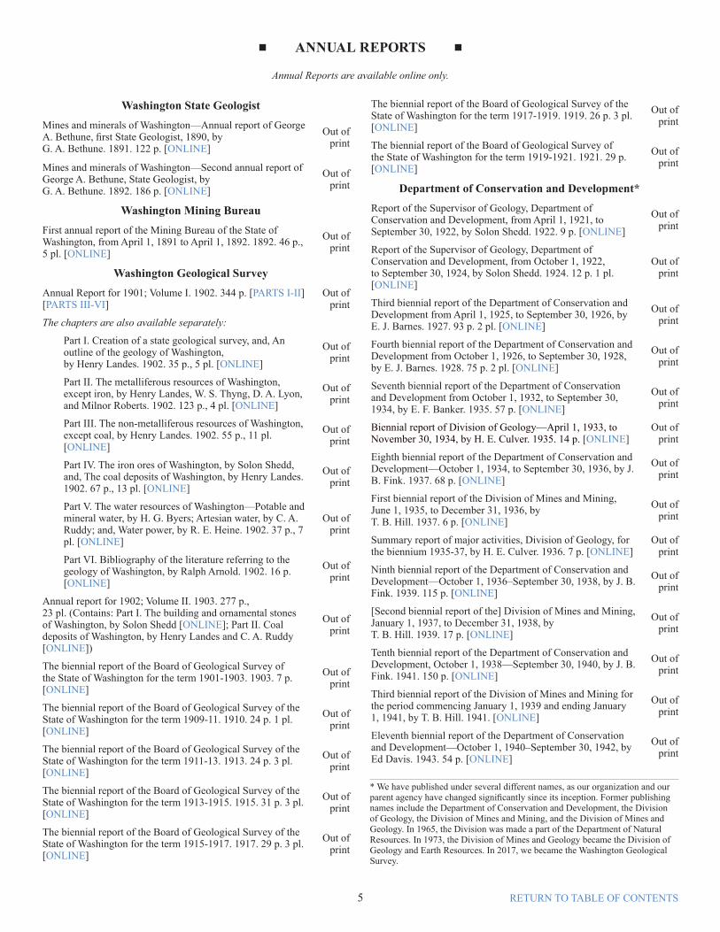
■ ANNUAL REPORTS ■
Annual Reports are available online only.
Washington State GeologistMines and minerals of Washington—Annual report of George A. Bethune, first State Geologist, 1890, by G. A. Bethune. 1891. 122 p. [ONLINE]
Out of print
Mines and minerals of Washington—Second annual report of George A. Bethune, State Geologist, by G. A. Bethune. 1892. 186 p. [ONLINE]
Out of print
Washington Mining BureauFirst annual report of the Mining Bureau of the State of Washington, from April 1, 1891 to April 1, 1892. 1892. 46 p., 5 pl. [ONLINE]
Out of print
Washington Geological SurveyAnnual Report for 1901; Volume I. 1902. 344 p. [PARTS I-II] [PARTS III-VI]
Out of print
The chapters are also available separately:
Part I. Creation of a state geological survey, and, An outline of the geology of Washington, by Henry Landes. 1902. 35 p., 5 pl. [ONLINE]
Out of print
Part II. The metalliferous resources of Washington, except iron, by Henry Landes, W. S. Thyng, D. A. Lyon, and Milnor Roberts. 1902. 123 p., 4 pl. [ONLINE]
Out of print
Part III. The non-metalliferous resources of Washington, except coal, by Henry Landes. 1902. 55 p., 11 pl. [ONLINE]
Out of print
Part IV. The iron ores of Washington, by Solon Shedd, and, The coal deposits of Washington, by Henry Landes. 1902. 67 p., 13 pl. [ONLINE]
Out of print
Part V. The water resources of Washington—Potable and mineral water, by H. G. Byers; Artesian water, by C. A. Ruddy; and, Water power, by R. E. Heine. 1902. 37 p., 7 pl. [ONLINE]
Out of print
Part VI. Bibliography of the literature referring to the geology of Washington, by Ralph Arnold. 1902. 16 p. [ONLINE]
Out of print
Annual report for 1902; Volume II. 1903. 277 p., 23 pl. (Contains: Part I. The building and ornamental stones of Washington, by Solon Shedd [ONLINE]; Part II. Coal deposits of Washington, by Henry Landes and C. A. Ruddy [ONLINE])
Out of print
The biennial report of the Board of Geological Survey of the State of Washington for the term 1901-1903. 1903. 7 p. [ONLINE]
Out of print
The biennial report of the Board of Geological Survey of the State of Washington for the term 1909-11. 1910. 24 p. 1 pl. [ONLINE]
Out of print
The biennial report of the Board of Geological Survey of the State of Washington for the term 1911-13. 1913. 24 p. 3 pl. [ONLINE]
Out of print
The biennial report of the Board of Geological Survey of the State of Washington for the term 1913-1915. 1915. 31 p. 3 pl. [ONLINE]
Out of print
The biennial report of the Board of Geological Survey of the State of Washington for the term 1915-1917. 1917. 29 p. 3 pl. [ONLINE]
Out of print
The biennial report of the Board of Geological Survey of the State of Washington for the term 1917-1919. 1919. 26 p. 3 pl. [ONLINE]
Out of print
The biennial report of the Board of Geological Survey of the State of Washington for the term 1919-1921. 1921. 29 p. [ONLINE]
Out of print
Department of Conservation and Development*Report of the Supervisor of Geology, Department of Conservation and Development, from April 1, 1921, to September 30, 1922, by Solon Shedd. 1922. 9 p. [ONLINE]
Out of print
Report of the Supervisor of Geology, Department of Conservation and Development, from October 1, 1922, to September 30, 1924, by Solon Shedd. 1924. 12 p. 1 pl. [ONLINE]
Out of print
Third biennial report of the Department of Conservation and Development from April 1, 1925, to September 30, 1926, by E. J. Barnes. 1927. 93 p. 2 pl. [ONLINE]
Out of print
Fourth biennial report of the Department of Conservation and Development from October 1, 1926, to September 30, 1928, by E. J. Barnes. 1928. 75 p. 2 pl. [ONLINE]
Out of print
Seventh biennial report of the Department of Conservation and Development from October 1, 1932, to September 30, 1934, by E. F. Banker. 1935. 57 p. [ONLINE]
Out of print
Biennial report of Division of Geology—April 1, 1933, to November 30, 1934, by H. E. Culver. 1935. 14 p. [ONLINE]
Out of print
Eighth biennial report of the Department of Conservation and Development—October 1, 1934, to September 30, 1936, by J. B. Fink. 1937. 68 p. [ONLINE]
Out of print
First biennial report of the Division of Mines and Mining, June 1, 1935, to December 31, 1936, by T. B. Hill. 1937. 6 p. [ONLINE]
Out of print
Summary report of major activities, Division of Geology, for the biennium 1935-37, by H. E. Culver. 1936. 7 p. [ONLINE]
Out of print
Ninth biennial report of the Department of Conservation and Development—October 1, 1936–September 30, 1938, by J. B. Fink. 1939. 115 p. [ONLINE]
Out of print
[Second biennial report of the] Division of Mines and Mining, January 1, 1937, to December 31, 1938, by T. B. Hill. 1939. 17 p. [ONLINE]
Out of print
Tenth biennial report of the Department of Conservation and Development, October 1, 1938—September 30, 1940, by J. B. Fink. 1941. 150 p. [ONLINE]
Out of print
Third biennial report of the Division of Mines and Mining for the period commencing January 1, 1939 and ending January 1, 1941, by T. B. Hill. 1941. [ONLINE]
Out of print
Eleventh biennial report of the Department of Conservation and Development—October 1, 1940–September 30, 1942, by Ed Davis. 1943. 54 p. [ONLINE]
Out of print
* We have published under several different names, as our organization and our parent agency have changed significantly since its inception. Former publishing names include the Department of Conservation and Development, the Division of Geology, the Division of Mines and Mining, and the Division of Mines and Geology. In 1965, the Division was made a part of the Department of Natural Resources. In 1973, the Division of Mines and Geology became the Division of Geology and Earth Resources. In 2017, we became the Washington Geological Survey.
Fourth biennial report of the Division of Mines and Mining for the period commencing October 1, 1940 and ending September 30, 1942, by S. L. Glover. 1943. 9 p. [ONLINE]
Out of print
Twelfth biennial report of the Department of Conservation and Development—October 1, 1942–September 30, 1944, by Ed Davis. 1944. 52 p. [ONLINE]
Out of print
Fifth biennial report of the Division of Mines and Mining for the period commencing October 1, 1942, and ending September 30, 1944, by S. L. Glover. 1944. 6 p. [ONLINE]
Out of print
Biennial report no. 1 of the Division of Mines and Geology for the period commencing October 1, 1944 and ending September 30, 1946, by S. L. Glover. 1946. 24 p. [ONLINE]
Out of print
Biennial report no. 2 of the Division of Mines and Geology for the period commencing October 1, 1946 and ending September 30, 1948; including a report on Washington’s mineral industry, by S. L. Glover. 1948. 28 p. [ONLINE]
Out of print
Biennial report no. 3 of the Division of Mines and Geology for the period commencing October 1, 1948 and ending September 30, 1950, by S. L. Glover. 1951. 13 p. [ONLINE]
Out of print
Biennial report no. 4 of the Division of Mines and Geology for the period commencing October 1, 1950 and ending September 30, 1952, by S. L. Glover. 1952. 8 p. [ONLINE]
Out of print
Biennial report no. 5 of the Division of Mines and Geology for the period commencing July 1, 1952 and ending June 30, 1954; Including a special report: One hundred years of mining, by S. L. Glover. 1954? 20 p. [ONLINE]
Out of print
Biennial report no. 6 of the Division of Mines and Geology for the period commencing July 1, 1954 and ending June 30, 1956, by S. L. Glover. 1956? 12 p. [ONLINE]
Out of print
Biennial report no. 7 of the Division of Mines and Geology for the period commencing July 1, 1956 and ending June 30, 1958, by M. T. Huntting. 1958. 19 p. [ONLINE]
Out of print
Biennial report no. 8 of the Division of Mines and Geology [for the period commencing July 1, 1958 and ending June 30, 1960], by M. T. Huntting. 1960. 26 p. [ONLINE]
Out of print
Biennial report no. 9 [of the] Division of Mines and Geology for the period commencing July 1, 1960 and ending June 30, 1962, by M. T. Huntting. 1962? 19 p. [ONLINE]
Out of print
Biennial report no. 10 [of the] Division of Mines and Geology [for the period commencing July 1, 1962 and ending June 30, 1964], by M. T. Huntting. 1964? 18 p. [ONLINE]
Out of print
Biennial report no. 11 [of the] Division of Mines and Geology [for the period commencing July 1, 1964 and ending June 30, 1966], by M. T. Huntting. 1966? 17 p. [ONLINE]
Out of print
[Biennial report no. 12 of the] Mines and Geology Division [1966-1968], by M. E. Felt. 1968? 5 p. [ONLINE]
Out of print
Department of Natural Resources Division of Geology and Earth Resources
Geology for the decade 1980-1990, by Raymond Lasmanis. 1983. 67 p. [ONLINE]
Out of print
The Washington Division of Geology and Earth Resources—Geology in the public interest. 2003. 4 p. [ONLINE]
Out of print
The Washington Division of Geology and Earth Resources—Geology in the public interest. 2005. 4 p. [ONLINE]
Out of print
The Washington Division of Geology and Earth Resources—Geology in the public interest [short version]. 2005. 2 p. [ONLINE]
Out of print
The Washington Division of Geology and Earth Resources—Geology in the public interest. 2009. 4 p. [ONLINE]
In-print Bulletins are sold through the Washington State Department of Printing General Store (see p. 3)
Washington Geological Survey 1. Geology and ore deposits of Republic mining
district, by J. B. Umpleby. 1910. 66 p., 13 pl., 5 figs. [ONLINE]
Out of print
2. The road materials of Washington, by Henry Landes. 1911. 204 p., 17 pl., 51 figs. [ONLINE]
Out of print
3. The coal fields of King County, by G. W. Evans. 1912. 247 p., 23 pl., 59 figs. [ONLINE]
Out of print
4. Cement materials and industry in Washington, by Solon Shedd. 1913. 268 p., 21 pl., 10 figs. [PART 1] [PART 2]
Out of print
5. Part I. Geology and ore deposits of the Myers Creek mining district; Part II. Geology and ore deposits of the Oroville–Nighthawk mining district, by J. B. Umpleby. 1911. 113 p., 3 pl., 5 figs. [ONLINE]
Out of print
6. Geology and ore deposits of the Blewett mining district, by C. E. Weaver. 1911. 104 p., 10 pl., 1 fig. [ONLINE]
Out of print
7. Geology and ore deposits of the Index mining district, by C. E. Weaver. 1912. 96 p., 7 pl. [ONLINE]
Out of print
8. Glaciation of the Puget Sound region, by J H. Bretz. 1913. 244 p., 24 pl., 27 figs. [ONLINE]
Out of print
9. The coal fields of Kittitas County, by E. J. Saunders. 1914. 204 p., 38 pl., 52 figs. [ONLINE]
Out of print
10. The coal fields of Pierce County, by Joseph Daniels. 1914. 146 p., 30 pl., 23 figs. [ONLINE]
Out of print
11. The mineral resources of Washington, with statistics for 1912, by Henry Landes. 1914. 53 p., 1 pl. [ONLINE]
Out of print
12. Bibliography of Washington geology and geography, by Gretchen O’Donnell. 1913. 63 p.Superseded by the online bibliography.
Out of print
13. The Tertiary formations of western Washington, by C. E. Weaver. 1916. 327 p., 30 figs., 3 pl. [PART 1] [PART 2]
Out of print
14. A preliminary report on the Quincy Valley Irrigation Project, by Henry Landes, A. W. Mangum, H. K. Benson, E. J. Saunders, and Joseph Jacobs. 1912. 49 p., 7 pl. [ONLINE]
Out of print
15. A preliminary report on the Tertiary paleontology of western Washington, by C. E. Weaver. 1912. 80 p., 16 pl. [ONLINE]
Out of print
16. Geology and ore deposits of the Covada mining district, by C. E. Weaver. 1913. 87 p., 5 pl., 3 figs. [ONLINE]
Out of print
17. A geographic dictionary of Washington, by Henry Landes. 1917. 346 p., 10 pl. [PART 1] [PART 2]
Out of print
18. The country about Camp Lewis, by M. M. Leighton. 1918. 105 p., 12 pl., 6 figs. [ONLINE]
Out of print
19. The coal fields of southwestern Washington, by H. E. Culver. 1919. 155 p., 24 pl., 12 figs. [ONLINE]
Out of print
20. The mineral resources of Stevens County, by C. E. Weaver. 1920. 350 p., 20 pl., 14 figs. [PART 1] [PART 2]
Out of print
21. The mineral resources of Washington, with statistics for 1919, by E. N. Patty and S. L. Glover. 1921. 155 p., 13 pl., 3 figs. [ONLINE]
Out of print
22. The road building sands and gravels of Washington, by M. M. Leighton. 1919. 307 p., 9 pl., 36 figs. [ONLINE]
Out of print
23. The metal mines of Washington, by E. N. Patty. 1921. 366 p., 36 pl., 27 figs. [PART 1] [PART 2]
Out of print
Division of Geology24. Clays and shales of Washington, by S. L. Glover. 1941.
368 p., 14 pl., 6 figs. [PART 1] [PART 2]Out of
print25. The magnesite deposits of Washington, their occurrence
and technology, by G. E. Whitwell and E. N. Patty. 1921. 194 p., 13 pl., 5 figs. [ONLINE]
Out of print
26. Underground water supply of the region about White Bluffs and Hanford, by O. P. Jenkins. 1922. 41 p., 3 pl., 1 fig. [ONLINE]
Out of print
27. Iron ores, fuels, and fluxes of Washington, by Solon Shedd, O. P. Jenkins, and H. H. Cooper. 1922. 160 p., 1 pl., 11 figs. [ONLINE]
Out of print
28. Geological investigation of the coal fields of western Whatcom County, Washington, by O. P. Jenkins. 1923. 135 p., 4 pl., 2 figs. [ONLINE]
Out of print
29. Geological investigation of the coal fields of Skagit County, Washington, by O. P. Jenkins. 1924. 63 p., 7 pl., 5 figs. [ONLINE]
Out of print
30. The mineral resources of Washington, with statistics for 1922, by Solon Shedd, with an article on coal and coke by G. W. Evans. 1924. 224 p., 3 figs. [ONLINE]
Out of print
31. Lead deposits of Pend Oreille and Stevens Counties, Washington, by O. P. Jenkins. 1924. 153 p., 3 pl., 15 figs. [ONLINE]
Out of print
32. Geology of Washington, by H. E. Culver. (Part I: General features of Washington geology; to accompany the preliminary geologic map, 1936). 1936. 70 p. [ONLINE]
Out of print
33. Nonmetallic mineral resources of Washington, with statistics for 1933, by S. L.69) Glover. 1936. 135 p. [ONLINE]
Out of print
34. Tungsten resources of Washington, by H. E. Culver and W. A. Broughton. 1945. 89 p., 23 pl., 9 figs. [ONLINE]
Out of print
35. Bibliography and index of geology and mineral resources of Washington, 1814–1936, by W. A. G. Bennett. 1939. 140 p. Superseded by the online bibliography.
Out of print
Division of Mines and Geology36. Geology and ore deposits of the Sultan Basin,
Snohomish County, Washington, by Ward Carithers and A. K. Guard. 1945. 90 p., 3 pl., 18 figs. [ONLINE]
Out of print
37. Inventory of Washington minerals:
Part I. (2nd ed.) Nonmetallic minerals, by G. M. Valentine, revised by M. T. Huntting. 1960. 2 v. (v. 1, 175 p. text; v. 2, maps, 39 pl.). [TEXT] [MAPS]
In print
Part II. Metallic minerals, by M. T. Huntting. 1956. 2 v. (v. 1, 428 p. text; v. 2, maps, 67 p. text, 27 pl.). [PART 1, PART 2, PART 3, PART 4, MAPS]
38. The place of steam-electric generating stations in the orderly program of electric power development in the Pacific Northwest, by H. H. Houston. 1950. 117 p., 1 pl., 25 figs. [ONLINE]
Out of print
39. Antimony occurrences of Washington, by C. P. Purdy Jr. 1951. 186 p., 14 figs. [ONLINE]
Out of print
40. Geology of the Bead Lake district, Pend Oreille County, Washington, by M. C. Schroeder. 1952. 57 p., 1 pl., 6 figs. [ONLINE]
Out of print
41. An outline of mining laws of the State of Washington [includes 16 p. supplement], compiled and annotated by M. H. Van Nuys. 1953. 142 p. [ONLINE]
Out of print
42. Gold in Washington, by M. T. Huntting. 1955. 158 p., 2 figs. [ONLINE]
Web only
43. Eocene stratigraphy of the lower Cowlitz River–eastern Willapa Hills area, southwestern Washington, by D. A. Henriksen. 1956. 122 p. [ONLINE]
In print
44. Peat resources of Washington, by G. B. Rigg. 1958. 272 p., 1 pl., 263 figs. [PART 1] [PART 2] [PART 3]
Out of print
45. Washington’s channeled scabland, by J H. Bretz. 1959. 57 p., 4 pl., 36 figs. [ONLINE]
Out of print
46. Bibliography and index of the geology and mineral resources of Washington, 1937–1956, by W. H. Reichert. 1960. 721 p. Superseded by the online bibliography.
Out of print
47. Coal reserves of Washington, by H. M. Beikman, H. D. Gower, and T. A. M. Dana. 1961. 115 p. [Reprinted with 15-p. addendum by H. W. Schasse, T. J. Walsh, and W. M. Phillips. 1984.] [ONLINE]
In print
48. High-calcium limestones of eastern Washington, by J. W. Mills. 1962. 268 p., 7 pl., 64 figs. [PART 1] [PART 2] [PART 3] [PART 4]
Out of print
49. Saline lake deposits in Washington, by W. A. G. Bennett. 1962. 129 p. [ONLINE]
In print
50. Geology and mineral deposits of the north half of the Van Zandt quadrangle, Whatcom County, Washington, by W. S. Moen. 1962. 129 p., 4 pl., 41 figs. [ONLINE]
Out of Print
51. Barite in Washington, by W. S. Moen. 1964. 112 p., 2 pl. [ONLINE]
In print
52. Limestone resources of western Washington, by W. R. Danner. 1966. 474 p. [PART 1] [PART 2] [PART 3]
In print
53. Stratigraphy and foraminifera of the Satsop River area, southern Olympic Peninsula, Washington, by W. W. Rau. 1966. 66 p. [ONLINE]
In print
54. Geology and mineral resources of the Kelso–Cathlamet area, Cowlitz and Wahkiakum Counties, Washington, by V. E. Livingston Jr. 1966. 110 p., 23 figs. [ONLINE]
Out of print
55. Building stone of Washington, by W. S. Moen. 1967. 85 p. [ONLINE]
In print
56. Geology of the Wynoochee Valley [15-minute] quadrangle, Grays Harbor County, Washington, by W. W. Rau. 1967. 51 p., 1 pl., scale 1:62,500. [ONLINE]
In print
57. Mines and mineral deposits of Whatcom County, Washington, by W. S. Moen. 1969. 134 p., 14 pl., 44 figs. [PART 1] [PART 2]
Out of print
58. Chemical and physical controls for base metal deposition in the Cascade Range of Washington, by A. R. Grant. 1969. 107 p., 33 figs. [ONLINE]
Out of print
59. Bibliography and index of the geology and mineral resources of Washington, 1957–1962, by W. H. Reichert. 1969. 375 p. Superseded by the online bibliography.
Out of print
60. Cenozoic volcanism in the Cascade Mountains of southern Washington, by W. S. Wise. 1970. 45 p., 1 pl., 14 figs. [ONLINE]
Out of print
61. Lead-zinc deposits in the Kootenay arc, northeastern Washington and adjacent British Columbia, edited by A. E. Weissenborn, F. C. Armstrong, and J. T. Fyles. 1970. 123 p. [ONLINE]
In print
62. Foraminifera, stratigraphy, and paleo ecol ogy of the Quinault Formation, Point Gren ville–Raft River coastal area, Washington, by W. W. Rau. 1970. 41 p. [ONLINE]
In print
63. Geology and mineral resources of King County, Washington, by V. E. Livingston Jr. 1971. 200 p., 6 pl., 103 figs. [PART 1, PART 2]
Out of print
64. Geology and mineral deposits of the Loomis [15-minute] quadrangle, Okanogan County, Washington, by C. D. Rinehart and K. F. Fox Jr. 1972. 124 p., 3 pl. (pl. 1: 27 x 33 in. color geologic map, scale 1:62,500), 32 figs. [ONLINE]
Out of print
65. Distribution of copper and other metals in gully sediments of part of Okanogan County, Washington, by K. F. Fox Jr., and C. D. Rine hart. 1972. 38 p., 4 pl. (pl. 1: 26 x 28 in. color geologic map, scale 1:96,000, with 2 overlays), 10 figs. [ONLINE]
In print
Division of Geology and Earth Resources66. Geology of the Washington coast between Point
Grenville and the Hoh River, by W. W. Rau. 1973. 58 p. [ONLINE]
In print
67. Mining laws of the State of Washington, by J. L. Neff and R. L. Magnuson. 1974. 109 p., 9 figs. [ONLINE]
Out of print
68. Geology of the Methow Valley, Okanogan County, Washington, by J. D. Barksdale. 1975. 72 p., 1 pl., 17 figs. [ONLINE]
Out of print
69. Silver occurrences of Washington, by W. S. Moen. 1976. 188 p. [Reprinted 1982.] [ONLINE]
In print
70. Zinc and lead ore deposits in carbonate rocks, Stevens County, Washington, by J. W. Mills. 1977. 171 p. [ONLINE]
In print
71. Geology of parts of Grant, Adams, and Franklin Counties, east-central Washington, by M. J. Grolier and J. W. Bingham. 1978. 91 p., 33 figs. [ONLINE]
Out of print
72. Washington coastal geology between the Hoh and Quillayute Rivers, by W. W. Rau. 1980. 57 p. [ONLINE]
In print
73. Myers Creek and Wauconda mining districts of northeastern Okanogan County, Washington, by W. S. Moen. 1980. 96 p., 6 pl., 36 figs. [ONLINE]
Out of print
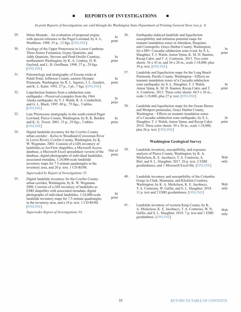
■ BULLETINS ■
In-print Bulletins are sold through the Washington State Department of Printing General Store (see p. 3)
74. Reconnaissance geochemical survey of gully and stream sediments, and geologic summary, in part of the Okanogan Range, Okanogan County, Washington, by C. D. Rine hart. 1981. 24 p., 3 pl. [ONLINE]
In print
75. Geology of the Wenatchee and Monitor quadrangles, Chelan and Douglas Counties, Washington, by R. L. Gresens. 1983. 75 p., 3 pl., scale 1:24,000. [ONLINE]
In print
76. Bibliography and index of the geology and mineral resources of Washington, 1963–1980, compiled by C. J. Manson and Debbie Burnetti. 1983. 398 p. Superseded by the online bibliography.
Out of print
77. Selected papers on the geology of Washington, edited by J. E. Schuster. 1987. 406 p. [PART 1] [PART 2] [PART 3]
In print
78. Engineering geology in Washington, edited by R. W. Galster, chairman. 1989. [2 v.], 1234 p. [VOL 1 PART 1] [VOL 1 PART 2] [ VOL 1 PART 3, [ VOL 1 PART 4] [VOL 1 PART 5] [ VOL 2 PART 1] [ VOL 2 PART 2] [VOL 2 PART 3] [VOL 2 PART 4]
In print
79. Bibliography and index of the geology and mineral resources of Washington, 1981–1985, compiled by C. J. Manson. 1990. 484 p. Superseded by the online bibliography.
Out of print
80. Regional Geology of Washington State, Raymond Lasmanis and E. S. Cheney, convenors. 1994. 227 p., 136 figs., 18 tables. [PART 1, PART 2]
Out of print
81. Bibliography and index of the geology and mineral resources of Washington, 1986–1990, by C. J. Manson. 1996. 476 p. Superseded by the online bibliography.
Out of print
Washington Geological Survey82. Protocol for landslide inventory mapping from lidar
data in Washington State, S. L. Slaughter, W. J. Burns, K. A. Mickelson, K. E. Jacobacci, Alyssa Biel, and T. A. Contreras. 2017. 27 p., 2 ESRI geodatabases, and 1 Excel data supplement. [ONLINE]
Web only
■ DIGITAL DATA SERIES ■
Digital Data Series are available online only.
1. Washington State seismogenic features database—GIS data, by J. D. Bowman and J. L. Czajkowski. 2019. [ONLINE]
Web only
2. Washington State aeromagnetic and gravity anomaly data—GIS data, by J. D. Bowman. 2013. [ONLINE]
Web only
3. Volcanic vents database for Washington State—GIS data, by J. L. Czajkowski and J. D. Bowman. 2013. [ONLINE]
Web only
4. Geothermal direct-use database in Washington State—GIS data, by J. D. Bowman. 2014. [ONLINE]
Web only
5. Washington State rock geochemistry database—GIS data, by J. D. Bowman, J. L. Czajkowski, S. P. Reidel, D. E. Boschmann, and L. A. Fusso. 2014. [ONLINE]
Web only
6. Washington State geochronology database—GIS data, by J. L. Czajkowski. 2016. [ONLINE]
Web only
7. Thermal and mineral springs database for Washington State—GIS data, by J. L. Czajkowski, J. D. Bowman, L.A. Fusso, and D. E. Boschmann. 2014. [ONLINE]
Web only
8. Washington State geothermal well database—GIS data, by J. L. Czajkowski, J. D. Bowman, L. A. Fusso, and D. E. Boschmann. 2014. [ONLINE]
Web only
9. Washington State geothermal favorability model database—GIS data, by D. E. Boshmann, J. L. Czajkowski, and J. D. Bowman. 2014. [ONLINE]
Web only
10 Surface geology, 1:24,000—GIS data, by Washington Division of Geology and Earth Resources. 2017. [ONLINE]
Web only
11. Subsurface database of Washington State—GIS data, by D. A. Jeschke, D. W. Eungard, K. G. Troost, and A. P. Wisher. 2019. [ONLINE]
Web only
13 Metallic minerals database—GIS data, by Washington Division of Geology and Earth Resources. 2015. [ONLINE]
Web only
14 Nonmetallic (industrial) minerals database—GIS data, by Washington Division of Geology and Earth Resources. 2015. [ONLINE]
Web only
15 Hazardous minerals database—GIS data, by Washington Division of Geology and Earth Resources. 2015. [ONLINE]
Web only
16 Coal database—GIS data, by Washington Division of Geology and Earth Resources. 2015. [ONLINE]
Web only
17 Shear wave database—GIS data, by Washington Division of Geology and Earth Resources. 2016. [ONLINE]
Web only
18 Surface geology, 1:100,000—GIS data, by Washington Division of Geology and Earth Resources. 2016. [ONLINE]
Web only
Washington Geological Survey
12 Landslides compilation of Washington State—GIS data, by Washington Geological Survey, 2019. [ONLINE]
Web only
19 Landslide inventory protocol mapping—GIS data, by Washington Geological Survey, 2019. [ONLINE]
Web only
20 Coal mine maps—GIS data, by Washington Geological Survey, 2017. [ONLINE]
Web only
21 Oil and Gas Wells—GIS data, by Washington Geological Survey, 2019. [ONLINE]
Web only
■ BULLETINS ■
In-print Bulletins are sold through the Washington State Department of Printing General Store (see p. 3)
1. Digital bibliography of the geology and mineral resources of Washington State, 1798–2000, by C. J. Manson, editor and compiler. 20010. Superseded by the online bibliography.
Lib. use
only
2. Digital geologic maps of the 1:100,000 quadrangles of Washington, by Washington Division of Geology and Earth Resources staff. 2001 and 2003. Superseded by the Geologic Information Portal.
Lib. use
only
3. Digital inventory of flood-plain mines in Washington State, by L. R. Baker, K. W. Wegmann, D. T. McKay Jr., D. K. Norman, and C. N. Johnson. 2003. Includes ArcView files plus 4 p. text as a PDF file. [ONLINE]
Web only
4. Pacific Northwest Tertiary foraminiferal collections of the U.S. Geological Survey and the state of Washington, by W. W. Rau. 2004. 1 Microsoft Excel spreadsheet with 9 p. text as a PDF file. [ONLINE]
Web only
■ FACT SHEETS ■
Fact Sheets are available online only.
Geology in the public interest. 2015. 4 p. [ONLINE]
Web only
The Washington Geology Library. 2015. 2 p. [ONLINE]
Web only
Landslide hazards in Washington state. 2015. 2 p. [ONLINE]
Web only
What are landslides and how do they occur? 2015. 2 p. [ONLINE]
Web only
Washington State Geologic Information Portal. 2014. 2 p. [ONLINE]
Web only
■ FIELD TRIP GUIDES ■
In-print Field Trip Guides are sold through the Washington State Department of Printing General Store (see p. 3)
Geology of the Yakima Valley wine country—A geologic field trip guide from Stevenson to Zillah, Washington, by D. K. Norman, A. J. Busacca, and Ron Teissere. 2004. Color, 13 p. [ONLINE]
In print
Geologic guide to the Yakima Valley wine-growing region, Benton and Yakima Counties, Washington, by D. K. Norman and A. J. Busacca. 2008. 10 p. [ONLINE]
Web only
Geologic Field Trip to the Aldercrest–Banyon Landslide and Mount St. Helens, Washington, Part I—Stevenson to Castle Rock, by K. W. Wegmann. 2004. 24 p. [ONLINE]
Web only
Waterfall loop tour on the historic Columbia River Highway [Oregon] [ONLINE]
Web only
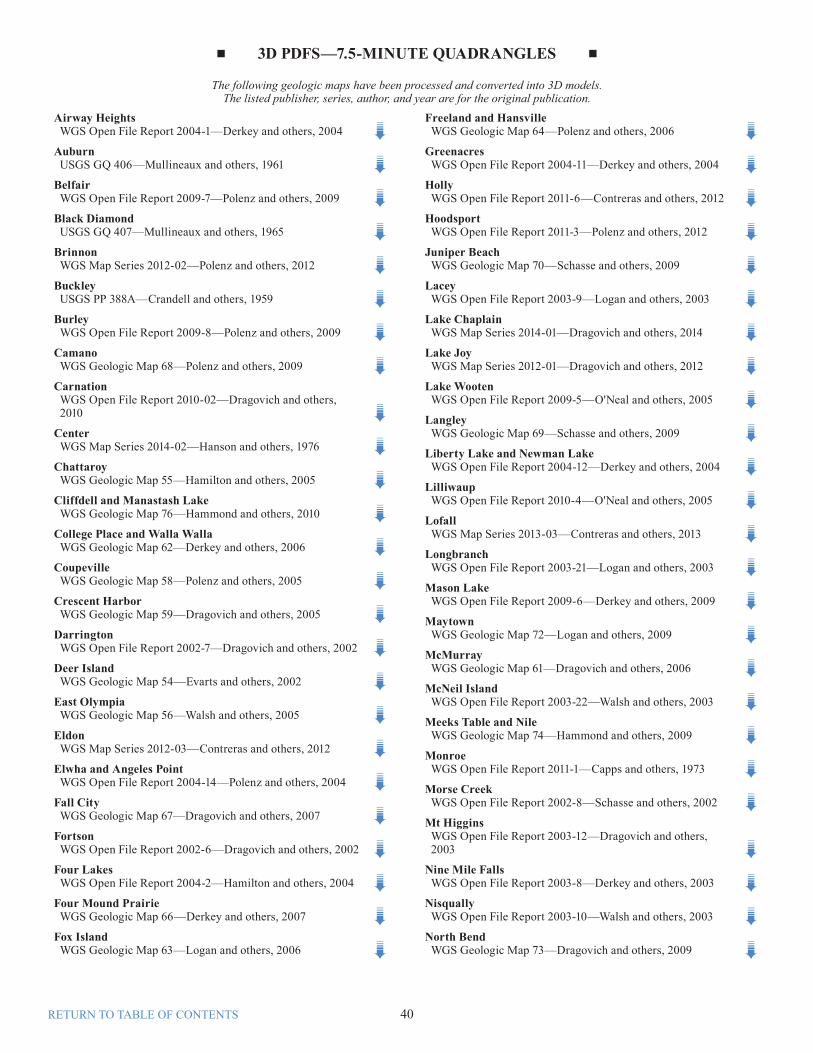
■ GEOLOGIC MAPS ■
In-print Geologic Maps are sold through the Washington State Department of Printing General Store (see p. 3)
Note: Geologic maps may also be found under other categories, such as Open File Reports, Bulletins, and Information Circulars.
Division of GeologyPreliminary geologic map, State of Washington, compiled from published and unpublished sources, edited by G. W. Stose. 1936. 53 x 35 in. color sheet, scale 1:500,000. [Accompanied by Bulletin 32, which is out of print.] [ONLINE]
Out of print
Division of Mines and GeologyGeologic map of Washington, by M. T. Huntting, W. A. G. Bennett, V. E. Livingston Jr., and W. S. Moen. 1961. One 75 x 50 in. color sheet or two 50 x 40 in. color sheets, scale 1:500,000. [1 SHEET] [SHEET 1 OF 2] [SHEET 2 OF 2]
Out of print
Geologic cross section to accompany the 1961 Geologic map of Washington, by V. E. Livingston, Jr. 1961. 1 sheet, scale 1:500,000. [ONLINE]
Out of print
GM-1. Preliminary geologic map of the Hobart and Maple Valley [7.5-minute] quadrangles, King County, Washington, by J. D. Vine. 1962. 43 x 36 in. color sheet, scale 1:24,000. [ONLINE]
In print
GM-2. Preliminary geologic map of the Cumberland [7.5-minute] quadrangle, King County, Washington, by H. D. Gower and A. A. Wanek. 1963. 30 x 41 in. color sheet, scale 1:24,000. [ONLINE]
In print
GM-3. Geology of the Simcoe Mountains volcanic area, Washington, by R. A. Sheppard. 1967. 43 x 23 in. sheet, scale 1:125,000. [ONLINE]
In print
GM-4. Geology of the Grays River [15-minute] quadrangle, Wahkiakum and Pacific Counties, Washington, by E. W. Wolfe and E. H. McKee. 1968. 23 x 34 in. color sheet, scale 1:62,500, with 6 p. text. [ONLINE]
GM-5. Preliminary geologic map of the Chewelah Mountain [15-minute] quadrangle, Stevens County, Washington, by L. D. Clark and F. K. Miller. 1968. Two 25 x 32 in. color sheets, scale 1:62,500, with 6 p. text. [ONLINE]
In print
GM-6. Preliminary geologic map of the Loon Lake [15-minute] quadrangle, Stevens and Spokane Counties, Washington, by F. K. Miller. 1969. 30 x 29 in. color sheet, scale 1:62,500, with 7 p. text. [ONLINE]
In print
Division of Geology and Earth ResourcesGM-7. Preliminary geologic map of the Newport Number
1 [15-minute] quadrangle, Pend Oreille County, Washington, and Bonner County, Idaho, by F. K. Miller. 1974. 24 x 31 in. color sheet, scale 1:62,500, with 6 p. text. [ONLINE]
Out of print
GM-8. Preliminary geologic map of the Newport Number 2 [15-minute] quadrangle, Pend Oreille and Stevens Counties, Washington, by F. K. Miller. 1974. 22 x 32 in. color sheet, scale 1:62,500, with 6 p. text. [ONLINE]
Out of print
GM-9. Preliminary geologic map of the Newport Number 3 [15-minute] quadrangle, Pend Oreille, Stevens, and Spokane Counties, Washington, by F. K. Miller. 1974. 23 x 32 in. color sheet, scale 1:62,500, with 7 p. text. [ONLINE]
Out of print
GM-10. Preliminary geologic map of the Newport Number 4 [15-minute] quadrangle, Spokane and Pend Oreille Counties, Washington, and Bonner County, Idaho, by F. K. Miller. 1974. 24 x 30 in. color sheet, scale 1:62,500, 6 p. text. [ONLINE]
Out of print
GM-11. Complete Bouguer gravity anomaly map of Washington, by W. E. Bonini, D. W. Hughes, and Z. F. Daneš. 1974. 59 x 43 in. sheet, scale 1:500,000. [ONLINE]
Out of print
GM-12. Thickness of unconsolidated sediments, Puget Lowland, Washington, by J. B. Hall and K. L. Othberg. 1974. 23 x 35 in. sheet, scale 1:250,000, with 3 p. text. [ONLINE]
Out of print
GM-13. Geologic map of the Destruction Island and Taholah [15-minute] quadrangles, Washington, by W. W. Rau. 1975. 36 x 47 color sheet, scale 1:62,500. [ONLINE]
Out of print
GM-14. Preliminary surficial geologic map of the Edmonds East and Edmonds West [7.5-minute] quadrangles, Snohomish and King Counties, Washington, by Mackey Smith. 1975. 31 x 24 in. sheet, scale 1:24,000. [ONLINE]
Out of print
GM-15. Slope stability map of Thurston County, Washington, by E. R. Artim. 1976. 31 x 19 in. color sheet, scale 1:125,000. [ONLINE]
In print
GM-16. Relative ground settlement hazards of Thurston County, Washington, by E. R. Artim. 1976. 31 x 19 in. color sheet, scale 1:125,000. [ONLINE]
In print
GM-17. Relative potential for differential settlement, Gig Harbor Peninsula, Pierce County, Washington, by Mackey Smith. 1976. 21 x 35 in. color sheet, scale 1:31,250. [ONLINE]
In print
GM-18. Relative slope stability of Gig Harbor Peninsula, Pierce County, Washington, by Mackey Smith. 1976. 21 x 35 in. color sheet, scale 1:31,250. [ONLINE]
In print
GM-19. Geologic factors affecting waste disposal practices, Gig Harbor Peninsula, Pierce County, Washington, by Mackey Smith. 1976. 1 sheet (21 x 35 in.), scale 1:31,250. [ONLINE]
In print
GM-20. Preliminary surficial geologic map of the Mukilteo and Everett [7.5-minute] quadrangles, Snohomish County, Washington, by Mackey Smith. 1976. 35 x 24 in. sheet, scale 1:24,000. [ONLINE]
In print
GM-21. Mineral resources of the southern Hood Canal area, Washington, by Mackey Smith and R. J. Carson. 1976. 23 x 27 in. sheet, scale 1:62,500. [ONLINE]
In print
GM-22. Mineral resource maps of Washington, by W. S. Moen. 1978. Four 28 x 19 in. color sheets, scale 1:1,000,000, with 4 p. text. [Reprinted 1986.] [ONLINE]
In print
GM-23. Geologic map of the Marblemount [15-minute] quadrangle, Washington, by Peter Misch. 1979. 36 x 30 in. color sheet, scale 1:48,000. [ONLINE]
In print
GM-24. Geologic map in the vicinity of the lower Bogachiel and Hoh River valleys and the Washington coast, by W. W. Rau. 1979. 29 x 47 in. color sheet, scale 1:62,500. [ONLINE]
In print
GM-25. Geothermal resources of Washington, compiled by M. A. Korosec, K. L. Kaler, J. E. Schuster, R. G. Bloomquist, S. J. Simpson, and D. D. Blackwell. 1981. 50 x 42 in. color sheet, scale 1:500,000. [ONLINE]
In print
GM-26. Geology of the Pullman, Moscow West, Colton, and Uniontown 7½-minute quadrangles, Washington and Idaho, by P. R. Hooper and G. D. Webster. 1982. 33 x 22 in. two-color sheet, scale 1:62,500. [ONLINE]
Out of print
GM-27. Complete Bouguer gravity anomaly map, Cascade Mountains, Washington, by Z. F. Daneš and W. M. Phillips. 1983. Two 24 x 35 in. two-color sheets, scale 1:250,000. [ONLINE]
In print
GM-28. Geologic map of the Ellensburg [15-minute] quadrangle, Washington, by R. D. Bentley and N. P. Campbell. 1983. 34 x 23 in. two-color sheet, scale 1:62,500. [ONLINE]
Out of print
GM-29. Geologic map of the Yakima quadrangle, Washington, by R. D. Bentley and N. P. Campbell. 1983. 34 x 23 in. two-color sheet, scale 1:62,500. [ONLINE]
Out of print
GM-30. Availability of Federal land for mineral exploration and development in the State of Washington, by D. P. Banister, D. J. Barnes, and W. D. Longwill. 1984. Four 50 x 37 in. color sheets, scale 1:500,000, with 17 p. text. [ONLINE]
In print
GM-31. Geologic map of the Clarkston 15-minute quadrangle, Washington and Idaho, by P. R. Hooper, G. D. Webster, and V. E. Camp. 1985. 27 x 33 in. color sheet, scale 1:48,000, with 11 p. text. [ONLINE]
Out of print
GM-32. Geologic maps of the Marcus and Kettle Falls [7.5-minute] quadrangles, Stevens and Ferry Counties, Washington, by J. W. Mills. 1985. Two 27 x 29 in. color sheets, scale 1:24,000, with 18 p. text. [ONLINE]
In print
■ GEOLOGIC MAPS ■
In-print Geologic Maps are sold through the Washington State Department of Printing General Store (see p. 3)
GM-33. Geologic map of the Humptulips [15-minute] quadrangle and adjacent areas, Grays Harbor County, Washington, by W. W. Rau. 1986. 31 x 41 in. color sheet, scale 1:62,500. [ONLINE]
In print
GM-34. Geologic map of Washington—Southwest quadrant, by T. J. Walsh, M. A. Korosec, W. M. Phillips, R. L. Logan, and H. W. Schasse. 1987. 54 x 39 in. color sheet, scale 1:250,000, and accompanying explanatory sheet (63 x 40 in.), with 28 p. text. [ONLINE]
In print
GM-35. Geologic map of the Bluelight 15-minute quadrangle, Washington, by R. D. Bentley, N. P. Campbell, and J. E. Powell. 1988. 25 x 37 in. two-color sheet, scale 1:48,000. [ONLINE]
In print
GM-36. Geologic map of the Poisel Butte 15-minute quadrangle, Washington, by R. D. Bentley, N. P. Campbell, and J. E. Powell. 1988. 25 x 37 in. two-color sheet, scale 1:48,000. [ONLINE]
In print
GM-37. Geologic map of the Logy Creek 15-minute quadrangle, Washington, by R. D. Bentley, N. P. Campbell, and J. E. Powell. 1988. 26 x 37 in. two-color sheet, scale 1:48,000. [ONLINE]
In print
GM-38. Geologic map of the Saddle Mountains, Washington, by S. P. Reidel. 1988. 28 p., 5 pl. (3 two-color)(pl. 1 & 2, 25 x 16 in.; pl. 3, 18 x 27 in.; pl. 4, 27 x 19 in.; pl. 5, 25 x 21 in.), scale 1:48,000. [ONLINE]
In print
GM-39. Geologic map of Washington—Northeast quadrant, by K. L. Stoffel, N. L. Joseph, S. Z. Waggoner, C. W. Gulick, M. A. Korosec, and B. B. Bunning. 1991. 62 x 39 in. color sheet, scale 1:250,000, and two accompanying explanatory sheets (57 x 39 in. and 46 x 39 in.), including a bedrock geologic and tectonic map at 1:625,000 scale, with 36 p. text. [ONLINE]
In print
GM-40. Geologic map of southeast Asotin County, Washington, by S. P. Reidel, P. R. Hooper, G. D. Webster, and V. E. Camp. 1992. 27 x 38 in. two-color sheet, scale 1:48,000, with 22 p. text. [ONLINE]
In print
GM-41. Liquefaction susceptibility for the Des Moines and Renton 7.5-minute quadrangles, Washington, by S. P. Palmer, H. W. Schasse, and D. K. Norman. 1994. Two 28 x 27 in. color sheets, scale 1:24,000, with 15 p. text. [ONLINE]
In print
GM-42. Relative earthquake hazard map for the Vancouver, Washington, urban region, by M. A. Mabey, I. P. Madin, and S. P. Palmer. 1994. Two color sheets (28 x 30 in. and 28 x 32 in.), scale 1:24,000, with 5 p. text. [ONLINE]
In print
GM-43. Liquefaction susceptibility for the Auburn and Poverty Bay 7.5-minute quadrangles, Washington, by S. P. Palmer, T. J. Walsh, R. L. Logan, and W. G. Gerstel. 1995. Two 24 x 26 in. color sheets, scale 1:24,000, with 15 p. text. [ONLINE]
In print
GM-44. Liquefaction susceptibility for the Sumner 7.5-minute quadrangles, Washington, by J. D. Dragovich and P. T. Pringle, with a section on liquefaction by S. P. Palmer. 1995. 24 x 26 in. color sheet, scale 1:24,000, with 26 p. text. [ONLINE]
In print
GM-45. Geologic map of Washington—Southeast quadrant, by J. E. Schuster, C. W. Gulick, S. P. Reidel, K. R. Fecht, and Stephanie Zurenko. 1997. 62 x 39 in. color sheet, scale 1:250,000, and accompanying explanatory sheet (38 x 31 in.) with bedrock geology and tectonic map at 1:625,000, with 20 p. text. [ONLINE]
In print
GM-46. Geologic map and bedrock history of the Gilbert 7.5-minute quadrangle, Chelan and Okanogan Counties, Washington, by J. D. Dragovich, D. K. Norman, R. A. Haugerud, and R. B. Miller. 1997. 40 x 28 in. two-color sheet, scale 1:24,000, with 67 p. text. [ONLINE]
In print
GM-47. Geologic folio of the Olympia–Lacey–Tumwater urban area, Washington—Liquefaction susceptibility map, by S. P. Palmer, T. J. Walsh, and W. G. Gerstel. 1999. 31 x 27 in. color sheet, scale 1:48,000, with 16 p. text. [ONLINE]
Out of print
GM-48. Liquefaction susceptibility of the greater Eastside area, King County, Washington, by S. P. Palmer, B. D. Evans, and H. W. Schasse. 2002. 29 x 36 in. color sheet, scale 1:36,000, with 14 p. text. [ONLINE]
In print
GM-49. Tsunami hazard map of the southern Washington coast—Modeled tsunami inundation from a Cascadia subduction zone earthquake, by T. J. Walsh, C. G. Caruthers, A. C. Heinitz, E. P. Myers III, A. M. Baptista, G. B. Erdakos, and R. A. Kamphaus. 2000. 26 x 52 color sheet, scale 1:100,000, with 12 p. text. [ONLINE]
In print
GM-50. Geologic map of Washington—Northwest quadrant, by J. D. Dragovich, R. L. Logan, H. W. Schasse, T. J. Walsh, W. S. Lingley Jr., D. K. Norman, W. J. Gerstel, T. J. Lapen, J. E. Schuster, and K. D. Meyers. 2002. 62 x 45 in. color sheet, scale 1:250,000, and two accompanying explanatory sheets (52 x 36 in. and 40 x 33 in.), with 72 p. text. [ONLINE]
In print
GM-51. Liquefaction susceptibility of the greater Tacoma urban area, Pierce and King Counties, Washington, by S. P. Palmer, W. J. Perkins, and W. P. Grant. 2003. 48 x 36 in. color pl., scale 1:30,000, with 11 p. text. [ONLINE]
In print
GM-52. Tectonic elements and evolution of northwest Washington, by E. H. Brown and J. D. Dragovich. 2003. 38 x 36 in. color sheet, scale 1:625,000, with 12 p. text. [ONLINE]
In print
GM-53. Geologic map of Washington State, by J. E. Schuster. 2005. 55.5 x 36 in. color sheet, scale 1:500,000, with 44 p. text. [ONLINE]
In print
GM-54. Geologic map of the Deer Park 7.5-minute quadrangle, Spokane County, Washington, by R. E. Derkey, M. M. Hamilton, and D. F. Stradling. 2005. 36 x 42 in. color sheet, scale 1:24,000. [ONLINE]
In print
GM-55. Geologic map of the Chattaroy 7.5-minute quadrangle, Spokane County, Washington, by R. E. Derkey, M. M. Hamilton, and D. F. Stradling. 2005. 36 x 42 in. color sheet, scale 1:24,000. [ONLINE]
In print
GM-56. Geologic map of the East Olympia 7.5-minute quadrangle, Thurston County, Washington, by T. J. Walsh and R. L. Logan. 2005. 42 x 36 in. color sheet, scale 1:24,000. [ONLINE]
In print
■ GEOLOGIC MAPS ■
In-print Geologic Maps are sold through the Washington State Department of Printing General Store (see p. 3)
In-print Geologic Maps are sold through the Washington State Department of Printing General Store (see p. 3)
GM-57. Geologic map of the Port Townsend South and part of the Port Townsend North 7.5-minute quadrangles, Jefferson County, Washington, by H. W. Schasse and S. L. Slaughter. 2005. 42 x 36 in. color sheet, scale 1:24,000. [ONLINE]
In print
GM-58. Geologic map of the Coupeville and part of the Port Townsend North 7.5-minute quadrangles, Island County, Washington, by Michael Polenz, S. L. Slaughter, and G. W. Thorsen. 2005. 50 x 36 in. color sheet, scale 1:24,000. [ONLINE]
In print
GM-59. Geologic map of the Oak Harbor, Crescent Harbor, and part of the Smith Island 7.5-minute quadrangles, Island County, Washington, by J. D. Dragovich, G. T. Petro, G. W. Thorsen, S. L. Larson, G. R. Foster, and D. K. Norman. 2005. Two 42 x 36 in. color sheets, scale 1:24,000. [ONLINE]
In print
GM-60. Geologic map of the Timberwolf Mountain 7.5-minute quadrangle, Yakima County, Washington, by P. E. Hammond. 2005. 48 x 36 in. color sheet, scale 1:24,000. Additional information available as Open File Report 2005-5. [ONLINE]
In print
GM-61. Geologic map of the McMurray 7.5-minute quadrangle, Skagit and Snohomish Counties, Washington, with a discussion of the evidence for Holocene activity on the Darrington–Devils Mountain fault zone, by J. D. Dragovich and A. J. DeOme. 2006. 33 x 36 in. color sheet, scale 1:24,000, with 18 p. text. [ONLINE]
In print
GM-62. Geologic map of the College Place and Walla Walla 7.5-minute quadrangles, Walla Walla County, Washington, and Umatilla County, Oregon, by R. E. Derkey, D. F. Stradling, K. A. Lindsey, and T. L. Tolan. 2006. 46 x 36 in. color sheet, scale 1:24,000. [ONLINE]
In print
GM-63. Geologic map of the Fox Island 7.5-minute quadrangle, Pierce County, Washington, by R. L. Logan, T. J. Walsh, and K. G. Troost. 2006. 33 x 36 in. color sheet, scale 1:24,000. [ONLINE]
In print
GM-64. Geologic map of the Freeland and northern part of the Hansville 7.5-minute quadrangles, Island County, Washington, by Michael Polenz, H. W. Schasse, and B. B. Petersen. 2006. 46 x 36 in. color sheet, scale 1:24,000. [ONLINE]
In print
GM-65. Geologic map of the Vaughn 7.5-minute quadrangle, Pierce and Mason Counties, Washington, by R. L. Logan and T. J. Walsh. 2007. 42 x 36 in. color sheet, scale 1:24,000. [ONLINE].
In print
GM-66. Geologic map of the Four Mound Prairie 7.5-minute quadrangle, Spokane and Stevens Counties, Washington, by R. E. Derkey and M. M. Hamilton. 2007. 42 x 36 in. color sheet, scale 1:24,000. [ONLINE]
In print
GM-67. Geologic map of the Fall City 7.5-minute quadrangle, King County, Washington, by J. D. Dragovich, M. L. Anderson, T. J. Walsh, B. L. Johnson, and T. L. Adams. 2007. 42 x 36 in. color sheet, scale 1:24,000, with 16 p. text. [ONLINE]
In print
GM-68 Geologic map of the Camano 7.5-minute quadrangle, Island County, Washington, by Michael Polenz, H. W. Schasse, M. L. Kalk, and B. B. Petersen. 2009. 48 x 36 in. color sheet, scale 1:24,000. [ONLINE]
In print
GM-69 Geologic map of the Langley and western part of the Tulalip 7.5-minute quadrangles, Island County, Washington, by H. W. Schasse, M. L. Kalk, B. B. Petersen, and Michael Polenz, 2009. 47 x 36 in. color sheet, scale 1:24,000. [ONLINE]
In print
GM-70 Geologic map of the Juniper Beach 7.5-minute quadrangle, Island County, Washington, by H. W. Schasse, M. L. Kalk, and Michael Polenz. 2009. 39 x 36 in. color sheet, scale 1:24,000. [ONLINE]
In print
GM-71 Geologic map of the Olsen Canyon 7.5-minute quadrangle, Lincoln and Stevens Counties, Washington, by R. E. Derkey and M. M. Hamilton. 2009. 42 x 36 in. color sheet, scale 1:24,000. [ONLINE]
In print
GM-72 Geologic map of the Maytown 7.5-minute quadrangle, Thurston County, Washington, by R. L. Logan, T. J. Walsh, B. W. Stanton, and I. Y. Sarikhan. 2009. 42 x 36 in. color sheet, scale 1:24,000. [ONLINE]
In print
GM-73 Geologic map of the North Bend 7.5-minute quadrangle, King County, Washington, with a discussion of major faults, folds, and basins in the map area, by J. D. Dragovich, T. J. Walsh, M. L. Anderson, Renate Hartog, S. A. DuFrane, Jeff Vervoot, S. A. Williams, Recep Cakir, K. D. Stanton, F. E. Wolff, and D. K. Norman. 2009. 38 x 36 in. color sheet, scale 1:24,000, with 39 p. text. [ONLINE]
In print
GM-74 Geologic map of the Meeks Table and western two-thirds of the Nile 7.5-minute quadrangles, Yakima County, Washington, by P. E. Hammond. 2009. 36 x 38 in. color sheet, scale 1:24,000, with 12 p. text. [ONLINE]
In print
GM-75 Geologic map of the Snoqualmie 7.5-minute quadrangle, King County, Washington, by J. D. Dragovich, H. A. Littke, M. L. Anderson, Renate Hartog, G. R. Wessel, S. A. DuFrane, T. J. Walsh, J. H. MacDonald Jr., J. F. Mangano, and Recep Cakir. 2009. Two 42 x 36 in. color sheets, scale 1:24,000. [ONLINE]
In print
GM-76 Geologic map of the Cliffdell and western two-thirds of the Manastash Lake 7.5-minute quadrangles, Yakima and Kittitas Counties, Washington, by P. E. Hammond. 2010. 36 x 48 in. color sheet, scale 1:24,000, with 11 p. text. [ONLINE]
In print
Note: STATEMAP 7.5-minute quadrangles from 2012 through the present have been published under the new Map Series.
In-print Information Circulars are sold through the Washington State Department of Printing General Store (see p. 3)
Division of Geology 1. Present status of topographic mapping in Washington, by
S. L. Glover. 1935. 10 p. [ONLINE]Out of
print 2. Summary report on Washington minerals, production and
resources, by S. L. Glover. 1935. 10 p. [ONLINE]Out of
print 3. State publications in geology, issued by the First State
Geologist, 1890-1892, the Washington Geological Survey, 1901-1902, the Division of Geology, 1921– —, compiled by S. L. Glover. 1937. 5 p. [ONLINE]
Out of print
Division of Mines and Mining 1. Directory of Washington mines 1938, compiled by the
Division of Mines and Mining. 1938. 15 p. [ONLINE]Out of
print 1. Summary of state and federal mining laws relating to
federal lands and mining laws relating to state lands, compiled by the Washington State Library. 1935. 8 p. [Reprinted 1938.] [ONLINE]
Out of print
2. Directory of Washington mines, 1939, compiled by the Division of Mines and Mining. 1939. 21 p. [ONLINE]
Out of print
3. January, 1940, supplement to directory of Washington mines, 1939, compiled by the Division of Mines and Mining. 1940. 3 p. [ONLINE]
Out of print
4. Preliminary report on strategic metals in Washington, by the Division of Mines and Mining. 1940. 7 p. [ONLINE]
Out of print
5. Directory of Washington metallic mining properties, by the Division of Mines and Mining. 1940. 72 p. [ONLINE]
Out of print
6. Summary of information on iron ore deposits of Washington, by the Division of Mines and Mining. 1940. 11 p. [ONLINE]
Out of print
7. Directory of Washington metallic mining properties, by Division of Mines and Mining. 1941. 74 p. [ONLINE]
Out of print
8. Directory of Washington mining operations, by Ward Carithers. 1943. 36 p. [ONLINE]
Out of print
9. 1944 directory of Washington mining operations, by S. H. Green. 1944. 36 p. [ONLINE]
Out of print
10. Geologic factors of quarrying, by S. L. Glover and W. A. G. Bennett. 1944. 18 p., 5 figs. [ONLINE]
Out of print
Division of Mines and Geology11. 1945 directory of Washington mining operations, by
S. H. Green and Ward Carithers. 1945. 48 p. [ONLINE]Out of
print12. 1946 directory of Washington mining operations, by
S. H. Green. 1946. 57 p. [ONLINE]Out of
print13. 1947 directory of Washington mining operations, by
S. H. Green. 1947. 59 p. [ONLINE]Out of
print14. Excerpts from “Washington fuel requirements and
supplies”, Battelle Memorial Institute survey report to Washington State Department of Conservation and Development, compiled by R. J. Lund and J. D. Sullivan. 1947. 19 p. [ONLINE]
Out of print
15. Oil and gas exploration in Washington, by S. L. Glover. 1947. 49 p., 3 figs. [ONLINE]
Out of print
15. Wells drilled for oil or gas in Washington from 1945 to July 1953 inclusive; Supplement to Information Circular 15, by S. L. Glover. 1953. 9 p. (table). [ONLINE]
Out of print
16. 1948 directory of Washington mining operations, by S. H. Green. 1948. 51 p. [ONLINE]
Out of print
17. 1949 directory of Washington mining operations, by M. T. Huntting. 1949. 62 p. [ONLINE]
Out of print
18. 1950 directory of Washington mining operations, by M. T. Huntting. 1950. 67 p. [ONLINE]
Out of print
19. 1951 directory of Washington mining operations, by R. H. Stebbins. 1951. 75 p., 2 figs. [ONLINE]
Out of print
20. 1952 directory of Washington mining operations, by C. P. Purdy Jr. 1952. 75 p., 2 figs. [ONLINE]
Out of print
21. 1953 directory of Washington mining operations, by C. P. Purdy Jr. 1953. 81 p., 2 figs. [ONLINE]
Out of print
22. Introduction to Washington geology and resources, by C. D. Campbell. 1953. 42 p., 5 figs. [ONLINE]
Out of print
22R. Introduction to Washington geology and resources, revised by C. D. Campbell. 44 p., 5 figs. [Revised 1962.] [ONLINE]
In print
23. 1954 directory of Washington mining operations, by C. P. Purdy Jr. 1954. 73 p., 2 figs. [ONLINE]
Out of print
24. 1955 directory of Washington mining operations, by M. T. Huntting. 1955. 80 p., 2 figs. [ONLINE]
Out of print
25. 1956 directory of Washington mining operations, by H. D. Banta. 1956. 88 p., 2 fig. [ONLINE]
Out of print
26. Uranium in Washington (an extract from Bulletin 37, Part II), by M. T. Huntting. 1957. 10 p., 1 pl. [ONLINE]
Out of print
27. 1957 directory of Washington mining operations, by V. E. Livingston Jr. 1957. 96 p., 2 figs. [ONLINE]
Out of print
28. 1958 directory of Washington mining operations, by W. S. Moen, V. E. Livingston Jr., and G. W. Thorsen. 1958. 76 p., 2 figs. [ONLINE]
Out of print
29. Oil and gas exploration in Washington, 1900–1957, by V. E. Livingston Jr. 1958. 61 p., 1 pl. [ONLINE]
Out of print
30. Archeology in Washington, by Bruce Stallard. 1958. 64 p., 1 pl., 34 figs. [ONLINE]
Out of print
31. Prospecting in Washington, by D. L. Anderson. 1959. 26 p., 9 figs. [ONLINE]
Out of print
32. Early man in Washington, by R. D. Daugherty. 1959. 66 p., 28 figs. [ONLINE]
Out of print
33. Fossils in Washington, by V. E. Livingston Jr. 1959. 34 p., 1 pl., 17 figs. [Reprinted 1983.] [ONLINE]
Out of print
34. 1959 directory of Washington mining operations, by G. W. Thorsen. 1960. 78 p., 2 figs. [ONLINE]
Out of print
35. 1960 directory of Washington mining operations, by G. W. Thorsen. 1961. 84 p., 2 figs. [ONLINE]
Out of print
36. Mineral rights and land ownership in Washington, by W. S. Moen. 1962. 23 p., 1 pl., 2 figs. [ONLINE]
Out of print
37. 1962 directory of Washington mining operations, by G. W. Thorsen. 1963. 81 p., 2 figs. [ONLINE]
38. A geologic trip along Snoqualmie, Swauk, and Stevens Pass highways, by University of Washington Geology Department staff, revised by V. E. Livingston Jr. 1963. 51 p. [ONLINE]
Out of print
39. Marketing of metallic and nonmetallic minerals, by D. L. Anderson. 1963. 39 p., 2 figs. [ONLINE]
In print
40. Caves of Washington, by W. R. Halliday. 1963. 132 p., 9 pl., 92 figs. [ONLINE]
Out of print
41. Origin of Cascade landscapes, by J. H. Mackin and A. S. Cary. 1965. 35 p., 11 figs. [ONLINE]
In print
42. 1964 directory of Washington mining operations, by W. S. Moen and G. W. Thorsen. 1965. 86 p., 3 figs. [ONLINE]
Out of print
43. 1965–1966 directory of Washington mining operations, by W. S. Moen. 1967. 80 p., 3 figs. [ONLINE]
Out of print
44. 1967–68 directory of Washington mining operations, by W. S. Moen. 1969. 78 p., 3 figs. [ONLINE]
Out of print
45. Geologic history and rocks and minerals of Washington, by V. E. Livingston Jr. 1969. 42 p., 49 figs. [ONLINE]
Out of print
46. 1969–70 directory of Washington mining operations, by W. S. Moen. 1971. 88 p., 3 figs. [ONLINE]
Out of print
47. Geology in land use planning—Some guidelines for the Puget Lowland, by E. R. Artim. 1973. 18 p., 2 pl., 6 figs. [ONLINE]
Out of print
48. 1971–72 directory of Washington mining operations, by J. E. Schuster. 1973. 97 p., 3 figs. [ONLINE]
Out of print
49. Conconully mining district of Okanogan County, Washington, by W. S. Moen. 1973. 42 p., 16 figs. [ONLINE]
Out of print
Division of Geology and Earth Resources
50. Energy resources of Washington, by Washington Division of Geology and Earth Resources staff; and others. 1974. 158 p. [ONLINE]
Out of print
51. Piercement structure outcrops along the Washington coast, by W. W. Rau and G. R. Grocock. 1974. 7 p., 7 figs. [ONLINE]
In print
52. Landslides in Seattle, by D. W. Tubbs. 1974. 15 p., 1 pl., 13 figs. [Reprinted 1983.] [ONLINE]
Out of print
53. Compilation of earthquake hypocenters in western Washington [July 1970–Dec. 1972], by R. S. Crosson. 1974. 26 p., 6 figs. [ONLINE]
In print
54. A geologic road log over Chinook, White Pass, and Ellensburg to Yakima highways, by N. P. Campbell. 1975. 82 p., figs. [ONLINE]
In print
55. Compilation of earthquake hypocenters in western Washington—1973, by R. S. Crosson. 1975. 14 p., 1 fig. [ONLINE]
In print
56. Compilation of earthquake hypocenters in western Washington—1974, by R. S. Crosson and R. C. Millard. 1975. 14 p., 2 figs. [ONLINE]
Out of print
57. Handbook for gold prospectors in Washington, by W. S. Moen and M. T. Huntting. 1975. 90 p., 13 figs. [Reprinted 1983.] [ONLINE]
Out of print
58. Engineering geologic studies, by Washington Division of Geology and Earth Resources staff; and others. 1976. 40 p. [ONLINE]
Out of print
59. Washington gravity base station network, by T. H. Nilsen. 1976. 83 p., 1 fig., 4 tables. [ONLINE]
In print
60. St. Helens and Washougal mining districts of the southern Cascades of Washington, by W. S. Moen. 1977. 71 p., 26 figs. [ONLINE]
Out of print
61. Annotated guide to sources of information on the geology, minerals, and ground-water resources of the Puget Sound region, Washington, King County section, by W. H. Reichert, with supplemental references by D. D. Dethier. 1978. 63 p., 8 figs. [ONLINE]
In print
62. Heat flow studies in the Steamboat Mountain–Lemei Rock area, Skamania County, Washington, by J. E. Schuster, D. D. Blackwell, P. E. Hammond, and M. T. Huntting. 1978. 56 p., 14 figs. [ONLINE]
In print
63. 1977 directory of Washington mining operations, by P. C. Milne and C. W. Walker. 1978. 117 p. [ONLINE]
Out of print
64. Compilation of earthquake hypocenters in western Washington—1975, by R. S. Crosson and L. L. Noson. 1978. 12 p., 2 figs. [ONLINE]
In print
65. Compilation of earthquake hypocenters in western Washington—1976, by R. S. Crosson and L. L. Noson. 1978. 13 p., 2 figs. [ONLINE]
In print
66. Compilation of earthquake hypocenters in western Washington—1977, by R. S. Crosson and L. L. Noson. 1978. 12 p., 3 figs. [ONLINE]
In print
67. Oil and gas exploration in Washington, 1900–1978, by C. R. McFarland. 1979. 119 p., 43 oil and gas test well maps. [ONLINE]Superseded by Information Circular 75.
Out of print
67R. Oil and gas exploration in Washington, 1900–1981, by C. R. McFarland. 1981. 119 p., 43 oil and gas test well maps. [ONLINE]Superseded by Information Circular 75.
Out of print
68. Index to published geologic mapping in Washington, 1854–1970, by W. H. Reichert. 1979. 233 p., 104 page-size maps.
Out of print
69. Directory of Washington mining operations—1979, by C. R. McFarland, G. B. McLucas, J. G. Rigby, and K. L. Stoffel. 1980. 100 p., 3 figs. [ONLINE]
Out of print
70. Theses on Washington geology—A comprehensive bibliography, 1901–1979, compiled by C. J. Manson. 1980. 212 p., 2 pl.Superseded by the online bibliography.
Out of print
71. The 1980 eruption of Mount St. Helens, Washington, Part I: March 20–May 19, 1980, by M. A. Korosec, J. G. Rigby, and K. L. Stoffel. 1980. 27 p., 4 figs. [ONLINE]
Out of print
72. Compilation of earthquake hypocenters in western Washington—1978, by L. L. Noson and R. S. Crosson. 1980. 18 p., 5 figs. [ONLINE]
In print
73. Index to geologic and geophysical mapping of Washington, compiled by C. J. Manson. 1981. 63 p., 10 pl.
Out of print
■ INFORMATION CIRCULARS ■
In-print Information Circulars are sold through the Washington State Department of Printing General Store (see p. 3)
74. The mineral industry of Washington—Highlights of its development, 1853–1980, by W. S. Moen. 1982. 26 p., 35 figs. [Reprinted 1983.] [ONLINE]
In print
75. Oil and gas exploration in Washington, 1900–1982, by C. R. McFarland. 1983. 119 p. [ONLINE; also, addendum covering 1982 to present ONLINE]
In print
76. Mount St. Helens—Annotated index to video archives, by R. L. Logan and C. J. Manson. 1983. 51 p. [Note: the videos were ¾-inch broadcast tapes. The collection was sent to the Smithsonian for preservation.] [ONLINE]
In print
77. Index to geologic and geophysical mapping of Washington, 1899–1983, compiled by C. J. Manson. 1984. 56 p., 12 pl.
Out of print
78. A guide for the preliminary evaluation of rock for road surfacing, by V. E. Livingston Jr. 1984. 8 p., 7 photos, 3 tables. [ONLINE]
In print
79. Compilation of earthquake hypocenters in western Washington—1979, by L. L. Noson, R. S. Ludwin, and R. S. Crosson. 1985. 19 p., 4 figs. [ONLINE]
In print
80. Theses on Washington geology, 1901–1985, compiled by C. J. Manson. 1986. 400 p., 5 pl. Superseded by the online bibliography.
In print
81. The Puget Lowland earthquakes of 1949 and 1965—Reproductions of selected articles describing damage, compiled by G. W. Thorsen. 1986. 113 p. [ONLINE]
In print
82. Earthquake hypocenters in Washington and northern Oregon—1980, compiled by Anthony Qamar, Anne Rathbun, R. S. Ludwin, R. S. Crosson, and S. D. Malone. 1986. 64 p., 9 figs. [ONLINE]
In print
83. Earthquake hypocenters in Washington and northern Oregon—1981, compiled by Anthony Qamar, Anne Rathbun, R. S. Ludwin, L. L. Noson, R. S. Crosson, and S. D. Malone. 1987. 50 p., 8 figs. [ONLINE]
In print
84. Earthquake hypocenters in Washington and northern Oregon—1982–1986, compiled by Anthony Qamar, R. S. Ludwin, R. S. Crosson, and S. D. Malone. 1987. 78 p., 10 figs. [ONLINE]
Out of print
85. Washington State earthquake hazards, by L. L. Noson, Anthony Qamar, and G. W. Thorsen. 1988. 77 p., 47 figs. [ONLINE]
In print
86. Geologic guidebook for Washington and adjacent areas, edited by N. L. Joseph and others. 1989. 369 p. [loose-leaf only] [ONLINE]
Out of print
87. Directory of Washington mining operations, 1992, by W. S. Lingley Jr. and C. J. Manson. 1992. 76 p., 6 figs. [ONLINE]
Out of print
88. Roadside geology of Mount St. Helens National Volcanic Monument and vicinity, by P. T. Pringle. 1993. 132 p., 70 figs. [Revised 2002.] [WHOLE BOOK] [PART 1] [PART 2]
Out of print
89. Earthquake hypocenters in Washington and northern Oregon, 1987–1989, and Operation of the Washington Regional Seismograph Network, by R. S. Ludwin, A. I. Qamar, S. D. Malone, C. Jonientz-Trisler, R. S. Crosson, Richard Benson, and S. C. Moran. 1994. 40 p., 13 figs., 11 tables. [ONLINE]
In print
90. Flood basalts and glacier floods—Roadside geology of parts of Walla Walla, Franklin, and Columbia Counties, Washington, by R. J. Carson and K. R. Pogue. 1996. 47 p., 68 figs. [ONLINE]
Out of print
91. Reconnaissance investigation of sand, gravel, and quarried bedrock resources in the Bellingham 1:100,000 quadrangle, Washington, by J. S. Loen, W. S. Lingley Jr., Garth Anderson, and T. J. Lapen. 2001. 45 p., 4 figs., 4 tables, 1 pl., scale 1:100,000. [ONLINE]
In print
92. Reconnaissance investigation of sand, gravel, and quarried bedrock resources in the Yakima 1:100,000 quadrangle, Washington, by K. D. Weberling, A. B. Dunn, and J. E. Powell. 2001. 34 p., 2 figs., 5 tables, 1 pl., scale 1:100,000. [ONLINE]
In print
93. Reconnaissance investigation of sand, gravel, and quarried bedrock resources in the Toppenish 1:100,000 quadrangle, Washington, by A. B. Dunn. 2001. 23 p., 3 figs., 5 tables, 1 pl., scale 1:100,000. [ONLINE]
In print
94. Directory of Washington mines, 2001, compiled by D. T. McKay Jr., D. K. Norman, M. A. Shawver, and R. F. Teissere. 2001. 104 p. [ONLINE] Superseded by Open File Report 2010-7.
In print
95. Reconnaissance investigation of sand, gravel, and quarried bedrock resources in the Mount St. Helens 1:100,000 quadrangle, Washington, by D. K. Norman, A. B. Dunn, and C. M. Kenner. 2001. 52 p., 2 figs., 4 tables, 1 pl., scale 1:100,000. [ONLINE]
In print
96. Reconnaissance investigation of sand, gravel, and quarried bedrock resources in the Snoqualmie Pass 1:100,000 quadrangle, Washington, by W. S. Lingley Jr., D. A. Knoblach, and C. K. B. Nightingale. 2002. 63 p., 4 figs., 4 tables, 1 pl., scale 1:100,000. [ONLINE]
In print
97. Reconnaissance investigation of sand, gravel, and quarried bedrock resources in the Shelton 1:100,000 quadrangle, Washington, by A. B. Dunn, Gordon Adams, W. S. Lingley Jr., J. S. Loen, and A. L. Pittelkau. 2002. 54 p., 1 fig., 5 tables, 1 pl., scale 1:100,000. [ONLINE]
In print
98. Inactive and abandoned mine lands—Lone Jack Mine, Mount Baker mining district, Whatcom County, Washington, by F. E. Wolff, D. T. McKay Jr., M. I. Brookshier, and D. K. Norman. 2005. 11 p. [ONLINE]
Web only
99. Inactive and abandoned mine lands—Boundary Red Mountain Mine, Mount Baker mining district, Whatcom County, Washington, by F. E. Wolff, M. I. Brookshier, and D. K. Norman. 2005. 9 p. [Revised 2008.] [ONLINE]
Web only
100. Inactive and abandoned mine lands—Van Stone Mine, Northport Mining District, Stevens County, Washington, by F. E. Wolff, D. T. McKay Jr., and D. K. Norman. 2005. 18 p. [ONLINE]
Web only
101. Inactive and abandoned mine lands—Cleveland Mine, Springdale Mining District, Stevens County, Washington, by F. E. Wolff, D. T. McKay Jr., and D. K. Norman. 2006. 19 p. [ONLINE]
Web only
102. Inactive and abandoned mine lands—Deer Trail Mine, Cedar Canyon Mining District, Stevens County, Washington, by F. E. Wolff, D. T. McKay Jr., and D. K. Norman. 2006. 14 p. [ONLINE]
Web only
■ INFORMATION CIRCULARS ■
In-print Information Circulars are sold through the Washington State Department of Printing General Store (see p. 3)
103. Inactive and abandoned mine lands—First Thought Mine, Orient Mining District, Stevens County, Washington, by F. E. Wolff, D. T. McKay Jr., and D. K. Norman. 2006. 13 p. [ONLINE]
Web only
104. Inactive and abandoned mine lands—Queen Seal Mine, Cedar Canyon Mining District, Stevens County, Washington, by F. E. Wolff, D. T. McKay Jr., and D. K. Norman. 2007. 10 p. [ONLINE]
Web only
105. Inactive and abandoned mine lands—Young America Mine, Bossburg Mining District, Stevens County, Washington, by F. E. Wolff, D. T. McKay Jr., M. I. Brookshier, and D. K. Norman. 2007. 12 p. [Revised 2008.] [ONLINE]
Web only
106. Inactive and abandoned mine lands—Bodie Mine, Wauconda Mining District, Okanogan County, Washington, by F. E. Wolff, M. I. Brookshier, D. T. McKay Jr., and D. K. Norman. 2007. 16 p. [ONLINE]
Web only
107. Roadside geology of Mount Rainier National Park and vicinity, by P. T. Pringle. 2008. 200 p. [ONLINE]
In print
108. Inactive and abandoned mine lands—Deep Creek mine, Northport Mining District, Stevens County, Washington, by F. E. Wolff, M. I. Brookshier, and D. K. Norman. 2008. 12 p. [ONLINE]
Web only
109. Inactive and abandoned mine lands—Bonanza mine, Bossburg Mining District, Stevens County, Washington, by F. E. Wolff, M. I. Brookshier, and D. K. Norman. 2008. 14 p. [ONLINE]
Web only
110. Inactive and abandoned mine lands—Republic Mining District, Ferry County, Washington, by F. E. Wolff, D. T. McKay, and D. K. Norman. 2010. 41 p. [ONLINE]
Web only
111. Inactive and abandoned mine lands—Ruby mine, Nighthawk Mining District, Okanogan County, Washington, by F. E. Wolff, D. T. McKay, and D. K. Norman. 2010. 11 p. [ONLINE]
Web only
112. Inactive and abandoned mine lands—Ruby Hill Mining District, Okanogan County, Washington, by F. E. Wolff, D. T. McKay, and D. K. Norman. 2011. 35 p. [ONLINE]
Web only
113. Loss estimation pilot project for lahar hazards from Mount Rainier, Washington, by Recep Cakir and T. J. Walsh. 2012. 17 p. [ONLINE]
Web only
114. Resilient Washington State—A framework for minimizing loss and improving statewide recovery after an earthquake; Final report and recommendations, by Resilient Washington State Subcommittee. 2012. 33 p. [ONLINE]
Web only
115. Inactive and abandoned mine lands—Old Dominion Mine, Colville Mining District, Stevens County, Washington, by F. E. Wolff, B. T. Garcia, D. T. McKay Jr., N. J. Hehemann, and D. K. Norman. 2013. 44 p. [ONLINE]
Web only
116. Cascadia subduction zone earthquakes—A magnitude 9.0 earthquake scenario, by the Cascadia Region Earthquake Workgroup (CREW). 2013 update. 23 p. [ONLINE]
Web only
117. Inactive and abandoned mine lands—Germania Mine, Cedar Canyon Mining District, Stevens County, Washington, by F. E. Wolff, B. T. Garcia, D. T. McKay, and D. K. Norman. 2014. 21 p. [ONLINE]
Web only
118. Geomorphic mapping of the Chehalis River floodplain, Cosmopolis to Pe Ell, Grays Harbor, Thurston, and Lewis Counties, Washington by S. L. Slaughter and I. J. Hubert. 2014. 61 p. [ONLINE]
Web only
119. Rock aggregate resource inventory map of Pierce County, Washington by D. W. Eungard and J. L. Czajkowski. 2015. 23 p., 1 pl., scale 1:100,000. [ONLINE]
Web only
120. Rock aggregate resource inventory map of Lewis County, Washington by D. W. Eungard. 2015. 25 p., 1 pl., scale 1:100,000. [ONLINE] Web
only
■ INFORMATION CIRCULARS ■
In-print Information Circulars are sold through the Washington State Department of Printing General Store (see p. 3)
Map Series products are sold through the Washington State Department of Printing General Store (see p. 3)
2012-01 Geologic map of the Lake Joy 7.5-minute quadrangle, King County, Washington, by J. D. Dragovich, M. L. Anderson, S. A. Mahan, J. H. MacDonald, Jr., C. P. McCabe, Recep Cakir, B. A. Stoker, N. M. Villeneuve, D. T. Smith, and J. P. Bethel. 2012. Two color plates, 45 x 36 in. and 36 x 48.5 in., scale 1:24,000, with 79 p. text and 1 Microsoft Excel file. [ONLINE]
In print
2012-02 Geologic map of the Brinnon 7.5-minute quadrangle, Jefferson and Kitsap Counties, Washington, by Michael Polenz, Eleanor Spangler, L. A. Fusso, D. A. Reioux, R. A. Cole, T. J. Walsh, Recep Cakir, K. P. Clark, J. H. Tepper, R. J. Carson, Domenico Pileggi, and S. A. Mahan. 2012. 42 x 36 in. color plate, scale 1:24,000, with 47 p. text. [ONLINE]
In print
2012-03 Geologic map of the Eldon 7.5-minute quadrangle, Jefferson, Kitsap, and Mason Counties, Washington, by T. A. Contreras, Eleanor Spangler, L. A. Fusso, D. A. Reioux, Gabriel Legorreta Paulin, P. T. Pringle, R. J. Carson, E. F. Lindstrum, K. P. Clark, J. H. Tepper, Domenico Pilegg, and S. A. Mahan. 2012. 42 x 36 in. color plate, scale 1:24,000, with 60 p. text. [ONLINE]
In print
2013-01 Geologic map of the Sultan 7.5-minute quadrangle, King and Snohomish Counties, Washington, by J. D. Dragovich, H. A. Littke, S. A. Mahan, M. L. Anderson, J. H. MacDonald, Jr., Recep Cakir, B. A. Stoker, C. J. Koger, J. P. Bethel, S. A. DuFrane, D. T. Smith, and N. M. Villeneuve. 2013. 44 x 36 in. color plate, scale 1:24,000, with 52 p. text. [ONLINE]
In print
2013-02 Geologic map of the Seabeck and Poulsbo 7.5-minute quadrangles, Kitsap and Jefferson Counties, Washington, by Michael Polenz, G. T. Petro, T. A. Contreras, K. A. Stone, and Gabriel Legorreta Paulin, and Recep Cakir. 2013. 48 x 36 in. color plate, scale 1:24,000, with 39 p. text. [ONLINE]
In print
2013-03 Geologic map of the Lofall 7.5-minute quadrangle, Jefferson and Kitsap Counties, Washington, by T. A. Contreras, K. A. Stone, and Gabriel Legorreta Paulin. 2013. 40 x 36 in. color plate, scale 1:24,000, with 19 p. text. [ONLINE]
In print
2014-01 Geologic map of the Lake Chaplain 7.5-minute quadrangle, Snohomish County, Washington, by J. D. Dragovich, C. L. Frattali, M. L. Anderson, S. A. Mahan, J. H. MacDonald, Jr., B. A. Stoker, D. T. Smith, C. J. Koger, Recep Cakir, S. A. DuFrane, and K. B. Sauer. 2014. 42 x 36 in. color plate, scale 1:24,000, with 51 p. text. [ONLINE]
In print
2014-02 Geologic map of the Center 7.5-minute quadrangle, Jefferson County, Washington, by M. P. Polenz, H.O. Gordon, I. J. Hubert, T. A. Contreras, A. I. Patton, Gabriel Legorreta Paulín, and Recep Cakir. 2014. 42 x 36 in. color plate, scale 1:24,000, with 35 p. text. [ONLINE]
In print
2014-03 Geologic map of the Quilcene 7.5-minute quadrangle, Jefferson County, Washington, by T. A. Contreras, A. I. Patton, Gabriel Legorreta Paulín, I. J. Hubert, Recep Cakir, and R. J. Carson. 2014. 42 x 36 in. color plate, scale 1:24,000, with 27 p. text. [ONLINE]
In print
2015-01 Geologic map of the Lake Roesiger 7.5-minute quadrangle, Snohomish County, Washington, by J. D. Dragovich, S. A. Mahan, M. L. Anderson, J. H. MacDonald Jr., J. F. Schilter, C. L. Frattali, C. J. Koger, D. T. Smith, B. A. Stoker, Andrew DuFrane, M. P. Eddy, Recep Cakir, and K. B. Sauer. 2015. 42 x 36 in. color plate, scale 1:24,000, with 47 p. text. [ONLINE]
In print
2015-02 Geologic map of the Port Ludlow and southern half of the Hansville 7.5-minute quadrangles, Kitsap and Jefferson Counties, Washington, by Michael Polenz, J. G. Favia, I. J. Hubert, Gabriel Legorreta Paulín, and Recep Cakir. 2015. 42 x 36 in. color plate, scale 1:24,000, with 40 p. text. [ONLINE]
In print
2015-03 Geologic map of the Tacoma 1:100,000-scale quadrangle, Washington, by J. E. Schuster, A. A. Cabibbo,J. F. Schilter, and I. J. Hubert. 2015. 42 x 36 in. color plate, scale 1:100,000, with 31 p. text. [ONLINE]
In print
2016-01 Tsunami hazard maps of the San Juan Islands, Washington—Model results from a Cascadia subduction zone earthquake scenario, by T. J. Walsh, Edison Gica, Diego Arcas, V. V. Titov, and D. W. Eungard. 2016. Four 36 x 36 in. map sheets, scale 1:24,000 and 1:48,000, with 9 p. text. [ONLINE]
Web only
2016-02 Geologic map of the Shelton Valley 7.5-minute quadrangle, Mason County, Washington, by Michael Polenz, M. D. Allen, Gabriel Legorreta Paulín, D. W. Eungard, Recep Cakir, S. P. Scott, and S. A. Mahan. 2016, rev. 2018. 42 x 36 in. color plate, scale 1:24,000, with 45 p. text. [ONLINE]
Web only
2016-03 Geologic map of the Granite Falls 7.5-minute quadrangle, Snohomish County, Washington, by J. D. Dragovich, S. P. Mavor, M. L. Anderson, S. A. Mahan, J. H. MacDonald, Jr., J. H. Tepper, D. T. Smith, B. A. Stoker, C. J. Koger, Recep Cakir, S. A. DuFrane, S. P. Scott, and B. P. Justman. 2016. 42 x 36 in. color plate, scale 1:24,000, with 63 p. text. [ONLINE]
Web only
Washington Geological Survey
2017-01 Geologic map of the Littlerock 7.5-minute quadrangle, Thurston County, Washington, by Michael Polenz, J. L. Vermeer, Gabriel Legorreta Paulín, J. H. Tepper, S. A. Mahan, and Recep Cakir. 2017. 42 x 36 in. color plate, scale 1:24,000, with 36 p. text. [ONLINE]
Web only
2017-02 Geologic map of the Maltby 7.5-minute quadrangle, Snohomish and King Counties, Washington, by M. D. Allen, S. P. Mavor, J. H. Tepper, E. A. Nesbitt, S. A. Mahan, Recep Cakir, B. A. Stoker, and M. L. Anderson. 2017. 42 x 36 in. color plate, scale 1:24,000, with 43 p. text. [ONLINE]
Web only
2017-03 Geologic map of the Rimrock Lake, Tieton Basin, and western two-thirds of the Weddle Canyon 7.5-minute quadrangles, Yakima County, Washington, by P. E. Hammond. 2017. 48 x 36 in. color plate, scale 1:24,000, with 19 p. text. [ONLINE]
Map Series products are sold through the Washington State Department of Printing General Store (see p. 3)
2018-01 Tsunami hazard maps of southwest Washington—Model results from a ~2,500-year Cascadia subduction zone earthquake scenario, by D. W. Eungard, Corina Forson, T. J. Walsh, Edison Gica, and Diego Arcas. 2018. Six 36 x 42 in. map sheets, scale 1:48,000, with 11 p. text. [Revised 2018] [ONLINE]
Web only
2018-02 Tsunami hazard maps of the Anacortes–Bellingham area, Washington—Model results from a ~2,500-year Cascadia subduction zone earthquake scenario, by D. W. Eungard, Corina Forson, T. J. Walsh, Edison Gica, and Diego Arcas. 2018. Six 36 x 36 in. map sheets, scale 1:30,000, with 10 p. text. [ONLINE]
Webonly
2018-03 Tsunami hazard maps of Port Angeles and Port Townsend, Washington—Model results from a ~2,500-year Cascadia subduction zone earthquake scenario, by D. W. Eungard, Corina Forson, T. J. Walsh, F. I. Gonzalez, R. J. LeVeque, and L. M. Adams. 2018. Six 36 x 36 in. map sheets, scales 1:11,000 and 1:16,000, with 11 p. text. [ONLINE]
2018-04 Geologic map of the Violet Prairie 7.5-minute quadrangle, Thurston and Lewis Counties, Washington, by Michael Polenz, B. A. Ostrom, T. R. Lau, A. J. Sadowski, A. L. Blanks-Bennett, Recep Cakir, J. H. Tepper, Gabriel Legorreta Paulín, Elizabeth Nesbitt, S. A. DuFrane. 2018. 42 x 36 in. color plate, scale 1:24,000, with 41 p. text. [ONLINE]
Web only
2018-05 Geologic map of the Centralia 7.5-minute quadrangle, Lewis County, Washington, by A. J. Sadowski, W. E. Keller, Michael Polenz, T. R. Lau, Recep Cakir, Elizabeth Nesbitt, J. H. Tepper, S. A. DuFrane, Gabriel Legorreta Paulín. 2018. 42 x 36 in. color plate, scale 1:24,000, with 43 p. text. [ONLINE]
Printed copies of our Open File Reports are no longer for sale.
Most open-file reports are preliminary and have not been edited or re-viewed for conformity with our standards and geologic nomenclature. Those reports marked “Lib. use only” may be inspected in the Division library in Olympia. Those marked “Web only” may be downloaded from the Division website but are no longer available for sale. Where possible, larger files (20MB+) have been broken into parts for ease of downloading [PART 1] [PART 2]. For unusual cases, we have tried to make the link name descriptive enough to distinguish between files. If you need a hard copy of a large format report, such as a map, and do not have access to a plotter, your local copy center may be able to print it out.
Division of Geology21-0. Geological investigation of the proposed Grand
Coulee Reservoir, by O. P. Jenkins and H. H. Cooper. 1921. 21 p., 1 pl., scale 1:63,360 [plate nonreproducible]. [ONLINE]
Web only
25-0. Geology and resources of the Pasco and Prosser quadrangles, by Solon Shedd. 1925. 125 p., 1 pl. [PART 1] [PART 2] [PART 3]
Web only
Division of Mines and Geology1961 Open-file report of analyses of Washington limestone,
samples collected in 1959-1960, by Washington Division of Mines and Geology. 1961. 20 p. [ONLINE]
Web only
68-1. Washington State coastal wells, by W. W. Rau. 1968. 1 sheet (chart). [ONLINE] Superseded by Report of Investigations 26.
Web only
69-0. Compilation of geologic mapping in Washington through 1968—A continuation of Leona Boardman’s index to geologic mapping in Washington; also, Geologic maps from theses on Washington geology, by W. H. Reichert. 1969. 43 p., 11 maps, scale 1:1,000,000.
Lib. use
only
69-1. Geology and mineral deposits in Stevens County, Washington, by N. P. Campbell and R. K. Sorem. 1969. 5 p., 7 pl. [ONLINE]
Web only
69-2. Analyses of stream sediment samples in Washington for copper, molybdenum, lead, and zinc, by W. S. Moen. 1969. 91 p. (including 15 tables), 39 pl., scale 1:125,000. [PART 1] [PART 2] [PART 3] [PART 4] [PART 5] [PART 6] [PART 7] [PART 8] [PART 9]
Web only
72-1. Report on geothermal ground noise measurements in Washington State, by R. S. Crosson and I. R. Mayers. 1972. 50 p. (including addendum). [ONLINE]
Web only
Division of Geology and Earth Resources73-1. Preliminary report on the geology of southern
Snohomish County, by Gerald Capps, J. D. Simmons, and F. D. Videgar. 1973. 12 p., 1 pl. [PART 1] [PART 2] [PART 3] [PART 4] [PART 5] [PART 6] [PART 7]
Web only
73-2. Slope stability of the Longview–Kelso urban area, Cowlitz County, by A. J. Fiksdal. 1973. 4 p., 2 pl., scale 1:24,000. [ONLINE]
Web only
73-3. Preliminary geologic map of the southern Cascade Range, by P. E. Hammond. 1973. 5 pl., scales 1:24,000, 1:125,000, 1:500,000. [ONLINE]
Web only
73-4. A learning guide on the geology of the Cispus Environmental Center area, Lewis County, Washington, by J. E. Schuster. 1973. 53 p. [ONLINE]
Web only
73-5. East Wenatchee and vicinity geologic hazard maps, by E. R. Artim. 1973. 9 sheets, scale 1:24,000 [nonreproducible]. [PART 1] [PART 2] [PART 3] [PART 4] [PART 5] [PART 6]
Web only
73-6. Entiat River geologic hazard study, by E. R. Artim. 1973. 1 p., 1 pl., scale 1:12,000. [ONLINE]
Web only
74 Flood hazards of part of Chelan County, Washington, by E. R. Artim. 1974? [no number]. 3 p., 1 pl. [plate missing] [ONLINE]
Web only
74-1. Tephra of Salmon Springs age from the southeastern Olympic Peninsula, Washington, by R. U. Birdseye and R. J. Carson. 1974, rev. 1989. 37 p. 35 p. [ORIGINAL] [REVISION]
Web only
74-2. Sand and gravel deposits of Klickitat County, Washington, by Scott Milne and Randy Cross. 1974. 1 sheet, scale 1:125,000. [ONLINE]
Web only
75-1. Ground water in the Methow Valley, Mazama to Winthrop, by E. R. Artim. 1975. 9 p., 4 pl., scale 1:200. [PART 1] [PART 2]
Web only
75-2. Environmental geology of the Parkland–Spanaway area, Washington, by John Battie, Donnella Johnston, and Craig Searls. 1975. 7 sheets, scale 1:24,000. [PART 1] [PART 2]
Web only
75-3. Geology of the Sherman Peak and west half of the Kettle Falls quadrangles, Ferry County, Washington, by C. D. Campbell and G. W. Thorsen. 1975, rev. 1980. 1 map, scale 1:62,500. [ONLINE]
Web only
75-4. Slope stability map of north-central Mason County, Washington, by R. J. Carson. 1975. 1 sheet, scale 1:62,500. [ONLINE]
Web only
75-5. [Bouguer] Gravity survey of Mt. Rainier [National Park], Washington, by Z. F. Daneš. 1974. 10 p., 1 pl., scale 1:63,360. [ONLINE]
Web only
75-6. Geologic mapping of the Wenatchee area, by R. L. Gresens. 1975. 2 sheets, scale 1:12,000. Also available in hand-colored version. [ORIGINAL] [COLOR 1] [COLOR 2]
Web only
75-7. Geologic interpretive map showing areas of unstable slopes, Kitsap County, Washington, by K. L. Othberg. 1975. 5 p., 12 pl., 1 fig., explanation, scale 1:24,000. [PART 1] [PART 2] [PART 3] [PART 4]
Web only
75-8. Geomorphology of the Colockum Pass area, Kittitas County, Washington, by K. L. Othberg. 1975. 3 p. [ONLINE]
Web only
75-9. Coal reserves of Whatcom County, Washington, by E. R. Vonheeder. 1975. 86 p., 2 pl., scale 1:62,500. [ONLINE]
Web only
75-10. Slope stability of Clark County [Washington], by A. J. Fiksdal. 1975. 4 p., 1 pl., scale 1:62.500. [ONLINE]
Web only
75-11. Sand and gravel in Clark County [Washington], by A. J. Fiksdal. 1975. 2 p., 1 pl., scale 1:62,500. [ONLINE]
Printed copies of our Open File Reports are no longer for sale.
75-12. Earthquake hazards of Clark County [Washington], by Mackey Smith. 1975. 2 p., 1 pl., scale 1:63,360. [ONLINE]
Web only
75-13. Preliminary geologic map and cross sections with emphasis on Quaternary volcanic rocks, southern Cascade mountains, Washington, by P. E. Hammond. 1975. 1 sheet, scale ≈1:120,000. [ONLINE]
Web only
75-14. The availability of nickel, chromium, and silver in Washington, by J. M. Lucas. 1975. 140 p. [ONLINE]
Web only
76-0. Differential settlement hazards of the Kirkland area, Washington, by E. R. Artim. 1976. 1 sheet, scale 1:24,000. [ONLINE]
Web only
76-00. Selected geologic reports of Washington for the period 1969 through 1976 [bibliography], compiled by W. H. Reichert. 1976. 19 p.Superseded by the online bibliography.
Lib. use
only
76-1. Preliminary geologic map of the La Conner [7.5-minute] quadrangle in Skagit County, Washington, by E. R. Artim and J. M. Wunder. 1976. 1 sheet, scale 1:24,000. [ONLINE]
Web only
76-2. Geologic map of north central Mason County, Washington, by R. J. Carson. 1976. 1 sheet, scale 1:62,500. [ONLINE]
Web only
76-3. Geologic map of the Brinnon area, Jefferson County, Washington, by R. J. Carson. 1976. 1 sheet, scale 1:24,000. [ONLINE]
Web only
76-4. Relative compressibility of earth materials in the Brinnon area, Jefferson County, Washington, by R. J. Carson. 1976. 1 sheet, scale 1:24,000. [ONLINE]
Web only
76-5. Geologic conditions related to waste disposal planning, Brinnon area, Jefferson County, Washington, by R. J. Carson. 1976. 1 sheet, scale 1:24,000. [ONLINE]
Web only
76-6. Petrogenesis of the Mount Stuart batholith plutonic equivalent of the high-alumina basalt association, by E. H. Erikson Jr. 1976. 38 p., 2 pl., scale 1:190,000. [ONLINE]
Web only
76-7. Waste-disposal map of the Uncas–Port Ludlow area, Jefferson County, Washington, by K. L. Hanson. 1976. 1 sheet, scale 1:24,000. [ONLINE]
Web only
76-8. Geology of the Clugston Creek area, Stevens County, Washington, by J. E. Schuster. 1976. 26 p., 1 fig., 2 tables. [ONLINE]
Web only
76-9. Surficial geology of northeast Tacoma, Pierce County, Washington, by Mackey Smith. 1976. 1 sheet, scale 1:24,000. [ONLINE]
Web only
76-10. Preliminary geologic map of the Utsalady [7.5-minute] quadrangle, Skagit and Snohomish Counties, Washington, by J. M. Wunder. 1976. 1 sheet, scale 1:24,000. [ONLINE]
Web only
76-11. Geologic map of the Yakima area [Washington], by N. P. Campbell. 1976. 1 sheet, scale 1:24,000. [ONLINE]
Web only
76-12. Monitoring of an active fault near Lilliwaup, Mason County, Washington, by K. L. Othberg and J. B. Hall. 1976. 7 p. [ONLINE]
Web only
76-13. The Ledbetter Slate–Metaline Limestone contact—1976 field study report, by B. W. Hurley. 1976. 23 p. [ONLINE]
Web only
76-14. Field report—Summer 1976—Outcrops of Metaline limestone in Stevens and Pend Oreille Counties, Washington, by H. J. Fischer. 1976. 11 p., 1 pl. [ONLINE]
Web only
76-15. Relative slope stability of the Brinnon area, Jefferson County, Washington, by R. J. Carson. 1976. 1 sheet, scale 1:24,000. [ONLINE]
Web only
76-16. Mineral resources map of the Brinnon area, Jefferson County, Washington, by R. J. Carson. 1976. 1 sheet, scale 1:24,000. [ONLINE]
Web only
76-17. Compressibility map the Uncas–Port Ludlow area, Jefferson County, Washington, by K. L. Hanson. 1976. 1 sheet, scale 1:24,000. [ONLINE]
Web only
76-18. Slope stability map of the Uncas–Port Ludlow area, Jefferson County, Washington, by K. L. Hanson. 1976. 1 sheet, scale 1:24,000. [ONLINE]
Web only
76-19. Mineral resources map of the Uncas–Port Ludlow area, Jefferson County, Washington, by K. L. Hanson. 1976. 1 sheet, scale 1:24,000. [ONLINE]
Web only
76-20. Geologic map of the Uncas–Port Ludlow area, Jefferson County, Washington, by K. L. Hanson. 1976. 1 sheet, scale 1:24,000. [ONLINE]
Web only
76-21. Geologic map of northeastern Jefferson County, Washington, by M. J. Gayer. 1976. 1 sheet, scale 1:24,000. [ONLINE]
Web only
76-22. Slope stability map of northeastern Jefferson County, Washington, by M. J. Gayer. 1976. 1 sheet, scale 1:24,000. [ONLINE]
Web only
76-23. Non-metallic mineral resources of northeastern Jefferson County, Washington, by M. J. Gayer. 1976. 1 sheet, scale 1:24,000. [ONLINE]
Web only
76-24. Compressibility of earth materials in northeastern Jefferson County, Washington, by M. J. Gayer. 1976. 1 sheet, scale 1:24,000. [ONLINE]
Web only
76-25. Waste-disposal map of northeastern Jefferson County, Washington, by M. J. Gayer. 1976. 1 sheet, scale 1:24,000. [ONLINE]
Web only
76-26. Geologic map of east-central Jefferson County, Washington, by R. U. Birdseye. 1976. 1 sheet, scale 1:24,000. [ONLINE]
Web only
76-27. Relative slope stability in east-central Jefferson County, Washington, by R. U. Birdseye. 1976. 1 sheet, scale 1:24,000. [ONLINE]
Web only
76-28. Mineral resources of east-central Jefferson County, Washington, by R. U. Birdseye. 1976. 1 sheet, scale 1:24,000. [ONLINE]
Web only
76-29. Compressibility of earth materials in east-central Jefferson County, Washington, by R. U. Birdseye. 1976. 1 sheet, scale 1:24,000. [ONLINE]
Web only
76-30. Suitability of geologic units for waste-disposal, east-central Jefferson County, Washington, by R. U. Birdseye. 1976. 1 sheet, scale 1:24,000. [ONLINE]
Printed copies of our Open File Reports are no longer for sale.
76-31. The availability of lead and zinc in Washington, by J. M. Lucas. 1976. 81 p. (including appendix), 1 pl. [ONLINE]
Web only
77-1. Coastal processes of the Whatcom County mainland, by T. A. Terich. 1977. 36 p. [ONLINE]
Web only
77-2. Relative slope stability of the Yakima core area and surrounding slopes, Yakima County, Washington, by N. P. Campbell and E. R. Artim. 1976, rev. 1977. 1 sheet, scale 1:24,000. [ONLINE]
Web only
77-3. Whatcom County, Washington, coal reserves, by E. R. Vonheeder. 1977. 3 sheets, scale 1:130,000. [ONLINE]
Web only
77-4. Lewis County, Washington, coal resources, by E. R. Vonheeder. 1977. 7 sheets, scale 1:130,000. [ONLINE]
Web only
77-5. Cowlitz County, Washington, coal resources, by E. R. Vonheeder. 1977. 2 sheets, scale 1:130,000. [ONLINE]
Web only
77-6. Investigation of tectonic deformation in the Puget Lowland, Washington, by Pamela Palmer. 1977. 36 p., 3 pl., scale 1:24,000. [ONLINE]
Web only
77-7. Geology, relative slope stability, and flood hazards of the Selah area, Yakima County, Washington, by N. P. Campbell. 1977. 3 sheets, scale 1:24,000. [ONLINE]
Web only
77-8. Geology, relative slope stability, and flood hazards of the Snipes Mountain area, Yakima County, Washington, by N. P. Campbell. 1977. 3 sheets, scale 1:24,000. [ONLINE]
Web only
77-9. Geologic map of the City of Tacoma, Pierce County, Washington, by Mackey Smith. 1977. 1 sheet, scale 1:24,000. [ONLINE]
Web only
77-10. Compilation of earthquake hypocenters in western Washington—1975, by R. S. Crosson and L. L. Noson. 1977. 16 p. Superseded by Information Circular 64.
Lib. use
only
77-11. Compilation of earthquake hypocenters in western Washington—1976, by R. S. Crosson and L. L. Noson. 1977. 18 p. Superseded by Information Circular 65.
Lib. use
only
77-12. Report on 1977 field investigations on lithology of Metaline Limestone in Stevens and Pend Oreille Counties, Washington, by H. J. Fischer. 1977. 13 p. [ONLINE]
Web only
77-13. The availability of iron in Washington, by J. M. Lucas. 1977. 20 p. [ONLINE]
Web only
78-0. The Chumstick and Wenatchee Formations—Fluvial and lacustrine rocks of Eocene and Oligocene age in the Chiwaukum graben, Washington, by R. L. Gresens, C. W. Naeser, and J. T. Whetten. 1978. 41 p. [ONLINE]
Web only
78-1. Kittitas County, Washington, coal reserves, by E. R. Vonheeder. 1978. 6 sheets including 3 maps, scale 1:130,000. [ONLINE]
Web only
78-2. Slope stability of the Centralia–Chehalis area, Lewis County, Washington, by A. J. Fiksdal. 1978. 4 p., 1 pl., scale 1:62,500. [ONLINE]
Web only
78-3. Bibliography of the geology of the Columbia Basin and surrounding areas of Washington, with selected references to Columbia Basin geology of Idaho and Oregon, by G. B. Tucker and J. G. Rigby. 1978. 443 p., 12 pl. [TEXT] [PLATES]
Web only
78-4. Compilation of earthquake hypocenters in western Washington—1977, by R. S. Crosson and L. L. Noson. 1978. 17 p. Superseded by Information Circular 66.
Lib. use
only
78-5. Skagit County, Washington, coal reserves, by E. R. Vonheeder. 1978. 3 sheets, scale 1:130,000. [ONLINE]
Web only
79-0. Placer gold mining in Washington by W. S. Moen. 1979. 21 p. [ONLINE]
Web only
79-1. Mining history of Pierce County, Washington, coal fields, 1860–1962, by Joseph Daniels. 1979. 161 p. [ONLINE]
Web only
79-2. An assessment of the uranium potential in the Ellensburg Formation, south-central Washington, by P. C. Milne. 1979. 32 p., 4 pl., scale 1:250,000. [PART 1] [PART 2] [PART 3] [PHOTOS]
Web only
79-3. Reconnaissance surficial geologic mapping of the late Cenozoic sediments of the Columbia Basin, Washington, by J. G. Rigby, K. L. Othberg, N. P. Campbell, L. G. Hanson, E. P. Kiver, D. F. Stradling, and G. D. Webster. 1979. 96 p. (including 2 appendices), 11 pl. Includes geologic mapping of Toppenish Ridge, Saddle Mountains, and Smyrna Bench, by N. P. Campbell, pl. 10 and 11, scale 1:12,000. (Pl. 1-9, scale 1:250,000, available only as OFRs 79-7–79-15.) [PART 1] [PART 2] [PART 3] [PART 4]
Web only
79-4. Pierce County, Washington, coal reserves, by E. R. Vonheeder. 1979. 5 sheets, scale 1:130,000, including 6 tables. [ONLINE]
Web only
79-5. Bibliography of the geology of the Columbia Basin and surrounding areas of Washington, by G. B. Tucker and J. G. Rigby. 1979. 475 p., 24 pl. [TEXT] [PLATES]
Web only
79-6. Bouguer gravity map, Camas area, Washington and Oregon, by Z. F. Daneš. 1979. 1 sheet, scale 1:62,500. [ONLINE]
Web only
79-7. Surficial geologic map of the Okanogan [1 x 2°] quadrangle, Washington, by L. G. Hanson. 1979. 1 sheet, scale 1:250,000. [ONLINE]
Web only
79-8. Surficial geologic map of the Pendleton [1 x 2°] quad, Washington, by N. P. Campbell. 1979. 1 sheet, scale 1:250,000. [ONLINE]
Web only
79-9. Surficial geologic map of the Pullman [1 x 2°] quad, Washington, by G. D. Webster. 1979. 1 sheet, scale 1:250,000. [ONLINE]
Web only
79-10. Surficial geologic map of the Ritzville [1 x 2°] quad, Washington, by L. G. Hanson, E. P. Kiver, J. G. Rigby, and D. F. Stradling. 1979. 1 sheet, scale 1:250,000. [ONLINE]
79-11. Surficial geologic map of the Spokane quad, Washington, by E. P. Kiver, J. G. Rigby, and D. F. Stradling. 1979. 1 sheet, scale 1:250,000. [ONLINE]
Web only
79-12. Surficial geologic map of The Dalles [1 x 2°] quad, Washington, by N. P. Campbell. 1979. 1 sheet, scale 1:250,000. [ONLINE]
Web only
79-13. Surficial geologic map of the Walla Walla [1 x 2°] quad, Washington, by N. P. Campbell, J. T. Lillie, and G. D. Webster. 1979. 1 sheet, scale 1:250,000. [ONLINE]
Web only
79-14. Surficial geologic map of the Wenatchee [1 x 2°] quad, Washington, by L. G. Hanson. 1979. 1 sheet, scale 1:250,000. [ONLINE]
Web only
79-15. Surficial geologic map of the Yakima [1 x 2°] quad, Washington, by N. P. Campbell. 1979. 1 sheet, scale 1:250,000. [ONLINE]
Web only
79-16. Forest slope stability pilot project, upper Deschutes River, Washington, by G. W. Thorsen and K. L. Othberg. 1978. 35 p. (including 3 appendices), 4 pl. [PART 1] [PART 2]
Web only
79-17. Preliminary surficial geologic map of the Dungeness [7.5-minute] quadrangle, Clallam County, Washington, by K. L. Othberg and Pamela Palmer. 1979. 3 p., 1 pl., scale 1:24,000. [ONLINE]
Web only
79-18. Preliminary surficial geologic map of the Sequim [7.5-minute] quadrangle, Clallam County, Washington, by K. L. Othberg and Pamela Palmer. 1979. 4 p., 1 pl., scale 1:24,000. [ONLINE]
Web only
79-19. Preliminary surficial geologic map of part of the Gardiner [7.5-minute] quadrangle, Clallam County, Washington, by K. L. Othberg and Pamela Palmer. 1979. 3 p., 1 pl., scale 1:24,000. [ONLINE]
Web only
79-20. Preliminary surficial geologic map of the Carlsborg [7.5-minute] quadrangle, Clallam County, Washington, by K. L. Othberg and Pamela Palmer. 1979. 1 sheet, scale 1:24,000. [ONLINE]
Web only
80-0. Stratigraphy of pre-Vashon Quaternary sediments applied to the evaluation of a proposed major tectonic structure in Island County, Washington—Final technical report, by K. L. Stoffel. 1980. 161 p., 12 figs. [ONLINE]
Web only
80-1. Geology and energy resources of the Roslyn–Cle Elum area, Kittitas County, Washington, by C. W. Walker. 1980. 59 p., 26 pl. [PART 1] [PART 2] [PART 3] [PART 4] [PART 5] [PART 6] [PART 7]
Web only
80-2. Preliminary fault map of Washington, by G. B. McLucas. 1980. 5 p., 2 pl., map scales 1:1,000,000 and 1:500,000. [ONLINE]
Web only
80-3. Surficial geology of the Springdale and Forest Center [7.5-minute] quadrangles, Stevens County, Washington, by G. B. McLucas. 1980. 29 p., 2 pl., scale 1:24,000. [ONLINE]
Web only
80-4. Bibliography of geothermal resource information for the State of Washington, by M. A. Korosec. 1980. 16 p. [ONLINE] Note: Also released as Open File Report 81-3, Chapter IX.. Superseded by Open File Report 2009-2.
Lib. use
only
80-5. Pacific Northwest Tertiary benthic foraminiferal biostratigraphic framework—An overview, by W. W. Rau. 1980, reprinted 1981. 18 p. [ONLINE] Note: Reprinted from Geological Society of America Special Paper 184.
Web only
80-6. Quaternary volcanics and volcanic centers in the State of Washington—Overlay to 1:500,000 U.S. Geological Survey Base Map, State of Washington, compiled by M. A. Korosec and G. B. McLucas. [Map missing from library.] [ONLINE]
80-7. Well temperature information and locations in the State of Washington, by M. A. Korosec and K. L. Kaler. 1980. 89 p. [unpaginated], 2 pl., scale 1:500,000. [ONLINE]Note: Overlays for the 1962 USGS topographic map of Washington.Note: Also released as OFR 81-3, Appendix A.
Web only
80-8. Geology of White Pass–Tumac Mountain area, Washington, by G. A. Clayton. 1980. 1 sheet, scale 1:24,000. [ONLINE]Note: Also released as Open File Report 81-3, Appendix B.
Web only
80-9. Heat flow and geothermal gradient measurements in Washington to 1979 and temperature-depth data collected during 1979, by D. D. Blackwell. 1980. 524 p. [unpaginated]. [ONLINE]Note: Also cited as Open File Report 81-3, Appendix D. Report is not available with OFR 81-3; only available separately.
Web only
80-10. Washington State geothermal leasing status, January 1981, by R. G. Bloomquist. 1981. 5 sheets, scale 1:126,730. [ONLINE]Note: Overlays to U.S. Forest Service maps.
Web only
80-11. Table of thermal and mineral spring locations in Washington, by M. A. Korosec. 1980. 6 p. [ONLINE]Note: Also released as Open File Report 81-3, Table 4.1.
Web only
80-12. Ash from the May 18, 1980, eruption of Mount St. Helens—maps showing bulk density, depth of uncompacted ash [2 sheets], time of first ashfall, kilograms of ash per square meter, and depth of rain-compacted ash, by M. M. Folsom and R. R. Quinn. 1980. 6 sheets, scales 1:100,000 and 1:200,000 [ONLINE]
Web only
81-1. Detailed fault maps—Hoquiam, Vancouver, Yakima, and The Dalles [1 x 2°] quadrangles, by G. B. McLucas. 1981. 5 sheets including explanation, scale 1:250,000. [PART 1] [PART 2]
Web only
81-2. Lineament and fault maps of the south Cascades, Washington, by G. B. McLucas. 1981. 6 sheets, scale 1:100,000. [ONLINE]
Web only
■ OPEN FILE REPORTS ■
Printed copies of our Open File Reports are no longer for sale.
81-3. The 1979–1980 geothermal resource assessment program in Washington, by M. A. Korosec, J. E. Schuster, with D. D. Blackwell, Z. F. Daneš, and G. A. Clayton. 1980. 267 p., 1 map, scale 1:24,000. [ONLINE] Note: Chapter IX available separately as Open File Report 80-4; Table 4.1 available separately as OFR 80-11; Appendix A available separately as OFR 80-7; Appendix B available separately as OFR 80-8; Appendix D only available separately as OFR 80-9.
Web only
81-4. Preliminary Bouguer gravity map, southern Cascade mountains area, Washington, by Z. F. Daneš. 1981. 1 sheet, scale 1:250,000. [ONLINE]
Web only
81-5. Bibliographies of the geology and volcanic hazards of the Cascade Range volcanoes of Washington and Mount Hood, Oregon, by J. G. Rigby. 1981. 42 p. [ONLINE]
Web only
81-6. Preliminary report on the geology of the Grande Ronde lignite field, Asotin County, Washington, by K. L. Stoffel. 1981. 30 p., 1 pl. [ONLINE]
Web only
81-7. The low temperature geothermal resources of the Yakima region—A preliminary report, by J. H. Biggane. 1981. 70 p., 1 pl. [ONLINE]
Web only
81-8. Preliminary report on heat-flow drilling in Washington during 1981, by J. E. Schuster and M. A. Korosec. 1981. 36 p. [ONLINE]
Web only
82-1. The low temperature geothermal resources of eastern Washington, by M. A. Korosec, W. M. Phillips, and J. E. Schuster. 1982. 20 p. (including appendix), 2 figs., 1 table. [ONLINE]
Web only
82-2. WELLTHERM: Temperature, depth, and geothermal gradient data for wells in Washington State, by M. A. Korosec and W. M. Phillips. 1982. 3 p., 74-p. table. [ONLINE]
Web only
82-3. Table of chemical analyses for thermal and mineral spring and well waters collected in 1980 and 1981, by M. A. Korosec. 1982. 5 p. [ONLINE]
Web only
82-4. Directory of Washington mining operations, 1980–1981, by T. J. Walsh, H. W. Schasse, and W. M. Phillips. 1982. 71 p.Superseded by Open File Report 2006-1.
Lib. use
only
82-5. Analyses and measured sections of Washington coals, by W. M. Phillips, T. J. Walsh, and H. W. Schasse. 1982. 173 p., 18 figs. [ONLINE]
Web only
82-6. The low-temperature geothermal resource and stratigraphy of portions of Yakima County, Washington, by J. H. Biggane. 1982. 128 p., 58 figs., 4 pl., 11 tables, appendix. [ONLINE]
Web only
83-1. Principal facts and a discussion of terrain correction methods for the complete Bouguer gravity anomaly map of the Cascade mountains, Washington, by Z. F. Daneš and W. M. Phillips. 1983. 15 p., 1 appendix (142 p.). [ONLINE]
Web only
83-2. Geophysical logs from water wells in the Yakima area, Washington, by J. H. Biggane. 1983. 50 p. [ONLINE]
Web only
83-3. Landslides of Washington—An annotated bibliography through 1982, compiled by C. J. Manson and G. W. Thorsen. 1983. 78 p. [ONLINE]
Web only
83-4. Preparation of residual gravity maps for the southern Cascade mountains, Washington using Fourier analysis, by D. M. Dishberger. 1983. 12 p., 2 appendices, 3 pl. [ONLINE]
Web only
83-5. Geological and geothermal investigation of the lower Wind River valley, southwestern Washington Cascade Range, by D. A. Berri and M. A. Korosec. 1983. 48 p., 2 pl., scale 1:24,000. [ONLINE]
Web only
83-6. Guide to Washington coal literature, by H. W. Schasse, T. J. Walsh, and W. M. Phillips. 1983. 65 p. (including 3 appendices), 5 pl. [ONLINE]
Web only
83-7. The 1980–1982 geothermal resource assessment program in Washington; with chapters on thermal springs, gravity investigations, heat-flow drilling, low-temperature resources in eastern Washington, geology of the south Cascades and White Pass areas, and targets for geothermal resource exploration, by M. A. Korosec, W. M. Phillips, J. E. Schuster, Z. F. Daneš, J. H. Biggane, P. E. Hammond, and G. A. Clayton. 1983. 299 p. [ONLINE]
Web only
83-8. Directory and user’s guide to the Washington State coal mine map collection, by H. W. Schasse, M. L. Koler, and N. E. Herman. 1983. 110 p. (accompanied by addendum, 8 p., 1984).Superseded by Open File Report 94-7.
Lib. use
only
83-9. Geology and coal potential of the Taneum–Manastash area, Kittitas County, Washington, by D. G. Lewellen, C. W. Walker, and C. D. Cushman. 1985. 79 p., 2 pl. [TEXT] [PLATE 1] [PLATE 2]
Web only
83-10. Targeting geothermal exploration sites in the Mount St. Helens area using soil mercury surveys, by Jenny Holmes and Kathleen Waugh. 1983. 13 p., 3 appendices, 2 pl. [ONLINE]
Web only
83-11. Low temperature geothermal resource evaluation of the Moses Lake–Ritzville–Connell area, Washington, by Scott Widness. 1983. 27 p. [ONLINE]
Web only
83-12. The 1983 temperature gradient and heat flow drilling project for the State of Washington, by M. A. Korosec. 1983. 11 p. [ONLINE]
Web only
83-13. Geochemical analyses, age dates, and flow-volume estimates for Quaternary volcanic rocks, southern Cascade mountains, Washington, by P. E. Hammond and M. A. Korosec. 1983. 36 p., 1 pl. [ONLINE]
Web only
83-14. Geophysical logs of selected wells in eastern Washington, compiled by K. L. Stoffel and Scott Widness. 1983. 81 p. [ONLINE]
Web only
83-15. Fluid-temperature logs for selected wells in eastern Washington, compiled by K. L. Stoffel and Scott Widness. 1983. 351 p. [ONLINE]
$9.50
83-16. Rank of Eocene coals in western and central Washington State—A reflection of Cascade plutonism?, by T. J. Walsh and W. M. Phillips. 1983. 21 p. [ONLINE]
Web only
■ OPEN FILE REPORTS ■
Printed copies of our Open File Reports are no longer for sale.
83-17. Map of coal mine workings in part of King County, Washington, by T. J. Walsh. 1983. 1 pl., scale 1:24,000, 4-p. explanation. [ONLINE]
Web only
84-1. Chemical analyses for thermal and mineral springs examined in 1982–1983, by M. A. Korosec. 1984. 8 p. [ONLINE]
Web only
84-2. Summary of geothermal exploration activity in the State of Washington from 1978 to 1983 (Final program report to the U.S. Department of Energy), by M. A. Korosec. 1984. 42 p. [ONLINE]
Web only
84-3. Geology and coal resources of central King County, Washington, by T. J. Walsh. 1984. 24 p., 3 pl. [ONLINE]
Web only
84-4. Compilation geologic map of the Green River coal district, King County, Washington, by W. M. Phillips. 1984. 4 p., 3 pl. [ONLINE]
Web only
84-5. Preliminary bibliography and index of the geology and mineral resources of Washington, 1981–May 15, 1984, compiled by C. J. Manson. 1984. 593 p.Superseded by the online bibliography.
Lib. use
only
84-6. Inventory of abandoned coal mines in the State of Washington, by F. V. LaSalata, M. C. Menard, T. J. Walsh, and H. W. Schasse. 1985. 42 p. including 4 appendices, 2 pl. [ONLINE]
Web only
84-7. Bibliography and index to U.S. Geological Survey open-file reports on the geology and mineral resources of Washington State, compiled by C. J. Manson. 1984. 134 p.Superseded by the online bibliography.
Lib. use
only
85-1. Preliminary geologic framework studies showing bathymetry, locations of geophysical tracklines and exploratory wells, sea floor geology and deeper geologic structures, magnetic contours, and inferred thickness of Tertiary rocks on the continental shelf and upper continental slope off southwestern Washington between latitudes 46°N. and 47°30′N. and from the Washington coast to 125°20′W., by H. C. Wagner. 1985. 6 p., 5 pl., scale 1:250,000. [ONLINE]
Web only
85-2. The pre-Tertiary Rimrock Lake inlier, southern Cascades, Washington, by R. B. Miller. 1985. 16 p., 1 pl. [ONLINE]
Web only
85-3. A geologic feasibility study for the Superconducting Super Collider, by Raymond Lasmanis and Tammy Hall. 1985. 41 p., 6 pl. [ONLINE]
Web only
85-4. Geology of the Kettle Falls, Marcus, Colville, and Echo Valley quadrangles, northeast Washington, by J. W. Mills. 1985. 6 p., 1 fig., scale 1:131,240. [ONLINE]
Web only
85-5. Sedimentary thickness in the Puget Sound area, Washington, derived from aeromagnetic data, by Z. F. Daneš. 1985. 14 p. [ONLINE]
Web only
85-6. Heat flow and geothermal studies in the State of Washington, by D. D. Blackwell, J. L. Steele, and S. A. Kelley. 1985. 77 p. [ONLINE]
Web only
85-7. Geologic maps of the Echo Valley and the north part of the Colville 7½-minute quadrangles, Washington, by J. W. Mills, G. W. Duncan, R. C. Brainard, C. E. Hogge, and E. R. Laskowski. 1985. 2 sheets, scale 1:24,000. [ONLINE]
Web only
86-1. Preliminary geologic framework studies showing bathymetry, locations of geophysical track-lines and exploratory wells, sea floor geology and deeper geologic structures, magnetic contours, and inferred thickness of Tertiary rocks on the continental shelf and upper continental slope off southwestern Washington between latitudes 46°N. and 48°30′N. and from the Washington coast to 125°20′W, by H. C. Wagner, L. D. Batatian, T. M. Lambert, and J. H. Tomson. 1986. 8 p., 6 pl. [ONLINE]
Web only
86-2. The 1985 geothermal gradient drilling project for the State of Washington, by D. B. Barnett. 1986. 34 p. [ONLINE]
Web only
86-3. Geologic map of the west half of the Toppenish quadrangle, Washington, compiled by T. J. Walsh. 1986. 7 p., 1 pl., scale 1:100,000. [ONLINE]
Web only
86-4. Geologic map of the west half of the Yakima quadrangle, Washington, compiled by T. J. Walsh. 1986. 9 p., 1 pl., scale 1:100,000. [ONLINE]
Web only
86-5. Preliminary bibliography and index of the geology and mineral resources of Washington, 1981–May 1, 1986, compiled by C. J. Manson. 1986. 908 p.Superseded by the online bibliography.
Lib. use
only
87-1. Offshore geology of the Strait of Juan de Fuca, State of Washington and British Columbia, Canada, by H. C. Wagner and J. H. Tomson. 1987. 15 p., 7 pl., scale 1:250,000. [ONLINE]
Web only
87-2. Geologic map of the Astoria and Ilwaco quadrangles, Washington and Oregon, compiled by T. J. Walsh. 1987. 28 p., 1 pl., scale 1:100,000. [ONLINE]
Web only
87-3. Geologic map of the south half of the Tacoma quadrangle, Washington, compiled by T. J. Walsh. 1987. 10 p., 1 pl., scale 1:100,000. [ONLINE]
Web only
87-4. Geologic map of the Mount St. Helens quadrangle, Washington and Oregon, compiled by W. M. Phillips. 1987. 48 p., 1 pl., scale 1:100,000. [ONLINE]
Web only
87-5. Geologic map of the Mount Adams quadrangle, Washington, compiled by M. A. Korosec. 1987. 39 p., 1 pl., scale 1:100,000. [ONLINE]
Web only
87-6. Geologic map of the Hood River quadrangle, Washington and Oregon, compiled by M. A. Korosec. 1987. 40 p., 1 pl., scale 1:100,000. [ONLINE]
Web only
87-7. Directory of Washington mining operations, compiled by U.S. Department of Labor, Mine Safety and Health Administration. 1987. 41 p.Superseded by Open File Report 2006-1.
Lib. use
only
87-8. Geologic map of the Chehalis River and Westport quadrangles, Washington, compiled by R. L. Logan. 1987. 16 p., 1 pl., scale 1:100,000. [ONLINE]
Web only
■ OPEN FILE REPORTS ■
Printed copies of our Open File Reports are no longer for sale.
87-9. Geologic map of the south half of the Shelton and south half of the Copalis Beach quadrangles, Washington, compiled by R. L. Logan. 1987. 15 p., 1 pl., scale 1:100,000. [ONLINE]
Web only
87-10. Geologic map of the Vancouver quadrangle, Washington and Oregon, compiled by W. M. Phillips. 1987. 27 p., 1 pl., scale 1:100,000. [ONLINE]
Web only
87-11. Geologic map of the Centralia quadrangle, Washington, compiled by H. W Schasse. 1987. 27 p., 1 pl., scale 1:100,000. [ONLINE]
Web only
87-12. Bibliography and index of mineral resources of the U.S. Exclusive Economic Zone west of the Washington State coastline, compiled by V. J. Taken. 1987. 151 p., 1 pl., scale 1:2,000,000. [ONLINE]
Web only
87-13. Geologic map of the northwest part of the Goldendale quadrangle, Washington, compiled by W. M. Phillips and T. J. Walsh. 1987. 7 p., 1 pl., scale 1:100,000. [ONLINE]
Web only
87-14. Geologic map of the Klickitat 15′ quadrangle, Washington, by James Lee Anderson. 1987, rev. 1990. 9 p., 1 pl., scale 1:38,400. [ONLINE]
Web only
87-15. Geologic map of the Goldendale 15′ quadrangle, Washington, by James Lee Anderson. 1987, rev. 1988. 6 p., 1 pl., scale 1:38,400. [ONLINE]
Web only
87-16. Geologic map of the Mount Rainier quadrangle, Washington, compiled by H. W. Schasse. 1987. 43 p., 1 pl., scale 1:100,000. [ONLINE]
Web only
87-17. Geology of the Twisp River–Chelan divide region, North Cascades, Washington, by R. B. Miller. 1987. 12 p., 12 pl., scales 1:100,000 (pl. 1); 1:24,000 (pl. 2-11); cross sections, pl. 12. [PART 1] [PART 2] [PART 3] [PART 4]
Web only
88-1. Landslides of western Washington—A preliminary bibliography and index, compiled by C. J. Manson. 1988. 58 p. [ONLINE]
Web only
88-2. Bibliography of the geology and mineral resources of Ferry County, Washington, 1900–1987, compiled by C. J. Manson. 1988. 54 p.Superseded by the online bibliography.
Lib. use
only
88-3. Geology of parts of the Upper Proterozoic to Lower Cambrian Three Sisters Formation, Gypsy Quartzite, and Addy Quartzite, Stevens and Pend Oreille Counties, northeastern Washington, by K. A. Lindsey. 1988. 18 p., 5 pl., explanation. [ONLINE]
Web only
88-4. Seismic hazards of western Washington and selected adjacent areas—Bibliography and index; 1855–June 1988, compiled by C. J. Manson. 1988. 1,039 p. [AUTHOR] [SUBJECT 1] [SUBJECT 2]
Web only
88-5. Structural geology along the northwestern Columbia River basalt margin, Washington, by N. P. Campbell. 1988. 108 p., 8 pl. [PART 1] [PART 2] [PART 3] [PART 4]
Web only
89-1. Geologic and geophysical mapping of Washington, 1984 through 1988, and theses on the geology of Washington, 1986 through 1988, compiled by C. J. Manson. 1989. 25 p., including 7 pl.
Lib. use
only
89-2. Results of the 1988 geothermal gradient test drilling program for the State of Washington, by D. B. Barnett and M. A. Korosec. 1989. 54 p. [ONLINE]
Web only
89-3. New K-Ar dates, geochemistry, and stratigraphic data for the Indian Heaven Quaternary volcanic field, south Cascade Range, Washington, by M. A. Korosec. 1989. 42 p., including 4 tables, 2 appendices. [ONLINE]
Web only
90-1. Geologic map of the Moses Lake 1:100,000 quadrangle, Washington, compiled by C. W. Gulick. 1990. 9 p., 1 pl., scale 1:100,000. [ONLINE]
Web only
90-2. Geologic map of the Ritzville 1:100,000 quadrangle, Washington, compiled by C. W. Gulick. 1990. 7 p., 1 pl., scale 1:100,000. [ONLINE]
Web only
90-3. Geologic and geophysical mapping of Washington, 1984 through 1989, and theses on the geology of Washington, 1986 through 1989, compiled by C. J. Manson. 1990. 28 p., including 7 pl.
Lib. use
only
90-4. Proposed revision of nomenclature for the Pleistocene stratigraphy of coastal Pierce County, Washington, by J. B. Noble. 1990. 54 p. [ONLINE]
Web only
90-5. Geologic map of the Robinson Mtn. 1:100,000 quadrangle, Washington, compiled by K. L. Stoffel and M. F. McGroder. 1990. 39 p., 1 pl., scale 1:100,000. [ONLINE]
Web only
90-6. Geologic map of the Banks Lake 1:100,000 quadrangle, Washington, compiled by C. W. Gulick and M. A. Korosec. 1990. 20 p., 1 pl., scale 1:100,000. [ONLINE]
Web only
90-7. Geologic map of the Rosalia 1:100,000 quadrangle, Washington–Idaho, compiled by S. Z. Waggoner. 1990. 20 p., 1 pl., scale 1:100,000. [ONLINE]
Web only
90-8. Preliminary bibliography and index of the geology and mineral resources of Washington, 1986–1989, compiled by C. J. Manson. 1990. 322 p.Superseded by the online bibliography.
Lib. use
only
90-9. Geologic map of the east half of the Twisp 1:100,000 quadrangle, Washington, compiled by B. B. Bunning. 1990. 52 p., 1 pl., scale 1:100,000. [ONLINE]
Web only
90-10. Geologic map of the Republic 1:100,000 quadrangle, Washington, compiled by K. L. Stoffel. 1990, rev. 1992. 62 p., 1 pl., scale 1:100,000. [ONLINE]
Web only
90-11. Geologic map of the Oroville 1:100,000 quadrangle, Washington, compiled by K. L. Stoffel. 1990. 58 p., 1 pl., scale 1:100,000. [ONLINE]
Web only
90-12. Geologic map of the Omak 1:100,000 quadrangle, Washington, compiled by C. W. Gulick and M. A. Korosec. 1990. 52 p., 1 pl., scale 1:100,000. [ONLINE]
Web only
90-13. Geologic map of the Colville 1:100,000 quadrangle, Washington–Idaho, compiled by N. L. Joseph. 1990, rev. 1992. 78 p., 1 pl., scale 1:100,000. [ONLINE]
Web only
90-14. Geologic map of the Chewelah 1:100,000 quadrangle, Washington–Idaho, compiled by S. Z. Waggoner. 1990. 63 p., 1 pl., scale 1:100,000. [ONLINE]
Web only
■ OPEN FILE REPORTS ■
Printed copies of our Open File Reports are no longer for sale.
90-15. Geologic map of the Coulee Dam 1:100,000 quadrangle, Washington, compiled by S. Z. Waggoner. 1990. 40 p., 1 pl., scale 1:100,000. [ONLINE]
Web only
90-16. Geologic map of the Nespelem 1:100,000 quadrangle, Washington, compiled by N. L. Joseph. 1990. 47 p., 1 pl., scale 1:100,000. [ONLINE]
Web only
90-17. Geologic map of the Spokane 1:100,000 quadrangle, Washington–Idaho, compiled by N. L. Joseph. 1990. 29 p., 1 pl., scale 1:100,000. [ONLINE]
Web only
90-18. Metal mines of Washington—Preliminary report, by R. E. Derkey, N. L. Joseph, and Raymond Lasmanis. 1990. 587 p. [PART 1] [PART 2]
Web only
90-19. Bedrock geologic map, biostratigraphy, and structure sections of the Methow Basin, Washington and British Columbia, by M. F. McGroder, J. L.[J. I.] Garver, and V. S. Mallory. 1990. 32 p., 3 pl., scale 1:100,000. [PART 1] [PART 2] [PART 3]
Web only
91-1. Geologic and geophysical mapping of Washington, 1984 through 1990, and, Theses on the geology of Washington, 1986 through 1990, compiled by C. J. Manson. 1991.37 p., 8 pl.
Lib. use
only
91-2. Coal maturation and the natural gas potential of western and central Washington, by T. J. Walsh and W. S. Lingley Jr. 1991. 26 p., 1 pl. [ONLINE]
Web only
91-3. Preliminary bibliography and index of the geology and mineral resources of Washington, 1990, compiled by C. J. Manson. 1991. 128 p.Superseded by the online bibliography.
Lib. use
only
91-4. Geologic strip map of the Ninemile Creek–Wilmont Creek–Hunters Creek area, Ferry and Stevens Counties, Washington, by M. T. Smith. 1991. 9 p., 1 pl., scale 1:24,000. [ONLINE]
Web only
91-5. A compilation of reflection and refraction seismic data for western Washington and adjacent offshore areas, by W. S. Lingley Jr., Linden Rhoads, S. P. Palmer, and C. F. T. Harris. 1991. 9 p., 1 pl., scale 1:500,000. [ONLINE]
Web only
91-6. Geologic map of the Old Copper Hill–Butcher Mountain area, Stevens County, Washington, by M. T. Smith. 1991. 9 p., 1 pl., scale 1:12,000. [ONLINE]
Web only
91-7. Prediction of sediment yield from tributary basins along Huelsdonk Ridge, Hoh River, Washington, by R. L. Logan, K. L. Kaler, and P. K. Bigelow. 1991. 14 p. [ONLINE]
Web only
92-1. Geologic and geophysical mapping of Washington, 1984 through 1991, and, Theses on the geology of Washington, 1986 through 1991, compiled by C. J. Manson. 1992. 36 p., 8 pl.
Lib. use
only
92-2. Seismic hazards of western Washington and selected adjacent areas—Bibliography and index, 1988–1991, compiled by C. J. Manson. 1992. 244 p. [PART 1] [PART 2]
Web only
92-3. Geology of the Naches Ranger District, Wenatchee National Forest, Kittitas and Yakima Counties, Washington, by N. P. Campbell and Daryl Gusey. 1992. 12 p., 2 pl. [TEXT] [PLATE 1] [PLATE 2]
Web only
92-4. Preliminary bibliography and index of the geologic and mineral resources of Washington, 1991, compiled by C. J. Manson. 1992. 104 p.Superseded by the online bibliography.
Lib. use
only
92-5. Surface mining in Washington: Some regulatory responsibilities of various federal, state, and local government agencies, 1992, compiled by D. K. Norman. 1992. 22 p.
Lib. use
only
Superseded by Open File Report 2000-3.92-6. Zircon fission-track ages for the Olympic subduction
complex and adjacent Eocene basin, western Washington State, by M. T. Brandon and J. A. Vance. 1992. 71 p., 2 figs. [and data tables]. [ONLINE]
Web only
92-7. Preliminary maps of liquefaction susceptibility for the Renton and Auburn 7.5′ quadrangles, Washington, by S. P. Palmer. 1992. 24 p., 8 figs., 2 pl., scale 1:24,000. [ONLINE]
Web only
92-8. Index to geologic and geophysical mapping of Washington, 1899–1983, compiled by C. J. Manson. 1992. 30 p., 14 pl. [color]
Lib. use
only93-1. Geologic and geophysical mapping of Washington,
1984 through 1992, and, Theses on the geology of Washington, 1986 through 1992, compiled by C. J. Manson. 1993. 37 p., 8 pl.
Lib. use
only
93-2. Preliminary bibliography and index of the geologic and mineral resources of Washington, 1992, compiled by C. J. Manson. 1993. 114 p.Superseded by the online bibliography.
Lib. use
only
93-3. Geologic maps of part of the Yakima Fold Belt, northeastern Yakima County, Washington, by R. D. Bentley, N. P. Campbell, and J. E. Powell. 1993. 13 p., 5 pl., scale 1:31,680. [TEXT] [SHEET 1] [SHEET 2] [SHEET 3] [SHEET 4] [SHEET 5]
Web only
93-4. Geologic map of the Clarkston 1:100,000 quadrangle, Washington–Idaho, and the Washington portion of the Orofino 1:100,000 quadrangle, compiled by J. E. Schuster. 1993. 43 p., 1 pl., scale 1:100,000. [ONLINE]
Web only
94-1. Bibliography and index of geothermal resources and development in Washington State, with selected general works, compiled by R. A. Christie. 1994. 56 p.Superseded by Open File Report 2009-2.
Lib. use
only
94-2. Geologic and geophysical mapping of Washington, 1984 through 1993, and, Theses on the geology of Washington, 1986 through 1993, compiled by C. J. Manson. 1994. 40 p., 9 pl.
Lib. use
only
94-3. Geologic map of the Walla Walla 1:100,000 quadrangle, Washington, compiled by J. E. Schuster. 1994. 18 p., 1 pl., scale 1:100,000. [ONLINE]
Web only
94-4. Surface mining in Washington—Some regulatory responsibilities of various federal, state, and local government agencies, 1994, compiled by D. K. Norman. 1994. 26 p.Superseded by Open File Report 2000-3.
Lib. use
only
■ OPEN FILE REPORTS ■
Printed copies of our Open File Reports are no longer for sale.
94-5. Tsunamis on the Pacific coast of Washington State and adjacent areas—An annotated bibliography and directory, compiled by C. J. Manson. 1994. 18 p. [ONLINE]
Web only
94-6. Geologic map of the Pullman 1:100,000 quadrangle, Washington–Idaho, compiled by C. W. Gulick. 1994. 22 p., 1 pl., scale 1:100,000. [ONLINE]
Web only
94-7. The Washington State coal mine map collection— A catalog, index, and user’s guide, compiled by H. W. Schasse, M. L. Koler, N. A. Eberle, and R. A. Christie. 107 p. [ONLINE]
Web only
Supersedes Open File Report 83-8.94-8. Geologic map of the Richland 1:100,000 quadrangle,
Washington, compiled by S. P. Reidel and K. R. Fecht. 1994. 21 p., 1 pl., scale 1:100,000. [ONLINE]
Web only
94-9. Geologic map of the east half of the Washington portion of the Goldendale 1:100,000 quadrangle and the Washington portion of the Hermiston 1:100,000 quadrangle, compiled by J. E. Schuster. 1994. 1 sheet, scale 1:100,000, with 17 p. text. [ONLINE]
Web only
94-10. Geologic map of the east half of the Toppenish 1:100,000 quadrangle, Washington, compiled by J. E. Schuster. 1994. 1 sheet, scale 1:100,000, with 15 p. text. [ONLINE]
Web only
94-11. Low-temperature geothermal resources of Washington, by J. E. Schuster and R. G. Bloomquist. 1994. 58 p., 2 pl., scales 1:1,000,000 and 1:500,000. [ONLINE]
Web only
94-12. Geologic map of the east half of the Yakima 1:100,000 quadrangle, Washington, compiled by J. E. Schuster. 1994. 1 sheet, scale 1:100,000, with 22 p. text. [ONLINE]
Web only
94-13. Geologic map of the Priest Rapids 1:100,000 quadrangle, Washington, compiled by S. P. Reidel and K. R. Fecht. 1994. 1 sheet, scale 1:100,000, with 22 p. text. [ONLINE]
Web only
94-14. Geologic map of the Connell 1:100,000 quadrangle, Washington, compiled by C. W. Gulick. 1994. 1 sheet, scale 1:100,000, with 18 p. text. [ONLINE]
Web only
94-15. Bibliography and index of the geology and mineral resources of Washington, 1993, compiled by C. J. Manson. 1994. 102 p.Superseded by the online bibliography.
Lib. use
only
94-16. Metal mining and the environment—A bibliography, compiled by R. A. Christie. 1994. 109 p. [ONLINE]
Web only
95-1. Landslide map and inventory, Tilton River–Mineral Creek area, Lewis County, Washington by J. D. Dragovich and M. J. Brunengo. 1995. 165 p., 3 pl., scale 1:36,000. [TEXT] [PLATES]
Web only
95-2. Geologic and geophysical mapping of Washington, 1984 through 1994, and Theses on the geology of Washington, 1986 through 1994, compiled by C. J. Manson. 1995. 40 p., 9 pl.
Lib. use
only
95-3. Geologic map of the west half of the Twisp 1:100,000 quadrangle, Washington, compiled by J. D. Dragovich and D. K. Norman. 1995. 63 p., 1 pl. [ONLINE]
Web only
96-1. Geologic and geophysical mapping of Washington, 1984 through 1995, and Theses on the geology of Washington, 1986 through 1995, compiled by C. J. Manson. 1996. 40 p., 9 pl.
Lib. use
only
96-2. Best management practices for reclaiming surface mines in Washington and Oregon, by D. K. Norman, P. J. Wampler, A. H. Throop, E. F. Schnitzer, and J. M. Roloff. 1996, rev. 1997. 130 p. [ONLINE]
Web only
96-3. Slope stability analysis of the bluffs along the Washington State Capitol Campus, Olympia, Washington, by W. J. Gerstel. 1996. 6 p. text, 7 appendices, 14 color photos, 1 pl. [ONLINE]
Web only
96-4. Association of American State Geologists earth science education source book, compiled by R. H. Fakundiny and N. H. Suneson. 1996. 131 p. [ONLINE]
Web only
96-5. Geologic map of the Pomeroy area, southeastern Washington, compiled by P. R. Hooper and B. A. Gillespie. 1996. 26 p., 1 pl., scale 1:38,520. [ONLINE]
Web only
96-6. Preliminary bibliography and index of the geologic and mineral resources of Washington, 1991–1995, compiled by C. J. Manson. 1996. 353 p.Superseded by the online bibliography.
Lib. use
only
96-7. Maps of the surficial geology and depth to bedrock of False Bay, Friday Harbor, Richardson, and Shaw Island 7.5-minute quadrangles, San Juan County, Washington, by D. P. Dethier, D. P. White, and C. M. Brookfield. 1996. 7 p., 2 pl. [ONLINE]
Web only
96-8. The Miocene to Pliocene Ringold Formation and associated deposits of the ancestral Columbia River system, south-central Washington and north-central Oregon, by K. A. Lindsey. 1996. 45 p., 4 appendices. [ONLINE]
Web only
97-1. Preliminary bibliography and index of the geology and mineral resources of Washington, 1996, compiled by C. J. Manson. 1997. 135 p.Superseded by the online bibliography.
Lib. use
only
97-2. Geologic map and interpreted geologic history of the Kendall and Deming 7.5-minute quadrangles, western Whatcom County, Washington, by J. D. Dragovich, D. K. Norman, R. A. Haugerud, and P. T. Pringle. 1997. 39 p., 3 pl. [ONLINE]
Web only
97-3. Geologic map of the Mead 7.5-minute quadrangle, Spokane County, Washington, by R. E. Derkey. 1997. 9 p., 2 pl. [ONLINE]
Web only
97-4. Quaternary stratigraphy and cross sections, Nooksack, Columbia, and Saar Creek valleys, Kendall and Deming 7.5-minute quadrangles, western Whatcom County, Washington, by J. D. Dragovich, Andrew Dunn, K. T. Parkinson, S. C. Kahle, and P. T. Pringle. 1997. 13 p., 8 pl. [ONLINE]
Web only
98-1. Geologic and geophysical mapping of Washington, 1984 through 1997, and Theses on the geology of Washington, 1986 through 1997, compiled by C. J. Manson. 1998. 54 p., 9 pl.
Lib. use
only
■ OPEN FILE REPORTS ■
Printed copies of our Open File Reports are no longer for sale.
98-2. Preliminary bibliography and index of the geology and mineral resources of Washington, 1997, compiled by C. J. Manson. 1998. 153 p.Superseded by the online bibliography.
Lib. use
only
98-3. Landslides of the Puget Lowland—A selected bibliography, compiled by C. J. Manson. 1998. 35 p. [ONLINE]
Web only
98-4. Tsunamis on the Pacific coast of Washington State and adjacent areas—A selected, annotated bibliography and directory, compiled by C. J. Manson and Lee Walkling. 1998. 40 p. [ONLINE]
Web only
98-5. Geologic map and interpreted geologic history of the Bow and Alger 7.5-minute quadrangles, western Skagit County, Washington, by J. D. Dragovich, D. K. Norman, C. L. Grisamer, R. L. Logan, and Garth Anderson. 1998. 80 p., 3 pl. [ONLINE]
Web only
98-6. Geologic map of the Dartford 7.5-minute quadrangle, Spokane County, Washington, by R. E. Derkey, W. J. Gerstel, and R. L. Logan. 1998. 9 p., 1 pl. [ONLINE]
Web only
98-7. Geologic map of the Sequim 7.5-minute quadrangle, Clallam County, Washington, by H. W. Schasse and R. L. Logan. 1998. 22 p., 2 pl. [ONLINE]
Web only
98-8. Quaternary stratigraphy, cross sections, and general geohydrologic potential of the Bow and Alger 7.5-minute quadrangles, western Skagit County, Washington, by J. D. Dragovich and C. L. Grisamer. 1998. 30 p., 6 pl. [ONLINE]
Web only
99-1. Geologic and geophysical mapping of Washington, 1984 through 1998, and Theses on the geology of Washington,1986 through 1998, compiled by C. J. Manson. 1999. 53 p., 9 pl.
Lib. use
only
99-2. Deep-seated landslide inventory of the west-central Olympic Peninsula, by W. J. Gerstel. 1999. 36 p., 2 pl. [ONLINE]
Web only
99-3. Geologic map of the Sedro-Woolley North and Lyman 7.5-minute quadrangles, western Skagit County, Washington, by J. D. Dragovich, D. K. Norman, T. J. Lapen, and Garth Anderson. 1999. 37 p., 4 pl., scale 1:24,000. [ONLINE]
Web only
99-4. Geologic map of the Easton area, Kit titas County, Washington, by E. S. Cheney. 1999. 11 p., 3 figs., 1 pl., scale 1:31,680. [ONLINE]
Web only
99-5. Preliminary bibliography and index of the geology and mineral resources of Washington, 1998, compiled by C. J. Manson. 1999. 111 p.Superseded by the online bibliography.
Lib. use
only
99-6. Preliminary geologic maps of the Spokane NE and SE 7.5-minute quadrangles, Spokane County, Washington, by R. E. Derkey, M. M. Hamilton, D. F. Stradling, and E. P. Kiver. 1999. 3 pl., scale 1:24,000. [ONLINE]
Web only
2000-1. Interpreted geologic history of the Sedro-Woolley North and Lyman 7.5-minute quadrangles, western Skagit County, Washington, by J. D. Dragovich, D. K. Norman, and Garth Anderson. 2000. 71 p., 1 pl. [ONLINE]
Web only
2000-2. Bibliography of the geology and mineral resources of Washington, 1991–1995, compiled by C. J. Manson. 2000. 192 p.Superseded by the online bibliography.
Lib. use
only
2000-3. Mining regulations in Washington, by D. K. Norman. 2000. 22 p. [ONLINE]
Web only
2000-4. Geologic map of the Forks 1:100,000 quadrangle, Washington, compiled by W. J. Gerstel and W. S. Lingley Jr. 2000. 36 p., 2 pl., scale 1:100,000. [ONLINE]
Web only
2000-5. Geologic map of the Belling ham 1:100,000 quadrangle, Washington, by T. J. Lapen. 2000. 36 p., 2 pl., scale 1:100,000. [ONLINE]
Web only
2000-6. Geologic map of the Anacortes South and La Conner 7.5-minute quadrangles, western Skagit County, Washington, by J. D. Drago vich, M. L. Troost, D. K. Norman, Garth Anderson, Jason Cass, L. A. Gilbert son, and D. T. McKay Jr. 2000. 4 sheets, scale 1:24,000. [ONLINE]
Web only
2000-7. Geologic map of the Carlsborg 7.5-minute quadrangle, Clallam County, Washington, by H. W. Schasse and K. W. Weg mann. 2000. 27 p., 2 pl., scale 1:24,000. [ONLINE]
Web only
2001-1. Inactive and abandoned mine lands—Roy and Barnum–McDonnell mines, Morton Cinnabar mining district, Lewis County, Washington, by F. E. Wolff, D. T. McKay Jr., and D. K. Norman. 2001. 7 p. [ONLINE]
Web only
2001-2. Inactive and abandoned mine lands—Apex mine, Money Creek mining district, King County, Washington, by F. E. Wolff, D. T. McKay Jr., and D. K. Norman. 2001. 8 p. [ONLINE]
Web only
2002-1. Tsunami inundation map of the Port Angeles, Washington, area, by T. J. Walsh, E. P. Myers III, and A. M. Baptista. 2002. 48 x 36 in. color sheet, scale 1:24,000. [ONLINE]
Web only
2002-2. Tsunami inundation map of the Port Townsend, Washington, area, by T. J. Walsh, E. P. Myers III, and A. M. Baptista. 2002. 38 x 36 in. color sheet, scale 1:24,000. [ONLINE]
Web only
2002-3. Inactive and abandoned mine lands—Azurite mine, Whatcom County, Washington, by F. E. Wolff, D. T. McKay Jr., and D. K. Norman. 2002. 8 p. [ONLINE]
Web only
2002-4. Inactive and abandoned mine lands—Sunset mine, Snohomish County, Washington, by F. E. Wolff, D. T. McKay Jr., and D. K. Norman. 2002. 9 p. [ONLINE]
Web only
2002-5. Geologic map of the Utsalady and Conway 7.5-minute quadrangles, Skagit, Snohomish, and Island Counties, Washington, by J. D. Dragovich, L. A. Gilbertson, D. K. Norman, Garth Anderson, and G. T. Petro. 2002, rev. 2004. 34 p., 2 color plates, 28 x 48 in. and 36 x 40 in., scale 1:24,000. [ONLINE]
Web only
2002-6. Geologic map of the Fortson 7.5-minute quadrangle, Skagit and Snohomish Counties, Washington, by J. D. Dragovich, L. A. Gilbertson, W. S. Lingley Jr., Michael Polenz, and Jennifer Glenn. 2002. 46 x 36 in. color sheet, scale 1:24,000. [ONLINE]
Web only
■ OPEN FILE REPORTS ■
Printed copies of our Open File Reports are no longer for sale.
2002-7. Geologic map of the Darrington 7.5-minute quadrangle, Skagit and Snohomish Counties, Washington, by J. D. Dragovich, L. A. Gilbertson, W. S. Lingley Jr., Michael Polenz, and Jennifer Glenn. 46 x 36 in. color sheet, scale 1:24,000. [ONLINE]
Web only
2002-8. Geologic map of the Morse Creek 7.5-minute quadrangle, Clallam County, Washington, by H. W. Schasse and Michael Polenz. 2002. 2 color plates, 30 x 36 in., scale 1:24,000, plus 19 p. text. [ONLINE]
Web only
2003-1. Tsunami inundation map of the Quileute, Washington, area, by T. J. Walsh, E. P. Myers III, and A. M. Baptista. 2003. 44 x 36 in. color sheet, scale 1:24,000. [ONLINE]
Web only
2003-2. Tsunami inundation map of the Neah Bay, Washington, area, by T. J. Walsh, E. P. Myers III, and A. M. Baptista. 2003. 38 x 36 in. color sheet, scale 1:24,000. [ONLINE]
Web only
2003-3. Inactive and abandoned mine lands—Spada Lake and Cecile Creek watershed analysis units, Snohomish and Okanogan Counties, Washington, by R. W. Phipps, D. T. McKay Jr., D. K. Norman, and F. E. Wolff. 2003. 37 p. [ONLINE]
Web only
2003-4. Geologic map of the Mount Olympus 1:100,000 quadrangle, Washington, by W. J. Gerstel and W. S. Lingley Jr. 2003. 52 x 36 in. color sheet, scale 1:100,000. [ONLINE]
Web only
2003-5. Geologic map of the Washington portion of the Cape Flattery 1:100,000 quadrangle, by H. W. Schasse. 2003. 45 x 36 in. color sheet, scale 1:100,000. [ONLINE]
Web only
2003-6. Geologic map of the Washington portion of the Port Angeles 1:100,000 quadrangle, by H. W. Schasse. 2003. 45 x 36 in. color sheet, scale 1:100,000. [ONLINE]
Web only
2003-7. Inactive and abandoned mine lands—Mystery and Justice mines, Monte Cristo mining district, Snohomish County, Washington, by F. E. Wolff, D. T. McKay Jr., and D. K. Norman. 2003. 13 p. [ONLINE]
Web only
2003-8. Geologic map of the Nine Mile Falls 7.5-minute quadrangle, Spokane and Stevens Counties, Washington, by R. E. Derkey, M. M. Hamilton, and D. F. Stradling. 2003. 38 x 36 in. color sheet, scale 1:24,000. [ONLINE]
Web only
2003-9. Geologic map of the Lacey 7.5-minute quadrangle, Thurston County, Washington, by R. L. Logan, T. J. Walsh, H. W. Schasse, and Michael Polenz. 2003. 36 x 32 in. color sheet, scale 1:24,000. [ONLINE]
Web only
2003-10. Geologic map of the Nisqually 7.5-minute quadrangle, Thurston and Pierce Counties, Washington, by T. J. Walsh, R. L. Logan, Michael Polenz, and H. W. Schasse. 2003. 42 x 36 in. color sheet, scale 1:24,000. [ONLINE]
Web only
2003-11. Geologic map of the Oso 7.5-minute quadrangle, Skagit and Snohomish Counties, Washington, by J. D. Dragovich, B. W. Stanton, W. S. Lingley Jr., G. A. Griesel, and Michael Polenz. 2003. 45 x 36 in. color sheet, scale 1:24,000. [ONLINE]
Web only
2003-12. Geologic map of the Mount Higgins 7.5-minute quadrangle, Skagit and Snohomish Counties, Washington, by J. D. Dragovich, B. W. Stanton, W. S. Lingley Jr., G. A. Griesel, and Michael Polenz. 2003. 48 x 36 in. color sheet, scale 1:24,000. [ONLINE]
Web only
2003-13. Inactive and abandoned mine lands—New Light and Mammoth mines, Slate Creek mining district, Whatcom County, Washington, by F. E. Wolff, D. T. McKay Jr., and D. K. Norman. 2003. 11 p. [ONLINE]
Web only
2003-14. Tsunami hazard map of the Elliott Bay area, Seattle, Washington: Modeled tsunami inundation from a Seattle fault earthquake, by T. J. Walsh, V. V. Titov, A. J. Venturato, H. O. Mofjeld, and F. I. Gonzalez. 2003. 36 x 36 in. color sheet, scale 1:50,000. [ONLINE]
Web only
2003-15. Geologic map of the Shelton 1:100,000 quadrangle, Washington, by R. L. Logan. 2003. 45 x 36 in. color sheet, scale 1:100,000. [ONLINE]
Web only
2003-16. Geologic map of the Copalis Beach 1:100,000 quadrangle, Washington, by R. L. Logan. 2003. 29 x 36 in. color sheet, scale 1:100,000. [ONLINE]
Web only
2003-17. Geologic map of the Washington portion of the Roche Harbor 1:100,000 quadrangle, by R. L. Logan. 2003. 24 x 36 in. color sheet, scale 1:100,000. [ONLINE]
Web only
2003-18. Inactive and abandoned mine lands—United Copper Group mines, Chewelah Mining District, Stevens County, Washington, by F. E. Wolff, D. T. McKay Jr., and D. K. Norman. 2003. 12 p. [ONLINE]
Web only
2003-19. Inactive and abandoned mine lands—Red Mountain Mine, Chiwawa mining district, Chelan County, Washington, by D. T. McKay Jr., F. E. Wolff, and D. K. Norman. 2003. 11 p. [ONLINE]
Web only
2003-20. Inactive and abandoned mine lands—Sierra Zinc Mine, Chewelah Mining District, Stevens County, Washington, by F. E. Wolff, D. T. McKay Jr., and D. K. Norman. 2003. 9 p. [ONLINE]
Web only
2003-21. Geologic map of the Longbranch 7.5-minute quadrangle, Thurston, Pierce, and Mason Counties, Washington, by R. L. Logan, T. J. Walsh, and Michael Polenz. 2003. 42 x 36 in. color sheet, scale 1:24,000. [ONLINE]
Web only
2003-22. Geologic map of the McNeil Island 7.5-minute quadrangle, Pierce and Thurston Counties, Washington, by T. J. Walsh, R. L. Logan, and Michael Polenz. 2003. 42 x 36 in. color sheet, scale 1:24,000. [ONLINE]
Web only
2003-23. Geologic map of the Squaxin Island 7.5-minute quadrangle, Mason and Thurston Counties, Washington, by R. L. Logan, Michael Polenz, T. J. Walsh, and H. W. Schasse. 2003. 34 x 36 in. color sheet, scale 1:24,000. [ONLINE]
Web only
2003-24. Geologic map of the Shelton 7.5-minute quadrangle, Mason and Thurston Counties, Washington, by H. W. Schasse, R. L. Logan, Michael Polenz, and T. J. Walsh. 2003. 36 x 36 in. color sheet, scale 1:24,000. [ONLINE]
Web only
■ OPEN FILE REPORTS ■
Printed copies of our Open File Reports are no longer for sale.
2003-25. Geologic map of the Tumwater 7.5-minute quadrangle, Thurston County, Washington, by T. J. Walsh, R. L. Logan, H. W. Schasse, and Michael Polenz. 2003. 43 x 36 in. color sheet, scale 1:24,000. [ONLINE]
Web only
2004-1. Geologic map of the Airway Heights 7.5-minute quadrangle, Spokane County, Washington, by R. E. Derkey, M. M. Hamilton, and D. F. Stradling. 2004. 30 x 36 in. color sheet, scale 1:24,000. [ONLINE]
Web only
2004-2. Geologic map of the Four Lakes 7.5-minute quadrangle, Spokane County, Washington, by M. M. Hamilton, R. E. Derkey, and D. F. Stradling. 2004. 30 x 36 in. color sheet, scale 1:24,000. [ONLINE]
Web only
2004-3. Geologic map of the Spokane Northwest 7.5-minute quadrangle, Spokane County, Washington, by R. E. Derkey, M. M. Hamilton, and D. F. Stradling. 2004. 30 x 36 in. color sheet, scale 1:24,000. [ONLINE]
Web only
2004-4. Geologic map of the Spokane Southwest 7.5-minute quadrangle, Spokane County, Washington, by M. M. Hamilton, R. E. Derkey, and D. F. Stradling. 2004. 30 x 36 in. color sheet, scale 1:24,000. [ONLINE]
Web only
2004-5. Inactive and abandoned mine lands—Great Excelsior mine, Mount Baker mining district, Whatcom County, Washington, by F. E. Wolff, D. T. McKay Jr., D. K. Norman, and M. I. Brookshier. 2004. 12 p. [ONLINE]
Web only
2004-6. A comparative study of aerial photographs and LIDAR imagery for landslide detection in the Puget Lowland, Washington, by R. D. Gold. 2004. 66 p., 1 plate, ArcView shapefiles. [ONLINE]
Web only
2004-7. A self-guided tour of the geology of the Columbia River Gorge—Portland Airport to Skamania Lodge, Stevenson, Washington, by D. K. Norman and J. M. Roloff. 2004. 9 p. [ONLINE]
Web only
2004-8. Yakima River floodplain mining impact study, by the Yakima River Floodplain Mining Impact Study Team. 2004. 270 p., 15 appendices. [MAIN TEXT] [APPENDICES]
CD $1.00
2004-9. Geologic map of the Stimson Hill 7.5-minute quadrangle, Skagit and Snohomish Counties, Washington, by J. D. Dragovich, M. W. Wolfe, B. W. Stanton, and D. K. Norman. 2004. 45 x 36 in. color sheet, scale 1:24,000. [ONLINE]
Web only
2004-10. Geologic map of the Summit Lake 7.5-minute quadrangle, Thurston and Mason Counties, Washington, by R. L. Logan and T. J. Walsh. 2004. 42 x 36 in. color sheet, scale 1:24,000. [ONLINE]
Web only
2004-11. Geologic map of the Greenacres 7.5-minute quadrangle, Spokane County, Washington, by R. E. Derkey, M. M. Hamilton, and D. F. Stradling. 2004. 36 x 39 in. color sheet, scale 1:24,000. [ONLINE]
Web only
2004-12. Geologic map of the Washington portions of the Liberty Lake 7.5-minute quadrangle and the south half of the Newman Lake 7.5-minute quadrangle, Spokane County, by R. E. Derkey, M. M. Hamilton, and D. F. Stradling. 2004. 36 x 40 in. color sheet, scale 1:24,000. [ONLINE]
Web only
2004-13. Geologic map of the Port Angeles and Ediz Hook 7.5-minute quadrangles, Clallam County, Washington, by H. W. Schasse, K. W. Wegmann, and Michael Polenz. 2004. 45 x 36 in. color sheet, scale 1:24,000. [ONLINE]
Web only
2004-14. Geologic map of the Elwha and Angeles Point 7.5-minute quadrangles, Clallam County, Washington, by Michael Polenz, K. W. Wegmann, and H. W. Schasse. 2004. 48 x 36 in. color sheet, scale 1:24,000. [ONLINE]
Web only
2004-15. Tsunami hazard map of the Bellingham area, Washington—Modeled tsunami inundation from a Cascadia subduction zone earthquake, by T. J. Walsh, V. V. Titov, A. J. Venturato, H. O. Mofjeld, and F. I. González. 2004. 40 x 36 in. color sheet, scale 1:50,000. [ONLINE]
Web only
2004-16. Inactive and abandoned mine lands—Alder Mine, Twisp mining district, Okanogan County, Washington, by F. E. Wolff, D. T. McKay Jr., and D. K. Norman. 2004. 12 p. [ONLINE]
Web only
2004-17. Inactive and abandoned mine lands—Iroquois Mine, Leadpoint mining district, Stevens County, Washington, by F. E. Wolff, D. T. McKay Jr., and D. K. Norman. 2004. 9 p. [ONLINE]
Web only
2004-18. Inactive and abandoned mine lands—Talisman Mine, Orient mining district, Ferry County, Washington, by F. E. Wolff, D. T. McKay Jr., and D. K. Norman. 2004. 9 p. [ONLINE]
Web only
2004-19. Inactive and abandoned mine lands—Gladstone and Electric Point Mines, Northport mining district, Stevens County, Washington, by F. E. Wolff, D. T. McKay Jr., and D. K. Norman. 2004. 12 p. [ONLINE]
Web only
2004-20. Liquefaction susceptibility and site class maps of Washington State, by county, by S. P. Palmer, S. L. Magsino, E. L. Bilderback, J. L. Poelstra, D. S. Folger, and R. A. Niggemann. 2004. 78 sheets, with 45 p. text. [ONLINE]
Web only
2005-1. Tsunami hazard map of the Anacortes–Whidbey Island area, Washington—Modeled tsunami inundation from a Cascadia subduction zone earthquake, by T. J. Walsh, V. V. Titov, A. J. Venturato, H. O. Mofjeld, and F. I. González. 2005. 48 x 36 in. color sheet, scale 1:62,500. [ONLINE]
Web only
2005-2. Geologic map of the Ebey’s Landing National Historical Reserve, Island County, Washington, by Michael Polenz, S. L. Slaughter, J. D. Dragovich, and G. W. Thorsen. 2005. 50 x 36 in. color sheet, scale 1:24,000. [ONLINE]
Web only
2005-3. Digital 1:100,000-scale geology of Washington State, version 1.0, by Washington Division of Geology and Earth Resources staff. 2005. Contains 11 ESRI shapefiles of geologic data, 3 shapefiles of nongeologic auxiliary data, and 7 documentation files in Microsoft Word, Microsoft Excel, and Adobe PDF formats.Superseded by online GIS data.
Lib. use
only
■ OPEN FILE REPORTS ■
Printed copies of our Open File Reports are no longer for sale.
2005-4. Development of design guidelines for structures that serve as tsunami vertical evacuation sites, by Harry Yeh, Ian Robertson, and Jane Preuss. 2005. 34 p. [ONLINE]
Web only
2005-5. Supplement to Geologic Map GM-60, Geologic map of the Timberwolf Mountain 7.5-minute quadrangle, Yakima County, Washington, by P. E. Hammond. 2005. Contains description and location of sample sites by map unit, analyses of samples, 40Ar/39Ar age dates, and 40Ar/39Ar age plateau and inverse isochron diagrams in Microsoft Excel and Adobe PDF formats. [ONLINE]
Web only
2006-1. Directory of Washington State surface mining reclamation sites—2006, compiled by T. C. Duerr, M. A. Shawver, and M. I. Brookshier. 2006. 271 p. [ONLINE]Superseded by Open File Report 2010-7.
Web only
2007-1. Field data for a trench on the Canyon River fault, southeast Olympic Mountains, Washington, by T. J. Walsh and R. L. Logan. 2007. 60 x 36 in. color sheet. [ONLINE]
Web only
2007-2. The Darrington–Devils Mountain fault—A probably active reverse-oblique-slip fault zone in Skagit and Island Counties, Washington, by J. D. Dragovich and B. W. Stanton. 2007. 2 color sheets: 101 x 36 in. (scale 1:31,104) and 26 x 36 in. [ONLINE]
Web only
2007-3. Sand point count and geochemical data in the Fall City and Carnation 7.5-minute quadrangles, King County, Washington, by J. D. Dragovich. 2007. 2 Microsoft Excel files with 6 p. text. [ONLINE]
Web only
2007-4. Seismic design category maps for residential construction in Washington, by Recep Cakir and T. J. Walsh. 2007. 2 color sheets, 58 x 36 in., scale 1:500,000. [ONLINE]
Web only
2008-1. Cascadia deep earthquakes, by Cascadia Region Earthquake Workgroup. 2008. 26 p. [ONLINE]
Web only
2008-2. Shear-wave database for Quaternary and bedrock geologic units, Washington State, by E. L. Bilderback, S. P. Palmer, D. S. Folger, J. L. Poelstra, S. L. Magsino, and R. A. Niggemann. 2008. Contains a database in Microsoft Access and ASCII formats, and a 528 p. text. [ONLINE]
Web only
2008-3. Tuff of Stampede Pass and tuff of Green Canyon in the central Cascade Range, King and Kittitas Counties, Washington, by P. E. Hammond and J. D. Dragovich. 2008. 2 Microsoft Excel files with 8 p. text. [ONLINE]
Web only
2008-4. Geochemical sample analyses of Tertiary and pre-Tertiary volcanic rocks in and around the North Bend 7.5-minute quadrangle, King County, Washington, by J. D. Dragovich and T. J. Walsh. 2008. 1 Microsoft Excel file with 6 p. text. [ONLINE]
Web only
2008-5 Landslide reconnaissance following the storm event of December 1–3, 2007, in western Washington, by I. Y. Sarikhan, K. D. Stanton, T. A. Contreras, Michael Polenz, Jack Powell, T. J. Walsh, and R. L. Logan. 2008. 16 p. [ONLINE]
Web only
2009-1 Landslide field trip to Morton, Glenoma, and Randle, Lewis County, Washington, by I. Y. Sarikhan and T. A. Contreras. 2009. 13 p. [ONLINE]
Web only
2009-2 Bibliography and index of geothermal resources and development in Washington State, with selected general works, compiled by R. A. Christie and updated by Lee Walkling. 2009. 90 p. [ONLINE]Supersedes Open File Report 94-1.
Web only
2009-3 Data supplement to GM-74—Geologic map of the Meeks Table and western two-thirds of the Nile 7.5-minute quadrangles, Yakima County, Washington, by P. E. Hammond. 2009. 1 Microsoft Excel file. [ONLINE]
Web only
2009-4 Geochemistry, geochronology, and sand point count data for the Snoqualmie 7.5-minute quadrangle, King County, Washington, by J. D. Dragovich, H. A. Littke, J. H. MacDonald, Jr., S. A. DuFrane, M. L. Anderson, G. R. Wessel, Renate Hartog. 2009. 3 Microsoft Excel files with 35 p. text. [ONLINE]
Web only
2009-5 Geologic map of the Lake Wooten 7.5-minute quadrangle, Mason County, Washington, by R. E. Derkey, N. J. Hehemann, and Katelin Alldritt. 2009. 35 x 36 in. color sheet, scale 1:24,000. [ONLINE]
Web only
2009-6 Geologic map of the Mason Lake 7.5-minute quadrangle, Mason County, Washington, by R. E. Derkey, N. J. Hehemann, and Katelin Alldritt. 2009. 35 x 36 color sheet, scale 1:24,000. [ONLINE]
Web only
2009-7 Geologic map of the Belfair 7.5-minute quadrangle, Mason, Kitsap, and Pierce Counties, Washington by Michael Polenz, Katelin Alldritt, N. J. Hehemann, I. Y. Sarikhan, and R. L. Logan. 2009. 45 x 36 in. color sheet, scale 1:24,000. [ONLINE]
Web only
2009-8 Geologic map of the Burley 7.5-minute quadrangle, Kitsap and Pierce Counties, Washington, by Michael Polenz, Katelin Alldritt, N. J. Hehemann, and R. L. Logan. 2009. 41 x 36 in. color sheet, scale 1:24,000. [ONLINE]
Web only
2009-9 Tsunami hazard map of Tacoma, Washington—Model results for Seattle fault and Tacoma fault earthquake tsunamis, by T. J. Walsh, Diego Arcas, A. J. Venturato, V. V. Titov, H. O. Mofjeld, C. C. Chamberlin, and F. I. González. 2009. 55 x 36 in. color sheet, scales 1:36,000 and 1:62,500. [ONLINE]
Web only
2010-1 Geologic map of the Carnation 7.5-minute quadrangle, King County, Washington, by J. D. Dragovich, H. A. Littke, M. L. Anderson, G. R. Wessel, C. J. Koger, J. H. Saltonstall, J. H. MacDonald Jr., S. A. Mahan, and S. A. DuFrane. 2010. 42 x 36 in. color sheet, scale 1:24,000, with 21 p. text. [ONLINE]
Web only
2010-2 Supplement to the geologic map of the Carnation 7.5-minute quadrangle, King County, Washington—Geochronologic, geochemical, point count, geophysical, earthquake, fault, and neotectonic data, by J. D. Dragovich, M. L. Anderson, J. H. MacDonald Jr., S. A. Mahan, S. A. DuFrane, H. A. Littke, G. R. Wessel, J. H. Saltonstall, C. J. Koger, and Recep Cakir. 2010. 42 p. with 8 digital appendices. [ONLINE]
Web only
■ OPEN FILE REPORTS ■
Printed copies of our Open File Reports are no longer for sale.
2010-3 Geologic map of the Skokomish Valley and Union 7.5-minute quadrangles, Mason County, Washington, by Michael Polenz, J. L. Czajkowski, Gabriel Legorreta Paulin, T. A. Contreras, B. A. Miller, M. E. Martin, T. J. Walsh, R. L. Logan, R. J. Carson, C. N. Johnson, R. H. Skov, S. A. Mahan, and C. R. Cohan. 2010, rev. 2011. 42 x 36 in. color sheet, scale 1:24,000, with 21 p. text. [ONLINE]
Web only
2010-4 Geologic map of the Lilliwaup 7.5-minute quadrangle, Mason County, Washington, by T. A. Contreras, Gabriel Legorreta Paulin, J. L. Czajkowski, Michael Polenz, R. L. Logan, R. J. Carson, S. A. Mahan, T. J. Walsh, C. N. Johnson, and R. H. Skov. 2010. 27.5 x 36 in. color sheet, scale 1:24,000, with 13 p. text. [ONLINE]
Web only
2010-5 Supplement to geologic maps of the Lilliwaup, Skokomish Valley, and Union 7.5-minute quadrangles, Mason County, Washington—Geologic setting and development around the Great Bend of Hood Canal, by Michael Polenz, T. A. Contreras, J. L. Czajkowski, Gabriel Legorreta Paulin, B. A. Miller, M. E. Martin, T. J. Walsh, R. L. Logan, R. J. Carson, C. N. Johnson, R. H. Skov, S. A. Mahan, and C. R. Cohan. 2010. 27 p. [ONLINE]
Web only
2010-6 Supplement to GM-76, Geologic map of the Cliffdell and western two-thirds of the Manastash Lake 7.5-minute quadrangles, Yakima and Kittitas Counties, Washington, by P. E. Hammond. 2010. 1 Microsoft Excel file. [ONLINE]
Web only
2010-7 Directory of Washington State surface mining reclamation sites – 2010, by T. C. Duerr. 2010. 282 p. [ONLINE]
Web only
2011-1 Geologic map of the Monroe 7.5-minute quadrangle, King and Snohomish Counties, Washington, by J. D. Dragovich, M. L. Anderson, S. A. Mahan, C. J. Koger, J. H. Saltonstall, J. H. MacDonald Jr., G. R. Wessel, B. A. Stoker, J. P. Bethel, J. E. Labadie, Recep Cakir, J. D. Bowman, and S. A. DuFrane. 2011. 42 x 36 in. color sheet, scale 1:24,000, with 24 p. text. [ONLINE]
Web only
2011-2 Analytical data from the Monroe 7.5-minute quadrangle, King and Snohomish Counties, Washington—Supplement to Open File Report 2011-1, by J. D. Dragovich, S. A. Mahan, M. L. Anderson, J. H. MacDonald Jr., G. R. Wessel, S. A. DuFrane, Recep Cakir, J. D. Bowman, and H. A. Littke. 2011. 61 p., 2 plates, and 2 Microsoft Excel files. [ONLINE]
Web only
2011-3 Geologic map of the Hoodsport 7.5-minute quadrangle, Mason County, Washington, by Michael Polenz, B. A. Miller, Nigel Davies, B. B. Perry, K. P. Clark, T. J. Walsh, R. J. Carson, and J. F. Hughes. 2012. 33 x 36 in. color sheet, scale 1:24,000, with 18 p. text. [ONLINE]
Web only
2011-4 Analytical data from the Hoodsport 7.5-minute quadrangle, Mason County, Washington—Supplement to Open File Report 2011-3, by Michael Polenz, B. A. Miller, Nigel Davies, B. B. Perry, J. F. Hughes, K. P. Clark, T. J. Walsh, J. H. Tepper, and R. J. Carson. 2012. 42 p. [ONLINE]
Web only
2011-5 Geologic map of the Holly 7.5-minute quadrangle, Jefferson, Kitsap, and Mason Counties, Washington, by T. A. Contreras, S. A. Weeks, K. M. D. Stanton, B. W. Stanton, B. B. Perry, T. J. Walsh, R. J. Carson, K. P. Clark, and S. A. Mahan. 2012. 37 x 36 in. color sheet, scale 1:24,000, with 13 p. text. [ONLINE]
Web only
2011-6 Analytical data from the Holly 7.5-minute quadrangle, Jefferson, Kitsap, and Mason Counties, Washington—Supplement to Open File Report 2011-5, by T. A. Contreras, S. A. Weeks, and B. B. Perry. 2012. 16 p. [ONLINE]
Web only
2011-7 Washington State School Seismic Safety Pilot Project—Providing safe schools for our students, by T. J. Walsh, J. D. Schelling, and the Washington State Seismic Safety Committee. 2011. 14 p. [ONLINE]
In print
2012-01 Remotely operated vehicle (ROV) video investigation of two large seafloor mounds in southern Hood Canal, Washington, by Recep Cakir, R. L. Logan, C. N. Johnson, T. J. Walsh, Todd Palzer, R. E. Pacunski, James Beam, and Lisa Hillier. 2012. 14 p. plus 6 shapefiles. [ONLINE]
Web only
2012-02 Oil and gas wells in Washington State, by J. L. Czajkowski, J. D. Bowman, J. E. Schuster, and C. M. Wheeler. 2012., rev. 2015, 1 Microsoft Excel file with 4 p. text. [ONLINE]
Web only
2013-01 Passive seismic analyses in the Sultan 7.5-Minute quadrangle, King and Snohomish Counties, Washington, by Koichi Hayashi, Recep Cakir, J. D. Dragovich, B. A. Stoker, T. J. Walsh, and H. A. Littke. 2013. 9 p. [ONLINE]
Web only
2014-01 Geologic mapping and geothermal assessment of the Wind River valley, Skamania County, Washington, by J. L. Czajkowski, J. D. Bowman, L. A. Fusso, and D. E. Boschmann. 2014. 30 p. with 42 x 42 in. color plate, scale 1:24,000. [ONLINE]
Web only
2014-02 Geothermal favorability model of Washington State, by D. E. Boschmann, J. L. Czajkowski, and J. D. Bowman. 2014. 20 p. with 48 x 36 in. color plate, scale 1:900,000. [ONLINE]
Web only
2014-03 Tsunami hazard map of Everett, Washington: Model results for magnitude 7.3 and 6.7 Seattle fault earthquakes, by T. J. Walsh, Diego Arcas, V. V. Titov, and C. C. Chamberlin 2014. 50 x 36 in. color sheet, scale 1:32,000. [ONLINE]
Web only
2014-04 Models of bedrock elevation and unconsolidated sediment thickness in the Puget Lowland, Washington, by D. W. Eungard. 2014. 2 plates, scale 1:475,000, with 20 p. text. [ONLINE]
Web only
2014-05 Faults and earthquakes in Washington State, by J. L. Czajkowski and J. D. Bowman. 2014. 36 x 45 color sheet, scale 1:750,000. [ONLINE]
Web only
Note: STATEMAP 7.5-minute quadrangles from 2012 through the present have been published under the new Map Series.
■ OPEN FILE REPORTS ■
Printed copies of our Open File Reports are no longer for sale.
In-print Reports of Investigations are sold through the Washington State Department of Printing General Store (see p. 3)
Division of Mines and Mining1. Olympic Peninsula manganese, by J. W. Melrose.
1940. 30 p. [ONLINE]Out of
print2. Washington iron ores, a summary report, by S. L.
Glover. 1942. 23 p. [ONLINE]Out of
print3. Mineral resources of the Wenatchee–Ellensburg–
Yakima region, by S. L. Glover. 1942. 13 p. [ONLINE]Out of
print4. Coal and coal mining in Washington, by S. H. Green.
1943. 41 p., 3 figs. [ONLINE]Out of
print4R. Coal and coal mining in Washington, by S. H. Green.
1947. 41 p., 3 figs. [Revision of RI 4.] [ONLINE]Out of
print5. Memorandum report on iron ores of the Cle Elum
district, Washington, by Carl Zappfe. 1944. 27 p., 2 pl., 5 figs. [ONLINE]
Out of print
6. Relation of geology to mineralization in the Morton cinnabar district, Lewis County, Washington, by J. H. Mackin. 1944. 47 p., 2 pl., 13 figs. [ONLINE]
Out of print
7. Manganese deposits of the Olympic Peninsula, Washington, by S. H. Green. 1945. 45 p., 5 pl., 1 fig. [ONLINE]
Out of print
Division of Geology1. Abstract of the report [by Solon Shedd] on the geology
and resources of the Pasco and Prosser quadrangles, by H. E. Culver. 1926. 7 p., 1 pl., 29 x 22 in., scale 1:125,000. [ONLINE]
Out of print
2. Oil and gas possibilities of western Whatcom County, by S. L. Glover. 1935. 69 p., 1 pl., 1 fig. [ONLINE]
Out of print
3. A report on a geologic reconnaissance of the St. Helens mining district, Washington, by Everett Hougland. 1935. 4 p., 1 fig., 1 pl., 18 x 19 in. [ONLINE]
Out of print
4. Preliminary report on petroleum and natural gas in Washington, by S. L. Glover. 1936. 24 p., 1 pl. [ONLINE]
Out of print
5. Preliminary report on magnesite deposits of Stevens County, Washington, by W. A. G. Bennett. 1941. 25 p., 2 pl., 1 fig. [ONLINE]
Out of print
6. Inventory of mineral properties in Snohomish County, Washington, by W. A. Broughton. 1942. 64 p., 1 pl. [Accompanied by Index to mineral properties of Snohomish County. 1942. 8 p., tables.] [ONLINE]
Out of print
7. Character and tonnage of the Turk magnesite deposit, by W. A. G. Bennett. 1943. 22 p., 1 pl., 1 fig. [ONLINE]
In print
8. The Buckhorn iron deposits of Okanogan County, Washington; Results of a magnetic survey, by W. A. Broughton. 1943. 21 p., 1 pl., 4 figs. [ONLINE]
Out of print
9. Inventory of mineral properties in Chelan County, Washington, by M. T. Huntting. 1943. 63 p., 1 pl. [ONLINE]
Out of print
10. The Blewett iron deposit, Chelan County, Washington (with preliminary tonnage estimates), by W. A. Broughton. 1943. 17 p., 1 pl., 2 figs. [ONLINE]
Out of print
11. Stratigraphic aspects of the Blewett–Cle Elum iron ore zone, Chelan and Kittitas Counties, Washington, by R. L. Lupher. 1944. 63 p., 2 pl. [ONLINE]
Out of print
12. Economic aspects of the Blewett–Cle Elum iron ore zone, Chelan and Kittitas Counties, Washington, by W. A. Broughton. 1944. 42 p., 7 pl., 14 figs. [ONLINE]
Out of print
13. Dolomite resources of Washington, by W. A. G. Bennett. 1944. 35 p., 12 pl., 2 figs. [ONLINE]
Out of print
14. Some magnetite deposits of Stevens and Okanogan Counties, Washington, by W. A. Broughton. 1945. 24 p., 5 pl., 1 fig. [ONLINE]
Out of print
Division of Mines and Geology15. Pumice and pumicite occurrences of Washington, by
In-print Reports of Investigations are sold through the Washington State Department of Printing General Store (see p. 3)
29. Mima Mounds—An evaluation of proposed origins with special reference to the Puget Lowland, by A. L. Washburn. 1988. 53 p., 13 figs. [ONLINE]
In print
30. Geology of the Upper Proterozoic to Lower Cambrian Three Sisters Formation, Gypsy Quartzite, and Addy Quartzite, Stevens and Pend Oreille Counties, northeastern Washington, by K. A. Lindsey, D. R. Gaylord, and L. H. Groffman. 1990. 37 p., 29 figs. [ONLINE]
In print
31. Paleontology and stratigraphy of Eocene rocks at Pulali Point, Jefferson County, eastern Olympic Peninsula, Washington, by R. L. Squires, J. L. Goedert, and K. L. Kaler. 1992. 27 p., 3 pl., 7 figs. [ONLINE]
In print
32. Liquefaction features from a subduction zone earthquake—Preserved examples from the 1964 Alaska earthquake, by T. J. Walsh, R. A. Combellick, and G. L. Black. 1995. 80 p., 75 figs., 3 tables. [ONLINE]
In print
33. Late Pleistocene stratigraphy in the south-central Puget Lowland, Pierce County, Washington, by R. K. Borden and K. G. Troost. 2001. 33 p., 29 figs., 3 tables. [ONLINE]
In print
34. Digital landslide inventory for the Cowlitz County urban corridor—Kelso to Woodland (Coweeman River to Lewis River), Cowlitz County, Washington, by K. W. Wegmann. 2003. Consists of a GIS inventory of landslides as ArcView shapefiles, a Microsoft Access database, a Microsoft Excel spreadsheet version of the database, digital photographs of individual landslides, associated metadata, 1:24,000-scale landslide inventory maps for 7.5-minute quadrangles in the inventory area, and 20 p. text. 1 CD-ROM.Superseded by Report of Investigations 35.
Out of print
35. Digital landslide inventory for the Cowlitz County urban corridor, Washington, by K. W. Wegmann. 2006. Consists of a GIS inventory of landslides as ESRI shapefiles with associated metadata, digital photographs of individual landslides, 1:24,000-scale landslide inventory maps for 7.5-minute quadrangles in the inventory area, and a 24 p. text. 1 CD-ROM. [ONLINE]Supersedes Report of Investigations 34.
In print
36. Earthquake-induced landslide and liquefaction susceptibility and initiation potential maps for tsunami inundation zones in Aberdeen, Hoquiam, and Cosmopolis, Grays Harbor County, Washington, for a M9+ Cascadia subduction zone event, by S. L. Slaughter, T. J. Walsh, Anton Ypma, K. M. D. Stanton, Recep Cakir, and T. A. Contreras. 2013. Two color sheets: 36 x 43 in. and 36 x 28 in., scale 1:18,000, plus 39 p. text. [ONLINE]
In print
37. Landslide and liquefaction maps for the Long Beach Peninsula, Pacific County, Washington—Effects on tsunami inundation zones of a Cascadia subduction zone earthquake, by S. L. Slaughter, T. J. Walsh, Anton Ypma, K. M. D. Stanton, Recep Cakir, and T. A. Contreras. 2013. Three color sheets: 44.5 x 36 in., scale 1:18,000, plus 27 p. text. [ONLINE]
In print
38. Landslide and liquefaction maps for the Ocean Shores and Westport peninsulas, Grays Harbor County, Washington—Effects on tsunami inundation zones of a Cascadia subduction zone earthquake, by S. L. Slaughter, T. J. Walsh, Anton Ypma, and Recep Cakir. 2014. Three color sheets: 39 x 36 in., scale 1:18,000, plus 26 p. text. [ONLINE]
In print
Washington Geological Survey
39. Landslide inventory, susceptibility, and exposure analysis of Pierce County, Washington, by K. A. Mickelson, K. E. Jacobacci, T. A. Contreras, A. Biel, and S. L. Slaughter. 2017. 26 p. text, 2 ESRI geodatabases, and 1 Microsoft Excel file. [ONLINE]
Web only
40. Landslide inventory and susceptibility of the Columbia Gorge in Clark, Skamania, and Klickitat Counties, Washington, by K. A. Mickelson, K. E. Jacobacci, T. A. Contreras, W. Gallin, and S. L. Slaughter. 2018. 11 p. text and 2 ESRI geodatabases. [ONLINE]
Web only
41. Landslide inventory of western King County, by K. A. Mickelson, K. E. Jacobacci, T. A. Contreras, W. N. Gallin, and S. L. Slaughter. 2019. 7 p. text and 1 ESRI geodatabase. [ONLINE]
1. Ringold Formation of Pleistocene age in type locality, the White Bluffs, Washington, by R. C. Newcomb. 1958. 14 p. [ONLINE]
Web only
2. Pleistocene sequence in southeastern part of the Puget Sound lowland, Washington, by D. R. Crandell, D. R. Mullineaux, and H. H. Waldron. 1958. 15 p. [ONLINE]
Web only
3. Tertiary stratigraphic papers, southwestern Washington: McIntosh formation, Centralia-Chehalis coal district, Washington, by P. D. Snavely, Jr., W. W. Rau, Linn Hoover, Jr., and A. E. Roberts; Lyre formation (redefinition), northern Olympic Peninsula, Washington, by R. D. Brown, Jr., P. D. Snavely, Jr., and H. D. Gower; Twin River formation (redefinition), northern Olympic Peninsula, Washington, by R. D. Brown, Jr., and H. D. Gower. 1959. 50 p. [ONLINE]
Web only
4. Nickel-gold ore of the Mackinaw mine, Snohomish County, Washington, by Charles Milton and D. J. Milton. 1959. 22 p. [ONLINE]
Web only
5. What are the prospects in Washington State?, by F. H. Wurden; and Puget Sound area has several prospective oil and gas basins, by J. Q. Anderson. 1959. 10 p. [ONLINE]
Web only
6. Geology of the Jumbo Mountain nickel deposit, Snohomish County, Washington, by J. W. Mills. 1960. 4 p. [ONLINE]
Web only
7. Mineralogy and geochemistry of the Read magnetite deposit, southwestern Stevens County, Washington, by W. A. G. Bennett; and Ludwigite from the Read magnetite deposit, Stevens County, Washington, by W. T. Schaller and A. C. Vlisidis. 1962. 13 p. [ONLINE]
Web only
8. Emplacement of the Twin Sisters Dunite, Washington, by D. M. Ragan. 1963. 16 p. [ONLINE]
Web only
9. Mineral and water resources of Washington, by the U.S. Geological Survey and others. 1966. 436 p. [ONLINE]
Web only
10. Washington mineral deposits, by M. T. Huntting. 1966. 7 p. [ONLINE]
Web only
11. The search for hot rocks—Geothermal exploration, Northwest, by J. E. Schuster. 1973. 3 p. [ONLINE]
Web only
12. Geology of Washington, by the U.S. Geological Survey. 1978. 51 p., 1 pl. [ONLINE]
Web only
13. An assessment of the oil and gas potential of the Washington outer continental shelf, by S. P. Palmer and W. S. Lingley, Jr. 1989. 83 p., 12 pl. [ONLINE]
Web only
■ RESOURCE MAPS ■
Resource Maps are sold through the Washington State Department of Printing General Store (see p. 3)
1. Rock aggregate resource lands inventory map for Clark County, Washington, by C. N. Johnson, S. P. Palmer, and J. L. Poelstra. 2005. 36 x 36 in. color sheet, scale 1:100,000. [ONLINE]
In print
2. Rock aggregate resource lands inventory map for Yakima County, Washington, by S. P. Palmer, J. L. Poelstra, and C. N. Johnson. 2005. 38 x 36 in. color sheet, scale 1:200,000. [ONLINE]
In print
3. Potential growing areas for wine grapes in the Yakima Valley, Washington, by D. K. Norman, A. J. Busacca, and Wade Wolfe. 2009. 48 x 36 in. color sheet, scale 1:110,000. [ONLINE]
In print
■ TOPOGRAPHIC MAPS ■
In-print Topographic Maps are sold through the Washington State Department of Printing General Store (see p. 3)
TM-1. State of Washington—Southwest quadrant, prepared by Division of Geology and Earth Resources staff. 1987. 1 sheet, scale 1:250,000. [Available rolled (R) or folded (F).] [ONLINE]
In print
TM-2. State of Washington—Northeast quadrant, prepared by Division of Geology and Earth Resources staff. 1991. 1 sheet, scale 1:250,000. [Available rolled (R) or folded (F).] [ONLINE]
In print
TM-3. Topographic map, State of Washington—Southeast quadrant, prepared by Division of Geology and Earth Resources staff. 1997. 1 sheet, scale 1:250,000. [Available rolled (R) or folded (F).] [ONLINE]
■ TSUNAMI EVACUATION BROCHURES AND INUNDATION MAPS ■
Tsunami inundation maps and evacuation brochures are available for many areas on Washington’s outer coast, the Strait of Juan de Fuca, and Puget Sound. The most complete listing of these maps is on the Geologic Hazard Maps page at our website. The Tsunami Evacuation theme on the Geologic
Information Portal allows you to search for evacuation routes by address. See also the Washington Emergency Management Division website.
EVACUATION BROCHURESTsunami! Evacuation map for Port Townsend and vicinity. 2003. [ONLINE]
Web only
Tsunami! Evacuation map for Bay Center and vicinity. 2007. [ONLINE]
Web only
Tsunami! Evacuation map for Bellingham. 2007. [ONLINE]
Web only
Tsunami! Evacuation map for Cosmopolis and South Aberdeen. 2007. [ONLINE]
Web only
Tsunami! Evacuation map for Long Beach and Ilwaco. 2007. [ONLINE]
Web only
Tsunami! Evacuation map for Lummi Reservation. 2007. [ONLINE]
Web only
Tsunami! Evacuation map for North Cove and Tokeland. 2007. [ONLINE]
Web only
Tsunami! Evacuation map for Ocean City, Copalis Beach, Pacific Beach, and Moclips. 2007. [ONLINE]
Web only
Tsunami! Evacuation map for Ocean Park and vicinity. 2007. [ONLINE]
Web only
Tsunami! Evacuation map for Ocean Shores and vicinity. 2007. [ONLINE]
Web only
Tsunami! Evacuation map for Point Roberts. 2007. [ONLINE]
Web only
Tsunami! Evacuation map for Raymond and South Bend. 2007. [ONLINE]
Web only
Tsunami! Evacuation map for Sandy Point. 2007. [ONLINE]
Web only
Tsunami! Evacuation map for the Hoh Reservation. 2007. [ONLINE]
Web only
Tsunami! Evacuation map for Westport, Grayland, and Ocosta. 2007. [ONLINE]
Web only
General Evacuation map for Taholah Ocean Tracts and Point Grenville. 2011. [ONLINE]
Web only
General Evacuation map for Taholah Village. 2011. [ONLINE]
Web only
General Evacuation map for Amanda Park Village. 2011. [ONLINE]
Web only
General Evacuation map for Tsa'alal Village. 2011. [ONLINE]
Web only
General Evacuation map for Queets. 2011. [ONLINE]
Web only
Tsunami! Evacuation map for Queets. 2011. [ONLINE]
Web only
Tsunami! Evacuation map for Tahola Village. 2011. [ONLINE]
Web only
Tsunami! Evacuation map for Tahola Ocean Tracts and Point Grenville. 2011. [ONLINE]
Web only
Tsunami! Evacuation map for Aberdeen and Hoquiam. 2012. [ONLINE]
Web only
Tsunami! Evacuation map for Clallam Bay and vicinity. 2012. [ONLINE]
Web only
Tsunami! Evacuation map for La Push and Vicinity. 2012. [ONLINE]
Web only
Tsunami! Evacuation map for Lummi Island. 2012. [ONLINE]
Web only
Tsunami! Evacuation map for Neah Bay and Vicinity. 2012. [ONLINE]
Web only
Tsunami! Evacuation map for Port Angeles and vicinity. 2012. [ONLINE]
Web only
Tsunami! Evacuation map for Birch Bay and Blaine. 2014. [ONLINE]
Web only
Tsunami! Evacuation map for Chinook and vicinity. 2014. [ONLINE]
Web only
INUNDATION MAPSGM-49 Tsunami hazard map of the southern Washington
coast--Modeled tsunami inundation from a Cascadia subduction zone earthquake. 2000. [ONLINE]
Web only
OFR 2002-1
Tsunami inundation map of the Port Angeles, Washington, area. 2002. [ONLINE]
Web only
OFR 2002-2
Tsunami inundation map of the Port Townsend, Washington, area. 2002. [ONLINE]
Web only
OFR 2003-1
Tsunami inundation map of the Quileute, Washington, area. 2003. [ONLINE]
Web only
OFR 2003-2
Tsunami inundation map of the Neah Bay, Washington, area. 2003. [ONLINE]
Web only
OFR 2003-14
Tsunami hazard map of the Elliott Bay area, Seattle, Washington Modeled tsunami inundation from a Seattle fault earthquake. 2003. [ONLINE]
Web only
OFR 2004-15
Tsunami hazard map of the Bellingham area, Washington Modeled tsunami inundation from a Cascadia subduction zone earthquake. 2004. [ONLINE]
Web only
OFR 2005-1
Tsunami hazard map of the Anacortes-Whidbey Island area, Washington--Modeled tsunami inundation from a Cascadia subduction zone earthquake. 2005. [ONLINE]
Web only
OFR 2009-9
Tsunami hazard map of Tacoma, Washington--Model results for Seattle Fault and Tacoma Fault earthquake tsunami. 2009. [ONLINE]
Web only
OFR 2014-3
Tsunami hazard map of Everett, Washington: Model results for magnitude 7.3 and 6.7 Seattle fault earthquakes. 2014. [ONLINE]
Quick report for the Ledgewood–Bonair landslide, Whidbey Island, Island County, Washington, by Stephen Slaughter, Isabelle Sarikhan, Michael Polenz, and Tim Walsh. 2013. [7 p.] [ONLINE]
Web only
Strategies for establishing a Washington State post-earthquake information clearinghouse: A report to the Washington Emergency Management Division, by T. J. Walsh and Recep Cakir. 2013. [20 p.] [ONLINE]
Web only
Shallow seismic site characterizations at 25 ANSS/PNSN stations and compilation of site-specific data for the entire strongmotion network in Washington and Oregon, by Recep Cakir and T. J. Walsh. 2012. 61 p. [ONLINE]
Web only
Shallow seismic site characterizations at 23 strong-motion station sites in and near Washington State, by Recep Cakir and T. J. Walsh. 2011. 101 p. [ONLINE]
Web only
Shallow-seismic site characterizations of near-surface geology at 20 strongmotion stations in Washington State, by Recep Cakir and T. J. Walsh. 2010. 39 p. [ONLINE]
Web only
Liquefaction susceptibility mapping for selected urban areas in the central Puget Sound region, Washington—Final technical report, by S. P. Palmer, W. J. Perkins, and W. P. Grant. 2004. 1 v. [ONLINE]
Web only
Holocene geologic history and sedimentology of the Duwamish and Puyallup valleys, Washington, by S. P. Palmer. 1997. 32 p. [ONLINE]
Web only
Reconnaissance geology of the Matheny Ridge–Higley Peak areas, Olympic Peninsula, Washington, by W. S. Lingley, Jr., R. L. Logan, T. J. Walsh, W. J. Gerstel, H. W. Schasse. 1996. 31 p., 1 pl., scale 1:62,500. [ONLINE]
Web only
Capitol campus greenhouse soil stability investigation status report, by S. P. Palmer and W. J. Gerstel. 1995. 1 v. [ONLINE]
Web only
Petroleum potential and probability of renewed mineral-rights leasing in the Columbia Basin, Washington, by W. S. Lingley, Jr. 1995. 43 p. [ONLINE]
Web only
Cyanide heap leaching—A report to the Legislature, by D. K. Norman and R. L. Raforth. 1994. 28 p. [ONLINE]
Web only
Fundamentals of blasting and reclamation workshop, by A. E. Teller. 1994. [ONLINE]
Web only
Index of geotechnical studies of the Washington State capitol campus and vicinity, by R. A. Christie. 1993. 4 p., 1 pl. [ONLINE]
Web only
General geology and paleontology of the Harsha 7.5 quadrangle, by P. K. Spencer. 1992? 14 p. [ONLINE]
Web only
Thunder Creek basin, Skagit County—Report of DNR Study Team, by Jerry Thorsen. 1989. 33 p. [ONLINE]
Web only
The Culver System in Washington State, by J. E. Schuster. 1988. [ONLINE]
Web only
Guide to production of 1:100,000-series open file reports, by Bill Phillips. 1988. 17 p. [ONLINE]
Web only
Introduction to the petroleum geology of the Olympic coast of Washington and adjacent portions of the continental shelf—A road log—Ocean Shores to Kalaloch guidebook, by Washington Division of Geology and Earth Resources staff. 1988. 46 p. [ONLINE]
Web only
Mount St. Helens—A bibliography of geoscience literature, 1882–1986, by C. J. Manson, C. H. Messick, and G. M. Sinnott. 1987. 205 p. [AUTHOR] [SUBJECT]
Web only
Notes on division history, by J. E. Schuster. 1986. 9 p. [ONLINE]
Web only
Gems and minerals of Washington, by Bob Pattie. 1985. 1 sheet, scale 1:443,520. [ONLINE]
Web only
Washington’s coal—History and future development potential, by Raymond Lasmanis and H. W. Schasse. 1982. 24 p. [ONLINE]
Web only
Forest Slope Stability Project, Phase II, by A. J. Fiksdal and M. J. Brunengo. 1981. 2 v. [ONLINE]
Web only
Forest Slope Stability Project, Phase I, by A. J. Fiksdal and M. J. Brunengo. 1980. 18 p., 7 pl. [ONLINE]
Web only
A pre-1980 eruption description of Mount St. Helens, by the Washington Division of Geology and Earth Resources. 1980. 10 p. [ONLINE]
Web only
Bibliography of Snohomish County geology, with an index to geologic mapping, by S. J. Simpson. 1979. 81 p., 6 pl. [ONLINE]
Web only
Photographic guide keyed to 15-minute quadrangles [supplement to OFR 79-2. An assessment of the uranium potentional in the Ellensburg Formation, south-central Washington], by P. C. Milne. 1979. [47 p.] [ONLINE]
Web only
A learning guide on the geology of the Cispus Environmental Center area, Lewis County, Washington, by J. E. Schuster. 1973. 53 p. [ONLINE]
Web only
Geothermal energy—Questions and answers, by J. E. Schuster. 1972. 4 p. [ONLINE]
Web only
Holden tailings [Holden mine, Chelan County], by G. W. Thorsen. 1970. 20 p. [ONLINE]
Web only
Landslide of January 1967 which diverted the North Fork of the Stillaguamish River near Hazel [Snohomish County], by G. W. Thorsen. 1970. 8 p. [ONLINE]
Web only
Surface-mined land reclamation act training session, by M. T. Huntting, D. M. Ford, and John Griffiths. 1970. 1 v., 76 p. [ONLINE]
Web only
Ghost town references, by the State of Washington Board of Natural Resources. 1968? 3 p. [ONLINE]
Web only
Mineral resources in the Puget Sound area, by the U.S. Bureau of Mines; Washington Division of Mines and Geology; Washington Department of Natural Resources. 1968. 150 p. [ONLINE]
Web only
State mineral production near record level in 1966, by M. T. Huntting. 1967? 9 p. [ONLINE]
Web only
Mine production record set in 1965, by M. T. Huntting. 1966? 3 p. [ONLINE]
Web only
Mining developments and future needs of Washington, by M. T. Huntting. 1965. 6 p. [ONLINE]
Web only
State mineral production at all time high in 1964, by M. T. Huntting. 1965? 4 p. [ONLINE]
Web only
“Firsts,” 1957–1964—Division of Mines and Geology, by M. T. Huntting? 1964? 2 p. [ONLINE]
Mine resource programs—Present and future, by M. T. Huntting. 1964. 3 p. [ONLINE]
Web only
Origin of Dry Falls [Grant County], by V. E. Livingston, Jr. 1964. 4 p. [ONLINE]
Web only
Tumtum Mountain [Clark County]—A potential source of feldspar, by W. A. G. Bennett. 1964. 5 p. [ONLINE]
Web only
Annotated bibliography of Washington clays, by W. H. Reichert. 1963. 19 p. [ONLINE]
Web only
Dolomite and andalusite deposits of northern Stevens County, by W. S. Moen and W. A. G. Bennett. 1963. 4 sheets, scale 1:62,500. [ONLINE]
Web only
A set of Washington rocks and minerals for schools, by Washington Division of Mines and Geology; Washington State Superintendent of Public Instruction. 1963. 13 p. [ONLINE]
Web only
State Department of Conservation has record year [1962], by M. T. Huntting. 1963. 7 p. [ONLINE]
Web only
Preliminary report on mineral resources of the Cougar Lake limited area [Yakima County], by W. S. Moen. 1962. 9 p. [ONLINE]
Web only
Mineral exploration in Washington—1960, by M. T. Huntting. 1961? 2 p. [ONLINE]
Web only
Washington mineral industry—1960, by M. T. Huntting. 1961? 5 p. [ONLINE]
Web only
Preliminary surveys for highway salvage archeology in the State of Washington—A final report, by Bruce Stallard. 1958. 23 p. [ONLINE]
Web only
Mining in Washington, by C. P. Purdy, Jr. 1953. 3 p. [ONLINE]
Web only
Steilacoom gravel, by S. H. Green and M. T. Huntting. 1948. 9 p. [ONLINE]
Web only
A factual review of mining developments in the State of Washington in 1947, by S. H. Green. 1947. 4 p. [ONLINE]
Web only
Preliminary report on the mines and prospects of the upper Methow region, Okanogan and Whatcom Counties, by Ward Carithers. 1946. 40 p. [ONLINE]
Web only
An outline of mining laws of the State of Washington, compiled and annotated, by M. H. Van Nuys. 1940. 55 p. [ONLINE]Superseded by Bulletin 41.
Web only
Oil and gas studies by the Division of Geology, by S. L. Glover. 1936. 8 p. [ONLINE]
Web only
Report of natural resources survey from October 1, 1933, to March 1, 1935, by T. B. Hill. 1935. 30 p. [ONLINE]
Web only
Colloidal fuel, by M. C. Butler. 1934. 9 p. [ONLINE] Web only
Mining in the Pacific Northwest, by L. K. Hodges. 1897. 183 p. [ONLINE]
Airway Heights WGS Open File Report 2004-1—Derkey and others, 2004
"
Auburn USGS GQ 406—Mullineaux and others, 1961
"
Belfair WGS Open File Report 2009-7—Polenz and others, 2009
"
Black Diamond USGS GQ 407—Mullineaux and others, 1965
"
Brinnon WGS Map Series 2012-02—Polenz and others, 2012
"
Buckley USGS PP 388A—Crandell and others, 1959
"
Burley WGS Open File Report 2009-8—Polenz and others, 2009
"
Camano WGS Geologic Map 68—Polenz and others, 2009
"
Carnation WGS Open File Report 2010-02—Dragovich and others, 2010
"
Center WGS Map Series 2014-02—Hanson and others, 1976
"
Chattaroy WGS Geologic Map 55—Hamilton and others, 2005
"
Cliffdell and Manastash Lake WGS Geologic Map 76—Hammond and others, 2010
"College Place and Walla Walla WGS Geologic Map 62—Derkey and others, 2006
"
Coupeville WGS Geologic Map 58—Polenz and others, 2005
"
Crescent Harbor WGS Geologic Map 59—Dragovich and others, 2005
"
Darrington WGS Open File Report 2002-7—Dragovich and others, 2002
"
Deer Island WGS Geologic Map 54—Evarts and others, 2002
"
East Olympia WGS Geologic Map 56—Walsh and others, 2005
"
Eldon WGS Map Series 2012-03—Contreras and others, 2012
"
Elwha and Angeles Point WGS Open File Report 2004-14—Polenz and others, 2004
"
Fall City WGS Geologic Map 67—Dragovich and others, 2007
"
Fortson WGS Open File Report 2002-6—Dragovich and others, 2002
"
Four Lakes WGS Open File Report 2004-2—Hamilton and others, 2004
"
Four Mound Prairie WGS Geologic Map 66—Derkey and others, 2007
"
Fox Island WGS Geologic Map 63—Logan and others, 2006
"Freeland and Hansville WGS Geologic Map 64—Polenz and others, 2006
"
Greenacres WGS Open File Report 2004-11—Derkey and others, 2004
"
Holly WGS Open File Report 2011-6—Contreras and others, 2012
"
Hoodsport WGS Open File Report 2011-3—Polenz and others, 2012
"
Juniper Beach WGS Geologic Map 70—Schasse and others, 2009
"
Lacey WGS Open File Report 2003-9—Logan and others, 2003
"
Lake Chaplain WGS Map Series 2014-01—Dragovich and others, 2014
"
Lake Joy WGS Map Series 2012-01—Dragovich and others, 2012
"
Lake Wooten WGS Open File Report 2009-5—O'Neal and others, 2005
"
Langley WGS Geologic Map 69—Schasse and others, 2009
"
Liberty Lake and Newman Lake WGS Open File Report 2004-12—Derkey and others, 2004
"
Lilliwaup WGS Open File Report 2010-4—O'Neal and others, 2005
"
Lofall WGS Map Series 2013-03—Contreras and others, 2013
"Longbranch WGS Open File Report 2003-21—Logan and others, 2003
"
Mason Lake WGS Open File Report 2009-6—Derkey and others, 2009
"
Maytown WGS Geologic Map 72—Logan and others, 2009
"
McMurray WGS Geologic Map 61—Dragovich and others, 2006
"
McNeil Island WGS Open File Report 2003-22—Walsh and others, 2003
"
Meeks Table and Nile WGS Geologic Map 74—Hammond and others, 2009
"
Monroe WGS Open File Report 2011-1—Capps and others, 1973
"
Morse Creek WGS Open File Report 2002-8—Schasse and others, 2002
"
Mt Higgins WGS Open File Report 2003-12—Dragovich and others, 2003
"
Nine Mile Falls WGS Open File Report 2003-8—Derkey and others, 2003
"
Nisqually WGS Open File Report 2003-10—Walsh and others, 2003
"
North Bend WGS Geologic Map 73—Dragovich and others, 2009
"
■ 3D PDFS—7.5-MINUTE QUADRANGLES ■
The following geologic maps have been processed and converted into 3D models. The listed publisher, series, author, and year are for the original publication.
Oak Harbor WGS Geologic Map 59—Dragovich and others, 2005
"
Olsen Canyon WGS Geologic Map 71—Derkey and others, 2009
"
Orting USGS PP 388A—Crandell and others, 1959
"
Port Angeles and Ediz Hook WGS Open File Report 2004-13—Schasse and others, 2004
"
Port Townsend South WGS Geologic Map 57—Schasse and others, 2005
"
Quilcene WGS Map Series 2014-03—Hanson and others, 1976
"
Seabeck and Poulsbo WGS Map Series 2013-02—Polenz and others, 2013
"
Shelton WGS Open File Report 2003-24—Schasse and others, 2003
"
Skokomish Valley and Union WGS Open File Report 2010-03—Polenz and others, 2011
"
Snoqualmie WGS Geologic Map 75—Dragovich and others, 2009
"
Spokane NW WGS Open File Report 2004-3—Derkey and others, 2004
"
Spokane SW WGS Open File Report 2004-4—Hamilton and others, 2004
"
Squaxin Island WGS Open File Report 2003-23—Logan and others, 2003
"
Stimson Hill WGS Open File Report 2004-9—Dethier and others, 1980
"
Sultan WGS Map Series 2013-01—Dragovich and others, 2013
"
Summit Lake WGS Open File Report 2004-10—Logan and others, 2004
"
Timberwolf Mtn WGS Geologic Map 60—Hammond and others, 2005
"
Tumwater WGS Open File Report 2003-25—Walsh and others, 2003
"
Utslady and Conway WGS Open File Report 2002-5—Dragovich and others, 2002
"
Vaughn WGS Geologic Map 65—Logan and others, 2007
"
Wilkeson USGS PP 388A—Crandell and others, 1959
"
■ 3D PDFS—7.5-MINUTE QUADRANGLES ■
The following geologic maps have been processed and converted into 3D models. The listed publisher, series, author, and year are for the original publication.
Color Page-Size Geologic Map of WashingtonThis 8½ x 14 in. map, compiled by J. E. Schuster, includes a brief descrip-tion of the geologic history of Washington. Scale 1:2,250,000 (or 1 in. ≈ 37 mi). Revised 2013. Available through the Washington State Depart-ment of Printing (see p. 3). [ONLINE]
Mining Districts of WashingtonA map (circa 1980?) of the named mining districts. This map is not defini-tive—names have changed over the years. [ONLINE]
Mount St. Helens Slide SetsTwo sets of slides of the eruptions and short descriptions of the scenes are available:Set 1 contains 20 slides and covers the period from March through June 1980. This slide set was digitally remastered in 2015. [ONLINE]Set 2 contains 20 slides and covers the period from May 18, 1980, to May 13, 1981. This slide set was digitally remastered in 2015. [ONLINE]Set 3 contains 16 digitally remastered photographs and slides of the erup-tion and its aftermath. [ONLINE]
DGER NewsDGER News was an electronic-only newsletter about the activities of the Survey. It was published quarterly from 2003 to 2007 and is available in PDF format. [ONLINE]
Washington Geology JournalWashington Geology was published about four times a year from 1973 to 2002. It is currently on hiatus. All issues are available in PDF format. Articles cover topics of interest to both geologists and the general public. [ONLINE]
GEOLOGY RECREATION AND EDUCATIONFossil and Mineral Collecting
Information on fossil and mineral collecting in Washington, includes Fossils in Washington, Gems and Minerals of Washington, and Mineral Checklist.
Geology Resources for TeachersSelected information about earth science for teachers, including online sources. [ONLINE]
Gold PanningInformation on recreational placer gold mining and mining claims pro-cedures (both state and federal), includes Mining Claims and Sites on Federal Lands, Small Scale Prospecting and Placer Mining in Washington, Boundaries of State-owned Aquatic Lands, Recreational Gold Panning, and the “Gold & Fish” brochure.
REGULATORY INFORMATIONRules, Regulations and Forms – Surface Mining Reclamation and Oil and Gas Conservation Acts and accompanying rules, regulations, fees, and forms. [ONLINE]
SCENARIO EARTHQUAKES FOR WASHINGTON STATE
Emergency management experts have created a series of reports on seismic zones at risk of a major earthquake in Washington State. These reports discuss the most likely size and type of earthquake and the amount and location of damage expected. The most up-to-date version of these data can be found in our Geologic Hazard Maps page on our website. Reports are available for the following:
Boulder Creek in Whatcom County (M6.8) Canyon River–Saddle Mountain in Mason County (M7.4) Cascadia (M9.0) Cascadia North (M8.3) Chelan (M7.2) Cle Elum (M6.8) Darrington–Devils Mountain (M7.1) Darrington–Devils Mountain West (M7.4) Hite in Walla Walla County (M6.8) Lake Creek–Boundary Creek in Clallam County (M6.8) Mill Creek in Yakima County (M7.1) Nisqually (M7.2) Olympia (M5.7) Saddle Mountain in south-central Washington (M7.4) SeaTac (M7.2) Seattle (M7.2) Latah in Spokane County (M5.5) Mount St. Helens (M7.0) southern Whidbey Island (M7.4) Tacoma (M7.1)
TOPOGRAPHIC INDEXES FOR WASHINGTON STATEWe have scanned our collection of U.S. Geological Survey topographic quadrangle indexes and catalogs for Washington State. Some quadrangle names have changed over the years. These indexes provide a historical record of the evolution of topographic mapping in Washington State. [1996] [1987] [1983] [1982] [1980] [1976] [1974] [1973] [1965] [1960] [1959] [1958] [1957] [1956] [1955] [1953] [1941] [1933] [1914] [1903]
Washington State Historic Topographic Maps—Inventory held by the Washington Geology Library. This is a list of topographic maps by the USGS and Army Map Service at scales of 1:24,000, 1:25,000, 1:62,500, and 1:125,000. The maps themselves are not online, but the inventory will tell you what we have on hand before you make the trip to Olympia. [ONLINE]
You may be able to find scans of historic topographic maps at the USGS Historical Topographic Map Collection at http://nationalmap.gov/historical/.
For more information on the topographic mapping of Washington State, see the article in Washington Geology [v. 20, no. 1, p. 41].