22
Quantitative Comparison of Some Aesthetic Factors Among Rivers
Quantitative Comparison of
Some Aesthetic Factors
Among Rivers


Quantitative Comparison of
Some Aesthetic Factors
Among Rivers
By l~na B. leopold
GEOLOGICAL SURVEY CIRCULAR 620
Washington 1969
United States Department of the Interior ROGERS C. B. MORTON, Secretary
Geological Survey V. E. McKelvey, Director
First printing 1969
Second printing 1 970
Third p~inting 1973
Free on application to the U.S. Geological Survey, National Center, Reston, Va. 22'192
CONTENTS
Page
The problem --------------------------------------------------------------- 1 Factors in comparing landscapes __ ----------------------------------------------- 1 Universe within which comparison is made ------------------------------------ 3 Ranking schemes ________ ---------------------------------------------------- 5 Comparison of all surveyed sites ---------------------------- __ __________________ 6 Factors selected for particular comparisons ------------------------------------ 7 Hells Canyon compared with other United States river sites -------------------- 10 Conclusion ____ -------------------- ______________________ --~-- _ ____________ ___ 12
Description of sites --------------------------------------------------------- 13
ILLUSTRATIONS
Pagr
FIGURE 1. Map showing location of sample sites -------------------------------- 4 2-6. Graphs showing:
2. Relation among uniqueness ratios of three groups of factors for surveyed sites ----------------------------------------- 8
3. Analysis of valley character -------------------------------- 9 4. Analysis of river character --------------------------- _______ 11 5. Relation of valley to river character for surveyed sites in
Idaho ------------------------------------------------- 12 6. Relation of valley to river character for selected rivers in national
parks and for Hells Canyon ----------------------------- 12
TABLES
Paga
TABLE 1. Field evaluation of aesthetic factors at selected sites, Hells Canyon area, Idaho-evaluation numbers for descriptive categories ______________ 2
2. Category assignment for aesthetic factors at the 12 localities on Idaho
rivers -------------------------------------------------------- 5 3. Uniqueness ratios for aesthetic factors at the Hells Canyon sites________ 6 4. Summary-totals of uniqueness ratios of aesthetic factor values, Hells
Canyon region ------------------------------------------------ 7 5. Sites in order of uniqueness ratio _______ --------------------------------- 7
III


QUANTITATIVE COMPARISON OF SOME AESTHETIC FACTORS AMONG RIVERS
By LUNA B. LEOPOLD
It is difficult to evaluate the factors contributing to aesthetic or nonmonetary aspects of a landscape. In contrast, aspects which lend themselves to cost-benefit comparisons are now treated in a routine way. As a result, nonmonetary values are described either in emotion-loaded words or else are mentioned and thence forgotten.
The present report is a preliminary attempt to quantify some elements of aesthetic appeal while eliminating, insofar as possible, value judgments or personal preferences. If methods of recording such factors can be developed, the results promise to be a useful, new kind of basic data needed in many planning and decisionmaking circumstances. Such data would be especially useful when choices must be made among alternative courses of action. Such data would tend to provide a more prominent consideration of the nonmonetary aspects of a landscape.
Assignment of quantitative estimates to aesthetic factors leads not so much to ratios of value as to relative rank positions. In fact, value itself tends to carry a connotation of preference, whereas ranking can more easily be used for categorization without attribution of preference and thus it tends to a void the introduction at too early a stage of differences in preference.
Because the Federal Power Commission has been studying an application for a permit to construct one or more additional hydropower dams in the vicinity of Hells Canyon of the Snake River, the localities studied for the p·resent discussion are in that region of Idaho.
1
Hopefully, the data collected will provi~e some useful information on factors related to nonmonetary values in the region.
The present discussion has been kept. free o~ the preference judgments of the writer, and throughout the discussions observations are treated as facts.
THE PROBLEM
It is assumed that there is some benefit to society from the existence of some lardscapes in the United States that are unchanged by development. Interest in this benefit is evidenced by the passage of the Wilderr·~ss Act and by recent congressional action on the N ationa! Scenic Rivers bill. In light of this interest, it becomes relevant to consider ( 1) What criteria can be used to judge a given piece of landscape? (2) What other landscapes or ·features can it be compared with? and (3) How can any set of landscapes be ranked by priority if some, but not all, can be preserved free of development? The present discussion deals with all three of these questions in a tentative and incomplete way. Even an approach to the questions may contribute toward a gradual improvement in techniques of evaluation. Trus, one purpose of the present essay is to suggest some possible methodology as well as to present some facts collected in the field.
FACTORS IN COMPARING LANDSCAPES
If criteria are sought for comparisor of different landscapes or landscape featur~~s, it is necessary to list certain factors which cc nstitute the relevant features of a landscape. T11e relevant features, in the present discussion, are

those which influence aesthetic impression and human interest in the area. These factors are relevant apart from the present or future intensity of use. The value to society may, from one standpoint, be increased in proportion to increased use by the public. On the other hand, increase of use is usually associated with decrease in the quality of the experience as use density passes some threshold value.
The factors considered in the p1·a.sent analysis are of three types: physical features, biologic features, and human interest factors. They are listed in table 1 and compriP~ a total of 46 items. Experience has shoWIJ that these factors are not equally sensitive or informative but it is hoped that experience would lead to improvement in the choice of factor~ considered.
The widely used visitor-day method of measuring value to society suffers the grave disadvantage of failure to reflect the decrease in quality of experience as use density becomes large. Therefore, in preparing a list of factors relevant to aesthetic impression and human interest, intensity of use may be very misleading and is not considered in the following analysis. Instead, access provision-presence of roads and trails-presently extant is listed as a basic fact but with the recognition that this may be changed with time.
Some of the factors, such as wif)th of river, are subject to direct measurement. Others must be estimated. Nonetheless, even those that are estimated can be assigned numerin.al positions on a comparative scale. Table 1 is a tabulation of definitions for it shows the range or position assigned to varying degrees of the presence or absence of each factor. All factors were assumed to range through a span of five degrees or categories. The physical factors which could be measured were divided by a geometric scale into the five categories.
TABLE 1.-Field evaluation of aesthetic factors at selected sites, Hells Canyon are~ .. ' Idaho-evaluation numbers for descriptive categories
Factor No.
1 __________ _
2 __________ _ 3 __________ _ 4 __________ _ 5 __________ _
6 __________ _ 7 __________ _
8 _____ ------9 __________ _ 10 _________ _ 11 _________ _ 12 _________ _ 13 _________ _
14.---------
15_---------1il _________ _ 17 _________ _ 18 _________ _
19 _________ _ 20 _________ _
21 _________ _ 22 _________ _
23 _________ _ 24 _________ _
25.---------26 _________ _
Descriptive categories
Physical factors: River width at low ft._ <3
flow. Depth at low flow ______ ft__ <.5 Velocity at low flow _____ ft__ <.5 Bankfull de~th _________ ft__ <.1 Flow variability____________ Little variation
River pattern______________ Torrent Ratio of valley height to !5:;1
width. Bed material _________ mm__ Clay or silt
Bed. slope. _______ ft perf~-- <.0005 Basm area __________ sq mL. <1 Stream order______________ ;:::2 Erosion of banks._ _ _ _ _ _ _ _ _ _ Stable Deposition________________ Stable
Width of valley flat _____ ft_ _ <100 Biologic and water quality:
Water color_ _ _ _ _ _ _ _ _ _ _ _ _ _ _ Clear and color-less.
Turbidity ___________ mg/L. <25 Floating material__________ None Water condition ___________ Poor Algae:
Amount_______________ Absent Type ___ ----- ____ --___ Green on rocks
Larger plants: Amount _______ ---_____ Absent Kind.________________ None
River fauna _______________ None Pollution evidence__________ None Land flora:
Valley________________ Opea
Hillslope __ -------- _ __ _ Open
27 __ - _ ----- _ Diversity_____________ Small 28.--------- Condition _______ ---___ Good
Human use and interest: Number of occurences of
trash and litter per 100 ft of river:
29---------- Metal________________ <2
Evaluation numbers of descriptive categories
2
3 to 10
.5 to 1 • 5 to 1 .1 to 2 Little variation
Pool and riffle 2 to 5
Sand
.0005 to .001 1 to 10 3 --------------------------------100 to 300
----------------25 to 150 Vegetation ----------------
Open with grass and trees.
Open with grass and trees.
3
10 to 30
1 to 2 1 to 2 2 to 4 Normal
Without riffles 5 to 10
Mixture of sand and gravel.
.001 to .005 10 to 100 4 Slumping ----------------300 to 500
Green tints
150 to 1,000 Foamy Good
nii&i<>;n---- -----
E"1~Cieia &~d.-duck: weed.
B "UBhy
Brushy
2 to 5 5 to 10
2
4
30 to 100
2 to 5 3 to 5 4 to 8 E£hemeral or
arge variation. Meander 11 to 14
Gravel
.005 to .01 100 to 1,000
5 --------------------------------500 to 1,000
----------------1,000 to 5,000 Oily ----------------
Wooded
Wooded
10 to 50
5
>100.
>5. >5 . >8. Ephemeral or B~~~:J.ariation. ~15.
Cobbles or larger.
>.01. >1,000. ~6. Eroding. Large-scale
deposition. >1,000.
Brown.
>5,000. Variety. Excellent.
Infested. None.
Infested. Cattail.
Trees and brush.
Trees and brush.
Great. Overused.
>50.

TABLE 1.-Field evaluation of aesthetic factors at selected sites, Hells Canyon area, Idaho-evalttation numbers for descriptit•e categories-Continued
Evaluation numbers of descriptive categories Factor No. Descriptive categories
2 3 5
so _________ _ 31 _________ _ ~~~=~ ~~~~ == = = = = = = = = = = =
<2 <2
2 to 5 2 to 5
5 to 10 5 to 10
10 to 50 10 to 50
>50. >50.
32 __ -------- Material removable _______ _ sa _________ _ Artificial controls _________ _
84 _________ _ Ac~3~~~~al ____ ________ _
85 _________ _ Maaa uae _____________ _
86 _________ _ Local scene _______________ _
87 _________ _ Vistas _____________ - - - - - - -
88_--------- View confinement_------ __ _
Easily removed Free and natural
Wilderness
Wilderness
Diverse views and scenes.
Vistas of far places.
Open or no obstructions.
D!Jfirolt. Cont:-olled.
Urba'l or paved at'cesa.
Urba"' or paved acC'ellll.
ClOSE'd or without diversity.
Cl()SE'<{ or no vis•.as.
ClOSE'd by hills, cliffs, or trees.
sg ___ ------- Land use _________________ _ Wilderness Grazed Lumbering Forest and mixed recreation.
Urbs"'ized. 40 _________ _ Utilities __________________ _
41 _________ _ Degree of change __________ _
42 _________ _ Recovery potentiaL _______ _ 43 _________ _ Urbanization _____________ _
"----------45 _________ _
46_--- ------
Scene unobstructed by c~;~r or electric
Original.
Natural recovery
No buildings
None None None
UNIVERSE WITHIN WHICH COMPARISON IS MADE
A central problem is the choice of area or universe within which landscape sites or types will be sampled. This universe might be the whole United States, for example. This would be justified by a desire to compare Hells Canyon with all the most spectacular landscape types which exist in the country. Such a choice would have the disadvantage of including environments so different that comparison is difficult.
Another alternative would be to include only undeveloped hydropower sites because this is one of the characteristics of Hells Canyon at issue. Such a choice would, however, give more than needed emphasis to the economics of power development and perhaps insufficient emphasis to aesthetic values. The requisite basic data would be difficult to obtain.
Another alternative would be to restrict the universe to the general region within which Hells Canyon lies on the grounds that the issue at hand concerns alternative choices of use within this region.
It was decided that more than one universe should be used and thus the comparisons dis-
3
Scene obstructed by utilities.
MatE-rially alt.,.red.
Natural change un1ikely.
Man:v houses and buildings.
Unmual interest. Man;". Many.
cussed here involve the first and third alternatives mentioned above.
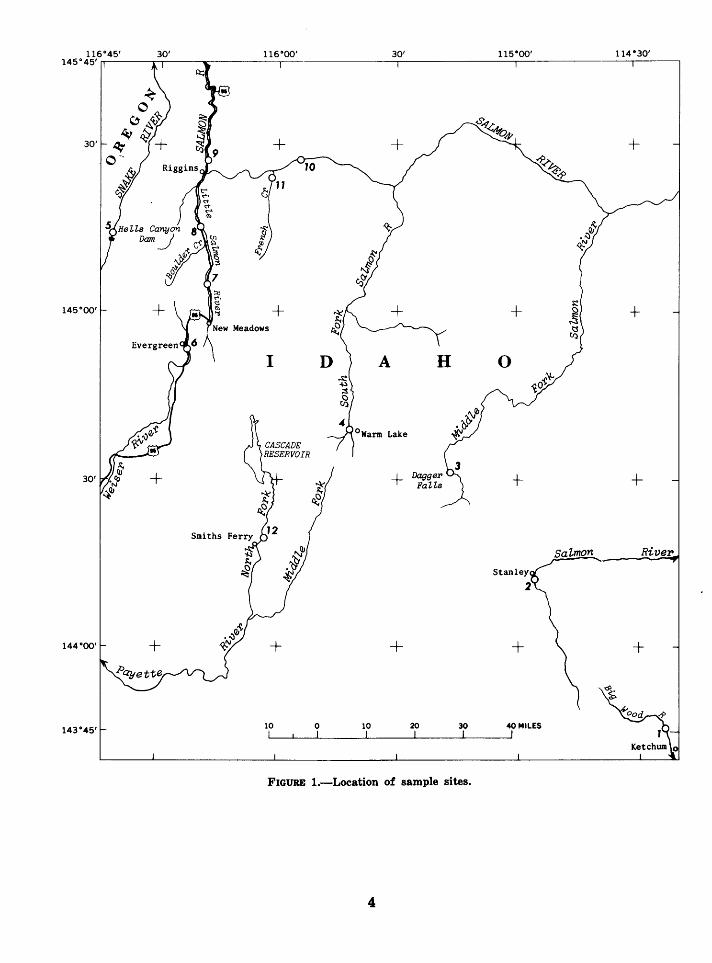
In August of 1968 I toured central Idaho and chose 12 localities on Idaho rivers to represent a cross section of river valleys in th2 t region (fig. 1). At each site the 46 check-list factors were observed and assigned an evaluatjon number according to the five categories in table i. Category assignment for each factor at each site is shown in table 2. More sites could have been evaluated had time permited, and the ranking scheme would allow additional sites to be included whenever the data were obtained. But the 12 sites are sufficient to indicate the range of differences which exist in central Idaho for each of the landscape factors.
Each site chosen has some possibility for power development. No attempt was made to estimate even roughly the power-generating capability of the rivers involved nor the economy of development. But the inclusion only of sites where some power development is at least physically possible gave the selected sites some commonness and excluded dese:~t landscapes and other scenic environments of different character. A photograph of eacl' site is shown at the end of this report.
30' + +
+
A
0 Warm Lake
+ + +
River
+ +
0 10 20 40 MILES
FIGURE 1.-Location of sample sites.
4

TABLE 2.-Category assignment for aesthetic factors at the 1! localitieB on Idaho rivers
[Category number entered for each site is the nu~ber from 1 to 5 indicating range within which the measured or estimated quantlty falls]
Descriptive categories
Physical factors: River width at low flow ________________________ _
~:C!~t;ta\oio!o&w: :::::::::::::::::::: =:: :::: Bankfull depth _______________________________ _ Flow variability----- __________________________ _ River pattern _________________________________ _ Ratio of valley height to width _________________ _ Bed material _________________________________ _
l::i:~: ~= = = = = = = == = = :::::: = = == = = = =: = == = === = Stream order _________________________________ _ Erosion of banks ________ ---- __________________ _ Deposition ___________________________________ _ Width of valley flat ______ • ___________________ ._
Biol'l!!t~~~J!rt~~ -~~~~:- ________________________ _
~!~!1~t~di~~~~= ::::::::::::::::::::::::::::: Algae: Amount _______________________________ ----
Type_------------------------------------Larger plants:
Amount __________________________ ------.-_ Kind._----- ___________________________ ---
River fauna ___________________________ ---_----Pollution evidence ________________________ ---- __ Land flora:
Valley------------------------------------
8l:i:-~ ~::::::::::::::::::::::::::::::: Human use and interest:
Trash and litter: Metal ____________________________ --------
~~re~======= === ==== ::::::: = = ::::: = =: == :::: Material-removable. _______________ ---_--------Artificial controls. _________________ ---_--------
Ac~~~
TABLE a.-Uniqueness ratios for aesthetic factors at the Hells Canyon sites
Categories and factor No.
Phyaieal:
2 3 5
Site No.
6 7 8 9 10 11 12
~_ ____________________ 0.14 0.14 0.14 0.14 0.33 0.50 0.50 0.14 0.33 0.33 0.14 0.14 2--------------------- .17 1.00 .50 .17 .33 .17 .17 .17 .33 .33 .17 .50 3 _____________________ 1.00 .12 .12 .5o .12 .50 t.oo .12 .12 .12 .12 .12 4.-------------------- .17 . 17 . 33 . 17 . 33 . 17 .17 . 33 . 33 . 33 .17 . 33 5--------------------- .11 .11 .50 .11 .11 .11 1.00 .11 .11 .11 .50 .11 6--------------------- .17 .17 .50 .17 .33 .17 .17 .17 .33 .33 1.00 .50 7 _____________________ .10 .10 .10 1.00 .10 .10 1.00 .10 .10 .10 .10 .10 8 _____________________ .10 .10 .10 1.00 .10 .10 1.00 .10 .10 .10 .10 .10 9--------------------- .20 .25 .20 .50 .25 .20 1.00 .25 .50 .25 .20 .20 10-------------------- .17 .11 .n .33 .33 .sa .17 .17 .33 .33 .33 .11 11-------------------- .20 .20 .17 .20 .17 1.00 .20 .17 .17 .17 .20 .17 12-------------------- .10 .10 .10 .10 .10 .10 1.00 1.00 .10 .10 .10 .10 13 ____________________ .10 .10 .10 .10 .10 .10 .50 .10 .10 .50 .10 .10 14-------------------- .33 1.00 .50 .20 .50 .20 1.00 .38 .33 .20 .20 .20
SubtotaL ____ • ______ --3 .-0-6 --3-.-73--3-.-53--4-.6-9--3-.2-0--3-.7-5--8-.8-8--3-.2-6--3-.-28--3-.3-0--3-.4-3--2-.84-
Biologic: 15-------------------- .50 .20 .50 1.00 .20 .50 .50 .20 .20 .50 16-------------------- .17 .17 .17 .17 .25 .17 .50 .25 .25 .25 11-------------------- .09 .09 .09 .09 .09 .09 1.00 .09 .09 .09 18-------------------- .20 .20 .33 .20 .33 .33 1.00 .20 .20 .33 19-------------------- .14 .14 .14 1.00 .33 .33 1.00 .33 .14 .14 20-------------------- .17 .17 .17 1.00 .50 .33 .50 .33 .17 .33 21-------------------- .09 .09 .09 .09 .09 .09 1.00 .09 .09 .09 22-------------------- .09 .09 .09 .09 .09 .09 1.00 .09 .09 .09 23____________________ .17 .17 .17 .17 .50 .33 1.00 .33 .33 .17 24 ____________________ .14 .14 .14 .14 .50 .50 1.00 .50 .14 .14 25____________________ .25 .50 .33 .33 .50 .33 .25 1.00 .25 .25 26 ____________________ .33 .33 .17 .17 .33 .17 .33 .17 .33 .33 27 ____________________ .33 .17 .17 .50 .50 .17 .33 .33 .17 1.00 28____________________ .25 .20 .25 .20 .20 .20 .33 .33 .20 .25
.50
.17
.09
.38
.14
.17
.09
.09
.17
.14
.50
.17
.17
.88 -----------------------------------------Subtotal ____________ 2.92 2.66 2.81 5.15 4.41 3.67 9.74 4.24 2.65 3.96 3.06
.20
.50
.09
.88
.14
.17
.09
.09
.50
.50
.50
.17
.17
.25
8.70
Human interest: 29-------------------- .20 .17 .20 .20 .17 .17 .17 l.ob .17 .17 .20 .20 so ____________________ .33 .17 .ss .ss .17 .ss .17 .stl .17 .17 .33 .17 81____________________ .11 .11 1.00 .50 .11 .11 .11 .50 .11 .11 .11 .11 32-------------------- .08 .08 .08 .08 .08 .08 .08 .08 .08 .08 .08 .08 33 ____________________ .12 .12 .33 .12 1.00 .12 .ss .12 .12 .12 .12 .33 34____________________ .20 .20 .33 .20 .33 .20 .33 .33 .33 1.00 .83 .20 35____________________ .20 .20 .50 .20 .50 .20 .33 .33 .33 .50 .50 .20 36____________________ .25 .25 .25 .33 .50 .33 .50 .25 .50 .50 1.00 .33 37 _______ ------------- .25 .25 .25 .25 . 50 . 25 . 50 . 50 .25 . 50 . 25 .25 38. ___________________ .33 .50 .25 .33 .50 .33 .33 .25 .25 .33 .83 .25 39 ____________________ .17 .25 .17 .17 .25 .17 .25 .17 .25 .50 .50 .17 40 ____________________ 1.00 .25 .25 .25 .25 .33 .25 .33 .33 .25 .25 .25 41-------------------- .20 .20 .20 .20 .50 .20 .20 .20 .20 .50 .20 .20 42-------------------- .50 .17 .50 .17 .50 .17 .17 1.00 .17 1.00 .50 .17 "-------------------- .20 1.00 .20 .20 1.00 .20 .20 .20 .20 .20 .20 .20 44-------------------- .33 .33 .33 .33 1.00 .33 .38 .38 .50 .50 .33 .88 45____________________ .50 .11 .11 .11 1.00 .11 .11 .11 .11 .50 .11 .11 46-------------------- .12 .25 .25 .12 .12 .12 .12 .25 .25 .12 .12 .12 ---------------------------------------------------------SubtotaL___________ 5.09 4.61 5. 53 4.09 8.48 3. 75 4.48 6.28 4.32 7.05 5.46 3.67
==================================================================== Total_______________ 11.07 11.~ 11.87 13.93 16.09 11.17 23.10 13.78 10.25 14.31 11.95 10.21
and for the 12 sites appear in table 3, which also contains the sum of uniqueness ratios. Subtotals for the three groups of factors, physical, biological, and human interest, as well as the sums of all three, are summarized in table 4.
COMPARISON OF 'ALL SURVEYED SITES
It will be understood that any group of riverside sites selected in central Idaho will display mountain scenery of high distinction, for the region is rugged, forested, and has many clear mountain rivers. Therefore the sample includes, nearly without exception, country of high aesthetic quality. It must be expected then that variance among sites is less than if other landscapes that are not so appealing were included.
6
Moreover, because the sites are in the same region and have the same type of forest, in many respects they are very similar.
Uniqueness ratios for each site, presented in table 4, have been arranged in order of rank and are listed separately in table 5 for the three main categories and for the total -r1alues.
Site 7 is the most unique for i~. ranks first in physical, biologic, and total uniqueness. Site 7, Little Salmon River, near N e'~v Meadows, is the only site which has a sluggish, algae infested, murky stream of small gradient that is evidently nutrient-enriched frcm agricultural use and, to a lesser extent, from urt'ln wastes.

TABLE 4.-Summary-totals of uniqueness ratios of aesthetic factor values, Hells Canyon region
Site Aesthetic factors
Physical Bioiogfe Human
1----------------------- 8.06 ~----------------------- 8. 78 ~----------------------- 8.68 4----------------------- 4.69 &_______________________ 8.10 8_______________________ 8.75 ?_______________________ 8.88
8----------------------- 8.18 9_______________________ 8.18 10______________________ 8.80 11---------------------- 8.48 11 ______ -- __ -- _ __ _ _ _ _ _ _ _ I. 84
1.92 2.68 1.81 5.15 4.41 8.67 9.74 4.24 2.65 8.96 8.06 8.70
interest
5.09 4.61 5.68 4.09 8.48 8.75 4.48 6.28 4.82 7.05 5.46 8.67
Total
11.07 11.00 11.87 18.98 16.09 11.17 28.10 18.78 10.25 14.8t 11.95 10.21
TABLE 5.-Sites in order of uniqueness ratio
Rank Aesthetic factors
Physical
1------------------------ 7 1------------------------ 4 1------------------------ 6 4------------------------ 2 5------------------------ 8 8------------------------ 11 1------------------------ 10 s__ _ _ _ _ ___ _ _ __ _ _ _ ___ ___ __ 9
9------------------------ 8 10----------------------- 5 11----------------------- 1 12 __ --------------------- 12
Biologic
7 4 6 8
10 12 6
11 1 8 2 9
Human interest
5 10
8 8
11 1 2 7 9 4 6
12
Total
7 5
10 4 8
11 6 8
12 1 2 9
Site 5, the Snake River in Hells Canyon, has the second largest total uniqueness ratio. It has a high total score because it ranks first in human interest and third in biologic factors. Surprisingly, it ranks 1Oth (or not unique among the -sites) in physical factors. Site 10, Salmon River at Carey Falls, is third in total uniqueness because it is second in human interest and fifth in biologic factors. Again, its position is seventh in physical factors.
A visual picture of the position of various sites in the uniqueness scale can be obtained in figure 2, in which the values of human interest and biologic uniqueness are, respectively, the ordinate and abscissa, and physical uniqueness is written in next to each plotted point.
In figure 2, site 7 stands alone because of its high position on the biologic scale. It is the only enriched (polluted) river among the sites surveyed. Sites 5, 10, and 8 stand more or less alone because of low positions on the biologic scale and high positions on the human interest .scale. All other sites form a bunch of approximately equal characteristics.
7
FACTORS SELECTED FOR P ARTICUI.AR COMPARISONS
The data allow site comparisons for groups factors selected to represent particular aspects of the landscapes. Although selection of factors involves judgment as to which facto!"s appropriately describe certain landscape char~eteristic, grouping of selected factors need not involve assignment of preference. Facto:-:- selection can then be merely a subdivision of objective basic data.
Landscape scale is a way of expressing one aspect of bigness or grandeur. The Tetor Range in Wyoming is often called the Alps of North America. Its spectacular character com~s, to a great extent, from the proximity of t1' ~ high peaks to the adjacent valley floor of ~T ackson Hole.
One way to define this relationship is the height of adjacent mountains compared to the width of the valley floor. Where high mountains exist next to narrow valleys, the scenery is generally of large scale. In contrast, low hills adjacent to wide valleys lack the grandeur of large landscape scale.
To describe this, the bottom graph of figure 3 is a plot of height in feet of mountainr ( ordinate) and width in feet of the floor of the adjacent valley (abscissa). On this plot, sites 5 and 10 fall in a zone of large-scale landscapes and other sites fall in a more subdued scale.
To reduce the combination of height of hills and width of valley to a single parameter, here called landscape scale, the projection of the position of each plotted point on a 45 o diagonal line was carried out. This projection is in1icated by the dashed lines leading from each :t: "lint at a 45° angle upward to the right in th~ lower graph.
The projection could have been made on to a line having some other slope. The choice of a 45 o line is an assignment of equal weight to ordinate and to abscissa value.
Thus, the position of each point proje~~ted on to the diagonal line is a quantitative ass~ssment of position on th~ yardstick of landscap~ scale, which can be used for construction of a new graph as has been done in the central portion of figure 3.

9~-----~~----~~------~~------~~-------,~-----,~----~,~~-----------------,
V) 0::: 0 1--u c( LL.
1--V) LLJ 0::: LLJ 1--:z
V) V) LLJ :z LLJ
8-
7f-
6f--
g. 3r--:z :::)
LL. 0
....1 2 fc( 1--0 1--
1r-
2
63.53 3
3.20 56
63.30 JO
L.\3.26 8
3.06 3.43 J6 6JJ
I::J.3.73
I::J.3.28 9
3.75 6
6 6 2.84
J2
-
EXPLANATION Uniqueness
3 43 of physical · -factors
ft-site number
I I
Totals of uniqueness ratios of sHveyed sites
-
-
-
-
-
-
-
o~----~'~----~'------~'------~~------~~------~'------~'----~'------~1----~ 1 2 3 4 5 6 7 8 9 10
TOTAL UNIQUENESS RATIO FOR BIOLOGIC FACTORS
FIGURE 2.-Relation among uniqueness ra~ios of three groups of factors for surveyec;1 sites.
Using the position along the diagonal as a measure of landscape scale, the middle graph of figure 3 plots landscape scale against the degree of view confinement. Where distant vistas are available in large-scale landscape, one has the impression of spectacular scenery. In contrast, confinement of view by heavy cover or where views are blocked by adjacent hills, especially when combined with subdued landscape, the result is aesthetically ordinary from the scenic point of view.
In the center diagram, the position of each point can again be projected to a 45° line providing a new yardstick of landscape scale com-
8
bined with availability of sceni~ outlooks or vistas, the two factors being giver equal weight. The result is a measure of what is called landscape interest and it varies from spectacular to ordinary.
One of the considerations in croosing among alternative areas to protect fron1 development is the degree of wildness or the freedom from the usual encroachments of civilization. One factor in the checklist of surveyed characteristics is the degree of urbanizaticn, which was defined as the totality of buildings, houses, roads, utilities, and other earmarks of change by man's use. As before, using the position of

tLJ..J
~ 5000 t-----....,....,.._
z: ....... ..
V)
....J
....J ....... :c >- 1000 t------------';~~----;--------1----,.'---~ cc 0::: c:t: LJ..J z: SOOt---~~~~~----;-~~-~-~ L1.. 0
t:c (.!:' ....... LJ..J :c
100~-----~--~----------~--~
100 500 1000 5000 10 ()()()
WIDTH OF VALLEY, IN FEET
FIGURE 3.-Analysis of valley character.
9
Note: Site number is labeled beside each plotted point.

each site on the diagonal line which is a yardstick of landscape interest as an abscissa, an ordinate representing urbanization is used to construct the upper diagram. The combination of spectacular scenery and low urbanization falls in the left lower zone of the upper graph, and the ordinary and urban conditions fall in the upper right. The combination of landscape interest and urbanization, each given equal weight, is represented by projection onto a 45 o
diagonal in the upper graph, and this yields a scale of valley character.
These considerations show clearly that sites 5 and 10, Snake River at Hells Canyon and the wild reach of Salmon River at Carey Falls, are unique to a high degree. All other sites studied are in a cluster of points to the right and upper part of the upper graph.
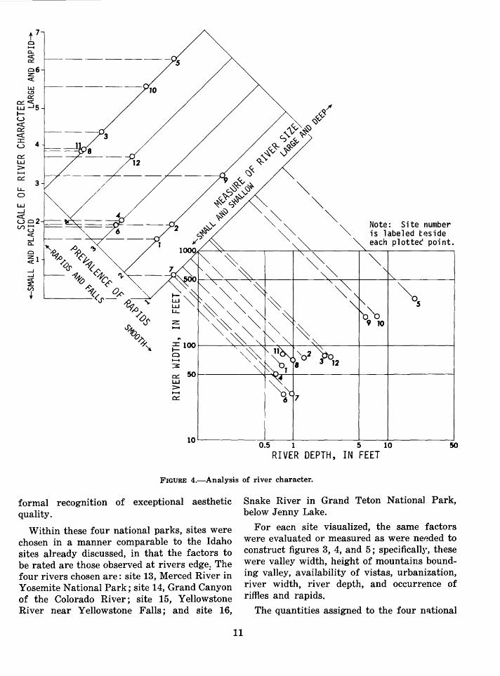
A comparable analysis can be made of river characteristics. Experience indicates that the grandeur or majesty of a river is dependent on a combination of size and apparent speed. Small rivers tumbling over a succession of falls are more impressive or are more aesthetically appealing than a large river which appears sluggish. The latter characteristic is not so much dependent on velocity, which is usually poorly estimated by the untrained eye, as it is on appearance of speed judged mostly by the waves and surface ripples caused by rapids or falls.
As a measure of scale, the lower graph of figure 4 is a plot of river width as a function of water depth. Deep and wide rivers appear in the upper right area of the graph.
The relative position of each point with respect to the lower left or upper right zones, is indicated by the projection of the position on to a 45 o line which becomes the abscissa for the center graph. The ordinate is a measure of the occurrence or absence of riffles, rapids, and falls. Thus, sites which fall in the upper part of the diagram are large and rapid and those in the lower zone are small and placid.
The combination of river size and prevalence of rapids is, as before, obtained by projecting the points on to a 45 o line in figure 4 which is a yardstick of river character.
10
Now the character of valley can be put together with the character of river which is done in figure 5. The ordinate is taken from the position of each site on the s~ale of valley character, figure 3. The spectaer lar and wild is high on the ordinate scale and the urban and ordinary is low on the scale. The abscissa is taken from the scale of river character, figure 4. It is a measure of the character of the river; lefthand positions are f"'lall and placid rivers, and righthand positions are large and rapid.
These graphs add information over and above the uniqueness ratios because they show associations among relevant characteristics. The efficacy of the analysis is indicated by the fact that these associations give a wider ~pread between sites than do uniqueness ratios alone, but at the same time they do rr:»t contradict relations shown by those ratios.
Hells Canyon, site 5, appears in a category of its own with respect to character of valley and river, a fact already showr by the uniqueness ratios. The nearest to it in these respects is site 10, Salmon River at Carey Falls which indeed is, from subjective impression, more like Hells Canyon than any other site. Site 7, the only nutrient-enriched site, becomes a part of the preponderance of points, usual or ordinary in its river and valley character.
HELLS CANYON COMPARED W~TH OTHER UNITED STATES RIVER ftlTES
As stated earlier, the choice of a universe within which to choose sites for comparison poses some problems. For this reason, two universes were used. The first consists of the 12 sites in the same region of Idaho; the second will now be discussed.
The purpose of the present analysis is to provide some quantitative information bearing on the social importance of Hells Canyon preserved in its present undeveloped condit~'ln. Such preservation would imply that it rarks among the best in American river scenery. It is logical then to compare Hells Canyon with some of the American landscapes acknowledged to be of high aesthetic quality. Accordir~ly, four sites in national parks are used for c.omparison on the assumption that national pa:rk status is a
-c... ~
l.&.J ~ c::
~<( L1..J -J5 1-u c:t: ~ c:t:
5 4 ~ L1..J > ..........
~ 3 LL.. 0
L1..J ....J
5 c2 V>t;
<( _J c... C)
~1
z ..........
...
Note: Site number is labeled teside each plotte~ point.
~0 5
~100r-----~~~~~~--~~----~----+----------o .......... 3:
~ 50r---------~~~r~----------~----~--------~ L1..J > .......... ~
10~--------~~--~--------~----L---------~ 0.5 1 5 10 50
RIVER DEPTH, IN FEET
FIGURE 4.-Analysis of river character.
formal recognition of exceptional aesthetic quality.
Within these four national parks, sites were chosen in a manner comparable to the Idaho sites already discussed, in that the factors to be rated are those observed at rivers edge. The four rivers chosen are: site 13, Merced Ri~er in Yosemite National Park; site 14, Grand Canyon of the Colorado River; site 15, Yellowstone River near Yellowstone Falls; and site 16,
11
Snake River in Grand Teton Nationa] Park, below Jenny Lake.
For eacn site visualized, the same factors were evaluated or measured as were needed to construct figures 3, 4, and 5; specifically, these were valley width, height of mountains bounding valley, availability of vistas, urbanization, river width, river depth, and occurrence of riffles and rapids.
The quantities assigned to the four national

7 I I I I I lo.s
6t- o• -
0: Lt.J
o' t;sr- o3 -
~ c(
o" ::I: u4t- ->- 4 Lt.J o' o ....J o• ....J
o1 06 c(
o,2 >3t- -LL. o2 0
Lt.J
~2- -u V)
1- -
l l I I I I 0 1 2 3 4 5 6 7
SCALE OF RIVER CHARACTER
FIGURE 5.-Relation of valley to river character for surveyed sites in Idaho.
park sites utilized the same scales and definitions as had previously been used. Graphs comparable to figures 3 and 4 were constructed as described earlier and from them a graph comparable to figure 5 was made which appears here as figure 6.
In this comparison it can be seen that combining river and valley characteristics, which obviously excluded many other noteworthy aspects of the respective parks, only Grand Canyon of the Colorado appears in the same category as Hells Canyon. The Merced River in Yosemite National Park is in a spectacular valley but is not an unusual river. It therefore plots in a lower left position not unlike most of the Idaho river sites. Yellowstone River and the Snake River in Grand Teton National Park are intermediate in position.
12
7
~ 6r ~5 :I: u
>LLJ
j4 c::( > LL. 03 LLJ ......J c::( u (/)2
0
Colorado River in Grand Canyon 0
® J4 Hells Canyon 5
Yellowstone River in Yellowstone National Park 0 15
Snake River in o16
Grand Teton National Park
Merced River in 013 Yosemite National Park
2 3 4 5 6 SCALE OF RIVER CHARAr.TER
7
FIGURE 6.-Relation of valley to river character for selected rivers in national parks and for Hells Canyon.
CONCLUSION
Quantitative evaluation of river and valley characteristics was made on 12 sites in Idaho. These were analyzed without introduction of any personal preference or bias. Hells Canyon of the Snake River was shown to b~ unique, and its evaluated rank or position was approximated only by the main Salmon River in its wilderness reaches.
A further comparison of a few selected river and valley characteristics was mac~ with rivers in four well-known national parks. Hells Canyon was clearly unique and compz.rable only to Grand Canyon of the Colorado River in these features.

DESCRIPTION OF SITES
SITE 1.-Wood River, 6 miles above Ketchum, Idaho, at Forest Camp in Sawtooth National Forest on U.S. Highway 93. A broad river valley closely forested with spruce and fir is set in rolling open hills, patched with timbered areas and interspersed with open grasslands. The stream is clear and gentle in gradient and is easily accessible along most of its length from the paved highway which goes up the valley. Several forest campgrounds exist and a considerable length of the valley is within the National Forest.
SITE 3.-Middle Fork Salmon River at Dagger Falls, Idaho, in Challis National Forest, at end of a side road off the road between Cape Horn and Warm Lake. In a gorgelike valley bottom, a large clear river courses between rock outcrops and tumbles over gravel or bedrock riffles or falls. Though the enclosing mountains are many hundreds of feet high, the views are confined by heavy spruce and fir timber and are restricted mostly to view of nearby hilltops only. The gravel forest road dead ends at the river site, where there is a forest campground. At some seasons of the year, salmon can be observed leaping the falls in migration. The site is a launching place for river boat expeditions.
13
SITE 2.-Salmon River, a quarter of a mile above Stanley, Idaho, on U.S . Highway 93. A broad nearly treeless valley, surrounded by low hills, is traversed by a large clear stream of very uniform gravel bed. The stream is nearly straight and is lined in some places by willow brush. Some low forest-covered hills can be seen in the distance. The valley contains some ranches and sporadic settlements. Access to the river is extant for some miles from the paved highway which goes along the valley.

SITE 5.-Hells Canyon of the Snake River, below Hells Canyon Dam. In broad green smooth pools alternating with sharp rapids, the very large river flows between rocky spurs which nearly everywhere reach to the water's very edge. The rough and bare spurs rise in cliffs and steps upward at a steep angle from the river to what seems immense heights. On bends in the canyon and where one can look up steep tributary valleys, far vistas of still higher cliffs and mountain tops are visible. The immense river is nearly dwarfed by the imposing rock palisades, colored in the dark tones of basalt and reddish metamorphic rock. Clusters of trees and open patches of grass hang on steep scarps or on local level ramparts. Access through much of the distance is by trail cut in the steep hillside rock and by obscure roads leading to a few widely scattered ranches.
SITE 4.-South Fork Salmon River, near Warm Lake, Idaho, at campground. In a broad open valley, a nearly clear stream flows between borders of willow, alder, and fir woods and is incised about 8 feet below the general valley floor. Distant forested hills are visible. Except for its incised position below the grasscovered terrace, the river is accessible from the road which follows the valley.
SITE 6.-Weiser River at Evergreen Forest Camp on U .S. Highway 95, south of Pine Ridge, Idaho. A small boulder stream of cloudy water flows in a narrow, brush-enclosed notch surrounded by low hilltops completely forested in cutover and second growth fir and spruce. A well-traveled, paved highway goes along the valley cut into the hillside. Views are absent owing to confining adjacent hills and heavy timber.
SITE 7.-Little Salmon River, 6 miles north of New Meadows, Idaho, on U.S. Highway 95. A shallow, turbid, and algae-infested stream curves in a meandering and partly braided course through a wide, flat valley floor. Vegetation on the nearby low hills is mixed between pine and grass and there are open views of more distant hillsides of low mountains covered by scattered timber.
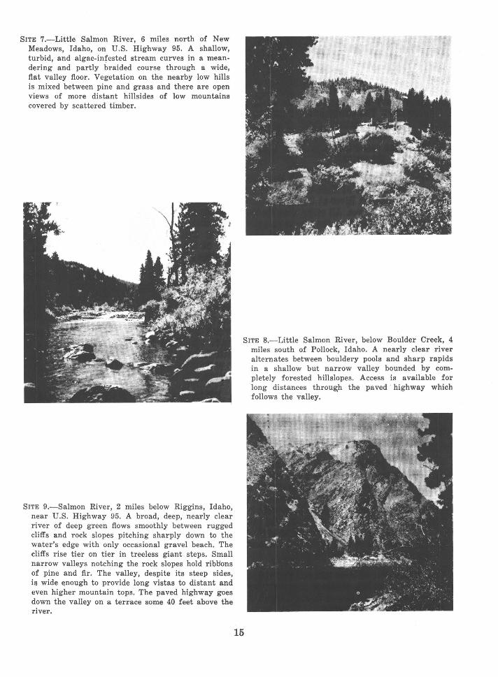
SITE 9.-Salmon River, 2 miles below Riggins, Idaho, near U.S. Highway 95. A broad, deep, nearly clear river of deep green flows smoothly between rugged cliffs and rock slopes pitching sharply down to the water's edge with only occasional gravel beach. The cliffs rise tier on tier in treeless giant steps. Small narrow valleys notching the rock slopes hold ribl:lons of pine and fir. The valley, despite its steep sides, is wide enough to provide long vistas to distant and even higher mountain tops. The paved highway goes down the valley on a terrace some 40 feet above the river.
SITE 8.-Little Salmon River, below Boulder Creek, 4 miles south of Pollock, Idaho. A nearly clear river alternates between bouldery pools and sharp rapids in a shallow but narrow valley bounded by completely forested hillslopes. Access is available for long distances through the paved · highway which follows the valley.
15

SITE 11.-French Creek, 1 mile above mouth where it joins main Salmon River and at place where the road up French Creek leaves the valley and enters the switchback zone up the mountainside. A narrow, steep-sided, forested valley hides a rushing torrent. Near the stream no concept of the depth of valley or height of mountains can be gained for there are no lookout openings. An unpaved road steeply follows up the valley and then turns into narrow and precipitous switchbacks up the mountain, where the road is labeled "single lane, no turnouts."
16
SITE 10.-Salmon River at Carey Falls, 20 miles abo •. _ Riggins, Idaho. A large clear green-hued river tumbles over big rapids alternating with fast pools. A mixed fir and open grass parkland rises steeply from the water's edge and broad V -shaped valleys open long vistas to forested peaks in the far high horizon. So steep and high are the sides of the main valley that the nearby mountain tops are hidden, but long vistas in several directions display ever more distant mountain crests in receding waves of horizons. An unpaved road winds dangerously along a cut in the steep mountainside and narrows to a single track which ends at Carey Falls.
SITE 12.-North Fork Payette River, near Smiths Ferry, on State Highway 15. In a forested, broadly open valley a swift, somewhat murky river of high gradient tumbles in a nearly continuous rapid. A railroad, powerline, and paved highway follow the river closely. No distant mountains are visible despite the broad openness of the valley.
-1< U.s. GOVERNMENT PRINTING OFFICE, 1973 0-543-57~


