Quaternary Stratigraphy of the La Playa Archaeological Site (SON F:10:3), Northern Sonora, Mexico Brett T. McLaurin, Aileen C. Elliott, James T. Watson and Maria Elisa Villalpando Canchola Abstract The La Playa archaeological site is located along the Rio Boquillas, north of Trincheras in northern Sonora, Mexico. The site contains an extensive record of human occupation beginning during the Paleoindian period with the most intense utilization of the site during the Early Agricultural period (3,700–1,900 cal BP). This work focused on detailed mapping and description of the stratigraphic units across the site. The oldest exposed stratigraphic unit is a reddish, sandy paleosol. The paleosol grades laterally into gravels that contain cobble-size clasts of diverse compositions. Overlying the paleosol is a tan-brown, homogenous silt (Holocene?) that lacks sedimentary structures and is consistently 98% silt and clay and 2% very fine sand. The paleosol and associated gravels were deposited during relatively wet conditions. The gravels are evidence of alluvial channels traversing the landscape and the composition of these gravels indicates significant transport distance based on the occurrence of nonlocal lithologies. The paleoenvironmental interpretation for the overlying silt has been considered a cienega deposit, but the silt has many charac- teristics in common with eolian deposited loess. An alluvial floodplain interpretation B. T. McLaurin (&) Á A. C. Elliott Department of Geography and Geosciences, Bloomsburg University of Pennsylvania, 400 E. 2nd Street, Bloomsburg, PA 17815, USA e-mail: [email protected]A. C. Elliott e-mail: [email protected]J. T. Watson Arizona State Museum and School of Anthropology, University of Arizona, 1013 E. University Blvd, Tucson, AZ 85721-0026, USA M. E. V. Canchola Sección de Arqueología, Centro INAH-Sonora, Hermosillo, Sonora, Mexico B. T. McLaurin et al., Reconstructing Human-Landscape Interactions – Volume 1, SpringerBriefs in Earth System Sciences, DOI: 10.1007/978-3-642-23759-1_2, Ó The Author(s) 2012 3
Transcript
Quaternary Stratigraphy of the La PlayaArchaeological Site (SON F:10:3),Northern Sonora, Mexico
Brett T. McLaurin, Aileen C. Elliott, James T. Watsonand Maria Elisa Villalpando Canchola
Abstract The La Playa archaeological site is located along the Rio Boquillas, northof Trincheras in northern Sonora, Mexico. The site contains an extensive record ofhuman occupation beginning during the Paleoindian period with the most intenseutilization of the site during the Early Agricultural period (3,700–1,900 cal BP).This work focused on detailed mapping and description of the stratigraphic unitsacross the site. The oldest exposed stratigraphic unit is a reddish, sandy paleosol. Thepaleosol grades laterally into gravels that contain cobble-size clasts of diversecompositions. Overlying the paleosol is a tan-brown, homogenous silt (Holocene?)that lacks sedimentary structures and is consistently 98% silt and clay and 2% veryfine sand. The paleosol and associated gravels were deposited during relatively wetconditions. The gravels are evidence of alluvial channels traversing the landscapeand the composition of these gravels indicates significant transport distance based onthe occurrence of nonlocal lithologies. The paleoenvironmental interpretation for theoverlying silt has been considered a cienega deposit, but the silt has many charac-teristics in common with eolian deposited loess. An alluvial floodplain interpretation
B. T. McLaurin (&) � A. C. ElliottDepartment of Geography and Geosciences,Bloomsburg University of Pennsylvania,400 E. 2nd Street, Bloomsburg, PA 17815, USAe-mail: [email protected]
J. T. WatsonArizona State Museum and School of Anthropology,University of Arizona, 1013 E. University Blvd,Tucson, AZ 85721-0026, USA
M. E. V. CancholaSección de Arqueología, Centro INAH-Sonora,Hermosillo, Sonora, Mexico
B. T. McLaurin et al., Reconstructing Human-Landscape Interactions – Volume 1,SpringerBriefs in Earth System Sciences, DOI: 10.1007/978-3-642-23759-1_2,� The Author(s) 2012
3
is feasible if the channel of the Rio Boquillas was stable and did not frequently avulse,allowing deposition of these fine-grained deposits.
Keywords La Playa � Sonora � Paleosol � Quaternary � Silt � Early Agriculturalperiod � Alluvial � Pleistocene � Mexico
Introduction
The relationships between environmental change, landscape evolution, and humanactivities is a complex web of interactions that have been a focus of variousgeoarchaeological studies (Butzer 1978; Ferring 1986; Haynes 1991; Bintliff 1992;Davis and Shafer 1992; Van Nest 1993; Holliday et al. 1994; Freeman 2000; Waters2000; Stafford and Creasman 2002; Hill 2004; Eitel et al. 2005; Bubenzer andRiemer 2007; Wright et al. 2007; Huckleberry and Duff 2008; Nials 2008). In thecontext of modern environmental change, geoarchaeological studies are increas-ingly informative about the long term effects of landscape and climate change onhuman populations. Human responses to environmental variation often relatedirectly to subsistence and the effects on the availability of food (Mabry 1998).Subsistence-based responses can significantly alter settlement patterns, initiatedemographic changes, and stimulate the adoption of new technologies. A criticalinitial step in studies of human–environment interaction is creation of a strati-graphic and paleoenvironmental framework to understand the overall landscapechange through time. With a model of landscape evolution firmly established, amore refined examination of these changes on human activity can be evaluated.
The goal of this study was to define a basic stratigraphic and paleoenvironmentalframework for the La Playa archaeological site located in northern Sonora, Mexico.This site contains an archaeological record that spans 12,000 years and has provideda wealth of artifacts and human skeletal remains. Much of the previous work at LaPlaya has focused on the documentation of cultural features that are being destroyedby modern erosion of the landscape. As a result, little work has been done tounderstand the depositional history of the site. While many studies in the DesertSouthwest have examined human–environment interactions within systems that arealluvial, sections of the La Playa stratigraphy do not possess the geomorphologicaland sedimentological characteristics typically observed in alluvial systems.
Intensively studied alluvial systems, such as the Gila River drainage basin insouthern Arizona (Waters 2008), record considerable deposition of gravels andsands, rapid facies changes, terrace formation and multiple episodes of channelincision and aggradation. The La Playa stratigraphy lacks these indicators of alluvialdeposition; therefore, previously developed models of those systems are not nec-essarily applicable. Assessment of the Quaternary stratigraphy involved character-ization of the soil and sediment types at La Playa and compilation of a surficial map ofthe site that addresses distribution of the sediment types, surfaces, and culturalmaterials. While this study addresses aspects of the stratigraphy and sedimentology,
4 B. T. McLaurin et al.
development of a chronological framework is in progress and consists of a combi-nation of 14C and OSL dating techniques.
Background
Geological/Geomorphic Setting
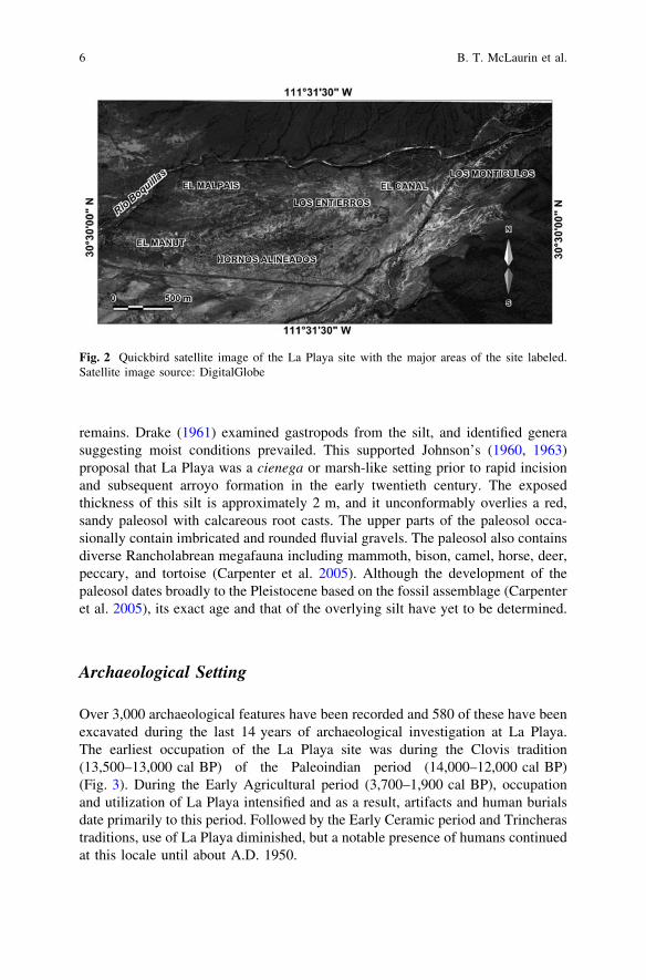
The La Playa archaeological site is located near of the town of Trincheras in northernSonora, Mexico approximately 100 km southwest of Nogales, Arizona (Fig. 1). Thesite covers 9 km2 along the Rio Boquillas east of its confluence with the RioMagdalena. The site is situated below the low hills of the Cerros Boquillas where theriver emerges from a narrow valley (Fig. 2). The Cerros Boquillas are a northwest–southeast trending ridge of Late Cretaceous metasedimentary fluvial deposits of thePozo Duro Formation (McLaurin 2008). The site slopes gently to the southwest froman elevation of 526 m adjacent to the Cerros Boquillas to 506 m nearing the con-fluence of the Rios Boquillas and Magdalena. The surface of much of the La Playasite is characterized by a light-colored silt capped by a mantle of fire-cracked rockderived from deflated roasting pits, dispersed prehistoric human remains, and locallydense artifacts including flaked stone debitage, projectile points, marine shell jew-elry and manufacturing debris, pottery sherds, and grinding stones.
Surface deposits at La Playa are characterized by a tan, homogenous silt thattypically lacks internal stratification or sedimentary structures. On the flanks of theRio Boquillas, this unit is reworked and is locally interbedded with sandierdeposits exhibiting ripples and cross-laminations. Rapid, recent arroyo formationis heavily dissecting the silt and extensively exposes buried archaeological
Fig. 1 Location map illustrating the location of the La Playa archaeological site within northernSonora. The site lies adjacent to the Cerros Boquillas south and east of the Rio Boquillas
Quaternary Stratigraphy of the La Playa Archaeological Site 5
remains. Drake (1961) examined gastropods from the silt, and identified generasuggesting moist conditions prevailed. This supported Johnson’s (1960, 1963)proposal that La Playa was a cienega or marsh-like setting prior to rapid incisionand subsequent arroyo formation in the early twentieth century. The exposedthickness of this silt is approximately 2 m, and it unconformably overlies a red,sandy paleosol with calcareous root casts. The upper parts of the paleosol occa-sionally contain imbricated and rounded fluvial gravels. The paleosol also containsdiverse Rancholabrean megafauna including mammoth, bison, camel, horse, deer,peccary, and tortoise (Carpenter et al. 2005). Although the development of thepaleosol dates broadly to the Pleistocene based on the fossil assemblage (Carpenteret al. 2005), its exact age and that of the overlying silt have yet to be determined.
Archaeological Setting
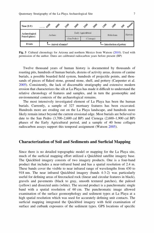
Over 3,000 archaeological features have been recorded and 580 of these have beenexcavated during the last 14 years of archaeological investigation at La Playa.The earliest occupation of the La Playa site was during the Clovis tradition(13,500–13,000 cal BP) of the Paleoindian period (14,000–12,000 cal BP)(Fig. 3). During the Early Agricultural period (3,700–1,900 cal BP), occupationand utilization of La Playa intensified and as a result, artifacts and human burialsdate primarily to this period. Followed by the Early Ceramic period and Trincherastraditions, use of La Playa diminished, but a notable presence of humans continuedat this locale until about A.D. 1950.
Fig. 2 Quickbird satellite image of the La Playa site with the major areas of the site labeled.Satellite image source: DigitalGlobe
6 B. T. McLaurin et al.
Twelve thousand years of human history is documented by thousands ofroasting pits, hundreds of human burials, dozens of activity areas, dozens of canineburials, a possible boarded field system, hundreds of projectile points, and thou-sands of pieces of flaked stone, ground stone, shell, and pottery (Carpenter et al.2005). Consistently, the lack of discernable stratigraphy and extensive modernerosion that characterizes the silt at La Playa has made it difficult to understand therelative chronology of features and samples, and in turn the geomorphic andenvironmental contexts of the archaeological remains.
The most intensively investigated element of La Playa has been the humanburials. Currently, a sample of 327 mortuary features has been excavated.Hundreds more are eroding out on the La Playa landscape, and hundreds morelikely remain intact beyond the current erosional edge. Most burials are believed todate to the San Pedro (3,700–2,600 cal BP) and Cienega (2,600–1,900 cal BP)phases of the Early Agricultural period, and a sample of 40 bone collagenradiocarbon assays support this temporal assignment (Watson 2005).
Characterization of Soil and Sediments and Surficial Mapping
Since there is no detailed topographic model or mapping for the La Playa site,much of the surficial mapping effort utilized a Quickbird satellite imagery base.The Quickbird imagery consists of two imagery products. One is a four-bandproduct that includes a near-infrared band and has a spatial resolution of 2.4 m.These bands cover the visible to near infrared range of wavelengths from 430 to918 nm. The near infrared Quickbird imagery (bands 4-3-2) was particularlyuseful for defining areas of firecracked rock (linear and circular features in black),gravels and pavements (black to gray, smooth textured patches), the palesol(yellow) and dissected units (white). The second product is a panchromatic singleband with a spatial resolution of 60 cm. The panchromatic image allowedexamination of the surface geomorphology and sediment types at La Playa at ahigh spatial resolution which was used for accurately defining unit contacts. Thesurficial mapping integrated the Quickbird imagery with field examination ofsurface and cutbank exposures of the sediment types. GPS locations of specific
Fig. 3 Cultural chronology for Arizona and northern Mexico from Watson (2010). Used withpermission of the author. Dates are calibrated radiocarbon years before present (BP)
Quaternary Stratigraphy of the La Playa Archaeological Site 7
lithologies on the Quickbird imagery base within GIS allowed the delineation ofmap units and spatial distribution of depositional and cultural deposits.
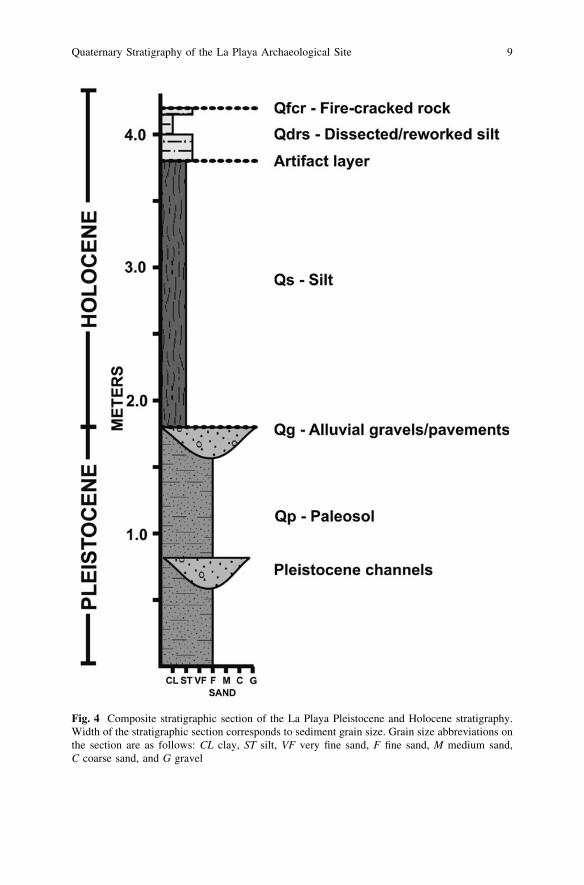
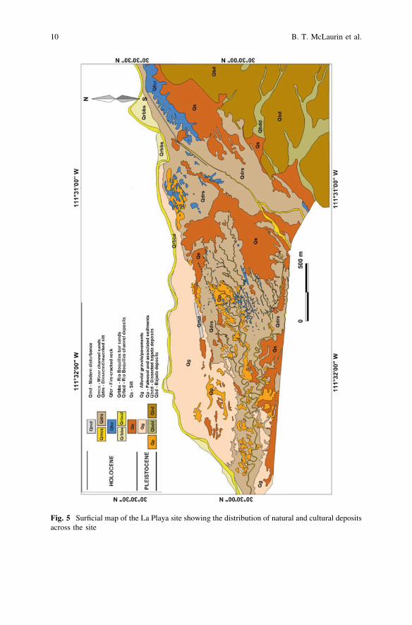
The extensive erosion that serves to expose and destroy human burials andartifacts at La Playa also provides an opportunity to examine the site stratigraphy.When describing and classifying these sediments, it is critical to distinguish sed-iments that are naturally deposited with those that result from cultural processesincluding modern disturbances. The natural deposits that define the landscape ofLa Playa can be divided into eight units. A composite stratigraphic columnillustrating the basic site stratigraphy is shown in Fig. 4. The age and exactstratigraphic relationships of these units are not yet clearly defined and areundergoing additional study. The surficial map of the La Playa site (Fig. 5)delineates both natural deposits and areas of cultural modification. The surficialunits, described in more detail below, are: (1) Paleosol and associated sediments(Qp), (2) bajada deposits (Qbd, Qbdd), (3) alluvial gravels/pavements (Qg),(4) silt (Qs), (5) modern Rio Boquillas bar sands (Qrbbs) (6) modern Rio Boquillaschannel deposits (Qrbcd), (7) fire-cracked rock concentrations (Qfcr), (8) minorchannel sands (Qmcs), (9) dissected/reworked silt (Qdrs), and (10) moderndisturbances (Qmd).
Paleosol and Associated Sediments: Qp
The paleosol at La Playa is the deepest exposed stratigraphic horizon and isprimarily confined to localities west of Los Entierros and Hornos Alineados. It isconsidered to be Pleistocene in age based on the fossil assemblage of Rancho-labrean fauna (Carpenter et al. 2005). There is a small area of exposed paleosoladjacent to the Rio Boquillas in the northern part of El Canal/Los Entierros. Inaddition, in the channel of the Rio Boquillas, the transition between the paleosoland overlying silt is exposed along a *400 m section. The paleosol is red in colorand the maximum thickness exposed is approximately 4 m (Fig. 6). Upper inter-vals of the paleosol are sandy with minor gravel and a variable silt/clay contentfrom 9 to 50%. The sand fraction is concentrated in the fine to medium-grainedsizes. Early stage pedogenic carbonate formation is indicated by the presence ofcalcium carbonate nodules and root casts. Overall, the top of the paleosol is aplanar surface with relief up to 50 cm. In several areas of the site, including theRio Boquillas channel, deposits of gravels within the paleosol are observed. Thesegravel intervals are 4 m thick and occupy up to 30 m wide zones within thepaleosol (Fig. 7). The gravels are calcite cemented with reddish sand and contain adiverse assemblage of rounded clasts of schist, gneiss, volcanics, plutonics, andsedimentary compositions. The clasts are in the cobble size range (up to 10 cm)although some clasts exceed 25 cm. Clast imbrications of the gravels indicates awest to southwesterly paleoflow direction.
8 B. T. McLaurin et al.
Fig. 4 Composite stratigraphic section of the La Playa Pleistocene and Holocene stratigraphy.Width of the stratigraphic section corresponds to sediment grain size. Grain size abbreviations onthe section are as follows: CL clay, ST silt, VF very fine sand, F fine sand, M medium sand,C coarse sand, and G gravel
Quaternary Stratigraphy of the La Playa Archaeological Site 9
Fig. 5 Surficial map of the La Playa site showing the distribution of natural and cultural depositsacross the site
10 B. T. McLaurin et al.
Fig. 6 Photographs of thepaleosol. a Here the paleosolis overlain by a thin intervalof the reworked silt.b Exposure of the paleosol inthe channel of the RioBoquillas. Beneath theinterval of sandy paleosol arePleistocene gravels andcobbles
Fig. 7 Photograph of thePleistocene cobbles,cemented with red,coarse-grained sands
Quaternary Stratigraphy of the La Playa Archaeological Site 11
Bajada Deposits: Qbd, Qbdd
Bajada deposits include colluvium derived from the adjacent Cerros Boquillas.These deposits occur on the north side of the Rio Boquillas (not mapped) and onthe eastern side of the site. The slope in these areas is steeper and overall hashigher elevations than other areas at the site. Slopes are covered by cobble-sizeangular clasts of Cerros Boquillas lithologies derived from the bedrock exposures.These deposits are a mixture of sandstone, siltstone and conglomerate clasts.In some areas, these Bajada deposits have been incised and dissected (Qbdd) byyounger drainage systems. These drainages, depending on depth of incision, mayexpose some of the bedrock lithologies beneath the colluvial cover.
Alluvial Gravels/Pavements: Qg
A layer of thin gravel lies atop the paleosol in the northern and southwestern areasof the site (Fig. 8a). These gravels are dominated by clasts derived from thesedimentary rocks and quartz veins of the Cerros Boquillas. The gravelsalso contain clasts of granite, volcanic, and metamorphic rocks. These clasts arewell-rounded and up to 9 cm in diameter and appear to have been reworkedsignificantly. The gravels often form a pavement-like surface containing slightlyvarnished cobbles, particularly in the southwestern areas of the site (Fig. 8b).
Silt: Qs
The silt that covers much of the site, herein termed the La Playa silt, possessessedimentological properties that are different from other archaeological sites in thesouthwestern U.S. and northern Mexico that are interpreted as alluvial. The siltstratigraphically overlies the paleosol and is often exposed in the cut banks ofmodern arroyos and channels that have incised into the landscape. The age of thesilt is unknown, but is assumed to be Holocene in age. For mapping purposes the siltunit is considered undissected silt (Qs) and covers those areas where the silt has notyet been incised by gully formation. The silt is tan-brown in color and lacksdefinable stratigraphy or sedimentary structures (Fig. 9). The unit is largely barrenof fossils compared to the underlying paleosol. However, terrestrial and aquaticgastropods were previously described within the La Playa silt by Drake (1960,1961). The exposed thickness of the silt is at least 2 m thick, but there is nocomplete section that preserves the entire silt succession on top of the paleosol.
Grain size distribution within the silt is fairly consistent with no particles largerthan very fine sand. Dry and wet sieve analysis of four samples of the silt showremarkable consistency in their grain size trends with each sample approximately98% clayey silt and 2% very fine sand size. Additional grain size determination,
12 B. T. McLaurin et al.
Fig. 8 Photograph of thegravel deposits (Qg). a Viewlooking towards the west ofthe alluvial gravels overlyingthe reddish paleosol.b Weakly developed desertpavement from thesouthwestern part of the site
Fig. 9 Section of the LaPlaya silt with the overlyingreworked silt
Quaternary Stratigraphy of the La Playa Archaeological Site 13
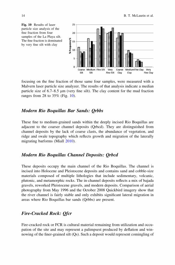
focusing on the fine fraction of those same four samples, were measured with aMalvern laser particle size analyzer. The results of that analysis indicate a medianparticle size of 6.7–8.5 lm (very fine silt). The clay content for the mud fractionranges from 28 to 35% (Fig. 10).
Modern Rio Boquillas Bar Sands: Qrbbs
These fine to medium-grained sands within the deeply incised Rio Boquillas areadjacent to the coarser channel deposits (Qrbcd). They are distinguished fromchannel deposits by the lack of coarse clasts, the abundance of vegetation, andridge and swale topography which reflects growth and migration of the laterallymigrating barforms (Miall 2010).
Modern Rio Boquillas Channel Deposits: Qrbcd
These deposits occupy the main channel of the Rio Boquillas. The channel isincised into Holocene and Pleistocene deposits and contains sand and cobble-sizematerials composed of multiple lithologies that include sedimentary, volcanic,plutonic, and metamorphic rocks. The in-channel deposits reflects a mix of bajadagravels, reworked Pleistocene gravels, and modern deposits. Comparison of aerialphotography from May 1996 and the October 2008 Quickbird imagery show thatthe river channel is fairly stable and only exhibits significant lateral migration inareas where Rio Boquillas bar sands (Qrbbs) are present.
Fire-Cracked Rock: Qfcr
Fire-cracked rock or FCR is cultural material remaining from utilization and occu-pation of the site and may represent a palimpsest produced by deflation and win-nowing of the finer-grained silt (Qs). Such a deposit would represent comingling of
Fig. 10 Results of laserparticle size analysis of thefine fraction from foursamples of the La Playa silt.The fine fraction is dominatedby very fine silt with clay
14 B. T. McLaurin et al.
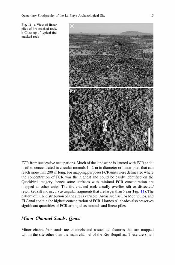
FCR from successive occupations. Much of the landscape is littered with FCR and itis often concentrated in circular mounds 1– 2 m in diameter or linear piles that canreach more than 200 m long. For mapping purposes FCR units were delineated wherethe concentration of FCR was the highest and could be easily identified on theQuickbird imagery, hence some surfaces with minimal FCR concentration aremapped as other units. The fire-cracked rock usually overlies silt or dissected/reworked silt and occurs as angular fragments that are larger than 5 cm (Fig. 11). Thepattern of FCR distribution on the site is variable. Areas such as Los Monticulos, andEl Canal contain the highest concentration of FCR. Hornos Alineados also preservessignificant quantities of FCR arranged as mounds and linear piles.
Minor Channel Sands: Qmcs
Minor channel/bar sands are channels and associated features that are mappedwithin the site other than the main channel of the Rio Boquillas. These are small
Fig. 11 a View of linearpiles of fire cracked rock.b Close-up of typical firecracked rock
Quaternary Stratigraphy of the La Playa Archaeological Site 15
ephemeral features that show a high degree of sinuosity and are responsible forproducing much of the modern dissected landscape. They drain into the Rio Bo-quillas, west of the site and are over 2 km long. The channel widths averageapproximately 2 m. The small channels are slightly sandy, but primarily arecomposed of reworked silt. Barforms along the insides of channel meanders aredominantly sandy, but may also be reworked sandy silt.
Dissected/Reworked Silt: Qdrs
These areas are underlain by silt that has been dissected by modern drainages andreworked by fluvial processes. Many of the areas in Los Entierros and LosMonticulos have been extensively dissected. Dissected silt surfaces often containmore rock and fire cracked rock than the undissected silt. The localities wherefluvial reworking is established include Los Monticulos, the northern parts of LosEntierros and western El Canal, and the areas immediately adjacent to the channelsthat flow through the dissected areas. Often these reworked deposits are difficult todistinguish from undissected silt. Some general characteristics for distinguishingreworked silt are (1) the reworked silt shows evidence of small ripples andother sedimentary structures, whereas non-reworked silt is homogenous, and(2) the reworked silt has a slightly higher sand content. Reworked silt is oftenpresent at the site as a ‘‘cap’’ that overlies the homogenous, undissected silt. Inareas of extensive erosion where the silt and upper parts of the paleosol have beenremoved, reworked silt may directly overlie the paleosol.
Modern Disturbances: Qmd
Modern disturbances reflect historic modification of the landscape, with much of itduring the twentieth century. This unit is represented by constructed features suchas roads and canals.
Discussion
The landscape at La Playa is interpreted to reflect development during extremesrelated to climatic shifts from the Pleistocene into the Holocene. The diverse grainsizes present within its soils and sediments and the variety of compositions showthat different styles of sediment transport and deposition were active. Within thepaleosol, Pleistocene gravels that are present indicate significant transport byrivers draining an extremely large catchment. The size of this drainage basin is
16 B. T. McLaurin et al.
suggested based on the variety of clast compositions present in these gravels andcobbles. The composition of the rocks in the adjacent Cerros Boquillas is clasticsedimentary and includes sandstone, siltstone, and conglomerate (McLaurin 2008).The presence of igneous and metamorphic clasts demonstrates that an ancestralRio Boquillas was transporting bed load from the north at a minimum distance of30 km. Furthermore, the rounded nature of the gravels is indicative of transport inwater, whereas locally sourced bajada gravels would be more angular in clastshape. The Pleistocene gravels exposed in the modern Rio Boquillas show thatmodern river is following the course of an ancestral Pleistocene channel. Othergravels identified in other areas of the site suggest that frequent channel avulsionallowed an ancestral Rio Boquillas to move across a broad floodplain or there weremultiple channels active simultaneously, such as in a braided river system. Thelarge clast size and diverse clast compositions suggest a wetter climate in whichmaterials from distant sources could be easily transported by high energy rivers.These rivers reflect a climate that received more rainfall than the present SonoranDesert. This is supported by paleoclimatic studies (Metcalfe et al. 2000) thatindicate conditions during the last glacial maximum to around 9,000 years agowere characterized by abundant rainfall during the winter months. The develop-ment of desert pavement surfaces above the paleosol may be attributed to stabil-ization of the landscape perhaps associated with a drying of the climate into theearly to middle Holocene (Mabry 1998).
The tan-brown La Playa silt was deposited under conditions quite different fromthe underlying paleosol. The clayey, very fine silt-size is consistent throughout theunit. The lack of definable stratigraphy, coarser sandy sheetflood deposits or coarsegravel lags make a floodplain or cienega-type interpretation (Johnson 1960, 1963)worth further examination. Another possible interpretation could be that the silt isan eolian loess or loess-like deposit. Comparison of the La Playa silt with diag-nostic criteria used to define loess (Pécsi 1990; Pye 1995) shows the grain size,composition, weathering characteristics, and stratigraphic context are all consistentwith other described loess deposits. Although the concept of ‘‘desert loess’’remains controversial (Tsoar and Pye 1987; Wright 2001), an eolian origin for theLa Playa silt is a reasonable interpretation based on characteristics defined byPécsi (1990) and Pye (1995). If the La Playa silt was deposited in a subaqueousenvironment, it would have required isolation from Rio Boquillas flooding andchannel switching. The very fine silt size would need deposition under verylow energy conditions and the lack of coarse interbeds would mean that the RioBoquillas would have been relatively stable in its floodplain, distant from thedeposition of the silt (Miall 2010). Mabry (1998) suggests that middle Holocenedrying would have encouraged channel downcutting and the establishment ofextensive flood plain sediments.
The modern erosive processes that are cutting into the La Playa landscape andexposing its stratigraphic and sedimentological story represents a shift to a drierclimate and involves the impact of human activities on the desert landscape.Watson (2005) relates that the Rio Boquillas was a perennial stream prior to the1960s. Overgrazing and modern disturbances throughout the twentieth and early
Quaternary Stratigraphy of the La Playa Archaeological Site 17
twenty-first century have served to initiate arroyo cutting and the gradualdestruction of the La Playa site.
Conclusions
The paleoenvironmental and depositional history of the La Playa site reflects theclimatic shift from the terminal Pleistocene into the Holocene. Wetter conditionswere present during the last glacial maximum to around 9,000 years BP innorthern Mexico (Metcalfe et al. 2000). At La Playa the paleosol reflectsdepositional conditions that were fluvially dominated as suggested by poorlysorted, rounded cobbles within channel fill of a sandy floodplain. The cobbleswere transported by high energy river systems. These cobbles are composed ofdiverse lithologies from a large drainage basin that tapped source areas ofvolcanic, plutonic, and metamorphic rock. Gravel imbrications show that thepaleoflow in the Pleistocene was westerly and consistent with the direction ofmodern flow of the Rio Boquillas. These rivers that traversed the La Playa areaeither were a single, frequently avulsing channel, or possibly a multi-channelbraided system. Individual channels were at least 30 m wide. Climatic conditionsduring the Pleistocene were clearly adequate to support a diverse biota as sug-gested by the Rancholabrean fauna (Carpenter et al. 2005). The transition to theoverlying silt records a period of landscape stabilization as indicated by thegravel sheet and desert pavements that overlie the paleosol. This period ofstability possibly records a climatic shift from a much wetter environmentcapable of supporting high energy fluvial systems to one that is drier. The LaPlaya silt was previously described as a cienega or swamp-type depositionalsystem, but many of the characteristics of the silt seem more typical of the eoliandeposition of loess. The tan-brown clayey silt is extremely fine-grained and doesnot exhibit sedimentary structures that are consistent with alluvial deposition.For the silt to have been deposited in such an environment would have requiredvery quiet depositional conditions where the environment was isolated frommajor flooding events. If La Playa represented a typical alluvial floodplain, thereshould be coarser channel deposits and crevasse splay sands that are interbeddedwith the silt and are a result of flooding events or avulsion. A floodplaininterpretation for the silt that can explain the lack of alluvial features woulddepend on a stable river system that was incising rather than frequently mean-dering across its floodplain. Clearly, more detailed studies are necessary toanswer this question.
The description and mapping of the surficial units at La Playa provides afundamental stratigraphic framework for understanding landscape changes withinthe larger context of climate change. The striking differences between thepaleosol and overlying silt are due to the highly variable nature of theirdepositional systems. This model of significant shifts in climate during thePleistocene–Holocene transition at La Playa may, in the future, prove to be
18 B. T. McLaurin et al.
accompanied by documented changes in the nature of the archaeological record.However, the lack of a detailed temporal framework for much of the depositionalhistory of La Playa currently prevents such correlations between climatic changeand shifts in human activities.
Acknowledgments Two anonymous reviewers provided helpful suggestions to improve thequality of the manuscript. We appreciate the continued funding for studies at La Playa that havebeen provided by Instituto Nacional de Antropología e Historia (INAH). Permission to conductstudies at La Playa has been granted by the Consejo de Arqueologia (INAH) and co-director ofthe La Playa project, John Carpenter. Funding was also provided by a University of ArizonaFaculty Small Grant.
References
Bintliff J (1992) Interaction between archaeological sites and geomorphology. Cuaternario yGeomorfologia 6:5–20
Bubenzer O, Riemer H (2007) Holocene climatic change and human settlement between thecentral Sahara and the Nile valley: archaeological and geomorphological results.Geoarchaeology 22:607–620
Butzer KW (1978) Changing Holocene environments at the Koster site: a geo-archaeologicalperspective. Am Antiquity 43(3):408–413
Carpenter JP, Sanchez G, Villalplando ME (2005) The Late Archaic/early agricultural period inSonora, Mexico. In: Vierra BJ (ed) New perspectives on the Late Archaic across theborderlands: from foraging to farming. University of Texas Press, Austin, pp 13–40
Davis OK, Shafer DS (1992) A Holocene climatic record for the Sonoran desert from pollen analysisof Montezuma Well, Arizona, U.S.A. Paleogeogr Paleoclimatol Paleoecol 92:107–119
Drake RJ (1960) Nonmarine molluscan remains from an archaeological site at La Playa, northernSonora, Mexico. Bull South Calif Acad Sci 59:133–137
Drake RJ (1961) Nonmarine molluscs from the La Playa site, Sonora, Mexico. Bull South CalifAcad Sci 60:127–129
Eitel B, Hecht S, Machtle B, Schukraft G, Kadereit A, Wagner GA, Kromer B, Unkel I, Reindel M(2005) Geoarchaeological evidence from desert loess in the Nazca-Palpa region, souther Peru:palaeoenvironmental changes and their impact on pre-Columbian cultures. Archaeometry47:137–158
Ferring CR (1986) Rates of fluvial sedimentation: implications for archaeological variability.Geoarchaeology 1(3):259–274
Freeman AKL (2000) Application of high-resolution alluival stratigraphy in assessing the hunter-gatherer/agricultural transition in the Santa Cruz river valley, southeastern Arizona.Geoarchaeology 15:559–589
Haynes CV Jr (1991) Geoarchaeological and paleohydrological evidence for a Clovis-agedrought in North America and its bearing on extinction. Quat Res 35:438–450
Hill JB (2004) Land use and an archaeological perspective on socio-natural studies in the WadiAl-Hasa, West-Central Jordan. Am Antiquity 69(3):389–412
Holliday VT, Haynes CV Jr, Hofman JL, Meltzer DJ (1994) Geoarchaeology and geochronologyof the Miami (Clovis) site, southern High Plains of Texas. Quat Res 41:234–244
Huckleberry G, Duff AI (2008) Alluvial cycles, climate, and puebloan settlement shifts near ZuniSalt lake, New Mexico, USA. Geoarchaeology 23(1):107–130
Johnson AE (1960) The place of the Trincheras culture of northwestern Sonora in southwesternarchaeology, M.A. University of Arizona, Tucson
Johnson AE (1963) The Trincheras culture of northern Sonora. Am Antiquity 29(2):174–186
Quaternary Stratigraphy of the La Playa Archaeological Site 19
Mabry JB (1998) Late quaternary environmental periods. In: Mabry JB (ed) Paleoindian andarchaic sites in Arizona. Center for Desert Archaeology technical report 97-7, pp 19–32
McLaurin BT (2008) Reconnaissance geology of the Boquillas and Ocuca Hills, northern Sonora,Mexico. Geol Soc Am Abstr Progr 40:198
Metcalfe SE, O’Hara SL, Caballero M, Davies SJ (2000) Records of Late Pleistocene–Holoceneclimatic change in Mexico—a review. Quat Sci Rev 19(7):699–721
Miall AD (2010) Alluvial deposits. In: James NP, Dalrymple RW (eds) Facies models 4.Geological association of Canada, GEOtext 6, pp 105–138
Nials FL (2008) Geomorphology and stratigraphy. In: Mabry JB (ed) Las Capas: early irrigationand sedentism in a southwestern floodplain. Center for Desert Archaeology, Anthropologicalpaper no. 28, pp 35–53
Pécsi M (1990) Loess is not just the accumulation of dust. Quat Int 7(8):1–21Pye K (1995) The nature, origin, and accumulation of loess. Quat Sci Rev 14:653–667Stafford CR, Creasman SD (2002) The hidden record: Late Holocene landscapes and settlement
archaeology in the lower Ohio river valley. Geoarchaeology 17:117–149Tsoar H, Pye K (1987) Dust transport and the question of desert loess formation. Sedimentology
34:139–153Van Nest J (1993) Geoarchaeology of dissected loess uplands in western Illinois. Geoarchaeology
8:281–311Waters MR (2000) Alluvial stratigraphy and geoarchaeology in the American southwest.
Geoarchaeology 15(6):537–557Waters MR (2008) Alluvial chronologies and archaeology of the Gila River drainage basin,
Arizona. Geomorphology 101:332–341Watson JT (2005) Cavities on the cob: dental health and agricultural transition in Sonora,
Mexico. Ph.D., University of Nevada Las Vegas, Las VegasWatson JT (2010) The introduction of agriculture and the foundation of biological variation in the
southern southwest. In: Auerbach B (ed) Center for archaeological investigations: archae-ological and biological variation in the New World. Occasional papers no. 36. SouthernIllinois University Press, Carbondale, IL, pp 135–171
Wright JS (2001) ‘‘Desert’’ loess versus ‘‘glacial’’ loess: quartz silt formation, source areas andsediment pathways in the formation of loess deposits. Geomorphology 36:231–256
Wright DK, Forman SL, Kusimba CM, Pierson J, Gomez J, Tattersfield P (2007) Stratigraphicand geochronological context of human habitation along the Galana river, Kenya.Geoarchaeology 22:709–728