57
Transportation Dublin City Council April 2017 Quietway Feasibility Study

Transportation
Dublin City Council April 2017
Quietway Feasibility Study
Prepared by: ............................................................. Checked by: ........................................................................ Jane Hennaghan Johanne Browne Consultant Engineer Principle Consultant Approved by: ............................................................. Joe Seymour Director Quietway Feasibility Study
Rev No Comments Checked by Approved by
Date
1 Draft 0 JB 05/08/16
2 Draft 1 JB 08/09/16
3 Draft 2 JS JS 05/04/17
4 Final JS JS 10/04/17
4
th Floor, Adelphi Plaza, Georges Street Upper, Dun Laoghaire, Co. Dublin, Republic of Ireland
Telephone: +353 (0) 1 238 3100 Website: http://www.aecom.com Job No 60502057 Reference Date Created April 2017 This document has been prepared by AECOM Limited for the sole use of our client (the “Client”) and in accordance with generally accepted consultancy principles, the budget for fees and the terms of reference agreed between AECOM Limited and the Client. Any information provided by third parties and referred to herein has not been checked or verified by AECOM Limited, unless otherwise expressly stated in the document. No third party may rely upon this document without the prior and express written agreement of AECOM Limited. f:\admin\admin_general_dub\000_projects\quietway\report\feasibility report.doc
1 Introduction ....................................................................................................................................................................... 2
2 Background ....................................................................................................................................................................... 5
3 Proposed Scheme Concept Options ............................................................................................................................. 21
4 Cost Estimates ................................................................................................................................................................ 45
5 Development of Quietway Concept ............................................................................................................................... 47
6 Conclusion and Recommendations .............................................................................................................................. 50
Table of Contents

Introduction
AECOM Quietway Feasibility Study 2
Capabilities on project:
Transportation
1.1 Introduction
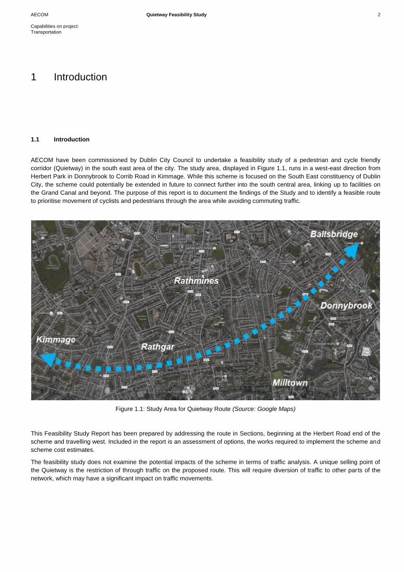
AECOM have been commissioned by Dublin City Council to undertake a feasibility study of a pedestrian and cycle friendly
corridor (Quietway) in the south east area of the city. The study area, displayed in Figure 1.1, runs in a west-east direction from
Herbert Park in Donnybrook to Corrib Road in Kimmage. While this scheme is focused on the South East constituency of Dublin
City, the scheme could potentially be extended in future to connect further into the south central area, linking up to facilities on
the Grand Canal and beyond. The purpose of this report is to document the findings of the Study and to identify a feasible route
to prioritise movement of cyclists and pedestrians through the area while avoiding commuting traffic.
Figure 1.1: Study Area for Quietway Route (Source: Google Maps)
This Feasibility Study Report has been prepared by addressing the route in Sections, beginning at the Herbert Road end of the
scheme and travelling west. Included in the report is an assessment of options, the works required to implement the scheme and
scheme cost estimates.
The feasibility study does not examine the potential impacts of the scheme in terms of traffic analysis. A unique selling point of
the Quietway is the restriction of through traffic on the proposed route. This will require diversion of traffic to other parts of the
network, which may have a significant impact on traffic movements.
1 Introduction
AECOM Quietway Feasibility Study 3
Capabilities on project:
Transportation
Quietways offer an alternative route to the busy commuter routes, offering a
more local connection to amenities and key destination, as well as more
strategic cycling infrastructure. The Quietway complements the primary and
secondary cycle network and forms feeder routes to this system.
With a Quietway, cyclist generally shares the road carriageway with vehicles,
as traffic volumes and speeds are low. Quietways also offer the opportunity to
open routes currently restricted due to permeability issues, such as cul-de-sac
streets and one-way streets. They offer the opportunity to open up
communities and make streets and neighbourhoods more attractive, by
reducing traffic volumes and speeds, as well as the dominance of the motor
vehicle. These routes are generally aimed at local trips and also the less
experienced cyclists.
Figure 1.2: Permeability Restriction

Background
AECOM Quietway Feasibility Study 5
Capabilities on project:
Transportation
2.1 Planning Context
In general, there have not been dedicated Quietways provided in Ireland to date. There have, however, been a number of trails
identified on mainly rural roads; however the facilities (such as crossings) and/or signage on these routes are generally limited,
with no restrictions on traffic movements. Examples are seen around the lakes and waterways
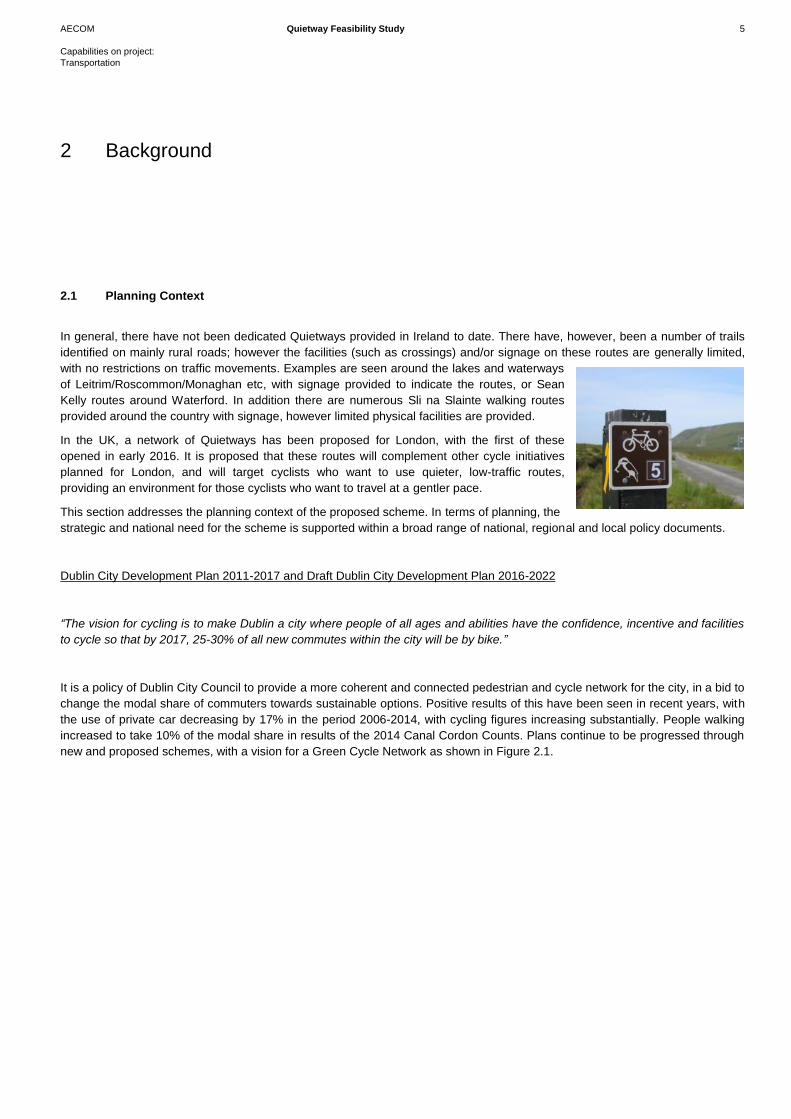
of Leitrim/Roscommon/Monaghan etc, with signage provided to indicate the routes, or Sean
Kelly routes around Waterford. In addition there are numerous Sli na Slainte walking routes
provided around the country with signage, however limited physical facilities are provided.
In the UK, a network of Quietways has been proposed for London, with the first of these
opened in early 2016. It is proposed that these routes will complement other cycle initiatives
planned for London, and will target cyclists who want to use quieter, low-traffic routes,
providing an environment for those cyclists who want to travel at a gentler pace.
This section addresses the planning context of the proposed scheme. In terms of planning, the
strategic and national need for the scheme is supported within a broad range of national, regional and local policy documents.
Dublin City Development Plan 2011-2017 and Draft Dublin City Development Plan 2016-2022
“The vision for cycling is to make Dublin a city where people of all ages and abilities have the confidence, incentive and facilities
to cycle so that by 2017, 25-30% of all new commutes within the city will be by bike.”
It is a policy of Dublin City Council to provide a more coherent and connected pedestrian and cycle network for the city, in a bid to
change the modal share of commuters towards sustainable options. Positive results of this have been seen in recent years, with
the use of private car decreasing by 17% in the period 2006-2014, with cycling figures increasing substantially. People walking
increased to take 10% of the modal share in results of the 2014 Canal Cordon Counts. Plans continue to be progressed through
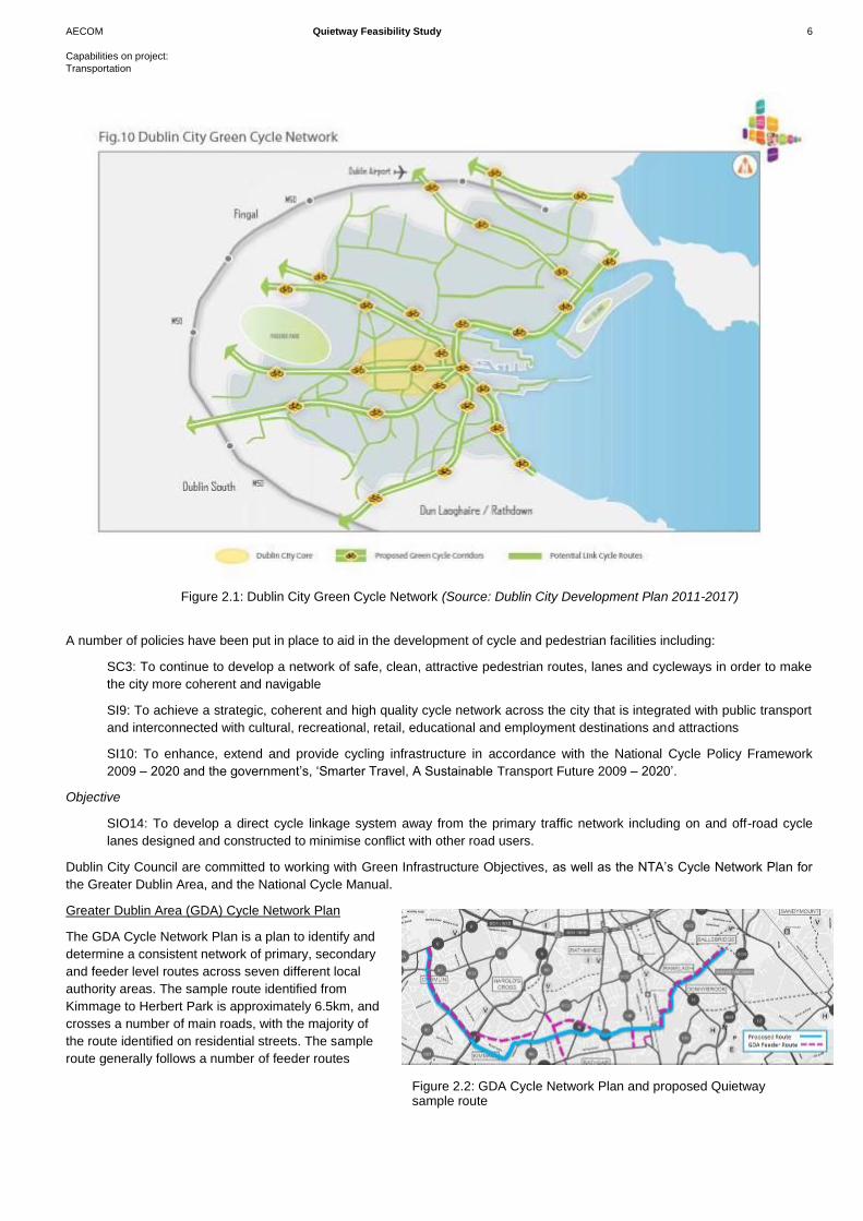
new and proposed schemes, with a vision for a Green Cycle Network as shown in Figure 2.1.
2 Background
AECOM Quietway Feasibility Study 6
Capabilities on project:
Transportation
Figure 2.1: Dublin City Green Cycle Network (Source: Dublin City Development Plan 2011-2017)
A number of policies have been put in place to aid in the development of cycle and pedestrian facilities including:
SC3: To continue to develop a network of safe, clean, attractive pedestrian routes, lanes and cycleways in order to make
the city more coherent and navigable
SI9: To achieve a strategic, coherent and high quality cycle network across the city that is integrated with public transport
and interconnected with cultural, recreational, retail, educational and employment destinations and attractions
SI10: To enhance, extend and provide cycling infrastructure in accordance with the National Cycle Policy Framework
2009 – 2020 and the government’s, ‘Smarter Travel, A Sustainable Transport Future 2009 – 2020’.
Objective
SIO14: To develop a direct cycle linkage system away from the primary traffic network including on and off-road cycle
lanes designed and constructed to minimise conflict with other road users.
Dublin City Council are committed to working with Green Infrastructure Objectives, as well as the NTA’s Cycle Network Plan for
the Greater Dublin Area, and the National Cycle Manual.
Greater Dublin Area (GDA) Cycle Network Plan
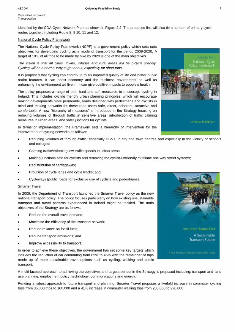
The GDA Cycle Network Plan is a plan to identify and
determine a consistent network of primary, secondary
and feeder level routes across seven different local
authority areas. The sample route identified from
Kimmage to Herbert Park is approximately 6.5km, and
crosses a number of main roads, with the majority of
the route identified on residential streets. The sample
route generally follows a number of feeder routes
Figure 2.1 Dublin City Green Cycle Network (Source Dublin City Development Plan 2011-2017)
Figure 2.2: GDA Cycle Network Plan and proposed Quietway sample route
AECOM Quietway Feasibility Study 7
Capabilities on project:
Transportation
identified by the GDA Cycle Network Plan, as shown in Figure 2.2. The proposed link will also tie a number of primary cycle
routes together, including Route 8, 9 10, 11 and 12.
National Cycle Policy Framework
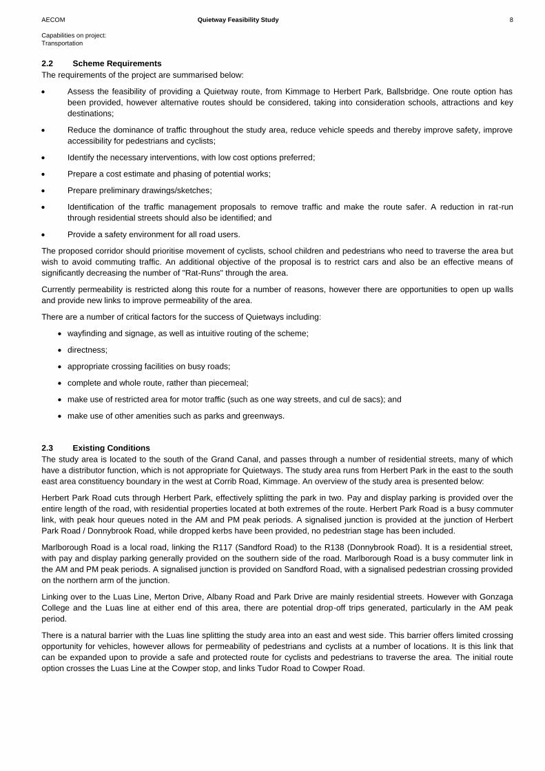
The National Cycle Policy Framework (NCPF) is a government policy which sets outs
objectives for developing cycling as a mode of transport for the period 2009-2020. A
target of 10% of all trips to be made by bike by 2020 is one of the main objectives.
The vision is that all cities, towns, villages and rural areas will be bicycle friendly.
Cycling will be a normal way to get about, especially for short trips.
It is proposed that cycling can contribute to an improved quality of life and better public
realm features. It can boost economy and the business environment as well as
enhancing the environment we live in. It can give positive impacts to people’s health.
The policy proposes a range of both hard and soft measures to encourage cycling in
Ireland. This includes cycling friendly urban planning principles, which will encourage
making developments more permeable, roads designed with pedestrians and cyclists in
mind and making networks for these road users safe, direct, coherent, attractive and
comfortable. A new “hierarchy of measures” is introduced in the Strategy focusing on
reducing volumes of through traffic in sensitive areas, introduction of traffic calming
measures in urban areas, and safer junctions for cyclists.
In terms of implementation, the Framework sets a hierarchy of intervention for the
improvement of cycling networks as follows:
Reducing volumes of through-traffic, especially HGVs, in city and town centres and especially in the vicinity of schools
and colleges;
Calming traffic/enforcing low traffic speeds in urban areas;
Making junctions safe for cyclists and removing the cyclist-unfriendly multilane one way street systems;
Redistribution of carriageway;
Provision of cycle lanes and cycle tracks; and
Cycleways (public roads for exclusive use of cyclists and pedestrians).
Smarter Travel
In 2009, the Department of Transport launched the Smarter Travel policy as the new
national transport policy. The policy focuses particularly on how existing unsustainable
transport and travel patterns experienced in Ireland might be tackled. The main
objectives of the Strategy are as follows:
Reduce the overall travel demand;
Maximise the efficiency of the transport network;
Reduce reliance on fossil fuels;
Reduce transport emissions; and
Improve accessibility to transport.
In order to achieve these objectives, the government has set some key targets which
includes the reduction of car commuting from 65% to 45% with the remainder of trips
made up of more sustainable travel options such as cycling, walking and public
transport.
A multi faceted approach to achieving the objectives and targets set out in the Strategy is proposed including: transport and land
use planning, employment policy, technology, communications and energy.
Pending a robust approach to future transport and planning, Smarter Travel proposes a fivefold increase in commuter cycling
trips from 35,000 trips to 160,000 and a 41% increase in commuter walking trips from 205,000 to 290,000.
AECOM Quietway Feasibility Study 8
Capabilities on project:
Transportation
2.2 Scheme Requirements
The requirements of the project are summarised below:
Assess the feasibility of providing a Quietway route, from Kimmage to Herbert Park, Ballsbridge. One route option has
been provided, however alternative routes should be considered, taking into consideration schools, attractions and key
destinations;
Reduce the dominance of traffic throughout the study area, reduce vehicle speeds and thereby improve safety, improve
accessibility for pedestrians and cyclists;
Identify the necessary interventions, with low cost options preferred;
Prepare a cost estimate and phasing of potential works;
Prepare preliminary drawings/sketches;
Identification of the traffic management proposals to remove traffic and make the route safer. A reduction in rat-run
through residential streets should also be identified; and
Provide a safety environment for all road users.
The proposed corridor should prioritise movement of cyclists, school children and pedestrians who need to traverse the area but
wish to avoid commuting traffic. An additional objective of the proposal is to restrict cars and also be an effective means of
significantly decreasing the number of "Rat-Runs" through the area.
Currently permeability is restricted along this route for a number of reasons, however there are opportunities to open up walls
and provide new links to improve permeability of the area.
There are a number of critical factors for the success of Quietways including:
wayfinding and signage, as well as intuitive routing of the scheme;
directness;
appropriate crossing facilities on busy roads;
complete and whole route, rather than piecemeal;
make use of restricted area for motor traffic (such as one way streets, and cul de sacs); and
make use of other amenities such as parks and greenways.
2.3 Existing Conditions
The study area is located to the south of the Grand Canal, and passes through a number of residential streets, many of which
have a distributor function, which is not appropriate for Quietways. The study area runs from Herbert Park in the east to the south
east area constituency boundary in the west at Corrib Road, Kimmage. An overview of the study area is presented below:
Herbert Park Road cuts through Herbert Park, effectively splitting the park in two. Pay and display parking is provided over the
entire length of the road, with residential properties located at both extremes of the route. Herbert Park Road is a busy commuter
link, with peak hour queues noted in the AM and PM peak periods. A signalised junction is provided at the junction of Herbert
Park Road / Donnybrook Road, while dropped kerbs have been provided, no pedestrian stage has been included.
Marlborough Road is a local road, linking the R117 (Sandford Road) to the R138 (Donnybrook Road). It is a residential street,
with pay and display parking generally provided on the southern side of the road. Marlborough Road is a busy commuter link in
the AM and PM peak periods. A signalised junction is provided on Sandford Road, with a signalised pedestrian crossing provided
on the northern arm of the junction.
Linking over to the Luas Line, Merton Drive, Albany Road and Park Drive are mainly residential streets. However with Gonzaga
College and the Luas line at either end of this area, there are potential drop-off trips generated, particularly in the AM peak
period.
There is a natural barrier with the Luas line splitting the study area into an east and west side. This barrier offers limited crossing
opportunity for vehicles, however allows for permeability of pedestrians and cyclists at a number of locations. It is this link that
can be expanded upon to provide a safe and protected route for cyclists and pedestrians to traverse the area. The initial route
option crosses the Luas Line at the Cowper stop, and links Tudor Road to Cowper Road.
AECOM Quietway Feasibility Study 9
Capabilities on project:
Transportation
Cowper Road links Merton Road to Rathmines Road Upper, passing through Palmerston Road junction. It is residential in nature
with a park located to the southern end of the street. Due to the location of the Luas stop, motorists dropping commuters/school
children in the AM peak period are common. Pay and display parking is provided on both sides of the road over the entire length.
A signalised junction is provided at the junction of Cowper Road/Palmerston Road, and while there are dropped kerbs provided,
no dedicated pedestrian phase is included in the signal sequence. The initial option proposed a link into Cowper Downs and
through to Cowper Mews. Cowper Mews forms a priority junction with Rathmines Road Upper. There are no crossing facilities
provided at this location.
Linking Rathmines Road Upper and Rathgar Road is Frankfort Avenue, which is a one way street south-east bound. Pay and
display parking is provided over the entire length, with one traffic lane provided. The initial route turns off Frankfort Avenue to
travel along Garville Road. This road is residential in nature, with pay and display parking provided on one side of the road.
Garville Road links onto Rathgar Road in the form of a priority junction. A raised table is provided at this junction, with an on-road
cycle lane provided through the junction. Frankfort Avenue is busy with traffic throughout the day, however Garville Road is less
so.
Garville Avenue links Rathgar Road and Rathgar Avenue. Pay and display parking is provided on both sides of the road. Garville
Road Upper continues through to Brighton Square and on to Terenure Road North. Pay and display parking is provided
throughout. At the junction of Terenure Road North, existing cycle lanes are provided on both sides of the road. A signalised
pedestrian crossing is provided to the south of the Ashdale Road junction.
Ashdale Road is a local residential street, with very little through traffic. Pay and display parking is provided through out. It is
proposed to bring the Quietway along Ashdale Road and into Ashdale Gardens. At the end of this street, a wall prevents
permeability; therefore it is proposed to break through to join Corrib Road. Corrib Road is a residential street, with an existing
filtered permeability feature provided. Corrib Road links to Kimmage Road Lower.
Collisions
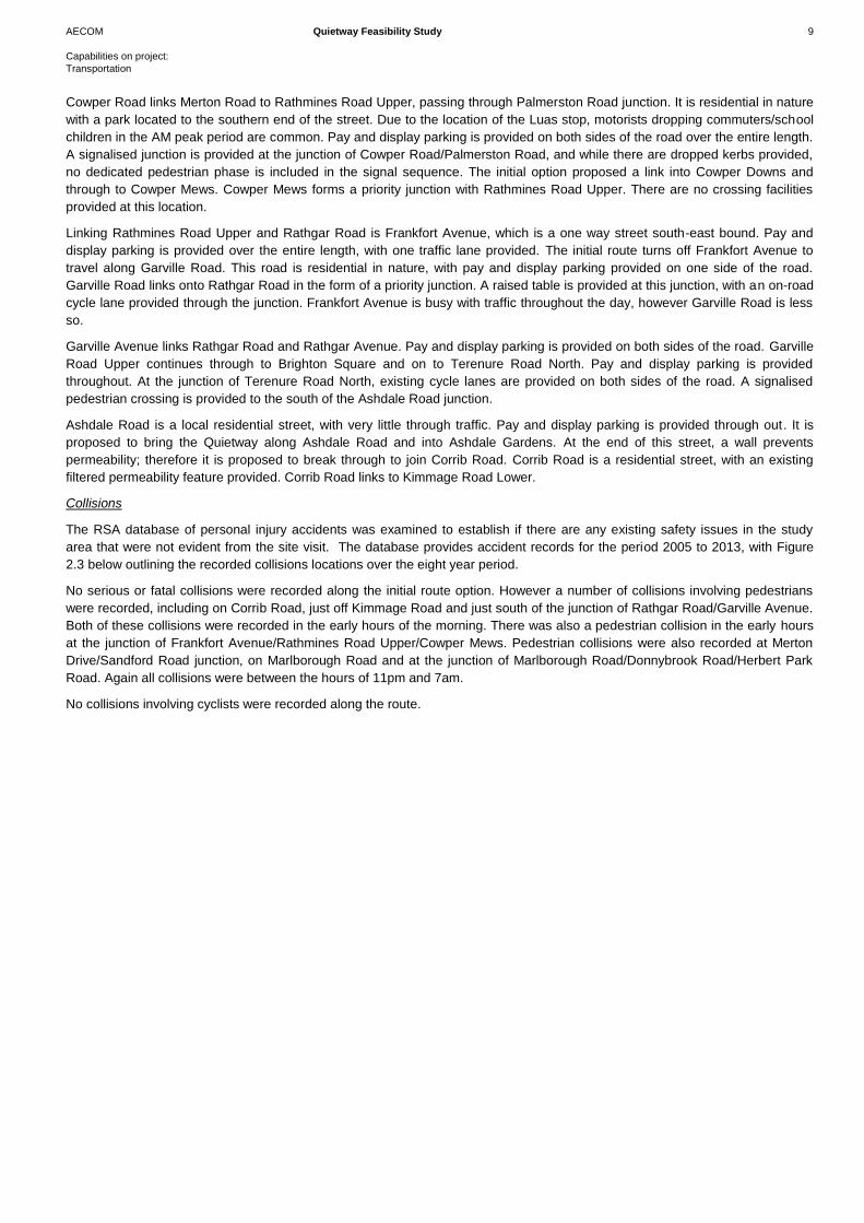
The RSA database of personal injury accidents was examined to establish if there are any existing safety issues in the study
area that were not evident from the site visit. The database provides accident records for the period 2005 to 2013, with Figure
2.3 below outlining the recorded collisions locations over the eight year period.
No serious or fatal collisions were recorded along the initial route option. However a number of collisions involving pedestrians
were recorded, including on Corrib Road, just off Kimmage Road and just south of the junction of Rathgar Road/Garville Avenue.
Both of these collisions were recorded in the early hours of the morning. There was also a pedestrian collision in the early hours
at the junction of Frankfort Avenue/Rathmines Road Upper/Cowper Mews. Pedestrian collisions were also recorded at Merton
Drive/Sandford Road junction, on Marlborough Road and at the junction of Marlborough Road/Donnybrook Road/Herbert Park
Road. Again all collisions were between the hours of 11pm and 7am.
No collisions involving cyclists were recorded along the route.
AECOM Quietway Feasibility Study 10
Capabilities on project:
Transportation
Figure 2.3: Accident Database 2005 – 2013 (Source: RSA.ie)
Generally bus routes pass through the proposed route in a north/south direction heading in and out of the city centre, however
there is a bus route that travels along Cowper Road, between the junction of Rathmines Road and Palmerston Road. The 140
bus route travels between IKEA in Finglas and Palmerston Park in Rathmines and runs at a frequency of five times in the AM and
PM peak hours.
Pedestrian Environment
Section 1 – Herbert Park to Green Luas Line
Beginning from Herbert Park and travelling west, pedestrian facilities are more than adequate along Herbert Park road, with a
wide footpath located on both sides of the road, in good condition, and there are trees that line the road. There are, however, no
dedicated crossing facilities for pedestrians at the Morehampton Road/Herbert Park Road junction. The only provision is dropped
kerbs and a central island. There is no tactile provision through the junction.
Marlborough Road has a footpath on both sides of the road, with an adequate width for walking. There are trees lining the
footpath which improves the streetscape. At the Marlborough Road/Sandford Road junction there is a signalised pedestrian
crossing facility on the west arm only in the junction. The crossing would need to be upgraded and widened for implementing the
scheme. On Merton Drive, there is a footpath on the west side of the road. After 140m, a footpath on the east side of the road
begins. The road itself is narrow and includes ramps every 100m along the road. Footpath width is approximately 2-2.3m. There
is existing public lighting along the road and the road is quiet residential in nature.
Albany Road, Park Drive and Cowper Gardens are all similar to the facilities provided along Merton Drive. The roads are all
residential with adequate footpath both sides and trees lining the street to provide a pleasant streetscape.
Section 2 – Green Luas Line to Terenure Road North
The Cowper Luas stop provides a crossing location for both pedestrians and cyclists with a wide walkway provided from the Luas
to Cowper Road. Cowper Road provides good pedestrian facilities with a wide footpath located on both sides of the street. The
condition of the footpath is good. The street is again lined with large trees on both sides, providing a pleasant streetscape to walk
through.
AECOM Quietway Feasibility Study 11
Capabilities on project:
Transportation
At the Cowper Road/Palmerston Road junction, there are no pedestrian crossing facilities provided on any arm. There are
dropped kerbs on some arms but no tactile facilities. As the route continues from Cowper Road to Cowper Downs and Cowper
Mews, the road layout remains the same.
Moving West to Frankfort Avenue and Garville Avenue, there is a footpath provided on both sides of the street. The footpath is
wider on the southern side of the road, approximately 2.5 - 3m in width. Coming out of Garville Road at Rathgar Road, there are
no crossing facilities provided at present. Continuing along Garville Avenue to the Rathgar Ave junction, pedestrian facilities are
good. There is a footpath on both sides of the road, both footpaths are in good condition. Ramps are located every 70m
approximately. There are no formal crossing facilities at the Rathgar Avenue junction. Dropped kerbs are provided on all arms,
however there are no tactile facilities in place.
There are no formal crossing facilities provided at the Garville Avenue/ Brighton Square junction. There is a raised table at the
junction and dropped kerbs are provided, however, no tactile facilities are in place.
Brighton Square is a wide road with footpaths provided on both sides. Footpath provision is good; the paths are wide and are in
good condition. The streetscape of the road could be improved.
Section 3 – Terenure Road North to Corrib Road
At the Terenure Road North/Ashdale Road junction, a toucan crossing is provided on the southern arm of the junction. Tactile
facilities and dropped kerbs are provided. The suggested route continues along Ashdale Road. Footpaths are provided on both
sides of the street. Width of footpath is narrower than in previous sections of the route, approximately 1 – 1.5m in width. The road
itself is narrow and is residential in nature.
From the sample route provided, it runs from Ashdale Road to Corrib Road, routing through an existing wall. Corrib Road is
residential. There is a footpath on both sides of the street with trees lining the footpath. Ramps are provided every 60 – 90m
along the road. The road is quiet with little through traffic. There is an existing filtered permeability barrier in place which prevents
rat running in this location.
Cycle Environment
Section 1 – Herbert Park to Green Luas Line
Herbert Park Road has no cycle facilities along its length. The road itself is quite wide with paid and permit parking along both
sides. The road is in good condition and already has many cyclists travelling along it. At the Morehampton Road/Herbert Park
Road junction, there are no crossing facilities for pedestrians or cyclists. There are advisory cycle lane facilities on the
Morehampton Road travelling in a north/south direction, running through the junction also.
Marlborough Road is a two way street, narrow in places. There is parking on the southern side of the road which is both pay and
display and residential permit parking. There are no cycle facilities in place along this road at present as the road is too narrow.
At the Marlborough Road/Sandford Road junction, there are mandatory cycle lanes on both sides of Sandford Road, these run
through the junction.
Merton Drive is a narrow two way residential street and has no existing cycle facilities. The road is in good condition. There is
residential and paid parking on one side of the street; this parking is not allocated the full length of the street. Albany Road, Park
Drive and Cowper Gardens have a similar layout to Merton Drive. There are no cycle facilities on the road. There is residential
parking on both sides of these streets.
It is noted that Section 1 of the route is generally a heavy trafficked part of Dublin, in particular, during peak hours of commuter
traffic.
Section 2 – Green Luas Line to Terenure Road North
Crossing the Cowper Luas stop provides access to both pedestrians and cyclists with a dedicated facility in place. This then
leads onto Cowper Road. There are no dedicated cycle facilities on this road. Parking is in place on both sides of the street. The
street is wide, even with the parking both sides. The road is in good condition and can accommodate cyclists on road.
At the Cowper Road/Palmerston Road junction, there are no dedicated crossing facilities in place for cyclists. The proposed route
continues along Cowper Road, which is a wide two way street with parking both sides of the road. There are no cycle facilities in
place at present due to width restrictions of the parking and footpath allocation. The condition of the road is good and can
accommodate cyclists.
AECOM Quietway Feasibility Study 12
Capabilities on project:
Transportation
Cowper Downs and Cowper Mews are both short residential streets. There is parking on Cowper Downs; however, no parking is
allocated along Cowper Mews as this is a short laneway leading to the main road. No cycle facilities are in place at present on
either street as it is not feasible to provide any facilities due to the narrow widths available.
No crossing facilities are available at present at the Cowper Mews/Rathmines Road Upper/Frankfort Avenue junction.
Frankfort Avenue is a one way residential street travelling eastbound from the junction with Rathgar Road to the junction with
Vernon Grove. The short section of Frankfort Avenue between Vernon Grove and Rathmines Road Upper is two-way to traffic.
There are no cycle facilities in place along the street. There is parking both sides of the street. The road itself is narrow and cycle
facilities would not be a possibility for this road unless parking is removed and the street changes to two way or a contra-flow
facility provided.
Garville Road is a two way street, and is residential in nature. Parking is allocated on the northern side of the street, this then
changes to the southern side of the street halfway along the road. At the Garville Road/Rathgar Road junction, there are no
crossing facilities provided. There are dedicated cycle lanes on the Rathgar Road on both sides.
Garville Avenue is a two way residential street with parking on both sides. There are no cycle facilities at present. Road width is
narrow for a two way route, however, there is areas for cars to pull in throughout the street. Road condition is adequate for
cycling, however, this route needs to be reduced in traffic in order to allow cyclists to travel on this street safely.
There are no cycle crossing facilities on Garville Avenue through the Rathgar Avenue junction, which is a busy traffic road. The
route continues on Garville Avenue Upper, which is similar to Garville Avenue. Through the Brighton Square junction, there are
no crossings in place. Brighton Square is a continuation of Garville Avenue in terms of layout and does not have any cycle
facilities in place.
Section 3 – Terenure Road North to Corrib Road
At the Terenure Road North/Garville Avenue/Corrib Road junction, there are cycle crossing facilities in place on the southern
arm. Terenure Road North also has advisory cycle lanes on both sides of the road and through the junction.
Ashdale Road and Ashdale Gardens is a two way narrow street. There are no cycle facilities in place due to width restrictions.
Dedicated parking is located on the southern side of the street. The condition of the road is good, and cyclists can be
accommodated on road through here.
Corrib Road is a two way residential street with no cycle facilities. This street has existing permeability barriers in place, therefore
traffic is low through this street, and cyclists are safe to travel on road through here.
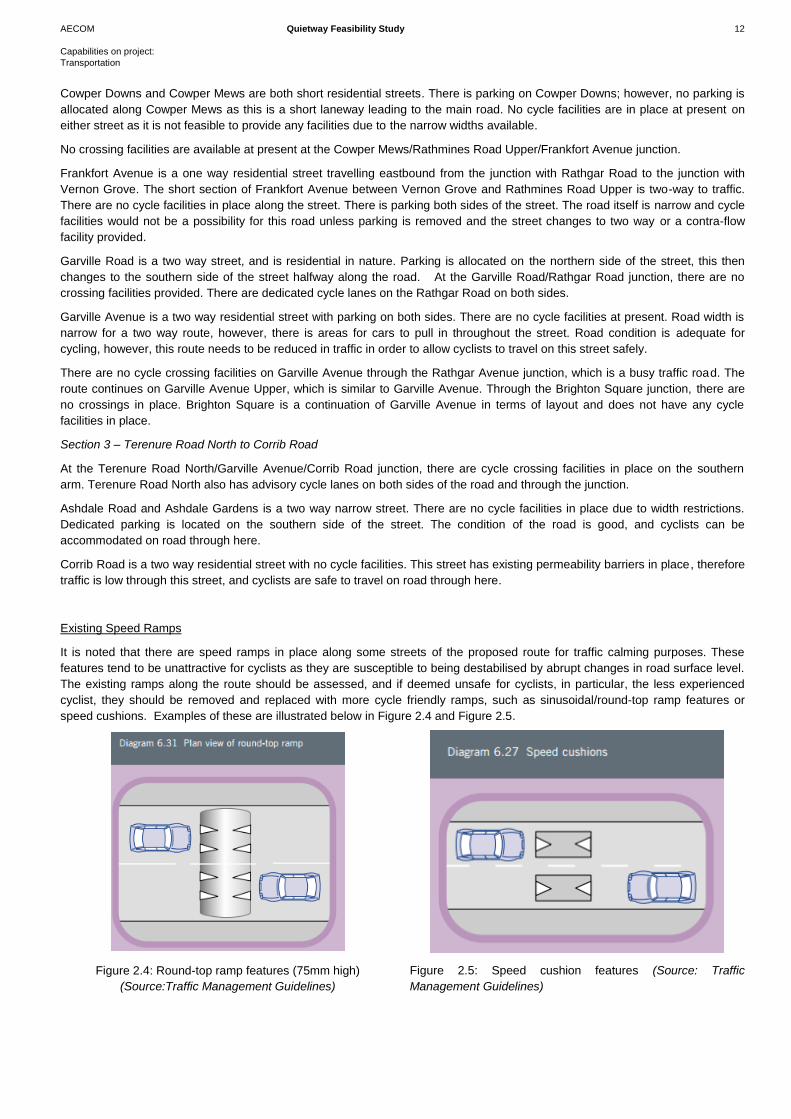
Existing Speed Ramps
It is noted that there are speed ramps in place along some streets of the proposed route for traffic calming purposes. These
features tend to be unattractive for cyclists as they are susceptible to being destabilised by abrupt changes in road surface level.
The existing ramps along the route should be assessed, and if deemed unsafe for cyclists, in particular, the less experienced
cyclist, they should be removed and replaced with more cycle friendly ramps, such as sinusoidal/round-top ramp features or
speed cushions. Examples of these are illustrated below in Figure 2.4 and Figure 2.5.
Figure 2.4: Round-top ramp features (75mm high)
(Source:Traffic Management Guidelines)
Figure 2.5: Speed cushion features (Source: Traffic
Management Guidelines)
AECOM Quietway Feasibility Study 13
Capabilities on project:
Transportation
2.4 Opportunities and Constraints
GDA Feeder Routes
The GDA Cycle Network Plan is a plan which sets out a ten year strategy for Counties Dublin, Kildare, Meath and Wicklow. The
cycle network aims to provide new connections between towns in the rural areas of the Greater Dublin Area. The planned
network consists of Primary, Secondary and Feeder routes.
The Primary and Secondary Routes are, in general, not an ideal option for cyclists travelling in this scheme as these routes are
busy trafficked roads with a distributor function. The Quietway will focus on the feeder routes; these are quiet roads, mainly
residential in nature, that connect the Primary and Secondary routes.
While the Quietway will inevitably cross Primary and Secondary roads along its proposed route, it would not be recommended to
have the proposed route travelling along these roads for any extended period of time.
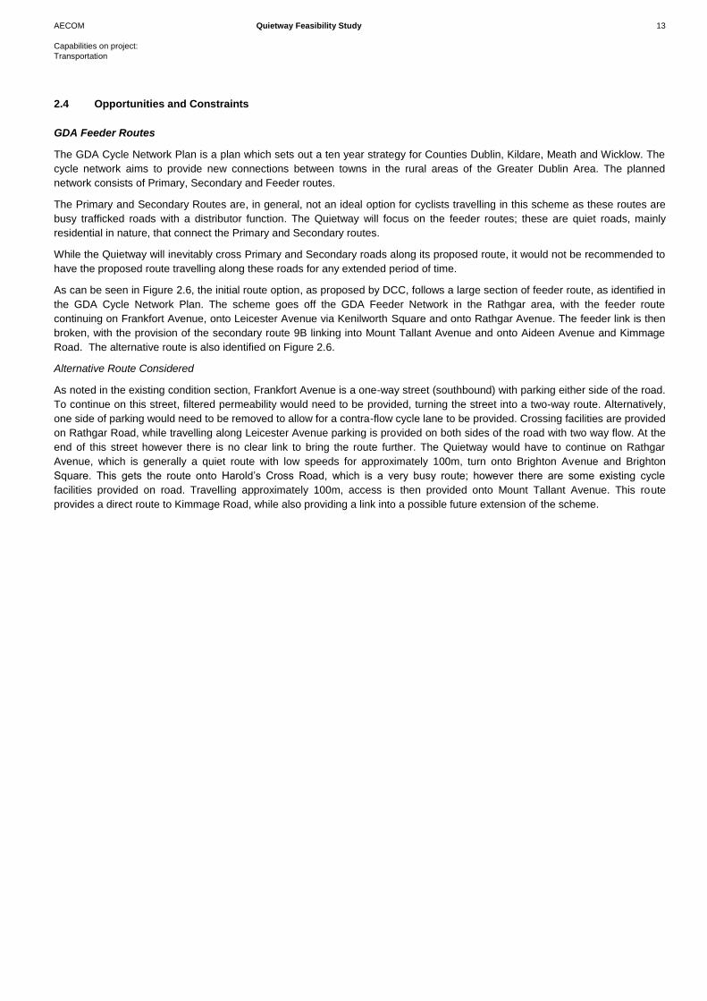
As can be seen in Figure 2.6, the initial route option, as proposed by DCC, follows a large section of feeder route, as identified in
the GDA Cycle Network Plan. The scheme goes off the GDA Feeder Network in the Rathgar area, with the feeder route
continuing on Frankfort Avenue, onto Leicester Avenue via Kenilworth Square and onto Rathgar Avenue. The feeder link is then
broken, with the provision of the secondary route 9B linking into Mount Tallant Avenue and onto Aideen Avenue and Kimmage
Road. The alternative route is also identified on Figure 2.6.
Alternative Route Considered
As noted in the existing condition section, Frankfort Avenue is a one-way street (southbound) with parking either side of the road.
To continue on this street, filtered permeability would need to be provided, turning the street into a two-way route. Alternatively,
one side of parking would need to be removed to allow for a contra-flow cycle lane to be provided. Crossing facilities are provided
on Rathgar Road, while travelling along Leicester Avenue parking is provided on both sides of the road with two way flow. At the
end of this street however there is no clear link to bring the route further. The Quietway would have to continue on Rathgar
Avenue, which is generally a quiet route with low speeds for approximately 100m, turn onto Brighton Avenue and Brighton
Square. This gets the route onto Harold’s Cross Road, which is a very busy route; however there are some existing cycle
facilities provided on road. Travelling approximately 100m, access is then provided onto Mount Tallant Avenue. This route
provides a direct route to Kimmage Road, while also providing a link into a possible future extension of the scheme.
AECOM Quietway Feasibility Study 14
Capabilities on project:
Transportation
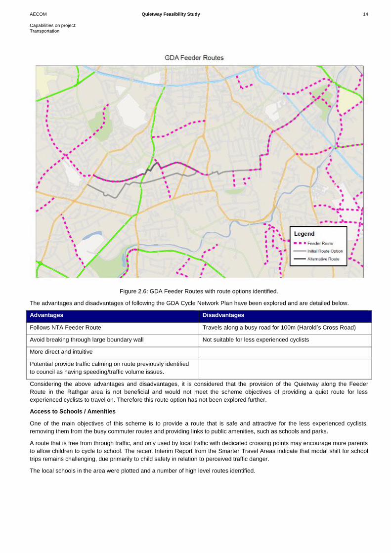
Figure 2.6: GDA Feeder Routes with route options identified.
The advantages and disadvantages of following the GDA Cycle Network Plan have been explored and are detailed below.
Advantages Disadvantages
Follows NTA Feeder Route Travels along a busy road for 100m (Harold’s Cross Road)
Avoid breaking through large boundary wall Not suitable for less experienced cyclists
More direct and intuitive
Potential provide traffic calming on route previously identified
to council as having speeding/traffic volume issues.
Considering the above advantages and disadvantages, it is considered that the provision of the Quietway along the Feeder
Route in the Rathgar area is not beneficial and would not meet the scheme objectives of providing a quiet route for less
experienced cyclists to travel on. Therefore this route option has not been explored further.
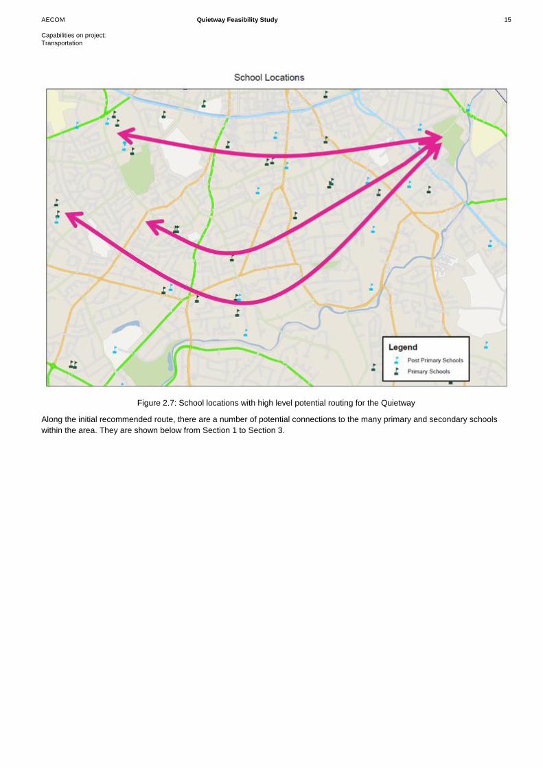
Access to Schools / Amenities
One of the main objectives of this scheme is to provide a route that is safe and attractive for the less experienced cyclists,
removing them from the busy commuter routes and providing links to public amenities, such as schools and parks.
A route that is free from through traffic, and only used by local traffic with dedicated crossing points may encourage more parents
to allow children to cycle to school. The recent Interim Report from the Smarter Travel Areas indicate that modal shift for school
trips remains challenging, due primarily to child safety in relation to perceived traffic danger.
The local schools in the area were plotted and a number of high level routes identified.
AECOM Quietway Feasibility Study 15
Capabilities on project:
Transportation
Figure 2.7: School locations with high level potential routing for the Quietway
Along the initial recommended route, there are a number of potential connections to the many primary and secondary schools
within the area. They are shown below from Section 1 to Section 3.
AECOM Quietway Feasibility Study 16
Capabilities on project:
Transportation
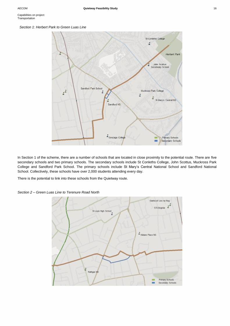
Section 1: Herbert Park to Green Luas Line
In Section 1 of the scheme, there are a number of schools that are located in close proximity to the potential route. There are five
secondary schools and two primary schools. The secondary schools include St Conleths College, John Scottus, Muckross Park
College and Sandford Park School. The primary schools include St Mary’s Central National School and Sandford National
School. Collectively, these schools have over 2,000 students attending every day.
There is the potential to link into these schools from the Quietway route.
Section 2 – Green Luas Line to Terenure Road North
AECOM Quietway Feasibility Study 17
Capabilities on project:
Transportation
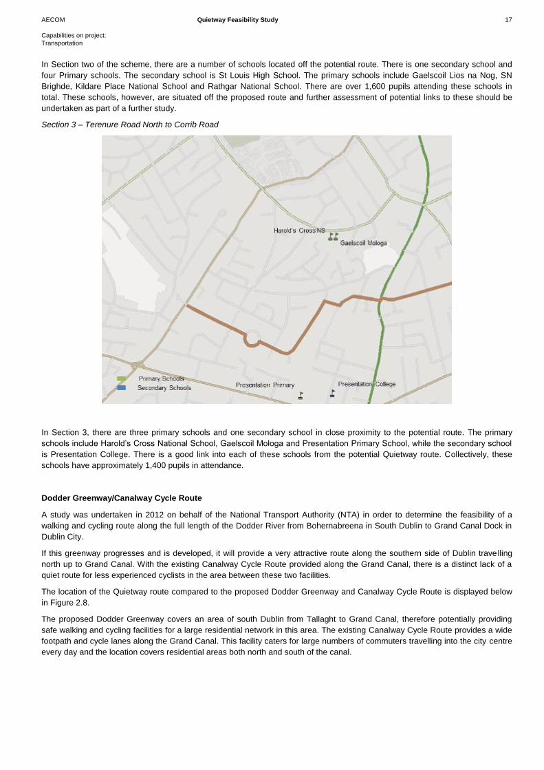
In Section two of the scheme, there are a number of schools located off the potential route. There is one secondary school and
four Primary schools. The secondary school is St Louis High School. The primary schools include Gaelscoil Lios na Nog, SN
Brighde, Kildare Place National School and Rathgar National School. There are over 1,600 pupils attending these schools in
total. These schools, however, are situated off the proposed route and further assessment of potential links to these should be
undertaken as part of a further study.
Section 3 – Terenure Road North to Corrib Road
In Section 3, there are three primary schools and one secondary school in close proximity to the potential route. The primary
schools include Harold’s Cross National School, Gaelscoil Mologa and Presentation Primary School, while the secondary school
is Presentation College. There is a good link into each of these schools from the potential Quietway route. Collectively, these
schools have approximately 1,400 pupils in attendance.
Dodder Greenway/Canalway Cycle Route
A study was undertaken in 2012 on behalf of the National Transport Authority (NTA) in order to determine the feasibility of a
walking and cycling route along the full length of the Dodder River from Bohernabreena in South Dublin to Grand Canal Dock in
Dublin City.
If this greenway progresses and is developed, it will provide a very attractive route along the southern side of Dublin travelling
north up to Grand Canal. With the existing Canalway Cycle Route provided along the Grand Canal, there is a distinct lack of a
quiet route for less experienced cyclists in the area between these two facilities.
The location of the Quietway route compared to the proposed Dodder Greenway and Canalway Cycle Route is displayed below
in Figure 2.8.
The proposed Dodder Greenway covers an area of south Dublin from Tallaght to Grand Canal, therefore potentially providing
safe walking and cycling facilities for a large residential network in this area. The existing Canalway Cycle Route provides a wide
footpath and cycle lanes along the Grand Canal. This facility caters for large numbers of commuters travelling into the city centre
every day and the location covers residential areas both north and south of the canal.
AECOM Quietway Feasibility Study 18
Capabilities on project:
Transportation
The location of both the Dodder Greenway and the Canalway Cycle facility does not facilitate for residential areas in between
these two routes. Therefore, as shown in Figure 2.8, the proposed route for the Quietway is located in between these two
facilities and will cater for residents within these areas, while also providing a potential link into the Dodder Greenway.
Figure 2.8: Location of the Quietway Route along with the Proposed Dodder Greenway Route and existing Canalway Cycle
Route
2.5 Summary
In general there is a lack of east/west cycle facilities, as well as public transport routes on the south side of the city, with all routes
generally leading to the city centre in a north/south direction. This provides an opportunity for pedestrians and cyclists to avoid
the busy commuter routes and travel to their destination in a more direct manner.
There are a number of locations where crossing facilities are not provided, or the quality of the crossing is poor, given the nature
and environment of the road. This includes locations such as the Herbert Park/Morehampton Road junction, the Cowper
Road/Palmerston Road junction, the Cowper Mews/Rathmines Road Upper junction and the Garville Road/Rathgar Road
junction. In addition, there are a number of locations where the footpath width is compromised due to vehicles parking on the
footway or the level of facility provided.
High traffic speeds and/or volumes are a major issue, and one that will have to be resolved prior to the implementation of the
scheme. Streets that see large volumes of through traffic in the peak periods are not attractive routes for the less experienced
cyclists. These traffic dominated streets ideally have to become areas for local traffic only, in order to attract cyclists to the route.
Traffic congestion on the route could lead to cyclists weaving in and out of stationary vehicles, which leads to an increased risk of
collisions with other vehicles.
The Luas provides a severance line in a north/south direction, and while vehicles can cross the line, it is done so at a limited
number of locations. Walking and cycling are generally permitted in more locations, which allow a competitive advantage to
other modes of transport, particularly the private car. This allows the route to become more attractive to users.

AECOM Quietway Feasibility Study 19
Capabilities on project:
Transportation
There is opportunity of following the GDA Cycle Network Plan feeder routes for the majority of the route, however in some
instances these routes do not connect to other feeder routes, rather providing a connection to the Primary and Secondary routes,
resulting in possible sections of the Quietway on busy commuter routes.
There are many schools in the south Dublin area, and providing a link that connects to a large number should be explored in a
further study of the route.
The Dodder Greenway will provide an attractive route along the southern side of South Dublin, along the Dodder River and
routing up towards Grand Canal. It has been determined, therefore, that the Quietway will not route too far south and will focus
on areas north of the Dodder Greenway to accommodate residential developments in this area. There is, however, the possibility
of connecting the Quietway route with the greenway at Herbert Park.
Proposed Scheme Concept
Options
AECOM Quietway Feasibility Study 21
Capabilities on project:
Transportation
3.1 Introduction
As noted there are a number of key elements required to make the Quietway a success, including:
A direct route, provided in a whole route offering rather than short elements;
A quiet route away from heavy volumes of traffic, while making use of one-way streets and cul-de-sacs;
Appropriate crossing facilities on busy roads;
Wayfinding and signage, as well as intuitive routing of the scheme;
Making use of other amenities such as parks and greenways.
3.2 Option Development Process
The proposed Quietway, subject to this feasibility study, provides an east –west link in the south east constituency of Dublin city.
The development of the possible route options was based on the above elements as well as taking into consideration the
following:
Travelling a route which permits access to the greatest number of school/amenities;
Providing a route where existing traffic volumes could be reduced and alternative options for diverted traffic were
available; and
Examining the proposed feeder routes as set out in the GDA Cycle Network Plan, as well as linking a number of the
primary cycle network routes;
Further to this, issues such as private lands, accident data and permeability were also considered. Rather than an end to end
origin/destination project, this scheme aims to provide an east-west link away from high volumes of traffic. Currently there are
limited options for this type of journey, with the majority of routes travelling towards the city centre. With the exception of the
Grand Canal route, which already has a high quality cycle facility provided, there are no other direct east-west connections, with
the Luas line providing severance in places.
The proposed options have been based on OS Mapping, with topographical survey not available for the full scheme. Therefore
the proposed design is indicative only, and should be reviewed fully when a topographical survey is available prior to the next
stage of design development.
The route has been split in three areas and proposals have been discussed under the following headings:
Environment,
Cultural, archaeological and architectural heritage
Economy,
Safety/accessibility,
Integration, and
Traffic diversions (if relevant).
Throughout the scheme, two key design options were considered,
Option 1: Removal of through traffic with provision for cyclists on road; and
Option 2: Removal of on-street parking to provide off-street facilities for cyclists.
3 Proposed Scheme Concept
Options
AECOM Quietway Feasibility Study 22
Capabilities on project:
Transportation
However Option 2 was only considered on links where space permitted (i.e. no removal of residential properties/gardens or CPO
considered) while Option 1 focuses on traffic diversions and filtered permeability.
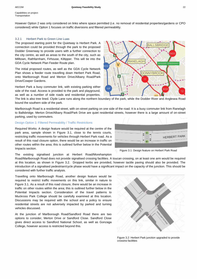
3.2.1 Herbert Park to Green Line Luas
The proposed starting point for the Quietway is Herbert Park. A
connection could be provided through the park to the proposed
Dodder Greenway to provide users with a further connection to
the city centre, as well as areas to the south of the city, such as
Milltown, Rathfarnham, Firhouse, Kiltipper. This will tie into the
GDA Cycle Network Plan Feeder Route plan.
The initial proposed routes, as well as the GDA Cycle Network
Plan shows a feeder route travelling down Herbert Park Road,
onto Marlborough Road and Merton Drive/Albany Road/Park
Drive/Cowper Gardens.
Herbert Park a busy commuter link, with existing parking either
side of the road. Access is provided to the park and playground,
as well as a number of side roads and residential properties.
The link is also tree lined. Clyde Lane runs along the northern boundary of the park, while the Dodder River and Anglesea Road
bound the southern side of the park.
Marlborough Road is a residential street, with on-street parking on one side of the road. It is a busy commuter link from Ranelagh
to Ballsbridge. Merton Drive/Albany Road/Park Drive are quiet residential streets, however there is a large amount of on-street
parking, used by commuters.
Design Option 1: Filtered Permeability / Traffic Restrictions
Required Works: A design feature would be required at the centre of the
park area, sample shown in Figure 3.1, close to the tennis courts,
restricting traffic movements for vehicles through Herbert Park road. As a
result of this road closure option, there would be an increase in traffic on
other routes within the area; this is outlined further below in the Potential
Impacts section.
The existing signalised junction at Herbert Road/Morehampton
Road/Marlborough Road does not provide signalised crossing facilities. A toucan crossing, on at least one arm would be required
at this location, as shown in Figure 3.2. Dropped kerbs are provided, however tactile paving should also be provided. The
introduction of a signalised pedestrian/cycle phase would have a significant impact on the capacity of the junction. This should be
considered with further traffic analysis.
Travelling onto Marlborough Road, another design feature would be
required to restrict traffic movements on this link, similar in nature to
Figure 3.1. As a result of this road closure, there would be an increase in
traffic on other routes within the area; this is outlined further below in the
Potential Impacts section. Consideration of the travel patterns to
Muckross Park College should be carefully examined at this location.
Discussions may be required with the school and a policy to ensure
residential streets are not adversely impacted by parked and turning
vehicles discussed.
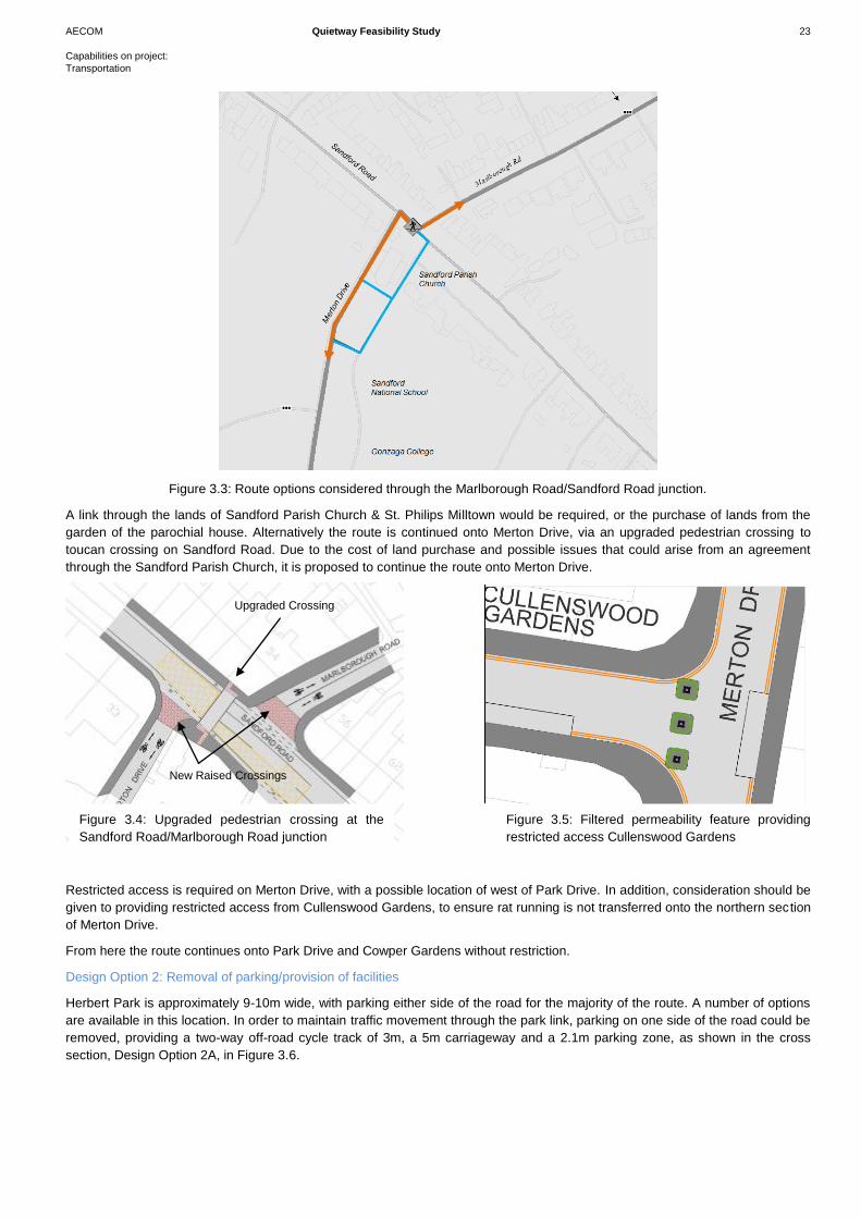
At the junction of Marlborough Road/Sandford Road there are two
options to consider, Merton Drive or Sandford Close. Sandford Close
gives direct access to Sandford National School, as well as Gonzaga
College, however access is restricted beyond this.
Figure 3.1: Design feature on Herbert Park Road
Figure 3.2: Herbert Park junction upgraded to provide crossing facilities
AECOM Quietway Feasibility Study 23
Capabilities on project:
Transportation
Figure 3.3: Route options considered through the Marlborough Road/Sandford Road junction.
A link through the lands of Sandford Parish Church & St. Philips Milltown would be required, or the purchase of lands from the
garden of the parochial house. Alternatively the route is continued onto Merton Drive, via an upgraded pedestrian crossing to
toucan crossing on Sandford Road. Due to the cost of land purchase and possible issues that could arise from an agreement
through the Sandford Parish Church, it is proposed to continue the route onto Merton Drive.
Restricted access is required on Merton Drive, with a possible location of west of Park Drive. In addition, consideration should be
given to providing restricted access from Cullenswood Gardens, to ensure rat running is not transferred onto the northern section
of Merton Drive.
From here the route continues onto Park Drive and Cowper Gardens without restriction.
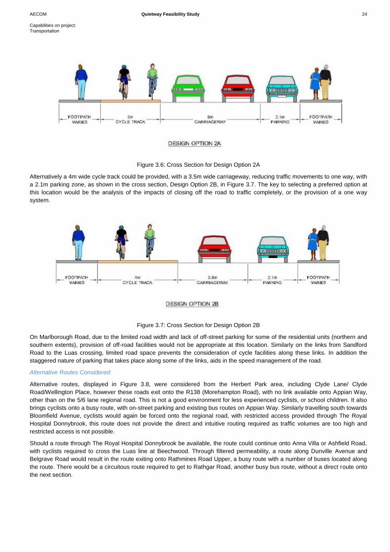
Design Option 2: Removal of parking/provision of facilities
Herbert Park is approximately 9-10m wide, with parking either side of the road for the majority of the route. A number of options
are available in this location. In order to maintain traffic movement through the park link, parking on one side of the road could be
removed, providing a two-way off-road cycle track of 3m, a 5m carriageway and a 2.1m parking zone, as shown in the cross
section, Design Option 2A, in Figure 3.6.
Upgraded Crossing
New Raised Crossings
Figure 3.4: Upgraded pedestrian crossing at the
Sandford Road/Marlborough Road junction
Figure 3.5: Filtered permeability feature providing
restricted access Cullenswood Gardens
AECOM Quietway Feasibility Study 24
Capabilities on project:
Transportation
Figure 3.6: Cross Section for Design Option 2A
Alternatively a 4m wide cycle track could be provided, with a 3.5m wide carriageway, reducing traffic movements to one way, with
a 2.1m parking zone, as shown in the cross section, Design Option 2B, in Figure 3.7. The key to selecting a preferred option at
this location would be the analysis of the impacts of closing off the road to traffic completely, or the provision of a one way
system.
Figure 3.7: Cross Section for Design Option 2B
On Marlborough Road, due to the limited road width and lack of off-street parking for some of the residential units (northern and
southern extents), provision of off-road facilities would not be appropriate at this location. Similarly on the links from Sandford
Road to the Luas crossing, limited road space prevents the consideration of cycle facilities along these links. In addition the
staggered nature of parking that takes place along some of the links, aids in the speed management of the road.
Alternative Routes Considered:
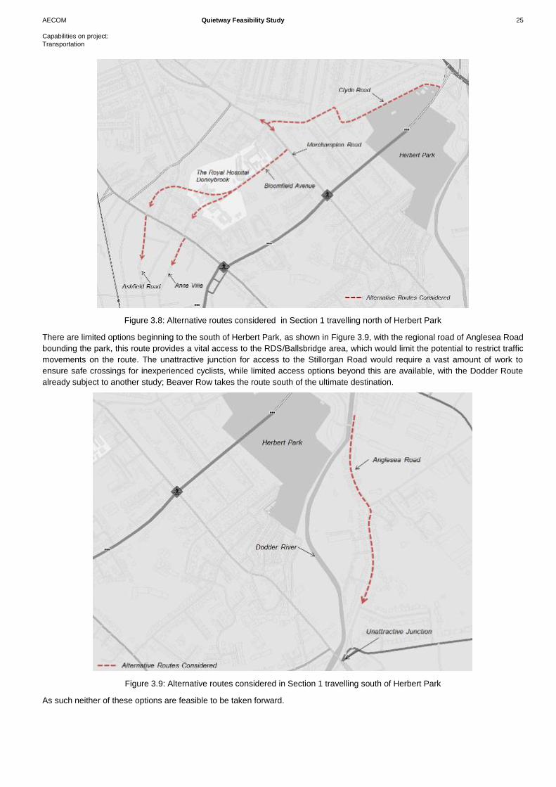
Alternative routes, displayed in Figure 3.8, were considered from the Herbert Park area, including Clyde Lane/ Clyde
Road/Wellington Place, however these roads exit onto the R138 (Morehampton Road), with no link available onto Appian Way,
other than on the 5/6 lane regional road. This is not a good environment for less experienced cyclists, or school children. It also
brings cyclists onto a busy route, with on-street parking and existing bus routes on Appian Way. Similarly travelling south towards
Bloomfield Avenue, cyclists would again be forced onto the regional road, with restricted access provided through The Royal
Hospital Donnybrook, this route does not provide the direct and intuitive routing required as traffic volumes are too high and
restricted access is not possible.
Should a route through The Royal Hospital Donnybrook be available, the route could continue onto Anna Villa or Ashfield Road,
with cyclists required to cross the Luas line at Beechwood. Through filtered permeability, a route along Dunville Avenue and
Belgrave Road would result in the route exiting onto Rathmines Road Upper, a busy route with a number of buses located along
the route. There would be a circuitous route required to get to Rathgar Road, another busy bus route, without a direct route onto
the next section.
AECOM Quietway Feasibility Study 25
Capabilities on project:
Transportation
Figure 3.8: Alternative routes considered in Section 1 travelling north of Herbert Park
There are limited options beginning to the south of Herbert Park, as shown in Figure 3.9, with the regional road of Anglesea Road
bounding the park, this route provides a vital access to the RDS/Ballsbridge area, which would limit the potential to restrict traffic
movements on the route. The unattractive junction for access to the Stillorgan Road would require a vast amount of work to
ensure safe crossings for inexperienced cyclists, while limited access options beyond this are available, with the Dodder Route
already subject to another study; Beaver Row takes the route south of the ultimate destination.
Figure 3.9: Alternative routes considered in Section 1 travelling south of Herbert Park
As such neither of these options are feasible to be taken forward.
AECOM Quietway Feasibility Study 26
Capabilities on project:
Transportation
Potential Impacts:
Environmental Impact: Both Design Option 1 and Design Option 2 will be carried out within the footprint of the existing road.
Hence there is no impact on the existing environment. All trees will be retained in each option.
Cultural, archaeological and architectural heritage: There will be no impact on archaeological and architectural heritage in the
area.
Economy: The economic impact of the proposed options have been explored based on scheme capital costs, maintenance costs
and quality of service for cyclists and pedestrians.
The majority of the scheme proposals for Option 1 and Option 2 are the same, with the exception of the treatment of Herbert
Park road. Providing an off-road cycle facility along Herbert Park road will add significant costs compared to the permitting
cyclists on the existing road way. In addition, the provision of an off-road cycle facility will require additional maintenance, with
potentially additional sweeping requirements and maintenance of additional kerb lines and surfacing. To facilitate the provision of
the off-road cycle facility, a line of on-street parking will have to be removed, with an associated loss of revenue for Dublin City
Council. Comparing the quality of service provided in Option 1 and Option 2 at Herbert Park shows positive benefits to providing
the off-road cycle facilities, however it is over a limited distance.
Safety/Accessibility
It is proposed in both Option 1 and Option 2 to provide upgraded crossings at the two major junctions along the route. Option 2
does remove cyclists from integration with vehicles completely over a short section, however Option 1 reduces traffic volumes in
the area, thus also improving safety. In addition to the upgraded crossing facilities, with widened crossings, additional measures
to improve safety and access along the route will include:
Advanced stop lines at signalised junction:
Continuous, coherent and linear route;
Banned or filtered permeability throughout the area; and
Continuous stream of signage to ensure a coherent route is identifiable by users.
Integration
This section follows one of the GDA Feeder cycle routes and so has the potential to link into this network as well as providing a
safe route along residential streets. The route is in close proximity to a number of schools and has the potential to connect to
these.
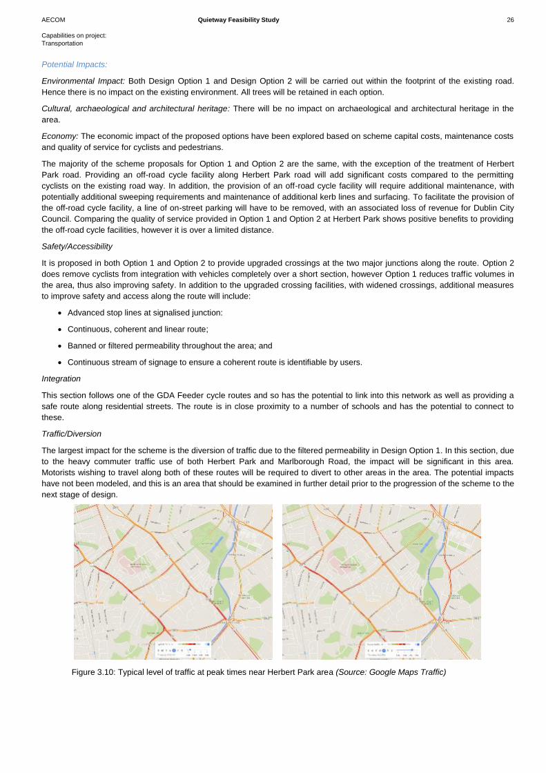
Traffic/Diversion
The largest impact for the scheme is the diversion of traffic due to the filtered permeability in Design Option 1. In this section, due
to the heavy commuter traffic use of both Herbert Park and Marlborough Road, the impact will be significant in this area.
Motorists wishing to travel along both of these routes will be required to divert to other areas in the area. The potential impacts
have not been modeled, and this is an area that should be examined in further detail prior to the progression of the scheme to the
next stage of design.
Figure 3.10: Typical level of traffic at peak times near Herbert Park area (Source: Google Maps Traffic)
AECOM Quietway Feasibility Study 27
Capabilities on project:
Transportation
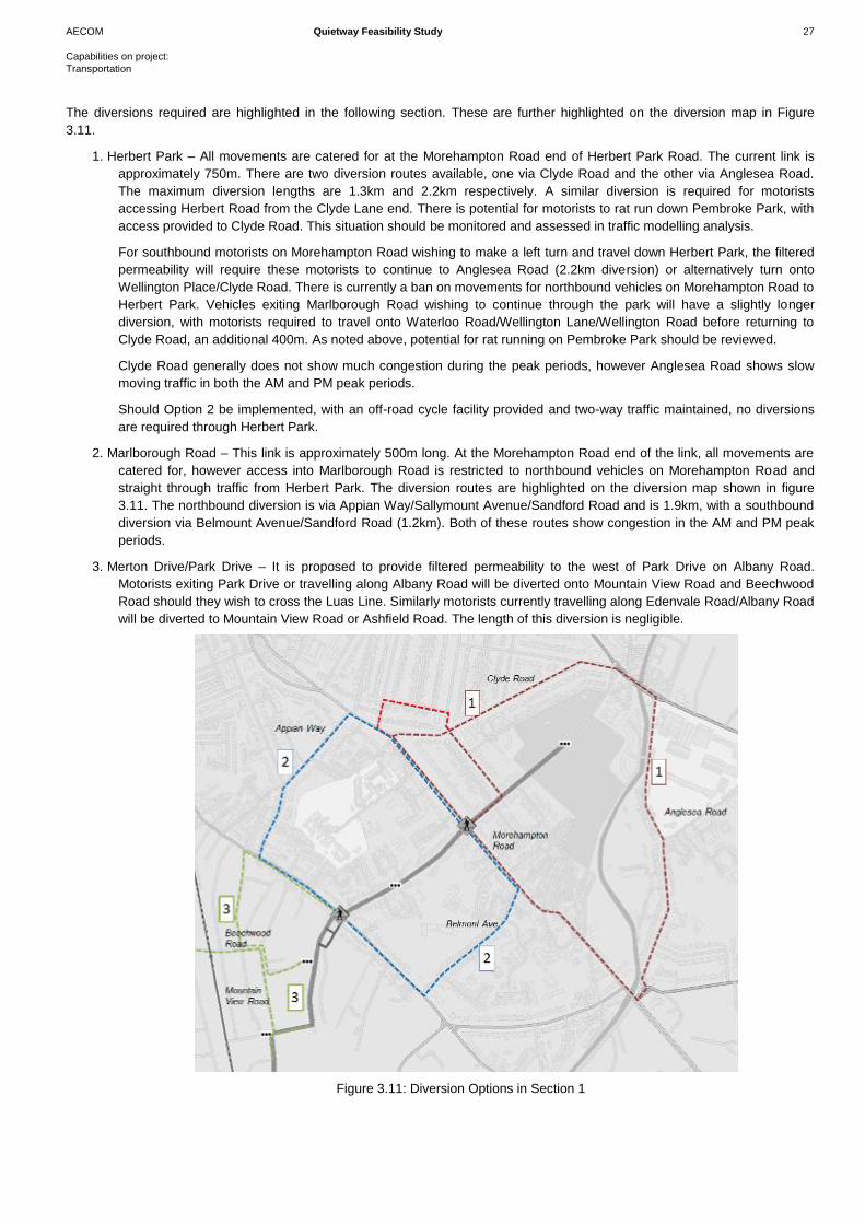
The diversions required are highlighted in the following section. These are further highlighted on the diversion map in Figure
3.11.
1. Herbert Park – All movements are catered for at the Morehampton Road end of Herbert Park Road. The current link is
approximately 750m. There are two diversion routes available, one via Clyde Road and the other via Anglesea Road.
The maximum diversion lengths are 1.3km and 2.2km respectively. A similar diversion is required for motorists
accessing Herbert Road from the Clyde Lane end. There is potential for motorists to rat run down Pembroke Park, with
access provided to Clyde Road. This situation should be monitored and assessed in traffic modelling analysis.
For southbound motorists on Morehampton Road wishing to make a left turn and travel down Herbert Park, the filtered
permeability will require these motorists to continue to Anglesea Road (2.2km diversion) or alternatively turn onto
Wellington Place/Clyde Road. There is currently a ban on movements for northbound vehicles on Morehampton Road to
Herbert Park. Vehicles exiting Marlborough Road wishing to continue through the park will have a slightly longer
diversion, with motorists required to travel onto Waterloo Road/Wellington Lane/Wellington Road before returning to
Clyde Road, an additional 400m. As noted above, potential for rat running on Pembroke Park should be reviewed.
Clyde Road generally does not show much congestion during the peak periods, however Anglesea Road shows slow
moving traffic in both the AM and PM peak periods.
Should Option 2 be implemented, with an off-road cycle facility provided and two-way traffic maintained, no diversions
are required through Herbert Park.
2. Marlborough Road – This link is approximately 500m long. At the Morehampton Road end of the link, all movements are
catered for, however access into Marlborough Road is restricted to northbound vehicles on Morehampton Road and
straight through traffic from Herbert Park. The diversion routes are highlighted on the diversion map shown in figure
3.11. The northbound diversion is via Appian Way/Sallymount Avenue/Sandford Road and is 1.9km, with a southbound
diversion via Belmount Avenue/Sandford Road (1.2km). Both of these routes show congestion in the AM and PM peak
periods.
3. Merton Drive/Park Drive – It is proposed to provide filtered permeability to the west of Park Drive on Albany Road.
Motorists exiting Park Drive or travelling along Albany Road will be diverted onto Mountain View Road and Beechwood
Road should they wish to cross the Luas Line. Similarly motorists currently travelling along Edenvale Road/Albany Road
will be diverted to Mountain View Road or Ashfield Road. The length of this diversion is negligible.
Figure 3.11: Diversion Options in Section 1
AECOM Quietway Feasibility Study 28
Capabilities on project:
Transportation
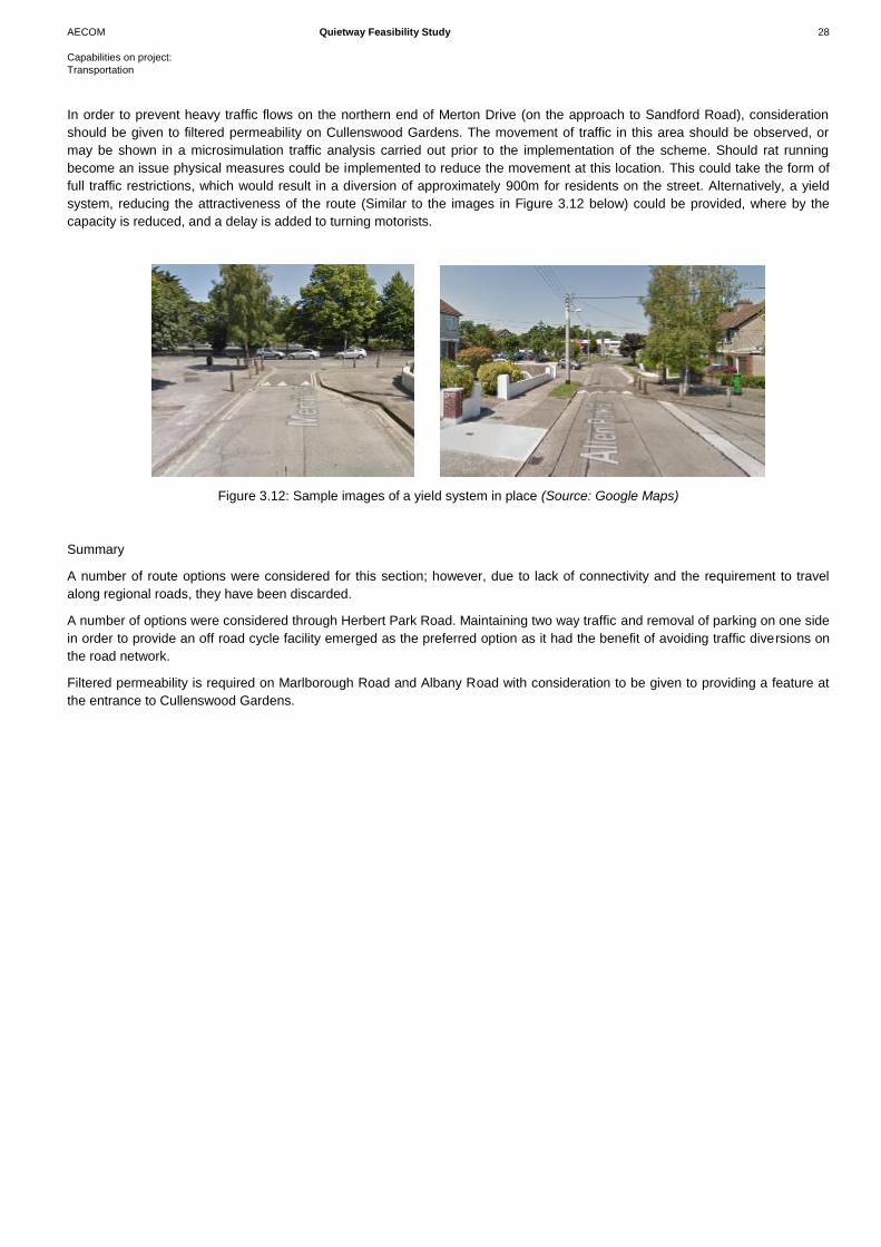
In order to prevent heavy traffic flows on the northern end of Merton Drive (on the approach to Sandford Road), consideration
should be given to filtered permeability on Cullenswood Gardens. The movement of traffic in this area should be observed, or
may be shown in a microsimulation traffic analysis carried out prior to the implementation of the scheme. Should rat running
become an issue physical measures could be implemented to reduce the movement at this location. This could take the form of
full traffic restrictions, which would result in a diversion of approximately 900m for residents on the street. Alternatively, a yield
system, reducing the attractiveness of the route (Similar to the images in Figure 3.12 below) could be provided, where by the
capacity is reduced, and a delay is added to turning motorists.
Figure 3.12: Sample images of a yield system in place (Source: Google Maps)
Summary
A number of route options were considered for this section; however, due to lack of connectivity and the requirement to travel
along regional roads, they have been discarded.
A number of options were considered through Herbert Park Road. Maintaining two way traffic and removal of parking on one side
in order to provide an off road cycle facility emerged as the preferred option as it had the benefit of avoiding traffic diversions on
the road network.
Filtered permeability is required on Marlborough Road and Albany Road with consideration to be given to providing a feature at
the entrance to Cullenswood Gardens.
AECOM Quietway Feasibility Study 29
Capabilities on project:
Transportation
3.2.2 Luas Crossing to Terenure Road North
Travelling across the Luas line the next section of the route
travels from Cowper Road to Terenure Road North.
The initial proposed route travels along Cowper Road, it then
routes into the quieter roads of Cowper Downs and Cowper
Mews, before crossing Rathmines Road Upper and onto
Frankfort Avenue, Garville Road and Garville Avenue, onto
Brighton Square and onto Terenure Road North.
A section of the route travels along the secondary route 10F,
and rejoins the GDA cycle network on Frankfort Avenue on a
feeder route.
Cowper Road is a single carriageway road, with parking either
side of the carriageway for the majority of its length. There are
trees located along the route, both mature and younger trees. At
the eastern end of Cowper Road, commuter parking is prevalent
with access close to the Luas line and the Cowper station.
To avoid a 70m link on the Rathmines Road Upper, the proposed route has been taken onto Cowper Downs, through a wall, and
into Cowper Mews. Crossing Rathmines Road Upper, the route travels onto Frankfort Avenue which is a one-way street
southbound from the junction with Rathgar Road to the Vernon Grove junction, with parking provided on either side of the road.
Garville Road is a narrow two way link, with parking provided on the northern side of the road, changing to the southern side on
the approach to Rathgar Road. The route crosses onto Garville Avenue, Garville Avenue Upper and onto Brighton Square.
These streets are generally residential, with parking provided along the route. Traffic volumes are generally low on this route.
Design Option 1: Filtered Permeability / Traffic restrictions
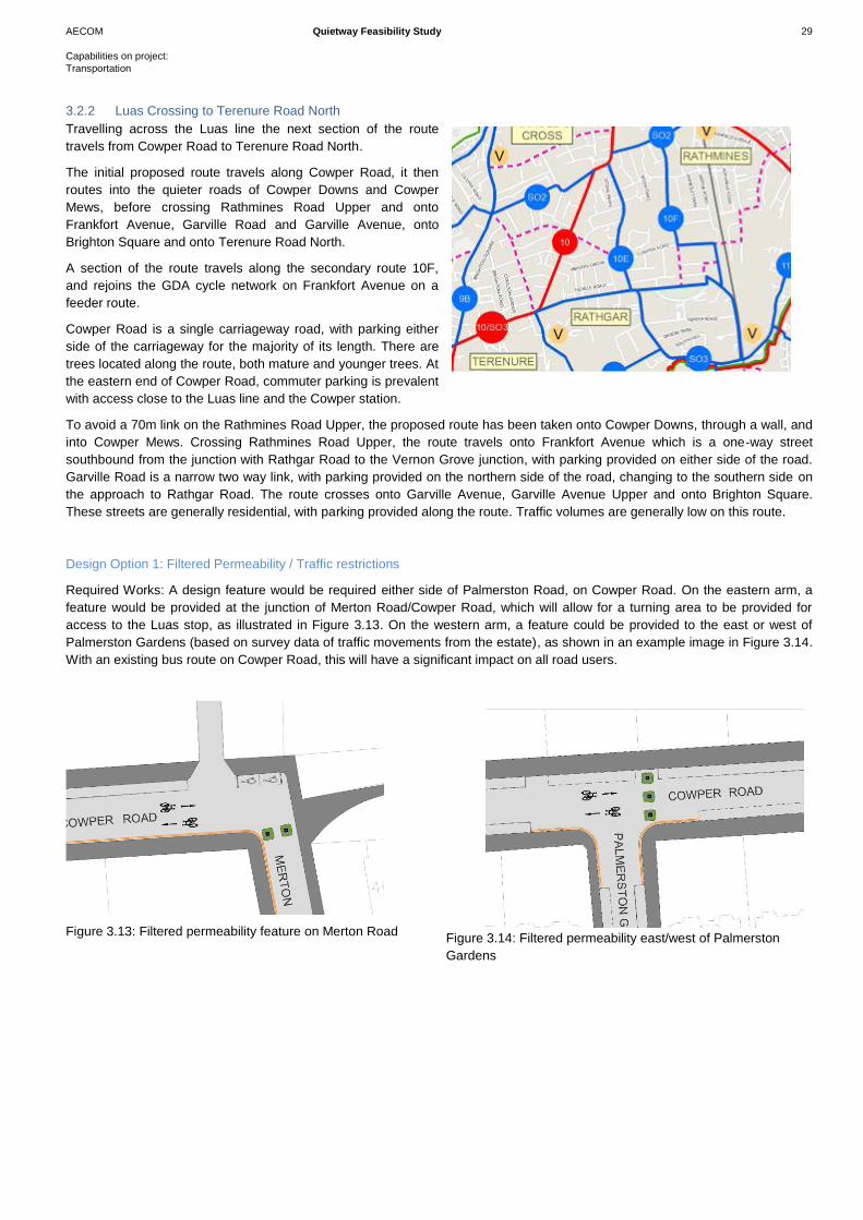
Required Works: A design feature would be required either side of Palmerston Road, on Cowper Road. On the eastern arm, a
feature would be provided at the junction of Merton Road/Cowper Road, which will allow for a turning area to be provided for
access to the Luas stop, as illustrated in Figure 3.13. On the western arm, a feature could be provided to the east or west of
Palmerston Gardens (based on survey data of traffic movements from the estate), as shown in an example image in Figure 3.14.
With an existing bus route on Cowper Road, this will have a significant impact on all road users.
Figure 3.13: Filtered permeability feature on Merton Road Figure 3.14: Filtered permeability east/west of Palmerston
Gardens
AECOM Quietway Feasibility Study 30
Capabilities on project:
Transportation
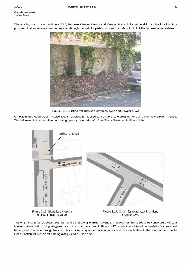
The existing wall, shown in Figure 3.15, between Cowper Downs and Cowper Mews limits permeability at this location. It is
proposed that an access could be provided through the wall, for pedestrians and cyclists only, to link the two residential estates.
Figure 3.15: Existing wall between Cowper Downs and Cowper Mews
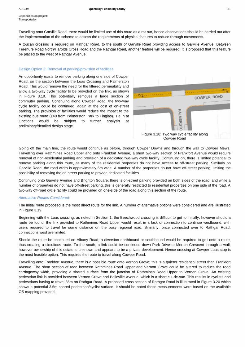
On Rathmines Road Upper, a wide toucan crossing is required to provide a safe crossing for users over to Frankfort Avenue.
This will result in the loss of some parking space (in the order of 1-2m). This is illustrated in Figure 3.16.
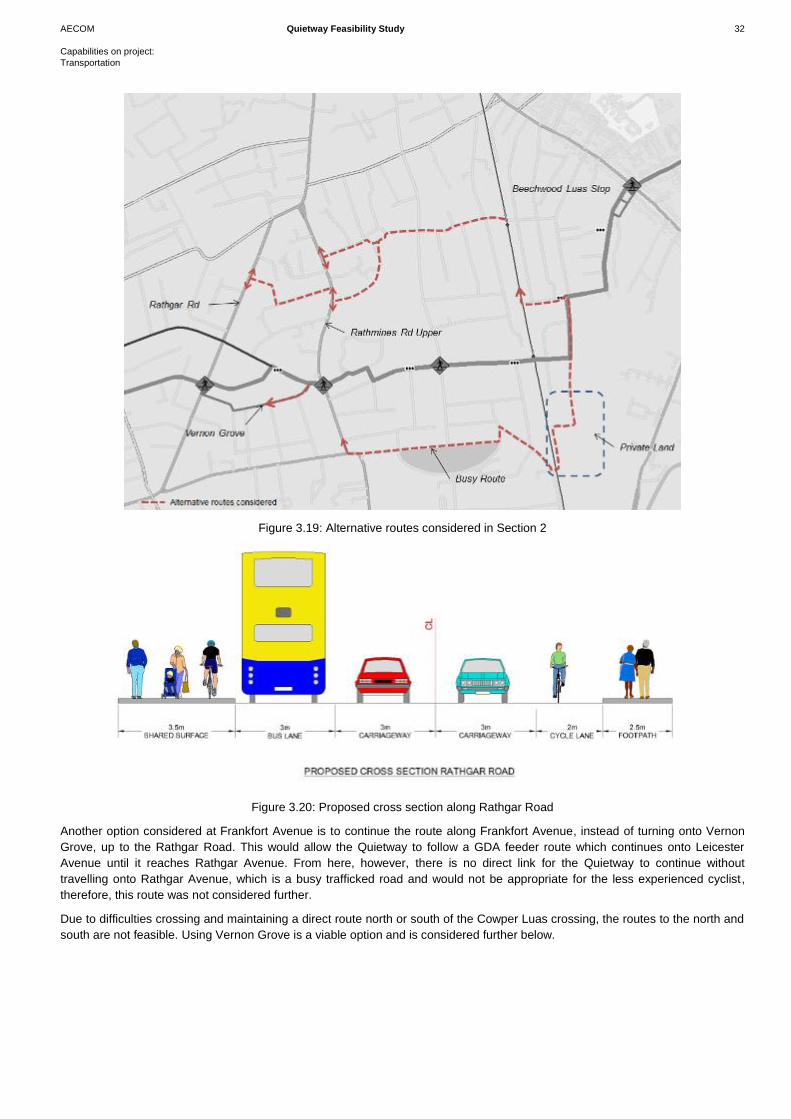
The original scheme proposals see the route travel along Frankfort Avenue. This requires the street to be converted back to a
two-way street, with parking staggered along the route, as shown in Figure 3.17. In addition a filtered permeability feature would
be required to reduce through traffic on this existing busy route. Locating a restricted access feature to the south of the Garville
Road junction will reduce rat running along Garville Road also.
Parking removed
Figure 3.16: Signalised crossing on Rathmines Rd Upper
Figure 3.17: Option for route travelling along Frankfort Ave
AECOM Quietway Feasibility Study 31
Capabilities on project:
Transportation
Travelling onto Garville Road, there would be limited use of this route as a rat run, hence observations should be carried out after
the implementation of the scheme to assess the requirements of physical features to reduce through movements.
A toucan crossing is required on Rathgar Road, to the south of Garville Road providing access to Garville Avenue. Between
Terenure Road North/Harolds Cross Road and the Rathgar Road, another feature will be required. It is proposed that this feature
be placed to the west of Rathgar Avenue.
Design Option 2: Removal of parking/provision of facilities
An opportunity exists to remove parking along one side of Cowper
Road, on the section between the Luas Crossing and Palmerston
Road. This would remove the need for the filtered permeability and
allow a two-way cycle facility to be provided on the link, as shown
in Figure 3.18. This potentially removes a large section of
commuter parking. Continuing along Cowper Road, the two-way
cycle facility could be continued, again at the cost of on-street
parking. The provision of facilities would reduce the impact to the
existing bus route (140 from Palmerston Park to Finglas). Tie in at
junctions would be subject to further analysis at
preliminary/detailed design stage.
Going off the main line, the route would continue as before, through Cowper Downs and through the wall to Cowper Mews.
Travelling over Rathmines Road Upper and onto Frankfort Avenue, a short two-way section of Frankfort Avenue would require
removal of non-residential parking and provision of a dedicated two-way cycle facility. Continuing on, there is limited potential to
remove parking along this route, as many of the residential properties do not have access to off-street parking. Similarly on
Garville Road, the road width is approximately 6m wide. A number of the properties do not have off-street parking, limiting the
possibility of removing the on-street parking to provide dedicated facilities.
Continuing onto Garville Avenue and Brighton Square, there is on-street parking provided on both sides of the road, and while a
number of properties do not have off-street parking, this is generally restricted to residential properties on one side of the road. A
two-way off-road cycle facility could be provided on one-side of the road along this section of the route.
Alternative Routes Considered:
The initial route proposed is the most direct route for the link. A number of alternative options were considered and are illustrated
in Figure 3.19.
Beginning with the Luas crossing, as noted in Section 1, the Beechwood crossing is difficult to get to initially, however should a
route be found, the link provided to Rathmines Road Upper would result in a lack of connection to continue westbound, with
users required to travel for some distance on the busy regional road. Similarly, once connected over to Rathgar Road,
connections west are limited.
Should the route be continued on Albany Road, a diversion northbound or southbound would be required to get onto a route,
thus creating a circuitous route. To the south, a link could be continued down Park Drive to Merton Crescent through a wall;
however ownership of this estate is unknown and appears to be a private development. Hence crossing at Cowper Luas stop is
the most feasible option. This requires the route to travel along Cowper Road.
Travelling onto Frankfort Avenue, there is a possible route onto Vernon Grove; this is a quieter residential street than Frankfort
Avenue. The short section of road between Rathmines Road Upper and Vernon Grove could be altered to reduce the road
carriageway width, providing a shared surface from the junction of Rathmines Road Upper to Vernon Grove. An existing
pedestrian link is provided between Vernon Grove and Belleville Avenue, which is a short cul-de-sac. This results in cyclists and
pedestrians having to travel 35m on Rathgar Road. A proposed cross section of Rathgar Road is illustrated in Figure 3.20 which
shows a potential 3.5m shared pedestrian/cyclist surface. It should be noted these measurements were based on the available
OS mapping provided.
Figure 3.18: Two way cycle facility along Cowper Road
AECOM Quietway Feasibility Study 32
Capabilities on project:
Transportation
Figure 3.19: Alternative routes considered in Section 2
Figure 3.20: Proposed cross section along Rathgar Road
Another option considered at Frankfort Avenue is to continue the route along Frankfort Avenue, instead of turning onto Vernon
Grove, up to the Rathgar Road. This would allow the Quietway to follow a GDA feeder route which continues onto Leicester
Avenue until it reaches Rathgar Avenue. From here, however, there is no direct link for the Quietway to continue without
travelling onto Rathgar Avenue, which is a busy trafficked road and would not be appropriate for the less experienced cyclist,
therefore, this route was not considered further.
Due to difficulties crossing and maintaining a direct route north or south of the Cowper Luas crossing, the routes to the north and
south are not feasible. Using Vernon Grove is a viable option and is considered further below.
AECOM Quietway Feasibility Study 33
Capabilities on project:
Transportation
Potential Impacts:
Environmental Impact: Design Option 1 and Design Option 2, as well as the alternative route through Vernon Grove, will be
carried out within the footprint of the existing road. Hence there is no impact on the existing environment. All trees will be retained
in each option.
In both options, there is a requirement to break through a wall between two residential estates, shown in Figure 3.15 above.
Cultural, archaeological and architectural heritage: There will be no impact on archaeological and architectural heritage in the
area.
Economy: The economic impacts of the proposed options have been explored based on scheme capital costs, maintenance
costs and quality of service for cyclists and pedestrians.
The majority of the Design Option 2 provides off-road cycle facilities along the route. This will add significant costs compared to
the permitting of cyclists on the existing road way. In addition, the provision of an off-road cycle facility will require additional
maintenance, with potentially additional sweeping requirements and maintenance of additional kerb lines and surfacing. To
facilitate the provision of the off-road cycle facility, a line of on-street parking will have to be removed, with an associated loss of
revenue for Dublin City Council. Comparing the quality of service provided in Option 1 and Option 2, Option 2 would provide a
better quality of service to the users of the facility. The alternative route via Vernon Grove would reduce the impact on loss of
parking required in both Design Option 1 and Design Option 2.
Safety/Accessibility
It is proposed in both Option 1 and Option 2 to provide upgraded crossings at the three major junctions along the route. Option 2
will permit off-road cycle facilities to be provided along the route, which is inherently safer, although Option 1 reduces traffic
volumes along the links. Therefore the safety will be similar for both options. In addition to the upgraded crossing facilities, with
widened crossings, additional measures to improve safety and access along the route will include:
Advanced stop lines at signalised junction:
Continuous, coherent and linear route;
Banned turns/ filtered permeability for traffic at key locations to improve route safety; and
Continuous stream of signage to ensure a coherent route is identifiable by users.
Integration
A small section of the route follows the Secondary Route 10F of the GDA cycle network. The route rejoins the GDA feeder route
at Frankfort Avenue. There are no schools that directly connect to the route in this section; however, there are possibilities of
connecting these via a further study in this area.
Traffic/Diversion
Possible traffic diversions for Section 2 are outlined below and are illustrated in Figure 3.21.
4. Providing a design feature at the junction of Merton Road/Cowper Road will require motorists travelling on Merton Road to
divert onto Temple Gardens and Temple Villas. This sees an increase from the original link of 290m to 550m, an
increase of 260m.
Depending on the location of the traffic filter to the east or west of Palmerston Gardens the following diversions will be
required. Assuming a physical feature to the west of Palmerston Gardens, motorists wishing to travel straight through on
Cowper Road, a distance of 140m, will now be required to travel 1.2km, along Cowper Road, Rathmines Road Upper
and onto Palmerston Park and Palmerston Road. In addition, the bus route on this road will need to be accommodated
elsewhere. A possible alternative bus route, of similar length, is via Cambridge Villas and Church Avenue to the north of
Cowper Road; however, discussions on re-routing would need to take place with the National Transport Authority (NTA)
and Dublin Bus.
5. On the section of route between Rathmines Road Upper and Rathgar Road, assuming the use of Vernon Grove, limited
diversions would be required due to the residential nature of the area. Should a filtered permeability feature be required,
localised diversion within the estate would result. This would need to be confirmed with traffic counts and Origin and
Destination Surveys.
AECOM Quietway Feasibility Study 34
Capabilities on project:
Transportation
Should the route be continued up Frankfort Avenue, a major change in traffic movements would be required. Frankfort
Avenue would essentially be cul-de-sac’d. The existing link between the Garville Road junction and Rathmines Road
Upper is 230m. Motorists heading southbound on Frankfort Avenue will be required to travel approximately 2km to travel
between Rathgar Road and Rathmines Road Upper, via Highfield Road. The northbound alternative from Rathgar Road
is a circuitous route of 1.7km via Castlewood Avenue and Church Avenue, while from Rathmines Road, a shorter 700m
route is available via Maxwell Road.
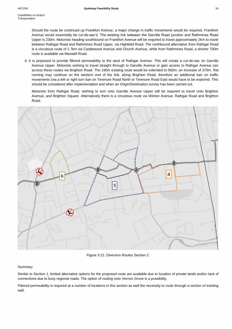
6. It is proposed to provide filtered permeability to the west of Rathgar Avenue. This will create a cul-de-sac on Garville
Avenue Upper. Motorists wishing to travel straight through to Garville Avenue or gain access to Rathgar Avenue can
access these routes via Brighton Road. The 190m existing route would be extended to 560m, an increase of 370m. Rat
running may continue on the western end of the link, along Brighton Road, therefore an additional ban on traffic
movements (via a left or right turn ban on Terenure Road North or Terenure Road East would have to be explored. This
should be considered after implementation and when an Origin/Destination survey has been carried out.
Motorists from Rathgar Road, wishing to turn onto Garville Avenue Upper will be required to travel onto Brighton
Avenue, and Brighton Square. Alternatively there is a circuitous route via Winton Avenue, Rathgar Road and Brighton
Road.
Figure 3.21: Diversion Routes Section 2.
Summary
Similar to Section 1, limited alternative options for the proposed route are available due to location of private lands and/or lack of
connections due to busy regional roads. The option of routing onto Vernon Grove is a possibility.
Filtered permeability is required at a number of locations in this section as well the necessity to route through a section of existing
wall.
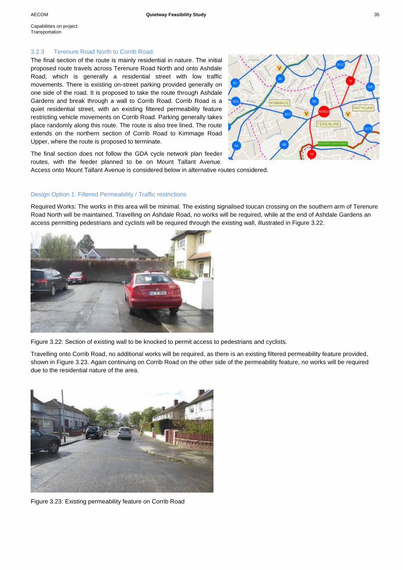
AECOM Quietway Feasibility Study 35
Capabilities on project:
Transportation
3.2.3 Terenure Road North to Corrib Road.
The final section of the route is mainly residential in nature. The initial
proposed route travels across Terenure Road North and onto Ashdale
Road, which is generally a residential street with low traffic
movements. There is existing on-street parking provided generally on
one side of the road. It is proposed to take the route through Ashdale
Gardens and break through a wall to Corrib Road. Corrib Road is a
quiet residential street, with an existing filtered permeability feature
restricting vehicle movements on Corrib Road. Parking generally takes
place randomly along this route. The route is also tree lined. The route
extends on the northern section of Corrib Road to Kimmage Road
Upper, where the route is proposed to terminate.
The final section does not follow the GDA cycle network plan feeder
routes, with the feeder planned to be on Mount Tallant Avenue.
Access onto Mount Tallant Avenue is considered below in alternative routes considered.
Design Option 1: Filtered Permeability / Traffic restrictions
Required Works: The works in this area will be minimal. The existing signalised toucan crossing on the southern arm of Terenure
Road North will be maintained. Travelling on Ashdale Road, no works will be required, while at the end of Ashdale Gardens an
access permitting pedestrians and cyclists will be required through the existing wall, illustrated in Figure 3.22.
Figure 3.22: Section of existing wall to be knocked to permit access to pedestrians and cyclists.
Travelling onto Corrib Road, no additional works will be required, as there is an existing filtered permeability feature provided,
shown in Figure 3.23. Again continuing on Corrib Road on the other side of the permeability feature, no works will be required
due to the residential nature of the area.
Figure 3.23: Existing permeability feature on Corrib Road
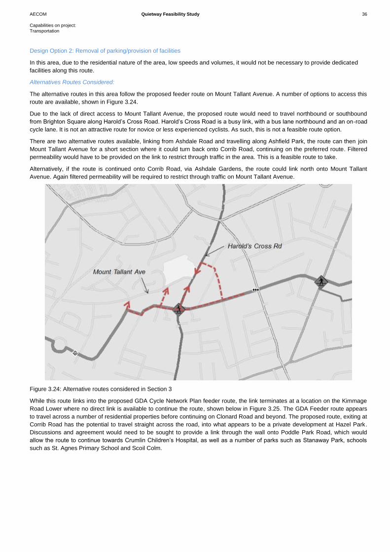
AECOM Quietway Feasibility Study 36
Capabilities on project:
Transportation
Design Option 2: Removal of parking/provision of facilities
In this area, due to the residential nature of the area, low speeds and volumes, it would not be necessary to provide dedicated
facilities along this route.
Alternatives Routes Considered:
The alternative routes in this area follow the proposed feeder route on Mount Tallant Avenue. A number of options to access this
route are available, shown in Figure 3.24.
Due to the lack of direct access to Mount Tallant Avenue, the proposed route would need to travel northbound or southbound
from Brighton Square along Harold’s Cross Road. Harold’s Cross Road is a busy link, with a bus lane northbound and an on-road
cycle lane. It is not an attractive route for novice or less experienced cyclists. As such, this is not a feasible route option.
There are two alternative routes available, linking from Ashdale Road and travelling along Ashfield Park, the route can then join
Mount Tallant Avenue for a short section where it could turn back onto Corrib Road, continuing on the preferred route. Filtered
permeability would have to be provided on the link to restrict through traffic in the area. This is a feasible route to take.
Alternatively, if the route is continued onto Corrib Road, via Ashdale Gardens, the route could link north onto Mount Tallant
Avenue. Again filtered permeability will be required to restrict through traffic on Mount Tallant Avenue.
Figure 3.24: Alternative routes considered in Section 3
While this route links into the proposed GDA Cycle Network Plan feeder route, the link terminates at a location on the Kimmage
Road Lower where no direct link is available to continue the route, shown below in Figure 3.25. The GDA Feeder route appears
to travel across a number of residential properties before continuing on Clonard Road and beyond. The proposed route, exiting at
Corrib Road has the potential to travel straight across the road, into what appears to be a private development at Hazel Park.
Discussions and agreement would need to be sought to provide a link through the wall onto Poddle Park Road, which would
allow the route to continue towards Crumlin Children’s Hospital, as well as a number of parks such as Stanaway Park, schools
such as St. Agnes Primary School and Scoil Colm.
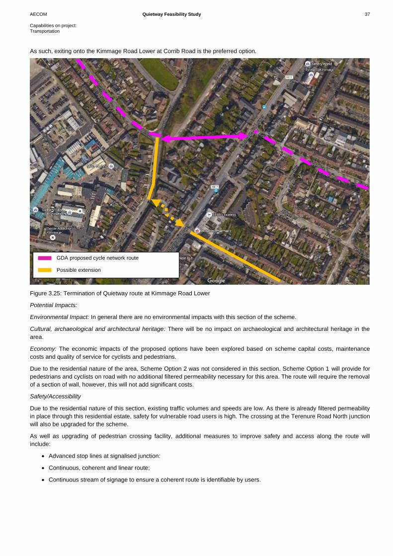
AECOM Quietway Feasibility Study 37
Capabilities on project:
Transportation
As such, exiting onto the Kimmage Road Lower at Corrib Road is the preferred option.
Figure 3.25: Termination of Quietway route at Kimmage Road Lower
Potential Impacts:
Environmental Impact: In general there are no environmental impacts with this section of the scheme.
Cultural, archaeological and architectural heritage: There will be no impact on archaeological and architectural heritage in the
area.
Economy: The economic impacts of the proposed options have been explored based on scheme capital costs, maintenance
costs and quality of service for cyclists and pedestrians.
Due to the residential nature of the area, Scheme Option 2 was not considered in this section. Scheme Option 1 will provide for
pedestrians and cyclists on road with no additional filtered permeability necessary for this area. The route will require the removal
of a section of wall, however, this will not add significant costs.
Safety/Accessibility
Due to the residential nature of this section, existing traffic volumes and speeds are low. As there is already filtered permeability
in place through this residential estate, safety for vulnerable road users is high. The crossing at the Terenure Road North junction
will also be upgraded for the scheme.
As well as upgrading of pedestrian crossing facility, additional measures to improve safety and access along the route will
include:
Advanced stop lines at signalised junction:
Continuous, coherent and linear route;
Continuous stream of signage to ensure a coherent route is identifiable by users.
GDA proposed cycle network route
Possible extension
AECOM Quietway Feasibility Study 38
Capabilities on project:
Transportation
Integration
The preferred route option does not follow any of the GDA cycle route. As highlighted earlier in the alternative route section,
Mount Tallant Avenue does follow the GDA feeder route, however, connectivity to further routes limits this as a viable route
option. The route is located in close proximity to schools and has possible link connections to these. This section integrates well
into the streetscape as there are existing filtered permeability features in place.
Traffic/Diversion
There are no diversions required with this option.
Summary
In Section 3, the route travels on mainly quiet residential streets, and therefore, there is little requirement to provide any
additional features for traffic calming.
At the Terenure Road North junction, the existing signalised toucan crossing will be maintained. It will also be necessary to
provide a route through a section of wall which currently connects two residential streets.
A number of alternative options were considered in this section. There is the possibility of linking onto Mount Tallant Avenue,
either from routing onto Harold’s Cross Road or via Ashdale Road and Ashdale Park. Staying on Mount Tallant Avenue would
mean that the route would terminate on a section of Kimmage Road Lower that would provide no potential link for a future
connection continuing west. Therefore, in terms of future connections, exiting from Corrib Road is the preferred option.
AECOM Quietway Feasibility Study 39
Capabilities on project:
Transportation
3.3 Emerging Preferred Scheme
The emerging preferred scheme is set out below, with more detailed drawings provided in Appendix A. Throughout the scheme,
road markings identifying the route, as well as dedicated route signage will be provided.
Section 1 – Herbert Park to Green Luas Line
The preferred scheme for Section 1 is illustrated in the map in Figure 3.25. The route will begin on Herbert Park Road where
Option 2 will be implemented as discussed above, ie, provide a two – way 3m off road cycle track and remove parking on the
southern side of the road, while maintaining two way traffic. This reduces the impact of traffic diversions in the area, however
comes at the cost of on-street parking, which is mainly commuter in nature. Crossing Herbert Park Road/Morehampton Road
junction, a wide dedicated toucan crossing facility will be provided. On Marlborough Road, the preferred option will be to provide
a filtered permeability feature west of Muckross College. This will reduce through traffic on this road, providing a safe
environment for cyclists and pedestrians.
Travelling through the Marlborough Road/Sandford Road junction, an existing crossing located on the northern arm of the
junction will be upgraded to a toucan crossing to provide for both pedestrians and cyclists. The route will then progress onto
Merton Drive where filtered permeability features will be provided in two locations, at the entrance to Cullenswood Gardens
travelling onto Merton Drive and also on Albany Road, just west of Park Drive.
The route will then continue across the Luas Line at the Cowper Luas Stop, where there is an existing access feature provided to
facilitate pedestrians and cyclists while restricting vehicular access.
Section 2 – Green Luas Line to Terenure Road North
The preferred scheme for Section 2 is illustrated in the map in Figure 3.26. Travelling from the Cowper Luas facility, the route will
continue on Cowper Road, where Option 1 will be implemented as discussed previously, ie, a filtered permeability feature will be
provided at the junction of Cowper Road/Merton Road and Cowper Road/Palmerston Garden. The proposed route will then travel
through Cowper Downs where it will be necessary to break through an existing wall to Cowper Mews.
At the Cowper Mews/Rathmines Road Upper junction, a toucan crossing facility will be provided to accommodate pedestrians
and cyclists. The route will then travel onto Frankfort Avenue where a two-way off road cycle track will be provided over a short
section. Continuing on, it is proposed to take the route onto Vernon Grove instead of Garville Road, which was originally
suggested. Taking the route onto Vernon Grove provides the possibility of having a sufficiently wide, direct toucan crossing
facility on Rathgar Road. It also negates the requirement of having to convert Frankfort Avenue to a two way system or having to
remove necessary residential parking on one side of Frankfort Avenue to provide a cycling facility. It does mean that pedestrians
and cyclists will have to travel on the Rathgar Road for approximately 30m to Garville Avenue, however, there will be an off road
shared pedestrian and cycle facility provided.
Along Garville Avenue, it is proposed to implement a filtered permeability feature to the west of the junction with Rathgar Avenue.
The route will then continue to the Brighton Square/Terenure Road North junction.
Section 3 – Terenure Road North to Corrib Road
The preferred scheme for Section 3 is illustrated in the map in Figure 3.27. An existing toucan crossing on the southern arm of
the Terenure Road North junction will be used and upgraded for the scheme. The route will then travel onto Ashdale Road and
Ashdale Gardens. No filtered permeability is necessary in this location as it is a quiet residential street with no rat running.
It is then proposed to take the route onto Corrib Road from Ashdale Gardens. This requires the removal of a section of wall to
connect the two residential streets. Along Corrib Road, there are already filtered permeability features in place; these will be
maintained with no requirement for additional permeability features along Corrib Road.
The scheme will terminate on Corrib Road at the Kimmage Road Lower junction. Ending the scheme at this location will provide
a possible future connection through Hazel Park Road and onto Poddle Park Road into Crumlin.
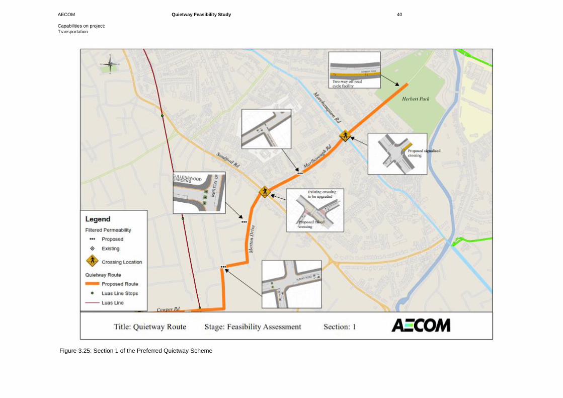
AECOM Quietway Feasibility Study 40
Capabilities on project:
Transportation
Figure 3.25: Section 1 of the Preferred Quietway Scheme
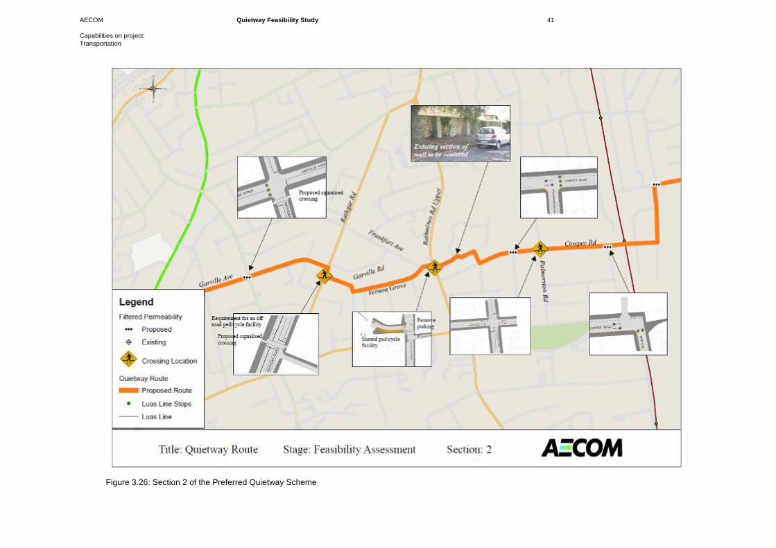
AECOM Quietway Feasibility Study 41
Capabilities on project:
Transportation
Figure 3.26: Section 2 of the Preferred Quietway Scheme
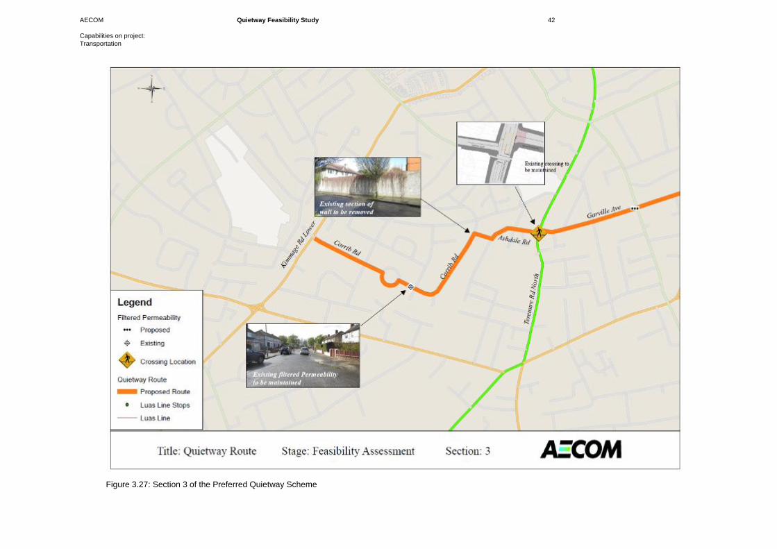
AECOM Quietway Feasibility Study 42
Capabilities on project:
Transportation
Figure 3.27: Section 3 of the Preferred Quietway Scheme
AECOM Quietway Feasibility Study 43
Capabilities on project:
Transportation
3.4 Works Required
The Works that will be required for this scheme are as follows:
Signage
Signage will be an important feature for this Quietway route. The location and accurate direction of signage will be important for
users of the route, in particular, if the route is being promoted towards school children. More detail on the signage requirements
is discussed below in Section 5.
Crossings
In total, there are seven crossing locations along the route that need to be upgraded for the implementation of the route; five of
these will be new toucan crossings and will be located at the Herbert Park/Morehampton Road junction, the Cowper
Road/Palmerston Road junction, the Rathmines Road Upper/Cowper Mews junction, the Rathgar Road/Belleville Avenue
junction and the Rathgar Avenue/Garville Avenue junction while two will be upgraded to toucan crossings located at the
Marlborough Road/Sandford Road junction and the Terenure Road North/Ashdale Road junction. These crossings will be wide,
approximately 3 – 4m if possible, in order to accommodate both pedestrians and cyclists crossing. Crossings will be facilitated
with dropped kerbs and tactile paving.
At a small number of locations, it is not proposed to provide dedicated signalised crossings, such as the Garville Avenue/Brighton
Road junction and the Corrib Road/Derravaragh Road junction. These crossings will be courtesy crossings and will have dropped
kerbs and tactile provided.
Off Road Cycle Track
An off road cycle track will be required in both Section 1 and Section 2 of the proposed route. In Section 1 a cycle track,
approximately 280m in length, will be required along Herbert Park Road. In Section 2 a cycle track, approximately 40m in length,
will be required along the short two way traffic section of Frankfort Avenue. These features will require extensive work including
new kerbs and drainage.
Walls
Two existing walls will be altered as part of this scheme. It is a requirement to knock through a section of the existing wall
between the Cowper Downs and the Cowper Mews residential estates. It is also a requirement to knock through a section of the
existing wall between the Ashdale Gardens and Corrib Road residential estate. Access at these locations will be limited to
pedestrians and cyclists. It is not proposed that vehicles will use these access points.
Lighting
Public lighting is already in place along the proposed route. These streets are residential streets and have existing public lighting
in place. Lighting should be reviewed, however, at each of the crossing locations along the route and upgraded as necessary.

Cost Estimates
AECOM Quietway Feasibility Study 45
Capabilities on project:
Transportation
4.1 Introduction
An initial cost estimate was undertaken for the proposed route. The route was divided into three sections;
Section 1: Herbert Park to Green Luas Line
Section 2: Green Luas Line to Terenure Road North
Section 3: Terenure Road North to Corrib Road
4.2 Cost Estimate
Shown below in Table 4.1 is an initial estimation of the cost required to implement the scheme.
Item Unit Type Units Rate (€) Total
Section 1: Herbert Park to Green Luas Line
New Toucan Crossing No. 2 70000 140000
Upgraded Pedestrian Crossing No. 1 28000 28000
Raised Crossing No. 2 10000 20000
Tactile Paving Construction m2 24 80 1920
Off road cycle track m 280 1500 420000
Filtered Permeability Feature No. 3 1000 3000
Road Markings (Text & Symbols) No. 25 160 4000
Road Markings (Lines) m 348 10 3480
Signage No. 20 350 7000
Public Lighting No. 9 1000 9000
Total: Section 1 636,400
Section 2: Green Luas Line to Terenure Road North
New Toucan Crossing No. 3 70000 210000
Upgraded Pedestrian Crossing No. 1 28000 28000
Raised Crossing No. 1 10000 10000
Tactile Paving Construction m2 36 80 2880
Off road cycle track m 40 1500 60000
Filtered Permeability Feature No. 3 1000 3000
Section of Wall knocked m2 20 150 3000
Road Markings (Text & Symbols) No. 24 160 3840
Road Markings (Lines) m 78 10 780
Signage No. 27 350 9450
Public Lighting No. 16 1000 16000
Total: Section 2 346,950
Section 3: Terenure Road North to Corrib Road
New Toucan Crossing No. 0 70000 0
Upgraded Pedestrian Crossing No. 0 28000 0
Tactile Paving Construction m2 0 80 0
Kerb removal/ New Kerbs m 16 45 720
Filtered Permeability Feature No. 0 1000 0
Section of Wall knocked m2 20 150 3000
Road Markings (Text & Symbols) No. 15 160 2400
Road Markings (Lines) m 22 10 220
Signage No. 14 350 4900
Public Lighting No. 7 1000 7000
Total: Section 3 18,240
Sub Total 1,001,590
Contingency (20%) 200,318
Total (€) 1,201,908
Table 4.1: Feasibility Cost Estimate for the Quietway Route
The results show that, in total, the scheme will cost approximately €1,201,908 to implement. That includes for a contingency of
20%.
4 Cost Estimates
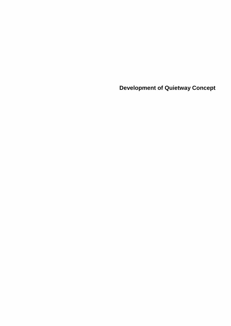
Development of Quietway Concept
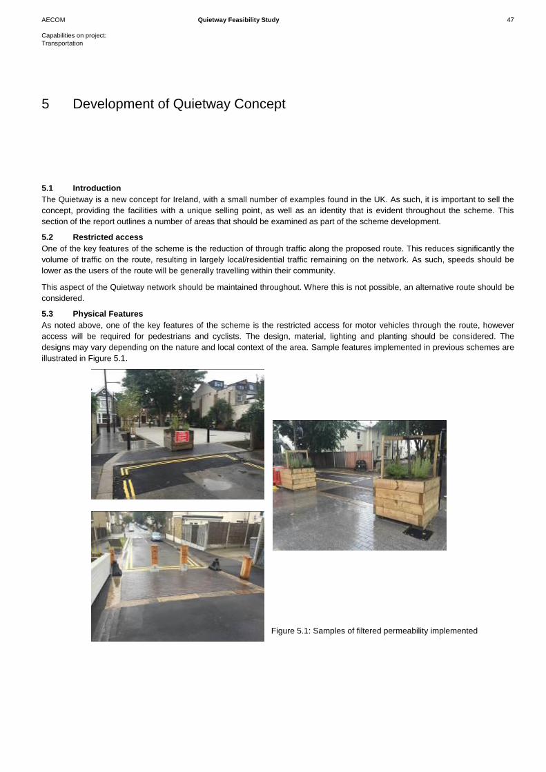
AECOM Quietway Feasibility Study 47
Capabilities on project:
Transportation
5.1 Introduction
The Quietway is a new concept for Ireland, with a small number of examples found in the UK. As such, it is important to sell the
concept, providing the facilities with a unique selling point, as well as an identity that is evident throughout the scheme. This
section of the report outlines a number of areas that should be examined as part of the scheme development.
5.2 Restricted access
One of the key features of the scheme is the reduction of through traffic along the proposed route. This reduces significantly the
volume of traffic on the route, resulting in largely local/residential traffic remaining on the network. As such, speeds should be
lower as the users of the route will be generally travelling within their community.
This aspect of the Quietway network should be maintained throughout. Where this is not possible, an alternative route should be
considered.
5.3 Physical Features
As noted above, one of the key features of the scheme is the restricted access for motor vehicles through the route, however
access will be required for pedestrians and cyclists. The design, material, lighting and planting should be considered. The
designs may vary depending on the nature and local context of the area. Sample features implemented in previous schemes are
illustrated in Figure 5.1.
5 Development of Quietway Concept
Figure 5.1: Samples of filtered permeability implemented
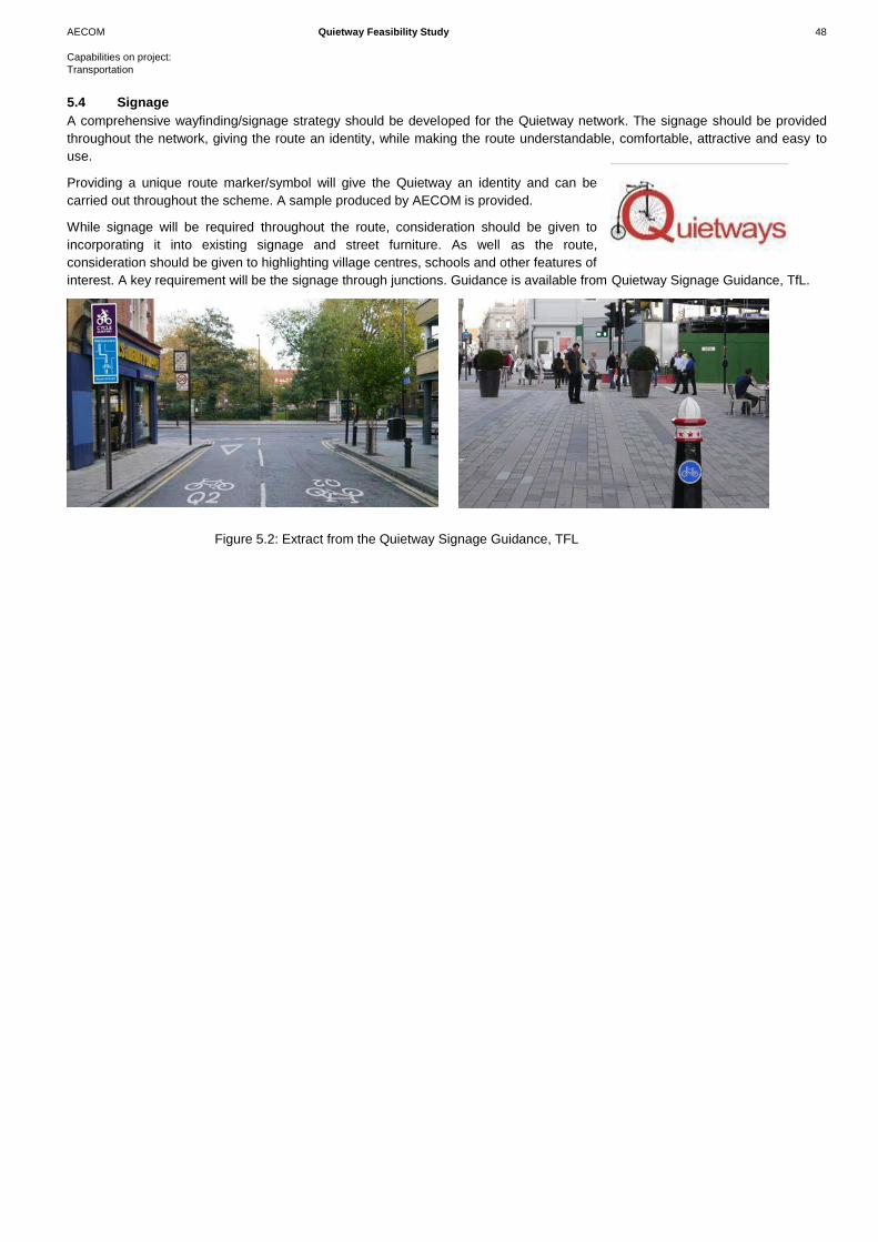
AECOM Quietway Feasibility Study 48
Capabilities on project:
Transportation
5.4 Signage
A comprehensive wayfinding/signage strategy should be developed for the Quietway network. The signage should be provided
throughout the network, giving the route an identity, while making the route understandable, comfortable, attractive and easy to
use.
Providing a unique route marker/symbol will give the Quietway an identity and can be
carried out throughout the scheme. A sample produced by AECOM is provided.
While signage will be required throughout the route, consideration should be given to
incorporating it into existing signage and street furniture. As well as the route,
consideration should be given to highlighting village centres, schools and other features of
interest. A key requirement will be the signage through junctions. Guidance is available from Quietway Signage Guidance, TfL.
Figure 5.2: Extract from the Quietway Signage Guidance, TFL

Conclusion and Recommendations
AECOM Quietway Feasibility Study 50
Capabilities on project:
Transportation
6.1 Conclusion
The conclusions of the feasibility study are:
That a viable route is available.
It is in line with planning policies, the local development plan, as well as the GDA Cycle Network Plan.
The scheme costs would be in the region of €1,201,908.
6.2 Recommendations
The following recommendations are made and should be carried out prior to the development of the scheme;
The scheme will have a significant impact on traffic movements in the area, and as such a traffic study should be
carried out to assess the impacts. While the closure of some sections of the proposed route will have little impact on
commuting traffic, such as areas closer to the western end of the scheme, the closure of links such as Herbert Park,
Marlborough Road etc. will have a significant impact on traffic movements in the area.
Traffic counts should be carried out extensively within the study area, and areas of potential rat running identified.
Should rat running become an issue, further traffic management measures may be required, such as banned
movements in peak hours or additional restricted access features.
As far as is practical, the entire route should be phased to open at the same time. This will allow for a whole route to
be provided to the community and will avoid a piecemeal facility to be provided.
The proposed scheme may result in delays for many residents due to the filtered permeability, as well as, in a number
of locations, the opening up of currently closed links. This could result in significant interest from the local community.
As such the communication between the local authority and community should be considered at an early stage.
The scheme drawings are indicative only, and based on OS mapping available. Full development of the scheme
would require a topographical survey to ensure physical features can be accommodated along the route.
6 Conclusion and
Recommendations

AECOM Quietway Feasibility Study 51
Capabilities on project:
Transportation
Appendix A: Scheme Drawings
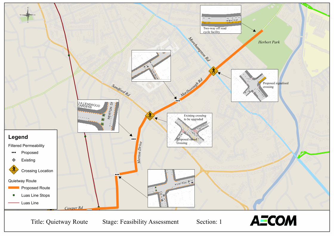
89:w
89:w
89:w
µ
µ
µ
µ¶µ
Herbert Park
Marlborough Rd
Morehampton Rd
Sandford Rd
Merto
nDriv
e
Cowper Rd
Palmerston Rd
Two-way off roadcycle facility
Proposed signalisedcrossing
Existing crossing to be upgraded
Proposed raisedcrossing
LegendFiltered Permeability µ¶ Proposed ±² Existing
89:w Crossing Location
Quietway RouteProposed RouteLuas Line StopsLuas Line
Title: Quietway Route Stage: Feasibility Assessment Section: 1
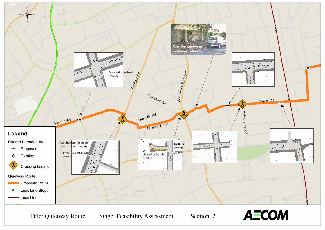
89:w
89:w
89:w
89:w
89:wµ
µ
µ
µ¶µ
Sandford Rd
Merto
nDriv
e
Cowper RdFrankfort Ave
Garville Rd
Vernon GroveGarville Ave
Corrib
Rd
Ashdale Rd
Existing section ofwall to be removed
Rathg
arRd
Rathm
ines R
d Upp
er
Palmerston Rd
Removeparking
Shared ped/cyclefacility
Proposed signalisedcrossing
Requirement for an off road ped/cycle facility
Proposed signalised crossing
LegendFiltered Permeability µ¶ Proposed ±² Existing
89:w Crossing Location
Quietway RouteProposed RouteLuas Line StopsLuas Line
Title: Quietway Route Stage: Feasibility Assessment Section: 2
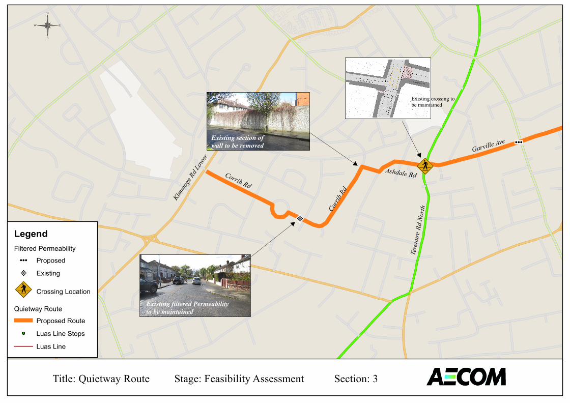
89:w
89:w
µ
±²
Garville Ave
Corrib Rd
Corrib
Rd
Ashdale Rd
Existing filtered Permeabilityto be maintained
Existing section ofwall to be removed
KimmageRd
Lower
Terenu
reRd
North
Existing crossing to be maintained
LegendFiltered Permeability µ¶ Proposed ±² Existing
89:w Crossing Location
Quietway RouteProposed RouteLuas Line StopsLuas Line
Title: Quietway Route Stage: Feasibility Assessment Section: 3


