+ All Categories
Home > Documents > Quod T. D. I 8001(0 {o I L L - Kentucky Geological...

Quod T. D. I 8001(0 {o I L L - Kentucky Geological...

Date post: 23-Apr-2018
Category:
Upload: lytruc
View: 217 times
Download: 5 times
Share this document with a friend
20
• , r. " Hole No.GNJK- 6- Property Area JQOf.S 8!J. eCqj&:.t County RA l--.' vO L "'D \-.\ State N. C- . Quod T. D. Coordinates 3544 20 I 800 1(0 c'O {o I '7 Elev. Bearino Incl. Contractor Started L L Completed L L Casino Core Disposition Loooed By Te . PariS <10% )sar, 0/ 0 -- - - - - I- - - - I- - .5 I- - - I- - - I- - - 10 I- - . - I- - l- I- - IS - - - - - I- - - 20 I- - I- - - I- - I- - - - 25 - - - I- - 30 I- - - I- - - I- - I- - 1 o\lERBURD£rI ,;" I Jt 35· "" 35 t?! - 0 ".,,,f;c +uf{ ""felsic lapin; f') I- - I- - 15,% c.ore. lQ.3'5 40 'ZD. <c.J. hvy ox . I- - I- - J I- - I- - - 1"7. "" 10" If r ""y C)< '..J ..
Transcript

• , r.

"

Hole No.GNJK- 6- Property Area JQOf.S -~~t5±Qae: 8!J. eCqj&:.t County RA l--.' vOL"'D \-.\ State N. C- . Quod T. D.

Coordinates 354420 I 800 1(0 c'O {o I

'7

Elev. Bearino Incl. Contractor

Started L L Completed L L Casino

Core Disposition Loooed By Te . PariS <10% )sar,

~~&es~;~o 0/0 --

- -- -

I- - -- I- -

.5 I- - -I- -

-I- - -

10 I- - . -I- -l-

I- -IS

- -- -- I- -

-20

I- -I- - -I- - I- -

--25

-- -I- -

30 I- - -I- - -I- -I- - 1 o\lERBURD£rI

,;" ~1'rIE IJt ~ 35·"" 35 t?! - 6JC. ~.

0 ".,,,f;c +uf{ ""felsic lapin; (i'~ f') I- - w~ I- - -~ 15,% c.ore. lQ.3'5

40 ~s

~ 'ZD. <c.J. hvy ox .

I- -I- - J

I- -I- - - ~ 1"7. "" 10"

If r ""y C)< '..J . .

EXPLORATION

Hole No.fzNJ\(-2.. Property Area JOoe5- Ke.ystone. Au Projed County State Quad T. D.

Coordinates

Elev. Bearino Incl. Contractor

Started l. l. Completed l. l. Casino

Core Disposition Laooed By T A. Pori:j' .

<.~~ ,"/fib Stri:jI ~ 4 ~ 0/0 --

- -

- - 'to?o CQf"e {CJss; 2ane of h"Y' 01(

50

- -I- - -

-6 ,~~; eJr'f. ~ I- -- 5S l-. r- -- ~ - r 1I1.rl;c nAt !oJ f~:: 14p,7/i

I-~ - 6af., CDrI! ("10$; zql1~ at h ... y ox. ~ ,,0 I-

t!- -J.-I- -

~ - -- ~

"S ~ I- - -I- - . I- - -I- - - 75'7.. core. l~s; z.oo~ cJ hvy.ox.

-- 70 -

/ - -- -- - -

G'rt-i ;"';'15 'f~ 75 ~ ~ -

I- - ~ -I- - l1= I- ~ 50'1.,,~1l:la~ ~"Q of h."" .ox . 80 I- ~ . I- ~ . I- - ~~ -

~ -

f • gS

~ --

inPJ· • fo% c..ar" loSS" i fetsie ,a-1Qf';\li-hA

! t; -~ - -

Q~

EX~LORATION

Hole No.GNJK - 2.. Property Area ,!ones-KerS±Cfle AtA. Projecr Count y State Quad T. D. Coordinates

Elev. Bearino Incl. Contractor

Started I. L Completed I. I. Cas ino

Core Disposition Loooed By TA , eariS .

u <LCf.~~ .. % --<u ' • .,,~~

I '1<1 --

~py. -

ffO?, CAJf'C (OS5 i ~~ IQP;J(;-,cl1uff - -1 - -

19 I 'is 6 ' r.etD ~f'I' /'15~ - - -- -- -

-IOD 'to~" ~ (ClS~ . ~ic laoilli.fuff

- -I ""~hvr" -~ -~ - -

I

/05 ~--

~ - ~~ lox.z", ft'S rr - 0.( .fr.s ~ 2/~ ,.,,&:. +uff IoJ £clsiccr i01errrteJ COnlP \QP;Ui

1/0 o.

I-q.. ~ - ~ life,+,..

r-I- - -:: 14p;rr; ... "., ca. ~~c:J" jilt<.. t: jtinJi

I

6 /~eI 13 _ ~ - "0.;:

I=:..~ / Irf~e Il1p,lI/ fA - .. --:...::..

f- . ~

liS ~o p- m.rtie -tuff IoV feiSlC IQP,lll' ~b"rrlh.s f- -.d

Uto, '7'<'ts, Of- i/1 . t;..~ f- - f-"-... f.-C":::

~.-/1(, ~(' •

f- -,'-='-:;t.~

/lO -' I&"cr, f- - ~-=- > k>~y OJl·2o ·

~lc ... - ~ &1'\ ,~ « pr ,- ,..,~c -luff '"' inderr"d . c..:y"p. lapiU; ... - " :.,.. ... f--~ I k..d.~~. (",a{.'c ~<!lJJI\- (qp il!;-tuff')

...!.. ..

115 [0- 1-1 r ... "A. ~t'>. .,......;."" I" o~

~ 'o..:

... -,_ . .;. ~' --..,. ... - ~-: . .~

- ~...;: 130

_=-0

~ ,cat" CD. spo' . q..~. ~III

f- - '" ~;I\ ~ - - #9 Mafic it.f( w fdsic f4p;J/ •. ~ b (JM ~S

- ~-=7 ';~ (".,af;c f.c1J ]«(-(:1piJli -n.~)

I f- - &"0 Illeao,ed ~, ~ '(e+.- eI/.n -= 'Y ,.,,.. ,oJ .J

£X~LORATION

Hole No.GNJK-2. Property ______________ Area .Jafles- uy:siooe AI.-< Projec..t County _________ State ________ Quad ___________ T. D. _____ _

Coordinates _____________________________________ _

~E~I.~Y~.==========~B~ea~r~in~O=====~----lncl.----Contractor-_____________ _

Started / I Completed_--L.I_..LI __ Casino----,=-----

6 1'tU ~'nll I~ ~

-~II ..... f ~'r),.J 176,.

Core Disposition LoOOed By LA. parr's

su~·&'~t

IJr -tnf"" -, f- -

I f- -

~ f- -f- -

r ... -

--

~P1 f- -.... po -

-I

~ --

:

I

+ ---

f-I , -i r+ {

f-

--

~ -f-

~

f-

~ --,

"7-i f- -, 7 -

t

I

I

I

I

I

I

% --

~S~~--------------------~

SS~~------------------------~

sc.o+ 'l.l(1 ~s

.fd sic fa?,?/,' +uf{ j hp,/ft· i~ J"ill dia. Jnif14r c.a. -H,fD"Jhot&t m-r,.

170 ~.:-j-----------------1

,[ t- -

EX~LORATION

Hole No.GMfK-2. Property ______________ Areo Ilooes-K~vS±Qne At.< Project County State Quod T. D, _____ _ Coordinotes _____________________________________ _

~E~le~Y~.===========8~e~or~in~!I~====~ ____ lnCI. ____ Controctor ______________ _

Started I I Completed_---L.1_ ...... 1 __ Cosing ______ _

Core Disposition Logged By TA , pacis

-c::> _

-co-

'"=-- F-=-0--_ - ---

--G>

~ ~ , =-~ - ~.;-c

- ~ci: - "':-0--

2.CXJ a:;; jC3' -

-~' ~ - ' -~~

~ - i2 s ~ - f-c." -- .-~

0_ - ' --.-~ ~

20.5 ~,:-= <3-

i- -

;;. --

~~--~-+--+-_+-r-r~220~~ t - t-e>o

t- -

0/0 --

u ~n~ 5po-B CCl, ~r i oc.c.as 11I01li rep\~ce.:J by pY

JdrbdJd "u.~f/ .felsic /ep/lil-tAX ~jp... Co.. tl;S'!>eM, ill m~

G4, ~:I(~

EXPLORATION

Hole No. GNJK-2. Property Area Jooes -Ker)~JQoe ALL ProjecT County State Quod T. D. Coordinates

Elev. Bearing Incl. Contractor

Started L L Completed L L Casing

Core Disposition Logged By ~ . TA.' QfrS -

hd~~·!~ % --SJJ '~~ll5

~ --~ - ~ =t1~iv- w t'y¢.po· , I-- c::> ca.. "".~r"_ ". - 1-.-\ " =~ r: ~ .. - ~~ co.J;U. vuy

~I?" :. - t~ ''3~. CA~iD"\luS ,

. ~.

1230 ~ ~ sr (a~y) ~sic (QP;\I~ fuff - --c:> _

: 1--- C>~ -~ -~=-

,~ 12" 1--<::>

~ I ~t:h. ... c:s _ ,

235 c:>

t <=>-

- ~c:::>_ <=>-

! - --~ 1--= ':- - C'-:-

~ C.JJ'ill-¥--240

~-

I- - I--c=. ~-

r: - E - ==--=-.c:t_

.;2

245 ~~

~ ~ C4 \;U ~rs.

.,:. - -~ c:::>_

~ - ~c=>_

~ ~~ Ca,hy> £dsic: lop;1!i 4uff t - --c:--;

1250 _c:::>

i ~-

~ f--"""-c:>-~c:P - '-L::~ CD ~((~. ,

~ ~c; -

fJ:~ ,..J ;. 15"'>~ - ~

1255 ~C>

~"~

-:-- -~

255 :"..2",r.5 '- so ... e lap;J/i pff, ~~~ CO'_

~7o~ - I--~ ~D

~ -~..c;- -

2~ c:--

- ~~ (. ... <;iU ~r~"~s \ - c:-_

.: - I-~ ... ~~ G&o.fif/ &-. -

JC,5 r--c:> ~-

it, ~ ~ - I-=-c=--

1 ;

~~ ~ -~c; - ~--:::: _c:::>

~ - I-~-

1.,7/"1 I--=-

EXPLORATION

Hole No. GN.lK- 2.. Property Areo dooes - Keystooe Au. ProjecT County Stote Quod T. D.

Coordinates

'Elev. Bearing Incl. Contractor

Started !. L Completed L !. Casing

Core Disposition Logged By I. t!, the is. -

<;L~.k~~~~ % --

70 ~IJ-="'" 2c>j ~~ .. « ~rs t - a

v-o ,,'/-' ~f ~ If '1 2- I7L fY

I C;-c:> fIJI - ~

-~ ca.~·a ~ "J~ ltJ..oJ 2.7(' - ~ ~i' Sr: in+e.rmed.CQ~,1tJf w,oh..,co..i" ""'+~

.-:...-. 2.75 . . ~...L - ~:..

Ir-:-+ - '<?~

-<:::7

~py' , -~ '1e:. C"aJin. Ir. I

- ~ ~

2~o r--= - ~

c.a.t-.1/..frs.

- CA ~pots

I- - ~ '!' e...~I . .J;, ~ - , lICe co. spots j , 225 ~1j tJ,~' 1 ! - r~ ~

~ - e- C4t;;!\ "~s ,

~-ti - ~ -::;::: ,

L~ t=- o

" . ~-

1.90 f--c::>' --~ - -~

~-

I- - ~~ I I-~ tl - ~-~ ~

" ~;yJ r- - <7- ~.~r,(ashy) ~ic (oe.-a; +uf"t Jfr lL,,5" ~ 1'15 l--T"

~ <:A fill ;.r5

t ~ - ~_S ~ ~

~

r:- ~ ~ - ~ CA~pY. !;ilL {C-.

300

~ ~ - Ii€. cA.","~y.~tf(' fT -

~ J ~ t%pt~ -1--"':::'

14/~. 4,,;,J. "r - ~

, c::»-

I 305 -§f PI &i{! fr"s eJ.(ap;l/i borr1eP '':-- .-;;,

\ --fTr -=--::-;:;:-,;. ",---

.1' '. _CO-

i<7·Pl ' . ~~ -~

3/0 =~ f-~.:

..=-.=;: , , ~

~ . , -mt'Y

" ~ r. - ~, rP'fbi.

! , --~: - ~{}

"2J c.. 1Cf, .co

EX~LORATION

Hole No.GNJK-2 Property ______________ Area Jones-Keystone Au Project County-----_____ State ________ Quad T. D. _____ _ Coordinotes _______________________________________________ _

~E~I~ev~.==========.~Be~a~r~in~g=======;_---lncl.----Contractor _________________ _

Started _---'-I_-LI __ Completed _.......LI_-L..1 __ Casing ______ _

Core Disposition Logged By T A. FOr-is

' .. . ,

I- .! -~, .. - -~ . : -

EXPLORATION

Hole No. GNJ K-Z Property _______________ Ar e a ---...\\..LI.!"!oLJnts:e;.::lsc.::-1:.Ke:;q'/GS;:tm£..l,OaO.lJe;,..,..,,AL.L.LoIA~P_nL.lo..!.:Jp;ie;.,!oct..!..-__

County-----_____ State ________ Ouad ___________ T.D. _____ _ Coordinates ______________________________________ ___

~E~I~ev~.-==========..B~e~a:':r~in~g~=====::::;:__--- Incl. _____ Controctor _______________ _

Storte d _---'/~--I.I __ Completed _--I./~-LI __ CO s in 9 _______ _

Core Disposition Logged By T f1 . Poris

~elsic. KI- (opi(!; +ufF (i '-t.~/"p;l!i) f:,It cfasfr kJ"1.5~fY

SC4f CIA . "eyes"

'~ispy • IOrill; -h.ff - ... ,dd.d?

t"'f-V. - (:1" J,1e Z4 dhc.r s'de

CJJ £11 bo:!ded..(~.

nu ctI c.res if"" bnJs J ",elk} +~?

EX,.LORATION

Hole No.GNJK-2. Property ______________ Area Jana-Ke.ystone Au Prqjee-t I

County _________ State ________ Quad ___________ T. D. _____ _

Coordinates _____________________________________ _

~E~I::ey~.===========B~e~ar~in~Q~=====_----lncl.----Contractor ______________ _

Started _~/_--L..I __ Completed _--L.1_..L1 __ Casing ______ _

Core Disposition LOQged By Til Pacis

. Qf{-~{sic iap;di -h.f( srrorlj pyn7:u.f,o"

lilp;I/; partly rt:fk:d I.y f)' '" t»

. . EX,.LORATION

Hole No.GNJK-~ Property ______________ Area Jooes-l<eysHme Au Project County-_________ State ________ Quad ___________ T. D. _____ _

Coordinates ____________________________________________ _

~E~f~eY~.===========..:B~e~o~ri~nO~======~---lncl.----Controctor ______________ _

Started _ ........ I'-----LI __ Completed _---I./~--'-I __ COS in II _______ _

Core Disposition LOllged By TA Paris

'Igo ~

ca Trlltrs f- -f- - ~.~

~ ~ - ~ CA f,ll fo..

-Of/z. -,lJ- .

b:f .• 1. - .~~ ~ - )'.7.. t:c./,r.. frll "'1s .~~ I,n- q.gS I- - 4-85.2.5 'TD.

.,.... ... r-... - f-

-l/f/CJ

f- f-

r- - ~

... -~ - ~

II IOC"

" . SPLII SHEt T GN Jj(-2 i?14- c- L flJ -•

6AMPLf 1t INT~RvAL Tt-/(CKN£"SS SPLIT rot<.. 330- 335 5

2 33~- 3,-/0 5 3 3tfo - 3Lf5 5 if 31-5 - 350 5 5 i

350- 355 5 . ,

~ 355-3bo 5 7 3bcJ -3b5 5

'l 8 365 -370 5 0 9 370 -375 5 ("-/0 375-380 5 ---II 380-385 5

..b

'i 12- 385-390 5 "-....

13 390-395 5 ~

<-Jt 315 -'f00 5 /5 Lj (JO -lfo5 S )b '105 -7(0 .s 17 'f(0 - tf/5 5

'" 1.+ ! or:: _ :"'_ ~ -: .-It.. J i ~ ---/~ Lf2o-Lf25 5 2.6 Jf25-L/-3° 5 2) Lf3o-'t3S 5 2L Lf35-'/io 5

..

Blu~ Ridge Analytical Laboratory, Inc. Post Office Box 7545 • Charlottesville • Virginia • 22906 • 804,973--4353

r u.s. Borax & Chemical Corp. P.O. Box 10831 Knoxville. Tenn. 37919

Attn: Harry Dunn

April 10, 1980

Job No. 780

L Submitted by: Bill Szymanski

([£rtiftath~ of J\ncrl ~5i5

There are 22 rock samples analyzed as follows: ----Sample Number ppm Au Sample Number ppm Au

GNJK-l .25 GNJK-12 .25 GNJK-2 .20 GNJK-13 _.35 GNJK-3 .22 GNJK-14 .28 GNJK-4 .26 GNJK-15 .38 GNJK-5 .31 GNJK-16 . 18 GNJK-6 .28 GNJ K-17 .23 GNJK-7 .23 GNJK-18 .37 GNJK-8 .22 GNJK-19 . 16 GNJK-9 . 23 GNJK-20 .21 GNJK-l0 .25 GNJK-21 .21 GNJK-ll .21 GNJK-22 .20

G/'I:JK-2 Respectfully submitted:

{j ~noJ J (;) '~fJjJJ Donald W. Foss ~ President

DWF :jaw

Samples are GNJK 2-

to cc ~ (j) 0 0 0 c· 0 0 0 0 0 0

(j) (J) v., (J) (f) (J) ~ ~ ~ :E .~ ~

I I I I I I I

~ < ~"' .. : " . - ~ ',' ~., .. . '1 ' : .... . .;:~ .

o · '- 0 b

~ . ...; .

. .' -"' 0

: " ' :-' .....

::-- . ." ~- :' " : "'~ ..... ~', -'. ::" :" . . ,. .

••• ~.. .. .. I . - ' .'

' .. . -, ',: 0 . t; .. 0 ': .... . ": - '0

.,"

. . ~ " '. -.. . ' . mved~"

• • o o

o • • • •

___ 0

.:J; O ~~ .... - 0 _...-0--:---_ 0 0 • ~if ,0--:------ ...... - ----.jI~--- ,.,-- - ....... _" ," -- -..;;:-=-----'

--............... _ lP ,. ,,'" i i ..... - - -'" / ~ ~ ___ ----- _--/ ~t

----- -

o

.... .... -o

o o o o • • o

GC0

K-1

~K-I

@:ro'

f?? o

LEGEND

u.s. Borax D. D. H.

Asarco D.D.H.

Total Depth

Incl ination

Soil Sample less than .1 ppm Au

Soi I Sample greater than .1 ppm Au

I"(A - c-, _ ~o 611XTK - I

Vf(A - c. - 2.. _l~ G/VJ"t(- 'L

.,. .. " .. ,,_.~Rw ~ EXPLORATIC

JONES KEYSTONE P

DRILL . HOLE LOCATI

I Exhibit 5 1 ----.-~., __ ...J

SCALE: I" = 100'

1 Merrill 2 New Sawyer 3 Allred 4 Copple. Spencer 5 and Ruth 6 Jones and Laughlin 7 Sawyer Complex 8 Hoover Hill 9 Scarlett

10 Jones-Keystone 11 Southern Homestake

12 Kindley 13 Parish 14 Delft 15 Redding 16 Pritchard 17 Gray 18 McAllister 19 Newby 20 Spoon 21 Pilot Mtn. No. 1 22 Pilot Mtn. No.2

Figure 19. Randolph County Deposits

23 Branson 24 Smith 25 Goliham and Smith 26 Dowd 27 Rush 28 Gluyas 29 Uharie 30 Talbert and Hill 31 Griffin 32 Stafford

58

-2-

A lease was obtained and detailed soil (exhibit 3), rock, and pit sampling and mapping were conducted in late 1979 - early 1980. Also in early 1980 core from three holes drilled by Asarco at the Jones­Keystone Mine was. obtained on loan and logged (exhibit 4).

Data obtained from Asarco showed only non-economic gold mineralization. From our soil and rock sampling however, it was decided to drill our own holes. A contract was secured with Cementation Corporation of America for core drilling. Two holes were drilled in March 1980 (exhibit 5 - . map; exhibit 6 - log) .

D.D.H. GNJK-l was drilled to investigate the quartz-sericite schist unit cropping out in the south pit of the main workings. The hole was drilled to a depth of 381 feet (linear) at an inclination of 45 0

and a bearing of S20 0 E. Stratigraphic picks made in the field place the top of the quartz-sericite schist unit at 270 feet and the top of the footwalllapilli tuff unit, of intermediate composition, at 365 feet.

A total of 24 split core samples from a 112 foot section of GNHK-l were analyzed for gold. The sampled section includes the entire quartz­sericite schist unit. No interval in excess of five feet was found to contain more than 0.03 oz/tn- Au (exhibit 7).

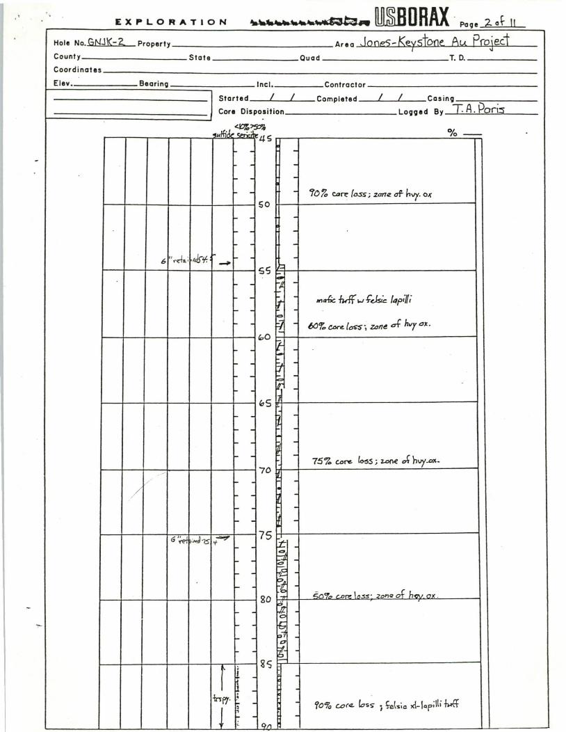
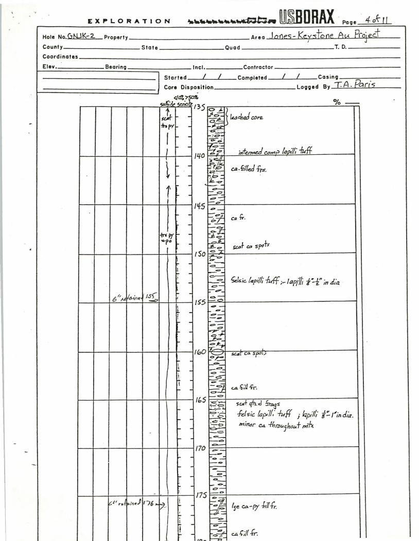
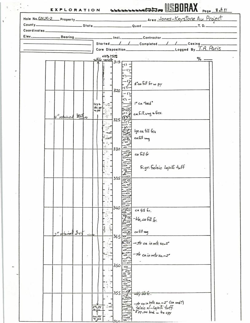
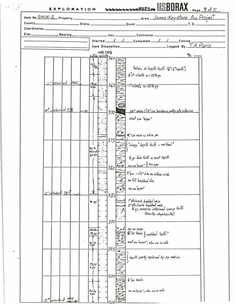
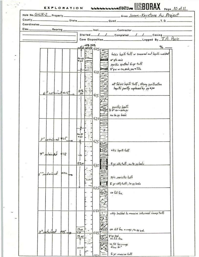
D.D.H. GNJK-2 was drilled to a depth of 485 feet (linear), also at an inclination of 45 0 , and a bearing of S20 0 E. The hole was located approximately 400 feet NW of GNJK-l to examine bedrock underlying soil and soil float anomalies west of the main workings and the continuity of the quartz-sericite schist unit. The tops of the quartz-sericite schist and footwall lapilli tuff units were picked in the field at 270 feet and 435 feet, respectively.

Twenty-two split core samples from a 110 foot section of GNJK-2 were analyzed for Au. Again, the entire quartz-sericite schist unit was sampled. No value greater than 0.01 oz/tn Au was found, however, the entire zone averages 0.007 oz/tn Au indicating a broad zone of non­economic gold mineralization.

Upon completion of drilling well record forms were filed with the North Carolina Department of Natural Resources and Community Development (exhibit 8).

rhe following conclusions are supported by drill core and assay data:

(1) Uneconomic, low-grade gold mineralization is hosted by a quartz-sericite schist unit, and continues down dip from the- weathered and largely mined-out surface outcrop. This fact is further substantiated by data obtained from Asarco.

(2) Gold values for fresh rock are lower that those re­ported in the literature for decomposed rock, however, it is not known if processes of supergene enrichment are responsible for the differences.

..

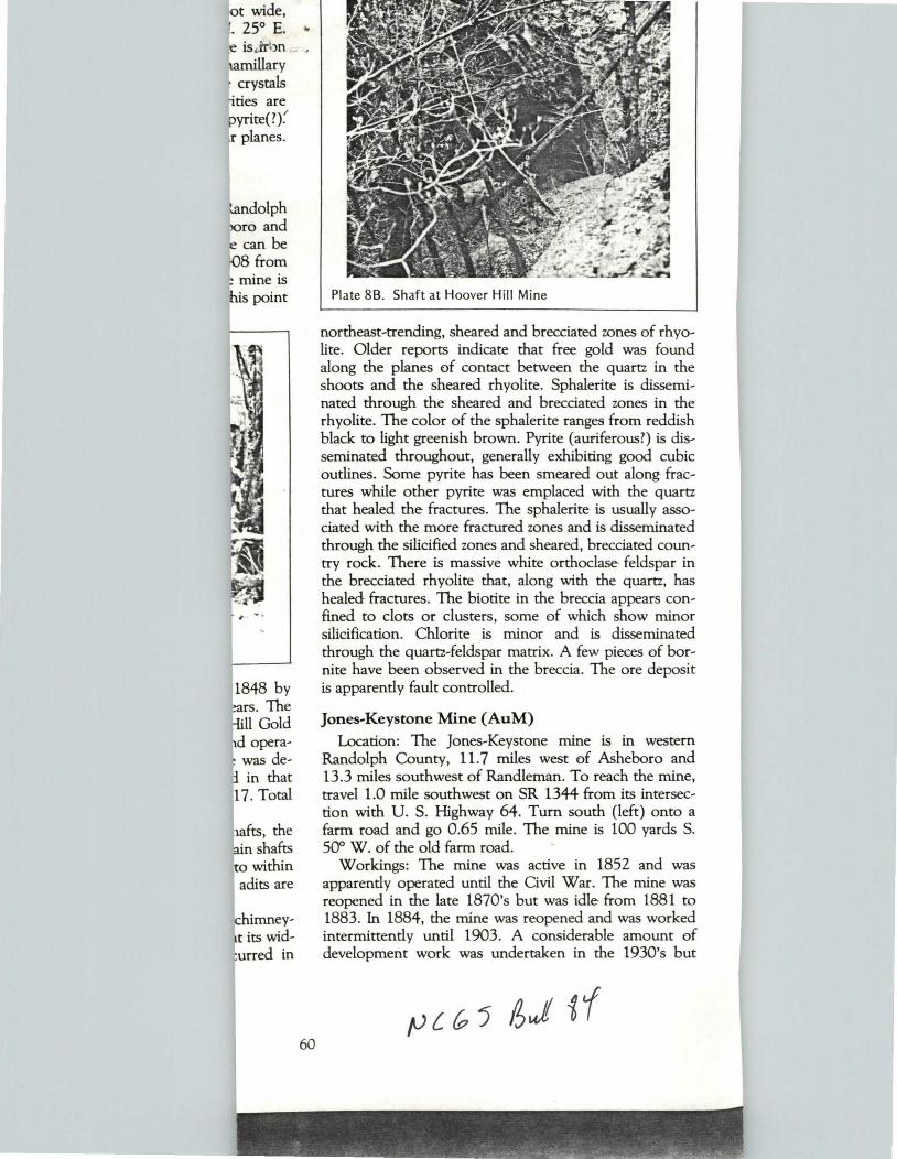
Plate 88. Shaft at Hoover Hill Mine

northeast-trending, sheared and brecciated zones of rhyo­lite. Older reports indicate that free gold was found along the planes of contact between the quartz in the shoots and the sheared rhyolite. Sphalerite is dissemi­nated through the sheared and brecciated zones in the rhyolite. The color of the sphalerite ranges from reddish black to light greenish brown. Pyrite (auriferous?) is dis­seminated throughout, generally exhibiting good cubic outlines. Some pyrite has been smeared out along frac­tures while other pyrite was emplaced with the quartz that healed the fractures. The sphalerite is usually asso­ciated with the more fractured zones and is disseminated through the silicified zones and sheared, brecciated coun­try rock. There is massive white orthoclase- feldspar in the brecciated rhyolite that, along with the quartz, has healed fractures . The biotite in the breccia appears con-

,. - - fined to clots or clusters, some of which show minor silicification. Chlorite is minor and is disseminated through the quartz-feldspar matrix. A few pieces of bor­

60

nite have been observed in the breccia. The ore deposit is apparently fault controlled.

Jones-Keystone Mine (AuM)

Location: The Jones-Keystone mine is in western Randolph County, 11.7 miles west of Asheboro and 13.3 miles southwest of Randleman. To reach the mine, travel 1.0 mile southwest on SR 1344 from its intersec­tion with U. S. Highway 64. Turn south (left) onto a farm road and go 0.65 mile. The mine is 100 yards S. 50" W. of the old farm road.

Workings: The mine was active in 1852 and was apparently operated until the Civil War. The mine was reopened in the late 1870's but was idle from 1881 to 1883. In 1884, the mine was reopened and was worked intermittently until 1903. A considerable amount of development work was undertaken in the 1930's but

Plate 8e. Open cut, Jones-Keystone Mine

there is no record of production. Mining was carried out in two large open pits and several shafts. In 1968, many large pits and shafts remained along with three Chilean mills and one or more cyanide vats.

Geology: Mining was concentrated in sheared, silici­fied, felsic volcanic rock. Minor quartz stringers in the silicified zone strike N. 30" to 48° E., and dip vertically. The silicified zone and the workings strike N. 60" E. and the zone dips 80" NW. Pyrite and pyrite cavities are dis­seminated throughout the zone.

Earlier reports indicate pyrophyllite composes a major portion of some samples. The silicified zones were said to be about 50 feet wide and iron-rich zones exposed were 30 feet wide. Gold was supposedly disseminated throughout the rock and a great deal of it was lost during processing because of the fineness of the gold.

Jones and Laughlin Mine (AuP) Location: The Jones and Laughlin mine is in western

Randolph County, 10.2 miles northwest of Asheboro and 9.3 miles west-southwest of Randleman. The mine is 510 feet due west of the intersection of SR 1408 and SR 1539. .

Workings: One partially filled shaft was on the prop­erty in 1967. Apparently, only prospect work was car­ried out here.

Geology: Prospecting was carried out in a quartz vein enclosed by gray-green to black, porphyritic rhyolite. The quartz is fractured and healed with silica and con­tains pyrite altering to limonite in the fractures. Pyrite and chalcopyrite after pyrite are also in the fractures. The rhyolite contains disseminated vugs filled with lim­onite which has altered from pyrite. The rhyolite is frac­tured, and the phenocrysts, now altered, seem to have

61

road on site the In Follow direction. direction. and then

Worki Civil War feet deep. trench 2 and trend workings hill.

Geol~ zone of f(l dips 7CJ' sericite arsenopyt and silici few relic rock. Epl

foot zont inches b limonite


Recommended